NORTHSTAR - BSEE Data Center · 4 (713) 626-9696 NORTHSTAR OFFSHORE VENTURES LLC / / Greenway Plaza...
52
4 (713) 626-9696 NORTHSTAR OFFSHORE VENTURES LLC / / Greenway Plaza Suite 2800 Houston, Texas 77046 FAX (713) 626-3444 Via Overnisht Delivery September 12,2017 Bureau of Ocean Energy Management Adjudication Unit 1201 Elmwood Park Blvd. New Orleans, Louisiana 70123-2390 Re: Non-Required Filing - Assignment, Conveyance and Bill of Sale Dear Land Law Examiner: Please find attached an Assignment, Conveyance and Bill of Sale by and between Northstar Offshore Group, LLC (3217) and Northstar Offshore Ventures LLC (3520). We respectfully request this document be placed within the Non-Required fdes under the category indicated below. Document Title: Assignment, Conveyance and Bill of Sale Parties: Northstar Offshore Group, LLC (3217), as Assignor to Northstar Offshore Ventures LLC (3520), as Assignee File Under Category: #7 "Contracts, Agreements, and Conveyances" Leases Affected; South Pass Block 89 OCS-G 1618 A Pay-Gov receipt in the amount of $29.00 is enclosed representing the captioned lease. Should you have any questions regarding these submittals, please contact the undersigned at (713) 386-1040. Sincerely, Sherry Gosn Property Administration Manager SherryAVord/Acq & Div/NOV 2017-Non-Required Filings-BOEM SP 89 ABOS Non-Req Cvr Ltr NOG-to-NOV.doc
Transcript of NORTHSTAR - BSEE Data Center · 4 (713) 626-9696 NORTHSTAR OFFSHORE VENTURES LLC / / Greenway Plaza...

4
(713) 626-9696
NORTHSTAR OFFSHORE VENTURES LLC
/ / Greenway Plaza Suite 2800
Houston, Texas 77046 FAX (713) 626-3444
Via Overnisht Delivery
September 12,2017
Bureau of Ocean Energy Management Adjudication Unit 1201 Elmwood Park Blvd. New Orleans, Louisiana 70123-2390
Re: Non-Required Filing - Assignment, Conveyance and Bill of Sale
Dear Land Law Examiner:
Please find attached an Assignment, Conveyance and Bill of Sale by and between Northstar Offshore Group, LLC (3217) and Northstar Offshore Ventures LLC (3520). We respectfully request this document be placed within the Non-Required fdes under the category indicated below.
Document Title: Assignment, Conveyance and Bill of Sale
Parties: Northstar Offshore Group, LLC (3217), as Assignor to
Northstar Offshore Ventures LLC (3520), as Assignee
File Under Category: #7 "Contracts, Agreements, and Conveyances"
Leases Affected; South Pass Block 89 OCS-G 1618
A Pay-Gov receipt in the amount of $29.00 is enclosed representing the captioned lease. Should you have any questions regarding these submittals, please contact the undersigned at (713) 386-1040.
Sincerely,
Sherry Gosn Property Administration Manager SherryAVord/Acq & Div/NOV 2017-Non-Required Filings-BOEM SP 89 ABOS Non-Req Cvr Ltr NOG-to-NOV.doc

ASSIGNMENT, CONVEYANCE AND BILL OF SALE
STATE OF TEXAS §
COUNTY OF HARRIS §
THIS ASSIGNMENT, CONVEYANCE AND BILL OF SALE (this "Assignmenf'), dated effective as of August 1,2017 at 12:01 a.m. Central Daylight Time (the "Effective Time"), is made by NORTHSTAR OFFSHORE GROUP, LLC, a Delaware limited liability company, whose address is 11 Greenway Plaza, Suite 2800, Houston, Texas 77046 ("Assignor") to Northstar Offshore Ventures LLC a Delaware limited liability company whose address is 15 Appledore Lane, Natural Bridge, VA 247578 ("Assignee"). This Assignment is executed and delivered in connection with and pursuant to the terms of that certain Asset Purchase Agreement by and between Assignor and Assignee dated August 2, 2017 (the "Asset Purchase Agreement"). Capitalized terms used and not otherwise defined herein shall have the meanings assigned to such terms in the Asset Purchase Agreement.
1. Assignment. For good and valuable consideration, the receipt and sufficiency of which is hereby acknowledged. Assignor does hereby SELL, ASSIGN, CONVEY AND TRANSFER unto Assignee, all of Assignor's right, title, and interest in and to the following (collectively, the "Assets"):
(a) All of the oil and gas leases; subleases and other leaseholds; net profits interests; carried interests; farmout rights; options; contractual rights; and other properties and interests described on Exhibit A (collectively, the "Leases"), together with each and every kind and character of right, title, claim, and interest that Assignor has in and to the lands covered by the Leases or the lands currently pooled, unitized, communitized or consolidated therewith (collectively, the "Lands"),
(b) All oil, gas, water, disposal or injection wells shown on Exhibit A-1 whether producing, shut-in, or temporarily or permanently abandoned, and any other oil, gas, water, disposal or injection wells located on or associated with the Lands, even if not shown on Exhibit A-1, whether producing, shut-in, or temporarily or permanently abandoned (collectively, the "Wells");
(c) All pools and units shown on Exhibit A-1, and all pools and units which include any Lands or all or a part of any Leases or include any Wells (the "Units"; the Units, together with the Leases, Lands and Wells, being hereinafter referred to as the "Properties"), and including all. interest of Assignor derived from the Leases in production of Hydrocarbons from any such Unit, whether such Unit production of Hydrocarbons comes from Wells located on or off of a Lease, and all tenements, hereditaments and appurtenances belonging to the Leases and.Units;
Page 1
NOG.NOV.Assignment Conveyance and Bill of Sale,final.docx.
#5508415
(d) All contracts, agreements, and instruments by which the Properties are bound, or that relate to or are otherwise applicable to the Properties, only to the extent such contracts are valid and existing and applicable to the Properties rather than Assignor's other properties, including but not limited to, operating agreements, unitization, pooling and communitization agreements, declarations and orders, joint venture agreements, farmin and farmout agreements, exploration agreements, participation agreements, exchange agreements, transportation or gathering agreements, agreements for the sale and purchase of oil, gas, casinghead gas or processing agreements to the extent applicable to the Properties or the Hydrocarbons produced from the Properties, including but not limited to those identified on Exhibit A-2 (collectively, the "Contracts"), but excluding any master service agreements and any contracts, agreements and instruments to the extent transfer is restricted by third-party agreement or applicable Law and the necessary consents to transfer are not obtained pursuant to Section 6.5 of the Asset Purchase Agreement and provided that "Contracts" shall not include the instruments constituting the Leases or Easements;
(e) All easements, permits, licenses, servitudes, rights-of-way, surface leases and other surface rights and all contracts, agreements, and instruments by which they are bound (collectively, the "Easements") appurtenant to, and used or held for use in connection with the Properties (including those identified on Exhibit A-3), but excluding any permits and other rights to the extent transfer is restricted by third-party agreement or applicable Law and the necessary consents to transfer are not obtained pursuant to Section 6.5 of the Asset Purchase Agreement;
( f ) All platforms, equipment, machinery, fixtures and other tangible personal property and improvements set forth on Exhibit A-4 and all other platforms, equipment, machinery, fixtures and other tangible personal property and improvements located on the Properties or used, or held for use, in connection with the operation of the Business, including all furniture, equipment and other personal property located in Assignor's office located at 11 Greenway Plaza, Suite 2800, Houston, Texas, 77046 (collectively, "Equipment");
(g) All flow lines, pipelines, gathering systems and appurtenances thereto set forth on Exhibit A-5 and all flow lines, pipelines, gathering systems and appurtenances thereto located on the Properties or used, or held for use, in connection with the operation ofthe Business (collectively, "Pipelines" and, together with the Equipment and Wells, "Personal Property");
(h) All Hydrocarbons produced from, located on or otherwise attributable to, the Leases, Lands, and Wells from and after the Effective Time;
(i) All Imbalances as set forth on Schedule 4.14 ofthe Asset Purchase Agreement;
(j) All lease files; land files; well files; gas and oil sales contract files; gas processing files; division order files; abstracts; title opinions; land surveys; environmental surveys, inspections, assessments, and reports; logs; maps; engineering data and reports; interpretive data, technical evaluations and technical outputs; reserve studies
Page 2 Asof7-l4-I7

and evaluations, to the extent delivered to Buyer prior to the date hereof; and other books, records, data, files, and accounting records, in each case to the extent related to the Business, the Assumed Liabilities or Assets, or used or held for use in connection with the maintenance or operation thereof, but excluding (i) any books, records, data, files, logs, maps, evaluations, outputs, and accounting records to the extent disclosure or transfer would result in a violation of applicable Law or is restricted by any Transfer Requirement that is not satisfied pursuant to Section 6.5 of the Asset Purchase Agreement, (ii) computer or communications software or intellectual property (including tapes, codes, data and program documentation and all tangible manifestations and technical information relating thereto), (iii) attorney-client privileged communications and work product of Assignor's or any of its Affiliates' legal counsel (other than title opinions), (iv) reserve studies and evaluations other than any that have been delivered to Buyer prior to the date hereof, and (v) records relating to the negotiation and consummation ofthe sale ofthe Assets (subject to such exclusions, the "Records"); provided, however, that Assignor may retain the originals of such Records as Assignor has reasonably determined may be required for existing litigation, tax, accounting, and auditing purposes;
(k) All Geological Data (provided it is not subject to a Transfer Requirement that is not satisfied pursuant to Section 6.5 of the Asset Purchase Agreement), including without limitation the Geological Data listed on Schedule 1.2(k) to the Asset Purchase Agreement, and all reserve estimates and economic estimates related to the Properties prepared by Assignor or its Affiliates;
(I) All computers, software (provided it is transferable), specialty tools, SCADA systems, peripherals, radio equipment, and telephone equipment, except as .listed in Schedule 1.3(h) to the Asset Purchase Agreement;
(m) All proprietary and other computer software to the extent transferrable;
(n) To the extent transferrable pursuant to applicable Law, all Governmental Authorizations;
(o) All trade credits, account receivables, note receivables, take-or-pay amounts receivable, and other receivables, attributable to the Assets with respect to (any period prior to the Effective Time, solely to the extent that any such receivables are owed to Seller by a party entitled to a payment under a Senior Statutory Lien, a Cure Amount or other Assumed Liability, up to the amount of the Assumed Liability payable to such party and, (ii) any period of time on or after the Effective Time;
(p) Subject to Section 8.12 of the Asset Purchase Agreement, all right, title, and interest in and to all causes of action, including claims under directors and officers insurance policies and any rights of insurance in connection therewith, whether or not related to the Properties;
(q) The tradename "Northstar" and all registered or unregistered logos, trademarks, symbols, service marks, copyrights, trade names, or other intellectual property
Page 3 As of 7-14-17
associated with the Business (including applications or pending applications thereof); and
(r) All premium payments, premium advances, collateral and escrowed funds provided in connection with any ofthe Seller's bonds that relate to the Assets, including all Replacement Bonds and all rights, but not obligations of Seller in all collateral, funds or credit support (including letters of credit) provided in connection with any such bond.
Notwithstanding anything contained herein to the contrary, the Assets do not include and specifically exclude any and all of the Excluded Assets. It is the intent of Assignor to convey and this Assignment hereby conveys to the Assignee, subject to the terms of the Asset Purchase Agreement and to the reservations and conditions herein contained, from and after the Effective Time, Assignor's interests in the Assets, subject to Permitted Liens, regardless of errors in description, any incorrect or misspelled names, or any mis-transcribed or incorrect recording references.
2. Excluded Assets. Assignor specifically excepts from this Assignment and reserves unto itself, as applicable, the Excluded Assets, which are identified on Exhibit B attached hereto and made a part hereof.
3. Special Warranty of Title. Assignor represents and warrants that (i) this Assignment is made and the Assets are being conveyed, in each case free and clear of all Liens and Claims (other than the Assumed Liabilities and the Permitted Encumbrances); and (ii) this Assignment is made by Assignor unto Assignee with a special warranty of Defensible Title for any person claiming by through and/or under Assignor or its Affiliates, but not otherwise, to the Units and Wells shown on Exhibit A-1 as to the interests shown thereon, subject to the Permitted Encumbrances ("Special Warranty"). Except as set forth above, this assignment is otherwise without any warranty of title of any kind, express implied or statutory or otherwise. Assignee's protection under the Special Warranty is limited as to the Allocated Values, as set forth in the Asset Purchase Agreement.
4. Asset Purchase Agreement. This Assignment is subject to the Asset Purchase Agreement, and nothing in this Assignment shall operate to limit, release or impair any of Assignor's or Assignee's respective rights, obligations, remedies, or indemnities in the Asset Purchase Agreement. To the extent the terms and provisions of this Assignment are in conflict or inconsistent with the terms and provisions of the Asset Purchase Agreement, the terms and provisions of the Asset Purchase Agreement shall control.
5. Successors and Permitted Assigns. This Assignment shall be binding upon and inure to the benefit of Assignee and Assignor and their respective successors and permitted assigns.
[SIGNATURE PAGES FOLLOW.)
Page 4 As of 7-14-17

IN WITNESS WHEREOF, the authorized representatives ofthe parties hereto have executed this instrument before the undersigned competent witnesses on the date of the acknowledgment annexed hereto, but effective for all purposes as of the Effective Time.
WITNESSES:
v
Pnntname: I p V " ^ \jU\f>i/V»o*-^
ASSIGNOR:
NORTHSTAR OFFSHORE GROUP, LLC, a Delaware limited liability company
By:. Name: David L. Dean Title: President & CEO
WITNESSES:
Print mmp:J\ -tsv^ fZl &rtor*r J
Print name: P ^ t ^ ^ • (pw^ty-^ W
ASSIGNEE:
NORTHSTAR OFFSHORE VENTURES LLC, a DeJ^are limited liability company
Name: Thomas M. Clarke Title: Chief Executive. Officer
Page 5
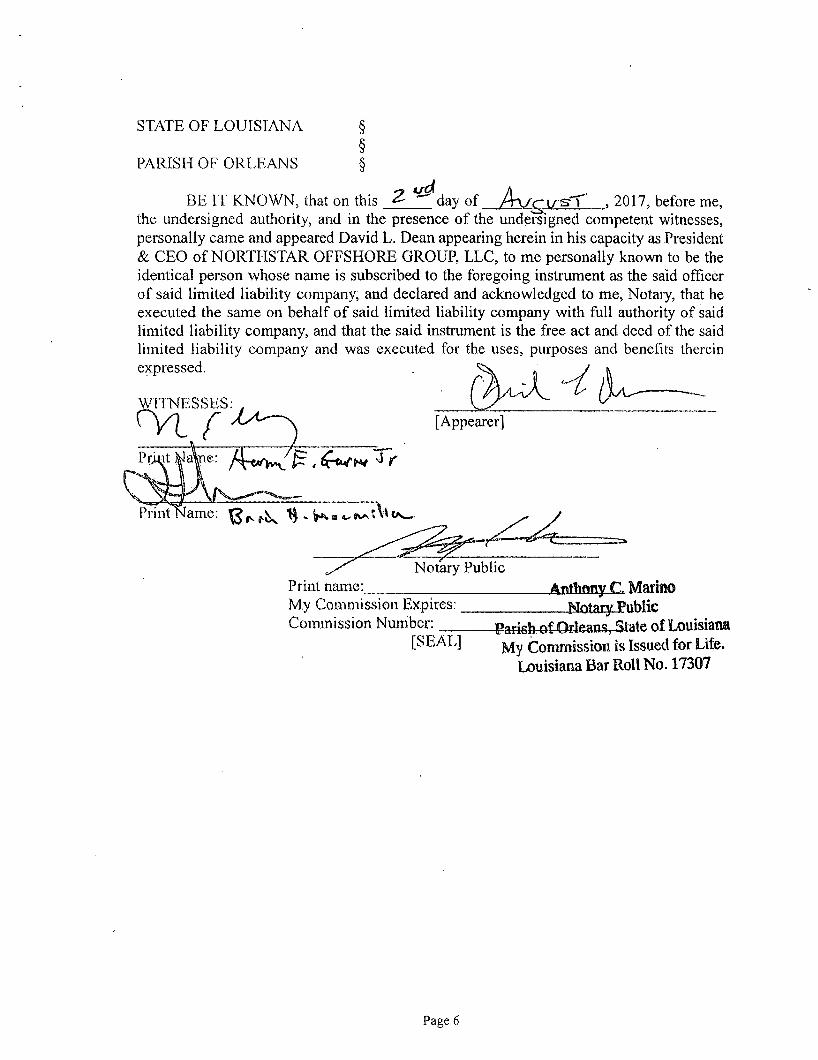
STATE OF LOUISIANA
PARISH OF ORLEANS
§ § §
BE IT KNOWN, that on this 2- ^ d a y of A x f r w s X , 2017, before me, the undersigned authority, and in the presence of the undersigned competent witnesses, personally came and appeared David L. Dean appearing herein in his capacity as President & CEO of NORTHSTAR OFFSHORE GROUP, LLC, to me personally known to be the identical person whose name is subscribed to the foregoing instrument as the said officer of said limited liability company, and declared and acknowledged to me, Notary, that he executed the same on behalf of said limited liability company with full authority of said limited liability company, and that the said instrument is the free act and deed of the said limited liability company and was executed for the uses, purposes and benefits therein expressed.
WITNESSES: [Appearer]
ame: ^ . ^ « c ^ t \ l
Print name: Notary Public
My Commission Expires: Commission Number:
[SEAL]
_Aiiliii3n5L£l Marino -Notary Public idean vState of Louisiana
My Commission is Issued for Life. Louisiana Bar Roll No. 17307
Page 6

STATE OF LOUISIANA
PARISH OF ORLEANS §
BE IT KNOWN, that on this 2 - " ^ day of A v ^ t / ST 2017, before me, the undersigned authority, and in the presence of the undersigned competent witnesses, personally came and appeared Thomas M. Clarke appearing herein in his capacity as Chief Executive Officer of NORTHSTAR OFFSHORE VENTURES LLC, to me personally known to be the identical person whose name is subscribed to the foregoing instrument as the said officer of said limited liability company, and declared and acknowledged to me, Notary, that he executed the same on behalf of said limited liability company with full authority of said limited liability company, and that the said instrument is the free act and deed of the said liability company and was executed for the uses, purposes and benefits therein expressed.
'S^TOESSES:
Print name: Notary Public
My Commission Expires: Commission Number:
-Anthaay C Marino -Hotary-Eublic
ish4jfjQfleasis,-State of Louisiana [SEAL] My Commission is issued for Life.
Louisiana Bar Roll No. 17307
Page?
NOG.NOV.Assignment Conveyance and Bill of Sale.final.docx

EXHIBIT "A"
LEASES FEDERAL AND STATE OF LOUISIANA LEASES:
Area Block L e a s e
No. Lease Date L e s s o r Original L e s s e e Lease/Aliquot Description O w n e r s h i p
R ights
Eugene
Island
32 OCS-0196 11/26/46 United States
of America
The Pure Oil Company All of Block 32, Eugene Island Area, as to those depths from 13,500' to
50,000' MD. (Deep Rights only).
Operating
Rights
#2
Eugene
Island
183 OCS-G 17981 8/1/1997 United States
of America
Elf Exploration, Inc. All of Block 183, Eugene Island Area, OCS Leasing Map, Louisiana Map
No. 4.
Record Title
Eugene
Island
184 OCS-G 5498 7/1/1983 United States
of America
Odeco Oil & Gas Company
Monsanto Oil Company
Murphy Oil Corporation
All of Block .184, Eugene Island Area, OCS Leasing Map No. 4. Record Title
(Al iquot A)
S/2
Odeco Oil & Gas Company
Monsanto Oil Company
Murphy Oil Corporation
All of Block 184, Eugene Island Area, OCS Leasing Map No. 4. Record Title
(Al iquot B)
N/2.
High Island A-443 OCS-G 3241 9/1/1975 United States
of America
Mobil Oil Corporation
Diamond Shamrock Corporation
Union Oil Company of California
All of Block A-443, High Island Area, South Addition, as shown on OCS
Official Leasing Map, Texas Map No. 7B.
Record Title
E/2 NE/4 of Biock A-443, High Island Area, South Addition, f rom surface
to 99,999' TVD.
Operating
Rights
#1
Contractual Obligation: Northstar is obligated to offer W&T the
opportunity to participate (at 50% of our interest) should Northstar
elect to perform operations to the #1 Well. See Project Summary
information and specific language regarding this obligation in Section
7.09 o f the PSA between W&T & Black Elk dated effective 9/14/2009.
Contractual
Obligation
High Island A-571 OCS-G 2391 8/1/1973 United States
of America
Texas Pacific Oil Company, Inc.
El Paso Natural Gas Company
CNG Producing Company
All of Block A-571, High Island Area, South Addition, Official Leasing
Map, Texas Map No. 7B
Record Title Texas Pacific Oil Company, Inc.
El Paso Natural Gas Company
CNG Producing Company S/2 SE/4 NE/4; E/2 SE/4; E/2 NW/4 SE/4; AND E/2 SW/4 SE/4 of Block A-
571, High Island Area, South Addition, and then INSOFAR AND ONLY
INSOFAR AS to the Glob Alt Sand Reservoir, defined as that productive
zone occurring within the interval 12,519 feet TVD and 13,028 feet
TVD, electric log, in well #C-22.
Operating
Rights
#1
Main Pass 64 OCS-G 4909 12/1/1981 United States
of America
Howell Peroleum Corporation That portion of Block 64, Main Pass Area, Louisiana Map No.10, which
is more than three geographical miles seaward from the line described
in the supplemental decree of the U. S. Supreme Court, June 16, 1975
(United States vs. Louisiana, 422 U.S. 13)
Record Title
As of 7-7-17 Orinoco Page 1 of7

A r e a B l o c k
Lease
N o . L e a s e Date L e s s o r Original L e s s e e Lease/Al iquot Descr ipt ion
O w n e r s h i p
R ights
Main Pass 64 CONTINUED That portion of Block 64, Main Pass Area, f rom Surface to 9,000' - Less
and Except as to the 7300' Sand Unit. Surface to 9,000' TVD. Includes
Wells #S-ST2, #7 #10 #11 #15 #B-21 Shortstring & B-22 ST1 Wells
Title Depth
#1
That portion of Block 64, Main Pass Area, covers depths f rom, but not
including, 9,000' to a depth 100' below the correlative point
encountered at TVD 8,960' in the Howell Petroleum #1 Well. (No wells
currently producing in this zone)
Title Depth
#2
That portion of Block 54, Main Pass Area, covers depths below a depth
of 100% below the correlative point encountered at a TVD depth of
8,960' in the Howell Petroleum #1 Well (Less and Except as to Deep
Operating Rights in the S/2 below, 11,500'). No wells currently
producing in this zone
Title Depth
#3
That portion of Block 64, Main Pass Area, INSOFAR AND ONLY INSOFAR
AS the lease covers the South Half (Sl/2) o f t h e block, below the
stratigraphic equivalent of 11,500' subsea as seen on the electric log on
the OCS-G 4909 Well #20. Known as "Deep Operating Rights".
Operating
Rights
#1
Unit covers the 7300' Sand Reservoir as that productive zone occurring
within the interval from 7323 feet, to 7482 feet, as in Well #11, Lease
OCS-G 4909 within the Unit Area containing a total of 1879 acres.
Unit Interests
Note: NRI in Unit can change based upon meeting various
accumulations of production.
Main Pass 65 OCS-G 5692 7/1/1983 United States
of America
Total Petroleum, Inc. All of Block 65, Main Pass Area, OCS Leasing Map, Louisiana Map No.
10.
Record Title
All of Block 65, Main Pass Area, OCS Leasing Map, Louisiana Map No.
10. Record Titles to depths from the surface to stratigraphic equivalent
of 8,600' TVD in the Total Petroleum Main Pass 64 A-2 well (Less and
Except the 73,000' Sand Unit).
Title Depth
#1
All of Block 65, Main Pass Area as to depths f rom, but not including, the
stratigraphic equivalent of 8600' TVD in the Total Petroleum A-2 well to
a depth 100' below the correlative point at a TVD of 8,750' in the #2
Well.
Title Depth
#2
All of Block 65, Main Pass Area as to depths 100' below the correlative
point encountered at a TVD of 8,750' in the Total Petroleum #2 Well .
Title Depth
-#3
As of 7-7-17 Orinoco Page 2 of?

A r e a B lock
L e a s e
No. L e a s e Date L e s s o r Original L e s s e e Lease/Al iquot Descr ip t ion
O w n e r s h i p
Rights Main Pass 65 CONTINUED Unit covers the 7300' Sand Reservoir as that productive zone occurring
within the interval from 7323 feet to 7482 feet, as in Well #11, tease
OCS-6 4909 within the Unit Area containing a total of 1879 acres.
Note: NRI in Unit can change based upon meeting various
accumulations of produtt ion.
Unit Interests
Main Pass 256 OCS-G 34386 8/1/2012 United States
of America
Northstar Offshore Group, LLC All of Block 256, Main Pass Area, South and East Addi t ion, OCS Leasing
Map, touisiana Map No. 10A.
Record Title
Main Pass 257 OCS-G 34387 8/1/2012 United Stares
of America
Northstar Offshore Group, LLC At! of Block 257, Main Pass Area, South and East Addi t ion, OCS Leasing
Map, Louisiana Map No. 10A.
Record Title
Ship Shoal 252 OCS-G 1529 7/1/1967 United States
of America
Union Oil Company of California
Marathon Oil Company
Operating Rights as to the NE/4; N/2 SE/4 of Block 252, Ship Shoal
Area, South Addition from 11,934 ' TVD to 13,513' TVD
Operating
Rights
#2
South
Marsh
Island
41 OCS-G 1192 6/1/1962 United States
of America
CALIFORNIA OIL COMPANY All of Block 41, South Marsh island Area, as shown on official leasing
map LA. No. 3A, Outer Continental Shelf Leasing Map, Louisiana
Offshore Operations.
Record Title
• E/2 of Block 4 1 , South Marsh island Area, l imited to depths f rom
11,500' TVD down to a depth of 50,000'TVD - fess and except the
contractual rights. (* NOG owns no rights in the E/2 in depths from
the surface to 11,500' TVD).
Operating
Rights
#2
W/2 of Block 4 1 , South Marsh Island Area, l imited to depths f rom
15,000' TVD down to a depth of 50,000' TVD.
Operating
Rights
#3
South
Marsh
Island
41 CONTINUED Contractual Obligation: The NE/4 NE/4 of SM 41 as to the stratigraphic
equivalents of the 4 intervals as seen in the No. A-1 Well at the
stratigraphic intervals:
1) C-1 Sands between 12,540'-12 /600' TVD;
2) 13,700' Sands between 12,870'-13,320' TVD;
3) E-l Sand between ISfiSO'-ll.l&O'WD;
And, as seen on the induction log o f t he OCS-G 1192 (SMI 41) No. A-3
Well at the stratigraphic interval:
4) Rob E Sand between 13,800-14,330' TVD
Contractual
Obligation
South Pass 86 OCS-G 5687 7/1/1983 United States
of America
Marathon Oil Company
Amerada Hess Corporation
The Louisiana Land and Exploration Co.
All of Block 86, South Pass Area, South and East Addit ion, OCS Leasing
Map, Louisiana Map No. 9A.
Record Title
As of 7-7-17 Orinoco Page 3 of 7

A r e a Block L e a s e
No. L e a s e Date L e s s o r Original L e s s e e Lease/Al iquot Descr ipt ion
O w n e r s h i p
R i g h t s
OKC Limited Partnership Contractual Obligation: Northstar is obligated to offer W&T the
opportunity to participate (at 50% of our interest) should Northstar
elect to perform operations to the #C-13 Well (aka the #C-5 well) or the
#C-8 Well. See Project Summary information and specific language
regarding this obligation in Section 7.09 of the PSA between W&T &
Black Elk dated effective 9/14/2009.
Northstar's WI would change to 37.5000% should W&T elect to
participate in this well.
Contractual
Obligation
South Pass 87 OCS-G 7799 9/1/1985 United States
of America
Marathon Oil Company
Amerada Hess Corporation
The Louisiana Land and Exploraiton Co.
OKC Limited Partnership
All of Block 87, South Pass Area, South and East Addit ion, OCS Leasing
Map, Louisiana Map No. 9A
Overriding
Royalty
Interest
Only
South Pass 89 OCS-G 1618 7/1/1967 United States
of America
Signal Oil & Gas Company
The Louisiana Land and Exploration Co.
Marathon Oil Company
Amerada Petroleum Corp.
Contractual: NE/4 of Block 89, South Pass Area, South and East Addit ion
from 14,000' SSTVD to 17500' SSTVD. Contractual Ownership in "C"
Wells.
Wells #C-1, C-4; C-6 & C-10 have a SP 89 BHL, with a SHL in SP 86 and
holds a 50% WI.
Contractual
Viosca Knoll 697 OCS-G 34870 7/1/2013 United States
of America
Northstar Offshore Group, LLC All of Block 697, Viosca Knoll, OCS Official Protraction Diagram, NH 16-
07.
Record Title
West
Cameron
20 OCS-0680 8/1/1959 United States
of America
The British-American Oil Producing Co. Block 20, West Cameron Area. That portion in Zone 2, as that zone is
defined in the agreement between the United States and the State of
Louisiana, October 12, 1956, as shown on official leasing map, La. Map
No. 1 Outer Continental Shelf Leasing Map (Louisiana offshore
operations)
Record Title
Portion of Block 20, West Cameron Area, INSOFAR AND ONLY INSOFAR
as the lease covers depths from 13,500' TVD down to a depth of
50,000" TVD.
Operating
Rights
#1
Portion of Block 20, West Cameron Area, as to that port ion described
as contributing 210 acres in the uppermost port ion of this lease -
subject to a 1% Overriding Royalty Interest regardless as to whether
drill ing is in Record Title or Operating Rights depths.
Contractual
Rights
West
Cameron
21 OCS-G 23730 7/1/2002 United States
of America
The William G. Helis Company, LL.C.
Houston Energy, L.P.
Duke Energy Hydrocarbons, LLC
That portion of Block 21, West Cameron Area, OCS Leasing Map,
Louisiana Map No. 1, seaward of the 1975 Supreme Court Decree Line
specifically described in the OCS Block Diagram.
Record Title
As of 7-7-17 Orinoco Page 4 of7
A r e a B l o c k
L e a s e
No . L e a s e Date L e s s o r Original L e s s e e Lease/Al iquot Descr ipt ion
O w n e r s h i p
R ights
Contractual area with Record Title Interest but the ORRI burden in this
port ion which Includes wells located in depths from the surface to base
of the P3 Sand in any wellbore or future wellbore wi th in the E/2 SE/4
NE/4; & E/2 NE/4 SE/4 in WC 21 wi th a BHL or perf located within 500'
of the West Lease line of WC 22. (Currently the #2 well). This
Contractual "A" is less any well drilled within the "Southern Fault Block"
as described below.
Contractual
"A"
Contractual area with Record Title Interest but the ORRI burdens vary
in this portion within the "Southern Fault Block" Limited to depths
from the surface to the base of the P3 Sand in any wellbore drilled on
.WC 21 in the SE/4 SE/4; & SE/4 SW/4 SE/4; and which has a BHL or perf
in the above described location of WC 2 1 ; and the BHL or per interval is
located with 2,000'of the West lease line of WC 22. This "Southern
Fault Block" holds a 3% ORRI burden in favor of Union Oil & Gas of
California.
Contractual
"B"
"Southern
Fault
Block"
West
Cameron
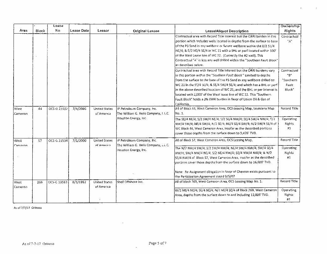
44 OCS-G 21532 7/1/2000 United States
of America
IP Petroleum Company, Inc.
The William G. Helis Company, L.L.C.
Houston Energy, Inc.
All of Block 44, West Cameron Area, OCS Leasing Map, Louisiana Map
No. 1.
Record Title West
Cameron
44 OCS-G 21532 7/1/2000 United States
of America
IP Petroleum Company, Inc.
The William G. Helis Company, L.L.C.
Houston Energy, Inc. The SE/4 NE/4; 5/2 SW/4 NE/4; S/2 SE/4 NW/4; SE/4 SW/4 NW/4; E/2
NW/4 SW/4; NE/4 SW/4; N/2 SE/4; NE/4 SE/4 SW/4; N/2 SW/4 SE/4 of
WC Block 44, West Cameron Area, insofar as the described portions
cover those depths from the surface down to 9,476' TVD.
Operating
Rights
#1
West 57 OCS-G 21534 7/1/2000 United States
nf Am^rir^
IP Petroleum Company, Inc.
The Will iam G. Helis Company, LL.C
Houston Energy, Inc.
All of Biock 57, West Cameron Area, OCS Leasing Map, Record Title West 57 OCS-G 21534 7/1/2000 United States
nf Am^rir^
IP Petroleum Company, Inc.
The Will iam G. Helis Company, LL.C
Houston Energy, Inc. The N/2 NW/4 SW/4; S/2 SW/4 NW/4; NE/4 SW/4 NW/4; SW/4 SE/4
NW/4; SW/4 NW/4 NE/4; S/2 NE/4 NW/4; SE/4 NW/4 NW/4; & N/2
SE/4 NW/4 of Block 57, West Cameron Area, insofar as the described
portions cover those depths from the surface down to 16,000' TVD.
Note: Re-Assignment obligation in favor of Chevron exists pursuant to
the Participation Agreement dated 9/5/07
Operating
Rights
#1
West
Cameron
269 OCS-G 13563 8/1/1992 United States
of America
Shell Offshore Inc. All of block 269, West Cameron Area, OCS Leasing Map No. 1. Record Title West
Cameron
269 OCS-G 13563 8/1/1992 United States
of America
Shell Offshore Inc.
W/2 NE/4 NE/4,- SE/4 NE/4; N/2 NE/4 SE/4 of Block 269, West Cameron
Area, depths from the surface down to and including 12,805' TVD.
Operating
Rights
#1
As of 7/7/17 Orinoco
As o f 7-7-17 Orinoco Pase 5 of 7

EXHIBIT "A.a"
SURFACE LEASES
SURFACE LEASE(s):
Area/
Block
Surface
Lease Name
Effective
Date Lessor Lessee j Description
WC 20
OCS-0680
Ivan Fisk Surface Lease 3/1/60 Barton L. Monro
Barton Fisk
Audra Cabral
Dianne Hinch
Deena Greenhaw
Northstar Offshore Group, LLC Surface Lease That certain tract of land in Sections 32, and 33
of Township 15 South, Range 13 West, more particularly
described as follows: Commencing at a point 251.6 feet West
and 646 feet North 0 degrees 56 feet West 1320 feet to the
South Line of State Highway 292, thence East along the South
line of said highway 360 feet, thence South 1320 feet, thence
West 360 feet to the point of beginning.
As o f 7/7/17 Orinoco Page 6 of 7
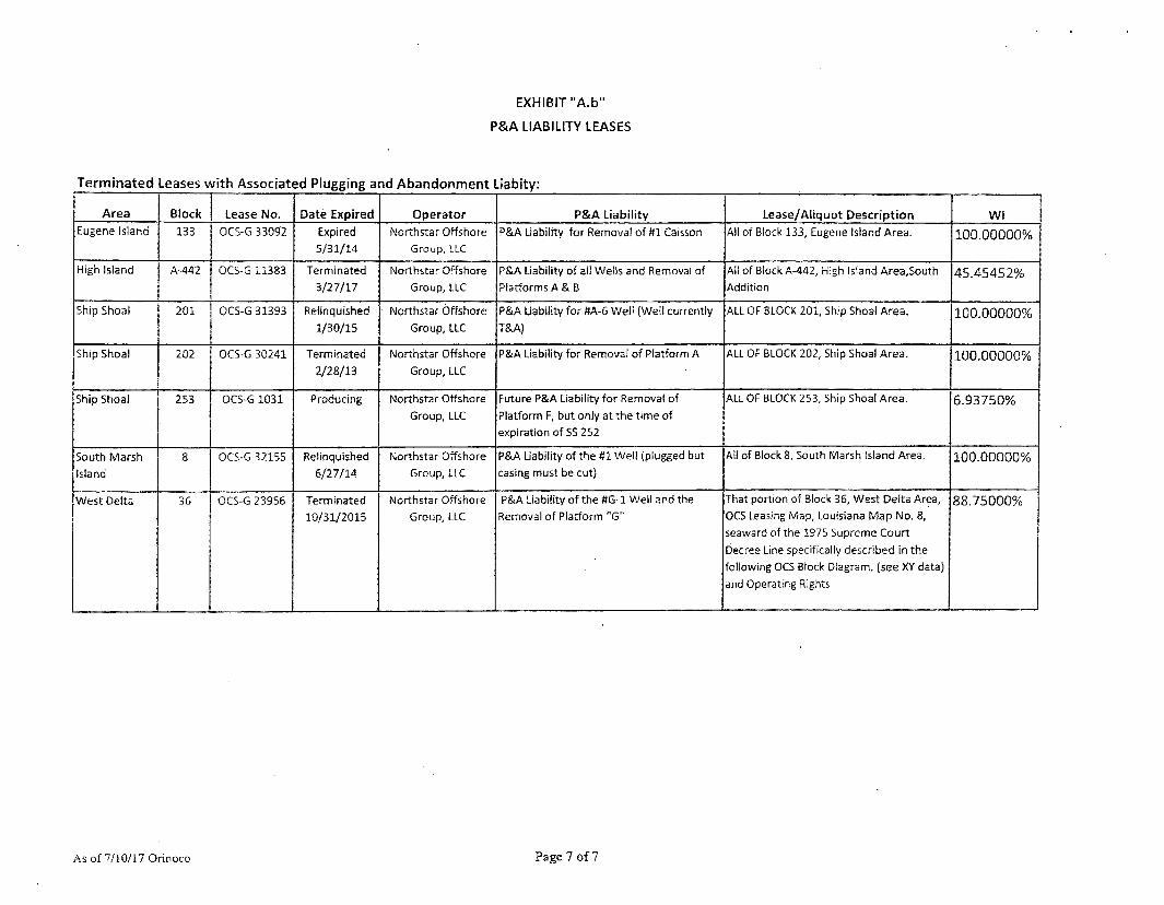
EXHIBIT "A.b"
P&A LIABILITY LEASES
Terminated Leases with Associated Plugging and Abandonment Liabity:
Area Block Lease No. Date Expired Operator P&A Liability Lease/Aliquot Description WI Eugene Island 133 OCS-G 33092 Expired
5/31/14 Northstar Offshore
Group, LLC P&A Liability for Removal of ttl Caisson All of Block 133, Eugene Island Area. 100.00000%
High Island A-442 OCS-G 11383 Terminated
3/27/17
Northstar Offshore Group, LLC
P&A Liability of all Wells and Removal of Platforms A & B
All of Block A-442, High Island Area,South Addition
45.45452%
Ship Shoal 201 OCS-G 31393 Relinquished
1/30/15
Northstar Offshore
Group, LLC
P&A Liability for #A-6 Well (Well currently
T&A)
ALL OF BLOCK 201, Ship Shoal Area. 100.00000%
Ship Shoal 202 OCS-G 30241 Terminated
2/28/13
Northstar Offshore
Group, LLC
P&A Liability for Removal of Platform A ALL OF BLOCK 202, Ship Shoal Area. 100.00000%
Ship Shoal 253 OCS-G 1031 Producing Northstar Offshore
Group, LLC
Future P&A Liability for Removal of Platform F, but only at the time of expiration of SS 252
ALL OF BLOCK 253, Ship Shoal Area. 6.93750%
South Marsh Island
8 OCS-G 32155 Relinquished
6/27/14
Northstar Offshore
Group, LLC
P&A Liability of the #1 Wel! (plugged but
casing must be cut)
All of Block 8, South Marsh Island Area. 100.00000%
West Delta 36 OCS-G 23956 Terminated 10/31/2015
Northstar Offshore Group, LLC
P&A Liability of the #G-1 Weil and the Removal of Platform "G"
That portion of Block 36, West Delta Area, OCS teasing Map, Louisiana Map No. 8, seaward ofthe 1975 Supreme Court Decree Line specifically described in the following OCS Block Diagram, (see XY data) and Operating Rights
88.75000%
As of 7/10/17 Orinoco Page 7 of7
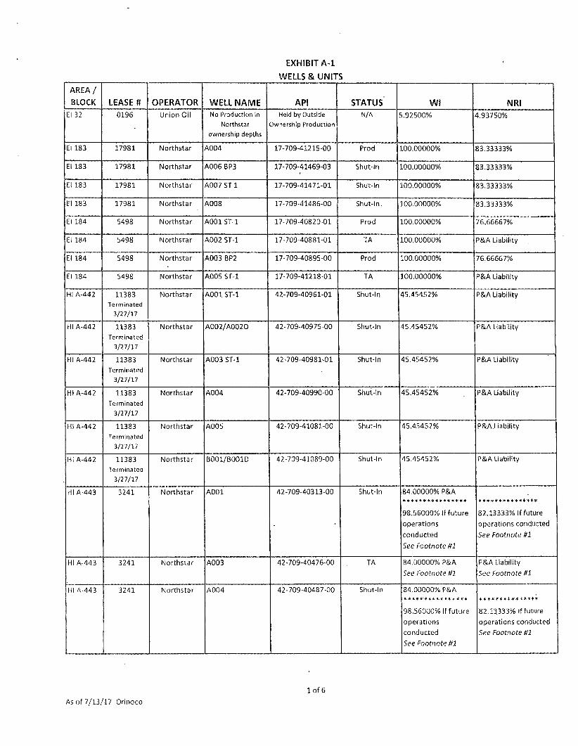
EXHIBIT A-1 WELLS & UNITS
AREA /
BLOCK LEASE tt OPERATOR WELL NAME API STATUS WI NRI El 32 0196 Union Oil No Production in
Northstar
ownership depths
Held by Outside
Ownership Production
N/A 5.92500% 4.93750%
El 183 17981 Northstar A004 17-709-41215-00 Prod 100.00000% 83.33333%
El 183 17981 Northstar A006 BP3 17-709-41469-03 Shut-In 100.00000% 83.33333%
El 183 17981 Northstar A007 ST 1 17-709-41471-01 Shut-in 100.00000% 83.33333%
El 183 17981 Northstar A008 17-709-41486-00 Shut-in. 100.00000% 83.33333%
El 184 5498 Northstar A001 ST-1 17-709-40820-01 Prod 100.00000% 76.66667%
El 184 5498 Northstar A002 ST-1 17-709-40881-01 TA 100.00000% P&A Liability
El 184 5498 Northstar A003 BP2 17-709-40895-00 Prod 100.00000% 76.66667%
El 184 5498 Northstar A005 ST-1 17-709-41218-01 TA 100.00000% P&A Liability
HI A-442 11383 Terminated
3/27/17
Northstar A001 ST-1 42-709-40961-01 Shut-In 45.45452% P&A Liability
HI A-442 11383
Terminated
3/27/17
Northstar A002/A002D 42-709-40975-00 Shut-In 45.45452% P&A Liability
HI A-442 11383
Terminated
3/27/17
Northstar A003 ST-1 42-709-40981-01 Shut-In 45.45452% P&A Liability
HI A-442 11383
Terminated
3/27/17
Northstar A004 42-709-40990-00 Shut-In 45.45452% P&A Liability
HI A-442 11383
Terminated
3/27/17
Northstar A005 42-709-41081-00 Shut-In 45.45452% P&A.Liability
HI A-442 11383
Terminated
3/27/17
Northstar B001/B001D 42-709-41089-00 Shut-In 45.45452% P&A Liability
HI A-443 3241 Northstar A001 42-709-40313-00 Shut-In 84.00000% P&A
98.56000% If future
operations
conducted
See Footnote tfl
***************
82.13333% If future
operations conducted
See Footnote ffl
HI A-443 3241 Northstar A003 42-709-40476-00 TA 84.00000% P&A
Set1 Footnote ffl
P&A Liability
See Footnote ffl
HI A-443 3241 Northstar A004 42-709-40487-00 Shut-in 84.00000% P&A
98.56000% If future
operations
conducted
See Footnote ffl
************ ***
82.13333% If future
operations conducted
See Footnote tfl
As of 7/13/17 Orinoco
1 of 6
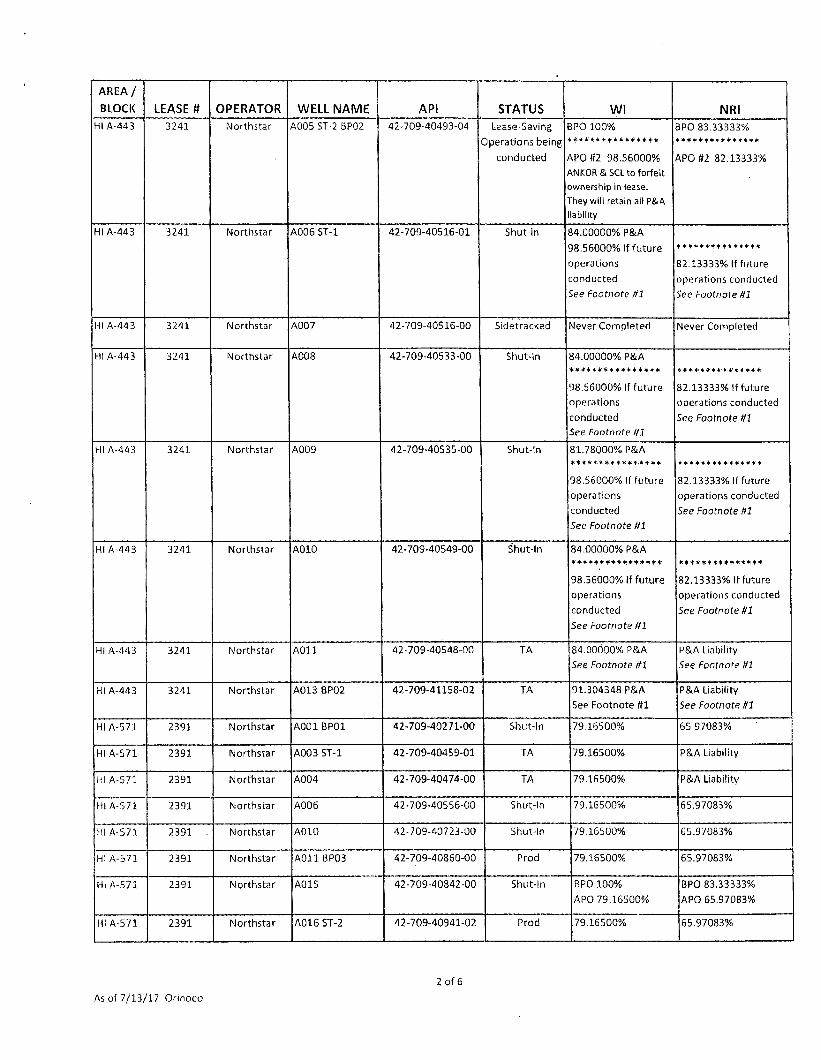
AREA /
BLOCK LEASE n OPERATOR WELL NAME API STATUS WI NRI HI A-443 3241 Northstar A005 ST-2 BP02 42-709-40493-04 Lease-Saving
Operations being
conducted
BPO 100% ****************
APO #2 98.56000%
ANKOR & SCL to forfeit
ownership in lease.
They will retain all P&A
iability
BPO 83.33333% ***************
APO H2 82.13333%
HI A-443 3241 Northstar A006 ST-1 42-709-40516-01 Shut-in 84.00000% P&A
98.56000% If future
operations
conducted
See foofnore ffl
***************
82.13333% If future
operations conducted
See foofnore ttl
HI A-443 3241 Northstar A007 42-709-40516-00 Sidetracked Never Completed Never Completed
HI A-443 3241 Northstar A008 42-709-40533-00 Shut-In 84.00000% P&A * * + + * * * # + * + + * * * *
98.56000% If future
operations
conducted
See Footnote til
82.13333% If future
operations conducted
See Footnote til
HI A-443 3241 Northstar A009 42-709-40535-00 Shut-In 81.78000% P&A
98.56000% If future
operations
conducted
Sec Footnote ttl
***************
82.13333% If future
operations conducted
See Footnote Itl
HI A-443 3241 Northstar A010 42-709-40549-00 Shut-In 84.00000% P&A ******
98.56000% If future
operations
conducted
See Footnote ttl
***************
82.13333% If future
operations conducted
See footnote tfl
HI A-443 3241 Northstar A011 42-709-40548-00 TA 84.00000% P&A
See Footnote tfl
P&A Liability
See Footnote Itl
HI A-443 3241 Northstar A013 BP02 42-709-41158-02 TA 91.304348 P&A
See Footnote ffl
P&A Liability
See footnote tfl
HI A-571 2391 Northstar A001BP01 42-709-40271-00 Shut-In 79.16500% 65.97083%
HI A-571 2391 Northstar AOO 3 ST-1 42-709-40459-01 TA 79.16500% P&A Liability
HI A-571 2391 Northstar A004 42-709-40474-00 TA 79.16500% P&A Liability
HI A-S71 2391 Northstar A006 42-709-40556-00 Shut-In 79.16500% 65.97083%
HI A-571 2391 Northstar A010 42-709-40723-00 Shut-In 79.16500% 65.97083%
HI A-571 2391 Northstar A O i l BP03 42-709-40860-00 Prod 79.16500% 65.97083%
HI A-571 2391 Northstar A015 42-709-40842-00 Shut-In BPO 100%
APO 79.16500%
BPO 83.33333%
APO 65.97083%
HI A-571 2391 Northstar A016 ST-2 42-709-40941-02 Prod 79.16500% 65.97083%
As of 7/13/17 Orinoco
2 of 6

AREA /
BLOCK LEASE # OPERATOR WELL NAME API STATUS WI NRI HI A-S71 2391 Northstar A017 BP01 42-709-40925-00 Prod 79.16500% 65.97083%
HI A-571 ' 2391 Northstar AO 18 42-709-41036-00 TA 79.16500% P&A Liability
HI A-571 2391 Northstar A019 ST-3 42-709-41042-03 Shut-in 79.16500% 65.97083%
MP 64 G 4909 Medco 20 17-725-40564-00 Shut-in 25.00000% P&A ****************
11.704690% [or new
operations within
current aliquots &
depths. * * * * * * * * * * + * * * * *
This well is not located within the MP 64/65 Unit
8.836985%
for new operations
within current aliquots
& depths
MP 256 34386 Northstar No Wells Primary Term Lease N/A 100.00000% 77.25000%
MP 257 34387 Northstar No Wells Primary Term Lease N/A 100.00000% 77.25000%
SM 8 3215S Terminafed
6/27/14
Northstar 001 BP03 17-709-41514-00 TA (Plugged but
casing must be cut)
100.00000% P&A Liability
#1 Well
SM 41 1192 Northstar A001 17-707-00327-00 TA 100.00000% P&A Liability
S M 4 1 1192 Northstar A009 17-707-40845-00 TA 100.00000% P&A Liability
S M 4 1 1192 Northstar CA013 17-707-40477-00 Shut-In 100.00000% 83.33333%
S M 4 1 1192 Northstar CA014 ST-1 17-707-40676-01 Shut-In 100.00000% 83.33330%
S M 4 1 1192 Northstar CA015 17-707-40892-00 Shut-In 100.00000% 83.33330%
SP 86 5687 Northstar C002 BP03 17-722-40180-00 Prod ' BPO 100%
APO 75.00000%
BPO 83.33333%
APO 62.50000%
SP 86 5687 Northstar COO 3 17-722-40184-00 Shut-In 75.00000% 62.50000%
SP 86 5687 Northstar COO5/C005A 17-722-40213-00 TA 75.00000% P&A Liability
SP 86 5687 Northstar C007 ST-1 17-722-40215-01 Prod 75.00000% 62.50000%
SP86 5687 Northstar COOS 17-722-40163-00 Shut-In BPO 100%
APO 75.00000%
BPO 83.33333%
APO 62.50000%
SP 87 7799 Fieldwood D-2 ST-1 17-722-40210-01 • Shut-in ORRI Only 1.00000%
SP 87 7799 Fieldwood D-3 ST2 BP1 17-722-40212-02 Shut-in ORRI Only 1.00000%
SP 37 7799 Fieldwood D-7 17-722-40213-00 Prod ORRI Only 1.00000%
SP 37 7799 Fieldwood D-8 ST-2 17-722-40208-03 TA ORRI Only 1.00000%
SP 87 7799 Fieldwood D-9 17-722-40226-00 Prod ORRI Only 1.00000%
SP87 7799 Fieldwood D-11 ST-1 17-722-40228-0 1 Shut-In ORRI Only 1.00000% .
SP89 1618 Northstar C001 17-722-40205-00 Shut-In 50.00000% 41.66667%
As of 7/13/1.7 Orinoco
3 of 6

A R E A /
BLOCK LEASE # OPERATOR WELL NAME API STATUS WI NRI SP 89 1618 Northstar C004 ST-1 BP1 17-722-40211-01 Prod 50.00000% 41.66667%
SP 89 1618 Northstar C006 17-722-40214-00 TA 50.00000% P&A Liability
SP 89 1618 Northstar C010 8P01 17-722-40224-00 Prod 50.00000% 41.66667%
SS 201 31393 Northstar A006 17-711-41540-00 TA 100.00000% P&A Liability
SS 252 1529 Fieldwood F004 17-712-40674-00 Prod 6.93750% 5.41125%
VK697 34870 Northstar No Wells Primary Term Lease N/A 100.00000% 77.25000%
WC 20 0680 Northstar 002 17-700-00006-00 Prod 100.00000% 83.33333%
WC 20 0680 Northstar 010 17-700-00287-00 TA 100.00000% P&A Liability
WC20 0680 Northstar 014 17-700-20068-00 Shut-In 100.00000% 83.33333%
WC20 0680 Northstar 15 17-700-20071-00 Shut-In 100.00000% 83.33333%
WC20 0680 Northstar D001 17-700-41272-00 Shut-In 100.00000% 83.33333%
WC20 0680 Northstar D002 17-700-41273-00 Shut-In 100.00000% 83.33333%
WC20 0680 Northstar D003 17-700-41299-00 Prod 100.00000% 83.33333%
WC20
Ivan Fisk
Ivan Fisk
Surface
Lease
Northstar SWD ta 17-023-88148-00 SW Disposal well 100.00000% N/A
WC 21 23730 Northstar 001 17-700-41214-00 Prod
(But temporarily
Shut-In until
Stingray Contract
concluded)
56.70000% 43.09200%
W C 2 1 23730 Northstar 002 17-700-41224-00 Shut-In 56.70000% 43.00000%
WC44 21532 Northstar 0002 ST-1 17-700-41176-01 Prod
(But temporarily
Shut-In until
Stingray Contract
concluded!
12.92324%
See Footnote ttl
10.08012%
See Footnote tt2
WC 44 21532 Northstar B001 BP01 17-700-41155-01 TA 33.30000% P&A Liability
WC44 21532 Northstar B002 BP01 17-700-41203-01 TA 33.30000% P&A Liability
WC 57 21534 Northstar 002 17-700-41222-00 Shut-In BPO 73.12500%
APO 33.30000%
BPO 57.03752%
APO 25.97400%
WC 5 7 21534 Northstar 003 17-700-41282-00 Prod
(But temporarily
Shut-In until
Stingray Contract
concluded)
58.4917% Oil 8. Gas 45.62350% Oil
55.37216% Gas
(Deep Gas Royalty Relief)
WC269 13563 Northstar JA001 17-700-40924-00 Shut-In 100.00000% 83.33333%
WC269 13563 Northstar jA002 17-700-40931-00 Shut-In 100.00000% 83.33333%
WC269 13563 Northstar JA004 17-700-40969-00 TA 100.00000% P&A Liability
As of 7/13/17 Orinoco
4 of 6

A R E A /
BLOCK LEASE n OPERATOR WELL NAME API STATUS WI NRI WC 269 13563 Northstar JA005 17-700-40970-00 Shut-In 100.00000% 83.33333%
WC269 13563 Northstar JA007 17-700-41159-00 TA 100.00000% P&A Liability
WC 269 13563 Northstar JA008 ST-1 17-700-41303-01 Prod
(But temporarily
Shut-In until
Stingray Contract
concluded]
25.00000% 20.83333%
WD 36 23956
Terminated
10/31/1S
Northstar G- l 17-719-40832-00 Shut-In 88.75000% P&A Liability
UNITS
MAIN PASS 64 & 65 UNIT #754390004: AREA /
BLOCK LEASE # OPERATOR WELL NAME API STATUS WI NRI
MP 64 G 4909 Medco 1ST-1 17-725-40294-01 Prod 25.00000% 19.18255%
MP 64 G 4909 Medco 2 17-725-40303-00 Prod 25.00000% 19.18255%
MP 64 G 4909 Medco 3 17-725-40306-00 Prod 25.00000% 19.18255%
MP 64 G4909 Medco 4 17-725-40307-00 Shut-In 25.00000% 19.18255%
MP 64 G4909 Medco 5 ST2 17-725-40317-02 Shut-In 25.00000% 19.03281%
MP 64 G4909 Medco 6 17-725-40320-00 Prod 25.00000% 19,18255%
MP 64 G4909 Medco 7 17-725-40322-00 TA 25.00000% P&A Liability
MP 64 G4909 Medco 8 17-725-40326-00 TA 25.00000% P&A Liability
MP 64 G 4909 Medco 9 17-725-40327-00 TA 25.00000% P&A Liability
MP 64 G 4909 Medco 1.0 ST-1 17-725-40328-01 Prod 25.00000% 19.03281%
MP 64 G 4909 Medco 11 17-725-40329-00 Shut-In 25.00000% 19.03281%
MP 64 G4909 Medco 12 17-725-40333-00 Shut-In 25.00000% 19.18255%
MP 64 G4909 Medco 13 17-725-40360-00 TA 25.00000% P&A Liability
MP 64 G4909 Medco 14 17-725-40370-00 Shut-In 25.00000% 19.18255%
MP 64 G4909 Medco 15 17-725-40446-00 Shut-In • 25.00000% 19.03281%
MP 64 G 4909 Medco 17 ST-1 17-725-40463-01 Prod 25.00000% 19,18255%
MP 64 G 4909 Medco 18 17-725-40555-00 Prod 25.00000% 19.18255%
MP 64 G4909 Medco 19 17-725-40560-00 Prod 25.00000% 19.18255%
MP 64 G4909 Medco B21
Short String
17-725-40812-00 Non-Prod
String
25.00000% 19.03281%
MP 64 G4909 Medco B21
Long String
17-725-40812-00 Prod String 25.00000% 18.93983%
MP 64 G 4909 Medco B22 ST-1 17-725-40816-01 Shut-In 25.00000% 19.03281%
As of 7/13/17 Orinoco
5 of 6
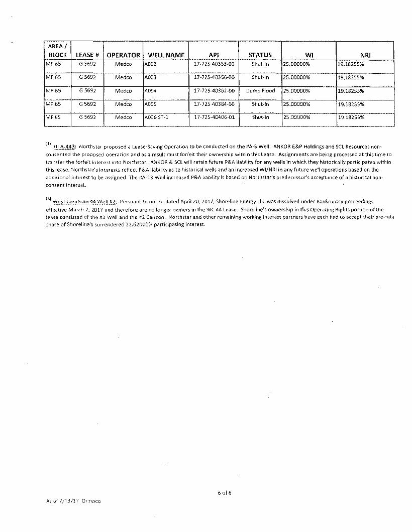
AREA /
BLOCK LEASE # OPERATOR WELL NAME API STATUS WI NRI MP 65 G 5692 Medco A002 17-725-40353-00 Shut-In 25.00000% 19.18255%
MP 65 G 5692 Medco A003 17-725-40356-00 Shut-In 25.00000% 19.18255%
MP 65 G5692 Medco A004 17-725-40362-00 Dump Flood 25.00000% 19.18255%
MP 65 G 5692 Medco A005 17-725-40384-00 Shut-In 25.00000% 19.18255%
MP 65 G 5692 Medco A006 ST-1 17-725-40406-01 Shut-In 25.00000% 19.18255%
HI A-443: Northstar proposed a Lease-Saving Operation to be conducted on the ttA-5 Well. ANKOR E&P Holdings and SCL Resources non-consented the proposed operation and as a result must forfeit their ownership within this Lease. Assignments are being processed at this time to transfer the forfeit interest into Northstar. ANKOR & SCL will retain future P&A liability for any wells in which they historically participated within this lease. Northstar's interests reflect P&A liability as to historical wells and an increased WI/NRI in any future well operations based on the additional interest to be assigned. The ftA-13 Well increased P&A liability is based on Northstar's predecessor's acceptance of a historical non-consent interest.
West Cameron 44 Well it2: Persuant to notice dated April 20, 2017, Shoreline Energy LtC was dissolved under Bankruptcy proceedings effective March 7, 2017 and therefore are no longer owners in the WC 44 tease. Shoreline's ownership in this Operating Rights portion of the lease consisted of the 1*2 Well and the tt2 Caisson. Northstar and other remaining working interest partners have each had to accept their pro-rata share of Shoreline's surrendered 22.62000% participating interest.
6 of 6 As of 7/13/17 Onnoco
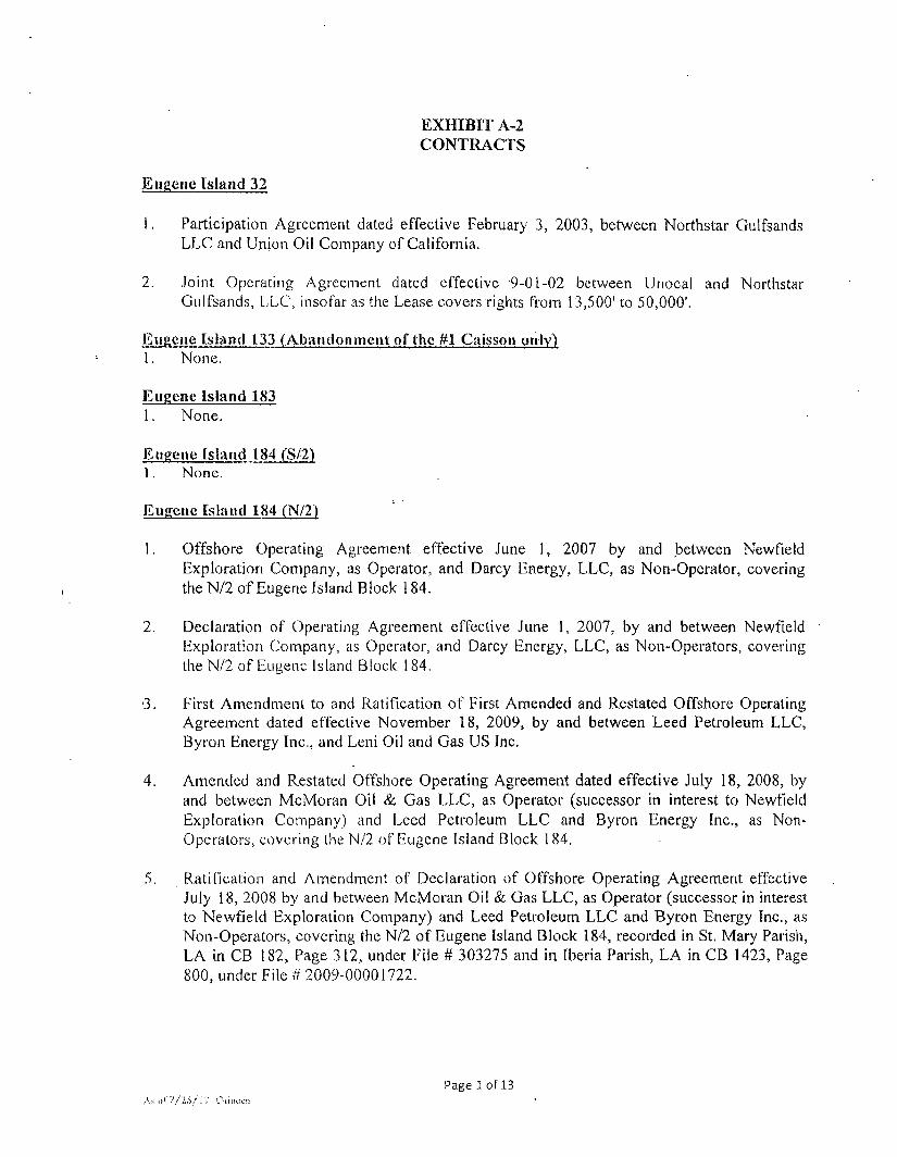
EXHIBIT A-2 CONTRACTS
Eugene Island 32
!. Participation Agreement dated effective February 3, 2003, between Northstar Gulfsands LLC and Union Oil Company of California.
2. Joint Operating Agreement dated effective 9-01-02 between Unocal and Northstar Gulfsands, LLC, insofar as the Lease covers rights from 13,500' to 50,000'.
Eugene Island 133 (Abandonment of the #1 Caisson only) 1. None.
Eugene Island 183 1. None.
Eugene Island 184 (S/2) 1. None.
Eugene Island 184 fN/2)
1. Offshore Operating Agreement effective June 1, 2007 by and between Newfield Exploration Company, as Operator, and Darcy Energy, LLC, as Non-Operator, covering the N/2 of Eugene Island Block 184.
2. Declaration of Operating Agreement effective June 1, 2007, by and between Newfield Exploration Company, as Operator, and Darcy Energy, LLC, as Non-Operators, covering the N/2 of Eugene Island Block 184.
•3. First Amendment to and Ratification of First Amended and Restated Offshore Operating Agreement dated effective November 18, 2009, by and between Leed Petroleum LLC, Byron Energy Inc., and Leni Oil and Gas US Inc.
4. Amended and Restated Offshore Operating Agreement dated effective July 18, 2008, by and between McMoran Oil & Gas LLC, as Operator (successor in interest to Newfield Exploration Cornpany) and Leed Petroleum LLC and Byron Energy Inc., as Non-Operators, covering the N/2 of Eugene Island Block 184.
5, Ratification and Amendment of Declaration of Offshore Operating Agreement effective July 18, 2008 by and between McMoran Oil & Gas LLC, as Operator (successor in interest to Newfield Exploration Company) and Leed Petroleum LLC and Byron Energy Inc., as Non-Operators, covering the N/2 of Eugene Island Block 184, recorded in St. Mary Parish, LA in CB 182, Page 312, under File # 303275 and in Iberia Parish, LA in CB 1423, Page 800, under File # 2009-00001722.
Page l o f 13
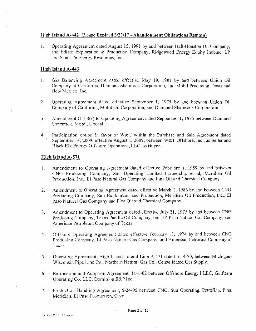
High Island A-442 (Lease Expired 3/27/17 - Abandonment Obligations Remain)
1. Operating Agreement dated August 15, 1991 by and between Hall-Houston Oil Company, and Edisto Exploration & Production Company, Ridgewood Energy Equity Income, LP and Santa Pe Energy Resources, Inc.
High Island A-443
1. Gas Balancing Agreement dated effective May 19, 1981 by and between Union Oil Company of California, Diamond Shamrock Corporation, and Mobil Producing Texas and New Mexico, Inc.
2. Operating Agreement dated effective September 1, 1975 by and between Union Oil Company of California, Mobil Oil Corporation, and Diamond Shamrock Corporation.
3. Amendment (1-1-87) to Operating Agreement dated September 1, 1975 between Diamond Shamrock, Mobil, Unocal.
4. Participation option in favor of W&T within the Purchase and Sale Agreement dated ' September 14, 2009, effective August 1, 2009, between W&T Offshore, Inc., as Seller and
Black Elk Energy Offshore Operations, LLC, as Buyer.
High Island A-571
1. Amendment to Operating Agreement dated effective February 1, 1989 by and between CNG Producing Company, Sun Operating Limited Partnership et al, Meridian Oil Production, Inc., El Paso Natural Gas Company and Fina Oil and Chemical Company.
2. Amendment to Operating Agreement dated effective March 1, 1986 by and between CNG Producing Company, Sun Exploration and Production, Meridian Oil Production, Inc., El Paso Natural Gas Company and Fina Oil and Chemical Company.
3. Amendment to Operating Agreement dated effective July 21, 1975 by and between CNG Producing Company, Texas Pacific Oil Company, Inc., El Paso Natural Gas Company, and American Petroleum Company of Texas.
4. Offshore Operating Agreement dated effective February 13, 1974 by and between CNG Producing Company, El Paso Natural Gas Company, and American Petrofma Company of Texas.
5. Operating Agreement, High Island Lateral Line A-571 dated 3-14-80, between Michigan-Wisconsin Pipe Line Co., Northern Natural Gas Co., Consolidated Gas Supply.
6. Ratification and Adoption Agreement, 11-1-02 between Offshore Energy I LLC, Gulfterra Operating Co. LLC, Dominion E&P Inc.
7. Production Handling Agreement, 5-24-95 between CNG, Sun Operating, Petrofma, Fina, Meridian, El Paso Production, Oryx.
Page 2 of 13 \ i o n / ? < / l 7 Orinoco
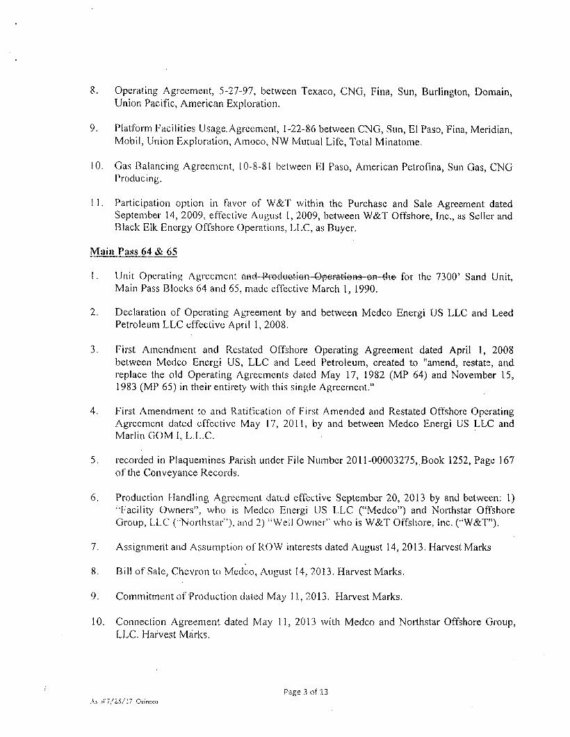
8. Operating Agreement, 5-27-97, between Texaco, CNG, Fina, Sun, Burlington, Domain, Union Pacific, American Exploration.
9. Platform Facilities Usage. Agreement, 1-22-86 between CNG, Sun, El Paso, Fina, Meridian, Mobil, Union Exploration, Amoco, NW Mutual Life, Total Minatome.
10. Gas Balancing Agreement, 10-8-81 between El Paso, American Petrofma, Sun Gas, CNG Producing.
1 1. Participation option in favor of W&T within the Purchase and Sale Agreement dated September 14, 2009, effective August I , 2009, between W&T Offshore, Inc., as Seller and Black Elk Energy Offshore Operations, LLC, as Buyer.
Main Pass 64 & 65
1. Unit Operating Agreement aH^^edtiot-ien-Opet^-tiem-on-tlie for the 7300' Sand Unit, Main Pass Blocks 64 and 65, made effective March 1, 1990.
2. Declaration of Operating Agreement by and between Medco Energi US LLC and Leed Petroleum LLC effective April 1, 2008.
3. First Amendment and Restated Offshore Operating Agreement dated April 1, 2008 between Medco Energi US, LLC and Leed Petroleum, created to "amend, restate, and replace the old Operating Agreements dated May 17, 1982 (MP 64) and November 15, 1983 (MP 65) in their entirety with this single Agreement."
4. First Amendment to and Ratification of First Amended and Restated Offshore Operating Agreement dated effective May 17, 2011, by and between Medco Energi US LLC and Marlin GOM I, L.L.C.
5. recorded in Plaquemines Parish under File Number 2011-00003275,.Book 1252, Page 167 ofthe Conveyance Records.
6. Production Handling Agreement dated effective September 20, 2013 by and between: 1) "Facility Owners", who is Medco Energi US LLC ("Medco") and Northstar Offshore Group, LLC (•"••Northstar'), and 2) "Weil Owner'" who is W&T Offshore, Inc. ("W&T").
7. Assignment and Assumption of ROW interests dated August 14, 2013. Harvest Marks
8. Bill of Sale, Chevron to Medco, August 14, 2013. Harvest Marks.
9. Commitment of Production dated May 11, 2013. Harvest Marks.
10. Connection Agreement dated May 11, 2013 with M edco and Northstar Offshore Group, LLC. Harvest Marks.
Page 3 of 13 As ..if 7/ZS/l ' i Orinoco

11. Main Pass 55 Lease Agreement, dated May 11, 2013 with Medco, Northstar Offshore Group, LLC, and Harvest Marks.
12. Master Agreement, Medco, Northstar Offshore Group, LLC, and Harvest Marks dated May 11,2013.
13. Pipeline Agreement, Asset PSA dated May 15, 2013 between Chevron, Medco, and Northstar Offshore Group, LLC.
14. Romero Pipeline Letter Agreement dated July 10, 2013 between Medco and Northstar Offshore Group, LLC.
Main Pass 256 & 257
1. Agreement for Conversion and Partial Re-Assignment of Net Profits Interest, and Simultaneous Assignment and Grant of Overriding Royalty Interest, by and between Northstar Offshore Group, LLC and NOG Royally Holdings, LP made effective as of 7-1-2017.
2. Offshore Daywork Drilling Contract between Northstar Offshore Group, LLC and ENSCO Offshore Company dated June 6, 2017, covering MP 256 and VK 697.
Ship Shoal 201 & 202 (SS 201 Relinquished 1/30/15 Abandonment Obligations Remain) 1. None.
Shin Shoal 252 (and SS 253 Platform "F" Future Abandonment Liability)
1. Farmout Agreement dated February 15, 2009, between SPN Resources, LLC and Moreno Offshore Resources, as Farmors, and Houston Energy, L.P., as Farmee, as amended.
2. Participation Agreement dated March 30, 2009, between Helis Oil & Gas Company, L.L.C, Houston Energy, L.P., CLF Resources LP, Challenger Minerals Inc., Marlin coastal, L.L.C. and Badger Oil Corporation. Schedule 4.02 (j) Page 9 of 17
3. Offshore Operating Agreement dated March 30, 2009 between Helis Oil & Gas Company, L.L.C, as Operator, and Houston Energy, L.P., et al, as Non-Operators.
4. Memorandum of Offshore Operating Agreement and Financing Statement effective March 30, 2009 between Helis Oil & Gas Company, L.L.C, as Operator, and Houston Energy, L.P., as Non-Operators, being recorded in COB 2154, Page 572, File #1324296 and in MTG Book 28\187, Page 781, File #1324296 all ofthe Records of Terrebonne Parish, Louisiana. UCC-1 Fixture Mineral being recorded under File Number Suffix 55, File Number 1324295 of the Records of Terrebonne Parish, Louisiana.
5. Ratification and Amendment of Operating Agreement dated March 16, 2012 between Helis Oil & Gas Company, L.L.C, Houston Energy, L.P., HE&D Offshore, L.P., Badger Oil Corporation, CL&F Resources LP. Challenger Minerals Inc., Dynamic Offshore Resources, L.L.C, Marlin Coastal, L.L.C. and SPN Resources, LLC.
Page 4 of 13 Ai of 7/25/17 Oniweo

6. Production Handling Agreement dated August 1, 2009 between SPN Resources, LLC and Moreno Offshore Resources L.L.C, as Owner, and Helis Oil & Gas Company, L.L.C, Houston Energy, L.P., CL&F Resources, LP, Badger Oil Corporation, challenger Minerals Inc. and Marlin Coastal, L.L.C, as Producer.
7. Amendment of Production Handling Agreement dated April 27, 2012, between Helis Oil & Gas Company, L.L.C, individually and on behalf of all parties Producer, pursuant to the authorization contained in the Ratification, Dynamic Offshore Resources, LLC and SPN Resources, LLC.
South Marsh Island 8 (Abandonment Obligations Remain (wcllpiugaed but casing must:bc cut) 1. None.
South Marsh Island 41
1. Production Handling Agreement dated effective September 1, 2004 by and between Hunt Petroleum (AEC), Inc. and Devon Energy Production Company.
2. Operating Agreement dated effective June 1, 2003 by and between Hunt Petroleum (AEC), Inc. LLOG Exploration Offshore, Inc. and Devon Energy Production Company.
3. Ratification and Amendment of PHA dated April 1, 2008 between Hunt Petroleum (AEC), Inc. Nippon Oil Exploration USA Limited.
South Pass 86
1. Joint Operating Agreement dated effective January 1, 1972 by and between Signal Oil and Gas Company, The Louisiana Land and Exploration Company, Amerada Hess Corporation and Marathon Oil Company.
2. Participation option in favor of W&T within the Purchase and Sale Agreement dated September 14, 2009, effective August 1, 2009, between W&T Offshore, Inc., as Seller and Black Elk Energy Offshore Operations, LLC, as Buyer.
South Pass 87
1. Assignment of Overriding Royalty Interest only. Assignment, Conveyance and Bill of Sale made and entered this 13 Date of April 15, 2015 but effective as of December 31, 2014 from Black Elk Energy Offshore Operations, LLC in favor of Northstar Offshore Group, LLC.
South Pass 89
I . Joint Operating Agreement dated effective January 1, 1972 by and between Signal Oil and Gas Company, The Louisiana Land and Exploration Company, Amerada Hess Corporation and Marathon Oil Company.
Pages of 13 As of 7/25/[7 Orinoco

Viosca Knoll 697
1. Agreement for Conversion and Partial Re-Assignment of Net Profits Interest, and Simultaneous Assignment and Grant of Overriding Royalty Interest, by and between Northstar Offshore Group, LLC and NOG Royalty Moldings, LP made effective as of 7-1-2017.
2. Offshore Daywork Drilling Contract between Northstar Offshore Group, LLC and ENSCO Offshore Company dated June 6, 2017, covering MP 256 and VK 697.
West Cameron 20
1. Ivan Fisk Surface Lease dated effective March 1, 1960 by and between Ivan Fisk Sr. Et. Al. and British American Producing, and its Amendments: First Amendment dated 3/1/1971; Second Amendment dated 3/1/1991; Third Amendment dated 11/22/1994; Forth Amendment dated 1/9/2006; and the Fifth Amendment dated 3/1/2016.
West Cameron 21
1. Joint Operating Agreement dated July I , 2002 between The William G. Helis Company, L.L.C, as Operator, and Houston Energy, L.P., et al, as Non-Operators.
2. Letter Agreement dated July 11, 2005 from Helis Oil & Gas Company, L.L.C. to Houston Energy, L.P., CL&F Resources LP, Red Willow Offshore, LLC and Chevron U.S.A. Inc., "WC 21 State Group", regarding the acquisition by Helis and Houston of certain rights and interests from Union Oil Company of California in OCS-G 24700 West Cameron Block 22 and the WC 21 State Group pursuant to the reciprocal AMI Agreement between Helis, Houston and the WC 21 State Group in the Participation Agreement dated December 16, 2003, as ratified and amended, as to part of the rights and interest acquired by Helis and Houston.
3. Letter Agreement dated March 10, 2006 from Helis Oil & Gas Company, L.L.C. to Marlin Coastal, L.L.C, McMoRan Oil & Gas LLC, Palace Exploration Company, Kerr-McGee Oil & Gas Corporation and Red Willow Offshore, LLC.
4. Amendment to Joint Operating Agreement dated August 8, 2006 between Helis Oil & Gas Company, L.L.C, Marlin Coastal, L.L.C, Houston Energy, L.P. and Louisiana Offshore Ventures I I , L.P.
5. Marlin Coastal, LLC to the William G. Helis Oil & Gas Company, LLC JOA Amendment Letter dated May 23, 2007.
6. Production Handling Agreement dated April I , 2008 between Helis Oil & Gas Company, L.L.C, Flouston Energy, L.P., and Marlin Coastal, L.L.C, as Owner of West Cameron Block 21 : 'G" Facility, Lease OCS-G 23730 ("Owner") and Helis Oil & Gas Company, L.L.C, Houston Energy, L.P., Marlin Coastal, L.LC, HE&D Offshore, LP, Ridgewood Energy Corporation, Louisiana Offshore Ventures 11 and Hilcorp Energy GOM, LLC, as
Page 6 of 13 As or 7 / 1 5 / 1 / Onnoco
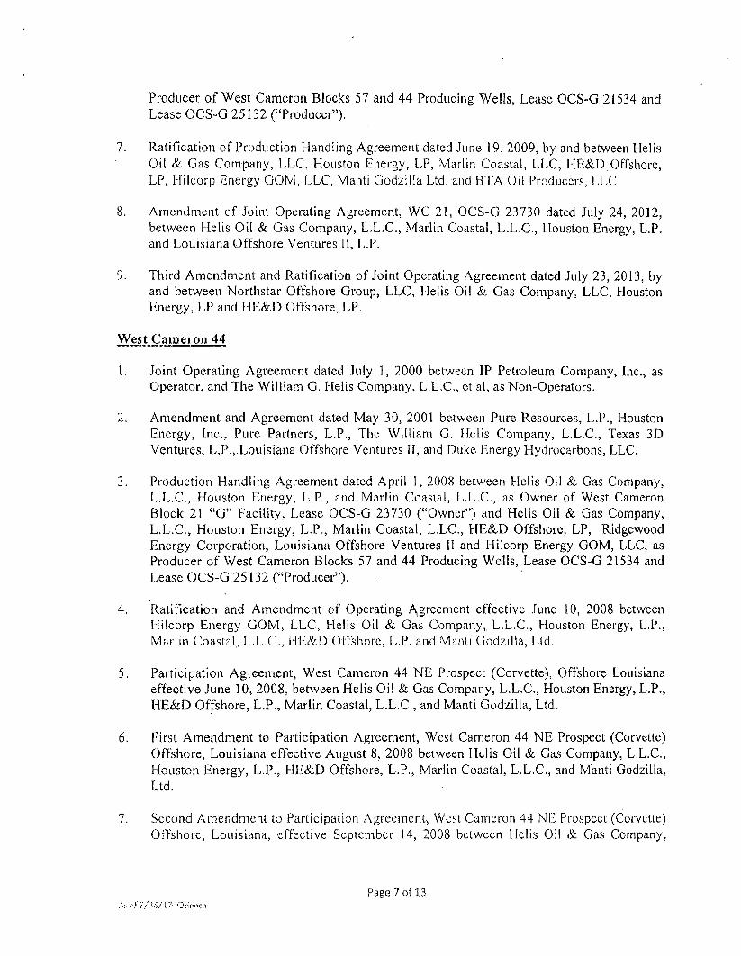
Producer of West Cameron Blocks 57 and 44 Producing Wells, Lease OCS-G 21534 and Lease OCS-G 25132 ("Producer").
7. Ratification of Production Handling Agreement dated June 19, 2009, by and between Helis Oil & Gas Company, LLC, Houston Energy, LP, Marlin Coastal, LLC, HE&D.Offshore, LP, Hilcorp Energy GOM, LLC, Manti Godzilla Ltd. and BTA Oil Producers, LLC
8. Amendment of Joint Operating Agreement, WC 21, OCS-G 23730 dated July 24, 2012, between Helis Oil & Gas Company, L.L.C, Marlin Coastal, L.L.C, Houston Energy, L.P. and Louisiana Offshore Ventures II , L.P.
9. Third Amendment and Ratification of Joint Operating Agreement dated July 23, 2013, by and between Northstar Offshore Group, LLC, Helis Oil & Gas Company, LLC, Houston Energy, LP and HE&D Offshore, LP.
West Cameron 44
1. Joint Operating Agreement dated July 1, 2000 between IP Petroleum Company, Inc., as Operator, and The William G. Llelis Company, L.L.C, et al, as Non-Operators.
2. Amendment and Agreement dated May 30, 2001 between Pure Resources, L.P., Houston Energy, Inc., Pure Partners, L.P., The William G. Helis Company, L.L.C, Texas 3D Ventures, L.P...Louisiana Offshore Ventures II, and Duke Energy Hydrocarbons, LLC
3. Production Handling Agreement dated April 1, 2008 between Helis Oil & Gas Company, L.L.C, Houston Energy, L.P., and Marlin Coastal, L.L.C, as Owner of West Cameron Block 21 "G" Facility, Lease OCS-G 23730 ("Owner") and Helis Oil & Gas Company, L.L.C, Houston Energy, L.P., Marlin Coastal, L.LC, HE&D Offshore, LP, Ridgewood Energy Corporation, Louisiana Offshore Ventures II and Hilcorp Energy GOM, LLC, as Producer of West Cameron Blocks 57 and 44 Producing Wells, Lease OCS-G 21534 and Lease OCS-G 25132 ("Producer").
4. Ratification and Amendment of Operating Agreement effective June 10, 2008 between Hilcorp Energy GOM, LLC, Helis Oil & Gas Company, L.L.C, Houston Energy, L.P., Marlin Coastal, L.L.C, HE&D Offshore, L.P. and Manti Godzilla, Ltd.
5. Participation Agreement, West Cameron 44 NE Prospect (Corvette), Offshore Louisiana effective June 10, 2008, between Helis Oil & Gas Company, L.L.C, Houston Energy, L.P., HE&D Offshore, L.P., Marlin Coastal, L.L.C, and Manti Godzilla, Ltd.
6. First Amendment to Participation Agreement, West Cameron 44 NE Prospect (Corvette) Offshore, Louisiana effective August 8, 2008 between Flelis Oil & Gas Company, L.L.C, Houston Energy, L.P., HE&D Offshore, L.P., Marlin Coastal, L.L.C, and Manti Godzilla, Ltd.
7. Second Amendment to Participation Agreement, West Cameron 44 NE Prospect (Corvette) Offshore, Louisiana, effective September 14, 2008 between Helis Oil & Gas Company,
Page 7 of 13 A> o f / / I S / \ 7- Otinocu

L.L.C, Houston Energy, L.P., HE&D Offshore, L.P, Marlin Coastal, L.L.C, and Manti Godzilla, Ltd.
8. Ratification and Amendment of Operating Agreement effective March 1, 2009 between Hilcorp Energy GOM, LLC, Helis Oil & Gas Company, L.L.C, Houston Energy, L.P, Marlin Coastal, L.L.C, HE&D Offshore, L.P, Manti Godzilla, L td , BTA Oil Producers, LLC.
9. Participation Agreement, West Cameron 44 Z-28 Prospect, Offshore, Louisiana effective March I , 2009 between Helis Oil & Gas Company, L.L.C, Houston Energy, L.P, HE&D Offshore, L.P, Marlin Coastal, L.L.C, and Manti Godzilla, Ltd. and BTA Oil Producers, LLC.
10. Ratification of Production Handling Agreement dated June 19, 2009, by and between Helis Oil & Gas Company, LLC, Houston Energy, LP, Marlin Coastal, LLC, HE&D Offshore, LP, Hilcorp Energy GOM, LLC, Manti Godzilla Ltd. and BTA Oil Producers, LLC.
11. Ratification and Amendment to the Operating Agreement dated July 23, 2013, by and between Northstar Offshore Group, LLC, Helis Oil & Gas Company, LLC, Houston Energy, LP, HE&D Offshore, LP, EPL Oil & Gas, Inc., Manti Operating Company and
. BTA Oil Producers, LLC
West Cameron 57
1. Joint Operating Agreement dated July 1, 2000 between IP Petroleum Company, Inc., as Operator, and The William G. Helis Company, L.L.C, et al, as Non-Operators.
2. Amendment and Agreement dated May 30, 2001 between Pure Resources, L.P, Pure Partners, L.P, Houston Energy, Inc., The William G. Helis Company, L.L.C, Texas 3D Ventures, L.P, Duke Energy Hydrocarbons, LLC and Louisiana Offshore Ventures II .
3. Amendment to Joint Operating Agreement, Outer Continental Shelf - Gulf of Mexico effective December 17, 2004 between Houston Energy, L.P, Helis Oil & Gas Company, L.L.C. Marlin Energy Offshore, LLC, HE&D Offshore, L.P. and Pure Resources, L.P.
4. Participation Agreement dated September 5, 2007 between Chevron Midcontinent, L.P. (formerly named Pure Resources, L.P.), Marlin Coastal, L.L.C, Helis Oil and Gas Company, LLC, Houston Energy, L.P. and Ridgewood Energy Corporation. (El Toro Prospect).
5. Ratification and Amendment of Operating Agreement effective January 27, 2008 between Hilcorp Energy GOM, LLC, Helis Oil & Gas Company, L.L.C, Houston Energy, L.P, Marlin Coastal, L.L.C, HE&D Offshore, L.P. and Ridgewood Energy Corporation.
6. Production Handling Agreement dated April I , 2008 between Helis Oil & Gas Company, L.L.C, Houston Energy, L.P, and Marlin Coastal, L.L.C, as Owner of West Cameron Block 21 -'G" Facility, Lease OCS-G 23730 ("Owner") and Helis Oil & Gas Company, L.L.C, Houston Energy, L.P, Marlin Coastal, L.LC, HE&D Offshore, LP, Ridgewood
Page 8 of 13 As of 7 / 2 5 / 1 7 Orinoco

Energy Corporation, Louisiana Offshore Ventures II and Hilcorp Energy GOM, LLC, as Producer of West Cameron Blocks 57 and 44 Producing Wells, Lease OCS-G 21534 and Lease OCS-G 25132 ("Producer").
7. Ratification of Production Handling Agreement dated June 19, 2009, by and between Helis Oil & Gas Company, LLC, Houston Energy, LP, Marlin Coastal, LLC, HE&D Offshore, LP, Hilcorp Energy GOM, LLC, Manti Godzilla Ltd. and BTA Oil Producers, LLC.
8. Ratification and Amendment to the Operating Agreement dated July 23, 2013, by and between Northstar Offshore Group, LLC, Helis Oil & Gas Company, LLC, Houston Energy, LP, HE&D Offshore, LP and EPL Oil & Gas, Inc.
West Cameron 269
1. Offshore Operating Agreement dated 12-1-11 by and between Black Elk Energy Offshore Operations, LLC; Peregrine Oil & Gas II, LLC, Apache Corporation and Castex Offshore, Inc.
West Delta 36 (Lease Expired 10/31/15 -Abandonment Obligations Remain)
1. Offshore Operating Agreement effective February I , 2006 between Marlin Coastal, L.L.C, as Operator, and Peregrine Oil & Gas, LP, Challenger Minerals Inc., Dynamic Offshore Resources NS, LLC and Republic Exploration LLC, as Non-Operators.
See Marketing Contracts on Following Page....
Page 9 of 13 As of 7/IS/-1? Ominco

MARKETING CONTRACTS
Marketing Contracts by Block
Area Block Affected
Area Block(s) Contract Description
Effective Date
Eugene Island 183/184 El 183 El 184
Dehydration Service Agreement between WFS-tiquids Company and Darcy Energy, LLC
5/1/2007
Eugene Island 183/184 El 183 El 184
Agreement for Processing Gas Delivered by Transcontinental Gas Pipe Line Corporation to the North Terrebonne Gas Processing Plant. (Exhibit F to the C&O Agreement dated July 25, 2007.
6/25/2007
Eugene Island 183/184 El 183 El 184
First Amendment to Gas Processing, Fractionation & Product Purchase Agreement dated Effective March 1, 2013, between Northstar Offshore Group, LLC and Enterprise Gas Processing, LLC.
7/18/2008
Eugene Island .183/184 El 183 El 184
Injected and Retrograde Condensate Transportation and BTU Reduction Make-up Agreement - Southeast Lateral dated effective 10-1-2012 between Transcontinental Gas Pipe Line Company and Northstar Offshore Group, LLC
10/1/2012
Eugene Island 183/184 El 183 El 184
Raw Make Purchase Letter Agreement for the North Terrebonne Gas Plant
12/20/2012
Eugene Island 183/184 El 183 El 184
Crude Contract between Shell Trading and Northstar Offshore Group, LLC dated 12/5/2016
1/1/2017
Eugene Island 183/184 El 183 El 184
C &. O Agreement Ratification and Joinder Agreement between Marlin GOM 1, L.L.C, and Enterprise Gas Processing, LLC as Operator of the North Terrebonne Gas Processing Plant and the Tebone Fractionation Plant.
No date provided
High Island A-442 Expired 3/27/17
HI A-442 Platform Connection Agreement by and between Santa Fe Energy Products and the Operator of the High Island Pipeline System
3/28/1997
High Island A-442 Expired 3/27/17
HI A-442 Lateral Line Operating Agreement dated July 3, 2002 between Ocean Energy and HIOS.
7/3/2002
High Island A-442 Expired 3/27/17
HI A-442 NGL Bank Agreement dated May 5, 2004, between SPL, Inc., et al and High Island Offshore System - This works with the gas transportation agreement with HIOS which is being assigned KffGM-300-0502.
5/5/2004
High Island A-442 Expired 3/27/17
HI A-442 HI A-443 HI A-571
IT Agreement between High Island Offshore System LLC and Black Elk Energy Offshore operations LtC date 12/1/2009
12/1/2009
High Island A-442 Expired 3/27/17
HIOS 442 HIOS 443 HIOS 571
NGL Bank Agreement dated December 1, 2009 between SPL, Black Elk and HIOS.
12/1/2009
A s o ( ' 7 / 2 5 / l 7 O m
Page 10 of 13

Area Block Affected
Area Blockfs) Contract Description
Effective Date
High Island A-442 Expired 3/27/17
HI A-442 Lateral Line Operating Agreement dated December 1, 2012 between Enterprise GTM Offshore Operating Company and Black Elk Energy Offshore Operations.
12/1/2012
High Island A-442 Expired 3/27/17
HIOS 442 HIOS 443 HIOS 571
Assignment of Lateral tine Agreements between Enterprise GTM Offshore Operating and High Island Offshore Services dated June 21, 2013
6/12/2013
High Island A-442 Expired 3/27/17
HI A-442 HI A-443 HI A-571
High Island Pipeline System (HIPS) Operating and Administrative Management Agreement dated effective June 1, 2009 by and between Owners of High Island Pipeline System (HIPS)
6/1/2009
High Island A-442 Expired 3/27/17
HI A-442 HI A-443 HI A-571
High Island Pipeline System (HIPS) Owners Agreement dated effective June 1, 2009 by and between Owners of High Island Pipeline System (HIPS)
6/1/2009
High Island A-443 HI A-442 HI A-443 HI A-571
High Island Pipeline System (HIPS) Operating and Administrative Management Agreement dated effective June 1, 2009 by and between Owners of High Island Pipeline System (HIPS)
6/1/2009
High Island A-443 HI A-442 HI A-443 HI A-571
High Island Pipeline System (HIPS) Owners Agreement dated effective June 1, 2009 by and between Owners bf High Island Pipeline System (HIPS)
6/1/2009
High Island A-443 HIOS 442 HIOS 443 HIOS 571
IT Agreement between High Island Offshore System LLC and Black Elk Energy Offshore operations LLC date 12/1/2009
12/1/2009
High Island A-443 HI A-443 HI A-571
Reserve Commitment Agreement dated December 1, 2009 between HIOS and Black Elk Energy Operations LLC
12/1/2009
High Island A-443 HI A-442 HI A-443 HI A-571
IT Agreement between High Island Offshore System LLC and Black Elk Energy Offshore operations LLC date 12/1/2009
12/1/2009
High Island A-443 HIOS 442 HIOS 443 HIOS 571
NGL Bank Agreement dated December 1, 2009 between SPL, Black Elk and HIOS.
12/1/2009
High Island A-443 HI A-443 Lateral Line Operating Agreement, February 4, 2013 between Enterprise GTM Offshore Operating Company and Black Elk Energy Offshore Operations.
241/2013
High Island A-443 HI A-443 Buy Back Operating Agreement between High Island Offshore System, LL.C. and Black Elk Energy Offshore Operations, LLC dated August 29, 2013
8/23/2013
High Island ' A-443 HI A-443 Crude Contract between Shell Trading and Northstar Offshore Group, LLC dated 12/5/2016
1/1/2017
As of 7 / 2 5 / [ 7 Ormoro
Page 11 of 13

Area Block Affected
A'rea Block(s) Contract Description
Effective Date
High Island A-571 HI A-442 HI A-443 HI A-571
High Island Pipeline System (HIPS) Operating and Administrative Management Agreement dated effective June 1, 2009 by and between Owners of High Island Pipeline System (HIPS)
6/1/2009
High Island A-571 HI A-442 HI A-443 HI A-571
High Island Pipeline System (HIPS) Owners Agreement dated effective June 1, 2009 by and between Owners of High Island Pipeline System (HIPS).
6/1/2009
High island A-571 ' HI A-443 HI A-571
Reserve Commitment Agreement dated December 1, 2009 between HIOS and Black Elk Energy Operations LLC
12/1/2009
High Island A-571 HI A-442 HI A-443 HI A-571
IT Agreement between High Island Offshore System LLC and Black Elk Energy Offshore operations LLC date 12/1/2009
12/1/2009
High Island A-571 HIOS 442 HIOS 443 HIOS 571
NGL Bank Agreement dated December 1, 2009 between SPL, Black Elk and HIOS.
12/1/2009
High Island A.571 HI A-571 Amendment to Reserve Commitment Agreement date April' 1, 2010 between High Island Offshore System L.L.C. and Black Elk Energy Offshore Operations LLC
4/1/2010
High Island A-571 HI A-571 Lateral Line Operating Agreement, entered into as of December 1, 2012 12 1 12 by and between-Enterprise GTM Offshore Operating Co. LLC, Black Elk Energy Offshore Operations, Pisces Energy LLC
12/1/2012
High Island A-571 HIOS 442 HIOS 443 HIOS 571
Assignment of Lateral Line Agreements between Enterprise GTM Offshore Operating and High Island Offshore Services dated June 21, 2013
6/12/2013
High Island A-571 HI A-571 Crude Contract between Shell Trading and Northstar Offshore Group, LLC dated 12/5/2016
1/1/2017
Ship Shoal 252 ; SS 252 !
Gas Processing, Fractionation & Products Purchase Agreement (ffL1109) dated March 1, 2010 (Transco and/or Gulf South) between Marlin Coastal, L.L.C. and Enterprise Gas Processing, LLC, North Terrebonne Gas Processing Plant, Tebone Fractionation Plant
3/1/2010
South Marsh Island
41 SM41 Gathering System Agreement dated September 24, 1973 between Exxon Pipeline Company and Chevron Oil Company
9/24/1973
South Marsh Island
41 SM41 Crude Contract between Shell Trading and Northstar Offshore Group, LLC dated 12/5/2016
1/1/2017
As o i : 7 / i . 5 / i 7 OwlniKo
Page 12 of 13
Area Block Affected
Area Block(s) Contract Description Effective
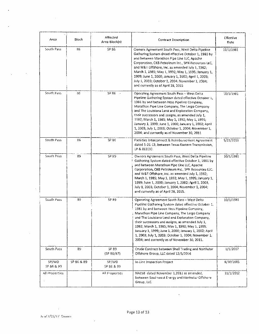
Date
South Pass 86 SP 86 Owners Agreement South Pass, West Delta Pipeline Gathering System dated effective October 1,1981 by and between Marathon Pipe Line tLC, Apache Corporation, CKB Petroleum Inc., SPN Resources LLC, and W&T Offshore; Inc. as amended July 1,1982; March 1,1985; May 1,1992; May 1,1995; January 1, 1999; June 1, 2000; January 1, 2002; April 1, 2003; July 1, 2003; October 1, 2004; November 1, 2004; and currently as of April 28, 2015
10/1/1981
South Pass 86 SP86 • Operating Agreement South Pass - West Delta Pipeline Gathering System dated effective October 1, 1981 by and between Hess Pipeline Company, Marathon Pipe Line Company, The Largo Company and The Louisiana Land and Exploration Company, their successors and assigns, as amended July 1, 1982; March 1, 1985; May 1, 1992; May 1,1995; January 1, 1999; June 1, 2000; January 1, 2002; April 1, 2003; July 1, 2003; October 1, 2004; November 1, 2004; and currently as of November 30, 2011
10/1/1981
South Pass 86 SP86 Facilities Interconnect & Reimbursement Agreement dated 5-21-13, between Texas Eastern Transmission, LP & BEEOO.
5/21/2013
South Pass 89 SP89 Owners Agreement South Pass, West Delta Pipeline Gathering System dated effective October 1, 1981 by and between Marathon Pipe Line LLC, Apache Corporation, CKB Petroleum Inc., SPN Resources LLC, and W&T Offshore, Inc. as amended July 1,1982; March 1,1985; May 1,1992; May 1,1995; January 1, 1999; June 1, 2000; January 1, 2002; April 1, 2003; July 1, 2003; October 1, 2004; November 1, 2004; and currently as of April 28, 2015.
10/1/1981
South Pass 89 SP 89 Operating Agreement South Pass - West Delta Pipeline Gathering System dated effective October 1, 1981 by and between Hess Pipeline Company, Marathon Pipe Line Company, The Largo Company and The Louisiana Land and Exploration Company, their successors and assigns, as amended July 1, 1982; March 1, 1985; May 1,1992; May 1, 1995; January 1,1999; June 1, 2000; January 1, 2002; April 1, 2003; July 1, 2003; October 1, 2004; November 1, 2004; and currently as of November 30, 2011.
10/1/1981
South Pass 89 SP89 (SP 86/87)
Crude Contract between Shell Trading and Northstar Offshore Group, LLC dated 12/5/2016
1/1/2017
SP/WD SP86&89
SP86&89 SP/WD SP 86 & 89
In-Line Inspection Project 6/30/2005
All Properties All Properties NAESB dated November 1,2012 as amended, between Southwest Energy and Northstar Offshore Group, LLC
11/1/2012
As of I / I S / 1 7 Orinoco
Page 13 of 13

EXHIBIT A.B
Easements
None.
Rights of Way listed on Exhibit A-5
Surface Leases listed on Exhibit A
Page 1 of 1
As of 7-14-17 Orinoco

EXHIBIT A-4
EQUIPMENT
Area Block
OCS
Lease Structure Name Structure tt Status Operator
Ownership
Interest
El 133 G33092 #1 Caisson 2562 Expired PStA Liability
Northstar 100.00000%
El 184 G05498 Platform A 23932 PROD Northstar 100.00000%
Et 184 G05498 Offshore Compressor
(El 184 A)
N/A PROD Northstar 100.00000%
HI A 442 G11383 Platform A 28020 Terminated P&A Liability
Northstar 45.45452%
HI A 442 G11383 Platform B 783 Terminated P&A Liability
Northstar 45.45452%
HI A 443 G03241 Platform A 10128 PROD Northstar 98.56000% *********
Future Platform Abandonment 84.0000% ***********
See Footnote #1
HI A 5 7 1 G02391 Platform A 10116 PROD Northstar 79.16500%
HI A 571 G02391 Platform
B-Aux
10116 PROD Northstar 79.16500%
MP 64 G04909 Platform A 22798 PROD Medco Energi 25.00000%
MP 64 G04909 Platform AQ 22798 PROD Medco Energi 25.00000%
MP 64 G04909 Platform B 22913 PROD Medco Energi 25.00000%
MP 64 G04909 til Caisson 22798 PROD Medco Energi 25.00000%
MP 64 G04909 #1 Caisson 22910 PROD Medco Energi 25.00000%
MP 64 G04909 #3 Caisson 22912 PROD Medco Energi 25.00000%
MP 64 G04909 #5 Caisson 22914 PROD Medco Energi 25.00000%
MP 64 G04909 #6 Caisson 22915 PROD Medco Energi 25.00000%
MP 64 G04909 #7 Caisson 22916 PROD Medco Energi 25.00000%
As of 7/11/17 Orinoco
Page 1 of 4

Area Block
OCS
Lease Structure Name Structure # Status Operator
Ownership
Interest MP 64 G04909 #8 Caisson 22917 PROD Medco Energi 25.00000%
MP 64 G04909 U9 Caisson 22918 PROD Medco Energi 25.00000%
MP 64 G04909 #10 Caisson 22919 PROD Medco Energi 25.00000%
MP 64 G04909 / / l l Caisson 22920 PROD Medco Energi 25.00000%
MP 64 G04909 #12 Caisson 22921 PROD Medco Energi 25.00000%
MP 64 G04909 #13 Caisson 22922 PROD Medco Energi 25.00000%
MP 64 G04909 #14 Caisson 23130 PROD Medco Energi 25.00000%
MP 64 G04909 #15 Caisson 23403 PROD Medco Energi 25.00000%
MP 64 G04909 #17 Caisson 23404 PROD Medco Energi 25.00000%
MP 64 G04909 #18 Caisson 24114 PROD Medco Energi 25.00000%
MP 64 G04909 #19 Caisson 23877 PROD Medco Energi 25.00000%
MP 64 G04909 #20 Caisson 24121 PROD Medco Energi 25.00000%
MP 65 G05692 Platform A 23057 PROD Medco Energi 25.00000%
SM 41 G01192 Platform A 20713 PROD Northstar 100.00000%
SM 41 G01192 Platform CA 23208 PROD Northstar 100.00000%
SP 86 G05687 Platform C 24103 PROD Northstar 63.88889%
SS 202 G31394 Platform A 23560 Expired P&A
Liability
Northstar 100.00000%
SS 253 G01031 Platform F 26072 PROD Northstar 6.93750%
WC 20 680 Platform A 20891 PROD Northstar 100.00000%
WC 20 680 Platform D 2038 PROD Northstar 100.00000%
WC 20 680 Platform D-Aux 1 2038 PROD Northstar 100.00000%
As of 7/11/17 Orinoco Page 2 of 4
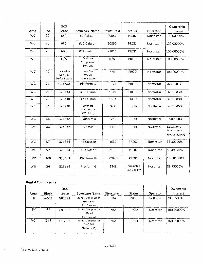
Area Block
OCS
Lease Structure Name Structure # Status Operator
Ownership
Interest WC 20 680 #2 Caisson 20881 PROD Northstar 100.00000%
WC 20 680 #10 Caisson 20890 PROD Northstar 100.00000%
WC 20 680 #14 Caisson 21011 PROD Northstar 100.00000%
WC 20 N/A Onshore Compressor
(WC20)
N/A PROD Northstar 100.00000%
WC 20 Located on Ivan Fisk
Surface Lease
Ivan Fisk WC 20
Tank Battery
N/A . PROD Northstar 100.00000%
WC 21 G23730 Platform G 1641 PROD Northstar 56.70000%
WC 21 G23730 #1 Caisson 1641 PROD Northstar 56.70000%
WC •21 G23730 #2 Caisson 1653 PROD Northstar 56.70000%
WC 21 G23730 Offshore Compressor (WC216)
N/A PROD Northstar 56.70000%
WC 44 G21532 Platform B 1252 PROD Northstar 33.00000%
WC 44 G21532 #2 WP 1398 PROD Northstar 12.92324% ***********
See Footnote #2
WC 57 G21534 #2 Caisson 1639 PROD Northstar 33.30000%
WC 57 G21534 #3 Caisson 2119 PROD Northstar 58.49170%
WC 269 G13563 Platform JA 29040 PROD Northstar 100.00000%
WD 36 G23956 Platform G 1948 Terminated P&A Liability
Northstar 88.75000%
Rental Compressors
Area Block
OCS
Lease Structure Name Structure # Status Operator
Ownership
Interest
HI A-571 G02391 Rental Compressor (HI A-571
Platform A)
' N/A PROD Nothstar 79.16500%
SM 41 G01192 Rental Compressor (SM 41
Platform A)
N/A PROD Nothstar 100.00000%
WC 269 G13563 Rental Compressor
(WC 269
Platform JA)
N/A PROD Nothstar 100.00000%
As of 7/11/17 Orinoco Page 3 of 4

OCS Ownership
Area Block Lease Structure Name Structure # Status Operator Interest
All furniture and fixtures located at 11 Greenway Plaza, Suite 2800, Houston, Texas 77046
' 1 ' HJ A-443: Northstar proposed a Lease-Saving Operation to be conducted on the #A-5 Well. ANKOR E&P Holdings and SCt Resources
non-consented the proposed operation and as a result must forfeit their ownership within this Lease, Assignments are being processed at
this time to transfer the forfeit interest Into Northstar. ANKOR & SCL will retain future P&A liability for any wells in which they historically
participated within this lease. Northstar's interests reflect P&A liability as to historical wells and an increased WI/NRI in any future well
operations based on the additional interest to be assigned.
' 2 ' West Cameron 44 Well t i l : Persuant to notice dated April 20, 2017, Shoreline Energy LLC was dissolved under Bankruptcy proceedings effective March 7, 2017 and therefore are no longer owners in the WC 44 Lease. Shoreline's ownership in this Operating Rights portion of the lease consisted of the #2 Well and the #2 Caisson. Northstar and other remaining working interest partners have each had to accept their pro-rata share of Shoreline's surrendered 22.62000% participating interest.
Page 4 of 4 As of 7/11/17 Orinoco
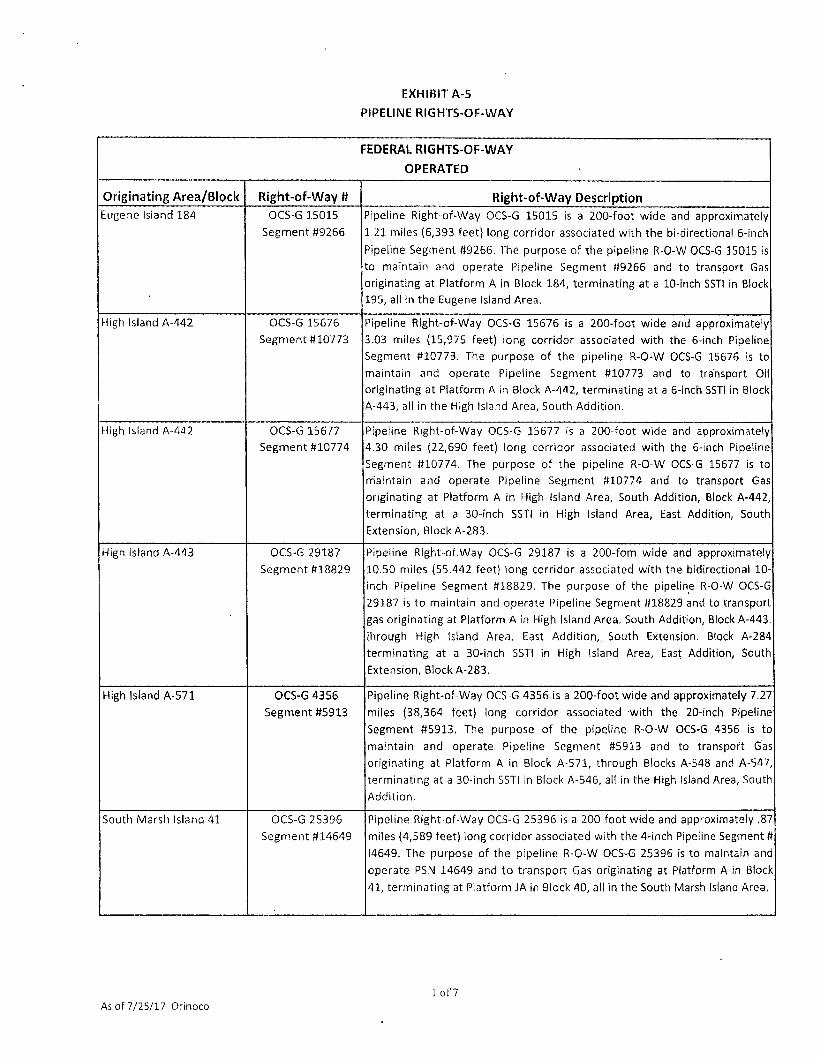
EXHIBIT A-5
PIPELINE RIGHTS-OF-WAY
FEDERAL RIGHTS-OF-WAY OPERATED
Originating Area/Block Right-of-Way # Right-of-Way Description Eugene Island 184 OCS-6 15015
Segment #9266
Pipeline Right-of-Way OCS-G 15015 is a 200-foot wide and approximately
1.21 miles (6,393 feet) long corridor associated with the bi-directional 6-inch
Pipeline Segment #9266. The purpose of the pipeline R-O-W OCS-G 15015 is
to maintain and operate Pipeline Segment #9266 and to transport Gas
originating at Platform A in Block 184, terminating at a 10-inch SSTI in Block
195, all in the Eugene Island Area.
High Island A-442 OCS-G 15676
Segment #10773
Pipeline Right-of-Way OCS-G 15676 is a 200-foot wide and approximately
3.03 miles (15,975 feet) long corridor associated with the 6-inch Pipeline
Segment #10773. The purpose of the pipeline R-O-W OCS-G 15676 is to
maintain and operate Pipeline Segment #10773 and to transport Oil
originating at Platform A in Block A-442, terminating at a 6-inch SSTI in Block
A-443, all in the High Island Area, South Addition.
High Island A-442 OCS-G 15677
Segment #10774
Pipeline Right-of-Way OCS-G 15677 is a 200-foot wide and approximately
4.30 miles (22,690 feet) long corridor associated with the 6-inch Pipeline
Segment #10774. The purpose of the pipeline R-O-W OCS-G 15677 is to
nriaintain and operate Pipeline Segment #10774 and to transport Gas
originating at Platform A in High Island Area, South Addition, Block A-442,
terminating at a 30-inch SSTI in High Island Area, East Addition, South
Extension, Block A-283.
High Island A-443 OCS-G 29187
Segment #18829
Pipeline Right-of.Way OCS-G 29187 is a 200-fom wide and approximately
10.50 miles (55.442 feet) long corridor associated with the bidirectional 10-
inch Pipeline Segment #18829. The purpose of the pipeline R-O-W OCS-G
29187 is to maintain and operate Pipeline Segment #18829 and to transport
gas originating at Platform A in High Island Area. South Addition, Block A-443.
ihrough High Island Area. East Addition,. South Extension. Block A-284
terminating at a 30-inch SSTI in High Island Area, East Addition, South
Extension, Block A-283.
High Island A-571 OCS-G 4356
Segment #5913
Pipeline Right-of-Way OCS-G 4356 is a 200-foot wide and approximately 7.27
miles (38,364 feet) long corridor associated with the 20-inch Pipeline
Segment #5913. The purpose of the pipeline R-O-W OCS-G 4356 is to
maintain and operate Pipeline Segment #5913 and to transport Gas
originating at Platform A in Block A-571, through Blocks A-548 and A-547,
terminating at a 30-inch SSTI in Block A-546, all in the High Island Area, South
Addition.
South Marsh Island 41 OCS-G 25396
Segment #14649
Pipeline Right-of-Way OCS-G 25396 is a 200-foot wide and approximately .87
miles (4,589 feet) long corridor associated with the 4-inch Pipeline Segment #
14649. The purpose of the pipeline R-O-W OCS-G 25396 is to maintain and
operate PSN 14649 and to transport Gas originating at Platform A in Block
41, terminating at Platform JA in Block 40, all in the South Marsh Island Area.
As of 7/25/17 Orinoco 1 of 7
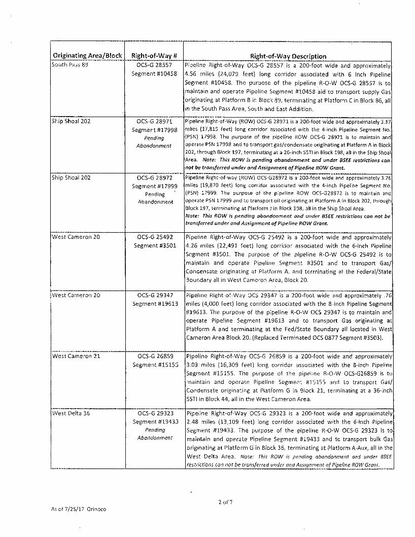
Originating Area /Block Right-of-Way # Right-of-Way Description South Pass 89 OCS-G 28557
Segment #10458
Pipeline Right-of-Way OCS-G 28557 is a 200-foot wide and approximately
4.56 miles (24,079 feet) long corridor associated with 6 inch Pipeline
Segment #10458. The purpose of the pipeline R-O-W OCS-G 28557 is to
maintain and operate Pipeline Segment #10458 aid to transport supply Gas
originating at Platform B in Block 89, terminating at Platform C in Block 86, all
in the South Pass Area, South and East Addit ion.
Ship Shoal 202 OCS-G 28971
Segment #17998
Pending
Abandonment
Pipeline Right-of-Way (ROW) OCS-G 28971 is a 200-foot wide and approximately 3.37 miles (17,815 feet) long corridor associated with the 4-inch Pipeline Segment No. (PSN) 17998. The purpose of the pipeline ROW OCS-G 28971 is to maintain and operate PSN 17998 and to transport gas/condensate originating at Platform A in Block 202, through Block 197, terminating at a 26-inch SSTI in Block 198, all in the Ship Shoal Area. Note: This ROW Is pending abandonment and under BSEE restrictions can not be transferred under and Assignment of Pipeline ROW Grant.
Ship Shoal 202 OCS-G 28972
Segment «17999
Pending
Abandonment
Pipeline Right-of-way (ROW) OCS-G28972 is a 200-foot wide and approximately 3.76 miles (19,870 feet) long corridor associated with the 4-inch Pipeline Segment No. (PSN) 17999. The purpose of the pipeline ROW OCS-G28972 is to maintain and operate PSN 17999 and to transport oil originating at Platform A in Block 202, through Block 197, terminating at Platform J in Block 198, all in the Ship Shoal Area. Note: This ROW is pending abandonment and under BSEE restrictions can not be transferred under and Assignment of Pipeline ROW Grant.
West Cameron 20 OCS-G 25492
Segment #3501
Pipeline Right-of-Way OCS-G 25492 is a 200-foot wide and approximately
4.26 miles (22,491 feet) long corridor associated with the 6-inch Pipeline
Segment #3501. The purpose of the pipeline R-O-W OCS-G 25492 is to
maintain and operate Pipeline Segment #3501 and to transport Gas/
Condensate originating at Platform A. and terminating at the Federal/State
Boundary all in West Cameron Area, Block 20.
West Cameron 20 OCS-G 29347
Segment #19613
Pipeline Right-of-Way OCS 29347 is a 200-foot wide and approximately .76
miles (4,000 feet) long corridor associated with the 8-inch Pipeline Segment
#19613. The purpose of the pipeline R-O-W OCS 29347 is to maintain and
operate Pipeline Segment #19613 and to transport Gas originating at
Platform A and terminating at the Fed/State Boundary all located in West
Cameron Area Block 20. (Replaced Terminated OCS 0877 Segment #3503).
West Cameron 21 OCS-G 26859
Segment #15155
Pipeline Right-of-Way OCS-G 26859 is a 200-foot wide and approximately
3.09 miles (16,309 feet) long corridor associated with the 8-inch Pipeline
Segment #15155. The purpose of the pipeline R-O-W OCS-G26859 is to
maintain and operate Pipeline Segment #15155 and to transport Gas/
Condensate originating at Platform G in Biock 21, terminating at a 36-inch
SSTI in Block 44, all in the West Cameron Area,
West Delta 36 OCS-G 29323
Segment #19433
Pending
Abandonment
Pipeline Right-of-Way OCS-G 29323 is a 200-foot wide and approximately
2.48 miles (13,109 feet) long corridor associated with the 6-inch Pipeline
Segment #19433. The purpose of the pipeline R-O-W OCS-G 29323 is to
maintain and operate Pipeline Segment #19433 and to transport bulk Gas
originating at Platform G in Block 36, terminating at Platform A-Aux, all in the
West Delta Area. Wofe: This ROW is pending abandonment and under BSEE
restrictions can not be transferred under and Assignment of Pipeline ROW Grant.
As of 7/25/17 Orinoco 2 of?

STATE OF LOUISIANA RIGHTS-OF-WAY OPERATED
Originating Area/Block Right-of-Way « Right-of-Way Description
West Cameron 20 State Lease
R-O-W #643
Right-of-Way #643 for certain rights through and under State Lands located
n Cameron Parish, Louisiana and extending southward into the Gulf of
Mexico, traversing under water bottoms in the offshore waters known as
West Cameron Area, Offshore Louisiana, Block No. 20, situated in the Parish
of Cameron, State of Louisiana. This Right-of-Way is associated with Federal Lease
West Cameron 2 OCS-0680.
RIGHTS-OF-WAY ASSOCIATED WITH NORTHSTAR LEASES
OUTSIDE OPERATED
Originating Area /Block Right-of-Way # Right-of-Way Description
Main Pass 55 OCS-G 7541
Pig-Trap Accessory
Platform Pig-Trap: An accessory platform to R-O-VV OCS-G 7541 in Main Pass Area Block 55. Northstar holds a 25% interest and Medco Energi US LLC holds a 75% interest in this Pipeline R-O-W Grant.
Main Pass 65 OCS-G 7541
Segment 1 #7294
Segment #7294: A 200 foot R-O-W to operate and maintain a 4-1/2 inch pipeline. 3.60 miles in length to transport oil from Platform A in block 65, through block 56, to Platform PIG-TRAP in Block 55, all located in Main Pass Area. Northstar holds a 25% interest and Medco Energi US LLC holds a 75% interest in this Pipeline R-O-W Grant
Main Pass 65 OCS-G 7541
Segment 2 #11963
Segment 811963: A 200 foot R-O-W to operate and maintain a 4-1/2 inch pipeine, 0.012 miles in length, to transport oil from Platform PIG-TRAP in Block 55, to a subsea tie-in Block 55, all located in Main Pass Area. Northstar holds a 25% interest and Medco Energi US LLC holds a 75% interest in this Pipeline R-O-W Grant.
Main Pass 55 OCS-G 1380
Segment #4892 .
Main Pass 55 ROW: Pipeline ROW OCS-G 1380, Segment 84892, a 200 foot wide right-of-way to operate and maintain a 12-3/4-inch O D pipeline, 0.39 miles in length, to transport oil from Sub Sea Tie-in (SSTI) in Block 55, to Federal/Stae Boundary in Block 55, all located in Main Pass Area.
Main Pass 64 OCS-G 8051
Segment #7640
OCS-G 08051, Segment Number 7640: A 200-foot wide right-of-way to operate and maintain an 8 5/8-inch pipeline, 3.66 miles in length, to transport gas from Platform A in Block 64 to a 26-inch subsea tie-in in Block 57, all located in Main Pass Area.
Main Pass 64 OCS-G 28612
Segment #16240
Maintain an 8 5/8-inch pipeline, 3.66 miles in length, to transport gas from Platform A
Main Pass 64 OCS-G 28613
Segment #16241
Block 64 to a 26-inch subsea tie-in in BlocK 57, all located in Main Pass Area.
Main Pass 64 OCS-G 29198
Segment #18895
Pipeline Right-of-Way OCS-G29198 is a 200-foot wide and approximately 1.40 miles (25,108 feet) long corridor associated with the 6.0-inch Pipeline Segment No. 18895. The purpose of pipeline ROW OCS-G29198 is to install, operate and maintain pipeline segment PSN 18895 and to transport bulk oil from Block 64, Platform "AQ" t o the Fed/State Boundary, Block 65, all located in Main Pass Area.
Main Pass 64 OCS-G 29044
Segment #18181
Pipeline Right-of-Way bearing Serial Number OCS-G 29044, Segment No. 18181 being a 200 foot-wide right-of-way to operate and maintain a 4 '/i-inch pipeline, 3.60 miles in length, to transport oil from Platform A in Block 65, through Block 56, to Platform PIG-TRAP in Block 55, all located in Main Pass Area.
Main Pass 65 OCS-G 28585
Segment #16199
Pipeline Right-of-Way bearing Serial Number OCS-G 28585 Segment No. 16199 being
a 200 foot-wide right-of-way to operate and maintain a 3-inch pipeline, 1.08 miles in
length, to transport Supply Gas from Federal/State Main Pass Block 68 to Platform A
in Main Pass Block 64, all located in Main Pass Area, South and East Addition.
As of 7/25/17 Orinoco 3 o f?
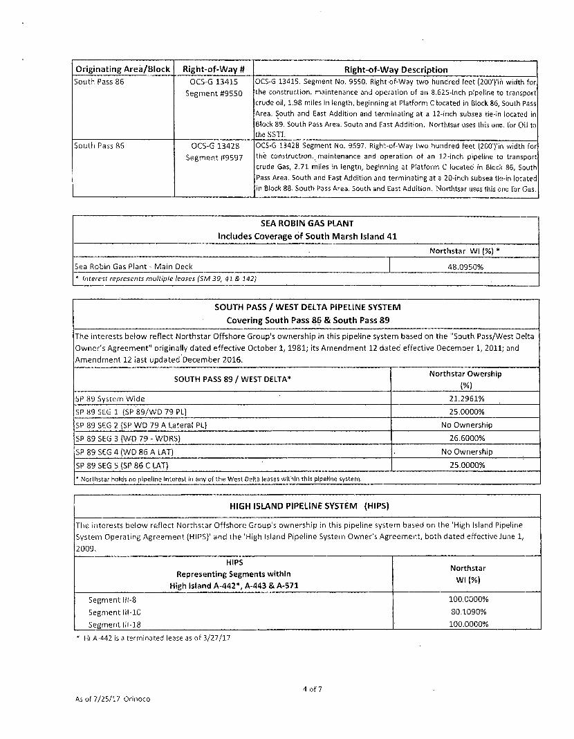
Originating Area/Block Right-of-Way tt Right-of-Way Description
South Pass 86 OCS-G 13415
Segment #9550
OCS-G 13415. Segment No. 9550. Right-of-Way two hundred feet (200')% width for the construction, maintenance and operation of an 8.625-Inch pipeline to transport crude oil, 1.98 miles in length, beginning at Platform C located in Block 86, South Pass Area. South and East Addition and terminating at a 12-inch subsea tie-in located in Block 89. South Pass Area. South and East Addition. Northtsar uses (his one. for Oil to the SSTI.
South Pass 86 OCS-G 13428
Segment #9597
OCS-G 13428 Segment No. 9597. Right-of-Way two hundred feet (200')'in width for the construction, maintenance and operation of an 12-inch pipeline to transport crude Gas, 2.71 miles in length, beginning at Platform C located in Block 86, South Pass Area. South and East Addition and terminating at a 20-inch subsea tie-in located in Block 88. South Pass Area. South and East Addition. Northtsar uses this one for Gas.
SEA ROBIN GAS PLANT
Includes Coverage of South Marsh Island 41
Northstar WI (%)
Sea Robin Gas Plant - Main Deck 48.0950% * Interest represents multiple leases (SM 39, 41 & 142)
SOUTH PASS / WEST DELTA PIPELINE SYSTEM
Covering South Pass 86 & South Pass 89
The interests below reflect Northstar Offshore Group's ownership in this pipeline system based on the "South Pass/West Delta
Owner's Agreement" originally dated effective October 1,1981; its Amendment 12 dated effective December 1, 2011; and
Amendment 12 last updated December 2016.
SOUTH PASS 89 / WEST DELTA* Northstar Owership
(%) SP 89 System Wide 21.2961%
SP 89 SEG 1 (SP 89/WD 79 PL] 25.0000%
SP 89 SEG 2 {SP WD 79 A Lateral PL) No Ownership
SP 89 SEG 3 {WD 79 - WDRS) 26.6000%
SP 89 SEG 4 (WD 86 A LAT) No Ownership
SP 89 SEG 5 (SP 86 C LAT) 25.0000%
* Northstar holds no pipeline Interest in any ofthe West Delta leases within this pipeline system.
HIGH ISLAND PIPELINE SYSTEM (HIPS)
The interests below reflect Northstar Offshore Group's ownership in this pipeline system based on the 'High Island Pipeline
System Operating Agreement {HIPS}' and the 'High Island Pipeline System Owner's Agreement, both dated effective June 1,
2009.
HIPS
Representing Segments within
High Island A-442*, A-443 & A-571
Northstar
WI (%)
Segment 111-8
Segment 111-10
Segment 111-18
100.0000%
80.1090%
100.0000%
* HI A-442 is a terminated lease as of 3/27/17
4 of? As of 7/25/17 Orinoco
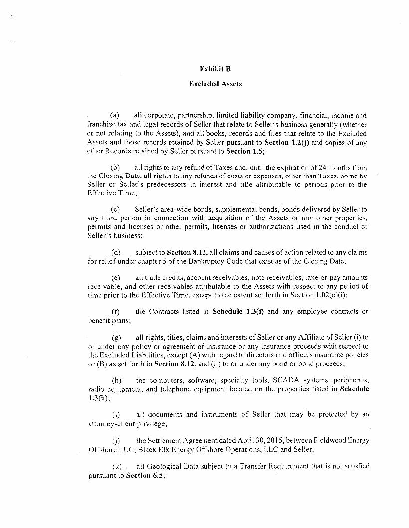
Exhibit B
Excluded Assets
(a) all corporate, partnership, limited liability company, financial, income and franchise tax and legal records of Seller that relate to Seller's business generally (whether or not relating to the Assets), and all books, records and files that relate to the Excluded Assets and those records retained by Seller pursuant to Section 1.2(j) and copies of any other Records retained by Seller pursuant to Section 1.5;
(b) all rights to any refund of Taxes and, until the expiration of 24 months from the Closing Date, all rights to any refunds of costs or expenses, other than Taxes, borne by Seller or Seller's predecessors in interest and title attributable to periods prior to the Effective Time;
(c) Seller's area-wide bonds, supplemental bonds, bonds delivered by Seller to any third person in connection with acquisition of the Assets or any other properties, permits and licenses or other permits, licenses or authorizations used in the conduct of Seller's business;
(d) subject to Section 8.12, all claims and causes of action related to any claims for relief under chapter 5 of the Bankruptcy Code that exist as of the Closing Date;
(e) all trade credits, account receivables, note receivables, take-or-pay amounts receivable, and other receivables attributable to the Assets with respect to any period of time prior to the Effective Time, except to the extent set forth in Section l.02(o)(i);
(f) the Contracts listed in Schedule 1.3(f) and any employee contracts or benefit plans;
(g) all rights, titles, claims and interests of Seller or any Affiliate of Seller (i) to or under any policy or agreement of insurance or any insurance proceeds with respect to the Excluded Liabilities, except (A) with regard to directors and officers insurance policies or (B) as set forth in Section 8.12, and (ii) to or under any bond or bond proceeds;
(h) the computers, software, specialty tools, SCADA systems, peripherals, radio equipment, and telephone equipment located on the properties listed in Schedule 1.3(h);
(i) all documents and instruments of Seller that may be protected by an attorney-client privilege;
(j) the Settlement Agreement dated April 30,2015, between Fieldwood Energy Offshore LLC, Black Elk Energy Offshore Operations, LLC and Seller;
(k) all Geological Data subject to a Transfer Requirement that is not satisfied pursuant to Section 6.5;

(1) any Asset deemed an Excluded Asset pursuant to Section 6.5;
(m) all of Seller's cash on hand at Closing; and
(n) all wells, leases, Easements and real, personal and mixed property located on, or used exclusively in the operation of, the properties listed in Schedule 1.3(n).

Schedule 1.3(f)
Excluded Contracts
East Cameron 317 & 318 (Lease Expired 2/27/17- Abandonment ObliBations Remain)
1. Offshore Operating Agreement effective August 27, 2004, between Novus Louisiana LLC and Darcy Energy, Ltd.
2. First Amended and Restated Offshore Operating Agreement between Medco Energi US LLC and Leed
Petroleum LLC dated effective April 1, 2008, whereby parties "amend and restate the Original Agreement"
{Offshore Operating dated August 27, 2004} and to reflect further amendments as well.
3. First Amendment to and Ratification of Memorandum of Operating Agreement and Financing Statement
dated effective May 17, 2011 by and between Medco Energi US LLC and Marlin GOM I, L.L.C. recorded in
Cameron Parish under File No. 323030 in the Conveyance and Mortgage Books.
South Marsh Island 39
1. Platform and Facilities Throughput Agreement dated effective October 5, 2001 by and between Remington Oil and Gas Corporation and Magnum Hunter Production, Inc. (producers) and Westport Resources Corporation and Chieftain International (US) Inc. (Platform Owners) and Westport as Platform Operator.
2. Offshore Operating Agreement dated effective July 1, 1996 by and between Equitable Resource Energy
Company and Chieftain International (US) Inc.
3. Purchase and Sale Agreement-dated September 14, 2009, effective August 1, 2009, between W&T Offshore,
Inc., as Seller and Black Elk Energy Offshore Operations, LLC, as Buyer.
South Marsh Island 142 (and SM 143 Future P&A Liability)
1. Unit Operating Agreement dated effective March 17, 1976 between Forest Oil Corporation, Columbia Gas Development Corporation, Texas Gas Exploration Corporation, CNG Producing Company, KERR-McGee Corporation, Cabot Corporation, Sun Oil Company (Delaware) and Felmont Oil Corporation.
2. Unit Agreement dated March 19, 1976, by and between Forest Oil Corp and Kerr-McGee Corp et al. (Box
26).
3. Revision of Exhibit B of Unit Operating Agreement (3/17/76) dated April 22,1979 by Forest Oil Corporation.
4. Addendum to Unit Operating Agreement (3/19/76) dated January 22,1979 by Forest Oil Corporation.
5. Amendment to Exhibit B of Joint Interest Operating Agreement dated effective January 1, 197S by Forest Oil
Corporation.
6. Continuation of Exhibit A to Joint Interest Operating Agreement following termination of Geophysical
Exploration Agreement (5/17/61) dated September 23, 1971 between Forest Oil Corporation, Columbia Gas
Development Corporation, Consolidated Gas Supply Corporation, and Texas Gas Exploration Corporation.
7. Operating Agreement attached to Exploration Agreement dated 5/17/61, between Forest Oil Corporation,
Hope Natural Gas Company, Texas Gas Exploration Corporation and The Preston Oil Company.
8. Amendment to Operating Agreement dated May 23, 1997 between CNG Producing Company, Total
Minatome Corporation, and Aviara Energy Corporation.
9. Amendment to Operating Agreement dated December 16, 1992 between CNG Producing Company, Total
Minatome Corporation, and Columbia Gas Development Corporation.
Page 1 of 4
As of 7-25-17 Orinoco

10. Production Handling Agreement dated January 1, 2007 between Hunt Petroleum, Dominion Exploration,
Northstar Gulfsands, Offshore Shelf as Platform Owners Hunt Petroleum and Energy Partners as Producers.
11. Amendatory Agreement (Gas Balancing Agreement) dated 1/22/79, effective 4/22/78, between Forest Oil
Corp, as Operator and Columbia Gas Development Corp, Texas Gas Exploration Corp, CNG Producing
Company, Kerr-McGee Corp, Cabot Corp, Sun Oil Co and Felmont Oil Corp.
12. Purchase and Sale Agreement dated September 14, 2009, effective August 1, 2009, between W&T Offshore,
Inc., as Seller and Black Elk Energy Offshore Operations, LLC, as Buyer.
South Pelto 8 1. Operating Agreement dated effective August 1, 1977 by and between Mesa Petroleum and American
Natural Gas.
South Pelto 13 1. Operating Agreement dated effective May 1, 1996 by and between Zilkha Energy Company and Santa Fe
Energy Company.
2. Gas Balancing Agreement dated effective March 23, 1979 by and between Mesa Petroleum Company and Santa Fe Energy Company.
3. Operating Agreement dated effective July 1, 1975 by and between Mesa Petroleum Company and American
Natural Gas Production Co.
4. Pipeline Crossing Agreement dated December 16, 1993, between Mesa Operating LTD., Partnership and
Zilkha Energy Company.
Vermi l ion 196 (and VR 207 P&A Liability) 1. Offshore Operating Agreement dated effective February 9, 1999 by and between Ocean Energy Inc. and
Shell Offshore, Inc.
2. Production Handling Agreement dated 7-1-12, between McMoRan, Piquant, Dynamic Offshore, Bandon,
Black Elk, Halliburton.
West Cameron 2 (Creole) State Leases: #18423,18521. #18524, #19031,'#19190, #19192 and #20473
1. Voluntary Unit Agreement entered into and effective May 14, 2008, between the State Mineral Board for
and on behalf of the State of Louisiana and Bamboo Investments, LLC; J & S Oil & Gas, LLC; Lewiston Atlas,
Ltd.; Madison, LLC; Stokes & Spiehler Properties, Inc. and Xplor Energy SPV-1, Inc. and subsequent'
Amendments.
2. First Amendment to Voluntary Unit Agreement dated February 18, 2009, by and between the State Mineral
Board for and on behalf of the State of Louisiana and Bamboo Investments, LLC, J & S Oil & Gas, LLC,
Lewiston Atlas, Ltd., Madison, LLC, Stokes & Spiehler Properties, inc. and XPLOR Energy SPV-1, Inc.
3. Second Amendment to Voluntary Unit Agreement dated December 14, 2011, between the State Mineral
Board, Deep South, J&S Oil and Gas, J&S 2008, J&S 2006, Wilkinson Family Ltd Partnership, Lewiston Atlas,
Madison, Stokes & Spiehler, Propel Energy.
4. Troy Bailey Agreement for Surface Lease and Saltwater Injection dated June 13, 2006 (Surface Lease "A"),
5. Troy Bailey Surface Lease Act of Correction dated January 1, 2008 (Surface Lease "A").
Page 2 of 4
As of 7-2S-17 Orinoco

6. Troy Bailey Surface Lease dated April 4, 2013, by and between Troy E. Bailey & Cyndie Bailey, Grantors and Northstar Offshore Group, LLC, Grantee. (Surface Lease "B")
7. Assignment, Conveyance and Bill of Sale dated effective December 1, 2012, from Jeffrey & Andrea Wilkinson
Family Limited Partnership (Assignor) and Northstar Offshore Group, LLC as (Assignee)
8. Wilma Picou Agreement for Surface Lease and Saltwater Injection, dated June 14th, 2006.
9. Wilma Picou Amendment to Agreement for Surface Lease and Saltwater Injection, dated June 14, 2008.
10. Wilma Picou Amendment and Ratification of Agreement for Surface Lease and Saltwater Injection, dated June 14, 2014.
West Cameron 60
1. Offshore Operating Agreement dated effective May 15, 1991 by and between BHP, Brooklyn Union, EP CNG and Nerco.
2. Joint Development Agreement dated effective June 27,1991 by and between Brooklyn Union and JCF.
3. Exploration Agreement dated effective May 15, 1991 by and between BHP, Brooklyn Union, EP CNG and Nerco.
4. Farmout Agreement dated September 12, 1996, between The Houston Exploration Company and Smith
Offshore.
5. Unit Agreement for OCS Exploration & Development (MMS Approved 5-26-93), between BHP, CNG, Ridgewood, Brooklyn Union, Smith Offshore, WEXCO, Contract No. 754393010.
West Cameron 61
1. Offshore Operating Agreement dated effective May 15, 1991 by and between BHP, Brooklyn Union, EP CNG
and Nerco.
2. Joint Development Agreement dated effective June 27,1991 by and between Brooklyn Union and JCF.
3. Exploration Agreement dated effective May 15, 1991 by and between BHP, Brooklyn Union, EP CNG and
Nerco.
4. Unit Agreement for OCS Exploration & Development (MMS Approved 5-26-93), between BHP, CNG,
Ridgewood, Brooklyn Union, Smith Offshore, WEXCO, Contract No, 754393010.
West Cameron 75 (and WC 62 P&A Liability only) 1. Participation Agreement dated effective August 20, 2004 by and between El Paso, THEC, and Chevron.
2. Offshore Operating Agreement dated effective August 20, 2004 by and between El Paso, THEC, and
Chevron.
West Cameron 76
1. Joint Development Agreement dated effective June 27, 1991 by and between Brooklyn Union and JCF.
2. Exploration Agreement dated effective May 15, 1991 by and between BHP, Brooklyn Union, EP CNG and
Nerco.
Page 3 of 4 As of 7-25-17 Orinoco
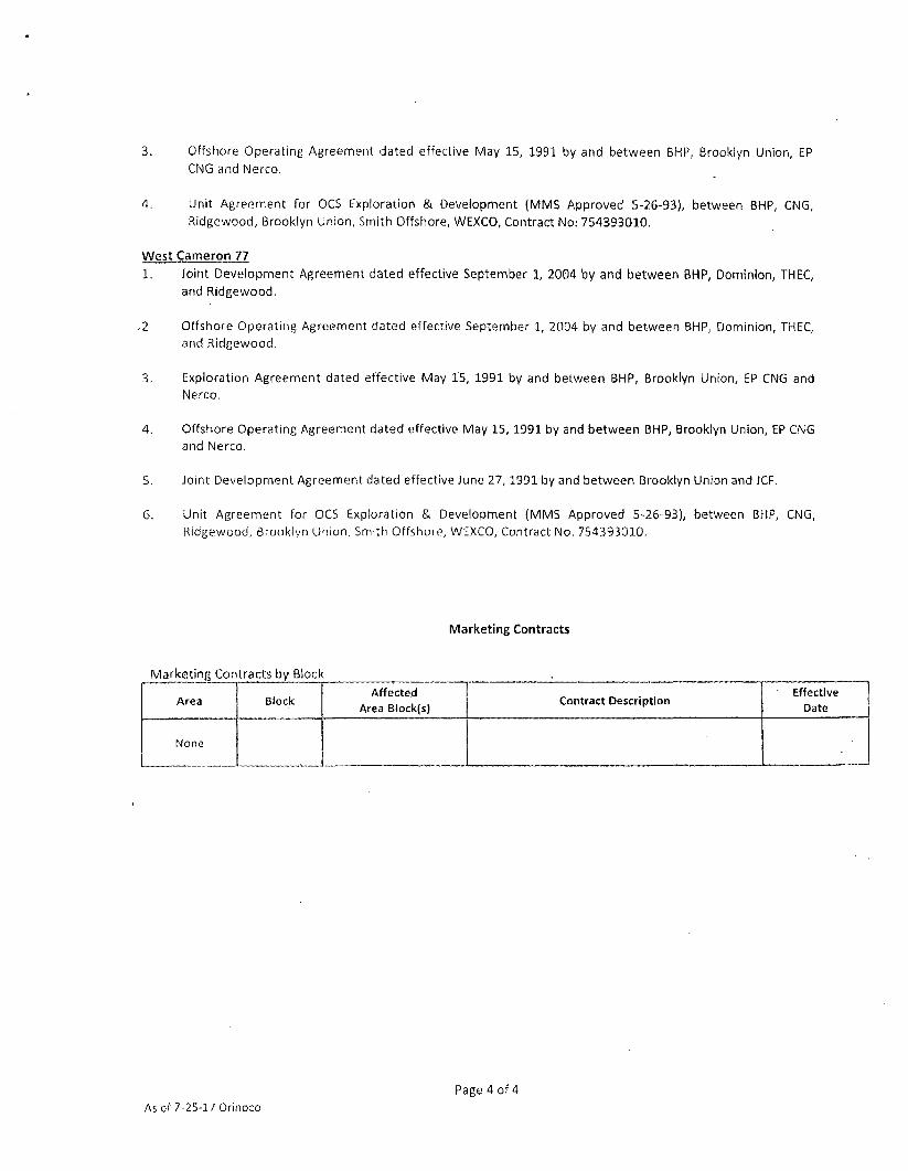
3. Offshore Operating Agreement dated effective May 15, 1991 by and between BHP, Brooklyn Union, EP
CNG and Nerco.
4. Unit Agreement for OCS Exploration & Development (MMS Approved 5-26-93), between BHP, CNG,
Ridgewood, Brooklyn Union, Smith Offshore, WEXCO, Contract No; 754393010.
West Cameron 77
1. Joint Development Agreement dated effective September 1, 2004 by and between BHP, Dominion, THEC, and Ridgewood.
,2. Offshore Operating Agreement dated effective September 1, 2004 by and between BHP, Dominion, THEC, and Ridgewood.
3. Exploration Agreement dated effective May 15, 1991 by and between BHP, Brooklyn Union, EP CNG and Nerco.
4. Offshore Operating Agreement dated effective May 15, 1991 by and between BHP, Brooklyn Union, EP CNG and Nerco.
5. Joint Development Agreement dated effective June 27, 1991 by and between Brooklyn Union and JCF.
6. Unit Agreement for OCS Exploration & Development (MMS Approved 5-26-93), between BHP, CNG, Ridgewood, Brooklyn Union, Smith Offshore, WEXCO, Contract No. 754393010.
Marketing Contracts
Marketing Contracts by Block
Area Block Affected
Area Block(s) Contract Description
Effective Date
None
As of 7-25-17 Orinoco
Page 4 of 4
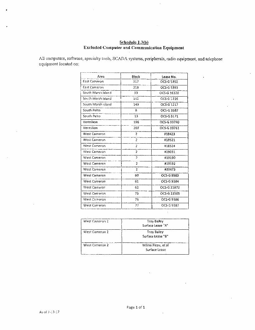
Schedule 1.3(h) Excluded Computer and Communication Equipment
All computers, software, specialty tools, SCADA systems, peripherals, radio equipment, and telephone equipment located on:
Area Block Lease No. East Cameron 317 OCS-G 5392
East Cameron 318 OCS-G 5393
South Marsh Island 39 OCS-G 16320
South Marsh Island 142 OCS-G 1216
South Marsh Island 143 OCS-G 1217
South Pelto 8 OCS-G 3587
South Pelto 13 OCS-G 3171
Vermilion 196 OCS-G 19760
Vermilion 207 OCS-G 19761
West Cameron 2 #18423
West Cameron 2 W18521
West Cameron 2 H18524
West Cameron 2 #19031
West Cameron 2 ttl9190
West Cameron 2 #19192
West Cameron 2 020473
West Cameron 60 OCS-G 9383
West Cameron 61 OCS-G 9384
West Cameron 62 OCS-G 25872
West Cameron 75 OCS-G 22505
West Cameron 76 OCS-G 9386
West Cameron 77 OCS-G 9387
West Cameron 2 Troy Bailey Surface Lease "A"
West Cameron 2 Troy Bailey Surface Lease "B"
West Cameron 2 Wilma Picou, etal Surface Lease
As of 7-13-17 Page 1 of 1

Schedule 1.3(n) Certain Excluded Assets
Area Block Lease No. East Cameron 317 OCS-G 5392
East Cameron 318 OCS-G 5393
South Marsh Island 39 OCS-G 16320
South Marsh Island 142 OCS-G 1216
South Marsh Island 143 OCS-G 1217
South Pelto 8 OCS-G 3587
South Pelto 13 OCS-G 3171
Vermilion 196 OCS-G 19760
Vermilion 207 OCS-G 19761
West Cameron 2 (#18423
West Cameron 2 #18521
West Cameron 2 #18524
West Cameron 2 #19031
West Cameron #19190
West Cameron 2 #19192
West Cameron 2 H20473
West Cameron 60 OCS-G 9383
West Cameron 61 OCS-G 9384
West Cameron 62 OCS-G 25872
West Cameron 75 OCS-G 22505
West Cameron 76 OCS-G 9386
West Cameron 77 OCS-G 9387
West Cameron 2 Troy Bailey Surface Lease "A"
West Cameron 2 Troy Bailey Surface Lease "B"
West Cameron 2 Wilma Picou, et al Surface Lease
As of 7-13-17 Orinoco Page 1 of 1

c,.-. 0;M..D'5haar;a ^ OSca :.:f f'J»r\j'jVon Parish
n-rkoH .uurt •WI, . tidal Oi^t Court
recorded tv , paqft _—.-- - ... —'