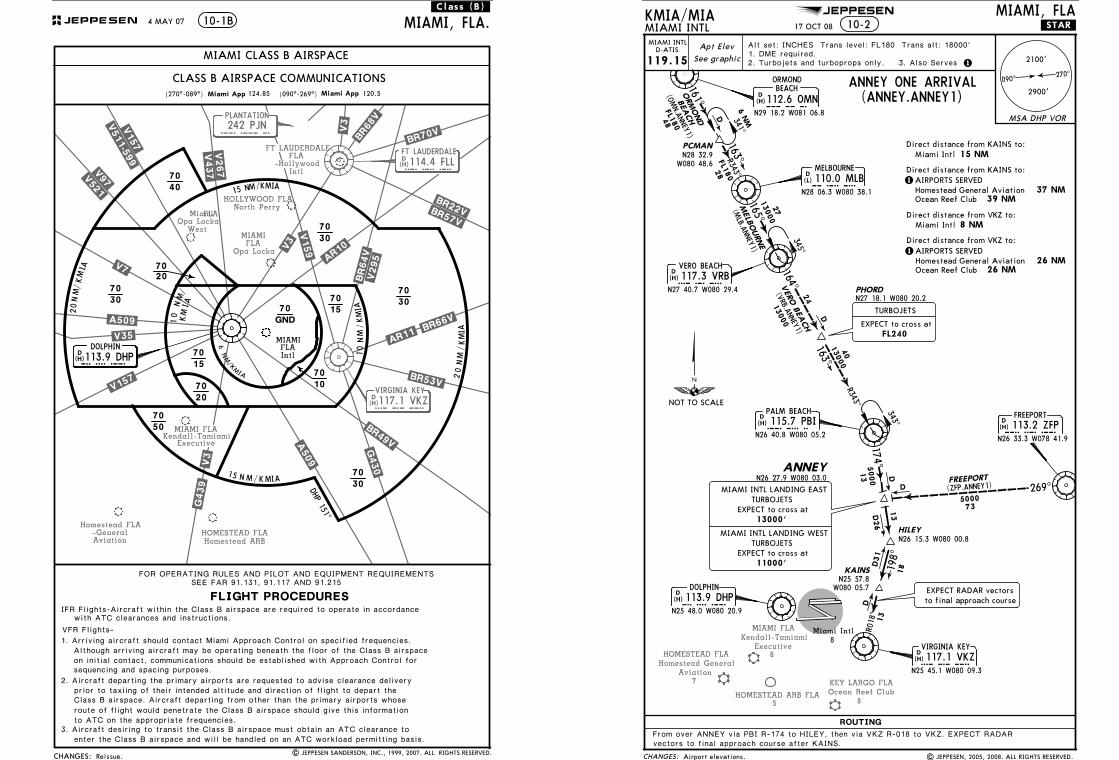
Apt Elev Miami App OMN (ANNEY.ANNEY1) PJN 242 PJN FLL...
31
FT LAUDERDALE FLA -Hollywood Intl D FT LAUDERDALE FLL 114.4 FLL MIAMI FLA Kendall-Tamiami Executive MIAMI FLA Opa Locka vkz D 117.1 VKZ VIRGINIA KEY Homestead ARB HOMESTEAD FLA 242 PJN PLANTATION PJN Opa Locka West .V5 11-599 . .V157. .V97. .V521. .V7. . A 5 0 9 . . V3 5 . .V15 7. .V3. .A509. .B R49V . .B R 5 3V. .AR11. . BR 66V . .BR64V . .V295 . .AR10. .V159. .V3. .V43 7. .V267. .B R68V. .V3. . B R 70 V. .BR22 V. .BR57V. .G43 0. .G43 9. (H) (H) Homestead FLA -General Aviation Miami FLA HOLLYWOOD FLA North Perry CHANGES: 70 70 70 70 70 70 70 70 70 30 30 30 30 20 40 50 70 15 10 70 GND 15 1 5 N M / K M I A MIAMI, FLA. 10-1B (270^-089^) FOR OPERATING RULES AND PILOT AND EQUIPMENT REQUIREMENTS FLIGHT PROCEDURES Miami App SEE FAR 91.131, 91.117 AND 91.215 MIAMI FLA Intl N M / K MI A 0 2 NM / K M I A 0 1 6 N M / K M I A 1 0 N M / K M I A 2 0 N M / K M I A CLASS B AIRSPACE COMMUNICATIONS VFR Flights- Miami App (090^-269^) 20 70 / K M I A .Class.(B). 15 N M MIAMI CLASS B AIRSPACE | JEPPESEN SANDERSON, INC., 1999, 2007. ALL RIGHTS RESERVED. 4 MAY 07 124.85 120.5 with ATC clearances and instructions. IFR Flights-Aircraft within the Class B airspace are required to operate in accordance Although arriving aircraft may be operating beneath the floor of the Class B airspace 1. Arriving aircraft should contact Miami Approach Control on specified frequencies. sequencing and spacing purposes. on initial contact, communications should be established with Approach Control for 2. Aircraft departing the primary airports are requested to advise clearance delivery prior to taxiing of their intended altitude and direction of flight to depart the to ATC on the appropriate frequencies. route of flight would penetrate the Class B airspace should give this information 3. Aircraft desiring to transit the Class B airspace must obtain an ATC clearance to enter the Class B airspace and will be handled on an ATC workload permitting basis. Class B airspace. Aircraft departing from other than the primary airports whose Reissue. JEPPESEN D 113.9 DHP DOLPHIN DHP DHP 151^ (H) JEPPESEN Ocean Reef Club KEY LARGO FLA 8 MIAMI FLA Kendall-Tamiami 8 Executive HOMESTEAD FLA 7 Homestead General Aviation HOMESTEAD ARB FLA 5 CHANGES: MSA DHP VOR Apt Elev ROUTING KMIA/MIA 17 OCT 08 .STAR. See graphic 119.15 ANNEY ONE ARRIVAL (ANNEY.ANNEY1) 8 10-2 112.6 OMN OMN N29 18.2 W081 06.8 D (H) MELBOURNE 110.0 MLB MLB N28 06.3 W080 38.1 D (L) VERO BEACH 117.3 VRB VRB N27 40.7 W080 29.4 D (H) ANNEY N26 27.9 W080 03.0 PCMAN PHORD N27 18.1 W080 20.2 HILEY N26 15.3 W080 00.8 KAINS DOLPHIN 113.9 DHP DHP N25 48.0 W080 20.9 D (H) MIAMI INTL MIAMI, FLA 270^ 090^ 2900' 2100' From over ANNEY via PBI R-174 to HILEY, then via VKZ R-018 to VKZ. EXPECT RADAR vectors to final approach course after KAINS. ORMOND BEACH FREEPORT 113.2 ZFP ZFP N26 33.3 W078 41.9 D (H) N28 32.9 W080 48.6 (OMN.ANNEY1) 161^ 48 FL180 ORMOND BEACH 341^ R343^ 28 FL180 165^ 163^ 27 13000 345^ 164^ 24 13000 163^ 40 13000 13 5000 174^ MELBOURNE (MLB.ANNEY1) VERO BEACH (VRB.ANNEY1) FR EEP O R T ( Z FP .A N N EY 1 ) 7 3 5 0 0 0 269^ R018^ N25 57.8 W080 05.7 198^ Miami Intl 13 D D D 13 D26 18 D31 D D 6 NM R343^ 343^ 1 3. Also Serves EXPECT RADAR vectors to final approach course VIRGINIA KEY 117.1 VKZ VKZ N25 45.1 W080 09.3 D (H) 1. DME required. 2. Turbojets and turboprops only. Alt set: INCHES Trans level: FL180 Trans alt: 18000' 8 NM Miami Intl 1 AIRPORTS SERVED 26 NM 26 NM Direct distance from VKZ to: Direct distance from KAINS to: 15 NM Miami Intl 1 AIRPORTS SERVED 39 NM 37 NM Homestead General Aviation Ocean Reef Club Homestead General Aviation Ocean Reef Club MIAMI INTL D-ATIS Airport elevations. | JEPPESEN, 2005, 2008. ALL RIGHTS RESERVED. Direct distance from KAINS to: Direct distance from VKZ to: TURBOJETS EXPECT to cross at FL240 PALM BEACH 115.7 PBI PBI N26 40.8 W080 05.2 D (H) MIAMI INTL LANDING EAST TURBOJETS EXPECT to cross at 13000' MIAMI INTL LANDING WEST TURBOJETS EXPECT to cross at 11000' NOT TO SCALE
Transcript of Apt Elev Miami App OMN (ANNEY.ANNEY1) PJN 242 PJN FLL...
Licensed to Romulo Serrano. Printed on 08 Jan 2010.NOTICE: PRINTED FROM AN EXPIRED REVISION. Disc 23-2009
JEPPESENJeppView 3.6.3.1
FT LAUDERDALEFLA
-HollywoodIntl
DFT LAUDERDALE
FLL
114.4 FLL
MIAMI FLAKendall-Tamiami
Executive
MIAMIFLA
Opa Locka
vkz
D 117.1 VKZVIRGINIA KEY
Homestead ARBHOMESTEAD FLA
242 PJNPLANTATION
PJN
Opa LockaWest
.V511-599..V157.
.V97.
.V521.
.V7.
.A509..V35.
.V157.
.V3. .A509.
.BR49V.
.BR53V.
.AR11. .BR66V.
.BR64V..V295.
.AR10.
.V159..V3.
.V437..V267.
.BR68V.
.V3.
.BR70V.
.BR22V..BR57V.
.G430.
.G439.
(H)
(H)
Homestead FLA-GeneralAviation
MiamiFLA
HOLLYWOOD FLANorth Perry
CHANGES:
70
70
70
70
70
70
70
70
70
30
30
30
30
20
40
50
7015
10
70
GND
15
15 N M/KMIA
MIAMI, FLA.10-1B
(270^-089^)
FOR OPERATING RULES AND PILOT AND EQUIPMENT REQUIREMENTS
FLIGHT PROCEDURES
Miami App
SEE FAR 91.131, 91.117 AND 91.215
MIAMIFLAIntl
NM
/KMIA
02
NM
/KMIA
01
6 N
M/KMIA
10
NM/
KM
I A
20NM/KMIA
CLASS B AIRSPACE COMMUNICATIONS
VFR Flights-
Miami App(090^-269^)
2070
/ KMIA
.Class.(B).
15 NM
MIAMI CLASS B AIRSPACE
| JEPPESEN SANDERSON, INC., 1999, 2007. ALL RIGHTS RESERVED.
4 MAY 07
124.85 120.5
with ATC clearances and instructions.IFR Flights-Aircraft within the Class B airspace are required to operate in accordance
Although arriving aircraft may be operating beneath the floor of the Class B airspace1. Arriving aircraft should contact Miami Approach Control on specified frequencies.
sequencing and spacing purposes.on initial contact, communications should be established with Approach Control for
2. Aircraft departing the primary airports are requested to advise clearance deliveryprior to taxiing of their intended altitude and direction of flight to depart the
to ATC on the appropriate frequencies.route of flight would penetrate the Class B airspace should give this information
3. Aircraft desiring to transit the Class B airspace must obtain an ATC clearance toenter the Class B airspace and will be handled on an ATC workload permitting basis.
Class B airspace. Aircraft departing from other than the primary airports whose
Reissue.
JEPPESEN
D 113.9 DHPDOLPHIN
DHP
DHP 151^
(H)
Licensed to Romulo Serrano. Printed on 08 Jan 2010.NOTICE: PRINTED FROM AN EXPIRED REVISION. Disc 23-2009
JEPPESENJeppView 3.6.3.1
JEPPESEN
Ocean Reef ClubKEY LARGO FLA
8
MIAMI FLAKendall-Tamiami
8Executive
HOMESTEAD FLA
7
Homestead GeneralAviation
HOMESTEAD ARB FLA5
CHANGES:
MSA DHP VOR
Apt Elev
ROUTING
KMIA/MIA17 OCT 08 .STAR.
See graphic119.15
ANNEY ONE ARRIVAL(ANNEY.ANNEY1)
8
10-2
112.6 OMNOMN
N29 18.2 W081 06.8
D(H)
MELBOURNE
110.0 MLBMLB
N28 06.3 W080 38.1
D(L)
VERO BEACH
117.3 VRBVRB
N27 40.7 W080 29.4
D(H)
ANNEYN26 27.9 W080 03.0
PCMAN
PHORDN27 18.1 W080 20.2
HILEYN26 15.3 W080 00.8
KAINS
DOLPHIN
113.9 DHPDHP
N25 48.0 W080 20.9
D(H)
MIAMI INTLMIAMI, FLA
270^090^
2900'
2100'
From over ANNEY via PBI R-174 to HILEY, then via VKZ R-018 to VKZ. EXPECT RADARvectors to final approach course after KAINS.
ORMONDBEACH
FREEPORT113.2 ZFP
ZFP
N26 33.3 W078 41.9
D(H)
N28 32.9W080 48.6
(OMN.A
NNEY1)161^
48
FL180
ORM
OND
BEA
CH 341^
R343^28
FL180
165^
163^
27
13000
345^
164^24
13000
163^
40
13000
13
5000
174^
MELB
OURNE
(MLB.A
NNEY1)
VER
O B
EACH
(VRB.ANNEY1)
FREEPORT
(ZFP.ANNEY1)
735000
269^
R018
^
N25 57.8W080 05.7
198^
Miami Intl
13
D
D
D
13D26
18D
31
D
D
6 N
M
R343^
343^
13. Also Serves
EXPECT RADAR vectorsto final approach course
VIRGINIA KEY
117.1 VKZVKZ
N25 45.1 W080 09.3
D(H)
1. DME required.2. Turbojets and turboprops only.
Alt set: INCHES Trans level: FL180 Trans alt: 18000'
8 NMMiami Intl
1AIRPORTS SERVED
26 NM26 NM
Direct distance from VKZ to:
Direct distance from KAINS to: 15 NMMiami Intl
1AIRPORTS SERVED
39 NM37 NMHomestead General Aviation
Ocean Reef Club
Homestead General AviationOcean Reef Club
MIAMI INTLD-ATIS
Airport elevations. | JEPPESEN, 2005, 2008. ALL RIGHTS RESERVED.
Direct distance from KAINS to:
Direct distance from VKZ to:
TURBOJETS
EXPECT to cross atFL240
PALM BEACH115.7 PBI
PBI
N26 40.8 W080 05.2
D(H)
MIAMI INTL LANDING EASTTURBOJETS
EXPECT to cross at13000'
MIAMI INTL LANDING WESTTURBOJETS
EXPECT to cross at11000'
NOT TO SCALE
Licensed to Romulo Serrano. Printed on 08 Jan 2010.NOTICE: PRINTED FROM AN EXPIRED REVISION. Disc 23-2009
JEPPESENJeppView 3.6.3.1
JEPPESEN
MIAMI FLA
FT LAUDERDALE FLA
13
Opa-Locka
North PerryHOLLYWOOD FLA
8
9
HOMESTEAD FLA
8
MIAMI FLA
Ocean Reef Club7
Aviation
8
Kendall-TamiamiExecutive
R010
^D27
147^
D41
270^D67
ZFPZFP
113.2
D77
162^VRB
117.3
KEY LARGO FLA
FT LAUDERDALE FLA
POMPANO BEACH FLA
19Pompano Beach
Ft Lauderdale Executive
-Hollywood Intl
HOMESTEAD ARB FLA5
Homestead General
8Executive
MELBOURNE
110.0 MLBMLB
N28 06.3 W080 38.1
D(L)
VERO BEACH117.3 VRBVRB
N27 40.7 W080 29.4
D(H)
VIRGINIA KEY
117.1 VKZVKZ
N25 45.1 W080 09.3
D(H)
NOT TO SCALE
CHANGES:
MSA DHP VOR
Apt Elev
ROUTING
KMIA/MIA17 OCT 08 .STAR.
See graphic119.152. DME required.
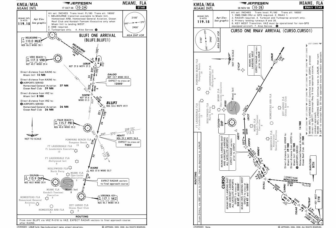
BLUFI ONE ARRIVAL(BLUFI.BLUFI1)
PALM BEACH115.7 PBI
PBI
N26 40.8 W080 05.2
D(H)
LEBURN27 37.8 W079 57.3
DALOON27 12.7 W080 00.8
TOPPR
HEATTN26 29.5 W079 56.8
KAINSN25 57.8 W080 05.7
BLUFIN26 53.6 W079 49.9
From over BLUFI via VKZ R-018 to VKZ. EXPECT RADAR vectors to final approach courseafter KAINS.
3. Turboprops only.
1. MELBOURNE transition available to Miami Intl, Homestead ARB, Homestead General Aviation, Ocean
Miami Intl is landing WEST.
190^
010^
MELBOURNE
(MLB.BLUFI1)46
12000
130^
190^
25
12000
55000
175000
R018
^
198^
D71
D46
25
D
13
33
D
D57
D32
DOLPHIN113.9 DHPDHP
N25 48.0 W080 20.9
D(H)
8Miami Intl
MIAMI INTLMIAMI, FLA
10-2A
270^090^
2900'
2100'
Reef Club and Kendall-Tamiami Executive only when
EXPECT RADAR vectorsto final approach course
14. Also Serves
N27 07.6W080 01.5
EXPECT to cross at7000'
EXPECT to cross at12000'
Alt set: INCHES Trans level: FL180 Trans alt: 18000'
MIAMI INTLD-ATIS
8 N
M
LEBUR hold, Opa-Locka airport name, airport elevations. | JEPPESEN, 2005, 2008. ALL RIGHTS RESERVED.
8 NMMiami Intl
1AIRPORTS SERVED
26 NM26 NM
Direct distance from VKZ to:
Direct distance from KAINS to: 15 NMMiami Intl
1AIRPORTS SERVED
39 NM37 NMHomestead General Aviation
Ocean Reef Club
Homestead General AviationOcean Reef Club
Direct distance from KAINS to:
Direct distance from VKZ to:
Licensed to Romulo Serrano. Printed on 08 Jan 2010.NOTICE: PRINTED FROM AN EXPIRED REVISION. Disc 23-2009
JEPPESENJeppView 3.6.3.1
MIA
MI FLA
Kendall-Tamia
mi
Executive
8
KEY L
ARGO F
LA
Ocean R
eef Clu
b8
HOMESTEAD F
LA
Homeste
ad
Genera
l Avia
tion
7
HOMESTEAD A
RB F
LA
5
POMPANO B
EACH F
LA
Pompano B
each
19
FT L
AUDERDALE F
LA
Ft Lauderd
ale
Executive
13
FT L
AUDERDALE F
LA
-Hollywood Intl
9
HOLLYW
OOD F
LA
North P
err
y8
COMMSLOST
COMMS
LOST
COMMS
LOST
COMMS
LOST
COMMS
LOST
COMMS
LOST
COMMS
LOST
COMMS LOST
MIA
MI FLA
Opa-Locka E
xecutive
8
CHANGES:
RO
UT
IN
G
KMIA/MIAMIAMI INTL 10-2B
MIAMI, FLA.RNAV.STAR.
270^
090^
2900
'
2100
'
MSA
DHP V
OR
DHP
DOLP
HIN
Mia
mi In
tl8
1
Dir
ect
dist
ance
fro
m J
OD
PO t
o: 2
2 N
MM
iam
i In
tl1
AIR
PORT
S SE
RVED
14 N
MHom
este
ad G
ener
al A
viat
ion
MIAMI INTLD-ATIS
119.15Apt Elev
See graphic
Fro
m D
VALL v
ia 0
69^
track t
o C
URSO, th
en a
s d
epic
ted t
o J
UNUR.
STRA
P
TIG
AR
CA
RNU
DVA
LL
JUNUR
CURSO
MNNDY
LECIT
JO
DPOG
RIT
TCYCLP
JESSS
069^
5000
5.6
011^
072^
053^
092^
126^
043^
5000
5000
5000
5000
5000
5000
5000
5000
5000
18.7
8.7
14.6
28.7
48.3
9.1
20.0
5.4
37.8
KEY
WES
T
MARATHON
(EYW.CURSO1)
(MTH.CURSO1)
Alt set: INCHES Trans level: FL180 Trans alt: 18000'
EYW
KEY
WEST
MTH
MARA
THON
223^
249^
126^
hdg
Oce
an R
eef
Clu
b 3
1 N
M
EXPE
CT
RAD
AR
vect
ors
prio
r to
JUN
UR
LAN
DIN
G W
EST
MIA
MI
INTL
MIA
MI
INTL
LA
ND
ING
EA
ST
ALL
SA
TELL
ITE
AIR
PORT
SA
ND
AIR
CRA
FT L
AN
DIN
G
EXPE
CT
RAD
AR
vect
ors
prio
r to
JO
DPO
MIA
MI
INTL L
ANDIN
G E
AST: Continue t
rack t
o J
ODPO, pro
ceed
conduct
appro
ach.
MIA
MI
INTL L
ANDIN
G W
EST: Continue t
rack t
o J
UNUR, th
en t
urn
3. RADAR required. 4. Turbojet and Turboprop aircraft only.
CURSO ONE RNAV ARRIVAL (CURSO.CURSO1)
MIA
MI
INTL
LA
ND
ING
EA
ST
ALL
SA
TELL
ITE
AIR
PORT
SA
ND
AIR
CRA
FT L
AN
DIN
G
EXPE
CT
to c
ross
at
250 K
T 1
0000'
and
EXPE
CT
to c
ross
at
and
250 K
T 1
4000'
MIA
MI
INTL
LA
ND
ING
WES
T
LEFT t
o inte
rcept
Rwy 3
0 f
inal appro
ach c
ours
e, conduct
appro
ach.
10 N
M
5 N
M
direct
to G
RIT
T, in
terc
ept
Rwy 9
fin
al appro
ach c
ours
e,
6. KEY WEST Transition: VKZ must be operational for non-GPS equipped aircraft. 7. Also Serves
39 N
MM
iam
i In
tlD
irec
t di
stan
ce f
rom
JUN
UR
to:
1. DME/DME/IRU or GPS required. 2. RNAV 1.
5. Primary landing runways 9 and 30.
28 NOV 08
| JEPPESEN, 2006, 2008. ALL RIGHTS RESERVED.None.
NO
T TO
SCA
LE
JEPPESEN
Licensed to Romulo Serrano. Printed on 08 Jan 2010.NOTICE: PRINTED FROM AN EXPIRED REVISION. Disc 23-2009
JEPPESENJeppView 3.6.3.1
MIAMI FLAKendall-Tamiami
Executive8
229^
140^D44
211^
D56
157^D60
7Aviation
Homestead GeneralHOMESTEAD FLA
HOMESTEAD ARB FLA5
KEY LARGO FLA
8Ocean Reef Club
MIAMI FLAOpa-Locka Executive
8
NOT TO SCALE
SARA
SOTA
31
182^
LEE C
OUNTY
ST PET
ERSB
URG
(PIE.CYY5)
(SRQ.CYY5)
N25 53.6 W080 58.4WORPP
113^5000
113^
293^
293^
152^
154^
(RSW
.CYY5)
D
D46
155000
293^
86
23
116
DEEDSN25 58.7
W081 14.0
108.6 CYY(T)
N26 09.2 W081 46.7
DCYPRESS
CYY
113.9 DHPD
D H P
(H)
N25 48.0 W080 20.9
DOLPHIN
PALM BEACH
115.7 PBID
P B I(H)
N26 40.8 W080 05.2
115.4 PHK(H)D
P H K
N26 47.0 W080 41.5
PAHOKEE110.4 LBVD
L B V(L)
N26 49.7 W081 23.5
LA BELLE
(H)D116.4 PIE
ST PETERSBURG
N27 54.5 W082 41.1P I E
N26 31.8 W081 46.5
111.8 RSWLEE COUNTY
D
R S W(L)
Miami Intl8
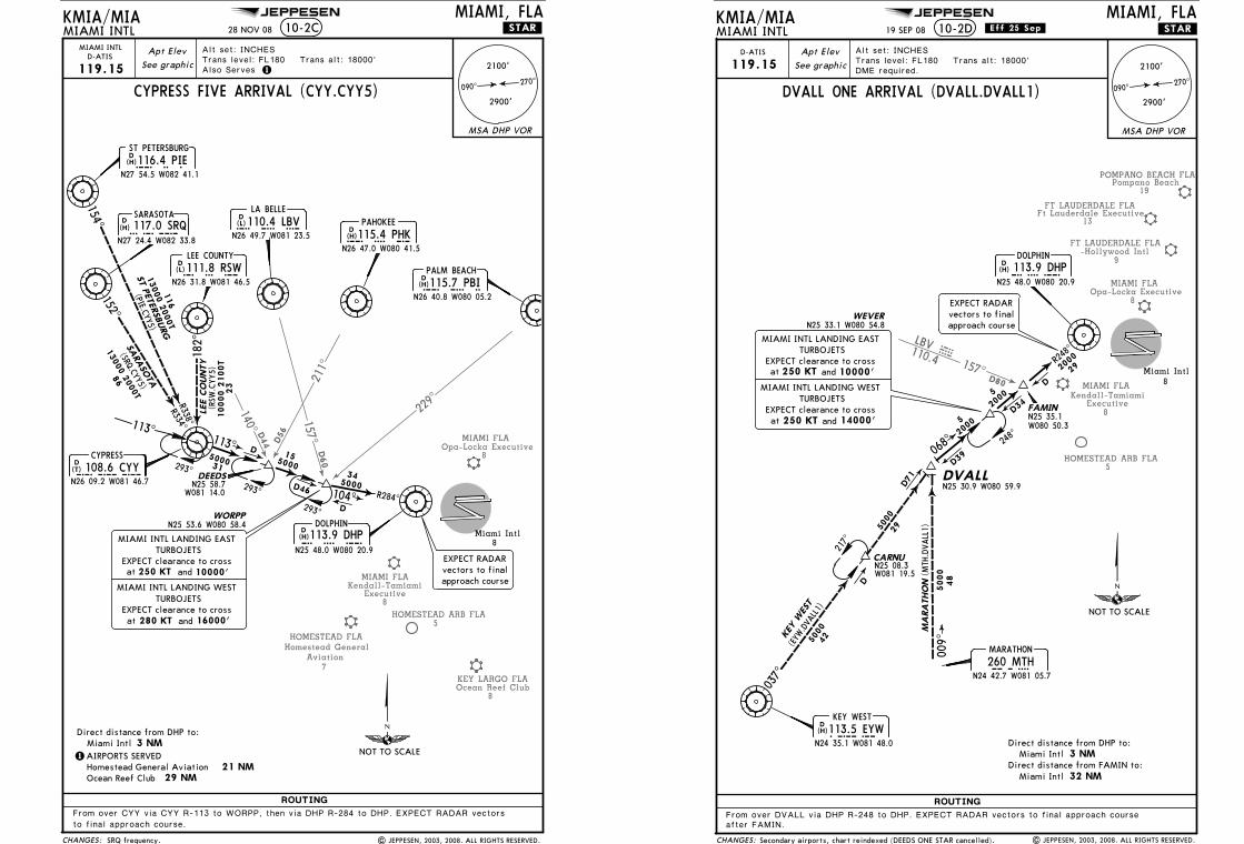
CYPRESS FIVE ARRIVAL (CYY.CYY5)
MIAMI, FLAMIAMI INTL
CHANGES:
KMIA/MIA
ROUTING
10-2C
270^090^
2900'
2100'
MSA DHP VOR
13000 2
000T
13000 2
000T
R284^104^
345000
3 NMMiami Intl
1AIRPORTS SERVED21 NMHomestead General Aviation
Direct distance from DHP to:
D
EXPECT RADARvectors to finalapproach course
Apt Elev
119.15 See graphic
Alt set: INCHESTrans level: FL180 Trans alt: 18000'
1
MIAMI INTLD-ATIS
Also Serves
.STAR.
From over CYY via CYY R-113 to WORPP, then via DHP R-284 to DHP. EXPECT RADAR vectors
to final approach course.
28 NOV 08
| JEPPESEN, 2003, 2008. ALL RIGHTS RESERVED.
R334^R338^ 1
0000 2
100T
MIAMI INTL LANDING EASTTURBOJETS
EXPECT clearance to cross250 KTat and 10000'
MIAMI INTL LANDING WESTTURBOJETS
EXPECT clearance to crossat 280 KT and 16000'
29 NMOcean Reef Club
SARASOTA117.0 SRQ
SRQ
N27 24.4 W082 33.8
D(H)
SRQ frequency.
JEPPESEN
Licensed to Romulo Serrano. Printed on 08 Jan 2010.NOTICE: PRINTED FROM AN EXPIRED REVISION. Disc 23-2009
JEPPESENJeppView 3.6.3.1
FT LAUDERDALE FLA
FT LAUDERDALE FLA
-Hollywood Intl9
13
157^
110.4
LBVVBL
D80
POMPANO BEACH FLA
19Pompano Beach
Ft Lauderdale Executive
HOMESTEAD ARB FLA5
MIAMI FLA
8Executive
Kendall-Tamiami
MIAMI FLAOpa-Locka Executive
8
42
037^
KEY
WES
T
(EYW
.DVA
LL1)
DVALLN25 30.9 W080 59.9
R248^
009^
N25 33.1 W080 54.8
48
WEVER
(MTH
.DVALL1)
MA
RA
THO
N
217^
CARNUN25 08.3 W081 19.5
Miami Intl8
NOT TO SCALE
5000
5000
D71
29
5000
2000
D34
D
2000
5
068^
D39
2000
5
248^
D
EYW
(H)D113.5 EYWKEY WEST
N24 35.1 W081 48.0
MTH260 MTHMARATHON
N24 42.7 W081 05.7
DHP(H)D 113.9 DHP
N25 48.0 W080 20.9
DOLPHIN
MIAMI, FLAMIAMI INTL .STAR.
CHANGES:
.Eff.25.Sep.KMIA/MIA
ROUTING
10-2D
From over DVALL via DHP R-248 to DHP. EXPECT RADAR vectors to final approach courseafter FAMIN.
Alt set: INCHESTrans level: FL180 Trans alt: 18000'DME required.
EXPECT RADARvectors to finalapproach course
Direct distance from DHP to:Miami Intl 3 NM
MIAMI INTL LANDING EASTTURBOJETS
EXPECT clearance to crossandat 250 KT 10000'
MIAMI INTL LANDING WESTTURBOJETS
EXPECT clearance to crossand 14000'250 KTat
Apt Elev
See graphic
DVALL ONE ARRIVAL (DVALL.DVALL1)270^
090^
2900'
2100'
MSA DHP VOR
D-ATIS
119.15
19 SEP 08
| JEPPESEN, 2003, 2008. ALL RIGHTS RESERVED.Secondary airports, chart reindexed (DEEDS ONE STAR cancelled).
Miami Intl 32 NMDirect distance from FAMIN to:
29
FAMINN25 35.1W080 50.3
JEPPESEN
Licensed to Romulo Serrano. Printed on 08 Jan 2010.NOTICE: PRINTED FROM AN EXPIRED REVISION. Disc 23-2009
JEPPESENJeppView 3.6.3.1
MIA
MI FLA
Kendall-Tamia
mi
Executive
8
HOMESTEAD F
LA
Homeste
ad
Genera
l Avia
tion
7
KEY L
ARGO F
LA
Ocean R
eef Clu
b8
HOMESTEAD A
RB F
LA
5
COMMS LOSTCOMMS LOST
COMMS
LOST
COMMS
LOST
COMMS
LOST
LOST
COMMS COMMSLOST
CHANGES:
RO
UT
IN
G
KMIA/MIAMIAMI INTL 10-2E
MIAMI, FLA.RNAV.STAR.
270^
090^
2900
'
2100
'
MSA
DHP V
OR
Mia
mi In
tl8
1
MIAMI INTLD-ATIS
119.15Apt Elev
See graphic
Alt set: INCHES Trans level: FL180 Trans alt: 18000'
3. RADAR required. 4. Turbojet and Turboprop aircraft only.
6. For non-GPS equipped aircraft, VKZ and ZBV must be operational.
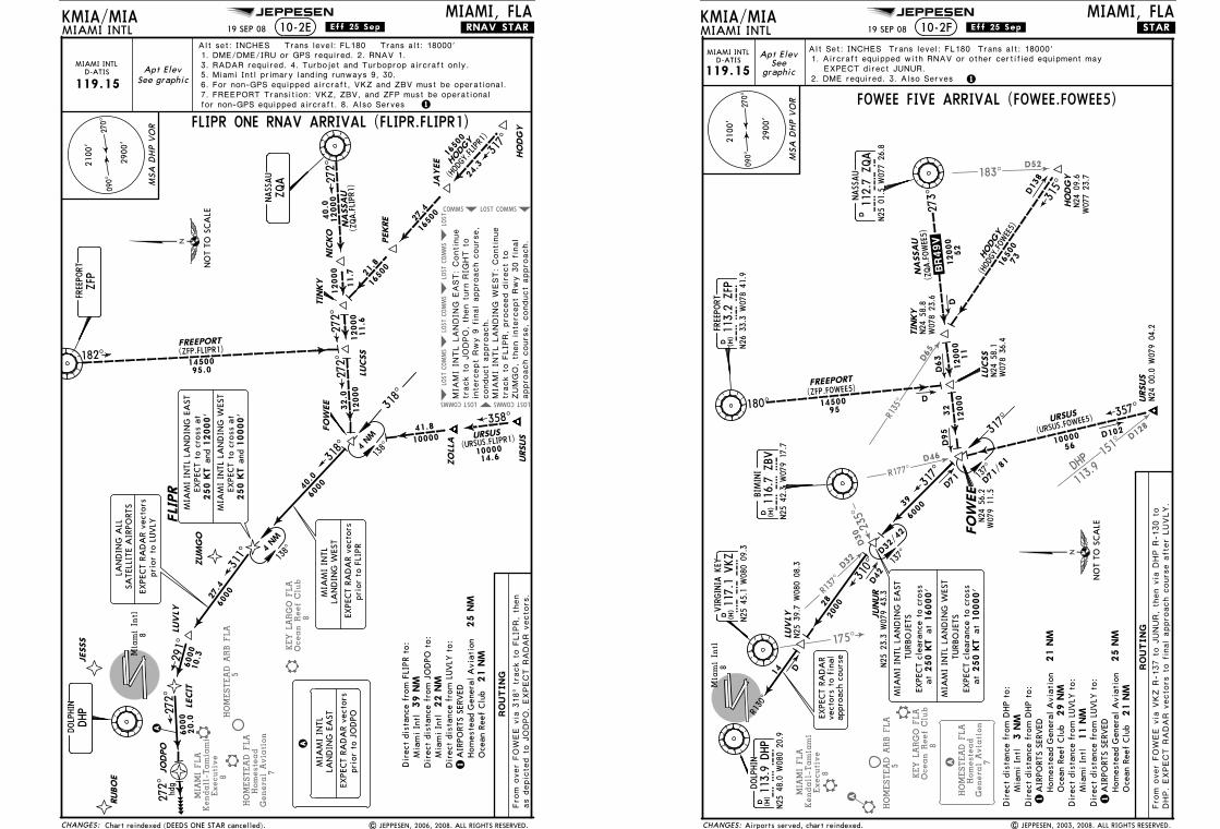
FLIPR ONE RNAV ARRIVAL (FLIPR.FLIPR1)
LECIT
JO
DPO
JESSS
HO
DG
Y
JA
YEE
PEKRE
TIN
KY
LUCSS
FO
WEE
URSUS
ZO
LLA
NIC
KO
FLI
PR
LUVLY
ZUM
GO
272^
317^
358^
182^27
2^27
2^318^
311^
291^
272^
1650
0
1650
0
1650
0
12000
12000
1000010000
14500
12000
12000
6000
6000
6000
6000
24.3
27.4
21.8
11.6
32.0
14.6
41.8
95.0
40.0
11.7
40.0
27.4
10.3
HODGY
URSUS
FREEPORTNA
SSA
U
(HODGY.FLIPR1)
(URSUS.FLIPR1)
(ZFP.FLIPR1)(ZQA.FLIPR
1)
20.0
MIA
MI
INTL
LA
ND
ING
EA
STEX
PECT
to c
ross
at
250 K
T 1
2000'
and
EXPE
CT
to c
ross
at
and
250 K
T 1
0000'
MIA
MI
INTL
LA
ND
ING
WES
T
A
A
EXPE
CT
RAD
AR
vect
ors
prio
r to
JO
DPO
MIA
MI
INTL
LAN
DIN
G E
AST
MIA
MI
INTL
LAN
DIN
G W
EST
EXPE
CT
RAD
AR
vect
ors
prio
r to
FLI
PR
EXPE
CT
RAD
AR
vect
ors
prio
r to
LUVLY
LAN
DIN
G A
LLSA
TELL
ITE
AIR
PORT
S
as d
epic
ted t
o J
ODPO. EXPECT R
ADAR v
ecto
rs.
Fro
m o
ver
FOW
EE v
ia 3
18^
track t
o F
LIP
R, th
en
DHP
ZFP
ZQA
DOLP
HIN
FREEPO
RT
NASSAU
318^
138^
138^
RUBO
E
272^
hdg
4 NM
4 NM
7. FREEPORT Transition: VKZ, ZBV, and ZFP must be operational for non-GPS equipped aircraft. 8. Also Serves
appro
ach c
ours
e, conduct
appro
ach.
ZUMGO, th
en inte
rcept
Rwy 3
0 f
inal
track t
o F
LIP
R, pro
ceed d
irect
to
MIA
MI
INTL L
ANDIN
G W
EST: Continue
MIA
MI
INTL L
ANDIN
G E
AST: Continue
track t
o J
ODPO, th
en t
urn
RIG
HT t
o
inte
rcept
Rwy 9
fin
al appro
ach c
ours
e,
conduct
appro
ach.
Dir
ect
dist
ance
fro
m J
OD
PO t
o: 2
2 N
M
Mia
mi
Intl
Dir
ect
dist
ance
fro
m F
LIPR
to:
39 N
M
Mia
mi
Intl
Dir
ect
dist
ance
fro
m L
UVLY
to:
1A
IRPO
RTS
SERV
ED 2
5 N
MHom
este
ad G
ener
al A
viat
ion
Oce
an R
eef
Clu
b 2
1 N
M
1. DME/DME/IRU or GPS required. 2. RNAV 1.
19 SEP 08
| JEPPESEN, 2006, 2008. ALL RIGHTS RESERVED.
.Eff.25.Sep.
Chart reindexed (DEEDS ONE STAR cancelled).
5. Miami Intl primary landing runways 9, 30.
NO
T TO
SCA
LE
JEPPESEN
Licensed to Romulo Serrano. Printed on 08 Jan 2010.NOTICE: PRINTED FROM AN EXPIRED REVISION. Disc 23-2009
JEPPESENJeppView 3.6.3.1
D32
235^
R137^
R177^D46
183^D52
175^
D30
MIA
MI FLA
Kendall-Tamia
mi
Executive
8
R135^
D65
DHP
113.9
151^
D128
HOMESTEAD A
RB F
LA
5
KEY L
ARGO F
LA
Ocean R
eef Clu
b8
HOMESTEAD F
LA
Homeste
ad
Genera
l Avia
tion
7A
A
R130^
D42
NA
SSA
U
(ZQA.FOWEE5)
KMIA/MIA10-2F .STAR.
Alt Set: INCHES Trans level: FL180 Trans alt: 18000'Apt Elev
Seegraphic
VIRGINIA
KEY
117.1
VKZ
VK
Z
N25
45.1
W08
0 09
.3
D (H)
116.7
ZBV
ZB
V
N25
42.3
W07
9 17
.7
D (H)
BIMINI
112.7
ZQA
ZQ
A
N25
01.5
W07
7 26
.8
DNASSAU
113.2
ZFP
ZF
P
N26
33.3
W07
8 41
.9
D (H)
FREEPO
RT
(HODGY.FOW
EE5)
HODGY
16500
73
D13
8315^
1450095
(ZFP.FOWEE5)FREEPORT
180^
D63
317^
090^
270^
D102
D
1. Aircraft equipped with RNAV or other certified equipment mayEXPECT direct JUNUR.
.BR 49V.
Dir
ect
dist
ance
fro
m D
HP
to:
3 N
MM
iam
i In
tl
DOLP
HIN
DH
P
113.9
DHP
N25
48.0
W08
0 20
.9
D (H)
D
19 SEP 08
| JEPPESEN, 2003, 2008. ALL RIGHTS RESERVED.
.Eff.25.Sep.
MIA
MI
INTL
LA
ND
ING
EA
STTU
RBO
JETS
EXPE
CT
clea
ranc
e to
cro
ss
MIA
MI
INTL
LA
ND
ING
WES
TTU
RBO
JETS
EXPE
CT
clea
ranc
e to
cro
ss
at250 K
Tat
16000'
at250 K
Tat
10000'
12. DME required. 3. Also Serves
MIAMI INTLD-ATIS
119.15
Dir
ect
dist
ance
fro
m D
HP
to:
1A
IRPO
RTS
SERV
ED 2
1 N
MHom
este
ad G
ener
al A
viat
ion
Oce
an R
eef
Clu
b 2
9 N
MD
irec
t di
stan
ce f
rom
LUVLY
to:
Mia
mi
Intl
11 N
MD
irec
t di
stan
ce f
rom
LUVLY
to:
1A
IRPO
RTS
SERV
ED 2
5 N
MHom
este
ad G
ener
al A
viat
ion
Oce
an R
eef
Clu
b 2
1 N
M
Airports served, chart reindexed.
MSA
DHP V
OR
URSUS
Mia
mi In
tl8
273^
D95
32
(URSUS.FOW
EE5)
FO
WEE
56
W07
7 23
.7N24
09.6
HO
DG
Y
W07
8 23
.6N24
58.8
TIN
KY
200028
URSUS
N24
00.0
W07
9 04
.2
357^
NO
T TO
SCA
LE
LUVLY
14
6000
39
317^
310^
D32/
42
137^
D71/
81
137^
12000
10000
D71
12000
52
D
N25
23.3
W07
9 43
.3JUNUR
CHANGES:
RO
UTIN
G
FOWEE FIVE ARRIVAL (FOWEE.FOWEE5)
MIAMI INTLMIAMI, FLA
Fro
m o
ver
FOW
EE v
ia V
KZ R
-137 t
o J
UNUR, th
en v
ia D
HP R
-130 t
oDHP. EXPECT R
ADAR v
ecto
rs t
o f
inal appro
ach c
ours
e a
fter
LUVLY.
12000
11
LUCSS
N24
58.1
W07
8 36
.4
2900
'
2100
'
EXPE
CT
RAD
AR
vect
ors
to f
inal
appr
oach
cou
rse
N25
39.7
W08
0 08
.3
N24
56.2
W07
9 11
.5
JEPPESEN
Licensed to Romulo Serrano. Printed on 08 Jan 2010.NOTICE: PRINTED FROM AN EXPIRED REVISION. Disc 23-2009
JEPPESENJeppView 3.6.3.1
KEY LARGO FLAOcean Reef Club
8
A
B
BMIAMI FLA
Kendall-Tamiami Executive
8
COMMSLOST COMMSLOST COMMSLOST COMMSLOSTLOSTCOMMS
COMMS
LOST
COMMSLOST COMMSLOST COMMSLOST COMMSLOST LOST
HOMESTEAD FLAHomestead
General Aviation7
A
HOMESTEAD ARB FLA5
KAINS
JORAY
PHORD
ANNEY
HILEY
YOSSI
MILSY
BOYUR
PCMAN
OSOGY
ENVOY
CHANGES:
ROUTING
KMIA/MIAMIAMI INTL 10-2G
MIAMI, FLA.RNAV.STAR.
270^090^
2900'
2100'
MSA DHP VOR
166^
168^
176^
200^
212^
242^
243^
229^
199^
274^
FREEPORT
JORA
Y(JORA
Y.HILEY
2)(ZFP.HILEY2)
(OMN.HILEY2)
47.9
28.1
26.7
FL2
40
FL2
40
FL1
80
39.5
5000
5000
12.8
ORM
OND B
EACH
13000
24.0
165^
5000
13.0
FL1
80
74.3
FL1
80
30.0
10000
8.7
1000
0
7.1
9.3
6000
10.7
18.0
1000049.7
MELBOURNE
MLB
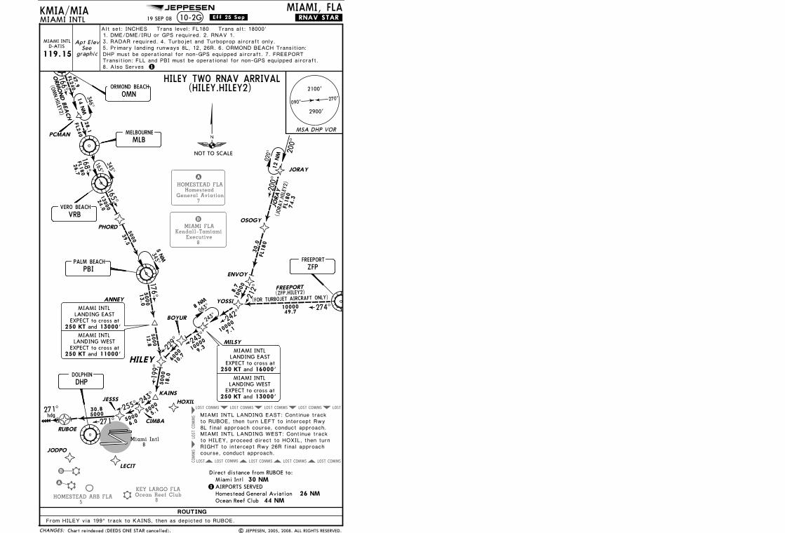
HILEY TWO RNAV ARRIVAL(HILEY.HILEY2)
VRBVERO BEACH
PALM BEACH
PBI
DHPDOLPHIN
ZFPFREEPORT
OMNORMOND BEACH
Miami Intl8
346^
063^8
NM
12 N
M
020^
345^
345^
200^
1000
0
14 N
M
1
Direct distance from RUBOE to: 30 NMMiami Intl
1AIRPORTS SERVED
44 NM 26 NMHomestead General Aviation
Ocean Reef Club
.Eff.25.Sep.
243^
255^
271^
271^ 5000
50005000 5.1
6.0
30.8hdg
HOXIL
LECIT
JODPO
RUBOE
JESSS
CIMBA
From HILEY via 199^ track to KAINS, then as depicted to RUBOE.
5000
RIGHT to intercept Rwy 26R final approach course, conduct approach.
Alt set: INCHES Trans level: FL180 Trans alt: 18000'
Apt ElevSee
graphic
MIAMI INTLD-ATIS
119.15
MIAMI INTL LANDING EAST: Continue track to RUBOE, then turn LEFT to intercept Rwy 8L final approach course, conduct approach.MIAMI INTL LANDING WEST: Continue track to HILEY, proceed direct to HOXIL, then turn
MIAMI INTL
LANDING EASTEXPECT to cross at
LANDING WESTEXPECT to cross at
250 KT and 11000'
250 KT and 13000'
MIAMI INTL
LANDING EASTEXPECT to cross at
LANDING WESTEXPECT to cross at
250 KT and 13000'
250 KT and 16000'
MIAMI INTL
MIAMI INTL
165^
5 N
M
243^
(FOR TURBOJET AIRCRAFT ONLY)
DHP must be operational for non-GPS equipped aircraft. 7. FREEPORT Transition: FLL and PBI must be operational for non-GPS equipped aircraft. 8. Also Serves
1. DME/DME/IRU or GPS required. 2. RNAV 1.3. RADAR required. 4. Turbojet and Turboprop aircraft only.5. Primary landing runways 8L, 12, 26R. 6. ORMOND BEACH Transition:
19 SEP 08
| JEPPESEN, 2005, 2008. ALL RIGHTS RESERVED.Chart reindexed (DEEDS ONE STAR cancelled).
NOT TO SCALE
JEPPESEN

Licensed to Romulo Serrano. Printed on 08 Jan 2010.NOTICE: PRINTED FROM AN EXPIRED REVISION. Disc 23-2009
JEPPESENJeppView 3.6.3.1
MIAMI FLAKendall-Tamiami
Executive8
KEY LARGO FLAOcean Reef Club
8
HOMESTEAD FLAHomestead
General Aviation7
HOMESTEAD ARB FLA5
COMMSLOST COMMSLOST COMMSLOST COMMSLOST COMMSLOST
COMMS
LOST
COMMSLOST COMMSLOST COMMSLOST COMMSLOST COMMSLOST
MIAMI FLAOpa-Locka Executive
8
Miami Intl8
JUNUR
LECIT
DEEDS
SSCOT
RUBOEWALIP
115^
116^091^ 126^
31.3
15.4
6.912.9
18.1
8000 5000
3000
295^
295^
126^hdg
9 NM
8 NM
HEVVN
LEGGT
PLYERHITTR
TUCKE
JUULI
BAGGS
BAARY
SEATE
CHANGES:
.Eff.25.Sep.19 SEP 08KMIA/MIA MIAMI, FLA
.RNAV.STAR.10-2HMIAMI INTLMIAMI INTL
D-ATIS
119.15Apt Elev
See graphic 11. DME/DME/IRU or GPS required. 2. RNAV 1.
5. For non-GPS equipped aircraft, PHK must be operational.6. Also Serves
270^090^
2900'
2100'
MSA DHP VOR
SSCOT ONE RNAV ARRIVAL(SSCOT.SSCOT1)
NOT TO SCALE
ROUTING
From over BAARY via 141^ track to CYY, then as depicted to LECIT,then via 126^ heading. EXPECT RADAR vectors.
| JEPPESEN, 2008. ALL RIGHTS RESERVED.New procedure at this airport.
141^35.5
FL180
VALD
OSTA
TA
YLO
R
SEMIN
OLE
CYYCYPRESS
DHPDOLPHIN
(OTK.SSCO
T1)
(SZW.SSCOT1)
(TAY.SSC
OT1)
BAGGS
(BAGGS.SSCOT1)
155^
161^ 181^
110
50.5
84.5
FL180
FL180
FL1
80
FL180
FL180
FL180 F
L180
156^
157^
167^
41.1
18.9
51.8
86.2
FL1
80
FL1
80
198^
47.2
23.2
140^
46.4FL180
10000
11000
2
OTKVALDOSTA2
EXPECT RADAR vectorsprior to LECIT
MIAMI INTLLANDING RWY 27
ALL SATELLITE AIRPORTSAND AIRCRAFT LANDING
EXPECT RADAR vectorsprior to RUBOE
MIAMI INTL LANDING RWYS 9, 12
MIAMI INTLLANDING
RWYS 8L/R, 26L/R
EXPECT RADAR vectorsprior to WALIP
167^
347^
337^
140^320^
321^
115^
295^
141^
MIAMI INTL LANDING EAST: Continue track
MIAMI INTL LANDING WEST: Continue trackto LECIT, then proceed direct to JUNUR, then
11 N
M
11 NM
11 N
M11 N
M
MIAMI INTL LANDING EASTEXPECT to cross at
250 KT 10000'and
EXPECT to cross atand280 KT 16000'
MIAMI INTL LANDING WEST
Direct distance from RUBOE to: 30 NMMiami Intl
1AIRPORTS SERVED 26 NMHomestead General Aviation
Ocean Reef Club 44 NMDirect distance from WALIP to:
Miami Intl 18 NM
FL180
15.7
to LECIT, intercept the Rwy 8L approach.
turn LEFT to intercept the Rwy 30 approach.
Direct distance from LECIT to:Miami Intl 5 NM
3. RADAR required. 4. Turbojet and Turboprop aircraft only.
TAYTAYLOR
SZWSEMINOLE
11 NM
Direct distance from RUBOE to:
Alt Set: INCHES Trans level: FL180 Trans alt: 18000'
JEPPESEN
Licensed to Romulo Serrano. Printed on 08 Jan 2010.NOTICE: PRINTED FROM AN EXPIRED REVISION. Disc 23-2009
JEPPESENJeppView 3.6.3.1
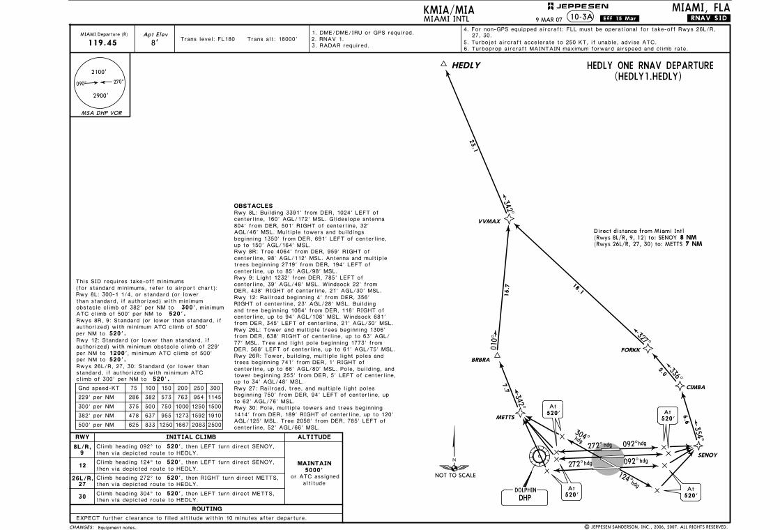
(for standard minimums, refer to airport chart):This SID requires take-off minimums
Rwy 8L: 300-1 1/4 with minimum obstacle climb of 221' per NM to 1200'
300' 520'.
, or standard (or lower than standard, if authorized) with minimum obstacle climb of 382' per NM toATC climb of 500' per NM to
, minimum
Rwy 8R: Standard (or lower than standard, if authorized) with minimum obstacle climb of 237' per NM to 1200', minimum ATC climb of 500' per NM to 520'.
authorized) with minimum obstacle climb of 233' per NM to 1200', minimum ATC climb of 500' per NM to 520'.
Rwy 9: Standard (or lower than standard, if
authorized) with minimum obstacle climb of 226' per NM to 1200', minimum ATC climb of 500' per NM to 520'.
Rwy 12: Standard (or lower than standard, if
520'.
Rwys 26L/R, 27, 30: Standard (or lower than standard, if authorized) with minimum ATC climb of 300' per NM to
OBSTACLESRwy 8L: Building 3391' from DER, 1024' LEFT of
DER, 438' RIGHT of centerline, 21' AGL/30' MSL.
centerline, 160' AGL/172' MSL. Glideslope antenna 804' from DER, 501' RIGHT of centerline, 32' AGL/46' MSL. Multiple towers and buildings beginning 1350' from DER, 691' LEFT of centerline, up to 150' AGL/164' MSL.Rwy 8R: Tree 4064' from DER, 959' RIGHT of centerline, 98' AGL/112' MSL. Antenna and multiple trees beginning 2719' from DER, 194' LEFT of centerline, up to 85' AGL/98' MSL.Rwy 9: Light 1232' from DER, 785' LEFT of centerline, 39' AGL/48' MSL. Windsock 22' from
Rwy 12: Railroad beginning 4' from DER, 356' RIGHT of centerline, 23' AGL/28' MSL. Building and tree beginning 1064' from DER, 118' RIGHT of centerline, up to 94' AGL/108' MSL. Windsock 681' from DER, 345' LEFT of centerline, 21' AGL/30' MSL.
Rwy 26R: Tower, building, multiple light poles and trees beginning 741' from DER, 1' RIGHT of centerline, up to 66' AGL/80' MSL. Pole, building, and tower beginning 255' from DER, 5' LEFT of centerline, up to 34' AGL/48' MSL.Rwy 27: Railroad, tree, and multiple light poles beginning 750' from DER, 94' LEFT of centerline, up to 62' AGL/76' MSL.Rwy 30: Pole, multiple towers and trees beginning 1414' from DER, 189' RIGHT of centerline, up to 120' AGL/125' MSL. Tree 2058' from DER, 785' LEFT of centerline, 52' AGL/66' MSL.
ROUTING
INITIAL CLIMB ALTITUDE
MAINTAIN5000'
altitudeor ATC assigned
RWY
26R
26L
30
27
12
Climb heading 092^ to 520'
Climb heading 124^ to 520'
8L/R,9
, then RIGHT turn direct SABRA,
Climb heading 272^ to 520', then LEFT turn direct JADAK,
Climb heading 272^ to 520', then LEFT turn direct LICEY,
Climb heading 272^ to 520'
Climb heading 304^ to 520', then LEFT turn direct LICEY,
75 100 150 200 250 300
221' per NM 276 368 553 737 921 1105
Gnd speed-KT
382' per NM
283 377 565 753 942 1130
237' per NM
291 388 583 777 971 1165233' per NM
296 395 593 790 988 1185
226' per NM
375 500 750 1000 1250 1500300' per NM
478 637 955 1273 1592 1910
500' per NM 625 833 1250 1667 2083 2500
Rwy 26L: Tower and multiple trees beginning 1306'
NOT TO SCALE
CHANGES:
JEPPESEN
.Eff.15.Mar.10-3KMIA/MIAMIAMI INTL
MIAMI, FLA
2100'
270^090^
2900'
MSA DHP VOR
6. Turboprop aircraft MAINTAIN maximum forward airspeed and climb rate.
1. DME/DME/IRU or GPS required.
3. RADAR required.Trans level: FL180 Trans alt: 18000'
MIAMI Departure (R)
125.5
4. For non-GPS equipped aircraft: DHP must be operational for take-off Rwys 8L/R, Apt Elev
8'
EONNS ONE RNAV DEPARTURE(EONNS1.EONNS)
Direct distance from Miami Intl(Rwys 8L/R, 9) to: VKZ(Rwy 12) to: SABRA(Rwy 27) to: GRITT
LICEY
GRITT
JADAK
272^hdg 092^hdg
092^hdg
hdg
272^5.1
5.2262^
263^
DHPDOLPHIN
At520'
124^hdg
hdg
SABRA
At520'
179^
CULBY
14.5
119^
24.4
176^
11.9
11.8
190^
DICKI
SHULA
EONNS
13.1
150^
154^
5.4
VKZVIRGINIA KEY
8 NM 5 NM
10 NM 5 NM
5 NM
At520'
At520'
9, 12; FLL, VKZ, and ZBV must be operational for take-off Rwys 26L/R, 27, 30.
EXPECT further clearance to filed altitude within 10 minutes after departure.
, then RIGHT turn direct VKZ, then via depicted route to EONNS.
then via depicted route to EONNS.
then via depicted route to EONNS.
then via depicted route to EONNS.
then via depicted route to EONNS.
, then LEFT turn direct GRITT,then LEFT turn via track 179^ to CULBY, then via depicted route to EONNS.
.RNAV.SID.
5. Turbojet aircraft accelerate to 250 KT, if unable, advise ATC.
(Rwy 26L) to: JADAK(Rwys 26R, 30) to: LICEY
from DER, 638' RIGHT of centerline, up to 63' AGL/77' MSL. Tree and light pole beginning 1773' from DER, 568' LEFT of centerline, up to 61' AGL/75' MSL.
2. RNAV 1.
Equipment notes. | JEPPESEN SANDERSON, INC., 2006, 2007. ALL RIGHTS RESERVED.
9 MAR 07
304^
Licensed to Romulo Serrano. Printed on 08 Jan 2010.NOTICE: PRINTED FROM AN EXPIRED REVISION. Disc 23-2009
JEPPESENJeppView 3.6.3.1
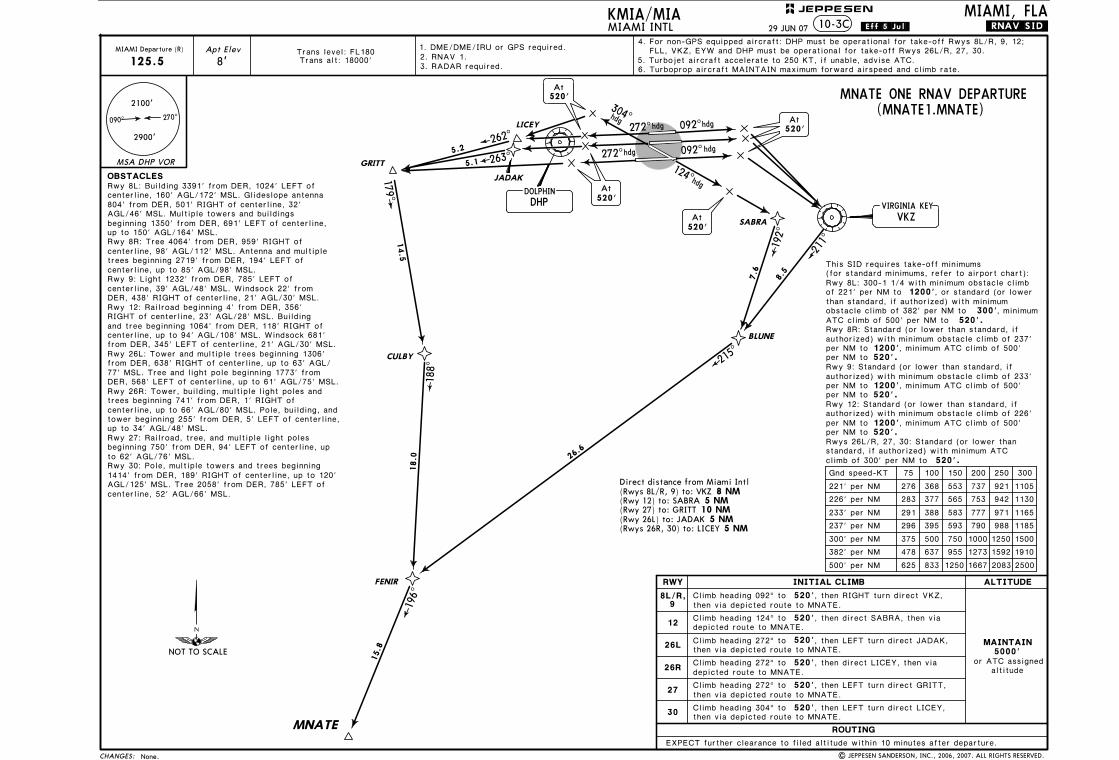
(for standard minimums, refer to airport chart):This SID requires take-off minimums
300' 520'.
than standard, if authorized) with minimum obstacle climb of 382' per NM toATC climb of 500' per NM to
, minimum
per NM to 520'.
authorized) with minimum obstacle climb of 229' per NM to 1200', minimum ATC climb of 500' per NM to 520'.
Rwy 12: Standard (or lower than standard, if
520'.
Rwys 26L/R, 27, 30: Standard (or lower than standard, if authorized) with minimum ATC climb of 300' per NM to
OBSTACLESRwy 8L: Building 3391' from DER, 1024' LEFT of
DER, 438' RIGHT of centerline, 21' AGL/30' MSL.
centerline, 160' AGL/172' MSL. Glideslope antenna 804' from DER, 501' RIGHT of centerline, 32' AGL/46' MSL. Multiple towers and buildings beginning 1350' from DER, 691' LEFT of centerline, up to 150' AGL/164' MSL.Rwy 8R: Tree 4064' from DER, 959' RIGHT of centerline, 98' AGL/112' MSL. Antenna and multiple trees beginning 2719' from DER, 194' LEFT of centerline, up to 85' AGL/98' MSL.Rwy 9: Light 1232' from DER, 785' LEFT of centerline, 39' AGL/48' MSL. Windsock 22' from
Rwy 12: Railroad beginning 4' from DER, 356' RIGHT of centerline, 23' AGL/28' MSL. Building and tree beginning 1064' from DER, 118' RIGHT of centerline, up to 94' AGL/108' MSL. Windsock 681' from DER, 345' LEFT of centerline, 21' AGL/30' MSL.
Rwy 26R: Tower, building, multiple light poles and trees beginning 741' from DER, 1' RIGHT of centerline, up to 66' AGL/80' MSL. Pole, building, and tower beginning 255' from DER, 5' LEFT of centerline, up to 34' AGL/48' MSL.Rwy 27: Railroad, tree, and multiple light poles beginning 750' from DER, 94' LEFT of centerline, up to 62' AGL/76' MSL.Rwy 30: Pole, multiple towers and trees beginning 1414' from DER, 189' RIGHT of centerline, up to 120' AGL/125' MSL. Tree 2058' from DER, 785' LEFT of centerline, 52' AGL/66' MSL.
ROUTING
INITIAL CLIMB ALTITUDE
MAINTAIN5000'
altitudeor ATC assigned
RWY
30
12
Climb heading 092^ to 520', then LEFT turn direct SENOY,
Climb heading 124^ to 520'
8L/R,9
Climb heading 272^ to 520'
Climb heading 304^ to 520', then LEFT turn direct METTS,
75 100 150 200 250 300Gnd speed-KT
382' per NM
286 382 573 763 954 1145229' per NM
375 500 750 1000 1250 1500300' per NM
478 637 955 1273 1592 1910
500' per NM 625 833 1250 1667 2083 2500
Rwy 26L: Tower and multiple trees beginning 1306'
NOT TO SCALE
CHANGES:
MIAMI, FLA
2100'
270^090^
2900'
MSA DHP VOR
Apt Elev
8'
, then RIGHT turn direct METTS,
HEDLY ONE RNAV DEPARTURE(HEDLY1.HEDLY)
Direct distance from Miami Intl
7 NM
JEPPESEN
.Eff.15.Mar.KMIA/MIAMIAMI INTL 10-3A
, then LEFT turn direct SENOY,
26L/R,27
EXPECT further clearance to filed altitude within 10 minutes after departure.
then via depicted route to HEDLY.
then via depicted route to HEDLY.
then via depicted route to HEDLY.
then via depicted route to HEDLY.
272^hdg 092^hdg
092^hdg
hdg
272^
DHPDOLPHIN
124^hdg
hdg
At520'
METTS
At520'
520'At
At520'
FORKK
354^
336^
327^
342^342^
010^
6.6
5.0
18.1
23.1
7.7
15.7
CIMBA
SENOY
VVMAX
HEDLY
BRBRA
(Rwys 8L/R, 9, 12) to: SENOY(Rwys 26L/R, 27, 30) to: METTS
MIAMI Departure (R)
119.45
1. DME/DME/IRU or GPS required.2. RNAV 1.
6. Turboprop aircraft MAINTAIN maximum forward airspeed and climb rate.5. Turbojet aircraft accelerate to 250 KT, if unable, advise ATC.
3. RADAR required.Trans level: FL180 Trans alt: 18000'
27, 30.
.RNAV.SID.
from DER, 638' RIGHT of centerline, up to 63' AGL/
DER, 568' LEFT of centerline, up to 61' AGL/75' MSL.77' MSL. Tree and light pole beginning 1773' from
Rwys 8R, 9: Standard (or lower than standard, if
Rwy 8L: 300-1 1/4, or standard (or lower
authorized) with minimum ATC climb of 500'
8 NM
4. For non-GPS equipped aircraft: FLL must be operational for take-off Rwys 26L/R,
9 MAR 07
Equipment notes. | JEPPESEN SANDERSON, INC., 2006, 2007. ALL RIGHTS RESERVED.
304^
Licensed to Romulo Serrano. Printed on 08 Jan 2010.NOTICE: PRINTED FROM AN EXPIRED REVISION. Disc 23-2009
JEPPESENJeppView 3.6.3.1
347^
177^
165^
136^
101^
215^ 326^ ZBV
116.7
D9
D33
D44
241^
D25 R245^
D17
261^D
13
R157^
073^FLL
114.4D59
D29
EONNSN25 17.8 W079 59.2
JANUS
MNATEN24 58.8 W080 31.4
VALLYN26 24.9 W079 08.3
WINCON26 25.0 W080 58.3 PADUS
BEECH
SKIPS
BEECH
EONNS
MNA
TE
PADUS
SKIPS
VALL
Y
WIN
CO
(MIA9.BEECH)
(MIA9.VALLY)
(MIA9
.PADUS)
(MIA9.SKIPS)(MIA9.EONNS)
(MIA
9.MNATE
)
(MIA9.W
INCO)
W079 38.0N26 05.6098^
151^
195^
058^
108^
322^
11000
3000
3000
3000
4000
4000
5000
50
50
36
42
33
32
49
MIAMIDEPARTURE
125.5
119.45
MIAMIDEPARTURE
(NORTH SECTOR)
(SOUTH SECTOR)
D68
D
D
D
D
D
D
VALLY
or PADUS
2000
35
D57
065^
N25 58.5 W079 23.1
N26 21.2W079 06.5
DRUUMN25 49.7 W080 14.6
HEDLYN26 35.0 W080 35.8
337^D62
(MIA9.HEDLY
)
4000
HEDLY4
9
N25 33.2 W079 16.5
NOT TO SCALE
CONTROL (R)
CONTROL (R)
1
NORTH PERRYOPA LOCKA
CHANGES:
FOR DEPARTURECONTROL FREQ.SEE GRAPHIC
MSA DHP VOR
JEPPESENKMIA/MIA
2. DME required.1. File DP in remarks section of flight plan.
1
75 100 150 200 250 300
270' per NM
370' per NM
380' per NM
420' per NM
338 450 675 900 1125 1350
463 617 925 1233 1542 1850
475 633 950 1267 1583 1900
525 700 1050 1400 1750 2100
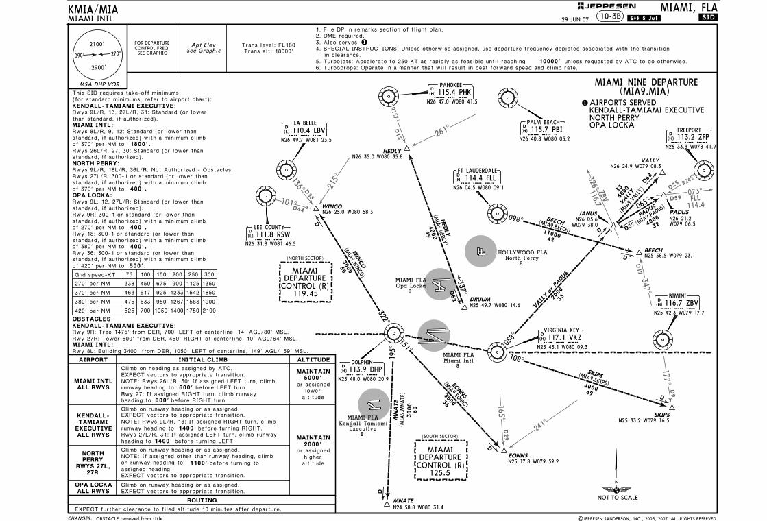
KENDALL-TAMIAMI EXECUTIVE:
NORTH PERRY:
OPA LOCKA:
(for standard minimums, refer to airport chart):
Apt ElevSee Graphic
LA BELLE110.4 LBV
LBV
N26 49.7 W081 23.5
D(L)
LEE COUNTY111.8 RSWRSW
N26 31.8 W081 46.5
D(L)
DOLPHIN113.9 DHP
DHP
N25 48.0 W080 20.9
D(H)
PAHOKEE115.4 PHK
PHK
N26 47.0 W080 41.5
D(H)
VIRGINIA KEY117.1 VKZ
VKZ
N25 45.1 W080 09.3
D(H)
PALM BEACH115.7 PBI
PBI
N26 40.8 W080 05.2
D(H)
114.4 FLLFLL
N26 04.5 W080 09.1
D(H)
BIMINI116.7 ZBV
ZBV
N25 42.3 W079 17.7
D(H)
FREEPORT113.2 ZFP
ZFP
N26 33.3 W078 41.9
D(H)
FT LAUDERDALE
MIAMI INTL
HOLLYWOOD FLANorth Perry
8
MIAMI FLAOpa Locka
8
MIAMI FLAMiami Intl
8
MIAMI FLAKendall-Tamiami
Executive8
MIAMI, FLA
KENDALL-TAMIAMI EXECUTIVE:
2100'
270^090^
2900'
Rwy 27R: Tower 600' from DER, 450' RIGHT of centerline, 10' AGL/64' MSL.
10000', unless requested by ATC to do otherwise.6. Turboprops: Operate in a manner that will result in best forward speed and climb rate.5. Turbojets: Accelerate to 250 KT as rapidly as feasible until reaching
400'.
of 270' per NM to
of 380' per NM to
400'.
400'.
of 420' per NM to 500'.
Gnd speed-KT
Rwy 9R: Tree 1475' from DER, 700' LEFT of centerline, 14' AGL/80' MSL.
in clearance.4. SPECIAL INSTRUCTIONS: Unless otherwise assigned, use departure frequency depicted associated with the transition
ROUTING
INITIAL CLIMB
600'
600'
ALTITUDE
5000'MAINTAIN
2000'MAINTAIN
1400'
1400'
1100'
Climb on heading as assigned by ATC.
before RIGHT turn.
Climb on runway heading or as assigned.
Climb on runway heading or as assigned.
Climb on runway heading or as assigned.
EXPECT further clearance to filed altitude 10 minutes after departure.
before turning LEFT.
EXPECT vectors to appropriate transition.
EXPECT vectors to appropriate transition.
runway heading to
heading to
EXPECT vectors to appropriate transition.
runway heading toRwy 27: If assigned RIGHT turn, climb runwayheading to
before LEFT turn.
NOTE: Rwys 9L/R, 13: If assigned RIGHT turn, climbbefore turning RIGHT.
EXPECT vectors to appropriate transition.
MIAMI NINE DEPARTURE(MIA9.MIA)
KENDALL-TAMIAMI EXECUTIVE
Rwy 8L: Building 3400' from DER, 1050' LEFT of centerline, 149' AGL/159' MSL.MIAMI INTL:
MIAMI INTL:
|JEPPESEN SANDERSON, INC., 2003, 2007. ALL RIGHTS RESERVED.
3. Also serves
AIRPORTS SERVED
Trans alt: 18000'
than standard, if authorized).
Rwys 8L/R, 9, 12: Standard (or lower thanstandard, if authorized) with a minimum climbof 370' per NM to 1800'.Rwys 26L/R, 27, 30: Standard (or lower thanstandard, if authorized).
Rwys 27L/R: 300-1 or standard (or lower thanstandard, if authorized) with a minimum climbof 370' per NM to
Rwys 9L, 12, 27L/R: Standard (or lower thanstandard, if authorized).Rwy 9R: 300-1 or standard (or lower thanstandard, if authorized) with a minimum climb
Rwy 18: 300-1 or standard (or lower thanstandard, if authorized) with a minimum climb
Rwy 36: 300-1 or standard (or lower thanstandard, if authorized) with a minimum climb
AIRPORT
or assignedlower
altitude
or assignedhigheraltitude
OPA LOCKAALL RWYS
NOTE: If assigned other than runway heading, climbon runway heading to before turning toassigned heading.
NORTHPERRY
RWYS 27L,27R
KENDALL-TAMIAMI
EXECUTIVEALL RWYS
MIAMI INTLALL RWYS
NOTE: Rwys 26L/R, 30: If assigned LEFT turn, climb
Rwys 27L/R, 31: If assigned LEFT turn, climb runway
10-3B
Trans level: FL180
Rwys 9L/R, 13, 27L/R, 31: Standard (or lower
Rwys 9L/R, 18L/R, 36L/R: Not Authorized - Obstacles.
OBSTACLES
29 JUN 07 .Eff.5.Jul. .SID.
This SID requires take-off minimums
OBSTACLE removed from title.
Licensed to Romulo Serrano. Printed on 08 Jan 2010.NOTICE: PRINTED FROM AN EXPIRED REVISION. Disc 23-2009
JEPPESENJeppView 3.6.3.1
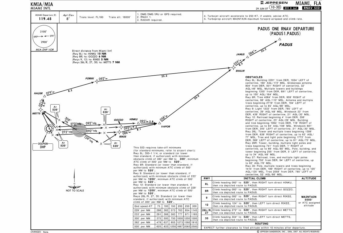
(for standard minimums, refer to airport chart):This SID requires take-off minimums
Rwy 8L: 300-1 1/4 with minimum obstacle climb of 221' per NM to 1200'
300' 520'.
, or standard (or lower than standard, if authorized) with minimum obstacle climb of 382' per NM toATC climb of 500' per NM to
, minimum
Rwy 8R: Standard (or lower than standard, if authorized) with minimum obstacle climb of 237' per NM to 1200', minimum ATC climb of 500' per NM to 520'.
authorized) with minimum obstacle climb of 233' per NM to 1200', minimum ATC climb of 500' per NM to 520'.
Rwy 9: Standard (or lower than standard, if
authorized) with minimum obstacle climb of 226' per NM to 1200', minimum ATC climb of 500' per NM to 520'.
Rwy 12: Standard (or lower than standard, if
520'.
Rwys 26L/R, 27, 30: Standard (or lower than standard, if authorized) with minimum ATC climb of 300' per NM to
OBSTACLESRwy 8L: Building 3391' from DER, 1024' LEFT of
DER, 438' RIGHT of centerline, 21' AGL/30' MSL.
centerline, 160' AGL/172' MSL. Glideslope antenna 804' from DER, 501' RIGHT of centerline, 32' AGL/46' MSL. Multiple towers and buildings beginning 1350' from DER, 691' LEFT of centerline, up to 150' AGL/164' MSL.Rwy 8R: Tree 4064' from DER, 959' RIGHT of centerline, 98' AGL/112' MSL. Antenna and multiple trees beginning 2719' from DER, 194' LEFT of centerline, up to 85' AGL/98' MSL.Rwy 9: Light 1232' from DER, 785' LEFT of centerline, 39' AGL/48' MSL. Windsock 22' from
Rwy 12: Railroad beginning 4' from DER, 356' RIGHT of centerline, 23' AGL/28' MSL. Building and tree beginning 1064' from DER, 118' RIGHT of centerline, up to 94' AGL/108' MSL. Windsock 681' from DER, 345' LEFT of centerline, 21' AGL/30' MSL.
Rwy 26R: Tower, building, multiple light poles and trees beginning 741' from DER, 1' RIGHT of centerline, up to 66' AGL/80' MSL. Pole, building, and tower beginning 255' from DER, 5' LEFT of centerline, up to 34' AGL/48' MSL.Rwy 27: Railroad, tree, and multiple light poles beginning 750' from DER, 94' LEFT of centerline, up to 62' AGL/76' MSL.Rwy 30: Pole, multiple towers and trees beginning 1414' from DER, 189' RIGHT of centerline, up to 120' AGL/125' MSL. Tree 2058' from DER, 785' LEFT of centerline, 52' AGL/66' MSL.
75 100 150 200 250 300
221' per NM 276 368 553 737 921 1105
Gnd speed-KT
382' per NM
283 377 565 753 942 1130
237' per NM
291 388 583 777 971 1165233' per NM
296 395 593 790 988 1185
226' per NM
375 500 750 1000 1250 1500300' per NM
478 637 955 1273 1592 1910
500' per NM 625 833 1250 1667 2083 2500
Rwy 26L: Tower and multiple trees beginning 1306'
NOT TO SCALE
CHANGES:
MIAMI, FLA
2100'
270^090^
2900'
MSA DHP VOR
6. Turboprop aircraft MAINTAIN maximum forward airspeed and climb rate.
1. DME/DME/IRU or GPS required.
3. RADAR required.2. RNAV 1.
MIAMI Departure (R)
125.5Apt Elev
8'
MNATE ONE RNAV DEPARTURE(MNATE1.MNATE)
Direct distance from Miami Intl(Rwys 8L/R, 9) to: VKZ(Rwy 12) to: SABRA(Rwy 27) to: GRITT
LICEY
GRITT
JADAK
272^hdg 092^hdg
092^hdg
hdg
272^5.1
5.2262^
263^
DHPDOLPHIN
At520'
124^hdg
hdg
SABRA
At520'
179^
CULBY
14.5
8.5
211^
BLUNE
VKZVIRGINIA KEY
8 NM 5 NM
10 NM 5 NM
5 NM
At520'
At520'
FLL, VKZ, EYW and DHP must be operational for take-off Rwys 26L/R, 27, 30.4. For non-GPS equipped aircraft: DHP must be operational for take-off Rwys 8L/R, 9, 12;
Trans level: FL180Trans alt: 18000'
7.6
192^
26.6
215^
18.0
188^
FENIR
196^
15.8
MNATE
JEPPESENKMIA/MIAMIAMI INTL 10-3C
ROUTING
INITIAL CLIMB ALTITUDE
MAINTAIN5000'
altitudeor ATC assigned
RWY
26R
26L
30
27
12
Climb heading 092^ to 520'
Climb heading 124^ to 520'
8L/R,9
Climb heading 272^ to 520', then LEFT turn direct JADAK,
Climb heading 272^ to 520'
Climb heading 272^ to 520'
Climb heading 304^ to 520', then LEFT turn direct LICEY,
EXPECT further clearance to filed altitude within 10 minutes after departure.
, then RIGHT turn direct VKZ, then via depicted route to MNATE.
, then LEFT turn direct GRITT,
then via depicted route to MNATE.
then via depicted route to MNATE.
.RNAV.SID.
5. Turbojet aircraft accelerate to 250 KT, if unable, advise ATC.
from DER, 638' RIGHT of centerline, up to 63' AGL/
DER, 568' LEFT of centerline, up to 61' AGL/75' MSL.77' MSL. Tree and light pole beginning 1773' from
(Rwy 26L) to: JADAK(Rwys 26R, 30) to: LICEY
, then direct SABRA, then via depicted route to MNATE.
then via depicted route to MNATE.
, then direct LICEY, then via depicted route to MNATE.
| JEPPESEN SANDERSON, INC., 2006, 2007. ALL RIGHTS RESERVED.
29 JUN 07 .Eff.5.Jul.
None.
304^
Licensed to Romulo Serrano. Printed on 08 Jan 2010.NOTICE: PRINTED FROM AN EXPIRED REVISION. Disc 23-2009
JEPPESENJeppView 3.6.3.1
(for standard minimums, refer to airport chart):This SID requires take-off minimums
300' 520'.
than standard, if authorized) with minimum obstacle climb of 382' per NM toATC climb of 500' per NM to
, minimum
Rwy 8R: Standard (or lower than standard, if
per NM to 520'.
authorized) with minimum obstacle climb of 233' per NM to 1200', minimum ATC climb of 500' per NM to 520'.
Rwy 9: Standard (or lower than standard, if
authorized) with minimum obstacle climb of 229' per NM to 1200', minimum ATC climb of 500' per NM to 520'.
Rwy 12: Standard (or lower than standard, if
520'.
Rwys 26L/R, 27, 30: Standard (or lower than standard, if authorized) with minimum ATC climb of 300' per NM to
OBSTACLESRwy 8L: Building 3391' from DER, 1024' LEFT of
DER, 438' RIGHT of centerline, 21' AGL/30' MSL.
centerline, 160' AGL/172' MSL. Glideslope antenna 804' from DER, 501' RIGHT of centerline, 32' AGL/46' MSL. Multiple towers and buildings beginning 1350' from DER, 691' LEFT of centerline, up to 150' AGL/164' MSL.Rwy 8R: Tree 4064' from DER, 959' RIGHT of centerline, 98' AGL/112' MSL. Antenna and multiple trees beginning 2719' from DER, 194' LEFT of centerline, up to 85' AGL/98' MSL.Rwy 9: Light 1232' from DER, 785' LEFT of centerline, 39' AGL/48' MSL. Windsock 22' from
Rwy 12: Railroad beginning 4' from DER, 356' RIGHT of centerline, 23' AGL/28' MSL. Building and tree beginning 1064' from DER, 118' RIGHT of centerline, up to 94' AGL/108' MSL. Windsock 681' from DER, 345' LEFT of centerline, 21' AGL/30' MSL.
Rwy 26R: Tower, building, multiple light poles and trees beginning 741' from DER, 1' RIGHT of centerline, up to 66' AGL/80' MSL. Pole, building, and tower beginning 255' from DER, 5' LEFT of centerline, up to 34' AGL/48' MSL.Rwy 27: Railroad, tree, and multiple light poles beginning 750' from DER, 94' LEFT of centerline, up to 62' AGL/76' MSL.Rwy 30: Pole, multiple towers and trees beginning 1414' from DER, 189' RIGHT of centerline, up to 120' AGL/125' MSL. Tree 2058' from DER, 785' LEFT of centerline, 52' AGL/66' MSL.
ROUTING
INITIAL CLIMB ALTITUDE
MAINTAIN5000'
altitudeor ATC assigned
RWY
30
12
Climb heading 092^ to 520'
Climb heading 124^ to 520'
Climb heading 092^ to 520'
Climb heading 092^ to 520'
Climb heading 272^ to 520'
Climb heading 304^ to 520', then LEFT turn direct METTS,
75 100 150 200 250 300Gnd speed-KT
382' per NM
286 382 573 763 954 1145
291 388 583 777 971 1165233' per NM
229' per NM
375 500 750 1000 1250 1500300' per NM
478 637 955 1273 1592 1910
500' per NM 625 833 1250 1667 2083 2500
Rwy 26L: Tower and multiple trees beginning 1306'
NOT TO SCALE
CHANGES:
JEPPESENKMIA/MIAMIAMI INTL
MIAMI, FLA
2100'
270^090^
2900'
MSA DHP VOR
Trans level: FL180 Trans alt: 18000'Apt Elev
8'
, then RIGHT turn direct METTS,
PADUS ONE RNAV DEPARTURE(PADUS1.PADUS)
Direct distance from Miami Intl
(Rwy 8R) to: GOZZO
272^hdg 092^hdg
092^hdg
hdg
272^
DHPDOLPHIN
124^hdg
hdg
At520'
10 NM 6 NM
5 NM 7 NM
10-3D
, then RIGHT turn direct RIKEE,
, then RIGHT turn direct GOZZO,
, then LEFT turn direct RIKEE,
26L/R,27
9
8R
8L, then RIGHT turn direct HINKU,
RIKEE
GOZZO HINKU
METTS
095^ 058^
059^
066^
092^
086^
021^
079^
092^
8.1
20.0
8.2
32.3
6.5
8.2
25.2
2.8
7.4
At520'
520'At
At520'
HAUSR
FORKK
VAPOR
SHALW
JANUS
PADUS
(Rwy 8L) to: HINKU
(Rwys 9, 12) to: RIKEE(Rwys 26L/R, 27, 30) to: METTS
EXPECT further clearance to filed altitude within 10 minutes after departure.
then via depicted route to PADUS.
then via depicted route to PADUS.
then via depicted route to PADUS.
then via depicted route to PADUS.
then via depicted route to PADUS.
then via depicted route to PADUS.
MIAMI Departure (R)
119.45
.RNAV.SID.
5. Turboprop aircraft MAINTAIN maximum forward airspeed and climb rate.3. RADAR required.
4. Turbojet aircraft accelerate to 250 KT, if unable, advise ATC.
Rwy 8L: 300-1 1/4, or standard (or lower
authorized) with minimum ATC climb of 500'
from DER, 638' RIGHT of centerline, up to 63' AGL/
DER, 568' LEFT of centerline, up to 61' AGL/75' MSL.77' MSL. Tree and light pole beginning 1773' from
| JEPPESEN SANDERSON, INC., 2006, 2007. ALL RIGHTS RESERVED.
1. DME/DME/IRU or GPS required.2. RNAV 1.
None.
29 JUN 07 .Eff.5.Jul.
304^
Licensed to Romulo Serrano. Printed on 08 Jan 2010.NOTICE: PRINTED FROM AN EXPIRED REVISION. Disc 23-2009
JEPPESENJeppView 3.6.3.1
347^
326^ZBV
116.7
D17
347^
136^
101^D44
D33
215^
R245^
D25
073^FLL114.4
D59
091^
R157^D13 261^
JANUS
VALLYN26 24.9 W079 08.3
WINCON26 25.0 W080 58.3
PADUS
BEECH
BEECH
VALL
Y
WIN
CO
W079 38.0N26 05.6098^
058^
322^
11000
3000
5000
50
42
33
D68
D
D
D
VALLY
or PADU
S
2000
35
N25 58.5 W079 23.1
N26 21.2W079 06.5
POTTRN25 48.5
W080 10.4
75 100 150 200 250 300
370' per NM 463 617 925 1233 1542 1850
(POTTR3.BEECH)
(POTTR3.WINCO)
119.45
060^
091^D10
PADUS
(POTTR
3.PADU
S)
4000
32
065^
D57
(POTTR3.VALLY)
hdg
CHANGES:
KMIA/MIA
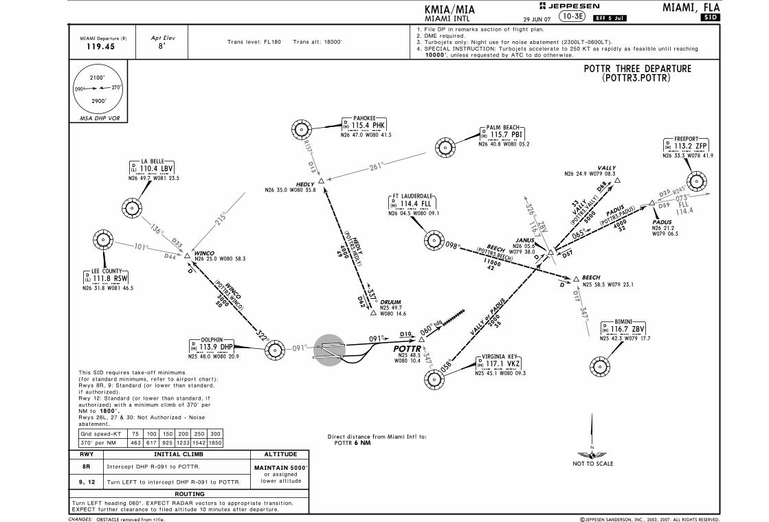
Apt Elev 2. DME required.1. File DP in remarks section of flight plan.
10-3E
8'
LA BELLE110.4 LBV
LBV
N26 49.7 W081 23.5
D(L)
LEE COUNTY111.8 RSWRSW
N26 31.8 W081 46.5
D(L)
DOLPHIN113.9 DHP
DHP
N25 48.0 W080 20.9
D(H)
PAHOKEE115.4 PHK
PHK
N26 47.0 W080 41.5
D(H)
VIRGINIA KEY117.1 VKZ
VKZ
N25 45.1 W080 09.3
D(H)
114.4 FLLFLL
N26 04.5 W080 09.1
D(H)
PALM BEACH115.7 PBI
PBI
N26 40.8 W080 05.2
D(H)
BIMINI116.7 ZBV
ZBV
N25 42.3 W079 17.7
D(H)
FREEPORT113.2 ZFP
ZFP
N26 33.3 W078 41.9
D(H)
FT LAUDERDALE
10000'
090^ 270^
4. SPECIAL INSTRUCTION: Turbojets accelerate to 250 KT as rapidly as feasible until reaching, unless requested by ATC to do otherwise.
Gnd speed-KT
|JEPPESEN SANDERSON, INC., 2003, 2007. ALL RIGHTS RESERVED.
Direct distance from Miami Intl to:POTTR 6 NM
HEDLYN26 35.0 W080 35.8
4000
HEDLY4
9
337^D62 DRUUM
(POTTR3.HEDLY)
N25 49.7W080 14.6
Trans level: FL180 Trans alt: 18000' 3. Turbojets only: Night use for noise abatement (2300LT-0600LT).
.Eff.5.Jul.29 JUN 07 .SID.
OBSTACLE removed from title.
MSA DHP VOR
NOT TO SCALE
(for standard minimums, refer to airport chart):
JEPPESEN
ROUTING
INITIAL CLIMB ALTITUDE
MIAMI, FLA
MIAMI Departure (R)
RWY
MIAMI INTL
2900'
2100'
9, 12
Intercept DHP R-091 to POTTR.
Turn LEFT to intercept DHP R-091 to POTTR.
POTTR THREE DEPARTURE(POTTR3.POTTR)
8R
Rwys 8R, 9: Standard (or lower than standard,if authorized).Rwy 12: Standard (or lower than standard, ifauthorized) with a minimum climb of 370' perNM to 1800'.Rwys 26L, 27 & 30: Not Authorized - Noiseabatement.
Turn LEFT heading 060^. EXPECT RADAR vectors to appropriate transition.EXPECT further clearance to filed altitude 10 minutes after departure.
MAINTAIN 5000'or assigned
lower altitude
This SID requires take-off minimums
Licensed to Romulo Serrano. Printed on 08 Jan 2010.NOTICE: PRINTED FROM AN EXPIRED REVISION. Disc 23-2009
JEPPESENJeppView 3.6.3.1
(for standard minimums, refer to airport chart):This SID requires take-off minimums
Rwy 8L: 300-1 1/4 with minimum obstacle climb of 221' per NM to 1200'
300' 520'.
, or standard (or lower than standard, if authorized) with minimum obstacle climb of 382' per NM toATC climb of 500' per NM to
, minimum
Rwy 8R: Standard (or lower than standard, if authorized) with minimum obstacle climb of 237' per NM to 1200', minimum ATC climb of 500' per NM to 520'.
authorized) with minimum obstacle climb of 233' per NM to 1200', minimum ATC climb of 500' per NM to 520'.
Rwy 9: Standard (or lower than standard, if
authorized) with minimum obstacle climb of 229' per NM to 1200', minimum ATC climb of 500' per NM to 520'.
Rwy 12: Standard (or lower than standard, if
520'.
Rwys 26L/R, 27, 30: Standard (or lower than standard, if authorized) with minimum ATC climb of 300' per NM to
OBSTACLESRwy 8L: Building 3391' from DER, 1024' LEFT of
DER, 438' RIGHT of centerline, 21' AGL/30' MSL.
centerline, 160' AGL/172' MSL. Glideslope antenna 804' from DER, 501' RIGHT of centerline, 32' AGL/46' MSL. Multiple towers and buildings beginning 1350' from DER, 691' LEFT of centerline, up to 150' AGL/164' MSL.Rwy 8R: Tree 4064' from DER, 959' RIGHT of centerline, 98' AGL/112' MSL. Antenna and multiple trees beginning 2719' from DER, 194' LEFT of centerline, up to 85' AGL/98' MSL.Rwy 9: Light 1232' from DER, 785' LEFT of centerline, 39' AGL/48' MSL. Windsock 22' from
Rwy 12: Railroad beginning 4' from DER, 356' RIGHT of centerline, 23' AGL/28' MSL. Building and tree beginning 1064' from DER, 118' RIGHT of centerline, up to 94' AGL/108' MSL. Windsock 681' from DER, 345' LEFT of centerline, 21' AGL/30' MSL.
Rwy 26R: Tower, building, multiple light poles and trees beginning 741' from DER, 1' RIGHT of centerline, up to 66' AGL/80' MSL. Pole, building, and tower beginning 255' from DER, 5' LEFT of centerline, up to 34' AGL/48' MSL.Rwy 27: Railroad, tree, and multiple light poles beginning 750' from DER, 94' LEFT of centerline, up to 62' AGL/76' MSL.Rwy 30: Pole, multiple towers and trees beginning 1414' from DER, 189' RIGHT of centerline, up to 120' AGL/125' MSL. Tree 2058' from DER, 785' LEFT of centerline, 52' AGL/66' MSL.
75 100 150 200 250 300
221' per NM 276 368 553 737 921 1105
Gnd speed-KT
382' per NM
286 382 573 763 954 1145
237' per NM
291 388 583 777 971 1165233' per NM
296 395 593 790 988 1185
229' per NM
375 500 750 1000 1250 1500300' per NM
478 637 955 1273 1592 1910
500' per NM 625 833 1250 1667 2083 2500
Rwy 26L: Tower and multiple trees beginning 1306'
NOT TO SCALE
CHANGES:
JEPPESENKMIA/MIAMIAMI INTL
MIAMI, FLA
2100'
270^090^
2900'
MSA DHP VOR
6. Turboprop aircraft MAINTAIN maximum forward airspeed and climb rate.
1. DME/DME/IRU or GPS required.
3. RADAR required.Trans level: FL180 Trans alt: 18000'
MIAMI Departure (R)
125.5
4. For non-GPS equipped aircraft: FLL must be operational for take-off Rwys 8L/R, Apt Elev
8'
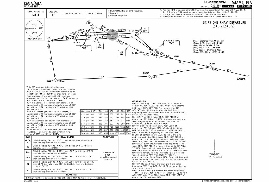
SKIPS ONE RNAV DEPARTURE(SKIPS1.SKIPS)
Direct distance from Miami Intl(Rwys 8L/R, 9) to: VKZ(Rwy 12) to: SABRA(Rwy 27) to: GRITT
LICEY
GRITT
JADAK
272^hdg 092^hdg
092^hdg
hdg
272^5.1
5.2262^
263^
DHPDOLPHIN
At520'
124^hdg
hdg
SABRA
At520'
179^
CULBY
14.5
091^
14.9
107^11.6
DICKI26.3
082^
VKZVIRGINIA KEY
8 NM 5 NM
10 NM 5 NM
5 NM
At520'
At520'
10-3F
112^8.8 IBISS
107^ 16.6CRABI
109^ 23.9
SKIPS
ROUTING
INITIAL CLIMB ALTITUDE
MAINTAIN5000'
altitudeor ATC assigned
RWY
26R
26L
30
27
12
Climb heading 092^ to 520'
Climb heading 124^ to 520'
8L/R,9
Climb heading 272^ to 520', then LEFT turn direct JADAK,
Climb heading 272^ to 520', then LEFT turn direct LICEY,
Climb heading 272^ to 520'
Climb heading 304^ to 520', then LEFT turn direct LICEY,
EXPECT further clearance to filed altitude within 10 minutes after departure.
, then RIGHT turn direct VKZ, then via depicted route to SKIPS.
, then LEFT turn direct GRITT,then LEFT turn via track 179^ to CULBY, then via depicted route to SKIPS.
then via depicted route to SKIPS.
then via depicted route to SKIPS.
then via depicted route to SKIPS.
9, 12; FLL and VKZ must be operational for take-off Rwys 26L/R, 27, 30.
.RNAV.SID.
5. Turbojet aircraft accelerate to 250 KT, if unable, advise ATC.
from DER, 638' RIGHT of centerline, up to 63' AGL/
DER, 568' LEFT of centerline, up to 61' AGL/75' MSL.77' MSL. Tree and light pole beginning 1773' from
, then direct SABRA, then via depicted route to SKIPS.
(Rwys 26R, 30) to: LICEY(Rwy 26L) to: JADAK
| JEPPESEN SANDERSON, INC., 2006, 2007. ALL RIGHTS RESERVED.
2. RNAV 1.
29 JUN 07 .Eff.5.Jul.
None.
304^
Licensed to Romulo Serrano. Printed on 08 Jan 2010.NOTICE: PRINTED FROM AN EXPIRED REVISION. Disc 23-2009
JEPPESENJeppView 3.6.3.1
103^
D29
165^
241^
177^D9
NO
T TO
SCA
LE
SO
UBY
N25
46.6
W08
0 11
.1D9
135^
MNA
TE
N24
58.8
W08
0 31
.4
EO
NNS
N25
17.8
W07
9 59
.2
SKIP
S
MNATE (SOUBY4.MNATE)
300050
103^
108^
195^
D
R315^
135^
hdg
2
(for
sta
ndard
min
imums, re
fer
to a
irport
chart
):
DOLP
HIN
113.9
DHP
DH
P
N25
48.0
W08
0 20
.9
D (H)
VIRGINIA
KEY
117.1
VKZ
VK
Z
N25
45.1
W08
0 09
.3
D (H)
BIMINI
116.7
ZBV
ZB
V
N25
42.3
W07
9 17
.7
D (H)
RO
UTIN
G
IN
IT
IA
L C
LIM
BA
LT
IT
UD
ERW
Y
8R,
9
12
Turn
RIG
HT.
Turn
LEFT.
CHANGES:
Trans level: FL180 Trans alt: 18000'
JEPPESENKMIA/MIA
SOUBY FOUR DEPARTURE (SOUBY4.SOUBY)
2. DME required.1. File DP in remarks section of flight plan.
MSA
DHP V
OR
2900
'
2100
'
090^
270^
10000'
EONNS
(SOUBY4.EONNS)
151^
363000
D
D
(SOU
BY4.SKIPS)
SKIP
S
49
4000
10-3GMIAMI, FLA
MIAMI INTL
75
100
150
200
250
300
370' per
NM
463
617
925
1233
1542
1850
Gnd s
peed-K
T
N25
33.2
W07
9 16
.5
Dir
ect
dist
ance
fro
m M
iam
i In
tl t
o:SO
UBY
6 N
M
| JEPPESEN SANDERSON, INC., 2004, 2007. ALL RIGHTS RESERVED.
4. SPECIAL INSTRUCTION: Turbojets accelerate to 250 KT as rapidly as feasible until reaching unless requested by ATC to do otherwise.
MIAMIDeparture (R)
125.5
Apt Elev
8' 3. Turbojets only: Night use for noise abatement (2300LT-0600LT).
MA
IN
TA
IN
5000'
or
assig
ned
lower
altitude
Rwys 8
R, 9, 12: Sta
ndard
(or
lower
than s
tandard
, if a
uth
orized)
with a
min
imum c
limb g
radie
nt
of
370' per
NM t
o 1
800'.
Inte
rcept
DHP R
-103 t
o S
OUBY/D9 D
HP, th
en t
urn
RIG
HT v
ia V
KZ R
-315 t
o V
KZ,
EXPECT f
urt
her
cle
ara
nce t
o f
iled a
ltitude 1
0 m
inute
s a
fter
depart
ure
.
Rwys 2
6L, 27, 30: Not
Auth
orized -
nois
e a
bate
ment.
Unle
ss o
therw
ise instr
ucte
d, continue h
eadin
g 1
35^
aft
er
VKZ u
ntil ATC issues
.Eff.5.Jul.29 JUN 07
OBSTACLE removed from title.
.SID.
This
SID
requires t
ake-o
ff m
inim
ums
then v
ia h
eadin
g 1
35^. E
XPECT R
ADAR v
ecto
rs t
o a
ppro
priate
tra
nsitio
n.
vecto
rs t
o a
ppro
priate
tra
nsitio
n.

Licensed to Romulo Serrano. Printed on 08 Jan 2010.NOTICE: PRINTED FROM AN EXPIRED REVISION. Disc 23-2009
JEPPESENJeppView 3.6.3.1
(for standard minimums, refer to airport chart):This SID requires take-off minimums
300' 520'.
than standard, if authorized) with minimum obstacle climb of 382' per NM toATC climb of 500' per NM to
, minimum
Rwy 8R: Standard (or lower than standard, if
per NM to 520'.
authorized) with minimum obstacle climb of 233' per NM to 1200', minimum ATC climb of 500' per NM to 520'.
Rwy 9: Standard (or lower than standard, if
authorized) with minimum obstacle climb of 229' per NM to 1200', minimum ATC climb of 500' per NM to 520'.
Rwy 12: Standard (or lower than standard, if
520'.
Rwys 26L/R, 27, 30: Standard (or lower than standard, if authorized) with minimum ATC climb of 300' per NM to
OBSTACLESRwy 8L: Building 3391' from DER, 1024' LEFT of
DER, 438' RIGHT of centerline, 21' AGL/30' MSL.
centerline, 160' AGL/172' MSL. Glideslope antenna 804' from DER, 501' RIGHT of centerline, 32' AGL/46' MSL. Multiple towers and buildings beginning 1350' from DER, 691' LEFT of centerline, up to 150' AGL/164' MSL.Rwy 8R: Tree 4064' from DER, 959' RIGHT of centerline, 98' AGL/112' MSL. Antenna and multiple trees beginning 2719' from DER, 194' LEFT of centerline, up to 85' AGL/98' MSL.Rwy 9: Light 1232' from DER, 785' LEFT of centerline, 39' AGL/48' MSL. Windsock 22' from
Rwy 12: Railroad beginning 4' from DER, 356' RIGHT of centerline, 23' AGL/28' MSL. Building and tree beginning 1064' from DER, 118' RIGHT of centerline, up to 94' AGL/108' MSL. Windsock 681' from DER, 345' LEFT of centerline, 21' AGL/30' MSL.
Rwy 26R: Tower, building, multiple light poles and trees beginning 741' from DER, 1' RIGHT of centerline, up to 66' AGL/80' MSL. Pole, building, and tower beginning 255' from DER, 5' LEFT of centerline, up to 34' AGL/48' MSL.Rwy 27: Railroad, tree, and multiple light poles beginning 750' from DER, 94' LEFT of centerline, up to 62' AGL/76' MSL.Rwy 30: Pole, multiple towers and trees beginning 1414' from DER, 189' RIGHT of centerline, up to 120' AGL/125' MSL. Tree 2058' from DER, 785' LEFT of centerline, 52' AGL/66' MSL.
75 100 150 200 250 300Gnd speed-KT
382' per NM
286 382 573 763 954 1145
291 388 583 777 971 1165233' per NM
229' per NM
375 500 750 1000 1250 1500300' per NM
478 637 955 1273 1592 1910
500' per NM 625 833 1250 1667 2083 2500
Rwy 26L: Tower and multiple trees beginning 1306'
NOT TO SCALE
CHANGES:
JEPPESENKMIA/MIAMIAMI INTL
MIAMI, FLA
2100'
270^090^
2900'
MSA DHP VOR
Trans level: FL180 Trans alt: 18000'Apt Elev
8'
VALLY ONE RNAV DEPARTURE(VALLY1.VALLY)
Direct distance from Miami Intl
(Rwy 8R) to: GOZZO
272^hdg 092^hdg
092^hdg
hdg
272^
DHPDOLPHIN
124^hdg
hdg
At520'
10 NM 6 NM
5 NM 7 NM
10-3H
RIKEE
METTS
095^ 058^
059^
092^
086^
021^
079^
092^
8.1
20.0
8.2
32.9
6.5
8.2
25.2
2.8
7.4
At520'
520'At
At520'
HAUSR
FORKK
VAPOR
SHALW
JANUS
VALLY
(Rwy 8L) to: HINKU
(Rwys 9, 12) to: RIKEE(Rwys 26L/R, 27, 30) to: METTS
.Eff.15.Mar.
ROUTING
INITIAL CLIMB ALTITUDE
MAINTAIN5000'
altitudeor ATC assigned
RWY
30
12
Climb heading 092^ to 520'
Climb heading 124^ to 520'
Climb heading 092^ to 520'
Climb heading 092^ to 520'
Climb heading 272^ to 520'
Climb heading 304^ to 520', then LEFT turn direct METTS,
, then RIGHT turn direct METTS,
, then RIGHT turn direct RIKEE,
, then RIGHT turn direct GOZZO,
, then LEFT turn direct RIKEE,
26L/R,27
9
8R
8L, then RIGHT turn direct HINKU,
EXPECT further clearance to filed altitude within 10 minutes after departure.
then via depicted route to VALLY.
then via depicted route to VALLY.
then via depicted route to VALLY.
then via depicted route to VALLY.
then via depicted route to VALLY.
then via depicted route to VALLY.
MIAMI Departure (R)
119.45
.RNAV.SID.
5. Turboprop aircraft MAINTAIN maximum forward airspeed and climb rate.3. RADAR required.
4. Turbojet aircraft accelerate to 250 KT, if unable, advise ATC.
Rwy 8L: 300-1 1/4, or standard (or lower
authorized) with minimum ATC climb of 500'
from DER, 638' RIGHT of centerline, up to 63' AGL/
DER, 568' LEFT of centerline, up to 61' AGL/75' MSL.77' MSL. Tree and light pole beginning 1773' from
GOZZO HINKU
9 MAR 07
| JEPPESEN SANDERSON, INC., 2006, 2007. ALL RIGHTS RESERVED.
1. DME/DME/IRU or GPS required.
Equipment notes.
2. RNAV 1.
304^
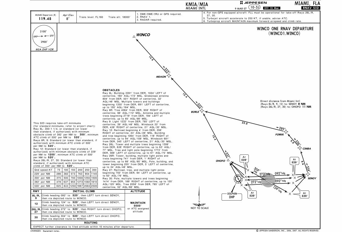
Licensed to Romulo Serrano. Printed on 08 Jan 2010.NOTICE: PRINTED FROM AN EXPIRED REVISION. Disc 23-2009
JEPPESENJeppView 3.6.3.1
(for standard minimums, refer to airport chart):This SID requires take-off minimums
300' 520'.
than standard, if authorized) with minimum obstacle climb of 382' per NM toATC climb of 500' per NM to
, minimum
per NM to 520'.
authorized) with minimum obstacle climb of 229' per NM to 1200', minimum ATC climb of 500' per NM to 520'.
Rwy 12: Standard (or lower than standard, if
520'.
Rwys 26L/R, 27, 30: Standard (or lower than standard, if authorized) with minimum ATC climb of 300' per NM to
OBSTACLESRwy 8L: Building 3391' from DER, 1024' LEFT of
DER, 438' RIGHT of centerline, 21' AGL/30' MSL.
centerline, 160' AGL/172' MSL. Glideslope antenna 804' from DER, 501' RIGHT of centerline, 32' AGL/46' MSL. Multiple towers and buildings beginning 1350' from DER, 691' LEFT of centerline, up to 150' AGL/164' MSL.Rwy 8R: Tree 4064' from DER, 959' RIGHT of centerline, 98' AGL/112' MSL. Antenna and multiple trees beginning 2719' from DER, 194' LEFT of centerline, up to 85' AGL/98' MSL.Rwy 9: Light 1232' from DER, 785' LEFT of centerline, 39' AGL/48' MSL. Windsock 22' from
Rwy 12: Railroad beginning 4' from DER, 356' RIGHT of centerline, 23' AGL/28' MSL. Building and tree beginning 1064' from DER, 118' RIGHT of centerline, up to 94' AGL/108' MSL. Windsock 681' from DER, 345' LEFT of centerline, 21' AGL/30' MSL.
Rwy 26R: Tower, building, multiple light poles and trees beginning 741' from DER, 1' RIGHT of centerline, up to 66' AGL/80' MSL. Pole, building, and tower beginning 255' from DER, 5' LEFT of centerline, up to 34' AGL/48' MSL.Rwy 27: Railroad, tree, and multiple light poles beginning 750' from DER, 94' LEFT of centerline, up to 62' AGL/76' MSL.Rwy 30: Pole, multiple towers and trees beginning 1414' from DER, 189' RIGHT of centerline, up to 120' AGL/125' MSL. Tree 2058' from DER, 785' LEFT of centerline, 52' AGL/66' MSL.
ROUTING
INITIAL CLIMB ALTITUDE
MAINTAIN5000'
altitudeor ATC assigned
RWY
30
12
Climb heading 092^ to 520', then LEFT turn direct SENOY,
Climb heading 124^ to 520'
8L/R,9
Climb heading 272^ to 520'
Climb heading 304^ to 520', then LEFT turn direct OHOFO,
75 100 150 200 250 300Gnd speed-KT
382' per NM
286 382 573 763 954 1145229' per NM
375 500 750 1000 1250 1500300' per NM
478 637 955 1273 1592 1910
500' per NM 625 833 1250 1667 2083 2500
Rwy 26L: Tower and multiple trees beginning 1306'
NOT TO SCALE
CHANGES:
MIAMI, FLA
2100'
270^090^
2900'
MSA DHP VOR
Apt Elev
8'
, then RIGHT turn direct OHOFO,
WINCO ONE RNAV DEPARTURE(WINCO1.WINCO)
Direct distance from Miami Intl 8 NM
11 NM
JEPPESEN
.Eff.15.Mar.KMIA/MIAMIAMI INTL 10-3J
, then LEFT turn direct SENOY,
26L/R,27
EXPECT further clearance to filed altitude within 10 minutes after departure.
then via depicted route to WINCO.
272^hdg 092^hdg
092^hdg
hdg
272^
DHPDOLPHIN
124hdg
hdg
At520'
OHOFO
At520'
520'At
At520'
FORKK
354^
336^
289^
337^
6.6
5.0
23.0
15.4
CIMBA
SENOY
(Rwys 8L/R, 9, 12) to: SENOY(Rwys 26L/R, 27, 30) to: OHOFO
then via depicted route to WINCO.
then via depicted route to WINCO.
then via depicted route to WINCO.
MIAMI Departure (R)
119.45
322^
12.4
BORLE
323^
14.5
MEAGN
WINCO
.RNAV.SID.
1. DME/DME/IRU or GPS required.
6. Turboprop aircraft MAINTAIN maximum forward airspeed and climb rate.5. Turbojet aircraft accelerate to 250 KT, if unable, advise ATC.
Trans level: FL180 Trans alt: 18000'3. RADAR required.
4. For non-GPS equipped aircraft: FLL must be operational for take-off Rwys 26L/R, 27, 30.
from DER, 638' RIGHT of centerline, up to 63' AGL/
DER, 568' LEFT of centerline, up to 61' AGL/75' MSL.77' MSL. Tree and light pole beginning 1773' from
Rwy 8L: 300-1 1/4, or standard (or lower
authorized) with minimum ATC climb of 500' Rwys 8R, 9: Standard (or lower than standard, if
9 MAR 07
Equipment notes. | JEPPESEN SANDERSON, INC., 2006, 2007. ALL RIGHTS RESERVED.
2. RNAV 1.
304^
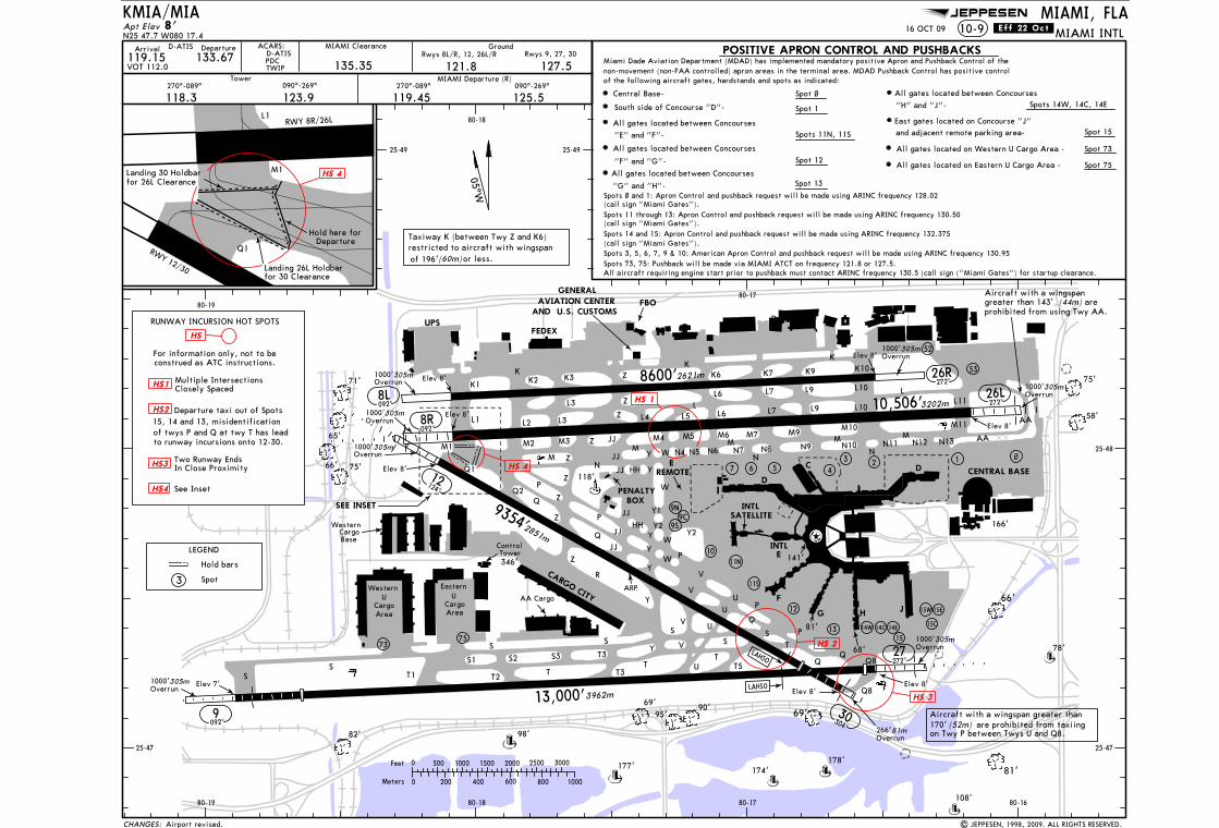
Licensed to Romulo Serrano. Printed on 08 Jan 2010.NOTICE: PRINTED FROM AN EXPIRED REVISION. Disc 23-2009
JEPPESENJeppView 3.6.3.1
JEPPESEN
Landing 30 Holdbarfor 26L Clearance
Landing 26L Holdbarfor 30 Clearance
Apt Elev
092^
ACARS:
PDCD-ATIS
TWIP
Western U
CargoArea
3962m
(44m)
(52m)
124^
092^
2851m
UCargoArea
Eastern
092^
1 ~
26L
12
10
9C
4
9N
9S
27272^
SEE INSET
RWY 8R/26L
RWY 12/30
CARGO CITY
prohibited from using Twy AA.aregreater than 143'
Aircraft with a wingspan
Central Base- Spot ~
and adjacent remote parking area-
"H" and "J"-
All gates located between Concourses
"G" and "H"-
All gates located between ConcoursesSpot 13
Spot 15
South side of Concourse "D"- Spot 1
"E" and "F"-
All gates located between Concourses
All gates located between Concourses
"F" and "G"-
Miami Dade Aviation Department (MDAD) has implemented mandatory positive Apron and Pushback Control of thenon-movement (non-FAA controlled) apron areas in the terminal area. MDAD Pushback Control has positive controlof the following aircraft gates, hardstands and spots as indicated:
(60m)or less.
Taxiway K (between Twy Z and K6)restricted to aircraft with wingspan of 196'
11N
11S
1315
Spots 11N, 11S
Spot 12
(call sign "Miami Gates").Spots 11 through 13: Apron Control and pushback request will be made using ARINC frequency 130.50
14W 14C 14E
Hold here forDeparture
Spots 14W, 14C, 14E
567
52
53
7375
POSITIVE APRON CONTROL AND PUSHBACKS
05^W
LAHSO
LAHSO
(call sign "Miami Gates").Spots 14 and 15: Apron Control and pushback request will be made using ARINC frequency 132.375
25-47 25-47
25-48
25-49 25-49
80-1680-17
80-17
80-18
80-18
80-19
80-19
| JEPPESEN, 1998, 2009. ALL RIGHTS RESERVED.
Spots 3, 5, 6, 7, 9 & 10: American Apron Control and pushback request will be made using ARINC frequency 130.95
Hold bars
LEGEND
16 OCT 09
Spots ~ and 1: Apron Control and pushback request will be made using ARINC frequency 128.02(call sign "Miami Gates").
All gates located on Eastern U Cargo Area -
All gates located on Western U Cargo Area - Spot 73
Spot 75
Aircraft with a wingspan greater thanare prohibited from taxiing
on Twy P between Twys U and Q8.170'
3
15W 15E
15C
Spots 73, 75: Pushback will be made via MIAMI ATCT on frequency 121.8 or 127.5.All aircraft requiring engine start prior to pushback must contact ARINC frequency 130.5 (call sign ("Miami Gates") for startup clearance.
Airport revised.
Western CargoBase
East gates located on Concourse "J"
2
272^26R
RUNWAY INCURSION HOT SPOTS
EREMOTE
9
Elev 7'
S
75'
82'
119.15MIAMI Clearance
135.35 121.8 127.5Tower
270^-089^
118.3090^-269^
123.9
MIAMI Departure (R)
MIAMI INTL10-9N25 47.7 W080 17.4
090^-269^270^-089^
125.5119.45
VOT 112.0
CHANGES:
MIAMI, FLA
66'
71'
65'
Ground
KMIA/MIA
S
D-ATIS
Elev 8'
108'
178'
TT1 T2 T3
Elev 8'13,000'
177'
90' 30304^
Q8
81'
95'
98'
69'
174'
69'
Elev 8'12
8L
Elev 8' 75'
58'
78'
T5T
SS
9354'
Y
R
GENERALAVIATION CENTER
ARP
66'
ControlTower346'
UV
V
Z
AND U.S. CUSTOMS
Q8Q
AA Cargo
S
8R
P
Q2
JJ
Q
Q
P118'
Z
Z
Z
ZM1
P
KK
L1
K1
L3
Q1
Y1
166'
D
M11
KK10
LL10
N11 N12 N13
Elev 8'
M
CENTRAL BASE
272^
Elev 8'
F
G H
T 68'
81'
D
C
N
141'
FEDEX
AA
AA
Z LZ L6L4 L5
K3
L3
L2
K2
M2 M3
Z K7 K9
L9L7L6
K6
N5
M5 M6 M7M
N7 N8 N9
M9M
N10
M10
L10L9L7
M ZN
JJM N6
Y2
PENALTYBOX
JJ
L11
S
Q
Rwys 9, 27, 30
8'
Rwys 8L/R, 12, 26L/R
M4
Elev 8'
M1
Q1
L1
N
JJ
N4WY
HHJJ
W
Y
W
V
UU
WY
Y
JJ
U
V
T
J
S1
Y2
S2 T3Y
UPS
FBO
500 2000 2500
800600200
Feet
Meters
0
0 1000
30001000 1500
400
1000' Overrun
305m
1000' Overrun
305m
1000' Overrun
305m
1000' Overrun
305m
1000' Overrun
305m
1000' Overrun
305m
1000' Overrun
305m
266' Overrun
81m
HHY
P
P
INTLE
INTLSATELLITE
For information only, not to beconstrued as ATC instructions.
See Inset
Multiple IntersectionsClosely Spaced
Two Runway EndsIn Close Proximity
3 Spot
133.67Arrival Departure
S3 Q
S
8600'2621m
10,506'3202mDeparture taxi out of Spots
15, 14 and 13, misidentification
to runway incursions onto 12-30.
.Eff.22.Oct.
of twys P and Q at twy T has lead
HS 4
HS 1
HS 2
HS 3
HS 4
HS
HS1
HS2
HS3
HS4
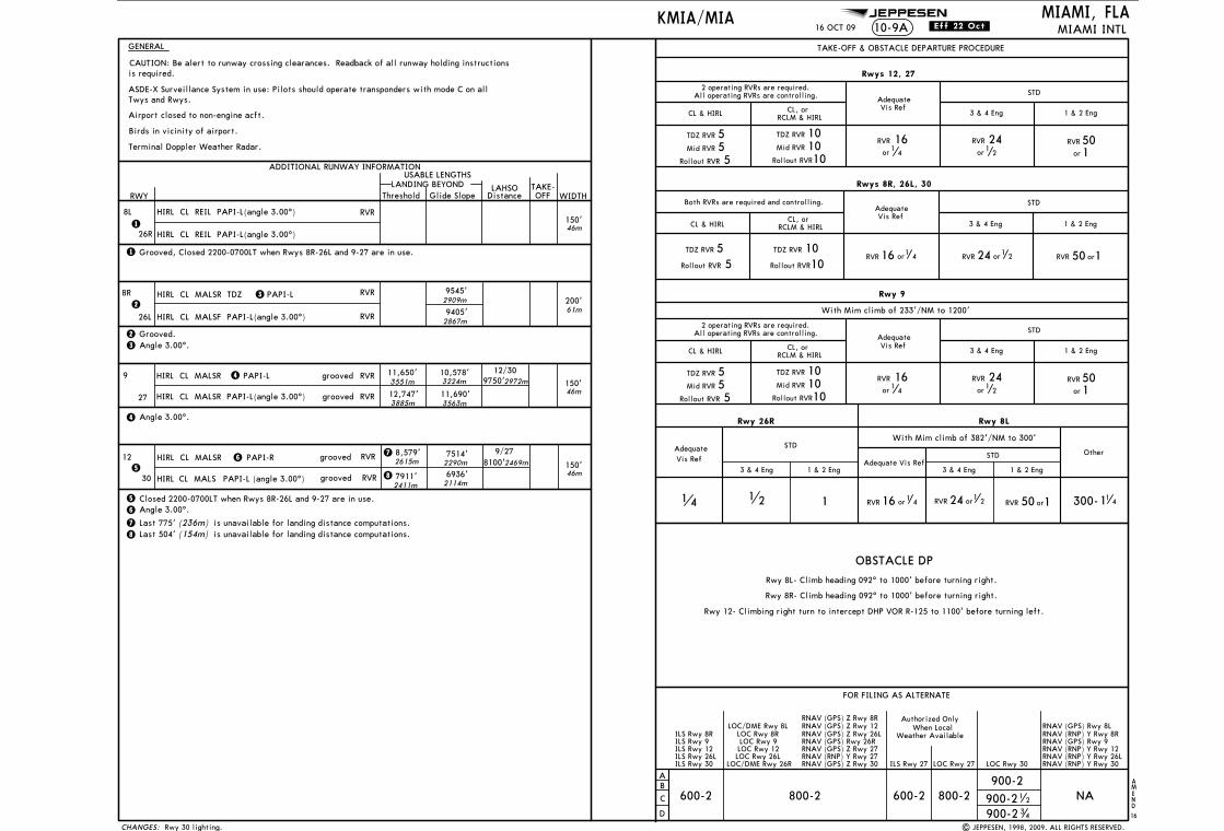
Licensed to Romulo Serrano. Printed on 08 Jan 2010.NOTICE: PRINTED FROM AN EXPIRED REVISION. Disc 23-2009
JEPPESENJeppView 3.6.3.1
JEPPESEN
OBSTACLE DP
46m
2141 1
CAUTION: Be alert to runway crossing clearances. Readback of all runway holding instructions
300-11 4
Rwy 8L- Climb heading 092^ to 1000' before turning right.
Rwy 8R- Climb heading 092^ to 1000' before turning right.
| JEPPESEN, 1998, 2009. ALL RIGHTS RESERVED.
NA
TAKE-OFF & OBSTACLE DEPARTURE PROCEDURE
CL & HIRL
STDAdequateVis Ref
1 & 2 Eng3 & 4 Eng
2 operating RVRs are required.All operating RVRs are controlling.
CL, or RCLM & HIRL
Rollout RVR 55Mid RVR
TDZ RVR 5
Rollout RVR1010Mid RVR
TDZ RVR 10
Rwys 12, 27
CL & HIRL
TDZ RVR
Rollout RVR
55
STDAdequateVis Ref
1 & 2 Eng3 & 4 Eng
TDZ RVR
Rollout RVR
1010
Both RVRs are required and controlling.
CL, or RCLM & HIRL
Rwys 8R, 26L, 30
CL & HIRL
STDAdequateVis Ref
1 & 2 Eng3 & 4 Eng
2 operating RVRs are required.All operating RVRs are controlling.
CL, or RCLM & HIRL
Rollout RVR 55Mid RVR
TDZ RVR 5
Rollout RVR1010Mid RVR
TDZ RVR 10
Rwy 9
With Mim climb of 233'/NM to 1200'
3 & 4 Eng 1 & 2 Eng 3 & 4 Eng 1 & 2 Eng
2909m
2867m
61m
3551m 3224m 2972m
3885m 3563m
46m
2411m
2290m 2469m46m
2114m
2615m
Rwy 12- Climbing right turn to intercept DHP VOR R-125 to 1100' before turning left.
16 OCT 09
When Local
Rwy 30 lighting.
10-9A MIAMI INTL
Birds in vicinity of airport.
AMEND
16
MIAMI, FLA
RWY
ADDITIONAL RUNWAY INFORMATIONUSABLE LENGTHS
WIDTH
GENERAL
Airport closed to non-engine acft.
LANDING BEYONDThreshold Glide Slope OFF
TAKE-DistanceLAHSO
KMIA/MIA
8L150'
Vis Ref
STDAdequateSTD
Adequate Vis Ref
With Mim climb of 382'/NM to 300'
1
26R
Rwy 26R
is required.
CHANGES:
1
HIRL CL REIL PAPI-L(angle 3.00^)
Rwy 8L
Other
HIRL CL REIL PAPI-L(angle 3.00^)
RVR
Grooved, Closed 2200-0700LT when Rwys 8R-26L and 9-27 are in use.
orRVR 150RVR or116 4 RVR 24 or1 2
600-2 800-2
FOR FILING AS ALTERNATE
AB
C
D
900-2
LOC Rwy 30
ILS Rwy 8R
ILS Rwy 12ILS Rwy 9
ILS Rwy 26L
900-2 34
900-21 2
LOC Rwy 12LOC Rwy 9
LOC Rwy 26L
LOC/DME Rwy 8LLOC Rwy 8R
ILS Rwy 30
RNAV (GPS) Z Rwy 8R
RNAV (RNP) Y Rwy 12
LOC/DME Rwy 26R
RNAV (GPS) Z Rwy 12
RNAV (RNP) Y Rwy 26L
RNAV (GPS) Rwy 26RRNAV (GPS) Z Rwy 26L
RNAV (RNP) Y Rwy 27RNAV (GPS) Z Rwy 27
RNAV (GPS) Z Rwy 30 RNAV (RNP) Y Rwy 30
RNAV (GPS) Rwy 8LRNAV (RNP) Y Rwy 8RRNAV (GPS) Rwy 9
RVR
or
241
2
RVR
or1164
RVR
or
501
orRVR 150RVR 24 or1 2RVR or116 4
RVR
or
241
2
RVR
or1164
RVR
or
501
Terminal Doppler Weather Radar.
8R
26L
200'RVR 9545'
9405'
2 Grooved.
RVRHIRL CL MALSF PAPI-L(angle 3.00^)2
HIRL CL MALSR TDZ PAPI-L3
3 Angle 3.00^.
9150'
RVR 12,747'
11,650'4
grooved
grooved 10,578'
11,690'
RVR
4 Angle 3.00^.
PAPI-LHIRL CL MALSR
27
12
30
150'7514'
7911'RVR
grooved
groovedHIRL CL MALS
RVRHIRL CL MALSR PAPI-R65
6 Angle 3.00^.
6936'
Closed 2200-0700LT when Rwys 8R-26L and 9-27 are in use.5
8,579'
ASDE-X Surveillance System in use: Pilots should operate transponders with mode C on allTwys and Rwys.
HIRL CL MALSR PAPI-L(angle 3.00^)
12/30
9/27 8100'
9750'
ILS Rwy 27 LOC Rwy 27
600-2 800-2
Authorized Only
Weather Available
78
7
8
Last 775' (236m) is unavailable for landing distance computations.is unavailable for landing distance computations.(154m)Last 504'
PAPI-L (angle 3.00^)
.Eff.22.Oct.
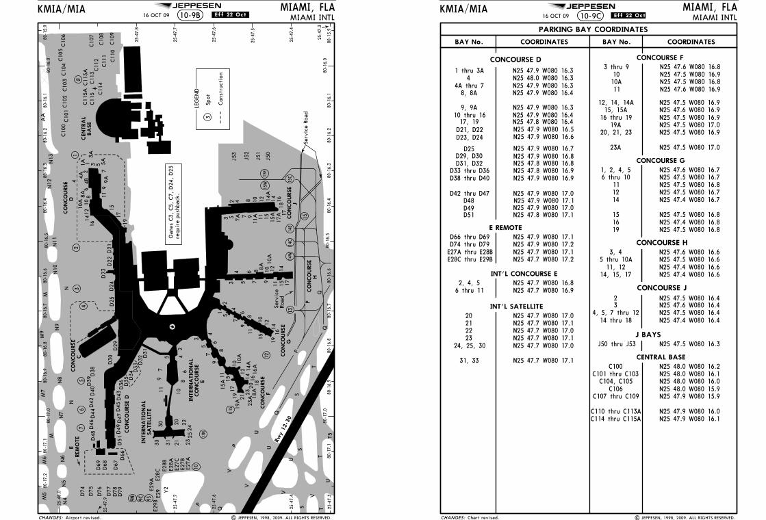
Licensed to Romulo Serrano. Printed on 08 Jan 2010.NOTICE: PRINTED FROM AN EXPIRED REVISION. Disc 23-2009
JEPPESENJeppView 3.6.3.1
JEPPESENKMIA/MIA10-9B
MIAMI, FLAMIAMI INTL
15
13
12
4
1~
80-17.0
80-16.0
80-17.1
80-17.2
80-16.1
80-16.2
80-16.3
80-16.4
80-16.5
80-16.6
80-16.7
80-16.8
80-16.9
80-15.9
25-48.0
25-47.7
25-47.6
25-47.4
25-47.3
80-16.0
80-17.0
80-17.1
80-16.1
80-16.2
80-16.3
80-16.4
80-16.5
80-16.6
80-16.7
80-16.8
80-16.9
80-15.9
25-47.8
25-47.7
25-47.6
25-47.5
25-47.4
25-47.3
3 5 7 9
11 15 1714121086
J53
J52
J51
J50
1 5
79
11
15
1916
141210
86
4
2
35
79
1115
15A
1719
19A21
23A
2318
A20 18
1614
A16
A14
1210
A10
86
4
2523
242220
21313330
81011
9
675 4
2
D31
D32
D33
D34
D35
D36
D43
D45
D47
D49
D51D
48D
46D
44D
42D
40D
39D
38
D74
D77
D76
D75
D69
D68
D67
1917
1511
97
5312
4
68
1010
A14
16
C10
1C10
2C10
3C10
4C10
6C10
5
C10
7
C10
8
C10
9C11
0
C10
0
C11
1C11
2C11
3
C11
4
C11
5C11
5AC11
3A
Rwy 1
2-3
0
11N
11S
9N 9C 9S
10
3
14W
14C
14E
56
7
16 OCT 09
3 5 7 9 11 15
1718
1614121082 4
| JEPPESEN, 1998, 2009. ALL RIGHTS RESERVED.
4
3
D25
D24
D29
D30
17A
15W
15E
15C
Gat
es C
3, C
5, C
7, D
24,
D25
requ
ire
push
back
.
9A5A
3A
1A4A
4B12
8A
Airport revised.
.Eff.22.Oct.
25-47.9
2
D23
D22
D21
D78
D79
D66
E27A
E27B
E27C
E28A
E28B
E28C
E29A
E29
E29B
8A
10A
7A 11A
15A
14A
Serv
ice
Road
Serv
ice
Road
CENTRA
LBA
SE
CO
NCO
URSE
F
CO
NCO
URSE
G
CO
NCO
URSE
H
INTERNA
TIO
NA
LCO
NCO
URSE
ELE
GEN
D
Spot
CO
NCO
URSE
C
CO
NCO
URSE
D
CHANGES:
T
S
V
U
P
P
Q
N11
N12
T
P
N
AA
N5
M5
M
N7
N8
N9
M
N10
N6
N4
Y2
S
SA
TELL
ITE
CO
NCO
URSE D
INTERNA
TIO
NA
L
M6
M7
M9
N13
N
V
TSQ
T5
P
Q
REM
OTE
E
V
V
U
U
Con
stru
ctio
n
U
CO
NCO
URSE
J
Q
Licensed to Romulo Serrano. Printed on 08 Jan 2010.NOTICE: PRINTED FROM AN EXPIRED REVISION. Disc 23-2009
JEPPESENJeppView 3.6.3.1
JEPPESEN MIAMI, FLAMIAMI INTL10-9C
KMIA/MIA16 OCT 09
| JEPPESEN, 1998, 2009. ALL RIGHTS RESERVED.
.Eff.22.Oct
D29, D30
N25 47.9 W080 16.6
N25 47.9 W080 16.8D25 N25 47.9 W080 16.7
D23, D24D21, D22 N25 47.9 W080 16.5
Chart revised.
PARKING BAY COORDINATES
BAY No. COORDINATES BAY No. COORDINATES
CONCOURSE G
CONCOURSE H
N25 47.4 W080 16.8N25 47.5 W080 16.815
1214
11N25 47.5 W080 16.7N25 47.5 W080 16.8N25 47.5 W080 16.7N25 47.4 W080 16.7
20212223
N25 47.7 W080 17.0N25 47.7 W080 17.1N25 47.7 W080 17.0N25 47.7 W080 17.1N25 47.7 W080 17.0
N25 47.7 W080 17.1
N25 47.8 W080 16.8
N25 47.7 W080 16.9N25 47.7 W080 16.8
N25 47.6 W080 16.8N25 47.5 W080 16.9
N25 47.5 W080 16.9N25 47.6 W080 16.9N25 47.5 W080 16.9
N25 47.5 W080 17.0
6 thru 112, 4, 5
3 thru 9
CONCOURSE FCONCOURSE D
N25 47.8 W080 16.9 N25 47.6 W080 16.7
CHANGES:
10
16 thru 19
N25 47.6 W080 16.911
6 thru 10
N25 47.5 W080 16.3
D31, D32
N25 47.9 W080 16.9
N25 47.9 W080 17.0N25 47.9 W080 17.1N25 47.9 W080 17.0D49
N25 47.5 W080 16.810A
12, 14, 14A15, 15A
N25 47.5 W080 16.9N25 47.5 W080 17.019A
20, 21, 23
23A
1619 N25 47.5 W080 16.8
1, 2, 4, 5D33 thru D36D38 thru D40
D42 thru D47D48
D51 N25 47.8 W080 17.1
N25 47.7 W080 17.1N25 47.9 W080 17.2N25 47.9 W080 17.1
D74 thru D79
INT'L CONCOURSE E
INT'L SATELLITE
24, 25, 30
31, 33
J BAYSJ50 thru J53
N25 47.9 W080 16.1N25 47.9 W080 16.0
N25 47.9 W080 15.9
N25 48.0 W080 16.0N25 48.0 W080 15.9
N25 48.0 W080 16.1N25 48.0 W080 16.2
CENTRAL BASE
C106
C100C101 thru C103
C104, C105
C107 thru C109
C110 thru C113AC114 thru C115A
E REMOTE
N25 47.4 W080 16.6N25 47.4 W080 16.6
N25 47.6 W080 16.6
CONCOURSE J
11, 12N25 47.5 W080 16.65 thru 10A
N25 47.4 W080 16.4
N25 47.6 W080 16.4N25 47.5 W080 16.4
3
14 thru 18
N25 47.5 W080 16.42
4, 5, 7 thru 12
3, 4
14, 15, 17
44A thru 78, 8A
9, 9A
17, 19
N25 47.9 W080 16.3N25 48.0 W080 16.3N25 47.9 W080 16.3N25 47.9 W080 16.4
N25 47.9 W080 16.3N25 47.9 W080 16.4N25 47.8 W080 16.4
10 thru 16
D66 thru D69
E27A thru E28BE28C thru E29B N25 47.7 W080 17.2
1 thru 3A
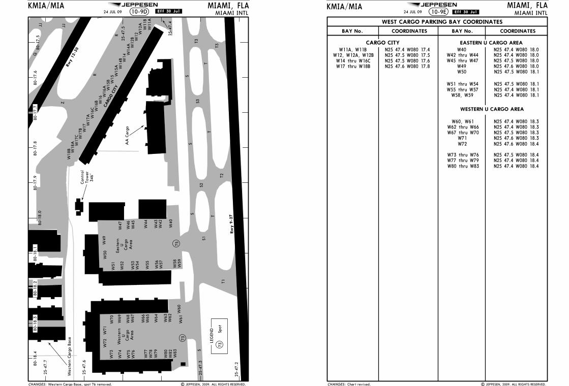
Licensed to Romulo Serrano. Printed on 08 Jan 2010.NOTICE: PRINTED FROM AN EXPIRED REVISION. Disc 23-2009
JEPPESENJeppView 3.6.3.1
JEPPESEN
MIAMI INTL24 JUL 09
Wes
tern
U
Car
goA
rea
UCar
goA
rea
East
ern
CARG
O C
ITY
73
75
Rw
y 9
-27
Rwy 1
2-3
0
T1T2
TT
T
T3
T3
SS
S
S1S2
R
R
Z
QJJ JJ
W72
W71
W73
W74
W75
W76
W77
W78
W79
W80
W82
W83
W70
W69
W68
W67
W66
W65
W64
W63
W62
W61
W60
W59
W58
W57
W56
W55
W54
W53
W52
W51
W50
W49
W47
W46
W45
W44
W43
W42
W40
LEG
END
73Sp
ot
KMIA/MIA MIAMI, FLA10-9D
S
25-4
7.2
25-4
7.3
25-4
7.4
25-4
7.5
25-4
7.6
25-4
7.7
80-1
7.5
80-1
7.6
80-1
7.8
80-1
7.9
80-1
8.4
80-1
8.0
| JEPPESEN, 2009. ALL RIGHTS RESERVED.
S3
Wes
tern
Car
go B
ase
Western Cargo Base, spot 76 removed.
.Eff.30.Jul.
80-1
7.7
80-1
8.1
80-1
8.2
80-1
8.3
CHANGES:
Con
trol
Tow
er34
6'
AA
Car
go
W18
B W18
A W17
C W17
B W17 W
17A W
16C W16
B W16W
16A W15
B W15
W15
A W14
B W14
W14
A W12
B W12 W
12A
W11
BW
11A
Licensed to Romulo Serrano. Printed on 08 Jan 2010.NOTICE: PRINTED FROM AN EXPIRED REVISION. Disc 23-2009
JEPPESENJeppView 3.6.3.1
JEPPESEN MIAMI, FLAMIAMI INTL10-9E
KMIA/MIA24 JUL 09
| JEPPESEN, 2009. ALL RIGHTS RESERVED.Chart revised.
.Eff.30.Jul.
BAY No. COORDINATES BAY No. COORDINATES
N25 47.4 W080 18.3
N25 47.5 W080 18.3
N25 47.4 W080 18.0
N25 47.5 W080 18.0
N25 47.5 W080 18.1
N25 47.4 W080 18.1
N25 47.5 W080 17.5N25 47.5 W080 17.6N25 47.6 W080 17.8
N25 47.4 W080 17.4
CHANGES:
N25 47.6 W080 18.0
CARGO CITY EASTERN U CARGO AREA
WESTERN U CARGO AREA
W11A, W11BW12, W12A, W12BW14 thru W16CW17 thru W18B
W42 thru W44
W62 thru W66
W71
WEST CARGO PARKING BAY COORDINATES
N25 47.4 W080 18.1W55 thru W57
W40
W45 thru W47W49W50
W51 thru W54
W58, W59
W60, W61
N25 47.5 W080 18.4N25 47.4 W080 18.4
W80 thru W83
W67 thru W70
W72
W73 thru W76W77 thru W79
N25 47.4 W080 18.0
N25 47.5 W080 18.1
N25 47.4 W080 18.3
N25 47.6 W080 18.3N25 47.6 W080 18.4
N25 47.4 W080 18.4
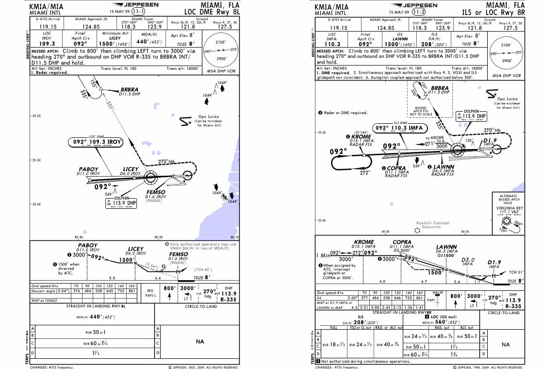
Licensed to Romulo Serrano. Printed on 08 Jan 2010.NOTICE: PRINTED FROM AN EXPIRED REVISION. Disc 23-2009
JEPPESENJeppView 3.6.3.1
JEPPESEN
335^
[3.04^]
Only authorized operators may useVNAV DA(H) in lieu of MDA(H).
2
2[TCH 60']
[RW~8L]
[RW~8L]DOLPHIN113.9 DHP
DHP
D(H)
PABOY LICEY
FEMSO
D6.0 IROYD11.0 IROY
D1.6 IROY
092^
270^hdg
LOC DME
092^ 109.3 IROYIROY
BRBRA
155^
335^ D11.5 DHP
MISSED APCH:
MIAMI, FLAMIAMI INTL
MIAMI Approach (R) MIAMI Tower
119.15 124.85 118.3270^-089^
123.9090^-269^
127.5121.8LOC
109.3IROY
FinalApch Crs
092^LICEY
1500'(1492') 440'(432')
Apt Elev
TDZE
MDA(H)Minimum AltBRIE
FIN
G S
TRIP
TM
LOC DME Rwy 8LKMIA/MIA
Trans alt: 18000'Alt Set: INCHES Trans level: FL 180
270^090^
NANA
A
B
C
D D
B
A
C
CIRCLE-TO-LAND
MAP at FEMSO
TDZE5.0
1500'
PABOY
3000'LICEY
D6.0 IROY
4.4
FEMSOD11.0 IROY
D1.6 IROY092^
11 2
STRAIGHT-IN LANDING RWY8L
MDA(H) 440'(432')
1
1
by ATC.
1500' whendirected
800'
LT
3000'via 270^
hdg
25-50
80-1080-2080-30
549'
1049'
1049'
(Can be mistaken Opa Locka
for Miami Intl)
PAPI-LDescent angle [3.04^] 376 484 538 645 753 861Gnd speed-Kts 70 90 100 120 140 160
Rwys 8L/R, 12, 26L/R
8'
8'
TERPS
8'
GroundRwys 9, 27, 30
andDHP
113.9R-335
25-45
25-55
REIL
1049'
1049'
| JEPPESEN, 2003, 2009. ALL RIGHTS RESERVED.
11-115 MAY 09
D-ATIS Arrival
ATIS frequency.
2900'
2100'
Climb to 800' then climbing LEFT turn to 3000' viaheading 270^ and outbound on DHP VOR R-335 to BRBRA INT/D11.5 DHP and hold.
1. Radar required. MSA DHP VOR
AMEND
O
AMEND
CHANGES:
orRVR 150
60 11 4RVR or
B
Licensed to Romulo Serrano. Printed on 08 Jan 2010.NOTICE: PRINTED FROM AN EXPIRED REVISION. Disc 23-2009
JEPPESENJeppView 3.6.3.1
JEPPESEN
Kendall-TamiamiExecutive
TDZE1.1
TCH 51'
3000'1
D1.9
LAWNNCOPRAKROME
4.0 4.7
3000'1
DHP
113.9 DHPD(H)
090^ 270^
BRBRA
270^hdg
RADAR FIX
RADAR FIX RADAR FIX
155^335^
NOT TO SCALE
MISSEDAPCH FIX
335^
092^
D11.5 DHP
D15.1 IMFA D11.1 IMFAD6.3 IMFA
IMFA
CIRCLE-TO-LAND
A
B
C
D
GS
NA
A
B
C
D
3.00^ 484377 538 646 753 861
FULL TDZ or CL outDA(H) 208'
ILS
(200')ALS out
LOC (GS out)
MDA(H) 560'(552')
STRAIGHT-IN LANDING RWY8R
800' 3000' 270^DHP
hdgR-335113.9and
MISSED APCH:
MIAMI, FLAMIAMI INTL 11-2
MSA DHP VOR
Gnd speed-Kts 70 90 100 120 140 160
PAPIMAP at D1.9 IMFA or
LT
30
AMEND
DOLPHIN
8'
Opa Locka(Can be mistaken
for Miami Intl)
BRIE
FIN
G S
TRIP
TM
MALSR
RAIL or ALS out RAIL out
1500'
KMIA/MIA
Trans alt: 18000'Alt Set: INCHES Trans level: FL 180
3000'GS
ILS
RVR 24 or12RVR or1
218 RVR 40or 34
TERPS
and hold.
ILS or LOC Rwy 8R
1500'GS
LAWNN to MAP 4.5 3:51 3:00 2:42 2:15 1:56 1:41
092^ 272^
When assigned byATC, interceptglidepath atCOPRA at 3000'.
3.4
D3.0IMFA
092^
272^
271^ 300010.6
to KROME
25-40
25-50
80-2080-30
117.1 VKZVKZ
300^120^
ALTERNATEMISSED APCH
HOLD
VIRGINIA KEY
1
1 Not authorized during simultaneous operations.
1 Min 092^
130'
Climb to 800' then climbing LEFT turn to 3000' viaheading 270^ and outbound on DHP VOR R-335 to BRBRA INT/D11.5 DHP
15 MAY 09
341
112
via
A
| JEPPESEN, 1998, 2009. ALL RIGHTS RESERVED.
1. DME required. 2. Simultaneous approach authorized with Rwy 9. 3. VGSI and ILS glidepath not coincident. 4. Autopilot coupled approach not authorized below 500'.
1 Radar or DME required.
1
1 1
ATIS frequency.
COPRA
092^D1.9
LAWNN
KROME
549'
2900'
2100'
IMFA
D11.1 IMFA
D15.1 IMFA
D6.3 IMFA
CHANGES:
MIAMI Approach (R) MIAMI Tower
119.15 124.85 118.3270^-089^
123.9090^-269^
121.8 127.5LOC GS
DA(H)Apt Elev
TDZEApch Crs
Final
110.3IMFA
092^LAWNN
8'
092^ 110.3 IMFAILS DME
I M F A
208'(200')
Rwys 8L/R, 12, 26L/R Rwys 9, 27, 30Ground
8'
1500'(1492')
(IF/IAF)
RVR 24 or1
2 RVR 40 or 34 orRVR 150
orRVR 15060 11 4RVR or
D-ATIS Arrival

Licensed to Romulo Serrano. Printed on 08 Jan 2010.NOTICE: PRINTED FROM AN EXPIRED REVISION. Disc 23-2009
JEPPESENJeppView 3.6.3.1
JEPPESEN
ExecutiveKendall-Tamiami
194^
221^
549'
300^
120^
RADAR FIX
0
MMC
M
0.43.6
GS
A
B
C
D
CIRCLE-TO-LAND
NA
INESS to MAP 4.0 3:26 2:40 2:24 2:00 1:43 1:30
3.00^
A
B
C
D
FULL orRAIL ALS out
DA(H) 207'ILS
(200') MDA(H)
LOC (GS out)
RAIL out ALS out
STRAIGHT-IN LANDING RWY9
(433')
112
113.9 DHPDHP
D(H)
DOLPHIN
QEEZY
T M
RADAR FIXD7.0 DHP
D7.0 DHP
266 TM
MISSED APCH:
MIAMI, FLAMIAMI INTL 11-3
MIAMI Approach (R) MIAMI Tower
119.15 124.85 118.3270^-089^
123.9090^-269^
127.5 121.8LOC
110.9IBUL
FinalApch Crs
092^
GSINESS
1349'(1342')
ILSDA(H)
207'(200')
Apt Elev
TDZE 7'Climb to 800' then climbing RIGHT turn to 3000' 270^
090^
MSA DHP VOR
2100'
2900'
Gnd speed-Kts 70 90 100 120 140 160
9
RVR 24 or12 RVR 40 or
34
RVR 24 or12 RVR 40or 3
4 orRVR 150
RVR 40or 34
orRVR 150
MALSR
RTD
800' 3000' VKZ
117.1
440'
TDZE
Opa Locka(Can be mistaken
for Miami Intl)
BRIE
FIN
G S
TRIP
TM
410'
565'
VIRGINIA KEY117.1 VKZ
VKZ
D(H)
PAPI377 484 538 646 753 861
25-40
25-50
80-1080-2080-30
KMIA/MIA
Trans alt: 18000'Alt Set: INCHES Trans level: FL 180
GroundRwys 9, 27, 30 Rwys 8L/R, 12, 26L/R
8'
60 11 4RVR or
TERPS
482'
AMEND
B
ILS or LOC Rwy 915 MAY 09
1. Radar required. 2. CAUTION: Lights on highway 1/4 NM south of final approachcourse may be mistaken for runway. 3. Simultaneous approach authorized with Rwy 8R.
direct VKZ VOR and hold.
| JEPPESEN, 1998, 2009. ALL RIGHTS RESERVED.
1
1 RVR 18 with Flight Director or Autopilot or HUD to DA.
1049'1049'
797'
D-ATIS Arrival
ATIS frequency.
3000'
INESS
TCH 55'
1
1
092^
5.0
1500'
GRITT
7'
INESS
MM
I B U L
092^ 110.9 IBULILS
GRITT
092^
CHANGES:
GS 2997' GS 1349'
GS 200'1500' whendirected by ATC.
Licensed to Romulo Serrano. Printed on 08 Jan 2010.NOTICE: PRINTED FROM AN EXPIRED REVISION. Disc 23-2009
JEPPESENJeppView 3.6.3.1
JEPPESEN
PJN05
5^
242
335^DHP113.9
DHP
PJN
MALSR
PAPI
Opa Locka
D1.6
DOLPHIN
DHP
113.9 DHPD(H)
309^
13.03000
377 484 538 646 753 861
MISSED APCH:
MIAMI, FLAMIAMI INTL
MIAMI Approach (R) MIAMI Tower
119.15 124.85 118.3270^-089^
123.9090^-269^
121.8 127.5LOCIGEM
FinalApch Crs
124^
GSVEPCO
2000'(1992')
ILSDA(H)
376'(368')
Apt Elev
TDZE
Climb to 800' then climbing LEFT turn to 3000'108.9
270^090^
2100'
2900'
MSA DHP VOR
Gnd speed-Kts 70 90 100 120 140 160
TDZE
800' 3000'
117.1VKZ
560'
11-4
(Can be mistaken for Miami Intl)
STRAIGHT-IN LANDING RWY CIRCLE-TO-LAND
AA
B B
CC
D D
LOC (GS out)ILS
GS 3.00^
NA
12
DA(H) 376'(368') MDA(H) (552')
LTD
BRIE
FIN
G S
TRIP
TM
8'
IGEM
IGEM
MAP at D1.6 IGEM or
direct VKZ VOR and hold.
KMIA/MIA
1. DME or Radar required.Trans alt: 18000'Alt Set: INCHES Trans level: FL 180
RAIL outRAIL out ALS outALS out
Rwys 8L/R, 12, 26L/R Rwys 9, 27, 30Ground
8'
TERPS
FULL
15 MAY 09 ILS or LOC Rwy 12
2. Visibility reduction by helicopters not authorized.3. VGSI and ILS glidepath not coincident.
VEPCO to MAP 6.0 5:09 4:00 3:36 3:00 2:34 2:15
117.1 VKZVKZ
VIRGINIA KEYMISSED APCH FIX
549'
1049'
1049'
25-50
80-2080-30
25-45
25-55
ALTERNATEMISSED APCH
HOLD
BRBRA
155^
335^
D11.5 DHP
166'
147'
341'
IGEM
1049'
1049'
112
341
| JEPPESEN, 1998, 2009. ALL RIGHTS RESERVED.
to GLRIA
D-ATIS Arrival
ATIS frequency.
GLRIA
VEPCO
124^
ILS DME
124^ 108.9 IGEM
TCH 56'
304^
1 Min 124^ 304^3000' 2000'
PIANA VEPCO
124^
3.1 4.5
I G E M
RADAR FIXRADAR FIX
300^120^
D1.6
AMEND5
CHANGES:
8'
D10.8 IGEMD7.6 IGEM
D16.8 IGEMD7.6 IGEM
60 11 4RVR or
orRVR 150
orRVR 150RVR 40 or 34
GS 2000'
GLRIAD10.8 IGEM
6.0
124^3000'
PIANA
RADAR FIXD16.8 IGEM 124^
(IF/IAF)
D3.1
1.5
RVR 40 or 34 60 11 4RVR or
A
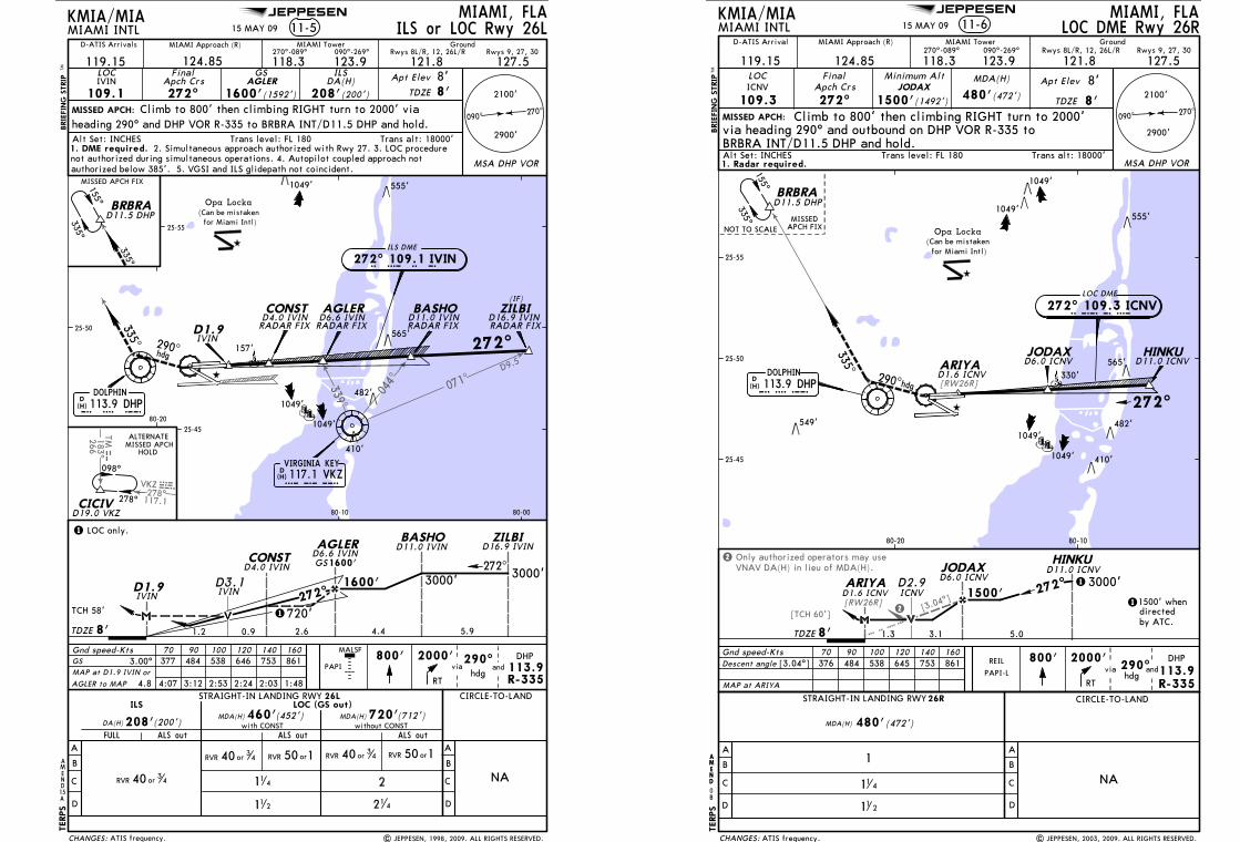
Licensed to Romulo Serrano. Printed on 08 Jan 2010.NOTICE: PRINTED FROM AN EXPIRED REVISION. Disc 23-2009
JEPPESENJeppView 3.6.3.1
JEPPESEN
339^
044^ 071^
278^VKZ
117.1
VKZ
D9.5
183^266
TMTM
155^
335^
VIRGINIA KEY
VKZ
D(H)117.1 VKZ
hdg290^
335^
D1.9IVIN
MISSED APCH:
MIAMI, FLAMIAMI INTL 11-5
MIAMI Approach (R) MIAMI Tower
119.15 124.85 118.3270^-089^
123.9090^-269^
121.8 127.5LOC
109.1IVIN
FinalApch Crs272^
GSAGLER
1600'(1592')
ILSDA(H) Apt Elev
TDZE
Gnd speed-Kts 70 90 100 120 140 160800' 2000' 290^
hdg
DHP
R-335
15
TDZE
460'
113.9
8'
410'
AMEND
565'
PAPI
KMIA/MIA
GroundRwys 8L/R, 12, 26L/R Rwys 9, 27, 30
8'
ILS or LOC Rwy 26L
D
C
B
AALS out
A
B
C
D
CIRCLE-TO-LAND
NA
DA(H)
ILS LOC (GS out)MDA(H)
STRAIGHT-IN LANDING RWY 26L
(452')208'(200')
GS 3.00^ 377 484 538 646 753 861MAP at D1.9 IVIN or
FULL ALS out
Opa Locka(Can be mistaken
for Miami Intl)
RT
andvia
BRIE
FIN
G S
TRIP
TM
Trans alt: 18000'Alt Set: INCHES Trans level: FL 180
208'(200')
TERPS
MALSF
15 MAY 09
MSA DHP VOR
270^090^
2100'
2900'
335^
25-50
80-0080-10
80-20
25-55
25-45
272^
IVIN
720'MDA(H) (712')with CONST without CONST
ALS out
11 2
2
21 4
ALTERNATEMISSED APCH
HOLD
278^
098^
CICIVD19.0 VKZ
157'
AGLER to MAP 4.8 4:07 3:12 2:53 2:24 2:03 1:48
Climb to 800' then climbing RIGHT turn to 2000' viaheading 290^ and DHP VOR R-335 to BRBRA INT/D11.5 DHP and hold.
| JEPPESEN, 1998, 2009. ALL RIGHTS RESERVED.
A
1. DME required. 2. Simultaneous approach authorized with Rwy 27. 3. LOC procedurenot authorized during simultaneous operations. 4. Autopilot coupled approach notauthorized below 385'. 5. VGSI and ILS glidepath not coincident.
114
1
1 LOC only.
D-ATIS Arrivals
ATIS frequency.
AGLER BASHO ZILBI
1049'
RADAR FIXRADAR FIXRADAR FIX
272^
I V I N272^ 109.1 IVIN
BRBRA
MISSED APCH FIX
D(H) 113.9 DHPD H P
DOLPHIN
D11.0 IVIN D16.9 IVIND1.9IVIN
D6.6 IVIN
D11.5 DHP
TCH 58'
0.9
BASHO ZILBI
3000'1600'
4.42.6
D11.0 IVIN D16.9 IVIN
272^
D4.0 IVINCONST
ILS DME
482'
CHANGES:
8'
555'
CONSTRADAR FIXD4.0 IVIN
D6.6 IVINAGLER
1600'GS
720'
3000'
5.9
D3.1
1.2
orRVR 150 orRVR 150
(IF)
RVR 40 or 34
RVR 40 or 34 RVR 40 or 3
4
1049'
1049'
Licensed to Romulo Serrano. Printed on 08 Jan 2010.NOTICE: PRINTED FROM AN EXPIRED REVISION. Disc 23-2009
JEPPESENJeppView 3.6.3.1
JEPPESEN
[3.04^]
Only authorized operators may useVNAV DA(H) in lieu of MDA(H).
2
2[TCH 60'][RW26R]
[RW26R]
D6.0 ICNV
335^
D11.5 DHPBRBRA
HINKUJODAXARIYA
DOLPHIN113.9 DHP
DHP
D(H)
D1.6 ICNVD11.0 ICNV
272^
290^hdg
410'
549'
1049'
1049'
565'
482'
MIAMI, FLAMIAMI INTL 11-6
MIAMI Approach (R) MIAMI Tower Ground
119.15 124.85 118.3270^-089^
123.9090^-269^
127.5121.8LOC
MISSED APCH:
ICNVFinal
Apch Crs
109.3JODAX
1500'(1492')480'(472')
Apt Elev
TDZE
MDA(H)Minimum Alt
272^
KMIA/MIA
270^090^
NA
MAP at ARIYA
800' 2000'
hdg
HINKUD11.0 ICNV
3000'
by ATC.directed1500' when1
1272^
1500'
TDZE 5.0
JODAXD6.0 ICNV
3.1
ARIYAD1.6 ICNV
290^
D2.9ICNV
1.3
B
D
C
A
MDA(H) 480'(472')
A
B
C
D
CIRCLE-TO-LANDSTRAIGHT-IN LANDING RWY
25-50
80-1080-20
PAPI-L
155^
335^ MISSEDAPCH FIXNOT TO SCALE
Descent angle [3.04^] 376 484 538 645 753 861
Rwys 8L/R, 12, 26L/R Rwys 9, 27, 30
LOC DME Rwy 26R
26R
8'
8'
8'
andDHP
113.9R-335
555'
25-45
25-55
Gnd speed-Kts 70 90 100 120 140 160
Opa Locka(Can be mistaken for Miami Intl)
BRIE
FIN
G S
TRIP
TM
Trans alt: 18000'Alt Set: INCHES Trans level: FL 180
via
RT
11 2
11 4
1
TERPS
REIL
15 MAY 09
330'
LOC DME
272^ 109.3 ICNVICNV
1049'
| JEPPESEN, 2003, 2009. ALL RIGHTS RESERVED.
1049'
D-ATIS Arrival
ATIS frequency.
2900'
2100'
MSA DHP VOR
Climb to 800' then climbing RIGHT turn to 2000'via heading 290^ and outbound on DHP VOR R-335 to BRBRA INT/D11.5 DHP and hold.
1. Radar required.
AMEND
0
AMEND
CHANGES:
B
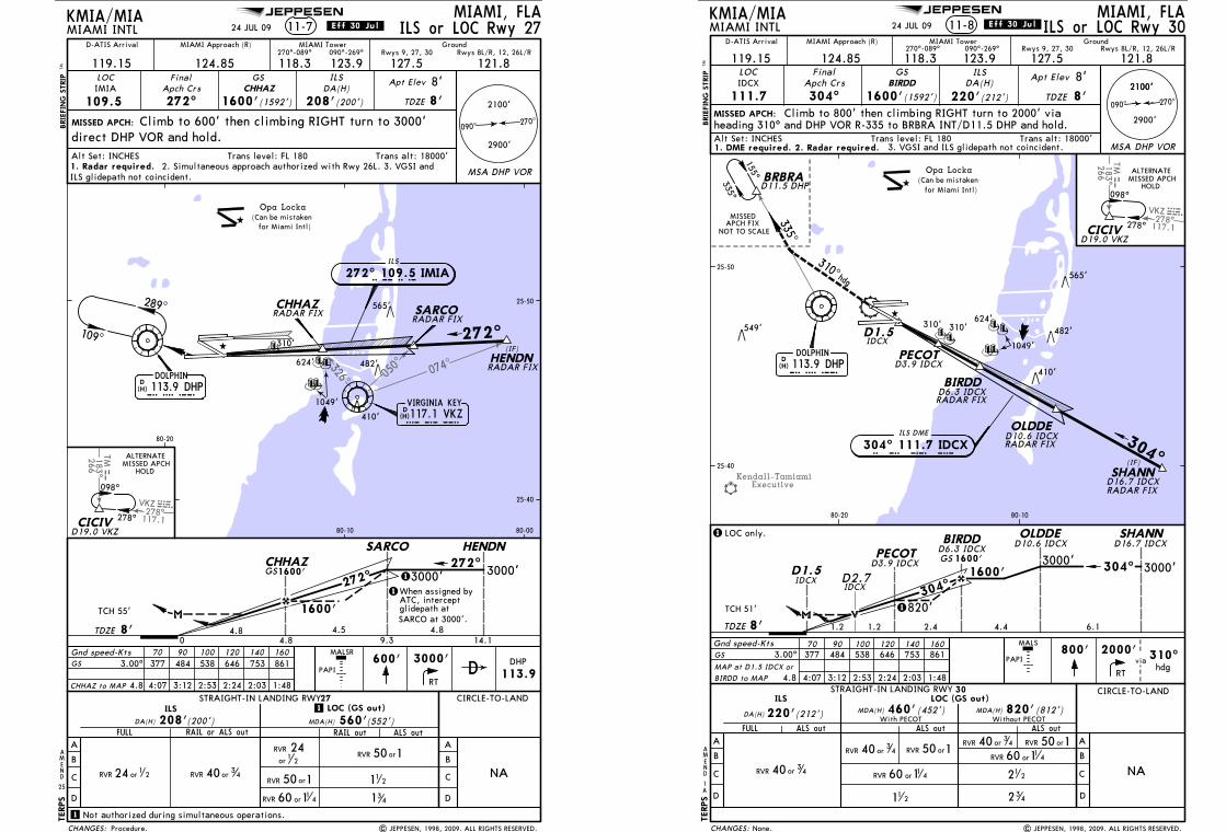
Licensed to Romulo Serrano. Printed on 08 Jan 2010.NOTICE: PRINTED FROM AN EXPIRED REVISION. Disc 23-2009
JEPPESENJeppView 3.6.3.1
JEPPESEN
050^ 074
^326^
278^VKZ
117.1
VKZ
183^266
TMTM
VIRGINIA KEY
VKZ
D(H)117.1 VKZ
IMIA
600' 3000' DHP
113.9
MISSED APCH:
MIAMI, FLAMIAMI INTL 11-7
Climb to 600' then climbing RIGHT turn to 3000'direct DHP VOR and hold.
25
AMEND
Opa Locka(Can be mistaken
for Miami Intl)
410'
565'
CIRCLE-TO-LAND
A
B
C
D
NA
3.00^ 377 484 538 646 753 861GS
A
B
C
D
FULL RAIL or ALS outDA(H)
ILS LOC (GS out)
MDA(H)
RAIL out ALS out
STRAIGHT-IN LANDING RWY
208'(200') 560'(552')
DMALSR
BRIE
FIN
G S
TRIP
TM
ILS
KMIA/MIA
Trans alt: 18000'Alt Set: INCHES Trans level: FL 180
27
TERPS
ILS or LOC Rwy 27
Gnd speed-Kts 70 90 100 120 140 160
24 JUL 09
1. Radar required.MSA DHP VOR
270^090^
2100'
2900'
CHHAZ to MAP 4.8 4:07 3:12 2:53 2:24 2:03 1:48 RT
DOLPHIN113.9 DHP
DHP
D(H)
109^
289^
25-40
25-50
80-0080-10
80-20
272^
1When assigned byATC, interceptglidepath atSARCO at 3000'.
2. Simultaneous approach authorized with Rwy 26L. 3. VGSI andILS glidepath not coincident.
1
1 Not authorized during simultaneous operations.
ALTERNATEMISSED APCH
HOLD
278^
098^
CICIVD19.0 VKZ
341
112
| JEPPESEN, 1998, 2009. ALL RIGHTS RESERVED.
(IF)
.Eff.30.Jul.
PAPI
Procedure.
272^
SARCO
TDZE 0
4.8 4.59.3
1
SARCO
272^
1600'
ILS
272^ 109.5 IMIA
RADAR FIX
TCH 55'
482'
LOC GSDA(H)
Apt Elev
TDZE
Apch CrsFinal
109.5IMIA
272^ 1600'(1592') 208'(200')
MIAMI Approach (R) MIAMI Tower Ground
119.15 124.85 118.3270^-089^
123.9090^-269^
121.8127.5
CHANGES:
8'
8'
8'
Rwys 9, 27, 30 Rwys 8L/R, 12, 26L/R
CHHAZ
CHHAZ
HENDNRADAR FIX
CHHAZRADAR FIX
GS1600'
HENDN
3000'3000'
4.84.8
14.1
310'
60 114RVR or
orRVR 150
orRVR 150
1049'
D-ATIS Arrival
624'
RVR 24 or1
2
RVR
or
241
2
RVR 40 or3
4
Licensed to Romulo Serrano. Printed on 08 Jan 2010.NOTICE: PRINTED FROM AN EXPIRED REVISION. Disc 23-2009
JEPPESENJeppView 3.6.3.1
JEPPESEN
Kendall-TamiamiExecutive
278^VKZ
117.1
VKZ
183^266
TMTM
304^
BIRDD
RADAR FIX
D1.5
ILS DME
304^ 111.7 IDCX
4.4
D1.5 1600'
OLDDEBIRDD
NA
DHP
090^ 270^
BRBRA
155^
335^
NOT TO SCALE
MISSEDAPCH FIX
hdg
335^
MISSED APCH:
MIAMI, FLAMIAMI INTL 11-8
MIAMI Approach (R) MIAMI Tower
119.15 124.85 118.3270^-089^
123.9090^-269^
127.5 121.8LOC
111.7IDCX
FinalApch Crs
304^BIRDD
1600'(1592') 220'(212')
Apt Elev
TDZE
Gnd speed-Kts 70 90 100 120 140 160
TDZE
D(H) 113.9 DHP
80-20
25-40
25-50
DA(H)
D11.5 DHP
DOLPHIN
PAPI
D6.3 IDCX
IDCX
D10.6 IDCX D6.3 IDCX
IDCX
Opa Locka(Can be mistaken
for Miami Intl)
OLDDE
A
B
C
D D
B
A
C
CIRCLE-TO-LANDSTRAIGHT-IN LANDING RWY
ALS out
820'(812')
30
MDA(H)
D10.6 IDCX RADAR FIX
80-10
MALS
BRIE
FIN
G S
TRIP
TM
I D C X
8'
377 484 538 646 753 861
1.28'
KMIA/MIA
Trans alt: 18000'Alt Set: INCHES Trans level: FL 180
TERPS
Rwys 9, 27, 30
8'
Rwys 8L/R, 12, 26L/R
112
ILS or LOC Rwy 30Ground
TCH 51'
GS 3.00^MAP at D1.5 IDCX or
PECOTD3.9 IDCX
PECOTD3.9 IDCX GS 1600'
820'
2.4
304^
ALS outALS out
460'(452')MDA(H)220'(212')DA(H)
FULL
ILS LOC (GS out)
With PECOT Without PECOT
60 11 4RVR or
RVR 40 or 34 orRVR 15060 11 4RVR or
212
2 34
ILSGS
24 JUL 09
1
AMEND
3. VGSI and ILS glidepath not coincident.
BIRDD to MAP 4.8 4:07 3:12 2:53 2:24 2:03 1:48
800'
RT
2000'via 310^
hdg
SHANN
3000'
D16.7 IDCX
304^
6.1
SHANND16.7 IDCX RADAR FIX
1.2
D2.7IDCX
(IF)
ALTERNATEMISSED APCH
HOLD
278^
098^
CICIVD19.0 VKZ
1
1 LOC only.
3000'
A
| JEPPESEN, 1998, 2009. ALL RIGHTS RESERVED.
D-ATIS Arrival
.Eff.30.Jul.
None.
549'
2900'
2100'
2100'
CHANGES:
565'
MSA DHP VOR
Climb to 800' then climbing RIGHT turn to 2000' viaheading 310^ and DHP VOR R-335 to BRBRA INT/D11.5 DHP and hold.
RVR 40 or 34
RVR 40 or3
4 orRVR 150
1. DME required. 2. Radar required.
1049'
310^
482'
410'
310'310'624'
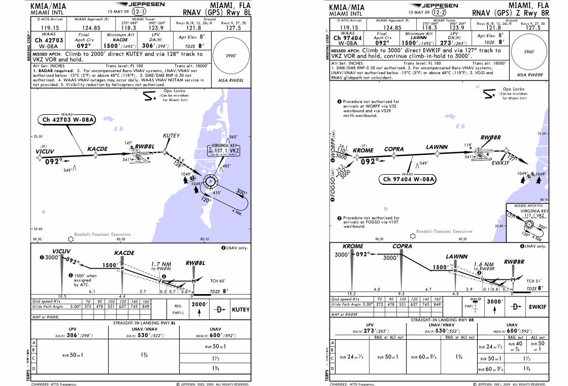
Licensed to Romulo Serrano. Printed on 08 Jan 2010.NOTICE: PRINTED FROM AN EXPIRED REVISION. Disc 23-2009
JEPPESENJeppView 3.6.3.1
JEPPESEN
Kendall-Tamiami Executive
128^
5.9
TDZE
1500'
KACDE
2.76.1
3000'VICUV
to RW~8L
2
2 LNAV only.
4.410.5 0
092^
0.8
1.7 NM
0.2
MISSED APCH:
MIAMI, FLAMIAMI INTL 12-1
MIAMI Approach (R) MIAMI Tower Ground
119.15 124.85 118.3270^-089^
123.9090^-269^
127.5121.8Final
Apch Crs
092^KACDE
1500'(1492') 306'(298')
Apt Elev
TDZE
Gnd speed-Kts 70 90 100 120 140 160
DA(H)Minimum Alt
MAP at RW~8L
KMIA/MIA
VICUV KACDE(IF)
WAAS
300^120^
4 NM
2000'KUTEY
KUTEY
372 478 531 637 743 849
092^
1
1 1500' whenassignedby ATC.
410'
549'
565'
482'
PAPI-L
RNAV (GPS) Rwy 8LRwys 8L/R, 12, 26L/R Rwys 9, 27, 30
8'
8'
RW~8L
RW~8L
8'
Ch 42703W-08A
WAAS
Ch 42703 W-08A
A
B
C
D
STRAIGHT-IN LANDING RWY 8L
LNAV
(592')MDA(H)
LNAV/VNAVLPV
DA(H) (522')DA(H) (298')306' 530' 600'
25-40
25-50
80-1080-2080-30
Glide Path Angle 3.00^
TCH 60'
LPV
Opa Locka(Can be mistaken
for Miami Intl)
BRIE
FIN
G S
TRIP
TM
Trans alt: 18000'Alt Set: INCHES Trans level: FL 180
D
TERPS
341
341
11 2
0.7
REIL
147'
341'
| JEPPESEN, 2003, 2009. ALL RIGHTS RESERVED.
1049'
1049'
15 MAY 09
D-ATIS Arrival
ATIS frequency.
VIRGINIA KEY117.1 VKZ
VKZ
D(H)
AMEND
1
AM
ND
CHANGES:
Climb to 2000' direct KUTEY and via 128^ track to VKZ VOR and hold.
1. RADAR required. 2. For uncompensated Baro-VNAV systems, LNAV/VNAV notauthorized below -15^C (5^F) or above 48^C (118^F). 3. DME/DME RNP-0.30 not
orRVR 150
orRVR 150
authorized. 4. WAAS VNAV outages may occur daily. WAAS VNAV NOTAM service is MSA RW~8L
2900'
not provided. 5. Visibility reduction by helicopters not authorized.
Licensed to Romulo Serrano. Printed on 08 Jan 2010.NOTICE: PRINTED FROM AN EXPIRED REVISION. Disc 23-2009
JEPPESENJeppView 3.6.3.1
JEPPESEN
Kendall-Tamiami Executive
Opa Locka(Can be mistaken
for Miami Intl)
12-2MIAMI, FLA
MIAMI INTL
2900'
MSA RW~8R
119.15MIAMI Approach (R)
124.85 118.3270^-089^
MIAMI Tower
123.9090^-269^
127.5121.8
092^
Minimum AltLAWNN
1500'DA(H)
273'(265')
Apt Elev
TDZE 8'
MISSED APCH:
EWKIF3000'
1500'
TDZE2.9 0.7
COPRA
LAWNN
Gnd speed-Kts 70 90 100 120 140 160372 478 531 637 743 849
04.5
RW~8R
9.24.7 8'
PAPI
BRIE
FIN
G S
TRIP
TM
MALSR
1
AMEND
Trans alt: 18000'Alt Set: INCHES Trans level: FL 180
KMIA/MIA
FinalApch Crs
(1492')
D
Rwys 8L/R, 12, 26L/R Rwys 9, 27, 30Ground
8'
TERPS
RNAV (GPS) Z Rwy 8R
WO
RPP
KROME
FOG
SO
COPRA LAWNN
EWKIF
RW~8R
(IA
F)(I
AF)
092^
(IF)
127^
VIRGINIA KEY
300^120^ 4 NM
127^
MISSED APCH FIX
KROME
13.2
092^
4.0
3000'
549'
25-40
25-50
80-10
80-2080-30
1
1 Procedure not authorized forarrivals at WORPP via V35
2
MAP at RW~8R
A
B
C
D
STRAIGHT-IN LANDING RWY 8RLNAV
MDA(H)
LNAV/VNAV
(592')DA(H) (522')DA(H) (265')
LPV
273' 530' 600'
Glide Path Angle 3.00^
LPVWAASCh 97404
W-08A
WAAS
Ch 97404 W-08A
TCH 51'
1.6 NMto RW~8R
0.1
3
3LNAV only.
westbound and via V529north-westbound.
arrivals at FOGSO via V157Procedure not authorized for2
westbound.
3000052^14
.2
3000
110^24.1
LNAV/VNAV not authorized below -15^C (5^F) or above 48^C (118^F). 3. VGSI andRNAV glidepath not coincident.
3000'
119'
341'
Climb to 3000' direct EWKIF and via 127^ track toVKZ VOR and hold, continue climb-in-hold to 3000'.
0.8
15 MAY 09
112
341
341
1049' 1049'
| JEPPESEN, 2001, 2009. ALL RIGHTS RESERVED.
RAIL or ALS out RAIL or ALS out ALS outRAIL out
D-ATIS Arrival
ATIS frequency.
117.1 VKZvkz
1. DME/DME RNP-0.30 not authorized. 2. For uncompensated Baro-VNAV systems,
CHANGES:
60 114RVR or
orRVR 150
RVR 24 or12
60 11 4RVR ororRVR 150RVR 24 or1
2
RVR
or
501
RVR
or
403
4

Licensed to Romulo Serrano. Printed on 08 Jan 2010.NOTICE: PRINTED FROM AN EXPIRED REVISION. Disc 23-2009
JEPPESENJeppView 3.6.3.1
JEPPESEN
Kendall-Tamiami Executive
[3.00^]
[TCH 55']
(IF/IAF)
Opa Locka(Can be mistaken
for Miami Intl)
VIRGINIA KEY
12-3MIAMI, FLA
MIAMI INTL
2900'
119.15
MIAMI Approach (R)
124.85 118.3270^-089^
MIAMI Tower
123.9090^-269^
127.5 121.8
RNAV092^
Minimum AltDOXSI
1500'DA(H)
LNAV/VNAV
420'(413')
Apt Elev
TDZE 7'MISSED APCH:
OPVAQ3000'
1500'
3000'
TDZE2.9 1.1
HODLE
DOXSI
1.6 NMto RW~9
092^
Gnd speed-KtsDescent angle
MAP at RW~9
70 90 100 120 140 160372 478 531 637 743 849
1 LNAV only.
1
04.59.55.0 7'
[3.00^]
MISSEDAPCH FIX
BRIE
FIN
G S
TRIP
TM
549'
0.5
HODLE DOXSI OPVAQ
092^
272^
MALSR
PAPI
280^ 18.0
3000
A
B
C
D
A
LNAVLNAV/VNAV
RAIL out ALS outRAIL out ALS out
CIRCLE-TO-LAND
B
C
D
NA
5.9117^
4 NM092^ 272^
112 11
2
341
0
AMEND
C
VIR
GIN
IA K
EY V
OR
KMIA/MIA
Trans alt: 18000'Alt Set: INCHES Trans level: FL 180
25-40
25-50
80-10
80-2080-30
to HODLE
300^
120^ 4 NM
117^
FinalApch Crs
(1493')
DA(H) 420'(413') MDA(H) 560'(553')
VKZ VOR and hold.
D
RNAV (GPS) Rwy 9Rwys 9, 27, 30 Rwys 8L/R, 12, 26L/R
Ground
8'
RW~9
RW~9
STRAIGHT-IN LANDING RWY 9
MSA RW~9
TERPS
Climb to 3000' direct OPVAQ and 117^ track to
orRVR 150
RVR 24 or1
2 RVR 40 or 34 orRVR 150
orRVR 150
60 11 4RVR or
1. GPS required. 2. CAUTION: Lights on highway 1/4 mile south of final approachcourse may be mistaken for runway. 3. Baro-VNAV not authorized below -15^C (5^F).
15 MAY 09
1049'
1049'
| JEPPESEN, 2001, 2009. ALL RIGHTS RESERVED.ATIS frequency.
D-ATIS Arrival
117.1 VKZvkz
VNAV NOTAM service not provided.4. DME/DME RNP-0.30 not authorized. 5. WAAS VNAV outages may occur. WAAS
CHANGES:
Licensed to Romulo Serrano. Printed on 08 Jan 2010.NOTICE: PRINTED FROM AN EXPIRED REVISION. Disc 23-2009
JEPPESENJeppView 3.6.3.1
JEPPESEN
MALSR
PAPI
12-4MIAMI, FLA
MIAMI INTL
2900'
119.15
MIAMI Approach (R)
124.85 118.3270^-089^
MIAMI Tower
123.9090^-269^
127.5121.8
124^
Minimum AltVEPCO
2000'(1992')DA(H)
390'(382')
Apt Elev
TDZE 8'MISSED APCH:
BRIE
FIN
G S
TRIP
TM
MSA RW12
VAYQO
VIRGINIA KEY
RW12
109^
300^120^
Gnd speed-Kts 70 90 100 120 140 160372 478 531 637 743 849 3000'
VAYQO
4 NM
Opa Locka(Can be mistaken
for Miami Intl)
549'
1
MISSEDAPCH FIX
109^
FinalApch Crs
D
KMIA/MIA
Rwys 8L/R, 12, 26L/R Rwys 9, 27, 30Ground
TERPS
8'
1049'
RNAV (GPS) Z Rwy 12
VEPCO
WO
RPP
FOG
SO(I
AF)
(IA
F)
arrivals at FOGSO via V157
12
Procedure not authorized for2
westbound.
1
GLRIA
PIANA
036^
091^
3000
3000
20.4
23.3
(IF)
124^
Procedure not authorized for arrivalsat WORPP via V35 westbound and viaV529 north-westbound.
VKZ VOR and hold, continue climb-in-hold to 3000'.Trans alt: 18000'Alt Set: INCHES Trans level: FL 180
25-50
80-2080-30
25-45
MAP at RW12
Glide Path Angle 3.00^
WAASCh 61204
W-12A
LPV
WAAS
Ch 61204 W-12A
2000'
TDZE4.4 1.0
GLRIAVEPCO
06.09.13.1 8'
PIANA
15.1
124^
6.0
3000'
TCH 56'
1.6 NMto RW12
0.2
3
3LNAV only.
A
B
C
D
STRAIGHT-IN LANDING RWY 12LNAV
MDA(H)
LNAV/VNAV
(592')DA(H) (498')
orRVR 150
60 1RVR or 1 4
112
341
DA(H) (382')
LPV
390' 506' 600'
341
LNAV/VNAV not authorized below -15^C (5^F) or above 49^C (120^F). 3. VGSI andRNAV glidepath not coincident. 4. Visibility reduction by helicopters not authorized.
3000'
147'
341'
Climb to 3000' direct VAYQO and via 109^ track to
RW12
0.4
5. WAAS VNAV outages may occur daily. WAAS VNAV NOTAM service is not provided.
| JEPPESEN, 2001, 2009. ALL RIGHTS RESERVED.
AMEND
A
RAIL or ALS out RAIL or ALS out ALS outRAIL out
D-ATIS Arrival
ATIS frequency.
15 MAY 09
1. DME/DME RNP-0.30 not authorized. 2. For uncompensated Baro-VNAV systems,
117.1 VKZVKZ
CHANGES:
RVR 40or3
4 60 11 4RVR or60 11 4RVR or
RVR 40or34
RVR
or
501
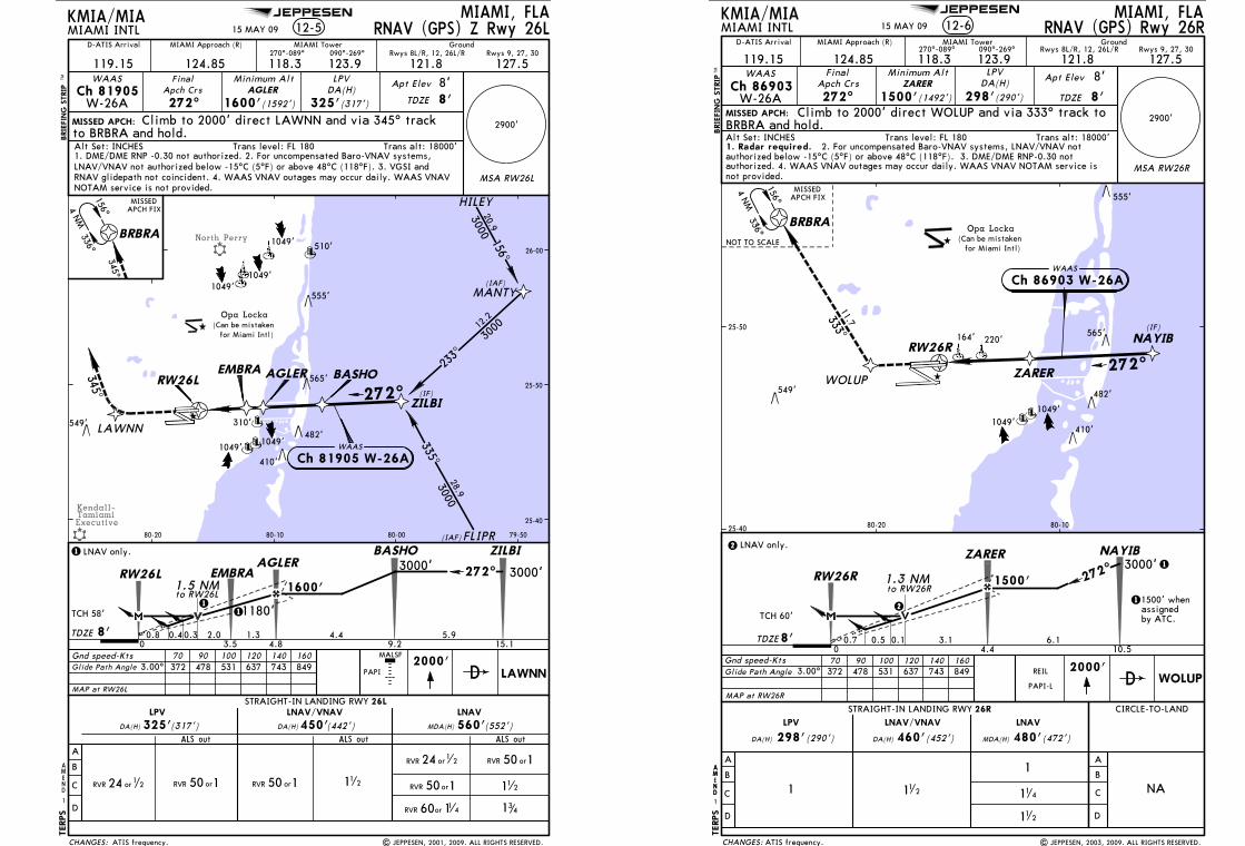
Licensed to Romulo Serrano. Printed on 08 Jan 2010.NOTICE: PRINTED FROM AN EXPIRED REVISION. Disc 23-2009
JEPPESENJeppView 3.6.3.1
JEPPESEN
North Perry
Kendall-TamiamiExecutive
12-5MIAMI, FLA
MIAMI INTL
2900'
MSA RW26L
119.15
MIAMI Approach (R)
124.85 118.3270^-089^
MIAMI Tower
123.9090^-269^
127.5
Ground
121.8
272^
Minimum AltAGLER
1600'(1592')
DA(H)
325'(317')
Apt Elev
TDZE 8'
MISSED APCH:
2000'Gnd speed-Kts 70 90 100 120 140 160372 478 531 637 743 849
PAPI
BRBRA
1
KMIA/MIA
to BRBRA and hold.
FinalApch Crs
BRIE
FIN
G S
TRIP
TM
AMEND
Trans alt: 18000'Alt Set: INCHES Trans level: FL 180
D
Rwys 8L/R, 12, 26L/R Rwys 9, 27, 30
8'
TERPS
MALSF
RNAV (GPS) Z Rwy 26L
Climb to 2000' direct LAWNN and via 345^ track
LAWNN
1600'
TDZE 1.30.8
BASHOAGLER
0 4.8
RW26L
9.24.48'
ZILBI
15.1
272^
5.9
3000'3000'
HILEY
FLIPR
MANTY
AGLERRW26L
ZILBI
345^345^
156^
336^
4 NM
MISSEDAPCH FIX
156^
300020.9
(IAF)
233^
300012
.2
335^3000
28.9
272^
(IAF)
(IF)
549'
1049'
510'
565'
482'
555'
1049'
1049'
25-40
25-50
26-00
79-5080-0080-1080-20
BASHO
LAWNN
MAP at RW26L
Glide Path Angle 3.00^
TCH 58'
EMBRA
3.5
1.5 NMto RW26L
0.3 2.0
1180'11
1 LNAV only.
LPVWAAS
A
B
C
D
STRAIGHT-IN LANDING RWYLNAV
MDA(H)
LNAV/VNAV
(552')DA(H) (442')ALS outALS out
orRVR 150
orRVR 150
60 1RVR or 1 4
112
341
DA(H) (317')ALS out
LPV
325' 450' 560'
Ch 81905W-26A
1. DME/DME RNP -0.30 not authorized. 2. For uncompensated Baro-VNAV systems,LNAV/VNAV not authorized below -15^C (5^F) or above 48^C (118^F). 3. VGSI and
26L
112
EMBRA
WAAS
Ch 81905 W-26A
(Can be mistaken Opa Locka
for Miami Intl)
310'
0.4
410'
NOTAM service is not provided.RNAV glidepath not coincident. 4. WAAS VNAV outages may occur daily. WAAS VNAV
1049'1049'
| JEPPESEN, 2001, 2009. ALL RIGHTS RESERVED.ATIS frequency.
D-ATIS Arrival
15 MAY 09
CHANGES:
RVR 24 or1
2
orRVR 150 orRVR 150RVR 24 or12
Licensed to Romulo Serrano. Printed on 08 Jan 2010.NOTICE: PRINTED FROM AN EXPIRED REVISION. Disc 23-2009
JEPPESENJeppView 3.6.3.1
JEPPESEN
BRBRA
NAYIB
ZARERWOLUP272^
333^11.7
(IF)
4 NM
MISSED APCH:
MIAMI, FLAMIAMI INTL 12-6
MIAMI Approach (R) MIAMI Tower
119.15 124.85 118.3270^-089^
123.9090^-269^
127.5121.8Final
Apch Crs
272^ZARER
1500'(1492') 298'(290')
Apt Elev
TDZE
DA(H)Minimum Alt
KMIA/MIA
WAAS
TDZE
1500'
ZARER
3.1 6.1
3000'NAYIB
to RW26R
1
2
4.4 10.50
272^
0.7
1.3 NM
0.1
Gnd speed-Kts 70 90 100 120 140 160
MAP at RW26R
2000'WOLUP
372 478 531 637 743 849
2
LNAV only.
11500' whenassignedby ATC.
RNAV (GPS) Rwy 26R
410'
549'
565'
482'
156^
336^
MISSEDAPCH FIX
NOT TO SCALE
BRIE
FIN
G S
TRIP
TM
Trans alt: 18000'Alt Set: INCHES Trans level: FL 180
D
Opa Locka(Can be mistaken
for Miami Intl)
25-40
25-50
80-1080-20
PAPI-L
RW26R
8'
8'
Rwys 8L/R, 12, 26L/R Rwys 9, 27, 30Ground
RW26R
TERPS
8'
555'
Ch 86903W-26A
LPV
WAAS
Ch 86903 W-26A
TCH 60'
3.00^Glide Path Angle
CIRCLE-TO-LAND
A
B
C
D
STRAIGHT-IN LANDING RWY
LNAV
(472')MDA(H)
LNAV/VNAVLPV
DA(H) (452')DA(H) (290')
26R
298' 460' 480'
1 112
1
11 4
112
NA
REIL
0.5
ATIS frequency.
164' 220'
| JEPPESEN, 2003, 2009. ALL RIGHTS RESERVED.
1049'1049'
D-ATIS Arrival
15 MAY 09
Climb to 2000' direct WOLUP and via 333^ track to
AMEND
1
AM
ND
CHANGES:
BRBRA and hold.
1. Radar required. 2. For uncompensated Baro-VNAV systems, LNAV/VNAV notauthorized below -15^C (5^F) or above 48^C (118^F). 3. DME/DME RNP-0.30 not
A
B
C
D
not provided.authorized. 4. WAAS VNAV outages may occur daily. WAAS VNAV NOTAM service is
2900'
MSA RW26R
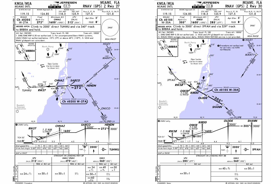
Licensed to Romulo Serrano. Printed on 08 Jan 2010.NOTICE: PRINTED FROM AN EXPIRED REVISION. Disc 23-2009
JEPPESENJeppView 3.6.3.1
JEPPESEN
North Perry
Kendall-TamiamiExecutive
MIAMI, FLAMIAMI INTL
2900'
119.15
MIAMI Approach (R)
124.85 118.3270^-089^
MIAMI Tower
123.9090^-269^
127.5
Ground
121.8
272^
Minimum AltCHHAZ
1600'(1592')
DA(H)
312'(304')
Apt Elev
TDZE 8'
MISSED APCH:
2000'Gnd speed-Kts 70 90 100 120 140 160372 478 531 637 743 849
BRBRA
2
KMIA/MIA
to BRBRA and hold.
FinalApch Crs
BRIE
FIN
G S
TRIP
TM
AMEND
Trans alt: 18000'Alt Set: INCHES Trans level: FL 180
D
Rwys 8L/R, 12, 26L/RRwys 9, 27, 30
8'
TERPS
RNAV (GPS) Z Rwy 27
Climb to 2000' direct TUHWU and via 340^ track
TUHWU
HILEY
FLIPR
MANTY
156^
336^
4 NM
MISSEDAPCH FIX
156^
300020.9
(IAF)
(IAF)
549'
1049'
510'
565'
482'
555'
1049'
1049'
MSA RW27
RW27
ONICO
HENDN
SARCOCHHAZ(IF)
272^TUHWU
340^
4.6
340^
332^
300018.8
332^3000
10.0
234^
300013
.7
MALSR
25-40
25-50
26-00
79-5080-0080-1080-20
LPVWAASCh 40205
W-27A
1600'
TDZE 3.30.8
CHHAZ HENDN
0 4.8 9.34.58'
14.1
272^
4.8
3000'
TCH 55'
1.5 NMto RW27
0.2
1
LNAV only.3000'
SARCO1
A
B
C
D
STRAIGHT-IN LANDING RWY 27LNAV
MDA(H)
LNAV/VNAV
(552')DA(H) (462')
orRVR 150 112
341
DA(H) (304')
LPV
312' 470' 560'
112
MAP at RW27
RW27
Glide Path Angle 3.00^
WAAS
Ch 40205 W-27A
LNAV/VNAV not authorized below -15^C (5^F) or above 48^C (118^F). 3. VGSI and
(Can be mistaken Opa Locka
for Miami Intl)
310'
410'
0.5
1049'
| JEPPESEN, 2001, 2009. ALL RIGHTS RESERVED.
12-7
RAIL or ALS out RAIL or ALS out
D-ATIS Arrival
24 JUL 09
1. DME/DME RNP-0.30 not authorized. 2. For uncompensated Baro-VNAV systems,
PAPI
.Eff.30.Jul.
624'
Procedure.
154'
RNAV glidepath not coincident.
RAIL out ALS out
12.112.1
CHANGES:
orRVR 150RVR 24 or1
2 orRVR 150
RVR
or
241
2
60or
RVR
11 4
RVR
or
403
4
RVR
or
501
Licensed to Romulo Serrano. Printed on 08 Jan 2010.NOTICE: PRINTED FROM AN EXPIRED REVISION. Disc 23-2009
JEPPESENJeppView 3.6.3.1
JEPPESEN
North Perry
Kendall-TamiamiExecutive
MIAMI, FLAMIAMI INTL
2900'
119.15
MIAMI Approach (R)
124.85 118.3270^-089^
MIAMI Tower
123.9090^-269^
127.5
Ground
121.8
305^
Minimum AltBIRDD
1600'(1592')
DA(H)
285'(277')
Apt Elev
TDZE 8'
MISSED APCH:
3000'Gnd speed-Kts 70 90 100 120 140 160
372 478 531 637 743 849
BRBRA
1
KMIA/MIA
to BRBRA and hold.
FinalApch Crs
BRIE
FIN
G S
TRIP
TM
AMEND
Trans alt: 18000'Alt Set: INCHES Trans level: FL 180
D
Rwys 8L/R, 12, 26L/RRwys 9, 27, 30
8'
TERPS
RNAV (GPS) Z Rwy 30
Climb to 3000' direct IPFAH and via 329^ track
IPFAH
HILEY
FLIPR
MANTY
156^
336^
4 NM
MISSEDAPCH FIX
156^
300020.9
(IAF)
(IAF)
549'
1049'
510'
565'
482'
555'
1049'
1049'
MSA RW3~
25-40
25-50
26-00
79-5080-1080-20
SHANN
OLDDE
BIRDD
RW3~
319^3000
23.1
219^
300020
.6
(IF)
305^
1
LPV
MAP at RW3~
Glide Path Angle 3.00^
WAASCh 40105
W-30A
A
B
C
D
STRAIGHT-IN LANDING RWY 30LNAV
MDA(H) (552')ALS out
orRVR 150
112
341
DA(H) (277')ALS out
LPV
285' 560'
MALS
PAPI
1600'
TDZE 1.60.7
OLDDEBIRDD
0 4.8 9.24.48'
SHANN
15.3
305^
6.1
3000'3000'
TCH 51'
OSKIE
1.5 NMto RW3~
0.8 1.7
1080'22
2 LNAV only.
RW3~
329^329^
1. DME/DME RNP-0.30 not authorized. 2. VGSI and LPV glidepath not coincident.
WAAS
Ch 40105 W-30A
(Can be mistaken Opa Locka
for Miami Intl)
310'1049'
1
410'
IPFAH
Procedure not authorizedfor arrivals via V295northbound.
3. WAAS VNAV outages may occur daily. WAAS VNAV NOTAM service is not provided.
3.2 NMto RW3~
to RW3~3.2 NMOSKIE
24 JUL 09 12-8
| JEPPESEN, 2001, 2009. ALL RIGHTS RESERVED.
D-ATIS Arrival.Eff.30.Jul.
None.
624'
CHANGES:
orRVR 150
RVR 40 or 34
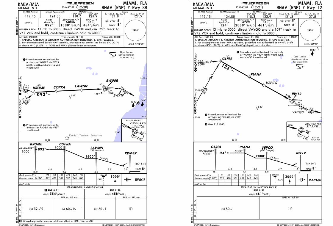
Licensed to Romulo Serrano. Printed on 08 Jan 2010.NOTICE: PRINTED FROM AN EXPIRED REVISION. Disc 23-2009
JEPPESENJeppView 3.6.3.1
JEPPESEN
Kendall-Tamiami Executive
[3.00^]
[TCH 51']
Opa Locka(Can be mistaken
for Miami Intl)
MIAMI, FLAMIAMI INTL
2900'
MSA RW~8R
119.15MIAMI Approach (R)
124.85 118.3270^-089^
MIAMI Tower
123.9090^-269^
127.5121.8
RNAV092^
Minimum AltLAWNN
1500'DA(H)
354'(346')
Apt Elev
TDZE 8'
MISSED APCH:
EWKIF3000'
1500'
TDZE3.6 0.9
COPRALAWNN
Gnd speed-KtsDescent angle
70 90 100 120 140 160372 478 531 637 743 849
04.5
RW~8R
9.24.7 8'
[3.00^]PAPI
BRIE
FIN
G S
TRIP
TM
MALSR
0
AMEND
Trans alt: 18000'Alt Set: INCHES Trans level: FL 180
KMIA/MIA
FinalApch Crs
(1492')
D
Rwys 8L/R, 12, 26L/R Rwys 9, 27, 30Ground
8'TERPS
RNAV (RNP) Y Rwy 8R
A
B
C
D
STRAIGHT-IN LANDING RWY 8R
DA(H) (450')DA(H) (346')
RNP 0.11 RNP 0.30
354' 458'
WO
RPP
KROME
FOG
SO
COPRA LAWNN
EWKIF
RW~8R
(IA
F)(I
AF)
110^3000
24.1
052^
3000
14.2
092^
(IF)
127^
VIRGINIA KEY
300^120^ 4 NM
127^
MISSED APCH FIX
RNP 0.11
Climb to 3000' direct EWKIF and via 127^ track to
112
MAP at DA
KROME
13.2
092^
4.0
3000'
549'
25-40
25-50
80-10
80-2080-30
1
1 Missed approach requires minimum climb of 330'/NM to 600'.
MANDATORY
1 Procedure not authorized forarrivals at WORPP via V529
arrivals at FOGSO via V157Procedure not authorized for2
westbound.
21
3000'
109'
VKZ VOR and hold, continue climb-in-hold to 3000'.
north-westbound and via V35westbound.
1. SPECIAL AIRCRAFT & AIRCREW AUTHORIZATION REQUIRED. 2. GPS required.3. For uncompensated Baro-VNAV systems, procedure not authorized below 6^C (42^F)or above 49^C (120^F). 4. VGSI and RNAV glidepath not coincident.
1049' 1049'
RAIL or ALS out RAIL or ALS out
| JEPPESEN, 2007, 2009. ALL RIGHTS RESERVED.
147'
15 MAY 09 12-20
ATIS frequency.
D-ATIS Arrival
117.1 VKZVKZ
(GP Intcpt)
CHANGES:
60 11 4RVR or orRVR 150RVR 32 or5
8
Licensed to Romulo Serrano. Printed on 08 Jan 2010.NOTICE: PRINTED FROM AN EXPIRED REVISION. Disc 23-2009
JEPPESENJeppView 3.6.3.1
JEPPESEN
MALSR
PAPI
MIAMI, FLAMIAMI INTL
2900'
119.15
MIAMI Approach (R)
124.85 118.3270^-089^
MIAMI Tower
123.9090^-269^
127.5121.8
RNAV124^
Minimum AltVEPCO
2000'(1992')DA(H)
461'(453')
Apt Elev
TDZE 8'MISSED APCH:
BRIE
FIN
G S
TRIP
TM
MSA RW12
VAYQO
VIRGINIA KEY
RW12
5.6109^
300^120^
Gnd speed-Kts 70 90 100 120 140 160Descent angle 372 478 531 637 743 849 3000'
VAYQO[3.00^]
4 NM
Opa Locka(Can be mistaken
for Miami Intl)
549'
MISSEDAPCH FIX
109^
FinalApch Crs
D
KMIA/MIA
Rwys 8L/R, 12, 26L/R Rwys 9, 27, 30Ground
TERPS
8'
1049'
15 MAY 09 RNAV (RNP) Y Rwy 12
VEPCO
WO
RPP
FOG
SO(I
AF)
(IA
F)
arrivals at FOGSO via V157
12
Procedure not authorized for2
westbound.
1
GLRIA
PIANA
036^
091^
3000
3000
20.4
23.3
(IF)
124^
Procedure not authorized for arrivalsat WORPP via V529 north-westboundand via V35 westbound.
VKZ VOR and hold, continue climb-in-hold to 3000'.
RNP 0.30
A
Trans alt: 18000'Alt Set: INCHES Trans level: FL 180
B
C
D
STRAIGHT-IN LANDING RWY 12
DA(H) (453')
RNP 0.30
461'
112
MAP at DA
[3.00^]
[TCH 56']
2000'
TDZE4.7 1.3
PIANA VEPCO
06.09.13.1 8'
GLRIA
15.1
124^
6.0
3000'MANDATORY
25-50
80-2080-30
25-45
RW12
3
3
3000'
147'
Climb to 3000' direct VAYQO and via 109^ track to
124^
3.0
1. SPECIAL AIRCRAFT & AIRCREW AUTHORIZATION REQUIRED. 2. GPS required.
or above 49^C (120^F). 4. VGSI and RNAV glidepath not coincident.3. For uncompensated Baro-VNAV systems, procedure not authorized below 6^C (42^F)
Max 210 KIAS
| JEPPESEN, 2007, 2009. ALL RIGHTS RESERVED.
AMEND
A0
12-21
ATIS frequency.
RAIL or ALS out
D-ATIS Arrival
117.1 VKZvkz
(GP Intcpt)
CHANGES:
orRVR 150
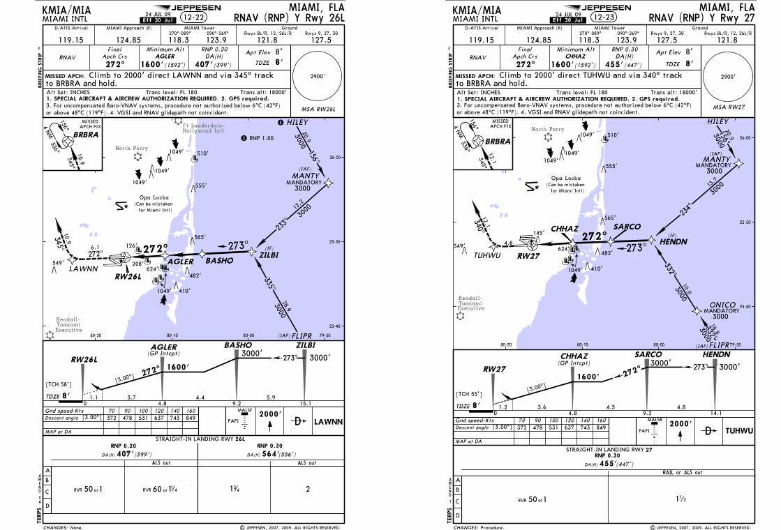
Licensed to Romulo Serrano. Printed on 08 Jan 2010.NOTICE: PRINTED FROM AN EXPIRED REVISION. Disc 23-2009
JEPPESENJeppView 3.6.3.1
JEPPESEN
North Perry
Ft Lauderdale-Hollywood Intl
Kendall-TamiamiExecutive
MIAMI, FLAMIAMI INTL
2900'
MSA RW26L
119.15
MIAMI Approach (R)
124.85 118.3270^-089^
MIAMI Tower
123.9090^-269^
127.5
Ground
121.8
RNAV272^
Minimum AltAGLER
1600'(1592')
DA(H)
407'(399')
Apt Elev
TDZE 8'
MISSED APCH:
2000'Gnd speed-KtsDescent angle
70 90 100 120 140 160372 478 531 637 743 849[3.00^]
PAPI
BRBRA
0
KMIA/MIA
to BRBRA and hold.
FinalApch Crs
BRIE
FIN
G S
TRIP
TM
AMEND
Trans alt: 18000'Alt Set: INCHES Trans level: FL 180
D
Rwys 8L/R, 12, 26L/R Rwys 9, 27, 30
8'
TERPS
MALSF
24 JUL 09 RNAV (RNP) Y Rwy 26L
RNP 0.20
Climb to 2000' direct LAWNN and via 345^ track
MAP at DA
LAWNN
[3.00^]
[TCH 58']
1600'
TDZE 3.71.1
BASHOAGLER
A
0 4.8
RW26L
9.24.48'
ZILBI
15.1
273^
5.9
3000'
B
C
D
STRAIGHT-IN LANDING RWY
DA(H) (556')ALS out
DA(H) (399')ALS out
RNP 0.20 RNP 0.30
407' 564'
3000'
26L
2
HILEY
FLIPR
MANTY
AGLER
RW26L
ZILBI
345^10.9
345^10.9
156^
336^
4 NM
MISSEDAPCH FIX
156^
300020.9
(IAF)
233^
300012
.2
335^3000
28.9
272^
(IAF)
(IF)
549'
1049'
510'
565'
482'
555'
1049'
1049'
126'
25-40
25-50
26-00
79-5080-0080-1080-20
BASHOLAWNN
(Can be mistaken Opa Locka
for Miami Intl)
208'
272^6.1
410'
1. SPECIAL AIRCRAFT & AIRCREW AUTHORIZATION REQUIRED. 2. GPS required.
or above 48^C (119^F). 4. VGSI and RNAV glidepath not coincident.3. For uncompensated Baro-VNAV systems, procedure not authorized below 6^C (42^F)
1
1 RNP 1.00
3000MANDATORY
12-22
| JEPPESEN, 2007, 2009. ALL RIGHTS RESERVED.
A
341
273^
272^
D-ATIS Arrival
(GP Intcpt)
.Eff.30.Jul.
None.
624'
1049'
CHANGES:
60 11 4RVR ororRVR 150
Licensed to Romulo Serrano. Printed on 08 Jan 2010.NOTICE: PRINTED FROM AN EXPIRED REVISION. Disc 23-2009
JEPPESENJeppView 3.6.3.1
JEPPESEN
North Perry
Kendall-TamiamiExecutive
MIAMI, FLAMIAMI INTL
2900'
119.15
MIAMI Approach (R)
124.85 118.3270^-089^
MIAMI Tower
123.9090^-269^
127.5
Ground
121.8
RNAV272^
Minimum AltCHHAZ
1600'(1592')
DA(H)
455'(447')
Apt Elev
TDZE 8'
MISSED APCH:
2000'Gnd speed-KtsDescent angle
70 90 100 120 140 160372 478 531 637 743 849[3.00^]
BRBRA
1
KMIA/MIA
to BRBRA and hold.
FinalApch Crs
BRIE
FIN
G S
TRIP
TM
AMEND
Trans alt: 18000'Alt Set: INCHES Trans level: FL 180
D
Rwys 8L/R, 12, 26L/RRwys 9, 27, 30
8'
TERPS
24 JUL 09 RNAV (RNP) Y Rwy 27
RNP 0.30
Climb to 2000' direct TUHWU and via 340^ track
MAP at DA
TUHWU
[3.00^]
[TCH 55']
1600'
TDZE 3.61.2
SARCOCHHAZ
A
0 4.8 9.34.58'
HENDN
14.1
273^
4.8
3000'
B
C
D
STRAIGHT-IN LANDING RWY
DA(H) (447')
RNP 0.30
455'
112
3000'
HILEY
FLIPR
MANTY
156^
336^
4 NM
MISSEDAPCH FIX
156^
300020.9
(IAF)
(IAF)
549'
1049'
510'
565'
482'
555'
1049'
1049'
12-23
MSA RW27
RW27
ONICO
HENDN
SARCOCHHAZ(IF)
273^TUHWU
340^12.1
4.6
340^12.1
332^
300018.8
332^3000
10.0
234^
300013
.7
27
MANDATORY
MANDATORY3000
3000
RW27
MALSR
25-40
25-50
26-00
79-5080-0080-1080-20
(Can be mistaken Opa Locka
for Miami Intl)
145'
410'
1. SPECIAL AIRCRAFT & AIRCREW AUTHORIZATION REQUIRED. 2. GPS required.
or above 48^C (119^F). 4. VGSI and RNAV glidepath not coincident.3. For uncompensated Baro-VNAV systems, procedure not authorized below 6^C (42^F)
1049'
| JEPPESEN, 2007, 2009. ALL RIGHTS RESERVED.
RAIL or ALS out
272^
272^
D-ATIS Arrival
(GP Intcpt)
.Eff.30.Jul.
PAPI
624'
Procedure.CHANGES:
orRVR 150
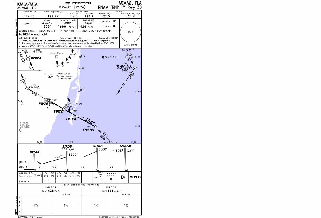
Licensed to Romulo Serrano. Printed on 08 Jan 2010.NOTICE: PRINTED FROM AN EXPIRED REVISION. Disc 23-2009
JEPPESENJeppView 3.6.3.1
JEPPESEN
North Perry
Kendall-TamiamiExecutive
MIAMI, FLAMIAMI INTL
2900'
119.15
MIAMI Approach (R)
124.85 118.3270^-089^
MIAMI Tower
123.9090^-269^
127.5
Ground
121.8
RNAV305^
Minimum AltBIRDD
1600'(1592')
DA(H)
426'(418')
Apt Elev
TDZE 8'
MISSED APCH:
3000'Gnd speed-KtsDescent angle
70 90 100 120 140 160372 478 531 637 743 849[3.00^]
BRBRA
0
KMIA/MIA
to BRBRA and hold.
FinalApch Crs
BRIE
FIN
G S
TRIP
TM
AMEND
Trans alt: 18000'Alt Set: INCHES Trans level: FL 180
D
Rwys 8L/R, 12, 26L/RRwys 9, 27, 30
8'
TERPS
15 MAY 09 RNAV (RNP) Y Rwy 30
RNP 0.23
Climb to 3000' direct VEPCO and via 342^ track
MAP at DA
VEPCO
[3.00^]
[TCH 51']
1600'
TDZE 3.61.2
OLDDEBIRDD
0 4.8 9.24.48'
SHANN
15.3
305^
6.1
3000'3000'
HILEY
FLIPR
MANTY
156^
336^
4 NM
MISSEDAPCH FIX
156^
300020.9
(IAF)
(IAF)
549'
1049'
510'
565'
482'
555'
1049'
1049'
12-24
MSA RW3~
MANDATORY3000
RW3~
25-40
25-50
26-00
79-5080-1080-20
SHANN
OLDDE
BIRDD
VEPCO
RW3~
319^3000
23.1
219^
300020
.6(IF)
305^
342^7.7
342^7.7
A
B
C
D
STRAIGHT-IN LANDING RWY
DA(H) (513')ALS out
DA(H) (418')ALS out
RNP 0.23 RNP 0.30
426' 521'
112
30
11 4 112 3
41
1
1Max 210 Kts.
MALS
PAPI
304^
7.4
(Can be mistaken Opa Locka
for Miami Intl)
1049'1049'
165'
108'410'
1. SPECIAL AIRCRAFT & AIRCREW AUTHORIZATION REQUIRED. 2. GPS required.
or above 48^C (119^F). 4. VGSI and RNAV glidepath not coincident.3. For uncompensated Baro-VNAV systems, procedure not authorized below 6^C (42^F)
| JEPPESEN, 2007, 2009. ALL RIGHTS RESERVED.ATIS frequency.
D-ATIS Arrival
(GP Intcpt)
CHANGES: