A SUPPLEMENTAL STUDY FOR TJ. BUNGA – …open_jicareport.jica.go.jp/pdf/11881349_18.pdfappendix-g a...
31
APPENDIX-G A SUPPLEMENTAL STUDY FOR TJ. BUNGA – TAKALAR ROAD (JALAN LINTAS BARAT MAKASSAR)
Transcript of A SUPPLEMENTAL STUDY FOR TJ. BUNGA – …open_jicareport.jica.go.jp/pdf/11881349_18.pdfappendix-g a...

APPENDIX-G
A SUPPLEMENTAL STUDY FOR TJ. BUNGA – TAKALAR ROAD
(JALAN LINTAS BARAT MAKASSAR)

Final Report The Study on Arterial Road Network Development Plan for Sulawesi Island and Feasibility Study on Priority Arterial Roads in South Sulawesi Province March 2008
G-1
Appendix G A Supplemental Study for Tj. Bunga – Takalar Road (Jalan Lintas Barat Makassar)
G-1 General
The existing Tj. Bunga – Takalar Road passes through Makkassar City, Kabupaten Takalar and Kabupaten Gowa. The existing road is a mostly 4.5 m wide paved road. The Takalar Regency proposed to the Japan International Cooperation Agency (JICA) through South Sulawesi Province to conduct a pre-feasibility study for the Tj. Bunga – Takalar Road, which is an alternative route from Makassar City to Takalar and the southern part of South Sulawesi. JICA has accepted the proposal and the Study Team has conducted a supplemental study in addition to the F/S roads. Figure G-1.1 shows the Tj. Bunga – Takalar Road (Jalan Lintas Barat Makassar).
Figure G-1.1 Location Map of Tj. Bunga – Takalar Road
G-2 Development Concept and Route Selection
G-2.1 Arterial Road Network Plan for the Mamminasata Metropolitan Area
(1) JICA 1989 Highway Development Plan

Final Report The Study on Arterial Road Network Development Plan for Sulawesi Island and Feasibility Study on Priority Arterial Roads in South Sulawesi Province March 2008
G-2
JICA conducted the “Ujung Pandang Highway Development Study” in 1989 (“the 1989 JICA Study or Plan”) for the target year of 2009. The trunk arterial road system in the Makassar Metropolitan Area was configured with five radial roads and three ring roads as listed below (also refer to Figure G-2.1). The Takalar – Jl.Tj.Bunga road is one of the radial roads in that plan.
Radial Roads: ・ Jl.Tol.Ir.Sutami ・ Jl. Jl.Urip Sumoharjo / Jl.Perintis Kemerdekaan ・ Jl.Boulevard Pannakukang and its east and west extensions (Central Radial Road) ・ Jl.Sultan Alauddin / Jl.Gowa Raya ・ Takalar – Jl.Tj.Bunga (South Radial Road)
Ring Roads: ・ Inner Ring Road (Jl.Andi Pangerang Pettarani / Jl.Tol Reformasi) ・ Middle Ring Road (Jl.Ir.Sutami – Jl.Perintis Kemerdekaan - Jl. Sultan Alauddin) ・ Outer Ring Road (Jl.Perintis Kemerdekaan – Sungguminasa)
Figure G-2.1 Road Development Plan by JICA in 1989
Source: Ujung Pandang Area Highway Development Study, JICA
21
3
1
5 4
2
3
Maros
Sungguminasa
MakassarCity
Road Network Configuration in theStudy Area (2009)UJUNG PANDANG AREA HIGHWAY
DEVELOPMENT STUDY
Arterial RoadOther Road
1
1
Radial Road
Ring Road
To Takalar
To Parepare
ToWatampone
To Sinjai
To Jeneponto& Bantaeng
Tj. Bunga – Takalar Road

Final Report The Study on Arterial Road Network Development Plan for Sulawesi Island and Feasibility Study on Priority Arterial Roads in South Sulawesi Province March 2008
G-3
These development plans are well coordinated with the Spatial Plan of Makassar City. Makassar City has developed the arterial road network as recommended in the 1989 JICA Study and completed most of them by 2005, except the Central Radial Road, South Radial Road (Tj Bunga-Takalar Road), Middle Ring Road, and Outer Ring Road.
(2) Road Development Plan of South Sulawesi Province
South Sulawesi Province has a trunk road network development plan evolving from the JICA 1989 plan for the Mamminasata Metropolitan Area. The development concept of ring and radial road network was adopted from the JICA 1989 plan. The Tj. Bunga – Takalar Road, which is a radial trunk road running along the coastal line in the JICA 1989 plan, connects the Makassar city center and Takalar town as shown in Figure G-2.2.
Figure G-2.2 Road Development Plan of South Sulawesi Province (2003 – 2012)
(3) Updated Mamminasata Spatial Development Plan
An Integrated Spatial Plan for the Mamminasata Metropolitan Area was established in 2005-2006 with the cooperation of JICA as shown in Figure G-2.3. A new port for cargo and passenger transports was planned at Galesong and its development was scheduled to be from 2007 to 2010.
Tj. Bunga – Takalar Road

Final Report The Study on Arterial Road Network Development Plan for Sulawesi Island and Feasibility Study on Priority Arterial Roads in South Sulawesi Province March 2008
G-4
A maritime research center, an education center and a regional fish market were planned integrally with the port development as a local activity center. The Tj. Bunga – Takalar Road has an essential role for the development of the Galesong activity center.
Figure G-2.3 Latest Spatial Development Plan of Mamminasata Metropolitan Area
G-2.2 Recommended Urban Arterial Road Network System for Mamminasata Metropolitan Area
Figure G-2.4 shows the urban arterial road network system recommended by the 1989 JICA Study, the Mamminasata Spatial Plan and by this F/S Study.
Tj. Bunga – Takalar Road
Source: BKSPMM, February 2007

Final Report The Study on Arterial Road Network Development Plan for Sulawesi Island and Feasibility Study on Priority Arterial Roads in South Sulawesi Province March 2008
G-5
Figure G-2.4 Urban Arterial Road Network System for Mamminasata Metropolitan Area
The urban arterial road system is composed of five radial roads and four ring roads (including Mamminasa Bypass). The Takalar – Tj. Bunga road is one of the southern bound radial roads.
G-2.3 Traffic Demand Forecast for Tj. Bunga – Takalar Road
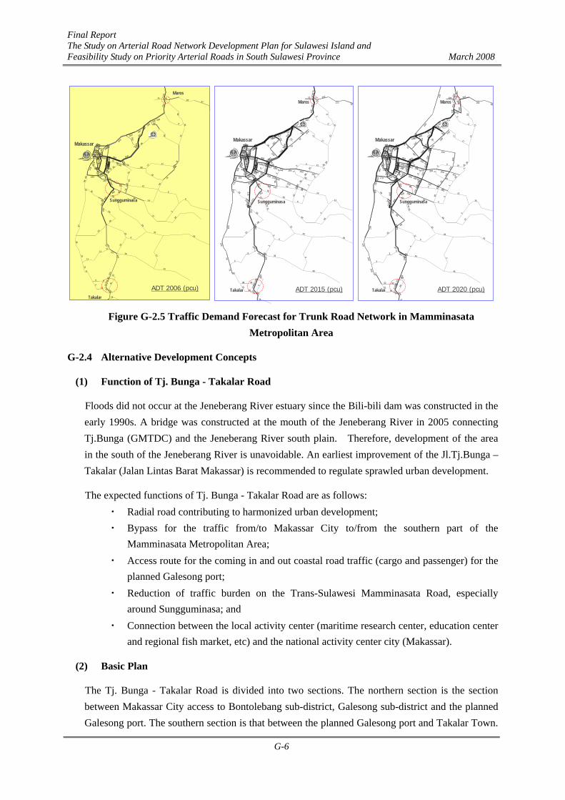
The forecast traffic demand in the Mamminasata Study was reviewed to avoid over-planning of road facilities. The present (2006) and future traffic demands for the trunk road network in the Mamminasata Metropolitan Area are indicated in Figure G-2.5. The traffic in 2015 was estimated at 15,000 - 18,000 pcu/day for the northern section and 4,000 - 10,000 pcu/day for the southern section of the Tj. Bunga - Takalar Road. The traffic in 2020 was estimated at 20,000 - 24,000 pcu/day for the northern section and 10,000 - 14,000 pcu/day for the southern section of the Tj. Bunga - Takalar Road.
Old TownArea(1980)
TownArea(2005)
UrbanizationunderProgress
New SatelliteCities to beinduced
DevelopmentProjectsA
Maros
Sungguminasa
Jeneberang River
Talo River
KIMA
G
C
E
AB
D
EF
Makassar Old Town Area for Re-development
Mamminasata M/P 2005
Future New Arterial Roads (JICA F/S)
Toll Roads
R=17-18km
H
Maros River
Trans-Sulawesi Road (Plan)
JICA Master Plan 1989 G
(On-going/Planned)
1
2
3
45
5 Radial Roads
4 Ring Roads
1
J Direction of Urban Development to
be guided
1
2
4
1Source: JICA Study Team
3
Final Report The Study on Arterial Road Network Development Plan for Sulawesi Island and Feasibility Study on Priority Arterial Roads in South Sulawesi Province March 2008
G-6
131
413334
301 195236
222
252
223
141
231
282
24419
6
182 182
81
34
400
300
176
153
153
103
7473
12
16
512
378 989
717737
737
34
15
2
2
431
431
431
278
76 162
122 79
302
224
9270385630
743
79
267
628
0
17
12
28
8
120
97
132
600
28
8
1
13
13
0
195 52
60
0
40
040
0
0
31
31
65
65
6
3
5
38
38
26
0
26
2
207
0
45195
294105 26
9
381
534 297245
165
515450
428
463
370
548
197
58
361
232339169
736
338
99
164
438
16
240
211
60
194
159
915
219
500
327
551
213
219
3194
3
941
431
0
17
21
0
21
78
66
0935331
53
246
196
196
194
61
240 487
66
7
1941203
31
8
162
278
431
431
070
246
246
323
282
29244
373
624509
36
926
66
338
50
23038 38
194
159
90
142
240
487
235
300
267282
0
0
500
193
74618
181
199
18
746
104120
277
275302 548
487
370
428
16ADT 2015 (pcu)
Maros
Sungguminasa
Takalar
Makassar
93
297264
233301340
352
380
356
248
185
157
127 129
129
99
77 108
44
18
214
6868
37
37
28
1321
2
13
284
176 483
259287
287
32
24
11
11
305
230
230
170
41 9067
47
217
151 43
80305505618
46
163 29
2
98
50 31
7626
310
46
86
500
76
74
52
6
8
17
191 67
88
14
27
225
31
31
29
29
64
64
22
24
3
26
23
32
17
15
11
114
17
42
59
51
191
18674 16
1153
311 160200
87
320366
347
495
449
723
159
38
159106
203
93
1697437
9
178
143
165
492
153
204
162
98
55
178
8
1046 6
84
230
51
59
51
75
70
563
24
181
206288
36
36
87
193217 723
563
449
347
153
ADT 2006 (pcu)
Maros
Sungguminasa
Takalar
Makassar
165
411347
285 233272
236
358
318
207
291
347
300
217
199 228
73
47
424
402
237
205
205
140
100100
20
18
484
458 849
498572
572
48
25
3
3
421421
196
227
104 207
158 98
289
216
14586369562
596
129
301 57
2
0
17
11
25
1
110
165
168
534
25
28
1
15
16
0
96 0
208
0
46
047
29
29
43
43
83
83
12
4
6
43
45
33
2
31
3
186
0
4496
362147 25
9
535
481 267193
112
428447
415
491
434
498
198
78
405
167297161
570
387
307
173
532
0
232
203
98
269
225
263
917
268
716
399
660
275
268
0239
0
999
421
0
225
17
24
0
129
103
81
0656543
36
105
330
278
246
246
239
86 249 411
141
1
2061510
43
15
11
129 98
238225
421
421
093
278
278
401
347
36300
418
728495
41
999
81
387
72
26552 52
206
197
225
225
431
225
2786
15
176
249
412
264
335
317302
0
0
493
223 223
211
525
75 132
207
295
75
525
136
128
162
128
128
452
292289 498
412
105
434
415
366
251
0
ADT 2020 (pcu)
Maros
Sungguminasa
Takalar
Makassar
Figure G-2.5 Traffic Demand Forecast for Trunk Road Network in Mamminasata Metropolitan Area
G-2.4 Alternative Development Concepts
(1) Function of Tj. Bunga - Takalar Road
Floods did not occur at the Jeneberang River estuary since the Bili-bili dam was constructed in the early 1990s. A bridge was constructed at the mouth of the Jeneberang River in 2005 connecting Tj.Bunga (GMTDC) and the Jeneberang River south plain. Therefore, development of the area in the south of the Jeneberang River is unavoidable. An earliest improvement of the Jl.Tj.Bunga – Takalar (Jalan Lintas Barat Makassar) is recommended to regulate sprawled urban development.
The expected functions of Tj. Bunga - Takalar Road are as follows: ・ Radial road contributing to harmonized urban development; ・ Bypass for the traffic from/to Makassar City to/from the southern part of the
Mamminasata Metropolitan Area; ・ Access route for the coming in and out coastal road traffic (cargo and passenger) for the
planned Galesong port; ・ Reduction of traffic burden on the Trans-Sulawesi Mamminasata Road, especially
around Sungguminasa; and ・ Connection between the local activity center (maritime research center, education center
and regional fish market, etc) and the national activity center city (Makassar).
(2) Basic Plan
The Tj. Bunga - Takalar Road is divided into two sections. The northern section is the section between Makassar City access to Bontolebang sub-district, Galesong sub-district and the planned Galesong port. The southern section is that between the planned Galesong port and Takalar Town.

Final Report The Study on Arterial Road Network Development Plan for Sulawesi Island and Feasibility Study on Priority Arterial Roads in South Sulawesi Province March 2008
G-7
The road development concept was established based on traffic demand and assigned road functions. Since earliest implementation of the existing road widening is expected for the planned Galesong port under limited budget, 1-lane 2-way road is the basic concept for the Tj. Bunga - Takalar Road. However, it is recommended that land acquisition for additional 2 lanes for the northern section, which will be used as a part of the Mamminasa Bypass/Outer Ring Road, should be made during the initial stage or development restriction should be imposed to maintain the required future ROW.
Three aspects (engineering, economic and environmental aspects) have been considered for the establishment of development concept for the Tj. Bunga – Takalar Road. The engineering aspect includes road functions, traffic demand and reduction of overburden on the Trans-Sulawesi Mamminasata Road. The economic aspect includes contribution to coastal traffic of cargo and passengers and marine products distribution. The major negative socio-environmental issue is land acquisition and resettlement.
Only two alternatives were set up, widening or zero option (without project), for evaluation. Alternative road development plans for the Tj. Bunga - Takalar Road are shown in Table G-2.1.
Table G-2.1 Alternative Development Plans for Tj. Bunga - Takalar Road
Existing PlanSupport of CoastalTrasnportation
Land Acquisition& Resettlement
1 Nil 14.0 Takalar 2 2 -
2Widening(2 lanes;4m→7m)
14.0 Takalar 2 2 ○ △
1 Nil 16.3 Takalar/Gowa 2 2 -
2Widening(2 lanes;4m→7m)
16.3 Takalar/Gowa 2 2 ○ △
Note: ○ Positive direct effective △Some positive effective - No direct influence Recommended plan
Location
Number of Lanes Measures for Major Issues
North
Section Alt. Development Concept Length (km)
South
(3) Standard Cross Section
The proposed standard cross-section for the Tj. Bunga - Takalar Road is 1-lane, 2-way road as illustrated in Figure G-2.6.
Figure G-2.6 Typical Cross Section of Tj. Bunga - Takalar
Final Report The Study on Arterial Road Network Development Plan for Sulawesi Island and Feasibility Study on Priority Arterial Roads in South Sulawesi Province March 2008
G-8
G-3 Evaluation and Recommendation on Alternative Plans
(1) Evaluation Method for Alternatives
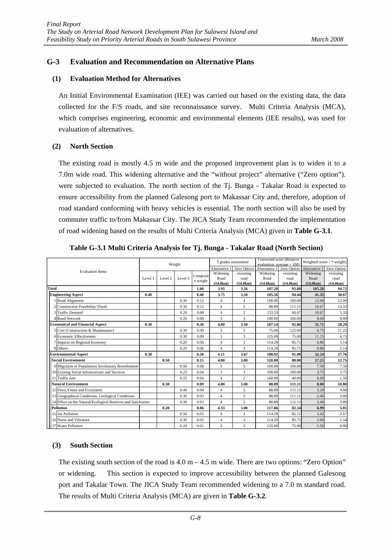
An Initial Environmental Examination (IEE) was carried out based on the existing data, the data collected for the F/S roads, and site reconnaissance survey. Multi Criteria Analysis (MCA), which comprises engineering, economic and environmental elements (IEE results), was used for evaluation of alternatives.
(2) North Section
The existing road is mostly 4.5 m wide and the proposed improvement plan is to widen it to a 7.0m wide road. This widening alternative and the “without project” alternative (“Zero option”). were subjected to evaluation. The north section of the Tj. Bunga - Takalar Road is expected to ensure accessibility from the planned Galesong port to Makassar City and, therefore, adoption of road standard conforming with heavy vehicles is essential. The north section will also be used by commuter traffic to/from Makassar City. The JICA Study Team recommended the implementation of road widening based on the results of Multi Criteria Analysis (MCA) given in Table G-3.1.
Table G-3.1 Multi Criteria Analysis for Tj. Bunga - Takalar Road (North Section)
Alternative 1 Zero Option Alternative 1 Zero Option Alternative 1 Zero Option
Level 1 Level 2 Level 3 Composite weight
WideningRoad
(14.0km)
exsistingroad
(14.0km)
WideningRoad
(14.0km)
exsistingroad
(14.0km)
WideningRoad
(14.0km)
exsistingroad
(14.0km)1.00 3.95 3.56 107.20 92.80 105.28 94.72
0.40 0.40 3.75 3.50 105.56 94.44 41.33 38.671 Road Alignment 0.30 0.12 4 4 100.00 100.00 12.00 12.002 Construction Feasibility/ Flood 0.30 0.12 4 5 88.89 111.11 10.67 13.333 Traffic Demand 0.20 0.08 4 2 133.33 66.67 10.67 5.334 Road Network 0.20 0.08 3 3 100.00 100.00 8.00 8.00
0.30 0.30 4.00 3.50 107.14 92.86 31.71 28.295 Cost (Construction & Maintenance) 0.30 0.09 3 5 75.00 125.00 6.75 11.256 Economic Effectiveness 0.30 0.09 5 3 125.00 75.00 11.25 6.757 Impacts on Regional Economy 0.20 0.06 4 3 114.29 85.71 6.86 5.148 Others 0.20 0.06 4 3 114.29 85.71 6.86 5.14
0.30 0.30 4.11 3.67 108.92 91.08 32.24 27.760.50 0.15 4.00 3.00 120.00 80.00 17.25 12.75
9 Migration of Populations Involuntary Resettlement 0.50 0.08 5 5 100.00 100.00 7.50 7.5010 Existing Social Infrastructure and Services 0.25 0.04 3 3 100.00 100.00 3.75 3.7511 Traffic Jam 0.25 0.04 4 1 160.00 40.00 6.00 1.50
0.30 0.09 4.00 5.00 88.89 111.11 8.00 10.0012 Flora, Fauna and Ecosystem 0.40 0.04 4 5 88.89 111.11 3.20 4.0013 Geographical Conditions, Geological Conditions 0.30 0.03 4 5 88.89 111.11 2.40 3.0014 Effect on the Natural/Ecological Reserves and Sanctuaries 0.30 0.03 4 5 88.89 111.11 2.40 3.00
0.20 0.06 4.33 3.00 117.86 82.14 6.99 5.0115 Air Pollution 0.50 0.03 4 3 114.29 85.71 3.43 2.5716 Noise and Vibration 0.30 0.02 4 3 114.29 85.71 2.06 1.5417 Water Pollution 0.20 0.01 5 3 125.00 75.00 1.50 0.90
Environmental AspectSocial Environment
Natural Environment
Pollution
Weighted score ( * weight)
TotalEngineering Aspect
Economical and Financial Aspect
Evaluation Items
Weight 5 grades assessment Converted score (Relativeevaluation, average = 100)
(3) South Section
The existing south section of the road is 4.0 m – 4.5 m wide. There are two options: “Zero Option” or widening. This section is expected to improve accessibility between the planned Galesong port and Takalar Town. The JICA Study Team recommended widening to a 7.0 m standard road. The results of Multi Criteria Analysis (MCA) are given in Table G-3.2.

Final Report The Study on Arterial Road Network Development Plan for Sulawesi Island and Feasibility Study on Priority Arterial Roads in South Sulawesi Province March 2008
G-9
Table G-3.2 Multi Criteria Analysis for Tj. Bunga - Takalar Road (South Section)
G-4 Design
The design of the Tj. Bunga - Takalar Road principally followed the existing design of Perencanaan Teknis Jalan dan Jembatan Metro Makassar, KU. 08.08/SNVT/P2JJM-Bh/B/IX/253/ 2006, September 2006, Department Pekerjaan Umum Directorat Jenderal Bina Marga, with a review based on site reconnaissance.
G-4.1 Roadway Design
(1) Geometric Design Standard
According to Perencanaan Teknis Jalan dan Jembatan Metro Makassar, KU. 08.08/SNVT/ P2JJM-Bh/B/IX/253/ 2006, Standard Specifications for Geometric Design of Urban Roads, MPW, Indonesia, 1992 were applied for the geometric design of which standard elements are tabulated in Table G-4.1. The proposed design classification for the Tj. Bunga- Takalar Road is Type-II, Class-I.
Alternative 1 Zero Option Alternative 1 Zero Option Alternative 1 Zero Option
Level 1 Level 2 Level 3 Composite weight
WideningRoad
(16.3km)
exsistingroad
(16.3km)
WideningRoad
(16.3km)
exsistingroad
(16.3km)
WideningRoad
(16.3km)
exsistingroad
(16.3km)1.00 4.06 3.64 106.49 93.51 104.74 95.26
0.40 0.40 4.00 3.75 103.47 96.53 40.67 39.331 Road Alignment 0.30 0.12 4 4 100.00 100.00 12.00 12.002 Construction Feasibility/ Flood 0.30 0.12 4 5 88.89 111.11 10.67 13.333 Traffic Demand 0.20 0.08 5 3 125.00 75.00 10.00 6.004 Road Network 0.20 0.08 3 3 100.00 100.00 8.00 8.00
0.30 0.30 3.75 3.50 103.57 96.43 30.86 29.145 Cost (Construction & Maintenance) 0.30 0.09 3 5 75.00 125.00 6.75 11.256 Economic Effectiveness 0.30 0.09 5 3 125.00 75.00 11.25 6.757 Impacts on Regional Economy 0.20 0.06 4 3 114.29 85.71 6.86 5.148 Others 0.20 0.06 3 3 100.00 100.00 6.00 6.00
0.30 0.30 4.44 3.67 112.43 87.57 33.21 26.790.50 0.15 4.67 3.00 126.98 73.02 18.04 11.96
9 Migration of Populations Involuntary Resettlement 0.50 0.08 5 5 100.00 100.00 7.50 7.5010 Existing Social Infrastructure and Services 0.25 0.04 4 3 114.29 85.71 4.29 3.2111 Traffic Jam 0.25 0.04 5 1 166.67 33.33 6.25 1.25
0.30 0.09 4.00 5.00 88.89 111.11 8.00 10.0012 Flora, Fauna and Ecosystem 0.40 0.04 4 5 88.89 111.11 3.20 4.0013 Geographical Conditions, Geological Conditions 0.30 0.03 4 5 88.89 111.11 2.40 3.0014 Effect on the Natural/Ecological Reserves and Sanctuaries 0.30 0.03 4 5 88.89 111.11 2.40 3.00
0.20 0.06 4.67 3.00 121.43 78.57 7.18 4.8215 Air Pollution 0.50 0.03 4 3 114.29 85.71 3.43 2.5716 Noise and Vibration 0.30 0.02 5 3 125.00 75.00 2.25 1.3517 Water Pollution 0.20 0.01 5 3 125.00 75.00 1.50 0.90
Environmental AspectSocial Environment
Natural Environment
Pollution
Weighted score ( * weight)
TotalEngineering Aspect
Economical and Financial Aspect
Evaluation Items
Weight 5 grades assessment Converted score (Relativeevaluation, average = 100)

Final Report The Study on Arterial Road Network Development Plan for Sulawesi Island and Feasibility Study on Priority Arterial Roads in South Sulawesi Province March 2008
G-10
Table G-4.1 Geometric Design Standards Type-I Type-II Road Classification
Class-I Class-II Class-I Class-II Class-III Design Speed (km/h) 100 or 80 100 or 60 60 60 or 50 40 or 30
Carriageway Width 3.5m 3.5m 3.5m 3.25m 3.25m, 3.0m
Median 2.5m 2.0m 2.0m (1.0m)
1.5m (1.0m)
1.5m (1.0m)
Shoulder Width (Right)
1.0m 0.75m 0.5m 0.5m 0.5m
Shoulder Width (Left without Side Walk)
2.0m (1.75m)
2.0m (1.75m)
2.0m (1.5m)
2.0m (1.5m)
2.0m (0.5m)
Cross-section
Sidewalk Width - - 3.0m (1.5m)
3.0m (1.5m)
1.5m (1.0m)
Min. Radius 230m 120m 150m 100m 30m Min. Curve Length a; intersection angle (degree)
1,000/a (140m)
700/a (100m)
700/a (100m)
600/a (80m)
350/a (50m)
Horizontal Alignment
Omission of Transition
>1,000m >600m >600m >400m >150m
Max. Grade 4.0% 5.0% 5.0% 6.0% 8.0% Min. Vertical Curve (crest)
3,000m 1,400m 1,400m 800m 250m Vertical Alignment
Min. Vertical Curve (sag)
2,000m 1,000m 1,000m 700m 250m
Note: ( ); Exceptional case
(2) Road Alignment
The proposed road starts at the south end of the Jeneberang Bridge in Tj. Bunga, passes through Galesong and ends at the intersection with the Trans-Sulawesi Mamminasata Road in Takalar Town as shown in Figure G-4.1. Since the terrain is flat and the road alignment follows the existing road, both horizontal and vertical alignments comply with the design speed of 60 km/hr.

Final Report The Study on Arterial Road Network Development Plan for Sulawesi Island and Feasibility Study on Priority Arterial Roads in South Sulawesi Province March 2008
G-11
Figure G-4.1 Plan of Tj. Bunga - Takalar
(3) Cross Section
Six typical cross sections are provided for the Tj. Bunga – Takalar Road as shown in Figures

Final Report The Study on Arterial Road Network Development Plan for Sulawesi Island and Feasibility Study on Priority Arterial Roads in South Sulawesi Province March 2008
G-12
G-4.2 to G-4.4. The typical cross section has 2 lanes (1 lane in each direction) with 3.5m lane width, 1.5 m shoulder and drainage or slope protection on both sides.
Type 1
The standard cross-section from Sta. 0+000 to Sta. 1+600 is widening of the existing 6 m wide travelway with asphalt concrete pavement to 7 m width. Side ditches on both sides are provided for residential and flat terrain sections. Slope protections on both sides are provided for plowland sections as illustrated in Figure G-4.2.
Figure G-4.2 Typical Cross Section (Types 1; AC)
Type 2
The standard cross-section from Sta. 1+600 to Sta. 25+800 and from Sta. 28+100 to Sta. 30+250 is widening of the existing 4 m road with asphalt concrete pavement to a 7 m wide road. Side ditches on both sides are provided for residential and flat terrain sections. Slope protections are provided for lowland sections as illustrated in Figure G-4.3.

Final Report The Study on Arterial Road Network Development Plan for Sulawesi Island and Feasibility Study on Priority Arterial Roads in South Sulawesi Province March 2008
G-13
Figure G-4.3 Typical Cross Section (Type 2; AC)
Type 3
The standard cross-section from Sta. 25+800 to Sta. 28+100 is widening of the 3.5m wide road with cement concrete pavement to a 7.0 m wide road. Side ditches on both sides are provided for residential and flat terrain sections and slope protections on both sides for lowland sections as illustrated in Figure G-4.4.
Figure G-4.4 Typical Cross Section (Type 3; PCCP)
Final Report The Study on Arterial Road Network Development Plan for Sulawesi Island and Feasibility Study on Priority Arterial Roads in South Sulawesi Province March 2008
G-14
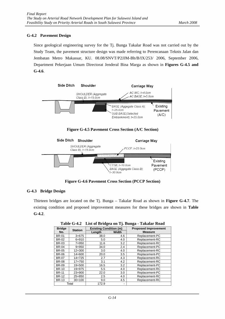
G-4.2 Pavement Design
Since geological engineering survey for the Tj. Bunga Takalar Road was not carried out by the Study Team, the pavement structure design was made referring to Perencanaan Teknis Jalan dan Jembatan Metro Makassar, KU. 08.08/SNVT/P2JJM-Bh/B/IX/253/ 2006, September 2006, Department Pekerjaan Umum Directorat Jenderal Bina Marga as shown in Figures G-4.5 and G-4.6.
Figure G-4.5 Pavement Cross Section (A/C Section)
Figure G-4.6 Pavement Cross Section (PCCP Section)
G-4.3 Bridge Design
Thirteen bridges are located on the Tj. Bunga – Takalar Road as shown in Figure G-4.7. The existing condition and proposed improvement measures for these bridges are shown in Table G-4.2.
Table G-4.2 List of Bridgea on Tj. Bunga - Takalar Road Existing Condition (m) Bridge
No. Station Length Width Proposed Improvement
Measure BR-01 3+675 38.0 4.6 Replacement-PC BR-02 6+910 5.0 4.0 Replacement-RC BR-03 7+950 11.6 3.2 Replacement-RC BR-04 9+950 34.0 2.4 Replacement-PC BR-05 12+300 3.0 4.0 Replacement-RC BR-06 14+600 20.0 3.5 Replacement-PC BR-07 14+725 2.7 4.3 Replacement-RC BR-08 17+750 3.1 4.2 Replacement-RC BR-09 19+500 16.5 3.2 Replacement-PC BR-10 19+975 5.5 4.0 Replacement-RC BR-11 23+900 22.0 3.0 Replacement-PC BR-12 25+850 2.5 4.0 Replacement-RC BR-13 30+100 9.0 4.5 Replacement-RC
Total 172.9 -

Final Report The Study on Arterial Road Network Development Plan for Sulawesi Island and Feasibility Study on Priority Arterial Roads in South Sulawesi Province March 2008
G-15
Figure G-4.7 Bridge Location on Tj. Bunga - Takalar Road

Final Report The Study on Arterial Road Network Development Plan for Sulawesi Island and Feasibility Study on Priority Arterial Roads in South Sulawesi Province March 2008
G-16
G-5 Cost Estimate and Economic Evaluation
G-5.1 Composition of Project Cost
The project cost consists of construction cost, detailed design and supervision cot, land acquisition and compensation cost and administration cost. The construction cost was estimated based on the result of preliminary engineering design, quantities of major work items, and assumptions on the percentages of overhead and profit of the contractor and physical contingency. The value added tax (VAT) of 10% and inflation (price escalation) were excluded in the economic evaluation but included in the financing plan under G-7, Implementation Plan. The maintenance cost for periodic maintenance and routine maintenance was also estimated.
The components of the project cost are shown in Figure G-5.1.
Figure G-5.1 Project Cost Components
G-5.2 Conditions of Cost Estimate
Cost estimate was made based on the following conditions.
i) Time of cost estimate: November 2007
ii) Foreign currency: US dollar
iii) Exchange rate: 1 US dollar = Rp. 9,376 (Bank Indonesia, 30 November 2007)
iv) Taxes: Not included in the economic evaluation but included in the project implementation plan as a part of the project cost.
Construction Cost
Detailed Design &Supervision Services
Land Acquisition &Compensation Cost
Direct Construction Cost
Indirect Construction Cost
Material Cost
Overhead & Profit
Labor Cost
Equipment Cost
Project Cost
Physical Contingency
Estimated by multiplying construction unit prices of each work item and quantities based on the preliminary design
Administration Cost
Those are not included in the economic evaluation but incorporated in the project implementation cost under Chapter 10
VAT 10% Price escalation (inflation)
Maintenance Cost
Final Report The Study on Arterial Road Network Development Plan for Sulawesi Island and Feasibility Study on Priority Arterial Roads in South Sulawesi Province March 2008
G-17
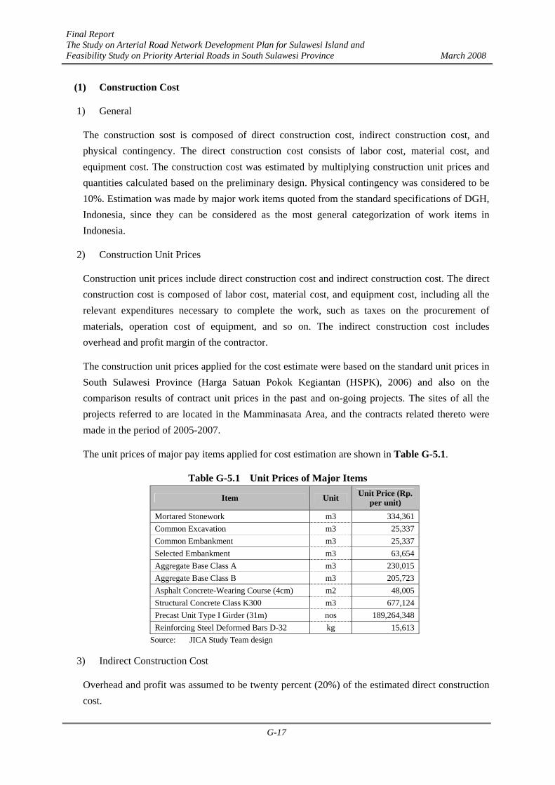
(1) Construction Cost
1) General
The construction sost is composed of direct construction cost, indirect construction cost, and physical contingency. The direct construction cost consists of labor cost, material cost, and equipment cost. The construction cost was estimated by multiplying construction unit prices and quantities calculated based on the preliminary design. Physical contingency was considered to be 10%. Estimation was made by major work items quoted from the standard specifications of DGH, Indonesia, since they can be considered as the most general categorization of work items in Indonesia.
2) Construction Unit Prices
Construction unit prices include direct construction cost and indirect construction cost. The direct construction cost is composed of labor cost, material cost, and equipment cost, including all the relevant expenditures necessary to complete the work, such as taxes on the procurement of materials, operation cost of equipment, and so on. The indirect construction cost includes overhead and profit margin of the contractor.
The construction unit prices applied for the cost estimate were based on the standard unit prices in South Sulawesi Province (Harga Satuan Pokok Kegiantan (HSPK), 2006) and also on the comparison results of contract unit prices in the past and on-going projects. The sites of all the projects referred to are located in the Mamminasata Area, and the contracts related thereto were made in the period of 2005-2007.
The unit prices of major pay items applied for cost estimation are shown in Table G-5.1.
Table G-5.1 Unit Prices of Major Items
Item Unit Unit Price (Rp. per unit)
Mortared Stonework m3 334,361 Common Excavation m3 25,337 Common Embankment m3 25,337 Selected Embankment m3 63,654 Aggregate Base Class A m3 230,015 Aggregate Base Class B m3 205,723 Asphalt Concrete-Wearing Course (4cm) m2 48,005 Structural Concrete Class K300 m3 677,124 Precast Unit Type I Girder (31m) nos 189,264,348 Reinforcing Steel Deformed Bars D-32 kg 15,613
Source: JICA Study Team design
3) Indirect Construction Cost
Overhead and profit was assumed to be twenty percent (20%) of the estimated direct construction cost.

Final Report The Study on Arterial Road Network Development Plan for Sulawesi Island and Feasibility Study on Priority Arterial Roads in South Sulawesi Province March 2008
G-18
(2) Detailed Design and Supervision Services
The cost for detailed design and supervision services was assumed to be seven percent (7%) of the estimated construction cost.
(3) Land Acquisition and Compensation Cost
Fund sources for land acquisition and compensation would be provided by regional governments. On the basis of the current procedure of land acquisition and compensation in Indonesia, the transaction prices and Nilai Jual Objek Pajak (NJOP) prices informed verbally by each Kota/Kabupaten, the land acquisition and compensation costs were estimated as shown in the Table G-5.2.
Table G-5.2 Land Acquisition and Compensation Cost of Tj. Bunga - Takalar Road
No. Item
North Section Makassar,
Takalar (M Rp.)
South Section Takalar, Gowa
(M Rp.)
Total (M Rp.)
1 Land Acquisition 17,850 18,050 35,9002 Building Compensation 0 0 0
Total 17,850 18,050 35,900Source: JICA Study Team estimation
(4) Administration Cost
The administration cost was assumed to be two percent (2%) of the estimated construction cost.
G-5.3 Project Cost
(1) Sectioning of Tj. Bunga - Takalar Road for Project Implementation
The project road was divided into two sections as shown in Figure G-5.2.

Final Report The Study on Arterial Road Network Development Plan for Sulawesi Island and Feasibility Study on Priority Arterial Roads in South Sulawesi Province March 2008
G-19
Figure G-5.2 Sections of the Project Road
(2) Major Construction Quantities
The estimated major construction quantities are shown in Table G-5.3. These were calculated by referring to the Perencanaan Teknis Jalan dan Jembatan Metro Makassar, KU. 08.08/SNVT/P2JJM-Bh/B/IX/253/ 2006.
Table G-5.3 Major Construction Quantities
Item Unit North Section
South Section Total
Mortared Stonework m3 3,786 7,924 11,710
Common Excavation m3 1,481 2,362 3,843
Common Embankment m3 52,644 35,698 88,342
Selected Embankment m3 16,170 16,728 32,898
Aggregate Base Class A m3 11,550 11,473 23,023
Aggregate Base Class B m3 6,930 10,241 17,171Asphalt Concrete -Wearing & Binder Course (4cm) m2 97,317 97,053 194,370
Structural Concrete Class K300 m3 995 1,467 2,462
Precast Unit Type I Girder (16-35m) nos 2 3 5
Reinforcing Steel ton 131,063 188,453 319,516
Source: JICA Study Team design
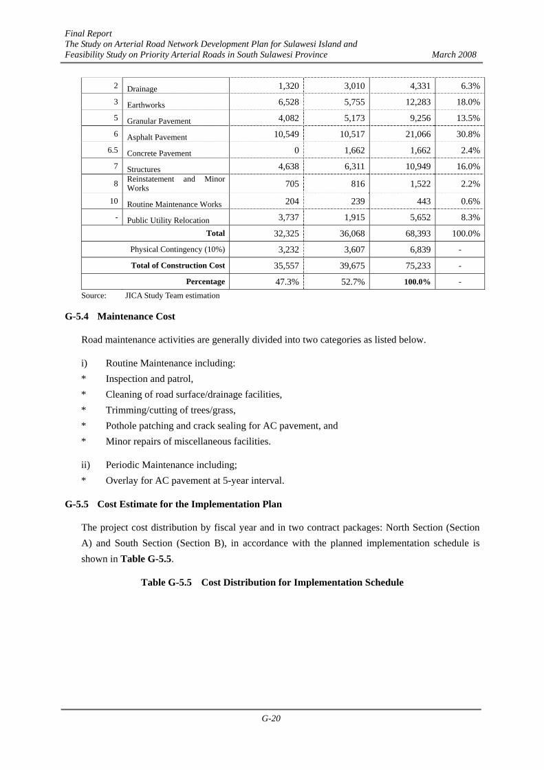
Based on the unit prices and estimated construction quantities, the project construction cost was estimated as shown in Table G-5.4.
Table G-5.4 Construction Cost of the Project Division
No. Item North Section (M Rp.)
South Section (M Rp.)
Total (M Rp.) Percentage
1 General 561 670 1,230 1.8%
Final Report The Study on Arterial Road Network Development Plan for Sulawesi Island and Feasibility Study on Priority Arterial Roads in South Sulawesi Province March 2008
G-20
2 Drainage 1,320 3,010 4,331 6.3%
3 Earthworks 6,528 5,755 12,283 18.0%
5 Granular Pavement 4,082 5,173 9,256 13.5%
6 Asphalt Pavement 10,549 10,517 21,066 30.8%
6.5 Concrete Pavement 0 1,662 1,662 2.4%
7 Structures 4,638 6,311 10,949 16.0%
8 Reinstatement and Minor Works 705 816 1,522 2.2%
10 Routine Maintenance Works 204 239 443 0.6%
- Public Utility Relocation 3,737 1,915 5,652 8.3%
Total 32,325 36,068 68,393 100.0%
Physical Contingency (10%) 3,232 3,607 6,839 -
Total of Construction Cost 35,557 39,675 75,233 -
Percentage 47.3% 52.7% 100.0% -
Source: JICA Study Team estimation
G-5.4 Maintenance Cost
Road maintenance activities are generally divided into two categories as listed below.
i) Routine Maintenance including: * Inspection and patrol, * Cleaning of road surface/drainage facilities, * Trimming/cutting of trees/grass, * Pothole patching and crack sealing for AC pavement, and * Minor repairs of miscellaneous facilities.
ii) Periodic Maintenance including; * Overlay for AC pavement at 5-year interval.
G-5.5 Cost Estimate for the Implementation Plan
The project cost distribution by fiscal year and in two contract packages: North Section (Section A) and South Section (Section B), in accordance with the planned implementation schedule is shown in Table G-5.5.
Table G-5.5 Cost Distribution for Implementation Schedule

Final Report The Study on Arterial Road Network Development Plan for Sulawesi Island and Feasibility Study on Priority Arterial Roads in South Sulawesi Province March 2008
G-21
Estimated Amount 2007 2008 2009 2010 2011 2012 2013 2014 2015 2016 2017 2018 2019 2020 2021 2022 2023
(M. Rp.) 1 2 3 4 5 6 7 8 9 10 11 12 13 14 15 16 17Section A 14.0kmLand Acquisition and Compensation 17,850 40.0% 40.0% 20.0%
Detailed Design and Supervision Services 2,489 24.0% 28.0% 24.0% 24.0%
Construction 35,557 20.0% 40.0% 40.0%
Administraition 711 25.0% 25.0% 25.0% 25.0%
Maintenance RoutineMaintenance Overlay per 5 Years
Section A 14.0kmLand Acquisition and Compensation 17,850 0 7,140 7,140 3,570 0 0 0 0 0 0 0 0 0 0 0 0 0Detailed Design and Supervision Services 2,489 0 597 697 597 597 0 0 0 0 0 0 0 0 0 0 0 0Construction 35,557 0 0 7,111 14,223 14,223 0 0 0 0 0 0 0 0 0 0 0 0Administraition 711 0 178 178 178 178 0 0 0 0 0 0 0 0 0 0 0 0Maintenance 3,711 742 742 742 742 742 742 742 742 742 742 742 742Maintenance Overlay per 5 Years 4,705 4,705 4,705
65,024 0 7,915 15,126 18,568 14,998 742 742 742 742 5,447 742 742 742 742 5,447 742 742(100%) (0.0%) (12.2%) (23.3%) (28.6%) (23.1%) (1.1%) (1.1%) (1.1%) (1.1%) (8.4%) (1.1%) (1.1%) (1.1%) (1.1%) (8.4%) (1.1%) (1.1%)
Section B 16.3kmLand Acquisition and Compensation 18,050 25.0% 50.0% 25.0%
Detailed Design and Supervision Services 2,777 24.0% 28.0% 24.0% 24.0%
Construction 39,675 20.0% 40.0% 40.0%
Administraition 794 14.3% 28.6% 28.6% 28.6%
Maintenance RoutineMaintenance Overlay per 5 Years
Section B 16.3kmLand Acquisition and Compensation 18,050 0 0 0 0 4,513 9,025 4,513 0 0 0 0 0 0 0 0 0 0Detailed Design and Supervision Services 2,777 0 0 0 0 667 778 667 667 0 0 0 0 0 0 0 0 0Construction 39,675 0 0 0 0 0 7,935 15,870 15,870 0 0 0 0 0 0 0 0 0Administraition 794 0 0 0 0 113 227 227 227 0 0 0 0 0 0 0 0 0Maintenance 1,574 787 787 787 787 787 787 787 787 787Maintenance Overlay per 5 Years 0 4,689
62,870 0 0 0 0 5,292 17,964 21,276 16,763 787 787 787 787 5,475 787 787 787 787(100%) (0.0%) (0.0%) (0.0%) (0.0%) (8.4%) (28.6%) (33.8%) (26.7%) (1.3%) (1.3%) (1.3%) (1.3%) (8.7%) (1.3%) (1.3%) (1.3%) (1.3%)
Total
Total
Item
G-5.6 Economic Evaluation
(1) Evaluation Methodology and Applied Data
Economic evaluation of the Tj. Bunga – Takalar Road was carried out with the same methodology and applying the same basic data for benefit estimation as explained in Chapter 9 (Section 9.2).
(2) Economic Cost
According to the overall implementation schedule, the construction of the Tj. Bunga – Takalar Road will be divided into two (2) phases, as follows:
1) Phase 1: North Section (14.0 km), 2008-2011 (2012 open) 2) Phase 2: South Section (16.3 km), 2011-2014 (2015 open)
The disbursement schedule in terms of economic costs including the land acquisition and detailed design for both phases is shown in Table G-5.6.
Table G-5.6 Disbursement Schedule (Unit: Rp. million)
Economic Cost YearPhase I Phase II
2008200920102011201220132014
7,915 15,126 18,568 14,998
5,292 17,964 21,276 16,763
Total 56,607 61,296

Final Report The Study on Arterial Road Network Development Plan for Sulawesi Island and Feasibility Study on Priority Arterial Roads in South Sulawesi Province March 2008
G-22
117,903 Source: JICA Study Team
(3) Economic Benefit
1) Quantified Economic Benefits
The quantified economic benefits which will be generated from the Tj. Bunga – Takalar Road consist of the following two (2) types of road users’ benefits:
Savings in Vehicle Operating Cost (VOC Savings); and Savings in passenger Travel Time Cost (TTC Savings).
The above benefits were estimated quantitatively based on the “With and Without Project comparison method”. The same input data of unit VOC (Rp/km) and unit TTC (Rp/hour) which were used for the evaluation of other target roads such as the Mamminasa Bypass, Trans-Sulawesi Mamminasata Road, Hertasning Road and Abdullah Daeng Sirua Road were also applied for the evaluation of the Tj. Bunga – Takalar Road.
2) Total Benefits Estimated
The results of estimation of economic benefits of the Tj. Bunga – Takalar Road are shown in Table G-5.7.

Final Report The Study on Arterial Road Network Development Plan for Sulawesi Island and Feasibility Study on Priority Arterial Roads in South Sulawesi Province March 2008
G-23
Table G-5.7 Estimated Economic Benefits (Unit: Rp. million)
Economic Benefit Year VOC
Savings Travel Time Cost Savings
Total
2012 6,301 1,987 8,2872013 15,196 4,792 19,9882014 36,652 11,557 48,208
Tj. Bunga - Takalar Road
2015 88,399 27,873 116,272 Source: JICA Study Team
(4) Economic Evaluation
1) Premises for the Evaluation
For the purpose of economic evaluation, the following preconditions were established:
- Price Level - Evaluation Period - Disbursement Schedule - Residual Value - Opportunity Cost of Capital
: Constant 2006 prices : 30 years after the first opening to traffic : Assumed in accordance with the construction plan : No residual values were counted : 15% (and 12% for reference)
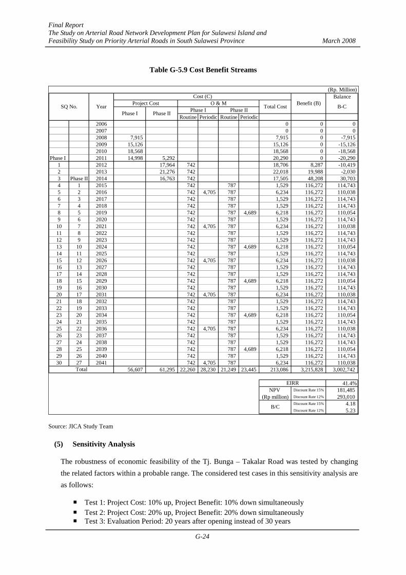
2) Cost Benefit Streams and Evaluation Indicators
The cost and benefit streams are presented in Table G-5.9. The following three kinds of evaluation indicators were calculated based on the traditional Discount Cash Flow method (DCF):
- Economic Internal Rate of Return (EIRR) - Net Present Value (NPV) - Benefit/ Cost Ratio (B/C)
The results of evaluation are summarized in Table G-5.8.
Table G-5.8 Results of Economic Evaluation Evaluation Indicators Value EIRR (%) NPV (Rp. million) (*) B/C (*)
41.4% 181,485
4.18 Source: JICA Study Team (*): Discount Rate = 15%
The above results indicate that implementation of the Tj. Bunga – Takalar Road is economically very optimistic as the EIRR value is sufficiently higher than the opportunity cost of capital (discount rate) (>15%), NPV is positive (>0) and B/C ratio is higher than unity (>1).
Final Report The Study on Arterial Road Network Development Plan for Sulawesi Island and Feasibility Study on Priority Arterial Roads in South Sulawesi Province March 2008
G-24
Table G-5.9 Cost Benefit Streams
Source: JICA Study Team
(5) Sensitivity Analysis
The robustness of economic feasibility of the Tj. Bunga – Takalar Road was tested by changing the related factors within a probable range. The considered test cases in this sensitivity analysis are as follows:
Test 1: Project Cost: 10% up, Project Benefit: 10% down simultaneously Test 2: Project Cost: 20% up, Project Benefit: 20% down simultaneously Test 3: Evaluation Period: 20 years after opening instead of 30 years
Balance
Routine Periodic Routine Periodic2006 0 0 02007 0 0 02008 7,915 7,915 0 -7,9152009 15,126 15,126 0 -15,1262010 18,568 18,568 0 -18,568
Phase I 2011 14,998 5,292 20,290 0 -20,2901 2012 17,964 742 18,706 8,287 -10,4192 2013 21,276 742 22,018 19,988 -2,0303 Phase II 2014 16,763 742 17,505 48,208 30,7034 1 2015 742 787 1,529 116,272 114,7435 2 2016 742 4,705 787 6,234 116,272 110,0386 3 2017 742 787 1,529 116,272 114,7437 4 2018 742 787 1,529 116,272 114,7438 5 2019 742 787 4,689 6,218 116,272 110,0549 6 2020 742 787 1,529 116,272 114,743
10 7 2021 742 4,705 787 6,234 116,272 110,03811 8 2022 742 787 1,529 116,272 114,74312 9 2023 742 787 1,529 116,272 114,74313 10 2024 742 787 4,689 6,218 116,272 110,05414 11 2025 742 787 1,529 116,272 114,74315 12 2026 742 4,705 787 6,234 116,272 110,03816 13 2027 742 787 1,529 116,272 114,74317 14 2028 742 787 1,529 116,272 114,74318 15 2029 742 787 4,689 6,218 116,272 110,05419 16 2030 742 787 1,529 116,272 114,74320 17 2031 742 4,705 787 6,234 116,272 110,03821 18 2032 742 787 1,529 116,272 114,74322 19 2033 742 787 1,529 116,272 114,74323 20 2034 742 787 4,689 6,218 116,272 110,05424 21 2035 742 787 1,529 116,272 114,74325 22 2036 742 4,705 787 6,234 116,272 110,03826 23 2037 742 787 1,529 116,272 114,74327 24 2038 742 787 1,529 116,272 114,74328 25 2039 742 787 4,689 6,218 116,272 110,05429 26 2040 742 787 1,529 116,272 114,74330 27 2041 742 4,705 787 6,234 116,272 110,038
56,607 61,295 22,260 28,230 21,249 23,445 213,086 3,215,828 3,002,742
41.4%NPV Discount Rate 15% 181,485
(Rp million) Discount Rate 12% 293,010Discount Rate 15% 4.18Discount Rate 12% 5.23
(Rp. Million)
B-C
Cost (C)Benefit (B)Total CostProject Cost O & M
Phase I Phase IIPhase I Phase II
EIRR
B/C
YearSQ No.
Total

Final Report The Study on Arterial Road Network Development Plan for Sulawesi Island and Feasibility Study on Priority Arterial Roads in South Sulawesi Province March 2008
G-25
The results of the three tests are summarized below:
Table G-5.10 Results of Sensitivity Analysis Test Cases EIRR
(%) NPV (*)
(Rp. million)
B/C (*) Original Case Test 1: Cost 10% up & Benefit 10% down Test 2: Cost 20% up & Benefit 20% down Test 3: Evaluation Period: 20 years
41.4% 36.8% 32.5% 41.3%
181,485 151,906 122,327 166,488
4.18 3.42 2.78 3.93
Source: JICA Study Team (*): Discount rate = 15%
The above results indicate the robustness of the economic feasibility of the Tj. Bunga – Takalar Road, showing that the EIRR value is higher than 15%, NPV is positive (>0), and B/C ratio is higher than unity (>1) in any cases considered for the sensitivity analysis.
(6) Conclusions of Economic Analysis
It is judged that the implementation of the Tj. Bunga – Takalar Road will be economically feasible and justified from the viewpoint of national economy. The Tj.Bunga – Takalar Road is an important coastal road intended to handle and distribute maritime products as well as for commuting. In order to provide good logistic services and efficient cargo transporation, sufficient road capacity should be provided. Therefore, widening of the Tj.Bunga – Takalar Road is essential and should be implemented in accordance with the proposed schedule.
G-6 IEE for Route Selection
(1) IEE and Route Evaluation Method
The objective of Initial Environmental Examination (IEE) is conducting an initial impact assessment on the alternative plans of the Tj. Bunga - Takalar Road. IEE was carried out based on the existing data, the data collected for the F/S roads, and site reconnaissance survey. It evaluated both negative and positive environmental impacts without prejudice (refer to Tables G-6.1 and G-6.2). The IEE was conducted in accordance with the JICA guidelines.
Multi Criteria Analysis (MCA), which comprises engineering, economic and environmental elements (IEE results), was used for evaluation of the alternatives shown in Tables G-3.1 and G-3.2.
(2) IEE Procedures
The IEE study was conducted in accordance with the methods established and used for the F/S road route selection in February - March 2007. Though a common IEE does not include MCA, the Study Team combined MCA and IEE to evaluate alternative plans in an integrated way.
(3) Summary of IEE

Final Report The Study on Arterial Road Network Development Plan for Sulawesi Island and Feasibility Study on Priority Arterial Roads in South Sulawesi Province March 2008
G-26
1) North Section
The north section passes in parallel with the west coastal line, and major land uses along the road side are groves, paddy fields (right photograph), and residential area including villages in two sub-districts. A new port has been planned in Galesong sub-district (local activity center) in collaboration with other planned public facilities such as maritime research center, education center and regional fish market. Fish farming, agriculture and commerce are currently the main regional economic activities of the residents. Most land owners expect urbanization development in this area for stable life in the future. Therefore, natural urbanization is unavoidable in this area.
As the population density is still relatively low, public facilities and lifeline are not yet well provided. Because the proposed alternative is widening of existing road, the biodiversity along the proposed route seems to be low. Common species of flora and fauna are found out around this area. However, EIA (AMDAL) should be conducted by the Praswil, South Sulawesi prior to the project implementation.
Some negative impacts (B-) are anticipated in 2 items for Alternative 1. Water pollution, noise and vibration caused by the operation of heavy equipment (machines and trucks, etc.) during the construction stage are anticipated. As the traffic will increase in the future, the air quality and noise will become worse compared with the present condition. On the other hand, positive impacts on local economy, land use and utilization of local resources are expected. Traffic jam on the existing road will be reduced while serious traffic jam is anticipated as the traffic volume will exceed the capacity in the without-project case.

Final Report The Study on Arterial Road Network Development Plan for Sulawesi Island and Feasibility Study on Priority Arterial Roads in South Sulawesi Province March 2008
G-27
Table G-6.1 IEE Matrix of Tj. Bunga - Takalar Road (North Section)
Roa
dway
Con
stru
ctio
n
Brid
geC
onst
ruct
ion
Roa
dway
Con
stru
ctio
n
Brid
geC
onst
ruct
ion
1 Migration of Populations Involuntary Resettlement C- C- - - - -0 - - -
13 - - -2 Impact on Local Economy (Employment, Livelihood, etc.) B+ - - - B+ C-3 Utilization of Land and Local Resources B+ - - - B+ -
4 - - - - - -
5 Existing Social Infrastructure and Services C+ - - - C+ -6 Vulnerable Social Groups C+ - - - C+ -
7 C- C- - - C- -
8 Local Conflicts of Interests C- C- - - C- -9 Gender - - - - - -
10 C+ - - - C+ -
11 Cultural Heritage - - - - - -12 Infectious Diseases (HIV/AIDS) C- - C- C- - -13 Traffic Jam B+ - - - B+ B-14 Traffic accidents C- - C- C- C+ C-15 C- - C- - - -16 - - - - - -17 C- - C- C- - -18 - - - - - -19 C- - C- C- - -20 - - - - - -21 C- - - C- - -22 - - - - - -23 - - - - - -24 - - - - - -25 - - - - - -26 Effect on the Global Warming Issues C- - - - C- C-27 Effect on Drainage and Floods C+ - - - C+ -28 C- - - - C- C-29 B- - C- B- - -30 - - - - - -31 - - - - - -32 B- - C- B- C- C-33 - - - - - -34 - - - - - -
35 - - - - - -
Notes: A: Significant changes expected, B: Relatively significant changes expected, C: Not significant but subject to further study, "-": Neglectable impact, A+, B+, C+ indicates relatively positive changes, A-, B-, C- indicates relatively negative changes.
Post
-co
nstru
ctio
nSt
age
Ove
rall
Eval
uatio
n
Pre-
cons
truct
ion
Stag
e
Construction Stage
Equality of Benefits and Losses and Equality inDevelopment process
Item / Description
Post
-co
nstru
ctio
nSt
age
Ove
rall
Eval
uatio
n
Construction Stage
Pre-
cons
truct
ion
Stag
e
Existing Road Widening (Length: 14.0km)Alternative 1 Alternative 2 (Zero-Option)
Existing Road (Length: 14.0km)
Effect on the Natural/Ecological Reserves and SanctuariesLocalised Climatic Changes
Effect on the Surface Water Body (River, Lakes, etc)Effect on the Coastal EnvironmentOceanographic Changes
a. Number of houses / building to be moved (no) b. Area of land acquisition required (ha)
Social Institutions (Social Capital and Local Decision-making institution)
Soil PollutionSolid Waste and/or Industrial Discharge ManagementNoise and Vibration
Geographical ConditionsGeological ConditionsSoil ErosionFaunal EcologyFlora Ecology
Large Scale Ground SettlementEmanating OdourPollution on the Water Bottom/Sludge and Its Effect on theAquatic Life
Soci
al E
nviro
nmen
tN
atur
al E
nviro
nmen
tPo
llutio
n
Effects on the Ground Water
Air PollutionWater Pollution
Children's Rights (interruption of children's schooling andincrease in the number of children's traffic accidents, etc.)
2) South Section
The major land uses along the south section are groves, paddy fields, and residential area including a few villages. This section connects the new Galesong port and Takalar Town. Agriculture and commerce are currently the main regional economic activities of the residents.
As the population density is still relatively low, public facilities and lifeline are not yet well provided except in the area near Takalar Town. As the proposed plans is widening of the existing road, the biodiversity along the proposed route seems to be low. Common species of flora and fauna are found out around this area. However, EIA (AMDAL) should be conducted.
Some negative impacts (B-) are anticipated in 2 items for Alternative 1. Water pollution, noise and vibration caused by the operation of heavy

Final Report The Study on Arterial Road Network Development Plan for Sulawesi Island and Feasibility Study on Priority Arterial Roads in South Sulawesi Province March 2008
G-28
equipment (machines and trucks, etc.) during the construction stage are anticipated. As the traffic will increase in the future, the air quality and noise will become worse compared with the present condition. On the other hand, positive impacts on local economy, land use and utilization of local resources are expected. Traffic jam on the existing road will be reduced while serious traffic jam is anticipated in the without project case.
Table G-6.2 IEE Matrix of Tj. Bunga - Takalar Road (South Section)
Roa
dway
Con
stru
ctio
n
Brid
geC
onst
ruct
ion
Roa
dway
Con
stru
ctio
n
Brid
geC
onst
ruct
ion
1 Migration of Populations Involuntary Resettlement C- C- - - - -0 - - -16 - - -
2 Impact on Local Economy (Employment, Livelihood, etc.) B+ - - - B+ C-3 Utilization of Land and Local Resources B+ - - - B+ -
4 - - - - - -
5 Existing Social Infrastructure and Services C+ - - - C+ -6 Vulnerable Social Groups C+ - - - C+ -7 C- C- - - C- -
8 Local Conflicts of Interests C- C- - - C- -9 Gender - - - - - -
10 C+ - - - C+ -
11 Cultural Heritage - - - - - -12 Infectious Diseases (HIV/AIDS) C- - C- C- - -13 Traffic Jam C+ - - - C+ B-14 Traffic accidents C- - C- C- C+ C-15 C- - C- - - -16 - - - - - -17 C- - C- C- - -18 - - - - - -19 C- - C- C- - -20 - - - - - -21 C- - - C- - -22 - - - - - -23 - - - - - -24 - - - - - -25 - - - - - -26 Effect on the Global Warming Issues C- - - - C- C-27 Effect on Drainage and Floods B+ - - - B+ C-28 C- - - - C- C-29 B- - C- B- - -30 - - - - - -31 - - - - - -32 B- - C- B- C- C-33 - - - - - -34 - - - - - -
35 - - - - - -
Notes: A: Significant changes expected, B: Relatively significant changes expected, C: Not significant but subject to further study, "-": Neglectable impact, A+, B+, C+ indicates relatively positive changes, A-, B-, C- indicates relatively negative changes.
Pre-
cons
truct
ion
Stag
e
Construction Stage
Post
-co
nstru
ctio
nSt
age
Soci
al E
nviro
nmen
t
Equality of Benefits and Losses and Equality inDevelopment process
Children's Rights (interruption of children's schooling andincrease in the number of children's traffic accidents, etc.)
Item / Description
a. Number of houses / building to be moved (no) b. Area of land acquisition required (ha)
Social Institutions (Social Capital and Local Decision-making institution)
Alternative 1 Alternative 2 (Zero-Option)Existing Road Widening (Length: 16.3km) Existing Road (Length: 16.3km)
Ove
rall
Eval
uatio
n
Pre-
cons
truct
ion
Stag
e
Construction Stage
Post
-co
nstru
ctio
nSt
age
Ove
rall
Eval
uatio
n
Nat
ural
Env
ironm
ent
Geographical ConditionsGeological ConditionsSoil ErosionFaunal EcologyFlora EcologyEffects on the Ground WaterEffect on the Surface Water Body (River, Lakes, etc)Effect on the Coastal EnvironmentOceanographic ChangesEffect on the Natural/Ecological Reserves and SanctuariesLocalised Climatic Changes
Pollu
tion
Air PollutionWater PollutionSoil PollutionSolid Waste and/or Industrial Discharge ManagementNoise and VibrationLarge Scale Ground SettlementEmanating OdourPollution on the Water Bottom/Sludge and Its Effect on theAquatic Life
G-7 Implementation Plan
The executing agency will be the Public Infrastructure Agency (Dinas Praswil) of South Sulawesi Province as the Tj Bunga – Takalar Road will be upgraded from a Kabupaten road to a provincial road.
A recommended implementation schedule is shown in Table G-5.5. The project will be implemented in 2 phases: North Section (Section A) in Phase 1 from the Jeneberang River Bridge to Galesong and South Section (Section B) in Phase 2 from Galesong to Takalar Town. A series of steps will be required prior to the construction, including EIA (AMDAL), a detailed engineering

Final Report The Study on Arterial Road Network Development Plan for Sulawesi Island and Feasibility Study on Priority Arterial Roads in South Sulawesi Province March 2008
G-29
design review, land acquisition and resettlement.
There may be three possible funding options for the development and maintenance of the Tj. Bunga - Takalar Road as illustrated in Table G-7.1. Option A is to finance the Project by using the regional fund as much as possible, since the project will be developed and maintained as a provincial road. Option B is to finance the project using the fund of APBN from GOI as much as possible. Option C is a combination of Options A and B.
Table G-7.1 Base Project Cost and Funding Options – Tj. Bunga - Takalar Road
Base CostOption A Option B Option B Bill Rp.
Phase 1 (North Section)1. Civil Works APBD I APBN APBD I/APBN 35.62. Consulting Services APBD I APBN APBD I/APBN 2.53. Land Acquisition PBD I/APBD APBD I/APBD II APBD I/APBD II 17.94. Administration Cost APBD I APBD I APBD I 0.7
Total 56.65. Routine Maintenance/yr APBD I APBD I APBD I 0.76. Periodic Maintenance /5yrs APBD I APBD I APBD I 4.7Phase 2 (South Section)1. Civil Works APBD I APBN APBD I/APBN 39.72. Consulting Services APBD I APBN APBD I/APBN 2.83. Land Acquisition PBD I/APBD APBD I/APBD II APBD I/APBD II 18.14. Administration Cost APBD I APBD I APBD I 0.8
Total 61.35. Routine Maintenance/yr APBD I APBD I APBD I 0.86. Periodic Maintenance /5yrs APBD I APBD I APBD I 4.8Note: VAT, Price Escalation and Contingency are not included.Source: JICA Study Team
Funding Option
In Option A, the provincial budget of South Sulawesi Province (APBD I) will be used for the construction and maintenance of the Project, while the land acquisition cost will be covered by APBD I and II (Makassar, Gowa and Takalar). However, the annual size of the road construction budget of South Sulawesi Province has been Rp. 50 to Rp. 70 billion in the recent years. The annual funding requirement for the majority of the implementing years will be Rp 15 - 20 billion which might be too heavy for South Sulawesi Province.
Hence, Option B or Option C should be applied. It is recommended to designate the Tj Bunga – Takalar Road as a strategic national road since the project road is one of the arterial radial roads for the Mamminasata Metropolitan Area.
Final Report The Study on Arterial Road Network Development Plan for Sulawesi Island and Feasibility Study on Priority Arterial Roads in South Sulawesi Province March 2008
G-30
G-8 Conclusion and Recommendations
1) Floods did not occur at the Jeneberang Rive estuary since the Bili-bili dam was constructed in the early 1990s. A bridge was constructed at the mouth of the Jeneberang River in 2005 and connected Tj.Bunga (GMTDC) and the Jeneberang River south plain. Therefore, development of the south area is unavoidable.
An earliest improvement of the Jl.Tj.Bunga – Takalar (Lintas Barat) is recommended to regulate sprawled urban development.
2) This road link constitutes one of the radial roads (south radial road) in the Mamminasata Urban Arterial Road Network System and access to Galesong Port.
As the road passes in Makassar City, Takalar Regency and Gowa Regency through Galesong (local activity center), it is recommended to upgrade this road status from Kabupaten road to provincial road.
3) The economic analysis justified that the project is highly feasible as EIRR is 41.4% and NPV is Rp 181,485 million at a 15% discount rate. The project will support various regional development plans in the south of the Jeneberang River and Galesong Port.
4) As the project road is an alternative route between Takalar and Makassar, it will contribute to reducing traffic jam in the Sungguminasa Area. As rapid increase of traffic demand on the Tj. Bunga – Takalar road is forecast, the project is recommended to be implemented in the short term.
5) Stage construction approach should be taken. The recommended road improvement is widening of the existing 4.5 m road to 7.0m carriageway, except in the densely populated residential section in Bontolebang and Galesong sub-districts. However, ROW should be secured or development restriction should be made for the Mamminasa Bypass/ Outer Ring Road Section for 4-lane widening in the future.
6) A further study is recommended for the coastal route from Rebae to Buludoang to provide arterial access for facilitating agro- and aqua-industries in the south of the Polongbankeng area.
7) EIA (AMDAL) should be conducted prior to the project implementation in accordance with relevant laws and regulations.