Urban Planning Unit - ryde.nsw.gov.au · Urban Planning Unit Planning Proposal For Macquarie Park...
36
Urban Planning Unit Planning Proposal For Macquarie Park Corridor Ryde Local Environmental Plan 2013 Draft (Amendment 1) Macquarie Park Corridor
Transcript of Urban Planning Unit - ryde.nsw.gov.au · Urban Planning Unit Planning Proposal For Macquarie Park...
Urban Planning Unit
Planning Proposal For Macquarie Park Corridor
Ryde Local Environmental Plan 2013 Draft (Amendment 1) Macquarie Park Corridor
Urban Planning Unit Planning Proposal for Macquarie Park Corridor
Page 2
CONTENTS
Executive Summary
1.0 Introduction
1.1 Site Description and Context
1.2 Background
1.3 Current Planning Controls
2.0 Objectives and Intended Outcomes
3.0 Explanation of Provisions
4.0 Justification
4.1 Need for the planning proposal.
4.2 Relationship to strategic planning framework.
4.3 Environmental, social and economic impact.
4.4 State and Commonwealth interests.
5.0 Community Consultation
6.0 Project Timeline
APPENDICES
A
Summary Centres, Floor Space Ratio and Height of Buildings Maps Ryde LEP 2013
B
Summary and Statutory Maps Ryde Local Environmental Plan 2013 Draft (Amendment 1) - Macquarie Park Corridor
C Prototype Written Instrument Ryde Local Environmental Plan 2013 Draft (Amendment 1) - Macquarie Park Corridor
D
Architectus, (May 2013), Macquarie Park Plan Review Part 1 Recommendations Paper Part 2 Options Paper Part 3 Issues Paper
E Council owned land
F S117 Ministerial Directions
G
Architectus 2013 Draft Macquarie Park Guideline for Un-deferrals and delivery of Public Infrastructure
H
Gateway Determination dated 6.12.2011
I
Council Report Macquarie Park Review of Planning Controls (Ryde LEP Amendment 1) and Minutes 9 April 2013
Urban Planning Unit Planning Proposal for Macquarie Park Corridor
Page 3
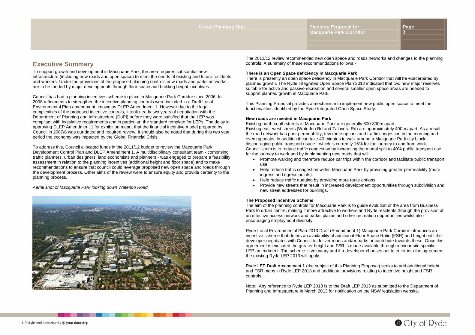
Executive Summary To support growth and development in Macquarie Park, the area requires substantial new infrastructure (including new roads and open space) to meet the needs of existing and future residents and workers. Under the provisions of the proposed planning controls new roads and parks networks are to be funded by major developments through floor space and building height incentives. Council has had a planning incentives scheme in place in Macquarie Park Corridor since 2006. In 2008 refinements to strengthen the incentive planning controls were included in a Draft Local Environmental Plan amendment, known as DLEP Amendment 1. However due to the legal complexities of the proposed incentive controls, it took nearly two years of negotiation with the Department of Planning and Infrastructure (DoPI) before they were satisfied that the LEP was compliant with legislative requirements and in particular, the standard template for LEPs. The delay in approving DLEP Amendment 1 for exhibition meant that the financial incentive model prepared by Council in 2007/8 was out-dated and required review. It should also be noted that during this two year period the economy was impacted by the Global Financial Crisis. To address this, Council allocated funds in the 2011/12 budget to review the Macquarie Park Development Control Plan and DLEP Amendment 1. A multidisciplinary consultant team - comprising traffic planners, urban designers, land economists and planners - was engaged to prepare a feasibility assessment in relation to the planning incentives (additional height and floor space) and to make recommendations to ensure that council could leverage proposed new open space and roads through the development process. Other aims of the review were to ensure equity and provide certainty to the planning process. Aerial shot of Macquarie Park looking down Waterloo Road
The 2011/12 review recommended new open space and roads networks and changes to the planning controls. A summary of these recommendations follows:- There is an Open Space deficiency in Macquarie Park There is presently an open space deficiency in Macquarie Park Corridor that will be exacerbated by planned growth. The Ryde Integrated Open Space Plan 2012 indicated that two new major reserves suitable for active and passive recreation and several smaller open space areas are needed to support planned growth in Macquarie Park. This Planning Proposal provides a mechanism to implement new public open space to meet the functionalities identified by the Ryde Integrated Open Space Study. New roads are needed in Macquarie Park Existing north-south streets in Macquarie Park are generally 600-800m apart. Existing east-west streets (Waterloo Rd and Talavera Rd) are approximately 400m apart. As a result the road network has poor permeability, few route options and traffic congestion in the morning and evening peaks. In addition it can take 40 minutes to walk around a Macquarie Park city block discouraging public transport usage - which is currently 15% for the journey to and from work. Council’s aim is to reduce traffic congestion by increasing the modal split to 40% public transport use for the journey to work and by implementing new roads that will:
• Promote walking and therefore reduce car trips within the corridor and facilitate public transport use.
• Help reduce traffic congestion within Macquarie Park by providing greater permeability (more ingress and egress points).
• Help reduce traffic queuing by providing more route options. • Provide new streets that result in increased development opportunities through subdivision and
new street addresses for buildings. The Proposed Incentive Scheme The aim of the planning controls for Macquarie Park is to guide evolution of the area from Business Park to urban centre, making it more attractive to workers and Ryde residents through the provision of an effective access network and parks, plazas and other recreation opportunities whilst also encouraging employment diversity. Ryde Local Environmental Plan 2013 Draft (Amendment 1) Macquarie Park Corridor introduces an incentive scheme that defers an availability of additional Floor Space Ratio (FSR) and height until the developer negotiates with Council to deliver roads and/or parks or contribute towards these. Once this agreement is executed the greater height and FSR is made available through a minor site specific LEP amendment. The scheme is voluntary and if a developer chooses not to enter into the agreement the existing Ryde LEP 2013 will apply. Ryde LEP Draft Amendment 1 (the subject of this Planning Proposal) seeks to add additional height and FSR maps in Ryde LEP 2013 and additional provisions relating to incentive height and FSR controls. Note: Any reference to Ryde LEP 2013 is to the Draft LEP 2013 as submitted to the Department of Planning and Infrastructure in March 2013 for notification on the NSW legislation website.
Urban Planning Unit Planning Proposal for Macquarie Park Corridor
Page 4
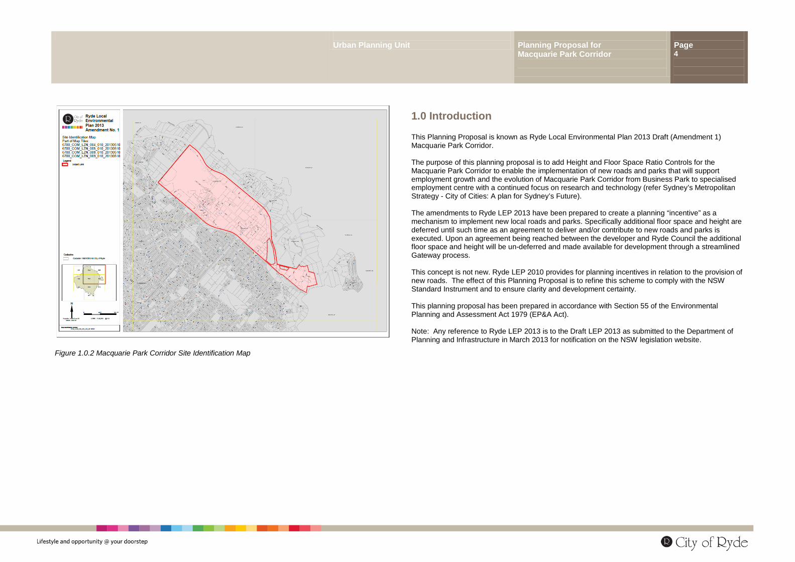
Figure 1.0.2 Macquarie Park Corridor Site Identification Map
1.0 Introduction This Planning Proposal is known as Ryde Local Environmental Plan 2013 Draft (Amendment 1) Macquarie Park Corridor. The purpose of this planning proposal is to add Height and Floor Space Ratio Controls for the Macquarie Park Corridor to enable the implementation of new roads and parks that will support employment growth and the evolution of Macquarie Park Corridor from Business Park to specialised employment centre with a continued focus on research and technology (refer Sydney’s Metropolitan Strategy - City of Cities: A plan for Sydney’s Future). The amendments to Ryde LEP 2013 have been prepared to create a planning “incentive” as a mechanism to implement new local roads and parks. Specifically additional floor space and height are deferred until such time as an agreement to deliver and/or contribute to new roads and parks is executed. Upon an agreement being reached between the developer and Ryde Council the additional floor space and height will be un-deferred and made available for development through a streamlined Gateway process. This concept is not new. Ryde LEP 2010 provides for planning incentives in relation to the provision of new roads. The effect of this Planning Proposal is to refine this scheme to comply with the NSW Standard Instrument and to ensure clarity and development certainty. This planning proposal has been prepared in accordance with Section 55 of the Environmental Planning and Assessment Act 1979 (EP&A Act). Note: Any reference to Ryde LEP 2013 is to the Draft LEP 2013 as submitted to the Department of Planning and Infrastructure in March 2013 for notification on the NSW legislation website.
Urban Planning Unit Planning Proposal for Macquarie Park Corridor
Page 5
1.1 Site Description and Context This planning proposal applies to the Macquarie Park Corridor identified on the map titled “Ryde Local Environmental Plan 2013 Draft Amendment No. 1: Site Identification Map” contained in Appendix C . An indicative map is at Figure 1.1.3). The Macquarie Park Corridor is a 75km2 employment centre located equidistant from Sydney City and Parramatta City Centre. Employment within the Corridor exceeds 39,000 and more than 30,000 students attend Macquarie University.
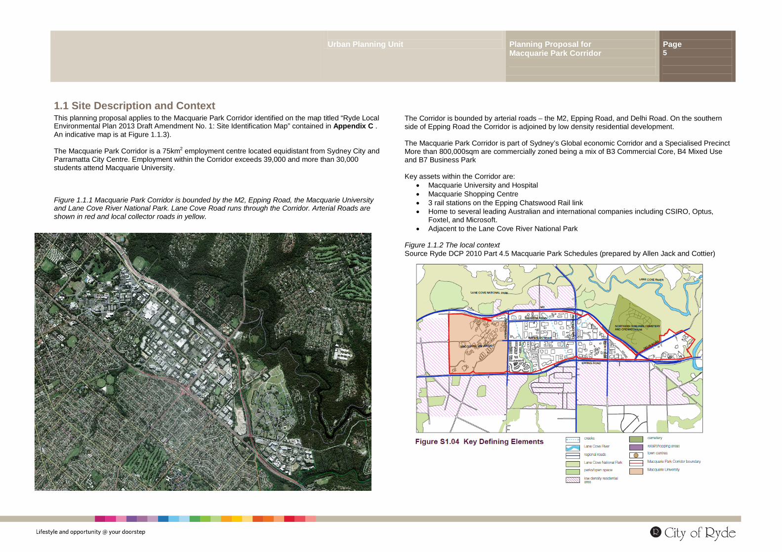
Figure 1.1.1 Macquarie Park Corridor is bounded by the M2, Epping Road, the Macquarie University and Lane Cove River National Park. Lane Cove Road runs through the Corridor. Arterial Roads are shown in red and local collector roads in yellow.
The Corridor is bounded by arterial roads – the M2, Epping Road, and Delhi Road. On the southern side of Epping Road the Corridor is adjoined by low density residential development. The Macquarie Park Corridor is part of Sydney’s Global economic Corridor and a Specialised Precinct More than 800,000sqm are commercially zoned being a mix of B3 Commercial Core, B4 Mixed Use and B7 Business Park Key assets within the Corridor are:
• Macquarie University and Hospital • Macquarie Shopping Centre • 3 rail stations on the Epping Chatswood Rail link • Home to several leading Australian and international companies including CSIRO, Optus,
Foxtel, and Microsoft. • Adjacent to the Lane Cove River National Park
Figure 1.1.2 The local context Source Ryde DCP 2010 Part 4.5 Macquarie Park Schedules (prepared by Allen Jack and Cottier)
Urban Planning Unit Planning Proposal for Macquarie Park Corridor
Page 6
1.2 Planning Proposal - Background In 2008 council exhibited and adopted a DCP and urban design study that responded to the new Epping to Chatswood rail line and provided guidelines to help Macquarie Park evolve from Business Park to urban centre. The DCP included plans for new roads, parks and plazas to meet the needs of residents and workers. It was proposed that the new roads and parks networks were to be funded by the development process through floor space and building height incentives set out in a Local Environmental Plan (LEP). Council commenced preparation of this LEP and submitted it to the Department of Planning and Infrastructure (DoPI) in 2008 for approval to publicly exhibit the plan. Around this time the NSW state government introduced a standardised format for LEPs which precluded planning incentives and vested control of local planning instruments in the Minister for Planning. In December 2010 negotiation between DoPI and Council resulted in an agreed way forward and DoPI gave council permission to publicly exhibit a Draft LEP amendment in the form of a Planning Proposal. However, as council’s research regarding the planning incentives for roads and parks had been completed in 2006/7, council, in 2011, allocated funds from the Macquarie Park Special Rate Levy to review the planning incentives scheme. The purpose of the review was to ensure that the scheme is practicable and sufficiently incentivised to leverage implementation of the proposed new roads and parks. This planning proposal is based on the review undertaken in 2012/13 – the background, methodology and recommendations of the review including recommendations for proposed Height and floor space ratio planning incentives. Timeline for the development of this Planning Proposal May 2006 LEP 137 (Macquarie Park) was notified in the Government Gazette and
came into effect (Note this LEP introduced a planning incentive scheme permitting additional floor space in return for new roads).
October 2007 Council resolved to review the planning provisions for the Macquarie
Park Corridor and prepare a draft local environmental plan. This resolution ensured compliance with Clause 103 of the Ryde Planning Scheme Ordinance which required that the plan be reviewed within 2 years of gazettal:
December 2007 Planning NSW (pursuant to s54 of the E, P & A Act) advised Council that
it could proceed with the preparation of the draft plan and undertake consultation with government agencies.
December 2007 S62 Consultation with NSW government agencies commenced.
February March 2008 Exhibition of Draft Ryde Development Control Plan Part 4.5 Macquarie
Park and Preliminary Height and Floor Space Ratio maps for inclusion in an LEP amendment
This exhibition was supported by the following studies: • Allen Jack and Cottier Macquarie Park DCP 2008 (now known as
Ryde DCP 2010 Part 4.5 Macquarie Park Corridor) • Aspect Studios,(2008), Macquarie Park Urban Design Manual • Bitzios, (2008), Macquarie Park Growth Model: Transport
Management Plan April 2008 S64 Report lodged with Planning NSW with a request for approval to
publicly exhibit the Draft Local Environmental Plan. January 2010 NSW Parliamentary Counsel completed preparation of draft Amendment
1 which circumscribed the “deferral” approach (and was based on Sydney’s Green Square Town Centre methodology).
December 2010 Ryde LEP Draft (Amendment 1) Macquarie Park Corridor was
transferred to the Gateway Process by the Minister’s Delegate and a Gateway Determination issued stating that all conditions precedent up to s57 had been met and permitting exhibition.
December 2011 Council commenced review of Amendment 1 to ensure feasibility and
update proposals to reflect all Part 3A approvals in the Macquarie Park Corridor. Council also obtained an extension to the Gateway Determination. This is at Appendix H
March 2012 Landowner Workshop to identify issues. September 2012 Landowner Workshop to seek feedback on the consultant’s preliminary
recommendations regarding proposed LEP and DCP amendments. November 2012 Ryde Councillor Workshop to discuss the proposed amendments and
landowner feedback April 2013 Ryde Council resolved to exhibit this Planning Proposal. Refer Council
Minutes 9 April 2013 – Appendix I
Urban Planning Unit Planning Proposal for Macquarie Park Corridor
Page 7
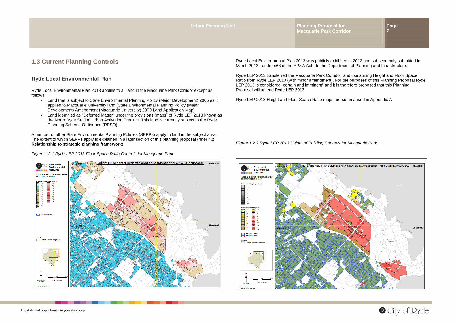
1.3 Current Planning Controls
Ryde Local Environmental Plan Ryde Local Environmental Plan 2013 applies to all land in the Macquarie Park Corridor except as follows:
• Land that is subject to State Environmental Planning Policy (Major Development) 2005 as it applies to Macquarie University land [State Environmental Planning Policy (Major Development) Amendment (Macquarie University) 2009 Land Application Map]
• Land identified as “Deferred Matter” under the provisions (maps) of Ryde LEP 2013 known as the North Ryde Station Urban Activation Precinct. This land is currently subject to the Ryde Planning Scheme Ordinance (RPSO).
A number of other State Environmental Planning Policies (SEPPs) apply to land in the subject area. The extent to which SEPPs apply is explained in a later section of this planning proposal (refer 4.2 Relationship to strategic planning framework). Figure 1.2.1 Ryde LEP 2013 Floor Space Ratio Controls for Macquarie Park
Ryde Local Environmental Plan 2013 was publicly exhibited in 2012 and subsequently submitted in March 2013 - under s68 of the EP&A Act - to the Department of Planning and Infrastructure. Ryde LEP 2013 transferred the Macquarie Park Corridor land use zoning Height and Floor Space Ratio from Ryde LEP 2010 (with minor amendment). For the purposes of this Planning Proposal Ryde LEP 2013 is considered “certain and imminent” and it is therefore proposed that this Planning Proposal will amend Ryde LEP 2013. Ryde LEP 2013 Height and Floor Space Ratio maps are summarised in Appendix A Figure 1.2.2 Ryde LEP 2013 Height of Building Controls for Macquarie Park
Urban Planning Unit Planning Proposal for Macquarie Park Corridor
Page 8
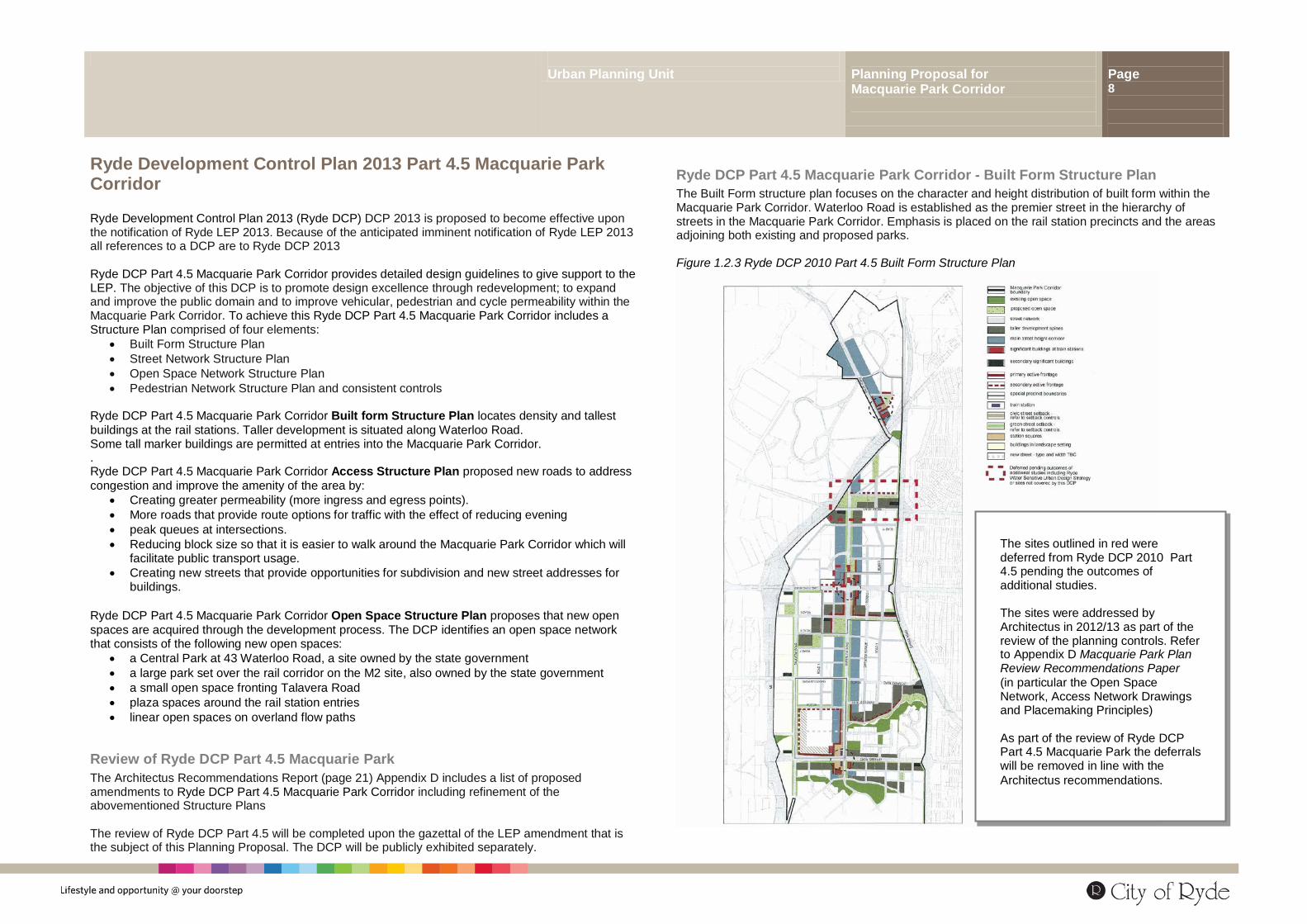
Ryde Development Control Plan 2013 Part 4.5 Macquarie Park Corridor Ryde Development Control Plan 2013 (Ryde DCP) DCP 2013 is proposed to become effective upon the notification of Ryde LEP 2013. Because of the anticipated imminent notification of Ryde LEP 2013 all references to a DCP are to Ryde DCP 2013 Ryde DCP Part 4.5 Macquarie Park Corridor provides detailed design guidelines to give support to the LEP. The objective of this DCP is to promote design excellence through redevelopment; to expand and improve the public domain and to improve vehicular, pedestrian and cycle permeability within the Macquarie Park Corridor. To achieve this Ryde DCP Part 4.5 Macquarie Park Corridor includes a Structure Plan comprised of four elements:
• Built Form Structure Plan • Street Network Structure Plan • Open Space Network Structure Plan • Pedestrian Network Structure Plan and consistent controls
Ryde DCP Part 4.5 Macquarie Park Corridor Built form Structure Plan locates density and tallest buildings at the rail stations. Taller development is situated along Waterloo Road. Some tall marker buildings are permitted at entries into the Macquarie Park Corridor. . Ryde DCP Part 4.5 Macquarie Park Corridor Access Structure Plan proposed new roads to address congestion and improve the amenity of the area by:
• Creating greater permeability (more ingress and egress points). • More roads that provide route options for traffic with the effect of reducing evening • peak queues at intersections. • Reducing block size so that it is easier to walk around the Macquarie Park Corridor which will
facilitate public transport usage. • Creating new streets that provide opportunities for subdivision and new street addresses for
buildings. Ryde DCP Part 4.5 Macquarie Park Corridor Open Space Structure Plan proposes that new open spaces are acquired through the development process. The DCP identifies an open space network that consists of the following new open spaces:
• a Central Park at 43 Waterloo Road, a site owned by the state government • a large park set over the rail corridor on the M2 site, also owned by the state government • a small open space fronting Talavera Road • plaza spaces around the rail station entries • linear open spaces on overland flow paths
Review of Ryde DCP Part 4.5 Macquarie Park The Architectus Recommendations Report (page 21) Appendix D includes a list of proposed amendments to Ryde DCP Part 4.5 Macquarie Park Corridor including refinement of the abovementioned Structure Plans The review of Ryde DCP Part 4.5 will be completed upon the gazettal of the LEP amendment that is the subject of this Planning Proposal. The DCP will be publicly exhibited separately.
Ryde DCP Part 4.5 Macquarie Park Corridor - Built Form Structure Plan The Built Form structure plan focuses on the character and height distribution of built form within the Macquarie Park Corridor. Waterloo Road is established as the premier street in the hierarchy of streets in the Macquarie Park Corridor. Emphasis is placed on the rail station precincts and the areas adjoining both existing and proposed parks. Figure 1.2.3 Ryde DCP 2010 Part 4.5 Built Form Structure Plan
The sites outlined in red were deferred from Ryde DCP 2010 Part 4.5 pending the outcomes of additional studies. The sites were addressed by Architectus in 2012/13 as part of the review of the planning controls. Refer to Appendix D Macquarie Park Plan Review Recommendations Paper (in particular the Open Space Network, Access Network Drawings and Placemaking Principles) As part of the review of Ryde DCP Part 4.5 Macquarie Park the deferrals will be removed in line with the Architectus recommendations.
Urban Planning Unit Planning Proposal for Macquarie Park Corridor
Page 9
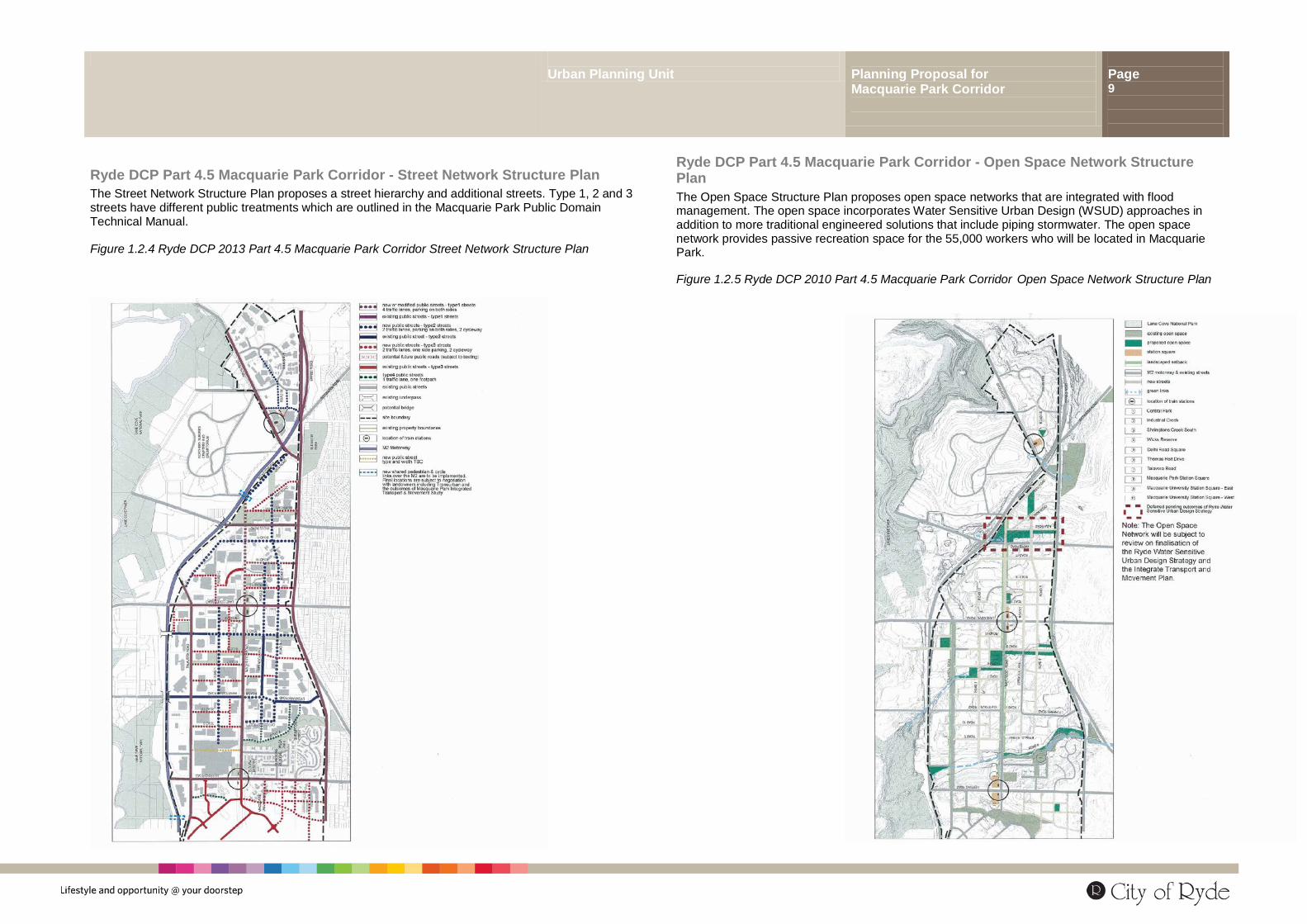
Ryde DCP Part 4.5 Macquarie Park Corridor - Street Network Structure Plan The Street Network Structure Plan proposes a street hierarchy and additional streets. Type 1, 2 and 3 streets have different public treatments which are outlined in the Macquarie Park Public Domain Technical Manual. Figure 1.2.4 Ryde DCP 2013 Part 4.5 Macquarie Park Corridor Street Network Structure Plan
Ryde DCP Part 4.5 Macquarie Park Corridor - Open Space Network Structure Plan The Open Space Structure Plan proposes open space networks that are integrated with flood management. The open space incorporates Water Sensitive Urban Design (WSUD) approaches in addition to more traditional engineered solutions that include piping stormwater. The open space network provides passive recreation space for the 55,000 workers who will be located in Macquarie Park.
Figure 1.2.5 Ryde DCP 2010 Part 4.5 Macquarie Park Corridor Open Space Network Structure Plan
Urban Planning Unit Planning Proposal for Macquarie Park Corridor
Page 10
2.0 Objectives and Intended Outcomes of the Planning Proposal This Planning Proposal seeks to amend Ryde LEP 2013 by providing incentive FSR and Height to land identified in a new map known as the Macquarie Park Corridor Precinct Map The objectives of this Planning Proposal are to
• Reinforce the importance of Macquarie Park Corridor as an employment centre
• Cater for growth and respond to the need for the Corridor to develop and change in a manner that allows the area to remain competitive.
• Enable the delivery of new road and park infrastructure to support the growth of the area.
This Planning Proposal seeks to amend Ryde LEP 2013 Centres Map with respect to the Macquarie Park Corridor to include land north of Delhi Road. The outcome of this Planning Proposal is to provide incentives to land owners and developers to implement new roads and parks (that will be identified in Ryde DCP part 4.5 Macquarie Park Corridor)
3.0 Explanation of Provisions The planning proposal seeks to:
a) Amend Ryde LEP 2013 written instrument by amending clause 4.6(8) exemption to development Standard to include clauses 4.3(2), 4.4(2) or the proposed new Part 7.
b) Amend Ryde LEP 2013 Centres Map with respect to Macquarie Park Corridor to include land north of Delhi Road.
c) Include a new map to be known as Ryde LEP 2013 (Amendment 1) Macquarie Park Corridor Precinct Map.
d) Include a new map to be known as Ryde LEP 2013 (Amendment 1) Macquarie Park Corridor Floor Space Ratio Map. The map identifies the maximum Floor Space Ratios permitted on land that has been identified in blue on the Macquarie Park Corridor Precinct Map.
e) Include a new map to be known as Ryde LEP 2013 (Amendment 1) Macquarie Park Corridor Height of Buildings Map. The map identifies the maximum Height of Buildings permitted on land that has been identified in blue on the Macquarie Park Corridor Precinct Map
f) Defer the Floor Space Ratio and Height The following summarises the proposed written instrument: Clause 1 Name of Plan Clause 2 Commencement Clause 3 Land to which the LEP Amendment applies Clause 4 A list of maps to be replaced and added. The following maps are to be added
Macquarie Park Corridor Precinct Map Macquarie Park Corridor Height of Buildings Map Macquarie Park Corridor Floor Space Ratio Map
Clause 4.6 does not permit development to contravene Height of Buildings or Floor Space development standards or a new Part 7 of the LEP
Part 7 Macquarie Park Corridor additional Provisions Clause 7.1 Part 7 applies to land identified (edged blue) on the Macquarie Park Corridor Precinct
Map (At the time of this exhibition there is no land edged blue) Clause 7.2 Despite clause 4.3 of Ryde LEP 2013 the Macquarie Park Corridor Height of Buildings
Map will apply to land edged blue on the Macquarie Park Corridor Precinct Map Clause 7.3 Despite clause 4.3 of Ryde LEP 2013 the Macquarie Park Corridor Floor Space Ratio
Map will apply to land edged blue on the Macquarie Park Corridor Precinct Map A prototype of the draft instrument is attached. The effect of the amendment is that Ryde LEP 2013 Floor Space Ratio and Height of Buildings Maps as they apply to the Macquarie Park Corridor cannot be varied unless land comes under the new Part 7. The effect of Part 7 will be to permit access to bonus floor space and height that captures some of the value of the uplift in order to implement new road and park infrastructure. The planning mechanism for this will be a planning proposal. Upon an agreement being reached between Council and the developer the bonus floor space and height will be made available through a planning proposal that will identify the subject site with a blue outline on the Macquarie Park Corridor Precinct Map. It is anticipated that this will be a streamlined Planning Proposal process To ensure transparency the proposed new road and park infrastructure is identified in Figures 4.0.2 and 4.0.3 of this document and in the Appendices. Should Ryde LEP Amendment 1 become effective
Urban Planning Unit Planning Proposal for Macquarie Park Corridor
Page 11
the Ryde DCP will be amended to update - in particular - the Street and Open Space Network Structure Plans. For the purposes of a Voluntary Planning Agreement negotiation the additional floor space will be valued at $250/sqm and land value for roads and parks also set at $250/sqm.
The un-deferral process Ryde LEP Draft (Amendment 1) Macquarie Park Corridor introduces an incentive scheme that defers an availability of additional FSR and height until the developer enters into an agreement with Council to deliver roads and/or parks or contribute towards these. Once this agreement is executed the greater height and FSR is made available through a minor site specific LEP amendment that will edge the site in blue on the Macquarie Park Corridor Precinct Map. The scheme has been designed to minimise costs to council for new infrastructure and transfer these to the development community. The scheme is voluntary and if a developer chooses not to enter into the agreement the existing Ryde LEP 2013 will apply. See Appendix G Architectus 2013 Draft Macquarie Park Guideline for Un-deferrals and delivery of Public Infrastructure
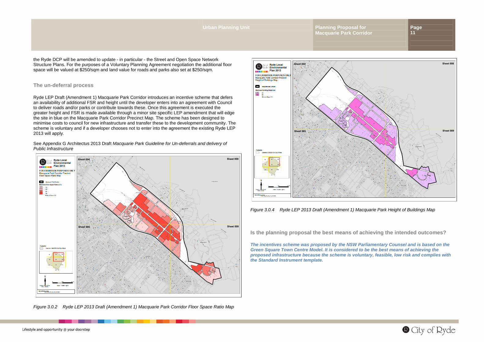
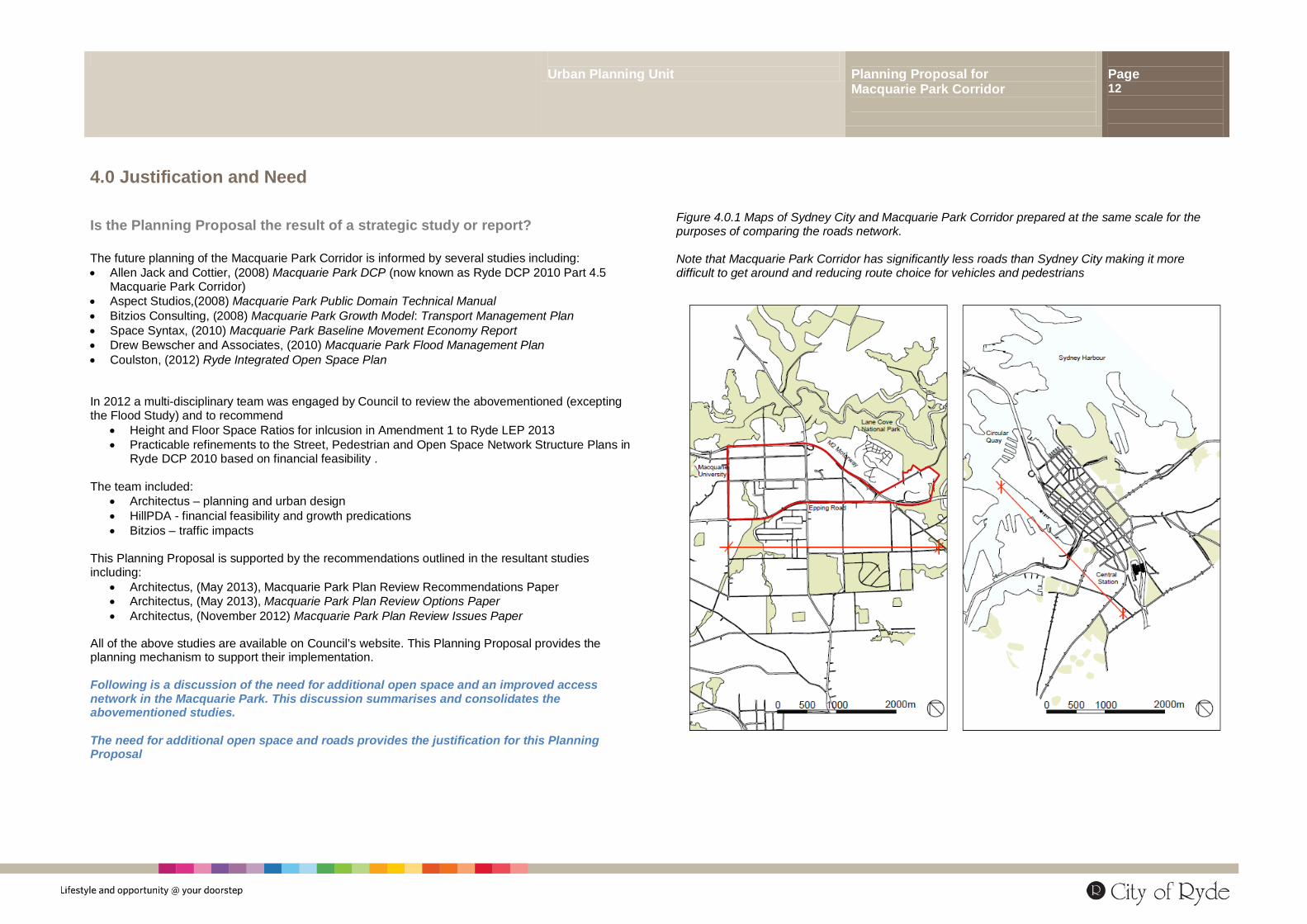
Figure 3.0.2 Ryde LEP 2013 Draft (Amendment 1) Macquarie Park Corridor Floor Space Ratio Map
Figure 3.0.4 Ryde LEP 2013 Draft (Amendment 1) Macquarie Park Height of Buildings Map
Is the planning proposal the best means of achieving the intended outcomes? The incentives scheme was proposed by the NSW Parliamentary Counsel and is based on the Green Square Town Centre Model. It is considered to be the best means of achieving the proposed infrastructure because the scheme is voluntary, feasible, low risk and complies with the Standard Instrument template.
Urban Planning Unit Planning Proposal for Macquarie Park Corridor
Page 12
4.0 Justification and Need
Is the Planning Proposal the result of a strategic study or report? The future planning of the Macquarie Park Corridor is informed by several studies including: • Allen Jack and Cottier, (2008) Macquarie Park DCP (now known as Ryde DCP 2010 Part 4.5
Macquarie Park Corridor) • Aspect Studios,(2008) Macquarie Park Public Domain Technical Manual • Bitzios Consulting, (2008) Macquarie Park Growth Model: Transport Management Plan • Space Syntax, (2010) Macquarie Park Baseline Movement Economy Report • Drew Bewscher and Associates, (2010) Macquarie Park Flood Management Plan • Coulston, (2012) Ryde Integrated Open Space Plan In 2012 a multi-disciplinary team was engaged by Council to review the abovementioned (excepting the Flood Study) and to recommend
• Height and Floor Space Ratios for inlcusion in Amendment 1 to Ryde LEP 2013 • Practicable refinements to the Street, Pedestrian and Open Space Network Structure Plans in
Ryde DCP 2010 based on financial feasibility . The team included:
• Architectus – planning and urban design • HillPDA - financial feasibility and growth predications • Bitzios – traffic impacts
This Planning Proposal is supported by the recommendations outlined in the resultant studies including:
• Architectus, (May 2013), Macquarie Park Plan Review Recommendations Paper • Architectus, (May 2013), Macquarie Park Plan Review Options Paper • Architectus, (November 2012) Macquarie Park Plan Review Issues Paper
All of the above studies are available on Council’s website. This Planning Proposal provides the planning mechanism to support their implementation. Following is a discussion of the need for additional open space and an improved access network in the Macquarie Park. This discussion summarises and consolidates the abovementioned studies. The need for additional open space and roads provides the justification for this Planning Proposal
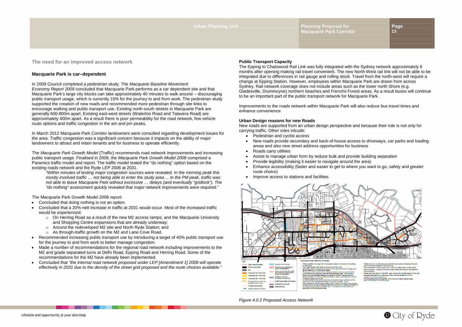
Figure 4.0.1 Maps of Sydney City and Macquarie Park Corridor prepared at the same scale for the purposes of comparing the roads network. Note that Macquarie Park Corridor has significantly less roads than Sydney City making it more difficult to get around and reducing route choice for vehicles and pedestrians
Urban Planning Unit Planning Proposal for Macquarie Park Corridor
Page 13
The need for an improved access network Macquarie Park is car–dependent In 2009 Council completed a pedestrian study. The Macquarie Baseline Movement Economy Report 2009 concluded that Macquarie Park performs as a car dependent site and that Macquarie Park’s large city blocks can take approximately 40 minutes to walk around -- discouraging public transport usage, which is currently 15% for the journey to and from work. The pedestrian study supported the creation of new roads and recommended more pedestrian through site links to encourage walking and public transport use. Existing north-south streets in Macquarie Park are generally 600-800m apart. Existing east-west streets (Waterloo Road and Talavera Road) are approximately 400m apart. As a result there is poor permeability for the road network, few vehicle route options and traffic congestion in the am and pm peaks. In March 2012 Macquarie Park Corridor landowners were consulted regarding development issues for the area. Traffic congestion was a significant concern because it impacts on the ability of major landowners to attract and retain tenants and for business to operate efficiently. The Macquarie Park Growth Model (Traffic) recommends road network improvements and increasing public transport usage. Finalised in 2008, the Macquarie Park Growth Model 2008 comprised a Paramics traffic model and report. The traffic model tested the “do nothing” option based on the existing roads network and the Ryde LEP 2006 at 2031.
“Within minutes of testing major congestion sources were revealed. In the morning peak this mostly involved traffic … not being able to enter the study area ... In the PM peak, traffic was not able to leave Macquarie Park without excessive … delays (and eventually “gridlock”). The “do nothing” assessment quickly revealed that major network improvements were required.”
The Macquarie Park Growth Model 2008 report: • Concluded that doing nothing is not an option. • Concluded that a 20% nett increase in traffic at 2031 would occur. Most of the increased traffic
would be experienced: o On Herring Road as a result of the new M2 access ramps, and the Macquarie University
and Shopping Centre expansions that are already underway; o Around the redeveloped M2 site and North Ryde Station; and o As through-traffic growth on the M2 and Lane Cove Road.
• Recommended increasing public transport use by introducing a target of 40% public transport use for the journey to and from work to better manage congestion.
• Made a number of recommendations for the regional road network including improvements to the M2 and grade separated turns at Delhi Road, Epping Road and Herring Road. Some of the recommendations for the M2 have already been implemented.
• Concluded that “the internal road network proposed under LEP [Amendment 1] 2008 will operate effectively in 2031 due to the density of the street grid proposed and the route choices available.”
Public Transport Capacity The Epping to Chatswood Rail Link was fully integrated with the Sydney network approximately 6 months after opening making rail travel convenient. The new North-West rail link will not be able to be integrated due to differences in rail gauge and rolling stock. Travel from the north-west will require a change at Epping Station. However, employees within Macquarie Park are drawn from across Sydney. Rail network coverage does not include areas such as the lower north Shore (e.g. Gladesville, Drummoyne) northern beaches and Frenchs Forest areas. As a result buses will continue to be an important part of the public transport network for Macquarie Park. Improvements to the roads network within Macquarie Park will also reduce bus travel times and enhance convenience. Urban Design reasons for new Roads New roads are supported from an urban design perspective and because their role is not only for carrying traffic. Other roles inlcude:
• Pedestrian and cyclist access • New roads provide secondary and back-of-house access to driveways, car parks and loading
areas and also new street address opportunities for business • Roads carry utilities • Assist to manage urban form by reduce bulk and provide building separation • Provide legibility (making it easier to navigate around the area) • Enhance accessibility (faster and easier to get to where you want to go, safety and greater
route choice) • Improve access to stations and facilities.
Figure 4.0.2 Proposed Access Network
Urban Planning Unit Planning Proposal for Macquarie Park Corridor
Page 14
The need for additional Open Space In Macquarie Park Macquarie Park open spaces include Elouera Reserve, Quandong Reserve, Shrimptons Creek parklands and Wilga Park. The Macquarie University grounds incorporate open space that is publicly accessible. However, over time the university grounds will be redeveloped in accordance with the Concept Plan approved by the Minister for Planning in 2009 resulting in the loss of much of this open space. The Macquarie Park Corridor is also bordered by open space – Lane Cove National Park, Christie Park and Blenheim Park for example – but these are not readily accessible to Macquarie Park Corridor due to the barriers created by arterial roads and because these open space areas are more than 400m distant from residents and business locations.
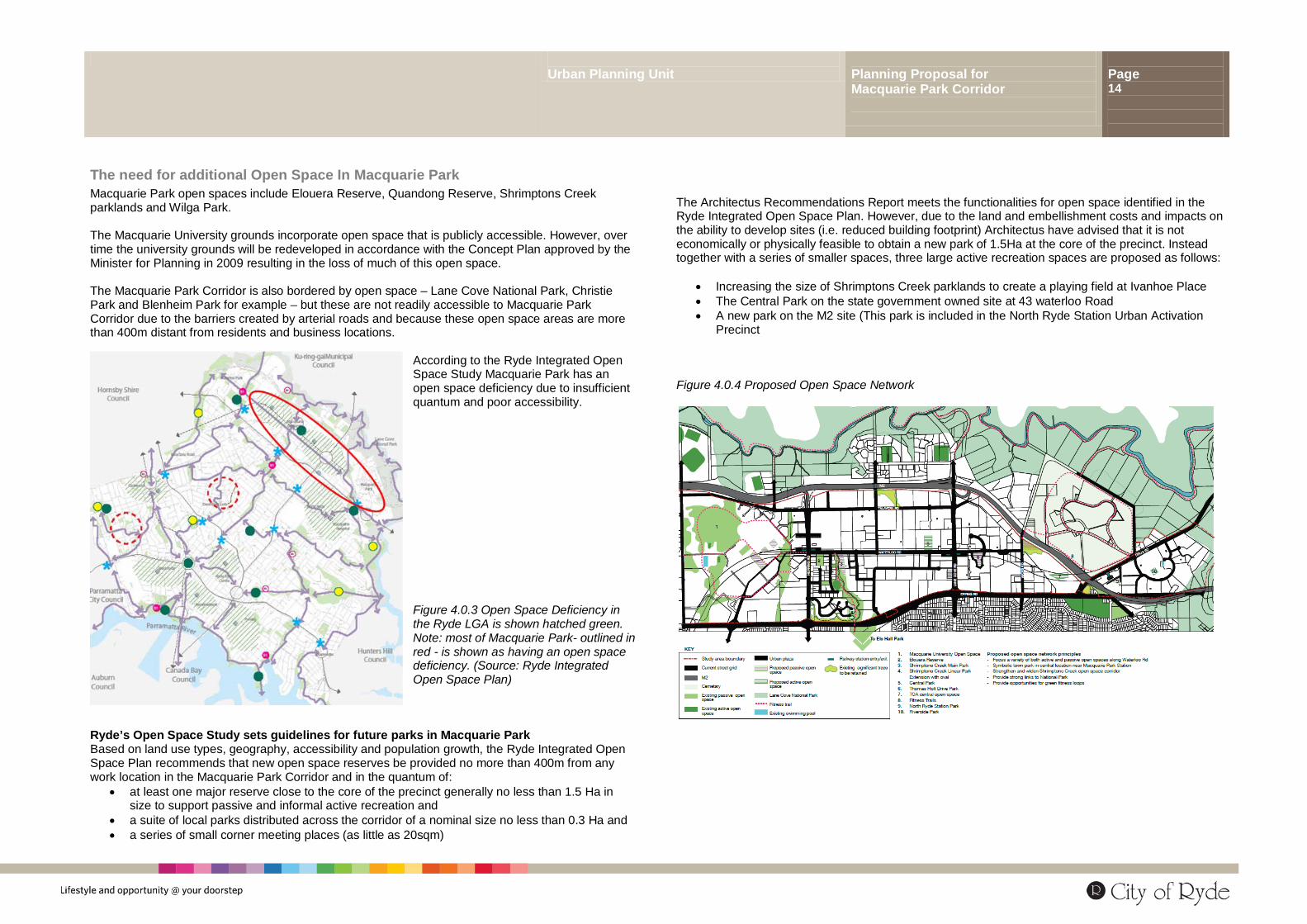
According to the Ryde Integrated Open Space Study Macquarie Park has an open space deficiency due to insufficient quantum and poor accessibility. Figure 4.0.3 Open Space Deficiency in the Ryde LGA is shown hatched green. Note: most of Macquarie Park- outlined in red - is shown as having an open space deficiency. (Source: Ryde Integrated Open Space Plan)
Ryde’s Open Space Study sets guidelines for future parks in Macquarie Park Based on land use types, geography, accessibility and population growth, the Ryde Integrated Open Space Plan recommends that new open space reserves be provided no more than 400m from any work location in the Macquarie Park Corridor and in the quantum of:
• at least one major reserve close to the core of the precinct generally no less than 1.5 Ha in size to support passive and informal active recreation and
• a suite of local parks distributed across the corridor of a nominal size no less than 0.3 Ha and • a series of small corner meeting places (as little as 20sqm)
The Architectus Recommendations Report meets the functionalities for open space identified in the Ryde Integrated Open Space Plan. However, due to the land and embellishment costs and impacts on the ability to develop sites (i.e. reduced building footprint) Architectus have advised that it is not economically or physically feasible to obtain a new park of 1.5Ha at the core of the precinct. Instead together with a series of smaller spaces, three large active recreation spaces are proposed as follows:
• Increasing the size of Shrimptons Creek parklands to create a playing field at Ivanhoe Place • The Central Park on the state government owned site at 43 waterloo Road • A new park on the M2 site (This park is included in the North Ryde Station Urban Activation
Precinct Figure 4.0.4 Proposed Open Space Network
Urban Planning Unit Planning Proposal for Macquarie Park Corridor
Page 15
4.2 Relationship of the Planning Proposal to the Strategic Planning Framework The planning framework for this Planning Proposal is:
• Sydney Metro Strategy • Draft Inner North Subregional Strategy • Ryde LEP 2010 and Draft Ryde LEP 2013 • Ryde Local Planning Strategy • Ryde Community Strategy / Plan • Ryde Development Control Plan
Sydney Metropolitan Strategy: sets the NSW Government’s framework for the future growth and prosperity of Sydney. It was first released in 2005 and has since been updated twice as follows:
• Planning NSW, (2005) City of Cities - A Plan for Sydney’s Future 2031 • NSW Department of Planning and Infrastructure, (2010) Draft Metropolitan Plan for Sydney to
2036. • NSW Department of Planning and Infrastructure, (2013) Draft Metropolitan Strategy for Sydney
to 2031. The Draft Inner North Subregional Strategy gives detailed guidance to the Sydney Metro Strategy and sets in particular targets for jobs creation and new dwellings for each local government area. In the Ryde Local Government Area the jobs creation target is 21,000 new jobs and 12,000 new dwellings. Ryde LEP defines land use zones and development standards in particular Height of Buildings and Floor Space Ratio maximums in particular. Ryde Development Control Plan gives detailed design guidance to the LEP and includes urban design based controls for centres (Part 4), controls for specific development typologies (e.g. child care centres) and for parking (Part 9.3) Ryde Local Planning Study has no statutory weight. The Local Study examined the capacity of Ryde’s existing Planning Controls to implement the recommendations of the Metro Strategy and the growth targets of the Inner North Subregional Strategy. The study concluded that capacity existed within Ryde’s existing controls to deliver the jobs and dwellings growth targets. The study also supported the Metro Stagey in relation to the hierarchy and character of centres within the Ryde LGA. Ryde Community Strategic Plan sets the vision for the City of Ryde is the place to be for lifestyle and opportunity @ your doorstep. The plan has seven outcome areas – defined through community consultation -- that guide city improvements, Council policy and city planning. The seven outcome areas are City of Prosperity, City of Liveable Neighbourhoods, City of Wellbeing, City of Environmental Sensitivity, City of Connections, City of Harmony and Culture, City of Progressive Leadership. Ryde Integrated Open Space Plan analyses existing open space in the City of Ryde – its function and size –and using population projections identifies areas in the city where there is a deficiency of open space. The Study recommends the provision of new open space both in terms of quantum and functionality within the City of Ryde. The study identifies and Open space deficiency in the Macquarie Park Corridor.
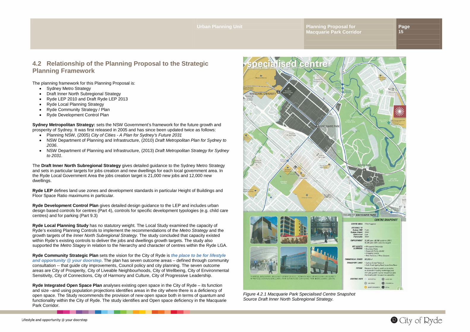
Figure 4.2.1 Macquarie Park Specialised Centre Snapshot Source Draft Inner North Subregional Strategy.
Urban Planning Unit Planning Proposal for Macquarie Park Corridor
Page 16
4.2.1 Is the Planning Proposal consistent with the objectives and actions of the Sydney Metropolitan Strategy? Macquarie Park Corridor was identified in the City of Cities - A Plan for Sydney’s Future released December 2005) as a Specialised Centre with a focus on education, employment, research and technology. This was further reinforced in the revised and updated versions of the Metro Strategy released in 2010 and 2013. Macquarie Park Corridor is part of Sydney’s Global Economic Corridor characterised by a concentration of jobs and business activities and a critical feature of Sydney’s economy. The Global Arc stretches from Macquarie Park to North Sydney, the City to the Airport and Port Botany. As identified in the Metropolitan Strategy, Specialised Centres are differentiated from other strategic centres in that they perform vital economic and employment roles for the whole metropolitan area. Specialised Centres are critical in sustaining Sydney’s competitiveness, and the State Government has a strategic interest in their success. A specialised centre is characterised by:
• a stronger employment or economic function than other centres, with a reduced focus for housing
• sufficient zoned land provided for business and enterprise in locations with high quality transport access
• major airports, ports, hospitals, universities, research and/ or business activities that perform vital economic and employment roles across the metropolitan area
• complex interaction with the rest of the city; growth and change in and around them must therefore be carefully planned
• an employment base, in common with Major Centres, of at least 8,000 jobs Macquarie Park is identified under the Metropolitan Plan 2036 as having a base of 39,000 jobs in 2009 and anticipated to grow to 58,000 by 2036 (p135 Metro Strategy to 2036). Council’s Local Planning Strategy seeks to support Macquarie Park as an employment centre and for this reason no changes to the land use zones are proposed and Macquarie Park will be allowed to evolve as an urban centre supported by rail and bus public transport. This Planning Proposal is consistent with the Sydney Metropolitan Strategy and supports business and jobs growth by providing the floor space capacity and incentives for growth and by also addressing traffic congestion and open space deficiency.
Is the Planning Proposal consistent with the Draft Inner North Draft Subregional Strategy? The draft Inner North Subregional Strategy relates to Ryde, Hunters Hill, Lane Cove, Mosman, North Sydney and Willoughby LGA’s. The Inner North Subregional Strategy gives detailed guidance to the Sydney Metro Strategy and in particular targets for jobs creation and new dwellings for each local government area. The 2031 targets proposed for the sub-region involve:
• an increase in the number of dwellings by 30,000 dwellings from 129,000 to 159,000; and • an increase in employment capacity by 60,000 from 228,000 to 288,000.
The jobs creation target for the City of Ryde is 21,000 new jobs by 2031. Local planning controls must allow the floor space capacity within commercial and industrial land use zones to deliver these targets. The Inner North Subregional Strategy identifies Macquarie Park as a specialised centre stating that:
Macquarie Park will continue to evolve as Australia’s leading Technology Park with jobs growth, further investment and improved public transport accessibility.
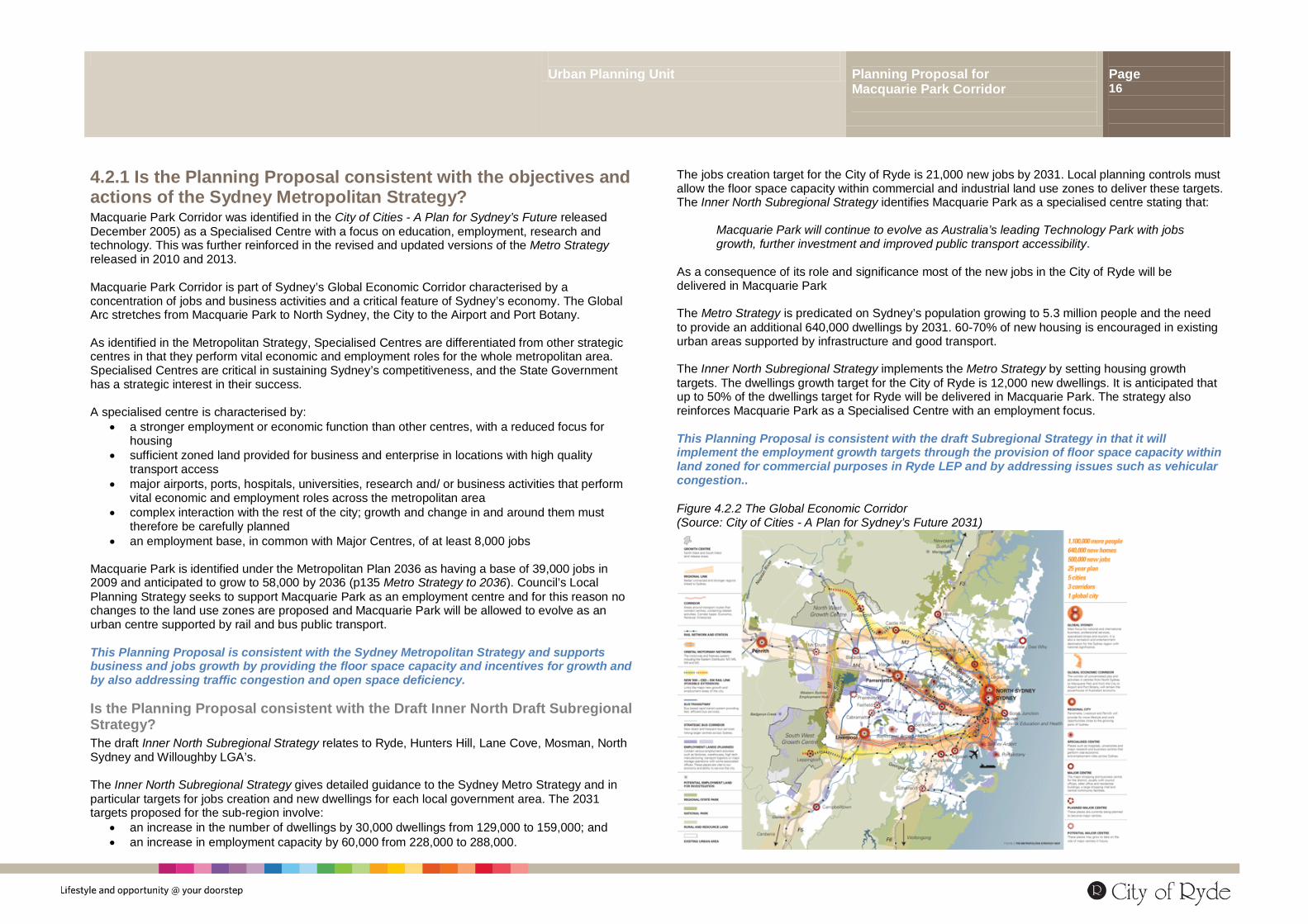
As a consequence of its role and significance most of the new jobs in the City of Ryde will be delivered in Macquarie Park The Metro Strategy is predicated on Sydney’s population growing to 5.3 million people and the need to provide an additional 640,000 dwellings by 2031. 60-70% of new housing is encouraged in existing urban areas supported by infrastructure and good transport. The Inner North Subregional Strategy implements the Metro Strategy by setting housing growth targets. The dwellings growth target for the City of Ryde is 12,000 new dwellings. It is anticipated that up to 50% of the dwellings target for Ryde will be delivered in Macquarie Park. The strategy also reinforces Macquarie Park as a Specialised Centre with an employment focus. This Planning Proposal is consistent with the draft Subregional Strategy in that it will implement the employment growth targets through the provision of floor space capacity within land zoned for commercial purposes in Ryde LEP and by addressing issues such as vehicular congestion.. Figure 4.2.2 The Global Economic Corridor (Source: City of Cities - A Plan for Sydney’s Future 2031)
Urban Planning Unit Planning Proposal for Macquarie Park Corridor
Page 17
4.2.2 Summary of Relationship to the Strategic Planning Framework This Planning Proposal seeks to amend Ryde LEP 2013 and to implement the:
• Sydney Metropolitan Strategy in particular by reinforcing the role of Macquarie Park Corridor as a significant employment centre, part of Sydney’s Economic Global Arc
• Inner North Subregional Strategy in particular by ensuring the capacity within appropriately zoned land to achieve the dwellings and employment growth targets
• Ryde Local Planning Study in particular by retaining the primacy role of Macquarie Park in the
hierarchy of centres within the Ryde Local Government Area.
• Ryde Community Strategic Plan in particular by developing innovative planning mechanisms that are feasible, low risk, will meet community needs and ensure attractive liveable sustainable neighbourhoods for workers and residents.
• Ryde Integrated Open Space Plan in particular by allowing for additional open space within Macquarie Park
4.2.3 Is the planning proposal consistent with applicable state environmental planning policies and Regional Environmental Plans? The Planning Proposal is consistent with:
• the strategic planning framework for development in this part of the Sydney sub-region; • all relevant State Environmental Planning Policies; and
• all relevant Section 117 Directions.
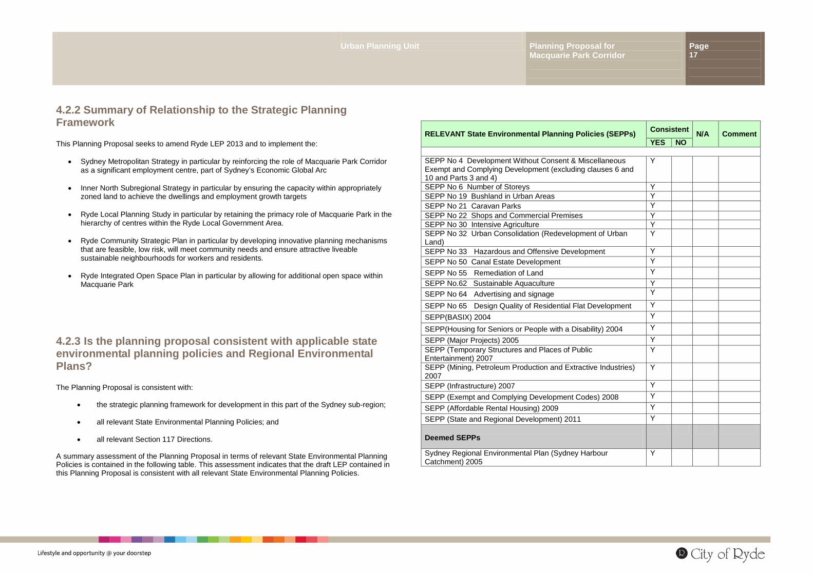
A summary assessment of the Planning Proposal in terms of relevant State Environmental Planning Policies is contained in the following table. This assessment indicates that the draft LEP contained in this Planning Proposal is consistent with all relevant State Environmental Planning Policies.
RELEVANT State Environmental Planning Policies (SEPPs) Consistent N/A Comment YES NO
SEPP No 4 Development Without Consent & Miscellaneous Exempt and Complying Development (excluding clauses 6 and 10 and Parts 3 and 4)
Y
SEPP No 6 Number of Storeys Y SEPP No 19 Bushland in Urban Areas Y SEPP No 21 Caravan Parks Y SEPP No 22 Shops and Commercial Premises Y SEPP No 30 Intensive Agriculture Y SEPP No 32 Urban Consolidation (Redevelopment of Urban Land)
Y
SEPP No 33 Hazardous and Offensive Development Y SEPP No 50 Canal Estate Development Y SEPP No 55 Remediation of Land Y SEPP No.62 Sustainable Aquaculture Y SEPP No 64 Advertising and signage Y
SEPP No 65 Design Quality of Residential Flat Development Y SEPP(BASIX) 2004 Y
SEPP(Housing for Seniors or People with a Disability) 2004 Y
SEPP (Major Projects) 2005 Y SEPP (Temporary Structures and Places of Public Entertainment) 2007
Y
SEPP (Mining, Petroleum Production and Extractive Industries) 2007
Y
SEPP (Infrastructure) 2007 Y SEPP (Exempt and Complying Development Codes) 2008 Y SEPP (Affordable Rental Housing) 2009 Y SEPP (State and Regional Development) 2011 Y Deemed SEPPs
Sydney Regional Environmental Plan (Sydney Harbour Catchment) 2005
Y
Urban Planning Unit Planning Proposal for Macquarie Park Corridor
Page 18
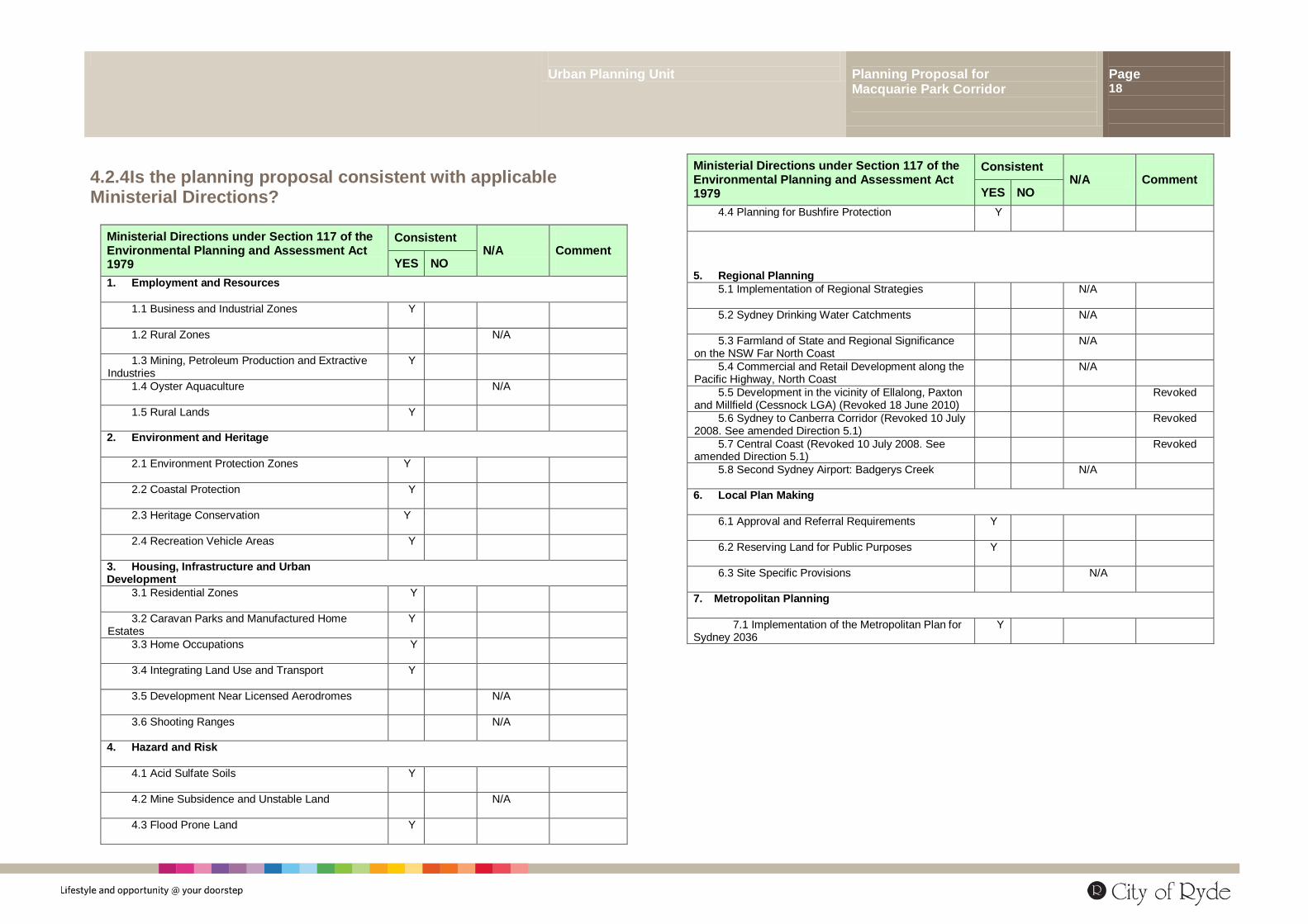
4.2.4 Is the planning proposal consistent with applicable Ministerial Directions?
Ministerial Directions under Section 117 of the Environmental Planning and Assessment Act 1979
Consistent N/A
Comment YES NO
1. Employment and Resources
1.1 Business and Industrial Zones Y
1.2 Rural Zones N/A
1.3 Mining, Petroleum Production and Extractive Industries
Y
1.4 Oyster Aquaculture N/A
1.5 Rural Lands Y
2. Environment and Heritage
2.1 Environment Protection Zones Y
2.2 Coastal Protection Y
2.3 Heritage Conservation Y
2.4 Recreation Vehicle Areas Y
3. Housing, Infrastructure and Urban Development
3.1 Residential Zones Y
3.2 Caravan Parks and Manufactured Home Estates
Y
3.3 Home Occupations Y
3.4 Integrating Land Use and Transport Y
3.5 Development Near Licensed Aerodromes N/A
3.6 Shooting Ranges N/A
4. Hazard and Risk
4.1 Acid Sulfate Soils Y
4.2 Mine Subsidence and Unstable Land N/A
4.3 Flood Prone Land Y
Ministerial Directions under Section 117 of the Environmental Planning and Assessment Act 1979
Consistent N/A
Comment YES NO
4.4 Planning for Bushfire Protection Y
5. Regional Planning
5.1 Implementation of Regional Strategies N/A
5.2 Sydney Drinking Water Catchments N/A
5.3 Farmland of State and Regional Significance on the NSW Far North Coast
N/A
5.4 Commercial and Retail Development along the Pacific Highway, North Coast
N/A
5.5 Development in the vicinity of Ellalong, Paxton and Millfield (Cessnock LGA) (Revoked 18 June 2010)
Revoked
5.6 Sydney to Canberra Corridor (Revoked 10 July 2008. See amended Direction 5.1)
Revoked
5.7 Central Coast (Revoked 10 July 2008. See amended Direction 5.1)
Revoked
5.8 Second Sydney Airport: Badgerys Creek N/A
6. Local Plan Making
6.1 Approval and Referral Requirements Y
6.2 Reserving Land for Public Purposes Y
6.3 Site Specific Provisions N/A
7. Metropolitan Planning
7.1 Implementation of the Metropolitan Plan for Sydney 2036
Y
Urban Planning Unit Planning Proposal for Macquarie Park Corridor
Page 19
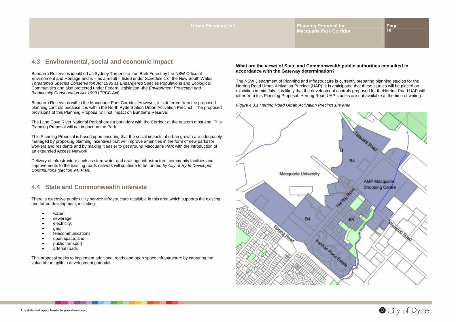
4.3 Environmental, social and economic impact Bundarra Reserve is identified as Sydney Turpentine Iron Bark Forest by the NSW Office of Environment and Heritage and is – as a result - listed under Schedule 1 of the New South Wales Threatened Species Conservation Act 1995 as Endangered Species Populations and Ecological Communities and also protected under Federal legislation -the Environment Protection and Biodiversity Conservation Act 1999 (EPBC Act). Bundarra Reserve is within the Macquarie Park Corridor. However, it is deferred from the proposed planning controls because it is within the North Ryde Station Urban Activation Precinct . The proposed provisions of this Planning Proposal will not impact on Bundarra Reserve. The Lane Cove River National Park shares a boundary with the Corridor at the eastern most end. This Planning Proposal will not impact on the Park. This Planning Proposal is based upon ensuring that the social impacts of urban growth are adequately managed by proposing planning incentives that will improve amenities in the form of new parks for workers and residents and by making it easier to get around Macquarie Park with the introduction of an expanded Access Network. Delivery of infrastructure such as stormwater and drainage infrastructure, community facilities and improvements to the existing roads network will continue to be funded by City of Ryde Developer Contributions (section 94) Plan.
4.4 State and Commonwealth interests There is extensive public utility service infrastructure available in this area which supports the existing and future development, including:
• water; • sewerage; • electricity; • gas; • telecommunications; • open space; and • public transport • arterial roads
This proposal seeks to implement additional roads and open space infrastructure by capturing the value of the uplift in development potential.
What are the views of State and Commonwealth public authorities consulted in accordance with the Gateway determination? The NSW Department of Planning and Infrastructure is currently preparing planning studies for the Herring Road Urban Activation Precinct (UAP). It is anticipated that these studies will be placed on exhibition in mid-July. It is likely that the development controls proposed for theHerring Road UAP will differ from this Planning Proposal. Herring Road UAP studies are not available at the time of writing. Figure 4.3.1 Herring Road Urban Activation Precinct site area
Urban Planning Unit Planning Proposal for Macquarie Park Corridor
Page 20
6.0 Community Consultation The community consultation process to be undertaken for this Planning will comply with the requirements of:
• Section 57 of the EP&A Act and the Environmental Planning and Assessment Regulation 2000; and
• The Gateway Determination
All landowners within the Macquarie Park Corridor -and those likely to be affected - will be notified by mail of the consultation. Advertisements will also be place in the media and on Council’s webpage. Information will be made widely available at the following locations:
• Ryde Library (Corner Pope and Devlin Streets) • Eastwood Library (opposite the rail station) • City of Ryde Customer Service Centre • City of Ryde Planning and Business Centre (which is manned by a duty planner who will be
able to answer questions) • On the Ryde Council webpage
Planned community consultation events will include at least one drop in information session and a information briefing. These will be detailed in advertisements and on the council’s webpage.
7.0 Anticipated Project Timeline Exhibition Mid June – Mid July 2013 Report exhibition to Council Mid October 2013 Report to Dept. of Planning and Infrastructure Late November 2013 Dept. Planning and Infrastructure review 3 months March 2014 Plan is made April / May 2014
Urban Planning Unit Planning Proposal for Macquarie Park Corridor
Page 21
Appendix A Ryde LEP 2013 maps Please note that Ryde LEP Draft (Amendment 1) Macquarie Park Corridor proposes to amend Ryde LEP 2013. Ryde LEP 2013 has been submitted to the Department of Planning and Infrastructure for notification. The Draft LEP is understood to be certain and imminent at the time the exhibition of this Planning Proposal commences. Following are: 6700_COM_FSR_000_015_20130606 – Floor Space Ratio map from LEP 2013 (as submitted to the Department) 6700_COM_HOB_000_015_20130606 – Height of Buildings map from LEP 2013 (as submitted to the Department)

Urban Planning Unit Planning Proposal for Macquarie Park Corridor
Page 22
Urban Planning Unit Planning Proposal for Macquarie Park Corridor
Page 23
Appendix B Maps
Ryde LEP 2013 Draft (Amendment 1) Macquarie Park Corridor Note: The maps have been prepared in accordance with specifications set out in the Standard Technical requirements for LEP maps issued by the Department of Planning and Infrastructure and have been notated for community consultation purposes.
Ryde LEP 2013 Draft (Amendment 1) Macquarie Park Corridor Ryde Centres Map CEN_009 6700_COM_CEN_009_010_20130528 Macquarie Park Corridor Precinct Summary Map This map consolidates Ryde LEP Draft (Amendment 1) Macquarie Park Corridor Precinct Maps onto a single sheet 6700_COM_MAQ_000_015_20130606 Macquarie Park Corridor Precinct Maps MAQ_004 6700_COM_MAQ_004_010_20130528 MAQ_005 6700_COM_MAQ_005_010_20130528 MAQ_008 6700_COM_MAQ_008_010_20130528 MAQ_009 6700_COM_MAQ_009_010_20130528 Macquarie Park Corridor Precinct Floor Space Ratio Summary Map This map consolidates Ryde LEP Draft (Amendment 1) Macquarie Park Corridor Floor Space Ratios onto a single sheet 6700_COM_MFS_000_015_20130606 Macquarie Park Corridor Precinct Floor Space Ratio Maps MFS_004 6700_COM_MFS_004_010_20130528 MFS_005 6700_COM_MFS_005_010_20130528 MFS_008 6700_COM_MFS_008_010_20130528 MFS_009 6700_COM_MFS_009_010_20130528 Macquarie Park Corridor Precinct Height of Buildings Summary Map This map consolidates Ryde LEP Draft (Amendment 1) Macquarie Park Corridor Height of Buildings onto a single sheet 6700_COM_MHB_000_015_20130606 Macquarie Park Corridor Precinct Height of Buildings MHB_004 6700_COM_MHB_004_010_20130528 MHB_005 6700_COM_MHB_005_010_20130528 MHB_008 6700_COM_MHB_008_010_20130528 MHB_009 6700_COM_MHB_009_010_20130528
Urban Planning Unit Planning Proposal for Macquarie Park Corridor
Page 24
Urban Planning Unit Planning Proposal for Macquarie Park Corridor
Page 25
Appendix C Written Instrument Ryde Local Environmental Plan Draft (Amendment 1) Macquarie Park Corridor
Under the NSW Government’s Gateway Plan-making Process, the wording of the Draft Local Environmental Plan to amend Ryde LEP 2013 (the legal instrument) is undertaken by Parliamentary Counsel (PC) upon receipt of instructions following community consultation. The prototype text following is provided for information only and will be redrafted by the PC following community consultation and based on instruction form the NSW Department of Planning and Infrastructure.

Urban Planning Unit Planning Proposal for Macquarie Park Corridor
Page 26
Urban Planning Unit Planning Proposal for Macquarie Park Corridor
Page 27
Appendix D Architectus, (May 2013), Macquarie Park Plan Review Recommendations Paper Architectus, (May 2013), Macquarie Park Plan Review Options Paper Architectus, (November 2012) Macquarie Park Plan Review Issues Paper

Urban Planning Unit Planning Proposal for Macquarie Park Corridor
Page 28
Urban Planning Unit Planning Proposal for Macquarie Park Corridor
Page 29
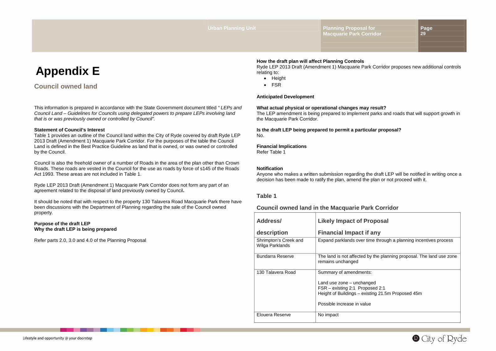
Appendix E Council owned land
This information is prepared in accordance with the State Government document titled “ LEPs and Council Land – Guidelines for Councils using delegated powers to prepare LEPs involving land that is or was previously owned or controlled by Council”. Statement of Council’s Interest Table 1 provides an outline of the Council land within the City of Ryde covered by draft Ryde LEP 2013 Draft (Amendment 1) Macquarie Park Corridor. For the purposes of the table the Council Land is defined in the Best Practice Guideline as land that is owned, or was owned or controlled by the Council. Council is also the freehold owner of a number of Roads in the area of the plan other than Crown Roads. These roads are vested in the Council for the use as roads by force of s145 of the Roads Act 1993. These areas are not included in Table 1. Ryde LEP 2013 Draft (Amendment 1) Macquarie Park Corridor does not form any part of an agreement related to the disposal of land previously owned by Council. It should be noted that with respect to the property 130 Talavera Road Macquarie Park there have been discussions with the Department of Planning regarding the sale of the Council owned property. Purpose of the draft LEP Why the draft LEP is being prepared Refer parts 2.0, 3.0 and 4.0 of the Planning Proposal
How the draft plan will affect Planning Controls Ryde LEP 2013 Draft (Amendment 1) Macquarie Park Corridor proposes new additional controls relating to:
• Height • FSR
Anticipated Development What actual physical or operational changes may result? The LEP amendment is being prepared to implement parks and roads that will support growth in the Macquarie Park Corridor. Is the draft LEP being prepared to permit a particular proposal? No. Financial Implications Refer Table 1 Notification Anyone who makes a written submission regarding the draft LEP will be notified in writing once a decision has been made to ratify the plan, amend the plan or not proceed with it.
Table 1
Council owned land in the Macquarie Park Corridor
Address/
description
Likely Impact of Proposal
Financial Impact if any Shrimpton’s Creek and Wilga Parklands
Expand parklands over time through a planning incentives process
Bundarra Reserve
The land is not affected by the planning proposal. The land use zone remains unchanged
130 Talavera Road Summary of amendments: Land use zone – unchanged FSR – existing 2:1 Proposed 2:1 Height of Buildings – existing 21.5m Proposed 45m Possible increase in value
Elouera Reserve
No impact

Urban Planning Unit Planning Proposal for Macquarie Park Corridor
Page 30
Urban Planning Unit Planning Proposal for Macquarie Park Corridor
Page 31
Appendix F S117 Ministerial Directions
Urban Planning Unit Planning Proposal for Macquarie Park Corridor
Page 32
Appendix G
Architectus (2013) Draft Macquarie Park Guideline for Un-deferrals and Delivery of Public Infrastructure

Urban Planning Unit Planning Proposal for Macquarie Park Corridor
Page 33
Urban Planning Unit Planning Proposal for Macquarie Park Corridor
Page 34
Appendix H
Gateway Determination dated 6.12.2011

Urban Planning Unit Planning Proposal for Macquarie Park Corridor
Page 35

Urban Planning Unit Planning Proposal for Macquarie Park Corridor
Page 36
Appendix I
Council Report Macquarie Park Review of Planning Controls (Ryde LEP Amendment 1) and Minutes 9 April 2013