The Pisco, Peru, Earthquake of August 15, 2007 · 2009-07-13 · on the south coast of the Paracas...
12
EERI Special Earthquake Report — October 2007 Learning from Earthquakes The Pisco, Peru, Earthquake of August 15, 2007 EERI team leader Eduardo A. Fierro of BFP Engineers, Inc. (Bertero, Fierro, Perry), in Berkeley, Califor- nia, visited the area affected by the earthquake August 18-24, 2007. Professor Marcial Blondet of the Pontificia Universidad Católica del Perú (PUCP) in Lima participated as an in-country member of the EERI team, providing critical assis- tance in the field. Other members of the EERI team included Donald Ballantyne of ABS Consulting, Inc., in Tacoma, Washington; Mikael Gartner of Nabih Youssef & Asso- ciates in Los Angeles, California; Adolfo Matamoros of the University of Kansas; Kim Shoaf and Alina Dorian of the Center for Public Health and Disasters at the Uni- versity of California at Los Ange- les; and Hope Seligson of MMI Engineering in Huntington Beach, California. EERI collaborated with many other investigators in the field, including Liliana Pinto and Kent Yu of Degenkolb Engineers, Mario Rodriguez of UNAM, San- tiago Pujol of Purdue University, and Arturo Schultz of the University of Minnesota, representing The Masonry Institute. Adrian Rodriguez-Marek of Wash- ington State University led the Geo- Engineering Earthquake Recon- naissance (GEER) team and also served as a member of the EERI team. His team included Brady Cox of the University of Arkansas; Jorge Meneses of Kleinfelder, Inc., in San Diego, California; Viviana Moreno and Manuel Olcese of PUCP; Rodolfo Sancio of Golder Associates in Houston, Texas; and Joseph Wartman of Drexel Univer- sity in Philadelphia, Pennsylvania. A tsunami reconnaissance team was composed of Hermann Fritz (team leader) of the Georgia In- stitute of Technology, Nikos Kalli- geris of the Technical University of Crete, and Erick Ortega and Pablo Broncano of Direccion de Hidrografia y Navegacion of the Peruvian Navy. The teams visited the following cities: Pisco, Chincha, Canete, Ica, San Andres, Tambo de Mora and Lima. All cities were within 97 km of the epicenter, with the exception of Lima, located about 145 km away. The EERI team joined up with the PUCP team led by Nicola Tarque, who start- ed the site inspection on August 17. The PUCP team included Luis Carlos Fernandez and Jesus Carpio from PUCP, and Eric Hulburd from Stan- ford University. The EERI team and the publication of this Learning from Earthquakes re- port were supported by the National Science Foundation through grant #CMII-0131895. NSF supported the GEER team and the tsunami survey team through grants #CMII-0323914 and CMS-0646278, respectively. Introduction The Mw 8.0 Pisco earthquake struck at 6:40 p.m. local time. The epicenter was about 45 km west-northwest of Chincha Alta, or about 45 km south- southeast of Lima. At least 59 peo- ple were killed and ,090 were in- jured. The majority of the damage and casualties occurred in Chincha Alta, Ica, and Pisco (Figure ). Most of the buildings destroyed were adobe housing. Hospitals, schools, and other medium-to-large public buildings were also damaged. Most of these buildings are built using reinforced concrete frames and infill brick masonry rigidly attached to the frames. Widespread communications and power outages occurred in the area. The Pan American Highway, the Carretera Central, and other main transport routes suffered heavy damage due to landslides and liquefaction. A small tsunami resulted in wave heights of 00 cm at Callao and La Punta, Peru; 36 cm at Arica, 28 cm at Coquimbo, and 7 cm at Valparaiso, Chile. Seismological Aspects The Pisco earthquake was the re- sult of the subduction process be- tween the Nazca plate and the South American continental plate. This subduction process results in a high rate of seismicity along the Figure 1. Overview map and Paracas peninsula detail map showing reconnais- sance track with tsunami survey loca- tions, gener- alized runup heights, and earthquake location. (Background satellite imagery: Europa Technologies/Google Earth)
Transcript of The Pisco, Peru, Earthquake of August 15, 2007 · 2009-07-13 · on the south coast of the Paracas...

�
EERI Special Earthquake Report — October 2007
Learning from Earthquakes
The Pisco, Peru, Earthquake of August 15, 2007
EERI team leader Eduardo A. Fierro of BFP Engineers, Inc. (Bertero, Fierro, Perry), in Berkeley, Califor-nia, visited the area affected by the earthquake August 18-24, 2007. Professor Marcial Blondet of the Pontificia Universidad Católica del Perú (PUCP) in Lima participated as an in-country member of the EERI team, providing critical assis-tance in the field. Other members of the EERI team included Donald Ballantyne of ABS Consulting, Inc., in Tacoma, Washington; Mikael Gartner of Nabih Youssef & Asso-ciates in Los Angeles, California; Adolfo Matamoros of the University of Kansas; Kim Shoaf and Alina Dorian of the Center for Public Health and Disasters at the Uni-versity of California at Los Ange-les; and Hope Seligson of MMI Engineering in Huntington Beach, California. EERI collaborated with many other investigators in the field, including Liliana Pinto and Kent Yu of Degenkolb Engineers, Mario Rodriguez of UNAM, San-tiago Pujol of Purdue University, and Arturo Schultz of the University of Minnesota, representing The Masonry Institute.
Adrian Rodriguez-Marek of Wash-ington State University led the Geo- Engineering Earthquake Recon-naissance (GEER) team and also served as a member of the EERI team. His team included Brady Cox of the University of Arkansas; Jorge Meneses of Kleinfelder, Inc., in San Diego, California; Viviana Moreno and Manuel Olcese of PUCP; Rodolfo Sancio of Golder Associates in Houston, Texas; and Joseph Wartman of Drexel Univer-sity in Philadelphia, Pennsylvania.
A tsunami reconnaissance team was composed of Hermann Fritz (team leader) of the Georgia In-stitute of Technology, Nikos Kalli-geris of the Technical University of
Crete, and Erick Ortega and Pablo Broncano of Direccion de Hidrografia y Navegacion of the Peruvian Navy.
The teams visited the following cities: Pisco, Chincha, Canete, Ica, San Andres, Tambo de Mora and Lima. All cities were within 97 km of the epicenter, with the exception of Lima, located about 145 km away. The EERI team joined up with the PUCP team led by Nicola Tarque, who start-ed the site inspection on August 17. The PUCP team included Luis Carlos Fernandez and Jesus Carpio from PUCP, and Eric Hulburd from Stan-ford University.
The EERI team and the publication of this Learning from Earthquakes re-port were supported by the National Science Foundation through grant #CMII-0131895. NSF supported the GEER team and the tsunami survey team through grants #CMII-0323914 and CMS-0646278, respectively.
IntroductionThe Mw 8.0 Pisco earthquake struck at 6:40 p.m. local time. The epicenter was about 45 km west-northwest of Chincha Alta, or about �45 km south- southeast of Lima. At least 5�9 peo-
ple were killed and �,090 were in-jured. The majority of the damage and casualties occurred in Chincha Alta, Ica, and Pisco (Figure �). Most of the buildings destroyed were adobe housing. Hospitals, schools, and other medium-to-large public buildings were also damaged. Most of these buildings are built using reinforced concrete frames and infill brick masonry rigidly attached to the frames.
Widespread communications and power outages occurred in the area. The Pan American Highway, the Carretera Central, and other main transport routes suffered heavy damage due to landslides and liquefaction. A small tsunami resulted in wave heights of �00 cm at Callao and La Punta, Peru; 36 cm at Arica, 28 cm at Coquimbo, and �7 cm at Valparaiso, Chile.
Seismological AspectsThe Pisco earthquake was the re- sult of the subduction process be-tween the Nazca plate and the South American continental plate. This subduction process results in a high rate of seismicity along the
Figure 1. Overview map and Paracas peninsula detail map showing reconnais-sance track with tsunami survey loca- tions, gener-alized runup heights, and earthquake location.
(Background satellite imagery: Europa Technologies/Google Earth)

2
EERI Special Earthquake Report — October 2007
coasts of Peru and Chile. The earth-quake was an interface event and occurred on a previously identified seismic gap between the rupture areas of the �974 Lima and the �996 Nazca earthquakes (Tavera and Bernal, 2005). The earthquake
had a moment magnitude (Mw) of 8.0 (USGS, Harvard CMT), and the hypo-center was located at �3.76S and 76.97W, at a depth of 39 km (USGS).
Fault rupture propagated south from the hypocenter (Tavera et al., 2007). The finite fault solution of Ji and Zeng
ground surface projection of the fault plane.
The earthquake was recorded at �6 stations within �50 km of the fault plane. All of the stations except fortwo in Ica are located approximate-ly �00 km to the north in the vicinity of Lima. A pattern of higher PGAs at soil stations was observed; addi-tional evidence of site effects isseen by the distinctly different spec-tral shapes observed in the four CISMID stations (Figure 2), which are located in three different soil types. Site effects are manifested by significant amplification over period bands that are compatible with the general site description (i.e., shallow, stiff soil deposits at La Molina, and soft soils at Callao).
Figure 3 shows the ground motion record from La Molina. It shows two phases of strong ground motion, which correspond to slip along two asperities in the finite fault solution of Ji and Zeng. The overall shape of the acceleration time history is simi-lar for other ground motion stations.
All the strong motion records had long durations of strong shaking. For example, for the La Molina rec-
Figure 2. East-west spectral accelerations recorded by CISMID stations (from Lazares et al., 2007). All stations are located ata range of 96-111 km from the fault plane. The Rimac and SanIsidro stations are located on dense, stiff gravel deposits (re- ferred to as Lima Conglomerate); the La Molina station is lo-cated on shallow soil overlying the denser Lima Conglomerate; the Callao station is located on soft soil.
Figure 3. Acceleration, velocity, and displacement time histories for the La Molina record (stiff soil).
(2007) indicates a rupture plane with a strike of 324º and a dip of 27º, having approxi-mate dimensions of �90 km along strike and 95 km along dip. The locations of after- shock hypocen-ters match this fault plane (Tav-era et al., 2007). The shallow dipand large width of the fault planeimplies that the cities most affect-ed by the earth-quake (Pisco and Ica) lie within the
Figure 4. Approximate area of seaward lateral displace-ment of a marine terrace in Canchamana (background image from Google Earth).

3
EERI Special Earthquake Report — October 2007
ord, the 5-95% significant duration (Trifunac and Brady, �975) is �0�.3 seconds and the bracketed dura-tion (duration of ground motion higher than 0.05g) is 98.6 seconds. A duration of approximately �00 seconds is significantly longer than the duration expected for earth-quakes of similar magnitude from shallow crustal events (the attenu-ation relationships of Abrahamson and Silva [�996], developed using data from shallow crustal events, predicts a median duration of 48 seconds for a Mw 8.0 earthquake).
Geotechnical Aspects The Pisco earthquake caused a significant amount of soil liquefac-tion in the mesoseismal zone which resulted in considerable damage to urban areas and to the transporta-tion infrastructure. In addition to liq- uefaction, there were a significant number of landslides in road cuts and natural terrain. Landslides were responsible for the three-day clos-ing of the east-west Highway 24A.
The earthquake spawned a wide variety of liquefaction failures. No-table liquefaction-induced damage included a massive lateral spread extending over approximately 3 km (Figure 4), a 400 m-long slope fail- ure induced by liquefaction at the toe, spectacular one- to two-story building foundation failures result-ing in up to 0.90 m of settlement (Figure 5), numerous highway
embankments damaged by lateral spreading, toppling of power poles founded in liquefied soil, rupture of water and sewer lines, and disruption to port facilities. The liquefaction at each of these sites was confirmed by either the presence of sand boils at the ground surface or wet sand ejecta in open cracks. The spatial distribu-tion of observed and reported lique-faction features along the Peru cen-tral coast ranged from Villa, just south of Lima and approximately 90 km north of the rupture plane, to Paracas in the south (the southern limit of our reconnaissance), approximately 24 km from the rupture plane, and Ica in the east, about 40 km from the fault plane. Within this region, liquefaction was widespread wherever the ground water table was shallow. The north-ernmost liquefaction site, in the Villa neighborhood of Lima, occurred in a swampy area.
The massive liquefaction-induced seaward displacement of a marine terrace in Canchamaná, 2.5 km north of Tambo de Mora, was � km wide by 3 km long (Figure 4). The eastern boundary of the lateral spread was defined by the interface between a Holocene marine terrace and the Pleistocene Cañete formation. The southern boundary appeared to be defined by the interface of the marine terrace with a Holocene alluvial sand deposit. The northern boundary was
Figure 6. Maximum vertical offset of approximately 3.0 m along the interface between the marine terrace deposit and the Cañete formation in the Canchamana lateral slide.
Figure 5. Approximately 0.9 m of liquefaction-induced settlement at a one-story residence in Tambo de Mora.
not firmly established, but appeared to be influenced by the presence of human-made works at a bend in the Pan American highway. The west-ward slope of the marine terrace surface was approximately �.6 to 2.� %. A clear vertical offset (scarp) of variable magnitude was observed along much of the geological inter-face between the marine terrace and the Cañete formation (Figure 6). In addition to the main scarp at the interface, numerous extensional ground cracks developed across the marine terrace parallel to the coastline. In general, the cracks were largest (both in terms of hori-zontal and vertical displacement) near the scarp and became smaller towards the coastline. Some crack widths were as large as � m and sand ejecta was found inside many of them.
TsunamiThe earthquake was centered 35 km offshore from Chincha Alta on Peru’scentral coastline. A number of near-by villages felt the earthquake, in-cluding all those affected by the tsu-nami in any way. Unfortunately, the closest tide gauge — located 55 km south of the epicenter at the Puerto General San Martin — was dam- aged by the earthquake and unable to record the tsunami. Peruvian Coast Guard personnel at countless

4
EERI Special Earthquake Report — October 2007
outposts were alerted by the earth-quake and triggered evacuations in affected fishing villages in the short time window of �0-20 minutes between the earthquake and the arrival of the tsunami. However,warnings did not reach Lagunilla, on the south coast of the Paracas peninsula, where three of the sev- en inhabitants were washed away and their bodies recovered up to �.8 km inland. Although the resi-dents of Lagunilla had felt the earthquake, they were unaware of the post-earthquake tsunami haz-ard, so the event failed to trigger a spontaneous self-evacuation.
The International Tsunami Survey Team measured local flow depths and tsunami heights, maximum run- up, and inundation distances; re-corded structural damage; and inter- viewed eyewitnesses per estab-lished methods (Synolakis and Okal, 2005). Eyewitnesses described be- tween one and four main waves with an initial recession correspond- ing to a leading depression N-wave(Tadepalli and Synolakis, �996). More than 50 transects were record-ed from the waterline to the inunda-tion limit and adjusted for tide levels upon tsunami arrival.
The tsunami runup distribution peaked south of the Paracas penin- sula with a �0 m runup, and sus-tained a runup in excess of 7 m along 5 km of coastline. Fortunate-
ly, the tsunami peaked in a mostly un-inhabited desert area. At Lagunilla, the tsunami flooded up to 2 km inland over extremely flat terrain, with 4 m runup at the inundation limit and 5-6 m runup at the village on the shore-line (Figure 7). Similar runup heights and flow depths during the 2004 In-dian Ocean tsunami resulted in much higher death tolls in Sri Lanka (Liu et al., 2005) and Somalia (Fritz and Bor-rero, 2006).
In Paracas, there was damage to thedock, a fixed platform supported by piles embedded in sand with a float-ing platform at the end. The sand supporting the dock liquefied and the piles lost bearing capacity and sank differentially into the sand up to approximately 30 cm, while thefloating dock rose with the tsunami and became stuck when the water level went down (Figure 8).
To the north of the Paracas penin-sula, the tsunami runup was roughly halved, with characteristic runup heights of 3 m. Boats were washed into the streets in Pisco, and the Tam-bo de Mora prison partially flooded in Chincha Alta. The prison compound walls had collapsed in the earth-quake, so luckily the 600 prisoners were gone prior to the tsunami arrival.
This earthquake demonstrates that community-based education and awareness programs are particularly essential to help save lives in locales at risk from near-source tsunamis
(Sieh, 2006), and that critical facili-ties such as hospitals, schools, and prisons should not be located in tsu-nami hazard and flood zones. This is of particular importance for Peru, given the fairly frequent moderate-size tsunamis such as the 200� Camana tsunami in southern Peru, the �996 Chimbote tsunami in northern Peru, and the �974 tsu-nami in the same area as this event.
AdobeThe earthquake caused enormous damage to earthen buildings in theaffected area. Adobe construction is widespread in Peru; most houses over 50 years old are made of adobe and, although confined masonry is becoming the preferred construction technique for families who can afford it, adobe is still the only viable alternative for many fam-ilies. On the Peruvian coast, most adobe houses are one story high. When the house has two stories, the second story is usually built with quincha, a series of wooden frames filled with crushed cane, covered with mud and plastered with mud or gypsum. Since it does not rain on most of the Peruvian coast, roofs are horizontal and flat, and consist of wooden joists supported directly on the adobe walls and covered by wooden planks or a layer of crushed cane, sometimes also covered by straw mats (esteras) and then plas-tered with mud.
Figure 7. Debris on the shore at the fishing village of Lagunilla, which was completely destroyed by the tsunami.
Figure 8. Paracas marina tsunami height measured based on a floating dock stuck in an uplifted position.

5
EERI Special Earthquake Report — October 2007
Wall thickness and height depend mostly on the age of the dwelling: older houses have thicker, taller walls (up to 0.80 m thick, 4 m high; with slenderness ratios of 5-6). Contemporary houses have thinner, shorter walls (typically 0.25 m thick, 2,5 m high, with slenderness ratios of 8-�0 or higher). Interior walls and partitions are made of adobe or quincha. The walls are not provided with additional reinforcement to withstand seismic forces. In short, adobe walls are massive, weak andbrittle. Since they are massive, theyattract large inertia forces during seismic shaking, which they are un-able to resist because the masonry is weak, and brittle failure occurs without warning. The duration of shaking in this earthquake — about �00 seconds — also contributed to the many collapses.
That more people were not killed in their adobe houses is attrib- utable in part to the fact that Peru- vians usually run out of their houses when they feel an earthquake. The team spoke with a number of people who watched their houses collapse after they got out of them.
In Pisco, closest to the epicenter, more than 80% of the adobe houses col-lapsed or sustained heavy damage (Figure 9). Apparently, the adobe blocks and mortar in the Pisco and surrounding areas were made with sandy soil, which did not have suffi-cient clay to provide good adhesion between mortar and adobe blocks.
The most common type of failure ob- served in adobe houses was due to
Figure 9. Street in Pisco three days after the earthquake. The house at the far right, undamaged, was made of confined masonry.
Figure 10. Two collapsed adobe houses in Pisco. The roof joists of the house on the left are supported on the quincha partitions. The roof joists of the house on the right were supported on the façade wall, and thus col-lapsed with the façade. Notice the undamaged confined masonry house at far left.
Figure 11. This undamaged adobe house was reinforced with bands of wire mesh covered with sand-cement mor-tar. Vertical bands were placed at each wall intersection, and horizontal bands at roof level. Notice the collapsed unreinforced wall at the right.
the formation of vertical cracks at the corners of the façade walls as a result of out-of-plane shaking, fol- lowed by the col-lapse of the walls onto the street, and sometimes the collapse of the roof (especially if the roof joists were supported on the façade wall). A top collar beam joining all
walls probably would have been helpful to prevent this type of damage (Figure �0).
City block effect: In Pisco, and in other towns, the seismic separation joints between buildings do not ap-pear to be common practice. Build-ings within a block influenced the performance of their neighboring structures due to direct contact. It appeared that the weakest aligned building system in a block would typically fail, for example, adobe building fronts failed when aligned with brick and/or “confined masonry systems.” The failure of the adobe structures (typically one story) may have served as a dissipater of energy for the rest of the block.
Reinforced adobe: In �999 the Catholic University of Peru (PUCP) reinforced �9 adobe houses in dif-ferent locations of the country. The reinforcement consisted of bands of welded wire mesh nailed to the walls and covered with a cement-sand mortar. Figure �� shows the house that was built in Guadalupe, a small town near Ica. It did not suf- fer any damage during the earth-quake, whereas neighboring unrein- forced houses were damaged or collapsed. This reinforcing system
6
EERI Special Earthquake Report — October 2007
should be used with caution be-cause, although shaking table tests have shown that the strength of the adobe walls is significantly increased, the mode of failure is brittle.
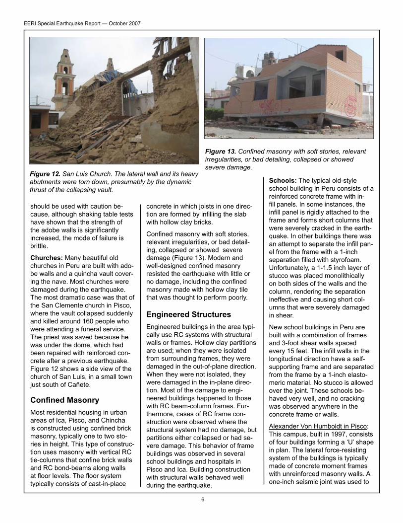
Churches: Many beautiful old churches in Peru are built with ado-be walls and a quincha vault cover-ing the nave. Most churches were damaged during the earthquake. The most dramatic case was that of the San Clemente church in Pisco, where the vault collapsed suddenly and killed around �60 people who were attending a funeral service. The priest was saved because he was under the dome, which had been repaired with reinforced con-crete after a previous earthquake. Figure �2 shows a side view of the church of San Luis, in a small town just south of Cañete.
Confined MasonryMost residential housing in urban areas of Ica, Pisco, and Chincha is constructed using confined brick masonry, typically one to two sto-ries in height. This type of construc-tion uses masonry with vertical RC tie-columns that confine brick walls and RC bond-beams along walls at floor levels. The floor system typically consists of cast-in-place
concrete in which joists in one direc-tion are formed by infilling the slab with hollow clay bricks.
Confined masonry with soft stories, relevant irregularities, or bad detail-ing, collapsed or showed severe damage (Figure �3). Modern and well-designed confined masonry resisted the earthquake with little or no damage, including the confined masonry made with hollow clay tile that was thought to perform poorly.
Engineered StructuresEngineered buildings in the area typi- cally use RC systems with structural walls or frames. Hollow clay partitionsare used; when they were isolated from surrounding frames, they were damaged in the out-of-plane direction. When they were not isolated, they were damaged in the in-plane direc- tion. Most of the damage to engi-neered buildings happened to those with RC beam-column frames. Fur- thermore, cases of RC frame con-struction were observed where the structural system had no damage, butpartitions either collapsed or had se-vere damage. This behavior of frame buildings was observed in several school buildings and hospitals in Pisco and Ica. Building construction with structural walls behaved well during the earthquake.
Schools: The typical old-style school building in Peru consists of a reinforced concrete frame with in-fill panels. In some instances, the infill panel is rigidly attached to the frame and forms short columns that were severely cracked in the earth-quake. In other buildings there was an attempt to separate the infill pan- el from the frame with a �-inch separation filled with styrofoam. Unfortunately, a �-�.5 inch layer of stucco was placed monolithically on both sides of the walls and the column, rendering the separation ineffective and causing short col-umns that were severely damaged in shear.
New school buildings in Peru are built with a combination of frames and 3-foot shear walls spaced every 15 feet. The infill walls in the longitudinal direction have a self- supporting frame and are separated from the frame by a �-inch elasto- meric material. No stucco is allowed over the joint. These schools be-haved very well, and no cracking was observed anywhere in the concrete frame or walls.
Alexander Von Humboldt in Pisco:This campus, built in �997, consists of four buildings forming a ‘U’ shape in plan. The lateral force-resisting system of the buildings is typically made of concrete moment frames with unreinforced masonry walls. A one-inch seismic joint was used to
Figure 12. San Luis Church. The lateral wall and its heavy abutments were torn down, presumably by the dynamic thrust of the collapsing vault.
Figure 13. Confined masonry with soft stories, relevant irregularities, or bad detailing, collapsed or showed severe damage.

7
EERI Special Earthquake Report — October 2007
separate the structures at all levels. It appears that no seismic joint was used to separate the main class-room building and the adjacent two-story east wing. Pounding damage was observed throughout the height of the buildings with significantly more damage on the top floors. Al- though compressible foam was used in the seismic joint, grouting was found to infill the top. The main lateral system of all the buildings suffered insignificant damage, but the unreinforced masonry walls suffered significant damage during the earthquake (Figure �4). Most of these walls need to be demolished and replaced. Several partial brick infill walls next to the corridor com-pletely collapsed.
The Instituto Superior Tecnologico Estatal Pisco in Pisco: Designed in �995, this classroom building con-sists of concrete frames with mason- ry fill with floor and roof concrete slabs. In the transverse direction, it has five lines of reinforcement concrete frames. Both the two end frames and the middle frame have two bays with complete masonry infill. The brick infill in the front is about one and half times higher than that in the back, resulting in an aspect ratio of about two and four for the columns in the front
and back, respectively. This resulted in severe shear failure of the columns in the front, which were on the verge of losing gravity-carrying capabili-ties (Figure �5). The windows next to the short columns fractured and fell on the floor. The front masonry infill in the first-story also experienced the moderate diagonal cracking. The partial brick infill created the short column condition, and caused the center columns at the second story to experience shear cracking. The water table at the site is approximately four feet below the ground surface and signs of sand boiling were observed in several locations behind the build-ing complex.
The University San Luis Gonzaga in Ica: Many buildings were damaged here due to the presence of short columns (Figure �6). Some of the building had the infill panels isolated from the frames. These panels were supported by a frame for the out of plane forces. The connection of this frame to the main frame was inade-quate. With the bars anchored only 4-5 inches into the main frame, the out-of-plane forces made these frame collapse or nearly so.
Hospitals: The Hospital Regional De Referencia Ica: The largest hospital in the region, it comprises approximate-ly �6 buildings, most of which were designed and constructed in �964. The main hospital consists of three four-story wings in a T configura-tion and a five-story elevator tower
Figure 14. Extensive masonry wall damage.
Figure 15. Shear failure of short col-umns next to corridor.
Figure 16. Damaged building at the University San Luis Gonzaga due to short columns.
in the center, separated with a 2-inch seismic joint at all levels. Exterior moment frames of each wing typically showed no sign of stress except significant pounding between the wings and the elevator tower. The infill walls at the corridor experienced extensive damage of architectural finishes. Mechanical pipes and medical equipment and supply racks were not seismically braced, resulting in extensive non-structural damage. As a result of extensive damage to architectural and mechanical components, the main hospital was abandoned.
San Jose Hospital in Chincha: Thesecond largest hospital in the re-gion consists of mostly one-story structures. After a seismic assess-ment of the hospital was completed about three years ago, the old hos-pital buildings are being replaced, including many adobe buildings. At the time of the earthquake, at least three new reinforced CMU build-ings were near the completion of construction, and they performed very well. Several adobe buildings used for storage, as a morgue, and to house the emergency generator

8
EERI Special Earthquake Report — October 2007
experienced partial collapse. The hospital had to borrow a new emer- gency generator for emergency treatment. Other existing engi-neered structures built in �989 performed well, except that one corridor structure experienced sig-nificant damage due to pounding because the contractor used the grouting to infill the seismic joint.
The mechanical pipes, mechanical and medical equipment, and supply racks were typically not seismically braced, so a majority of the medical
supplies were destroyed, and the hospital was without oxygen, elec-tricity or water for a couple of days. The patients stayed outside for four days after the quake and then moved into the newly constructed buildings.
Pisco Hospital: The Pisco Hospital has about �8 structures, two of which were reinforced concrete wall buildings and near the comple-tion of construction. The majority of the original hospital buildings were
one-story rectangular buildings constructed about 74 years ago (Figure �7).
The only original construction that did not experience some structural damage was the kitchen/mechani-cal equipment building. This is due to its lateral force system of mul-tiple lines of concrete shear walls in each direction. After the earth-quake, the hospital salvaged medi-cal beds and medical equipment and supplies and moved them into the newly constructed buildings. Figure �8 shows the structural dam- age to an original building with window openings at one end and a door opening at the other end. Significant torsional response of this building caused the wall piers adjacent to the windows to suffer more damage, resulting in the out-of-place collapse of the windows and the walls. Figure �9 shows damage to a reinforced concrete building.
Lifelines Bridges: The two major roadways crossing the epicentral region are the Pan American Highway, which runs north-south along the Pacific Coast, and the Carretera los Liber- tadores, which runs approximately east-west, linking Pisco to Ayacu-cho. These two roads intersect at the town of San Clemente. The Carretera runs along the Pisco
Figure 17. Damage to Pisco Hospital. Figure 18. Damage to a Pisco Hospital building with win-dow openings at one end and a door opening at the other.
Figure 19. Damage to a reinforced concrete building at Pisco Hospital.
9
EERI Special Earthquake Report — October 2007
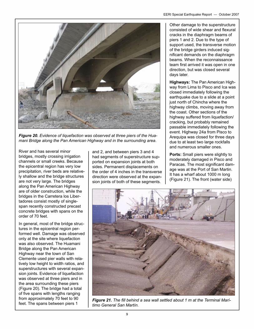
River and has several minor bridges, mostly crossing irrigation channels or small creeks. Because the epicentral region has very low precipitation, river beds are relative-ly shallow and the bridge structures are not very large. The bridges along the Pan American Highway are of older construction, while the bridges in the Carretera los Liber-tadores consist mostly of single-span recently constructed precast concrete bridges with spans on the order of 70 feet.
In general, most of the bridge struc- tures in the epicentral region per- formed well. Damage was observed only at the site where liquefaction was also observed. The Huamani Bridge along the Pan American Highway near the town of San Clemente used pier walls with rela-tively low height to width ratios, and superstructures with several expan-sion joints. Evidence of liquefaction was observed at three piers and in the area surrounding these piers (Figure 20). The bridge had a total of five spans with lengths rangingfrom approximately 70 feet to 90 feet. The spans between piers �
Other damage to the superstructure consisted of wide shear and flexural cracks in the diaphragm beams of piers � and 2. Due to the type of support used, the transverse motion of the bridge girders induced sig-nificant demands on the diaphragm beams. When the reconnaissance team first arrived it was open in one direction, but was closed several days later.
Highways: The Pan American High- way from Lima to Pisco and Ica was closed immediately following the earthquake due to a slide at a point just north of Chincha where the highway climbs, moving away from the coast. Other sections of the highway suffered from liquefaction/cracking, but probably remained passable immediately following the event. Highway 24a from Pisco to Arequipa was closed for three days due to at least two large rockfalls and numerous smaller ones.
Ports: Small piers were slightly to moderately damaged in Pisco and Paracas. The most significant dam-age was at the Port of San Martin. It has a wharf about �000 m long (Figure 2�). The front (water side)
Figure 20. Evidence of liquefaction was observed at three piers of the Hua-mani Bridge along the Pan American Highway and in the surrounding area.
Figure 21. The fill behind a sea wall settled about 1 m at the Terminal Marí-timo General San Martín.
and 2, and between piers 3 and 4 had segments of superstructure sup-ported on expansion joints at both sides. Permanent displacements on the order of 4 inches in the transverse direction were observed at the expan-sion joints of both of these segments.

�0
EERI Special Earthquake Report — October 2007
20 m is pile-supported. The fill be-hind a sea wall settled about � m and pushed the wall towards the piles, slightly bending them. A ware- house just behind sea wall has pile- supported walls. The floor and sur-rounding area settled about 60 cm, with extensive evidence of liquefac-tion.
Gas/Liquid Fuels: There is no gas distribution system; gas is distrib-uted in bottles. There is a gas line coming down from the Andes; the gas is liquefied at a facility in Pisco and loaded onto ships in an off-shore facility. There was no damage observed at any of these facilities.
Electric Power: Hydro-generated electricity comes down from the Andes to a substation in Indepen-dencia. There was no apparent damage to the substation. Power is then distributed at 60 KV from this substation through seven circuits serving Pisco, Ica, and Paracas. On the circuit serving Paracas/San Andreas, three poles broke. The two transformers at this substation (60 KV> �0 KV) rolled on their tracks, resulting in broken insula-tors where the wire connections were fixed. The building housing the substation had only slight struc-tural damage. Substations were back on line within a day. There
were many broken poles, poles that toppled in liquefiable soils, and drops that were cut when buildings col-lapsed, particularly in Pisco.
Communications: The hardwired system failed, but cell systems were generally functional. In the main town square of Pisco, temporary phone booths were installed for civilian use (Figure 22). After the earthquake severed the electrical power grid, the Pisco hospital started its back-up generators and allowed residents to charge their cellular phones. The hos-pital also operated by cell phone to coordinate their post-disaster efforts and coordinate their needs with the Peruvian Department of Health.
Water: Pisco gets its water from a infiltration gallery 30 km east of town. Damage to the pipeline (AC and rein-forced concrete) along the transmis-sion line into town reduced the flow from 300 lps to about �70 lps. Water was distributed from the operations center by tank truck. The Pisco system had one �400 m3 concrete elevated tank where the operations center is located, and one 4500 m3 ground-level tank. The elevated tank support structure had spalling at the joints. The ground level tank ap-peared to be OK. Tambo de Mora gets water from Chincha Baja. The transmission line connecting the two
was broken so Tambo de Mora had no water.
Wastewater: There is a wastewater system in Pisco. The collection sys-tem was heavily damaged and will probably need to be replaced. Their treatment plant was undamaged, but no sewage could flow to it.
Human Impacts As of August 3�, 463 deaths were estimated for the City of Pisco alone, with 340 listed by name in a local newspaper (El Libertador, Ano XVII, No. �93, Setiembre 2007). This total does not include injured that were transferred to Lima or other hospitals, and 42 reported missing.
Most are assumed to have resulted from building collapse. Of these, �48 happened in the collapse of the Cathedral de San Clemente located at the Plaza de las Armas, where only two survivors were pulled from the debris by search and rescue teams. Another significant building collapse was at the Embassy Hotel, where at least �5 people (MSNBC.COM) were killed when the bottom two stories of the 5-story structure collapsed. Pisco residents reported that the mass burial of the dead pro-ceeded rapidly, but that the families of the dead were responsible for providing caskets. Many families could not afford caskets and, in any event, casket suppliers could not meet the demand, so some bodies were buried wrapped only in blankets.
There are more data available on earthquake-related injuries. The main building at the tertiary care hospital in Pisco collapsed, requir-ing transport by ambulance of �92 significantly injured patients to other hospitals in Lima and Ica. Epidemio- logical data collected by the Ministryof Health indicate a total of 2,6�5 in-juries between August �5 and Sep-tember 3. The Ministry of Health’s lead physician deployed to Pisco indicated that they were currently treating the third wave of injuries,
Figure 22. Temporary phone booths were installed for civilian use in Pisco.
��
EERI Special Earthquake Report — October 2007
associated with clean-up and debris removal. The first treatment peak took place on the day after the earthquake; the second was 5-7 days after the earthquake.
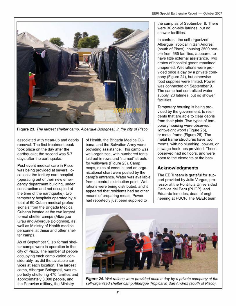
Post-event medical care in Pisco was being provided at several lo-cations: the tertiary care hospital (operating out of their new emer-gency department building, under construction and not occupied at the time of the earthquake), two temporary hospitals operated by a total of 60 Cuban medical profes-sionals from the Brigada Medica Cubana located at the two largest formal shelter camps (Albergue Grau and Albergue Bolognesi), as well as Ministry of Health medical personnel at these and other shel-ter camps.
As of September 9, six formal shel- ter camps were in operation in thecity of Pisco. The number of people occupying each camp varied con- siderably, as did the available ser- vices at each location. The largestcamp, Albergue Bolognesi, was re- portedly sheltering 470 families andapproximately 3,000 people, and the Peruvian military, the Ministry
of Health, the Brigada Medica Cu-bana, and the Salvation Army were providing assistance. This camp was well-organized, with numbered tents laid out in rows and “named” streets for walkways (Figure 23). Camp maps, rules of conduct and an orga-nizational chart were posted by the camp’s entrance. Water was available from a central distribution point. Wet rations were being distributed, and it appeared that residents had no other means of preparing meals. Power had reportedly just been supplied to
Figure 23. The largest shelter camp, Albergue Bolognesi, in the city of Pisco.
the camp as of September 8. There were 30 on-site latrines, but no shower facilities.
In contrast, the self-organized Albergue Tropical in San Andres (south of Pisco), housing 2500 peo-ple from 585 families, appeared to have little external assistance. Two crates of hospital goods remained unopened. Wet rations were pro- vided once a day by a private com-pany (Figure 24), but otherwise food supplies were limited. Power was connected on September 9. The camp had centralized water supply, 23 latrines, but no shower facilities.
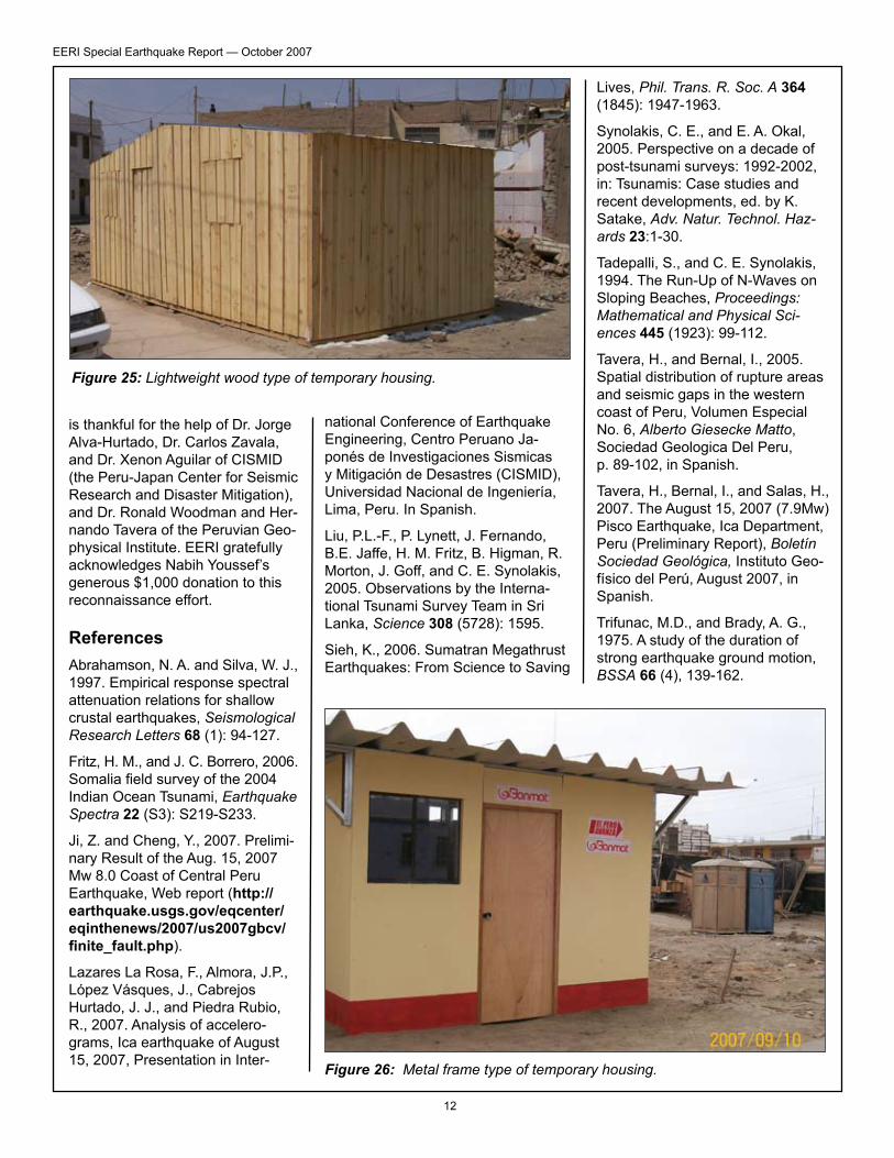
Temporary housing is being pro-vided by the government, to resi-dents that are able to clear debris from their plots. Two types of tem- porary housing were observed: lightweight wood (Figure 25), or metal frame (Figure 26). The metal frame structures have two rooms, with no plumbing, pow-er, or sewage hook-ups provided. Those observed had no floors, and were open to the elements at the back.
AcknowledgmentsThe EERI team is grateful for sup- port provided by Julio Vargas, pro-fessor at the Pontificia Universidad Católica del Perú (PUCP), and Eduardo Ismodes, dean of engi-neering at PUCP. The GEER team
Figure 24. Wet rations were provided once a day by a private company at the self-organized shelter camp Albergue Tropical in San Andres (south of Pisco).
�2
EERI Special Earthquake Report — October 2007
is thankful for the help of Dr. Jorge Alva-Hurtado, Dr. Carlos Zavala, and Dr. Xenon Aguilar of CISMID (the Peru-Japan Center for Seismic Research and Disaster Mitigation), and Dr. Ronald Woodman and Her-nando Tavera of the Peruvian Geo-physical Institute. EERI gratefully acknowledges Nabih Youssef’s generous $�,000 donation to this reconnaissance effort.
ReferencesAbrahamson, N. A. and Silva, W. J., �997. Empirical response spectral attenuation relations for shallow crustal earthquakes, Seismological Research Letters 68 (�): 94-�27.
Fritz, H. M., and J. C. Borrero, 2006. Somalia field survey of the 2004 Indian Ocean Tsunami, Earthquake Spectra 22 (S3): S2�9-S233.
Ji, Z. and Cheng, Y., 2007. Prelimi- nary Result of the Aug. �5, 2007 Mw 8.0 Coast of Central Peru Earthquake, Web report (http://earthquake.usgs.gov/eqcenter/eqinthenews/2007/us2007gbcv/finite_fault.php).
Lazares La Rosa, F., Almora, J.P., López Vásques, J., Cabrejos Hurtado, J. J., and Piedra Rubio, R., 2007. Analysis of accelero-grams, Ica earthquake of August �5, 2007, Presentation in Inter-
Figure 25: Lightweight wood type of temporary housing.
Figure 26: Metal frame type of temporary housing.
national Conference of Earthquake Engineering, Centro Peruano Ja-ponés de Investigaciones Sismicas y Mitigación de Desastres (CISMID), Universidad Nacional de Ingeniería, Lima, Peru. In Spanish.
Liu, P.L.-F., P. Lynett, J. Fernando, B.E. Jaffe, H. M. Fritz, B. Higman, R. Morton, J. Goff, and C. E. Synolakis, 2005. Observations by the Interna-tional Tsunami Survey Team in Sri Lanka, Science 308 (5728): �595.
Sieh, K., 2006. Sumatran Megathrust Earthquakes: From Science to Saving
Lives, Phil. Trans. R. Soc. A 364 (�845): �947-�963.
Synolakis, C. E., and E. A. Okal, 2005. Perspective on a decade of post-tsunami surveys: �992-2002, in: Tsunamis: Case studies and recent developments, ed. by K. Satake, Adv. Natur. Technol. Haz-ards 23:�-30.
Tadepalli, S., and C. E. Synolakis, �994. The Run-Up of N-Waves on Sloping Beaches, Proceedings: Mathematical and Physical Sci-ences 445 (�923): 99-��2.
Tavera, H., and Bernal, I., 2005. Spatial distribution of rupture areas and seismic gaps in the western coast of Peru, Volumen Especial No. 6, Alberto Giesecke Matto, Sociedad Geologica Del Peru, p. 89-�02, in Spanish.
Tavera, H., Bernal, I., and Salas, H., 2007. The August �5, 2007 (7.9Mw) Pisco Earthquake, Ica Department, Peru (Preliminary Report), Boletín Sociedad Geológica, Instituto Geo-físico del Perú, August 2007, in Spanish.
Trifunac, M.D., and Brady, A. G., �975. A study of the duration of strong earthquake ground motion, BSSA 66 (4), �39-�62.