the KGIS Gazetteer Historical (Retired) Named …...Historical (Retired) Named Features and Places...
35
Historical (Retired) Named Features and Places in Knoxville and Knox County, TN the KGIS Gazetteer Tuesday, December 10, 2019 ©KGIS Historical (Retired) Feature / Place Name Planning Sector Feature Typ Category Community / District City County Neighborhood Apartments https://www.kgis.org/kgismaps/map.htm? Subdivision: Alt_Na 811 East Downtown Apts (Historical) Central City 1 6 https://www.kgis.org/kgismaps/map.htm? Subdivision: Alt_Na Adair Manor Apts (Historical) North City FOUNTAIN CITY 2 5 https://www.kgis.org/kgismaps/map.htm? Subdivision: Alt_Na Altavia Apts (Historical) Central City FORT SANDERS 1 1 https://www.kgis.org/kgismaps/map.htm? Subdivision: Alt_Na Arbor Place North Apts (Historical) East City WHITTLE SPRINGS 2 4 https://www.kgis.org/kgismaps/map.htm? Subdivision: Alt_Na Black Oak Apts (Historical) North County HALLS 7 https://www.kgis.org/kgismaps/map.htm? Subdivision: Alt_Na Bridgecourt Apts (Historical) Central City FORT SANDERS 1 1 https://www.kgis.org/kgismaps/map.htm? Subdivision: Alt_Na Cambridge Arms Apts (Historical) West City LYONS VIEW 4 2 https://www.kgis.org/kgismaps/map.htm? Subdivision: Alt_Na Campus Pointe Apts (Historical) Central City FORT SANDERS 1 1 https://www.kgis.org/kgismaps/map.htm? Subdivision: Alt_Na Carlton Towers Apts (Historical) West City BEARDEN VILLAGE 4 2 https://www.kgis.org/kgismaps/map.htm? Subdivision: Alt_Na Cassell Ridge Apts (Historical) Central City 1 5 https://www.kgis.org/kgismaps/map.htm? Subdivision: Alt_Na Continuum Care Group Home Apts (Historical) North City INSKIP 2 5 https://www.kgis.org/kgismaps/map.htm? Subdivision: Alt_Na Country Meadow Apts (Historical) Northwest Cou 3 https://www.kgis.org/kgismaps/map.htm? Subdivision: Alt_Na Country Oaks Apts (Historical) Northwest City 4 2 https://www.kgis.org/kgismaps/map.htm? Subdivision: Alt_Na Dailey Apts (Historical) Central City FORT SANDERS 1 1 https://www.kgis.org/kgismaps/map.htm? Subdivision: Alt_Na Dawn St Apts (Historical) Central City WEST VIEW 1 3 https://www.kgis.org/kgismaps/map.htm? Subdivision: Alt_Na De Ford Curtis Randell Apts (Historical) Central City FORT SANDERS 1 1 https://www.kgis.org/kgismaps/map.htm? Subdivision: Alt_Na Deane Hill S/D (Historical) West City DEANE HILL 4 2 https://www.kgis.org/kgismaps/map.htm? Subdivision: Alt_Na Eastport Apartments (Historical) Central City FIVE POINTS 1 6 https://www.kgis.org/kgismaps/map.htm? Subdivision: Alt_Na Emerald Woods Apts (Historical) Southwest Cou 3 https://www.kgis.org/kgismaps/map.htm? Subdivision: Alt_Na Evolve Apts (Historical) Central City CUMBERLAND AVENUE ST 9 1 https://www.kgis.org/kgismaps/map.htm? Subdivision: Alt_Na Foxfire West Apts (Historical) West City 4 2 https://www.kgis.org/kgismaps/map.htm? Subdivision: Alt_Na Green Hill Apts (Historical) Central City MORNINGSIDE 1 6 https://www.kgis.org/kgismaps/map.htm? Subdivision: Alt_Na Hayes House Apts (Historical) Central City PARKRIDGE 1 6 https://www.kgis.org/kgismaps/map.htm? Subdivision: Alt_Na Hialeah Apts (Historical) South City VESTAL 9 1 https://www.kgis.org/kgismaps/map.htm? Subdivision: Alt_Na Hidden Ridge Apts (Historical) South City OLD SEVIER 9 1 https://www.kgis.org/kgismaps/map.htm? Subdivision: Alt_Na Huntington Place Apts (Historical) West City POND GAP 4 2 https://www.kgis.org/kgismaps/map.htm? Subdivision: Alt_Na Jefferson Commons Apts (Historical) Central City FORT SANDERS 1 1 https://www.kgis.org/kgismaps/map.htm? Subdivision: Alt_Na Knoxville Place Apts (Historical) Central City FORT SANDERS 9 1 https://www.kgis.org/kgismaps/map.htm? Subdivision: Alt_Na Knoxwood Hills Apts (Historical) East City EAST KNOXVILLE 1 6 https://www.kgis.org/kgismaps/map.htm? Subdivision: Alt_Na Lakeview Apts (Historical) Southwest Cou NORTHSHORE TOWN CEN 4 2 https://www.kgis.org/kgismaps/map.htm? Subdivision: Alt_Na Lakewood Apts (Historical) East City PARK CITY 1 6 https://www.kgis.org/kgismaps/map.htm? Subdivision: Alt_Na Laurel Heights Apts (Historical) Central City FORT SANDERS 1 1 https://www.kgis.org/kgismaps/map.htm? Subdivision: Alt_Na Mansion Apts (Historical) East City BURLINGTON 1 6 https://www.kgis.org/kgismaps/map.htm? Subdivision: Alt_Na Maxey Meadows (Historical) Northwest Cou 3 https://www.kgis.org/kgismaps/map.htm? Subdivision: Alt_Na One Place South Apts (Historical) South City OLD SEVIER 9 1 https://www.kgis.org/kgismaps/map.htm? Subdivision: Alt_Na Parkview West Assisted Living Apts (Historical) Southwest Cou CONCORD 5 https://www.kgis.org/kgismaps/map.htm? Subdivision: Alt_Na Pinecrest Apts (Historical) Central City FORT SANDERS 1 1 https://www.kgis.org/kgismaps/map.htm? Subdivision: Alt_Na Prestwick Ridge Apts (Historical) Central City POND GAP 1 6 https://www.kgis.org/kgismaps/map.htm? Subdivision: Alt_Na Reserve At Westland Apts (Historical) Southwest Cou 5 https://www.kgis.org/kgismaps/map.htm? Subdivision: Alt_Na Riverfront Station Apts (Historical) South City SOUTH WATERFRONT 9 1 https://www.kgis.org/kgismaps/map.htm? Subdivision: Alt_Na Riverwalk (Historical) South City SOUTH WATERFRONT 9 1 https://www.kgis.org/kgismaps/map.htm? Subdivision: Alt_Na Shenandoah Apts (Historical) East City PARK CITY 1 6 https://www.kgis.org/kgismaps/map.htm? Subdivision: Alt_Na Southwood Gardens Apts (Historical) South City OLD SEVIER 9 1 https://www.kgis.org/kgismaps/map.htm? Subdivision: Alt_Na Summit Court Apts (Historical) Central City FORT SANDERS 1 1 https://www.kgis.org/kgismaps/map.htm? Subdivision: Alt_Na Sunchase Apts (Historical) Northwest Cou CEDAR BLUFF 3 https://www.kgis.org/kgismaps/map.htm? Subdivision: Alt_Na Sunflower Apts (Historical) Northwest City MIDDLEBROOK HEIGHTS 4 2 https://www.kgis.org/kgismaps/map.htm? Subdivision: Alt_Na Taliwa Court Apts (Historical) South City SOUTH KNOXVILLE 9 1 https://www.kgis.org/kgismaps/map.htm? Subdivision: Alt_Na The Canyon Apts (Historical) North City INSKIP 2 5 https://www.kgis.org/kgismaps/map.htm? Subdivision: Alt_Na The Cumberland Apts (Historical) Central City CUMBERLAND AVENUE ST 1 1 https://www.kgis.org/kgismaps/map.htm? Subdivision: Alt_Na Tillery Ridge Apts (Historical) Northwest City NORWOOD 3 5 https://www.kgis.org/kgismaps/map.htm? Subdivision: Alt_Na Town View Terrace Apts (Historical) Central City EAST KNOXVILLE 1 6 https://www.kgis.org/kgismaps/map.htm? Subdivision: Alt_Na Viginia Walker Apts (Historical) Northwest City 6 https://www.kgis.org/kgismaps/map.htm? Subdivision: Alt_Na Villas At Wallace Way Apts (Historical) Southwest Cou 4 www.kgis.org Page 1 of 35 ©KGIS Note: POI = Point of Address
Transcript of the KGIS Gazetteer Historical (Retired) Named …...Historical (Retired) Named Features and Places...

Historical (Retired) Named Features and Places in Knoxville and Knox County, TN
the KGIS GazetteerTuesday, December 10, 2019
©KGIS
Historical (Retired) Feature / Place Name Planning Sector Feature Typ
CategoryCommunity / District
City County Neighborhood
Apartmentshttps://www.kgis.org/kgismaps/map.htm? Subdivision: Alt_Na811 East Downtown Apts (Historical) Central City 1 6
https://www.kgis.org/kgismaps/map.htm? Subdivision: Alt_NaAdair Manor Apts (Historical) North City FOUNTAIN CITY 2 5
https://www.kgis.org/kgismaps/map.htm? Subdivision: Alt_NaAltavia Apts (Historical) Central City FORT SANDERS 1 1
https://www.kgis.org/kgismaps/map.htm? Subdivision: Alt_NaArbor Place North Apts (Historical) East City WHITTLE SPRINGS 2 4
https://www.kgis.org/kgismaps/map.htm? Subdivision: Alt_NaBlack Oak Apts (Historical) North County HALLS 7
https://www.kgis.org/kgismaps/map.htm? Subdivision: Alt_NaBridgecourt Apts (Historical) Central City FORT SANDERS 1 1
https://www.kgis.org/kgismaps/map.htm? Subdivision: Alt_NaCambridge Arms Apts (Historical) West City LYONS VIEW 4 2
https://www.kgis.org/kgismaps/map.htm? Subdivision: Alt_NaCampus Pointe Apts (Historical) Central City FORT SANDERS 1 1
https://www.kgis.org/kgismaps/map.htm? Subdivision: Alt_NaCarlton Towers Apts (Historical) West City BEARDEN VILLAGE 4 2
https://www.kgis.org/kgismaps/map.htm? Subdivision: Alt_NaCassell Ridge Apts (Historical) Central City 1 5
https://www.kgis.org/kgismaps/map.htm? Subdivision: Alt_NaContinuum Care Group Home Apts (Historical)
North City INSKIP 2 5
https://www.kgis.org/kgismaps/map.htm? Subdivision: Alt_NaCountry Meadow Apts (Historical) Northwest Cou 3
https://www.kgis.org/kgismaps/map.htm? Subdivision: Alt_NaCountry Oaks Apts (Historical) Northwest City 4 2
https://www.kgis.org/kgismaps/map.htm? Subdivision: Alt_NaDailey Apts (Historical) Central City FORT SANDERS 1 1
https://www.kgis.org/kgismaps/map.htm? Subdivision: Alt_NaDawn St Apts (Historical) Central City WEST VIEW 1 3
https://www.kgis.org/kgismaps/map.htm? Subdivision: Alt_NaDe Ford Curtis Randell Apts (Historical) Central City FORT SANDERS 1 1
https://www.kgis.org/kgismaps/map.htm? Subdivision: Alt_NaDeane Hill S/D (Historical) West City DEANE HILL 4 2
https://www.kgis.org/kgismaps/map.htm? Subdivision: Alt_NaEastport Apartments (Historical) Central City FIVE POINTS 1 6
https://www.kgis.org/kgismaps/map.htm? Subdivision: Alt_NaEmerald Woods Apts (Historical) Southwest Cou 3
https://www.kgis.org/kgismaps/map.htm? Subdivision: Alt_NaEvolve Apts (Historical) Central City CUMBERLAND AVENUE ST 9 1
https://www.kgis.org/kgismaps/map.htm? Subdivision: Alt_NaFoxfire West Apts (Historical) West City 4 2
https://www.kgis.org/kgismaps/map.htm? Subdivision: Alt_NaGreen Hill Apts (Historical) Central City MORNINGSIDE 1 6
https://www.kgis.org/kgismaps/map.htm? Subdivision: Alt_NaHayes House Apts (Historical) Central City PARKRIDGE 1 6
https://www.kgis.org/kgismaps/map.htm? Subdivision: Alt_NaHialeah Apts (Historical) South City VESTAL 9 1
https://www.kgis.org/kgismaps/map.htm? Subdivision: Alt_NaHidden Ridge Apts (Historical) South City OLD SEVIER 9 1
https://www.kgis.org/kgismaps/map.htm? Subdivision: Alt_NaHuntington Place Apts (Historical) West City POND GAP 4 2
https://www.kgis.org/kgismaps/map.htm? Subdivision: Alt_NaJefferson Commons Apts (Historical) Central City FORT SANDERS 1 1
https://www.kgis.org/kgismaps/map.htm? Subdivision: Alt_NaKnoxville Place Apts (Historical) Central City FORT SANDERS 9 1
https://www.kgis.org/kgismaps/map.htm? Subdivision: Alt_NaKnoxwood Hills Apts (Historical) East City EAST KNOXVILLE 1 6
https://www.kgis.org/kgismaps/map.htm? Subdivision: Alt_NaLakeview Apts (Historical) Southwest Cou NORTHSHORE TOWN CEN 4 2
https://www.kgis.org/kgismaps/map.htm? Subdivision: Alt_NaLakewood Apts (Historical) East City PARK CITY 1 6
https://www.kgis.org/kgismaps/map.htm? Subdivision: Alt_NaLaurel Heights Apts (Historical) Central City FORT SANDERS 1 1
https://www.kgis.org/kgismaps/map.htm? Subdivision: Alt_NaMansion Apts (Historical) East City BURLINGTON 1 6
https://www.kgis.org/kgismaps/map.htm? Subdivision: Alt_NaMaxey Meadows (Historical) Northwest Cou 3
https://www.kgis.org/kgismaps/map.htm? Subdivision: Alt_NaOne Place South Apts (Historical) South City OLD SEVIER 9 1
https://www.kgis.org/kgismaps/map.htm? Subdivision: Alt_NaParkview West Assisted Living Apts (Historical)
Southwest Cou CONCORD 5
https://www.kgis.org/kgismaps/map.htm? Subdivision: Alt_NaPinecrest Apts (Historical) Central City FORT SANDERS 1 1
https://www.kgis.org/kgismaps/map.htm? Subdivision: Alt_NaPrestwick Ridge Apts (Historical) Central City POND GAP 1 6
https://www.kgis.org/kgismaps/map.htm? Subdivision: Alt_NaReserve At Westland Apts (Historical) Southwest Cou 5
https://www.kgis.org/kgismaps/map.htm? Subdivision: Alt_NaRiverfront Station Apts (Historical) South City SOUTH WATERFRONT 9 1
https://www.kgis.org/kgismaps/map.htm? Subdivision: Alt_NaRiverwalk (Historical) South City SOUTH WATERFRONT 9 1
https://www.kgis.org/kgismaps/map.htm? Subdivision: Alt_NaShenandoah Apts (Historical) East City PARK CITY 1 6
https://www.kgis.org/kgismaps/map.htm? Subdivision: Alt_NaSouthwood Gardens Apts (Historical) South City OLD SEVIER 9 1
https://www.kgis.org/kgismaps/map.htm? Subdivision: Alt_NaSummit Court Apts (Historical) Central City FORT SANDERS 1 1
https://www.kgis.org/kgismaps/map.htm? Subdivision: Alt_NaSunchase Apts (Historical) Northwest Cou CEDAR BLUFF 3
https://www.kgis.org/kgismaps/map.htm? Subdivision: Alt_NaSunflower Apts (Historical) Northwest City MIDDLEBROOK HEIGHTS 4 2
https://www.kgis.org/kgismaps/map.htm? Subdivision: Alt_NaTaliwa Court Apts (Historical) South City SOUTH KNOXVILLE 9 1
https://www.kgis.org/kgismaps/map.htm? Subdivision: Alt_NaThe Canyon Apts (Historical) North City INSKIP 2 5
https://www.kgis.org/kgismaps/map.htm? Subdivision: Alt_NaThe Cumberland Apts (Historical) Central City CUMBERLAND AVENUE ST 1 1
https://www.kgis.org/kgismaps/map.htm? Subdivision: Alt_NaTillery Ridge Apts (Historical) Northwest City NORWOOD 3 5
https://www.kgis.org/kgismaps/map.htm? Subdivision: Alt_NaTown View Terrace Apts (Historical) Central City EAST KNOXVILLE 1 6
https://www.kgis.org/kgismaps/map.htm? Subdivision: Alt_NaViginia Walker Apts (Historical) Northwest City 6
https://www.kgis.org/kgismaps/map.htm? Subdivision: Alt_NaVillas At Wallace Way Apts (Historical) Southwest Cou 4
www.kgis.org Page 1 of 35©KGIS Note: POI = Point of Address
Historical (Retired) Feature / Place Name Planning Sector Feature Typ
CategoryCommunity / District
City County Neighborhoodhttps://www.kgis.org/kgismaps/map.htm? Subdivision: Alt_NaWades Ridge (Historical) South City OLD SEVIER 9 1
https://www.kgis.org/kgismaps/map.htm? Subdivision: Alt_NaWalter P Taylor Home Apts (Historical) Central City FIVE POINTS 1 6
https://www.kgis.org/kgismaps/map.htm? Subdivision: Alt_NaWalter P Taylor Homes Apt (Historical) Central City FIVE POINTS 1 6
https://www.kgis.org/kgismaps/map.htm? Subdivision: Alt_NaWalter P Taylor Homes Apts (Historical) Central City FIVE POINTS 1 6
https://www.kgis.org/kgismaps/map.htm? Subdivision: Alt_NaWarren House Apts (Historical) Northwest Cou CEDAR BLUFF 3 2
https://www.kgis.org/kgismaps/map.htm? Subdivision: Alt_NaWellspark Park At Deane Hill Apts (Historical)
West City DEANE HILL 4 2
https://www.kgis.org/kgismaps/map.htm? Subdivision: Alt_NaWest Vista Ridge Apts (Historical) Northwest Cou 3 3
https://www.kgis.org/kgismaps/map.htm? Subdivision: Alt_NaWind Song Apts (Historical) Northwest Cou 3
https://www.kgis.org/kgismaps/map.htm? Subdivision: Alt_NaWoodmead South (Historical) South City SOUTH KNOXVILLE 9 1
https://www.kgis.org/kgismaps/map.htm? Subdivision: Alt_NaZaina Apts (Historical) South City 9 1
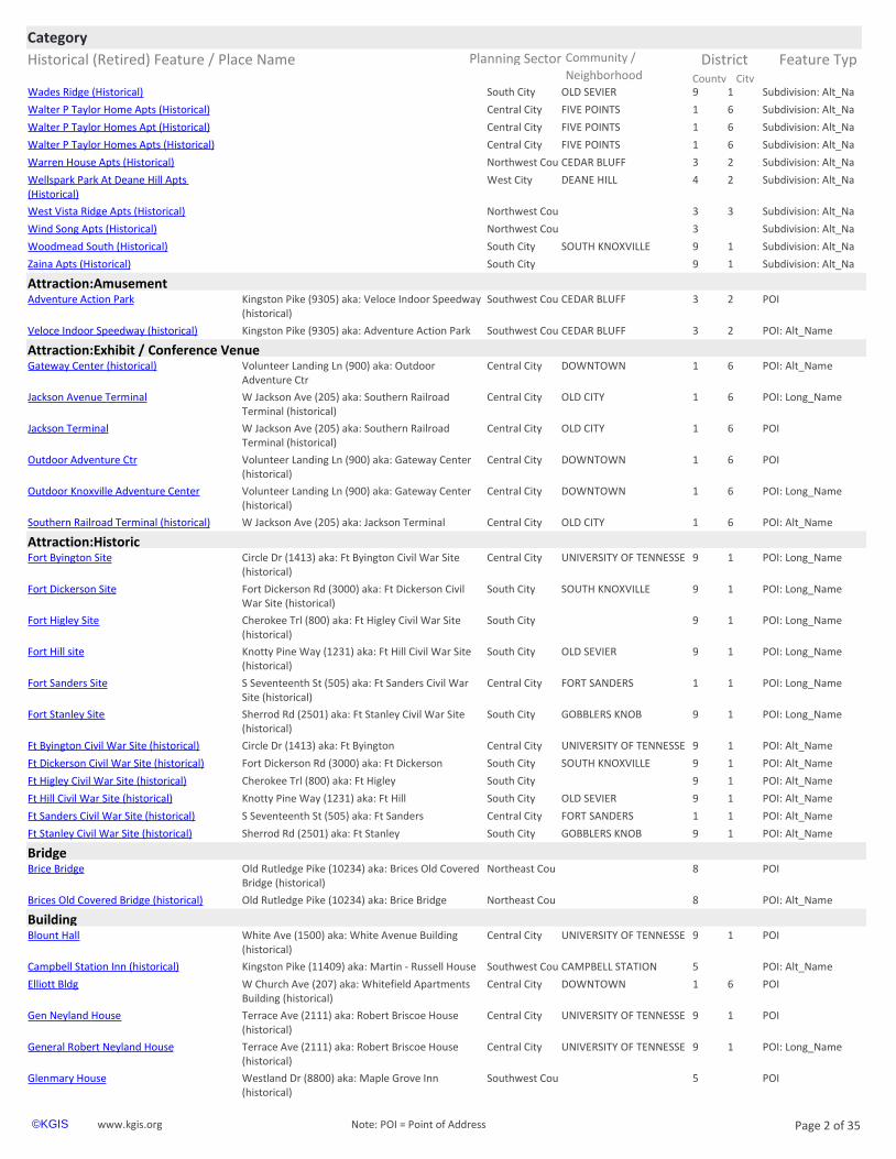
Attraction:Amusementhttps://www.kgis.org/kgismaps/map.htm? POIAdventure Action Park Southwest Cou CEDAR BLUFF 3 2Kingston Pike (9305) aka: Veloce Indoor Speedway
(historical)
https://www.kgis.org/kgismaps/map.htm? POI: Alt_NameVeloce Indoor Speedway (historical) Southwest Cou CEDAR BLUFF 3 2Kingston Pike (9305) aka: Adventure Action Park
Attraction:Exhibit / Conference Venuehttps://www.kgis.org/kgismaps/map.htm? POI: Alt_NameGateway Center (historical) Central City DOWNTOWN 1 6Volunteer Landing Ln (900) aka: Outdoor
Adventure Ctr
https://www.kgis.org/kgismaps/map.htm? POI: Long_NameJackson Avenue Terminal Central City OLD CITY 1 6W Jackson Ave (205) aka: Southern Railroad Terminal (historical)
https://www.kgis.org/kgismaps/map.htm? POIJackson Terminal Central City OLD CITY 1 6W Jackson Ave (205) aka: Southern Railroad Terminal (historical)
https://www.kgis.org/kgismaps/map.htm? POIOutdoor Adventure Ctr Central City DOWNTOWN 1 6Volunteer Landing Ln (900) aka: Gateway Center (historical)
https://www.kgis.org/kgismaps/map.htm? POI: Long_NameOutdoor Knoxville Adventure Center Central City DOWNTOWN 1 6Volunteer Landing Ln (900) aka: Gateway Center (historical)
https://www.kgis.org/kgismaps/map.htm? POI: Alt_NameSouthern Railroad Terminal (historical) Central City OLD CITY 1 6W Jackson Ave (205) aka: Jackson Terminal
Attraction:Historichttps://www.kgis.org/kgismaps/map.htm? POI: Long_NameFort Byington Site Central City UNIVERSITY OF TENNESSE 9 1Circle Dr (1413) aka: Ft Byington Civil War Site
(historical)
https://www.kgis.org/kgismaps/map.htm? POI: Long_NameFort Dickerson Site South City SOUTH KNOXVILLE 9 1Fort Dickerson Rd (3000) aka: Ft Dickerson Civil War Site (historical)
https://www.kgis.org/kgismaps/map.htm? POI: Long_NameFort Higley Site South City 9 1Cherokee Trl (800) aka: Ft Higley Civil War Site (historical)
https://www.kgis.org/kgismaps/map.htm? POI: Long_NameFort Hill site South City OLD SEVIER 9 1Knotty Pine Way (1231) aka: Ft Hill Civil War Site (historical)
https://www.kgis.org/kgismaps/map.htm? POI: Long_NameFort Sanders Site Central City FORT SANDERS 1 1S Seventeenth St (505) aka: Ft Sanders Civil War Site (historical)
https://www.kgis.org/kgismaps/map.htm? POI: Long_NameFort Stanley Site South City GOBBLERS KNOB 9 1Sherrod Rd (2501) aka: Ft Stanley Civil War Site (historical)
https://www.kgis.org/kgismaps/map.htm? POI: Alt_NameFt Byington Civil War Site (historical) Central City UNIVERSITY OF TENNESSE 9 1Circle Dr (1413) aka: Ft Byington
https://www.kgis.org/kgismaps/map.htm? POI: Alt_NameFt Dickerson Civil War Site (historical) South City SOUTH KNOXVILLE 9 1Fort Dickerson Rd (3000) aka: Ft Dickerson
https://www.kgis.org/kgismaps/map.htm? POI: Alt_NameFt Higley Civil War Site (historical) South City 9 1Cherokee Trl (800) aka: Ft Higley
https://www.kgis.org/kgismaps/map.htm? POI: Alt_NameFt Hill Civil War Site (historical) South City OLD SEVIER 9 1Knotty Pine Way (1231) aka: Ft Hill
https://www.kgis.org/kgismaps/map.htm? POI: Alt_NameFt Sanders Civil War Site (historical) Central City FORT SANDERS 1 1S Seventeenth St (505) aka: Ft Sanders
https://www.kgis.org/kgismaps/map.htm? POI: Alt_NameFt Stanley Civil War Site (historical) South City GOBBLERS KNOB 9 1Sherrod Rd (2501) aka: Ft Stanley
Bridgehttps://www.kgis.org/kgismaps/map.htm? POIBrice Bridge Northeast Cou 8Old Rutledge Pike (10234) aka: Brices Old Covered
Bridge (historical)
https://www.kgis.org/kgismaps/map.htm? POI: Alt_NameBrices Old Covered Bridge (historical) Northeast Cou 8Old Rutledge Pike (10234) aka: Brice Bridge
Buildinghttps://www.kgis.org/kgismaps/map.htm? POIBlount Hall Central City UNIVERSITY OF TENNESSE 9 1White Ave (1500) aka: White Avenue Building
(historical)
https://www.kgis.org/kgismaps/map.htm? POI: Alt_NameCampbell Station Inn (historical) Southwest Cou CAMPBELL STATION 5Kingston Pike (11409) aka: Martin - Russell House
https://www.kgis.org/kgismaps/map.htm? POIElliott Bldg Central City DOWNTOWN 1 6W Church Ave (207) aka: Whitefield Apartments Building (historical)
https://www.kgis.org/kgismaps/map.htm? POIGen Neyland House Central City UNIVERSITY OF TENNESSE 9 1Terrace Ave (2111) aka: Robert Briscoe House (historical)
https://www.kgis.org/kgismaps/map.htm? POI: Long_NameGeneral Robert Neyland House Central City UNIVERSITY OF TENNESSE 9 1Terrace Ave (2111) aka: Robert Briscoe House (historical)
https://www.kgis.org/kgismaps/map.htm? POIGlenmary House Southwest Cou 5Westland Dr (8800) aka: Maple Grove Inn (historical)
www.kgis.org Page 2 of 35©KGIS Note: POI = Point of Address
Historical (Retired) Feature / Place Name Planning Sector Feature Typ
CategoryCommunity / District
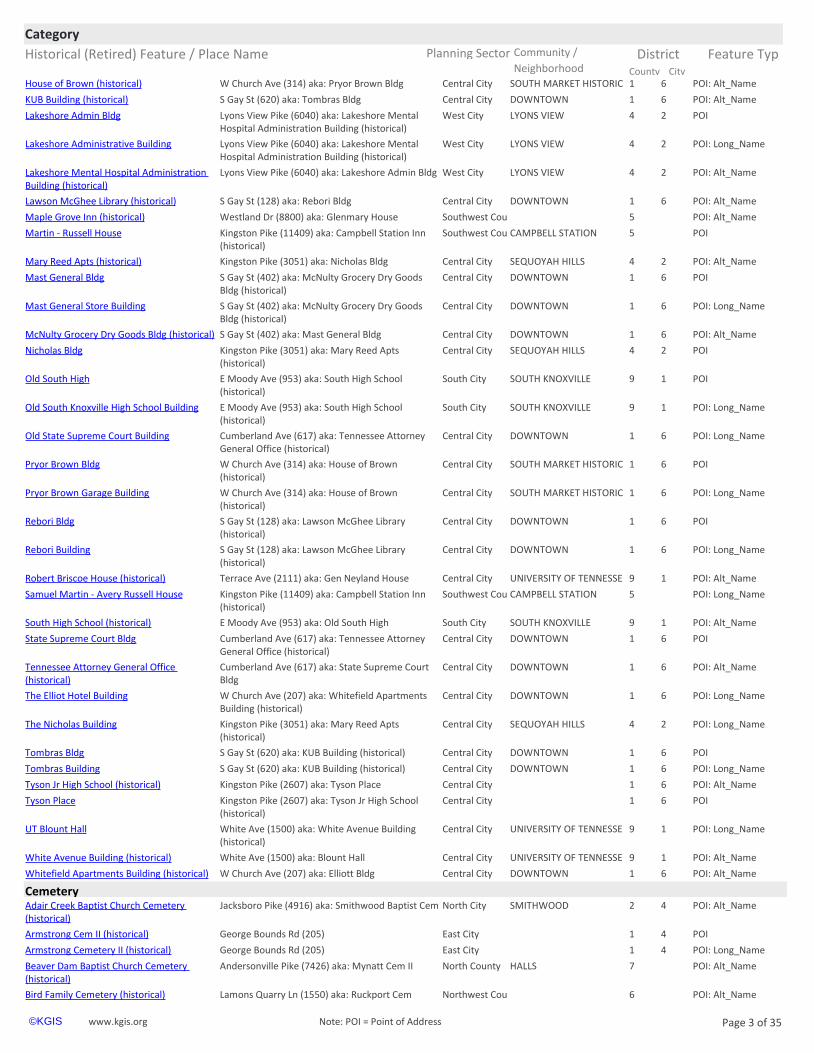
City County Neighborhoodhttps://www.kgis.org/kgismaps/map.htm? POI: Alt_NameHouse of Brown (historical) Central City SOUTH MARKET HISTORIC 1 6W Church Ave (314) aka: Pryor Brown Bldg
https://www.kgis.org/kgismaps/map.htm? POI: Alt_NameKUB Building (historical) Central City DOWNTOWN 1 6S Gay St (620) aka: Tombras Bldg
https://www.kgis.org/kgismaps/map.htm? POILakeshore Admin Bldg West City LYONS VIEW 4 2Lyons View Pike (6040) aka: Lakeshore Mental Hospital Administration Building (historical)
https://www.kgis.org/kgismaps/map.htm? POI: Long_NameLakeshore Administrative Building West City LYONS VIEW 4 2Lyons View Pike (6040) aka: Lakeshore Mental Hospital Administration Building (historical)
https://www.kgis.org/kgismaps/map.htm? POI: Alt_NameLakeshore Mental Hospital Administration Building (historical)
West City LYONS VIEW 4 2Lyons View Pike (6040) aka: Lakeshore Admin Bldg
https://www.kgis.org/kgismaps/map.htm? POI: Alt_NameLawson McGhee Library (historical) Central City DOWNTOWN 1 6S Gay St (128) aka: Rebori Bldg
https://www.kgis.org/kgismaps/map.htm? POI: Alt_NameMaple Grove Inn (historical) Southwest Cou 5Westland Dr (8800) aka: Glenmary House
https://www.kgis.org/kgismaps/map.htm? POIMartin - Russell House Southwest Cou CAMPBELL STATION 5Kingston Pike (11409) aka: Campbell Station Inn (historical)
https://www.kgis.org/kgismaps/map.htm? POI: Alt_NameMary Reed Apts (historical) Central City SEQUOYAH HILLS 4 2Kingston Pike (3051) aka: Nicholas Bldg
https://www.kgis.org/kgismaps/map.htm? POIMast General Bldg Central City DOWNTOWN 1 6S Gay St (402) aka: McNulty Grocery Dry Goods Bldg (historical)
https://www.kgis.org/kgismaps/map.htm? POI: Long_NameMast General Store Building Central City DOWNTOWN 1 6S Gay St (402) aka: McNulty Grocery Dry Goods Bldg (historical)
https://www.kgis.org/kgismaps/map.htm? POI: Alt_NameMcNulty Grocery Dry Goods Bldg (historical) Central City DOWNTOWN 1 6S Gay St (402) aka: Mast General Bldg
https://www.kgis.org/kgismaps/map.htm? POINicholas Bldg Central City SEQUOYAH HILLS 4 2Kingston Pike (3051) aka: Mary Reed Apts (historical)
https://www.kgis.org/kgismaps/map.htm? POIOld South High South City SOUTH KNOXVILLE 9 1E Moody Ave (953) aka: South High School (historical)
https://www.kgis.org/kgismaps/map.htm? POI: Long_NameOld South Knoxville High School Building South City SOUTH KNOXVILLE 9 1E Moody Ave (953) aka: South High School (historical)
https://www.kgis.org/kgismaps/map.htm? POI: Long_NameOld State Supreme Court Building Central City DOWNTOWN 1 6Cumberland Ave (617) aka: Tennessee Attorney General Office (historical)
https://www.kgis.org/kgismaps/map.htm? POIPryor Brown Bldg Central City SOUTH MARKET HISTORIC 1 6W Church Ave (314) aka: House of Brown (historical)
https://www.kgis.org/kgismaps/map.htm? POI: Long_NamePryor Brown Garage Building Central City SOUTH MARKET HISTORIC 1 6W Church Ave (314) aka: House of Brown (historical)
https://www.kgis.org/kgismaps/map.htm? POIRebori Bldg Central City DOWNTOWN 1 6S Gay St (128) aka: Lawson McGhee Library (historical)
https://www.kgis.org/kgismaps/map.htm? POI: Long_NameRebori Building Central City DOWNTOWN 1 6S Gay St (128) aka: Lawson McGhee Library (historical)
https://www.kgis.org/kgismaps/map.htm? POI: Alt_NameRobert Briscoe House (historical) Central City UNIVERSITY OF TENNESSE 9 1Terrace Ave (2111) aka: Gen Neyland House
https://www.kgis.org/kgismaps/map.htm? POI: Long_NameSamuel Martin - Avery Russell House Southwest Cou CAMPBELL STATION 5Kingston Pike (11409) aka: Campbell Station Inn (historical)
https://www.kgis.org/kgismaps/map.htm? POI: Alt_NameSouth High School (historical) South City SOUTH KNOXVILLE 9 1E Moody Ave (953) aka: Old South High
https://www.kgis.org/kgismaps/map.htm? POIState Supreme Court Bldg Central City DOWNTOWN 1 6Cumberland Ave (617) aka: Tennessee Attorney General Office (historical)
https://www.kgis.org/kgismaps/map.htm? POI: Alt_NameTennessee Attorney General Office (historical)
Central City DOWNTOWN 1 6Cumberland Ave (617) aka: State Supreme Court Bldg
https://www.kgis.org/kgismaps/map.htm? POI: Long_NameThe Elliot Hotel Building Central City DOWNTOWN 1 6W Church Ave (207) aka: Whitefield Apartments Building (historical)
https://www.kgis.org/kgismaps/map.htm? POI: Long_NameThe Nicholas Building Central City SEQUOYAH HILLS 4 2Kingston Pike (3051) aka: Mary Reed Apts (historical)
https://www.kgis.org/kgismaps/map.htm? POITombras Bldg Central City DOWNTOWN 1 6S Gay St (620) aka: KUB Building (historical)
https://www.kgis.org/kgismaps/map.htm? POI: Long_NameTombras Building Central City DOWNTOWN 1 6S Gay St (620) aka: KUB Building (historical)
https://www.kgis.org/kgismaps/map.htm? POI: Alt_NameTyson Jr High School (historical) Central City 1 6Kingston Pike (2607) aka: Tyson Place
https://www.kgis.org/kgismaps/map.htm? POITyson Place Central City 1 6Kingston Pike (2607) aka: Tyson Jr High School (historical)
https://www.kgis.org/kgismaps/map.htm? POI: Long_NameUT Blount Hall Central City UNIVERSITY OF TENNESSE 9 1White Ave (1500) aka: White Avenue Building (historical)
https://www.kgis.org/kgismaps/map.htm? POI: Alt_NameWhite Avenue Building (historical) Central City UNIVERSITY OF TENNESSE 9 1White Ave (1500) aka: Blount Hall
https://www.kgis.org/kgismaps/map.htm? POI: Alt_NameWhitefield Apartments Building (historical) Central City DOWNTOWN 1 6W Church Ave (207) aka: Elliott Bldg
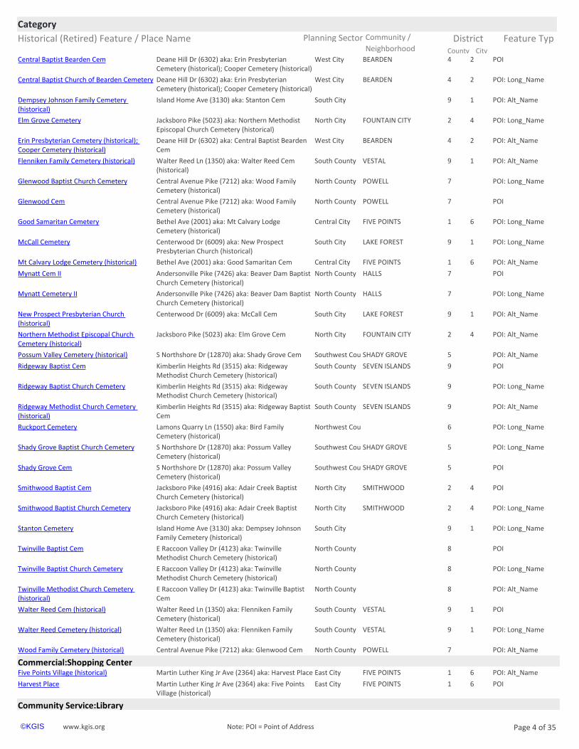
Cemeteryhttps://www.kgis.org/kgismaps/map.htm? POI: Alt_NameAdair Creek Baptist Church Cemetery (historical)
North City SMITHWOOD 2 4Jacksboro Pike (4916) aka: Smithwood Baptist Cem
https://www.kgis.org/kgismaps/map.htm? POIArmstrong Cem II (historical) East City 1 4George Bounds Rd (205)
https://www.kgis.org/kgismaps/map.htm? POI: Long_NameArmstrong Cemetery II (historical) East City 1 4George Bounds Rd (205)
https://www.kgis.org/kgismaps/map.htm? POI: Alt_NameBeaver Dam Baptist Church Cemetery (historical)
North County HALLS 7Andersonville Pike (7426) aka: Mynatt Cem II
https://www.kgis.org/kgismaps/map.htm? POI: Alt_NameBird Family Cemetery (historical) Northwest Cou 6Lamons Quarry Ln (1550) aka: Ruckport Cem
www.kgis.org Page 3 of 35©KGIS Note: POI = Point of Address
Historical (Retired) Feature / Place Name Planning Sector Feature Typ
CategoryCommunity / District
City County Neighborhoodhttps://www.kgis.org/kgismaps/map.htm? POICentral Baptist Bearden Cem West City BEARDEN 4 2Deane Hill Dr (6302) aka: Erin Presbyterian
Cemetery (historical); Cooper Cemetery (historical)
https://www.kgis.org/kgismaps/map.htm? POI: Long_NameCentral Baptist Church of Bearden Cemetery West City BEARDEN 4 2Deane Hill Dr (6302) aka: Erin Presbyterian Cemetery (historical); Cooper Cemetery (historical)
https://www.kgis.org/kgismaps/map.htm? POI: Alt_NameDempsey Johnson Family Cemetery (historical)
South City 9 1Island Home Ave (3130) aka: Stanton Cem
https://www.kgis.org/kgismaps/map.htm? POI: Long_NameElm Grove Cemetery North City FOUNTAIN CITY 2 4Jacksboro Pike (5023) aka: Northern Methodist Episcopal Church Cemetery (historical)
https://www.kgis.org/kgismaps/map.htm? POI: Alt_NameErin Presbyterian Cemetery (historical); Cooper Cemetery (historical)
West City BEARDEN 4 2Deane Hill Dr (6302) aka: Central Baptist Bearden Cem
https://www.kgis.org/kgismaps/map.htm? POI: Alt_NameFlenniken Family Cemetery (historical) South County VESTAL 9 1Walter Reed Ln (1350) aka: Walter Reed Cem (historical)
https://www.kgis.org/kgismaps/map.htm? POI: Long_NameGlenwood Baptist Church Cemetery North County POWELL 7Central Avenue Pike (7212) aka: Wood Family Cemetery (historical)
https://www.kgis.org/kgismaps/map.htm? POIGlenwood Cem North County POWELL 7Central Avenue Pike (7212) aka: Wood Family Cemetery (historical)
https://www.kgis.org/kgismaps/map.htm? POI: Long_NameGood Samaritan Cemetery Central City FIVE POINTS 1 6Bethel Ave (2001) aka: Mt Calvary Lodge Cemetery (historical)
https://www.kgis.org/kgismaps/map.htm? POI: Long_NameMcCall Cemetery South City LAKE FOREST 9 1Centerwood Dr (6009) aka: New Prospect Presbyterian Church (historical)
https://www.kgis.org/kgismaps/map.htm? POI: Alt_NameMt Calvary Lodge Cemetery (historical) Central City FIVE POINTS 1 6Bethel Ave (2001) aka: Good Samaritan Cem
https://www.kgis.org/kgismaps/map.htm? POIMynatt Cem II North County HALLS 7Andersonville Pike (7426) aka: Beaver Dam Baptist Church Cemetery (historical)
https://www.kgis.org/kgismaps/map.htm? POI: Long_NameMynatt Cemetery II North County HALLS 7Andersonville Pike (7426) aka: Beaver Dam Baptist Church Cemetery (historical)
https://www.kgis.org/kgismaps/map.htm? POI: Alt_NameNew Prospect Presbyterian Church (historical)
South City LAKE FOREST 9 1Centerwood Dr (6009) aka: McCall Cem
https://www.kgis.org/kgismaps/map.htm? POI: Alt_NameNorthern Methodist Episcopal Church Cemetery (historical)
North City FOUNTAIN CITY 2 4Jacksboro Pike (5023) aka: Elm Grove Cem
https://www.kgis.org/kgismaps/map.htm? POI: Alt_NamePossum Valley Cemetery (historical) Southwest Cou SHADY GROVE 5S Northshore Dr (12870) aka: Shady Grove Cem
https://www.kgis.org/kgismaps/map.htm? POIRidgeway Baptist Cem South County SEVEN ISLANDS 9Kimberlin Heights Rd (3515) aka: Ridgeway Methodist Church Cemetery (historical)
https://www.kgis.org/kgismaps/map.htm? POI: Long_NameRidgeway Baptist Church Cemetery South County SEVEN ISLANDS 9Kimberlin Heights Rd (3515) aka: Ridgeway Methodist Church Cemetery (historical)
https://www.kgis.org/kgismaps/map.htm? POI: Alt_NameRidgeway Methodist Church Cemetery (historical)
South County SEVEN ISLANDS 9Kimberlin Heights Rd (3515) aka: Ridgeway Baptist Cem
https://www.kgis.org/kgismaps/map.htm? POI: Long_NameRuckport Cemetery Northwest Cou 6Lamons Quarry Ln (1550) aka: Bird Family Cemetery (historical)
https://www.kgis.org/kgismaps/map.htm? POI: Long_NameShady Grove Baptist Church Cemetery Southwest Cou SHADY GROVE 5S Northshore Dr (12870) aka: Possum Valley Cemetery (historical)
https://www.kgis.org/kgismaps/map.htm? POIShady Grove Cem Southwest Cou SHADY GROVE 5S Northshore Dr (12870) aka: Possum Valley Cemetery (historical)
https://www.kgis.org/kgismaps/map.htm? POISmithwood Baptist Cem North City SMITHWOOD 2 4Jacksboro Pike (4916) aka: Adair Creek Baptist Church Cemetery (historical)
https://www.kgis.org/kgismaps/map.htm? POI: Long_NameSmithwood Baptist Church Cemetery North City SMITHWOOD 2 4Jacksboro Pike (4916) aka: Adair Creek Baptist Church Cemetery (historical)
https://www.kgis.org/kgismaps/map.htm? POI: Long_NameStanton Cemetery South City 9 1Island Home Ave (3130) aka: Dempsey Johnson Family Cemetery (historical)
https://www.kgis.org/kgismaps/map.htm? POITwinville Baptist Cem North County 8E Raccoon Valley Dr (4123) aka: Twinville Methodist Church Cemetery (historical)
https://www.kgis.org/kgismaps/map.htm? POI: Long_NameTwinville Baptist Church Cemetery North County 8E Raccoon Valley Dr (4123) aka: Twinville Methodist Church Cemetery (historical)
https://www.kgis.org/kgismaps/map.htm? POI: Alt_NameTwinville Methodist Church Cemetery (historical)
North County 8E Raccoon Valley Dr (4123) aka: Twinville Baptist Cem
https://www.kgis.org/kgismaps/map.htm? POIWalter Reed Cem (historical) South County VESTAL 9 1Walter Reed Ln (1350) aka: Flenniken Family Cemetery (historical)
https://www.kgis.org/kgismaps/map.htm? POI: Long_NameWalter Reed Cemetery (historical) South County VESTAL 9 1Walter Reed Ln (1350) aka: Flenniken Family Cemetery (historical)
https://www.kgis.org/kgismaps/map.htm? POI: Alt_NameWood Family Cemetery (historical) North County POWELL 7Central Avenue Pike (7212) aka: Glenwood Cem
Commercial:Shopping Centerhttps://www.kgis.org/kgismaps/map.htm? POI: Alt_NameFive Points Village (historical) East City FIVE POINTS 1 6Martin Luther King Jr Ave (2364) aka: Harvest Place
https://www.kgis.org/kgismaps/map.htm? POIHarvest Place East City FIVE POINTS 1 6Martin Luther King Jr Ave (2364) aka: Five Points Village (historical)
Community Service:Library
www.kgis.org Page 4 of 35©KGIS Note: POI = Point of Address
Historical (Retired) Feature / Place Name Planning Sector Feature Typ
CategoryCommunity / District
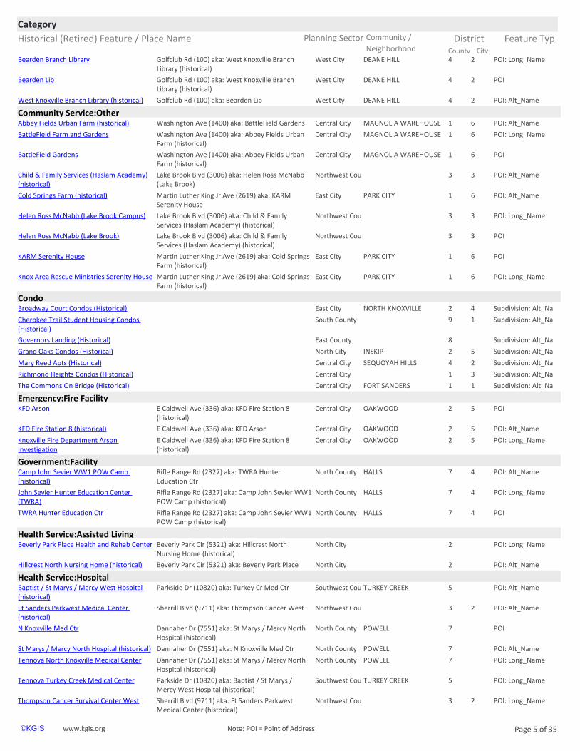
City County Neighborhoodhttps://www.kgis.org/kgismaps/map.htm? POI: Long_NameBearden Branch Library West City DEANE HILL 4 2Golfclub Rd (100) aka: West Knoxville Branch
Library (historical)
https://www.kgis.org/kgismaps/map.htm? POIBearden Lib West City DEANE HILL 4 2Golfclub Rd (100) aka: West Knoxville Branch Library (historical)
https://www.kgis.org/kgismaps/map.htm? POI: Alt_NameWest Knoxville Branch Library (historical) West City DEANE HILL 4 2Golfclub Rd (100) aka: Bearden Lib
Community Service:Otherhttps://www.kgis.org/kgismaps/map.htm? POI: Alt_NameAbbey Fields Urban Farm (historical) Central City MAGNOLIA WAREHOUSE 1 6Washington Ave (1400) aka: BattleField Gardens
https://www.kgis.org/kgismaps/map.htm? POI: Long_NameBattleField Farm and Gardens Central City MAGNOLIA WAREHOUSE 1 6Washington Ave (1400) aka: Abbey Fields Urban Farm (historical)
https://www.kgis.org/kgismaps/map.htm? POIBattleField Gardens Central City MAGNOLIA WAREHOUSE 1 6Washington Ave (1400) aka: Abbey Fields Urban Farm (historical)
https://www.kgis.org/kgismaps/map.htm? POI: Alt_NameChild & Family Services (Haslam Academy) (historical)
Northwest Cou 3 3Lake Brook Blvd (3006) aka: Helen Ross McNabb (Lake Brook)
https://www.kgis.org/kgismaps/map.htm? POI: Alt_NameCold Springs Farm (historical) East City PARK CITY 1 6Martin Luther King Jr Ave (2619) aka: KARM Serenity House
https://www.kgis.org/kgismaps/map.htm? POI: Long_NameHelen Ross McNabb (Lake Brook Campus) Northwest Cou 3 3Lake Brook Blvd (3006) aka: Child & Family Services (Haslam Academy) (historical)
https://www.kgis.org/kgismaps/map.htm? POIHelen Ross McNabb (Lake Brook) Northwest Cou 3 3Lake Brook Blvd (3006) aka: Child & Family Services (Haslam Academy) (historical)
https://www.kgis.org/kgismaps/map.htm? POIKARM Serenity House East City PARK CITY 1 6Martin Luther King Jr Ave (2619) aka: Cold Springs Farm (historical)
https://www.kgis.org/kgismaps/map.htm? POI: Long_NameKnox Area Rescue Ministries Serenity House East City PARK CITY 1 6Martin Luther King Jr Ave (2619) aka: Cold Springs Farm (historical)
Condohttps://www.kgis.org/kgismaps/map.htm? Subdivision: Alt_NaBroadway Court Condos (Historical) East City NORTH KNOXVILLE 2 4
https://www.kgis.org/kgismaps/map.htm? Subdivision: Alt_NaCherokee Trail Student Housing Condos (Historical)
South County 9 1
https://www.kgis.org/kgismaps/map.htm? Subdivision: Alt_NaGovernors Landing (Historical) East County 8
https://www.kgis.org/kgismaps/map.htm? Subdivision: Alt_NaGrand Oaks Condos (Historical) North City INSKIP 2 5
https://www.kgis.org/kgismaps/map.htm? Subdivision: Alt_NaMary Reed Apts (Historical) Central City SEQUOYAH HILLS 4 2
https://www.kgis.org/kgismaps/map.htm? Subdivision: Alt_NaRichmond Heights Condos (Historical) Central City 1 3
https://www.kgis.org/kgismaps/map.htm? Subdivision: Alt_NaThe Commons On Bridge (Historical) Central City FORT SANDERS 1 1
Emergency:Fire Facilityhttps://www.kgis.org/kgismaps/map.htm? POIKFD Arson Central City OAKWOOD 2 5E Caldwell Ave (336) aka: KFD Fire Station 8
(historical)
https://www.kgis.org/kgismaps/map.htm? POI: Alt_NameKFD Fire Station 8 (historical) Central City OAKWOOD 2 5E Caldwell Ave (336) aka: KFD Arson
https://www.kgis.org/kgismaps/map.htm? POI: Long_NameKnoxville Fire Department Arson Investigation
Central City OAKWOOD 2 5E Caldwell Ave (336) aka: KFD Fire Station 8 (historical)
Government:Facilityhttps://www.kgis.org/kgismaps/map.htm? POI: Alt_NameCamp John Sevier WW1 POW Camp (historical)
North County HALLS 7 4Rifle Range Rd (2327) aka: TWRA Hunter Education Ctr
https://www.kgis.org/kgismaps/map.htm? POI: Long_NameJohn Sevier Hunter Education Center (TWRA)
North County HALLS 7 4Rifle Range Rd (2327) aka: Camp John Sevier WW1 POW Camp (historical)
https://www.kgis.org/kgismaps/map.htm? POITWRA Hunter Education Ctr North County HALLS 7 4Rifle Range Rd (2327) aka: Camp John Sevier WW1 POW Camp (historical)
Health Service:Assisted Livinghttps://www.kgis.org/kgismaps/map.htm? POI: Long_NameBeverly Park Place Health and Rehab Center North City 2Beverly Park Cir (5321) aka: Hillcrest North
Nursing Home (historical)
https://www.kgis.org/kgismaps/map.htm? POI: Alt_NameHillcrest North Nursing Home (historical) North City 2Beverly Park Cir (5321) aka: Beverly Park Place
Health Service:Hospitalhttps://www.kgis.org/kgismaps/map.htm? POI: Alt_NameBaptist / St Marys / Mercy West Hospital (historical)
Southwest Cou TURKEY CREEK 5Parkside Dr (10820) aka: Turkey Cr Med Ctr
https://www.kgis.org/kgismaps/map.htm? POI: Alt_NameFt Sanders Parkwest Medical Center (historical)
Northwest Cou 3 2Sherrill Blvd (9711) aka: Thompson Cancer West
https://www.kgis.org/kgismaps/map.htm? POIN Knoxville Med Ctr North County POWELL 7Dannaher Dr (7551) aka: St Marys / Mercy North Hospital (historical)
https://www.kgis.org/kgismaps/map.htm? POI: Alt_NameSt Marys / Mercy North Hospital (historical) North County POWELL 7Dannaher Dr (7551) aka: N Knoxville Med Ctr
https://www.kgis.org/kgismaps/map.htm? POI: Long_NameTennova North Knoxville Medical Center North County POWELL 7Dannaher Dr (7551) aka: St Marys / Mercy North Hospital (historical)
https://www.kgis.org/kgismaps/map.htm? POI: Long_NameTennova Turkey Creek Medical Center Southwest Cou TURKEY CREEK 5Parkside Dr (10820) aka: Baptist / St Marys / Mercy West Hospital (historical)
https://www.kgis.org/kgismaps/map.htm? POI: Long_NameThompson Cancer Survival Center West Northwest Cou 3 2Sherrill Blvd (9711) aka: Ft Sanders Parkwest Medical Center (historical)
www.kgis.org Page 5 of 35©KGIS Note: POI = Point of Address

Historical (Retired) Feature / Place Name Planning Sector Feature Typ
CategoryCommunity / District
City County Neighborhoodhttps://www.kgis.org/kgismaps/map.htm? POIThompson Cancer West Northwest Cou 3 2Sherrill Blvd (9711) aka: Ft Sanders Parkwest
Medical Center (historical)
https://www.kgis.org/kgismaps/map.htm? POITurkey Cr Med Ctr Southwest Cou TURKEY CREEK 5Parkside Dr (10820) aka: Baptist / St Marys / Mercy West Hospital (historical)
Historical:Feature No Longer Therehttps://www.kgis.org/kgismaps/map.htm? POI1st Methodist Episcopal (historical) Central City MARKET STREET DISTRICT 1 6Clinch Ave (414)
https://www.kgis.org/kgismaps/map.htm? POI2nd Presbyterian (historical) Central City MARKET STREET DISTRICT 1 6Clinch Ave (413)
https://www.kgis.org/kgismaps/map.htm? POI2nd Presbyterian Cem (historical) Central City MARKET STREET DISTRICT 1 6Market St (507)
https://www.kgis.org/kgismaps/map.htm? POI: Long_NameAconda Court (historical) Central City UNIVERSITY OF TENNESSE 9 1Cumberland Ave (1534) aka: Alumni Hall (historical)
https://www.kgis.org/kgismaps/map.htm? POIAconda Ct (historical) Central City UNIVERSITY OF TENNESSE 9 1Cumberland Ave (1534) aka: Alumni Hall (historical)
https://www.kgis.org/kgismaps/map.htm? POIAdm Farragut Birthplace (historical) Southwest Cou 4Christus Way (2055)
https://www.kgis.org/kgismaps/map.htm? POI: Long_NameAdmiral David Glasgow Farragut Birthplace (historical)
Southwest Cou 4Christus Way (2055)
https://www.kgis.org/kgismaps/map.htm? POIAlice Ijams Greenhouse (historical) South City 9 1Island Home Ave (2935)
https://www.kgis.org/kgismaps/map.htm? POI: Alt_NameAlumni Hall (historical) Central City UNIVERSITY OF TENNESSE 9 1Cumberland Ave (1534) aka: Aconda Ct (historical)
https://www.kgis.org/kgismaps/map.htm? POI: Alt_NameAmerican Zinc Mascot Mine Number 1 Northeast Cou MASCOT 8Sand Plant Ln (1730) aka: Mascot Mine (historical)
https://www.kgis.org/kgismaps/map.htm? POIAnderson - Ford Cem (historical) South City 9 1Sevierville Pike (6313) aka: Anderson Ford Cemetery (historical)
https://www.kgis.org/kgismaps/map.htm? POI: Long_NameAnderson - Ford Cemetery (historical) South City 9 1Sevierville Pike (6313) aka: Anderson Ford Cemetery (historical)
https://www.kgis.org/kgismaps/map.htm? POI: Alt_NameAnderson Ford Cemetery (historical) South City 9 1Sevierville Pike (6313) aka: Anderson - Ford Cem (historical)
https://www.kgis.org/kgismaps/map.htm? POIApostolic Faith Church (historical) East City FIVE POINTS 1 6Ben Hur Ave (122)
https://www.kgis.org/kgismaps/map.htm? POI: Alt_NameArmory Fieldhouse (historical) Central City UNIVERSITY OF TENNESSE 9 2Johnny Majors Dr (1717) aka: Stokely Athletic Ctr (historical)
https://www.kgis.org/kgismaps/map.htm? POIArmstrong School (historical) East County 8Stony Point Rd (1616)
https://www.kgis.org/kgismaps/map.htm? POIAsbury School (historical) East County ASBURY 8Asbury Rd (2822)
https://www.kgis.org/kgismaps/map.htm? POI: Alt_NameBaker Bldg at Lakeshore (historical) West City LYONS VIEW 4 2Lyons View Pike (5908) aka: Lakeshore Institute (historical)
https://www.kgis.org/kgismaps/map.htm? POI: Long_NameBarbara Blount Hall Cemetery (historical) Central City UNIVERSITY OF TENNESSE 9 1Middle Dr (1506)
https://www.kgis.org/kgismaps/map.htm? POIBarbara Hill Cem (historical) Central City UNIVERSITY OF TENNESSE 9 1Circle Dr (1403)
https://www.kgis.org/kgismaps/map.htm? POI: Long_NameBarbara Hill Cemetery (historical) Central City UNIVERSITY OF TENNESSE 9 1Circle Dr (1403)
https://www.kgis.org/kgismaps/map.htm? POIBattery Billingsley (historical) Central City DOWNTOWN 1 6S Gay St (300 #401)
https://www.kgis.org/kgismaps/map.htm? POIBattery Clifton Lee (historical) Central City EAST KNOXVILLE 1 6Lula Powell Dr (1100 #C413)
https://www.kgis.org/kgismaps/map.htm? POIBattery Fearns (historical) Central City 1 6E Hill Ave (709)
https://www.kgis.org/kgismaps/map.htm? POIBattery Galpin (historical) Central City DOWNTOWN 1 6S Broadway (109)
https://www.kgis.org/kgismaps/map.htm? POIBattery Noble (historical) Central City UNIVERSITY OF TENNESSE 9 1Melrose Ave (1620)
https://www.kgis.org/kgismaps/map.htm? POIBattery Stearman (historical) Central City MORNINGSIDE 1 6E Hill Ave (928)
https://www.kgis.org/kgismaps/map.htm? POIBattery Wiltsie (historical) Central City SUMMIT HILL 1 6W Summit Hill Dr (401)
https://www.kgis.org/kgismaps/map.htm? POIBattery Zoellner (historical) Central City FORT SANDERS 1 1Eleventh St (219 #3)
https://www.kgis.org/kgismaps/map.htm? POI: Long_NameBattle of Fort Sanders Re-Enactment Site (historical)
Northeast Cou 8Circle Rd (6704) aka: Fort Sanders 150th Anniversary Reenactment Site (historical)
https://www.kgis.org/kgismaps/map.htm? POIBeaman Lake (historical) East City EAST KNOXVILLE 1 6Beaman Lake Rd (1231 #Cct)
https://www.kgis.org/kgismaps/map.htm? POIBean Cem (historical) Southwest Cou 4Crystal Lake Dr (6810)
https://www.kgis.org/kgismaps/map.htm? POI: Long_NameBean Cemetery (historical) Southwest Cou 4Crystal Lake Dr (6810)
https://www.kgis.org/kgismaps/map.htm? POIBerry Hall (historical) Central City UNIVERSITY OF TENNESSE 9 1Estabrook Rd (1012)
https://www.kgis.org/kgismaps/map.htm? POIBethel Church (historical) South County MOUNT OLIVE 9Maryville Pike (2622)
https://www.kgis.org/kgismaps/map.htm? POIBethel School (historical) East County KODAK 8Kelly Ln (2612)
https://www.kgis.org/kgismaps/map.htm? POIBig Oak Ctr (historical) North County HALLS 7Fountain Valley Dr (3926)
https://www.kgis.org/kgismaps/map.htm? POI: Long_NameBig Oak Shopping Center (historical) North County HALLS 7Fountain Valley Dr (3926)
https://www.kgis.org/kgismaps/map.htm? POIBill Meyer Stadium (historical) Central City MAGNOLIA WAREHOUSE 1 6Jessamine St (634) aka: Knoxville Municipal Stadium (historical)
https://www.kgis.org/kgismaps/map.htm? POIBiology Annex (historical) Central City UNIVERSITY OF TENNESSE 9 1Neyland Dr (901) aka: UT Anthopology (historical)
https://www.kgis.org/kgismaps/map.htm? POIBlount Hall Cem (historical) Central City UNIVERSITY OF TENNESSE 9 1Middle Dr (1506)
https://www.kgis.org/kgismaps/map.htm? POIBlue Grass Dock (historical) Southwest Cou 4
https://www.kgis.org/kgismaps/map.htm? POIBooker School (historical) Northeast Cou SENTERTOWN 8Millertown Pike (7149)
https://www.kgis.org/kgismaps/map.htm? POIBoyd Ferry (historical) East County 1 6Boyds Bridge Pike (3917)
https://www.kgis.org/kgismaps/map.htm? POIBoyd School (historical) Southwest Cou 5S Northshore Dr (12613)
www.kgis.org Page 6 of 35©KGIS Note: POI = Point of Address

Historical (Retired) Feature / Place Name Planning Sector Feature Typ
CategoryCommunity / District
City County Neighborhoodhttps://www.kgis.org/kgismaps/map.htm? POI: Alt_NameBrakebill Indian Mound at Gilliams Station (historical)
East County FORKS OF THE RIVER 8Asbury Rd (2403) aka: Brakebill's Mound (historical)
https://www.kgis.org/kgismaps/map.htm? POI: Long_NameBrakebills Indian Mound (historical) East County FORKS OF THE RIVER 8Asbury Rd (2403) aka: Brakebill Indian Mound at Gilliams Station (historical)
https://www.kgis.org/kgismaps/map.htm? POIBrakebill's Mound (historical) East County FORKS OF THE RIVER 8Asbury Rd (2403) aka: Brakebill Indian Mound at Gilliams Station (historical)
https://www.kgis.org/kgismaps/map.htm? POIBranch Hill Church (historical) Northwest Cou 6George Light Rd (3055)
https://www.kgis.org/kgismaps/map.htm? POIBrewers Park (historical) East City PARK CITY 1 6Selma Ave (2637)
https://www.kgis.org/kgismaps/map.htm? POIBrice Tavern (historical) Northeast Cou 8Old Rutledge Pike (10312)
https://www.kgis.org/kgismaps/map.htm? POIBroadway Speedway (historical) North County HALLS 7Fountain Valley Dr (3902)
https://www.kgis.org/kgismaps/map.htm? POIBrooks Road Church (historical) East City EAST KNOXVILLE 1 6Brooks Ave (3320)
https://www.kgis.org/kgismaps/map.htm? POIBrookside Mills (historical) Central City 1 6W Baxter Ave (545)
https://www.kgis.org/kgismaps/map.htm? POI: Alt_NameBurke Bridge (historical) East County 8 4Asheville Hwy (6110) aka: James Edward Burke Bridge (historical)
https://www.kgis.org/kgismaps/map.htm? POICabbage Cem (historical) North County HALLS 7Miracle Ln (4208)
https://www.kgis.org/kgismaps/map.htm? POI: Long_NameCabbage Cemetery (historical) North County HALLS 7Miracle Ln (4208)
https://www.kgis.org/kgismaps/map.htm? POI: Alt_NameCal Johnson Racetrack (historical) East City BURLINGTON 1 6Speedway Cir (3790) aka: Cal Johnson Speedway (historical)
https://www.kgis.org/kgismaps/map.htm? POICal Johnson Speedway (historical) East City BURLINGTON 1 6Speedway Cir (3790) aka: Cal Johnson Racetrack (historical)
https://www.kgis.org/kgismaps/map.htm? POICallahan Cem (historical) North City DANTE 7Kern Rd (6601) aka: Tillery Cemetery (historical)
https://www.kgis.org/kgismaps/map.htm? POI: Long_NameCallahan Cemetery (historical) North City DANTE 7Kern Rd (6601) aka: Tillery Cemetery (historical)
https://www.kgis.org/kgismaps/map.htm? POICallans Pond (historical) East County TUCKAHOE 8 4Midway Rd (1211)
https://www.kgis.org/kgismaps/map.htm? POICalloway Island (historical) Southwest Cou 5
https://www.kgis.org/kgismaps/map.htm? POICarl Frazier Trl (historical) Northwest Cou 6Beaver Ridge Rd (6618)
https://www.kgis.org/kgismaps/map.htm? POI: Long_NameCarl Frazier Walking Trail (historical) Northwest Cou 6Beaver Ridge Rd (6618)
https://www.kgis.org/kgismaps/map.htm? POI: Long_NameCarolyn P Brown University Center (historical)
Central City UNIVERSITY OF TENNESSE 9 1Cumberland Ave (1502)
https://www.kgis.org/kgismaps/map.htm? POICarpenter School (historical) Northwest Cou 6Carpenter Rd (7324)
https://www.kgis.org/kgismaps/map.htm? POICarter Mill (historical) East County CARTER 8Carter Mill Dr (9218)
https://www.kgis.org/kgismaps/map.htm? POICaswell Taylor House (historical) Central City FOURTH & GILL 2 4N Fourth Ave (803) aka: The Governors House (historical)
https://www.kgis.org/kgismaps/map.htm? POICausier School (historical) Central City MECHANICSVILLE 1 6Reynolds St (1719)
https://www.kgis.org/kgismaps/map.htm? POICCC Camp 495 (historical) North County POWELL STATION 7
https://www.kgis.org/kgismaps/map.htm? POICedar Cliff Church (historical) Southwest Cou WEST KNOXVILLE 3 2Kingston Pike (8870)
https://www.kgis.org/kgismaps/map.htm? POICedar Grove School (historical) Northwest Cou 3 3Middlebrook Pike (5937)
https://www.kgis.org/kgismaps/map.htm? POI: Alt_NameChair Rock at Luttrell Park South City SOUTH WATERFRONT 9 1E Blount Ave (151) aka: Luttrell Park (historical)
https://www.kgis.org/kgismaps/map.htm? POIChandler Lake (historical) Northwest Cou 6Schaad Rd (3301)
https://www.kgis.org/kgismaps/map.htm? POIChestnut Grove School (historical) Northwest Cou 6Yarnell Rd (10911)
https://www.kgis.org/kgismaps/map.htm? POIChildress Cem (historical) North County PEDIGO 7Long Hollow Rd (2709)
https://www.kgis.org/kgismaps/map.htm? POI: Long_NameChildress Cemetery (historical) North County PEDIGO 7Long Hollow Rd (2709)
https://www.kgis.org/kgismaps/map.htm? POIChota Bldg (historical) West City LYONS VIEW 4 2S Northshore Dr (6400)
https://www.kgis.org/kgismaps/map.htm? POI: Long_NameChota Building at Lakeshore (historical) West City LYONS VIEW 4 2S Northshore Dr (6400)
https://www.kgis.org/kgismaps/map.htm? POIChrist Temple Apostolic (historical) Central City LONSDALE 1 5Minnesota Ave (1900)
https://www.kgis.org/kgismaps/map.htm? POI: Long_NameChrist Temple Apostolic Church (historical) Central City LONSDALE 1 5Minnesota Ave (1900)
https://www.kgis.org/kgismaps/map.htm? POIChristenberry Jr High (historical) Central City 2 5Oglewood Ave (927)
https://www.kgis.org/kgismaps/map.htm? POI: Long_NameChristenberry Junior High School (historical) Central City 2 5Oglewood Ave (927)
https://www.kgis.org/kgismaps/map.htm? POIChristian Fellowship (Andrew Johnson Hwy) (historical)
East County TRENTVILLE 8Andrew Johnson Hwy (309)
https://www.kgis.org/kgismaps/map.htm? POI: Long_NameChristian Fellowship Church on Andrew Johnson Hwy (historical)
East County TRENTVILLE 8Andrew Johnson Hwy (309)
https://www.kgis.org/kgismaps/map.htm? POI: Long_NameCivilian Conservation Corps Camp Number 495 (historical)
North County POWELL STATION 7
https://www.kgis.org/kgismaps/map.htm? POIClaiborne Cem (historical) North City FOUNTAIN CITY 2 4Tazewell Pike (4008)
https://www.kgis.org/kgismaps/map.htm? POI: Long_NameClaiborne Cemetery (historical) North City FOUNTAIN CITY 2 4Tazewell Pike (4008)
https://www.kgis.org/kgismaps/map.htm? POIClark Cem (historical) North County 8Old Maynardville Pike (9202)
https://www.kgis.org/kgismaps/map.htm? POI: Long_NameClark Cemetery (historical) North County 8Old Maynardville Pike (9202)
https://www.kgis.org/kgismaps/map.htm? POIClaxton Church (historical) North County 7Naff Rd (9436)
https://www.kgis.org/kgismaps/map.htm? POIClinch Avenue Park (historical) Central City UNIVERSITY OF TENNESSE 9 2Volunteer Blvd (1800)
https://www.kgis.org/kgismaps/map.htm? POICline Cem (historical) North County 8Old Maynardville Pike (8320)
https://www.kgis.org/kgismaps/map.htm? POI: Long_NameCline Cemetery (historical) North County 8Old Maynardville Pike (8320)
www.kgis.org Page 7 of 35©KGIS Note: POI = Point of Address

Historical (Retired) Feature / Place Name Planning Sector Feature Typ
CategoryCommunity / District
City County Neighborhoodhttps://www.kgis.org/kgismaps/map.htm? POIColored Cem (historical) East County 8Drummer Ln (545) aka: Coloured Cemetery
(historical)
https://www.kgis.org/kgismaps/map.htm? POI: Long_NameColored Cemetery (historical) East County 8Drummer Ln (545) aka: Coloured Cemetery (historical)
https://www.kgis.org/kgismaps/map.htm? POI: Alt_NameColoured Cemetery (historical) East County 8Drummer Ln (545) aka: Colored Cem (historical)
https://www.kgis.org/kgismaps/map.htm? POIConcord School (historical) Southwest Cou CONCORD 5Loop Rd (709)
https://www.kgis.org/kgismaps/map.htm? POI: Long_NameCormac McCarthy Homeplace (historical) South County 9W Martin Mill Pike (5501) aka: Cormac McCarthy House (historical)
https://www.kgis.org/kgismaps/map.htm? POI: Alt_NameCormac McCarthy House (historical) South County 9W Martin Mill Pike (5501) aka: McCarthy Homeplace (historical)
https://www.kgis.org/kgismaps/map.htm? POICorum Cem (historical) Northwest Cou 6Pinestraw Ln (1811)
https://www.kgis.org/kgismaps/map.htm? POI: Long_NameCorum Cemetery (historical) Northwest Cou 6Pinestraw Ln (1811)
https://www.kgis.org/kgismaps/map.htm? POI: Long_NameCradle of Country Music Treble Clef Status (historical)
Central City DOWNTOWN 1 6W Summit Hill Dr (207)
https://www.kgis.org/kgismaps/map.htm? POICraig Cem (historical) Southwest Cou BLUEGRASS 4Norlake Cir (9308)
https://www.kgis.org/kgismaps/map.htm? POI: Long_NameCraig Cemetery (historical) Southwest Cou BLUEGRASS 4Norlake Cir (9308)
https://www.kgis.org/kgismaps/map.htm? POI: Alt_NameDaniel McCall Cemetery (historical) North County HALLS 7Kingdom Ln (4215) aka: McCall Cem II (historical)
https://www.kgis.org/kgismaps/map.htm? POIDante Dale School (historical) North County 7Dantedale Rd (6715)
https://www.kgis.org/kgismaps/map.htm? POIDante School (historical) North City DANTE 7Dante School Rd (422)
https://www.kgis.org/kgismaps/map.htm? POI: Alt_NameDeane Hill Country Club West City DEANE HILL 4 2Catherine Mcauley Way (401) aka: The Deanery (historical)
https://www.kgis.org/kgismaps/map.htm? POI: Long_NameDepartment of Health Building at Lakeshore (historical)
West City LYONS VIEW 4 2Lyons View Pike (5908)
https://www.kgis.org/kgismaps/map.htm? POIDept of Health Bldg (historical) West City LYONS VIEW 4 2Lyons View Pike (5908)
https://www.kgis.org/kgismaps/map.htm? POI: Alt_NameDr Lay Cemetery (historical) Northeast Cou 8Three Points Rd (8923) aka: Lay Cem (historical)
https://www.kgis.org/kgismaps/map.htm? POI: Long_NameDr Lee L Williams Senior Center (historical) Central City FIVE POINTS 1 6Martin Luther King Jr Ave (2240) aka: Dr Lee Williams Complex (historical)
https://www.kgis.org/kgismaps/map.htm? POI: Alt_NameDr Lee Williams Complex (historical) Central City FIVE POINTS 1 6Martin Luther King Jr Ave (2240) aka: Williams Senior Ctr (historical)
https://www.kgis.org/kgismaps/map.htm? POIE Hill Ave Cem (historical) Central City 1 6E Hill Ave (501) aka: E Hill Ave Cemetery (historical)
https://www.kgis.org/kgismaps/map.htm? POI: Alt_NameE Hill Ave Cemetery (historical) Central City 1 6E Hill Ave (501) aka: E Hill Ave Cem (historical)
https://www.kgis.org/kgismaps/map.htm? POIEarley Island (historical) Southwest Cou 5
https://www.kgis.org/kgismaps/map.htm? POIEast Emory Church (historical) Southwest Cou 4Bluegrass Rd (9806)
https://www.kgis.org/kgismaps/map.htm? POIEast Emory School (historical) Southwest Cou 4Whistler Woods Way (1611)
https://www.kgis.org/kgismaps/map.htm? POI: Long_NameEast Hill Avenue Methodist Church Cemetery (historical)
Central City 1 6E Hill Ave (501) aka: E Hill Ave Cemetery (historical)
https://www.kgis.org/kgismaps/map.htm? POIEast Stony Point School (historical) East County 8Mccarty Rd (1735)
https://www.kgis.org/kgismaps/map.htm? POIEleanor Mill (historical) North County 7E Raccoon Valley Dr (1707)
https://www.kgis.org/kgismaps/map.htm? POIElmwood School (historical) Northeast Cou 8Millertown Pike (5912)
https://www.kgis.org/kgismaps/map.htm? POIEstabrook Hall (historical) Central City UNIVERSITY OF TENNESSE 9 1Estabrook Rd (1012)
https://www.kgis.org/kgismaps/map.htm? POIEvans - Collins Field (historical) Central City EAST KNOXVILLE 1 6Winona St (620)
https://www.kgis.org/kgismaps/map.htm? POIFaith & Hope Baptist (historical) South County 9Kimberlin Heights Rd (122) aka: Faith and Hope Baptist Church (historical)
https://www.kgis.org/kgismaps/map.htm? POI: Long_NameFaith & Hope Baptist Church (historical) South County 9Kimberlin Heights Rd (122) aka: Faith and Hope Baptist Church (historical)
https://www.kgis.org/kgismaps/map.htm? POI: Alt_NameFaith and Hope Baptist Church (historical) South County 9Kimberlin Heights Rd (122) aka: Faith & Hope Baptist (historical)
https://www.kgis.org/kgismaps/map.htm? POI: Long_NameFaith Christian Center (historical) East City EAST KNOXVILLE 1 6Skyline Dr (3536)
https://www.kgis.org/kgismaps/map.htm? POIFaith Christian Ctr (historical) East City EAST KNOXVILLE 1 6Skyline Dr (3536)
https://www.kgis.org/kgismaps/map.htm? POIFaith Presbyterian (historical) Southwest Cou BLUEGRASS 4 2Pinnacle Pointe Way (1992)
https://www.kgis.org/kgismaps/map.htm? POI: Long_NameFaith Presbyterian Church (historical) Southwest Cou BLUEGRASS 4 2Pinnacle Pointe Way (1992)
https://www.kgis.org/kgismaps/map.htm? POI: Long_NameFirst Methodist Episcopal Church (historical) Central City MARKET STREET DISTRICT 1 6Clinch Ave (414)
https://www.kgis.org/kgismaps/map.htm? POIFlenniken Cem (historical) Southwest Cou RIVERBEND 4Lyons Bend Rd (2127) aka: Tarwater - Flenniken II Cemetery (historical)
https://www.kgis.org/kgismaps/map.htm? POI: Long_NameFlenniken Cemetery (historical) Southwest Cou RIVERBEND 4Lyons Bend Rd (2127) aka: Tarwater - Flenniken II Cemetery (historical)
https://www.kgis.org/kgismaps/map.htm? POIFletcher Cem (historical) North County 71120 (E Bullrun Valley Dr)
https://www.kgis.org/kgismaps/map.htm? POI: Long_NameFletcher Cemetery (historical) North County 71120 (E Bullrun Valley Dr)
https://www.kgis.org/kgismaps/map.htm? POIForestdale Brethren Cem (historical) East City NORTH KNOXVILLE 2 4Brunswick St (3118) aka: Forestdale Methodist Cemetery (historical)
https://www.kgis.org/kgismaps/map.htm? POI: Alt_NameForestdale Methodist Cemetery (historical) East City NORTH KNOXVILLE 2 4Brunswick St (3118) aka: Forestdale Brethren Cem (historical)
www.kgis.org Page 8 of 35©KGIS Note: POI = Point of Address
https://www.kgis.org/kgismaps/map.htm?map=park&place=Coloured%20Cemetery%20(historical)&method=exact
https://www.kgis.org/kgismaps/map.htm?map=park&place=Dr%20Lay%20Cemetery%20(historical)&method=exact

Historical (Retired) Feature / Place Name Planning Sector Feature Typ
CategoryCommunity / District
City County Neighborhoodhttps://www.kgis.org/kgismaps/map.htm? POI: Long_NameForestdale United Brethren Methodist Church Cemetery (historical)
East City NORTH KNOXVILLE 2 4Brunswick St (3118) aka: Forestdale Methodist Cemetery (historical)
https://www.kgis.org/kgismaps/map.htm? POI: Alt_NameForks of the River Convenience Center (historical)
East County ASBURY 8Water Plant Rd (3106) aka: Forks of the Rivers Waste Ctr (historical)
https://www.kgis.org/kgismaps/map.htm? POI: Long_NameForks of the River Solid Waste Center (historical)
East County ASBURY 8Water Plant Rd (3106) aka: Forks of the River Convenience Center (historical)
https://www.kgis.org/kgismaps/map.htm? POIForks of the Rivers Waste Ctr (historical) East County ASBURY 8Water Plant Rd (3106) aka: Forks of the River Convenience Center (historical)
https://www.kgis.org/kgismaps/map.htm? POI: Long_NameFort Comstock (historical) Central City SUMMIT HILL 1 6W Vine Ave (520)
https://www.kgis.org/kgismaps/map.htm? POI: Long_NameFort Hill (historical) Central City MORNINGSIDE 1 6Saxton Ave (1930)
https://www.kgis.org/kgismaps/map.htm? POI: Long_NameFort Huntington Smith (historical) Central City EAST KNOXVILLE 1 6Lula Powell Dr (801)
https://www.kgis.org/kgismaps/map.htm? POI: Alt_NameFort Sanders 150th Anniversary Reenactment Site (historical)
Northeast Cou 8Circle Rd (6704) aka: Ft Sanders Re-Enactment Site (historical)
https://www.kgis.org/kgismaps/map.htm? POIFort Sumter School (historical) North County 8Hill Rd (8201)
https://www.kgis.org/kgismaps/map.htm? POIFountain Village Ctr (historical) North City FOUNTAIN CITY 2 4N Broadway (5101)
https://www.kgis.org/kgismaps/map.htm? POI: Long_NameFountain Village Shopping Center (historical) North City FOUNTAIN CITY 2 4N Broadway (5101)
https://www.kgis.org/kgismaps/map.htm? POI: Alt_NameFrancis Alexander Ramsey Scott House (historical)
Central City NORTH KNOXVILLE 2 5E Oak Hill Ave (900 #614) aka: Oak Hill Mansion (historical)
https://www.kgis.org/kgismaps/map.htm? POIFt Comstock (historical) Central City SUMMIT HILL 1 6W Vine Ave (520)
https://www.kgis.org/kgismaps/map.htm? POIFt Hill (historical) Central City MORNINGSIDE 1 6Saxton Ave (1930)
https://www.kgis.org/kgismaps/map.htm? POIFt Huntington Smith (historical) Central City EAST KNOXVILLE 1 6Lula Powell Dr (801)
https://www.kgis.org/kgismaps/map.htm? POIFt Sanders Re-Enactment Site (historical) Northeast Cou 8Circle Rd (6704) aka: Fort Sanders 150th Anniversary Reenactment Site (historical)
https://www.kgis.org/kgismaps/map.htm? POIGallaher Bend Cem (historical) Northwest Cou 6Manning Ln (12740)
https://www.kgis.org/kgismaps/map.htm? POI: Long_NameGallaher Bend Cemetery (historical) Northwest Cou 6Manning Ln (12740)
https://www.kgis.org/kgismaps/map.htm? POIGallaher Ferry (historical) Northwest Cou 6Williams Rd (2821)
https://www.kgis.org/kgismaps/map.htm? POIGarland School (historical) Southwest Cou 5Garland Rd (1625)
https://www.kgis.org/kgismaps/map.htm? POIGate Sculpture (historical) South City VESTAL 9 1Maryville Pike (401)
https://www.kgis.org/kgismaps/map.htm? POI: Alt_NameGene Monday Boys & Girls Club Gym (historical)
Central City DOWNTOWN NORTH 2 4E Baxter Ave (240) aka: Gene Monday Gym (historical)
https://www.kgis.org/kgismaps/map.htm? POIGene Monday Gym (historical) Central City DOWNTOWN NORTH 2 4E Baxter Ave (240) aka: Gene Monday Boys & Girls Club Gym (historical)
https://www.kgis.org/kgismaps/map.htm? POIGibbs Hall (historical) Central City UNIVERSITY OF TENNESSE 9 2Lake Loudoun Blvd (1311)
https://www.kgis.org/kgismaps/map.htm? POIGilliam's Station (historical) East County FORKS OF THE RIVER 8Asbury Rd (2403)
https://www.kgis.org/kgismaps/map.htm? POIGlocker Hall (historical) Central City UNIVERSITY OF TENNESSE 9 1Volunteer Blvd (1000)
https://www.kgis.org/kgismaps/map.htm? POIGreen Acres Church (historical) Northeast Cou 8Rutledge Pike (10016)
https://www.kgis.org/kgismaps/map.htm? POIGreen Hill School (historical) North County PEDIGO 7E Brushy Valley Dr (2502)
https://www.kgis.org/kgismaps/map.htm? POIGreenway Baptist (historical) East City EAST KNOXVILLE 1 6Fuller Ave (1021)
https://www.kgis.org/kgismaps/map.htm? POI: Long_NameGreenway Baptist Church (historical) East City EAST KNOXVILLE 1 6Fuller Ave (1021)
https://www.kgis.org/kgismaps/map.htm? POIH E Christenberry House (historical) West City SEQUOYAH HILLS 4 2Kingston Pike (3222)
https://www.kgis.org/kgismaps/map.htm? POI: Alt_NameHahn - Tarwater Cemetery (historical) South County 9Bud King Ln (8400) aka: Tarwater Cem (historical)
https://www.kgis.org/kgismaps/map.htm? POIHall Cem IV (historical) North County HALLS 7Bonair Rd (7105) aka: Pulaski Hall Cemetery (historical)
https://www.kgis.org/kgismaps/map.htm? POI: Long_NameHall Cemetery IV (historical) North County HALLS 7Bonair Rd (7105) aka: Pulaski Hall Cemetery (historical)
https://www.kgis.org/kgismaps/map.htm? POIHampden Sidney Acad (historical) Central City DOWNTOWN 1 6W Summit Hill Dr (200)
https://www.kgis.org/kgismaps/map.htm? POI: Long_NameHampden Sidney Academy (historical) Central City DOWNTOWN 1 6W Summit Hill Dr (200)
https://www.kgis.org/kgismaps/map.htm? POIHansard Cem II (historical) North County 7Bright Ln (9065)
https://www.kgis.org/kgismaps/map.htm? POI: Long_NameHansard Cemetery II (historical) North County 7Bright Ln (9065)
https://www.kgis.org/kgismaps/map.htm? POIHansard Mill (historical) North County 8Andersonville Pike (9808)
https://www.kgis.org/kgismaps/map.htm? POIHappy Home School (historical) Northwest City 3 3Montwood Dr (5324)
https://www.kgis.org/kgismaps/map.htm? POIHardin Valley School (historical) Northwest Cou HARDIN VALLEY 6Marietta Church Rd (2007)
https://www.kgis.org/kgismaps/map.htm? POIHenrys Ferry (historical) Southwest Cou 4Lakefront Dr (2425)
https://www.kgis.org/kgismaps/map.htm? POIHenson Island (historical) Southwest Cou 5
https://www.kgis.org/kgismaps/map.htm? POIHill Cem II (historical) North County POWELL 7E Emory Rd (718)
https://www.kgis.org/kgismaps/map.htm? POI: Long_NameHill Cemetery II (historical) North County POWELL 7E Emory Rd (718)
https://www.kgis.org/kgismaps/map.htm? POIHillvale Country Club (historical) South County TOPSIDE 9Topside Dr (3624)
https://www.kgis.org/kgismaps/map.htm? POIHoliness Church (historical) South County 9Island Home Pike (3627)
https://www.kgis.org/kgismaps/map.htm? POIHollywood Hills Baptist (historical) Northwest City POND GAP 1 6Papermill Dr (4310)
https://www.kgis.org/kgismaps/map.htm? POI: Long_NameHollywood Hills Baptist Church (historical) Northwest City POND GAP 1 6Papermill Dr (4310)
https://www.kgis.org/kgismaps/map.htm? POIHolston Church (historical) East County 8Old Strawberry Plains Pike (1231)
www.kgis.org Page 9 of 35©KGIS Note: POI = Point of Address

Historical (Retired) Feature / Place Name Planning Sector Feature Typ
CategoryCommunity / District
City County Neighborhoodhttps://www.kgis.org/kgismaps/map.htm? POIHolston Quarry (historical) East County 8River Shores Dr (1612)
https://www.kgis.org/kgismaps/map.htm? POIHouse of God Faith House (historical) Central City SOUTH OF MAGNOLIA 1 6E Jackson Ave (317)
https://www.kgis.org/kgismaps/map.htm? POI: Alt_NameHudeburg Cemetery (historical) West City BEARDEN HILL 4 2Kingston Pike (6400) aka: Hudiburgh Cem (historical)
https://www.kgis.org/kgismaps/map.htm? POIHudiburgh Cem (historical) West City BEARDEN HILL 4 2Kingston Pike (6400) aka: Hudeburg Cemetery (historical)
https://www.kgis.org/kgismaps/map.htm? POI: Long_NameHudiburgh Cemetery (historical) West City BEARDEN HILL 4 2Kingston Pike (6400) aka: Hudeburg Cemetery (historical)
https://www.kgis.org/kgismaps/map.htm? POIHuffaker Ferry (historical) South County SEVEN ISLANDS 9Huffaker Ferry Rd (7311)
https://www.kgis.org/kgismaps/map.htm? POIHuffaker Island (historical) East County ASBURY 8
https://www.kgis.org/kgismaps/map.htm? POIHumes Ferry (historical) South City 9 1Neyland Dr (300)
https://www.kgis.org/kgismaps/map.htm? POIHumes Hall (historical) Central City UNIVERSITY OF TENNESSE 9 1Andy Holt Ave (1911)
https://www.kgis.org/kgismaps/map.htm? POIHumes House (historical) Central City MARKET STREET DISTRICT 1 6Cumberland Ave (413)
https://www.kgis.org/kgismaps/map.htm? POIIntercity Church (historical) East City EAST KNOXVILLE 1 6Skyline Dr (3536)
https://www.kgis.org/kgismaps/map.htm? POIJ Will Taylor Bridge (historical) East County 8 4Asheville Hwy (6110) aka: Taylor Bridge (historical)
https://www.kgis.org/kgismaps/map.htm? POIJacks Mill (historical) South County 9 1Burnett Creek Rd (5915)
https://www.kgis.org/kgismaps/map.htm? POI: Alt_NameJacob Lonas Cemetery (historical) Northwest City WEST HILLS 4 2Nightingale Ln (6621) aka: Lonas Cem III (historical)
https://www.kgis.org/kgismaps/map.htm? POI: Long_NameJacob Tarwater Cemetery (historical) South County 9Bud King Ln (8400) aka: Hahn - Tarwater Cemetery (historical)
https://www.kgis.org/kgismaps/map.htm? POIJames Edward Burke Bridge (historical) East County 8 4Asheville Hwy (6110) aka: Burke Bridge (historical)
https://www.kgis.org/kgismaps/map.htm? POIJames Miller Cem (historical) West City BEARDEN 4 2Baum Dr (6431) aka: Unnamed Cemetery
https://www.kgis.org/kgismaps/map.htm? POI: Long_NameJames Miller Cemetery (historical) West City BEARDEN 4 2Baum Dr (6431) aka: Unnamed Cemetery
https://www.kgis.org/kgismaps/map.htm? POIJett Cem (historical) North County PEDIGO 7Childress Rd (8905)
https://www.kgis.org/kgismaps/map.htm? POI: Long_NameJett Cemetery (historical) North County PEDIGO 7Childress Rd (8905)
https://www.kgis.org/kgismaps/map.htm? POIJohn Sevier School (historical) Northeast Cou JOHN SEVIER 8Charlotte Dr (7221)
https://www.kgis.org/kgismaps/map.htm? POIJohnson Univ Hiking Trail (historical) South County KIMBERLIN HEIGHTS 9Hodges Ferry Rd (8001)
https://www.kgis.org/kgismaps/map.htm? POI: Long_NameJohnson University Hiking and Walking Trails (historical)
South County KIMBERLIN HEIGHTS 9Hodges Ferry Rd (8001)
https://www.kgis.org/kgismaps/map.htm? POI: Long_NameJohnson University Morgan Field (historical) South County KIMBERLIN HEIGHTS 9Hodges Ferry Rd (8001)
https://www.kgis.org/kgismaps/map.htm? POIJohnson University Pavilion (historical) South County KIMBERLIN HEIGHTS 9Hodges Ferry Rd (8001)
https://www.kgis.org/kgismaps/map.htm? POIJones Chapel (historical) Southwest Cou KELLER BEND 4Keller Bend Rd (2236)
https://www.kgis.org/kgismaps/map.htm? POI: Long_NameJones Chapel Church (historical) Southwest Cou KELLER BEND 4Keller Bend Rd (2236)
https://www.kgis.org/kgismaps/map.htm? POIJones Island (historical) Northwest Cou 6
https://www.kgis.org/kgismaps/map.htm? POIJoseph Bell Cem (historical) Central City EAST KNOXVILLE 1 6Mccalla Ave (1828)
https://www.kgis.org/kgismaps/map.htm? POI: Long_NameJoseph Bell Cemetery (historical) Central City EAST KNOXVILLE 1 6Mccalla Ave (1828)
https://www.kgis.org/kgismaps/map.htm? POI: Alt_NameJoshua Mitchell Cemetery (historical) North County HALLS 7Sunny Creek Way (3009) aka: Mitchell Cem (historical)
https://www.kgis.org/kgismaps/map.htm? POIKain Cem II (historical) East County 8Drummer Ln (505)
https://www.kgis.org/kgismaps/map.htm? POI: Long_NameKain Cemetery II (historical) East County 8Drummer Ln (505)
https://www.kgis.org/kgismaps/map.htm? POIKeller Bldg (historical) West City LYONS VIEW 4 2S Northshore Dr (6400)
https://www.kgis.org/kgismaps/map.htm? POI: Long_NameKeller Building at Lakeshore (historical) West City LYONS VIEW 4 2S Northshore Dr (6400)
https://www.kgis.org/kgismaps/map.htm? POIKeyhill - Kirby Cem (historical) South County 9 1W Governor John Sevier Hwy (224)
https://www.kgis.org/kgismaps/map.htm? POI: Long_NameKeyhill - Kirby Cemetery (historical) South County 9 1W Governor John Sevier Hwy (224)
https://www.kgis.org/kgismaps/map.htm? POIKingston Pike Church (historical) Southwest Cou LOVELL 5Kingston Pike (10704)
https://www.kgis.org/kgismaps/map.htm? POIKnox County Adult High (historical) North City 2 4Knoxville Center Dr (3001) aka: Knox County Basic Education School (historical)
https://www.kgis.org/kgismaps/map.htm? POI: Long_NameKnox County Adult High School (KCAHS) of Basic Education (historical)
North City 2 4Knoxville Center Dr (3001) aka: Knox County Basic Education School (historical)
https://www.kgis.org/kgismaps/map.htm? POI: Alt_NameKnox County Basic Education School (historical)
North City 2 4Knoxville Center Dr (3001) aka: Knox County Adult High (historical)
https://www.kgis.org/kgismaps/map.htm? POIKnox County Farm (historical) Northeast Cou MALONEYVILLE 8Maloneyville Rd (5101)
https://www.kgis.org/kgismaps/map.htm? POIKnox County Prison Farm (historical) Northwest City TEKOA 6Tecoy Quarry Ln (6511)
https://www.kgis.org/kgismaps/map.htm? POIKnoxville General Hospital (historical) Central City DOWNTOWN NORTH 2 4Bernard Ave (133)
https://www.kgis.org/kgismaps/map.htm? POI: Alt_NameKnoxville Municipal Stadium (historical) Central City MAGNOLIA WAREHOUSE 1 6Jessamine St (634) aka: Bill Meyer Stadium (historical)
https://www.kgis.org/kgismaps/map.htm? POIKoontz Cem (historical) North County 8Hill Rd (8505)
https://www.kgis.org/kgismaps/map.htm? POI: Long_NameKoontz Cemetery (historical) North County 8Hill Rd (8505)
https://www.kgis.org/kgismaps/map.htm? POI: Long_NameLakeshore Hospital Steam Plant and Smokestack (historical)
West City LYONS VIEW 4 2Lyons View Pike (5930)
https://www.kgis.org/kgismaps/map.htm? POILakeshore Institute (historical) West City LYONS VIEW 4 2Lyons View Pike (5908) aka: Baker Bldg at Lakeshore (historical)
www.kgis.org Page 10 of 35©KGIS Note: POI = Point of Address
https://www.kgis.org/kgismaps/map.htm?map=park&place=Hudeburg%20Cemetery%20(historical)&method=exact
Historical (Retired) Feature / Place Name Planning Sector Feature Typ
CategoryCommunity / District
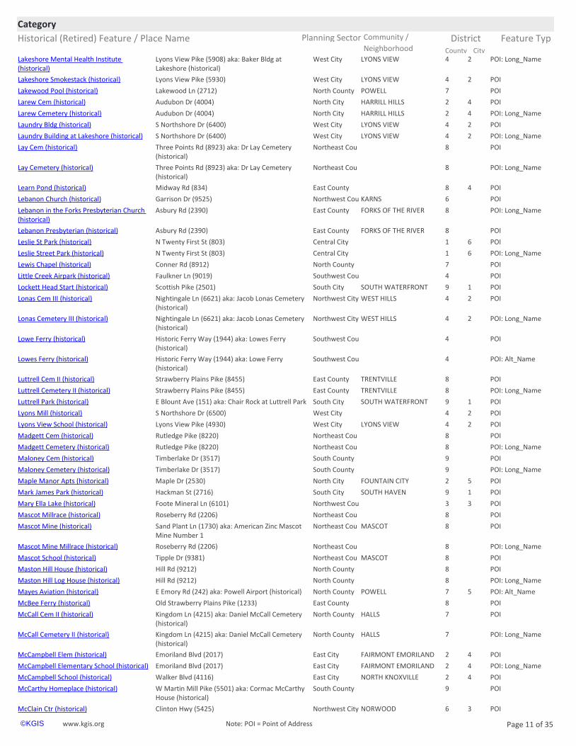
City County Neighborhoodhttps://www.kgis.org/kgismaps/map.htm? POI: Long_NameLakeshore Mental Health Institute (historical)
West City LYONS VIEW 4 2Lyons View Pike (5908) aka: Baker Bldg at Lakeshore (historical)
https://www.kgis.org/kgismaps/map.htm? POILakeshore Smokestack (historical) West City LYONS VIEW 4 2Lyons View Pike (5930)
https://www.kgis.org/kgismaps/map.htm? POILakewood Pool (historical) North County POWELL 7Lakewood Ln (2712)
https://www.kgis.org/kgismaps/map.htm? POILarew Cem (historical) North City HARRILL HILLS 2 4Audubon Dr (4004)
https://www.kgis.org/kgismaps/map.htm? POI: Long_NameLarew Cemetery (historical) North City HARRILL HILLS 2 4Audubon Dr (4004)
https://www.kgis.org/kgismaps/map.htm? POILaundry Bldg (historical) West City LYONS VIEW 4 2S Northshore Dr (6400)
https://www.kgis.org/kgismaps/map.htm? POI: Long_NameLaundry Building at Lakeshore (historical) West City LYONS VIEW 4 2S Northshore Dr (6400)
https://www.kgis.org/kgismaps/map.htm? POILay Cem (historical) Northeast Cou 8Three Points Rd (8923) aka: Dr Lay Cemetery (historical)
https://www.kgis.org/kgismaps/map.htm? POI: Long_NameLay Cemetery (historical) Northeast Cou 8Three Points Rd (8923) aka: Dr Lay Cemetery (historical)
https://www.kgis.org/kgismaps/map.htm? POILearn Pond (historical) East County 8 4Midway Rd (834)
https://www.kgis.org/kgismaps/map.htm? POILebanon Church (historical) Northwest Cou KARNS 6Garrison Dr (9525)
https://www.kgis.org/kgismaps/map.htm? POI: Long_NameLebanon in the Forks Presbyterian Church (historical)
East County FORKS OF THE RIVER 8Asbury Rd (2390)
https://www.kgis.org/kgismaps/map.htm? POILebanon Presbyterian (historical) East County FORKS OF THE RIVER 8Asbury Rd (2390)
https://www.kgis.org/kgismaps/map.htm? POILeslie St Park (historical) Central City 1 6N Twenty First St (803)
https://www.kgis.org/kgismaps/map.htm? POI: Long_NameLeslie Street Park (historical) Central City 1 6N Twenty First St (803)
https://www.kgis.org/kgismaps/map.htm? POILewis Chapel (historical) North County 7Conner Rd (8912)
https://www.kgis.org/kgismaps/map.htm? POILittle Creek Airpark (historical) Southwest Cou 4Faulkner Ln (9019)
https://www.kgis.org/kgismaps/map.htm? POILockett Head Start (historical) South City SOUTH WATERFRONT 9 1Scottish Pike (2501)
https://www.kgis.org/kgismaps/map.htm? POILonas Cem III (historical) Northwest City WEST HILLS 4 2Nightingale Ln (6621) aka: Jacob Lonas Cemetery (historical)
https://www.kgis.org/kgismaps/map.htm? POI: Long_NameLonas Cemetery III (historical) Northwest City WEST HILLS 4 2Nightingale Ln (6621) aka: Jacob Lonas Cemetery (historical)
https://www.kgis.org/kgismaps/map.htm? POILowe Ferry (historical) Southwest Cou 4Historic Ferry Way (1944) aka: Lowes Ferry (historical)
https://www.kgis.org/kgismaps/map.htm? POI: Alt_NameLowes Ferry (historical) Southwest Cou 4Historic Ferry Way (1944) aka: Lowe Ferry (historical)
https://www.kgis.org/kgismaps/map.htm? POILuttrell Cem II (historical) East County TRENTVILLE 8Strawberry Plains Pike (8455)
https://www.kgis.org/kgismaps/map.htm? POI: Long_NameLuttrell Cemetery II (historical) East County TRENTVILLE 8Strawberry Plains Pike (8455)
https://www.kgis.org/kgismaps/map.htm? POILuttrell Park (historical) South City SOUTH WATERFRONT 9 1E Blount Ave (151) aka: Chair Rock at Luttrell Park
https://www.kgis.org/kgismaps/map.htm? POILyons Mill (historical) West City 4 2S Northshore Dr (6500)
https://www.kgis.org/kgismaps/map.htm? POILyons View School (historical) West City LYONS VIEW 4 2Lyons View Pike (4930)
https://www.kgis.org/kgismaps/map.htm? POIMadgett Cem (historical) Northeast Cou 8Rutledge Pike (8220)
https://www.kgis.org/kgismaps/map.htm? POI: Long_NameMadgett Cemetery (historical) Northeast Cou 8Rutledge Pike (8220)
https://www.kgis.org/kgismaps/map.htm? POIMaloney Cem (historical) South County 9Timberlake Dr (3517)
https://www.kgis.org/kgismaps/map.htm? POI: Long_NameMaloney Cemetery (historical) South County 9Timberlake Dr (3517)
https://www.kgis.org/kgismaps/map.htm? POIMaple Manor Apts (historical) North City FOUNTAIN CITY 2 5Maple Dr (2530)
https://www.kgis.org/kgismaps/map.htm? POIMark James Park (historical) South City SOUTH HAVEN 9 1Hackman St (2716)
https://www.kgis.org/kgismaps/map.htm? POIMary Ella Lake (historical) Northwest Cou 3 3Foote Mineral Ln (6101)
https://www.kgis.org/kgismaps/map.htm? POIMascot Millrace (historical) Northeast Cou 8Roseberry Rd (2206)
https://www.kgis.org/kgismaps/map.htm? POIMascot Mine (historical) Northeast Cou MASCOT 8Sand Plant Ln (1730) aka: American Zinc Mascot Mine Number 1
https://www.kgis.org/kgismaps/map.htm? POI: Long_NameMascot Mine Millrace (historical) Northeast Cou 8Roseberry Rd (2206)
https://www.kgis.org/kgismaps/map.htm? POIMascot School (historical) Northeast Cou MASCOT 8Tipple Dr (9381)
https://www.kgis.org/kgismaps/map.htm? POIMaston Hill House (historical) North County 8Hill Rd (9212)
https://www.kgis.org/kgismaps/map.htm? POI: Long_NameMaston Hill Log House (historical) North County 8Hill Rd (9212)
https://www.kgis.org/kgismaps/map.htm? POI: Alt_NameMayes Aviation (historical) North County POWELL 7 5E Emory Rd (242) aka: Powell Airport (historical)
https://www.kgis.org/kgismaps/map.htm? POIMcBee Ferry (historical) East County 8Old Strawberry Plains Pike (1233)
https://www.kgis.org/kgismaps/map.htm? POIMcCall Cem II (historical) North County HALLS 7Kingdom Ln (4215) aka: Daniel McCall Cemetery (historical)
https://www.kgis.org/kgismaps/map.htm? POI: Long_NameMcCall Cemetery II (historical) North County HALLS 7Kingdom Ln (4215) aka: Daniel McCall Cemetery (historical)
https://www.kgis.org/kgismaps/map.htm? POIMcCampbell Elem (historical) East City FAIRMONT EMORILAND 2 4Emoriland Blvd (2017)
https://www.kgis.org/kgismaps/map.htm? POI: Long_NameMcCampbell Elementary School (historical) East City FAIRMONT EMORILAND 2 4Emoriland Blvd (2017)
https://www.kgis.org/kgismaps/map.htm? POIMcCampbell School (historical) East City NORTH KNOXVILLE 2 4Walker Blvd (4116)
https://www.kgis.org/kgismaps/map.htm? POIMcCarthy Homeplace (historical) South County 9W Martin Mill Pike (5501) aka: Cormac McCarthy House (historical)
https://www.kgis.org/kgismaps/map.htm? POIMcClain Ctr (historical) Northwest City NORWOOD 6 3Clinton Hwy (5425)
www.kgis.org Page 11 of 35©KGIS Note: POI = Point of Address

Historical (Retired) Feature / Place Name Planning Sector Feature Typ
CategoryCommunity / District
City County Neighborhoodhttps://www.kgis.org/kgismaps/map.htm? POI: Long_NameMcClain Shopping Center (historical) Northwest City NORWOOD 6 3Clinton Hwy (5425)
https://www.kgis.org/kgismaps/map.htm? POIMcClung Warehouses (historical) Central City JACKSON AVE WAREHOUS 1 6W Jackson Ave (517)
https://www.kgis.org/kgismaps/map.htm? POIMcMillan School (historical) Central City 1 6Howard Baker Jr Ave (500)
https://www.kgis.org/kgismaps/map.htm? POIMcReynolds Island (historical) Southwest Cou 5
https://www.kgis.org/kgismaps/map.htm? POIMelton Hill Community Center (historical) Northwest Cou 6Hickory Creek Rd (12508)
https://www.kgis.org/kgismaps/map.htm? POIMerchants Village Ctr (historical) Northwest City 2 5Merchants Center Blvd (5605)
https://www.kgis.org/kgismaps/map.htm? POI: Long_NameMerchants Village Shopping Center (historical)
Northwest City 2 5Merchants Center Blvd (5605)
https://www.kgis.org/kgismaps/map.htm? POIMiddlebrook Pike Church (historical) Northwest City 4 2South Middlebrook Pike (5416)
https://www.kgis.org/kgismaps/map.htm? POIMidway Church of God (historical) Central City 1 5Midway St (3342)
https://www.kgis.org/kgismaps/map.htm? POIMidway Ctr (historical) North County HALLS 7Maynardville Pike (6818)
https://www.kgis.org/kgismaps/map.htm? POI: Long_NameMidway Shopping Center (historical) North County HALLS 7Maynardville Pike (6818)
https://www.kgis.org/kgismaps/map.htm? POIMill Pond (historical) East County 8Thorn Grove Pike (10402)
https://www.kgis.org/kgismaps/map.htm? POIMiller Chapel (historical) Northeast Cou 8Boruff Rd (6523)
https://www.kgis.org/kgismaps/map.htm? POIMitchell Cem (historical) North County HALLS 7Sunny Creek Way (3009) aka: Joshua Mitchell Cemetery (historical)
https://www.kgis.org/kgismaps/map.htm? POI: Long_NameMitchell Cemetery (historical) North County HALLS 7Sunny Creek Way (3009) aka: Joshua Mitchell Cemetery (historical)
https://www.kgis.org/kgismaps/map.htm? POIMontvue Ctr (historical) West City WEST KNOXVILLE 4 2North Winston Rd (220)
https://www.kgis.org/kgismaps/map.htm? POI: Long_NameMontvue Shopping Center (historical) West City WEST KNOXVILLE 4 2North Winston Rd (220)
https://www.kgis.org/kgismaps/map.htm? POIMorgan Field (historical) South County KIMBERLIN HEIGHTS 9Hodges Ferry Rd (8001)
https://www.kgis.org/kgismaps/map.htm? POIMorrill Hall (historical) Central City UNIVERSITY OF TENNESSE 9 1Twentieth St (1038)
https://www.kgis.org/kgismaps/map.htm? POIMountain View School (historical) Central City MORNINGSIDE 1 6Dandridge Ave (1807)
https://www.kgis.org/kgismaps/map.htm? POIMurphy Chapel (historical) Northeast Cou 8Luttrell Rd (4671)
https://www.kgis.org/kgismaps/map.htm? POINeubert PO (historical) South County HENDRON 9Chapman Hwy (8200)
https://www.kgis.org/kgismaps/map.htm? POI: Long_NameNeubert Post Office (historical) South County HENDRON 9Chapman Hwy (8200)
https://www.kgis.org/kgismaps/map.htm? POINorth Halls Center (historical) North County HALLS 7Cunningham Rd (3745)
https://www.kgis.org/kgismaps/map.htm? POINorth Hills Presbyterian (historical) East City 2 4Prosser Rd (2329)
https://www.kgis.org/kgismaps/map.htm? POI: Long_NameNorth Hills Presbyterian Church (historical) East City 2 4Prosser Rd (2329)
https://www.kgis.org/kgismaps/map.htm? POIOak Hill Mansion (historical) Central City NORTH KNOXVILLE 2 5E Oak Hill Ave (900 #614) aka: Francis Alexander Ramsey Scott House (historical)
https://www.kgis.org/kgismaps/map.htm? POIPanorama Farm (historical) West City BEARDEN HILL 4 2Kingston Pike (6315 #308)
https://www.kgis.org/kgismaps/map.htm? POIPark City Lowry School (historical) Central City EAST KNOXVILLE 1 6Parkview Ave (2323)
https://www.kgis.org/kgismaps/map.htm? POIPark Jr High (historical) Central City EAST KNOXVILLE 1 6Parkview Ave (2315)
https://www.kgis.org/kgismaps/map.htm? POI: Long_NamePark Junior High School (historical) Central City EAST KNOXVILLE 1 6Parkview Ave (2315)
https://www.kgis.org/kgismaps/map.htm? POIParkway Ctr (historical) South City SOUTH KNOXVILLE 9 1Chapman Hwy (3940)
https://www.kgis.org/kgismaps/map.htm? POI: Long_NameParkway Shopping Center (historical) South City SOUTH KNOXVILLE 9 1Chapman Hwy (3940)
https://www.kgis.org/kgismaps/map.htm? POIPasqua Bldg (historical) Central City UNIVERSITY OF TENNESSE 9 1Estabrook Rd (1004)
https://www.kgis.org/kgismaps/map.htm? POI: Long_NamePasqua Nuclear Engineering Building (historical)
Central City UNIVERSITY OF TENNESSE 9 1Estabrook Rd (1004)
https://www.kgis.org/kgismaps/map.htm? POIPete Stafford Field (historical) South City SOUTH KNOXVILLE 9 1Decatur Dr (3901)
https://www.kgis.org/kgismaps/map.htm? POIPeter Kern House (historical) Central City MARKET STREET DISTRICT 1 6Locust St (408)
https://www.kgis.org/kgismaps/map.htm? POI: Alt_NamePeter Shipe Cemetery (historical) Northeast Cou 8Shipe Rd (3515) aka: Shipe Cem III (historical)
https://www.kgis.org/kgismaps/map.htm? POIPickle Mansion (historical) Central City FORT SANDERS 1 1Clinch Ave (1633)
https://www.kgis.org/kgismaps/map.htm? POIPleasant Chapel (historical) Northwest Cou 6Coward Mill Rd (10515)
https://www.kgis.org/kgismaps/map.htm? POIPleasant Forest Presbyterian (historical) Southwest Cou 5Concord Rd (401)
https://www.kgis.org/kgismaps/map.htm? POI: Long_NamePleasant Forest Presbyterian Church (historical)
Southwest Cou 5Concord Rd (401)
https://www.kgis.org/kgismaps/map.htm? POIPoore Hall (historical) South City ISLAND HOME 9 1Island Home Blvd (2725)
https://www.kgis.org/kgismaps/map.htm? POIPost Oak Island (historical) Southwest Cou 4 2aka: Turkey Island (historical)
https://www.kgis.org/kgismaps/map.htm? POIPowell Airport (historical) North County POWELL 7 5E Emory Rd (242) aka: Mayes Aviation (historical)
https://www.kgis.org/kgismaps/map.htm? POIPraters Ferry (historical) Southwest Cou 5Prater Ln (12044)
https://www.kgis.org/kgismaps/map.htm? POI: Alt_NamePulaski Hall Cemetery (historical) North County HALLS 7Bonair Rd (7105) aka: Hall Cem IV (historical)
https://www.kgis.org/kgismaps/map.htm? POIRaby Airpark (historical) Southwest Cou BOYD 5Raby Way (12716)
https://www.kgis.org/kgismaps/map.htm? POIRamsey Ferry (historical) East County 1 6Asbury Rd (2403)
https://www.kgis.org/kgismaps/map.htm? POIRamsey School (historical) East County 8Strawberry Plains Pike (4920)
https://www.kgis.org/kgismaps/map.htm? POIReynolds Cem (historical) West City BEARDEN HILL 4 2Major Reynolds Pl (140)
https://www.kgis.org/kgismaps/map.htm? POI: Long_NameReynolds Cemetery (historical) West City BEARDEN HILL 4 2Major Reynolds Pl (140)
https://www.kgis.org/kgismaps/map.htm? POIRising Sun School (historical) Northeast Cou SUNRISE 8Sunrise Rd (8504)
https://www.kgis.org/kgismaps/map.htm? POIRiverdale Ferry (historical) East County 8Thorn Grove Pike (6604)
www.kgis.org Page 12 of 35©KGIS Note: POI = Point of Address
https://www.kgis.org/kgismaps/map.htm?map=park&place=Mitchell%20Cemetery%20(historical)&method=exact
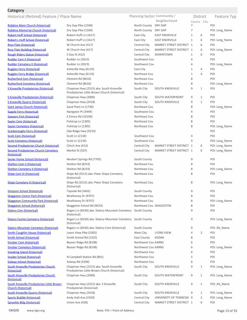
Historical (Retired) Feature / Place Name Planning Sector Feature Typ
CategoryCommunity / District
City County Neighborhoodhttps://www.kgis.org/kgismaps/map.htm? POIRobbins Mem Church (historical) North County DRY GAP 7Dry Gap Pike (1500)
https://www.kgis.org/kgismaps/map.htm? POI: Long_NameRobbins Memorial Church (historical) North County DRY GAP 7Dry Gap Pike (1500)
https://www.kgis.org/kgismaps/map.htm? POIRobert Huff School (historical) East City EAST KNOXVILLE 1 6Robert Huff Ln (1617)
https://www.kgis.org/kgismaps/map.htm? POI: Long_NameRobert L Huff School (historical) East City EAST KNOXVILLE 1 6Robert Huff Ln (1617)
https://www.kgis.org/kgismaps/map.htm? POIRoss Flats (historical) Central City MARKET STREET DISTRICT 1 6W Church Ave (417)
https://www.kgis.org/kgismaps/map.htm? POI: Long_NameRoss Flats Building (historical) Central City MARKET STREET DISTRICT 1 6W Church Ave (417)
https://www.kgis.org/kgismaps/map.htm? POIRough Riders Statue (historical) Central City DOWNTOWN 1 6S Gay St (422)
https://www.kgis.org/kgismaps/map.htm? POIRudder Cem II (historical) Southwest Cou 4Rudder Ln (2023)
https://www.kgis.org/kgismaps/map.htm? POI: Long_NameRudder Cemetery II (historical) Southwest Cou 4Rudder Ln (2023)
https://www.kgis.org/kgismaps/map.htm? POIRuggles Ferry (historical) East City 1 4Asheville Hwy (6110)
https://www.kgis.org/kgismaps/map.htm? POIRuggles Ferry Bridge (historical) Northeast Cou 1 4Asheville Hwy (6110)
https://www.kgis.org/kgismaps/map.htm? POIRutherford Cem (historical) Northeast Cou 8Clement Rd (8616)
https://www.kgis.org/kgismaps/map.htm? POI: Long_NameRutherford Cemetery (historical) Northeast Cou 8Clement Rd (8616)
https://www.kgis.org/kgismaps/map.htm? POIS Knoxville Presbyterian (historical) South City SOUTH KNOXVILLE 9 1Chapman Hwy (2315) aka: South Knoxville Presbyterian Little Brown Church (historical)
https://www.kgis.org/kgismaps/map.htm? POIS Knoxville Presbyterian (historical) South City SOUTH WATERFRONT 9 1Chapman Hwy (2000)
https://www.kgis.org/kgismaps/map.htm? POIS Knoxville Quarry (historical) South City SOUTH KNOXVILLE 9 1Chapman Hwy (2418)
https://www.kgis.org/kgismaps/map.htm? POI: Long_NameSaint James Church (historical) Northeast Cou 8Sand Plant Ln (1730)
https://www.kgis.org/kgismaps/map.htm? POISapple Ferry (historical) Southwest Cou 4Navigator Pt (3494)
https://www.kgis.org/kgismaps/map.htm? POISawyers Fort (historical) Northeast Cou 8E Emory Rd (10106)
https://www.kgis.org/kgismaps/map.htm? POISaylor Cem (historical) Northeast Cou 8Fishtrap Ln (1305)
https://www.kgis.org/kgismaps/map.htm? POI: Long_NameSaylor Cemetery (historical) Northeast Cou 8Fishtrap Ln (1305)
https://www.kgis.org/kgismaps/map.htm? POIScarboroughs Ferry (historical) Oak Ridge Hwy (9233)
https://www.kgis.org/kgismaps/map.htm? POIScott Cem (historical) Southwest Cou 4Scott Ln (2134)
https://www.kgis.org/kgismaps/map.htm? POI: Long_NameScott Cemetery (historical) Southwest Cou 4Scott Ln (2134)
https://www.kgis.org/kgismaps/map.htm? POI: Long_NameSecond Presbyterian Church (historical) Central City MARKET STREET DISTRICT 1 6Clinch Ave (413)
https://www.kgis.org/kgismaps/map.htm? POI: Long_NameSecond Presbyterian Church Cemetery (historical)
Central City MARKET STREET DISTRICT 1 6Market St (507)
https://www.kgis.org/kgismaps/map.htm? POISevier Home School (historical) South County 9Neubert Springs Rd (7705)
https://www.kgis.org/kgismaps/map.htm? POIShelton Cem II (historical) Northeast Cou 8Shelton Rd (8233)
https://www.kgis.org/kgismaps/map.htm? POI: Long_NameShelton Cemetery II (historical) Northeast Cou 8Shelton Rd (8233)
https://www.kgis.org/kgismaps/map.htm? POIShipe Cem III (historical) Northeast Cou 8Shipe Rd (3515) aka: Peter Shipe Cemetery (historical)
https://www.kgis.org/kgismaps/map.htm? POI: Long_NameShipe Cemetery III (historical) Northeast Cou 8Shipe Rd (3515) aka: Peter Shipe Cemetery (historical)
https://www.kgis.org/kgismaps/map.htm? POISimpson School (historical) South County 9Topside Rd (3402)
https://www.kgis.org/kgismaps/map.htm? POISkaggston Comm Park (historical) Northeast Cou 8Mcelhaney Dr (9707)
https://www.kgis.org/kgismaps/map.htm? POI: Long_NameSkaggston Community Park (historical) Northeast Cou 8Mcelhaney Dr (9707)
https://www.kgis.org/kgismaps/map.htm? POISkaggston School (historical) Northeast Cou SKAGGSTON 8Skaggston School Rd (9433)
https://www.kgis.org/kgismaps/map.htm? POISlatery Cem (historical) South County 9Rogers Ln (8330) aka: Slatery Mountain Cemetery (historical)
https://www.kgis.org/kgismaps/map.htm? POI: Long_NameSlatery Family Cemetery (historical) South County 9Rogers Ln (8330) aka: Slatery Mountain Cemetery (historical)
https://www.kgis.org/kgismaps/map.htm? POI: Alt_NameSlatery Mountain Cemetery (historical) South County 9Rogers Ln (8330) aka: Slatery Cem (historical)
https://www.kgis.org/kgismaps/map.htm? POISmith Coughlin House (historical) West City LYONS VIEW 4 2Lyons View Pike (5305)
https://www.kgis.org/kgismaps/map.htm? POISmith School (historical) East County KODAK 8Smith School Rd (1325)
https://www.kgis.org/kgismaps/map.htm? POISmoker Cem (historical) Northwest Cou KARNS 6Beaver Ridge Rd (8108)
https://www.kgis.org/kgismaps/map.htm? POI: Long_NameSmoker Cemetery (historical) Northwest Cou KARNS 6Beaver Ridge Rd (8108)
https://www.kgis.org/kgismaps/map.htm? POISneaking Island (historical) Northwest Cou 6
https://www.kgis.org/kgismaps/map.htm? POISnyder School (historical) Northwest Cou 5N Campbell Station Rd (801)
https://www.kgis.org/kgismaps/map.htm? POISolway School (historical) Northwest Cou 6Solway Rd (3206)
https://www.kgis.org/kgismaps/map.htm? POI: Long_NameSouth Knoxville Presbyterian Church (historical)
South City SOUTH KNOXVILLE 9 1Chapman Hwy (2315) aka: South Knoxville Presbyterian Little Brown Church (historical)
https://www.kgis.org/kgismaps/map.htm? POI: Long_NameSouth Knoxville Presbyterian Church (historical)
South City SOUTH WATERFRONT 9 1Chapman Hwy (2000)
https://www.kgis.org/kgismaps/map.htm? POI: Alt_NameSouth Knoxville Presbyterian Little Brown Church (historical)
South City SOUTH KNOXVILLE 9 1Chapman Hwy (2315) aka: S Knoxville Presbyterian (historical)
https://www.kgis.org/kgismaps/map.htm? POI: Long_NameSouth Knoxville Quarry (historical) South City SOUTH KNOXVILLE 9 1Chapman Hwy (2418)
https://www.kgis.org/kgismaps/map.htm? POI: Long_NameSports Bubble (historical) Central City UNIVERSITY OF TENNESSE 9 2Andy Holt Ave (1920)
https://www.kgis.org/kgismaps/map.htm? POISprankle Bldg (historical) Central City MARKET STREET DISTRICT 1 6Union Ave (428)
www.kgis.org Page 13 of 35©KGIS Note: POI = Point of Address

Historical (Retired) Feature / Place Name Planning Sector Feature Typ
CategoryCommunity / District
City County Neighborhoodhttps://www.kgis.org/kgismaps/map.htm? POISt James Church (historical) Northeast Cou 8Sand Plant Ln (1730)
https://www.kgis.org/kgismaps/map.htm? POISt James Hotel (historical) Central City SUMMIT HILL 1 6Wall Ave (301)
https://www.kgis.org/kgismaps/map.htm? POI: Long_NameSt James Hotel Building (historical) Central City SUMMIT HILL 1 6Wall Ave (301)
https://www.kgis.org/kgismaps/map.htm? POIStinnett Cem (historical) Southwest Cou 4Spring Pass Way (1456)
https://www.kgis.org/kgismaps/map.htm? POI: Long_NameStinnett Cemetery (historical) Southwest Cou 4Spring Pass Way (1456)
https://www.kgis.org/kgismaps/map.htm? POI: Long_NameStokely Athletic Center (historical) Central City UNIVERSITY OF TENNESSE 9 2Johnny Majors Dr (1717) aka: Armory Fieldhouse (historical)
https://www.kgis.org/kgismaps/map.htm? POIStokely Athletic Ctr (historical) Central City UNIVERSITY OF TENNESSE 9 2Johnny Majors Dr (1717) aka: Armory Fieldhouse (historical)
https://www.kgis.org/kgismaps/map.htm? POI: Long_NameStony Point Baptist Church (historical) East County 8Stony Point Rd (2009)
https://www.kgis.org/kgismaps/map.htm? POI: Long_NameStony Point Church in Halls (historical) North County HALLS 7E Emory Rd (5113)
https://www.kgis.org/kgismaps/map.htm? POIStony Pt Baptist (historical) East County 8Stony Point Rd (2009)
https://www.kgis.org/kgismaps/map.htm? POIStony Pt Church Halls (historical) North County HALLS 7E Emory Rd (5113)
https://www.kgis.org/kgismaps/map.htm? POITaliaferro Island (historical) Southwest Cou 5
https://www.kgis.org/kgismaps/map.htm? POITan Rara Airport (historical) Southwest Cou TAN RARA 5Casa Real Cove (10040)
https://www.kgis.org/kgismaps/map.htm? POI: Alt_NameTarwater - Flenniken II Cemetery (historical) Southwest Cou RIVERBEND 4Lyons Bend Rd (2127) aka: Flenniken Cem (historical)
https://www.kgis.org/kgismaps/map.htm? POITarwater Cem (historical) South County 9Bud King Ln (8400) aka: Hahn - Tarwater Cemetery (historical)
https://www.kgis.org/kgismaps/map.htm? POI: Alt_NameTaylor Bridge (historical) East County 8 4Asheville Hwy (6110) aka: J Will Taylor Bridge (historical)
https://www.kgis.org/kgismaps/map.htm? POI: Long_NameTemple Court (historical) Central City UNIVERSITY OF TENNESSE 9 1Volunteer Blvd (804)
https://www.kgis.org/kgismaps/map.htm? POITemple Ct (historical) Central City UNIVERSITY OF TENNESSE 9 1Volunteer Blvd (804)
https://www.kgis.org/kgismaps/map.htm? POI: Alt_NameTerminal Building (historical) Central City DOWNTOWN 1 6S Gay St (322) aka: Union Bus Terminal (historical)
https://www.kgis.org/kgismaps/map.htm? POIThe Bowery (historical) Central City DOWNTOWN 1 6S Central St (300)
https://www.kgis.org/kgismaps/map.htm? POIThe Deanery (historical) West City DEANE HILL 4 2Catherine Mcauley Way (401) aka: Deane Hill Country Club
https://www.kgis.org/kgismaps/map.htm? POI: Long_NameThe Deanery Clubhouse (historical) West City DEANE HILL 4 2Catherine Mcauley Way (401) aka: Deane Hill Country Club
https://www.kgis.org/kgismaps/map.htm? POI: Long_NameThe Gate Sculpture (historical) South City VESTAL 9 1Maryville Pike (401)
https://www.kgis.org/kgismaps/map.htm? POI: Alt_NameThe Governors House (historical) Central City FOURTH & GILL 2 4N Fourth Ave (803) aka: Caswell Taylor House (historical)
https://www.kgis.org/kgismaps/map.htm? POI: Long_NameThe Sprankle Building (historical) Central City MARKET STREET DISTRICT 1 6Union Ave (428)
https://www.kgis.org/kgismaps/map.htm? POIThomas Cem (historical) Northeast Cou 8Harris Rd (1702)
https://www.kgis.org/kgismaps/map.htm? POI: Long_NameThomas Cemetery (historical) Northeast Cou 8Harris Rd (1702)
https://www.kgis.org/kgismaps/map.htm? POI: Long_NameThomas J Walker House (historical) Northwest Cou 4 2Mars Hill Rd (645)
https://www.kgis.org/kgismaps/map.htm? POIThomas Walker House (historical) Northwest Cou 4 2Mars Hill Rd (645)
https://www.kgis.org/kgismaps/map.htm? POIThompson School (historical) Northeast Cou CLEAR SPRINGS 8Thompson School Rd (8518)
https://www.kgis.org/kgismaps/map.htm? POIThree Rivers Boat Ramp (historical) East County FORKS OF THE RIVER 8Asbury Rd (2403)
https://www.kgis.org/kgismaps/map.htm? POI: Alt_NameTillery Cemetery (historical) North City DANTE 7Kern Rd (6601) aka: Callahan Cem (historical)
https://www.kgis.org/kgismaps/map.htm? POITreble Clef Statue (historical) Central City DOWNTOWN 1 6W Summit Hill Dr (207)
https://www.kgis.org/kgismaps/map.htm? POITrinity Church (historical) East County 8N East End Rd (803)
https://www.kgis.org/kgismaps/map.htm? POI: Long_NameTSD Poore Hall (historical) South City ISLAND HOME 9 1Island Home Blvd (2725)
https://www.kgis.org/kgismaps/map.htm? POI: Alt_NameTurkey Island (historical) Southwest Cou 4 2aka: Post Oak Island (historical)
https://www.kgis.org/kgismaps/map.htm? POIUnion Bus Terminal (historical) Central City DOWNTOWN 1 6S Gay St (322) aka: Terminal Building (historical)
https://www.kgis.org/kgismaps/map.htm? POIUniversity Center (historical) Central City UNIVERSITY OF TENNESSE 9 1Cumberland Ave (1502)
https://www.kgis.org/kgismaps/map.htm? POI: Alt_NameUnnamed Cemetery West City BEARDEN 4 2Baum Dr (6431) aka: James Miller Cem (historical)
https://www.kgis.org/kgismaps/map.htm? POIUnnamed Cemetery (historical) Central City 3 3Sanderson Rd (2917)
https://www.kgis.org/kgismaps/map.htm? POIUnnamed Cemetery (historical) Northeast Cou 8E Emory Rd (10023)
https://www.kgis.org/kgismaps/map.htm? POIUphostery Bldg (historical) West City LYONS VIEW 4 2Lyons View Pike (5930)
https://www.kgis.org/kgismaps/map.htm? POI: Long_NameUphostery Building at Lakeshore (historical) West City LYONS VIEW 4 2Lyons View Pike (5930)
https://www.kgis.org/kgismaps/map.htm? POI: Alt_NameUT Anthopology (historical) Central City UNIVERSITY OF TENNESSE 9 1Neyland Dr (901) aka: Biology Annex (historical)
https://www.kgis.org/kgismaps/map.htm? POI: Long_NameUT Berry Hall (historical) Central City UNIVERSITY OF TENNESSE 9 1Estabrook Rd (1012)
https://www.kgis.org/kgismaps/map.htm? POI: Long_NameUT Biology Annex Building (historical) Central City UNIVERSITY OF TENNESSE 9 1Neyland Dr (901) aka: UT Anthopology (historical)
https://www.kgis.org/kgismaps/map.htm? POIUT Child Dev (historical) West City POND GAP 4 6Hospitality Cir (6908) aka: UT Early Learning Center Labratory (historical)
https://www.kgis.org/kgismaps/map.htm? POI: Long_NameUT Child Development Institute (historical) West City POND GAP 4 6Hospitality Cir (6908) aka: UT Early Learning Center Labratory (historical)
https://www.kgis.org/kgismaps/map.htm? POI: Alt_NameUT Early Learning Center Labratory (historical)
West City POND GAP 4 6Hospitality Cir (6908) aka: UT Child Dev (historical)
https://www.kgis.org/kgismaps/map.htm? POI: Long_NameUT Humes Hall (historical) Central City UNIVERSITY OF TENNESSE 9 1Andy Holt Ave (1911)
www.kgis.org Page 14 of 35©KGIS Note: POI = Point of Address
Historical (Retired) Feature / Place Name Planning Sector Feature Typ
CategoryCommunity / District
City County Neighborhoodhttps://www.kgis.org/kgismaps/map.htm? POI: Long_NameUT Morrill Hall (historical) Central City UNIVERSITY OF TENNESSE 9 1Twentieth St (1038)
https://www.kgis.org/kgismaps/map.htm? POIUT Sports Bubble (historical) Central City UNIVERSITY OF TENNESSE 9 2Andy Holt Ave (1920)
https://www.kgis.org/kgismaps/map.htm? POIVillage Mall Bldg (historical) West City LYONS VIEW 4 2S Northshore Dr (6404)
https://www.kgis.org/kgismaps/map.htm? POI: Long_NameVillage Mall Building at Lakeshore (historical) West City LYONS VIEW 4 2S Northshore Dr (6404)
https://www.kgis.org/kgismaps/map.htm? POIWaterside Bldg (historical) West City LYONS VIEW 4 2S Northshore Dr (6400)
https://www.kgis.org/kgismaps/map.htm? POI: Long_NameWaterside Building at Lakeshore (historical) West City LYONS VIEW 4 2S Northshore Dr (6400)
https://www.kgis.org/kgismaps/map.htm? POIWeston Fulton House (historical) Central City UNIVERSITY OF TENNESSE 9 1Volunteer Blvd (900) aka: Weston M Fulton Jr Memorial Hospital (historical)
https://www.kgis.org/kgismaps/map.htm? POI: Alt_NameWeston M Fulton Jr Memorial Hospital (historical)
Central City UNIVERSITY OF TENNESSE 9 1Volunteer Blvd (900) aka: Weston Fulton House (historical)
https://www.kgis.org/kgismaps/map.htm? POIWestside Dinner Theatre (historical) Southwest Cou 5Kingston Pike (12717)
https://www.kgis.org/kgismaps/map.htm? POIWhittle Springs Hotel (historical) East City WHITTLE SPRINGS 2 4Mineral Springs Ave (2704)
https://www.kgis.org/kgismaps/map.htm? POI: Long_NameWhittle Springs Resort Hotel (historical) East City WHITTLE SPRINGS 2 4Mineral Springs Ave (2704)
https://www.kgis.org/kgismaps/map.htm? POIWilliams Senior Ctr (historical) Central City FIVE POINTS 1 6Martin Luther King Jr Ave (2240) aka: Dr Lee Williams Complex (historical)
https://www.kgis.org/kgismaps/map.htm? POIYork Cem II (historical) Northwest City 4 2Old Weisgarber Rd (1254)
https://www.kgis.org/kgismaps/map.htm? POI: Long_NameYork Cemetery II (historical) Northwest City 4 2Old Weisgarber Rd (1254)
Historical:Feature Still Existshttps://www.kgis.org/kgismaps/map.htm? POI: Alt_Name1st Baptist Church of Fountain City (historical)
North City FOUNTAIN CITY 2 4Holbrook Dr (2619) aka: First Baptist of Ftn City (historical)
https://www.kgis.org/kgismaps/map.htm? POI: Alt_Name1st Congregational Church of Knoxville (historical)
Northwest City 4 2N Weisgarber Rd (934) aka: First Congregational Church (historical)
https://www.kgis.org/kgismaps/map.htm? POI: Alt_Name1st Landmark Missionary Baptist Church (historical)
Northwest Cou 6Hickey Rd (1321) aka: First Landmark Baptist (historical)
https://www.kgis.org/kgismaps/map.htm? POI: Alt_Name1st Trinity Wesleyan Church (historical) Central City NORTH KNOXVILLE 2 5E Emerald Ave (506) aka: First Trinity Wesleyan (historical)
https://www.kgis.org/kgismaps/map.htm? POI: Alt_Name1st United Presbyterian Church (historical) Central City MECHANICSVILLE 1 6Knoxville College Dr (809) aka: First United Presbyterian (historical)
https://www.kgis.org/kgismaps/map.htm? POI9th Ward School (historical) Central City MECHANICSVILLE 1 6Carrick St (220)
https://www.kgis.org/kgismaps/map.htm? POIA K Stewart Science Bldg (historical) Central City MECHANICSVILLE 1 6Knoxville College Dr (915)
https://www.kgis.org/kgismaps/map.htm? POI: Long_NameA K Stewart Science Building (historical) Central City MECHANICSVILLE 1 6Knoxville College Dr (915)
https://www.kgis.org/kgismaps/map.htm? POIAhlulbayt Islamic Center (historical) South City SOUTH KNOXVILLE 9 1Chapman Hwy (3607)
https://www.kgis.org/kgismaps/map.htm? POIAichton Mem Baptist (historical) Southwest Cou CONCORD 5Loop Rd (801)
https://www.kgis.org/kgismaps/map.htm? POI: Long_NameAichton Memorial Baptist Church (historical) Southwest Cou CONCORD 5Loop Rd (801)
https://www.kgis.org/kgismaps/map.htm? POIAmazing Grace Assembly (historical) Central City 2 5W Columbia Ave (123) aka: Fountain of Life Assembly of God (historical)
https://www.kgis.org/kgismaps/map.htm? POI: Long_NameAmazing Grace Assembly of God (historical) Central City 2 5W Columbia Ave (123) aka: Fountain of Life Assembly of God (historical)
https://www.kgis.org/kgismaps/map.htm? POI: Alt_NameAncient Egyptian Arabic Order Nobles Mystic Masonic Lodge (historical)
East City PARK CITY 1 6Selma Ave (2834) aka: Knoxville Masonic Lodge (historical)
https://www.kgis.org/kgismaps/map.htm? POIAnderson Elem (historical) South County 9 1Prospect Rd (4808)
https://www.kgis.org/kgismaps/map.htm? POI: Long_NameAnderson Elementary School (historical) South County 9 1Prospect Rd (4808)
https://www.kgis.org/kgismaps/map.htm? POIAppalachian Child Dev (historical) West City 4 2Gleason Rd (8042)
https://www.kgis.org/kgismaps/map.htm? POI: Long_NameAppalachian Regional Child Development Center (historical)
West City 4 2Gleason Rd (8042)
https://www.kgis.org/kgismaps/map.htm? POIArminda School (historical) Northeast Cou ARMINDA 8Ellistown Rd (2124)
https://www.kgis.org/kgismaps/map.htm? POIAult Rd Church of Christ (historical) East City 1 4Ault Rd (1501)
https://www.kgis.org/kgismaps/map.htm? POI: Long_NameAult Road Church of Christ (historical) East City 1 4Ault Rd (1501)
https://www.kgis.org/kgismaps/map.htm? POIAustin High (historical) Central City EAST KNOXVILLE 1 6Martin Luther King Jr Ave (1807)
https://www.kgis.org/kgismaps/map.htm? POI: Long_NameAustin High School (historical) Central City EAST KNOXVILLE 1 6Martin Luther King Jr Ave (1807)
https://www.kgis.org/kgismaps/map.htm? POIAustin Homes Rec Ctr (historical) Central City EAST KNOXVILLE 1 6Martin Luther King Jr Ave (1807)
https://www.kgis.org/kgismaps/map.htm? POI: Long_NameAustin Homes Recreation Center (historical) Central City EAST KNOXVILLE 1 6Martin Luther King Jr Ave (1807)
https://www.kgis.org/kgismaps/map.htm? POIAvenue A Church of God (historical) South City VESTAL 9 1Avenue A (1109)
https://www.kgis.org/kgismaps/map.htm? POIBaker Chapel Baptist (historical) Central City MARBLE CITY 1 6Sutherland Ave (2554)
https://www.kgis.org/kgismaps/map.htm? POI: Long_NameBaker Chapel United Baptist Church (historical)
Central City MARBLE CITY 1 6Sutherland Ave (2554)
https://www.kgis.org/kgismaps/map.htm? POIBall Rd Church of God (historical) Northwest Cou 6Ball Rd (6111)
https://www.kgis.org/kgismaps/map.htm? POI: Long_NameBall Road Church of God (historical) Northwest Cou 6Ball Rd (6111)
https://www.kgis.org/kgismaps/map.htm? POIBaptist Hosp (historical) South City SOUTH WATERFRONT 9 1E Blount Ave (221) aka: Tennova Hosptial Riverside (historical)
https://www.kgis.org/kgismaps/map.htm? POIBaptist Hospital Chapel (historical) South City SOUTH WATERFRONT 9 1E Blount Ave (151)
www.kgis.org Page 15 of 35©KGIS Note: POI = Point of Address

Historical (Retired) Feature / Place Name Planning Sector Feature Typ
CategoryCommunity / District
City County Neighborhoodhttps://www.kgis.org/kgismaps/map.htm? POIBarbara Hill (historical) Central City UNIVERSITY OF TENNESSE 9 1Circle Dr (1403) aka: University Hill
https://www.kgis.org/kgismaps/map.htm? POIBarner Cem (historical) North County HALLS 7E Emory Rd (4822 #B)
https://www.kgis.org/kgismaps/map.htm? POI: Long_NameBarner Cemetery (historical) North County HALLS 7E Emory Rd (4822 #B)
https://www.kgis.org/kgismaps/map.htm? POIBaxter Ave Baptist (historical) Central City MECHANICSVILLE 1 6W Baxter Ave (923) aka: New Victory Baptist Church (historical)
https://www.kgis.org/kgismaps/map.htm? POIBearden Christian (historical) West City BEARDEN 4 2Kingston Pike (5902) aka: Korean Christian Church of Bearden (historical)
https://www.kgis.org/kgismaps/map.htm? POI: Long_NameBearden Christian Church (historical) West City BEARDEN 4 2Kingston Pike (5902) aka: Korean Christian Church of Bearden (historical)
https://www.kgis.org/kgismaps/map.htm? POIBeardsley Middle (historical) Central City MECHANICSVILLE 1 6Reynolds St (1719)
https://www.kgis.org/kgismaps/map.htm? POI: Long_NameBeardsley Middle School (historical) Central City MECHANICSVILLE 1 6Reynolds St (1719)
https://www.kgis.org/kgismaps/map.htm? POIBeech Grove Cem (historical) Northwest Cou 6Blacks Ferry Rd (8011)
https://www.kgis.org/kgismaps/map.htm? POI: Long_NameBeech Grove Cemetery (historical) Northwest Cou 6Blacks Ferry Rd (8011)
https://www.kgis.org/kgismaps/map.htm? POIBell Ave Baptist (historical) East City CHILHOWEE HILLS 1 6Asheville Hwy (4615)
https://www.kgis.org/kgismaps/map.htm? POI: Long_NameBell Avenue Baptist Church (historical) East City CHILHOWEE HILLS 1 6Asheville Hwy (4615)
https://www.kgis.org/kgismaps/map.htm? POIBell Cem II (historical) East County 8S Patty Rd (215)
https://www.kgis.org/kgismaps/map.htm? POI: Long_NameBell Cemetery II (historical) East County 8S Patty Rd (215)
https://www.kgis.org/kgismaps/map.htm? POIBelleview Cem (historical) Central City EAST KNOXVILLE 1 6Martin Luther King Jr Ave (2020) aka: Bellevue County Cemetery (historical)
https://www.kgis.org/kgismaps/map.htm? POI: Long_NameBelleview County Cemetery (historical) Central City EAST KNOXVILLE 1 6Martin Luther King Jr Ave (2020) aka: Bellevue County Cemetery (historical)
https://www.kgis.org/kgismaps/map.htm? POI: Alt_NameBellevue County Cemetery (historical) Central City EAST KNOXVILLE 1 6Martin Luther King Jr Ave (2020) aka: Belleview Cem (historical)
https://www.kgis.org/kgismaps/map.htm? POIBerea Baptist (Pond Gap) (historical) Central City POND GAP 1 6Washburn Rd (704)
https://www.kgis.org/kgismaps/map.htm? POI: Long_NameBerea Baptist Church (Pond Gap) (historical) Central City POND GAP 1 6Washburn Rd (704)
https://www.kgis.org/kgismaps/map.htm? POIBerkeley St (historical) East City FAIRMONT EMORILAND 2 4Fairmont Blvd (1706)
https://www.kgis.org/kgismaps/map.htm? POI: Long_NameBethel African Methodist Episcopal (AME) Church (historical)
East City EAST KNOXVILLE 1 6Boyds Bridge Pike (3811)
https://www.kgis.org/kgismaps/map.htm? POIBethel AME (historical) East City EAST KNOXVILLE 1 6Boyds Bridge Pike (3811)
https://www.kgis.org/kgismaps/map.htm? POIBethesda Baptist (historical) Central City NEW TOWN 1 6Glider Ave (1000)
https://www.kgis.org/kgismaps/map.htm? POI: Long_NameBethesda Baptist Church (historical) Central City NEW TOWN 1 6Glider Ave (1000)
https://www.kgis.org/kgismaps/map.htm? POIBethesda Christian Fellowship (historical) North City 2 5Cedar Ln (1015) aka: Christ Chapel (Bethesda) Christian Fellowship Church (historical)
https://www.kgis.org/kgismaps/map.htm? POIBethlehem Methodist (historical) Northeast Cou 8Millertown Pike (7921)
https://www.kgis.org/kgismaps/map.htm? POI: Long_NameBethlehem Methodist Church (historical) Northeast Cou 8Millertown Pike (7921)
https://www.kgis.org/kgismaps/map.htm? POIBeveridge Hall (historical) Central City MECHANICSVILLE 1 6Knoxville College Dr (933)
https://www.kgis.org/kgismaps/map.htm? POIBible Church of God (historical) Central City 1 3Whedbee Dr (3906)
https://www.kgis.org/kgismaps/map.htm? POIBible Deliverance Church (historical) Central City MECHANICSVILLE 1 6University Ave (907)
https://www.kgis.org/kgismaps/map.htm? POIBible Presbyterian (historical) East City 1 4Buffat Mill Rd (3711)
https://www.kgis.org/kgismaps/map.htm? POI: Long_NameBible Presbyterian Church (historical) East City 1 4Buffat Mill Rd (3711)
https://www.kgis.org/kgismaps/map.htm? POIBible Way Baptist (historical) Northwest Cou KARNS 6Wright Rd (7003)
https://www.kgis.org/kgismaps/map.htm? POI: Long_NameBible Way Baptist Church (historical) Northwest Cou KARNS 6Wright Rd (7003)
https://www.kgis.org/kgismaps/map.htm? POIBicentennial Park (historical) Central City 1 6Neyland Dr (300)
https://www.kgis.org/kgismaps/map.htm? POIBishop Shea Knights Hall (historical) Northeast Cou MILLERTOWN 8Millertown Pike (6515)
https://www.kgis.org/kgismaps/map.htm? POI: Long_NameBishop Shea Knights of Columbus Council Hall (historical)
Northeast Cou MILLERTOWN 8Millertown Pike (6515)
https://www.kgis.org/kgismaps/map.htm? POIBlind Hill (historical) West City LYONS VIEW 4 2S Northshore Dr (6414)
https://www.kgis.org/kgismaps/map.htm? POIBlount Ave Baptist (historical) South City SOUTH KNOXVILLE 9 1Wrinkle Ave (137) aka: Blount Avenue Missionary Baptist Church (historical)
https://www.kgis.org/kgismaps/map.htm? POI: Long_NameBlount Avenue Baptist Church (historical) South City SOUTH KNOXVILLE 9 1Wrinkle Ave (137) aka: Blount Avenue Missionary Baptist Church (historical)
https://www.kgis.org/kgismaps/map.htm? POI: Alt_NameBlount Avenue Missionary Baptist Church (historical)
South City SOUTH KNOXVILLE 9 1Wrinkle Ave (137) aka: Blount Ave Baptist (historical)
https://www.kgis.org/kgismaps/map.htm? POIBrandon Hall (historical) Central City MECHANICSVILLE 1 6Knoxville College Dr (927)
https://www.kgis.org/kgismaps/map.htm? POIBridgewater Baptist (historical) Northwest Cou WEST KNOXVILLE 3 2Bridgewater Rd (205)
https://www.kgis.org/kgismaps/map.htm? POI: Long_NameBridgewater Baptist Church (historical) Northwest Cou WEST KNOXVILLE 3 2Bridgewater Rd (205)
https://www.kgis.org/kgismaps/map.htm? POIBright Hope Church (historical) North County HALLS 7Maynardville Pike (6612)
https://www.kgis.org/kgismaps/map.htm? POIBrown Gap Church (historical) North County 7Mcfall Rd (6571)
https://www.kgis.org/kgismaps/map.htm? POIBrownlow Elementary (historical) Central City FOURTH & GILL 2 4Luttrell St (1305) aka: Brownlow School Lofts
https://www.kgis.org/kgismaps/map.htm? POI: Long_NameBrownlow Elementary School (historical) Central City FOURTH & GILL 2 4Luttrell St (1305) aka: Brownlow School Lofts
www.kgis.org Page 16 of 35©KGIS Note: POI = Point of Address
https://www.kgis.org/kgismaps/map.htm?map=park&place=Beech%20Grove%20Cem%20(historical)&method=exact

Historical (Retired) Feature / Place Name Planning Sector Feature Typ
CategoryCommunity / District
City County Neighborhoodhttps://www.kgis.org/kgismaps/map.htm? POI: Alt_NameBrownlow School Lofts Central City FOURTH & GILL 2 4Luttrell St (1305) aka: Brownlow Elementary
(historical)
https://www.kgis.org/kgismaps/map.htm? POIBrushy Valley Church (historical) North County 7W Brushy Valley Dr (1904)
https://www.kgis.org/kgismaps/map.htm? POI: Long_NameBuffat Heights Baptist Church (historical) East City 1 4Ault Rd (2101)
https://www.kgis.org/kgismaps/map.htm? POIBuffat Hgts Baptist (historical) East City 1 4Ault Rd (2101)
https://www.kgis.org/kgismaps/map.htm? POIBurlington Church of God (historical) East City BURLINGTON 1 6Speedway Cir (3819)
https://www.kgis.org/kgismaps/map.htm? POI: Long_NameBurlington East Knox County Health Department Clinic (historical)
East City BURLINGTON 1 6Asheville Hwy (4510)
https://www.kgis.org/kgismaps/map.htm? POIBurlington Methodist (historical) East City BURLINGTON 1 6Fern St (121) aka: Burlington Methodist Episcopal Church (historical)
https://www.kgis.org/kgismaps/map.htm? POI: Alt_NameBurlington Methodist Episcopal Church (historical)
East City BURLINGTON 1 6Fern St (121) aka: Burlington Methodist (historical)
https://www.kgis.org/kgismaps/map.htm? POI: Long_NameBurlington United Methodist Church (historical)
East City BURLINGTON 1 6Fern St (121) aka: Burlington Methodist Episcopal Church (historical)
https://www.kgis.org/kgismaps/map.htm? POIByington Church (historical) Northwest Cou 6Ball Rd (6111)
https://www.kgis.org/kgismaps/map.htm? POICalvary Baptist (Midlands) (historical) Central City MECHANICSVILLE 1 6W Baxter Ave (923) aka: W Baxter Avenue Missionary Baptist Church (historical)
https://www.kgis.org/kgismaps/map.htm? POI: Long_NameCalvary Baptist Church of the Midlands Association (historical)
Central City MECHANICSVILLE 1 6W Baxter Ave (923) aka: W Baxter Avenue Missionary Baptist Church (historical)
https://www.kgis.org/kgismaps/map.htm? POICalvarys Cross Church (historical) South City VESTAL 9 1Avenue A (833)
https://www.kgis.org/kgismaps/map.htm? POI: Long_NameCalvarys Cross Community Church (historical)
South City VESTAL 9 1Avenue A (833)
https://www.kgis.org/kgismaps/map.htm? POICampground Chapel (historical) Southwest Cou 5 2Cogdill Rd (217)
https://www.kgis.org/kgismaps/map.htm? POICapri 70 Cinema (historical) West City BEARDEN 4 2Kingston Pike (5308) aka: Capri Cinema III - IV (historical)
https://www.kgis.org/kgismaps/map.htm? POI: Long_NameCapri 70 Cinerama Cinema (historical) West City BEARDEN 4 2Kingston Pike (5308) aka: Capri Cinema III - IV (historical)
https://www.kgis.org/kgismaps/map.htm? POI: Alt_NameCapri Cinema I - II (historical) West City BEARDEN 4 2Kingston Pike (5308) aka: Pike Theatre (historical)
https://www.kgis.org/kgismaps/map.htm? POI: Alt_NameCapri Cinema III - IV (historical) West City BEARDEN 4 2Kingston Pike (5308) aka: Capri 70 Cinema (historical)
https://www.kgis.org/kgismaps/map.htm? POICapri Terrace Cinema (historical) West City HOMBERG PLACE 4 2S Mohican St (315) aka: Terrace Tap House (historical)
https://www.kgis.org/kgismaps/map.htm? POICarter Community Park (historical) East County CARTER 8Carter Mill Dr (9204)
https://www.kgis.org/kgismaps/map.htm? POI: Alt_NameCedar Grove Plantation House (historical) Central City NORTH KNOXVILLE 2 5Oglewood Ave (1304) aka: Scott House (historical)
https://www.kgis.org/kgismaps/map.htm? POI: Alt_NameCenterpointe Baptist Church (historical); Amazing Church (historical)
Central City NORTH KNOXVILLE 2 5N Broadway (2909) aka: Second Baptist (historical)
https://www.kgis.org/kgismaps/map.htm? POICentral Church of God (historical) Northwest City POND GAP 1 6Papermill Dr (4029)
https://www.kgis.org/kgismaps/map.htm? POICherry St Church of God (historical) East City PARK CITY 1 6S Cherry St (729)
https://www.kgis.org/kgismaps/map.htm? POI: Long_NameCherry Street Church of God (historical) East City PARK CITY 1 6S Cherry St (729)
https://www.kgis.org/kgismaps/map.htm? POIChildren of God Church (historical) Central City LONSDALE 1 5Texas Ave (1300)
https://www.kgis.org/kgismaps/map.htm? POIChoto Church (historical) Southwest Cou CHOTO BEND 5Early Rd (12301)
https://www.kgis.org/kgismaps/map.htm? POI: Long_NameChoto Presbyterian Church (historical) Southwest Cou CHOTO BEND 5Early Rd (12301)
https://www.kgis.org/kgismaps/map.htm? POI: Alt_NameChrist Chapel (Bethesda) Christian Fellowship Church (historical)
North City 2 5Cedar Ln (1015) aka: Bethesda Christian Fellowship (historical)
https://www.kgis.org/kgismaps/map.htm? POIChrist Way Ministries (historical) Central City WEST VIEW 1 3Keith Ave (3220)
https://www.kgis.org/kgismaps/map.htm? POIChristian Fellowship Academy (historical) Northwest Cou SOLWAY 6Dogwood Rd (10613)
https://www.kgis.org/kgismaps/map.htm? POI: Long_NameChristian Fellowship Academy School (historical)
Northwest Cou SOLWAY 6Dogwood Rd (10613)
https://www.kgis.org/kgismaps/map.htm? POIClear Springs School (historical) Northeast Cou 8Old Rutledge Pike (10601)
https://www.kgis.org/kgismaps/map.htm? POI: Alt_NameCollege Street Cemetery (historical) Central City MECHANICSVILLE 1 6College St (1100) aka: Knoxville College Cem (historical)
https://www.kgis.org/kgismaps/map.htm? POI: Long_NameColston Center for the Performing Arts (historical)
Central City MECHANICSVILLE 1 6Knoxville College Dr (971)
https://www.kgis.org/kgismaps/map.htm? POIColston Ctr (historical) Central City MECHANICSVILLE 1 6Knoxville College Dr (971)
https://www.kgis.org/kgismaps/map.htm? POIColston Hall (historical) Central City MECHANICSVILLE 1 6Knoxville College Dr (941)
https://www.kgis.org/kgismaps/map.htm? POICommercial Driver Inst (historical) Northwest Cou 6 2Cogdill Rd (9737)
https://www.kgis.org/kgismaps/map.htm? POI: Long_NameCommercial Driver Institute (historical) Northwest Cou 6 2Cogdill Rd (9737)
https://www.kgis.org/kgismaps/map.htm? POICommunity Chapel (historical) East City BURLINGTON 1 6Skyline Dr (4111) aka: Freedom Heart Worship Center (historical)
https://www.kgis.org/kgismaps/map.htm? POI: Long_NameCommunity Chapel Church (historical) East City BURLINGTON 1 6Skyline Dr (4111) aka: Freedom Heart Worship Center (historical)
https://www.kgis.org/kgismaps/map.htm? POICommunity Chapel Church (historical) Central City LINWOOD 2 5Atlantic Ave (401)
www.kgis.org Page 17 of 35©KGIS Note: POI = Point of Address
Historical (Retired) Feature / Place Name Planning Sector Feature Typ
CategoryCommunity / District
City County Neighborhoodhttps://www.kgis.org/kgismaps/map.htm? POICopper Ridge Baptist (historical) North County COPPER RIDGE 8Majors Rd (8726)
https://www.kgis.org/kgismaps/map.htm? POI: Long_NameCopper Ridge Baptist Church (historical) North County COPPER RIDGE 8Majors Rd (8726)
https://www.kgis.org/kgismaps/map.htm? POI: Long_NameCornerstone Church Worship Center (historical)
North County 7Mcfall Rd (6577)
https://www.kgis.org/kgismaps/map.htm? POICornerstone Church Worship Ctr (historical) North County 7Mcfall Rd (6577)
https://www.kgis.org/kgismaps/map.htm? POICurrier School (historical) Southwest Cou ROCKY HILL 4Currier Ln (1426) aka: The Wonder Home
https://www.kgis.org/kgismaps/map.htm? POIDante Methodist (historical) North City DANTE 7Kern Rd (6721)
https://www.kgis.org/kgismaps/map.htm? POI: Long_NameDante United Methodist Church (historical) North City DANTE 7Kern Rd (6721)
https://www.kgis.org/kgismaps/map.htm? POIDavis Hall (historical) Central City MECHANICSVILLE 1 6Knoxville College Dr (963)
https://www.kgis.org/kgismaps/map.htm? POIDeaderick Ave Baptist (historical) Central City MECHANICSVILLE 1 6Deaderick Ave (309)
https://www.kgis.org/kgismaps/map.htm? POI: Long_NameDeaderick Avenue Baptist Church (historical) Central City MECHANICSVILLE 1 6Deaderick Ave (309)
https://www.kgis.org/kgismaps/map.htm? POIDelrose Church (historical) East City EAST KNOXVILLE 1 6Delrose Dr (2908)
https://www.kgis.org/kgismaps/map.htm? POI: Long_NameDixie - Lee Highway (historical) Southwest Cou DIXIE LEE JUNCTION 5Kingston Pike (13128)
https://www.kgis.org/kgismaps/map.htm? POIDixie Lee Hwy (historical) Southwest Cou DIXIE LEE JUNCTION 5Kingston Pike (13128)
https://www.kgis.org/kgismaps/map.htm? POIDora Kennedy School (historical) East County 8Strawberry Plains Pike (6208)
https://www.kgis.org/kgismaps/map.htm? POIDoyle High School (historical) South County 9Tipton Station Rd (2020)
https://www.kgis.org/kgismaps/map.htm? POIDoyle Middle School (historical) South County 9Tipton Station Rd (2021)
https://www.kgis.org/kgismaps/map.htm? POIDulin Gallery of Art (historical) West City SEQUOYAH HILLS 4 2Kingston Pike (3106)
https://www.kgis.org/kgismaps/map.htm? POIEast Health Clinic (historical) East City BURLINGTON 1 6Asheville Hwy (4510)
https://www.kgis.org/kgismaps/map.htm? POIEast High School (historical) East City PARK CITY 1 6Martin Luther King Jr Ave (2800)
https://www.kgis.org/kgismaps/map.htm? POI: Alt_NameEast Knoxville Jehovahs Witnesses Kingdom Hall (historical)
East City EAST KNOXVILLE 1 6Delrose Dr (2708) aka: New Season Church (historical)
https://www.kgis.org/kgismaps/map.htm? POI: Long_NameEast Tennessee Baptist Hospital (historical) South City SOUTH WATERFRONT 9 1E Blount Ave (221) aka: Tennova Hosptial Riverside (historical)
https://www.kgis.org/kgismaps/map.htm? POI: Long_NameEast Tennessee Chest Disease Hospital (historical)
North City 2Beverly Park Cir (5325)
https://www.kgis.org/kgismaps/map.htm? POI: Long_NameEast Tennessee Discovery Center (historical) East City PARK CITY 1 6N Beaman St (516)
https://www.kgis.org/kgismaps/map.htm? POI: Long_NameEast Tennessee State Hospital Tooles Farm Dormitory (historical)
Southwest Cou TOOLES BEND 4Tooles Bend Rd (2616) aka: Eastern State Mental Hospital Farm Dormitory (historical)
https://www.kgis.org/kgismaps/map.htm? POIEast TN Chest Disease Hosp (historical) North City 2Beverly Park Cir (5325)
https://www.kgis.org/kgismaps/map.htm? POIEast Towne Mall (historical) North City 2 4Knoxville Center Dr (3001) aka: Knoxville Center Mall (historical)
https://www.kgis.org/kgismaps/map.htm? POIEastern St Dormitory (historical) Southwest Cou TOOLES BEND 4Tooles Bend Rd (2616) aka: Eastern State Mental Hospital Farm Dormitory (historical)
https://www.kgis.org/kgismaps/map.htm? POIEastern State Hospital Farm (historical) East City 1 6Kreis Rd (3835) aka: Kreis Riverside Dairy Farm (historical)
https://www.kgis.org/kgismaps/map.htm? POI: Alt_NameEastern State Mental Hospital Farm Dormitory (historical)
Southwest Cou TOOLES BEND 4Tooles Bend Rd (2616) aka: Eastern St Dormitory (historical)
https://www.kgis.org/kgismaps/map.htm? POI: Long_NameEastern State Wildlife Management Area (historical)
South County 9 1Mcclure Ln (3140)
https://www.kgis.org/kgismaps/map.htm? POIEastern State WMA (historical) South County 9 1Mcclure Ln (3140)
https://www.kgis.org/kgismaps/map.htm? POIEastport Elem (historical) Central City FIVE POINTS 1 6Bethel Ave (2036)
https://www.kgis.org/kgismaps/map.htm? POI: Long_NameEastport Elementary School (historical) Central City FIVE POINTS 1 6Bethel Ave (2036)
https://www.kgis.org/kgismaps/map.htm? POIEl Hussin Mosque (historical) South City 9 1Chapman Hwy (6622)
https://www.kgis.org/kgismaps/map.htm? POIElnathan Hall (historical) Central City MECHANICSVILLE 1 6Knoxville College Dr (835)
https://www.kgis.org/kgismaps/map.htm? POIET Discovery Ctr (historical) East City PARK CITY 1 6N Beaman St (516)
https://www.kgis.org/kgismaps/map.htm? POIEuclid Ave Baptist (historical) Central City 1 6Donald Lee Derrickson Ave (1954)
https://www.kgis.org/kgismaps/map.htm? POI: Long_NameEuclid Avenue Baptist Church (historical) Central City 1 6Donald Lee Derrickson Ave (1954)
https://www.kgis.org/kgismaps/map.htm? POIEureka Church (historical) East City 2 4Fairway Rd (2901)
https://www.kgis.org/kgismaps/map.htm? POIEverett Baptist (historical) Southwest Cou 5Everett Rd (504)
https://www.kgis.org/kgismaps/map.htm? POI: Long_NameEverett Baptist Church (historical) Southwest Cou 5Everett Rd (504)
https://www.kgis.org/kgismaps/map.htm? POIFair Garden Elementary (historical) East City BURLINGTON 1 6Fern St (400)
https://www.kgis.org/kgismaps/map.htm? POI: Long_NameFair Garden Elementary School (historical) East City BURLINGTON 1 6Fern St (400)
https://www.kgis.org/kgismaps/map.htm? POIFairview Baptist (Solway) (historical) Northwest Cou 6River Dr (8000)
https://www.kgis.org/kgismaps/map.htm? POI: Long_NameFairview Baptist Church (Solway) (historical) Northwest Cou 6River Dr (8000)
https://www.kgis.org/kgismaps/map.htm? POIFairview School (historical) Northwest Cou 6Solway School Rd (11012)
https://www.kgis.org/kgismaps/map.htm? POI: Long_NameFairview School (Mechanicsville) (historical) Central City MECHANICSVILLE 1 6Dora St (1626)
https://www.kgis.org/kgismaps/map.htm? POIFairview School(Mechanicsville) (historical) Central City MECHANICSVILLE 1 6Dora St (1626)
https://www.kgis.org/kgismaps/map.htm? POIFaith Christian Fellowship (historical) East City 2 4Knox Ln (3706)
https://www.kgis.org/kgismaps/map.htm? POI: Long_NameFaith Christian Fellowship Church (historical) East City 2 4Knox Ln (3706)
www.kgis.org Page 18 of 35©KGIS Note: POI = Point of Address

Historical (Retired) Feature / Place Name Planning Sector Feature Typ
CategoryCommunity / District
City County Neighborhoodhttps://www.kgis.org/kgismaps/map.htm? POIFaith Church (historical) Northwest Cou 4 3Francis Rd (901)
https://www.kgis.org/kgismaps/map.htm? POIFaith Community Church (historical) East County 8Strawberry Plains Pike (5637)
https://www.kgis.org/kgismaps/map.htm? POIFaith Early Learning Ctr (historical) Southwest Cou CAMPBELL STATION 5Jamestowne Blvd (239)
https://www.kgis.org/kgismaps/map.htm? POI: Long_NameFaith Lutheran Church Early Learning Center (historical)
Southwest Cou CAMPBELL STATION 5Jamestowne Blvd (239)
https://www.kgis.org/kgismaps/map.htm? POIFaith of the Nazarine (historical) East City 2 4Knox Ln (3706)
https://www.kgis.org/kgismaps/map.htm? POI: Long_NameFaith of the Nazarine Church (historical) East City 2 4Knox Ln (3706)
https://www.kgis.org/kgismaps/map.htm? POIFaith Southern Methodist (historical) Central City NORTH KNOXVILLE 2 5E Oldham Ave (426)
https://www.kgis.org/kgismaps/map.htm? POI: Long_NameFaith Southern Methodist Church (historical) Central City NORTH KNOXVILLE 2 5E Oldham Ave (426)
https://www.kgis.org/kgismaps/map.htm? POIFarragut Assembly of God (historical) Southwest Cou 5N Campbell Station Rd (416)
https://www.kgis.org/kgismaps/map.htm? POIFarragut Church (historical) Southwest Cou 5Kingston Pike (11704)
https://www.kgis.org/kgismaps/map.htm? POIFarragut First Baptist (historical) Southwest Cou 5Herron Rd (515)
https://www.kgis.org/kgismaps/map.htm? POI: Long_NameFarragut First Baptist Church (historical) Southwest Cou 5Herron Rd (515)
https://www.kgis.org/kgismaps/map.htm? POIFarragut Montessori (historical) Southwest Cou 5Kingston Pike (11214)
https://www.kgis.org/kgismaps/map.htm? POI: Long_NameFarragut Montessori School (historical) Southwest Cou 5Kingston Pike (11214)
https://www.kgis.org/kgismaps/map.htm? POIFellowship Baptist (historical) South County 9E Governor John Sevier Hwy (1204)
https://www.kgis.org/kgismaps/map.htm? POI: Long_NameFellowship Baptist Church (historical) South County 9E Governor John Sevier Hwy (1204)
https://www.kgis.org/kgismaps/map.htm? POIFirst 7th Day Adventist (historical) Central City FOURTH & GILL 2 4Luttrell St (800) aka: Friends (Quaker) Church (historical)
https://www.kgis.org/kgismaps/map.htm? POI: Long_NameFirst Baptist Church of Fountain City (historical)
North City FOUNTAIN CITY 2 4Holbrook Dr (2619) aka: 1st Baptist Church of Fountain City (historical)
https://www.kgis.org/kgismaps/map.htm? POIFirst Baptist of Ftn City (historical) North City FOUNTAIN CITY 2 4Holbrook Dr (2619) aka: 1st Baptist Church of Fountain City (historical)
https://www.kgis.org/kgismaps/map.htm? POIFirst Church of Voodoo (historical) East City PARK CITY 1 6E Fifth Ave (2827 #1)
https://www.kgis.org/kgismaps/map.htm? POIFirst Congregational Church (historical) Northwest City 4 2N Weisgarber Rd (934) aka: 1st Congregational Church of Knoxville (historical)
https://www.kgis.org/kgismaps/map.htm? POI: Long_NameFirst Congregational Church of Knoxville (historical)
Northwest City 4 2N Weisgarber Rd (934) aka: 1st Congregational Church of Knoxville (historical)
https://www.kgis.org/kgismaps/map.htm? POI: Alt_NameFirst Friends Quaker Church (historical) Central City PARKRIDGE 1 6Washington Ave (2100) aka: Greater Refuge Temple (historical)
https://www.kgis.org/kgismaps/map.htm? POIFirst Landmark Baptist (historical) Northwest Cou 6Hickey Rd (1321) aka: 1st Landmark Missionary Baptist Church (historical)
https://www.kgis.org/kgismaps/map.htm? POI: Long_NameFirst Landmark Missionary Baptist Church (historical)
Northwest Cou 6Hickey Rd (1321) aka: 1st Landmark Missionary Baptist Church (historical)
https://www.kgis.org/kgismaps/map.htm? POI: Long_NameFirst Seventh Day Adventist Church (historical)
Central City FOURTH & GILL 2 4Luttrell St (800) aka: Friends (Quaker) Church (historical)
https://www.kgis.org/kgismaps/map.htm? POIFirst Trinity Wesleyan (historical) Central City NORTH KNOXVILLE 2 5E Emerald Ave (506) aka: 1st Trinity Wesleyan Church (historical)
https://www.kgis.org/kgismaps/map.htm? POI: Long_NameFirst Trinity Wesleyan Church (historical) Central City NORTH KNOXVILLE 2 5E Emerald Ave (506) aka: 1st Trinity Wesleyan Church (historical)
https://www.kgis.org/kgismaps/map.htm? POIFirst United Presbyterian (historical) Central City MECHANICSVILLE 1 6Knoxville College Dr (809) aka: 1st United Presbyterian Church (historical)
https://www.kgis.org/kgismaps/map.htm? POI: Long_NameFirst United Presbyterian Church (historical) Central City MECHANICSVILLE 1 6Knoxville College Dr (809) aka: 1st United Presbyterian Church (historical)
https://www.kgis.org/kgismaps/map.htm? POIFlagpole Hill (historical) Central City MECHANICSVILLE 1 6
https://www.kgis.org/kgismaps/map.htm? POIFlenniken Elem (historical) South City SOUTH KNOXVILLE 9 1Flenniken Ave (115)
https://www.kgis.org/kgismaps/map.htm? POI: Long_NameFlenniken Elementary School (historical) South City SOUTH KNOXVILLE 9 1Flenniken Ave (115)
https://www.kgis.org/kgismaps/map.htm? POI: Long_NameFort Sanders Baptist Church (historical) Central City FORT SANDERS 1 1Highland Ave (1648)
https://www.kgis.org/kgismaps/map.htm? POI: Long_NameFort Sanders Trail (historical) West City LYONS VIEW 4 2Lyons View Pike (6014)
https://www.kgis.org/kgismaps/map.htm? POI: Alt_NameFountain of Life Assembly of God (historical) Central City 2 5W Columbia Ave (123) aka: Amazing Grace Assembly (historical)
https://www.kgis.org/kgismaps/map.htm? POIFountainhead College (historical) North City SMITHWOOD 2 4Tazewell Pike (3203)
https://www.kgis.org/kgismaps/map.htm? POI: Long_NameFountainhead College of Technology (historical)
North City SMITHWOOD 2 4Tazewell Pike (3203)
https://www.kgis.org/kgismaps/map.htm? POIFreedom Fellowship Baptist (historical) Northeast Cou SHIPETOWN 8A Dr (8901)
https://www.kgis.org/kgismaps/map.htm? POI: Long_NameFreedom Fellowship Baptist Church (historical)
Northeast Cou SHIPETOWN 8A Dr (8901)
https://www.kgis.org/kgismaps/map.htm? POI: Alt_NameFreedom Heart Worship Center (historical) East City BURLINGTON 1 6Skyline Dr (4111) aka: Community Chapel (historical)
https://www.kgis.org/kgismaps/map.htm? POI: Long_NameFreedom Worship Center (historical) East County 8Strawberry Plains Pike (5637)
https://www.kgis.org/kgismaps/map.htm? POIFreedom Worship Ctr (historical) East County 8Strawberry Plains Pike (5637)
www.kgis.org Page 19 of 35©KGIS Note: POI = Point of Address

Historical (Retired) Feature / Place Name Planning Sector Feature Typ
CategoryCommunity / District
City County Neighborhoodhttps://www.kgis.org/kgismaps/map.htm? POI: Alt_NameFriends (Quaker) Church (historical) Central City FOURTH & GILL 2 4Luttrell St (800) aka: First 7th Day Adventist
(historical)
https://www.kgis.org/kgismaps/map.htm? POIFt Sanders Baptist (historical) Central City FORT SANDERS 1 1Highland Ave (1648)
https://www.kgis.org/kgismaps/map.htm? POIFt Sanders Trl (historical) West City LYONS VIEW 4 2Lyons View Pike (6014)
https://www.kgis.org/kgismaps/map.htm? POIFullwood Chapel (historical) North City OAK GROVE 2 4Washington Pike (5667)
https://www.kgis.org/kgismaps/map.htm? POI: Long_NameFullwood Chapel Church (historical) North City OAK GROVE 2 4Washington Pike (5667)
https://www.kgis.org/kgismaps/map.htm? POIGalbraith School (historical) South City SOUTH KNOXVILLE 9 1Galbraith School Rd (4333)
https://www.kgis.org/kgismaps/map.htm? POI: Long_NameGayland Heights Baptist Church (historical) South City VESTAL 9 1Willoughby Rd (1517)
https://www.kgis.org/kgismaps/map.htm? POIGayland Hgts Baptist (historical) South City VESTAL 9 1Willoughby Rd (1517)
https://www.kgis.org/kgismaps/map.htm? POIGibbs Middle (historical) Northeast Cou GIBBS 8Tazewell Pike (7628)
https://www.kgis.org/kgismaps/map.htm? POI: Long_NameGibbs Middle School (historical) Northeast Cou GIBBS 8Tazewell Pike (7628)
https://www.kgis.org/kgismaps/map.htm? POIGiffin Elem (historical) South City SOUTH HAVEN 9 1Beech St (1834)
https://www.kgis.org/kgismaps/map.htm? POI: Long_NameGiffin Elementary School (historical) South City SOUTH HAVEN 9 1Beech St (1834)
https://www.kgis.org/kgismaps/map.htm? POIGiffin Mem Gym (historical) Central City MECHANICSVILLE 1 6Knoxville College Dr (975)
https://www.kgis.org/kgismaps/map.htm? POI: Long_NameGiffin Memorial Gymnasium (historical) Central City MECHANICSVILLE 1 6Knoxville College Dr (975)
https://www.kgis.org/kgismaps/map.htm? POIGlen Oak Methodist (historical) Central City OLD NORTH KNOXVILLE 2 4E Oklahoma Ave (510)
https://www.kgis.org/kgismaps/map.htm? POI: Long_NameGlen Oak United Methodist Church (historical)
Central City OLD NORTH KNOXVILLE 2 4E Oklahoma Ave (510)
https://www.kgis.org/kgismaps/map.htm? POIGreater Refuge Temple (historical) Central City PARKRIDGE 1 6Washington Ave (2100) aka: First Friends Quaker Church (historical)
https://www.kgis.org/kgismaps/map.htm? POIGreater Warner AME (historical) East City BURLINGTON 1 6Speedway Cir (3819)
https://www.kgis.org/kgismaps/map.htm? POI: Long_NameGreater Warner Tabernacle African Methodist Episcopal (AME) Church (historical)
East City BURLINGTON 1 6Speedway Cir (3819)
https://www.kgis.org/kgismaps/map.htm? POIGreenfield Mem Cem (historical) North County 8Salem Church Rd (4824) aka: Halls Memory Gardens (historical)
https://www.kgis.org/kgismaps/map.htm? POI: Long_NameGreenfield Memorial Cemetery (historical) North County 8Salem Church Rd (4824) aka: Halls Memory Gardens (historical)
https://www.kgis.org/kgismaps/map.htm? POIGreenway Church of God (historical) North City 2 4Greenway Dr (2718)
https://www.kgis.org/kgismaps/map.htm? POIGreenway School (historical) Southwest Cou 5Canton Hollow Rd (550)
https://www.kgis.org/kgismaps/map.htm? POIGriffith Hill (historical) West City BEARDEN HILL 4 2Kingston Pike (6515)
https://www.kgis.org/kgismaps/map.htm? POIHalls Christian (historical) North County 8Salem Church Rd (4806)
https://www.kgis.org/kgismaps/map.htm? POI: Long_NameHalls Christian Church (historical) North County 8Salem Church Rd (4806)
https://www.kgis.org/kgismaps/map.htm? POI: Alt_NameHalls Memory Gardens (historical) North County 8Salem Church Rd (4824) aka: Greenfield Mem Cem (historical)
https://www.kgis.org/kgismaps/map.htm? POIHappy Homes Church (historical) Northwest City 3 3Montwood Dr (5341)
https://www.kgis.org/kgismaps/map.htm? POI: Long_NameHappy Homes Church of God (historical) Northwest City 3 3Montwood Dr (5341)
https://www.kgis.org/kgismaps/map.htm? POIHarvey College Center (historical) Central City MECHANICSVILLE 1 6Knoxville College Dr (975)
https://www.kgis.org/kgismaps/map.htm? POI: Alt_NameHebrew Cemetery (historical) Central City EAST KNOXVILLE 1 6Linden Ave (1506) aka: Old Jewish Cem (historical)
https://www.kgis.org/kgismaps/map.htm? POIHeiskell Church (historical) North County 7E Raccoon Valley Dr (1228)
https://www.kgis.org/kgismaps/map.htm? POIHeiskell School (historical) North County HEISKELL 7Heiskell Rd (9420)
https://www.kgis.org/kgismaps/map.htm? POIHeiskell VFD (historical) North County HEISKELL 7Heiskell Rd (9444) aka: HVFD (historical)
https://www.kgis.org/kgismaps/map.htm? POI: Long_NameHeiskell Volunteer Fire Department (historical)
North County HEISKELL 7Heiskell Rd (9444) aka: HVFD (historical)
https://www.kgis.org/kgismaps/map.htm? POI: Alt_NameHendron Chapel Church (historical) South County 9Chapman Hwy (8015) aka: Hendrons Chapel Methodist (historical)
https://www.kgis.org/kgismaps/map.htm? POIHendrons Chapel Methodist (historical) South County 9Chapman Hwy (8015) aka: Hendron Chapel Church (historical)
https://www.kgis.org/kgismaps/map.htm? POI: Long_NameHendrons Chapel United Methodist Church (historical)
South County 9Chapman Hwy (8015) aka: Hendron Chapel Church (historical)
https://www.kgis.org/kgismaps/map.htm? POIHeritage Baptist (historical) North City 2 5E Inskip Dr (122)
https://www.kgis.org/kgismaps/map.htm? POI: Long_NameHeritage Baptist Church (historical) North City 2 5E Inskip Dr (122)
https://www.kgis.org/kgismaps/map.htm? POIHialeah Apts (historical) South City 9 1Gayview Dr (206)
https://www.kgis.org/kgismaps/map.htm? POIHIghland East Cem (historical) East County 8Andrew Johnson Hwy (1320) aka: Highland East Memorial Cemetery (historical)
https://www.kgis.org/kgismaps/map.htm? POI: Long_NameHIghland East Cemetery (historical) East County 8Andrew Johnson Hwy (1320) aka: Highland East Memorial Cemetery (historical)
https://www.kgis.org/kgismaps/map.htm? POI: Alt_NameHighland East Memorial Cemetery (historical)
East County 8Andrew Johnson Hwy (1320) aka: HIghland East Cem (historical)
https://www.kgis.org/kgismaps/map.htm? POIHoller Performing Arts Center (historical) Central City HAPPY HOLLER 2 4W Anderson Ave (109) aka: Modern Studio (historical)
https://www.kgis.org/kgismaps/map.htm? POIHolston Chapel Methodist (historical) Central City NEW TOWN 1 6Glider Ave (1000)
www.kgis.org Page 20 of 35©KGIS Note: POI = Point of Address
Historical (Retired) Feature / Place Name Planning Sector Feature Typ
CategoryCommunity / District
City County Neighborhoodhttps://www.kgis.org/kgismaps/map.htm? POI: Long_NameHolston Chapel Methodist Church (historical)
Central City NEW TOWN 1 6Glider Ave (1000)
https://www.kgis.org/kgismaps/map.htm? POIHolston High (historical) Northeast Cou 1 4N Chilhowee Dr (600)
https://www.kgis.org/kgismaps/map.htm? POI: Long_NameHolston High School (historical) Northeast Cou 1 4N Chilhowee Dr (600)
https://www.kgis.org/kgismaps/map.htm? POIHolston View Cem (historical) East County 8Andrew Johnson Hwy (1320) aka: Holston View Memory Gardens (historical)
https://www.kgis.org/kgismaps/map.htm? POI: Long_NameHolston View Cemetery (historical) East County 8Andrew Johnson Hwy (1320) aka: Holston View Memory Gardens (historical)
https://www.kgis.org/kgismaps/map.htm? POI: Alt_NameHolston View Memory Gardens (historical) East County 8Andrew Johnson Hwy (1320) aka: Holston View Cem (historical)
https://www.kgis.org/kgismaps/map.htm? POIHouston St Baptist (historical) East City EAST KNOXVILLE 1 6Houston St (819)
https://www.kgis.org/kgismaps/map.htm? POI: Long_NameHouston Street Baptist Church (historical) East City EAST KNOXVILLE 1 6Houston St (819)
https://www.kgis.org/kgismaps/map.htm? POIHoward Henderson Hospital (historical) Central City 1 6Kingston Pike (2633)
https://www.kgis.org/kgismaps/map.htm? POI: Alt_NameHVFD (historical) North County HEISKELL 7Heiskell Rd (9444) aka: Heiskell VFD (historical)
https://www.kgis.org/kgismaps/map.htm? POIInskip Presbyterian (historical) North City 2 5Cedar Ln (609)
https://www.kgis.org/kgismaps/map.htm? POI: Long_NameInskip Presbyterian Church (historical) North City 2 5Cedar Ln (609)
https://www.kgis.org/kgismaps/map.htm? POIInst of Hair Design (historical) Central City HAPPY HOLLER 2 4N Central St (1221)
https://www.kgis.org/kgismaps/map.htm? POIIsland Home Church (historical) South County 9Island Home Pike (3919)
https://www.kgis.org/kgismaps/map.htm? POIIsland Home Pike Church (historical) South City 9Island Home Pike (4020)
https://www.kgis.org/kgismaps/map.htm? POIITT Technical (historical) Northwest Cou CEDAR BLUFF 3 2Executive Park Dr (9123)
https://www.kgis.org/kgismaps/map.htm? POI: Long_NameITT Technical Institute (historical) Northwest Cou CEDAR BLUFF 3 2Executive Park Dr (9123)
https://www.kgis.org/kgismaps/map.htm? POI: Long_NameJehovahs Witness South Kingdom Hall Church (historical)
South County KINGSLEY STATION 9Woodson Dr (1700)
https://www.kgis.org/kgismaps/map.htm? POIJersey Ave Baptist (historical) Central City 4 2Jersey Ave (2815)
https://www.kgis.org/kgismaps/map.htm? POI: Long_NameJersey Ave Baptist Church (historical) Central City 4 2Jersey Ave (2815)
https://www.kgis.org/kgismaps/map.htm? POIJones Chapel Baptist (historical) Southwest Cou BLUEGRASS 4Ebenezer Rd (1904)
https://www.kgis.org/kgismaps/map.htm? POI: Long_NameJones Chapel Baptist Church (historical) Southwest Cou BLUEGRASS 4Ebenezer Rd (1904)
https://www.kgis.org/kgismaps/map.htm? POIKatie Miller Home for Girls (historical) Northwest Cou 3 3Middlebrook Pike (7215)
https://www.kgis.org/kgismaps/map.htm? POIKirk Hills Presbyterian (historical) East City 1 4Buffat Mill Rd (4123)
https://www.kgis.org/kgismaps/map.htm? POI: Long_NameKirk Hills Presbyterian Church (historical) East City 1 4Buffat Mill Rd (4123)
https://www.kgis.org/kgismaps/map.htm? POIKlondike School (historical) South County 9Spangler Rd (8808)
https://www.kgis.org/kgismaps/map.htm? POIKnoxville Business College (historical) Central City MAGNOLIA WAREHOUSE 2 4N Fifth Ave (724)
https://www.kgis.org/kgismaps/map.htm? POI: Alt_NameKnoxville Center Mall (historical) North City 2 4Knoxville Center Dr (3001) aka: East Towne Mall (historical)
https://www.kgis.org/kgismaps/map.htm? POIKnoxville Coll Alumni Library (historical) Central City MECHANICSVILLE 1 6Knoxville College Dr (829)
https://www.kgis.org/kgismaps/map.htm? POI: Long_NameKnoxville College Alumni Library (historical) Central City MECHANICSVILLE 1 6Knoxville College Dr (829)
https://www.kgis.org/kgismaps/map.htm? POIKnoxville College Cem (historical) Central City MECHANICSVILLE 1 6College St (1100) aka: College Street Cemetery (historical)
https://www.kgis.org/kgismaps/map.htm? POI: Long_NameKnoxville College Cemetery (historical) Central City MECHANICSVILLE 1 6College St (1100) aka: College Street Cemetery (historical)
https://www.kgis.org/kgismaps/map.htm? POI: Long_NameKnoxville College McKee Hall Administration Building (historical)
Central City MECHANICSVILLE 1 6Knoxville College Dr (901)
https://www.kgis.org/kgismaps/map.htm? POI: Long_NameKnoxville College President's House (historical)
Central City MECHANICSVILLE 1 6Knoxville College Dr (803)
https://www.kgis.org/kgismaps/map.htm? POIKnoxville High (historical) Central City DOWNTOWN NORTH 2 4E Fifth Ave (101) aka: Old Knoxville High School (historical)
https://www.kgis.org/kgismaps/map.htm? POI: Long_NameKnoxville High School (historical) Central City DOWNTOWN NORTH 2 4E Fifth Ave (101) aka: Old Knoxville High School (historical)
https://www.kgis.org/kgismaps/map.htm? POI: Long_NameKnoxville Institute of Hair Design (historical) Central City HAPPY HOLLER 2 4N Central St (1221)
https://www.kgis.org/kgismaps/map.htm? POIKnoxville Masonic Lodge (historical) East City PARK CITY 1 6Selma Ave (2834) aka: Ancient Egyptian Arabic Order Nobles Mystic Masonic Lodge (historical)
https://www.kgis.org/kgismaps/map.htm? POIKnoxville Mem Park (historical) Northwest Cou 3 2Sherrill Blvd (9913)
https://www.kgis.org/kgismaps/map.htm? POI: Long_NameKnoxville Memorial Park (historical) Northwest Cou 3 2Sherrill Blvd (9913)
https://www.kgis.org/kgismaps/map.htm? POIKnoxville Primitive Baptist (historical) Central City OLD NORTH KNOXVILLE 2 4E Woodland Ave (120) aka: New Living Faith Community Church (historical)
https://www.kgis.org/kgismaps/map.htm? POI: Long_NameKnoxville Primitive Baptist Church (historical) Central City OLD NORTH KNOXVILLE 2 4E Woodland Ave (120) aka: New Living Faith Community Church (historical)
https://www.kgis.org/kgismaps/map.htm? POI: Long_NameKnoxville Turkish Cultural Center (historical) Northwest Cou 3 3Middlebrook Pike (7035)
https://www.kgis.org/kgismaps/map.htm? POI: Alt_NameKorean Christian Church of Bearden (historical)
West City BEARDEN 4 2Kingston Pike (5902) aka: Bearden Christian (historical)
https://www.kgis.org/kgismaps/map.htm? POI: Alt_NameKreis Riverside Dairy Farm (historical) East City 1 6Kreis Rd (3835) aka: Eastern State Hospital Farm (historical)
www.kgis.org Page 21 of 35©KGIS Note: POI = Point of Address
Historical (Retired) Feature / Place Name Planning Sector Feature Typ
CategoryCommunity / District
City County Neighborhoodhttps://www.kgis.org/kgismaps/map.htm? POILake Ottosee (historical) East City 1 6Ace Miller Way (3611)
https://www.kgis.org/kgismaps/map.htm? POI: Long_NameLillian A Pedigo School (historical) Northwest City 3 3Ball Camp Pike (5208) aka: Third Creek School (historical)
https://www.kgis.org/kgismaps/map.htm? POILillian Pedigo School (historical) Northwest City 3 3Ball Camp Pike (5208) aka: Third Creek School (historical)
https://www.kgis.org/kgismaps/map.htm? POILincoln Park Elem (historical) Central City LINCOLN PARK 2 5Chickamauga Ave (535)
https://www.kgis.org/kgismaps/map.htm? POI: Long_NameLincoln Park Elementary School (historical) Central City LINCOLN PARK 2 5Chickamauga Ave (535)
https://www.kgis.org/kgismaps/map.htm? POILittle Creek Academy (historical) Southwest Cou 4Little Creek Ln (1744)
https://www.kgis.org/kgismaps/map.htm? POILongstreet Hill (historical) Central City MECHANICSVILLE 1 6Knoxville College Dr (981)
https://www.kgis.org/kgismaps/map.htm? POI: Long_NameLongstreets Heights (historical) South County LAKEMOOR HILLS 9
https://www.kgis.org/kgismaps/map.htm? POILongstreets Hts (historical) South County LAKEMOOR HILLS 9
https://www.kgis.org/kgismaps/map.htm? POILonsdale Christian (historical) Central City LONSDALE 1 5Delaware Ave (1247)
https://www.kgis.org/kgismaps/map.htm? POI: Long_NameLonsdale Christian Church (historical) Central City LONSDALE 1 5Delaware Ave (1247)
https://www.kgis.org/kgismaps/map.htm? POI: Long_NameLovell Heights Church of God (historical) Southwest Cou LOVELL 5 2Lovell Rd (132)
https://www.kgis.org/kgismaps/map.htm? POILovell Hgts Church of God (historical) Southwest Cou LOVELL 5 2Lovell Rd (132)
https://www.kgis.org/kgismaps/map.htm? POIM L King Towers (historical) Central City MECHANICSVILLE 1 6Knoxville College Dr (923) aka: Martin Luther King Junior Towers and Dining Hall (historical)
https://www.kgis.org/kgismaps/map.htm? POIMarble City Baptist Tablernacle (historical) Central City MARBLE CITY 1 6Knott Ave (3700)
https://www.kgis.org/kgismaps/map.htm? POI: Long_NameMarble City Baptist Tablernacle Church (historical)
Central City MARBLE CITY 1 6Knott Ave (3700)
https://www.kgis.org/kgismaps/map.htm? POIMarble City Methodist (historical) Central City MARBLE CITY 1 6Sutherland Ave (2554)
https://www.kgis.org/kgismaps/map.htm? POI: Long_NameMarble City United Methodist Church (historical)
Central City MARBLE CITY 1 6Sutherland Ave (2554)
https://www.kgis.org/kgismaps/map.htm? POIMars Hill Church (historical) Northwest City 4 2Robinson Rd (1540)
https://www.kgis.org/kgismaps/map.htm? POI: Long_NameMartin Luther King Jr Towers and Dining Hall (historical)
Central City MECHANICSVILLE 1 6Knoxville College Dr (923) aka: Martin Luther King Junior Towers and Dining Hall (historical)
https://www.kgis.org/kgismaps/map.htm? POI: Alt_NameMartin Luther King Junior Towers and Dining Hall (historical)
Central City MECHANICSVILLE 1 6Knoxville College Dr (923) aka: M L King Towers (historical)
https://www.kgis.org/kgismaps/map.htm? POIMayes Chapel (historical) North County HALLS 7E Emory Rd (3315)
https://www.kgis.org/kgismaps/map.htm? POI: Long_NameMayes Chapel Church (historical) North County HALLS 7E Emory Rd (3315)
https://www.kgis.org/kgismaps/map.htm? POIMcCalla Ave Baptist (historical) East City BURLINGTON 1 6Martin Luther King Jr Ave (3800)
https://www.kgis.org/kgismaps/map.htm? POI: Long_NameMcCalla Avenue Baptist Church (historical) East City BURLINGTON 1 6Martin Luther King Jr Ave (3800)
https://www.kgis.org/kgismaps/map.htm? POIMcCulloch Hall (historical) Central City MECHANICSVILLE 1 6Knoxville College Dr (947)
https://www.kgis.org/kgismaps/map.htm? POIMcGranahan Hall (historical) Central City MECHANICSVILLE 1 6Knoxville College Dr (955)
https://www.kgis.org/kgismaps/map.htm? POIMcKee Hall Admin Bldg (historical) Central City MECHANICSVILLE 1 6Knoxville College Dr (901)
https://www.kgis.org/kgismaps/map.htm? POIMcMillan Chapel (historical) Central City MECHANICSVILLE 1 6Knoxville College Dr (809)
https://www.kgis.org/kgismaps/map.htm? POIMead Park (historical) Northwest City 2 5Wilford Rd (5022)
https://www.kgis.org/kgismaps/map.htm? POIMeade School (historical) South City 9 1Bafford Pl (2647)
https://www.kgis.org/kgismaps/map.htm? POI: Alt_NameMechanicsville Boys & Girls Club (historical) Central City MECHANICSVILLE 1 6Carrick St (220) aka: Moses Teen Ctr (historical)
https://www.kgis.org/kgismaps/map.htm? POIMedford Chapel (historical) Northwest Cou 6W Emory Rd (9827)
https://www.kgis.org/kgismaps/map.htm? POI: Long_NameMedford Chapel Church (historical) Northwest Cou 6W Emory Rd (9827)
https://www.kgis.org/kgismaps/map.htm? POIMemorial Wesleyan (historical) East City 1 4Millertown Pike (4508)
https://www.kgis.org/kgismaps/map.htm? POI: Long_NameMemorial Wesleyan Church (historical) East City 1 4Millertown Pike (4508)
https://www.kgis.org/kgismaps/map.htm? POIMetropolitan Baptist (historical) East City BURLINGTON 1 6Fern St (121)
https://www.kgis.org/kgismaps/map.htm? POI: Long_NameMetropolitan Missionary Baptist Church (historical)
East City BURLINGTON 1 6Fern St (121)
https://www.kgis.org/kgismaps/map.htm? POIMiddlebrook Ind Park (historical) Northwest City 3 3Middlebrook Pike (5800)
https://www.kgis.org/kgismaps/map.htm? POI: Long_NameMiddlebrook Industrial Park (historical) Northwest City 3 3Middlebrook Pike (5800)
https://www.kgis.org/kgismaps/map.htm? POIMidway School (historical) East County MIDWAY 8Midway Rd (1915)
https://www.kgis.org/kgismaps/map.htm? POIMillers Bldg -Gay St (historical) Central City DOWNTOWN 1 6S Gay St (445)
https://www.kgis.org/kgismaps/map.htm? POI: Long_NameMinisterio Internacional East (historical) North City 2 5Central Avenue Pike (4800)
https://www.kgis.org/kgismaps/map.htm? POIMinisterio Intl East (historical) North City 2 5Central Avenue Pike (4800)
https://www.kgis.org/kgismaps/map.htm? POI: Alt_NameModern Studio (historical) Central City HAPPY HOLLER 2 4W Anderson Ave (109) aka: Holler Performing Arts Center (historical)
https://www.kgis.org/kgismaps/map.htm? POIMontwood Church (historical) Northwest City 3 3Montwood Dr (5341)
https://www.kgis.org/kgismaps/map.htm? POI: Long_NameMoses Teen Center Boys & Girls Club (historical)
Central City MECHANICSVILLE 1 6Carrick St (220) aka: Mechanicsville Boys & Girls Club (historical)
https://www.kgis.org/kgismaps/map.htm? POIMoses Teen Ctr (historical) Central City MECHANICSVILLE 1 6Carrick St (220) aka: Mechanicsville Boys & Girls Club (historical)
https://www.kgis.org/kgismaps/map.htm? POI: Long_NameMount Calvary Baptist Church (Dantedale Rd) (historical)
North County 7Dantedale Rd (6722)
www.kgis.org Page 22 of 35©KGIS Note: POI = Point of Address
Historical (Retired) Feature / Place Name Planning Sector Feature Typ
CategoryCommunity / District
City County Neighborhoodhttps://www.kgis.org/kgismaps/map.htm? POIMountain View Church (historical) South City VESTAL 9 1Avenue A (1109)
https://www.kgis.org/kgismaps/map.htm? POIMt Calvary Baptist (Dantedale) (historical) North County 7Dantedale Rd (6722)
https://www.kgis.org/kgismaps/map.htm? POI: Long_NameMy Village Child Development Center Pre K (historical)
South City VESTAL 9 1Willoughby Rd (1600)
https://www.kgis.org/kgismaps/map.htm? POIMy Village Pre K (historical) South City VESTAL 9 1Willoughby Rd (1600)
https://www.kgis.org/kgismaps/map.htm? POINational College (historical) West City WEST KNOXVILLE 3 2Kingston Pike (8415)
https://www.kgis.org/kgismaps/map.htm? POI: Long_NameNational College of Business and Technology (historical)
West City WEST KNOXVILLE 3 2Kingston Pike (8415)
https://www.kgis.org/kgismaps/map.htm? POINeubert School (historical) South County NEUBERT 9Tipton Station Rd (511)
https://www.kgis.org/kgismaps/map.htm? POINew Beginnings Baptist (historical) Northwest Cou 6Zion Ln (3440)
https://www.kgis.org/kgismaps/map.htm? POI: Long_NameNew Beginnings Baptist Church (historical) Northwest Cou 6Zion Ln (3440)
https://www.kgis.org/kgismaps/map.htm? POINew Covenant Baptist (historical) Southwest Cou LOVELL 5Canton Hollow Rd (209)
https://www.kgis.org/kgismaps/map.htm? POI: Long_NameNew Covenant Baptist Church (historical) Southwest Cou LOVELL 5Canton Hollow Rd (209)
https://www.kgis.org/kgismaps/map.htm? POINew Covenant Presbyterian (historical) Northwest City 3 3Ball Camp Pike (5520)
https://www.kgis.org/kgismaps/map.htm? POI: Long_NameNew Covenant Presbyterian Church (historical)
Northwest City 3 3Ball Camp Pike (5520)
https://www.kgis.org/kgismaps/map.htm? POINew Hope Baptist (historical) South County 9Burnett Creek Rd (6470)
https://www.kgis.org/kgismaps/map.htm? POI: Long_NameNew Hope Baptist Church (historical) South County 9Burnett Creek Rd (6470)
https://www.kgis.org/kgismaps/map.htm? POINew Hope Presbyterian (historical) Northwest City NORWOOD 6 3Merchant Dr (1705)
https://www.kgis.org/kgismaps/map.htm? POI: Long_NameNew Hope Presbyterian Church (historical) Northwest City NORWOOD 6 3Merchant Dr (1705)
https://www.kgis.org/kgismaps/map.htm? POI: Alt_NameNew Living Faith Community Church (historical)
Central City OLD NORTH KNOXVILLE 2 4E Woodland Ave (120) aka: Knoxville Primitive Baptist (historical)
https://www.kgis.org/kgismaps/map.htm? POINew Season Church (historical) East City EAST KNOXVILLE 1 6Delrose Dr (2708) aka: East Knoxville Jehovahs Witnesses Kingdom Hall (historical)
https://www.kgis.org/kgismaps/map.htm? POI: Long_NameNew Season Church of God (historical) East City EAST KNOXVILLE 1 6Delrose Dr (2708) aka: East Knoxville Jehovahs Witnesses Kingdom Hall (historical)
https://www.kgis.org/kgismaps/map.htm? POI: Alt_NameNew Victory Baptist Church (historical) Central City MECHANICSVILLE 1 6W Baxter Ave (923) aka: Baxter Ave Baptist (historical)
https://www.kgis.org/kgismaps/map.htm? POINew Vision Fellowship (historical) Northwest City 3 3Dewine Rd (3343) aka: Northwest Assembly of God (historical)
https://www.kgis.org/kgismaps/map.htm? POI: Long_NameNew Vision Fellowship Assembly of God (historical)
Northwest City 3 3Dewine Rd (3343) aka: Northwest Assembly of God (historical)
https://www.kgis.org/kgismaps/map.htm? POINewLight Presbyterian (historical) Southwest Cou CAMPBELL STATION 5Jamestowne Blvd (225)
https://www.kgis.org/kgismaps/map.htm? POI: Long_NameNewLight Presbyterian Church (historical) Southwest Cou CAMPBELL STATION 5Jamestowne Blvd (225)
https://www.kgis.org/kgismaps/map.htm? POINorth Knoxville Church of God (historical) Central City OLD NORTH KNOXVILLE 2 4Kenyon St (1026)
https://www.kgis.org/kgismaps/map.htm? POI: Alt_NameNorthwest Assembly of God (historical) Northwest City 3 3Dewine Rd (3343) aka: New Vision Fellowship (historical)
https://www.kgis.org/kgismaps/map.htm? POINorthwest Gen Hosp (historical) Northwest City 3 3Ball Camp Pike (5310)
https://www.kgis.org/kgismaps/map.htm? POI: Long_NameNorthwest General Hospital (historical) Northwest City 3 3Ball Camp Pike (5310)
https://www.kgis.org/kgismaps/map.htm? POIOakland School (historical) North City OAKLAND 2 4Oakland Dr (3816)
https://www.kgis.org/kgismaps/map.htm? POIOakmont School (historical) West City 4 2Gleason Rd (8042)
https://www.kgis.org/kgismaps/map.htm? POIOakwood Elem (historical) Central City NORTH KNOXVILLE 2 5E Churchwell Ave (232)
https://www.kgis.org/kgismaps/map.htm? POI: Long_NameOakwood Elementary School (historical) Central City NORTH KNOXVILLE 2 5E Churchwell Ave (232)
https://www.kgis.org/kgismaps/map.htm? POI: Alt_NameOld Banner Lodge Cemetery (historical) Central City FIVE POINTS 1 6Bethel Ave (2001) aka: Silver Moon Lodge Cem (historical)
https://www.kgis.org/kgismaps/map.htm? POIOld City Hall (historical) Central City SUMMIT HILL 1 6W Summit Hill Dr (601) aka: Tennessee School for the Deaf (historical)
https://www.kgis.org/kgismaps/map.htm? POIOld County Cem (historical) Central City EAST KNOXVILLE 1 6Martin Luther King Jr Ave (2020) aka: The County Cemetery (historical)
https://www.kgis.org/kgismaps/map.htm? POI: Long_NameOld County Cemetery (historical) Central City EAST KNOXVILLE 1 6Martin Luther King Jr Ave (2020) aka: The County Cemetery (historical)
https://www.kgis.org/kgismaps/map.htm? POIOld Jewish Cem (historical) Central City EAST KNOXVILLE 1 6Linden Ave (1506) aka: Hebrew Cemetery (historical)
https://www.kgis.org/kgismaps/map.htm? POI: Long_NameOld Jewish Cemetery (historical) Central City EAST KNOXVILLE 1 6Linden Ave (1506) aka: Hebrew Cemetery (historical)
https://www.kgis.org/kgismaps/map.htm? POI: Long_NameOld Knoxville City Hall (historical) Central City SUMMIT HILL 1 6W Summit Hill Dr (601) aka: Tennessee School for the Deaf (historical)
https://www.kgis.org/kgismaps/map.htm? POI: Alt_NameOld Knoxville High School (historical) Central City DOWNTOWN NORTH 2 4E Fifth Ave (101) aka: Knoxville High (historical)
https://www.kgis.org/kgismaps/map.htm? POI: Long_NameOld Millers Department Store Building Gay St (historical)
Central City DOWNTOWN 1 6S Gay St (445)
https://www.kgis.org/kgismaps/map.htm? POIOld Sears Bldg (historical) Central City DOWNTOWN NORTH 2 4N Central St (1000)
https://www.kgis.org/kgismaps/map.htm? POI: Long_NameOld Sears Building (historical) Central City DOWNTOWN NORTH 2 4N Central St (1000)
www.kgis.org Page 23 of 35©KGIS Note: POI = Point of Address
Historical (Retired) Feature / Place Name Planning Sector Feature Typ
CategoryCommunity / District
City County Neighborhoodhttps://www.kgis.org/kgismaps/map.htm? POI: Long_NameOld Watsons Department Store Building Market Square (historical)
Central City MARKET STREET DISTRICT 1 6Market Sq (11)
https://www.kgis.org/kgismaps/map.htm? POIOpen Door Chapel (historical) East County TUCKAHOE 8Midway Rd (1516)
https://www.kgis.org/kgismaps/map.htm? POIOur Fathers House (historical) South County ARROWHEAD 9Apache Trl (6330)
https://www.kgis.org/kgismaps/map.htm? POI: Long_NameOur Fathers House Church (historical) South County ARROWHEAD 9Apache Trl (6330)
https://www.kgis.org/kgismaps/map.htm? POIOwens Cem II (historical) South City SOUTH KNOXVILLE 9 1Woodlawn Pike (4500) aka: William Owens Cemetery (historical)
https://www.kgis.org/kgismaps/map.htm? POI: Long_NameOwens Cemetery II (historical) South City SOUTH KNOXVILLE 9 1Woodlawn Pike (4500) aka: William Owens Cemetery (historical)
https://www.kgis.org/kgismaps/map.htm? POIPark City Jr High (historical) Central City EAST KNOXVILLE 1 6N Bertrand St (523) aka: Park Junior High School (historical)
https://www.kgis.org/kgismaps/map.htm? POI: Long_NamePark City Junior High School (historical) Central City EAST KNOXVILLE 1 6N Bertrand St (523) aka: Park Junior High School (historical)
https://www.kgis.org/kgismaps/map.htm? POIPark City Presbyterian (historical) Central City EAST KNOXVILLE 1 6Linden Ave (2204)
https://www.kgis.org/kgismaps/map.htm? POI: Long_NamePark City Presbyterian Church (historical) Central City EAST KNOXVILLE 1 6Linden Ave (2204)
https://www.kgis.org/kgismaps/map.htm? POI: Alt_NamePark Junior High School (historical) Central City EAST KNOXVILLE 1 6N Bertrand St (523) aka: Park City Jr High (historical)
https://www.kgis.org/kgismaps/map.htm? POI: Long_NamePark Lane Baptist Church (historical) Central City EDGEWOOD 1 6Washington Ave (1723)
https://www.kgis.org/kgismaps/map.htm? POIPark Ln Baptist (historical) Central City EDGEWOOD 1 6Washington Ave (1723)
https://www.kgis.org/kgismaps/map.htm? POIParkview Biblical House (historical) East City BURLINGTON 1 6Speedway Cir (3819)
https://www.kgis.org/kgismaps/map.htm? POI: Long_NameParkview Biblical House of God Church (historical)
East City BURLINGTON 1 6Speedway Cir (3819)
https://www.kgis.org/kgismaps/map.htm? POIParkway Church of God (historical) Central City EAST KNOXVILLE 1 6Parkview Ave (2334)
https://www.kgis.org/kgismaps/map.htm? POIParkway Presbyterian (historical) Northwest Cou 6Sanctuary Ln (940)
https://www.kgis.org/kgismaps/map.htm? POI: Long_NameParkway Presbyterian Church (historical) Northwest Cou 6Sanctuary Ln (940)
https://www.kgis.org/kgismaps/map.htm? POIPatrick Sullivans Saloon (historical) Central City OLD CITY 1 6N Central St (100)
https://www.kgis.org/kgismaps/map.htm? POIPeoples Church (historical) Northeast Cou 8Tazewell Pike (6625)
https://www.kgis.org/kgismaps/map.htm? POIPike Theatre (historical) West City BEARDEN 4 2Kingston Pike (5308) aka: Capri Cinema I - II (historical)
https://www.kgis.org/kgismaps/map.htm? POIPresidents House (historical) Central City MECHANICSVILLE 1 6Knoxville College Dr (803)
https://www.kgis.org/kgismaps/map.htm? POIProvidence Church (historical) Northwest Cou 6Solway Rd (3317)
https://www.kgis.org/kgismaps/map.htm? POIRest In Christ Baptist (historical) North City 2Washington Pike (5713)
https://www.kgis.org/kgismaps/map.htm? POI: Long_NameRest in Christ Baptist Church (historical) North City 2Washington Pike (5713)
https://www.kgis.org/kgismaps/map.htm? POIReuben Allen College (historical) Southwest Cou 5Center Park Dr (120 #1)
https://www.kgis.org/kgismaps/map.htm? POI: Long_NameReuben Allen College of Cosmetology (historical)
Southwest Cou 5Center Park Dr (120 #1)
https://www.kgis.org/kgismaps/map.htm? POIRidgedale Comm Park (historical) Northwest City RIDGEDALE 3 3Ridgedale Rd (4600)
https://www.kgis.org/kgismaps/map.htm? POI: Long_NameRidgedale Community Park (historical) Northwest City RIDGEDALE 3 3Ridgedale Rd (4600)
https://www.kgis.org/kgismaps/map.htm? POI: Long_NameRIO Praise and Worship Center (historical) East City 2 4Knox Ln (3706)
https://www.kgis.org/kgismaps/map.htm? POIRIO Praise Worship Ctr (historical) East City 2 4Knox Ln (3706)
https://www.kgis.org/kgismaps/map.htm? POIRising Sun Methodist (historical) Northeast Cou SUNRISE 8Sunrise Rd (8504)
https://www.kgis.org/kgismaps/map.htm? POI: Long_NameRising Sun Methodist Church (historical) Northeast Cou SUNRISE 8Sunrise Rd (8504)
https://www.kgis.org/kgismaps/map.htm? POIRiverdale School (historical) East County RIVERDALE 8Thorn Grove Pike (7009)
https://www.kgis.org/kgismaps/map.htm? POI: Alt_NameRMFD #11 (historical) Southwest Cou CAMPBELL STATION 5N Campbell Station Rd (160) aka: RMFD #11 (historical)
https://www.kgis.org/kgismaps/map.htm? POIRMFD #14 (historical) Southwest Cou DIXIE LEE JUNCTION 5N Watt Rd (201) aka: RMFD #14 N Watt Rd (historical)
https://www.kgis.org/kgismaps/map.htm? POI: Alt_NameRMFD #14 N Watt Rd (historical) Southwest Cou DIXIE LEE JUNCTION 5N Watt Rd (201) aka: RMFD #14 (historical)
https://www.kgis.org/kgismaps/map.htm? POI: Long_NameRobert H Harvey College Center (historical) Central City MECHANICSVILLE 1 6Knoxville College Dr (975)
https://www.kgis.org/kgismaps/map.htm? POIRomanian Church (historical) Central City DOWNTOWN 1 6S Central St (800)
https://www.kgis.org/kgismaps/map.htm? POI: Long_NameRomanian Church of Knoxville (historical) Central City DOWNTOWN 1 6S Central St (800)
https://www.kgis.org/kgismaps/map.htm? POIRoseberry Church (historical) Central City LINWOOD 2 5Cedar Ave (119)
https://www.kgis.org/kgismaps/map.htm? POIRoyal Chaplain Corps (historical) West City BEARDEN 4 2Kingston Pike (5902)
https://www.kgis.org/kgismaps/map.htm? POIRule High (historical) Central City LONSDALE 1 5Vermont Ave (1901)
https://www.kgis.org/kgismaps/map.htm? POI: Long_NameRule High School (historical) Central City LONSDALE 1 5Vermont Ave (1901)
https://www.kgis.org/kgismaps/map.htm? POI: Long_NameRural Metro Fire Station #11 (historical) Southwest Cou CAMPBELL STATION 5N Campbell Station Rd (160) aka: RMFD #11 (historical)
https://www.kgis.org/kgismaps/map.htm? POI: Long_NameRural Metro Fire Station #14 (historical) Southwest Cou DIXIE LEE JUNCTION 5N Watt Rd (201) aka: RMFD #14 N Watt Rd (historical)
https://www.kgis.org/kgismaps/map.htm? POIS Knoxville Baptist (historical) South City OLD SEVIER 9 1Sevier Ave (522)
https://www.kgis.org/kgismaps/map.htm? POIS Knoxville Optimist Park (historical) South City VESTAL 9 1Joe Lewis Rd (4540)
www.kgis.org Page 24 of 35©KGIS Note: POI = Point of Address
Historical (Retired) Feature / Place Name Planning Sector Feature Typ
CategoryCommunity / District
City County Neighborhoodhttps://www.kgis.org/kgismaps/map.htm? POISafe Haven Church (historical) Central City NORTH KNOXVILLE 2 5E Oldham Ave (426)
https://www.kgis.org/kgismaps/map.htm? POISand Branch Brethren (historical) East County 8Thorn Grove Pike (2301)
https://www.kgis.org/kgismaps/map.htm? POI: Long_NameSand Branch United Brethren Church (historical)
East County 8Thorn Grove Pike (2301)
https://www.kgis.org/kgismaps/map.htm? POISaw Works Brewing (historical) Central City MAGNOLIA WAREHOUSE 1 6E Depot Ave (708)
https://www.kgis.org/kgismaps/map.htm? POI: Long_NameSaw Works Brewing Company (historical) Central City MAGNOLIA WAREHOUSE 1 6E Depot Ave (708)
https://www.kgis.org/kgismaps/map.htm? POIScott House (historical) Central City NORTH KNOXVILLE 2 5Oglewood Ave (1304) aka: Cedar Grove Plantation House (historical)
https://www.kgis.org/kgismaps/map.htm? POI: Long_NameScott Ledgerwood Ogle House (historical) Central City NORTH KNOXVILLE 2 5Oglewood Ave (1304) aka: Cedar Grove Plantation House (historical)
https://www.kgis.org/kgismaps/map.htm? POISea Ray Boats Boat Ramp (historical) East County FORKS OF THE RIVER 8Leisure Island Way (2813)
https://www.kgis.org/kgismaps/map.htm? POISecond Baptist (historical) Central City NORTH KNOXVILLE 2 5N Broadway (2909) aka: Centerpointe Baptist Church (historical); Amazing Church (historical)
https://www.kgis.org/kgismaps/map.htm? POI: Long_NameSecond Baptist Church (historical) Central City NORTH KNOXVILLE 2 5N Broadway (2909) aka: Centerpointe Baptist Church (historical); Amazing Church (historical)
https://www.kgis.org/kgismaps/map.htm? POISevier Ave Baptist (historical) South City OLD SEVIER 9 1Sevier Ave (2600)
https://www.kgis.org/kgismaps/map.htm? POI: Long_NameSevier Avenue Missionary Baptist Church (historical)
South City OLD SEVIER 9 1Sevier Ave (2600)
https://www.kgis.org/kgismaps/map.htm? POISilver Moon Lodge Cem (historical) Central City FIVE POINTS 1 6Bethel Ave (2001) aka: Old Banner Lodge Cemetery (historical)
https://www.kgis.org/kgismaps/map.htm? POI: Long_NameSilver Moon Lodge Cemetery (historical) Central City FIVE POINTS 1 6Bethel Ave (2001) aka: Old Banner Lodge Cemetery (historical)
https://www.kgis.org/kgismaps/map.htm? POISinking Springs School (historical) East County MARBLEDALE 8Thorn Grove Pike (5912)
https://www.kgis.org/kgismaps/map.htm? POISmith Chapel Church (historical) Central City LONSDALE 1 5Ohio Ave (1110)
https://www.kgis.org/kgismaps/map.htm? POI: Long_NameSmith Chapel Church of God in Christ (historical)
Central City LONSDALE 1 5Ohio Ave (1110)
https://www.kgis.org/kgismaps/map.htm? POISmithwood School (historical) North City SMITHWOOD 2 4Tazewell Pike (3203)
https://www.kgis.org/kgismaps/map.htm? POISouth Health Clinic (historical) South City VESTAL 9 1Maryville Pike (522)
https://www.kgis.org/kgismaps/map.htm? POISouth Jr High (historical) South City SOUTH KNOXVILLE 9 1Tipton Ave (801)
https://www.kgis.org/kgismaps/map.htm? POI: Long_NameSouth Junior High School (historical) South City SOUTH KNOXVILLE 9 1Tipton Ave (801)
https://www.kgis.org/kgismaps/map.htm? POISouth Kingdom Hall (historical) South County KINGSLEY STATION 9Woodson Dr (1700)
https://www.kgis.org/kgismaps/map.htm? POI: Long_NameSouth Knox County Health Department Clinic (historical)
South City VESTAL 9 1Maryville Pike (522)
https://www.kgis.org/kgismaps/map.htm? POI: Long_NameSouth Knoxville Baptist Church (historical) South City OLD SEVIER 9 1Sevier Ave (522)
https://www.kgis.org/kgismaps/map.htm? POI: Long_NameSouth Knoxville Optimist Park (historical) South City VESTAL 9 1Joe Lewis Rd (4540)
https://www.kgis.org/kgismaps/map.htm? POISouth Young High (historical) South City SOUTH KNOXVILLE 9 1Decatur Dr (3900)
https://www.kgis.org/kgismaps/map.htm? POI: Long_NameSouth Young High School (historical) South City SOUTH KNOXVILLE 9 1Decatur Dr (3900)
https://www.kgis.org/kgismaps/map.htm? POISouthern Fellowship (historical) Northwest City WEST HILLS 4 2Bennington Dr (7301)
https://www.kgis.org/kgismaps/map.htm? POI: Long_NameSouthern Fellowship Church (historical) Northwest City WEST HILLS 4 2Bennington Dr (7301)
https://www.kgis.org/kgismaps/map.htm? POISouthern Rail Docks (historical) Central City OLD CITY 1 6W Jackson Ave (203)
https://www.kgis.org/kgismaps/map.htm? POI: Long_NameSouthern Railway Loading Docks (historical) Central City OLD CITY 1 6W Jackson Ave (203)
https://www.kgis.org/kgismaps/map.htm? POISpring Hill Middle (historical) East City BUFFAT HEIGHTS 1 4Mildred Dr (4711)
https://www.kgis.org/kgismaps/map.htm? POI: Long_NameSpring Hill Middle School (historical) East City BUFFAT HEIGHTS 1 4Mildred Dr (4711)
https://www.kgis.org/kgismaps/map.htm? POISpring St Baptist (historical) North County POWELL 7Spring St (1709)
https://www.kgis.org/kgismaps/map.htm? POI: Long_NameSpring Street Baptist Church (historical) North County POWELL 7Spring St (1709)
https://www.kgis.org/kgismaps/map.htm? POISt Marys Hospital (historical) Central City NORTH KNOXVILLE 2 5E Oak Hill Ave (900) aka: Tennova Physicians Regional Medical Center (historical)
https://www.kgis.org/kgismaps/map.htm? POI: Long_NameSt Marys Hospital / Mercy Medical Center (historical)
Central City NORTH KNOXVILLE 2 5E Oak Hill Ave (900) aka: Tennova Physicians Regional Medical Center (historical)
https://www.kgis.org/kgismaps/map.htm? POIStair Tech (historical) Central City SUMMIT HILL 1 6W Summit Hill Dr (601)
https://www.kgis.org/kgismaps/map.htm? POI: Long_NameStair Technological High School (historical) Central City SUMMIT HILL 1 6W Summit Hill Dr (601)
https://www.kgis.org/kgismaps/map.htm? POI: Long_NameStar of Hope Assembly of God (historical) Northwest City 3 5Sunny Ln (1921)
https://www.kgis.org/kgismaps/map.htm? POIStar of Hope Church (historical) Northwest City 3 5Sunny Ln (1921)
https://www.kgis.org/kgismaps/map.htm? POIState Office Bldg (historical) Central City DOWNTOWN 1 6Henley St (531)
https://www.kgis.org/kgismaps/map.htm? POIStock Cr Boat Dock (historical) South County 9 1Maryville Pike (3725)
https://www.kgis.org/kgismaps/map.htm? POI: Long_NameStock Creek Boat Dock (historical) South County 9 1Maryville Pike (3725)
https://www.kgis.org/kgismaps/map.htm? POISummit Church (historical) South County 9Chapman Hwy (8729)
https://www.kgis.org/kgismaps/map.htm? POISunnyview School (historical) East County 8 4S Ruggles Ferry Pike (6520)
https://www.kgis.org/kgismaps/map.htm? POITarklin Valley Church (historical) South County 9Tarklin Valley Rd (912)
https://www.kgis.org/kgismaps/map.htm? POITazewell Baptist (historical) Northeast Cou 8Tazewell Pike (6625)
https://www.kgis.org/kgismaps/map.htm? POI: Long_NameTazewell Baptist Church (historical) Northeast Cou 8Tazewell Pike (6625)
www.kgis.org Page 25 of 35©KGIS Note: POI = Point of Address
Historical (Retired) Feature / Place Name Planning Sector Feature Typ
CategoryCommunity / District
City County Neighborhoodhttps://www.kgis.org/kgismaps/map.htm? POITenn Inst of Electronics (historical) North City SMITHWOOD 2 4Tazewell Pike (3203)
https://www.kgis.org/kgismaps/map.htm? POI: Long_NameTennessee Child Protective Services (historical)
Central City DOWNTOWN 1 6Henley St (531)
https://www.kgis.org/kgismaps/map.htm? POI: Long_NameTennessee Institute of Electronics (historical) North City SMITHWOOD 2 4Tazewell Pike (3203)
https://www.kgis.org/kgismaps/map.htm? POI: Alt_NameTennessee School for the Deaf (historical) Central City SUMMIT HILL 1 6W Summit Hill Dr (601) aka: Old City Hall (historical)
https://www.kgis.org/kgismaps/map.htm? POI: Long_NameTennessee State Office Building (historical) Central City DOWNTOWN 1 6Henley St (531)
https://www.kgis.org/kgismaps/map.htm? POI: Alt_NameTennova Hosptial Riverside (historical) South City SOUTH WATERFRONT 9 1E Blount Ave (221) aka: Baptist Hosp (historical)
https://www.kgis.org/kgismaps/map.htm? POI: Alt_NameTennova Physicians Regional Medical Center (historical)
Central City NORTH KNOXVILLE 2 5E Oak Hill Ave (900) aka: St Marys Hospital (historical)
https://www.kgis.org/kgismaps/map.htm? POI: Alt_NameTerrace Tap House (historical) West City HOMBERG PLACE 4 2S Mohican St (315) aka: Capri Terrace Cinema (historical)
https://www.kgis.org/kgismaps/map.htm? POIThackston School (historical) Central City CUMBERLAND AVENUE ST 9 1Lake Ave (2023)
https://www.kgis.org/kgismaps/map.htm? POI: Alt_NameThe Concourse (historical) Central City WAREHOUSE DISTRICT 1 6Blackstock Ave (940) aka: The International (historical)
https://www.kgis.org/kgismaps/map.htm? POI: Alt_NameThe County Cemetery (historical) Central City EAST KNOXVILLE 1 6Martin Luther King Jr Ave (2020) aka: Old County Cem (historical)
https://www.kgis.org/kgismaps/map.htm? POIThe International (historical) Central City WAREHOUSE DISTRICT 1 6Blackstock Ave (940) aka: The Concourse (historical)
https://www.kgis.org/kgismaps/map.htm? POI: Long_NameThe Summit Church (historical) South County 9Chapman Hwy (8729)
https://www.kgis.org/kgismaps/map.htm? POI: Alt_NameThe Wonder Home Southwest Cou ROCKY HILL 4Currier Ln (1426) aka: Currier School (historical)
https://www.kgis.org/kgismaps/map.htm? POI: Alt_NameThird Creek School (historical) Northwest City 3 3Ball Camp Pike (5208) aka: Lillian Pedigo School (historical)
https://www.kgis.org/kgismaps/map.htm? POIThomas / Davenport Home (historical) South City OLD SEVIER 9 1Davenport Rd (3105)
https://www.kgis.org/kgismaps/map.htm? POITn Child Protective Srvcs (historical) Central City DOWNTOWN 1 6Henley St (531)
https://www.kgis.org/kgismaps/map.htm? POI: Long_NameTower Heights Baptist Church (historical) North City 2 5Pratt Rd (5335)
https://www.kgis.org/kgismaps/map.htm? POITower Hgts Baptist (historical) North City 2 5Pratt Rd (5335)
https://www.kgis.org/kgismaps/map.htm? POITrue Vine Baptist (historical) Central City LONSDALE 1 5Texas Ave (1300)
https://www.kgis.org/kgismaps/map.htm? POI: Long_NameTrue Vine Baptist Church (historical) Central City LONSDALE 1 5Texas Ave (1300)
https://www.kgis.org/kgismaps/map.htm? POITurkish Cultural Center (historical) Northwest Cou 3 3Middlebrook Pike (7035)
https://www.kgis.org/kgismaps/map.htm? POI: Alt_NameTyson Junior High School (historical) Central City 1 6Kingston Pike (2607) aka: Tyson Middle (historical)
https://www.kgis.org/kgismaps/map.htm? POITyson Middle (historical) Central City 1 6Kingston Pike (2607) aka: Tyson Junior High School (historical)
https://www.kgis.org/kgismaps/map.htm? POI: Long_NameTyson Middle School (historical) Central City 1 6Kingston Pike (2607) aka: Tyson Junior High School (historical)
https://www.kgis.org/kgismaps/map.htm? POIUnity Baptist (historical) Northwest Cou 4 3Francis Rd (905)
https://www.kgis.org/kgismaps/map.htm? POIUnity Baptist (historical) Northwest Cou 6Yarnell Rd (11216)
https://www.kgis.org/kgismaps/map.htm? POI: Long_NameUnity Baptist Church (historical) Northwest Cou 4 3Francis Rd (905)
https://www.kgis.org/kgismaps/map.htm? POI: Long_NameUnity Baptist Church (historical) Northwest Cou 6Yarnell Rd (11216)
https://www.kgis.org/kgismaps/map.htm? POI: Alt_NameUniversity Hill Central City UNIVERSITY OF TENNESSE 9 1Circle Dr (1403) aka: Barbara Hill (historical)
https://www.kgis.org/kgismaps/map.htm? POI: Long_NameUniversity of Tennesee Faculty Club (historical)
West City UNIVERSITY OF TENNESSE 4 2Neyland Dr (2704)
https://www.kgis.org/kgismaps/map.htm? POI: Long_NameUS Veterans Affairs Clinic (historical) Northwest Cou CEDAR BLUFF 3 2Cross Park Dr (9031)
https://www.kgis.org/kgismaps/map.htm? POIUT Faculty Club (historical) West City UNIVERSITY OF TENNESSE 4 2Neyland Dr (2704)
https://www.kgis.org/kgismaps/map.htm? POIVestal School (historical) South City VESTAL 9 1Willoughby Rd (1600)
https://www.kgis.org/kgismaps/map.htm? POIVeterans Clinic (historical) Northwest Cou CEDAR BLUFF 3 2Cross Park Dr (9031)
https://www.kgis.org/kgismaps/map.htm? POIVeterans Hall of Honor (historical) South City SOUTH KNOXVILLE 9 1Chapman Hwy (4000)
https://www.kgis.org/kgismaps/map.htm? POIVictory Baptist (historical) Northeast Cou MILLERTOWN 8Millertown Pike (6515)
https://www.kgis.org/kgismaps/map.htm? POI: Long_NameVictory Baptist Church (historical) Northeast Cou MILLERTOWN 8Millertown Pike (6515)
https://www.kgis.org/kgismaps/map.htm? POIVictory View Baptist (historical) East City PARK CITY 1 6Selma Ave (3102)
https://www.kgis.org/kgismaps/map.htm? POI: Long_NameVictory View Baptist Church (historical) East City PARK CITY 1 6Selma Ave (3102)
https://www.kgis.org/kgismaps/map.htm? POIVirginia College (historical) North City FOUNTAIN CITY 2 5N Broadway (5003)
https://www.kgis.org/kgismaps/map.htm? POI: Long_NameVolunteer State Veterans Memorial Hall of Honor (historical)
South City SOUTH KNOXVILLE 9 1Chapman Hwy (4000)
https://www.kgis.org/kgismaps/map.htm? POI: Alt_NameW Baxter Avenue Missionary Baptist Church (historical)
Central City MECHANICSVILLE 1 6W Baxter Ave (923) aka: Calvary Baptist (Midlands) (historical)
https://www.kgis.org/kgismaps/map.htm? POIW Knoxville Baptist (historical) Northwest Cou WEST KNOXVILLE 3 2Bridgewater Rd (205)
https://www.kgis.org/kgismaps/map.htm? POIWallace Hall (historical) Central City MECHANICSVILLE 1 6Knoxville College Dr (981)
https://www.kgis.org/kgismaps/map.htm? POIWards Chapel Church of God (historical) South City VESTAL 9 1Drive E (901)
https://www.kgis.org/kgismaps/map.htm? POIWatsons Bldg (historical) Central City MARKET STREET DISTRICT 1 6Market Sq (11)
www.kgis.org Page 26 of 35©KGIS Note: POI = Point of Address

Historical (Retired) Feature / Place Name Planning Sector Feature Typ
CategoryCommunity / District
City County Neighborhoodhttps://www.kgis.org/kgismaps/map.htm? POI: Long_NameWest Baxter Avenue Missionary Baptist Church (historical)
Central City MECHANICSVILLE 1 6W Baxter Ave (923) aka: New Victory Baptist Church (historical)
https://www.kgis.org/kgismaps/map.htm? POIWest End Baptist (historical) Central City 1 3Middlebrook Pike (2810)
https://www.kgis.org/kgismaps/map.htm? POI: Long_NameWest End Baptist Church (historical) Central City 1 3Middlebrook Pike (2810)
https://www.kgis.org/kgismaps/map.htm? POI: Long_NameWest Knoxville Baptist Church (historical) Northwest Cou WEST KNOXVILLE 3 2Bridgewater Rd (205)
https://www.kgis.org/kgismaps/map.htm? POIWest Side Community Church (historical) Northwest Cou SOLWAY 6Dogwood Rd (10613)
https://www.kgis.org/kgismaps/map.htm? POIWestlake Baptist (historical) Southwest Cou 5 2Westland Dr (9635)
https://www.kgis.org/kgismaps/map.htm? POI: Long_NameWestlake Baptist Church (historical) Southwest Cou 5 2Westland Dr (9635)
https://www.kgis.org/kgismaps/map.htm? POIWestview Methodist (historical) Central City 1 3Middlebrook Pike (3545)
https://www.kgis.org/kgismaps/map.htm? POI: Long_NameWestview United Methodist Church (historical)
Central City 1 3Middlebrook Pike (3545)
https://www.kgis.org/kgismaps/map.htm? POIWhittle Bldg (historical) Central City DOWNTOWN 1 6Market St (800)
https://www.kgis.org/kgismaps/map.htm? POI: Long_NameWhittle Building Complex (historical) Central City DOWNTOWN 1 6Market St (800)
https://www.kgis.org/kgismaps/map.htm? POI: Alt_NameWilliam Owens Cemetery (historical) South City SOUTH KNOXVILLE 9 1Woodlawn Pike (4500) aka: Owens Cem II (historical)
https://www.kgis.org/kgismaps/map.htm? POIWord A Fire Church (historical) South City SOUTH HAVEN 9 1Sevier Heights Rd (3706)
Historical:Former Location Feature No Longer Therehttps://www.kgis.org/kgismaps/map.htm? POIAmherst School (historical) Northwest Cou 3 3Piney Grove Church Rd (2325)
https://www.kgis.org/kgismaps/map.htm? POIArmor Pierce Sculpture (historical) Central City UNIVERSITY OF TENNESSE 9 1Volunteer Blvd (1715)
https://www.kgis.org/kgismaps/map.htm? POIBeaver Ridge Lodge #366 (historical) Northwest Cou KARNS 6Copper Ridge Rd (3600)
https://www.kgis.org/kgismaps/map.htm? POI: Long_NameBeaver Ridge Masonic Lodge 366 (historical) Northwest Cou KARNS 6Copper Ridge Rd (3600)
https://www.kgis.org/kgismaps/map.htm? POIBerry Cem (historical) South County MOUNT OLIVE 9Mount Olive Rd (1936)
https://www.kgis.org/kgismaps/map.htm? POI: Long_NameBerry Cemetery (historical) South County MOUNT OLIVE 9Mount Olive Rd (1936)
https://www.kgis.org/kgismaps/map.htm? POIBlack Cultural Ctr (historical) Central City UNIVERSITY OF TENNESSE 9 1Volunteer Blvd (812)
https://www.kgis.org/kgismaps/map.htm? POIBrickey Elementary (historical) North County HALLS 7Dry Gap Pike (1816)
https://www.kgis.org/kgismaps/map.htm? POI: Long_NameBrickey Elementary School (historical) North County HALLS 7Dry Gap Pike (1816)
https://www.kgis.org/kgismaps/map.htm? POIBurlington PO (historical) East City PARK CITY 1 6N Beaman St (516)
https://www.kgis.org/kgismaps/map.htm? POI: Long_NameBurlington Post Office (historical) East City PARK CITY 1 6N Beaman St (516)
https://www.kgis.org/kgismaps/map.htm? POICarter High (historical) East County CARTER 8N Carter School Rd (204)
https://www.kgis.org/kgismaps/map.htm? POI: Long_NameCarter High School (historical) East County CARTER 8N Carter School Rd (204)
https://www.kgis.org/kgismaps/map.htm? POIConcord PO (historical) Southwest Cou CONCORD VILLAGE 5Clay St (1012)
https://www.kgis.org/kgismaps/map.htm? POI: Long_NameConcord Post Office (historical) Southwest Cou CONCORD VILLAGE 5Clay St (1012)
https://www.kgis.org/kgismaps/map.htm? POIDuncan Dock (historical) Southwest Cou RIVERBEND 4Lyons Bend Rd (2113)
https://www.kgis.org/kgismaps/map.htm? POIErin Presbyterian (historical) West City BEARDEN 4 2Kingston Pike (6200)
https://www.kgis.org/kgismaps/map.htm? POI: Long_NameErin Presbyterian Church (historical) West City BEARDEN 4 2Kingston Pike (6200)
https://www.kgis.org/kgismaps/map.htm? POIFarragut Intermediate (historical) Southwest Cou CONCORD 5Kingston Pike (11130)
https://www.kgis.org/kgismaps/map.htm? POI: Long_NameFarragut Intermediate School (historical) Southwest Cou CONCORD 5Kingston Pike (11130)
https://www.kgis.org/kgismaps/map.htm? POIFarragut Middle (historical) Southwest Cou CONCORD 5Concord Rd (116 #500)
https://www.kgis.org/kgismaps/map.htm? POI: Long_NameFarragut Middle School (historical) Southwest Cou CONCORD 5Concord Rd (116 #500)
https://www.kgis.org/kgismaps/map.htm? POIFarragut Primary (historical) Southwest Cou 5Grigsby Chapel Rd (11416)
https://www.kgis.org/kgismaps/map.htm? POI: Long_NameFarragut Primary School (historical) Southwest Cou 5Grigsby Chapel Rd (11416)
https://www.kgis.org/kgismaps/map.htm? POIFire Station Number 1 (historical) Northwest Cou 6Oak Ridge Hwy (7505)
https://www.kgis.org/kgismaps/map.htm? POIFire Station Number 10 (historical) Southwest Cou LOVELL 5Kingston Pike (10500)
https://www.kgis.org/kgismaps/map.htm? POIFire Station Number 14 (historical) Southwest Cou 5S Hobbs Rd (106)
https://www.kgis.org/kgismaps/map.htm? POIFire Station Number 16 (historical) Southwest Cou 4Duncan Rd (1913)
https://www.kgis.org/kgismaps/map.htm? POIFire Station Number 17 (historical) Southwest Cou RIVERBEND 4Lyons Bend Rd (1801)
https://www.kgis.org/kgismaps/map.htm? POIFire Station Number 20 (historical) North County HALLS 7Halls View Rd (7504)
https://www.kgis.org/kgismaps/map.htm? POIFire Station Number 21 (historical) North County POWELL 7Spring St (1904)
https://www.kgis.org/kgismaps/map.htm? POIFire Station Number 25 (historical) Northeast Cou 8Washington Pike (7000)
https://www.kgis.org/kgismaps/map.htm? POIFire Station Number 28 (historical) South County 9W Martin Mill Pike (6910)
https://www.kgis.org/kgismaps/map.htm? POIFire Station Number 3 (historical) Northwest Cou 6Solway Ferry Rd (9011)
https://www.kgis.org/kgismaps/map.htm? POIFire Station Number 4 (historical) Northwest Cou 6Ball Camp Pike (8113)
https://www.kgis.org/kgismaps/map.htm? POIFoster Chapel Baptist (historical) East City EAST KNOXVILLE 1 6Cherry Hill Ave (3523)
https://www.kgis.org/kgismaps/map.htm? POI: Long_NameFoster Chapel Baptist Church (historical) East City EAST KNOXVILLE 1 6Cherry Hill Ave (3523)
https://www.kgis.org/kgismaps/map.htm? POIFountain City PO (historical) North City FOUNTAIN CITY 2 5Knox Rd (106)
https://www.kgis.org/kgismaps/map.htm? POI: Long_NameFountain City Post Office (historical) North City FOUNTAIN CITY 2 5Knox Rd (106)
https://www.kgis.org/kgismaps/map.htm? POI: Long_NameGibbs Tazewell Pike Solid Waste Center (historical)
Northeast Cou 8Tazewell Pike (7128) aka: Gibbs Tazewell Pike Solid Waste Convenience Center (historical)
www.kgis.org Page 27 of 35©KGIS Note: POI = Point of Address
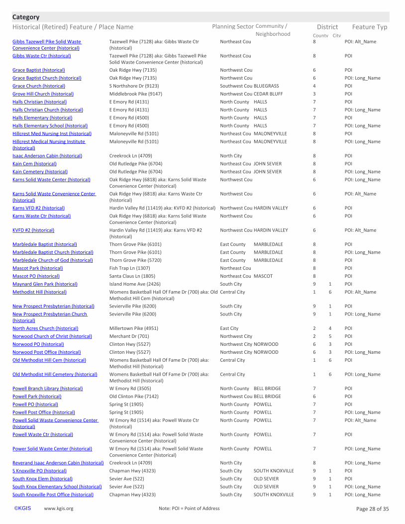
Historical (Retired) Feature / Place Name Planning Sector Feature Typ
CategoryCommunity / District
City County Neighborhoodhttps://www.kgis.org/kgismaps/map.htm? POI: Alt_NameGibbs Tazewell Pike Solid Waste Convenience Center (historical)
Northeast Cou 8Tazewell Pike (7128) aka: Gibbs Waste Ctr (historical)
https://www.kgis.org/kgismaps/map.htm? POIGibbs Waste Ctr (historical) Northeast Cou 8Tazewell Pike (7128) aka: Gibbs Tazewell Pike Solid Waste Convenience Center (historical)
https://www.kgis.org/kgismaps/map.htm? POIGrace Baptist (historical) Northwest Cou 6Oak Ridge Hwy (7135)
https://www.kgis.org/kgismaps/map.htm? POI: Long_NameGrace Baptist Church (historical) Northwest Cou 6Oak Ridge Hwy (7135)
https://www.kgis.org/kgismaps/map.htm? POIGrace Church (historical) Southwest Cou BLUEGRASS 4S Northshore Dr (9123)
https://www.kgis.org/kgismaps/map.htm? POIGrove Hill Church (historical) Northwest Cou CEDAR BLUFF 3Middlebrook Pike (9147)
https://www.kgis.org/kgismaps/map.htm? POIHalls Christian (historical) North County HALLS 7E Emory Rd (4131)
https://www.kgis.org/kgismaps/map.htm? POI: Long_NameHalls Christian Church (historical) North County HALLS 7E Emory Rd (4131)
https://www.kgis.org/kgismaps/map.htm? POIHalls Elementary (historical) North County HALLS 7E Emory Rd (4500)
https://www.kgis.org/kgismaps/map.htm? POI: Long_NameHalls Elementary School (historical) North County HALLS 7E Emory Rd (4500)
https://www.kgis.org/kgismaps/map.htm? POIHillcrest Med Nursing Inst (historical) Northeast Cou MALONEYVILLE 8Maloneyville Rd (5101)
https://www.kgis.org/kgismaps/map.htm? POI: Long_NameHillcrest Medical Nursing Institute (historical)
Northeast Cou MALONEYVILLE 8Maloneyville Rd (5101)
https://www.kgis.org/kgismaps/map.htm? POIIsaac Anderson Cabin (historical) North City 8Creekrock Ln (4709)
https://www.kgis.org/kgismaps/map.htm? POIKain Cem (historical) Northeast Cou JOHN SEVIER 8Old Rutledge Pike (6704)
https://www.kgis.org/kgismaps/map.htm? POI: Long_NameKain Cemetery (historical) Northeast Cou JOHN SEVIER 8Old Rutledge Pike (6704)
https://www.kgis.org/kgismaps/map.htm? POI: Long_NameKarns Solid Waste Center (historical) Northwest Cou 6Oak Ridge Hwy (6818) aka: Karns Solid Waste Convenience Center (historical)
https://www.kgis.org/kgismaps/map.htm? POI: Alt_NameKarns Solid Waste Convenience Center (historical)
Northwest Cou 6Oak Ridge Hwy (6818) aka: Karns Waste Ctr (historical)
https://www.kgis.org/kgismaps/map.htm? POIKarns VFD #2 (historical) Northwest Cou HARDIN VALLEY 6Hardin Valley Rd (11419) aka: KVFD #2 (historical)
https://www.kgis.org/kgismaps/map.htm? POIKarns Waste Ctr (historical) Northwest Cou 6Oak Ridge Hwy (6818) aka: Karns Solid Waste Convenience Center (historical)
https://www.kgis.org/kgismaps/map.htm? POI: Alt_NameKVFD #2 (historical) Northwest Cou HARDIN VALLEY 6Hardin Valley Rd (11419) aka: Karns VFD #2 (historical)
https://www.kgis.org/kgismaps/map.htm? POIMarbledale Baptist (historical) East County MARBLEDALE 8Thorn Grove Pike (6101)
https://www.kgis.org/kgismaps/map.htm? POI: Long_NameMarbledale Baptist Church (historical) East County MARBLEDALE 8Thorn Grove Pike (6101)
https://www.kgis.org/kgismaps/map.htm? POIMarbledale Church of God (historical) East County MARBLEDALE 8Thorn Grove Pike (5720)
https://www.kgis.org/kgismaps/map.htm? POIMascot Park (historical) Northeast Cou 8Fish Trap Ln (1307)
https://www.kgis.org/kgismaps/map.htm? POIMascot PO (historical) Northeast Cou MASCOT 8Santa Claus Ln (1805)
https://www.kgis.org/kgismaps/map.htm? POIMaynard Glen Park (historical) South City 9 1Island Home Ave (2426)
https://www.kgis.org/kgismaps/map.htm? POI: Alt_NameMethodist Hill (historical) Central City 1 6Womens Basketball Hall Of Fame Dr (700) aka: Old Methodist Hill Cem (historical)
https://www.kgis.org/kgismaps/map.htm? POINew Prospect Presbyterian (historical) South City 9 1Sevierville Pike (6200)
https://www.kgis.org/kgismaps/map.htm? POI: Long_NameNew Prospect Presbyterian Church (historical)
South City 9 1Sevierville Pike (6200)
https://www.kgis.org/kgismaps/map.htm? POINorth Acres Church (historical) East City 2 4Millertown Pike (4951)
https://www.kgis.org/kgismaps/map.htm? POINorwood Church of Christ (historical) Northwest City 2 5Merchant Dr (701)
https://www.kgis.org/kgismaps/map.htm? POINorwood PO (historical) Northwest City NORWOOD 6 3Clinton Hwy (5527)
https://www.kgis.org/kgismaps/map.htm? POI: Long_NameNorwood Post Office (historical) Northwest City NORWOOD 6 3Clinton Hwy (5527)
https://www.kgis.org/kgismaps/map.htm? POIOld Methodist Hill Cem (historical) Central City 1 6Womens Basketball Hall Of Fame Dr (700) aka: Methodist Hill (historical)
https://www.kgis.org/kgismaps/map.htm? POI: Long_NameOld Methodist Hill Cemetery (historical) Central City 1 6Womens Basketball Hall Of Fame Dr (700) aka: Methodist Hill (historical)
https://www.kgis.org/kgismaps/map.htm? POIPowell Branch Library (historical) North County BELL BRIDGE 7W Emory Rd (3505)
https://www.kgis.org/kgismaps/map.htm? POIPowell Park (historical) Northwest Cou BELL BRIDGE 6Old Clinton Pike (7142)
https://www.kgis.org/kgismaps/map.htm? POIPowell PO (historical) North County POWELL 7Spring St (1905)
https://www.kgis.org/kgismaps/map.htm? POI: Long_NamePowell Post Office (historical) North County POWELL 7Spring St (1905)
https://www.kgis.org/kgismaps/map.htm? POI: Alt_NamePowell Solid Waste Convenience Center (historical)
North County POWELL 7W Emory Rd (1514) aka: Powell Waste Ctr (historical)
https://www.kgis.org/kgismaps/map.htm? POIPowell Waste Ctr (historical) North County POWELL 7W Emory Rd (1514) aka: Powell Solid Waste Convenience Center (historical)
https://www.kgis.org/kgismaps/map.htm? POI: Long_NamePower Solid Waste Center (historical) North County POWELL 7W Emory Rd (1514) aka: Powell Solid Waste Convenience Center (historical)
https://www.kgis.org/kgismaps/map.htm? POI: Long_NameReverand Isaac Anderson Cabin (historical) North City 8Creekrock Ln (4709)
https://www.kgis.org/kgismaps/map.htm? POIS Knoxville PO (historical) South City SOUTH KNOXVILLE 9 1Chapman Hwy (4323)
https://www.kgis.org/kgismaps/map.htm? POISouth Knox Elem (historical) South City OLD SEVIER 9 1Sevier Ave (522)
https://www.kgis.org/kgismaps/map.htm? POI: Long_NameSouth Knox Elementary School (historical) South City OLD SEVIER 9 1Sevier Ave (522)
https://www.kgis.org/kgismaps/map.htm? POI: Long_NameSouth Knoxville Post Office (historical) South City SOUTH KNOXVILLE 9 1Chapman Hwy (4323)
www.kgis.org Page 28 of 35©KGIS Note: POI = Point of Address

Historical (Retired) Feature / Place Name Planning Sector Feature Typ
CategoryCommunity / District
City County Neighborhoodhttps://www.kgis.org/kgismaps/map.htm? POIThree Rivers Rambler (historical) Central City 1 6Neyland Dr (750)
https://www.kgis.org/kgismaps/map.htm? POI: Long_NameUT Black Cultural Center (historical) Central City UNIVERSITY OF TENNESSE 9 1Volunteer Blvd (812)
https://www.kgis.org/kgismaps/map.htm? POI: Long_NameWarner Tabernacle African Methodist Episcopal (AME) Zion Church (historical)
East City EAST KNOXVILLE 1 6Fuller Ave (1021)
https://www.kgis.org/kgismaps/map.htm? POIWarner Tabernacle AME Zion (historical) East City EAST KNOXVILLE 1 6Fuller Ave (1021)
Historical:Former Location Feature Still Existshttps://www.kgis.org/kgismaps/map.htm? POI: Alt_Name1st Apostolic Church (historical) Northwest City 3 3Pleasant Ridge Rd (4701) aka: First Apostolic
Church (historical)
https://www.kgis.org/kgismaps/map.htm? POI: Alt_Name1st Christian Church (historical) Central City DOWNTOWN NORTH 1 6W Fifth Ave (211) aka: First Christian (historical)
https://www.kgis.org/kgismaps/map.htm? POIAbsolute Word Church (historical) Central City WEST VIEW 1 3Keith Ave (3220) aka: Deliverance Temple (historical)
https://www.kgis.org/kgismaps/map.htm? POIAlex Haley Residence (historical) West City SEQUOYAH HILLS 4 2Cherokee Blvd (840)
https://www.kgis.org/kgismaps/map.htm? POIAlice Bell Elementary (historical) East City ALICE BELL 2 4Washington Pike (4415)
https://www.kgis.org/kgismaps/map.htm? POI: Long_NameAlice Bell Elementary School (historical) East City ALICE BELL 2 4Washington Pike (4415)
https://www.kgis.org/kgismaps/map.htm? POI: Long_NameAmbulance Operations Center (historical) Northwest City 7Callahan Dr (910 #102) aka: Rural Metro AOC (historical)
https://www.kgis.org/kgismaps/map.htm? POIAntioch Community Church (historical) Central City MARBLE CITY 1 6Sutherland Ave (2202) aka: Antioch Mosaic Community Church (historical)
https://www.kgis.org/kgismaps/map.htm? POI: Alt_NameAntioch Mosaic Community Church (historical)
Central City MARBLE CITY 1 6Sutherland Ave (2202) aka: Antioch Community Church (historical)
https://www.kgis.org/kgismaps/map.htm? POIArlington Baptist (historical) East City FAIRMONT EMORILAND 2 4Fairmont Blvd (1928)
https://www.kgis.org/kgismaps/map.htm? POIBasswood Baptist (historical) Northwest City WEST HAVEN 3 3Basswood Rd (3108)
https://www.kgis.org/kgismaps/map.htm? POI: Long_NameBasswood Baptist Church (historical) Northwest City WEST HAVEN 3 3Basswood Rd (3108)
https://www.kgis.org/kgismaps/map.htm? POIBearden Middle (historical) West City BEARDEN 4 2Kingston Pike (5719)
https://www.kgis.org/kgismaps/map.htm? POI: Long_NameBearden Middle School (historical) West City BEARDEN 4 2Kingston Pike (5719)
https://www.kgis.org/kgismaps/map.htm? POIBlackhorse Brewery (historical) West City 4 2Kingston Pike (4429)
https://www.kgis.org/kgismaps/map.htm? POI: Long_NameBlackhorse Pub & Brewery (historical) West City 4 2Kingston Pike (4429)
https://www.kgis.org/kgismaps/map.htm? POIBurnett Creek Baptist (historical) South County 9Burnett Creek Rd (6455) aka: Burnetts Creek Baptist Church (historical)
https://www.kgis.org/kgismaps/map.htm? POI: Long_NameBurnett Creek Baptist Church (historical) South County 9Burnett Creek Rd (6455) aka: Burnetts Creek Baptist Church (historical)
https://www.kgis.org/kgismaps/map.htm? POI: Alt_NameBurnetts Creek Baptist Church (historical) South County 9Burnett Creek Rd (6455) aka: Burnett Creek Baptist (historical)
https://www.kgis.org/kgismaps/map.htm? POICallahan Rd Baptist (historical) Northwest City 7 3Callahan Dr (1336)
https://www.kgis.org/kgismaps/map.htm? POI: Long_NameCallahan Road Baptist Church (historical) Northwest City 7 3Callahan Dr (1336)
https://www.kgis.org/kgismaps/map.htm? POICalvary Chapel (historical) South County 9Alcoa Hwy (2864)
https://www.kgis.org/kgismaps/map.htm? POI: Long_NameCalvary Chapel Church (historical) South County 9Alcoa Hwy (2864)
https://www.kgis.org/kgismaps/map.htm? POICarter Elem (historical) East County CARTER 8College St (9304)
https://www.kgis.org/kgismaps/map.htm? POICarter Elementary (historical) East County CARTER 8N Carter School Rd (210)
https://www.kgis.org/kgismaps/map.htm? POI: Long_NameCarter Elementary School (historical) East County CARTER 8College St (9304)
https://www.kgis.org/kgismaps/map.htm? POI: Long_NameCarter Elementary School (historical) East County CARTER 8N Carter School Rd (210)
https://www.kgis.org/kgismaps/map.htm? POICarter Middle (historical) East County CARTER 8N Carter School Rd (210)
https://www.kgis.org/kgismaps/map.htm? POI: Long_NameCarter Middle School (historical) East County CARTER 8N Carter School Rd (210)
https://www.kgis.org/kgismaps/map.htm? POIChildrens Hosp (historical) Central City FORT SANDERS 1 1Clinch Ave (1901)
https://www.kgis.org/kgismaps/map.htm? POIChildrens Theatre (historical) Central City DOWNTOWN NORTH 1 6Tyson St (800)
https://www.kgis.org/kgismaps/map.htm? POI: Long_NameChildrens Theatre of Knoxville (CTK) (historical)
Central City DOWNTOWN NORTH 1 6Tyson St (800)
https://www.kgis.org/kgismaps/map.htm? POIChilhowee Elementary (historical) East City CHILHOWEE HILLS 1 6Asheville Hwy (5005)
https://www.kgis.org/kgismaps/map.htm? POI: Long_NameChilhowee Elementary School (historical) East City CHILHOWEE HILLS 1 6Asheville Hwy (5005)
https://www.kgis.org/kgismaps/map.htm? POIChurch at Knoxville (historical) West City ROCKY HILL 4 2Rocky Hill Rd (1300)
https://www.kgis.org/kgismaps/map.htm? POICity on a Hill Church (historical) North City 2 4Knoxville Center Dr (3001 #2109)
https://www.kgis.org/kgismaps/map.htm? POIClear Springs Baptist (historical) Northeast Cou CLEAR SPRINGS 8Thompson School Rd (8518)
https://www.kgis.org/kgismaps/map.htm? POI: Long_NameClear Springs Baptist Church (historical) Northeast Cou CLEAR SPRINGS 8Thompson School Rd (8518)
https://www.kgis.org/kgismaps/map.htm? POICounty Clerk - Knoxville Ctr (historical) North City 2 4Knoxville Center Dr (3001)
https://www.kgis.org/kgismaps/map.htm? POICounty Clerk - N Knox (historical) North County HALLS 7Maynardville Pike (7028)
https://www.kgis.org/kgismaps/map.htm? POI: Alt_NameDeliverance Temple (historical) Central City WEST VIEW 1 3Keith Ave (3220) aka: Absolute Word Church (historical)
https://www.kgis.org/kgismaps/map.htm? POI: Long_NameDr Paul L Kelley Volunteer Academy (historical)
North City 2 4Knoxville Center Dr (3001 #2297)
https://www.kgis.org/kgismaps/map.htm? POI: Long_NameEast Tennessee Childrens Hospital (historical)
Central City FORT SANDERS 1 1Clinch Ave (1901)
www.kgis.org Page 29 of 35©KGIS Note: POI = Point of Address
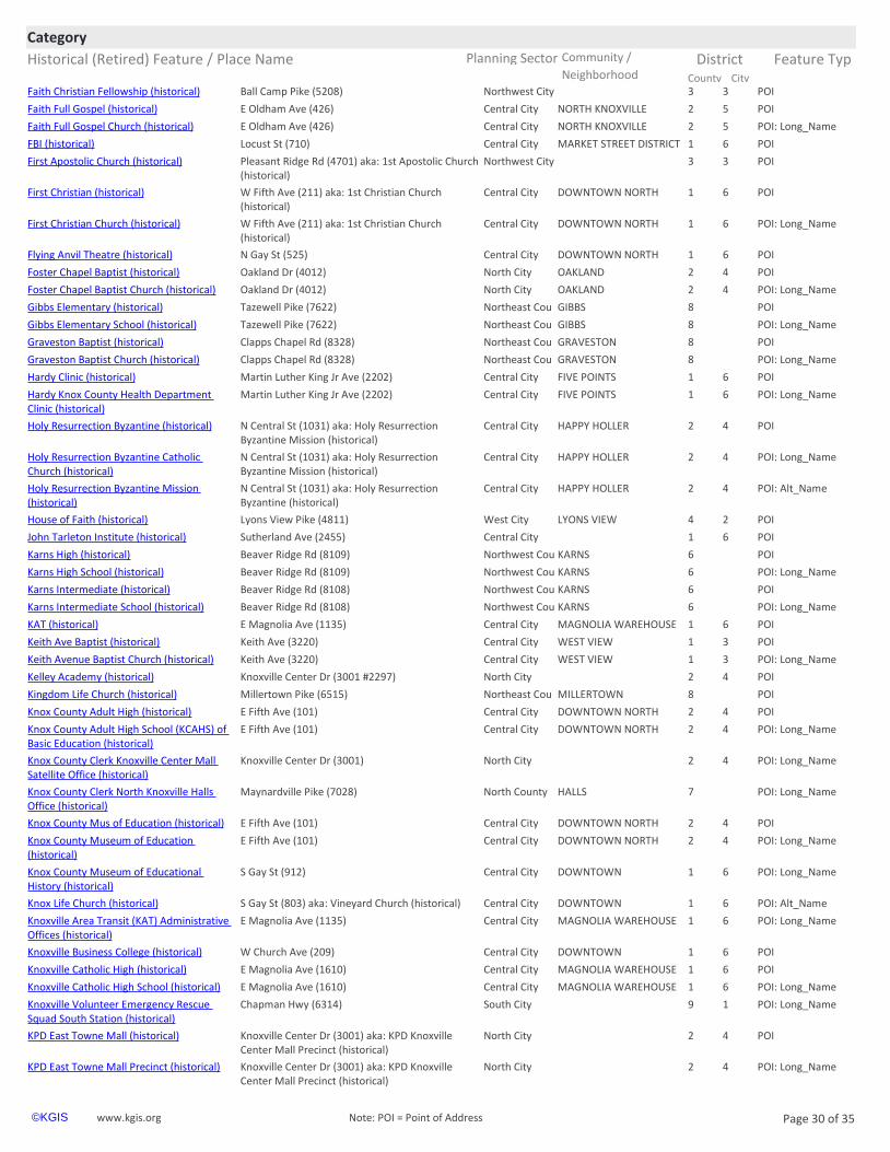
Historical (Retired) Feature / Place Name Planning Sector Feature Typ
CategoryCommunity / District
City County Neighborhoodhttps://www.kgis.org/kgismaps/map.htm? POIFaith Christian Fellowship (historical) Northwest City 3 3Ball Camp Pike (5208)
https://www.kgis.org/kgismaps/map.htm? POIFaith Full Gospel (historical) Central City NORTH KNOXVILLE 2 5E Oldham Ave (426)
https://www.kgis.org/kgismaps/map.htm? POI: Long_NameFaith Full Gospel Church (historical) Central City NORTH KNOXVILLE 2 5E Oldham Ave (426)
https://www.kgis.org/kgismaps/map.htm? POIFBI (historical) Central City MARKET STREET DISTRICT 1 6Locust St (710)
https://www.kgis.org/kgismaps/map.htm? POIFirst Apostolic Church (historical) Northwest City 3 3Pleasant Ridge Rd (4701) aka: 1st Apostolic Church (historical)
https://www.kgis.org/kgismaps/map.htm? POIFirst Christian (historical) Central City DOWNTOWN NORTH 1 6W Fifth Ave (211) aka: 1st Christian Church (historical)
https://www.kgis.org/kgismaps/map.htm? POI: Long_NameFirst Christian Church (historical) Central City DOWNTOWN NORTH 1 6W Fifth Ave (211) aka: 1st Christian Church (historical)
https://www.kgis.org/kgismaps/map.htm? POIFlying Anvil Theatre (historical) Central City DOWNTOWN NORTH 1 6N Gay St (525)
https://www.kgis.org/kgismaps/map.htm? POIFoster Chapel Baptist (historical) North City OAKLAND 2 4Oakland Dr (4012)
https://www.kgis.org/kgismaps/map.htm? POI: Long_NameFoster Chapel Baptist Church (historical) North City OAKLAND 2 4Oakland Dr (4012)
https://www.kgis.org/kgismaps/map.htm? POIGibbs Elementary (historical) Northeast Cou GIBBS 8Tazewell Pike (7622)
https://www.kgis.org/kgismaps/map.htm? POI: Long_NameGibbs Elementary School (historical) Northeast Cou GIBBS 8Tazewell Pike (7622)
https://www.kgis.org/kgismaps/map.htm? POIGraveston Baptist (historical) Northeast Cou GRAVESTON 8Clapps Chapel Rd (8328)
https://www.kgis.org/kgismaps/map.htm? POI: Long_NameGraveston Baptist Church (historical) Northeast Cou GRAVESTON 8Clapps Chapel Rd (8328)
https://www.kgis.org/kgismaps/map.htm? POIHardy Clinic (historical) Central City FIVE POINTS 1 6Martin Luther King Jr Ave (2202)
https://www.kgis.org/kgismaps/map.htm? POI: Long_NameHardy Knox County Health Department Clinic (historical)
Central City FIVE POINTS 1 6Martin Luther King Jr Ave (2202)
https://www.kgis.org/kgismaps/map.htm? POIHoly Resurrection Byzantine (historical) Central City HAPPY HOLLER 2 4N Central St (1031) aka: Holy Resurrection Byzantine Mission (historical)
https://www.kgis.org/kgismaps/map.htm? POI: Long_NameHoly Resurrection Byzantine Catholic Church (historical)
Central City HAPPY HOLLER 2 4N Central St (1031) aka: Holy Resurrection Byzantine Mission (historical)
https://www.kgis.org/kgismaps/map.htm? POI: Alt_NameHoly Resurrection Byzantine Mission (historical)
Central City HAPPY HOLLER 2 4N Central St (1031) aka: Holy Resurrection Byzantine (historical)
https://www.kgis.org/kgismaps/map.htm? POIHouse of Faith (historical) West City LYONS VIEW 4 2Lyons View Pike (4811)
https://www.kgis.org/kgismaps/map.htm? POIJohn Tarleton Institute (historical) Central City 1 6Sutherland Ave (2455)
https://www.kgis.org/kgismaps/map.htm? POIKarns High (historical) Northwest Cou KARNS 6Beaver Ridge Rd (8109)
https://www.kgis.org/kgismaps/map.htm? POI: Long_NameKarns High School (historical) Northwest Cou KARNS 6Beaver Ridge Rd (8109)
https://www.kgis.org/kgismaps/map.htm? POIKarns Intermediate (historical) Northwest Cou KARNS 6Beaver Ridge Rd (8108)
https://www.kgis.org/kgismaps/map.htm? POI: Long_NameKarns Intermediate School (historical) Northwest Cou KARNS 6Beaver Ridge Rd (8108)
https://www.kgis.org/kgismaps/map.htm? POIKAT (historical) Central City MAGNOLIA WAREHOUSE 1 6E Magnolia Ave (1135)
https://www.kgis.org/kgismaps/map.htm? POIKeith Ave Baptist (historical) Central City WEST VIEW 1 3Keith Ave (3220)
https://www.kgis.org/kgismaps/map.htm? POI: Long_NameKeith Avenue Baptist Church (historical) Central City WEST VIEW 1 3Keith Ave (3220)
https://www.kgis.org/kgismaps/map.htm? POIKelley Academy (historical) North City 2 4Knoxville Center Dr (3001 #2297)
https://www.kgis.org/kgismaps/map.htm? POIKingdom Life Church (historical) Northeast Cou MILLERTOWN 8Millertown Pike (6515)
https://www.kgis.org/kgismaps/map.htm? POIKnox County Adult High (historical) Central City DOWNTOWN NORTH 2 4E Fifth Ave (101)
https://www.kgis.org/kgismaps/map.htm? POI: Long_NameKnox County Adult High School (KCAHS) of Basic Education (historical)
Central City DOWNTOWN NORTH 2 4E Fifth Ave (101)
https://www.kgis.org/kgismaps/map.htm? POI: Long_NameKnox County Clerk Knoxville Center Mall Satellite Office (historical)
North City 2 4Knoxville Center Dr (3001)
https://www.kgis.org/kgismaps/map.htm? POI: Long_NameKnox County Clerk North Knoxville Halls Office (historical)
North County HALLS 7Maynardville Pike (7028)
https://www.kgis.org/kgismaps/map.htm? POIKnox County Mus of Education (historical) Central City DOWNTOWN NORTH 2 4E Fifth Ave (101)
https://www.kgis.org/kgismaps/map.htm? POI: Long_NameKnox County Museum of Education (historical)
Central City DOWNTOWN NORTH 2 4E Fifth Ave (101)
https://www.kgis.org/kgismaps/map.htm? POI: Long_NameKnox County Museum of Educational History (historical)
Central City DOWNTOWN 1 6S Gay St (912)
https://www.kgis.org/kgismaps/map.htm? POI: Alt_NameKnox Life Church (historical) Central City DOWNTOWN 1 6S Gay St (803) aka: Vineyard Church (historical)
https://www.kgis.org/kgismaps/map.htm? POI: Long_NameKnoxville Area Transit (KAT) Administrative Offices (historical)
Central City MAGNOLIA WAREHOUSE 1 6E Magnolia Ave (1135)
https://www.kgis.org/kgismaps/map.htm? POIKnoxville Business College (historical) Central City DOWNTOWN 1 6W Church Ave (209)
https://www.kgis.org/kgismaps/map.htm? POIKnoxville Catholic High (historical) Central City MAGNOLIA WAREHOUSE 1 6E Magnolia Ave (1610)
https://www.kgis.org/kgismaps/map.htm? POI: Long_NameKnoxville Catholic High School (historical) Central City MAGNOLIA WAREHOUSE 1 6E Magnolia Ave (1610)
https://www.kgis.org/kgismaps/map.htm? POI: Long_NameKnoxville Volunteer Emergency Rescue Squad South Station (historical)
South City 9 1Chapman Hwy (6314)
https://www.kgis.org/kgismaps/map.htm? POIKPD East Towne Mall (historical) North City 2 4Knoxville Center Dr (3001) aka: KPD Knoxville Center Mall Precinct (historical)
https://www.kgis.org/kgismaps/map.htm? POI: Long_NameKPD East Towne Mall Precinct (historical) North City 2 4Knoxville Center Dr (3001) aka: KPD Knoxville Center Mall Precinct (historical)
www.kgis.org Page 30 of 35©KGIS Note: POI = Point of Address
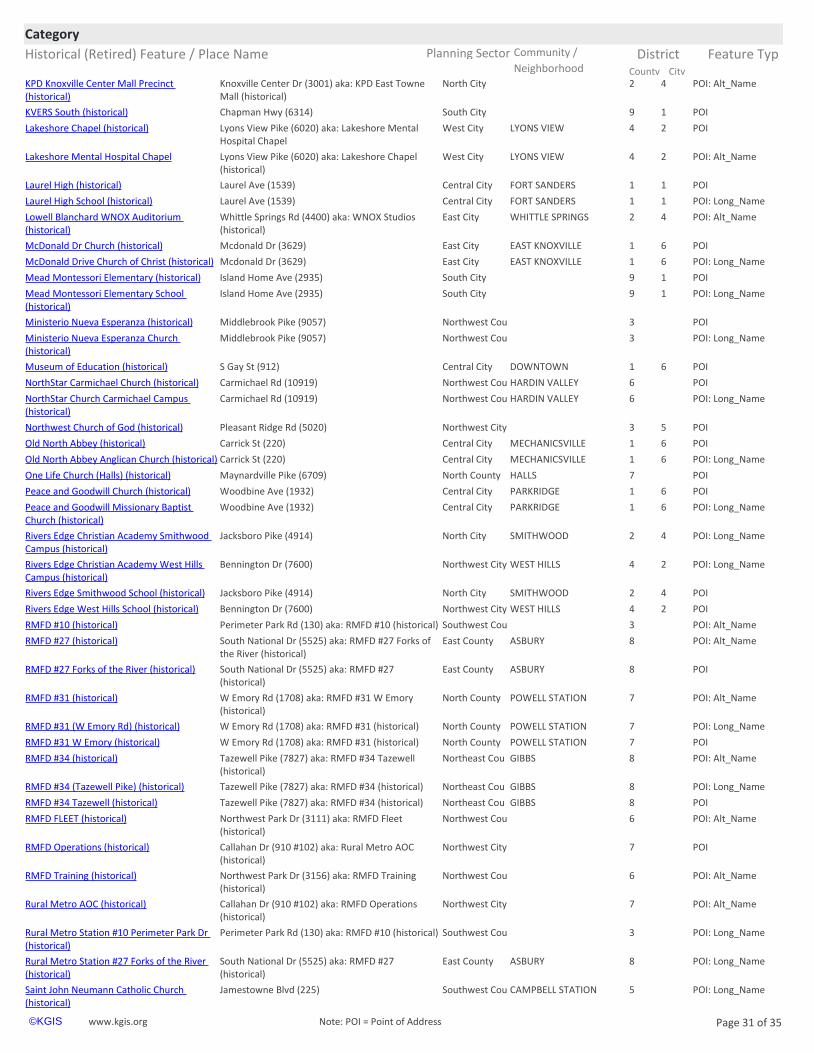
Historical (Retired) Feature / Place Name Planning Sector Feature Typ
CategoryCommunity / District
City County Neighborhoodhttps://www.kgis.org/kgismaps/map.htm? POI: Alt_NameKPD Knoxville Center Mall Precinct (historical)
North City 2 4Knoxville Center Dr (3001) aka: KPD East Towne Mall (historical)
https://www.kgis.org/kgismaps/map.htm? POIKVERS South (historical) South City 9 1Chapman Hwy (6314)
https://www.kgis.org/kgismaps/map.htm? POILakeshore Chapel (historical) West City LYONS VIEW 4 2Lyons View Pike (6020) aka: Lakeshore Mental Hospital Chapel
https://www.kgis.org/kgismaps/map.htm? POI: Alt_NameLakeshore Mental Hospital Chapel West City LYONS VIEW 4 2Lyons View Pike (6020) aka: Lakeshore Chapel (historical)
https://www.kgis.org/kgismaps/map.htm? POILaurel High (historical) Central City FORT SANDERS 1 1Laurel Ave (1539)
https://www.kgis.org/kgismaps/map.htm? POI: Long_NameLaurel High School (historical) Central City FORT SANDERS 1 1Laurel Ave (1539)
https://www.kgis.org/kgismaps/map.htm? POI: Alt_NameLowell Blanchard WNOX Auditorium (historical)
East City WHITTLE SPRINGS 2 4Whittle Springs Rd (4400) aka: WNOX Studios (historical)
https://www.kgis.org/kgismaps/map.htm? POIMcDonald Dr Church (historical) East City EAST KNOXVILLE 1 6Mcdonald Dr (3629)
https://www.kgis.org/kgismaps/map.htm? POI: Long_NameMcDonald Drive Church of Christ (historical) East City EAST KNOXVILLE 1 6Mcdonald Dr (3629)
https://www.kgis.org/kgismaps/map.htm? POIMead Montessori Elementary (historical) South City 9 1Island Home Ave (2935)
https://www.kgis.org/kgismaps/map.htm? POI: Long_NameMead Montessori Elementary School (historical)
South City 9 1Island Home Ave (2935)
https://www.kgis.org/kgismaps/map.htm? POIMinisterio Nueva Esperanza (historical) Northwest Cou 3Middlebrook Pike (9057)
https://www.kgis.org/kgismaps/map.htm? POI: Long_NameMinisterio Nueva Esperanza Church (historical)
Northwest Cou 3Middlebrook Pike (9057)
https://www.kgis.org/kgismaps/map.htm? POIMuseum of Education (historical) Central City DOWNTOWN 1 6S Gay St (912)
https://www.kgis.org/kgismaps/map.htm? POINorthStar Carmichael Church (historical) Northwest Cou HARDIN VALLEY 6Carmichael Rd (10919)
https://www.kgis.org/kgismaps/map.htm? POI: Long_NameNorthStar Church Carmichael Campus (historical)
Northwest Cou HARDIN VALLEY 6Carmichael Rd (10919)
https://www.kgis.org/kgismaps/map.htm? POINorthwest Church of God (historical) Northwest City 3 5Pleasant Ridge Rd (5020)
https://www.kgis.org/kgismaps/map.htm? POIOld North Abbey (historical) Central City MECHANICSVILLE 1 6Carrick St (220)
https://www.kgis.org/kgismaps/map.htm? POI: Long_NameOld North Abbey Anglican Church (historical) Central City MECHANICSVILLE 1 6Carrick St (220)
https://www.kgis.org/kgismaps/map.htm? POIOne Life Church (Halls) (historical) North County HALLS 7Maynardville Pike (6709)
https://www.kgis.org/kgismaps/map.htm? POIPeace and Goodwill Church (historical) Central City PARKRIDGE 1 6Woodbine Ave (1932)
https://www.kgis.org/kgismaps/map.htm? POI: Long_NamePeace and Goodwill Missionary Baptist Church (historical)
Central City PARKRIDGE 1 6Woodbine Ave (1932)
https://www.kgis.org/kgismaps/map.htm? POI: Long_NameRivers Edge Christian Academy Smithwood Campus (historical)
North City SMITHWOOD 2 4Jacksboro Pike (4914)
https://www.kgis.org/kgismaps/map.htm? POI: Long_NameRivers Edge Christian Academy West Hills Campus (historical)
Northwest City WEST HILLS 4 2Bennington Dr (7600)
https://www.kgis.org/kgismaps/map.htm? POIRivers Edge Smithwood School (historical) North City SMITHWOOD 2 4Jacksboro Pike (4914)
https://www.kgis.org/kgismaps/map.htm? POIRivers Edge West Hills School (historical) Northwest City WEST HILLS 4 2Bennington Dr (7600)
https://www.kgis.org/kgismaps/map.htm? POI: Alt_NameRMFD #10 (historical) Southwest Cou 3Perimeter Park Rd (130) aka: RMFD #10 (historical)
https://www.kgis.org/kgismaps/map.htm? POI: Alt_NameRMFD #27 (historical) East County ASBURY 8South National Dr (5525) aka: RMFD #27 Forks of the River (historical)
https://www.kgis.org/kgismaps/map.htm? POIRMFD #27 Forks of the River (historical) East County ASBURY 8South National Dr (5525) aka: RMFD #27 (historical)
https://www.kgis.org/kgismaps/map.htm? POI: Alt_NameRMFD #31 (historical) North County POWELL STATION 7W Emory Rd (1708) aka: RMFD #31 W Emory (historical)
https://www.kgis.org/kgismaps/map.htm? POI: Long_NameRMFD #31 (W Emory Rd) (historical) North County POWELL STATION 7W Emory Rd (1708) aka: RMFD #31 (historical)
https://www.kgis.org/kgismaps/map.htm? POIRMFD #31 W Emory (historical) North County POWELL STATION 7W Emory Rd (1708) aka: RMFD #31 (historical)
https://www.kgis.org/kgismaps/map.htm? POI: Alt_NameRMFD #34 (historical) Northeast Cou GIBBS 8Tazewell Pike (7827) aka: RMFD #34 Tazewell (historical)
https://www.kgis.org/kgismaps/map.htm? POI: Long_NameRMFD #34 (Tazewell Pike) (historical) Northeast Cou GIBBS 8Tazewell Pike (7827) aka: RMFD #34 (historical)
https://www.kgis.org/kgismaps/map.htm? POIRMFD #34 Tazewell (historical) Northeast Cou GIBBS 8Tazewell Pike (7827) aka: RMFD #34 (historical)
https://www.kgis.org/kgismaps/map.htm? POI: Alt_NameRMFD FLEET (historical) Northwest Cou 6Northwest Park Dr (3111) aka: RMFD Fleet (historical)
https://www.kgis.org/kgismaps/map.htm? POIRMFD Operations (historical) Northwest City 7Callahan Dr (910 #102) aka: Rural Metro AOC (historical)
https://www.kgis.org/kgismaps/map.htm? POI: Alt_NameRMFD Training (historical) Northwest Cou 6Northwest Park Dr (3156) aka: RMFD Training (historical)
https://www.kgis.org/kgismaps/map.htm? POI: Alt_NameRural Metro AOC (historical) Northwest City 7Callahan Dr (910 #102) aka: RMFD Operations (historical)
https://www.kgis.org/kgismaps/map.htm? POI: Long_NameRural Metro Station #10 Perimeter Park Dr (historical)
Southwest Cou 3Perimeter Park Rd (130) aka: RMFD #10 (historical)
https://www.kgis.org/kgismaps/map.htm? POI: Long_NameRural Metro Station #27 Forks of the River (historical)
East County ASBURY 8South National Dr (5525) aka: RMFD #27 (historical)
https://www.kgis.org/kgismaps/map.htm? POI: Long_NameSaint John Neumann Catholic Church (historical)
Southwest Cou CAMPBELL STATION 5Jamestowne Blvd (225)
www.kgis.org Page 31 of 35©KGIS Note: POI = Point of Address

Historical (Retired) Feature / Place Name Planning Sector Feature Typ
CategoryCommunity / District
City County Neighborhoodhttps://www.kgis.org/kgismaps/map.htm? POISalem Church (historical) North County 8Salem Church Rd (4806)
https://www.kgis.org/kgismaps/map.htm? POI: Long_NameSevier Heights Baptist Church (historical) South City SOUTH HAVEN 9 1Sevier Heights Rd (3708)
https://www.kgis.org/kgismaps/map.htm? POISevier Hgts Baptist (historical) South City SOUTH HAVEN 9 1Sevier Heights Rd (3708)
https://www.kgis.org/kgismaps/map.htm? POISeymour VFD #6 (historical) South County KIMBERLIN HEIGHTS 9Gateway Ct (2302) aka: SVFD #6 (historical)
https://www.kgis.org/kgismaps/map.htm? POIShomair Yisrael Congregation (historical) Central City MARBLE CITY 1 6Sutherland Ave (2554)
https://www.kgis.org/kgismaps/map.htm? POI: Long_NameShomair Yisrael Messianic Jewish Congregation (historical)
Central City MARBLE CITY 1 6Sutherland Ave (2554)
https://www.kgis.org/kgismaps/map.htm? POISouth College (historical) Central City MAGNOLIA WAREHOUSE 2 4N 5th Ave (720)
https://www.kgis.org/kgismaps/map.htm? POISt John Neumann Catholic (historical) Southwest Cou CAMPBELL STATION 5Jamestowne Blvd (225)
https://www.kgis.org/kgismaps/map.htm? POI: Alt_NameSVFD #6 (historical) South County KIMBERLIN HEIGHTS 9Gateway Ct (2302) aka: Seymour VFD #6 (historical)
https://www.kgis.org/kgismaps/map.htm? POI: Long_NameThe House of Faith Church (historical) West City LYONS VIEW 4 2Lyons View Pike (4811)
https://www.kgis.org/kgismaps/map.htm? POI: Long_NameThe Word Players (historical) Northwest City 4 2Robinson Rd (1540)
https://www.kgis.org/kgismaps/map.htm? POI: Alt_NameTheatre Central Central City SOUTH OF MAGNOLIA 1 6S Gay St (319) aka: Theatre Knoxville (historical)
https://www.kgis.org/kgismaps/map.htm? POITheatre Knoxville (historical) Central City SOUTH OF MAGNOLIA 1 6S Gay St (319) aka: Theatre Central
https://www.kgis.org/kgismaps/map.htm? POI: Long_NameTheatre Knoxville Downtown (TKD) (historical)
Central City SOUTH OF MAGNOLIA 1 6S Gay St (319) aka: Theatre Central
https://www.kgis.org/kgismaps/map.htm? POITrinity Chapel (historical) North City 2 5Haynes-Sterchi Rd (5830)
https://www.kgis.org/kgismaps/map.htm? POI: Long_NameTrinity Chapel Church (historical) North City 2 5Haynes-Sterchi Rd (5830)
https://www.kgis.org/kgismaps/map.htm? POITrinity Christian Academy (historical) North City 2 5Haynes-Sterchi Rd (5830)
https://www.kgis.org/kgismaps/map.htm? POI: Long_NameUniversity of Tennesee Visitors Center (historical)
West City UNIVERSITY OF TENNESSE 4 2Neyland Dr (2712)
https://www.kgis.org/kgismaps/map.htm? POI: Long_NameUS Department of Veterans Affairs Knoxville Vet Center (historical)
East City PARK CITY 1 6E Magnolia Ave (2817) aka: Veterans Counseling Center (historical)
https://www.kgis.org/kgismaps/map.htm? POI: Long_NameUS Federal Bureau of Investigation (FBI) (historical)
Central City MARKET STREET DISTRICT 1 6Locust St (710)
https://www.kgis.org/kgismaps/map.htm? POIUT Visitors Ctr (historical) West City UNIVERSITY OF TENNESSE 4 2Neyland Dr (2712)
https://www.kgis.org/kgismaps/map.htm? POIVet Center (historical) East City PARK CITY 1 6E Magnolia Ave (2817) aka: Veterans Counseling Center (historical)
https://www.kgis.org/kgismaps/map.htm? POI: Alt_NameVeterans Counseling Center (historical) East City PARK CITY 1 6E Magnolia Ave (2817) aka: Vet Center (historical)
https://www.kgis.org/kgismaps/map.htm? POIVineyard Church (historical) Central City DOWNTOWN 1 6S Gay St (803) aka: Knox Life Church (historical)
https://www.kgis.org/kgismaps/map.htm? POI: Long_NameVineyard Knoxville Church (historical) Central City DOWNTOWN 1 6S Gay St (803) aka: Knox Life Church (historical)
https://www.kgis.org/kgismaps/map.htm? POIWestgate Christian Fellowship (historical) Northwest Cou 6Lovell Rd (1110)
https://www.kgis.org/kgismaps/map.htm? POIWNOX Studios (historical) East City WHITTLE SPRINGS 2 4Whittle Springs Rd (4400) aka: Lowell Blanchard WNOX Auditorium (historical)
https://www.kgis.org/kgismaps/map.htm? POI: Long_NameWNOX Studios Building (historical) East City WHITTLE SPRINGS 2 4Whittle Springs Rd (4400) aka: Lowell Blanchard WNOX Auditorium (historical)
https://www.kgis.org/kgismaps/map.htm? POIWord Players (historical) Northwest City 4 2Robinson Rd (1540)
Historical:Namehttps://www.kgis.org/kgismaps/map.htm? POIBayless (historical) North County 8
https://www.kgis.org/kgismaps/map.htm? POIBuzzard Roost (historical) Central City 2 5Coram St (3417) aka: Buzzards Roost (historical)
https://www.kgis.org/kgismaps/map.htm? POI: Alt_NameBuzzards Roost (historical) Central City 2 5Coram St (3417) aka: Buzzard Roost (historical)
https://www.kgis.org/kgismaps/map.htm? POICentral Market (historical) Central City EMORY PLACE 1 6Emory Pl (17)
https://www.kgis.org/kgismaps/map.htm? POI: Alt_NameCrippen (historical) West City BEARDEN 4 2S Weisgarber Rd (111) aka: Erin (historical)
https://www.kgis.org/kgismaps/map.htm? POICripple Creek (historical) Central City MAGNOLIA WAREHOUSE 1 6Willow Ave (651)
https://www.kgis.org/kgismaps/map.htm? POIEastport (historical) Central City FIVE POINTS 1 6Mcconnell St (539 #1)
https://www.kgis.org/kgismaps/map.htm? POIEdington (historical) Southwest Cou 5
https://www.kgis.org/kgismaps/map.htm? POIErin (historical) West City BEARDEN 4 2S Weisgarber Rd (111) aka: Crippen (historical)
https://www.kgis.org/kgismaps/map.htm? POIFlatwoods (historical) Central City OAKWOOD 2 5E Caldwell Ave (225)
https://www.kgis.org/kgismaps/map.htm? POIFloyd (historical) Northeast Cou CORRYTON 8Corryton Rd (7812)
https://www.kgis.org/kgismaps/map.htm? POIFriendly Town (historical) Central City MAGNOLIA WAREHOUSE 1 6Florida St (622)
https://www.kgis.org/kgismaps/map.htm? POIGapcreek (historical) South County 9
https://www.kgis.org/kgismaps/map.htm? POI: Alt_NameGraveston (historical) Northeast Cou CORRYTON 8aka: House Mountain (historical)
https://www.kgis.org/kgismaps/map.htm? POIHighpoint (historical) East County 8
https://www.kgis.org/kgismaps/map.htm? POIHolston Hill (historical) Northeast Cou MASCOT 8Staff Loop (2026)
https://www.kgis.org/kgismaps/map.htm? POIHouse Mountain (historical) Northeast Cou CORRYTON 8aka: Graveston (historical)
https://www.kgis.org/kgismaps/map.htm? POIIrish Town (historical) Central City DOWNTOWN NORTH 2 4E Fifth Ave (114)
https://www.kgis.org/kgismaps/map.htm? POIKincaid (historical) Southwest Cou 5Zola Ln (823)
https://www.kgis.org/kgismaps/map.htm? POIKings Alley (historical) Central City MAGNOLIA WAREHOUSE 1 6E Jackson Ave (622)
https://www.kgis.org/kgismaps/map.htm? POIKinkaid (historical) Southwest Cou 5
www.kgis.org Page 32 of 35©KGIS Note: POI = Point of Address
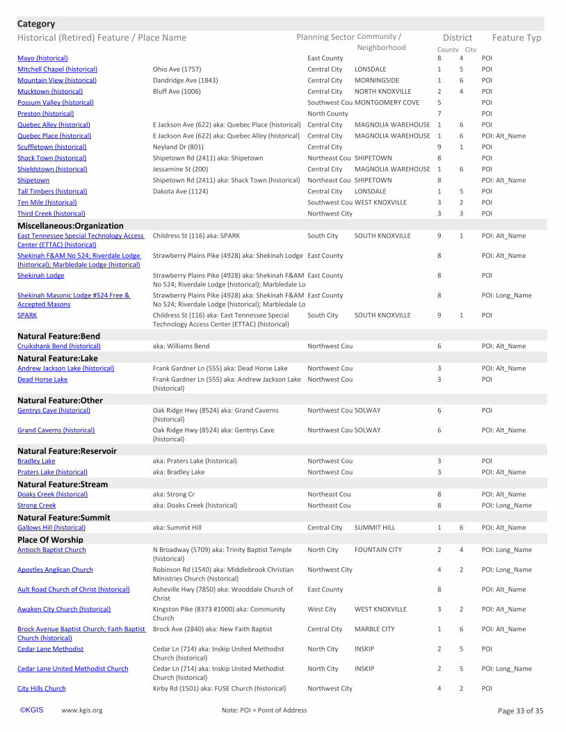
Historical (Retired) Feature / Place Name Planning Sector Feature Typ
CategoryCommunity / District
City County Neighborhoodhttps://www.kgis.org/kgismaps/map.htm? POIMayo (historical) East County 8 4
https://www.kgis.org/kgismaps/map.htm? POIMitchell Chapel (historical) Central City LONSDALE 1 5Ohio Ave (1757)
https://www.kgis.org/kgismaps/map.htm? POIMountain View (historical) Central City MORNINGSIDE 1 6Dandridge Ave (1843)
https://www.kgis.org/kgismaps/map.htm? POIMucktown (historical) Central City NORTH KNOXVILLE 2 4Bluff Ave (1006)
https://www.kgis.org/kgismaps/map.htm? POIPossum Valley (historical) Southwest Cou MONTGOMERY COVE 5
https://www.kgis.org/kgismaps/map.htm? POIPreston (historical) North County 7
https://www.kgis.org/kgismaps/map.htm? POIQuebec Alley (historical) Central City MAGNOLIA WAREHOUSE 1 6E Jackson Ave (622) aka: Quebec Place (historical)
https://www.kgis.org/kgismaps/map.htm? POI: Alt_NameQuebec Place (historical) Central City MAGNOLIA WAREHOUSE 1 6E Jackson Ave (622) aka: Quebec Alley (historical)
https://www.kgis.org/kgismaps/map.htm? POIScuffletown (historical) Central City 9 1Neyland Dr (801)
https://www.kgis.org/kgismaps/map.htm? POIShack Town (historical) Northeast Cou SHIPETOWN 8Shipetown Rd (2411) aka: Shipetown
https://www.kgis.org/kgismaps/map.htm? POIShieldstown (historical) Central City MAGNOLIA WAREHOUSE 1 6Jessamine St (200)
https://www.kgis.org/kgismaps/map.htm? POI: Alt_NameShipetown Northeast Cou SHIPETOWN 8Shipetown Rd (2411) aka: Shack Town (historical)
https://www.kgis.org/kgismaps/map.htm? POITall Timbers (historical) Central City LONSDALE 1 5Dakota Ave (1124)
https://www.kgis.org/kgismaps/map.htm? POITen Mile (historical) Southwest Cou WEST KNOXVILLE 3 2
https://www.kgis.org/kgismaps/map.htm? POIThird Creek (historical) Northwest City 3 3
Miscellaneous:Organizationhttps://www.kgis.org/kgismaps/map.htm? POI: Alt_NameEast Tennessee Special Technology Access Center (ETTAC) (historical)
South City SOUTH KNOXVILLE 9 1Childress St (116) aka: SPARK
https://www.kgis.org/kgismaps/map.htm? POI: Alt_NameShekinah F&AM No 524; Riverdale Lodge (historical); Marbledale Lodge (historical)
East County 8Strawberry Plains Pike (4928) aka: Shekinah Lodge
https://www.kgis.org/kgismaps/map.htm? POIShekinah Lodge East County 8Strawberry Plains Pike (4928) aka: Shekinah F&AM No 524; Riverdale Lodge (historical); Marbledale Lo
https://www.kgis.org/kgismaps/map.htm? POI: Long_NameShekinah Masonic Lodge #524 Free & Accepted Masons
East County 8Strawberry Plains Pike (4928) aka: Shekinah F&AM No 524; Riverdale Lodge (historical); Marbledale Lo
https://www.kgis.org/kgismaps/map.htm? POISPARK South City SOUTH KNOXVILLE 9 1Childress St (116) aka: East Tennessee Special Technology Access Center (ETTAC) (historical)
Natural Feature:Bendhttps://www.kgis.org/kgismaps/map.htm? POI: Alt_NameCruikshank Bend (historical) Northwest Cou 6aka: Williams Bend
Natural Feature:Lakehttps://www.kgis.org/kgismaps/map.htm? POI: Alt_NameAndrew Jackson Lake (historical) Northwest Cou 3Frank Gardner Ln (555) aka: Dead Horse Lake
https://www.kgis.org/kgismaps/map.htm? POIDead Horse Lake Northwest Cou 3Frank Gardner Ln (555) aka: Andrew Jackson Lake (historical)
Natural Feature:Otherhttps://www.kgis.org/kgismaps/map.htm? POIGentrys Cave (historical) Northwest Cou SOLWAY 6Oak Ridge Hwy (8524) aka: Grand Caverns
(historical)
https://www.kgis.org/kgismaps/map.htm? POI: Alt_NameGrand Caverns (historical) Northwest Cou SOLWAY 6Oak Ridge Hwy (8524) aka: Gentrys Cave (historical)
Natural Feature:Reservoirhttps://www.kgis.org/kgismaps/map.htm? POIBradley Lake Northwest Cou 3aka: Praters Lake (historical)
https://www.kgis.org/kgismaps/map.htm? POI: Alt_NamePraters Lake (historical) Northwest Cou 3aka: Bradley Lake
Natural Feature:Streamhttps://www.kgis.org/kgismaps/map.htm? POI: Alt_NameDoaks Creek (historical) Northeast Cou 8aka: Strong Cr
https://www.kgis.org/kgismaps/map.htm? POI: Long_NameStrong Creek Northeast Cou 8aka: Doaks Creek (historical)
Natural Feature:Summithttps://www.kgis.org/kgismaps/map.htm? POI: Alt_NameGallows Hill (historical) Central City SUMMIT HILL 1 6aka: Summit Hill
Place Of Worshiphttps://www.kgis.org/kgismaps/map.htm? POI: Long_NameAntioch Baptist Church North City FOUNTAIN CITY 2 4N Broadway (5709) aka: Trinity Baptist Temple
(historical)
https://www.kgis.org/kgismaps/map.htm? POI: Long_NameApostles Anglican Church Northwest City 4 2Robinson Rd (1540) aka: Middlebrook Christian Ministries Church (historical)
https://www.kgis.org/kgismaps/map.htm? POI: Alt_NameAult Road Church of Christ (historical) East County 8Asheville Hwy (7850) aka: Wooddale Church of Christ
https://www.kgis.org/kgismaps/map.htm? POI: Alt_NameAwaken City Church (historical) West City WEST KNOXVILLE 3 2Kingston Pike (8373 #1000) aka: Community Church
https://www.kgis.org/kgismaps/map.htm? POI: Alt_NameBrock Avenue Baptist Church; Faith Baptist Church (historical)
Central City MARBLE CITY 1 6Brock Ave (2840) aka: New Faith Baptist
https://www.kgis.org/kgismaps/map.htm? POICedar Lane Methodist North City INSKIP 2 5Cedar Ln (714) aka: Inskip United Methodist Church (historical)
https://www.kgis.org/kgismaps/map.htm? POI: Long_NameCedar Lane United Methodist Church North City INSKIP 2 5Cedar Ln (714) aka: Inskip United Methodist Church (historical)
https://www.kgis.org/kgismaps/map.htm? POICity Hills Church Northwest City 4 2Kirby Rd (1501) aka: FUSE Church (historical)
www.kgis.org Page 33 of 35©KGIS Note: POI = Point of Address
https://www.kgis.org/kgismaps/map.htm?map=neighborhoods&place=Ten%20Mile%20(historical)&Method=Exact

Historical (Retired) Feature / Place Name Planning Sector Feature Typ
CategoryCommunity / District
City County Neighborhoodhttps://www.kgis.org/kgismaps/map.htm? POI: Alt_NameCity Hills Church (historical) Southwest Cou 5 2Center Park Dr (201 #1100) aka: City Hills Kids
Church
https://www.kgis.org/kgismaps/map.htm? POICity Hills Kids Church Southwest Cou 5 2Center Park Dr (201 #1100) aka: City Hills Church (historical)
https://www.kgis.org/kgismaps/map.htm? POI: Long_NameCommunity Church of Knoxville West City WEST KNOXVILLE 3 2Kingston Pike (8373 #1000) aka: Awaken City Church (historical)
https://www.kgis.org/kgismaps/map.htm? POI: Alt_NameEbenezer Methodist Church (historical) Southwest Cou 5Westland Dr (8730) aka: Victory Chapel Baptist
https://www.kgis.org/kgismaps/map.htm? POI: Alt_NameElm Street Baptist Church (historical) Central City MECHANICSVILLE 1 6Burgess Ave (728) aka: Greens Chapel Baptist (South)
https://www.kgis.org/kgismaps/map.htm? POI: Alt_NameFairmont Presbyterian Church (historical) East City NORTH KNOXVILLE 2 4Fairmont Blvd (2537) aka: Old North Abbey
https://www.kgis.org/kgismaps/map.htm? POIFairview Methodist East City NORTH KNOXVILLE 2 4Fairview St (2800) aka: Forestdale United Brethren Methodist Church (historical)
https://www.kgis.org/kgismaps/map.htm? POI: Long_NameFairview United Methodist Church East City NORTH KNOXVILLE 2 4Fairview St (2800) aka: Forestdale United Brethren Methodist Church (historical)
https://www.kgis.org/kgismaps/map.htm? POI: Alt_NameFirst Baptist Church of Fountain City (historical)
North City FOUNTAIN CITY 2 4Holbrook Dr (2801) aka: Fountain City Church
https://www.kgis.org/kgismaps/map.htm? POI: Alt_NameForestdale United Brethren Methodist Church (historical)
East City NORTH KNOXVILLE 2 4Fairview St (2800) aka: Fairview Methodist
https://www.kgis.org/kgismaps/map.htm? POIFountain City Church North City FOUNTAIN CITY 2 4Holbrook Dr (2801) aka: First Baptist Church of Fountain City (historical)
https://www.kgis.org/kgismaps/map.htm? POI: Alt_NameFreedom Heart Worship Center (historical) Central City EAST KNOXVILLE 1 6Linden Ave (2204) aka: Word of Faith Christian Ctr
https://www.kgis.org/kgismaps/map.htm? POIFrench Broad Methodist East County RIVERDALE 8Kodak Rd (7117) aka: Riverdale Methodist Church (historical)
https://www.kgis.org/kgismaps/map.htm? POI: Long_NameFrench Broad United Methodist Church East County RIVERDALE 8Kodak Rd (7117) aka: Riverdale Methodist Church (historical)
https://www.kgis.org/kgismaps/map.htm? POI: Alt_NameFUSE Church (historical) Northwest City 4 2Kirby Rd (1501) aka: City Hills Church
https://www.kgis.org/kgismaps/map.htm? POI: Long_NameGods House Church East City BURLINGTON 1 6Meadow View Rd (107) aka: United Christian Church (historical)
https://www.kgis.org/kgismaps/map.htm? POIGreens Chapel Baptist (South) Central City MECHANICSVILLE 1 6Burgess Ave (728) aka: Elm Street Baptist Church (historical)
https://www.kgis.org/kgismaps/map.htm? POI: Long_NameGreens Chapel Baptist Church (South) Central City MECHANICSVILLE 1 6Burgess Ave (728) aka: Elm Street Baptist Church (historical)
https://www.kgis.org/kgismaps/map.htm? POI: Long_NameHeaven Bound Baptist Church North City INSKIP 2 5High School Rd (4701 #A) aka: Open Arms Ministry (historical)
https://www.kgis.org/kgismaps/map.htm? POI: Alt_NameInskip United Methodist Church (historical) North City INSKIP 2 5Cedar Ln (714) aka: Cedar Lane Methodist
https://www.kgis.org/kgismaps/map.htm? POI: Alt_NameMiddlebrook Christian Ministries Church (historical)
Northwest City 4 2Robinson Rd (1540) aka: Apostles Anglican
https://www.kgis.org/kgismaps/map.htm? POI: Long_NameNew Faith Baptist Church Central City MARBLE CITY 1 6Brock Ave (2840) aka: Brock Avenue Baptist Church; Faith Baptist Church (historical)
https://www.kgis.org/kgismaps/map.htm? POI: Long_NameOld North Abbey Church East City NORTH KNOXVILLE 2 4Fairmont Blvd (2537) aka: Fairmont Presbyterian Church (historical)
https://www.kgis.org/kgismaps/map.htm? POI: Alt_NameOpen Arms Ministry (historical) North City INSKIP 2 5High School Rd (4701 #A) aka: Heaven Bound Baptist
https://www.kgis.org/kgismaps/map.htm? POI: Alt_NameRiverdale Methodist Church (historical) East County RIVERDALE 8Kodak Rd (7117) aka: French Broad Methodist
https://www.kgis.org/kgismaps/map.htm? POIShomair Yisrael Congregation (historical) East City EAST KNOXVILLE 1 6Boyds Bridge Pike (3811)
https://www.kgis.org/kgismaps/map.htm? POI: Long_NameShomair Yisrael Messianic Jewish Congregation (historical)
East City EAST KNOXVILLE 1 6Boyds Bridge Pike (3811)
https://www.kgis.org/kgismaps/map.htm? POI: Alt_NameTrinity Baptist Temple (historical) North City FOUNTAIN CITY 2 4N Broadway (5709) aka: Antioch Baptist
https://www.kgis.org/kgismaps/map.htm? POI: Alt_NameUnited Christian Church (historical) East City BURLINGTON 1 6Meadow View Rd (107) aka: Gods House
https://www.kgis.org/kgismaps/map.htm? POI: Long_NameVictory Chapel Baptist Church Southwest Cou 5Westland Dr (8730) aka: Ebenezer Methodist Church (historical)
https://www.kgis.org/kgismaps/map.htm? POIVineyard Church (historical) Central City OLD NORTH KNOXVILLE 2 4Kenyon St (1026)
https://www.kgis.org/kgismaps/map.htm? POI: Long_NameVineyard Knoxville Church (historical) Central City OLD NORTH KNOXVILLE 2 4Kenyon St (1026)
https://www.kgis.org/kgismaps/map.htm? POIWooddale Church of Christ East County 8Asheville Hwy (7850) aka: Ault Road Church of Christ (historical)
https://www.kgis.org/kgismaps/map.htm? POI: Long_NameWord of Faith Christian Center Central City EAST KNOXVILLE 1 6Linden Ave (2204) aka: Freedom Heart Worship Center (historical)
https://www.kgis.org/kgismaps/map.htm? POIWord of Faith Christian Ctr Central City EAST KNOXVILLE 1 6Linden Ave (2204) aka: Freedom Heart Worship Center (historical)
Recreation:Community Centerhttps://www.kgis.org/kgismaps/map.htm? POIDavis Family YMCA Southwest Cou 5S Northshore Dr (12133) aka: Farragut Family
YMCA (historical)
https://www.kgis.org/kgismaps/map.htm? POI: Long_NameDavis Family Young Mens Christian Association (YMCA)
Southwest Cou 5S Northshore Dr (12133) aka: Farragut Family YMCA (historical)
www.kgis.org Page 34 of 35©KGIS Note: POI = Point of Address
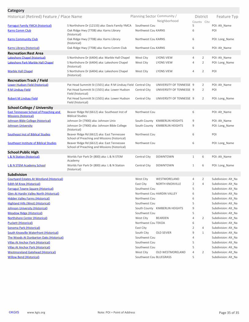
Historical (Retired) Feature / Place Name Planning Sector Feature Typ
CategoryCommunity / District
City County Neighborhoodhttps://www.kgis.org/kgismaps/map.htm? POI: Alt_NameFarragut Family YMCA (historical) Southwest Cou 5S Northshore Dr (12133) aka: Davis Family YMCA
https://www.kgis.org/kgismaps/map.htm? POIKarns Comm Club Northwest Cou KARNS 6Oak Ridge Hwy (7708) aka: Karns Library (historical)
https://www.kgis.org/kgismaps/map.htm? POI: Long_NameKarns Community Club Northwest Cou KARNS 6Oak Ridge Hwy (7708) aka: Karns Library (historical)
https://www.kgis.org/kgismaps/map.htm? POI: Alt_NameKarns Library (historical) Northwest Cou KARNS 6Oak Ridge Hwy (7708) aka: Karns Comm Club
Recreation:Rest Areahttps://www.kgis.org/kgismaps/map.htm? POI: Alt_NameLakeshore Chapel (historical) West City LYONS VIEW 4 2S Northshore Dr (6404) aka: Marble Hall Chapel
https://www.kgis.org/kgismaps/map.htm? POI: Long_NameLakeshore Park Marble Hall Chapel West City LYONS VIEW 4 2S Northshore Dr (6404) aka: Lakeshore Chapel (historical)
https://www.kgis.org/kgismaps/map.htm? POIMarble Hall Chapel West City LYONS VIEW 4 2S Northshore Dr (6404) aka: Lakeshore Chapel (historical)
Recreation:Track / Fieldhttps://www.kgis.org/kgismaps/map.htm? POI: Alt_NameLower Hudson Field (historical) Central City UNIVERSITY OF TENNESSE 9 2Pat Head Summitt St (1501) aka: R M Lindsay Field
https://www.kgis.org/kgismaps/map.htm? POIR M Lindsay Field Central City UNIVERSITY OF TENNESSE 9 2Pat Head Summitt St (1501) aka: Lower Hudson Field (historical)
https://www.kgis.org/kgismaps/map.htm? POI: Long_NameRobert M Lindsay Field Central City UNIVERSITY OF TENNESSE 9 2Pat Head Summitt St (1501) aka: Lower Hudson Field (historical)
School:College / Universityhttps://www.kgis.org/kgismaps/map.htm? POI: Alt_NameEast Tennessee School of Preaching and Missions (historical)
Northwest Cou 6Beaver Ridge Rd (6612) aka: Southeast Inst of Biblical Studies
https://www.kgis.org/kgismaps/map.htm? POI: Alt_NameJohnson Bible College (historical) South County KIMBERLIN HEIGHTS 9Johnson Dr (7900) aka: Johnson Univ
https://www.kgis.org/kgismaps/map.htm? POI: Long_NameJohnson University South County KIMBERLIN HEIGHTS 9Johnson Dr (7900) aka: Johnson Bible College (historical)
https://www.kgis.org/kgismaps/map.htm? POISoutheast Inst of Biblical Studies Northwest Cou 6Beaver Ridge Rd (6612) aka: East Tennessee School of Preaching and Missions (historical)
https://www.kgis.org/kgismaps/map.htm? POI: Long_NameSoutheast Institute of Biblical Studies Northwest Cou 6Beaver Ridge Rd (6612) aka: East Tennessee School of Preaching and Missions (historical)
School:Public Highhttps://www.kgis.org/kgismaps/map.htm? POI: Alt_NameL & N Station (historical) Central City DOWNTOWN 1 6Worlds Fair Park Dr (800) aka: L & N STEM
Academy
https://www.kgis.org/kgismaps/map.htm? POI: Long_NameL & N STEM Academy School Central City DOWNTOWN 1 6Worlds Fair Park Dr (800) aka: L & N Station (historical)
Subdivisionhttps://www.kgis.org/kgismaps/map.htm? Subdivision: Alt_NaCourtyard Estates At Westland (Historical) West City WESTMORELAND 4 2
https://www.kgis.org/kgismaps/map.htm? Subdivision: Alt_NaEdith M Knox (Historical) East City NORTH KNOXVILLE 2 4
https://www.kgis.org/kgismaps/map.htm? Subdivision: Alt_NaFarragut Towne Square (Historical) Southwest Cou 5
https://www.kgis.org/kgismaps/map.htm? Subdivision: Alt_NaGlen At Hardin Valley North (Historical) Northwest Cou HARDIN VALLEY 6
https://www.kgis.org/kgismaps/map.htm? Subdivision: Alt_NaHidden Valley Farms (Historical) Northwest Cou 6
https://www.kgis.org/kgismaps/map.htm? Subdivision: Alt_NaHighland Hills (West) (Historical) Southwest Cou 5
https://www.kgis.org/kgismaps/map.htm? Subdivision: Alt_NaJohnson University (Historical) South County KIMBERLIN HEIGHTS 9
https://www.kgis.org/kgismaps/map.htm? Subdivision: Alt_NaMeadow Ridge (Historical) Southwest Cou 5
https://www.kgis.org/kgismaps/map.htm? Subdivision: Alt_NaNorthshore Center (Historical) West City BEARDEN 4 2
https://www.kgis.org/kgismaps/map.htm? Subdivision: Alt_NaPuckett (Historical) Northwest Cou TEKOA 6
https://www.kgis.org/kgismaps/map.htm? Subdivision: Alt_NaSonoma Park (Historical) East City 2 4
https://www.kgis.org/kgismaps/map.htm? Subdivision: Alt_NaSouth Knoxville Waterfront (Historical) South City OLD SEVIER 9 1
https://www.kgis.org/kgismaps/map.htm? Subdivision: Alt_NaThe Woods At Dunbarton Oaks (Historical) Southwest Cou 4
https://www.kgis.org/kgismaps/map.htm? Subdivision: Alt_NaVillas At Anchor Park (Historical) Southwest Cou 5
https://www.kgis.org/kgismaps/map.htm? Subdivision: Alt_NaVillas At Anchor Park (Historical) Southwest Cou 5
https://www.kgis.org/kgismaps/map.htm? Subdivision: Alt_NaWestmoreland Gatehead (Historical) West City OLD WESTMORELAND 4 2
https://www.kgis.org/kgismaps/map.htm? Subdivision: Alt_NaWillow Bend (Historical) Southwest Cou BLUEGRASS 5
www.kgis.org Page 35 of 35©KGIS Note: POI = Point of Address