GAZETTEER - BirdLife International
116
2558 GAZETTEER Introduction Point-locality maps have been used in this book to illustrate the distributions of almost all threatened, Data Deficient and Conservation Dependent species in the Asian region (see Introduction: Localities, maps and gazetteers). A total of c.18,000 bird records are shown on the maps, at c.10,400 different localities. The geographical coordinates of all traced localities are given below by territory, together with details of the source references used to trace them. Coordinates are given in degrees and minutes, rounded to the nearest minute where seconds were also provided in the source. For several countries, additional information is given for each locality on the island and/or province. The localities in this gazetteer were traced through various means, involving searching pre- existing gazetteers supplemented by review of maps. The most important sources were the gazetteers of the United States Board of Geographic Names (NIMA 2000), the 1:1 million and 1:500,000 scale Operational Navigational Charts (DMMAC 1962–present), and the Times atlas of the world (TAW 1999). Key national sources are given below by country. Place names have been spelt according to compilers’ best judgement and the most recent traceable usage. An attempt has been made to standardise the locality names as far as possible, to avoid listing the same locality under two different names, but, given the scale of the task and the constraints of time, it has not proved possible to complete this process. As with the other data presented in the book, readers are encouraged to send to BirdLife International their suggestions for improvements to the gazetteer. The numbers in column three of the locality lists represent the following sources (standalone initials are those of editors; note that separate reference lists are given in the sections for the Philippines and Indonesia, with references numbered with the prefixs “PH” and “ID”): (1) NIMA (2000); (2) Beehler (undated); (3) GOC (1995); (4) DMMAC (1962–present); (5) Survey of India Map Series (various dates); (6) TAW (1999); (7) China Atlas (1977); (8) AVA (most coordinates read from a computerised 1:1,000,000 map of Russia called Gisware.Rossiya 1000 maps, produced in May 1999 by the Ingit Company in St. Petersburg; others identified from a set of 1: 200 000 maps of eastern Russia); (9) SS (including the coordinates of localities surveyed during the Asian Wetland Count); (10) SC; (11) MJC; (12) N. B. Peet; (13) WBSJ Research Center database; (14) USNM specimen label data; (15) BMNH specimen label data; (16) Ali (1983); (17) Ali and Crook (1959); (18) Allen and Thorpe (1995); (19) Barua and Sharma (1999); (20) Barzen (1994); (21) Bishop (1999a); (22) Bransbury (1993); (23) Brooks (1875a); (24) Bhushan (1986a,b); (25) CGS (1933–1943); (26) Chacko (1993a); (27) Chakrapani et al. (1990); (28) Chong and Pak (1999); (29) Chong and Morishita (1996); (30) Choudhury (1991); (31) Choudhury (1995b); (32) Choudhury (1996e); (33) Choudhury (1997c); (34) Choudhury (1998b); (35) Choudhury (2000c); (36) Clements (1992); (37) Collar et al. (1986); (38) Counsell (1986); (39) Dai Bo (1996); (40) Dai Bo (1998); (41) Datta (1997); (42) Davidson (1998); (43) DENR (1990); (44) DWNPPM (1987); (45) unallocated; (46) Dickinson et al. (1991); (47) Dissing et al. (1990); (48) Dolan (1938); (49) Dowell et al. (1997); (50) Duff et al. (1991); (51) Eames (1995a); (52) Eames and Ericson (1996); (53) Eames and Tordoff (in prep.); (54) Eames et al. (1999b); (55) Edwards (1999); (56) Engelbach (1952); (57) Evans (1994); (58) Evans et al. (1997); (59) Fellowes et al. (in prep.); (60) Ford and Davison (1995); (61) Gandhi and Singh (1995a,b); (62) Gao Yuren and Yu Degun (1999); (63) Garson (1987); (64) Ghosh (1997); (65) Gole (1984); (66) Green (1992a) (note that the author described the coordinates given in this publication as “rough approximations”); (67) Green (1993c); (68) Gyldenstolpe (1913); (69) Gyldenstolpe (1916); (70) Hawkins and Howes (1986); (71) He Fenqi et al. (1992); (72) Hume (1875a); (73) Hume and Davidson (1878); (74) Hume and Oates (1889–1890); (75) Hussain et al. (1992); (76) Inglis (1951–1969); (77) Inskipp and Inskipp (1993a);
Transcript of GAZETTEER - BirdLife International
2558
Threatened birds of Asia
GAZETTEER
IntroductionPoint-locality maps have been used in this book to illustrate the distributions of almost allthreatened, Data Deficient and Conservation Dependent species in the Asian region (seeIntroduction: Localities, maps and gazetteers). A total of c.18,000 bird records are shown on themaps, at c.10,400 different localities. The geographical coordinates of all traced localities aregiven below by territory, together with details of the source references used to trace them.Coordinates are given in degrees and minutes, rounded to the nearest minute where seconds werealso provided in the source. For several countries, additional information is given for each localityon the island and/or province.
The localities in this gazetteer were traced through various means, involving searching pre-existing gazetteers supplemented by review of maps. The most important sources were thegazetteers of the United States Board of Geographic Names (NIMA 2000), the 1:1 million and1:500,000 scale Operational Navigational Charts (DMMAC 1962–present), and the Times atlasof the world (TAW 1999). Key national sources are given below by country. Place names have beenspelt according to compilers’ best judgement and the most recent traceable usage. An attempt hasbeen made to standardise the locality names as far as possible, to avoid listing the same localityunder two different names, but, given the scale of the task and the constraints of time, it has notproved possible to complete this process. As with the other data presented in the book, readersare encouraged to send to BirdLife International their suggestions for improvements to thegazetteer.
The numbers in column three of the locality lists represent the following sources (standaloneinitials are those of editors; note that separate reference lists are given in the sections for thePhilippines and Indonesia, with references numbered with the prefixs “PH” and “ID”): (1) NIMA(2000); (2) Beehler (undated); (3) GOC (1995); (4) DMMAC (1962–present); (5) Survey of IndiaMap Series (various dates); (6) TAW (1999); (7) China Atlas (1977); (8) AVA (most coordinatesread from a computerised 1:1,000,000 map of Russia called Gisware.Rossiya 1000 maps, producedin May 1999 by the Ingit Company in St. Petersburg; others identified from a set of 1: 200 000maps of eastern Russia); (9) SS (including the coordinates of localities surveyed during the AsianWetland Count); (10) SC; (11) MJC; (12) N. B. Peet; (13) WBSJ Research Center database; (14)USNM specimen label data; (15) BMNH specimen label data; (16) Ali (1983); (17) Ali and Crook(1959); (18) Allen and Thorpe (1995); (19) Barua and Sharma (1999); (20) Barzen (1994); (21)Bishop (1999a); (22) Bransbury (1993); (23) Brooks (1875a); (24) Bhushan (1986a,b); (25) CGS(1933–1943); (26) Chacko (1993a); (27) Chakrapani et al. (1990); (28) Chong and Pak (1999);(29) Chong and Morishita (1996); (30) Choudhury (1991); (31) Choudhury (1995b); (32)Choudhury (1996e); (33) Choudhury (1997c); (34) Choudhury (1998b); (35) Choudhury (2000c);(36) Clements (1992); (37) Collar et al. (1986); (38) Counsell (1986); (39) Dai Bo (1996); (40) DaiBo (1998); (41) Datta (1997); (42) Davidson (1998); (43) DENR (1990); (44) DWNPPM (1987);(45) unallocated; (46) Dickinson et al. (1991); (47) Dissing et al. (1990); (48) Dolan (1938); (49)Dowell et al. (1997); (50) Duff et al. (1991); (51) Eames (1995a); (52) Eames and Ericson (1996);(53) Eames and Tordoff (in prep.); (54) Eames et al. (1999b); (55) Edwards (1999); (56) Engelbach(1952); (57) Evans (1994); (58) Evans et al. (1997); (59) Fellowes et al. (in prep.); (60) Ford andDavison (1995); (61) Gandhi and Singh (1995a,b); (62) Gao Yuren and Yu Degun (1999); (63)Garson (1987); (64) Ghosh (1997); (65) Gole (1984); (66) Green (1992a) (note that the authordescribed the coordinates given in this publication as “rough approximations”); (67) Green (1993c);(68) Gyldenstolpe (1913); (69) Gyldenstolpe (1916); (70) Hawkins and Howes (1986); (71) HeFenqi et al. (1992); (72) Hume (1875a); (73) Hume and Davidson (1878); (74) Hume and Oates(1889–1890); (75) Hussain et al. (1992); (76) Inglis (1951–1969); (77) Inskipp and Inskipp (1993a);
2559
Gazetteer
(78) Inskipp and Inskipp (1993b); (79) Inskipp and Inskipp (1998); (80) Inskipp et al. (2000a,b);(81) Ishtiaq and Rahmani (2000a); (82) Islam and Crawford (1986); (83) IUCN (1993); (84)IUCN (1996); (85) IUCN (1997); (86) IUCN (1998); (87) IUCN/WCMC (1997); (88) unallocated;(89) Jones et al. (1998); (90) Kalsi (1998a); (91) Kalsi (1999); (92) Kapoor and Bhatia (1983); (93)Karthikeyan (1995); (94) King and Jin Longrong (1992–1993); (95) King and Peng Jitai (1991);(96) Kinnear (1934); (97) Kitson (1978); (98) Kolthoff (1932); (99) Koning and Walmsley (1973);(100) Kováts et al. (undated); (101) Kozlova (1932–1933); (102) Kumar and Singh (1999a); (103)Kumar and Singh (2000); (104) La Touche (1920–1921); (105) La Touche (1925–1934); (106)Lainer (1999); (107) Lambert (1989a); (108) Lekagul and McNeely (1988); (109) Le Xuan Canhet al. (1997); (110) Legge (1880); (111) Lewthwaite (1996); (112) Liley et al. (1995); (113) LiuGaohuan and Drost (1997); (114) Ludlow and Kinnear (1937); (115) Ma Shilai et al. (1994);(116) MacKinnon et al. (1996); (117) Manakadan and Rahmani (1989); (118) Mann (1987);(119) Meise (1934); (120) Meyer de Schauensee (1946); (121) Mikhailov and Shibnev (1998);(122) Mitra and Sheldon (1993); (123) Miyabayashi and Mundkur (1999); (124) MMNE (1996);(125) Mundkur et al. (1995a); (126) Stresemann and Portenko (1982); (127) Oates (1882); (128)Oates (1883); (129) Parr et al. (1993a); (130) PAWB unpublished information; (131) Pedersen etal. (1998); (132) Perennou and Santharan (1990); (133) Perennou et al. (1994); (134) Pfister (1998);(135) Piatt and Gould (1994); (136) Piechocki (1956); (137) Piechocki (1968); (138) Pollok (1879);(139) Rahmani and Manakadan (1990); (140) Rasmussen and Collar (1998); (141) Rickett ms b;(142) Roberts (1991–1992); (143) Robinson (1987); (144) Robson et al. (1989); (145) Robson et al.(1993b); (146) unallocated; (147) Robson et al. (1998); (148) unallocated; (149) Round (1998);(150) Sankaran (1995a); (151) Sauey et al. (1987); (152) Saxena (1994); (153) Scott (1989); (154)Scully (1876); (155) Severinghaus et al. (1991); (156) Sharma and Pandey (1990); (157) unallocated;(158) Sheldon et al. (in press); (159) Showler and Davison (1999); (160) Showler et al. (1998b);(161) Singh (1994); (162) Singh (1995); (163) Singha (1996); (164) Smythies (1960); (165) Sonobe(1987); (166) Stanford and Ticehurst (1938–1939); (167) Stevens (1914–1915); (168) Stevens (1923–1925); (169) Subramanya et al. (in prep.); (170) Talukdar (1995b); (171) Thewlis and Timmins(1996); (172) Thewlis et al. (1998); (173) Thompson and Johnson (1996); (174) Thompson et al.(1993); (175) Timmins and Soriyun (1998); (176) Tiwari and Rahmani (1996); (177) Tobias (1997);(178) Tomek (1999); (179) Tourenq et al. (1996); (180) Traylor (1967); (181) Turner (1899); (182)Tweedie (1887); (183) Tymstra (1993); (184) Tymstra et al. (1996); (185) unallocated; (186) Urfi(1995); (187) Vaughan and Jones (1913); (188) Vaurie (1972); (189) Vidal (1880); (190) Vyas et al.(1983); (191) Waterbird Specialist Group (1994); (192) Wells (1990a-c); (193) Wells (1999); (194)Whistler (1922a); (195) Yahya (1994); (196) R. E. Green in litt. 2001; (197) Yen (1932a); (198)Zacharias and Gaston (1993); (199) Zacharias and Gaston (1999); (200) Zeliang (1980); (201)Zhang Yinsun et al. (1992); (202) Zhao Ermi and Adler (1993); (203) H. S. Baral in litt. (2001);(204) D. Batdelger in litt. (1997); (205) C. Bealey in litt. (1999); (206) Bird Conservation Societyof Thailand in litt. (2000); (207) A. Choudhury in litt. (2000); (208) P. Davidson in litt. (2000);(209) G. W. H. Davison in litt. (2000); (210) Ding Changqing in litt. (1999); (211) J. C. Eames andNguyen Cu in litt. (1997); (212) Gao Yuren in litt. (2000); (213) F. Goes in litt. (1999); (214) J.Hinshaw in litt. (2000); (215) J. I. Hodges and W. D. Eldridge per N. I. Germogenov, A. G.Degtyarev and Yu. V. Labutin in litt. (1997); (216) Houng Kuangying in litt. (1997); (217) C.Inskipp and T. Inskipp in litt. (1997, 2000); (218) Kisup Lee in litt. (2000); (219) Le Trong Trai inlitt. (1997); (220) M. L. Narang verbally (1995); (221) Nguyen Cu in litt. (1997, 2000); (222)Omaliss Keo verbally (2000); (223) C. M. Poole in litt. (1999); (224) C. R. Robson in litt. (1991—data gathered during BirdLife International’s Endemic Bird Area analysis: see ICBP 1992,Stattersfield et al. 1998); (225) P. D. Round in litt. (1998, 2000); (226) D. Showler verbally (2001);(227) Sun Hean in litt. (1997); (228) J. Tordoff in litt. (2000); (229) N. Tseveenmyadag in litt.(1997); (230) M. J. Ueta in litt. (1999); (231) W. J. M. Verheugt in litt. (1998); (232) M. Wangdi in litt.(2000); (233) Wang Qishan in litt. (1997, 2000); (234) K. Weerakoon in litt. (1997); (235) D. R. Wellsin litt. (2000, 2001); (236) Yang Lan in litt. (1997); (237) Zhang Zhengwang in litt. (1999, 2000).
2560
Threatened birds of Asia
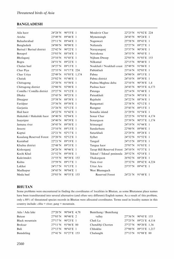
Aila haor 24°28’N 90°53’E 1
Aricha 23°49’N 89°46’E 1
Bahadurabad 25°11’N 89°44’E 1
Bangladesh 24°00’N 90°00’E 1
Barisal / Barisal district 22°42’N 90°22’E 1
Benapol 23°03’N 88°54’E 1
Bholaganj 25°10’N 91°45’E 1
Bogra 24°51’N 89°22’E 1
Chalan beel 24°27’N 89°13’E 1
Char Piya 22°33’N 91°17’E 224
Char Uriya 22°49’N 91°05’E 1,174
Chatak 25°02’N 91°40’E 1
Chittagong 22°20’N 91°50’E 1
Chittagong district 22°00’N 92°00’E 1
Comilla / Comilla district 23°27’N 91°12’E 1
Dhaka 23°43’N 90°25’E 1
Dinajpur 25°38’N 88°38’E 1
Faridpur 23°36’N 89°50’E 1
Garjania 21°26’N 92°12’E 1
Hail haor 24°22’N 91°42’E 1
Hakaluki / Hakaluki haor 24°40’N 92°04’E 1
Inayetpur 24°40’N 90°39’E 1
Jamuna river 24°45’N 89°50’E 1
Jessore 23°10’N 89°13’E 1
Kaptai 22°21’N 92°17’E 1
Kasalang Reserved Forest 23°20’N 92°12’E 1
Kasiabad 22°21’N 89°19’E 1
Khulna district 22°48’N 89°33’E 1
Kishorganj 24°26’N 90°46’E 1
Kochi Khal 21°52’N 89°50’E 1
Kukrimukri 21°55’N 90°38’E 153
Kulna 23°59’N 89°17’E 1
Lakhai 24°17’N 91°13’E 1
Madhupur 24°43’N 90°04’E 1
Meda beel 25°03’N 90°55’E 153
Moulevir Char 22°25’N 91°02’E 224
Mymensingh 24°45’N 90°24’E 1
Nageswari 25°58’N 89°43’E 1
Nalianala 22°27’N 89°27’E 1
Narayanganj 23°37’N 90°30’E 1
Netrakona 24°53’N 90°43’E 1
Nijhum Dweep 22°05’N 91°03’E 153
Nilkamal 22°15’N 90°40’E 1
Noakhali / Noakhali coast 22°49’N 91°06’E 1
Pablakhali 23°16’N 92°05’E 1
Pabna 24°00’N 89°15’E 1
Pabna district 24°10’N 89°30’E 1
Padma-Meghna delta 22°10’N 90°30’E 1,4
Pashua haor 24°45’N 90°35’E 6,173
Patenga 22°14’N 91°48’E 1
Patuakhali 22°16’N 90°18’E 1
Rajshahi 24°22’N 88°36’E 1
Rangamati 22°38’N 92°12’E 1
Rangpur 25°45’N 89°15’E 1
Sonadia island 21°29’N 91°54’E 1
Sonar Char 22°25’N 91°05’E 4,174
Sonargaon 23°39’N 90°37’E 1,174
Srimangal 24°19’N 91°44’E 1
Sundarbans 22°00’N 89°00’E 1
Sutarkhali 22°29’N 89°28’E 1
Sylhet 24°32’N 91°52’E 1
Tangail 24°15’N 89°55’E 1
Tangua haor 25°07’N 91°03’E 1
Tarap Hill Reserved Forest 24°10’N 91°37’E 1
Teknaf / Teknaf peninsula 20°52’N 92°18’E 1
Thakurgaon 26°02’N 88°28’E 1
Tista river 25°32’N 89°42’E 4,224
Uttar Ara 23°57’N 89°47’E 1
West Bhanugach
Reserved Forest 24°21’N 91°48’E 1
BHUTANSome problems were encountered in finding the coordinates of localities in Bhutan, as some Bhutanese place names
have been transliterated into several alternative (and often very different) English names. As a result of this problem,
only c.80% of threatened species records in Bhutan were allocated coordinates. Terms used in locality names in this
country include: chhu = river; gang = mountain.
Ada / Ada lake 27°20’N 90°04’E 4,78
Batase 27°05’N 90°40’E 2
Black mountain 27°17’N 90°23’E 1
Broksar 27°11’N 91°06’E 80
Buli 27°13’N 90°43’E 1
Bumdeling 27°41’N 91°27’E 153
Bumthang / Bumthang
valley 27°36’N 90°43’E 153
Cheli La 27°25’N 89°21’E 4,114
Chendibji Chorten 27°27’N 90°20’E 1,36
Chhukha 27°00’N 89°33’E 1,217
Chulungbi 27°13’N 91°08’E 80
BANGLADESH
2561
Gazetteer
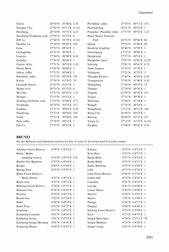
Dalim 26°50’N 91°40’E 4,78
Dangme Chu 27°05’N 91°17’E 4,114
Deothang 26°54’N 91°31’E 4,21
Deothang-Narphang road 27°05’N 91°25’E 4
Dib La 27°40’N 91°39’E 4,114
Dochhu La 27°29’N 89°45’E 184
Gasa 27°55’N 89°41’E 1
Geylegphug 26°51’N 90°30’E 1
Gogona 27°24’N 90°08’E 4,26
Gonphu 27°05’N 90°46’E 1
Gyetsa valley 27°31’N 90°38’E 1,36
Honey Rock 27°05’N 90°40’E 2
Jakhar valley 27°33’N 90°44’E 1
Khatekha valley 27°27’N 89°50’E 153
Korila 27°18’N 91°20’E 79
Lhuntshi district 27°45’N 91°11’E 1
Manas river 26°55’N 91°33’E 4
Mo Chu 27°37’N 89°52’E 1,21
Mongar 27°15’N 91°12’E 1
Namling-Yonkhala road 27°25’N 91°00’E 4,77
Narphang 26°55’N 91°32’E 217
Nashina 27°17’N 90°03’E 4,78
Nimshong 27°13’N 90°36’E 184
Nobji 27°11’N 90°28’E 184
Paro valley 27°19’N 89°32’E 1
Pele La 27°33’N 90°13’E 1
Phobjikha valley 27°28’N 90°11’E 153
Phuntsholing 26°51’N 89°23’E 1
Punakha / Punakha valley 27°37’N 89°52’E 1,21
Royal Manas National
Park 26°51’N 90°46’E 86
Saleng 27°16’N 91°06’E 80
Samdrup Jongkhar 26°48’N 91°28’E 1
Samtengang 27°32’N 90°00’E 1
Shingkarap 27°37’N 89°16’E 1
Shingkhar Lawri 27°07’N 92°03’E 4,232
Subrang 27°01’N 90°41’E 4,78
Tashi Yangtse 27°35’N 91°28’E 1
Tashigang 27°21’N 91°33’E 5
Thangby-Kharsa 27°43’N 90°42’E 4,26
Thangmachu 27°45’N 91°00’E 4,26
Thekpaling 27°20’N 90°55’E 79
Thimpu 27°29’N 89°36’E 1
Tingtibi 27°09’N 90°42’E 217
Tongsa 27°31’N 90°30’E 1
Wamrong 27°04’N 91°34’E 1
Wangdi 27°29’N 89°54’E 1
Wangdinala 27°13’N 90°37’E 184
Wong Chu 26°50’N 89°35’E 1
Worong 26°48’N 91°32’E 217
Yonpu La 27°15’N 91°32’E 4,114
Zurphey 27°04’N 90°41’E 4,78
BRUNEISee the Malaysia and Indonesia sections for lists of some of the terms used in locality names.
Andulau Forest Reserve 4°38’N 114°32’E 1
Badas / Badas
pumping station 4°39’N 114°23’E 118
Bandar Seri Begawan 4°53’N 114°56’E 1
Bangar 4°43’N 115°04’E 1
Batang Duri 4°35’N 115°07’E 1
Belait Forest Reserve /
Belait district 4°25’N 114°35’E 1
Belait river 4°35’N 114°12’E 1
Belalong Forest Reserve 4°29’N 115°11’E 1
Benutan river 4°36’N 114°43’E 1
Berakas 4°59’N 114°55’E 1
Brunei bay 5°05’N 115°18’E 1
Bukit 4°38’N 114°39’E 1
Bukit Puan 4°32’N 114°27’E 1
Jerudong 4°57’N 114°51’E 1
Kampong Lamunin 4°41’N 114°43’E 1
Kampong Serasa 5°01’N 115°03’E 1
Kampong Sungai Beruang 4°41’N 114°43’E 1
Kampong Wasan 4°46’N 114°47’E 1
Kilanas 4°52’N 114°52’E 1
Kota Batu 4°53’N 114°57’E 1
Kuala Balai 4°27’N 114°19’E 1
Kuala Belait 4°35’N 114°11’E 1
Kuala Belalong 4°33’N 115°08’E 1
Labi 4°23’N 114°26’E 1
Labu Forest Reserve 4°48’N 115°10’E 1
Ladan hills 4°35’N 114°45’E 1
Lamunin 4°41’N 114°43’E 1
Layong 4°41’N 114°40’E 1
Limau Manis 4°45’N 114°49’E 1
Mentiri 4°59’N 115°01’E 1
Muara 5°02’N 115°04’E 1
Panaga 4°36’N 114°17’E 1
Penapar 4°44’N 114°40’E 1
Selirong Forest Reserve 4°53’N 115°08’E 1
Seria 4°37’N 114°19’E 1
Sungai Batu Apoi 4°38’N 115°11’E 38
Sungai Benutan 4°36’N 114°43’E 1
Sungai Liang 4°41’N 114°30’E 1
2562
Threatened birds of Asia
Sungai Mau 4°33’N 114°29’E 1
Sungai Rampayoh 4°26’N 114°24’E 1
Temburong 4°35’N 115°10’E 1
Temburong (lower) 4°48’N 115°03’E 1
Tungku 4°56’N 114°53’E 1
Tutong / Tutong road 4°48’N 114°39’E 1
Tutong river 4°46’N 114°36’E 1
Ukong 4°40’N 114°38’E 1
Ulu Belait 4°35’N 114°12’E 1
Ulu Temburong
National Park 4°27’N 115°11’E 86
Wasan 4°46’N 114°47’E 1
CAMBODIATerms used in locality names in Cambodia include: kampong = town, village; kaoh = island; phnum = hill, mountain;
phumi = town, village; prek = lake, river; stoeng = river; tonle = lake, river.
Ang Trapeang Thmor
Reserve 13°47’N 103°18’E 223
Angkor Wat 13°25’N 103°52’E 1
Baray district 12°28’N 104°50’E 4,222
Bassac marshes / Bassac river11°10’N 105°09’E 4,55
Basset marshes 11°41’N 104°47’E 4,222
Battambang 13°06’N 103°12’E 1
Boeng Chhma 12°45’N 104°20’E 125
Boeng Veal Samnap 11°35’N 105°03’E 1
Bokor National Park 10°37’N 104°03’E 1
Cardomom mountains 12°00’N 103°15’E 1
Dak Dam stream 13°01’N 107°30’E 1
Kampong Chhnang 12°15’N 104°40’E 1
Kampong Som 10°38’N 103°30’E 1
Kampot 10°37’N 104°11’E 1
Kandieng district 12°45’N 104°02’E 125
Kaoh Kapik 11°27’N 103°01’E 1
Kaoh Nhek 13°05’N 107°04’E 1
Khet Kracheh 12°30’N 106°00’E 1
Kirirom National Park 11°20’N 104°03’E 1
Koh Ker 13°47’N 104°32’E 1
Koh Kong 11°36’N 103°00’E 1
Kom Mum 13°36’N 106°40’E 1
Kompong Chikreng /
Kompong Chikreng
district 13°05’N 104°18’E 1
Kompong Kdey 13°07’N 104°21’E 1
Kompong Som 11°03’N 103°42’E 1
Kompong Svay district 12°45’N 104°59’E 1
Kompong Thom 12°42’N 104°54’E 1
Kralagn district 13°35’N 103°25’E 1
Kruos Kraoum 12°38’N 104°49’E 208
Lomphat 13°30’N 106°59’E 1
Moat Khla 12°54’N 104°11’E 1
Mondolkiri 12°47’N 106°36’E 125
Neak Leung district 11°16’N 105°18’E 1
Phnom Penh 11°30’N 104°50’E 1
Phnom Samkos
Wildlife Sanctuary 12°10’N 103°00’E 4,222
Phnum Kraom 13°17’N 103°49’E 1
Phumi Sre Kor 13°37’N 106°23’E 1
Phumi Yuon Dong 12°34’N 107°03’E 4
Pich Nil 11°11’N 104°05’E 4,222
Pointe Samit 10°52’N 103°08’E 1
Prak Kda 11°50’N 104°45’E 1
Prek Da 13°14’N 103°39’E 1
Prek Kal 12°50’N 103°54’E 125
Prek Peach Kantoeli 13°05’N 103°42’E 1
Prek Preah Dam Chheu 13°07’N 103°42’E 1
Prek Spot 13°10’N 103°42’E 1
Prek Toal 13°14’N 103°40’E 1
Prey Nup district 10°38’N 103°47’E 1
Ratanakiri 13°00’N 107°00’E 1
Ream National Park 10°30’N 103°37’E 1
Saang district 12°57’N 104°37’E 1
Sambor 12°44’N 106°01’E 6
Sangke river 13°06’N 103°12’E 1
Siem Pang 14°07’N 106°23’E 1
Siem Reap 13°22’N 103°51’E 1
Sisophon 13°35’N 102°59’E 1
Snuol Wildlife Sanctuary 12°05’N 106°42’E 86
Soai Rieng 11°05’N 105°48’E 1
Sotr Nikam district 13°00’N 104°10’E 125
Srayov 12°39’N 104°55’E 1
Stoeng Areng 11°30’N 103°30’E 6,56
Stoeng Kampong Smach 10°39’N 103°52’E 1
Stoeng Sangke 13°13’N 103°41’E 1
Stung Chikreng 13°00’N 104°15’E 4,222
Stung Chinit 12°25’N 105°33’E 231
Stung Treng 13°31’N 105°58’E 1
Su Vu 11°49’N 105°47’E 1
Svay Leu 13°45’N 104°15’E 227
Ta Veng 14°04’N 107°11’E 175
Tang Krasang river 12°33’N 105°00’E 1
Taveng district 14°02’N 107°07’E 1
Tonle Kong 13°32’N 105°58’E 1
Tonle San 13°41’N 106°31’E 1,20
Tonle Sap lake 13°00’N 104°00’E 1
2563
Gazetteer
Tonle Sap river 11°34’N 104°57’E 1
Tonle Srepok 13°33’N 106°16’E 1
Veal Renh 10°47’N 103°50’E 4,222
Vun Say district 14°00’N 106°15’E 4,222
CHINAThe data on China are listed under four territories, Mainland China, Macau, Hong Kong and Taiwan. Note that in
Mainland China, the transliteration of place names follows the Pinyin romanisation system, whereas the transliteration
of Taiwanese names generally follows the Wade-Giles romanisation system (see Introduction). Terms used in locality
names in China include: bei = north, northern; chi = small lake; chuan = river; co, cona = lake (tibetan); -cun = village;
da = big; dao = island; dashan = mountain; dian = shallow lake; ding = mountain; dong = east, eastern; feng =
mountain, mountain range; gang = bay, harbour, port, river, hillock; gou = river; guan = pass; hai = lake, sea; he =
river; hu = lake; jiang = river; jiao = cape, point; kou = river mouth; la = pass (tibetan); ling = mountain range; men =
gate; miao = temple; nan = south, southern; nei = inner; nur = lake; qi = banner (administrative division); qiao =
bridge; qu = river (tibetan); quan = spring, well; shan = hill(s), mountain(s); shang = next to, upper; shi = city; shui =
river; tao = island; tso = lake (tibetan); wan = bay; xi = river, west, western; xia = gorge, lower; xian = county; xiao =
small; yang = channel; you = right; yuan = spring; yumco = lake (tibetan); yunhe = canal; zangbo = river (tibetan); zhen
= town; zhong = middle, central; zhou = island.
Mainland ChinaIn the species accounts, data on mainland China have been listed under the following 22 provinces (sheng), five autonomous
regions (zizhiqu) and three municipalities (shi) (in Pinyin, with alternative transliterations using the Wade-Giles romanisation
system, followed by the codes used to represent these regions in the locality list), in the sequence given below.
— Heilongjiang (Heilungkiang) Province [HL]
— Jilin (Kirin) Province [JL]
— Liaoning Province [LN]
— Inner Mongolia Autonomous Region [IM]
— Xinjiang (Sinkiang) Autonomous Region [XJ]
— Tibet Autonomous Region [TB]
— Qinghai (Tsinghai) Province [QH]
— Gansu (Kansu) Province [GS]
— Ningxia (Ningsia) Autonomous Region [NX]
— Sichuan (Szechwan) Province [SC]
— Yunnan Province [YU]
— Guizhou (Kweichow) Province [GZ]
— Shaanxi (Shensi) Province [SX]
— Shanxi (Shansi) Province [SN]
— Hebei (Hopeh) Province [HB]
— Tianjin (Tientsin) City [TJ]
— Beijing (Peking) City [BJ]
— Shandong (Shantung) Province [SD]
— Henan (Honan) Province [HE]
— Hubei (Hupeh) Province [HU]
— Anhui (Anhwei) Province [AH]
— Jiangsu (Kiangsu) Province [JG]
— Shanghai City [SH]
— Zhejiang (Chekiang) Province [ZJ]
— Fujian (Fukien) Province [FJ]
— Jiangxi (Kiangsi) Province [JX]
— Hunan Province [HN]
— Guangxi (Kwangsi) Autonomous Region [GX]
— Guangdong (Kwangtung) Province [GD]
— Hainan Province [HA]
Aba county, SC 32°55’N 101°42’E 1
Acheng county, HL 45°32’N 126°59’E 1
Ah Ch’ung, FJ 26°44’N 118°35’E 4,141
Ailaoshan National Nature
Reserve, YU 24°10’N 101°12’E 116
Ainishan, YU 24°30’N 101°34’E 1
Aksay, GS 39°22’N 94°24’E 1
Aksay county, GS 39°28’N 94°15’E 1
Altay, XJ 47°52’N 88°07’E 1
Alxa league, IM 38°50’N 105°32’E 1
Amdo county, TB 32°20’N 91°40’E 1
An Xian county, SC 31°40’N 104°26’E 1
Anda city, HL 46°24’N 125°19’E 1,3
Ang’angxi, HL 47°09’N 123°48’E 1
Ankang, SX 32°41’N 109°01’E 1
Anmenkou, GS 33°18’N 105°36’E 1
Anqing, AH 30°31’N 117°03’E 1
Antu, JL 42°35’N 128°20’E 1
Antu county, JL 42°33’N 128°19’E 1
Anxi Gobi
Nature Reserve, GS 40°30’N 95°40’E 116
Anyi county, JX 28°50’N 115°32’E 1
Anyuan county, JX 25°09’N 115°21’E 1
Ao Jiang / Ao Jiang
estuary, ZJ 27°35’N 120°36’E 1,191
Ar Horqin Qi, IM 43°45’N 120°00’E 1
2564
Threatened birds of Asia
Arjin Shan National
Nature Reserve, XJ 37°00’N 89°00’E 116
Ashi He, HL 45°48’N 126°42’E 3
Ata Kang La, TB 29°08’N 96°53’E 188
Aubai Nur, IM 38°55’N 108°48’E 4,71
Babao Shan
Nature Reserve, GD 24°52’N 112°58’E 111
Bada Ling, BJ 40°20’N 115°59’E 1
Badong county, HU 31°02’N 110°20’E 1
Bagrax Hu, XJ 42°00’N 87°00’E 1
Baicheng / Baicheng
prefecture, JL 45°37’N 122°49’E 1
Baihe, JL 42°28’N 128°09’E 1
Baihe Nature Reserve, SC 33°14’N 104°07’E 116
Baihe county, SX 32°49’N 110°06’E 1
Baihuashan
Nature Reserve, BJ 39°51’N 115°36’E 1
Baima, AH 31°15’N 118°21’E 1
Baima county, QH 32°58’N 100°42’E 1
Bainang county, TB 29°10’N 89°15’E 1
Baingoin county, TB 31°45’N 89°50’E 1
Baisha county, HA 19°13’N 109°26’E 1
Baishuijiang National
Nature Reserve, GS 32°47’N 104°51’E 116
Baishuxi valley, SC 28°28’N 103°44’E 4,39
Baixing Hu, GD 22°15’N 113°28’E 4,212
Baiyang Dian, HB 38°54’N 116°01’E 1
Baiyu county, SC 31°14’N 98°48’E 1
Balahai, IM 40°34’N 107°17’E 4,201
Bam Tso, TB 28°06’N 89°19’E 188
Bang Hu, JX 29°15’N 115°58’E 4,10
Banggong Co, TB 33°45’N 78°43’E 1
Bangxi Nature Reserve, HA 19°25’N 109°05’E 116
Banqiao, YU 25°38’N 102°55’E 1
Baoding, HB 38°51’N 115°29’E 1
Baojia, GZ 26°54’N 104°11’E 1
Baoqing / Baoqing
county, HL 46°20’N 132°12’E 1
Baoshan / Baoshan
county, SH 31°25’N 121°29’E 1
Baoshan, YU 25°07’N 99°09’E 1,224
Baoting, HA 18°39’N 109°40’E 1
Baotou / Baotou city, IM 40°39’N 109°49’E 1
Baoxiu, YU 23°46’N 102°24’E 1
Barga, IM 48°50’N 117°45’E 4,136
Barkam county, SC 31°51’N 102°28’E 1
Barkol, XJ 43°35’N 92°51’E 1
Barun, QH 36°10’N 97°20’E 1
Batang, SC 30°00’N 99°00’E 1
Bawangling National
Nature Reserve, HA 19°06’N 109°07’E 116
Bayan, HL 46°05’N 127°24’E 1
Bayan Gol, QH 37°18’N 96°50’E 1
Bayan Obo Nature
Reserve, IM 43°33’N 117°11’E 116
Bayanbulak, XJ 43°05’N 84°05’E 1,3,47
Bayannur league, IM 40°50’N 107°30’E 1
Bayiwua, YU 27°10’N 100°20’E 224
Bazhong, SC 31°51’N 106°42’E 1
Bazhou, HB 39°06’N 116°24’E 1
Bei Jiang, GD 23°02’N 112°58’E 1
Beibu bay, GX 21°32’N 109°04’E 1
Beidagang, TJ 38°42’N 117°27’E 1
Beidaihe, HB 39°52’N 119°26’E 1
Beigantang Dao, FJ 26°12’N 120°00’E 3,7
Beihai, GX 21°29’N 109°06’E 1
Beijing / Beijing city, BJ 39°54’N 116°25’E 1
Beijing Shisanling
reservoir, BJ 40°18’N 116°14’E 1
Beijingzi, LN 39°52’N 123°53’E 1
Biannian, GX 22°10’N 108°20’E 59
Bijie county, GZ 27°18’N 105°16’E 1
Biluo Xueshan, YU 26°47’N 99°00’E 1
Bimbi La, TB 28°47’N 93°29’E 188
Bita Hai Nature
Reserve, YU 27°50’N 99°58’E 116
Boerjiang Nur, IM 39°52’N 109°27’E 4,71
Bose, GX 23°54’N 106°37’E 1
Boxodoi, IM 42°36’N 115°28’E 1
Boyang county, JX 28°59’N 116°40’E 1
Bugt, IM 48°47’N 121°56’E 1
Buir Nur, IM 47°50’N 117°43’E 1
Buliuhe Nature
Reserve, GX 24°57’N 106°54’E 116
Burang county, TB 30°15’N 81°10’E 1
Burchan Buddha Ula, QH 35°50’N 97°10’E 1
Burqin, XJ 47°43’N 86°53’E 1
Butha Qi, IM 48°00’N 122°43’E 1
Caizi Hu, AH 30°47’N 117°07’E 1
Camp 71, QH 33°07’N 97°09’E 4,48
Camp 80, QH 33°25’N 97°15’E 188
Camp 91, QH 32°25’N 96°50’E 188
Camp 139, SC 32°50’N 98°30’E 188
Cangkou, SD 36°10’N 120°23’E 1
Cangling, SC 29°00’N 108°36’E 1
Cangyuan county, YU 23°09’N 99°15’E 1
Cao Hai / Cao Hai
Nature Reserve, GZ 26°53’N 104°13’E 1
Caoba, SC 29°59’N 103°10’E 1
Chaishang Hu, HN 29°27’N 112°50’E 123
Chaiwopu Hu, XJ 43°30’N 87°54’E 1
Changbai Shan, JL 41°45’N 127°58’E 1
2565
Gazetteer
Changchun / Changchun
prefecture, JL 43°52’N 125°21’E 1
Changdao National
Nature Reserve, SD 38°08’N 120°45’E 116
Changdong, TB 28°19’N 86°02’E 188
Changli, HB 39°43’N 119°08’E 1
Changling county, JL 44°16’N 123°58’E 1
Changning county, YU 24°50’N 99°36’E 1
Changshan islands, SD 38°08’N 120°46’E 123
Changshou, SC 29°50’N 107°04’E 1
Changshou reservoir, SC 30°00’N 107°15’E 1
Changting, FJ 25°52’N 116°19’E 1
Changyi, SD 36°51’N 119°23’E 1
Chao Hu, AH 31°31’N 117°33’E 1
Chaor He, IM 46°49’N 123°35’E 1
Chaoyang, LN 41°35’N 120°27’E 1
Chaoyang county /
Chaoyang district, LN 41°33’N 120°25’E 1
Chaozhou city, GD 23°41’N 116°38’E 1
Chardingjy, XJ 48°20’N 87°03’E 4,47
Chasora river, QH 35°42’N 99°58’E 188
Chayuan, ZJ 29°19’N 121°34’E 1
Chebaling National
Nature Reserve, GD 24°42’N 114°10’E 111,116
Chen Hu / Chen Hu
Nature Reserve, HU 30°30’N 113°28’E 1
Cheng Hai, YU 26°34’N 100°20’E 1,153
Chengde, HB 40°58’N 117°56’E 1
Chengdong Hu, AH 32°17’N 116°21’E 1
Chengdu city, SC 30°40’N 104°04’E 1
Chenggu county, SX 33°10’N 107°22’E 1
Chenghai, GD 23°28’N 116°45’E 1
Chengkou salt works, SD 38°07’N 117°45’E 1
Chengkou county, SC 31°58’N 108°48’E 1
Chengxing Dao, SH 31°24’N 121°41’E 1
Cheniu Shan, SD 34°59’N 119°48’E 1
Chenyao Hu, AH 30°56’N 117°38’E 1
Chienliang Shan, SC 31°20’N 102°45’E 224
Chifeng / Chifeng city, IM 42°17’N 118°53’E 1
Chigai Nur, IM 39°25’N 109°22’E 4,71
Chindu county, QH 33°22’N 97°08’E 1
Ching Feng, FJ 26°35’N 118°44’E 4,141
Chira, TB 29°14’N 91°28’E 188
Chishui county, GZ 28°29’N 105°38’E 1
Chiu Gompa, TB 30°47’N 81°22’E 188
Chongming Dao, SH 31°37’N 121°33’E 1
Chongqing
municipality, SC 29°34’N 106°35’E 1
Chongyang / Chongyang
county, HU 29°33’N 113°59’E 1
Chongyi county, JX 25°42’N 114°19’E 1
Chuandong Gang, JG 32°59’N 120°34’E 1
Chudi Chu, TB 28°49’N 94°00’E 188
Chumbi river, TB 27°30’N 89°00’E 188
Chun’an county, ZJ 29°36’N 119°01’E 1
Chung Lok, FJ 26°49’N 117°50’E 4,141
Chunhu, ZJ 29°35’N 121°31’E 1
Churchura, HL 47°16’N 123°30’E 4,119
Chuzhou, AH 32°19’N 118°18’E 1
Cona, TB 27°59’N 91°59’E 1,188
Coqen county, TB 31°20’N 85°25’E 1
Cuiluan, HL 47°51’N 128°32’E 1,4
Da Hinggan Ling, IM 49°00’N 122°00’E 1
Da Sugan Hu
Nature Reserve, GS 38°55’N 93°53’E 116
Daba, NX 38°00’N 106°02’E 1
Dabu county, GD 24°19’N 116°43’E 1
Dadeng Dao, FJ 24°33’N 118°19’E 1
Dafang county, GZ 27°10’N 105°39’E 1
Dafeng Nature Reserve, JG 33°15’N 120°30’E 116
Dafeng county, JG 33°12’N 120°28’E 1
Dagu, TJ 38°59’N 117°41’E 1
Dagze county, TB 29°40’N 91°21’E 1
Dahu Chi, JX 29°08’N 115°57’E 4,10
Dailing, HL 47°01’N 129°02’E 1
Dalai Hu National
Nature Reserve, IM 48°47’N 117°20’E 116
Dalai Nur Nature
Reserve, IM 43°18’N 116°37’E 1,116
Dali, HA 18°44’N 109°57’E 3
Dali, YU 25°42’N 100°11’E 1
Dali county, SX 34°48’N 109°56’E 1
Dalian / Dalian city, LN 38°55’N 121°39’E 1
Dalian bay, LN 38°57’N 121°45’E 1
Daling He estuary, LN 40°56’N 121°44’E 1
Damen island, ZJ 27°58’N 121°05’E 1
Daming Shan Nature
Reserve, GX 23°27’N 108°22’E 59
Damxung county, TB 30°32’N 91°06’E 1
Danba county, SC 30°57’N 101°55’E 1
Dandong, LN 40°07’N 124°22’E 1
Dangtu county, AH 31°34’N 118°29’E 1
Danian Shan, SD 35°01’N 119°53’E 1
Daning county, SN 36°32’N 110°47’E 1
Danjiangkou reservoir, HE 32°34’N 111°29’E 1
Danyang Hu, AH 31°38’N 118°42’E 1
Dapeng, GX 23°45’N 110°11’E 1
Daqiao, SC 29°13’N 102°55’E 3
Daqing Shan, IM 41°00’N 111°00’E 1
Daqing city, HL 46°35’N 125°00’E 1
Daqinghe / Daqinghe
estuary, HB 39°06’N 118°53’E 1
Gazetteer (Mainland China)
2566
Threatened birds of Asia
Darganghze steppes, JL 43°36’N 126°10’E 237
Darlag county, QH 33°48’N 99°52’E 1
Dashanbao / Dashanbao
Nature Reserve, YU 27°28’N 103°16’E 1
Dashitou, JL 43°18’N 128°31’E 1,3
Dasugan Hu, QH 39°02’N 95°03’E 50
Datang, YU 25°45’N 98°45’E 4,115
Datong county, QH 36°56’N 101°40’E 1
Dawa county, LN 40°58’N 122°00’E 1
Dawang, TB 27°35’N 91°53’E 224
Dawangling Watershed
Forest Reserve, GX 23°41’N 106°20’E 116
Dawu county, SC 31°00’N 101°09’E 1
Daxi Hu, HN 29°27’N 112°50’E 123
Daxue Shan Nature
Reserve, YU 24°06’N 99°38’E 116
Daxuecao, YU 28°15’N 103°59’E 49
Dayao Shan Nature
Reserve, GX 24°00’N 110°07’E 1
Dayi county, SC 30°41’N 103°29’E 1
Dayingzi, IM 43°39’N 118°00’E 1
Dayong county, HN 29°06’N 110°24’E 1
Dayu county, JX 25°24’N 114°22’E 1
Dazheng, LN 39°37’N 122°31’E 1
Dazhu, FJ 27°12’N 117°34’E 1
Dazhuba-Pingdeng, SC 29°03’N 103°24’E 49
De’an, JX 29°20’N 115°46’E 1
Dege county, SC 31°49’N 98°40’E 1
Dehui county, JL 44°32’N 125°42’E 1
Deqen county, YU 28°30’N 98°52’E 1
Dexing, JX 28°54’N 117°34’E 1
Dian Chi, YU 24°50’N 102°43’E 1
Dianbai county, GD 21°30’N 111°01’E 1
Dianjiping, SC 28°39’N 103°32’E 4,49
Dianziwa reservoir, NX 35°52’N 106°03’E 1
Diaoluo Shan, HA 18°45’N 109°52’E 1
Ding Tso, TB 30°46’N 81°35’E 188
Dingba Qu, TB 29°10’N 95°26’E 3,4
Dingbian county, SX 37°36’N 107°38’E 1
Dinghai, ZJ 30°01’N 122°06’E 1
Dingji, AH 31°56’N 116°21’E 1
Dingxin, GS 40°18’N 99°31’E 1
Dobo, QH 36°41’N 101°30’E 188
Doilungdeqen county, TB 29°39’N 90°59’E 1
Dolonnur county, IM 42°11’N 116°29’E 1
Dong Dongting Hu
Nature Reserve, HN 29°18’N 112°57’E 116
Dong Hu, HU 30°35’N 114°25’E 1
Dongfang, HA 19°04’N 108°51’E 1
Dongfanghong, HL 46°13’N 133°09’E 1
Donggang, LN 39°52’N 124°09’E 1
Donggou county, LN 39°52’N 124°08’E 1
Donghai Dao, GD 21°02’N 110°25’E 1
Donghuayuan, HB 40°22’N 115°50’E 1
Dongling, HB 40°36’N 117°29’E 3
Dongling Shan, BJ 40°02’N 115°30’E 1
Dongning county, HL 44°03’N 131°07’E 1
Dongpu, ZJ 28°22’N 121°30’E 1
Dongqilihai, TJ 39°20’N 117°40’E 123
Dongsha islands, JG 33°25’N 120°40’E 123
Dongshan, YU 24°24’N 103°26’E 3
Dongshan bay, FJ 23°49’N 117°32’E 1
Dongsheng county, IM 39°49’N 109°59’E 1
Dongtai / Dongtai city, JG 32°51’N 120°18’E 1
Dongtai He river
mouth, JG 32°57’N 120°47’E 1
Dongting Hu, HN 28°48’N 112°30’E 1
Dongtou, ZJ 27°50’N 121°08’E 1
Dongtse, TB 28°52’N 89°30’E 188
Dongwu Yang, FJ 26°44’N 119°59’E 1
Dongzhai Nature
Reserve, HE 31°51’N 114°17’E 116
Dongzhaigang Nature
Reserve, HA 19°59’N 110°34’E 116
Dorbiljin, XJ 46°34’N 83°36’E 1
Dorbod county, HL 46°50’N 124°25’E 1
Duchang county, JX 29°15’N 116°13’E 1
Duiqingshan, HL 45°55’N 126°20’E 1
Dulan county, QH 36°10’N 98°16’E 1
Dulong, YU 22°53’N 104°32’E 1
Dulu He, HL 47°14’N 131°10’E 1
Dunhua county, JL 43°21’N 128°13’E 1
Dunmenkou, JG 33°00’N 120°50’E 123
Duobukur, IM 50°22’N 124°48’E 1
Duyun city, GZ 26°16’N 107°31’E 1
Ebian, SC 29°15’N 103°24’E 1
Ejia, YU 24°26’N 101°20’E 1
Ejin Qi, IM 41°58’N 101°04’E 1
Emei Shan, SC 29°32’N 103°21’E 1
Erdao, JL 42°42’N 129°06’E 1
Erlang Shan, SC 29°58’N 102°20’E 1
Erlangba, SX 33°44’N 107°25’E 1
Ershisigeng, YU 28°27’N 103°56’E 49
Fangcheng county, GX 21°47’N 108°23’E 1
Fangshan, BJ 39°42’N 115°58’E 1
Fanjia Nature Reserve, HA 19°16’N 109°38’E 116
Fanjing Shan National
Nature Reserve, GZ 27°56’N 108°44’E 1,116
Feidong, AH 31°53’N 117°28’E 1
Feiyun Jiang, ZJ 27°42’N 120°41’E 1
Fengdu county, SC 29°53’N 107°43’E 1
Fenghua, ZJ 29°40’N 121°25’E 1
2567
Gazetteer
Fenghuang Shan Nature
Reserve, LN 40°24’N 124°04’E 116
Fenghuang county, HN 27°54’N 109°36’E 1
Fengjie county, SC 31°03’N 109°31’E 1
Fengqing county, YU 24°35’N 99°54’E 1
Fengtongzhai Nature
Reserve, SC 30°33’N 102°55’E 116
Fengxin, JX 28°42’N 115°23’E 1
Fengyang Shan National
Nature Reserve, ZJ 27°55’N 119°11’E 116
Fenxi county, SN 36°39’N 111°34’E 1
Fenyang county, SN 37°16’N 111°47’E 1
Fenyi, JX 27°48’N 114°41’E 1
Foping county, SX 33°34’N 107°59’E 1
Fuchuan, GX 24°50’N 111°16’E 1
Fuhai county, XJ 47°06’N 87°23’E 1
Fujian, FJ 26°00’N 118°00’E 1
Fujin county, HL 47°16’N 132°01’E 1
Fuling city, SC 29°43’N 107°24’E 1
Funing county, JG 33°47’N 119°48’E 1
Funing county, YU 23°37’N 105°36’E 1
Fuqing /
Fuqing county, FJ 25°43’N 119°22’E 1
Fuqing river mouth, FJ 25°43’N 119°23’E 1
Fusong county, JL 42°17’N 127°19’E 1
Futian Nature Reserve, GD 22°25’N 113°42’E 116
Fuyang, ZJ 30°03’N 119°57’E 1
Fuyu county, HL 47°47’N 124°27’E 1,116
Fuyuan county, HL 48°21’N 134°18’E 1
Fuyun county, XJ 47°00’N 89°28’E 1
Fuzhou, FJ 26°05’N 119°18’E 1
Ga Hai Nature Reserve, GS 34°13’N 102°19’E 116
Gan Xian county, JX 25°53’N 115°02’E 1
Gandaingoin, TB 29°46’N 91°28’E 1
Gang Yang Go, SC 30°20’N 102°30’E 180
Ganhaizi Nature
Reserve, GS 40°23’N 98°02’E 116
Ganluo county, SC 28°58’N 102°59’E 1
Gannan county, HL 47°54’N 123°30’E 1
Gantang, HU 30°53’N 114°22’E 233
Ganzhou, JX 25°51’N 114°56’E 1
Gao’an, JX 28°25’N 115°22’E 1
Gaoluo, SN 35°15’N 111°42’E 1
Gaoyou Hu, JG 32°49’N 119°17’E 1
Gar county, TB 32°12’N 79°59’E 1
Garzê prefecture, SC 30°03’N 102°02’E 1,95
Gaxun Nur, IM 42°25’N 100°40’E 1
Ge’gyai county, TB 32°25’N 81°05’E 1
Gengma county, YU 23°31’N 99°24’E 1
Genhe, IM 50°47’N 121°31’E 1
Gerze county, TB 32°16’N 84°12’E 1
Gobi, QH 37°12’N 97°00’E 1
Golmud city, QH 36°22’N 94°55’E 1
Gongbo’gyamda
county, TB 29°56’N 93°23’E 1
Gongcheng county, GX 24°50’N 110°49’E 1
Gonggar county, TB 29°15’N 90°50’E 1
Gonghe county, QH 36°21’N 100°47’E 1
Gongshan county, YU 27°41’N 98°37’E 1
Gossul Gompa, TB 30°41’N 81°22’E 188
Gu Shan, FJ 26°04’N 119°25’E 1
Guadun, FJ 27°45’N 117°35’E 4,141
Guan He estuary, JG 34°28’N 119°48’E 1
Guan Shan Nature
Reserve, JX 28°33’N 114°35’E 111,116
Guandong salt works, JG 34°23’N 120°08’E 123
Guandoushan, SC 28°34’N 103°36’E 49
Guangchang, JX 26°50’N 116°16’E 1
Guangkeng, JX 29°42’N 117°37’E 1
Guangli-Zhimai
confluence, SD 37°22’N 118°53’E 4,113
Guangxi Autonomous
Region 24°00’N 109°00’E 1
Guangzhou /
Guangzhou city, GD 23°07’N 113°15’E 1
Guannan county, JG 34°05’N 119°21’E 1
Guanyun county, JG 34°17’N 119°15’E 1
Gudong He, JL 42°39’N 128°04’E 1
Guichi, AH 30°39’N 117°29’E 1
Guide county, QH 36°03’N 101°28’E 1
Guiding county, GZ 26°34’N 107°14’E 1
Guilin prefecture, GX 25°17’N 110°17’E 1
Guixi, JX 28°17’N 117°11’E 1
Guiyang city, GZ 26°35’N 106°43’E 1
Gujiao county, SN 37°55’N 112°10’E 1
Gulin county, SC 28°07’N 105°51’E 1
Gulongshan Watershed
Forest Reserve, GX 23°00’N 106°45’E 116
Gulou Cun, SC 31°00’N 105°52’E 3
Gung Tang Goh, SC 31°17’N 103°18’E 180
Guniujiang National
Nature Reserve, AH 30°07’N 117°28’E 116
Gurab Angir Gol, QH 37°43’N 97°28’E 188
Gutian Shan Nature
Reserve, ZJ 29°20’N 118°14’E 116
Gutian county, FJ 26°36’N 118°48’E 1
Guzhang county, HN 28°37’N 109°56’E 1
Gyangze, TB 28°57’N 89°38’E 1
Gyanyima Tso, TB 30°50’N 80°46’E 188
Gyaring Hu, QH 34°52’N 97°38’E 1
Gyirong county, TB 29°00’N 85°15’E 1
Hadato Nur, IM 39°22’N 109°23’E 4,71
Gazetteer (Mainland China)
2568
Threatened birds of Asia
Haifeng, GD 22°58’N 115°20’E 1
Haifeng farm, JG 33°16’N 120°36’E 1
Haikou, FJ 25°42’N 119°28’E 1
Haikou, HA 20°03’N 110°20’E 1
Hailar, IM 49°12’N 119°42’E 1
Haimao Dao, LN 38°52’N 121°01’E 1
Hainan Province 19°00’N 109°30’E 1
Haining, ZJ 30°32’N 120°41’E 1
Haitan Dao, FJ 25°33’N 119°47’E 1
Haiyan, ZJ 30°31’N 120°56’E 1
Haiyan county, QH 36°58’N 100°50’E 1
Haiyang Shan Nature
Reserve, GX 25°28’N 110°42’E 116
Haliut, IM 41°33’N 108°31’E 1
Hami, XJ 42°48’N 93°27’E 1
Hangzhou, ZJ 30°15’N 120°10’E 1
Hangzhou bay, ZJ 30°26’N 121°01’E 1
Hankou, HU 30°35’N 114°16’E 1
Hannan lakes, HU 30°20’N 113°50’E 123
Hanyin county, SX 32°53’N 108°37’E 1
Hanzhong county, SX 33°08’N 107°02’E 1
Haotongchagan Nur, IM 39°11’N 109°00’E 4,71
Haozhiba, YU 28°03’N 103°38’E 49
Harbin, HL 45°45’N 126°39’E 1
Hebei Province 39°00’N 116°00’E 1
Heigangkou, HE 34°53’N 114°15’E 1,4
Heishui county, SC 32°15’N 103°00’E 1
Heizhugou-Laoyingzai, SC 29°03’N 102°56’E 49
Hejing county, XJ 42°18’N 86°18’E 1
Helan Shan, NX 38°58’N 106°02’E 1
Helan county, NX 38°35’N 106°16’E 1
Helong, JL 42°33’N 129°00’E 1
Henan Province 34°00’N 114°00’E 1
Hengjing, JG 31°10’N 120°32’E 1
Hengshan, ZJ 28°19’N 121°20’E 1
Heqing county, YU 26°34’N 100°12’E 1
Herlen He, IM 48°48’N 117°00’E 1
Heshui county, GS 35°43’N 108°07’E 1
Heshun, SN 37°20’N 113°34’E 1
Hexian, GX 24°25’N 111°31’E 1
Hexigten Qi, IM 43°15’N 117°31’E 1
Heyang county, SX 35°14’N 110°08’E 1
Hezhang county, GZ 27°08’N 104°43’E 1
Hoei-Hsien, HE 35°27’N 113°47’E 237
Hohhot, IM 40°49’N 111°39’E 1
Hohhot city, IM 40°47’N 111°37’E 1,50
Hojia Nur, IM 39°49’N 109°15’E 4,71
Hom Hanas Mongolzu
Xiang, XJ 48°34’N 87°25’E 1,47
Hong Hu, HU 29°54’N 113°24’E 1
Honghai bay, GD 22°40’N 115°10’E 1
Honghe Nature
Reserve, HL 47°47’N 133°41’E 116
Hongjian Nur, SX 39°09’N 109°56’E 1
Hongkou, SH 31°15’N 121°29’E 1
Hongya / Hongya
county, SC 29°56’N 103°25’E 1
Hongyuan county, SC 32°46’N 102°42’E 1
Hongze Hu, JG 33°17’N 118°35’E 1
Horqin Nature Reserve, IM 44°54’N 121°27’E 116
Hotan district, XJ 37°07’N 79°55’E 1
Hsichüan Tao, FJ 25°58’N 119°56’E 1
Hsieh Chia Ying, HB 39°25’N 119°17’E 4,104
Huai He, AH 32°57’N 117°20’E 1,4
Huai’an county, HB 40°40’N 114°23’E 1
Huaihua, HN 27°33’N 109°57’E 1
Huaiji county, GD 23°55’N 112°10’E 1
Huailai / Huailai
county, HB 40°25’N 115°27’E 1
Huaining county, AH 30°19’N 116°39’E 1
Huang Shan / Huang Shan
Nature Reserve, AH 30°08’N 118°10’E 1, 116
Huang Shan, JX 29°50’N 117°20’E 1,4
Huang ho, QH 35°00’N 97°00’E 188
Huang-fu-ping, YU 28°10’N 98°55’E 224
Huangbaiyuan, SX 33°49’N 107°31’E 1
Huangfu Shan Nature
Reserve, AH 32°21’N 118°00’E 116
Huanglianshan Nature
Reserve, YU 22°55’N 102°15’E 116
Huanglianshan-
Wuzhishan, SC 28°51’N 103°40’E 49
Huanglong Shan, SX 35°25’N 109°42’E 1
Huanglongsi Nature
Reserve, SC 32°47’N 103°56’E 116
Huangpu Jiang, SH 31°00’N 121°07’E 1,4
Huangsang Nature
Reserve, HN 26°21’N 110°05’E 116
Huangyan county, ZJ 28°39’N 121°16’E 1
Huangyangtan, NX 38°15’N 105°59’E 1
Huangzangsi, QH 38°13’N 100°13’E 1
Huangzhou, HU 30°27’N 114°48’E 1
Huanjiang / Huanjiang
county, GX 24°50’N 108°15’E 1
Huashi Shan, GD 24°36’N 113°48’E 1
Huashuichong Nature
Reserve, GX 24°23’N 111°53’E 116
Huating county, GS 35°09’N 106°38’E 1
Huayuankou, HE 34°54’N 113°41’E 1
Huihe Nature Reserve, IM 48°40’N 118°52’E 1,4
Huishan reservoir, LN 41°48’N 123°25’E 233
Huishui county, GZ 26°08’N 106°36’E 1
2569
Gazetteer
Huixian county, GS 33°46’N 106°05’E 1
Huiyang county, GD 23°05’N 114°24’E 1
Huize county, YU 26°21’N 103°25’E 1
Hukou county, JX 29°44’N 116°13’E 1
Hulan Ergi, HL 47°15’N 123°40’E 1
Hulun Buir league, IM 49°12’N 119°42’E 1
Hun He, SN 39°47’N 113°16’E 1
Hunchun, JL 42°52’N 130°21’E 1
Hunhe, LN 41°44’N 123°22’E 1
Huo Shan, AH 31°06’N 116°12’E 1,3
Huoshan, AH 31°25’N 116°20’E 1
Huoshan county, AH 31°24’N 116°20’E 1
Huping Shan Nature
Reserve, HN 29°33’N 110°45’E 116
Huret, IM 49°48’N 118°33’E 1
Hurleg Hu, QH 37°18’N 96°48’E 1,188
Husa, YU 24°27’N 97°53’E 1
Huxian county, SX 34°07’N 108°36’E 1
Igachi, XJ 38°21’N 77°28’E 4,154
Ih Ju league, IM 39°49’N 109°59’E 1
Ili He, XJ 43°58’N 80°54’E 1
Jalaid Qi, IM 46°42’N 122°56’E 1
Jerko La, TB 31°23’N 80°37’E 188
Ji Xian county, HB 37°34’N 115°34’E 1
Ji Xian county, SN 36°08’N 110°39’E 1
Ji’an county, JX 27°03’N 114°54’E 1
Jiajin Shan, SC 30°20’N 102°25’E 1
Jian’ou county, FJ 27°03’N 118°19’E 1
Jianchang, LN 40°50’N 119°50’E 1
Jiande county, ZJ 29°29’N 119°16’E 1
Jianfengling Nature
Reserve, HA 18°42’N 108°48’E 1,116
Jiang Cuo, QH 34°40’N 98°05’E 18
Jiangjin county, SC 29°17’N 106°15’E 1
Jiangkou county, GZ 27°42’N 108°50’E 1
Jiangmen, GD 22°35’N 113°05’E 1
Jiangshan county, ZJ 28°45’N 118°37’E 1
Jiangsu coast, JG 34°00’N 121°00’E 4
Jiangsu Province 33°00’N 120°00’E 1
Jiangxia, ZJ 28°22’N 121°17’E 1
Jiangxi Province 28°00’N 116°00’E 1
Jiangyin, JG 31°54’N 120°16’E 1
Jianling Nature Reserve, HA 18°54’N 110°15’E 116
Jianshui county, YU 23°37’N 102°49’E 1
Jianyang, FJ 27°20’N 118°07’E 1
Jiao Shan, HB 40°02’N 119°43’E 1
Jiaokou county, SN 36°58’N 111°13’E 1
Jiaozhou bay, SD 36°08’N 120°15’E 1
Jiaozuo / Jiaozuo city, HE 35°15’N 113°13’E 1
Jiaxi Nature Reserve, HA 18°53’N 109°09’E 116
Jiaxing, ZJ 30°46’N 120°45’E 1
Jigong Shan National
Nature Reserve, HE 31°50’N 114°05’E 116
Jigzhi county, QH 33°26’N 101°26’E 1
Jilin prefecture, JL 43°51’N 126°33’E 1
Jin Jiang, JL 41°58’N 127°37’E 1
Jinan, SD 36°40’N 117°00’E 1
Jinchuan county, SC 31°30’N 102°03’E 1
Jing’an county, JX 28°52’N 115°22’E 1
Jingde, AH 30°18’N 118°33’E 1
Jingde county, AH 30°18’N 118°32’E 1
Jingdong county, YU 24°28’N 100°54’E 1
Jinggang Shan Nature
Reserve, JX 26°37’N 114°05’E 1,116
Jinggu / Jinggu county, YU 23°28’N 100°42’E 1
Jinghong county, YU 21°59’N 100°49’E 1
Jingle county, SN 38°22’N 111°56’E 1
Jingning county, ZJ 27°58’N 119°39’E 1
Jingpo Hu, HL 43°53’N 128°56’E 1
Jingui, NX 38°30’N 106°25’E 1
Jingxin, JL 42°38’N 130°28’E 1
Jinhua county, ZJ 29°07’N 119°39’E 1
Jinjiang county, FJ 24°49’N 118°35’E 1
Jinmen Dao, FJ 24°27’N 118°23’E 1
Jinping, YU 24°28’N 100°54’E 1
Jinping county, YU 22°46’N 103°15’E 1
Jinqing, ZJ 28°30’N 121°31’E 1
Jinsha county, GZ 27°29’N 106°15’E 1
Jinshan county, SH 30°54’N 121°10’E 1
Jintang county, SC 30°51’N 104°27’E 1
Jinxi city, LN 40°45’N 120°50’E 1
Jinxi county, JX 27°54’N 116°44’E 1
Jinxian county, LN 39°06’N 121°43’E 1
Jinyun county, ZJ 28°39’N 120°03’E 1
Jinzhai county, AH 31°41’N 115°51’E 1
Jinzhong Shan, GX 24°38’N 104°57’E 1
Jinzhou city, LN 41°07’N 121°06’E 1
Jirem league, IM 43°37’N 122°16’E 1
Jishan county, SN 35°36’N 110°59’E 1
Jishou county, HN 28°19’N 109°43’E 1
Jiucaiping, GZ 26°52’N 104°40’E 1
Jiuduan Sha, SH 31°13’N 122°00’E 1
Jiugong Shan Nature
Reserve, HU 29°22’N 114°38’E 116
Jiujiang, JX 29°44’N 115°59’E 1
Jiujiang county, JX 29°37’N 115°53’E 1
Jiulian Shan Nature
Reserve, JX 24°35’N 114°28’E 116
Jiulong Jiang estuary, FJ 24°28’N 117°48’E 1
Jiulong Shan Nature
Reserve, ZJ 28°21’N 118°52’E 116
Jiulong county, SC 28°59’N 101°32’E 1
Gazetteer (Mainland China)
2570
Threatened birds of Asia
Jiuquan county, GS 39°46’N 98°34’E 1
Jiutai county, JL 44°10’N 125°49’E 1
Jiuzhaigou Nature
Reserve, SC 33°05’N 103°52’E 116
Jizu Shan, YU 25°59’N 100°23’E 1
Jomda county, TB 31°30’N 98°16’E 1
Jone county, GS 34°35’N 103°32’E 1
Junggar Basin, XJ 45°00’N 88°00’E 1
Junshan Hu, JX 28°33’N 116°18’E 1
Kaifeng county, HE 34°46’N 114°24’E 1
Kaiyang county, GZ 27°04’N 106°58’E 1
Kala Tso, TB 28°15’N 89°16’E 188
Kalamaili Nature
Reserve, XJ 45°20’N 89°15’E 116
Kalashar, TB 28°16’N 89°23’E 188
Kamen He, TB 27°10’N 92°45’E 3,4
Kang Xian county, GS 33°26’N 105°37’E 1
Kangbao, HB 41°51’N 114°36’E 1
Kangding county, SC 30°03’N 102°02’E 1
Kangping county, LN 42°45’N 123°20’E 1
Karamay /
Karamay city, XJ 45°30’N 84°55’E 1
Karaxahar, XJ 41°47’N 86°32’E 1
Kashi / Kashi city, XJ 39°29’N 75°58’E 1
Khalka, IM 47°55’N 117°47’E 1
Kienningfu, FJ 27°03’N 118°19’E 1
Korla, XJ 41°46’N 86°09’E 1
Kuanhsien, SC 31°15’N 103°15’E 4,180
Kung-ho-ku-chih, QH 36°08’N 100°50’E 188
Kunming, YU 25°03’N 102°43’E 1
Kushku Maidan, XJ 35°50’N 78°35’E 188
Kyi Chu, TB 29°57’N 91°54’E 188
Labahe Nature Reserve, SC 30°12’N 102°25’E 116
Laifeng county, HU 29°31’N 109°18’E 1
Laishui county, HB 39°23’N 115°42’E 1
Laiyuan county, HB 39°21’N 114°41’E 1
Lamagulusu, IM 48°51’N 117°48’E 4,136
Lan Xian county, SN 38°17’N 111°40’E 1
Langchaigou, GS 40°31’N 95°48’E 3
Langmusi, GS 34°05’N 102°38’E 1
Lanping county, YU 26°29’N 99°16’E 1
Lanxi / Lanxi county, ZJ 29°13’N 119°28’E 1
Lanzhou /
Lanzhou city, GS 36°03’N 103°48’E 1
Lao Ling Nature
Reserve, HB 40°06’N 119°24’E 4
Laochang, YU 24°11’N 101°42’E 1
Laotie Shan, LN 38°44’N 121°10’E 1
Laoyujian, HB 39°10’N 118°53’E 1
Lasihai, YU 26°53’N 100°13’E 153
Lechang county, GD 25°08’N 113°20’E 1
Ledong county, HA 18°44’N 109°09’E 1
Ledugou /
Ledugou-Erbagou, SC 28°27’N 103°25’E 49
Lei Shui, HN 26°56’N 112°39’E 1
Leibo, SC 28°15’N 103°34’E 1
Leigong Shan Nature
Reserve, GZ 26°23’N 108°14’E 116
Leikou, SC 28°57’N 103°15’E 49
Lejandak Tso, TB 30°55’N 81°10’E 188
Leshan, SC 29°34’N 103°44’E 1
Leye county, GX 24°48’N 106°34’E 1
Lha Chhu, TB 30°53’N 81°15’E 188
Lhagyari, TB 29°06’N 92°10’E 188
Lhasa, TB 29°39’N 91°06’E 1
Lhaze county, TB 29°06’N 87°39’E 1
Lhunzhub county, TB 30°12’N 91°18’E 1
Li Shan, YU 26°15’N 103°41’E 230
Li Xian county, GS 34°11’N 105°02’E 1
Li Xian county, SC 31°28’N 103°17’E 1
Liangduo He, JG 32°46’N 120°48’E 1,4
Liangzi Hu, HU 30°15’N 114°32’E 1
Lianhua county, JX 27°03’N 113°54’E 1
Lianhuan Hu, HL 46°40’N 124°10’E 1
Lianping county, GD 24°22’N 114°30’E 1
Lianshan county, GD 24°35’N 112°06’E 1
Lianshanguan, LN 40°58’N 123°46’E 1
Lianxinggang, JG 31°41’N 121°53’E 1
Lianyungang /
Lianyungang city, JG 34°44’N 119°27’E 1
Liao He / Liao He
estuary, LN 40°39’N 122°12’E 1
Liaoyang city, LN 41°14’N 123°06’E 1
Liaoyuan prefecture, JL 42°54’N 125°08’E 1
Liaozhong county, LN 41°30’N 122°42’E 1
Libo county, GZ 25°25’N 107°53’E 1
Lichuan county, HU 30°18’N 108°51’E 1
Lichuan county, JX 27°14’N 116°51’E 1
Lieh-yü Tao, FJ 24°26’N 118°15’E 1
Liezi estuary, JG 34°32’N 119°40’E 1
Lijiang, YU 26°48’N 100°16’E 1
Lijiang range, YU 27°13’N 100°10’E 4
Lijiang-Daju, YU 27°18’N 100°13’E 4
Limu Ling, HA 19°11’N 109°46’E 1
Limu Shan Forest
Park, HA 19°16’N 109°48’E 116
Lin Xian county, SN 37°57’N 110°59’E 1
Lin’an county, ZJ 30°14’N 119°43’E 1
Lincang county, YU 23°54’N 100°02’E 1
Lindian county, HL 47°11’N 124°52’E 1
Linfen county, SN 36°05’N 111°31’E 1
Lingao county, HA 19°54’N 109°40’E 1
2571
Gazetteer
Lingbi county, AH 33°33’N 117°33’E 1
Lingchuan, FJ 25°18’N 118°57’E 1
Lingkun island, ZJ 27°58’N 120°53’E 1
Lingmen, HA 19°10’N 109°57’E 1
Lingshi Si, FJ 25°43’N 119°22’E 202
Lingwu county, NX 38°05’N 106°20’E 1
Lingwu farm, NX 38°08’N 106°18’E 1
Lingyun county, GX 24°24’N 106°31’E 1
Linhai county, ZJ 28°51’N 121°07’E 1
Linhong estuary, JG 34°46’N 119°18’E 1
Lintan county, GS 34°40’N 103°23’E 1
Lintao county, GS 35°20’N 104°00’E 1
Lintong county, SX 34°22’N 109°12’E 1
Lishi county, SN 37°31’N 111°08’E 1
Lishui / Lishui county, ZJ 28°27’N 119°54’E 1
Litiping mountains, YU 27°12’N 99°22’E 224
Liujiahe, LN 40°40’N 123°59’E 1
Liuku, YU 25°52’N 98°52’E 1
Liulianling Nature
Reserve, HA 19°01’N 110°26’E 116
Liulishe, JG 32°46’N 120°49’E 1
Liupan Shan National
Nature Reserve, NX 35°25’N 106°22’E 116
Liuyang county, HN 28°09’N 113°38’E 1
Liuyuankou, HE 34°54’N 114°21’E 1
Lo La, TB 28°58’N 93°58’E 188
Longbaotan Nature
Reserve, QH 33°13’N 96°30’E 116
Longgan Hu / Longgan Hu
Nature Reserve, HU 29°56’N 116°01’E 1
Longgong, ZJ 29°22’N 121°16’E 1
Longhai city, FJ 24°27’N 117°49’E 1
Longhua, GD 23°36’N 114°11’E 1
Longhua, SH 31°10’N 121°27’E 1
Longhua county, HB 41°17’N 117°37’E 1
Longjiang, ZJ 27°34’N 120°34’E 1
Longjiang county, HL 47°20’N 123°12’E 1
Longli county, GZ 26°27’N 106°58’E 1
Longlin / Longlin
county, GX 24°43’N 105°26’E 1
Longling county, YU 24°35’N 98°41’E 1
Longnan county, JX 24°54’N 114°47’E 1
Longpeng, YU 23°53’N 102°34’E 1
Longquan county, ZJ 28°05’N 119°07’E 1
Longshan county, HN 29°27’N 109°23’E 1
Longsheng county, GX 25°48’N 110°00’E 1
Longshengou Nature
Reserve, GS 33°01’N 105°48’E 116
Longtan, YU 23°07’N 101°36’E 1
Longting, SX 33°13’N 107°39’E 1
Longtoushan, GD 25°00’N 115°50’E 202
Longwu, YU 24°00’N 102°24’E 1
Longyou / Longyou
county, ZJ 29°02’N 119°10’E 1
Lop Nur, XJ 40°30’N 90°30’E 1
Loufan county, SN 38°04’N 111°47’E 1
Lu Shan, JX 29°30’N 116°00’E 1
Lu’an city, AH 31°45’N 116°29’E 1,3
Luan He / Luan He
estuary, HB 39°24’N 119°16’E 1
Luannan county, HB 39°30’N 118°42’E 1
Ludian, YU 27°12’N 99°28’E 1
Ludian county, YU 27°11’N 103°33’E 1
Luding county, SC 29°56’N 102°12’E 1
Lufeng, GD 22°57’N 115°38’E 1
Lufeng county, YU 25°08’N 102°05’E 1
Lugu Hu / Lugu Hu
Nature Reserve, YU 27°50’N 100°45’E 1
Lung, TB 28°21’N 93°10’E 1,188
Luocheng county, GX 24°47’N 108°54’E 1
Luonan, SX 34°05’N 110°08’E 1
Luoshan county, HE 32°12’N 114°32’E 1
Luotian county, HU 30°47’N 115°20’E 1
Luoxu, GX 23°15’N 108°01’E 1
Luqu county, GS 34°36’N 102°30’E 1
Lusha La, TB 29°18’N 94°37’E 188
Lushan county, SC 30°10’N 102°59’E 1
Lushui county, YU 25°58’N 98°50’E 1
Luxi county, YU 24°27’N 98°36’E 1
Luya Shan Nature
Reserve, SN 38°40’N 111°57’E 116
Luzhai county, GX 24°29’N 109°44’E 1
Luzhou, SC 28°53’N 105°23’E 1
Lüshun, LN 38°48’N 121°16’E 1
Lüsi Gang, JG 32°08’N 121°44’E 1
Ma Huang, SC 28°04’N 101°02’E 224
Mabian Dafengding, SC 28°35’N 103°19’E 40
Mabian Dafengding
Nature Reserve, SC 28°34’N 103°19’E 116
Macheng city, HU 31°11’N 115°02’E 1
Madoi county, QH 34°56’N 98°14’E 1
Madu, HE 34°52’N 113°50’E 1,233
Maizhokunggar county, TB 29°50’N 91°44’E 1
Maku, YU 27°41’N 98°18’E 236
Mang Shan Nature
Reserve, HN 24°58’N 112°51’E 111,116
Manshuihe, AH 31°11’N 116°00’E 1
Mao’ergai, SC 32°36’N 103°03’E 1
Mao’ershan, HL 45°16’N 127°31’E 1
Mao’ershan Nature
Reserve, GX 25°53’N 110°23’E 116
Maolan, YU 24°36’N 100°15’E 1
Gazetteer (Mainland China)
2572
Threatened birds of Asia
Maolan National
Nature Reserve, GZ 25°15’N 107°58’E 1,116
Maowen county, SC 31°41’N 103°52’E 1
Mapam Yumco, TB 30°40’N 81°25’E 1
Maqu, GS 34°00’N 102°04’E 1
Maqu county, GS 34°05’N 101°45’E 1
Maquanzi, LN 41°51’N 123°54’E 233
Markam county, TB 29°41’N 98°33’E 1
Matai, YU 23°48’N 100°16’E 1
Mauniugou, SC 32°39’N 103°35’E 224
Mayidui, YU 24°08’N 100°03’E 1
Mazu Dao, FJ 26°09’N 119°56’E 1
Medamuji, IM 48°44’N 118°48’E 94
Medog county, TB 29°19’N 95°19’E 1
Meigu Dafengding
Nature Reserve, SC 28°40’N 103°12’E 40,116
Meigu county, SC 28°20’N 103°04’E 1
Meihua, FJ 26°01’N 119°41’E 1
Meizhou bay, FJ 25°04’N 119°01’E 1
Mekong-Salwin
divide, YU 28°20’N 98°45’E 224
Melmeg Nature
Reserve, JL 45°57’N 123°16’E 116
Meng’a, YU 22°12’N 100°25’E 1
Mengban, YU 23°07’N 100°21’E 1
Mengbang, YU 24°04’N 98°59’E 1
Mengjiagang, HL 46°28’N 130°29’E 237
Mengjian, YU 23°42’N 99°20’E 1
Mengjin Nature
Reserve, HE 34°50’N 112°26’E 1
Mengla / Mengla
county, YU 21°28’N 101°35’E 1
Menglun, YU 21°55’N 101°15’E 1
Mengpeng, YU 21°26’N 101°17’E 1
Mengsa, YU 23°43’N 99°36’E 1
Mengyang, YU 22°01’N 100°54’E 1
Mengyuan, YU 21°45’N 101°25’E 1
Mengzhe, YU 22°02’N 100°15’E 1
Mengzi / Mengzi
county, YU 23°22’N 103°24’E 1
Mianning county, SC 28°35’N 102°11’E 1
Mianzhu county, SC 31°20’N 104°12’E 1
Miaogang, SH 30°53’N 121°52’E 1
Mile county, YU 24°24’N 103°27’E 1
Min Xian / Min Xian
county, GS 34°26’N 104°02’E 1
Min river mouth, FJ 26°05’N 119°32’E 1
Mingshui county, HL 47°10’N 125°55’E 1
Minle, YU 23°42’N 100°31’E 1
Minqin county, GS 38°42’N 103°11’E 1
Miyi county, SC 26°50’N 102°03’E 1
Miyun reservoir, BJ 40°31’N 116°58’E 1
Mogan Shan, ZJ 30°38’N 119°50’E 1
Moincer, TB 31°10’N 80°48’E 1
Moren He, IM 40°26’N 107°35’E 1,201
Mori, XJ 43°49’N 90°11’E 1
Moyu county, XJ 37°17’N 79°42’E 1
Mt Gyi-na-loko, YU 27°09’N 100°10’E 224
Mudanjiang, HL 44°35’N 129°36’E 1
Muguan Dao, SD 35°35’N 119°44’E 1
Muli county, SC 27°50’N 101°15’E 1
Muri, QH 38°08’N 99°04’E 1
Na La, TB 28°40’N 93°36’E 188
Nagpag Co, YU 27°51’N 99°38’E 1
Nagqu county, TB 31°30’N 92°00’E 1
Nahuang Cun, GX 22°11’N 107°50’E 59
Naitou He, JL 42°32’N 128°11’E 1
Nalatie, XJ 43°15’N 84°33’E 4,47
Nam Co, TB 30°45’N 90°30’E 1
Nam La, TB 29°35’N 95°04’E 188
Namfung, HA 19°24’N 109°32’E 1
Namling county, TB 29°40’N 89°03’E 1
Namphu La, TB 29°58’N 94°19’E 188
Nancha river, HL 47°08’N 129°16’E 1
Nanchang /
Nanchang city, JX 28°41’N 115°53’E 1
Nancheng county, JX 27°32’N 116°36’E 1
Nanchong city, SC 30°48’N 106°04’E 1
Nanchuan county, SC 29°07’N 107°16’E 1
Nanfeng county, JX 27°10’N 116°24’E 1
Nangunhe Nature
Reserve, YU 23°16’N 98°59’E 116
Nanhua county, YU 25°13’N 101°21’E 1
Nanhui county, SH 31°03’N 121°45’E 1
Nanjiang county, SC 32°21’N 106°50’E 1
Nanjing, JG 32°04’N 118°47’E 1
Nankun Shan Nature
Reserve, GD 23°35’N 113°45’E 111,116
Nanling / Nanling
county, AH 30°56’N 118°20’E 1
Nanning, GX 22°49’N 108°19’E 1
Nanping / Nanping city, FJ 26°38’N 118°10’E 1
Nanqian, QH 32°19’N 96°17’E 18
Nantong county, JG 32°06’N 121°05’E 1
Nantuoji Shuidao, SD 38°07’N 120°48’E 1
Nanwan Nature
Reserve, HA 18°24’N 110°01’E 116
Nanwan reservoir, HE 32°06’N 113°57’E 1
Nanwei Ling Nature
Reserve, HA 19°30’N 109°56’E 62
Nanweng He, IM 51°10’N 125°59’E 1
Nanxiong county, GD 25°07’N 114°18’E 1
2573
Gazetteer
Nanyuan, BJ 39°47’N 116°25’E 1
Naoli He / Naoli He
river mouth, HL 47°18’N 134°09’E 1
Naoli He-Qixing He
river basin, HL 47°12’N 133°17’E 1
Napa Hai Nature
Reserve, YU 27°52’N 99°40’E 116
Nedong county, TB 29°14’N 91°48’E 1
Nenjiang, HL 49°11’N 125°13’E 1
Ngamring county, TB 29°14’N 87°10’E 1
Ngayeze, TB 30°36’N 81°21’E 188
Ngoring Hu, QH 34°52’N 97°10’E 1
Niao Dao Nature
Reserve, QH 36°56’N 100°00’E 116
Nienpaihsien, GS 36°29’N 102°25’E 1,188
Ning’an county, HL 44°23’N 129°26’E 1
Ningbo, ZJ 29°53’N 121°33’E 1
Ninggang county, JX 26°45’N 113°58’E 1
Ningguo county, AH 30°38’N 118°59’E 1
Ninghai county, ZJ 29°18’N 121°25’E 1
Ninglang county, YU 27°19’N 100°53’E 1
Ningming county, GX 22°08’N 107°04’E 1
Ningqiang county, SX 32°50’N 106°15’E 1
Ningshan county, SX 33°19’N 108°19’E 1
Ningwu county, SN 39°01’N 112°18’E 1
Niubeiliang National
Nature Reserve, SX 33°51’N 108°55’E 116
Niulanshan, BJ 40°12’N 116°38’E 1
Niuzhuang, LN 40°57’N 122°32’E 1
Nomhon, QH 36°23’N 96°26’E 1
Nongba, YU 24°17’N 97°50’E 1
Nongdao, YU 23°52’N 97°41’E 1
North Hadato Nur, IM 39°31’N 109°20’E 4,71
Nyang-chu, TB 28°32’N 89 °40’E 4,188
Nyingchi county, TB 29°32’N 94°25’E 1
Nyug La, TB 28°40’N 94°13’E 188
Nüshan Hu, AH 32°57’N 118°03’E 1
Ongniud Qi, IM 42°56’N 119°01’E 1
Ordos desert, IM 38°45’N 109°10’E 1
Orqohan river, IM 49°32’N 121°23’E 1
Ou Jiang estuary, ZJ 28°01’N 120°44’E 1
Ouhai county, ZJ 28°01’N 120°39’E 1
Pangquanguo National
Nature Reserve, SN 37°50’N 111°27’E 116
Pangzhai, HE 35°20’N 114°20’E 123
Panjin, LN 41°12’N 122°04’E 1
Panshan, LN 41°11’N 122°03’E 1
Panxian county, GZ 25°46’N 104°39’E 1
Peikantang Tao, FJ 26°13’N 119°59’E 1
Pengshui county, SC 29°17’N 108°13’E 1
Pengze county, JX 29°53’N 116°32’E 1
Pikou, LN 39°24’N 122°22’E 1
Ping Shan, SD 35°09’N 119°54’E 1
Pingcun, YU 23°41’N 100°20’E 1
Pingli county, SX 32°26’N 109°22’E 1
Pingliang county, GS 35°32’N 106°41’E 1
Pingluo county, NX 38°56’N 106°34’E 1
Pingnan, GX 22°30’N 109°12’E 1,3
Pingshan, GX 22°57’N 107°36’E 1
Pingshan, HL 45°20’N 127°24’E 1
Pingshan county, SC 28°37’N 104°07’E 1
Pingtang county, GZ 25°50’N 107°19’E 1
Pingxiang city, JX 27°37’N 113°51’E 1
Pingyang county, ZJ 27°40’N 120°33’E 1
Pishan, XJ 37°38’N 78°19’E 1
Po Tsangpo
confluence, TB 29°52’N 95°08’E 188
Pome, TB 30°15’N 95°00’E 188
Poyang Hu, JX 29°00’N 116°25’E 1
Poyang Hu Nature
Reserve, JX 29°12’N 116°01’E 116
Pu’an county, GZ 25°47’N 104°57’E 1
Pu’er county, YU 23°05’N 101°03’E 1
Pudong, SH 31°14’N 121°30’E 1
Pukou, JG 32°06’N 118°43’E 1
Putuo, ZJ 29°57’N 122°17’E 1
Qagan Nur / Qagan Nur
Nature Reserve, JL 45°15’N 124°18’E 1
Qaidam basin, QH 37°00’N 93°00’E 1
Qianjiadong Nature
Reserve, HN 25°32’N 111°18’E 116
Qianjiang county, SC 29°31’N 108°46’E 1
Qianjin Hu, NX 38°49’N 106°31’E 1
Qianjin farm, NX 38°47’N 106°21’E 1
Qianshan, JX 27°21’N 114°08’E 1
Qianshan county, AH 30°38’N 116°35’E 1
Qianyang, HN 27°15’N 110°06’E 1
Qiaojia county, YU 26°57’N 103°03’E 1
Qiaotouhu, ZJ 29°23’N 121°29’E 1
Qifang, HA 19°18’N 109°13’E 3
Qilian Shan, GS/QH 39°12’N 98°35’E 1
Qilihai, HB 39°34’N 119°15’E 1
Qilihai, TJ 39°16’N 117°27’E 237
Qingdao, SD 36°05’N 120°21’E 1
Qinggangtang, GZ 28°20’N 107°09’E 1
Qinggil county, XJ 46°37’N 90°25’E 1
Qinghai Hu, QH 37°00’N 100°20’E 1
Qingliangfeng Nature
Reserve, AH 30°05’N 118°47’E 1
Qingping, YU 24°26’N 98°01’E 1
Qingpu county, SH 31°09’N 121°06’E 1
Qingshuihe, QH 33°48’N 97°07’E 1
Gazetteer (Mainland China)
2574
Threatened birds of Asia
Qingtongxia city, NX 38°02’N 106°03’E 1
Qingtongxia reservoir, NX 37°47’N 105°56’E 1
Qingxi, GZ 27°07’N 108°44’E 1
Qinhuangdao, HB 39°56’N 119°37’E 1
Qinling Shan, SX 33°30’N 108°36’E 1
Qiqihar, HL 47°21’N 124°00’E 1
Qixing He, HL 47°12’N 133°17’E 1
Qu Xian county, ZJ 28°58’N 118°52’E 1
Quannan county, JX 24°45’N 114°32’E 1
Quannei, YU 23°37’N 100°07’E 1
Quanzhou bay, FJ 24°50’N 118°43’E 1
Quanzhou county, GX 25°57’N 111°04’E 1
Quitz Nur, IM 39°19’N 109°15’E 4,71
Qujiang county, GD 24°41’N 113°35’E 1
Qujing city, YU 25°29’N 103°47’E 1
Qukoupu, NX 37°39’N 105°52’E 1
Qumarleb county, QH 34°35’N 95°18’E 1
Quxu county, TB 29°21’N 90°39’E 1
Rakas Tal, TB 30°37’N 81°15’E 188
Rencundu, NX 38°09’N 106°13’E 1
Renhua county, GD 25°05’N 113°45’E 1
Renxing, HA 19°30’N 109°53’E 1
Reshui, QH 37°29’N 100°31’E 1
Rizhao, SD 35°25’N 119°27’E 1
Rkhombo-mtso, QH 33°10’N 96°18’E 188
Rong’an county, GX 25°14’N 109°23’E 1
Rongcheng Nature
Reserve, SD 37°16’N 122°33’E 116
Rongshui county, GX 25°04’N 109°15’E 1
Rudong county, JG 32°19’N 121°13’E 1
Rui’an county, ZJ 27°47’N 120°39’E 1
Ruichang county, JX 29°40’N 115°39’E 1
Ruili county, YU 24°02’N 97°52’E 1
Rutog county, TB 33°27’N 79°42’E 1
Sa’gya county, TB 28°55’N 88°03’E 1
Saga county, TB 29°23’N 85°22’E 1
Saihanmiao Shan, HB 42°13’N 117°27’E 1
Sancang He, JG 32°47’N 120°50’E 1
Sandaobai He, JL 42°36’N 128°11’E 1
Sandu Ao, FJ 26°38’N 119°41’E 1
Sandu county, GZ 25°59’N 107°52’E 1
Sang La, TB 28°09’N 91°58’E 188
Sangzhi county, HN 29°24’N 110°09’E 1
Sanmen bay, ZJ 29°10’N 121°42’E 1,13
Sanmenxia, HE 34°50’N 111°05’E 1
Sanmenxia Nature
Reserve, HE 34°48’N 111°12’E 123
Sanmenxia Nature
Reserve, SX 34°38’N 110°15’E 116
Sanpihu Nature
Reserve, GX 25°05’N 107°13’E 116
Sanqing Shan Nature
Reserve, JX 28°53’N 118°01’E 116
Sansha bay, FJ 26°35’N 119°50’E 1
Sansuo Nature
Reserve, GX 25°06’N 109°37’E 116
Sanxikou reservoir, SC 29°10’N 105°40’E 123
Sanzao Dao, GD 22°03’N 113°21’E 1
Sayram Hu, XJ 44°36’N 81°07’E 1
Sazhubxi, QH 36°17’N 100°17’E 1
Senag, QH 36°54’N 99°36’E 1
Sera Gompa, TB 29°41’N 91°05’E 188
Serh, QH 36°59’N 98°24’E 1
Serxu county, SC 32°59’N 98°04’E 1
Sha Xian county, FJ 26°24’N 117°47’E 1
Shache county, XJ 38°24’N 77°15’E 1
Shagou, JG 33°09’N 119°43’E 1
Shahu, HU 30°11’N 113°41’E 1
Shandong Province 36°00’N 119°00’E 1
Shangcheng county, HE 31°48’N 115°24’E 1
Shangdu, IM 41°33’N 113°32’E 1
Shanghai, SH 31°13’N 121°27’E 1
Shangrao county, JX 28°26’N 117°54’E 1
Shangxi Nature
Reserve, HA 18°47’N 110°10’E 116
Shangyou county, JX 25°48’N 114°32’E 1
Shangyu county, ZJ 30°01’N 120°52’E 1
Shangzhi county, HL 45°13’N 127°58’E 1
Shanhaiguan, HB 40°00’N 119°45’E 1
Shanhetun, HL 44°42’N 127°12’E 1
Shanhu Dao, HA 16°50’N 111°30’E 3
Shankou Mangroves
National Nature
Reserve, GX 21°32’N 109°44’E 116
Shantou /
Shantou city, GD 23°22’N 116°40’E 1
Shanxi Province 37°00’N 112°00’E 1
Shanyang county, SX 33°32’N 109°52’E 1
Shaobo Hu, JG 32°37’N 119°26’E 1
Shaowu / Shaowu
county, FJ 27°18’N 117°30’E 1
Shatuo, SC 28°33’N 103°40’E 4,39
Shawaishan island, SH 31°25’N 122°14’E 1
Shenchi county, SN 39°06’N 112°11’E 1
Shengjin Hu / Shengjin Hu
Nature Reserve, AH 30°20’N 117°05’E 1,116
Shenjiahe reservoir, NX 36°06’N 106°16’E 1
Shennongjia Nature
Reserve, HU 31°29’N 110°12’E 116
Sheyang He, JG 33°49’N 120°29’E 1
Sheyang salt works, JG 33°41’N 120°32’E 123
Shia Po, GD 23°10’N 112°41’E 4,187
2575
Gazetteer
Shigatse county, TB 29°15’N 88°53’E 1
Shih Kgo To, SC 30°20’N 102°35’E 4,180
Shijiazhuang city, HB 38°02’N 114°29’E 1
Shijiu Hu, AH 31°28’N 118°53’E 1
Shijiutuo, HB 39°06’N 118°54’E 1
Shilou county, SN 37°00’N 110°49’E 1
Shimen county, HN 29°35’N 111°22’E 1
Shiquan county, SX 33°03’N 108°14’E 1
Shitouhezi, HL 44°52’N 128°41’E 1
Shiyan city, HU 32°38’N 110°47’E 1
Shoucheng Nature
Reserve, GX 25°16’N 109°47’E 116
Shuangbai county, YU 24°40’N 101°38’E 1
Shuangfeng, HL 47°48’N 130°12’E 1
Shuanghekou, SC 28°28’N 103°44’E 4,39
Shuangjiang county, YU 23°28’N 99°50’E 1
Shuangtai Hekou National
Nature Reserve, LN 40°57’N 121°46’E 116
Shucheng county, AH 31°27’N 116°57’E 1
Shuitang, YU 24°07’N 101°30’E 1
Shulingou, SC 31°18’N 103°15’E 224
Shunchang county, FJ 26°48’N 117°47’E 1
Shunhuang Shan Nature
Reserve, HN 26°30’N 111°01’E 116
Shunyi, BJ 40°08’N 116°38’E 1
Shuowlow, SC 30°02’N 100°43’E 224
Sidu, SX 32°56’N 107°27’E 1
Sihong county, JG 33°27’N 118°12’E 1
Simao county, YU 22°48’N 100°59’E 1
Simaoyou He, JG 33°19’N 120°30’E 1
Sinan county, GZ 27°56’N 108°14’E 1
Siping prefecture, JL 43°10’N 124°20’E 1
Sishilidian, NX 38°39’N 106°21’E 1
Sitaizi, LN 40°28’N 123°58’E 1
Sogo Nur, GS 42°18’N 101°15’E 1
Song Shan National
Nature Reserve, BJ 40°32’N 115°39’E 116
Songhua Jiang, HL 47°42’N 132°30’E 1
Songhua Jiang, JL 42°33’N 128°19’E 4
Songjiang, JL 42°35’N 128°20’E 1
Songjiang county, SH 31°01’N 121°14’E 1
Songpan / Songpan
county, SC 32°36’N 103°36’E 1
Songpan pass, SC 33°02’N 103°43’E 4
Songtao county, GZ 28°12’N 109°12’E 1
Subei county, GS 39°36’N 94°58’E 1
Suichang county, ZJ 28°36’N 119°16’E 1
Suichuan county, JX 26°19’N 114°31’E 1
Suining county, HN 26°34’N 110°07’E 1
Suiyang county, GZ 27°57’N 107°11’E 1
Suizhong county, LN 40°21’N 120°21’E 1
Summer Palace, BJ 39°59’N 116°16’E 4
Sunan county, GS 38°51’N 99°37’E 1
Sunjialiuzi, LN 41°07’N 122°03’E 3
Susong county, AH 30°09’N 116°07’E 1
Suzhou city, JG 31°18’N 120°37’E 1
Tacheng county, XJ 46°45’N 82°57’E 1
Tai Hu, JG 31°16’N 120°07’E 1
Tai’an county, LN 41°23’N 122°27’E 1
Taibai Shan, SX 33°57’N 107°45’E 1
Taibai county, SX 34°04’N 107°18’E 1
Taibaiding Nature
Reserve, HE 32°22’N 113°15’E 116
Taihang Shan, HB/SN 37°00’N 113°56’E 1
Taihu county, AH 30°26’N 116°16’E 1
Taikang, HL 46°50’N 124°25’E 1
Tailai county, HL 46°23’N 123°24’E 1
Tan-tse-kay, JG 31°51’N 118°33’E 4,98
Tanggu, TJ 39°01’N 117°40’E 1
Tangjiahe Nature
Reserve, SC 32°36’N 104°45’E 116
Tangshancheng, LN 40°19’N 124°12’E 1
Tao-mung-chung, YU 27°10’N 99°25’E 224
Taole county, NX 38°50’N 106°40’E 1
Taolimiao-Alashan
Nur, IM 39°47’N 109°19’E 4,71
Taoyuandong Nature
Reserve, HN 26°30’N 114°00’E 116
Tarim basin, XJ 41°00’N 84°00’E 1
Taskhama, XJ 38°27’N 77°32’E 4,154
Temo Gompa, TB 29°30’N 94°30’E 188
Tengchong county, YU 25°02’N 98°28’E 1
Tian’e county, GX 25°00’N 107°10’E 1
Tianba, SC 28°47’N 103°44’E 49
Tianchi, HA 18°30’N 108°55’E 3
Tianjin / Tianjin City, TJ 39°08’N 117°12’E 1
Tianjun county, QH 37°13’N 98°57’E 6
Tianlin county, GX 24°18’N 106°13’E 1
Tianmen Shan Nature
Reserve, HN 29°08’N 110°27’E 116
Tianmu Shan, ZJ 30°30’N 119°37’E 1
Tianshui city, GS 34°35’N 105°43’E 1
Tiantai county, ZJ 29°09’N 121°02’E 1
Tianzhu county, GS 37°13’N 102°48’E 1
Tiao river, SD 38°02’N 118°33’E 4,113
Tiebu Nature Reserve, SC 33°59’N 103°02’E 116
Tieshan Gang, GX 21°40’N 109°32’E 1
Tingri county, TB 28°38’N 87°05’E 1
Tong Xian county, BJ 39°55’N 116°39’E 1
Tongbai county, HE 32°22’N 113°24’E 1
Tongbiguan Nature
Reserve, YU 24°22’N 97°38’E 116
Gazetteer (Mainland China)
2576
Threatened birds of Asia
Tongcheng county, HU 29°14’N 113°48’E 1
Tongchi Gompa, QH 33°25’N 97°03’E 188
Tonggu county, JX 28°32’N 114°23’E 1
Tongguan, YU 23°22’N 101°22’E 1
Tonggui, NX 38°30’N 106°28’E 1
Tonghua city, JL 41°41’N 125°55’E 1
Tonglu county, ZJ 29°49’N 119°40’E 1
Tongmuxi, SC 28°34’N 103°36’E 49
Tongqiao, NX 38°22’N 106°21’E 1
Tongren county, GZ 27°41’N 109°08’E 1
Tongtian He, QH 33°26’N 96°36’E 1,188
Tongyu county, JL 44°48’N 123°06’E 1
Toudaobai He, JL 42°38’N 128°00’E 1
Trulung, TB 30°03’N 95°03’E 188
Tsari Sama, TB 28°43’N 93°50’E 188
Tsatang, TB 31°25’N 92°23’E 188
Tschoksi, SC 32°00’N 102°25’E 224
Tshe Chu, QH 34°53’N 101°30’E 188
Tsurumun Chu, QH 35°29’N 100°07’E 188
Tsékou, YU 28°02’N 98°53’E 202,224
Tuanpo, TJ 38°54’N 117°09’E 1,237
Tuantian, YU 23°48’N 101°18’E 1
Tum La, TB 29°03’N 94°13’E 188
Tumen Jiang, JL 42°30’N 130°35’E 4
Tuna, TB 27°58’N 89°13’E 188
Tunchang county, HA 19°22’N 110°05’E 1
Tung-liu, AH 30°13’N 116°55’E 1
Tungchüan Tao, FJ 25°57’N 119°58’E 1
Tungyin Tao, FJ 26°22’N 120°30’E 1
Tuoda, GZ 27°01’N 104°06’E 1
Tuodian, YU 24°40’N 101°38’E 1
Tuoji Dao, SD 38°10’N 120°45’E 1
Tuole, QH 38°49’N 98°24’E 1
Têwo county, GS 34°03’N 103°21’E 1
Ulan Nur, IM 39°23’N 109°17’E 4,71
Ulan county, QH 36°55’N 98°16’E 1
Ulanqab league, IM 40°57’N 113°02’E 1
Ulansuhai Nur, IM 40°54’N 108°51’E 1
Ulgai, IM 45°42’N 118°28’E 1
Ulungur Hu, XJ 47°20’N 87°10’E 1
Wa Shan, SC 29°20’N 103°05’E 202
Wabu Hu, AH 32°23’N 116°54’E 1
Wahei river, SC 28°47’N 103°13’E 40
Wanggang He, JG 33°13’N 120°41’E 1
Wanghongpu, NX 38°15’N 106°12’E 1
Wangjia Dao, LN 39°26’N 123°04’E 1
Wangjiang county, AH 30°08’N 116°41’E 1
Wanglang Nature
Reserve, SC 32°55’N 104°02’E 116
Wangqing county, JL 43°18’N 129°47’E 1
Wanluo, GZ 25°06’N 104°48’E 236
Wanmulin Nature
Reserve, FJ 27°03’N 118°09’E 116
Wannian county, JX 28°42’N 117°03’E 1
Wantan, HE 34°52’N 113°56’E 1
Wanxian, SC 30°49’N 108°24’E 1
Wanyuan county, SC 32°04’N 108°02’E 1
Wanzai county, JX 28°06’N 114°27’E 1
Wanzhu, JL 42°02’N 129°02’E 3
Wanzi Hu, HN 28°48’N 112°30’E 1
Wei He, SX 34°37’N 110°17’E 1
Weifang /
Weifang city, SD 36°43’N 119°06’E 1
Weihai / Weihai city, SD 37°30’N 122°06’E 1
Weinan county, SX 34°30’N 109°30’E 1
Weining county, GZ 26°51’N 104°41’E 1
Weishan Hu, SD 34°36’N 117°15’E 1
Weishan county, YU 25°16’N 100°21’E 1
Weixi county, YU 27°13’N 99°16’E 1
Weixin county, YU 27°48’N 105°05’E 1
Weiyuan river, YU 23°02’N 100°39’E 237
Wen Xian county, GS 32°59’N 104°40’E 1
Wencheng county, ZJ 27°48’N 120°05’E 1
Wenchuan, SC 31°28’N 103°35’E 1
Wenjing, YU 24°15’N 100°54’E 1
Wenling county, ZJ 28°22’N 121°22’E 1
Wenshui county, SN 37°26’N 112°01’E 1
Wenzhou bay, ZJ 27°55’N 121°15’E 1
Wenzhou city, ZJ 28°01’N 120°39’E 1
Wobuzucha, SC 28°33’N 103°26’E 40
Wolong Biosphere
Reserve, SC 31°05’N 103°08’E 116
Wuchang county, HL 44°54’N 127°11’E 1
Wucheng, JX 29°11’N 115°59’E 1
Wuchuan county, IM 41°08’N 111°24’E 1,50
Wudalianchi city, HL 48°45’N 126°10’E 1
Wuding county, YU 25°33’N 102°26’E 1
Wudu county, GS 33°24’N 104°50’E 1
Wugang county, HN 26°44’N 110°38’E 1
Wuhaozhuang, SD 37°52’N 118°53’E 4,113
Wuhe county, AH 33°09’N 117°53’E 1
Wuhu, AH 31°21’N 118°22’E 1
Wuhua county, GD 23°55’N 115°46’E 1
Wujiaochang, SH 31°18’N 121°31’E 1
Wuliang Shan Nature
Reserve, YU 24°29’N 100°37’E 116
Wulong county, SC 29°20’N 107°43’E 1
Wulushan Nature
Reserve, SN 36°33’N 111°13’E 116
Wuning county, JX 29°17’N 115°05’E 1
Wushan county, GS 34°43’N 104°53’E 1
Wushan county, SC 31°02’N 109°56’E 1
2577
Gazetteer
Wusi, SH 30°53’N 121°43’E 1
Wusong, SH 31°22’N 121°30’E 1
Wuwei county, GS 37°58’N 102°48’E 1
Wuxi county, SC 31°28’N 109°36’E 1
Wuyanling National
Natural Reserve, ZJ 27°45’N 119°45’E 116
Wuyi Shan Nature
Reserve, FJ 27°45’N 117°37’E 111,116
Wuyi Shan Nature
Reserve, JX 27°50’N 117°44’E 111,116
Wuyuan county, JX 29°17’N 117°54’E 1
Wuyur He, HL 47°14’N 124°22’E 1
Wuzhi Shan, HA 18°47’N 109°42’E 1
Wuzhi Shan Nature
Reserve, HA 18°53’N 109°43’E 116
Wuzhou, GX 23°29’N 111°19’E 1
Xainza county, TB 30°56’N 88°38’E 1
Xaitongmoin county, TB 29°22’N 88°15’E 1
Xi Jiang, GD 22°48’N 113°03’E 1
Xi Shan, BJ 40°00’N 116°00’E 1
Xi’an city, SX 34°16’N 108°56’E 1
Xiajiang county, JX 27°33’N 115°10’E 1
Xiamen, FJ 24°27’N 118°05’E 1
Xian Xian county, HB 38°12’N 116°07’E 1
Xianfeng county, HU 29°41’N 109°02’E 1
Xianghai National
Nature Reserve, JL 45°02’N 122°30’E 116
Xiangning county, SN 35°58’N 110°50’E 1
Xiangshan Gang, ZJ 29°30’N 121°30’E 1
Xiangshan county, ZJ 29°28’N 121°52’E 1
Xiangyangchuan, HL 47°18’N 132°20’E 1
Xianhu reservoir, GX 23°26’N 108°25’E 59
Xianrendong National
Nature Reserve, LN 40°02’N 122°57’E 116
Xiao Hinggan Ling, HL 48°45’N 127°00’E 1
Xiao Sugan Hu Nature
Reserve, GS 39°09’N 94°13’E 116
Xiaojin county, SC 31°01’N 102°23’E 1
Xiaolongshan Dao, LN 38°57’N 120°58’E 1
Xiaomengtong, YU 24°13’N 99°19’E 1
Xiaoshan county, ZJ 30°10’N 120°15’E 1
Xiaowutai Shan Nature
Reserve, HB 39°58’N 115°08’E 116
Xiaoxi Hu, HN 29°27’N 112°50’E 123
Xiaoxingkai Hu, HL 45°20’N 132°36’E 1
Xiaoyi county, SN 37°08’N 111°48’E 1
Xiaozhaizigou Nature
Reserve, SC 32°05’N 103°53’E 116
Xiaozhuangzi, LN 40°17’N 120°24’E 1
Xiaruyue, SN 39°13’N 113°22’E 1
Xidian, ZJ 29°29’N 121°26’E 1
Xiema, SC 29°46’N 106°22’E 1
Xijin reservoir, GX 22°37’N 109°02’E 1
Xilin Gol, IM 43°55’N 116°05’E 1
Xilin Gol League, IM 43°58’N 116°02’E 1
Xilin county, GX 24°30’N 105°03’E 1
Xilingshan Shuiyuanlin
Nature Reserve, GX 24°50’N 111°10’E 116
Ximeng county, YU 22°45’N 99°29’E 1
Xin Xian county, HE 31°38’N 114°50’E 1
Xin’an, HB 38°55’N 115°56’E 1,3
Xinfeng county, GD 24°04’N 114°12’E 1
Xinfu, YU 23°42’N 101°10’E 1
Xing Xian county, SN 38°28’N 111°07’E 1
Xingcheng city, LN 40°37’N 120°43’E 1
Xingfu, YU 24°08’N 99°56’E 1
Xinghua bay, FJ 25°23’N 119°18’E 1
Xingkai Hu, HL 45°00’N 132°24’E 1
Xingkai Hu National
Nature Reserve, HL 45°16’N 132°25’E 116
Xinglong Dongsha Island
Nature Reserve, JG 31°47’N 121°28’E 1
Xinglong Nature
Reserve, HL 46°59’N 132°32’E 1
Xingren Tuo, LN 39°30’N 123°03’E 4,210
Xingshan county, HU 31°10’N 110°51’E 1
Xingtai, HB 37°04’N 114°30’E 1
Xingyang county, HE 34°47’N 113°21’E 1
Xingzi county, JX 29°27’N 116°03’E 1
Xinhuaqiao, NX 38°04’N 106°13’E 1
Xining / Xining city, QH 36°37’N 101°46’E 1
Xining, SC 28°33’N 103°34’E 1
Xining river, SC 28°22’N 103°36’E 49
Xinjian county, JX 28°42’N 115°49’E 1
Xinjiang
Autonomous Region 42°00’N 86°00’E 1
Xinping, YU 24°06’N 101°58’E 1
Xintan salt works, JG 34°19’N 120°14’E 123
Xinyang county, HE 32°03’N 114°05’E 1
Xinyuan, XJ 43°24’N 83°18’E 1
Xinzhou, SN 38°24’N 112°44’E 1
Xiong’er Shan, HE 34°13’N 111°44’E 1
Xiongyue, LN 40°11’N 122°07’E 1
Xishuangbanna
National Nature
Reserve, YU 21°47’N 101°03’E 116
Xiuning county, AH 29°47’N 118°11’E 1
Xiushan county, SC 28°27’N 108°59’E 1
Xiushui county, JX 29°02’N 114°34’E 1
Xiuwen county, GZ 26°51’N 106°35’E 1
Xixiang county, SX 32°59’N 107°46’E 1
Xuancheng county, AH 30°57’N 118°45’E 1
Gazetteer (Mainland China)
2578
Threatened birds of Asia
Xuanhua county, HB 40°38’N 115°06’E 1
Xujiahui, SH 31°11’N 121°26’E 1
Xun He, HL 49°27’N 128°55’E 1
Xundian county, YU 25°33’N 103°15’E 1
Xunyang county, SX 32°50’N 109°22’E 1
Xuya Hu, HE 33°04’N 114°15’E 233
Xuyong county, SC 28°10’N 105°24’E 1
Ya’an / Ya’an county, SC 29°59’N 103°05’E 1
Yabuli, HL 44°55’N 128°35’E 1
Yak Shamba Bazar, XJ 37°58’N 77°21’E 4,154
Yakeshi, IM 49°17’N 120°44’E 1
Yalu Jiang, JL 41°44’N 126°50’E 4
Yalu Jiang / Yalu Jiang
estuary, LN 39°56’N 124°19’E 1
Yamakan, FJ 26°40’N 118°40’E 4,141
Yamdrok Tso, TB 28°50’N 90°40’E 188
Yamzho Yumco, TB 29°00’N 90°40’E 1
Yanbian county, SC 26°54’N 101°34’E 1
Yanbian prefecture, JL 42°53’N 129°31’E 1
Yancheng Nature
Reserve, JG 33°20’N 120°30’E 116
Yang Xian county, SX 33°14’N 107°32’E 1
Yang-mei-lang, GD 25°00’N 113°00’E 197
Yangbi / Yangbi
county, YU 25°40’N 100°00’E 1
Yangchun county, GD 22°10’N 111°47’E 1
Yangjie, YU 25°26’N 103°07’E 1
Yangqu county, SN 38°04’N 112°40’E 1
Yangshan county, GD 24°29’N 112°38’E 1
Yangsiba, SC 28°38’N 103°37’E 49
Yangzi’e National
Nature Reserve, AH 30°52’N 118°50’E 116
Yanjin county, YU 28°04’N 104°14’E 1
Yanqi, XJ 42°03’N 86°34’E 1
Yanqing county, BJ 40°28’N 115°58’E 1
Yantai / Yantai city, SD 37°32’N 121°24’E 1
Yantongtun, HL 46°59’N 124°08’E 1
Yanwodao, HL 46°45’N 132°54’E 1
Yanyuan county, SC 27°26’N 101°31’E 1
Yao’an county, YU 25°32’N 101°12’E 1
Yaojingzi Caoyuan
Nature Reserve, JL 44°38’N 123°32’E 116
Yaotuo, JL 44°00’N 124°05’E 1
Yecheng, XJ 37°54’N 77°26’E 1
Yellow River, HE 34°45’N 113°40’E 1
Yellow River, SD 37°45’N 119°05’E 1
Yellow River Delta Nature
Reserve / Yellow River
delta, SD 37°55’N 119°00’E 116
Yematan, QH 34°40’N 98°01’E 1
Yematu, JL 45°39’N 122°00’E 1
Yen Tien Pa, SC 29°15’N 106°55’E 180
Yesheng, NX 38°07’N 106°10’E 1
Yi Xian county, HB 39°21’N 115°29’E 1
Yi’ong, TB 30°20’N 94°55’E 1
Yichang /
Yichang city, HU 30°42’N 111°17’E 1
Yichun /
Yichun city, HL 47°42’N 128°54’E 1
Yichun county, JX 27°50’N 114°24’E 1
Yigrong Tso, TB 30°12’N 95°00’E 188
Yihuang county, JX 27°33’N 116°11’E 1
Yiliekede, IM 48°52’N 121°38’E 1
Yimianpo, HL 45°04’N 128°03’E 1
Yimin He, IM 48°16’N 120°00’E 4,136
Yinchuan city, NX 38°28’N 106°19’E 1
Yincun, HB 37°50’N 114°28’E 1
Yindian Shan /
Yindian Shan Nature
Reserve, GX 24°52’N 111°03’E 116
Yingchun / Yingchun
marshes, HL 46°03’N 132°57’E 1
Yingjiang county, YU 24°43’N 97°56’E 1
Yingkou /
Yingkou city, LN 40°40’N 122°17’E 1
Yingpan, GZ 25°56’N 106°19’E 1,3
Yingpan, YU 24°22’N 99°41’E 1
Yingshan county, HU 30°44’N 115°40’E 1,3
Yingtan city, JX 28°14’N 117°00’E 1
Yingxiuwan, SC 31°04’N 103°29’E 1,202
Yinjiang county, GZ 28°01’N 108°24’E 1
Yixing county, JG 31°22’N 119°50’E 1,3
Yizhang county, HN 25°24’N 112°57’E 1
Yongde county, YU 24°04’N 99°18’E 1
Yongdeng county, GS 36°44’N 103°24’E 1
Yongjia county, ZJ 28°09’N 120°42’E 1
Yongjin, YU 24°00’N 101°06’E 3
Yongkang, YU 24°07’N 99°23’E 1
Yongkang county, ZJ 28°53’N 120°02’E 1
Yongning county, NX 38°18’N 106°18’E 1
Yongping / Yongping
county, YU 25°24’N 99°36’E 1
Yongshan county, YU 28°11’N 103°35’E 1
Yongshun county, HN 29°00’N 109°54’E 1
Yongxin county, JX 26°55’N 114°18’E 1
Yongxingzhen, ZJ 27°54’N 120°49’E 1
Yongxiu county, JX 29°03’N 115°49’E 1
Yu Xian county, HB 39°52’N 114°34’E 1
Yuan Jiang, HN 28°56’N 112°01’E 1
Yuanbao Tuo, LN 39°28’N 123°05’E 4,210
Yuanjiang county, HN 28°50’N 112°23’E 1
Yuanjiaxi, SC 28°42’N 103°32’E 4,39
2579
Gazetteer
Yuecheng / Yueqing
county, ZJ 28°08’N 120°57’E 1
Yuewan, AH 30°45’N 119°08’E 1
Yuexi county, AH 30°51’N 116°21’E 1
Yueya Hu Nature
Reserve, HL 45°54’N 133°29’E 116
Yueyang city, HN 29°23’N 113°06’E 1
Yuhuan county, ZJ 28°08’N 121°14’E 1
Yulongxue Shan, YU 27°07’N 100°10’E 1
Yuncheng county, SN 35°01’N 110°59’E 1
Yungkong river, GD 24°20’N 113°30’E 11
Yunhe county, ZJ 28°07’N 119°33’E 1
Yunnan Province 25°00’N 102°00’E 1
Yuntai Shan Nature
Reserve, JG 34°38’N 119°21’E 116
Yunwu Shan Caoyuan
Nature Reserve, NX 36°16’N 106°26’E 116
Yunxian county, YU 24°25’N 100°06’E 1
Yuqiao reservoir, TJ 40°02’N 117°30’E 1
Yushan county, JX 28°40’N 118°15’E 1
Yushu county, QH 33°01’N 96°44’E 1
Yushutai, JL 43°28’N 124°17’E 1
Yuyao county, ZJ 30°03’N 121°09’E 1
Zadoi county, QH 33°10’N 95°05’E 1
Zayü county, TB 28°40’N 97°31’E 1
Zekog county, QH 35°00’N 101°35’E 1
Zhalan Nur, IM 49°28’N 117°40’E 237
Zhalong National
Nature Reserve, HL 47°00’N 124°19’E 116
Zhan He, HL 49°21’N 128°07’E 1
Zhanang county, TB 29°14’N 91°20’E 1
Zhangbu, GZ 26°01’N 107°05’E 1
Zhangjiakou, HB 40°49’N 114°53’E 1
Zhangjiakou city, HB 40°50’N 114°56’E 1
Zhangwu county, LN 42°22’N 122°31’E 1
Zhangye county, GS 38°56’N 100°27’E 1
Zhangzhengqiao, NX 38°24’N 106°22’E 1
Zhanjiang /
Zhanjiang city, GD 21°12’N 110°23’E 1
Zhanjiang bay, GD 21°06’N 110°28’E 1
Zhaoqing city, GD 23°03’N 112°27’E 1
Zhaotong county, YU 27°19’N 103°43’E 1
Zhefang, YU 24°16’N 98°17’E 1
Zhehou, YU 24°08’N 101°02’E 1
Zhelong, YU 24°18’N 101°24’E 1
Zhejiang Province 29°00’N 120°00’E 1
Zhenba county, SX 32°34’N 107°58’E 1
Zheng’an county, GZ 28°30’N 107°30’E 1
Zhengnuo, YU 22°30’N 100°50’E 1
Zhenhai county, ZJ 29°57’N 121°42’E 1
Zhenjiang, JG 32°13’N 119°26’E 1
Zhenkang county, YU 23°54’N 99°02’E 1
Zhenlai county, JL 45°50’N 123°12’E 1
Zhenping county, SX 31°56’N 109°31’E 1
Zhenxiong county, YU 27°27’N 104°50’E 1
Zhenyuan county, YU 23°51’N 100°59’E 1
Zhidoi county, QH 33°54’N 95°36’E 1
Zhiju, YU 26°04’N 101°25’E 1
Zhong Xian county, SC 30°18’N 108°02’E 1
Zhongba county, TB 29°39’N 84°10’E 1
Zhongdian / Zhongdian
county, YU 27°50’N 99°36’E 1
Zhonghe, YU 26°10’N 101°25’E 1
Zhongtiao Shan, SN 35°15’N 111°30’E 1
Zhongyang county, SN 37°20’N 111°11’E 1
Zhongyishe, YU 24°45’N 101°17’E 1
Zhoushan islands, ZJ 30°30’N 122°18’E 1
Zhouzhi county, SX 34°11’N 108°13’E 1
Zhu Jiang delta, GD 22°45’N 113°37’E 1
Zhuanghe county /
Zhuanghe estuary, LN 39°41’N 122°58’E 1
Zhubao, AH 30°52’N 116°22’E 3
Zhufo’an, AH 31°25’N 116°10’E 1
Zhugqu county, GS 33°46’N 104°18’E 1
Zhuhai city, GD 22°17’N 113°34’E 1
Zhuji county, ZJ 29°43’N 120°14’E 1
Zhuolu county, HB 40°22’N 115°12’E 1
Zhuor river, HL 46°40’N 123°12’E 153
Zhuxi, ZJ 29°35’N 121°54’E 1
Zishi, SC 30°04’N 102°40’E 1
Zixi county, JX 27°42’N 117°05’E 1
Ziyang county, SX 32°31’N 108°32’E 1
Ziyuan county, GX 26°06’N 110°40’E 1
Ziyun Wanfeng Shan
Nature Reserve, HN 26°35’N 110°52’E 116
Zoigê / Zoigê county, SC 33°40’N 102°50’E 1
Zongyang county, AH 30°42’N 117°13’E 1
Zunthulphuk, TB 31°00’N 81°22’E 188
Zunyi county, GZ 27°33’N 106°50’E 1
MacauMacao 22°12’N 113°33’E 4
Hong KongA Chau 22°26’N 114°13’E 1
Cape D’Aguilar 22°13’N 114°16’E 1
Chek Lap Kok 22°18’N 113°56’E 1
Cheung Chau 22°12’N 114°01’E 1
Clear Water bay 22°17’N 114°18’E 1
Deep Water bay 22°14’N 114°11’E 1
Deep Bay 22°27’N 113°55’E 1
Ho Sheung Heung 22°31’N 114°06’E 1
Gazetteer (Mainland China)
2580
Threatened birds of Asia
Kai Tak airport 22°18’N 114°10’E 10
Kam Tin 22°26’N 114°04’E 1
Kowloon 22°19’N 114°11’E 1
Lau Fau Shan 22°28’N 113°59’E 1
Lin Barn Tsuen 22°30’N 114°05’E 10
Lok Ma Chau 22°31’N 114°05’E 1
Long Valley 22°30’N 114°07’E 1
Ma Tso Lung 22°32’N 114°05’E 1
Mai Po 22°30’N 114°03’E 1
Mong Tseng 22°29’N 114°00’E 1
Nam Sang Wei 22°30’N 114°00’E 10
New Territories 22°25’N 114°05’E 1
Pearl island 22°10’N 113°58’E 10
Po Toi island 22°10’N 114°16’E 1
Pok Fu Lam 22°16’N 114°08’E 1
San Tin 22°30’N 114°04’E 1
Sha Chau 22°21’N 113°53’E 1
Shek Kong 22°26’N 114°06’E 1
Shuen Wan 22°28’N 114°12’E 1
Starling inlet 22°32’N 114°14’E 1
Tai Lam Chung 22°22’N 114°01’E 1
Tai Lam Chung reservoir 22°23’N 114°01’E 1
Tai Mo Shan 22°25’N 114°07’E 1
Tai Po Kau 22°26’N 114°11’E 1
Tin Shui Wai 22°28’N 114°00’E 1
Ting Kau 22°22’N 114°05’E 1
Tsim Bei Tsui 22°30’N 114°00’E 10
Tsing Yi 22°21’N 114°06’E 1
Victoria peak 22°17’N 114°09’E 1
Wah Fu 22°15’N 114°08’E 1
Yim Tso Ha 22°32’N 114°12’E 1
Yuen Long 22°25’N 114°03’E 1
Zoological and
Botanical Garden 22°16’N 114°10’E 10
TaiwanAnma Shan 24°16’N 121°00’E 1
Anping 23°00’N 120°09’E 1
Aoku 23°30’N 120°10’E 1
Aoti 25°03’N 121°55’E 1
Changhua city 24°05’N 120°34’E 1
Changhua county 24°00’N 120°30’E 1
Chengching lake 22°40’N 120°21’E 1
Chiai county 23°30’N 120°30’E 1
Chichi 23°50’N 120°47’E 1
Chienshih 24°42’N 121°12’E 1
Chiku salt pans 23°11’N 120°06’E 1
Chilan 24°35’N 121°29’E 1
Chilung 25°08’N 121°44’E 1
Chimei 23°16’N 119°22’E 1
Chingshui 24°16’N 120°34’E 1
Chinshan 25°13’N 121°38’E 1
Chipei island 23°45’N 119°37’E 1
Chishan 22°53’N 120°28’E 1
Chitou 23°39’N 119°36’E 1
Chu-an 24°50’N 121°49’E 1
Chu-chi 22°50’N 120°30’E 1
Chuanhsing 24°11’N 120°30’E 1
Chuhou 22°43’N 120°20’E 1
Chunan 24°41’N 120°52’E 1
Chungcheng Bridge 25°01’N 121°30’E 1
Chungkang estuary 24°40’N 120°49’E 1
Chuntou 25°05’N 121°11’E 1
Chuoshui estuary 23°50’N 120°42’E 1
Chupei 24°50’N 121°00’E 1
Chushan 23°45’N 120°40’E 1
Chuyun Shan 22°59’N 120°49’E 1
Fenglin 23°45’N 121°26’E 1
Fengshan 22°53’N 120°21’E 1
Hanpao 24°00’N 120°22’E 1
Hsiapu 24°51’N 121°48’E 1
Hsikoutsun 23°49’N 121°28’E 1
Hsincheng estuary 24°38’N 121°51’E 1
Hsinchu county 24°40’N 121°10’E 1
Hsinchuang 24°46’N 121°43’E 1
Hsingjen 23°33’N 119°35’E 1
Hsinnan 24°43’N 121°47’E 1
Hsinshe 24°15’N 120°48’E 1
Hsintien 24°56’N 121°31’E 1
Hsinwu estuary 23°45’N 120°18’E 1
Hsinyuen 22°32’N 120°27’E 1
Hsipao 24°12’N 121°29’E 1
Hsitou 23°41’N 120°47’E 1,216
Hsiukuluan river 23°28’N 121°30’E 1
Hsutsokang 25°05’N 121°10’E 1
Hua Yu 23°24’N 119°19’E 1
Huachiangta Bridge 25°02’N 121°29’E 1
Hualien 23°59’N 121°36’E 1
Hualien county 23°45’N 121°25’E 1
Hualien estuary /
Hualien river 23°57’N 121°36’E 1
Huayuan 24°39’N 121°09’E 1
Ilan 24°46’N 121°45’E 1
Ilan county 24°30’N 121°35’E 1
Jihyueh Tan 23°51’N 120°55’E 1
Kanglin 23°01’N 120°24’E 1
Kangnan 24°49’N 120°55’E 1
Kangshan 22°48’N 120°17’E 1
Kangshan district 22°48’N 120°18’E 1
Kaohsiung 22°38’N 120°17’E 1
Kaohsiung county 23°00’N 120°35’E 1
Kaomei 24°19’N 120°33’E 1
2581
Gazetteer
Kaoping estuary 22°28’N 120°25’E 1
Kelung river 25°07’N 121°27’E 1
Kengfang 24°54’N 121°52’E 1
Kenting 21°57’N 120°48’E 1
Koya estuary 24°48’N 120°55’E 1
Kuantu 25°07’N 121°27’E 1
Kuanyin Shan 25°08’N 121°25’E 1
Kueitzukeng 25°02’N 121°25’E 1
Kukeng 23°39’N 120°33’E 1
Kungliao 25°01’N 121°54’E 1
Kuting 24°46’N 121°47’E 1
Lanyang estuary /
Lanyang river 24°43’N 121°49’E 1
Lanyu island 22°03’N 121°32’E 1
Laomei 25°18’N 121°32’E 1
Lichia / Lichia river 22°47’N 121°03’E 1
Litse 24°40’N 121°49’E 1
Liu-kuei 23°00’N 120°38’E 1
Liyutan 23°56’N 121°30’E 1
Lotung 24°41’N 121°46’E 1
Lungching Sewage
Treatment Plant 24°11’N 120°31’E 1
Lungluan Tan 21°59’N 120°44’E 1
Makung island 23°34’N 119°34’E 1
Mao Yu 23°19’N 119°19’E 1
Mei Feng 24°06’N 121°10’E 1,216
Meinung 22°54’N 120°32’E 1
Miauli county 24°34’N 120°48’E 1
Mienhua Yu 25°29’N 122°06’E 1
Nanchuang 24°28’N 120°53’E 1
Nankang 23°55’N 120°51’E 1
Nankunshen 23°17’N 120°08’E 1
Nantou county 23°56’N 120°40’E 1
Neihu 25°05’N 121°34’E 1
Pachang river 23°21’N 120°09’E 1
Pahsien Shan 24°10’N 121°01’E 1
Paiho reservoir 23°22’N 120°28’E 1
Paisha island 23°42’N 119°34’E 1,6
Peikang estuary 23°31’N 120°08’E 1
Peimen 23°16’N 120°07’E 1
Pengchia Yu 25°38’N 122°04’E 1
Penghu islands 23°30’N 119°30’E 1
Pingtung county 22°30’N 120°40’E 1
Potzu river 23°27’N 120°08’E 1
Puli 23°58’N 120°57’E 1
Putai 23°22’N 120°09’E 1
Sanchi 24°39’N 121°48’E 1
Shanping 22°59’N 120°40’E 4,155
Sheting Park 21°58’N 120°49’E 1
Shetzu 25°06’N 121°30’E 1
Shihmen reservoir 24°49’N 121°17’E 1
Shihting 24°59’N 121°39’E 1
Shuanghsi 23°16’N 120°27’E 1
Shuili 24°12’N 120°33’E 1
Taan 25°02’N 121°32’E 1
Tacheng 23°52’N 120°19’E 1
Tachi 24°53’N 121°17’E 1
Tachia estuary 24°20’N 120°33’E 1
Tachuang 24°51’N 121°12’E 1
Tahsüeh Shan 24°20’N 121°07’E 1
Tahu 24°45’N 121°41’E 1
Taichung / Taichung city 24°10’N 120°38’E 1
Taichung county 24°15’N 120°55’E 1
Tainan 23°00’N 120°12’E 1
Tainan city 23°00’N 120°11’E 1
Taipei 24°50’N 121°35’E 1
Taipei city 25°03’N 121°32’E 1
Taitung county 23°00’N 121°00’E 1
Taiwan Strait 24°00’N 119°00’E 1
Takang Shan 22°51’N 120°20’E 1,105
Takeng 24°11’N 120°44’E 1
Tanshui 25°10’N 121°26’E 1
Tanshui river 25°11’N 121°25’E 1
Tapingting 24°58’N 121°31’E 1
Tatan 25°02’N 121°03’E 1
Tatu estuary 24°12’N 120°29’E 1
Taya 24°14’N 120°38’E 1
Tayuan 25°04’N 121°11’E 1
Tayuling 24°11’N 121°18’E 1
Tengchihlai 22°59’N 120°45’E 1
Tienliaoyang 25°00’N 121°57’E 1
Tienwei 24°02’N 120°30’E 1
Tingpu 24°58’N 121°25’E 1
Touchien river 24°51’N 120°56’E 1
Tsengwen estuary 23°02’N 120°03’E 1
Tung-ho 22°58’N 121°18’E 1
Tungshi Bridge 23°27’N 120°09’E 153
Wanshou Shan 22°39’N 120°15’E 1
Watzuwei 25°10’N 121°24’E 1
Wenkang 23°45’N 120°13’E 1
Wentitsun 24°48’N 121°48’E 1
Wuku 25°03’N 121°27’E 1
Wulai 24°52’N 121°33’E 1
Wushulin 23°20’N 120°22’E 1
Wutiaokang 23°43’N 120°11’E 1
Yangmingshan 25°09’N 121°33’E 1
Yehliu 25°12’N 121°41’E 1
Yuanchungkang 22°44’N 120°16’E 1
Yuanlin 24°15’N 120°39’E 1
Yungan 22°49’N 120°13’E 1
Yünlin county 23°40’N 120°20’E 1
Gazetteer (Taiwan)
2582
Threatened birds of Asia
HONG KONG see CHINA
INDIAIn the species accounts, data on India have been listed under the following 25 states and two union territories (with the
codes used to represent these regions in the locality list), in the sequence given below. The main sources used to find
coordinates were the NIMA (2000) and Beehler (undated) gazetteers and the Survey of India and ONC maps (DMMAC
1962–present). The boundary between Pakistan and India is disputed, and records to the south and east of the “line
of control” (as mapped in the TAW 1999) have been listed under India. This does not imply the expression of any
opinion whatsoever on the part of BirdLife International concerning the legal status of any country, territory or area,
or concerning the delimitation of its frontiers or boundaries.
— Jammu and Kashmir State [JK]
— Himachal Pradesh State [HP]
— Punjab State [PJ]
— Haryana State [HY]
— Delhi Union Territory [DU]
— Rajasthan State [RJ]
— Gujarat State [GJ]
— Uttar Pradesh State [UP]
— Madhya Pradesh State [MP]
— Maharashtra State [MH]
— Goa State [GO]
— Karnataka State [KN]
— Andhra Pradesh State [AH]
— Kerala State [KE]
— Tamil Nadu State [TN]
— Bihar State [BI]
— Orissa State [OR]
— West Bengal State [WB]
— Sikkim State [SK]
— Arunachal Pradesh State [AR]
— Assam State [AS]
— Meghalaya State [MG]
— Nagaland State [NG]
— Manipur State [MN]
— Tripura State [TR]
— Mizoram State [MZ]
— Andaman and Nicobar Islands Union
Territory [AN]
77-mile camp, AR 27°22’N 96°49’E 224
Abheda, RJ 25°11’N 75°47’E 4,65
Abu lake, RJ 24°36’N 72°42’E 1
Achampet, AH 16°39’N 80°08’E 1
Adichunchanagiri, KN 13°01’N 76°45’E 169
Adochani dam, GJ 23°24’N 69°28’E 4,75
Agamani, AS 26°12’N 89°46’E 1
Agastiamalai, KE 8°37’N 77°16’E 1
Aghapur, RJ 27°09’N 77°31’E 1
Agia, AS 26°04’N 90°32’E 1
Agra, UP 27°11’N 78°01’E 1
Agra district, UP 27°04’N 77°58’E 1
Ahiri, MH 19°23’N 80°01’E 1
Ahmedabad, GJ 23°01’N 72°37’E 1
Ahmedabad district, GJ 23°25’N 72°55’E 1
Ahmednagar, MH 19°05’N 74°44’E 1
Ainthpur, UP 28°34’N 80°34’E 1
Aizawl, MZ 23°43’N 92°43’E 1
Ajay river, WB 23°38’N 88°07’E 1
Ajmer, RJ 26°27’N 74°38’E 1
Ajmer district, RJ 26°15’N 74°40’E 1
Ajwa, GJ 22°22’N 73°23’E 1
Akalpur, RJ 27°00’N 71°00’E 1
Akkulam, KE 8°30’N 76°55’E 1
Akola, MH 20°44’N 77°00’E 1
Alania, RJ 25°00’N 75°52’E 4,65
Alibag, MH 18°39’N 72°54’E 1
Aligarh, UP 27°53’N 78°05’E 1
Aligarh district, UP 27°49’N 78°10’E 1
Alipur Duar, WB 26°28’N 89°34’E 1
Allahabad, UP 25°27’N 81°50’E 1
Allahabad district, UP 25°30’N 81°30’E 1
Almora, UP 29°37’N 79°40’E 1
Alnia / Alnia Nadi, RJ 25°13’N 75°58’E 1
Alwar district, RJ 27°30’N 76°30’E 1
Amarkantak, MP 22°40’N 81°45’E 1
Amarpur, AS 27°48’N 95°38’E 32
Ambala, HY 30°21’N 76°50’E 1
Ambarnath, MH 19°12’N 73°10’E 1
Ambikanagar, WB 22°57’N 86°46’E 1
Amboli, MH 20°07’N 73°01’E 1
Anaimalai hills, TN 10°18’N 77°00’E 1
Anand district, GJ 22°34’N 72°55’E 1
Anantapur, AH 14°41’N 77°36’E 1
Andheri, MH 19°07’N 72°49’E 1
Anpun, AR 27°55’N 95°32’E 32
Anshi, KN 14°58’N 74°22’E 1
Anshi National Park, KN 15°01’N 74°20’E 86
Antargange State
Forest, KN 13°06’N 78°04’E 169
2583
Gazetteer
Apa Tani / Apa Tani
valley, AR 27°33’N 93°46’E 2
Arain, RJ 26°27’N 75°02’E 1
Aralam Wildlife
Sanctuary, KE 11°52’N 75°53’E 86
Arangaon, MH 18°40’N 75°10’E 1
Arasikeri, KN 14°40’N 76°04’E 1
Ariyakulam, TN 9°16’N 79°16’E 1
Arniwala, PJ 30°21’N 74°16’E 1
Aruppukkottai, TN 9°31’N 78°05’E 1
Asalu, AS 25°10’N 93°10’E 2
Asan barrage, UP 30°26’N 77°42’E 61
Ashambu hills, TN 8°30’N 77°23’E 224
Asu Tar, RJ 27°13’N 70°06’E 4,190
Atru, RJ 24°52’N 76°40’E 1
Avalanche, TN 11°15’N 76°30’E 2
Bada tank, GJ 22°53’N 69°09’E 1
Badabandha Puduni, OR 18°15’N 84°00’E 9
Badati, AS 26°55’N 93°58’E 1
Bagalkot, KN 16°10’N 75°42’E 1
Baghwali, PJ 30°01’N 74°46’E 1
Bagrakote, WB 26°52’N 88°34’E 1
Bahraich district, UP 27°45’N 81°45’E 1
Bahramghat, UP 27°07’N 81°27’E 1
Bailadila, MP 18°42’N 81°17’E 1
Baisakhi, RJ 27°02’N 70°54’E 16
Bajaloni, AS 27°22’N 95°28’E 32
Baladhan, AS 25°04’N 93°13’E 1
Balaghat district, MP 21°58’N 80°19’E 1
Balaram, GJ 24°17’N 72°33’E 224
Balasore, OR 21°30’N 86°56’E 1
Balesar, RJ 26°23’N 72°30’E 1
Balimela, OR 18°15’N 82°08’E 1
Balotra, RJ 25°50’N 72°14’E 1
Balrumpur, UP 27°25’N 82°10’E 1
Ban Baretta, RJ 27°10’N 77°31’E 1
Bananthimari, KN 12°34’N 77°23’E 169
Banda, UP 25°28’N 80°19’E 1
Bandal, HP 31°37’N 77°25’E 1
Bandha, RJ 27°05’N 70°02’E 4,190
Bandhavgarh
National Park, MP 23°37’N 80°57’E 86
Bandipur, JK 34°25’N 74°39’E 1
Bandipur National
Park, KN 11°41’N 76°34’E 86
Bandli Sanctuary, HP 31°28’N 76°54’E 86
Bangalore, KN 12°59’N 77°35’E 1
Banganapalle, AH 15°19’N 78°14’E 1
Bangori Forest
Reserve, HP 33°53’N 76°10’E 12
Banjar, HP 31°37’N 77°20’E 1
Bankipore, BI 25°37’N 85°09’E 1
Bankura district, WB 23°15’N 87°15’E 1
Bannerghatta
National Park, KN 12°43’N 77°33’E 86
Banni, GJ 23°42’N 69°34’E 1
Banog, UP 30°28’N 78°01’E 224
Banswara district, RJ 23°30’N 74°19’E 1
Baoli, GJ 22°55’N 71°24’E 1
Bap, RJ 27°23’N 72°21’E 1
Bar, RJ 25°23’N 77°04’E 1
Bara Banki district, UP 26°45’N 81°00’E 1
Barail range, AS 25°31’N 93°17’E 1
Barak river, AS 24°43’N 93°05’E 1,4
Baramula, JK 34°12’N 74°20’E 1
Baranda, GJ 23°33’N 68°40’E 4,75
Baratang island, AN 12°13’N 92°45’E 1
Barddhaman, WB 23°15’N 87°50’E 1
Bareilly district, UP 28°25’N 79°22’E 1
Barhi, MP 23°53’N 80°47’E 1
Baridua, MG 26°05’N 91°50’E 32
Barkurki, KN 16°04’N 75°22’E 1
Barmer, RJ 25°45’N 71°23’E 1
Barpeta / Barpeta
district, AS 26°19’N 91°00’E 1
Barrackpur, WB 22°46’N 88°22’E 1
Barua, HP 31°30’N 78°10’E 4,156
Basar, AH 18°53’N 77°58’E 1
Basna, MP 21°13’N 82°51’E 140
Basra river, WB 26°48’N 89°25’E 224
Bastar, MP 19°12’N 81°55’E 1
Bastar district, MP 19°15’N 81°15’E 1
Basti, UP 26°48’N 82°43’E 1
Basti district, UP 27°15’N 83°00’E 1
Batabari, AS 26°49’N 92°13’E 1
Bauda, OR 20°49’N 84°19’E 1
Bawana, DU 28°48’N 77°02’E 1
Bazpur, UP 29°08’N 79°07’E 1
Beale lake, MH 19°45’N 73°44’E 1
Bearsingia, UP 29°15’N 79°45’E 1
Belgaum, KN 15°52’N 74°30’E 1
Belgaum district, KN 16°20’N 74°45’E 1
Belikeri, KN 14°42’N 74°16’E 1
Bellaji, KN 11°54’N 77°12’E 224
Bellary, KN 15°09’N 76°56’E 1
Betul district, MP 21°49’N 77°49’E 1
Bezwada, AH 16°31’N 80°37’E 1
Bhadarwah, JK 32°58’N 75°43’E 1
Bhadra, GJ 23°27’N 68°56’E 1
Bhadrachalam, AH 17°40’N 80°53’E 1
Bhagalpur, BI 25°15’N 87°00’E 1
Bhagalpur district, BI 25°00’N 86°55’E 1
2584
Threatened birds of Asia
Bhagarathi valley, UP 30°43’N 78°27’E 1
Bhagwan Mahavir
National Park, GO 15°20’N 74°00’E 86
Bhandara, MH 21°10’N 79°39’E 1
Bhandara district, MH 21°10’N 80°00’E 1
Bhandaria, GJ 21°35’N 72°08’E 1
Bharatpur district, RJ 27°00’N 77°30’E 1
Bharda, RJ 25°13’N 75°42’E 4,65
Bharmour, HP 32°27’N 76°31’E 1
Bhataal, HP 32°40’N 76°10’E 90
Bhatghar, MH 18°10’N 73°52’E 1
Bhatia, GJ 22°04’N 69°16’E 1
Bhatinda, PJ 30°12’N 74°57’E 1
Bhattu, HY 29°36’N 75°19’E 1
Bhavani (upper), TN 11°12’N 76°30’E 224
Bhavanisagar
reservoir, TN 11°25’N 77°05’E 1
Bhavnagar, GJ 21°46’N 72°09’E 1
Bhavnagar district, GJ 21°40’N 71°49’E 1
Bheling valley, UP 30°35’N 78°50’E 224
Bhetanai Haja, OR 19°30’N 84°40’E 9
Bhilwara district, RJ 25°30’N 74°45’E 1
Bhim chapori, AS 27°47’N 95°47’E 32
Bhima river, KN 16°25’N 77°16’E 1
Bhimasar, GJ 23°31’N 70°52’E 1
Bhimashankar, MH 19°04’N 73°32’E 1
Bhimpoora bhil, AS 27°20’N 94°13’E 224
Bhindawas Wildlife
Sanctuary, HY 28°32’N 76°33’E 4,186
Bhinmal, RJ 25°00’N 72°15’E 1
Bhitarkanika Wildlife
Sanctuary, OR 20°38’N 86°56’E 2
Bhiwani, HY 28°46’N 76°07’E 1
Bhojpur jheel, BI 25°34’N 84°07’E 1
Bholuka, AS 27°53’N 95°33’E 32
Bhopal district, MP 23°30’N 77°25’E 1
Bhuj, GJ 23°16’N 69°40’E 1
Bhutan duars, AS 26°40’N 90°00’E 2
Bhutia foothills, AR 27°00’N 92°20’E 224
Bijapur, RJ 25°04’N 73°15’E 1
Bijnor, UP 29°22’N 78°08’E 1
Bijnur district, UP 29°25’N 78°31’E 1
Bikaner, RJ 28°01’N 73°17’E 1
Bikaner district, RJ 28°10’N 73°10’E 1
Bilara district, RJ 26°10’N 73°42’E 1
Bilasipara, AS 26°13’N 90°13’E 1
Bilaspur, UP 28°52’N 79°16’E 1
Bilaspur district, MP 22°23’N 82°08’E 1
Bilgi, KN 16°21’N 75°37’E 1
Biligirirangan hill, KN 12°08’N 77°00’E 93
Biligirirangan hills, KN 11°54’N 77°13’E 1
Bilikere, KN 12°20’N 76°25’E 1
Bilikeri, KN 12°19’N 76°25’E 1
Binsar Wildlife
Sanctuary, UP 29°43’N 79°45’E 1
Birik, WB 26°59’N 88°27’E 224
Birpur, BI 26°31’N 87°01’E 1
Bishenpur, MN 24°30’N 93°45’E 224
Bishnath plain, AS 26°40’N 93°10’E 1
Bithur, UP 26°37’N 80°16’E 1
Blue Mountain
National Park, MZ 22°41’N 93°02’E 86
Bodinayakanur, TN 10°01’N 77°21’E 1
Bogapani, AS 27°20’N 95°40’E 66
Bokaghat, AS 26°37’N 93°35’E 1
Bokajan, AS 26°00’N 93°43’E 66
Bolare Koppalu, KN 12°46’N 76°54’E 9
Bolarigarh, GJ 23°16’N 69°43’E 4,75
Bombay, MH 18°58’N 72°50’E 1
Bomdila, AR 27°15’N 92°24’E 1
Bomjir, AR 28°07’N 95°42’E 34
Bompoka, AN 8°15’N 93°13’E 1
Bondla Wildlife
Sanctuary, GO 15°35’N 74°00’E 4
Bongaigaon district, AS 26°28’N 90°34’E 1
Bordubi tea estate, AS 27°35’N 95°41’E 66
Borivli National
Park, MH 19°14’N 72°51’E 2
Borjan, AS 26°49’N 94°50’E 1
Brahmagiri, KN 12°22’N 75°28’E 1
Brahmagiris, KN 11°56’N 75°58’E 224
Brahmakund, AR 27°52’N 96°22’E 1
Brahmaputra /
Brahmaputra river, AS 26°45’N 93°25’E 2
Budge Budge, WB 22°28’N 88°10’E 1
Buili, RJ 27°02’N 70°02’E 4,190
Bukkapatna, KN 13°40’N 76°44’E 1
Bulandshahr, UP 28°24’N 77°51’E 1
Bulandshahr district, UP 28°25’N 77°49’E 1
Bundelkhand, UP 25°00’N 79°30’E 1
Bundi district, RJ 25°30’N 75°49’E 1
Burhi Dihing river, AS 27°13’N 94°42’E 1
Burhi beel, AS 27°40’N 95°25’E 32
Buri-bazar, MN 24°43’N 93°51’E 224
Buxa Duar / Buxa
Sanctuary, WB 26°45’N 89°34’E 1
Byramangala
reservoir, KN 12°22’N 77°30’E 133
Cachar / Cachar district /
plains, AS 25°04’N 92°55’E 1
Cachar (western), AS 24°53’N 92°35’E 1
Calcutta, WB 22°34’N 88°22’E 1
2585
Gazetteer
Camorta, AN 8°08’N 93°30’E 1
Camp Deramalai, TN 9°27’N 77°08’E 224
Campbell Bay, AN 7°00’N 93°54’E 1
Canacona, GO 15°01’N 74°01’E 1
Captainganj, UP 26°45’N 82°35’E 1
Car Nicobar, AN 9°10’N 92°47’E 1
Carambolim lake, GO 15°28’N 73°54’E 1
Cardamom hills, KE 9°45’N 77°10’E 1
Castle Rock, KN 15°25’N 74°20’E 1
Chaduva, GJ 23°15’N 69°40’E 2
Chagra, JK 34°04’N 78°28’E 1
Chaibasa, BI 22°34’N 85°49’E 1
Chail Wildlife
Sanctuary, HP 30°56’N 77°12’E 83
Chakar Talao, JK 33°10’N 74°35’E 1
Chakki Khad, HP 32°04’N 75°34’E 1
Chakrashila Wildlife
Sanctuary, AS 26°20’N 90°18’E 41
Chakrata, UP 30°42’N 77°50’E 1
Chaksu, RJ 26°36’N 75°57’E 1
Chalakudi, KE 10°18’N 76°20’E 1
Chamba, HP 32°34’N 76°08’E 1
Chamba district, HP 32°30’N 76°30’E 1
Chambal river, MP 26°10’N 76°55’E 1,153
Chamkor, PJ 30°53’N 76°25’E 1
Champaran district, BI 27°00’N 84°30’E 1
Chamundi hill, KN 12°16’N 76°40’E 1
Chandaka Dampara
Sanctuary, OR 20°23’N 85°44’E 86
Chandarpur, MP 21°43’N 83°13’E 1
Chander, AR 27°26’N 92°14’E 4,102
Chandhana, RJ 27°00’N 71°18’E 4
Chandigarh, HY 30°45’N 76°47’E 1
Chandlai, RJ 26°41’N 75°53’E 1
Chandoli, MH 16°58’N 73°49’E 1
Chandrapur, MH 19°57’N 79°17’E 1
Changu, SK 27°25’N 88°45’E 2
Channapatna tank, KN 12°39’N 77°13’E 1
Chapora estuary, GO 15°37’N 73°43’E 1
Chapra, WB 22°53’N 88°37’E 1
Charakla, GJ 22°20’N 69°05’E 133
Chauka river, UP 28°00’N 81°00’E 6
Chaulkhoa, AS 27°28’N 94°58’E 1
Chausala, MH 18°42’N 75°42’E 1
Chemunji hills, KE 8°40’N 77°10’E 224
Cherrapunji, MG 25°18’N 91°42’E 1
Chhabra, RJ 24°40’N 76°49’E 1
Chhari-Dhand, GJ 23°10’N 69°45’E 133
Chhata lakes, UP 27°43’N 77°30’E 1
Chhatarpur, MP 24°53’N 79°35’E 1
Chheh Tiba, RJ 27°36’N 71°22’E 4,92
Chicacole, AH 18°18’N 83°54’E 1
Chilka lake, OR 19°46’N 85°20’E 1
Chimpani hills, KE 8°36’N 77°07’E 4
Chinchavli, MH 18°58’N 73°19’E 1
Chingai, MN 25°23’N 94°29’E 5
Chini, HP 31°31’N 78°15’E 1
Chiplun, MH 17°32’N 73°31’E 1
Chiria Tapu, AN 11°28’N 92°43’E 1
Chitradurga, KN 14°13’N 76°24’E 1
Chitrangudi tank, TN 9°20’N 78°30’E 133
Chitteri hills, TN 11°49’N 78°28’E 1
Chittorgarh district, RJ 24°30’N 74°30’E 1
Chlinchlip, MZ 23°10’N 92°50’E 214
Choki Sorath, GJ 21°40’N 70°31’E 1
Choli, MP 22°15’N 75°40’E 1
Chopra, RJ 26°04’N 73°25’E 1
Choral, MP 22°27’N 75°55’E 1
Chorao island, GO 15°33’N 73°53’E 4,106
Chupra, BI 25°46’N 84°45’E 1
Chur mountain, HP 30°52’N 77°28’E 1
Churachandpur /
Churachandpur
district, MN 24°20’N 93°40’E 1
Churchgate Street, MH 18°55’N 72°49’E 1
Churdar Wildlife
Sanctuary, HP 30°50’N 77°26’E 86
Churu district, RJ 28°30’N 74°30’E 1
Chushul, JK 33°36’N 78°39’E 1
Chutla bhil, AS 24°50’N 92°22’E 2
Ciba Geigy / Ciba Geigy
Factory Reserve, GO 15°32’N 73°56’E 4,106
Cochin, KE 9°58’N 76°14’E 1
Coconada, AH 16°56’N 82°13’E 1
Coimbatore, TN 11°00’N 76°58’E 1
Coimbatore district, TN 11°15’N 77°19’E 1
Colgong, BI 25°16’N 87°13’E 1
Coonoor, TN 11°21’N 76°49’E 1
Coorg, KN 12°25’N 75°45’E 1
Corbett National Park, UP 29°33’N 78°54’E 86
Coringa Wildlife
Sanctuary, AH 16°52’N 82°19’E 2
Cuddapah, AH 14°28’N 78°49’E 1
Cuddapah district, AH 14°25’N 78°45’E 1
Cuttack, OR 20°30’N 85°50’E 1
D’ering Memorial
Wildlife Sanctuary, AR 27°56’N 95°25’E 86
Dabeepoor factory, BI 25°28’N 87°17’E 224
Dachgam, JK 34°08’N 74°50’E 2
Dafla hills, AR 27°20’N 93°29’E 1
Dafla hills, AS 26°55’N 93°30’E 1,4
Dahod, GJ 22°49’N 74°16’E 1
Gazetteer (India)
2586
Threatened birds of Asia
Dakor, GJ 22°45’N 73°09’E 1
Damin, AR 28°05’N 93°23’E 4,103
Damoh district, MP 23°45’N 79°34’E 1
Dangori Reserve Forest, AS 27°38’N 95°38’E 32
Dapoli, MH 17°46’N 73°10’E 1
Daranghati, HP 31°27’N 77°46’E 1
Daranghati Sanctuary, HP 31°25’N 77°49’E 83
Darazpur, HY 30°09’N 77°12’E 1
Darba, HY 29°23’N 75°07’E 1
Darbhanga, BI 26°10’N 85°54’E 1
Darbhanga district, BI 26°00’N 86°00’E 1
Darjeeling / Darjeeling
district, WB 27°02’N 88°16’E 1
Darrang, AS 26°37’N 92°47’E 1
Darrang district, AS 26°45’N 92°30’E 1
Darshna hills, KN 12°23’N 77°34’E 169
Dasna jheel, UP 28°40’N 77°31’E 1
Dausa, RJ 26°52’N 76°19’E 1
Davangere, KN 14°28’N 75°55’E 1
Davapar, GJ 23°42’N 68°50’E 4,75
Dechu, RJ 26°46’N 72°19’E 1
Deeg, RJ 27°28’N 77°19’E 1
Deepor beel, AS 26°07’N 91°40’E 133
Deesa, GJ 24°15’N 72°10’E 1
Deh, RJ 27°18’N 73°54’E 1
Dehing river, AS 27°08’N 94°45’E 224
Dehra Dun, UP 30°19’N 78°02’E 1
Dehra Dun district, UP 30°25’N 77°56’E 1
Dehri, BI 24°52’N 84°10’E 1
Delhi, DU 28°40’N 77°13’E 1
Dening, AR 28°01’N 96°13’E 1
Deoband, UP 29°42’N 77°40’E 1
Deohal, AS 27°25’N 95°20’E 207
Deolali, MH 19°28’N 74°37’E 1
Deopani river, AS 27°57’N 95°40’E 2
Depalpur, MP 22°51’N 75°33’E 1
Derpai, AS 27°30’N 94°16’E 1
Desang river, AS 27°08’N 94°45’E 224
Desert National Park, RJ 26°29’N 70°46’E 86
Desuri, RJ 25°16’N 73°34’E 1
Deulgaon, MH 20°38’N 75°59’E 1
Devarayanadurga, KN 13°23’N 77°02’E 169
Devarbetta hill, KN 12°06’N 77°23’E 224
Devarkonda, AH 16°42’N 78°55’E 1
Devikot, RJ 26°42’N 71°12’E 1
Devikulam, KE 10°04’N 77°04’E 1
Devisar / Devisar tank, GJ 23°16’N 69°40’E 2
Dew-Mornai, AS 26°06’N 90°43’E 1
Dhadgaon, MH 21°49’N 74°13’E 1
Dhamnod, MP 23°27’N 74°58’E 1
Dhampur, UP 29°19’N 78°31’E 1
Dhanana, RJ 26°43’N 70°12’E 1
Dharamtar creek, MH 18°49’N 72°55’E 1
Dharangoan, MH 21°01’N 75°15’E 1
Dhari, GJ 21°19’N 71°01’E 1
Dharmarpur, UP 28°10’N 81°13’E 1
Dharmsala, HP 32°13’N 76°19’E 1
Dharoadhari, UP 31°03’N 78°34’E 64
Dharwad / Dharwad
district, KN 15°28’N 75°01’E 1
Dhauli valley, UP 29°58’N 80°37’E 1
Dhekiajan, AS 27°25’N 95°42’E 32
Dhinodhar, GJ 23°27’N 69°21’E 1
Dholong river, AR 28°10’N 95°40’E 224
Dholpur, MP 26°42’N 77°54’E 1
Dholpur / Dholpur
district, RJ 26°42’N 77°54’E 1
Dhoni, KE 10°55’N 76°32’E 4,199
Dhopabor-Miajan, AS 27°35’N 95°38’E 32
Dhrangadhra, GJ 22°59’N 71°28’E 1
Dhubri / Dhubri
district, AS 26°02’N 89°58’E 1
Dhulajan, AS 27°44’N 95°35’E 66
Dhule, MH 20°54’N 74°47’E 1
Dhulianali dam, OR 20°22’N 84°24’E 9
Dhunsirimukh, AS 26°42’N 93°37’E 1
Dibang Reserve Forest, AR 28°00’N 95°35’E 32
Dibang Valley Wildlife
Sanctuary, AR 29°04’N 95°47’E 86
Dibang chapori, AR 27°58’N 95°38’E 1
Dibru river, AS 27°32’N 94°58’E 1
Dibru-Saikhowa
National Park, AS 27°40’N 95°24’E 66
Dibrugarh, AS 27°29’N 94°54’E 1
Dibrugarh district, AS 27°30’N 95°00’E 1
Digboi / Digboi district, AS 27°22’N 95°37’E 1
Dighali beel, AS 27°40’N 95°20’E 66
Dighaltarang, AS 27°37’N 95°27’E 32
Diju / Diju river, AR/AS 27°16’N 94°02’E 1
Dikhomukh, AS 26°58’N 94°25’E 1
Dikhu river, NG 26°30’N 94°40’E 1,4
Dikrang, AR 27°13’N 93°40’E 224
Dilkhushah, AS 24°55’N 93°17’E 224
Dimapur, NG 25°53’N 93°43’E 1
Dinapur, BI 25°38’N 85°03’E 1
Dirak Reserve Forest, AS 27°16’N 95°37’E 32
Dirang, AR 27°20’N 92°16’E 1
Dishergarh, WB 23°41’N 86°50’E 1
Diyatra, RJ 27°40’N 72°55’E 5
Diyung river /
Diyungmukh, AS 25°46’N 92°55’E 1
Dodda Gubbi tank, KN 13°04’N 77°40’E 9
2587
Gazetteer
Doddabetta, TN 11°24’N 76°44’E 1
Dodi, MP 23°00’N 76°35’E 1
Dodra-Kwar, JK 33°21’N 75°49’E 220
Dollah, AS 27°46’N 95°36’E 66
Dommasandra, KN 12°52’N 77°45’E 27
Doria, GJ 23°29’N 69°55’E 4,75
Dotung river, AR 27°58’N 95°33’E 32
Dras, JK 34°27’N 75°46’E 1
Dreyi, AR 28°02’N 96°17’E 224
Duarmora Reserve
Forest, AS 27°31’N 95°51’E 66
Dubak Mandal, AH 18°10’N 78°40’E 1
Dubi, RJ 26°10’N 76°22’E 1
Dudua river, WB 26°32’N 89°07’E 4,76
Dudwa National Park, UP 28°30’N 80°40’E 2
Duklingia tea estate, AS 26°42’N 94°15’E 66
Dum Duma / Dum Duma
Reserve Forest, AS 27°36’N 95°42’E 32,66
Dumra, BI 26°34’N 85°31’E 1
Dunda, UP 30°42’N 78°16’E 5,23
Dungarpur district, RJ 23°40’N 73°45’E 1
Dungti, JK 33°13’N 78°53’E 1
Durga Vadi, MH 17°20’N 73°33’E 189
Durgapur, OR 20°55’N 84°52’E 1
Durgarpur, WB 23°28’N 87°19’E 1
Dwarka, GJ 22°13’N 68°58’E 1
Dzuko valley, MN 25°32’N 94°05’E 5,30
Dzukou range, NG 25°34’N 93°55’E 5
Eagle Nest Wildlife
Sanctuary, AR 27°09’N 92°21’E 86
Edamalayar, KE 10°55’N 76°55’E 4,199
Ekruk, MH 17°45’N 75°55’E 1
Erandol, MH 20°55’N 75°19’E 1
Eravikulam National
Park, KE 10°15’N 77°06’E 86
Etah district, UP 27°30’N 78°45’E 1
Etalin, AR 28°36’N 95°52’E 1
Etawah, UP 26°46’N 79°01’E 1
Ethirpattu, AH 13°45’N 79°50’E 132
Fagoo, HP 31°06’N 77°17’E 224
Faizabad, UP 26°47’N 82°08’E 1
Faizabad district, UP 26°45’N 82°00’E 1
Fakim Wildlife
Sanctuary, NG 25°40’N 94°53’E 4,33
Fakiragram, AS 26°22’N 90°07’E 1
Fakirganj, AS 25°58’N 90°01’E 1
Farrukhabad district, UP 27°30’N 79°30’E 1
Farrukhnagar, HY 28°27’N 76°49’E 1
Fatehabad, HY 29°31’N 75°27’E 1
Fatehabad, UP 27°01’N 78°19’E 1
Fatehgarh, PJ 30°31’N 75°43’E 1
Fatehgarh, UP 27°22’N 79°37’E 1
Fatehpur / Fatehpur
district, UP 25°45’N 80°45’E 1
Fazilka, PJ 30°24’N 74°02’E 1
Firozpur, PJ 30°55’N 74°36’E 1
Firozpur district, PJ 30°20’N 74°25’E 1
Forbesganj, BI 26°18’N 87°15’E 1
Fort Ater, MP 26°45’N 78°39’E 1
Fort William, WB 22°32’N 88°19’E 1
Fukche, JK 32°58’N 79°11’E 1,134
Fulay, GJ 23°12’N 69°54’E 176
Gadhada, GJ 21°58’N 71°34’E 1
Gadwal, AH 16°13’N 77°47’E 1
Gagaldubi, AS 27°22’N 94°12’E 1
Gajendragarh, KN 15°43’N 75°58’E 1
Gajner Sanctuary, RJ 27°57’N 73°03’E 2
Galsi, WB 23°19’N 87°42’E 1
Gamgul Siahbehi
Sanctuary, HP 32°50’N 76°04’E 86
Gandarbal, JK 34°14’N 74°47’E 1
Gangapur, MH 19°40’N 75°01’E 1
Gangasagar, GJ 24°10’N 72°26’E 2
Gangotri, UP 30°58’N 78°55’E 1
Gangrar, RJ 25°03’N 74°35’E 1
Ganjam, OR 19°23’N 85°04’E 1
Garhi Harsaru, HY 28°27’N 76°55’E 1
Garhmuktesar, UP 28°48’N 78°06’E 1
Garhwa, BI 24°13’N 83°52’E 1
Garhwal, UP 29°48’N 78°37’E 1
Garjia, UP 29°30’N 79°08’E 1
Garo hills, MG 25°30’N 90°20’E 1
Garo hills (foot of), MG 25°52’N 90°43’E 1,4
Gauhati, AS 26°11’N 91°44’E 1
Gauripur, AS 26°04’N 89°58’E 1
Ghatigaon Bustard
Sanctuary, MP 26°09’N 77°57’E 86
Ghazipur district, UP 25°30’N 83°30’E 1
Ghilamara, AS 27°27’N 94°45’E 4,170
Ghodahada dam, OR 21°91’N 84°37’E 9
Ghosi, UP 26°07’N 83°32’E 1
Ghotadu, RJ 27°19’N 70°01’E 1
Ghoti, MH 19°43’N 73°38’E 1
Gingi hills, TN 12°14’N 79°23’E 169
Gir National Park, GJ 21°15’N 70°32’E 86
Gish, WB 26°48’N 88°32’E 1
Goalpara, AS 26°10’N 90°37’E 1
Goalpara district, AS 26°26’N 90°22’E 1
Godavari district, AH 17°49’N 81°49’E 1
Godsar, GJ 23°17’N 69°42’E 4,75
Golaghat, AS 26°31’N 93°58’E 1
Golana, GJ 22°27’N 72°25’E 1
Gazetteer (India)
2588
Threatened birds of Asia
Gonda, UP 27°07’N 81°55’E 1
Gonda district, UP 27°15’N 82°00’E 1
Gondal, GJ 21°58’N 70°47’E 1
Gopaldhara, WB 26°55’N 88°11’E 224
Gorakhpur, UP 26°45’N 83°22’E 1
Gorakhpur district, UP 26°55’N 83°15’E 1
Gorumara, WB 26°44’N 88°51’E 4,76
Gosaigaon river, AS 26°27’N 89°58’E 1
Grass hills, TN 10°30’N 76°50’E 224
Great Himalayan
National Park, HP 31°50’N 77°26’E 86
Great Nicobar, AN 7°00’N 93°50’E 1
Greater Bombay, MH 19°10’N 72°50’E 1
Gudalur, TN 11°30’N 76°30’E 1
Gudur, AH 15°46’N 77°49’E 1
Guilong, AS 25°07’N 92°59’E 224
Guindy National Park, TN 13°01’N 80°13’E 1
Gulf of Khambhat, GJ 21°46’N 72°09’E 1
Gulf of Kutch, GJ 22°36’N 69°30’E 1
Guna, MP 24°38’N 77°19’E 1
Guna district, MP 24°30’N 77°30’E 1
Gund, JK 34°16’N 75°05’E 1
Gundlupet, KN 11°48’N 76°40’E 1
Gunjong, AS 25°19’N 93°01’E 1
Guntakal, AH 15°10’N 77°23’E 1
Guntlukere, KN 12°30’N 76°55’E 9
Gurdaspur, PJ 32°01’N 75°31’E 1
Gurdaspur district, PJ 32°10’N 75°19’E 1
Gurgaon, HY 28°28’N 77°02’E 1
Guttal, KN 14°49’N 75°37’E 1
Gwalior, MP 26°13’N 78°10’E 1
Gwalior district, MP 26°12’N 78°12’E 1
Hadmatia, GJ 22°26’N 70°29’E 1
Haflong, AS 25°10’N 93°01’E 1
Hahkhati Reserve
Forest, AS 27°44’N 95°40’E 32
Haigam Rakh, JK 34°15’N 74°31’E 153
Hailakandi, AS 24°40’N 92°34’E 1
Hajo, AS 26°15’N 91°31’E 1
Haldibari, WB 26°40’N 89°00’E 76
Halimpur, BI 26°19’N 85°34’E 1
Haliyal, KN 15°19’N 74°46’E 1
Hamirpur district, UP 25°45’N 80°00’E 1
Hamta, HP 32°17’N 77°17’E 1
Hanle, JK 32°48’N 79°00’E 1
Hansi, HY 29°06’N 75°58’E 1
Hardoi, UP 27°25’N 80°07’E 1
Hardoi district, UP 27°25’N 80°15’E 1
Hardwar, UP 29°58’N 78°10’E 1
Harike Lake Wildlife
Sanctuary, PJ 31°10’N 74°57’E 1
Harong, JK 34°00’N 78°10’E 1
Hasimara, WB 26°45’N 89°21’E 1
Hassan district, KN 12°57’N 76°04’E 1
Hassemara, AS 27°24’N 94°17’E 224
Hastinapur, UP 29°10’N 78°01’E 1
Hastinapur Wildlife
Sanctuary, UP 29°32’N 78°08’E 86
Hathab, GJ 21°36’N 72°16’E 1
Hatighuli, AS 27°46’N 95°32’E 31
Hayuliang, AR 28°04’N 96°32’E 1
Hazaribagh, BI 23°58’N 85°20’E 1
Helem, AS 26°49’N 93°19’E 1
Hemeo peak, AS 25°07’N 92°51’E 2
High Wavy mountains, TN 9°30’N 77°25’E 2
Hilgee, UP 27°22’N 81°23’E 151
Hindan river, UP 28°27’N 77°28’E 1
Hisar, HY 29°10’N 75°43’E 1
Hojai, AS 26°00’N 92°52’E 1
Hokarsar, JK 34°06’N 74°05’E 2,153
Hoolan, WB 26°48’N 89°18’E 4,76
Horsley hill, AH 13°41’N 78°28’E 169
Hosdurga, KN 13°48’N 76°16’E 1
Hoshangabad, MP 22°45’N 77°43’E 1
Hoshiarpur, PJ 31°32’N 75°54’E 1
Hoskote tank, KN 13°04’N 77°47’E 1
Howrah, WB 22°35’N 88°19’E 1
Hulmari, AS 27°07’N 93°56’E 1
Hungrum, AS 25°07’N 93°17’E 1
Hyderabad, AH 17°23’N 78°28’E 1
Idukki Wildlife
Sanctuary, KE 9°54’N 77°00’E 86
Imphal, MN 24°49’N 93°57’E 1
Indore, MP 22°43’N 75°50’E 1
Indore district, MP 22°40’N 75°45’E 1
Indravati river, MP 18°44’N 80°16’E 1
Indugurh jheel, UP 26°56’N 79°40’E 151
Inshan, JK 33°49’N 75°34’E 1
Irang valley, MN 24°50’N 93°30’E 5
Isagarh, MP 24°49’N 77°52’E 1
Jabalpur district, MP 23°26’N 80°05’E 1
Jagadhri, HY 30°10’N 77°17’E 1
Jagannath Sagar, OR 18°50’N 84°10’E 1
Jagatsukh, HP 32°12’N 77°12’E 1
Jaipur, AS 27°16’N 95°24’E 1
Jaisalmer, RJ 26°55’N 70°54’E 1
Jakhau, GJ 23°13’N 68°43’E 1
Jakhu, HP 31°06’N 77°10’E 1
Jalalpur, AS 25°01’N 92°28’E 1
Jaldapara Wildlife
Sanctuary, WB 26°31’N 89°28’E 86
Jaldhaka river, WB 26°34’N 88°55’E 4
2589
Gazetteer
Jalna, MH 19°50’N 75°53’E 1
Jalore, RJ 25°10’N 72°15’E 1
Jalpaiguri, WB 26°31’N 88°44’E 1
Jalpaiguri district, WB 26°30’N 88°30’E 1
Jam Jodhpur, GJ 21°53’N 70°01’E 1
Jamalpur, BI 25°25’N 86°40’E 1
Jamjing / Jamjing beel, AS 27°36’N 94°51’E 66
Jammalamadugu, AH 14°49’N 78°24’E 1
Jamnagar, GJ 22°28’N 70°04’E 1
Jamnagar district, GJ 22°15’N 70°00’E 1
Japvo, NG 25°36’N 94°05’E 1
Japvo peak, NG 25°36’N 94°06’E 1
Jasdan / Jasdan lakes, GJ 22°01’N 71°12’E 1
Jathavira, GJ 23°26’N 69°19’E 4,75
Jaunsar Bawar, UP 30°45’N 77°49’E 1
Jawai Bandh, RJ 25°08’N 73°02’E 1
Jaynagar, BI 26°34’N 86°09’E 1
Jaypur, OR 18°51’N 82°34’E 1
Jejuri, MH 18°17’N 74°10’E 1
Jengdia beel, AS 26°16’N 91°46’E 207
Jhabua district, MP 22°30’N 74°30’E 1
Jhajju, RJ 27°46’N 72°58’E 1
Jhalawar district, RJ 24°25’N 76°15’E 1
Jhansi, UP 25°26’N 78°35’E 1
Jheenjuck jheel, UP 26°37’N 79°35’E 74
Jhilla, WB 21°58’N 88°55’E 1
Jhilmili, MP 23°23’N 82°50’E 1
Jiran, MP 24°19’N 74°52’E 1
Jodhpur, RJ 26°16’N 73°01’E 1
Jodhpur district, RJ 26°45’N 72°45’E 1
Jodiya, GJ 22°43’N 70°17’E 1
Jogimaradi, KN 14°13’N 76°13’E 169
Jora, MP 26°19’N 77°49’E 1
Jorhat, AS 26°45’N 94°13’E 1
Joshimath, UP 30°34’N 79°34’E 1
Jotsama, NG 25°40’N 94°04’E 1
Joyhing, AS 27°18’N 94°03’E 224
Joypur Reserve Forest, AS 27°14’N 95°34’E 66
Jyothimamidi, AH 17°55’N 82°15’E 2
Kadalundi estuary, KE 11°07’N 75°49’E 1
Kaira district, GJ 22°45’N 72°50’E 1
Kais Sanctuary, HP 32°01’N 77°11’E 86
Kakarapally creek, AH 18°28’N 84°18’E 9
Kakching, MN 24°28’N 93°58’E 1
Kakojan Reserve
Forest, AS 27°29’N 95°39’E 66
Kaksthal, HP 31°30’N 78°01’E 91
Kaladgi, KN 16°12’N 75°30’E 1
Kaladhungi, UP 29°16’N 79°20’E 1
Kalahandi, OR 19°45’N 83°00’E 1
Kalakad, TN 8°30’N 77°34’E 1
Kalalia, RJ 25°55’N 74°07’E 1
Kalanaur, PJ 32°01’N 75°09’E 1
Kalanpur, RJ 26°01’N 72°34’E 1
Kalatop and Khajjiar
Sanctuary, HP 32°03’N 76°04’E 86
Kalhatti, TN 11°28’N 76°42’E 2
Kaliani river, AS 26°28’N 93°42’E 66
Kaliveli tank, TN 12°05’N 79°50’E 1
Kalnahi, UP 27°19’N 83°43’E 1
Kalu, RJ 26°22’N 73°58’E 1
Kalyan, MH 19°15’N 73°09’E 1
Kamlang Wildlife
Sanctuary, AR 27°44’N 96°39’E 86
Kampur, AS 26°12’N 92°37’E 1
Kamrup district, AS 26°19’N 91°15’E 1
Kanasar, RJ 27°27’N 72°07’E 1
Kanatal, UP 30°58’N 78°34’E 1
Kanawar Sanctuary, HP 31°57’N 77°19’E 86
Kandbari nala, HP 32°08’N 76°50’E 2
Kanewal reservoir, GJ 22°45’N 73°00’E 2
Kangan, JK 34°16’N 74°55’E 1
Kanganahalli betta, KN 13°15’N 78°19’E 169
Kanglatongbi, MN 24°58’N 93°54’E 1
Kangra, HP 32°06’N 76°16’E 1
Kanha National Park, MP 22°17’N 80°37’E 2
Kanhei nala, OR 19°20’N 84°36’E 9
Kannur, KE 11°51’N 75°22’E 1
Kanod, RJ 27°07’N 71°07’E 1
Kanota, RJ 26°52’N 75°57’E 1
Kanpru, MN 25°04’N 93°55’E 181
Kanpur, UP 26°28’N 80°20’E 1
Kanpur Dehat
district, UP 26°30’N 80°00’E 1
Kansar, RJ 28°58’N 74°25’E 1
Kansrao, UP 30°05’N 78°08’E 1
Kanva reservoir, KN 12°43’N 77°12’E 9
Kanyakumari district, TN 8°15’N 77°15’E 1
Kao, HP 31°34’N 78°05’E 4
Kapura, GJ 21°04’N 73°22’E 1
Karagola /
Karagola ghat, BI 25°25’N 87°24’E 1
Karaivetti Sanctuary, TN 10°30’N 78°30’E 153
Karbianglong district, AS 26°00’N 93°30’E 1
Karera Bustard
Sanctuary, MP 25°35’N 78°08’E 86
Karikili Waterfowl
Refuge, TN 12°33’N 79°50’E 2
Karjat, MH 18°33’N 75°00’E 1
Karnal, HY 29°41’N 76°59’E 1
Karong, MN 25°18’N 94°03’E 1
Karunagapaly, KE 9°05’N 76°32’E 1
Gazetteer (India)
2590
Threatened birds of Asia
Karungulam, TN 8°10’N 77°35’E 1
Karwar, KN 14°48’N 74°08’E 1
Kasha Pat, HP 31°50’N 77°24’E 4,156
Kashmir, JK 33°00’N 77°00’E 1
Kashmir valley, JK 34°10’N 74°45’E 1
Kasia, UP 26°45’N 83°55’E 1
Kasol, HP 32°01’N 77°19’E 1
Katchall, AN 7°57’N 93°22’E 1
Katerniaghat Wildlife
Sanctuary, UP 28°15’N 81°11’E 86
Kathua district, JK 32°34’N 75°30’E 1
Katihar, BI 25°32’N 87°35’E 1
Katrain, HP 32°07’N 77°07’E 1
Kaveri river, KN 12°16’N 77°25’E 1
Kaziranga National
Park, AS 26°32’N 93°00’E 2
Kedarnath Sanctuary, UP 30°45’N 79°04’E 86
Kedimai, MN 25°18’N 93°46’E 224
Keegut, AR 28°49’N 94°38’E 4,162
Kemmanugundi, KN 13°33’N 75°45’E 1
Kendatti State Forest, KN 13°08’N 78°03’E 169
Keoladeo National
Park, RJ 27°13’N 77°29’E 2
Keran, JK 34°40’N 73°58’E 1
Khadakwasla, MH 18°26’N 73°46’E 1
Khadki, MH 18°34’N 73°52’E 1
Khakhou, RJ 26°27’N 74°30’E 4,190
Khaknar forest range, MP 21°16’N 76°35’E 81
Khambhat, GJ 22°18’N 72°37’E 1
Khamgaon, MH 20°41’N 76°34’E 1
Khara, RJ 27°02’N 72°07’E 1
Kharaghoda, GJ 23°13’N 71°45’E 1
Khariar, OR 20°17’N 82°46’E 1
Kharsang, AR 27°23’N 96°05’E 32
Khasia hills, MG 25°35’N 91°38’E 1
Khati, UP 30°07’N 79°57’E 1
Kheda district, GJ 22°45’N 72°49’E 1
Khellong, AR 27°14’N 92°16’E 224
Kheri, UP 27°53’N 80°47’E 1,182
Kheri district, UP 28°07’N 80°43’E 1
Khijadia Sanctuary, GJ 22°30’N 70°15’E 2
Khinwasar, RJ 26°58’N 73°24’E 1
Khinyan, RJ 27°19’N 70°50’E 1
Khokan Sanctuary, HP 31°52’N 77°05’E 86
Khonoma, NG 25°39’N 94°02’E 1
Khopili river, AS 26°05’N 92°45’E 4
Khordha, OR 20°10’N 85°37’E 1
Khowang, AS 27°16’N 94°53’E 1
Khunho, NG 25°36’N 94°00’E 224
Kichha, UP 28°55’N 79°30’E 1,17
Kinnaur, HP 31°35’N 78°25’E 1
Kishanganj, BI 25°42’N 86°57’E 1
Kishangarh, RJ 27°00’N 70°53’E 4,190
Kishanpur Wildlife
Sanctuary, UP 28°23’N 80°21’E 86
Kishengur, RJ 26°34’N 74°52’E 1
Kishtwar National
Park, JK 33°34’N 76°05’E 86
Kitardarji, JK 34°12’N 74°04’E 1
Koabari Doloni
Abhayaranya, AS 27°04’N 94°15’E 9
Kobo, AS 27°47’N 95°24’E 5
Koch Bihar, WB 26°19’N 89°25’E 1
Kodaikanal, TN 10°14’N 77°29’E 1
Kodanad, TN 11°31’N 76°55’E 1
Kodangal, AH 17°06’N 77°38’E 1
Kodayar (upper), TN 8°27’N 77°19’E 1
Kohima, NG 25°40’N 94°07’E 1
Kohora, AS 26°35’N 93°28’E 4,19
Kokkare Bellur, KN 12°58’N 76°44’E 2
Kokrajhar district, AS 26°23’N 90°16’E 1
Kolathupuzha, TN 8°15’N 77°05’E 2
Kolattupuzha, KE 8°54’N 77°04’E 1
Kolayat, RJ 27°50’N 72°57’E 1
Kole wetlands, KE 10°25’N 76°05’E 133
Kolhapur, AH 16°06’N 78°18’E 1
Kolhapur, MH 16°42’N 74°13’E 1
Koliapani beel, AS 27°38’N 95°26’E 195
Kolleru lake, AH 16°39’N 81°13’E 1
Komolabari, AS 26°55’N 94°10’E 224
Kondakarla, AH 17°36’N 83°00’E 1
Kondul island, AN 7°13’N 93°42’E 1
Konnakad, KE 12°09’N 75°31’E 4,199
Koonria, GJ 23°49’N 69°52’E 1
Koonthakulam, TN 8°29’N 77°46’E 2
Kopamedzu range, NG 25°37’N 94°21’E 5
Koraput district, OR 19°00’N 83°00’E 1
Korba, MP 22°21’N 82°41’E 1
Korna, RJ 26°12’N 72°36’E 1
Kota, RJ 25°10’N 75°49’E 1
Kota district, RJ 25°00’N 76°30’E 1
Kotagiri, TN 11°26’N 76°53’E 1
Kotara, GJ 21°07’N 71°55’E 1
Kotdasangani, GJ 22°03’N 70°50’E 1
Kotgarh, HP 31°19’N 77°28’E 1
Kotha Reserve Forest, AS 27°23’N 95°52’E 32
Kothari river, RJ 25°19’N 75°04’E 1
Koti, HP 31°06’N 77°07’E 2
Krishna estuary, AH 15°45’N 81°00’E 1
Krishnanagar, WB 23°23’N 88°30’E 1
Kudremukh, KN 13°07’N 75°16’E 1
Kugti Sanctuary, HP 32°30’N 76°47’E 86
2591
Gazetteer
Kuhi, MH 21°01’N 79°22’E 1
Kukkal, TN 10°18’N 77°19’E 1
Kukurmara Reserve
Forest, AS 27°51’N 95°52’E 66
Kulan, JK 34°15’N 75°06’E 1
Kullur Sandai tank, TN 9°32’N 77°55’E 153
Kulu, HP 31°58’N 77°06’E 1
Kumaon, UP 29°49’N 79°30’E 1
Kumbhalgarh, RJ 25°08’N 73°34’E 1
Kumbharwada, KN 15°07’N 74°24’E 1
Kumbi, MN 24°25’N 93°45’E 5
Kumili, TN 9°36’N 77°09’E 224
Kumsong Reserve
Forest, AS 27°44’N 95°44’E 32
Kundah river, TN 11°14’N 76°46’E 1
Kundana hills, KN 13°01’N 77°38’E 9
Kundanpur, RJ 25°05’N 76°15’E 5,190
Kundil Kalia Reserve
Forest, AS 27°56’N 95°53’E 66
Kunigal Dodda Kere, KN 13°02’N 77°02’E 9
Kurnool, AH 15°49’N 78°02’E 1
Kursela, BI 25°27’N 87°15’E 1
Kurseong, WB 26°53’N 88°17’E 1
Kutch, GJ 23°35’N 70°00’E 1
Lachen, SK 27°43’N 88°32’E 1
Lagga Bagga, UP 28°48’N 80°04’E 4
Laishan Lokchao, MN 25°07’N 94°17’E 66
Laisong, AS 25°12’N 93°17’E 1
Laitlyngkot, MG 25°27’N 91°49’E 1
Lakhimpur, UP 27°57’N 80°46’E 1
Lakhota lake, GJ 22°28’N 70°06’E 2
Lalpari, JK 33°00’N 78°48’E 134
Lalsot, RJ 26°34’N 76°19’E 1
Laluk, AS 27°07’N 93°56’E 1
Laluka, AS 27°07’N 93°55’E 1
Lam-Tso, JK 32°45’N 78°32’E 1
Lankamalai, AH 14°35’N 79°01’E 196
Laokhowa Wildlife
Sanctuary, AS 26°31’N 92°45’E 86
Lathi, RJ 27°02’N 71°31’E 1
Lava, WB 27°10’N 88°40’E 224
Lawan, RJ 26°52’N 72°02’E 1
Leh, JK 34°10’N 77°35’E 1
Lhonak valley, SK 27°46’N 88°28’E 1
Lhungparma, JK 33°48’N 78°24’E 134
Lidar valley, JK 33°46’N 75°08’E 1
Lilabari, AS 27°19’N 94°06’E 224
Limber Wildlife
Sanctuary, JK 34°09’N 74°09’E 86
Lingtam, SK 27°14’N 88°43’E 1
Lippa Sanctuary, HP 31°36’N 78°20’E 86
Little Nicobar, AN 7°20’N 93°40’E 1
Little Rann of Kutch, GJ 23°27’N 71°15’E 4
Little Rungeet river, WB 27°04’N 88°12’E 4
Logtak lake, MN 24°33’N 93°50’E 1
Lohardaga, BI 23°25’N 84°40’E 1
Loharghat, AS 25°58’N 91°28’E 1
Lohit river, AR/AS 27°48’N 95°43’E 32
Lolab valley, JK 34°30’N 74°24’E 1
Loma, JK 33°10’N 78°50’E 1
Londa, KN 15°28’N 74°31’E 1
Longwala, RJ 27°16’N 71°19’E 4,190
Longwood shola, TN 11°25’N 76°52’E 224
Loni, UP 28°45’N 77°17’E 1
Lucknow, UP 26°51’N 80°55’E 1
Ludhiana, PJ 30°54’N 75°51’E 1
Ludhiana district, PJ 30°53’N 75°51’E 1
Lumding, AS 25°46’N 93°10’E 66
Machuka, AR 28°37’N 94°04’E 4
Macleodganj, HP 32°15’N 76°19’E 1
Maddur tank, KN 12°36’N 77°01’E 9
Madhapur, GJ 23°15’N 69°43’E 1
Madhav National Park, MP 25°29’N 77°49’E 86
Madhopur, JK 32°22’N 75°36’E 1
Madhubani, BI 26°22’N 86°05’E 1
Madhwa, RJ 27°19’N 70°54’E 4,92
Madras, TN 13°05’N 80°17’E 1
Madura, TN 9°55’N 78°07’E 1
Madura district, TN 9°49’N 77°49’E 1
Madurai tank, TN 9°55’N 78°07’E 1
Madure Kere tank, KN 13°13’N 77°27’E 27
Mago, AR 27°40’N 92°10’E 5
Mahabaleshwar, MH 17°55’N 73°40’E 1
Mahalaxmi, MH 18°59’N 72°48’E 1
Mahan river, MP 23°30’N 82°50’E 1
Maharajganj district, UP 26°22’N 81°16’E 1
Mahisa district, GJ 22°51’N 73°02’E 1
Mainpur, UP 25°31’N 83°29’E 1
Mainpuri, UP 27°13’N 79°01’E 1
Mainpuri district, UP 27°10’N 79°00’E 1
Mairang, MG 25°34’N 91°38’E 1
Majathal Wildlife
Sanctuary, HP 31°19’N 76°54’E 86
Majhauli, UP 26°19’N 83°58’E 1
Majuli beel, AS 26°39’N 94°18’E 66
Majuli island, AS 26°58’N 94°13’E 1
Makalidurga, KN 13°26’N 77°30’E 1
Makhdumnagar, UP 26°28’N 82°46’E 1
Malappuram, KE 11°04’N 76°04’E 1
Malavalli tank, KN 12°23’N 77°03’E 1
Maldah, WB 25°02’N 88°09’E 1
Malegaon, MH 20°33’N 74°32’E 1
Gazetteer (India)
2592
Threatened birds of Asia
Malia, GJ 23°04’N 70°46’E 1
Malinye, AR 28°40’N 96°09’E 4,162
Mallur, TN 11°33’N 78°08’E 1
Malpura, RJ 26°16’N 75°22’E 1
Mamandur, TN 12°45’N 79°40’E 1
Manali, TN 10°34’N 79°39’E 1
Manali Sanctuary, HP 32°14’N 77°08’E 86
Manalsu, HP 32°14’N 77°06’E 224
Manas National Park, AS 26°43’N 90°59’E 86
Manavadar, GJ 21°30’N 70°07’E 1
Manbum Tila, AR 27°45’N 95°57’E 224
Mandalgarh, RJ 25°12’N 75°06’E 1
Mandi, HP 31°43’N 76°55’E 1
Mandla district, MP 22°42’N 81°00’E 1
Mandol, RJ 25°12’N 74°55’E 4,65
Mandsaur district, MP 24°19’N 75°15’E 1
Mandu, MP 22°22’N 75°23’E 1
Mandvi, GJ 22°50’N 69°22’E 1
Mangaldai, AS 26°26’N 92°02’E 1
Mangalwad, RJ 25°15’N 74°36’E 4,65
Mangliawas, RJ 26°16’N 74°30’E 1
Mangpu, WB 26°58’N 88°22’E 1
Manihari, BI 25°21’N 87°37’E 1
Manipur hills, MN 25°00’N 94°25’E 2
Manipur valley, MN 24°37’N 93°58’E 2
Manmad, MH 20°15’N 74°27’E 1
Manpura, RJ 26°03’N 73°57’E 4,190
Maraiyur, KE 10°16’N 77°09’E 1
Maram, MN 25°25’N 94°07’E 5
Marbul pass, JK 33°33’N 75°27’E 6
Marehalli tank, KN 12°21’N 77°03’E 9
Margherita, AS 27°17’N 95°41’E 1
Mari tank, OR 18°52’N 84°07’E 9
Masnigudi, TN 11°34’N 76°40’E 1
Matanomadh, GJ 23°33’N 68°57’E 1
Matheran, MH 18°59’N 73°16’E 1
Mathunga hill, AH 15°19’N 78°28’E 169
Mathura, UP 27°30’N 77°40’E 1
Mathura district, UP 27°38’N 77°35’E 1
Mau district, UP 25°57’N 83°32’E 1
Mawiyngkhung, MG 25°40’N 91°54’E 1
Mawphlang, MG 25°28’N 91°46’E 1
Mawrygkneng, MG 25°32’N 92°05’E 5
Mawsynram, MG 25°18’N 91°35’E 1
Medak, AH 18°01’N 78°16’E 1
Meerut, UP 28°59’N 77°42’E 1
Meerut district, UP 28°55’N 77°41’E 1
Megapode island, AN 6°48’N 93°39’E 6
Mehao Wildlife
Sanctuary, AR 28°12’N 95°51’E 86
Meja, RJ 25°25’N 74°33’E 1
Melghat Sanctuary /
Melghat forest, MH 21°30’N 77°15’E 86
Menchal, AN 7°24’N 93°45’E 1
Mercara, KN 12°25’N 75°44’E 1
Meroe island, AN 7°33’N 93°32’E 1
Mesaki, AS 27°42’N 95°40’E 32
Mhow, MP 22°33’N 75°46’E 1
Miao, AR 27°29’N 96°11’E 1
Midnapur, WB 22°26’N 87°20’E 1
Mingmung, AR 27°50’N 95°32’E 32
Mipi, AR 28°57’N 95°48’E 1
Miraj, MH 16°50’N 74°38’E 1
Mirgund jheel /
Mirgund lake, JK 34°08’N 74°38’E 224
Mirzapur / Mirzapur
district, UP 24°30’N 83°00’E 1
Misamari /
Misamari beel, AS 26°48’N 92°35’E 1
Mishmi hills, AR 28°15’N 96°00’E 1
Mishmi hills (foot of), AR 28°00’N 96°00’E 1,4
Mithapur, GJ 22°38’N 72°08’E 1
Mohammadganj, BI 24°26’N 83°52’E 6
Mohana, MP 25°53’N 77°45’E 1
Mohangarh, RJ 27°16’N 71°13’E 1
Mohanlalganj, UP 26°40’N 80°58’E 1
Moirang, MN 24°30’N 93°46’E 1
Mokokchung, NG 26°20’N 94°32’E 1
Monghyr district, BI 25°00’N 86°15’E 1
Monkey falls, TN 10°30’N 77°00’E 169
Moonradaippu, TN 8°40’N 77°43’E 2
Moradabad, UP 28°50’N 78°47’E 1
Moral Kanda, HP 31°20’N 77°42’E 4,156
Moran, AS 27°11’N 94°56’E 1
Morar, MP 26°14’N 78°14’E 1
Morena district, MP 26°10’N 77°30’E 1
Mornai / Mornai
tea estate, AS 26°06’N 90°44’E 1
Moti-Aral, GJ 23°29’N 69°40’E 4,176
Mouling National
Park, AR 28°32’N 94°46’E 86
Mount Abu, RJ 24°36’N 72°42’E 1
Mount Harriet Island
National Park, AN 11°48’N 92°46’E 86
Mubarakpur, HY 30°37’N 76°52’E 1
Mudigere, KN 13°11’N 75 °6 ‘E 1
Mudumalai Wildlife
Sanctuary, TN 11°32’N 76°38’E 86
Mughal Sarai, UP 25°18’N 83°07’E 1
Mukhteswar Reserve
Forest, UP 29°28’N 79°39’E 1
Mukundadev Sagar, OR 19°15’N 84°40’E 9
2593
Gazetteer
Mukurti National
Park, TN 11°22’N 76°31’E 1
Mula-Mutha
Sanctuary, MH 18°00’N 75°00’E 153
Mulshi lake, MH 18°30’N 73°30’E 1
Mulug, AH 18°11’N 79°57’E 1
Mundanthurai, TN 8°40’N 77°20’E 2
Munnar, KE 10°06’N 77°04’E 1
Murinda, PJ 30°46’N 76°28’E 1
Murlen National Park, MZ 23°37’N 93°18’E 86
Mussoorie, UP 30°27’N 78°05’E 1
Muthukuzhi, TN 8°30’N 77°23’E 224
Muzaffarnagar, UP 29°28’N 77°40’E 1
Muzaffarnagar district, UP 29°27’N 77°34’E 1
Muzaffarpur district, BI 26°10’N 85°25’E 1
Mynall, KE 8°38’N 77°11’E 224
Mysore, KN 12°18’N 76°39’E 1
Mysore district, KN 12°00’N 76°30’E 1
Nachar, HP 31°33’N 77°58’E 1
Nadia, WB 23°15’N 88°30’E 1
Naduvattam, TN 11°29’N 76°34’E 1
Naga hills, NG 26°00’N 95°00’E 1
Nagarhole / Nagarhole
National Park, KN 12°01’N 76°05’E 1
Nagpur, MH 21°09’N 79°06’E 1
Nagtiba, UP 30°34’N 78°09’E 1
Naharlagun, AR 27°08’N 93°45’E 4,162
Naini Tal, UP 29°22’N 79°27’E 1
Najafgarh lake, DU 28°36’N 77°12’E 151
Nal lake, GJ 23°13’N 71°45’E 1
Nalbari, AS 26°25’N 91°25’E 1
Naliya, GJ 23°16’N 68°49’E 1,176
Nalsarovar, GJ 22°45’N 72°01’E 86
Nalwar, KN 16°55’N 76°58’E 1
Namdapha National
Park, AR 27°31’N 96°37’E 86
Namdung Reserve
Forest, AS 27°20’N 94°55’E 32
Nameri National
Park, AS 27°01’N 92°43’E 86
Namphai Reserve
Forest, AS 27°25’N 95°55’E 66
Namsai, AR 27°37’N 95°50’E 66
Namsangmukh, AR 27°14’N 95°30’E 32
Namtok, AR 27°13’N 95°39’E 32
Nancowry, AN 7°59’N 93°32’E 1
Nanda Devi Biosphere
Reserve, UP 30°25’N 79°51’E 86
Nander, MH 19°08’N 77°19’E 1
Nandi hills, KN 13°20’N 77°39’E 1
Nandikotkur, AH 15°52’N 78°16’E 1
Nandur, MH 19°06’N 75°43’E 1
Nandurbar, MH 21°22’N 74°15’E 1
Nandyal, AH 15°28’N 78°28’E 1
Nanpara, UP 27°52’N 81°30’E 1
Narasimhadevarabetta
Range Forest, KN 13°27’N 77°37’E 169
Narayanpet, AH 16°44’N 77°30’E 1
Narcondam island, AN 13°25’N 94°17’E 2
Nargu Sanctuary, HP 31°55’N 76°57’E 1
Narhar, BI 26°21’N 86°35’E 224
Narora, UP 28°15’N 78°23’E 2
Narwar, MP 25°38’N 77°54’E 1
Narwar district, MP 25°30’N 78°00’E 1
Nashik, MH 19°59’N 73°48’E 1
Nasirabad, RJ 26°18’N 74°44’E 1
National Chambal
Sanctuary, MP 26°15’N 77°10’E 2
Nawabganj, MP 23°33’N 74°52’E 1
Nawabganj Priyadarshani
Sanctuary, UP 26°50’N 81°10’E 153
Nawada, BI 24°52’N 85°31’E 1
Nazirating, AS 27°28’N 95°38’E 1
Nelamangala, KN 12°57’N 76°04’E 1
Nelapattu tank, AH 13°50’N 79°59’E 9
Nelliampathy /
Nelliampathy hills,
KE/TN 10°30’N 76°47’E 2
Nelligudda tank, KN 12°48’N 77°22’E 9
Nellore, AH 14°26’N 79°58’E 1
Neora Nadi, WB 26°43’N 88°43’E 1
Nichlaul, UP 27°19’N 83°44’E 1
Nikori Chapri, AS 26°41’N 93°46’E 224
Nilambur, KE 11°17’N 76°15’E 1
Nilgiri hills, TN 11°25’N 76°30’E 1
Nilgiris, TN 11°24’N 76°42’E 1
Nimach, MP 24°27’N 74°56’E 2
Nimar district, MP 21°49’N 75°30’E 1
Nirmali, BI 26°19’N 86°35’E 1
Nizamabad, AH 18°45’N 78°15’E 1
Noa Dihing river, AR 27°35’N 95°55’E 224
Nokha, RJ 27°36’N 73°25’E 1
North Cachar Hills
district, AS 25°30’N 93°00’E 1
North Lakhimpur /
North Lakhimpur
district, AS 27°13’N 94°07’E 1
Northern Circars, AH 17°50’N 82°45’E 2
Nowgong, AS 26°21’N 92°40’E 1
Nubra, JK 34°45’N 77°25’E 1
Nungba, MN 24°45’N 93°26’E 1
Nurbong, WB 26°50’N 88°22’E 4
Gazetteer (India)
2594
Threatened birds of Asia
Odhan, HY 29°45’N 74°54’E 1
Okha Mandal, GJ 22°12’N 69°07’E 1
Okha Rann, GJ 22°12’N 69°08’E 1
Okhla, DU 28°34’N 77°17’E 1
Okhla barrage, DU 28°34’N 77°16’E 1
Ongaito lake, OR 19°26’N 84°39’E 9
Ongole, AH 15°30’N 80°02’E 1
Orai, UP 25°59’N 79°28’E 1
Orang National Park, AS 26°34’N 92°25’E 86
Orchha, MP 25°21’N 78°39’E 1
Osian, RJ 26°43’N 72°55’E 1
Osmanabad, MH 18°10’N 76°02’E 1
Overa Wildlife
Sanctuary, JK 34°05’N 75°14’E 86
Pachi Cherugu Girisola, OR 18°55’N 84°10’E 9
Pachmarhi, MP 22°28’N 78°25’E 1
Paglam, AR 27°54’N 95°32’E 32
Paglamghat, AS 27°44’N 95°32’E 32
Pahalgam, JK 34°02’N 75°20’E 1
Pai Balapur, RJ 25°38’N 75°48’E 4,65
Paithan, MH 19°28’N 75°22’E 1
Pakdhung, AR 28°05’N 93°07’E 102
Pakhda hill, GJ 23°24’N 69°17’E 1
Pakhui Wildlife
Sanctuary, AR 27°14’N 92°51’E 86
Pal, GJ 22°13’N 70°45’E 1
Palamau National
Park, BI 23°46’N 84°10’E 86
Palanpur, GJ 24°10’N 72°26’E 1
Palasbari, AS 26°07’N 91°30’E 1
Palghat, KE 10°46’N 76°39’E 1
Palghat district, KE 10°45’N 76°30’E 1
Pali, RJ 25°46’N 73°19’E 1
Palia, UP 28°27’N 80°35’E 1
Palni hills, TN 10°12’N 77°30’E 1
Palumpur, HP 32°07’N 76°31’E 1
Palwal district, HY 28°08’N 77°19’E 1
Pambadumpara, KE 9°34’N 77°15’E 4,199
Panagarh, WB 23°27’N 87°26’E 1
Panchatia, GJ 22°52’N 69°10’E 1
Panchmahal district, GJ 23°00’N 74°00’E 1
Panchnoi river, AR 27°05’N 93°40’E 224
Panchungula, HP 32°34’N 76°20’E 12
Pande, MH 18°23’N 75°14’E 1
Pandharpur, MH 17°40’N 75°19’E 1
Pange, AR 27°33’N 93°58’E 4,162
Pangi, HP 31°36’N 78°16’E 1
Panidihing Sanctuary, AS 27°10’N 94°06’E 133
Panitola, AS 27°30’N 95°17’E 1
Panna, MP 24°43’N 80°12’E 1
Panvel, MH 18°59’N 73°06’E 1
Parambikulam Wildlife
Sanctuary, KE 10°23’N 76°44’E 86
Parashar, HP 31°40’N 77°22’E 224
Parashuram Kund, AR 27°52’N 96°20’E 4
Parbhani, MH 19°16’N 76°46’E 1
Parel, MH 19°00’N 72°50’E 1
Pariej / Pariej reservoir, GJ 22°45’N 72°41’E 2
Pasighat, AR 28°04’N 95°20’E 1
Patancheru, AH 17°31’N 78°16’E 1
Pathalipam, AS 27°26’N 94°18’E 1
Patkai hills, AR 27°20’N 96°00’E 1,4
Patna, BI 25°36’N 85°07’E 1
Patna district, BI 25°25’N 85°10’E 1
Pauna, NG 25°31’N 93°17’E 4,200
Pauri district, UP 30°08’N 78°46’E 1
Payagpur jheel, UP 27°25’N 81°48’E 151
Payya, GJ 23°29’N 69°19’E 4,75
Pench National Park, MP 21°49’N 79°31’E 86
Pengari Reserve Forest, AS 27°27’N 95°45’E 66
Penukonda, AH 14°05’N 77°35’E 1
Peppara Wildlife
Sanctuary, KE 8°34’N 77°13’E 86
Periya ghats, KE 11°49’N 75°49’E 1
Periyar Sanctuary, KE 9°32’N 77°12’E 86
Pfutsero, NG 25°30’N 94°23’E 2
Phaileng, MZ 23°53’N 92°55’E 1
Phalel, MN 24°27’N 94°01’E 1
Phalodi, RJ 27°08’N 72°22’E 1
Pharenda, UP 27°06’N 83°16’E 1
Phekekedzumi range, NG 25°38’N 94°40’E 5
Phillaur / Phillaur
bridge, PJ 31°01’N 75°47’E 1
Phillobari, AS 27°36’N 95°42’E 66
Phokolai beel, AS 27°08’N 94°40’E 30
Phulbari, MG 25°53’N 90°03’E 5
Pilibhit, UP 28°37’N 79°47’E 1
Pilibhit district, UP 28°33’N 80°05’E 1
Pimpalner, MH 19°03’N 75°57’E 1
Pipartora, GJ 22°22’N 70°04’E 1
Pipraich, UP 26°51’N 83°31’E 1
Pir Panjal range, JK 33°25’N 75°34’E 1
Pirmed, KE 9°34’N 76°58’E 1
Pithoragarh, UP 29°34’N 80°13’E 1
Piyoni temple, GJ 23°28’N 69°42’E 4,176
Poba river mouth, AS 27°48’N 95°24’E 66
Pobitora Wildlife
Sanctuary, AS 26°10’N 92°10’E 86
Pocharam reservoir, AH 18°10’N 78°12’E 133
Pohri, MP 25°30’N 77°27’E 5,139
Point Calimere, TN 10°18’N 79°52’E 1
Pokaran, RJ 26°55’N 71°55’E 1
2595
Gazetteer
Pondicherry, TN 11°55’N 79°52’E 1
Pondichery, TN 11°56’N 79°53’E 1
Pong Dam lake, HP 32°05’N 76°00’E 2
Ponneri, TN 13°19’N 80°12’E 1
Poonch, JK 33°46’N 74°06’E 1
Porbandar district, GJ 21°37’N 69°35’E 1
Port Blair, AN 11°40’N 92°45’E 1
Pratapgarh, RJ 24°01’N 74°46’E 1
Puga, JK 33°13’N 78°19’E 1
Pulebadze Wildlife
Sanctuary, NG 25°37’N 94°00’E 5,33
Pulga, HP 31°59’N 77°26’E 1
Pulicat lake, AH/TN 13°40’N 80°10’E 1
Pulo Kunji, AN 7°02’N 93°40’E 1
Pune, MH 18°32’N 73°52’E 1
Purnea, BI 25°46’N 87°28’E 1
Puruliya, WB 23°19’N 86°22’E 1
Puruliya district, WB 23°20’N 86°25’E 1
Pushkar, RJ 26°30’N 74°32’E 1
Putturnulla, HP 30°42’N 77°42’E 1
Pynursla, MG 25°19’N 91°54’E 1
Radhanagari, MH 16°23’N 74°00’E 1
Rae Bareli district, UP 26°15’N 81°15’E 1
Ragihalli State Forest, KN 12°46’N 77°34’E 169
Raha, AS 26°13’N 92°31’E 1
Rahimabad, UP 26°59’N 80°37’E 1
Raichur, KN 16°12’N 77°22’E 1
Raipur, MP 21°13’N 81°37’E 1
Raipur district, MP 20°55’N 82°00’E 1
Raisar, RJ 27°08’N 76°07’E 1
Raisen district, MP 23°15’N 78°04’E 1
Raj Nandgaon district, MP 21°10’N 81°00’E 1
Rajabhat Khawa, WB 26°37’N 89°31’E 1
Rajaji National Park, UP 29°57’N 78°12’E 86
Rajamandri, AH 16°58’N 81°46’E 1
Rajkot, GJ 22°18’N 70°46’E 1
Rajmahal, BI 25°03’N 87°49’E 1
Rajmahal hills, BI 24°40’N 87°25’E 1
Rajpipla, GJ 21°52’N 73°30’E 1
Ramandurga, KN 15°04’N 76°30’E 169
Ramdeora, RJ 27°01’N 71°55’E 1
Rameswaram island, TN 9°15’N 79°19’E 1
Ramgarh, RJ 27°22’N 70°30’E 1
Ramnad district, TN 9°30’N 78°30’E 1
Ramnagar, UP 29°24’N 79°07’E 1
Ramnagar camp, AR 27°12’N 95°54’E 14
Rampur, GJ 22°39’N 71°21’E 1
Rampur, HP 31°27’N 77°38’E 1
Rampur, JK 34°07’N 74°09’E 1
Ramsar, RJ 26°17’N 74°52’E 1
Ramshai, WB 26°44’N 88°51’E 1
Ranchi district, BI 23°21’N 85°19’E 1
Ranga Reserve Forest, AS 27°01’N 94°01’E 1
Ranganadi, AS 26°28’N 91°37’E 1
Rangananthittoo Wildlife
Sanctuary, KN 12°25’N 76°45’E 153
Rangat / Rangat bay, AN 12°30’N 93°00’E 152
Rangia, AS 26°28’N 91°37’E 1
Ranibennur Sanctuary, KN 14°40’N 75°39’E 86
Raniya, HY 29°31’N 74°49’E 1
Ranpur, RJ 25°10’N 75°51’E 4,65
Ranthambhore, RJ 26°02’N 76°27’E 1
Ranthambhore National
Park, RJ 26°03’N 76°28’E 86
Rapar, GJ 23°34’N 70°37’E 1
Ratlam, MP 23°34’N 75°10’E 1
Ratnagiri, MH 16°59’N 73°18’E 1
Raung, HP 31°40’N 78°25’E 4
Ravi valley, HP 32°34’N 76°10’E 4
Raxaul, BI 26°59’N 84°51’E 1
Rayadrug, AH 14°42’N 76°52’E 1
Reddipalle, AH 14°04’N 79°13’E 1
Rewa, MP 24°45’N 81°30’E 1
Rinchingpong, WB 27°13’N 88°16’E 1
Ringnod, MP 23°43’N 75°10’E 1
Rishi valley, AH 13°37’N 78°27’E 9
Rithi, MP 23°53’N 80°07’E 1
Rohat, RJ 25°57’N 73°07’E 1
Rohilkhand, UP 28°30’N 79°00’E 1
Rohtak / Rohtak
district, HY 28°53’N 76°34’E 1
Rohtang pass, HP 32°22’N 77°15’E 1
Roing, AR 28°10’N 95°50’E 5
Rollapadu Sanctuary, AH 15°52’N 78°18’E 117
Roorkee, UP 29°52’N 77°53’E 1
Rori, HY 29°45’N 75°12’E 1
Rowta, AS 26°42’N 92°13’E 1
Rungagora, AS 27°30’N 95°20’E 224
Rungbong valley, WB 26°55’N 88°11’E 224
Rungeet, WB 27°10’N 88°21’E 2
Rupahi Pathar, AS 26°25’N 92°44’E 1
Rupar, PJ 30°59’N 76°31’E 1
Rupi Bhabba Sanctuary, HP 31°39’N 77°57’E 86
Russelkonda, OR 19°55’N 84°34’E 1
Rutland island, AN 11°25’N 92°40’E 4
Saberkanta district, GJ 23°30’N 73°15’E 1
Sadhowala, RJ 29°58’N 73°55’E 1
Sadiya, AS 27°50’N 95°40’E 1
Sadiya Station Reserve
Forest, AS 27°56’N 95°39’E 1
Sagar, MP 23°50’N 78°43’E 1
Sagar district, MP 23°45’N 78°45’E 1
Gazetteer (India)
2596
Threatened birds of Asia
Saharanpur / Saharanpur
district, UP 29°53’N 77°40’E 1
Saharsa district, BI 26°00’N 86°45’E 1
Sahibgunj, BI 25°15’N 87°39’E 1
Saho, HP 32°36’N 76°13’E 1
Saikhowa, AS 27°46’N 95°35’E 1
Sailana, MP 23°28’N 74°55’E 1
Sainj valley, HP 31°45’N 77°19’E 1
Salkocha, AS 26°15’N 90°19’E 1
Salsette island, MH 19°12’N 72°54’E 1
Salt lakes, WB 22°30’N 88°20’E 2
Samaguri beel, AS 26°26’N 93°25’E 163
Samaguting, NG 25°48’N 93°47’E 224
Samastipur, BI 25°51’N 85°47’E 1
Samayapuram, TN 10°56’N 78°44’E 1
Samba, JK 32°34’N 75°07’E 1
Sambalpur, OR 21°27’N 83°58’E 1
Sambalpur district, OR 21°23’N 83°52’E 1
Sambhar / Sambhar
lake, RJ 27°00’N 75°08’E 2
Sanarnath, GJ 23°26’N 69°18’E 4,75
Sanchi, MP 23°30’N 77°34’E 1
Sandi / Sandi jheel, UP 27°18’N 79°57’E 1
Sandila, UP 27°05’N 80°31’E 1
Sandran river, JK 33°30’N 74°54’E 4
Sangau, MZ 22°45’N 93°04’E 5
Sangla Sanctuary, HP 31°25’N 78°15’E 1
Sangod, RJ 24°55’N 76°16’E 1
Sangti valley, AR 27°28’N 92°19’E 5,161
Sankara, RJ 26°43’N 71°33’E 5
Sankaridrug, TN 11°28’N 77°51’E 224
Sankosh river, WB 26°22’N 89°47’E 1
Sankrametta, AH 18°15’N 83°05’E 2
Santa Cruz, GO 15°28’N 73°50’E 1
Santa Cruz, MH 19°05’N 72°50’E 1
Santhanpara, KE 9°58’N 77°13’E 224
Santragachi jheel, WB 22°30’N 88°20’E 133
Sara, HP 32°37’N 76°17’E 224
Sara Reserve Forest, HP 32°45’N 76°15’E 90
Sarahan, HP 31°31’N 77°48’E 1
Saraj, HP 31°59’N 77°06’E 1
Saramati, NG 25°43’N 95°01’E 1
Saran, BI 25°42’N 85°11’E 1
Saran district, BI 25°55’N 84°45’E 1
Sarangda, BI 22°37’N 85°12’E 1
Saraskheri, MP 24°43’N 77°46’E 1
Sardarpur, MP 22°40’N 74°59’E 1
Sareli, RJ 25°40’N 74°36’E 4,65
Sareswar bheel, AS 26°20’N 90°05’E 153
Sariska Wildlife
Sanctuary, RJ 27°27’N 76°27’E 86
Sarkari, RJ 27°02’N 70°02’E 4,190
Sarli, AR 27°46’N 93°14’E 4,103
Sarugaon, WB 26°37’N 88°06’E 4,76
Sarwari, RJ 25°25’N 71°14’E 4,190
Sasan, GJ 21°10’N 70°26’E 2
Satara, MH 16°59’N 74°08’E 1
Satoi, NG 25°52’N 94°40’E 4,33
Satyamangala, TN 11°31’N 77°15’E 2
Savan, BI 26°13’N 84°22’E 1
Savandurga, KN 12°56’N 77°17’E 1
Sawai Madhopur, RJ 25°59’N 76°22’E 1
Sawai Madhopur
district, RJ 26°30’N 76°45’E 1
Sayala, GJ 22°27’N 71°27’E 4,65
Schakund, HP 32°37’N 76°17’E 12
Sechu Tuan Nala
Sanctuary, HP 33°01’N 76°47’E 86
Secunderabad, AH 17°27’N 78°30’E 1
Sehore, MP 23°12’N 77°05’E 1
Sehore district, MP 23°15’N 77°15’E 1
Senchal, WB 26°59’N 88°18’E 4,168
Sendra Reserve Forest, RJ 26°04’N 74°10’E 1
Sengmai, MN 24°57’N 93°53’E 224
Seoni, MP 22°04’N 79°31’E 1
Seri, HP 31°03’N 77°18’E 4
Sesni, AR 27°04’N 92°25’E 224
Sessa Orchid
Sanctuary, AR 27°11’N 92°32’E 86
Shahada, MH 21°32’N 74°30’E 140
Shahjahanpur, UP 27°52’N 79°55’E 1
Shahjahanpur district, UP 28°00’N 79°49’E 1
Shahpur, PJ 31°58’N 75°01’E 1
Shahpura, RJ 25°38’N 74°56’E 1
Shajapur district, MP 23°30’N 76°15’E 1
Shatrunji river, GJ 21°21’N 72°02’E 1
Shendurney Wildlife
Sanctuary, KE 8°49’N 77°08’E 86
Shergarh, UP 27°48’N 77°37’E 1
Shevaroy hills, TN 11°50’N 78°16’E 1
Shikari Devi Sanctuary, HP 31°30’N 77°07’E 86
Shillong, MG 25°34’N 91°53’E 1
Shimoga, KN 13°55’N 75°34’E 1
Shimoga district, KN 14°05’N 75°20’E 1
Shimong, AR 28°36’N 95°04’E 1
Shivpuri district, MP 25°30’N 78°00’E 1
Shogi, HP 31°03’N 77°07’E 1
Sholavandan /
Sholavandan tank, TN 10°01’N 77°58’E 1
Shri Mohangarh, RJ 27°16’N 71°13’E 1
Shvinahalli hills, KN 12°43’N 77°33’E 169
Siang valley, AR 28°59’N 94°48’E 224
2597
Gazetteer
Sibia chapori, AS 27°49’N 95°30’E 32
Sibsagar, AS 26°58’N 94°37’E 1
Sibsagar district, AS 26°37’N 93°49’E 1
Sikar, RJ 27°34’N 75°10’E 1
Silai beel, AS 26°03’N 89°58’E 1
Silchar, AS 24°49’N 92°48’E 1
Silent Valley National
Park, KE 11°08’N 76°25’E 86
Sileru, AH 18°01’N 82°02’E 1
Silguri, WB 26°42’N 88°26’E 1
Siling Lalbeel, AS 27°48’N 95°33’E 32
Silonibari, AS 27°12’N 94°03’E 224
Simla, HP 31°06’N 77°10’E 1
Simlipal hills, OR 22°00’N 86°25’E 2
Simoluguri Chuk, AS 27°25’N 95°27’E 32
Simri Bakhtiarpur, BI 25°43’N 86°35’E 1
Sind valley, JK 34°15’N 75°15’E 2
Singalila National
Park, WB 27°09’N 88°02’E 86
Singhbhum, BI 22°30’N 85°30’E 1
Singpho, AS 27°58’N 95°23’E 66
Sini, BI 22°48’N 85°58’E 1
Sira, KN 13°45’N 76°54’E 1
Sirasgaon, MH 21°19’N 77°40’E 1
Sirohi, MN 25°06’N 94°28’E 1
Sirohi, RJ 24°53’N 72°52’E 1
Sironcha, MH 18°49’N 79°58’E 1
Sirsa, HY 29°32’N 75°01’E 1
Sirsa district, HY 29°34’N 75°04’E 1
Siruvani hills, TN 10°50’N 76°38’E 224
Sirvani range, TN 11°00’N 76°58’E 1
Sitapur, UP 27°34’N 80°40’E 1
Sitapur district, UP 27°30’N 80°55’E 1
Sitarganj, UP 28°55’N 79°42’E 1
Sivok, WB 26°52’N 88°27’E 1
Siwana, RJ 25°38’N 72°25’E 1
Soalkuchi, AS 26°10’N 91°34’E 1
Sohagibarwa Wildlife
Sanctuary, UP 27°18’N 83°43’E 86
Sohela, OR 21°18’N 83°24’E 1
Sohuwala, HY 29°38’N 74°58’E 1
Solan, HP 30°55’N 77°07’E 1
Solang nala, HP 32°10’N 77°08’E 195
Solapur, MH 17°45’N 75°30’E 1
Somwarpet, KN 12°36’N 75°52’E 1
Sonai-Rupai Wildlife
Sanctuary, AS 26°55’N 92°30’E 35
Sonapur, AS 26°07’N 91°58’E 1
Sonapur district, OR 20°49’N 83°55’E 1
Sonkhaliya, RJ 25°58’N 75°09’E 1
Sookerating, AS 27°34’N 95°34’E 1
Soomrasir, GJ 23°28’N 69°55’E 4,75
Sotingjan, AS 27°36’N 95°42’E 32
South Kanara, KN 13°00’N 75°00’E 1
Specka, HP 32°40’N 76°15’E 12
Spiti, HP 32°04’N 78°13’E 1
Sri Venkateshwara
Wildlife Sanctuary, AH 13°31’N 79°28’E 86
Srikakulam district, AH 16°12’N 80°50’E 1
Srinagar, JK 34°05’N 74°49’E 1
Staglung, JK 33°06’N 78°42’E 134
Startsapuk-Tso, JK 33°15’N 78°02’E 1
Subansiri river, AR/AS 27°31’N 94°17’E 66
Sugauli, BI 26°47’N 84°44’E 1
Sugnu, MN 24°18’N 93°52’E 5,30
Suigam, GJ 24°10’N 71°23’E 6
Sujanpur, HP 31°49’N 76°30’E 1
Sule Kere tank, KN 14°07’N 75°54’E 1
Sulluru marshes, AH 13°40’N 80°03’E 9
Sultanganj, BI 25°15’N 86°44’E 6
Sultanpur / Sultanpur
National Park, HY 28°28’N 76°55’E 153
Sundarbans National
Park, WB 21°42’N 88°53’E 86
Sungri, HP 31°19’N 77°42’E 1
Sunpura, AS 27°50’N 95°52’E 1
Surendranagar /
Surendranagar
district / reservoirs, GJ 22°42’N 71°40’E 1
Surguja, MP 23°07’N 83°12’E 1
Surma valley, AS 24°50’N 92°40’E 5
Surwaya, MP 25°25’N 77°49’E 1
Tada, AH 13°34’N 80°01’E 1
Tailur tank, KN 12°36’N 77°05’E 9
Takh, JK 33°07’N 77°32’E 1
Taksing, AR 28°35’N 93°31’E 4,102
Tal Chappar Sanctuary, RJ 27°49’N 74°28’E 1
Talegaon, MH 19°42’N 74°18’E 1
Tali, AR 28°01’N 93°46’E 1
Tali Reserve Forest, HP 32°29’N 76°22’E 12
Talod, MP 23°41’N 75°36’E 1
Taloda, MH 21°34’N 74°13’E 1
Taloda Reserve Forest, MH 21°39’N 74°12’E 81
Talra Sanctuary, HP 31°00’N 77°46’E 86
Talwasa, RJ 25°35’N 75°53’E 4,65
Tansa lake, MH 19°34’N 73°15’E 1
Tapkeshwari, GJ 23°16’N 69°40’E 2
Taranga hill, GJ 23°57’N 72°42’E 1
Tarnot, RJ 26°14’N 70°51’E 4,5,190
Tasser Puttu, AR 27°19’N 93°52’E 2
Tawang, AR 27°34’N 91°52’E 4,102
Tcho-Ti, HP 31°59’N 77°14’E 224
Gazetteer (India)
2598
Threatened birds of Asia
Tehri, UP 30°22’N 78°28’E 1
Tendong, SK 27°12’N 88°25’E 224
Tenmalai, KE 8°58’N 77°07’E 1
Teressa, AN 8°15’N 93°10’E 1
Tetaria, BI 26°23’N 85°11’E 1
Tezpur, AS 26°37’N 92°47’E 1
Tezu, AR 27°55’N 96°10’E 1
Than, GJ 22°34’N 71°11’E 1
Thana, MH 19°12’N 72°58’E 1
Tharjot, HP 31°23’N 78°04’E 86
Thattakkad Bird
Sanctuary, KE 10°02’N 76°37’E 86
Theog, HP 31°07’N 77°21’E 1
Thirunelli, KE 12°02’N 75°42’E 4,199
Thol Lake Sanctuary, GJ 23°08’N 72°22’E 2
Thondebhavi, KN 13°30’N 77°30’E 169
Thuthukudi, TN 8°47’N 78°08’E 1
Tidding saddle, AR 28°05’N 96°15’E 2
Tighara, MP 26°13’N 78°01’E 1
Tikamgarh, MP 24°43’N 78°49’E 1
Tillanchong, AN 8°30’N 93°37’E 1
Tiloni, RJ 26°38’N 74°57’E 1
Tilpara barrage, WB 23°55’N 87°43’E 1
Timbi, GJ 22°49’N 73°24’E 2
Tingrai river, AS 27°28’N 95°34’E 1
Tinkopani Reserve
Forest, AS 27°30’N 95°35’E 66
Tinsukia district, AS 27°30’N 95°22’E 1
Tipi, AR 27°02’N 92°40’E 4,162
Tipkai, AS 26°18’N 90°02’E 1
Tirap, AR 27°10’N 95°48’E 1
Tirap Reserve Forest, AS 27°21’N 95°57’E 66
Tirit, JK 34°30’N 77°40’E 1
Tirthan Sanctuary, HP 31°34’N 77°31’E 86
Tiruchchinappalli, TN 10°49’N 78°40’E 1
Tista valley, WB 27°00’N 88°27’E 4
Tiumra, HP 31°25’N 78°06’E 4
Tiuni, UP 30°57’N 77°50’E 1
Todgarh, RJ 25°42’N 73°58’E 1
Tonglu, WB 27°03’N 88°07’E 4,167
Tonk district, RJ 26°10’N 75°34’E 1
Tons river, HP 30°57’N 77°40’E 4
Topchanchi lake, BI 23°53’N 86°12’E 1
Toranmal, MH 21°52’N 74°28’E 1
Torsa river, WB 26°43’N 89°25’E 4
Toruputu peak, AR 27°10’N 93°28’E 1
Toyang river, MN 24°13’N 93°52’E 1
Trapaj, GJ 21°26’N 72°07’E 1
Trax, AN 7°28’N 93°39’E 6,150
Treis, AN 7°28’N 93°38’E 1
Trinkat, AN 8°05’N 93°30’E 1
Trivandrum, KE 8°29’N 76°55’E 1
Tso-Moriri lake, JK 32°53’N 78°19’E 1
Tuman jheel, UP 26°46’N 79°02’E 151
Tumkur, KN 13°21’N 77°05’E 1
Tundah Sanctuary, HP 32°31’N 76°31’E 86
Tungabhadra, KN 15°55’N 77°17’E 1
Turthang, MN 25°01’N 93°19’E 224
Udagamandalam, TN 11°24’N 76°42’E 1
Udaipur, RJ 24°34’N 73°40’E 1
Udaipur district, RJ 24°49’N 73°30’E 1
Udayagiri / Udayagiri
hill range, AH 14°52’N 79°19’E 1
Udham Singh Nagar
district, UP 28°55’N 79°42’E 1
Ukhrul, MN 25°07’N 94°22’E 1
Umaria district, MP 23°31’N 80°16’E 1
Ummedganj, RJ 25°12’N 75°54’E 4,65
Undu, RJ 26°21’N 71°41’E 1
Uppalapadu, AH 15°34’N 79°45’E 1
Upper Dihing (East Block)
Reserve Forest, AS 27°25’N 95°42’E 32
Upper Dihing (West Block)
Reserve Forest, AS 27°24’N 95°33’E 66
Upshi, JK 33°50’N 77°49’E 1
Uri, JK 34°04’N 74°01’E 1
Utarlai, RJ 25°49’N 71°28’E 1
Utnur, AH 19°22’N 78°46’E 1
Uttarkashi district, UP 31°00’N 78°30’E 1
Vadali, GJ 22°12’N 70°52’E 1
Vadodara, GJ 22°18’N 73°12’E 1
Vadodara district, GJ 22°30’N 73°30’E 1
Vaijapur, MH 19°55’N 74°43’E 1
Vaishali district, BI 25°45’N 85°25’E 1
Valmikinagar Sanctuary, BI 27°18’N 83°55’E 86
Vani, GJ 22°52’N 71°42’E 1
Varanasi, UP 25°20’N 83°00’E 1
Varanasi district, UP 25°19’N 83°00’E 1
Vari Talab, GJ 21°55’N 70°55’E 133
Vedanthangal Sanctuary /
Vedanthangal tank, TN 12°33’N 79°52’E 1
Vedhar camp, GJ 23°30’N 69°15’E 4,176
Vekaria, GJ 21°19’N 70°54’E 1
Velavadar National
Park, GJ 22°02’N 72°02’E 86
Veliconda Wildlife
Sanctuary, AH 14°18’N 79°19’E 4,24
Veliconda range, AH 14°45’N 79°10’E 1
Vellore, TN 12°55’N 79°07’E 1
Vembakottai tank, TN 9°20’N 77°46’E 153
Veri, GJ 22°00’N 70°48’E 4,65
Vigodi, GJ 23°32’N 69°10’E 1
2599
Gazetteer
Vijaysagar, GJ 23°04’N 69°21’E 4,65
Vikarabad, AH 17°19’N 77°54’E 1
Viramgam, GJ 23°07’N 72°02’E 1
Virani, GJ 23°23’N 69°18’E 4,75
Virgaon, MH 20°40’N 74°07’E 1
Vishu Ganga, UP 30°40’N 79°01’E 224
Viswema, NG 25°33’N 94°07’E 1
Vizagapatam, AH 17°42’N 83°18’E 1
Waccham, UP 30°05’N 79°53’E 63
Wadala, MH 20°23’N 73°59’E 1
Wadhwan, GJ 22°42’N 71°41’E 1
Waltair, AH 17°43’N 83°20’E 1
Wanaparthy, AH 16°22’N 78°04’E 1
Wankaner, GJ 22°37’N 70°55’E 1
Wardha, MH 20°45’N 78°37’E 1
Wellington, TN 11°22’N 76°48’E 1
West Bengal State 24°00’N 88°00’E 1
West Dinajpur district, WB 25°30’N 88°30’E 1
Wild Ass Sanctuary, GJ 23°25’N 71°15’E 86
Wrightmyo, AN 11°47’N 92°43’E 1
Wular lake, JK 34°30’N 74°30’E 1
Wynaad Wildlife
Sanctuary, KE 11°38’N 76°24’E 86
Wynaad district, KE 11°45’N 76°10’E 198
Wynaad ghats, KE 11°25’N 76°08’E 4,199
Yamnotri, UP 31°01’N 78°27’E 1
Yellamallappa Shetty
tank, KN 13°02’N 77°44’E 27
Yercaud, TN 11°47’N 78°12’E 93
Yongyap La, AR 29°12’N 95°36’E 224
Zedua Basti, AR 26°50’N 95°20’E 32
Zunheboto district, NG 26°00’N 94°30’E 1
INDONESIAIn the species accounts, Indonesian localities are listed by island, with the larger islands of Borneo (i.e. Kalimantan),
Sumatra, Java and Sulawesi subdivided by province. Terms used in locality names in indonesia include: -air = river;
barat = west, western; besar = big; bukit = hill, mountain; danau = lake; gunung = mountain; kali = river; karang =
reef; kecil = small; kepulauan = islands; laut = sea; muara = estuary; nusa = island; pegunungan = mountain range;
pulau = island; selatan = south, southern; sungai = river; tanjong, tanjung = cape, point; teluk, telukan = bay, gulf;
timur = east, eastern; ujung = cape, point; utara = north, northern.
The reference list below shows the sources of coordinates for Indonesian localities (which are given in column
three of the following locality list), with references numbered with the prefix “ID”: (ID1) NIMA (2000); (ID2) Office
of Geography (1955); (ID3) AMS (1944d); (ID4) NHO (1943); (ID5) NHO (1944a); (ID6) NHO (1944b); (ID7) NHO
(1944c); (ID8) AMS (1943a); (ID9) AMS (1943b); (ID10) AMS (1943c); (ID11) AMS (1944a); (ID12) AMS (1944b);
(ID13) AMS (1944c); (ID14) GSGS (1941); (ID15) GSGS (1942a); (ID16) GSGS (1942b); (ID17) IMW (1939); (ID18)
TPC (1975); (ID19) Rudyanto (database of Indonesian localities developed from a wide variety of maps, gazetteers
and personal contacts); (ID20) BBPD (unpublished); (ID21) Addin (1992); (ID22) Andrew and Holmes (1990); (ID23)
Argeloo (1994); (ID24) Baker and Butchart (2000); (ID25) van Balen et al. (1995); (ID26) Butchart and Baker (2000);
(ID27) Chasen and Hoogerwerf (1941); (ID28) Finsch (1905); (ID29) Green and Crosby (1991); (ID30) Holmes (1996);
(ID31) Holmes (1997); (ID32) M. J. Jones et al. (1995); (ID33) Linsley (1995); (ID34) van Marle and Voous (1998);
(ID35) Mees (1996); (ID36) Pfeffer (1960–1961); (ID37) Pilgrim et al. (1997); (ID38) Robinson and Kloss (1924a);
(ID39) Siebers (1930); (ID40) Smythies (1981); (ID41) Wardill et al. (1998); (ID42) D. Agista verbally (1999); (ID43)
NJC; (ID44) R. Gregory-Smith in litt. (1999); (ID45) D. A. Holmes verbally (1999); (ID46) Kutilang Birdwatching
Club verbally (1999); (ID47) D. Lesmana verbally (1999); (ID48) S. J. Marsden verbally (1999); (ID49) M. Muchtar
verbally (1999); (ID50) Y. R. Noor verbally (1999); (ID51) Y. Persulessy verbally (1999); (ID52) D. Purmiasa verbally
(1999); (ID53) J. Riley verbally (1999); (ID54) A. Setiadi verbally (1999); (ID55) I. Setiawan verbally (1999); (ID56)
R. Sözer verbally (1999); (ID57) C. Trainor verbally (1999); (ID58) J. C. Wardill verbally (1999); (ID59) I. S. Suwelo
verbally (1999).
Abian Base, Bali 8°33’S 115°10’E ID19
Aegela, Flores 8°44’S 121°19’E ID57
Air Besar, Seram 2°48’S 129°30’E ID19
Air Hitam Dalam, Sumatra 1°17’S 104°07’E ID30
Air Hitam Laut, Sumatra 1°19’S 104°26’E ID1
Air Oba, Halmahera 0°41’N 127°38’E ID52
Air Panas, Sulawesi 1°09’S 120°07’E ID26
Air Toniku, Halmahera 0°42’N 127°41’E ID52
Airangat, Sumatra 0°41’S 101°04’E ID1
Airbangis, Sumatra 0°12’N 99°23’E ID1
Airdingin, Sumatra 2°14’N 97°15’E ID3
Aisio, Timor 10°07’S 124°24’E ID19
Akelamo, Halmahera 1°28’N 128°41’E ID1
Alas Peurba, Sumatra 5°01’N 97°10’E ID19
Gazetteer (India)
2600
Threatened birds of Asia
Alas Purwo National
Park, Java 8°42’S 114°28’E ID19
Alas Roban, Java 6°58’S 110°17’E ID25
Alas Sengok, Java 7°17’S 111°12’E ID25
Alor, Alor 8°16’S 124°43’E ID1
Amahai, Seram 3°20’S 128°55’E ID19
Amat, Karakelang 4°24’N 126°51’E ID19
Ambalong, Bali 3°09’S 107°38’E ID1
Ambunu, Sulawesi 2°15’S 121°46’E ID26
Amed, Bali 8°20’S 115°39’E ID1
Amfoang, Timor 9°32’S 124°07’E ID42
Ampang, Sumbawa 8°46’S 117°59’E ID19
Atapupu, Timor 9°00’S 124°51’E ID1
Aur, Sumatra 3°44’S 104°14’E ID1
Babo /Ayong, Sulawesi 0°49’N 123°53’E ID23
Bacan, Bacan 0°35’N 127°30’E ID1
Badang, Kalimantan 2°35’N 115°50’E ID19
Bagansiapiapi, Sumatra 2°9’N 100°49’E ID19
Bahau atas, Kalimantan 2°34’N 116°20’E ID2
Bajawa, Flores 8°47’S 120°59’E ID1
Bajulmati, Java 7°56’S 114°23’E ID1
Bakan, Sulawesi 0°37’N 124°17’E ID23
Bakiriang, Sulawesi 1°25’S 122°25’E ID26
Bale, Sulawesi 4°16’S 119°50’E ID5
Balekambang, Java 7°11’S 106°27’E ID1
Balekambang, Java 8°23’S 112°32’E ID19
Bali, Bali 8°20’S 115°00’E ID1
Bali Barat National
Park, Bali 8°08’S 114°28’E ID19
Balikpapan Bay,
Kalimantan 1°15’S 116°48’E ID1
Balubuk, Java 5°57’S 107°02’E ID19
Balun, Sumatra 1°29’N 101°03’E ID1
Baluran National
Park, Java 7°50’S 114°22’E ID19
Bambamata, Sulawesi 0°59’S 119°28’E ID26
Bamo, Flores 8°50’S 120°48’E ID57
Banaran, Java 7°22’S 110°07’E ID1
Banda Aceh, Sumatra 5°33’N 95°19’E ID19
Bandar Baru, Sumatra 3°16’N 98°33’E ID1
Bandung, Java 6°54’S 107°36’E ID1
Bangau, Kalimantan 3°29’N 115°41’E ID36
Bangga, Sulawesi 1°16’S 119°55’E ID26
Banggai islands, Banggai 1°30’S 123°15’E ID1
Bangil, Java 7°36’S 112°47’E ID1
Bangka, Sumatra 2°15’S 106°00’E ID1
Banjar, Java 7°22’S 108°32’E ID1
Banjaran, Java 7°03’S 107°35’E ID1
Banjaran, Java 6°32’S 110°46’E ID25
Banjarmasin, Kalimantan 3°20’S 114°35’E ID1
Banten, Java 6°03’S 106°09’E ID1
Banyuasin delta / estuary,
Sumatra 2°19’S 104°53’E ID19
Banyuasin peninsula,
Sumatra 2°04’S 104°49’E ID19
Banyuwedang, Bali 8°08’S 114°36’E ID1
Bara, Buru 3°08’S 126°14’E ID19
Barabai, Kalimantan 2°35’S 115°23’E ID1
Barungbaru /
Barungbarung,
Sumatra 1°07’S 100°29’E ID1
Bat Rereiket, Siberut 1°36’S 99°06’E ID19
Batam, Batam 1°05’N 104°03’E ID1
Batang Batang, Java 6°56’S 113°59’E ID1
Batang Batang, Madura 6°56’S 113°59’E ID1
Batangkuis, Sumatra 3°39’N 98°49’E ID19
Batu Ampar, Kalimantan 0°10’N 109°49’E ID19
Batu Hijau, Sumbawa 9°00’S 116°55’E ID55
Batu Katunda, Sulawesi 1°47’S 121°33’E ID26
Batu Putih, Pantar 8°20’S 124°03’E ID42
Batu Putih, Sulawesi 1°36’N 125°08’E ID23
Batudulang, Sumbawa 8°36’S 117°19’E ID1
Batujaya, Java 6°04’S 107°10’E ID1
Batukelau, Kalimantan 0°48’S 115°01’E ID1
Batumerah, Damar 7°04’S 128°35’E ID1
Baturiti, Bali 8°19’S 115°11’E ID1
Baubau, Buton 5°28’S 122°38’E ID1
Baumata, Timor 10°13’S 123°41’E ID1
Baun, Timor 10°18’S 123°42’E ID19
Bayan, Lombok 8°16’S 116°25’E ID17
Bedugul, Bali 8°17’S 115°09’E ID19
Begonong, Pantar 8°18’S 124°01’E ID42
Belang, Sulawesi 0°56’N 124°46’E ID23
Belitung, Belitung 2°50’S 107°55’E ID1
Bena Plain, Timor 10°07’S 124°18’E ID42
Bengkayang, Kalimantan 0°49’N 109°28’E ID19
Bengkulu, Sumatra 3°48’S 102°16’E ID1
Benteng Jawa, Flores 8°25’S 120°37’E ID47
Beo, Karakelang 4°15’N 126°48’E ID19
Berastagi, Sumatra 3°11’N 98°31’E ID1
Berbak National Park,
Sumatra 1°23’S 104°20’E ID30
Besi Pae, Timor 9°56’S 124°08’E ID19
Bessa, Halmahera 0°56’N 127°27’E ID1
Besuki, Java 7°52’S 111°51’E ID1
Beutong, Sumatra 4°27’N 96°33’E ID1
Bima, Sumbawa 8°28’S 118°43’E ID1
Binjeita, Sulawesi 0°52’N 123°26’E ID23
Binongko, Binongko 5°57’S 124°01’E ID19
Bintang, Karimun Besar 1°04’N 104°30’E ID1
Bintang, Sumatra 4°35’N 96°59’E ID19
Bipolo, Timor 10°01’S 123°45’E ID19
2601
Gazetteer
Bitorik, Seram 3°47’S 130°38’E ID19
Blangkolam, Sumatra 5°04’N 97°18’E ID19
Bogani Nani Wartabone
National Park,
Sulawesi 0°33’N 123°40’E ID19
Bogor, Java 6°35’S 106°47’E ID1
Bohobok, Sulawesi 0°52’N 123°26’E ID23
Bolang Hilir, Java 6°29’S 106°30’E ID2
Bonleo, Timor 9°35’S 124°17’E ID4
Bontang, Kalimantan 0°08’N 117°30’E ID1
Bowoni Baru, Karakelang 4°03’N 126°46’E ID19
Brang Sumbawa, Sumbawa 8°28’S 117°25’E ID4
Brangkua, Moyo 8°14’S 117°36’E ID19
Brangrea, Moyo 8°12’S 117°29’E ID19
Brangsedu, Moyo 8°16’S 117°30’E ID42
Brebes, Java 6°53’S 109°03’E ID1
Buahdua, Java 6°42’S 107°57’E ID1
Buat, Timor 9°48’S 124°16’E ID19
Bubu, Buton 4°58’S 122°57’E ID26
Bubunan, Bali 8°12’S 114°56’E ID1
Buduan, Java 7°45’S 113°42’E ID19
Bukit Baka Nature Reserve,
Kalimantan 0°39’S 112°22’E ID1
Bukit Barisan Selatan
National Park, Sumatra 5°16’S 104°14’E ID19
Bukit Raya Nature Reserve,
Kalimantan 0°40’S 112°41’E ID1
Bukit Tunggul, Java 6°48’S 107°43’E ID19
Bukittinggi, Sumatra 0°19’S 100°22’E ID1
Bula, Seram 3°06’S 130°29’E ID19
Buleleng, Bali 8°06’S 115°05’E ID1
Buli, Halmahera 0°53’N 128°18’E ID1
Bulo Oliyo, Sulawesi 0°28’N 122°11’E ID23
Bulukumba, Sulawesi 5°33’S 120°11’E ID1
Bulungan, Kalimantan 2°55’N 117°35’E ID2
Bumbulan, Sulawesi 0°29’N 122°04’E ID19
Buntalo, Sulawesi 0°53’N 124°00’E ID23
Bunto, Sulawesi 0°30’N 121°43’E ID23
Bunto, Sulawesi 1°57’S 121°36’E ID26
Buo, Sumatra 0°28’S 100°46’E ID34
Buol, Sulawesi 1°10’N 121°26’E ID1
Buraen, Timor 10°18’S 123°43’E ID1
Busang-Kasau, Kalimantan 0°10’S 113°58’E ID2
Cabang, Sumatra 4°39’S 105°49’E ID1
Cabangbungin, Java 5°59’S 107°05’E ID1
Camplong, Timor 10°02’S 123°55’E ID1
Candikusuma, Bali 8°17’S 114°31’E ID19
Cangkring, Java 6°19’S 108°13’E ID1
Caringin, Java 6°52’S 106°51’E ID35
Carui, Java 7°18’S 108°19’E ID19
Cengkareng, Java 6°09’S 106°43’E ID1
Cepu, Java 7°09’S 111°35’E ID1
Cereng, Flores 8°36’S 119°51’E ID57
Cianjur, Java 6°49’S 107°08’E ID1
Cibarusa, Java 6°26’S 107°04’E ID1
Cibening, Java 7°06’S 106°51’E ID19
Cibungur, Java 6°45’S 107°17’E ID19
Cicurug, Java 6°47’S 106°47’E ID1
Cidadap, Java 7°02’S 106°33’E ID1
Cihea, Java 6°54’S 107°16’E ID1
Ciheulang, Java 7°18’S 107°31’E ID1
Cijambu, Java 6°50’S 107°47’E ID1
Cijeruk, Java 6°39’S 106°47’E ID1
Cikahuripan, Java 6°53’S 106°46’E ID1
Cikajang, Java 7°22’S 107°47’E ID1
Cikalong, Java 7°07’S 107°33’E ID1
Cikalongkulon, Java 6°42’S 107°11’E ID19
Cikao, Java 6°30’S 107°23’E ID1
Cikarang, Java 6°42’S 105°23’E ID1
Cikawung, Java 6°28’S 108°08’E ID25
Cikelet, Java 7°38’S 107°41’E ID25
Cikepuh, Java 7°14’S 106°24’E ID19
Cikiray, Java 6°52’S 106°35’E ID19
Cikondang, Java 6°52’S 107°13’E ID2
Cilegong, Java 6°44’S 110°46’E ID19
Cilesung, Java 5°58’S 107°17’E ID19
Cilodong, Java 6°26’S 106°51’E ID1
Cilowa, Java 7°11’S 106°28’E ID1
Cimaja, Java 6°57’S 106°29’E ID1
Cimanggu, Java 7°09’S 107°23’E ID54
Cimarinjung, Java 7°10’S 106°28’E ID1
Cimungkat, Java 6°46’S 106°57’E ID19
Ciogong, Java 7°24’S 107°03’E ID25
Ciomas, Java 6°36’S 106°45’E ID1
Cipetir, Java 6°52’S 106°42’E ID2
Cirebon, Java 6°44’S 108°34’E ID1
Ciseureuh, Java 7°25’S 106°40’E ID25
Cisolok, Java 6°57’S 106°26’E ID1
Citarum delta, Java 5°59’S 107°03’E ID1
Ciwaru, Java 7°05’S 108°36’E ID1
Clering, Java 6°28’S 110°56’E ID25
Colo, Java 6°40’S 110°54’E ID1
Curah Udang, Java 7°41’S 113°50’E ID54
Curug Cijalu, Java 6°40’S 107°35’E ID49
Curug Cipendog, Java 7°20’S 109°09’E ID19
Dami, Sulawesi 0°21’N 123°58’E ID23
Dampar, Java 8°17’S 113°02’E ID19
Danau Ambuau, Buton 5°17’S 123°09’E ID13
Danau Bais, Roti 10°31’S 123°18’E ID19
Danau Manis, Obi 1°29’S 127°26’E ID33
Danau Matano, Sulawesi 2°30’S 120°28’E ID26
Danau Sagea, Halmahera 0°29’N 128°03’E ID19
Gazetteer (Indonesia)
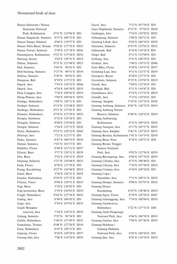
2602
Threatened birds of Asia
Danau Sentarum / Danau
Sentarum National
Park, Kalimantan 0°51’N 112°06’E ID1
Danau Singakrak, Sumatra 0°37’S 100°33’E ID1
Danau Tempe, Sulawesi 4°06’S 119°57’E ID1
Danau Tolire Besar, Ternate 0°50’N 127°18’E ID52
Danau Towuti, Sulawesi 2°50’S 121°34’E ID26
Danumparoy, Kalimantan 0°21’N 115°24’E ID56
Dawang, Seram 3°42’S 130°31’E ID19
Dehua, Sulawesi 0°31’N 121°40’E ID23
Deli, Sumatra 3°45’N 98°41’E ID1
Deli-Serdang, Sumatra 3°27’N 98°51’E ID19
Delitua, Sumatra 3°30’N 98°41’E ID1
Denpasar, Bali 8°39’S 115°13’E ID1
Depok, Java 7°43’S 110°22’E ID46
Depok, Java 6°24’S 106°50’E ID35
Desa Langgen, Java 7°36’S 108°42’E ID19
Dieng Plateau, Java 7°09’S 109°46’E ID19
Dodaga, Halmahera 1°09’N 128°11’E ID1
Dodepo, Sulawesi 0°19’N 123°48’E ID23
Dodinga, Halmahera 0°51’N 127°41’E ID1
Domato, Halmahera 0°54’N 127°29’E ID52
Dompu, Sumbawa 8°32’S 118°28’E ID1
Dongala, Sulawesi 0°40’S 119°44’E ID1
Dongin, Sulawesi 1°34’S 122°15’E ID26
Dotte, Halmahera 0°23’N 128°22’E ID42
Driorejo, Java 7°21’S 112°37’E ID1
Duku, Sumatra 0°47’S 100°19’E ID34
Dumai, Sumatra 1°41’N 101°27’E ID1
Ebulobo, Flores 8°48’S 121°11’E ID57
Efrarat, Buru 3°37’S 126°31’E ID39
Ehu, Buru 3°42’S 126°31’E ID19
Empung, Sulawesi 1°27’N 124°48’E ID23
Ende, Flores 8°50’S 121°39’E ID1
Esang, Karakelang 4°27’N 126°44’E ID19
Fakal, Buru 3°38’S 126°31’E ID19
Fanaha, Halmahera 0°29’N 127°35’E ID1
Filaran, Timor 9°04’S 124°51’E ID19
Fogi, Buru 3°20’S 126°02’E ID1
Fogi mountains, Buru 3°19’S 126°03’E ID19
Fongli, Halmahera 0°42’N 127°54’E ID52
Gadog, Java 6°40’S 106°43’E ID1
Gaga, Java 5°59’S 107°01’E ID35
Gajah Mungkur
reservoir, Java 7°54’S 110°53’E ID19
Galang, Sumatra 3°25’N 98°54’E ID1
Galela, Halmahera 1°49’N 127°49’E ID52
Gamalama, Ternate 0°48’N 127°20’E ID19
Gani, Halmahera 0°47’S 128°13’E ID1
Gapong, Flores 8°28’S 120°29’E ID57
Garang lake, Java 7°00’S 110°20’E ID29
Garut, Java 7°13’S 107°54’E ID1
Gayo Highlands, Sumatra 4°15’N 97°05’E ID34
Gedangan, Java 7°16’S 110°28’E ID25
Gelumpang, Sumatra 1°08’S 102°12’E ID3
Genteng Lebak, Java 6°02’S 106°10’E ID19
Gentuma, Sulawesi 0°55’N 123°02’E ID23
Gilimanuk, Bali 8°10’S 114°26’E ID1
Gitgit, Bali 8°11’S 115°08’E ID1
Gobang, Java 6°31’S 106°39’E ID1
Godean, Java 7°46’S 110°15’E ID46
Golo Bilas, Flores 8°30’S 119°57’E ID37
Gondang Legi, Java 8°11’S 112°37’E ID19
Gorogoro, Bacan 0°24’S 127°37’E ID1
Gorontalo, Sulawesi 0°33’N 123°03’E ID19
Gresik, Java 7°09’S 112°38’E ID1
Grokgak, Bali 8°11’S 114°47’E ID1
Gumukmas, Java 8°19’S 113°23’E ID19
Gundih, Java 7°12’S 110°54’E ID1
Gunung, Sangihe 3°35’N 125°32’E ID58
Gunung Ambang, Sulawesi 0°45’N 124°25’E ID19
Gunung Ambang Nature
Reserve, Sulawesi 0°48’N 124°23’E ID19
Gunung Ambawang,
Kalimantan 0°23’S 109°18’E ID19
Gunung Aseupan, Java 6°17’S 105°57’E ID19
Gunung Awu, Sangihe 3°41’N 125°26’E ID53
Gunung Beratus, Kalimantan 1°01’S 116°19’E ID19
Gunung Besar, Pura 8°18’S 124°21’E ID4
Gunung Bromo Tengger
Semeru National
Park, Java 8°02’S 112°56’E ID19
Gunung Burangrang, Java 6°46’S 107°34’E ID19
Gunung Cibodas, Java 6°33’S 106°40’E ID1
Gunung Cikuray, Java 7°19’S 107°50’E ID19
Gunung Ciremay, Java 6°54’S 108°24’E ID1
Gunung Cupu /
Simembut, Java 7°11’S 109°31’E ID19
Gunung Dempo, Sumatra 4°00’S 103°07’E ID19
Gunung Duata,
Karakelang 4°23’N 126°48’E ID19
Gunung Egon, Flores 8°39’S 122°26’E ID47
Gunung Galunggung, Java 7°14’S 108°04’E ID19
Gunung Gamkonora,
Halmahera 1°22’N 127°31’E ID4
Gunung Gede-Pangrango
National Park, Java 6°46’S 106°58’E ID19
Gunung Guntur, Java 7°08’S 107°49’E ID19
Gunung Halimun /
Gunung Halimun
National Park, Java 6°42’S 106°26’E ID1
Gunung Ijen, Java 8°01’S 114°10’E ID19
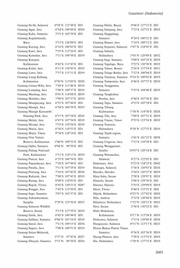
2603
Gazetteer
Gunung Ile-Ile, Sulawesi 0°58’N 121°48’E ID1
Gunung Jagat, Java 6°54’S 108°09’E ID54
Gunung Kaba, Sumatra 3°31’S 102°38’E ID1
Gunung Kapalatmada,
Buru 3°15’S 126°09’E ID1
Gunung Karang, Java 6°16’S 106°03’E ID1
Gunung Kawi, Java 7°55’S 112°26’E ID1
Gunung Kemulan, Java 7°11’S 109°50’E ID19
Gunung Kenepai,
Kalimantan 0°42’S 111°43’E ID1
Gunung Kidul, Java 8°11’S 110°45’E ID19
Gunung Lawu, Java 7°37’S 111°11’E ID19
Gunung Liang Kubung,
Kalimantan 0°30’N 113°05’E ID28
Gunung Liman-Wilis, Java 7°49’S 111°46’E ID19
Gunung Lumping, Java 7°08’S 109°37’E ID19
Gunung Maelang, Java 8°01’S 114°08’E ID19
Gunung Malabar, Java 7°09’S 107°37’E ID19
Gunung Manglayang, Java 6°52’S 107°44’E ID1
Gunung Masigit, Java 6°54’S 106°39’E ID35
Gunung Masigit Kareumbi
Hunting Park, Java 6°57’S 107°54’E ID19
Gunung Melati, Java 6°47’S 107°34’E ID19
Gunung Merapi, Java 7°33’S 110°26’E ID19
Gunung Muria, Java 6°36’S 110°53’E ID1
Gunung Mutis, Timor 9°34’S 124°14’E ID1
Gunung Niut Nature
Reserve, Kalimantan 1°00’N 109°55’E ID1
Gunung Ophir, Sumatra 0°04’N 99°59’E ID1
Gunung Palung National
Park, Kalimantan 1°11’S 110°13’E ID19
Gunung Pancar, Java 6°35’S 106°54’E ID1
Gunung Papandayan, Java 7°20’S 107°44’E ID1
Gunung Patuha, Java 7°11’S 107°29’E ID19
Gunung Puntang, Java 7°16’S 107°42’E ID54
Gunung Rakutak, Java 7°08’S 107°45’E ID19
Gunung Raung, Java 8°08’S 114°03’E ID1
Gunung Repok, Flores 8°45’S 120°21’E ID47
Gunung Ringgit, Java 7°43’S 113°50’E ID1
Gunung Sago, Sumatra 3°07’S 101°57’E ID1
Gunung Sahendaruman,
Sangihe 3°29’N 125°30’E ID53
Gunung Sahuwai Wildlife
Reserve, Seram 3°13’S 127°59’E ID19
Gunung Salak, Java 6°42’S 106°44’E ID1
Gunung Salihan, Sumatra 0°06’N 101°16’E ID19
Gunung Sawal, Java 7°11’S 108°15’E ID54
Gunung Segara, Java 7°08’S 108°51’E ID19
Gunung Setan-Meluwak,
Sumatra 3°37’N 97°43’E ID27
Gunung Sibayak, Sumatra 3°15’N 98°30’E ID34
Gunung Sibela, Bacan 0°46’S 127°31’E ID1
Gunung Simpang, Java 7°33’S 107°52’E ID19
Gunung Singgalang,
Sumatra 0°24’S 100°21’E ID1
Gunung Slamet, Java 7°14’S 109°12’E ID1
Gunung Soputan, Sulawesi 1°07’N 124°45’E ID1
Gunung Subaim,
Halmahera 1°05’N 128°09’E ID52
Gunung Sugi, Sumatra 5°00’S 105°16’E ID19
Gunung Tagalago, Buru 3°22’S 126°30’E ID19
Gunung Tahun, Boano 2°56’S 127°54’E ID12
Gunung Talaga Bodas, Java 7°12’S 108°04’E ID19
Gunung Talamau, Sumatra 0°10’N 100°02’E ID19
Gunung Tampomas, Java 6°46’S 107°57’E ID19
Gunung Tanggamus,
Sumatra 5°25’S 104°40’E ID19
Gunung Tangkuban
Perahu, Java 6°44’S 107°36’E ID1
Gunung Tapa, Sumatra 4°23’S 105°34’E ID1
Gunung Tibang,
Kalimantan 1°30’N 114°30’E ID28
Gunung Tilu, Java 7°09’S 107°31’E ID19
Gunung Timau, Timor 9°35’S 123°54’E ID19
Gunung Tomoria,
Halmahera 0°58’N 127°33’E ID19
Gunung Tujuh region,
Sumatra 1°41’S 101°25’E ID38
Gunung Ungaran, Java 7°12’S 110°20’E ID1
Gunung Wanggameti,
Sumba 10°07’S 120°14’E ID1
Gunung Watumohai,
Sulawesi 4°27’S 122°02’E ID1
Halerman, Alor 8°23’S 124°23’E ID42
Haluapu, Sulawesi 1°36’S 120°03’E ID26
Haruku, Haruku 3°34’S 128°27’E ID19
Hatu Saka, Seram 2°58’S 129°07’E ID19
Hatuolo, Seram 3°06’S 129°36’E ID1
Hatuwe, Hatuwe 2°55’S 129°09’E ID19
Heret, Flores 8°44’S 122°25’E ID4
Hijrah, Halmahera 0°25’N 127°42’E ID42
Hila, Ambon 3°35’S 128°04’E ID19
Hilaitetor, Halmahera 1°23’N 128°12’E ID52
Hoti, Seram 2°58’S 130°22’E ID1
Hulu Mahakam,
Kalimantan 0°17’N 115°24’E ID19
Hulurawa, Sulawesi 1°13’S 120°06’E ID26
Hungayono, Sulawesi 0°31’N 123°17’E ID23
Hutan Bakau Pantai Timur,
Sumatra 0°56’S 103°36’E ID19
Hyang Plateau, Java 7°58’S 113°35’E ID19
Ibu, Halmahera 1°29’N 127°32’E ID19
Gazetteer (Indonesia)
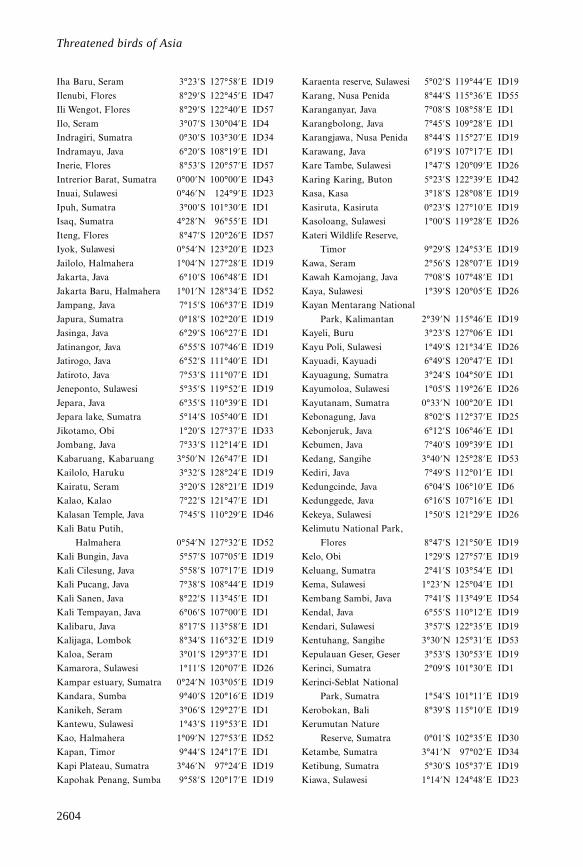
2604
Threatened birds of Asia
Iha Baru, Seram 3°23’S 127°58’E ID19
Ilenubi, Flores 8°29’S 122°45’E ID47
Ili Wengot, Flores 8°29’S 122°40’E ID57
Ilo, Seram 3°07’S 130°04’E ID4
Indragiri, Sumatra 0°30’S 103°30’E ID34
Indramayu, Java 6°20’S 108°19’E ID1
Inerie, Flores 8°53’S 120°57’E ID57
Intrerior Barat, Sumatra 0°00’N 100°00’E ID43
Inuai, Sulawesi 0°46’N 124°9’E ID23
Ipuh, Sumatra 3°00’S 101°30’E ID1
Isaq, Sumatra 4°28’N 96°55’E ID1
Iteng, Flores 8°47’S 120°26’E ID57
Iyok, Sulawesi 0°54’N 123°20’E ID23
Jailolo, Halmahera 1°04’N 127°28’E ID19
Jakarta, Java 6°10’S 106°48’E ID1
Jakarta Baru, Halmahera 1°01’N 128°34’E ID52
Jampang, Java 7°15’S 106°37’E ID19
Japura, Sumatra 0°18’S 102°20’E ID19
Jasinga, Java 6°29’S 106°27’E ID1
Jatinangor, Java 6°55’S 107°46’E ID19
Jatirogo, Java 6°52’S 111°40’E ID1
Jatiroto, Java 7°53’S 111°07’E ID1
Jeneponto, Sulawesi 5°35’S 119°52’E ID19
Jepara, Java 6°35’S 110°39’E ID1
Jepara lake, Sumatra 5°14’S 105°40’E ID1
Jikotamo, Obi 1°20’S 127°37’E ID33
Jombang, Java 7°33’S 112°14’E ID1
Kabaruang, Kabaruang 3°50’N 126°47’E ID1
Kailolo, Haruku 3°32’S 128°24’E ID19
Kairatu, Seram 3°20’S 128°21’E ID19
Kalao, Kalao 7°22’S 121°47’E ID1
Kalasan Temple, Java 7°45’S 110°29’E ID46
Kali Batu Putih,
Halmahera 0°54’N 127°32’E ID52
Kali Bungin, Java 5°57’S 107°05’E ID19
Kali Cilesung, Java 5°58’S 107°17’E ID19
Kali Pucang, Java 7°38’S 108°44’E ID19
Kali Sanen, Java 8°22’S 113°45’E ID1
Kali Tempayan, Java 6°06’S 107°00’E ID1
Kalibaru, Java 8°17’S 113°58’E ID1
Kalijaga, Lombok 8°34’S 116°32’E ID19
Kaloa, Seram 3°01’S 129°37’E ID1
Kamarora, Sulawesi 1°11’S 120°07’E ID26
Kampar estuary, Sumatra 0°24’N 103°05’E ID19
Kandara, Sumba 9°40’S 120°16’E ID19
Kanikeh, Seram 3°06’S 129°27’E ID1
Kantewu, Sulawesi 1°43’S 119°53’E ID1
Kao, Halmahera 1°09’N 127°53’E ID52
Kapan, Timor 9°44’S 124°17’E ID1
Kapi Plateau, Sumatra 3°46’N 97°24’E ID19
Kapohak Penang, Sumba 9°58’S 120°17’E ID19
Karaenta reserve, Sulawesi 5°02’S 119°44’E ID19
Karang, Nusa Penida 8°44’S 115°36’E ID55
Karanganyar, Java 7°08’S 108°58’E ID1
Karangbolong, Java 7°45’S 109°28’E ID1
Karangjawa, Nusa Penida 8°44’S 115°27’E ID19
Karawang, Java 6°19’S 107°17’E ID1
Kare Tambe, Sulawesi 1°47’S 120°09’E ID26
Karing Karing, Buton 5°23’S 122°39’E ID42
Kasa, Kasa 3°18’S 128°08’E ID19
Kasiruta, Kasiruta 0°23’S 127°10’E ID19
Kasoloang, Sulawesi 1°00’S 119°28’E ID26
Kateri Wildlife Reserve,
Timor 9°29’S 124°53’E ID19
Kawa, Seram 2°56’S 128°07’E ID19
Kawah Kamojang, Java 7°08’S 107°48’E ID1
Kaya, Sulawesi 1°39’S 120°05’E ID26
Kayan Mentarang National
Park, Kalimantan 2°39’N 115°46’E ID19
Kayeli, Buru 3°23’S 127°06’E ID1
Kayu Poli, Sulawesi 1°49’S 121°34’E ID26
Kayuadi, Kayuadi 6°49’S 120°47’E ID1
Kayuagung, Sumatra 3°24’S 104°50’E ID1
Kayumoloa, Sulawesi 1°05’S 119°26’E ID26
Kayutanam, Sumatra 0°33’N 100°20’E ID1
Kebonagung, Java 8°02’S 112°37’E ID25
Kebonjeruk, Java 6°12’S 106°46’E ID1
Kebumen, Java 7°40’S 109°39’E ID1
Kedang, Sangihe 3°40’N 125°28’E ID53
Kediri, Java 7°49’S 112°01’E ID1
Kedungcinde, Java 6°04’S 106°10’E ID6
Kedunggede, Java 6°16’S 107°16’E ID1
Kekeya, Sulawesi 1°50’S 121°29’E ID26
Kelimutu National Park,
Flores 8°47’S 121°50’E ID19
Kelo, Obi 1°29’S 127°57’E ID19
Keluang, Sumatra 2°41’S 103°54’E ID1
Kema, Sulawesi 1°23’N 125°04’E ID1
Kembang Sambi, Java 7°41’S 113°49’E ID54
Kendal, Java 6°55’S 110°12’E ID19
Kendari, Sulawesi 3°57’S 122°35’E ID19
Kentuhang, Sangihe 3°30’N 125°31’E ID53
Kepulauan Geser, Geser 3°53’S 130°53’E ID19
Kerinci, Sumatra 2°09’S 101°30’E ID1
Kerinci-Seblat National
Park, Sumatra 1°54’S 101°11’E ID19
Kerobokan, Bali 8°39’S 115°10’E ID19
Kerumutan Nature
Reserve, Sumatra 0°01’S 102°35’E ID30
Ketambe, Sumatra 3°41’N 97°02’E ID34
Ketibung, Sumatra 5°30’S 105°37’E ID19
Kiawa, Sulawesi 1°14’N 124°48’E ID23
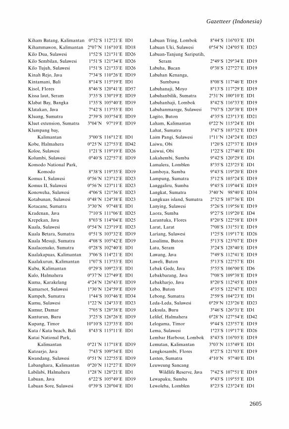
2605
Gazetteer
Kiham Batang, Kalimantan 0°52’S 112°21’E ID1
Kihammawon, Kalimantan 2°07’N 116°10’E ID18
Kilo Dua, Sulawesi 1°52’S 121°31’E ID26
Kilo Sembilan, Sulawesi 1°51’S 121°34’E ID26
Kilo Tujuh, Sulawesi 1°51’S 121°33’E ID26
Kinah Rejo, Java 7°34’S 110°26’E ID19
Kintamani, Bali 8°14’S 115°19’E ID1
Kisol, Flores 8°46’S 120°41’E ID57
Kissa laut, Seram 3°35’S 130°19’E ID19
Klabat Bay, Bangka 1°35’S 105°40’E ID19
Klatakan, Java 7°42’S 113°55’E ID1
Kluang, Sumatra 2°39’S 103°54’E ID19
Kluet extension, Sumatra 3°04’N 97°19’E ID19
Klumpang bay,
Kalimantan 3°00’S 116°12’E ID1
Kobe, Halmahera 0°25’N 127°53’E ID42
Koloe, Sulawesi 1°21’S 119°19’E ID26
Kolumbi, Sulawesi 0°40’S 122°57’E ID19
Komodo National Park,
Komodo 8°38’S 119°35’E ID19
Komus I, Sulawesi 0°56’N 123°12’E ID23
Komus II, Sulawesi 0°56’N 123°11’E ID23
Konoweha, Sulawesi 4°06’S 121°36’E ID23
Kotabunan, Sulawesi 0°48’N 124°38’E ID23
Kotacane, Sumatra 3°30’N 97°48’E ID1
Kradenan, Java 7°10’S 111°06’E ID25
Krepekan, Java 8°03’S 114°04’E ID25
Kuala, Sulawesi 0°54’N 123°19’E ID23
Kuala Betara, Sumatra 0°51’S 103°32’E ID19
Kuala Mesuji, Sumatra 4°08’S 105°42’E ID19
Kualacenako, Sumatra 0°28’S 102°40’E ID1
Kualakapuas, Kalimantan 3°06’S 114°21’E ID1
Kualakurun, Kalimantan 1°07’S 113°53’E ID1
Kubu, Kalimantan 0°29’S 109°23’E ID1
Kulo, Halmahera 0°37’N 127°49’E ID1
Kuma, Karakelang 4°24’N 126°43’E ID19
Kumarsot, Sulawesi 1°30’N 124°59’E ID19
Kumpeh, Sumatra 1°44’S 103°46’E ID34
Kumu, Sulawesi 1°22’N 124°33’E ID23
Kumur, Damar 7°05’S 128°38’E ID19
Kunturun, Buru 3°25’S 126°26’E ID19
Kupang, Timor 10°10’S 123°35’E ID1
Kuta / Kuta beach, Bali 8°43’S 115°11’E ID1
Kutai National Park,
Kalimantan 0°21’N 117°18’E ID19
Kutoarjo, Java 7°43’S 109°54’E ID1
Kwandang, Sulawesi 0°51’N 122°55’E ID19
Labanghara, Kalimantan 0°20’N 112°27’E ID19
Labilabi, Halmahera 1°28’N 128°21’E ID1
Labuan, Java 6°22’S 105°49’E ID19
Labuan Sore, Sulawesi 0°39’S 120°04’E ID1
Labuan Tring, Lombok 8°44’S 116°03’E ID1
Labuan Uki, Sulawesi 0°54’N 124°05’E ID23
Labuan-Tanjung Sariputih,
Seram 2°49’S 129°34’E ID19
Labuha, Bacan 0°38’S 127°27’E ID19
Labuhan Kenanga,
Sumbawa 8°08’S 117°46’E ID19
Labuhanaji, Moyo 8°13’S 117°29’E ID19
Labuhanbilik, Sumatra 2°31’N 100°10’E ID1
Labuhanhaji, Lombok 8°42’S 116°33’E ID19
Labuhanmarege, Sulawesi 7°07’S 120°38’E ID19
Lagito, Buton 4°35’S 123°13’E ID21
Laham, Kalimantan 0°22’N 115°24’E ID1
Lahat, Sumatra 3°47’S 103°32’E ID19
Laim Pangi, Sulawesi 1°11’N 124°24’E ID23
Laiwu, Obi 1°20’S 127°37’E ID19
Laiwui, Obi 1°22’S 127°40’E ID1
Lakahembi, Sumba 9°42’S 120°29’E ID1
Lamalera, Lomblen 8°35’S 123°25’E ID1
Lamboya, Sumba 9°43’S 119°20’E ID19
Lampung, Sumatra 5°12’S 105°24’E ID19
Langgaliru, Sumba 9°45’S 119°44’E ID19
Langkat, Sumatra 3°40’N 98°40’E ID34
Langkuas island, Sumatra 2°32’S 107°36’E ID1
Lanying, Sulawesi 5°26’S 119°56’E ID19
Laora, Sumba 9°27’S 119°20’E ID4
Larantuka, Flores 8°20’S 122°58’E ID19
Larat, Larat 7°08’S 131°51’E ID19
Lariang, Sulawesi 1°25’S 119°17’E ID26
Lasalimu, Buton 5°13’S 123°07’E ID19
Latu, Seram 3°24’S 128°40’E ID19
Lawang, Java 7°49’S 112°41’E ID19
Laweli, Buton 5°13’S 122°57’E ID1
Lebak Gede, Java 5°55’S 106°00’E ID6
Lebakbarang, Java 7°08’S 109°38’E ID19
Lebakharjo, Java 8°20’S 112°45’E ID19
Lebo, Buton 4°35’S 122°47’E ID21
Lebong, Sumatra 2°59’S 104°23’E ID1
Leda-Leda, Sulawesi 0°29’N 123°26’E ID23
Leksula, Buru 3°46’S 126°31’E ID1
Lelilef, Halmahera 0°28’N 127°54’E ID42
Lelogama, Timor 9°44’S 123°57’E ID19
Lema, Sulawesi 1°23’S 119°17’E ID26
Lembar Harbour, Lombok 8°43’S 116°05’E ID19
Lemutan, Kalimantan 3°03’N 115°49’E ID1
Lengkosambi, Flores 8°27’S 121°03’E ID19
Lesten, Sumatra 4°10’N 97°40’E ID1
Leuweung Sancang
Wildlife Reserve, Java 7°42’S 107°51’E ID19
Lewapaku, Sumba 9°43’S 119°55’E ID1
Lewoleba, Lomblen 8°23’S 123°24’E ID1
Gazetteer (Indonesia)
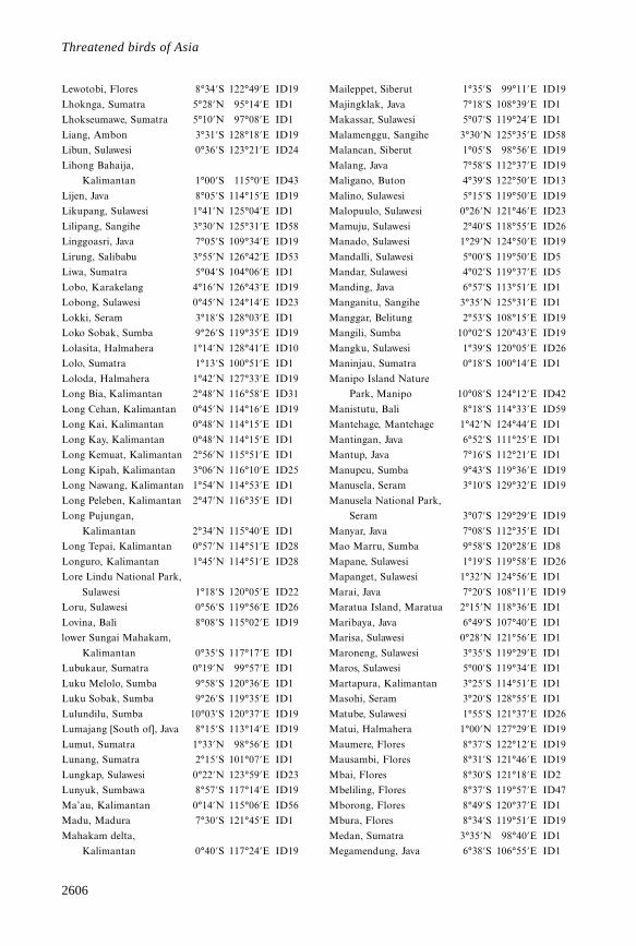
2606
Threatened birds of Asia
Lewotobi, Flores 8°34’S 122°49’E ID19
Lhoknga, Sumatra 5°28’N 95°14’E ID1
Lhokseumawe, Sumatra 5°10’N 97°08’E ID1
Liang, Ambon 3°31’S 128°18’E ID19
Libun, Sulawesi 0°36’S 123°21’E ID24
Lihong Bahaija,
Kalimantan 1°00’S 115°0’E ID43
Lijen, Java 8°05’S 114°15’E ID19
Likupang, Sulawesi 1°41’N 125°04’E ID1
Lilipang, Sangihe 3°30’N 125°31’E ID58
Linggoasri, Java 7°05’S 109°34’E ID19
Lirung, Salibabu 3°55’N 126°42’E ID53
Liwa, Sumatra 5°04’S 104°06’E ID1
Lobo, Karakelang 4°16’N 126°43’E ID19
Lobong, Sulawesi 0°45’N 124°14’E ID23
Lokki, Seram 3°18’S 128°03’E ID1
Loko Sobak, Sumba 9°26’S 119°35’E ID19
Lolasita, Halmahera 1°14’N 128°41’E ID10
Lolo, Sumatra 1°13’S 100°51’E ID1
Loloda, Halmahera 1°42’N 127°33’E ID19
Long Bia, Kalimantan 2°48’N 116°58’E ID31
Long Cehan, Kalimantan 0°45’N 114°16’E ID19
Long Kai, Kalimantan 0°48’N 114°15’E ID1
Long Kay, Kalimantan 0°48’N 114°15’E ID1
Long Kemuat, Kalimantan 2°56’N 115°51’E ID1
Long Kipah, Kalimantan 3°06’N 116°10’E ID25
Long Nawang, Kalimantan 1°54’N 114°53’E ID1
Long Peleben, Kalimantan 2°47’N 116°35’E ID1
Long Pujungan,
Kalimantan 2°34’N 115°40’E ID1
Long Tepai, Kalimantan 0°57’N 114°51’E ID28
Longuro, Kalimantan 1°45’N 114°51’E ID28
Lore Lindu National Park,
Sulawesi 1°18’S 120°05’E ID22
Loru, Sulawesi 0°56’S 119°56’E ID26
Lovina, Bali 8°08’S 115°02’E ID19
lower Sungai Mahakam,
Kalimantan 0°35’S 117°17’E ID1
Lubukaur, Sumatra 0°19’N 99°57’E ID1
Luku Melolo, Sumba 9°58’S 120°36’E ID1
Luku Sobak, Sumba 9°26’S 119°35’E ID1
Lulundilu, Sumba 10°03’S 120°37’E ID19
Lumajang [South of], Java 8°15’S 113°14’E ID19
Lumut, Sumatra 1°33’N 98°56’E ID1
Lunang, Sumatra 2°15’S 101°07’E ID1
Lungkap, Sulawesi 0°22’N 123°59’E ID23
Lunyuk, Sumbawa 8°57’S 117°14’E ID19
Ma’au, Kalimantan 0°14’N 115°06’E ID56
Madu, Madura 7°30’S 121°45’E ID1
Mahakam delta,
Kalimantan 0°40’S 117°24’E ID19
Maileppet, Siberut 1°35’S 99°11’E ID19
Majingklak, Java 7°18’S 108°39’E ID1
Makassar, Sulawesi 5°07’S 119°24’E ID1
Malamenggu, Sangihe 3°30’N 125°35’E ID58
Malancan, Siberut 1°05’S 98°56’E ID19
Malang, Java 7°58’S 112°37’E ID19
Maligano, Buton 4°39’S 122°50’E ID13
Malino, Sulawesi 5°15’S 119°50’E ID19
Malopuulo, Sulawesi 0°26’N 121°46’E ID23
Mamuju, Sulawesi 2°40’S 118°55’E ID26
Manado, Sulawesi 1°29’N 124°50’E ID19
Mandalli, Sulawesi 5°00’S 119°50’E ID5
Mandar, Sulawesi 4°02’S 119°37’E ID5
Manding, Java 6°57’S 113°51’E ID1
Manganitu, Sangihe 3°35’N 125°31’E ID1
Manggar, Belitung 2°53’S 108°15’E ID19
Mangili, Sumba 10°02’S 120°43’E ID19
Mangku, Sulawesi 1°39’S 120°05’E ID26
Maninjau, Sumatra 0°18’S 100°14’E ID1
Manipo Island Nature
Park, Manipo 10°08’S 124°12’E ID42
Manistutu, Bali 8°18’S 114°33’E ID59
Mantehage, Mantehage 1°42’N 124°44’E ID1
Mantingan, Java 6°52’S 111°25’E ID1
Mantup, Java 7°16’S 112°21’E ID1
Manupeu, Sumba 9°43’S 119°36’E ID19
Manusela, Seram 3°10’S 129°32’E ID19
Manusela National Park,
Seram 3°07’S 129°29’E ID19
Manyar, Java 7°08’S 112°35’E ID1
Mao Marru, Sumba 9°58’S 120°28’E ID8
Mapane, Sulawesi 1°19’S 119°58’E ID26
Mapanget, Sulawesi 1°32’N 124°56’E ID1
Marai, Java 7°20’S 108°11’E ID19
Maratua Island, Maratua 2°15’N 118°36’E ID1
Maribaya, Java 6°49’S 107°40’E ID1
Marisa, Sulawesi 0°28’N 121°56’E ID1
Maroneng, Sulawesi 3°35’S 119°29’E ID1
Maros, Sulawesi 5°00’S 119°34’E ID1
Martapura, Kalimantan 3°25’S 114°51’E ID1
Masohi, Seram 3°20’S 128°55’E ID1
Matube, Sulawesi 1°55’S 121°37’E ID26
Matui, Halmahera 1°00’N 127°29’E ID19
Maumere, Flores 8°37’S 122°12’E ID19
Mausambi, Flores 8°31’S 121°46’E ID19
Mbai, Flores 8°30’S 121°18’E ID2
Mbeliling, Flores 8°37’S 119°57’E ID47
Mborong, Flores 8°49’S 120°37’E ID1
Mbura, Flores 8°34’S 119°51’E ID19
Medan, Sumatra 3°35’N 98°40’E ID1
Megamendung, Java 6°38’S 106°55’E ID1
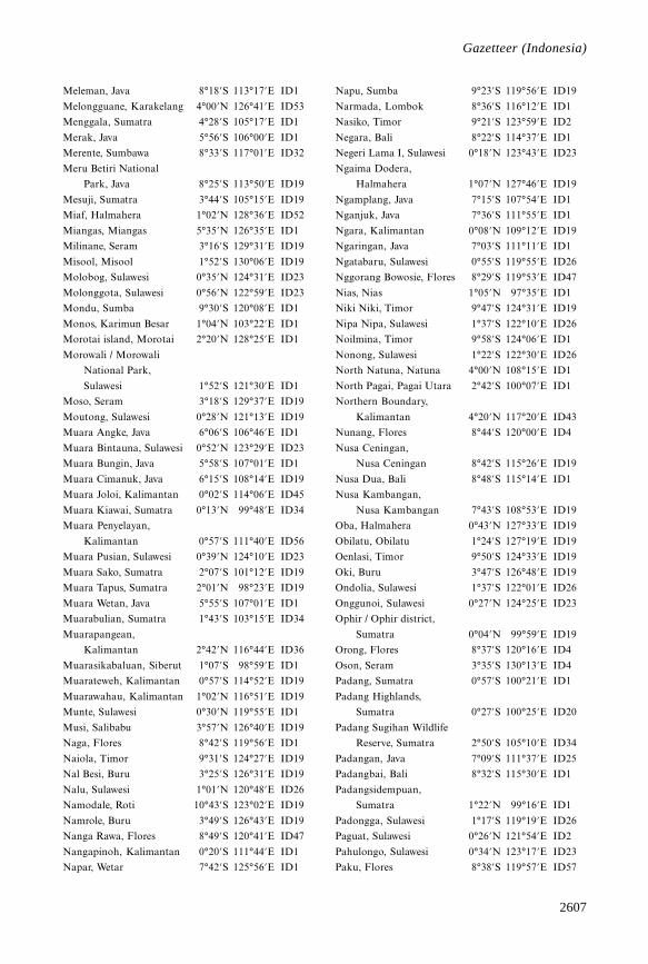
2607
Gazetteer
Meleman, Java 8°18’S 113°17’E ID1
Melongguane, Karakelang 4°00’N 126°41’E ID53
Menggala, Sumatra 4°28’S 105°17’E ID1
Merak, Java 5°56’S 106°00’E ID1
Merente, Sumbawa 8°33’S 117°01’E ID32
Meru Betiri National
Park, Java 8°25’S 113°50’E ID19
Mesuji, Sumatra 3°44’S 105°15’E ID19
Miaf, Halmahera 1°02’N 128°36’E ID52
Miangas, Miangas 5°35’N 126°35’E ID1
Milinane, Seram 3°16’S 129°31’E ID19
Misool, Misool 1°52’S 130°06’E ID19
Molobog, Sulawesi 0°35’N 124°31’E ID23
Molonggota, Sulawesi 0°56’N 122°59’E ID23
Mondu, Sumba 9°30’S 120°08’E ID1
Monos, Karimun Besar 1°04’N 103°22’E ID1
Morotai island, Morotai 2°20’N 128°25’E ID1
Morowali / Morowali
National Park,
Sulawesi 1°52’S 121°30’E ID1
Moso, Seram 3°18’S 129°37’E ID19
Moutong, Sulawesi 0°28’N 121°13’E ID19
Muara Angke, Java 6°06’S 106°46’E ID1
Muara Bintauna, Sulawesi 0°52’N 123°29’E ID23
Muara Bungin, Java 5°58’S 107°01’E ID1
Muara Cimanuk, Java 6°15’S 108°14’E ID19
Muara Joloi, Kalimantan 0°02’S 114°06’E ID45
Muara Kiawai, Sumatra 0°13’N 99°48’E ID34
Muara Penyelayan,
Kalimantan 0°57’S 111°40’E ID56
Muara Pusian, Sulawesi 0°39’N 124°10’E ID23
Muara Sako, Sumatra 2°07’S 101°12’E ID19
Muara Tapus, Sumatra 2°01’N 98°23’E ID19
Muara Wetan, Java 5°55’S 107°01’E ID1
Muarabulian, Sumatra 1°43’S 103°15’E ID34
Muarapangean,
Kalimantan 2°42’N 116°44’E ID36
Muarasikabaluan, Siberut 1°07’S 98°59’E ID1
Muarateweh, Kalimantan 0°57’S 114°52’E ID19
Muarawahau, Kalimantan 1°02’N 116°51’E ID19
Munte, Sulawesi 0°30’N 119°55’E ID1
Musi, Salibabu 3°57’N 126°40’E ID19
Naga, Flores 8°42’S 119°56’E ID1
Naiola, Timor 9°31’S 124°27’E ID19
Nal Besi, Buru 3°25’S 126°31’E ID19
Nalu, Sulawesi 1°01’N 120°48’E ID26
Namodale, Roti 10°43’S 123°02’E ID19
Namrole, Buru 3°49’S 126°43’E ID19
Nanga Rawa, Flores 8°49’S 120°41’E ID47
Nangapinoh, Kalimantan 0°20’S 111°44’E ID1
Napar, Wetar 7°42’S 125°56’E ID1
Napu, Sumba 9°23’S 119°56’E ID19
Narmada, Lombok 8°36’S 116°12’E ID1
Nasiko, Timor 9°21’S 123°59’E ID2
Negara, Bali 8°22’S 114°37’E ID1
Negeri Lama I, Sulawesi 0°18’N 123°43’E ID23
Ngaima Dodera,
Halmahera 1°07’N 127°46’E ID19
Ngamplang, Java 7°15’S 107°54’E ID1
Nganjuk, Java 7°36’S 111°55’E ID1
Ngara, Kalimantan 0°08’N 109°12’E ID19
Ngaringan, Java 7°03’S 111°11’E ID1
Ngatabaru, Sulawesi 0°55’S 119°55’E ID26
Nggorang Bowosie, Flores 8°29’S 119°53’E ID47
Nias, Nias 1°05’N 97°35’E ID1
Niki Niki, Timor 9°47’S 124°31’E ID19
Nipa Nipa, Sulawesi 1°37’S 122°10’E ID26
Noilmina, Timor 9°58’S 124°06’E ID1
Nonong, Sulawesi 1°22’S 122°30’E ID26
North Natuna, Natuna 4°00’N 108°15’E ID1
North Pagai, Pagai Utara 2°42’S 100°07’E ID1
Northern Boundary,
Kalimantan 4°20’N 117°20’E ID43
Nunang, Flores 8°44’S 120°00’E ID4
Nusa Ceningan,
Nusa Ceningan 8°42’S 115°26’E ID19
Nusa Dua, Bali 8°48’S 115°14’E ID1
Nusa Kambangan,
Nusa Kambangan 7°43’S 108°53’E ID19
Oba, Halmahera 0°43’N 127°33’E ID19
Obilatu, Obilatu 1°24’S 127°19’E ID19
Oenlasi, Timor 9°50’S 124°33’E ID19
Oki, Buru 3°47’S 126°48’E ID19
Ondolia, Sulawesi 1°37’S 122°01’E ID26
Onggunoi, Sulawesi 0°27’N 124°25’E ID23
Ophir / Ophir district,
Sumatra 0°04’N 99°59’E ID19
Orong, Flores 8°37’S 120°16’E ID4
Oson, Seram 3°35’S 130°13’E ID4
Padang, Sumatra 0°57’S 100°21’E ID1
Padang Highlands,
Sumatra 0°27’S 100°25’E ID20
Padang Sugihan Wildlife
Reserve, Sumatra 2°50’S 105°10’E ID34
Padangan, Java 7°09’S 111°37’E ID25
Padangbai, Bali 8°32’S 115°30’E ID1
Padangsidempuan,
Sumatra 1°22’N 99°16’E ID1
Padongga, Sulawesi 1°17’S 119°19’E ID26
Paguat, Sulawesi 0°26’N 121°54’E ID2
Pahulongo, Sulawesi 0°34’N 123°17’E ID23
Paku, Flores 8°38’S 119°57’E ID57
Gazetteer (Indonesia)
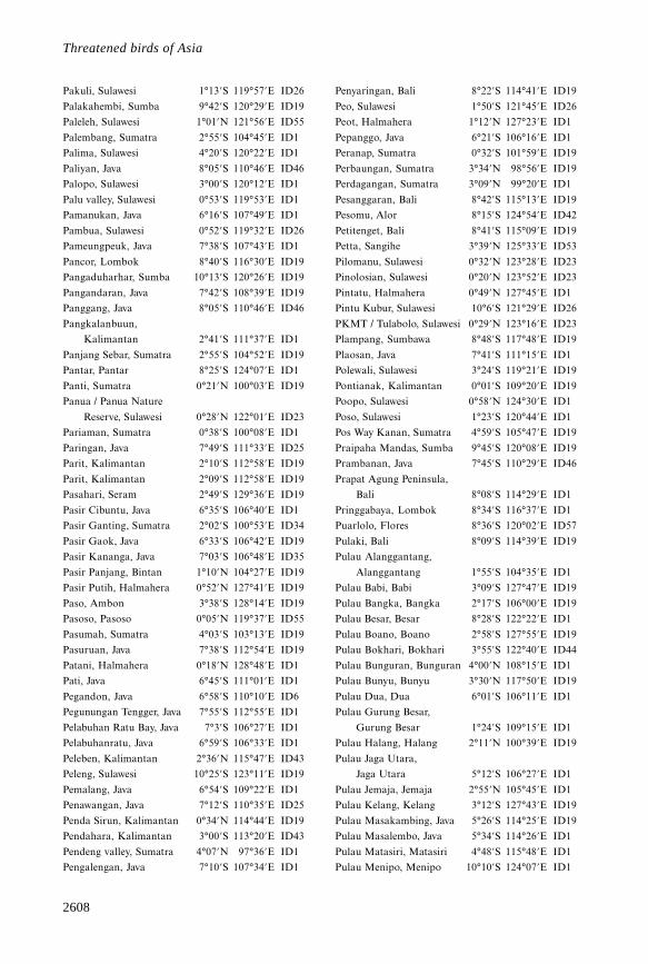
2608
Threatened birds of Asia
Pakuli, Sulawesi 1°13’S 119°57’E ID26
Palakahembi, Sumba 9°42’S 120°29’E ID19
Paleleh, Sulawesi 1°01’N 121°56’E ID55
Palembang, Sumatra 2°55’S 104°45’E ID1
Palima, Sulawesi 4°20’S 120°22’E ID1
Paliyan, Java 8°05’S 110°46’E ID46
Palopo, Sulawesi 3°00’S 120°12’E ID1
Palu valley, Sulawesi 0°53’S 119°53’E ID1
Pamanukan, Java 6°16’S 107°49’E ID1
Pambua, Sulawesi 0°52’S 119°32’E ID26
Pameungpeuk, Java 7°38’S 107°43’E ID1
Pancor, Lombok 8°40’S 116°30’E ID19
Pangaduharhar, Sumba 10°13’S 120°26’E ID19
Pangandaran, Java 7°42’S 108°39’E ID19
Panggang, Java 8°05’S 110°46’E ID46
Pangkalanbuun,
Kalimantan 2°41’S 111°37’E ID1
Panjang Sebar, Sumatra 2°55’S 104°52’E ID19
Pantar, Pantar 8°25’S 124°07’E ID1
Panti, Sumatra 0°21’N 100°03’E ID19
Panua / Panua Nature
Reserve, Sulawesi 0°28’N 122°01’E ID23
Pariaman, Sumatra 0°38’S 100°08’E ID1
Paringan, Java 7°49’S 111°33’E ID25
Parit, Kalimantan 2°10’S 112°58’E ID19
Parit, Kalimantan 2°09’S 112°58’E ID19
Pasahari, Seram 2°49’S 129°36’E ID19
Pasir Cibuntu, Java 6°35’S 106°40’E ID1
Pasir Ganting, Sumatra 2°02’S 100°53’E ID34
Pasir Gaok, Java 6°33’S 106°42’E ID19
Pasir Kananga, Java 7°03’S 106°48’E ID35
Pasir Panjang, Bintan 1°10’N 104°27’E ID19
Pasir Putih, Halmahera 0°52’N 127°41’E ID19
Paso, Ambon 3°38’S 128°14’E ID19
Pasoso, Pasoso 0°05’N 119°37’E ID55
Pasumah, Sumatra 4°03’S 103°13’E ID19
Pasuruan, Java 7°38’S 112°54’E ID19
Patani, Halmahera 0°18’N 128°48’E ID1
Pati, Java 6°45’S 111°01’E ID1
Pegandon, Java 6°58’S 110°10’E ID6
Pegunungan Tengger, Java 7°55’S 112°55’E ID1
Pelabuhan Ratu Bay, Java 7°3’S 106°27’E ID1
Pelabuhanratu, Java 6°59’S 106°33’E ID1
Peleben, Kalimantan 2°36’N 115°47’E ID43
Peleng, Sulawesi 10°25’S 123°11’E ID19
Pemalang, Java 6°54’S 109°22’E ID1
Penawangan, Java 7°12’S 110°35’E ID25
Penda Sirun, Kalimantan 0°34’N 114°44’E ID19
Pendahara, Kalimantan 3°00’S 113°20’E ID43
Pendeng valley, Sumatra 4°07’N 97°36’E ID1
Pengalengan, Java 7°10’S 107°34’E ID1
Penyaringan, Bali 8°22’S 114°41’E ID19
Peo, Sulawesi 1°50’S 121°45’E ID26
Peot, Halmahera 1°12’N 127°23’E ID1
Pepanggo, Java 6°21’S 106°16’E ID1
Peranap, Sumatra 0°32’S 101°59’E ID19
Perbaungan, Sumatra 3°34’N 98°56’E ID19
Perdagangan, Sumatra 3°09’N 99°20’E ID1
Pesanggaran, Bali 8°42’S 115°13’E ID19
Pesomu, Alor 8°15’S 124°54’E ID42
Petitenget, Bali 8°41’S 115°09’E ID19
Petta, Sangihe 3°39’N 125°33’E ID53
Pilomanu, Sulawesi 0°32’N 123°28’E ID23
Pinolosian, Sulawesi 0°20’N 123°52’E ID23
Pintatu, Halmahera 0°49’N 127°45’E ID1
Pintu Kubur, Sulawesi 10°6’S 121°29’E ID26
PKMT / Tulabolo, Sulawesi 0°29’N 123°16’E ID23
Plampang, Sumbawa 8°48’S 117°48’E ID19
Plaosan, Java 7°41’S 111°15’E ID1
Polewali, Sulawesi 3°24’S 119°21’E ID19
Pontianak, Kalimantan 0°01’S 109°20’E ID19
Poopo, Sulawesi 0°58’N 124°30’E ID1
Poso, Sulawesi 1°23’S 120°44’E ID1
Pos Way Kanan, Sumatra 4°59’S 105°47’E ID19
Praipaha Mandas, Sumba 9°45’S 120°08’E ID19
Prambanan, Java 7°45’S 110°29’E ID46
Prapat Agung Peninsula,
Bali 8°08’S 114°29’E ID1
Pringgabaya, Lombok 8°34’S 116°37’E ID1
Puarlolo, Flores 8°36’S 120°02’E ID57
Pulaki, Bali 8°09’S 114°39’E ID19
Pulau Alanggantang,
Alanggantang 1°55’S 104°35’E ID1
Pulau Babi, Babi 3°09’S 127°47’E ID19
Pulau Bangka, Bangka 2°17’S 106°00’E ID19
Pulau Besar, Besar 8°28’S 122°22’E ID1
Pulau Boano, Boano 2°58’S 127°55’E ID19
Pulau Bokhari, Bokhari 3°55’S 122°40’E ID44
Pulau Bunguran, Bunguran 4°00’N 108°15’E ID1
Pulau Bunyu, Bunyu 3°30’N 117°50’E ID19
Pulau Dua, Dua 6°01’S 106°11’E ID1
Pulau Gurung Besar,
Gurung Besar 1°24’S 109°15’E ID1
Pulau Halang, Halang 2°11’N 100°39’E ID19
Pulau Jaga Utara,
Jaga Utara 5°12’S 106°27’E ID1
Pulau Jemaja, Jemaja 2°55’N 105°45’E ID1
Pulau Kelang, Kelang 3°12’S 127°43’E ID19
Pulau Masakambing, Java 5°26’S 114°25’E ID19
Pulau Masalembo, Java 5°34’S 114°26’E ID1
Pulau Matasiri, Matasiri 4°48’S 115°48’E ID1
Pulau Menipo, Menipo 10°10’S 124°07’E ID1
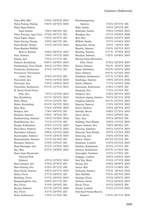
2609
Gazetteer
Pulau Miti, Miti 1°34’N 128°03’E ID19
Pulau Padang, Padang 1°08’N 102°20’E ID30
Pulau Pagai Selatan,
Pagai Selatan 3°00’S 100°20’E ID1
Pulau Panaitan, Jaga Utara 6°36’S 105°12’E ID1
Pulau Papan, Papan 1°42’N 101°07’E ID1
Pulau Payung, Payung 5°49’S 106°33’E ID1
Pulau Pombo, Pombo 3°32’S 128°22’E ID19
Pulau Rambut Wildlife
Reserve, Rambut 6°00’S 106°43’E ID19
Pulu, Sulawesi 1°09’S 119°52’E ID26
Pulung, Java 7°52’S 111°37’E ID1
Pulutan, Karakelang 4°09’N 126°48’E ID19
Pundukakaja, Nusa Penida 8°43’S 115°28’E ID19
Purukcahu, Kalimantan 0°35’S 114°35’E ID1
Purwakarta / Purwakarta
county, Java 6°34’S 107°26’E ID1
Purwodadi, Java 7°05’S 110°54’E ID19
Purworejo, Java 7°42’S 110°00’E ID19
Putussibau, Kalimantan 0°51’N 112°55’E ID19
R. Soerjo Grand Forest
Park, Java 7°47’S 112°34’E ID19
Rae, Karakelang 4°17’N 126°43’E ID19
Raha, Muna 4°51’S 122°43’E ID1
Rainis, Karakelang 4°14’N 126°52’E ID19
Raja, Raja 2°56’S 129°08’E ID19
Rampoa, Java 7°34’S 109°19’E ID1
Ramunia, Sumatra 3°38’N 98°54’E ID7
Randomoyang, Sulawesi 1°03’S 119°20’E ID26
Randublatung, Java 7°12’S 111°23’E ID1
Rangas, Kalimantan 2°30’S 115°15’E ID43
Rano Rano, Sulawesi 1°36’S 120°07’E ID19
Ranomeeto, Sulawesi 4°00’S 122°30’E ID44
Ranotongkor, Sulawesi 1°23’N 124°41’E ID19
Rantaupandan, Sumatra 2°13’S 101°34’E ID1
Rantepao, Sulawesi 2°59’S 119°54’E ID1
Ranu Darungan, Java 8°12’S 112°56’E ID25
Rau, Rau 2°21’N 128°09’E ID19
Rawa Aopa Watumohai
National Park,
Sulawesi 4°21’S 122°02’E ID19
Rawa Gempol, Java 5°58’S 107°05’E ID1
Rawa Kalong, Java 6°20’S 107°32’E ID6
Rawa Susuk, Sumatra 4°45’S 105°27’E ID19
Rekas, Flores 8°37’S 120°02’E ID1
Rembong, Flores 8°37’S 120°56’E ID19
Rengasdengklok, Java 6°09’S 107°17’E ID1
Reo, Flores 8°19’S 120°30’E ID1
Rerang, Sulawesi 0°17’N 119°52’E ID26
Ria, Flores 8°27’S 120°59’E ID1
Riam, Kalimantan 1°50’S 111°54’E ID1
Rimbopengadang,
Sumatra 3°18’S 102°25’E ID1
Roho, Seram 3°01’S 129°22’E ID1
Rokoraka, Sumba 9°26’S 119°04’E ID19
Rongkop, Java 8°11’S 110°42’E ID46
Roti, Roti 10°44’S 123°07’E ID19
RTK44, Sumba 9°37’S 119°44’E ID19
Rumasokat, Seram 2°58’S 129°8’E ID4
Rumbia, Sulawesi 1°01’N 124°53’E ID23
Runding, Sumatra 2°17’N 97°48’E ID19
Rurukan, Sulawesi 1°20’N 124°48’E ID19
Ruteng Nature Recreation
Park, Flores 8°36’S 120°28’E ID19
Saentis, Sumatra 3°43’N 98°47’E ID19
Sagea, Halmahera 0°29’N 128°05’E ID42
Saleo, Sulawesi 0°53’N 123°24’E ID23
Salimbatu, Kalimantan 2°57’N 117°20’E ID2
Salubanga, Sulawesi 1°09’S 120°24’E ID26
Saluki, Sulawesi 1°17’S 119°58’E ID26
Samarinda, Kalimantan 0°30’S 117°09’E ID1
Sampang, Java 7°12’S 113°14’E ID1
Sampora, Java 6°56’S 106°35’E ID19
Sandaran Agung, Sumatra 2°07’S 101°31’E ID38
Sangkup, Sulawesi 0°51’N 123°39’E ID23
Saparua, Saparua 3°33’S 128°39’E ID19
Sausu, Sulawesi 1°05’S 120°29’E ID55
Sawadai, Bacan 0°44’S 127°26’E ID19
Sawai, Seram 2°58’S 129°09’E ID1
Saya, Saya 0°47’S 104°58’E ID1
Sedihing, Nusa Penida 8°48’S 115°35’E ID55
Segara Anakan, Java 7°40’S 108°50’E ID1
Sejorong, Sumbawa 9°01’S 116°47’E ID19
Sekartaji, Nusa Penida 8°47’S 115°34’E ID19
Semarang, Java 6°58’S 110°25’E ID1
Semau, Semau 10°13’S 123°22’E ID1
Sembalun, Lombok 8°23’S 116°32’E ID19
Sembera, Kalimantan 0°16’S 117°25’E ID1
Semitau, Kalimantan 0°33’N 111°58’E ID1
Semongkat, Sumbawa 8°35’S 117°20’E ID1
Senggigi, Lombok 8°28’S 116°02’E ID19
Sera Nae, Moyo 8°16’S 117°32’E ID42
Serang, Java 6°06’S 106°08’E ID19
Seraya, Bali 8°25’S 115°40’E ID2
Serbajadi, Sumatra 3°22’N 98°56’E ID34
Sere, Salibabu 3°56’N 126°39’E ID19
Serempe, Flores 8°23’S 120°07’E ID57
Seriholu, Seram 3°21’S 128°40’E ID19
Sesok, Flores 8°47’S 120°02’E ID1
Sewela, Lombok 8°32’S 116°35’E ID19
Siak Kecil Nature Reserve,
Sumatra 1°10’N 101°35’E ID30
Gazetteer (Indonesia)
2610
Threatened birds of Asia
Siantan, Kalimantan 3°10’N 106°15’E ID1
Siau, Siau 2°44’N 125°23’E ID19
Sibado, Sulawesi 0°13’S 119°48’E ID55
Siberut, Siberut 1°20’S 98°55’E ID1
Sibolga, Sumatra 1°44’N 98°47’E ID34
Sidangoli, Halmahera 0°54’N 127°30’E ID1
Sidangoli (30 km north of),
Halmahera 1°10’N 127°34’E ID19
Sidoarjo, Java 7°27’S 112°43’E ID1
Sijunjung, Sumatra 0°42’S 100°58’E ID1
Sikabaluan, Siberut 1°07’S 98°58’E ID19
Silambea, Sulawesi 0°02’S 119°52’E ID26
Simpang, Sumatra 4°15’N 98°03’E ID1
Simpangtoba, Sumatra 2°45’N 99°35’E ID11
Sinahari, Seram 3°17’S 129°34’E ID48
Sindang, Sumatra 2°20’S 101°10’E ID19
Singkawang, Kalimantan 0°54’N 109°00’E ID1
Singkil, Java 8°03’S 110°32’E ID19
Sinondu, Sulawesi 0°30’N 123°28’E ID23
Sintang, Kalimantan 0°04’N 111°30’E ID1
Sipirok, Sumatra 1°36’N 99°15’E ID19
Siraro, Sulawesi 0°26’N 119°52’E ID26
Sita, Flores 8°29’S 120°14’E ID1
Situ Patenggang, Java 7°09’S 107°21’E ID19
Siulakderas, Sumatra 1°54’S 101°48’E ID34
Soa, Flores 8°38’S 121°03’E ID57
Soe, Timor 9°52’S 124°17’E ID1
Sokruntung, Flores 8°36’S 119°52’E ID19
Solea, Seram 2°53’S 129°33’E ID19
Solo, Java 7°35’S 110°50’E ID1
Solok, Sumatra 0°48’S 100°39’E ID1
Solor, Solor 8°27’S 123°05’E ID1
Solumena, Seram 3°06’S 129°31’E ID19
Sondo, Halmahera 0°52’N 127°40’E ID19
Sopan Unke, Kalimantan 0°58’S 111°40’E ID56
Sosowomo, Halmahera 0°14’N 127°55’E ID42
southern Barisan Range,
Sumatra 3°53’S 103°7’E ID19
Suaq Balimbiang, Sumatra 3°05’N 97°26’E ID30
Sukabumi, Java 6°55’S 106°56’E ID1
Sukamaju, Java 6°53’S 106°46’E ID19
Sukamandang,
Kalimantan 2°03’S 112°14’E ID1
Sukawati, Bali 8°35’S 115°16’E ID19
Sukowono, Java 8°03’S 113°50’E ID1
Sumalata, Sulawesi 0°59’N 122°30’E ID1
Sumbawa Besar, Sumbawa 8°30’S 117°26’E ID1
Sumenep, Madura 7°01’S 113°52’E ID1
Sungai Akar, Sumatra 0°38’S 102°43’E ID1
Sungai Alas, Sumatra 3°41’N 97°38’E ID19
Sungai Apa, Kalimantan 0°30’S 115°54’E ID56
Sungai Barito, Kalimantan 3°32’S 114°29’E ID1
Sungai Batang Hari,
Sumatra 1°16’S 104°05’E ID1
Sungai Benawang, Sumatra 1°57’S 104°27’E ID19
Sungai Bengen,
Kalimantan 0°35’N 116°02’E ID1
Sungai Berau, Kalimantan 2°10’N 117°42’E ID1
Sungai Berbak, Sumatra 1°04’S 104°12’E ID1
Sungai Besitang, Sumatra 4°06’N 98°10’E ID1
Sungai Birang,
Kalimantan 2°11’N 117°28’E ID1
Sungai Blu, Kalimantan 0°44’N 114°25’E ID1
Sungai Bodjo, Sulawesi 4°05’S 119°37’E ID5
Sungai Boh, Kalimantan 0°00’N 115°00’E ID1
Sungai Bosu, Sulawesi 2°21’S 121°51’E ID26
Sungai Bukit Batu,
Sumatra 1°27’N 102°00’E ID19
Sungai Bulu, Sumatra 0°23’N 100°21’E ID19
Sungai Bungin, Sumatra 2°15’S 104°48’E ID1
Sungai Busang,
Kalimantan 0°04’S 114°04’E ID19
Sungai Dodaga,
Halmahera 1°08’N 128°12’E ID52
Sungai Essang, Karakelang 4°28’N 126°44’E ID19
Sungai Ewang, Kalimantan 0°59’S 112°28’E ID18
Sungai Galian, Java 5°58’S 107°17’E ID1
Sungai Gelumpangkecil,
Sumatra 1°08’S 102°11’E ID50
Sungai Ifis, Halmahera 1°21’N 128°14’E ID52
Sungai Kahayan,
Kalimantan 3°20’S 114°04’E ID1
Sungai Kapuas,
Kalimantan 0°25’S 109°40’E ID1
Sungai Kapuas
(Anak Barito),
Kalimantan 3°1’S 114°20’E ID19
Sungai Karangan,
Kalimantan 1°06’N 117°54’E ID1
Sungai Karaopa, Sulawesi 2°09’S 121°44’E ID26
Sungai Kateman, Sumatra 0°14’N 103°37’E ID1
Sungai Kendawangan,
Kalimantan 2°31’S 110°12’E ID19
Sungai Kepahiang,
Sumatra 2°07’S 104°13’E ID1
Sungai Ketalo, Sumatra 1°59’S 102°59’E ID1
Sungai Ketibung, Sumatra 5°30’S 105°37’E ID34
Sungai Kubu, Kalimantan 0°35’S 109°20’E ID1
Sungai Landak,
Kalimantan 0°01’S 109°23’E ID1
Sungai Lendola, Alor 8°11’S 124°30’E ID42
Sungai Lobo, Karakelang 4°17’N 126°45’E ID53
2611
Gazetteer
Sungai Mahakam,
Kalimantan 0°35’S 117°17’E ID1
Sungai Marikoi,
Kalimantan 0°46’S 114°17’E ID56
Sungai Melawi,
Kalimantan 0°05’N 111°29’E ID1
Sungai Membuluh,
Kalimantan 2°32’S 110°17’E ID1
Sungai Menganne,
Kalimantan 0°29’N 117°34’E ID40
Sungai Merah, Kalimantan 0°50’N 116°49’E ID1
Sungai Metas, Sumatra 0°48’N 102°28’E ID1
Sungai Moesaj, Nias 1°26’N 97°18’E ID14
Sungai Mukamuka,
Sumatra 2°20’N 97°44’E ID19
Sungai Murung,
Kalimantan 0°11’S 114°08’E ID19
Sungai Musi, Sumatra 2°20’S 104°56’E ID1
Sungai Nipah, Kalimantan 2°31’S 110°12’E ID19
Sungai Oba, Halmahera 0°44’N 127°34’E ID52
Sungai Oketai, Halmahera 1°05’N 128°01’E ID52
Sungai Pampea, Sulawesi 4°33’S 122°00’E ID41
Sungai Pawan, Kalimantan 1°51’S 109°57’E ID1
Sungai Pegadungan,
Sumatra 4°47’S 105°40’E ID19
Sungai Penuh, Sumatra 2°05’S 101°23’E ID1
Sungai Ra, Bacan 0°39’S 127°31’E ID19
Sungai Rae, Karakelang 4°19’N 126°44’E ID19
Sungai Rawa, Sumatra 0°53’N 102°20’E ID1
Sungai Rokan, Sumatra 2°00’N 100°52’E ID1
Sungai Rungan,
Kalimantan 2°12’S 113°55’E ID1
Sungai Sampanahan,
Kalimantan 2°38’S 116°16’E ID1
Sungai Sebangau,
Kalimantan 2°23’S 113°51’E ID19
Sungai Segah, Kalimantan 2°10’N 117°30’E ID1
Sungai Sembilang,
Sumatra 2°00’S 104°42’E ID1
Sungai Sempang,
Kalimantan 1°07’S 109°57’E ID1
Sungai Seruyan,
Kalimantan 2°00’S 112°10’E ID19
Sungai Siak, Sumatra 1°13’N 102°09’E ID1
Sungai Siak Kecil, Sumatra 1°16’N 102°08’E ID1
Sungai Simpang Malaka,
Sumatra 1°23’S 104°20’E ID19
Sungai Simpangagas,
Sumatra 1°52’S 104°27’E ID19
Sungai Sosolat, Halmahera 1°06’N 128°41’E ID4
Sungai Tapus, Sumatra 2°10’N 98°11’E ID22
Sungai Taramana, Alor 8°13’S 124°51’E ID42
Sungai Telen, Kalimantan 0°26’N 116°42’E ID1
Sungai Tembesi, Sumatra 1°43’S 103°07’E ID30
Sungai Tolawi, Halmahera 0°57’N 127°56’E ID52
Sungai Wain, Kalimantan 0°46’S 117°02’E ID19
Sungai Wain Nature
Reserve, Kalimantan 0°26’S 116°38’E ID56
Sungai Wide Besar, Obi 1°34’S 127°53’E ID19
Sungaisilan, Sumatra 2°24’N 99°09’E ID19
Sungei Karang Mumus,
Kalimantan 0°31’S 117°09’E ID1
Surabaya, Java 7°15’S 112°45’E ID1
Surabaya Hilir, Sumatra 4°38’S 105°45’E ID19
Surau Gadang, Sumatra 0°54’S 101°28’E ID7
Surian, Sumatra 1°15’S 100°53’E ID1
Suwung, Bali 8°45’S 115°10’E ID19
Taba, Sulawesi 0°59’S 120°28’E ID26
Tabang, Kalimantan 0°34’N 116°02’E ID1
Tabukanlama, Sangihe 3°40’N 125°32’E ID53
Tabundung, Sumba 10°01’S 120°06’E ID1
Tagulandang, Tagulandang 2°21’N 125°25’E ID19
Tahuna, Sangihe 3°36’N 125°30’E ID53
Taimanu, Sumba 9°38’S 120°14’E ID15
Takala, Alor 8°09’S 124°56’E ID42
Talang Ampat, Sumatra 3°47’S 102°20’E ID38
Talangbetutu, Sumatra 2°53’S 104°41’E ID1
Talawid Atas, Sangihe 3°42’N 125°24’E ID53
Taliwang, Sumbawa 8°45’S 116°51’E ID1
Talu, Sumatra 0°14’N 99°59’E ID1
Tamako, Sangihe 3°27’N 125°30’E ID1
Tamansari, Java 8°12’S 114°17’E ID35
Tamarenja, Sulawesi 0°25’S 119°47’E ID26
Tambak Oibelo, Timor 10°06’S 123°43’E ID19
Tambayoli, Sulawesi 1°39’S 121°16’E ID26
Tambu, Sulawesi 1°02’S 120°31’E ID26
Tambun, Sulawesi 0°40’N 124°07’E ID23
Tamilau, Seram 3°22’S 129°11’E ID19
Tanahjampea,
Tanahjampea 7°05’S 120°42’E ID1
Tanahlot, Bali 8°36’S 115°04’E ID19
Tanangtalu, Sumatra 1°44’S 100°54’E ID7
Tangerang, Java 6°11’S 106°37’E ID1
Tanggarasi, Sulawesi 0°28’N 121°44’E ID23
Tanggari, Sulawesi 1°19’N 124°55’E ID19
Tangkoko-Dua Sudara
Nature Reserve,
Sulawesi 1°31’N 125°16’E ID22
Tanglad, Bali 8°46’S 115°34’E ID49
Tanjung, Java 7°22’S 108°10’E ID19
Tanjung Api, Sulawesi 0°54’S 121°35’E ID26
Tanjung Bakung, Sumatra 0°20’S 103°46’E ID7
Gazetteer (Indonesia)
2612
Threatened birds of Asia
Tanjung Balai, Sumatra 1°22’N 102°09’E ID1
Tanjung Bambalatung,
Sulawesi 1°18’N 121°06’E ID26
Tanjung Batikolo, Sulawesi 4°29’S 122°44’E ID23
Tanjung Bone, Sulawesi 1°19’N 120°49’E ID26
Tanjung Dako, Sulawesi 1°18’N 121°27’E ID26
Tanjung Dapuran, Sulawesi 1°45’S 119°20’E ID26
Tanjung Datuk, Sumatra 0°00’N 103°47’E ID19
Tanjung Doiyan, Sulawesi 1°04’N 120°47’E ID26
Tanjung Hunimua, Ambon 3°30’S 128°19’E ID19
Tanjung Jabung, Sumatra 1°01’S 104°22’E ID1
Tanjung Kerita Mese,
Flores 8°48’S 119°55’E ID19
Tanjung Koyan, Sumatra 2°56’S 106°00’E ID1
Tanjung Labuanunuk,
Sulawesi 1°18’N 121°03’E ID26
Tanjung Matop, Sulawesi 1°19’N 121°04’E ID26
Tanjung Panjang, Sulawesi 0°24’N 121°47’E ID23
Tanjung Parimpi, Sulawesi 0°10’S 119°43’E ID26
Tanjung Pasir, Moyo 8°10’S 117°41’E ID19
Tanjung Puting National
Park, Kalimantan 2°56’S 112°02’E ID19
Tanjung Sambang, Bintan 1°10’N 104°20’E ID19
Tanjung Sedari, Java 5°57’S 107°18’E ID1
Tanjung Selokan, Sumatra 2°24’S 105°38’E ID1
Tanjung Slamat, Sumatra 3°49’N 98°20’E ID34
Tanjung Tambue, Sulawesi 1°09’S 119°22’E ID26
Tanjung Tonjorak, Sumatra 1°58’S 104°50’E ID34
Tanjungbarus, Sumatra 3°10’N 98°34’E ID30
Tanjungberingin, Sumatra 3°29’N 99°12’E ID19
Tanjungkassau, Sumatra 2°55’N 99°15’E ID34
Tanjungselor, Kalimantan 2°51’N 117°22’E ID1
Tapanuli bay, Sumatra 1°38’N 98°45’E ID1
Tapokolintang, Sulawesi 0°35’N 124°04’E ID23
Tapos, Java 6°41’S 106°53’E ID19
Taripa, Sulawesi 1°37’S 119°49’E ID55
Tarohan, Karakelang 4°08’N 126°45’E ID19
Tasik Belat, Sumatra 0°39’N 102°40’E ID1
Tasoso, Sulawesi 5°18’S 119°41’E ID19
Taveki, Sulawesi 1°22’S 120°11’E ID26
Tawaya, Sulawesi 0°35’S 119°48’E ID19
Tawiri, Ambon 3°41’S 128°05’E ID19
Tegal, Java 6°52’S 109°08’E ID1
Tegallengah, Bali 8°12’S 114°53’E ID1
Teladas, Sumatra 4°22’S 105°50’E ID1
Telaga Meluwak, Sumatra 3°41’N 97°43’E ID27
Telaga Raja, Ambon 3°37’S 128°04’E ID19
Telaga Warna, Java 6°42’S 106°59’E ID1
Telang, Kalimantan 2°07’S 115°00’E ID1
Telepeh, Halmahera 0°56’N 127°29’E ID19
Telo, Sumatra 0°03’S 98°15’E ID1
Teluk Dalam, Simeulue 2°40’N 96°08’E ID1
Teluk Kapas, Sulawesi 1°17’N 120°49’E ID19
Teluk Kayeli, Buru 3°18’S 127°07’E ID1
Teluk Labuan Bajau,
Simeulue 2°23’N 96°28’E ID1
Telukbetung, Sumatra 5°27’S 105°16’E ID1
Telukpanji, Sumatra 2°02’N 100°14’E ID1
Tepus, Java 8°05’S 110°46’E ID46
Terbao, Sulawesi 1°01’S 119°28’E ID26
Terimbang, Sumba 9°57’S 119°57’E ID19
Ternate, Ternate 0°48’N 127°19’E ID19
Tewe, Halmahera 0°48’N 127°38’E ID19
Tidore, Tidore 0°40’N 127°24’E ID19
Tikke, Sulawesi 1°20’S 119°19’E ID26
Tilamuta, Sulawesi 0°30’N 122°20’E ID1
Tilope, Halmahera 0°14’N 127°55’E ID1
Tiwo / Remesun, Sulawesi 1°30’N 125°14’E ID23
Tiwu Bowu, Flores 8°31’S 121°02’E ID57
Toabatu, Karakelang 4°18’N 126°51’E ID19
Tobelo, Halmahera 1°44’N 128°01’E ID1
Tobu, Sulawesi 1°56’S 121°41’E ID26
Todowongi, Halmahera 1°04’N 127°28’E ID19
Togid, Sulawesi 0°44’N 124°36’E ID23
Tolewang, Halmahera 1°19’N 127°49’E ID1
Toli-toli, Sulawesi 1°02’N 120°49’E ID19
Tombatu, Sulawesi 1°13’N 124°47’E ID23
Tomia, Tomia 5°44’S 123°56’E ID19
Tomini, Sulawesi 0°33’N 120°53’E ID19
Tomohon, Sulawesi 1°19’N 124°49’E ID1
Topo, Sulawesi 1°31’S 122°20’E ID26
Torosik, Sulawesi 0°26’N 124°21’E ID23
Trinil, Java 7°21’S 111°20’E ID19
Tuban, Java 6°54’S 112°03’E ID1
Tubang, Taliabu 1°47’S 125°12’E ID19
Tuhemberua, Nias 1°30’N 97°25’E ID1
Tule, Karakelang 4°01’N 126°47’E ID19
Tulen Dusun II, Alor 8°24’S 124°25’E ID42
Tumbang Kunyi,
Kalimantan 0°35’S 114°11’E ID19
Tumbang Maruwei,
Kalimantan 0°45’S 114°52’E ID19
Tumbangmarikui,
Kalimantan 0°53’S 113°21’E ID1
Tumokang, Sulawesi 0°37’N 124°04’E ID23
Tuntung, Sulawesi 0°54’N 123°11’E ID23
Tuntungan, Sumatra 3°22’N 98°34’E ID19
Tuti Adagae Nature
Recreation Park, Alor 8°11’S 124°48’E ID42
Ubud, Bali 8°30’S 115°16’E ID1
Ujung Kulon National
Park, Java 6°45’S 105°20’E ID19
2613
Gazetteer
Ujung Pangkah, Java 6°51’S 112°33’E ID1
Ujung Tanjung, Sumatra 4°59’S 103°39’E ID1
Ujungtebu, Java 6°15’S 106°00’E ID1
Ulu Gadut, Sumatra 0°59’S 100°32’E ID19
Ulu Watu, Bali 8°49’S 115°05’E ID19
Ulung Peliang, Sangihe 3°29’N 125°31’E ID53
Upper Kapuas,
Kalimantan 0°55’N 112°57’E ID1
Upper Mamas Valley,
Sumatra 3°34’N 97°47’E ID34
upper Sungai Barito,
Kalimantan 0°35’S 114°35’E ID19
Uuwan, Sulawesi 0°39’N 124°05’E ID23
Wa Bobo, Buru 3°38’S 126°15’E ID19
Wa Fawel, Buru 3°04’S 126°24’E ID19
Wa Fehat, Buru 3°24’S 126°31’E ID19
Wa Mala, Buru 3°42’S 126°22’E ID19
Wa Msasi, Buru 3°33’S 126°10’E ID19
Wa Pati, Buru 3°03’S 126°40’E ID19
Wa Pude, Buru 3°04’S 126°28’E ID19
Wa Temun, Buru 3°23’S 126°31’E ID19
Wa Turen, Buru 3°39’S 126°17’E ID19
Wae Ansela, Seram 3°08’S 129°28’E ID19
Wae Atauhuhu, Seram 3°06’S 129°41’E ID4
Wae Bobok, Flores 8°29’S 120°01’E ID57
Wae Bolifar, Seram 3°10’S 130°35’E ID1
Wae Eno, Buru 3°31’S 126°29’E ID19
Wae Fufa, Seram 3°02’S 130°25’E ID1
Wae Isal, Seram 2°57’S 129°38’E ID19
Wae Kase, Buru 3°36’S 126°13’E ID9
Wae Sala, Seram 3°08’S 127°54’E ID19
Wae Sune, Seram 3°05’S 129°03’E ID52
Wae Tanabotik, Seram 3°38’S 130°32’E ID4
Waeplau, Buru 3°08’S 126°54’E ID37
Waflia, inland from, Buru 3°12’S 126°06’E ID1
Wahai, Seram 2°48’S 129°30’E ID1
Wahai-Saleman / Saha, Seram 2°53’S 129°18’E ID19
Waikelo, Sumba 9°23’S 119°13’E ID19
Wailulu, Seram 2°54’S 129°02’E ID4
Waimangura, Sumba 9°30’S 119°14’E ID1
Wainenda, Flores 8°25’S 120°38’E ID16
Waingapu, Sumba 9°39’S 120°15’E ID19
Waitina, Buru 3°50’S 126°41’E ID37
Wakat, Sulawesi 0°54’N 123°21’E ID23
Wakatin, Buru 3°36’S 126°29’E ID19
Waleh, Halmahera 0°25’N 128°11’E ID42
Walikukun, Java 7°25’S 111°14’E ID1
Wamlana, Buru 3°04’S 126°30’E ID19
Wamlana, inland from, Buru 3°09’S 126°31’E ID1
Wanci, Wangiwangi 5°18’S 123°31’E ID19
Wangaya Gede, Bali 8°22’S 115°07’E ID19
Wangga, Sumba 9°44’S 120°32’E ID19
Wangkung, Flores 8°31’S 119°55’E ID19
Wasa, Seram 2°52’S 129°25’E ID4
Waso, Flores 8°36’S 120°11’E ID4
Watubelan, Sumba 9°47’S 119°45’E ID19
Wawo, Sulawesi 3°41’S 121°02’E ID1
Way Kambas National
Park, Sumatra 4°55’S 105°44’E ID19
Way Lima, Sumatra 5°36’S 104°48’E ID3
Way Semangka, Sumatra 5°27’S 104°27’E ID19
Wayabula, Morotai 2°17’N 128°12’E ID1
Wayamega, Bacan 0°37’S 127°34’E ID19
Wayaua, Bacan 0°45’S 127°38’E ID19
Weda, Halmahera 0°21’N 127°52’E ID1
Wetar, Wetar 7°48’S 126°17’E ID19
Widi, Widi 0°34’S 128°23’E ID19
Wirosari, Java 7°05’S 111°05’E ID1
Woda, Halmahera 0°24’N 127°35’E ID1
Wolo Tado, Flores 8°28’S 121°02’E ID37
Wolulu, Sulawesi 4°35’S 121°25’E ID44
Wonosalem, Java 7°41’S 112°20’E ID19
Wonosobo, Sumatra 5°28’S 104°33’E ID19
Wulur, Damar 7°09’S 128°39’E ID1
Wundut, Sumba 9°39’S 119°51’E ID19
Yaba, Bacan 0°26’S 127°26’E ID19
Yamdena, Yamdena 7°36’S 131°23’E ID19
Yawila, Sumba 9°35’S 119°15’E ID1
Yeh Embang, Bali 8°24’S 114°45’E ID1
Yogyakarta, Java 7°46’S 110°21’E ID19
Yonelu, Halmahera 0°28’N 128°04’E ID42
Yumbu, Sumba 9°39’S 120°23’E ID19
JAPANIn the species accounts, data on Japan have been listed by island and prefecture or city (in the sequence given below,
together with the codes used to represent them in the locality list). The 47 prefectures and cities are divided between
the main islands of Hokkaido (a single prefecture), Honshu (34), Shikoku (four) and Kyushu (seven), with one prefecture
(and the southern part of another) in the Nansei Shoto islands. In the species accounts, the data for the Izu, Ogasawara,
Iwo (Volcano), Daito, Senkaku and Nansei Shoto (Ryukyu) island groups are subdivided by island. In the case of the
seabird, Japanese Murrelet Synthliboramphus wumizusume, records are listed by small island and for the coastal areas
of the large islands, rather than by prefecture. Terms used in locality names in Japan include: -cho = administrative
Gazetteer (Indonesia)
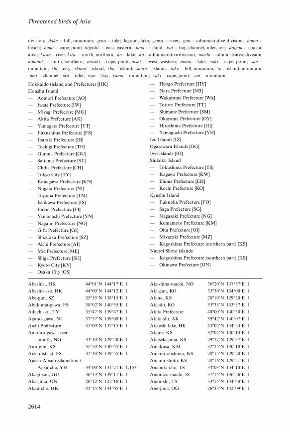
2614
Threatened birds of Asia
division; -dake = hill, mountain; -gata = inlet, lagoon, lake; -gawa = river; -gun = administrative division; -hama =
beach; -hana = cape, point; higashi- = east, eastern; -jima = island; -kai = bay, channel, inlet, sea; -kaigan = coastal
area; -kawa = river; kita- = north, northern; -ko = lake; -ku = administrative division; -machi = administrative division;
minami- = south, southern; -misaki = cape, point; nishi- = west, western; -numa = lake; -saki = cape, point; -san =
mountain; -shi = city; -shima = island; -sho = island; -shoto = islands; -take = hill, mountain; -to = island, mountain;
-umi = channel; -ura = inlet; -wan = bay; -yama = mountain; -zaki = cape, point; -zan = mountain.
Hokkaido (island and Prefecture) [HK]
Honshu Island
— Aomori Prefecture [AO]
— Iwate Prefecture [IW]
— Miyagi Prefecture [MG]
— Akita Prefecture [AK]
— Yamagata Prefecture [YT]
— Fukushima Prefecture [FS]
— Ibaraki Prefecture [IB]
— Tochigi Prefecture [TH]
— Gunma Prefecture [GU]
— Saitama Prefecture [ST]
— Chiba Prefecture [CH]
— Tokyo City [TY]
— Kanagawa Prefecture [KN]
— Niigata Prefecture [NI]
— Toyama Prefecture [TM]
— Ishikawa Prefecture [IS]
— Fukui Prefecture [FI]
— Yamanashi Prefecture [YN]
— Nagano Prefecture [NO]
— Gifu Prefecture [GI]
— Shizuoka Prefecture [SZ]
— Aichi Prefecture [AI]
— Mie Prefecture [ME]
— Shiga Prefecture [SH]
— Kyoto City [KY]
— Osaka City [OS]
— Hyogo Prefecture [HY]
— Nara Prefecture [NR]
— Wakayama Prefecture [WA]
— Tottori Prefecture [TT]
— Shimane Prefecture [SM]
— Okayama Prefecture [OY]
— Hiroshima Prefecture [HI]
— Yamaguchi Prefecture [YH]
Izu Islands [IZ]
Ogasawara Islands [OG]
Iwo Islands [IO]
Shikoku Island
— Tokushima Prefecture [TS]
— Kagawa Prefecture [KW]
— Ehime Prefecture [EH]
— Kochi Prefecture [KO]
Kyushu Island
— Fukuoka Prefecture [FO]
— Saga Prefecture [SG]
— Nagasaki Prefecture [NG]
— Kumamoto Prefecture [KM]
— Oita Prefecture [OI]
— Miyazaki Prefecture [MZ]
— Kagoshima Prefecture (northern part) [KS]
Nansei Shoto islands
— Kagoshima Prefecture (southern part) [KS]
— Okinawa Prefecture [ON]
Abashiri, HK 44°01’N 144°17’E 1
Abashiri-ko, HK 44°00’N 144°12’E 1
Abe-gun, SZ 35°15’N 138°15’E 1
Abukuma-gawa, FS 38°02’N 140°55’E 1
Adachi-ku, TY 35°47’N 139°47’E 1
Agano-gawa, NI 37°57’N 139°08’E 1
Aichi Prefecture 35°00’N 137°15’E 1
Ainoura-gawa river
mouth, NG 33°10’N 129°40’E 1
Aira-gun, KS 31°50’N 130°45’E 1
Aizu district, FS 37°30’N 139°55’E 1
Ajisu / Ajisu reclamation /
Ajisu-cho, YH 34°00’N 131°21’E 1,153
Akagi-san, GU 36°33’N 139°11’E 1
Aka-jima, ON 26°12’N 127°16’E 1
Akan-cho, HK 43°15’N 144°05’E 1
Akashina-machi, NO 36°20’N 137°57’E 1
Aki-gun, KO 33°30’N 134°00’E 1
Akina, KS 28°10’N 129°20’E 1
Aki-shi, KO 33°35’N 133°57’E 1
Akita Prefecture 40°00’N 140°30’E 1
Akita-shi, AK 39°42’N 140°07’E 1
Akkeshi lake, HK 43°02’N 144°54’E 1
Akune, KS 32°02’N 130°14’E 1
Akuseki-jima, KS 29°27’N 129°37’E 1
Amakusa, KM 32°25’N 130°10’E 1
Amami-ooshima, KS 28°15’N 129°20’E 1
Amami-shoto, KS 28°16’N 129°21’E 1
Anabuki-cho, TS 34°03’N 134°10’E 1
Anamizu-machi, IS 37°14’N 136°56’E 1
Anan-shi, TS 33°55’N 134°40’E 1
Ane-jima, OG 26°33’N 142°09’E 1
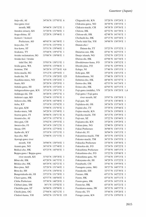
2615
Gazetteer
Anjo-shi, AI 34°56’N 137°05’E 6
Ano-gawa river
mouth, ME 34°44’N 136°32’E 1
Anraku estuary, KS 31°28’N 131°04’E 1
Aoga-shima, IZ 32°28’N 139°46’E 1
Aomori / Aomori
Prefecture, AO 40°45’N 141°00’E 1
Aoya-cho, TT 35°31’N 133°59’E 1
Ara-kawa, ST 35°51’N 139°44’E 1
Arakawa, TY 35°44’N 139°47’E 1
Ariake reclamation, SG 33°08’N 130°08’E 1
Ariake-kai / Ariake
tidal flat, SG 33°05’N 130°15’E 1
Arida-gawa, WA 34°05’N 135°06’E 1
Arimine, TM 36°28’N 137°26’E 4,6
Arita-machi, SG 33°12’N 129°54’E 1
Asahi-ike, NI 37°15’N 138°20’E 123
Asashina-mura, NO 36°16’N 138°24’E 1
Asato, KS 28°20’N 129°29’E 1
Ashida-gawa, HI 34°26’N 133°24’E 1
Ashigarashimo-gun, KN 35°18’N 139°17’E 1
Ashikaga-shi, TH 36°20’N 139°27’E 1
Ashizuri cape, KO 32°44’N 133°01’E 1
Ashoro-cho, HK 43°20’N 143°40’E 1
Ashu, KY 35°18’N 135°42’E 1
Aso-gun, KM 33°00’N 131°05’E 1
Asuka-mura, NR 34°28’N 135°49’E 1
Asuwa-gawa, FI 36°06’N 136°11’E 6
Atsumi-cho, AI 34°37’N 137°07’E 1
Awa-gun, CH 35°02’N 139°55’E 1
Awara-cho, FI 36°14’N 136°12’E 1
Awase, ON 26°19’N 127°50’E 1
Ayabe-shi, KY 35°18’N 135°15’E 1
Aya-cho, MZ 32°00’N 131°15’E 1
Ayaragi-gawa river
mouth, YH 34°00’N 130°54’E 1
Azumi-gun, NO 36°10’N 137°40’E 1
Bekkai-cho, HK 43°25’N 145°05’E 1
Beppu-gawa / Beppu-gawa
river mouth, KS 31°43’N 130°38’E 1
Bibai-shi, HK 43°20’N 141°53’E 1
Bifuka-cho, HK 44°29’N 142°21’E 1
Biro-jima, MZ 32°28’N 131°44’E 1
Biwa-ko, SH 35°15’N 136°05’E 1
Bungotakada-shi, OI 33°33’N 131°30’E 1
Charo-gawa, HK 42°57’N 144°04’E 1
Chiba Prefecture 35°30’N 140°20’E 1
Chiburi-jima, SM 36°1’N 133°02’E 1
Chichibu-gun, ST 36°00’N 139°00’E 1
Chichi-jima, OG 27°04’N 142°12’E 1
Chidori-hama, YH 34°02’N 131°01’E 153
Chigasaki-shi, KN 35°20’N 139°24’E 1
Chikuma-gawa, NO 36°59’N 138°35’E 1
Chikura-machi, CH 34°58’N 139°56’E 1
Chitose, HK 42°52’N 141°38’E 1
Chitose-shi, HK 42°48’N 141°41’E 1
Chobushi-ko, HK 43°15’N 145°34’E 1
Chofu tidal flat, YH 34°00’N 130°59’E 1
Daisen-cho /
Daisen-ike, TT 35°23’N 133°32’E 1
Daisetsu-zan, HK 43°41’N 142°53’E 1
Danjo islands, NG 32°02’N 128°23’E 1
Ebetsu-shi, HK 43°06’N 141°34’E 1
Eboshiiwano-hana, FO 33°58’N 130°52’E 1
Eboshi-jima, FO 33°41’N 129°59’E 1
Echigo, NI 37°40’N 139°15’E 1
Echi-gun, SH 35°10’N 136°15’E 1
Echizenhama, NI 37°48’N 138°51’E 1
Enbetsu-cho, HK 44°44’N 141°47’E 1
Eniwa-cho, HK 42°53’N 141°34’E 1
Erimo-cho, HK 42°05’N 143°15’E 1
Fuji-gawa (middle), YN 35°20’N 138°28’E 1,4
Fuji-gawa / Fuji-gawa
river mouth, SZ 35°07’N 138°38’E 1
Fuji-gun, SZ 35°18’N 138°40’E 1
Fujiidera-shi, OS 34°34’N 135°36’E 1
Fujimi-cho, TY 35°39’N 139°44’E 1
Fujino-machi, KN 35°36’N 139°08’E 1
Fujioka-machi, TH 36°15’N 139°39’E 1
Fuji-san, SZ 35°22’N 138°44’E 1
Fujisawa-shi, KN 35°20’N 139°29’E 1
Fukue-jima, NG 32°40’N 128°45’E 1
Fukui Prefecture 36°00’N 136°15’E 1
Fukui-shi, FI 36°04’N 136°13’E 1
Fukumitsu-machi, TM 36°33’N 136°52’E 1
Fukuno-machi, TM 36°35’N 136°55’E 1
Fukuoka Prefecture 33°30’N 130°30’E 1
Fukuoka-shi, FO 33°34’N 130°22’E 1
Fukushima Prefecture 37°30’N 140°15’E 1
Fukushima-cho, FO 33°22’N 129°48’E 1
Fukushima-gata, NI 37°54’N 139°15’E 1
Fukuyama-shi, HI 34°29’N 133°22’E 1
Funabashi, CH 35°41’N 139°59’E 1
Funagata-yama, MG 38°27’N 140°37’E 1
Funakoshi, EH 32°57’N 132°30’E 1
Furano, HK 43°15’N 142°22’E 1
Furen, HK 43°16’N 145°11’E 1
Furen-gawa, HK 43°19’N 145°15’E 6
Furen-ko, HK 43°18’N 145°21’E 1
Furukawa-numa, IW 38°35’N 140°57’E 1
Fussa-shi, TY 35°44’N 139°20’E 1
Futago-yama, KN 35°13’N 139°03’E 1
Gazetteer (Japan)
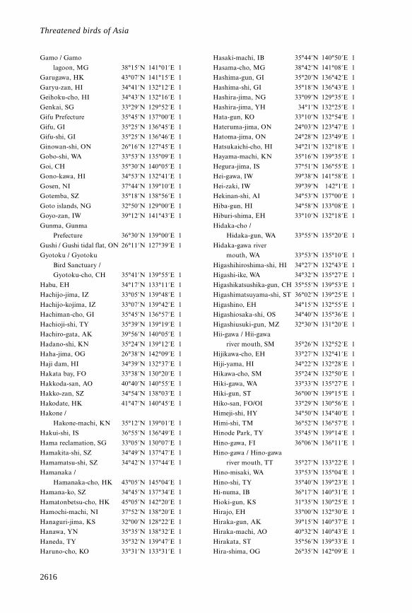
2616
Threatened birds of Asia
Gamo / Gamo
lagoon, MG 38°15’N 141°01’E 1
Garugawa, HK 43°07’N 141°15’E 1
Garyu-zan, HI 34°41’N 132°12’E 1
Geihoku-cho, HI 34°43’N 132°16’E 1
Genkai, SG 33°29’N 129°52’E 1
Gifu Prefecture 35°45’N 137°00’E 1
Gifu, GI 35°25’N 136°45’E 1
Gifu-shi, GI 35°25’N 136°46’E 1
Ginowan-shi, ON 26°16’N 127°45’E 1
Gobo-shi, WA 33°53’N 135°09’E 1
Goi, CH 35°30’N 140°05’E 1
Gono-kawa, HI 34°53’N 132°41’E 1
Gosen, NI 37°44’N 139°10’E 1
Gotemba, SZ 35°18’N 138°56’E 1
Goto islands, NG 32°50’N 129°00’E 1
Goyo-zan, IW 39°12’N 141°43’E 1
Gunma, Gunma
Prefecture 36°30’N 139°00’E 1
Gushi / Gushi tidal flat, ON 26°11’N 127°39’E 1
Gyotoku / Gyotoku
Bird Sanctuary /
Gyotoku-cho, CH 35°41’N 139°55’E 1
Habu, EH 34°17’N 133°11’E 1
Hachijo-jima, IZ 33°05’N 139°48’E 1
Hachijo-kojima, IZ 33°07’N 139°42’E 1
Hachiman-cho, GI 35°45’N 136°57’E 1
Hachioji-shi, TY 35°39’N 139°19’E 1
Hachiro-gata, AK 39°56’N 140°05’E 1
Hadano-shi, KN 35°24’N 139°12’E 1
Haha-jima, OG 26°38’N 142°09’E 1
Haji dam, HI 34°39’N 132°37’E 1
Hakata bay, FO 33°38’N 130°20’E 1
Hakkoda-san, AO 40°40’N 140°55’E 1
Hakko-zan, SZ 34°54’N 138°03’E 1
Hakodate, HK 41°47’N 140°45’E 1
Hakone /
Hakone-machi, KN 35°12’N 139°01’E 1
Hakui-shi, IS 36°55’N 136°49’E 1
Hama reclamation, SG 33°05’N 130°07’E 1
Hamakita-shi, SZ 34°49’N 137°47’E 1
Hamamatsu-shi, SZ 34°42’N 137°44’E 1
Hamanaka /
Hamanaka-cho, HK 43°05’N 145°04’E 1
Hamana-ko, SZ 34°45’N 137°34’E 1
Hamatonbetsu-cho, HK 45°05’N 142°20’E 1
Hamochi-machi, NI 37°52’N 138°20’E 1
Hanaguri-jima, KS 32°00’N 128°22’E 1
Hanawa, YN 35°35’N 138°32’E 1
Haneda, TY 35°32’N 139°47’E 1
Haruno-cho, KO 33°31’N 133°31’E 1
Hasaki-machi, IB 35°44’N 140°50’E 1
Hasama-cho, MG 38°42’N 141°08’E 1
Hashima-gun, GI 35°20’N 136°42’E 1
Hashima-shi, GI 35°18’N 136°43’E 1
Hashira-jima, NG 33°09’N 129°35’E 1
Hashira-jima, YH 34°1’N 132°25’E 1
Hata-gun, KO 33°10’N 132°54’E 1
Hateruma-jima, ON 24°03’N 123°47’E 1
Hatoma-jima, ON 24°28’N 123°49’E 1
Hatsukaichi-cho, HI 34°21’N 132°18’E 1
Hayama-machi, KN 35°16’N 139°35’E 1
Hegura-jima, IS 37°51’N 136°55’E 1
Hei-gawa, IW 39°38’N 141°58’E 1
Hei-zaki, IW 39°39’N 142°1’E 1
Hekinan-shi, AI 34°53’N 137°00’E 1
Hiba-gun, HI 34°58’N 133°08’E 1
Hiburi-shima, EH 33°10’N 132°18’E 1
Hidaka-cho /
Hidaka-gun, WA 33°55’N 135°20’E 1
Hidaka-gawa river
mouth, WA 33°53’N 135°10’E 1
Higashihiroshima-shi, HI 34°27’N 132°43’E 1
Higashi-ike, WA 34°32’N 135°27’E 1
Higashikatsushika-gun, CH 35°55’N 139°53’E 1
Higashimatsuyama-shi, ST 36°02’N 139°25’E 1
Higashino, EH 34°15’N 132°55’E 1
Higashiosaka-shi, OS 34°40’N 135°36’E 1
Higashiusuki-gun, MZ 32°30’N 131°20’E 1
Hii-gawa / Hii-gawa
river mouth, SM 35°26’N 132°52’E 1
Hijikawa-cho, EH 33°27’N 132°41’E 1
Hiji-yama, HI 34°22’N 132°28’E 1
Hikawa-cho, SM 35°24’N 132°50’E 1
Hiki-gawa, WA 33°33’N 135°27’E 1
Hiki-gun, ST 36°00’N 139°15’E 1
Hiko-san, FO/OI 33°29’N 130°56’E 1
Himeji-shi, HY 34°50’N 134°40’E 1
Himi-shi, TM 36°52’N 136°57’E 1
Hinode Park, TY 35°45’N 139°14’E 1
Hino-gawa, FI 36°06’N 136°11’E 1
Hino-gawa / Hino-gawa
river mouth, TT 35°27’N 133°22’E 1
Hino-misaki, WA 33°53’N 135°04’E 1
Hino-shi, TY 35°40’N 139°23’E 1
Hi-numa, IB 36°17’N 140°31’E 1
Hioki-gun, KS 31°35’N 130°25’E 1
Hirajo, EH 33°00’N 132°30’E 1
Hiraka-gun, AK 39°15’N 140°37’E 1
Hiraka-machi, AO 40°32’N 140°43’E 1
Hirakata, ST 35°56’N 139°33’E 1
Hira-shima, OG 26°35’N 142°09’E 1
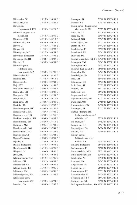
2617
Gazetteer
Hirata-cho, GI 35°15’N 136°38’E 1
Hirata-shi, SM 35°28’N 132°48’E 1
Hiratsuka /
Hiratsuka-shi, KN 35°20’N 139°20’E 1
Hironishi-oogawa river
mouth, HI 34°13’N 132°36’E 1
Hiroo-cho, HK 42°18’N 143°13’E 1
Hirosaki-shi, AO 40°36’N 140°28’E 1
Hirose, GI 35°36’N 136°24’E 1
Hirose, KS 31°55’N 130°29’E 1
Hirose-gawa, MG 38°12’N 140°54’E 1
Hiroshima Prefecture 34°30’N 133°00’E 1
Hiroshima-shi, HI 34°24’N 132°27’E 1
Hitachi, IB 36°35’N 140°39’E 1
Hitotsuse-gawa /
Hitotsuse-gawa
river mouth, MZ 32°03’N 131°31’E 1
Hiwasa-cho, TS 33°44’N 134°32’E 1
Hiyama, HK 41°50’N 140°10’E 1
Hizen-cho, SG 33°28’N 129°48’E 1
Hojo, EH 33°58’N 132°46’E 1
Hokkaido island, HK 44°00’N 143°00’E 1
Honai-cho, EH 33°30’N 132°25’E 1
Hongo-cho, HI 34°25’N 132°58’E 1
Honjo-shi, ST 36°14’N 139°11’E 1
Hori-kawa, SM 35°23’N 132°41’E 1
Horioka, TM 36°46’N 137°07’E 1
Horobetsu-gawa, HK 42°08’N 142°51’E 1
Horoka-yama, HK 43°27’N 143°08’E 1
Horonobe-cho, HK 45°00’N 141°55’E 1
Hoshinokami-jima, SM 36°09’N 133°05’E 1
Hosoiri-mura, TM 36°29’N 137°13’E 1
Hosojima, MZ 32°26’N 131°40’E 1
Hotaka-machi, NO 36°03’N 137°49’E 1
Hotoke-numa, AO 40°49’N 141°23’E 1
Hozumi-cho, GI 35°23’N 136°42’E 1
Hyogo Prefecture 35°00’N 135°00’E 1
Hyo-ko, NI 37°50’N 139°14’E 1
Ibaraki Prefecture 36°30’N 140°30’E 1
Ibaraki-machi, IB 36°15’N 140°26’E 1
Ibi-gawa, GI 35°03’N 136°42’E 1
Iburi, HK 42°35’N 140°45’E 1
Ichibusa-yama, KM 32°19’N 131°06’E 1
Ichihara, CH 35°31’N 140°05’E 1
Ichihara-shi, CH 35°25’N 140°07’E 1
Ichikai-machi, TH 36°33’N 140°06’E 1
Ichi-kawa, HY 34°46’N 134°41’E 1
Ichinomiya-cho, KM 33°00’N 131°08’E 1
Ichinomiya-gawa
river mouth, CH 35°23’N 140°24’E 1
Ie-shima, ON 26°43’N 127°47’E 1
Ihara-gun, SZ 35°08’N 138°30’E 1
Iide-san, YT 37°51’N 139°43’E 1
Iinashi-gawa / Iinashi-gawa
river mouth, SM 35°27’N 133°14’E 1
Ikeda-cho, GI 35°26’N 136°34’E 1
Ikeda-ko, KS 31°14’N 130°34’E 1
Iki island, NG 33°47’N 129°43’E 1
Ikitsuki-jima, NG 33°23’N 129°26’E 1
Ikoma-shi, NR 34°42’N 135°44’E 1
Imadate-cho, FI 35°55’N 136°16’E 1
Imaichi-shi, TH 36°45’N 139°42’E 1
Imari-shi, SG 33°16’N 129°53’E 1
Imazu / Imazu tidal flat, FO 33°35’N 131°16’E 1
Imizu-gun, TM 36°43’N 137°05’E 1
Imoto-jima, OG 26°33’N 142°12’E 1
Imperial duck pond, ST 36°00’N 139°30’E 1
Inami-cho, HY 34°45’N 134°56’E 1
Inashiki-gun, IB 35°58’N 140°17’E 1
Inba, CH 35°45’N 140°15’E 1
Inba-numa, CH 35°45’N 140°12’E 1
Inokashira, SZ 35°22’N 138°34’E 1
Inotani, TM 36°27’N 137°15’E 1
Inubosaki, CH 35°42’N 140°52’E 1
Inuyama-shi, AI 35°22’N 136°56’E 1
Ippommatsu-cho, EH 32°57’N 132°39’E 1
Irabu-jima, ON 24°50’N 125°10’E 1
Iriomote-jima, ON 24°20’N 123°50’E 1
Iruma-gun, ST 35°52’N 139°22’E 1
Isahaya / Isahaya-shi /
Isahaya reclamation /
tidal flat, NG 32°50’N 130°03’E 1
Isai-mura, HY 34°52’N 134°31’E 1
Isehara-shi, KN 35°24’N 139°18’E 1
Ishigaki-jima, ON 24°24’N 124°12’E 1
Ishikari, HK 43°00’N 141°15’E 1
Ishikari-gawa /
Ishikari-gawa river
mouth, HK 43°15’N 141°23’E 1
Ishikawa Prefecture 36°45’N 136°45’E 1
Ishikawa-gun, IS 36°20’N 136°40’E 1
Ishinomaki-shi, MG 38°25’N 141°23’E 1
Ishite-gawa dam, EH 33°48’N 132°44’E 1
Isshiki-cho, AI 34°48’N 137°01’E 1
Itami-shi, HY 34°47’N 135°24’E 1
Itoigawa-shi, NI 37°02’N 137°51’E 1
Itoman-shi, ON 26°08’N 127°40’E 1
Itoshima-gun, FO 33°35’N 130°10’E 1
Itsukaichi-cho, HI 34°24’N 132°22’E 1
Itsukaichi-cho, TY 35°43’N 139°13’E 1
Iwafune-gun, NI 38°20’N 139°40’E 1
Iwaki-gawa river delta, AO 41°01’N 140°22’E 1
Gazetteer (Japan)
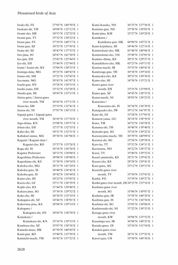
2618
Threatened birds of Asia
Iwaki-shi, FS 37°05’N 140°50’E 1
Iwakuni-shi, YH 34°09’N 132°12’E 1
Iwami-cho, SM 34°53’N 132°25’E 1
Iwami-gun, TT 35°32’N 134°22’E 1
Iwase-gun, FS 37°19’N 140°17’E 1
Iwata-gun, SZ 34°55’N 137°45’E 1
Iwata-shi, SZ 34°43’N 137°52’E 1
Iwo-jima, IO 24°47’N 141°20’E 1
Iyo-gun, EH 33°43’N 132°44’E 1
Iyo-shi, EH 33°44’N 132°44’E 1
Izumi / Izumi-shi, KS 32°04’N 130°25’E 1
Izumiga-dake, MG 38°25’N 140°43’E 1
Izumo-shi, SM 35°21’N 132°45’E 1
Izu-numa, MG 38°43’N 141°07’E 1
Izushi-gun, HY 35°28’N 134°53’E 1
Izushi-yama, EH 33°32’N 132°28’E 1
Jinseki-gun, HI 34°45’N 133°13’E 1
Jintsu-gawa / Jintsu-gawa
river mouth, TM 36°45’N 137°13’E 1
Jinzai-ko, SM 35°19’N 132°41’E 1
Joetsu-shi, NI 37°07’N 138°15’E 1
Joganji-gawa / Joganji-gawa
river mouth, TM 36°45’N 137°18’E 1
Joga-shima, KN 35°08’N 139°37’E 1
Johen-cho, EH 32°57’N 132°35’E 1
Kabe-cho, HI 34°31’N 132°31’E 1
Kabukuri-numa, MG 38°38’N 141°06’E 1
Kagami / Kagami dam /
Kagami-cho, KO 33°37’N 133°26’E 1
Kaga-shi, IS 36°18’N 136°20’E 1
Kagawa Prefecture 34°15’N 134°00’E 1
Kagoshima Prefecture 30°00’N 130°00’E 1
Kagoshima-shi, KS 31°38’N 130°34’E 1
Kahoku-cho, MG 38°31’N 141°24’E 1
Kahoku-gata, IS 36°40’N 136°41’E 1
Kahoku-gun, IS 36°42’N 136°44’E 1
Kaino-cho, HI 34°23’N 133°05’E 1
Kaizu-cho, GI 35°11’N 136°39’E 1
Kajiki-cho, KS 31°44’N 130°40’E 1
Kakara-jima, SG 33°36’N 129°52’E 1
Kake-cho, HI 34°36’N 132°19’E 1
Kakegawa-shi, SZ 34°46’N 138°01’E 1
Kakeroma-jima, KS 28°08’N 129°14’E 1
Kakogawa /
Kakogawa-shi, HY 34°45’N 134°50’E 1
Kamakura /
Kamakura-shi, KN 35°18’N 139°33’E 1
Kambara-cho, SZ 35°07’N 138°36’E 1
Kameda-mura, HK 41°50’N 140°45’E 1
Kami-gun, KO 33°40’N 133°50’E 1
Kamiichi-machi, TM 36°42’N 137°22’E 1
Kami-ikusaka, NO 36°25’N 137°56’E 1
Kamiina-gun, NO 35°50’N 138°05’E 1
Kami-jima, KM 32°27’N 130°20’E 1
Kamikawa /
Kamikawa-gun, HK 44°00’N 142°21’E 1
Kami-kojinbara, HI 34°44’N 132°14’E 1
Kaminokuni-cho, HK 41°48’N 140°06’E 1
Kaminokuni-cho, YH 33°49’N 132°05’E 1
Kamino-shima, KS 30°51’N 129°27’E 1
Kamishihoro-cho, HK 43°23’N 143°13’E 1
Kamisu-machi, IB 35°53’N 140°41’E 1
Kamitsuga-gun, TH 36°38’N 139°34’E 1
Kamiyaku-cho, KS 30°23’N 130°30’E 1
Kamo-cho, HI 34°38’N 133°21’E 1
Kamo-gawa river
mouth, EH 33°55’N 133°09’E 1
Kamo-gun, SZ 34°45’N 138°53’E 1
Kanai-machi, NI 38°03’N 138°23’E 1
Kanazawa /
Kanazawa-shi, IS 36°34’N 136°39’E 1
Kanegasaki-cho, IW 39°12’N 141°07’E 1
Kani-shi, GI 35°24’N 137°05’E 1
Kannon-yama, GU 36°18’N 138°59’E 1
Kano, TM 36°52’N 136°58’E 1
Kanuma-shi, TH 36°40’N 139°40’E 1
Kanzaki-gun, SG 33°18’N 130°22’E 1
Karasuyama-machi, TH 36°39’N 140°09’E 1
Karatsu-shi, SG 33°26’N 129°58’E 1
Karo-ko, TT 35°32’N 134°11’E 1
Karuizawa, NO 36°22’N 138°37’E 1
Kasai, TY 35°40’N 139°52’E 1
Kasari peninsula, KS 28°31’N 129°42’E 1
Kasari-cho, KS 28°28’N 129°41’E 1
Kase-gawa, SG 33°12’N 130°15’E 1
Kaseichi-gawa river
mouth, TT 35°30’N 133°43’E 1
Kashii, FO 33°39’N 130°27’E 1
Kashii-gawa river mouth, OS 34°23’N 135°16’E 1
Kashima-gawa river
mouth, SG 33°06’N 130°07’E 1
Kashima-gun, IB 35°58’N 140°38’E 1
Kashima-gun, IS 37°11’N 136°54’E 1
Kashima-shi, SG 33°05’N 130°06’E 1
Kashiwazaki-shi, NI 37°22’N 138°33’E 1
Kasuga-gawa river
mouth, KW 34°08’N 133°52’E 1
Kasumiga-ura, IB 36°00’N 140°25’E 1
Katada-gawa, OI 32°56’N 131°54’E 1
Katakai-gawa river
mouth, TM 36°51’N 137°25’E 1
Katori-gun, CH 35°50’N 140°30’E 1
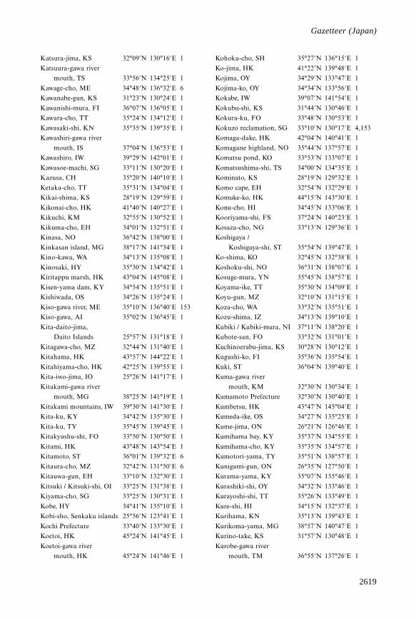
2619
Gazetteer
Katsura-jima, KS 32°09’N 130°16’E 1
Katsuura-gawa river
mouth, TS 33°56’N 134°25’E 1
Kawage-cho, ME 34°48’N 136°32’E 6
Kawanabe-gun, KS 31°23’N 130°24’E 1
Kawanishi-mura, FI 36°07’N 136°05’E 1
Kawara-cho, TT 35°24’N 134°12’E 1
Kawasaki-shi, KN 35°35’N 139°35’E 1
Kawashiri-gawa river
mouth, IS 37°04’N 136°53’E 1
Kawashiro, IW 39°29’N 142°01’E 1
Kawasoe-machi, SG 33°11’N 130°20’E 1
Kazusa, CH 35°20’N 140°10’E 1
Ketaka-cho, TT 35°31’N 134°04’E 1
Kikai-shima, KS 28°19’N 129°59’E 1
Kikonai-cho, HK 41°40’N 140°27’E 1
Kikuchi, KM 32°55’N 130°52’E 1
Kikuma-cho, EH 34°01’N 132°51’E 1
Kinasa, NO 36°42’N 138°00’E 1
Kinkasan island, MG 38°17’N 141°34’E 1
Kino-kawa, WA 34°13’N 135°08’E 1
Kinosaki, HY 35°30’N 134°42’E 1
Kiritappu marsh, HK 43°04’N 145°08’E 1
Kisen-yama dam, KY 34°54’N 135°51’E 1
Kishiwada, OS 34°26’N 135°24’E 1
Kiso-gawa river, ME 35°10’N 136°40’E 153
Kiso-gawa, AI 35°02’N 136°45’E 1
Kita-daito-jima,
Daito Islands 25°57’N 131°18’E 1
Kitagawa-cho, MZ 32°44’N 131°40’E 1
Kitahama, HK 43°57’N 144°22’E 1
Kitahiyama-cho, HK 42°25’N 139°55’E 1
Kita-iwo-jima, IO 25°26’N 141°17’E 1
Kitakami-gawa river
mouth, MG 38°25’N 141°19’E 1
Kitakami mountains, IW 39°30’N 141°30’E 1
Kita-ku, KY 34°42’N 135°30’E 1
Kita-ku, TY 35°45’N 139°45’E 1
Kitakyushu-shi, FO 33°50’N 130°50’E 1
Kitami, HK 43°48’N 143°54’E 1
Kitamoto, ST 36°01’N 139°32’E 6
Kitaura-cho, MZ 32°42’N 131°50’E 6
Kitauwa-gun, EH 33°10’N 132°30’E 1
Kitsuki / Kitsuki-shi, OI 33°25’N 131°38’E 1
Kiyama-cho, SG 33°25’N 130°31’E 1
Kobe, HY 34°41’N 135°10’E 1
Kobi-sho, Senkaku islands 25°56’N 123°41’E 1
Kochi Prefecture 33°40’N 133°30’E 1
Koetoi, HK 45°24’N 141°45’E 1
Koetoi-gawa river
mouth, HK 45°24’N 141°46’E 1
Kohoku-cho, SH 35°27’N 136°15’E 1
Ko-jima, HK 41°22’N 139°48’E 1
Kojima, OY 34°29’N 133°47’E 1
Kojima-ko, OY 34°34’N 133°56’E 1
Kokabe, IW 39°07’N 141°54’E 1
Kokubu-shi, KS 31°44’N 130°46’E 1
Kokura-ku, FO 33°48’N 130°53’E 1
Kokuzo reclamation, SG 33°10’N 130°17’E 4,153
Komaga-dake, HK 42°04’N 140°41’E 1
Komagane highland, NO 35°44’N 137°57’E 1
Komatsu pond, KO 33°53’N 133°07’E 1
Komatsushima-shi, TS 34°00’N 134°35’E 1
Kominato, KS 28°19’N 129°32’E 1
Komo cape, EH 32°54’N 132°29’E 1
Komuke-ko, HK 44°15’N 143°30’E 1
Konu-cho, HI 34°45’N 133°06’E 1
Kooriyama-shi, FS 37°24’N 140°23’E 1
Kosaza-cho, NG 33°13’N 129°36’E 1
Koshigaya /
Koshigaya-shi, ST 35°54’N 139°47’E 1
Ko-shima, KO 32°45’N 132°38’E 1
Koshoku-shi, NO 36°31’N 138°07’E 1
Kosuge-mura, YN 35°45’N 138°57’E 1
Koyama-ike, TT 35°30’N 134°09’E 1
Koyu-gun, MZ 32°10’N 131°15’E 1
Koza-cho, WA 33°32’N 135°51’E 1
Kozu-shima, IZ 34°13’N 139°10’E 1
Kubiki / Kubiki-mura, NI 37°11’N 138°20’E 1
Kubote-san, FO 33°32’N 131°01’E 1
Kuchinoerabu-jima, KS 30°28’N 130°12’E 1
Kugushi-ko, FI 35°36’N 135°54’E 1
Kuki, ST 36°04’N 139°40’E 1
Kuma-gawa river
mouth, KM 32°30’N 130°34’E 1
Kumamoto Prefecture 32°30’N 130°40’E 1
Kumbetsu, HK 43°47’N 145°04’E 1
Kumeda-ike, OS 34°27’N 135°25’E 1
Kume-jima, ON 26°21’N 126°46’E 1
Kumihama bay, KY 35°37’N 134°55’E 1
Kumihama-cho, KY 35°35’N 134°57’E 1
Kumotori-yama, TY 35°51’N 138°57’E 1
Kunigami-gun, ON 26°35’N 127°50’E 1
Kurama-yama, KY 35°07’N 135°46’E 1
Kurashiki-shi, OY 34°32’N 133°46’E 1
Kurayoshi-shi, TT 35°26’N 133°49’E 1
Kure-shi, HI 34°15’N 132°37’E 1
Kurihama, KN 35°13’N 139°43’E 1
Kurikoma-yama, MG 38°57’N 140°47’E 1
Kurino-take, KS 31°57’N 130°48’E 1
Kurobe-gawa river
mouth, TM 36°55’N 137°26’E 1
Gazetteer (Japan)
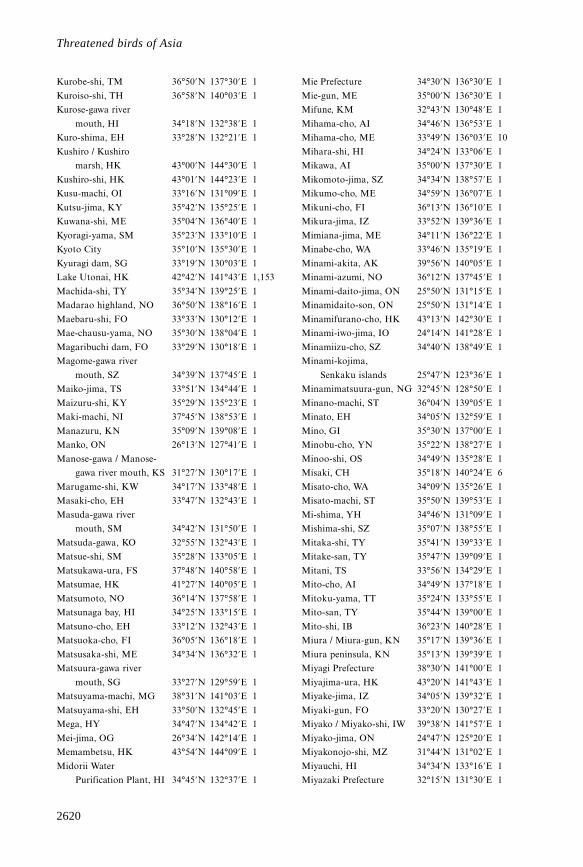
2620
Threatened birds of Asia
Kurobe-shi, TM 36°50’N 137°30’E 1
Kuroiso-shi, TH 36°58’N 140°03’E 1
Kurose-gawa river
mouth, HI 34°18’N 132°38’E 1
Kuro-shima, EH 33°28’N 132°21’E 1
Kushiro / Kushiro
marsh, HK 43°00’N 144°30’E 1
Kushiro-shi, HK 43°01’N 144°23’E 1
Kusu-machi, OI 33°16’N 131°09’E 1
Kutsu-jima, KY 35°42’N 135°25’E 1
Kuwana-shi, ME 35°04’N 136°40’E 1
Kyoragi-yama, SM 35°23’N 133°10’E 1
Kyoto City 35°10’N 135°30’E 1
Kyuragi dam, SG 33°19’N 130°03’E 1
Lake Utonai, HK 42°42’N 141°43’E 1,153
Machida-shi, TY 35°34’N 139°25’E 1
Madarao highland, NO 36°50’N 138°16’E 1
Maebaru-shi, FO 33°33’N 130°12’E 1
Mae-chausu-yama, NO 35°30’N 138°04’E 1
Magaribuchi dam, FO 33°29’N 130°18’E 1
Magome-gawa river
mouth, SZ 34°39’N 137°45’E 1
Maiko-jima, TS 33°51’N 134°44’E 1
Maizuru-shi, KY 35°29’N 135°23’E 1
Maki-machi, NI 37°45’N 138°53’E 1
Manazuru, KN 35°09’N 139°08’E 1
Manko, ON 26°13’N 127°41’E 1
Manose-gawa / Manose-
gawa river mouth, KS 31°27’N 130°17’E 1
Marugame-shi, KW 34°17’N 133°48’E 1
Masaki-cho, EH 33°47’N 132°43’E 1
Masuda-gawa river
mouth, SM 34°42’N 131°50’E 1
Matsuda-gawa, KO 32°55’N 132°43’E 1
Matsue-shi, SM 35°28’N 133°05’E 1
Matsukawa-ura, FS 37°48’N 140°58’E 1
Matsumae, HK 41°27’N 140°05’E 1
Matsumoto, NO 36°14’N 137°58’E 1
Matsunaga bay, HI 34°25’N 133°15’E 1
Matsuno-cho, EH 33°12’N 132°43’E 1
Matsuoka-cho, FI 36°05’N 136°18’E 1
Matsusaka-shi, ME 34°34’N 136°32’E 1
Matsuura-gawa river
mouth, SG 33°27’N 129°59’E 1
Matsuyama-machi, MG 38°31’N 141°03’E 1
Matsuyama-shi, EH 33°50’N 132°45’E 1
Mega, HY 34°47’N 134°42’E 1
Mei-jima, OG 26°34’N 142°14’E 1
Memambetsu, HK 43°54’N 144°09’E 1
Midorii Water
Purification Plant, HI 34°45’N 132°37’E 1
Mie Prefecture 34°30’N 136°30’E 1
Mie-gun, ME 35°00’N 136°30’E 1
Mifune, KM 32°43’N 130°48’E 1
Mihama-cho, AI 34°46’N 136°53’E 1
Mihama-cho, ME 33°49’N 136°03’E 10
Mihara-shi, HI 34°24’N 133°06’E 1
Mikawa, AI 35°00’N 137°30’E 1
Mikomoto-jima, SZ 34°34’N 138°57’E 1
Mikumo-cho, ME 34°59’N 136°07’E 1
Mikuni-cho, FI 36°13’N 136°10’E 1
Mikura-jima, IZ 33°52’N 139°36’E 1
Mimiana-jima, ME 34°11’N 136°22’E 1
Minabe-cho, WA 33°46’N 135°19’E 1
Minami-akita, AK 39°56’N 140°05’E 1
Minami-azumi, NO 36°12’N 137°45’E 1
Minami-daito-jima, ON 25°50’N 131°15’E 1
Minamidaito-son, ON 25°50’N 131°14’E 1
Minamifurano-cho, HK 43°13’N 142°30’E 1
Minami-iwo-jima, IO 24°14’N 141°28’E 1
Minamiizu-cho, SZ 34°40’N 138°49’E 1
Minami-kojima,
Senkaku islands 25°47’N 123°36’E 1
Minamimatsuura-gun, NG 32°45’N 128°50’E 1
Minano-machi, ST 36°04’N 139°05’E 1
Minato, EH 34°05’N 132°59’E 1
Mino, GI 35°30’N 137°00’E 1
Minobu-cho, YN 35°22’N 138°27’E 1
Minoo-shi, OS 34°49’N 135°28’E 1
Misaki, CH 35°18’N 140°24’E 6
Misato-cho, WA 34°09’N 135°26’E 1
Misato-machi, ST 35°50’N 139°53’E 1
Mi-shima, YH 34°46’N 131°09’E 1
Mishima-shi, SZ 35°07’N 138°55’E 1
Mitaka-shi, TY 35°41’N 139°33’E 1
Mitake-san, TY 35°47’N 139°09’E 1
Mitani, TS 33°56’N 134°29’E 1
Mito-cho, AI 34°49’N 137°18’E 1
Mitoku-yama, TT 35°24’N 133°55’E 1
Mito-san, TY 35°44’N 139°00’E 1
Mito-shi, IB 36°23’N 140°28’E 1
Miura / Miura-gun, KN 35°17’N 139°36’E 1
Miura peninsula, KN 35°13’N 139°39’E 1
Miyagi Prefecture 38°30’N 141°00’E 1
Miyajima-ura, HK 43°20’N 141°43’E 1
Miyake-jima, IZ 34°05’N 139°32’E 1
Miyaki-gun, FO 33°20’N 130°27’E 1
Miyako / Miyako-shi, IW 39°38’N 141°57’E 1
Miyako-jima, ON 24°47’N 125°20’E 1
Miyakonojo-shi, MZ 31°44’N 131°02’E 1
Miyauchi, HI 34°34’N 133°16’E 1
Miyazaki Prefecture 32°15’N 131°30’E 1
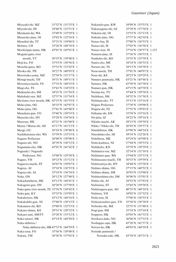
2621
Gazetteer
Miyazaki-shi, MZ 31°52’N 131°25’E 1
Miyoshi-shi, HI 34°48’N 132°51’E 1
Mizukami-ike, WA 33°49’N 135°29’E 1
Mizunoko-jima, OI 33°02’N 132°10’E 1
Mizushiri-ike, TT 35°31’N 134°06’E 1
Mobara, CH 35°26’N 140°18’E 1
Mochirippu-numa, HK 43°01’N 145°01’E 1
Mogami-gawa river
mouth, YT 38°55’N 139°48’E 1
Moji-ku, FO 33°55’N 130°56’E 1
Monobe-gawa, KO 33°32’N 133°42’E 1
Mooka-shi, TH 36°27’N 140°03’E 1
Morotsuka-yama, MZ 32°38’N 131°17’E 1
Motegi-machi, TH 36°31’N 140°11’E 1
Motomiya-machi, FS 37°35’N 140°25’E 1
Mugi-cho, TS 33°41’N 134°25’E 1
Muikaichi-cho, SM 34°21’N 131°56’E 1
Mukabaki-san, MZ 32°37’N 131°34’E 1
Mu-kawa river mouth, HK 42°33’N 141°55’E 1
Muko-jima, OG 26°35’N 142°07’E 1
Muko-jima, OG 27°41’N 142°08’E 1
Munakata-gun, FO 33°48’N 130°33’E 1
Muraoka-cho, HY 35°28’N 134°36’E 1
Muroran, HK 42°21’N 141°00’E 1
Mutsu / Mutsu-shi, AO 41°17’N 141°13’E 1
Myogi, GU 36°18’N 138°48’E 6
Nachikatsuura-cho, WA 33°39’N 135°53’E 1
Nagano Prefecture 36°00’N 138°00’E 1
Nagano-shi, NO 36°39’N 138°12’E 1
Naganuma-cho, HK 43°01’N 141°42’E 1
Nagasaki / Nagasaki
Prefecture, NG 33°00’N 129°30’E 1
Nagato, YH 34°23’N 131°12’E 1
Nagatoro-machi, ST 36°07’N 139°07’E 1
Nagoya, AI 35°10’N 136°55’E 1
Nagoya-shi, AI 35°10’N 136°54’E 1
Naha, ON 26°12’N 127°40’E 1
Nakachambetsu, HK 43°13’N 144°41’E 1
Nakagami-gun, ON 26°20’N 127°50’E 1
Naka-gawa river mouth, TS 33°56’N 134°42’E 1
Naka-gun, KY 35°35’N 135°05’E 1
Nakahororo, HK 43°12’N 144°16’E 1
Nakakubiki-gun, NI 37°00’N 138°15’E 1
Nakamura-shi, KO 33°00’N 132°53’E 1
Nakano-shima, KS 29°51’N 129°52’E 1
Nakano-umi, SM/TT 35°28’N 133°12’E 1
Naka-setsuri, HK 43°14’N 144°20’E 1
Naka-shibetsu /
Naka-shibetsu-cho, HK 43°33’N 144°59’E 1
Naka-sone, FO 33°56’N 130°40’E 1
Nakata, TM 36°56’N 137°02’E 1
Nakatado-gun, KW 34°09’N 133°53’E 1
Nakatsugawa-shi, GI 35°29’N 137°30’E 1
Nakatsu-shi, OI 33°35’N 131°13’E 1
Nakodo-jima, OG 27°37’N 142°10’E 1
Nanao bay, IS 37°08’N 136°55’E 1
Nanao-shi, IS 37°03’N 136°58’E 1
Nanao-wan, IS 37°10’N 136°57’E 1,153
Nanatsu-jima, IS 37°36’N 136°53’E 1
Nankoku-shi, KO 33°35’N 133°39’E 1
Nanto-cho, ME 34°18’N 136°32’E 1
Naruto-shi, TS 34°13’N 134°38’E 1
Nasu-machi, TH 37°01’N 140°07’E 1
Naze-shi, KS 28°23’N 129°29’E 1
Nemuro peninsula, HK 43°21’N 145°46’E 1
Nemuro, HK 43°30’N 145°30’E 1
Nemuro-gun, HK 43°15’N 145°30’E 1
Nerima-ku, TY 35°44’N 139°38’E 1
Nichihara, SM 34°32’N 131°50’E 1
Nichinan-cho, TT 35°13’N 133°16’E 1
Niigata Prefecture 37°30’N 139°00’E 1
Niigata-shi, NI 37°55’N 139°03’E 1
Niihama-shi, EH 33°58’N 133°16’E 1
Nii-jima, IZ 34°22’N 139°16’E 1
Nikaho-machi, AK 39°13’N 139°59’E 1
Nikko / Nikko-shi, TH 36°45’N 139°37’E 1
Ninishibetsu, HK 43°08’N 144°14’E 1
Ninoshima-cho, HI 34°18’N 132°26’E 1
Nishibetsu, HK 43°24’N 145°08’E 1
Nishi-kanbara, NI 37°44’N 138°53’E 1
Nishikubo, KN 35°39’N 139°39’E 1
Nishimera-son, MZ 32°14’N 131°10’E 1
Nishimuro-gun, WA 33°44’N 135°33’E 1
Nishinasuno-machi, TH 36°53’N 139°59’E 1
Nishinomiya-shi, HY 34°44’N 135°20’E 1
Nishino-shima, OG 27°15’N 140°52’E 1
Nishino-shima, SM 36°05’N 133°00’E 1
Nishinoshima-cho, SM 36°06’N 133°01’E 1
Nishio-shi, AI 34°52’N 137°03’E 1
Nishitama, ST 35°45’N 139°20’E 1
Nishitsugaru-gun, AO 40°25’N 140°10’E 1
Nishiura, YH 34°02’N 131°32’E 1
Nishi-wan, IS 37°06’N 136°55’E 1
Nishiyatsushiro-gun, YN 35°30’N 138°30’E 1
Nobeoka-shi, MZ 32°35’N 131°40’E 1
Nogi-gun, SM 35°18’N 133°10’E 1
Nopporo, HK 43°05’N 141°32’E 1
Norikura-dake, NO 36°06’N 137°33’E 1
Noshappu cape, HK 45°28’N 141°37’E 1
Notoro-ko, HK 44°05’N 144°10’E 1
Notsuke peninsula /
Notsuke-saki, HK 43°34’N 145°21’E 1
Gazetteer (Japan)
2622
Threatened birds of Asia
Nozuka, HK 42°21’N 143°18’E 1
Numazu-shi, SZ 35°05’N 138°51’E 1
Nuta-gawa, HI 34°23’N 133°04’E 1
Nyu-gun, FI 35°58’N 136°04’E 1
Oarai, IB 36°19’N 140°36’E 1
Obama, FI 35°30’N 135°45’E 1
Obihiro-shi, HK 42°55’N 143°12’E 1
Obitsu-gawa river
mouth, CH 35°25’N 139°54’E 1
Oboro-gawa, HK 43°04’N 144°52’E 1
Ochi-gata, IS 36°55’N 136°49’E 1
Odaigahara, NR 34°11’N 136°05’E 1
Oda-ike, KW 34°20’N 134°14’E 1
Odawara /
Odawara-shi, KN 35°15’N 139°08’E 1
Ogachi, KS 28°13’N 129°18’E 1
Ogasa-gun, SZ 34°45’N 138°05’E 1
Ogasawara Islands 27°00’N 142°10’E 1
Ogasa-yama, SZ 34°44’N 138°01’E 1
Oga-shi, AK 39°55’N 139°48’E 1
Ogawa-machi, ST 36°03’N 139°16’E 1
Ogawara-numa, AO 40°47’N 141°20’E 1
Ogi-gun, SG 33°16’N 130°12’E 1
Ogi-machi, SG 33°18’N 130°11’E 1
Ohama, ON 26°41’N 127°53’E 1
O-hori-koen, FO 33°35’N 130°23’E 1
Oi-gawa river mouth, SZ 34°46’N 138°18’E 1
Oikamanae-numa, HK 42°33’N 143°30’E 1
O-ike, SZ 34°46’N 137°59’E 1
Oita Prefecture 33°15’N 131°30’E 1
Oita-gun, OI 33°11’N 131°30’E 1
Oita-shi, OI 33°15’N 131°36’E 1
Oitsukami-jima, EH 33°06’N 132°20’E 1
Oji-ku, TY 35°46’N 139°44’E 1
Okagaki-machi, FO 33°49’N 130°37’E 1
Okayama Prefecture 35°00’N 134°00’E 1
Okayama-shi, OY 34°39’N 133°56’E 1
Oketo-cho, HK 43°41’N 143°35’E 1
Oki islands, SM 36°15’N 133°15’E 1
Okinawa island, ON 26°42’N 128°11’E 1
Okino-daito-jima,
Daito islands 24°28’N 131°11’E 1
Okino-erabu-shima, KS 27°22’N 128°35’E 1
Okino-shima, FO 34°15’N 130°06’E 1
Okutama-ko, TY 35°46’N 139°02’E 1
Omaezaki, SZ 34°36’N 138°13’E 1
Omaru-gawa, MZ 32°07’N 131°32’E 1
Ombase-jima, IZ 34°11’N 139°04’E 1
Omigawa-machi, CH 35°50’N 140°37’E 1
Omiya park, ST 35°54’N 139°37’E 1
Omogo-kei, EH 33°43’N 133°06’E 1
Omono-gawa, AK 39°41’N 140°04’E 1
Omura bay, NG 32°57’N 129°52’E 1
Onbetsu-gawa, HK 44°43’N 141°47’E 1
Onne-to, HK 43°15’N 145°31’E 1
Ono-gun, GI 35°28’N 136°37’E 1
Onohara-jima, IZ 34°02’N 139°23’E 1
Ono-mura, KN 35°21’N 139°21’E 1
Ono-shi, HY 34°41’N 135°13’E 1
Ooda-shi, SM 35°10’N 132°30’E 1
Oogata-cho, KO 33°03’N 133°02’E 1
Ooiso-cho, KN 35°18’N 139°18’E 1
Ookawa-gun, KW 34°13’N 134°16’E 1
Oono-shi, FI 35°59’N 136°29’E 1
Ooshima-gun, YH 33°55’N 132°20’E 1
Oota-ku, TY 35°34’N 139°42’E 1
Ootawara-shi, TH 36°51’N 140°01’E 1
Ootsuki-cho, KO 32°49’N 132°42’E 1
Osaka bay, OS 34°30’N 135°18’E 1
Osaka City 34°30’N 135°30’E 1
Osaka, OS 34°40’N 135°30’E 1
Oshiba-shima, HI 34°16’N 132°48’E 1
Oshima, HK 41°30’N 139°21’E 1
O-shima, IZ 34°44’N 139°24’E 1
Ota-gawa, HI 34°21’N 132°27’E 1
Ota-gawa, WA 33°35’N 135°55’E 1
Ota-gawa river mouth, SZ 34°40’N 137°54’E 1
Otaki-machi, CH 35°17’N 140°16’E 6
Otarunai-gawa, HK 43°10’N 141°14’E 1
Otaru-shi, HK 43°11’N 141°01’E 1
Otome, OI 33°34’N 131°21’E 1
Otsu marsh, HK 42°41’N 143°39’E 1
Otsuchi-cho, IW 39°21’N 141°54’E 1
Oume-shi, TY 35°48’N 139°15’E 1
Oyabe-gawa, TM 36°47’N 137°04’E 1
Oyama-shi, TH 36°18’N 139°48’E 1
Ozu / Ozu-machi, YH 33°54’N 132°03’E 1
Ozuki, YH 34°04’N 131°02’E 1
Ozu-shi, EH 33°31’N 132°34’E 1
Ranzan-machi, ST 36°03’N 139°19’E 1
Rausu / Rausu-gawa, HK 44°01’N 145°12’E 1
Rausu-cho, HK 44°05’N 145°10’E 1
Rebun-to, HK 45°16’N 141°02’E 1
Rokkaku-gawa, SG 33°12’N 130°13’E 1
Rokkasho, AO 40°55’N 141°20’E 1
Rumoi, HK 43°56’N 141°39’E 1
Rumoi-shi, HK 43°54’N 141°44’E 1
Ryugasaki, IB 35°54’N 140°11’E 1
Sabae-shi, FI 35°57’N 136°11’E 1
Sado island, NI 38°00’N 138°25’E 1
Sadowara-cho, MZ 32°02’N 131°28’E 1
Saeki-gun, HI 34°25’N 132°13’E 1
2623
Gazetteer
Saga Prefecture 33°20’N 130°00’E 1
Saga-gun, SG 33°23’N 130°13’E 1
Sagami bay, KN 35°15’N 139°25’E 1
Sagami, KN 35°20’N 139°15’E 1
Sagami-gawa / Sagami-gawa
river mouth, KN 35°18’N 139°22’E 1
Sagamihara-shi /
Sagamihara
reservoir, KN 35°33’N 139°21’E 1
Saga-shi, SG 33°15’N 130°18’E 1
Sago, NG 34°37’N 129°21’E 1
Sai-gawa, IS 36°35’N 136°35’E 1
Saigo-son, MZ 32°27’N 131°22’E 1
Saijo-cho, HI 34°25’N 132°45’E 1
Saijo-shi, EH 33°55’N 133°11’E 1
Saiki-shi, OI 32°58’N 131°53’E 1
Saitama Prefecture 36°00’N 139°30’E 1
Sakai-gun, FI 36°10’N 136°14’E 1
Sakai-shi, OS 34°35’N 135°29’E 1
Sakata, YT 38°55’N 139°51’E 1
Sakata-shi, YT 38°55’N 139°50’E 1
Sakauchi-cho, ME 34°37’N 136°33’E 1
Sakawa-gawa, KN 35°15’N 139°11’E 1
Sakuragawa-mura, IB 36°04’N 140°13’E 1
Sakura-shi, CH 35°40’N 140°13’E 1
Saku-shi, NO 36°17’N 138°30’E 1
Sakyo-ku, KY 35°07’N 135°48’E 1
Samani-gun, HK 42°08’N 143°02’E 1
Sambe-san, SM 35°08’N 132°37’E 1
Sanage-san, AI 35°07’N 137°11’E 6
Sanaru-ko, SZ 34°42’N 137°41’E 1
Sangan-jima, IW 39°18’N 141°59’E 1
Sano, TM 36°43’N 136°59’E 1
Sanriku, IW 39°20’N 142°00’E 1
Sanyo-cho, YH 34°03’N 131°08’E 1
Sapporo, HK 43°00’N 141°18’E 1
Sapporo-shi, HK 43°04’N 141°21’E 1
Sasebo-shi, NG 33°10’N 129°43’E 1
Satsuma, KS 31°30’N 130°25’E 1
Sayama-ko, ST 35°46’N 139°24’E 1
Sayama-shi, OS 34°31’N 135°33’E 1
Sayama-shi, ST 35°52’N 139°24’E 1
Sefuri-san, SG 33°26’N 130°22’E 1
Seki-gawa river
mouth, EH 33°59’N 133°27’E 1
Sendai-shi, KS 31°49’N 130°18’E 1
Sendai-shi, MG 38°15’N 140°52’E 1
Seto-cho, EH 33°25’N 132°14’E 1
Setsuri, HK 43°01’N 144°26’E 1
Shakotan peninsula, HK 43°15’N 140°30’E 1
Shari / Shari-cho, HK 44°00’N 144°55’E 1
Shibakawa-cho, SZ 35°15’N 138°33’E 1
Shibecha, HK 43°17’N 144°36’E 1
Shibetsu-cho, HK 43°44’N 144°53’E 1
Shiga Prefecture 35°15’N 136°00’E 1
Shigenobu-gawa river
mouth, EH 33°48’N 132°41’E 1
Shiida / Shiida-machi, FO 33°39’N 131°04’E 1
Shiigi, CH 35°19’N 140°22’E 1
Shikano-cho, TT 35°27’N 134°04’E 1
Shikano-shima, FO 33°40’N 130°18’E 1
Shikaoi-cho, HK 43°07’N 143°02’E 1
Shikine-jima, IZ 34°19’N 139°13’E 1
Shiki-shi, ST 35°50’N 139°35’E 1
Shikotsu-ko, HK 42°45’N 141°20’E 1
Shima-gun, ME 34°25’N 136°50’E 1
Shimane Prefecture 35°00’N 132°30’E 1
Shimanto-gawa, KO 32°56’N 133°00’E 1
Shimizu, KO 32°48’N 132°55’E 1
Shimizu / Shimizu-shi, SZ 35°00’N 138°30’E 1
Shimminato-shi, TM 36°46’N 137°05’E 1
Shimoda, SZ 34°41’N 138°56’E 1
Shimoina-gun, NO 35°30’N 137°50’E 1
Shimoniikawa-gun, TM 36°50’N 137°33’E 1
Shimonoseki-shi, YH 34°02’N 130°57’E 1
Shimosa, CH 35°45’N 140°20’E 1
Shimosato, WA 33°35’N 135°55’E 1
Shimo-setsuri, HK 43°11’N 144°19’E 1
Shimo-teshibetsu, HK 43°10’N 144°10’E 1
Shimotsuga-gun, TH 36°22’N 139°45’E 1
Shimura, TY 35°46’N 139°42’E 1
Shinano, NO 36°48’N 138°18’E 1
Shinano-gawa, NI 37°54’N 139°15’E 153
Shinhama, CH 35°40’N 139°55’E 153
Shinichi-cho, HI 34°33’N 133°16’E 1
Shinji-ko, SM 35°26’N 132°57’E 1
Shin-kawa, KS 31°33’N 130°33’E 1
Shinobazu pond, TY 35°42’N 139°47’E 153
Shintoku-cho, HK 43°04’N 142°51’E 1
Shinzaike, HY 34°47’N 134°36’E 1
Shiobara-machi, TH 36°58’N 139°50’E 1
Shiono-misaki, WA 33°26’N 135°45’E 1
Shioya-gun, TH 36°55’N 139°40’E 1
Shirahama-cho, WA 33°39’N 135°24’E 1
Shira-kawa, KM 32°46’N 130°37’E 1
Shiraki-cho, HI 34°33’N 132°38’E 1
Shiranuhi-machi, KM 32°20’N 130°25’E 1
Shiretoko peninsula, HK 44°00’N 145°00’E 1
Shiriuchi-cho, HK 41°35’N 140°27’E 1
Shishikui-cho, TS 33°36’N 134°14’E 1
Shitada-machi, NI 37°30’N 139°10’E 1
Shitakara-gawa, HK 43°06’N 144°08’E 1
Gazetteer (Japan)
2624
Threatened birds of Asia
Shiura-mura, AO 41°04’N 140°23’E 1
Shizugawa, MG 38°40’N 141°27’E 1
Shizunai-cho, HK 42°25’N 142°35’E 1
Shizuoka Prefecture 35°00’N 138°00’E 1
Shizuoka-shi, SZ 34°58’N 138°23’E 1
Shobara-shi, HI 34°51’N 133°01’E 1
Sho-gawa / Sho-gawa
river mouth, TM 36°47’N 137°04’E 1
Shonai-gawa river
mouth, AI 35°05’N 136°51’E 1
Shunkunitai, HK 43°17’N 145°25’E 4,143
Soja-shi, OY 34°40’N 133°45’E 1
Soka-shi, ST 35°49’N 139°48’E 1
Sone tidal flat, FO 33°50’N 130°56’E 1
Sorachi, HK 43°30’N 142°00’E 1
Soya, HK 45°00’N 142°15’E 1
Sugao-numa, IB 35°59’N 139°56’E 1
Suiha, EH 33°56’N 133°32’E 1
Suki-son, MZ 32°04’N 131°05’E 1
Sukumo-shi, KO 32°56’N 132°44’E 1
Suminodo-cho, OS 34°42’N 135°37’E 1
Sumiyo-son, KS 30°40’N 130°57’E 1
Sunto-gun, SZ 35°20’N 139°00’E 1
Suruga / Suruga bay, SZ 34°51’N 138°33’E 1
Susaki-shi, KO 33°23’N 133°16’E 1
Suttsu bay, HK 42°48’N 140°16’E 1
Tachikawa-shi, TY 35°42’N 139°25’E 1
Tada, HI 34°28’N 132°14’E 1
Tadanae-jima, IZ 34°12’N 139°11’E 1
Tagata-gun, SZ 35°00’N 139°00’E 1
Tahara-cho, AI 34°40’N 137°15’E 1
Taiki / Taiki-cho, HK 42°29’N 143°07’E 1
Taiko-yama, KY 35°41’N 135°12’E 1
Taira-jima, KS 29°42’N 129°34’E 1
Taira-mura, TM 36°25’N 136°58’E 1
Taisetsu-zan, HK 43°41’N 142°53’E 1
Taishaku-kyo, HI 34°51’N 133°14’E 1
Taito-ku, TY 35°42’N 139°47’E 153
Tajimi-shi, GI 35°21’N 137°06’E 1
Takabo, TS 34°07’N 134°33’E 1
Takahara, TS 34°05’N 134°25’E 1
Takaharu-cho, MZ 31°55’N 131°00’E 1
Takamatsu / Takamatsu
coast, IS 36°46’N 136°43’E 1,153
Takamatsu-shi, KW 34°20’N 134°03’E 1
Takaoka-cho, MZ 31°57’N 131°18’E 1
Takaoka-shi, TM 36°45’N 137°00’E 1
Takaono-cho, KS 32°03’N 130°17’E 1
Takao-san, TY 35°37’N 139°15’E 1
Takara-jima, KS 29°09’N 129°13’E 1
Takasago, HY 34°47’N 134°47’E 1
Takasaki-shi, GU 36°20’N 139°00’E 1
Takase-gawa river
mouth, AO 40°53’N 141°23’E 1
Takayama-shi, GI 36°07’N 137°15’E 1
Takefu / Takefu-shi, FI 35°54’N 136°10’E 1
Takeno-cho, HY 35°39’N 134°45’E 1
Takeno-gun, KY 35°44’N 135°06’E 1
Taketomi-cho, ON 24°19’N 124°05’E 1
Tama Hills, TY 35°38’N 139°27’E 1
Tama-gawa / Tama-gawa
river mouth, KN/TY 35°32’N 139°46’E 1
Tama-ko, TY 35°45’N 139°25’E 1
Tamatsukuri, IB 36°06’N 140°25’E 1
Tanabe-shi, WA 33°45’N 135°23’E 1
Tanega-shima, KS 30°40’N 131°00’E 1
Taniguchi, TM 36°39’N 137°02’E 1
Taniyama, KS 31°30’N 130°28’E 1
Tanzawa-ko, KN 35°28’N 139°08’E 1
Taragi-machi, KM 32°16’N 130°57’E 1
Tatara-numa, GU 36°15’N 139°30’E 1
Tateyama-machi, TM 36°35’N 137°30’E 1
Tateyama-shi, CH 35°00’N 139°52’E 1
Tateyama-wan, CH 35°00’N 139°50’E 1
Tatsuruhama-cho, IS 37°04’N 136°53’E 1
Tatsuta, AI 35°10’N 136°42’E 1
Tega-numa, CH 35°51’N 140°05’E 1
Tenjin-gawa river
mouth, TT 35°30’N 133°51’E 1
Tenri-shi, WA 34°35’N 135°53’E 1
Tenryu-gawa, NO 35°17’N 137°52’E 1
Tenryu-gawa river
mouth, SZ 34°39’N 137°48’E 1
Teshio-gawa, HK 44°53’N 141°45’E 1
Teshio-gun, HK 44°45’N 141°50’E 1
Toberi marsh, HK 42°30’N 143°24’E 1
Tobetsu-cho, HK 43°13’N 141°31’E 1
Tobi-shima, YT 39°12’N 139°34’E 1
Tobutsu-ko, HK 43°56’N 144°25’E 153
Tochigi, TH 36°45’N 139°45’E 1
Toda-shi, ST 35°48’N 139°40’E 1
Tofutsu-ko, HK 43°56’N 144°24’E 1
Togakushi highland, NO 36°44’N 138°05’E 1
Toga-mura, TM 36°25’N 137°00’E 1
Togane-shi, CH 35°33’N 140°22’E 1
Togo-cho, AI 35°06’N 137°03’E 1
Togo-ike, TT 35°28’N 133°53’E 1
Tohaku-gun, TT 35°23’N 133°55’E 1
To-jima, EH 33°12’N 132°22’E 1
Tokachi, HK 43°00’N 143°20’E 1
Tokashiki-jima, ON 26°11’N 127°21’E 1
Tokuno-shima, KS 27°45’N 128°58’E 1
2625
Gazetteer
Tokushima-shi, TS 34°04’N 134°34’E 1
Tokuyama-shi, YH 34°05’N 131°45’E 1
Tokyo bay, CH/TY 35°25’N 139°47’E 1
Tokyo / Tokyo City, TY 35°45’N 139°30’E 1
Tomakomai /
Tomakomai-shi, HK 42°40’N 141°38’E 1
Tomigusuku-son, ON 26°10’N 127°40’E 1
Tomisato, HK 42°04’N 139°27’E 1
Tonda-gawa, WA 33°38’N 135°24’E 1
Tone-gawa, CH 35°55’N 139°53’E 1
Tone-gawa, GU 36°29’N 138°27’E 1
Tori-shima, IZ 30°29’N 140°19’E 1
Tosa-cho, KO 33°45’N 133°29’E 1
Tosa-shi, KO 33°29’N 133°23’E 1
Tosashimizu-shi, KO 32°48’N 132°55’E 1
To-shima, IZ 34°31’N 139°17’E 1
Tosu-shi, SG 33°22’N 130°31’E 1
Tottori Prefecture 35°30’N 134°00’E 1
Tottori-shi, TT 35°30’N 134°15’E 1
Toyama Prefecture 36°30’N 137°30’E 1
Toyama-shi, TM 36°43’N 137°14’E 1
Toyano-gata, NI 37°53’N 139°03’E 1
Toyoda-cho, SZ 34°43’N 137°50’E 1
Toyohashi-shi, AI 34°46’N 137°23’E 1
Toyooka-shi, HY 35°33’N 134°50’E 1
Toyo-shi, EH 33°56’N 133°05’E 1
Toyoshina-machi, NO 36°18’N 137°54’E 1
Toyota-shi, AI 35°05’N 137°10’E 1
Tsudanuma, CH 35°41’N 140°03’E 1
Tsugaruishi-gawa river
mouth, IW 39°35’N 141°57’E 1
Tsuiki-machi, FO 33°40’N 131°02’E 1
Tsukiji, TY 35°40’N 139°46’E 1
Tsukui-gun, KN 35°35’N 139°10’E 1
Tsumeki-saki, SZ 34°39’N 138°59’E 1
Tsuno-jima, YH 34°21’N 130°51’E 1
Tsuruga-shi, FI 35°35’N 136°05’E 1
Tsurui-mura, HK 43°15’N 144°20’E 1
Tsurumi-ku, OS 34°42’N 135°35’E 1
Tsuruoka /
Tsuruoka-shi, YT 38°43’N 139°50’E 1
Tsuruta-machi, AO 40°45’N 140°27’E 1
Tsushima, NG 34°20’N 129°20’E 1
Tsuyazaki, FO 33°47’N 130°28’E 1
Ube-shi, YH 33°58’N 131°15’E 1
Udone-jima, IZ 34°28’N 139°17’E 1
Uga-kyo, HI 34°42’N 133°02’E 1
Uke-shima, KS 28°02’N 129°14’E 1
Ukishima wetland, IB 35°57’N 140°28’E 153
Ukishima, SZ 35°09’N 138°46’E 1
Ukishima-numa, SZ 35°08’N 138°44’E 1
Unazuki-machi, TM 36°49’N 137°35’E 1
Unozumai-gawa river
mouth, IW 39°20’N 141°54’E 1
Unuma-cho, GI 35°25’N 136°55’E 1
Unzen-dake, NG 32°45’N 130°17’E 1
Uraga channel, CH/KN 35°12’N 139°44’E 1
Uraga, KN 35°14’N 139°43’E 1
Urahoro-cho, HK 42°48’N 143°39’E 1
Urakawa-cho, HK 42°09’N 142°47’E 1
Urawa-shi, ST 35°51’N 139°39’E 1
Urayasu-shi, CH 35°39’N 139°54’E 1
Utazu-cho, KW 34°18’N 133°49’E 1
Uto-gun, KM 32°40’N 130°35’E 1
Utsunomiya-shi, TH 36°34’N 139°53’E 1
Uwa-cho, EH 33°22’N 132°31’E 1
Wada, WA 33°54’N 135°08’E 1
Wada-numa, CH 35°02’N 140°01’E 1
Wajima-shi, IS 37°22’N 136°54’E 1
Wajiro tidal flat, FO 33°42’N 130°25’E 1
Wakamatsu, HK 42°21’N 139°55’E 1
Wakamatsu-ku, FO 33°54’N 130°49’E 1
Wakasa-cho, TT 35°20’N 134°24’E 1
Wakaura, WA 34°11’N 135°10’E 1
Wakayama Prefecture 34°00’N 135°30’E 1
Wakayama-shi, WA 34°13’N 135°12’E 1
Wakayanagi-cho, MG 38°46’N 141°08’E 1
Wakimoto, AK 39°54’N 139°54’E 1
Wakkanai-shi, HK 45°20’N 141°45’E 1
Warashina-gawa, SZ 34°57’N 138°22’E 1
Watari-cho, MG 38°02’N 140°52’E 1
Yabakei-cho, OI 33°25’N 131°07’E 1
Yachiyo, HK 42°44’N 142°59’E 1
Yaeyama islands, ON 24°20’N 124°00’E 1
Yagaji-jima, ON 26°39’N 128°00’E 1
Yagi-cho, KY 35°04’N 135°32’E 1
Yakkan-gawa, OI 33°34’N 131°22’E 1
Yaku-shima, KS 30°20’N 130°30’E 1
Yamabe, HK 43°14’N 142°23’E 1
Yamada, OS 34°48’N 135°32’E 1
Yamagata Prefecture 38°30’N 140°15’E 1
Yamagata-gun, HI 34°40’N 132°20’E 1
Yamagata-shi, YT 38°15’N 140°20’E 1
Yamaguchi Prefecture 34°20’N 131°30’E 1
Yamaguchi-shi, YH 34°10’N 131°25’E 1
Yamakita-machi, KN 35°21’N 139°04’E 1
Yamanaka-ko, YN 35°25’N 138°52’E 1
Yamanakako-mura, YN 35°25’N 138°53’E 1
Yamanashi Prefecture 35°30’N 138°30’E 1
Yamanashi, SZ 34°47’N 137°54’E 1
Yame-gun, FO 33°13’N 130°42’E 1
Yanaizu-cho, GI 35°22’N 136°44’E 1
Gazetteer (Japan)
2626
Threatened birds of Asia
Yanaizu-cho, HI 34°26’N 133°16’E 1
Yashiro, YH 34°01’N 131°54’E 153
Yasugi-shi, SM 35°26’N 133°15’E 1
Yatomi-cho, AI 35°06’N 136°43’E 1
Yatsu tidal flat, CH 35°40’N 140°01’E 153
Yawata-gawa river
mouth, HI 34°22’N 132°23’E 1
Yawatahama-shi, EH 33°27’N 132°25’E 1
Yawata-shi, KY 34°52’N 135°42’E 1
Yazu-gun, TT 35°20’N 134°13’E 1
Yodoe-cho, TT 35°28’N 133°26’E 1
Yoichi-cho, HK 43°11’N 140°45’E 1
Yokata-kaigan coast, TM 36°45’N 137°12’E 1
Yokogoshi-machi, NI 37°51’N 139°09’E 1
Yokohama, KN 35°27’N 139°38’E 1
Yokosuka /
Yokosuka-shi, KN 35°16’N 139°40’E 1
Yonago Waterbird Park, TT 35°26’N 133°20’E 1
Yonaguni-jima, ON 24°27’N 123°00’E 1
Yonaha bay, ON 24°45’N 125°16’E 1
Yorii-machi, ST 36°07’N 139°12’E 1
Yoro-cho, GI 35°17’N 136°34’E 1
Yoro-shima, KS 28°02’N 129°09’E 1
Yoshida, ST 36°02’N 139°02’E 1
Yoshimatsu-cho, KS 32°01’N 130°44’E 1
Yoshimi-machi, ST 36°03’N 139°28’E 1
Yoshino-cho, TS 34°05’N 134°07’E 1
Yoshinodani, IS 36°17’N 136°45’E 1
Yoshino-gawa / Yoshino-
gawa river mouth, TS 34°05’N 134°36’E 1
Yoshitomi-machi, FO 33°36’N 131°10’E 1
Yoyogi, TY 35°40’N 139°40’E 1
Yudo-numa, HK 42°35’N 143°32’E 1
Yufutsu / Yufutsu-gun, HK 42°37’N 141°44’E 1
Yugawa, FO 33°52’N 130°33’E 1
Yugawara-machi, KN 35°09’N 139°04’E 1
Yukuhashi-shi, FO 33°40’N 131°00’E 1
Yusuhara-cho, KO 33°23’N 132°55’E 1
Yuwa-machi, AK 39°32’N 140°13’E 1
Yuya bay, YH 34°22’N 130°58’E 1
Yuzawa-shi, AK 39°09’N 140°29’E 1
Zao-yama, MG 38°08’N 140°26’E 1
Zenibako, HK 43°08’N 141°10’E 1
Zushi-shi, KN 35°17’N 139°35’E 1
KOREAThe data on Korea are listed under two territories, North Korea and South Korea. Terms used in locality names in
Korea include: -do = island; -gang = river; -ho = lake; -ri = village; -san = mountain; -to = island.
North KoreaIn the species accounts, data on North Korea have been listed under the following nine provinces (-do, -bukto or -
namdo) and two cities (-si) (with alternative names from the TAW 1999, and the codes used to represent these regions
in the locality list).
— North Hamgyong Province
(Hamgyong-bukto) [NM]
— South Hamgyong Province
(Hamgyong-namdo) [SM]
— Ryanggang Province (Yanggang-do) [RY]
— Chagang Province (Chagang-do) [CH]
— North Pyongan Province (P’yongan-bukto) [NP]
— South Pyongan Province (P’yongan-namdo) [SP]
— Pyongyang City (P’yongyang-si) [PY]
— Kangwon Province (Kangwon-do) [KW]
— North Hwanghae Province
(Hwanghae-bukto) [NW]
— South Hwanghae Province (Hwanghae-namdo) [SW]
— Kaesong City (Kaesong-si) [KS]
Ae-do, NP 39°32’N 125°12’E 1,28
Anbyon, KW 39°02’N 127°31’E 1,178
Anju, SP 39°36’N 125°40’E 1
Batoggisem, NP 39°27’N 124°47’E 4,28
Chaeryong, SW 38°25’N 125°40’E 1
Chamcha-do, NP 39°25’N 124°43’E 1
Changyon, SW 38°15’N 125°05’E 1
Cholsan / Cholsan
county, NP 39°45’N 124°40’E 1
Chongchon-gang
estuary, NP 39°34’N 125°27’E 1
Chongdan / Chongdan
county, SW 38°00’N 125°55’E 1
Chunghwa, PY 38°50’N 125°50’E 1
Chungsan, SP 39°06’N 125°22’E 1,178
Dansem, NP 39°27’N 124°47’E 4,28
Dongjong lake, KW 39°06’N 127°45’E 4,29
Dongsolbatsem, NP 39°28’N 124°37’E 4,28,178
Gakhouido, SW 37°47’N 125°54’E 4,28
Gurang-ri, SW 38°03’N 125°10’E 4,28
Gyoei island, NP 39°37’N 124°33’E 1
Haeju / Haeju-gun, SW 38°03’N 125°42’E 1
2627
Gazetteer
Haejung-ni, SM 39°25’N 127°24’E 1
Hakso-ri, NP 39°51’N 124°33’E 1
Hamhung, SM 39°54’N 127°32’E 1,178
Han river, KS 37°45’N 126°11’E 1
Hoeryong, NM 42°26’N 129°45’E 1
Honam-ri, SW 37°52’N 126°10’E 1
Hwanghae Province
(North or South) 38°30’N 126°25’E 1
Hyengze-do, NP 39°32’N 125°12’E 1,4,28
Hyongje island, NP 39°28’N 125°10’E 1
Janghungri, NM 40°50’N 129°29’E 178
Jedo, SW 38°41’N 125°22’E 178
Jongju, NP 39°41’N 125°13’E 178
Kaechon, SP 39°45’N 125°54’E 1
Kaep’ung, KS 37°55’N 126°30’E 1
Kaesong, KS 38°02’N 126°33’E 1
Kangdong, PY 39°08’N 126°06’E 178
Kangryong, SW 37°54’N 125°30’E 1,178
Kangwon Province 38°45’N 127°35’E 1
Kil-ju, NM 40°57’N 129°19’E 1
Kosong, KW 38°35’N 128°15’E 1
Kukdo, KW 39°09’N 127°43’E 178
Kumsong-ni, SP 38°48’N 125°10’E 1
Kumya / Kumya Wetland
Reserve, SM 39°32’N 127°14’E 1
Kwail, SW 38°25’N 125°01’E 1
Kwaksan, NP 39°40’N 125°05’E 1
Maengsan-gun, SP 39°40’N 126°35’E 1,218
Manpo, NM 42°20’N 130°32’E 1
Mayangdon Chosuji, NM 42°04’N 129°30’E 1
Mugi-do, NP 39°17’N 124°44’E 1
Mumyongpyong, NP 39°50’N 124°14’E 178
Mundok / Mundok
Wetland Reserve, SP 39°30’N 125°30’E 1
Musan, NM 42°14’N 129°14’E 178
Myohyangsan, NP 40°02’N 126°11’E 1
Naemun-ni, KW 38°20’N 127°02’E 1
Namhae-ri, SW 37°50’N 125°20’E 1
Nampho, SP 38°52’N 125°25’E 1
Namsolbatsem, NP 39°28’N 124°37’E 4,28,178
Nanshi, NP 39°53’N 125°14’E 1
North Hamgyong Province 42°00’N 129°40’E 1
North Pyongan Province 40°00’N 125°15’E 1
Oksem, NP 39°28’N 124°37’E 4,28,178
Onchon, SW 38°20’N 125°18’E 178
Onchon / Onchon
county, SP 38°50’N 125°15’E 1
Ongjin / Ongjin county /
Ongjin district, SW 37°55’N 125°15’E 1
Orang / Orang county, NM 41°25’N 129°25’E 1
Orangchon river, NM 41°24’N 129°44’E 1
Paechon, SW 38°00’N 126°15’E 1,178
Pagyon, KS 38°05’N 126°34’E 1,178
Pakchon county, NP 39°40’N 125°40’E 1
Pankungri, NP 39°54’N 124°35’E 178
Panmun, KS 37°55’N 126°35’E 1
Panmunjom, KS 37°57’N 126°40’E 1,178
Pochon, RY 41°31’N 128°17’E 1
Posan-ni, NP 39°37’N 125°11’E 1,178
Pyonggang, KW 38°25’N 127°17’E 1
Pyongsan /
Pyongsan-gun, NW 38°20’N 126°25’E 1
Pyongyang, PY 39°04’N 125°50’E 1
Riwon, SM 40°20’N 128°38’E 178
Ryonghung estuary, SM 39°24’N 127°26’E 178
Ryonghyonri, NP 39°48’N 124°54’E 178
Ryongmaedo, SW 37°47’N 125°54’E 4,28
Ryongyon, SW 38°09’N 124°53’E 178
Sachon river, KS 37°50’N 126°40’E 1
Sahyon-ni, SW 38°06’N 125°32’E 1
Samilpho, KW 38°41’N 128°18’E 178
Samjiyon, RY 41°50’N 128°15’E 1
Samjiyon lake, RY 41°55’N 128°10’E 153
Sesolbatsem, NP 39°28’N 124°37’E 4,28,178
Sinchon, SW 38°21’N 125°29’E 1
Sindo, NP 39°48’N 124°14’E 1
Sindo county, NP 40°07’N 124°26’E 1
Sinpo, NM 41°05’N 129°12’E 1
Sinpo, SM 40°05’N 128°12’E 1
Sinpo, SW 37°49’N 126°08’E 1
Sobonpo, NM 42°22’N 130°36’E 1
Sogam-do, NP 39°28’N 124°37’E 4,178
Sohae-ri, SW 37°51’N 125°17’E 1
Sokhu, SM 40°07’N 128°23’E 1
Solbansan, NM 40°39’N 129°11’E 178
Sonbong / Sonbong
county, NM 42°20’N 130°25’E 1
Sonchon, NP 39°45’N 124°55’E 1
Sorap-to, NP 39°16’N 124°44’E 1
South Hamgyong
Province 40°00’N 127°30’E 1
Suiya-ri, SW 38°03’N 125°33’E 1
Synuiju, NP 40°06’N 124°23’E 178
Taegam-do, NP 39°29’N 125°07’E 1
Taejon, SW 37°57’N 125°50’E 1
Taesong-ho, SP 38°54’N 125°26’E 1
Taesong-san, PY 39°04’N 125°50’E 1
Taetan, SW 38°05’N 125°17’E 1
Tasa-do, NP 39°47’N 124°25’E 1
Tegam-do, NP 39°26’N 124°37’E 178
Tok-do, SP 38°55’N 124°58’E 4,28,165
2628
Threatened birds of Asia
Toksom, SP 38°34’N 124°48’E 1
Tongchon, KW 39°00’N 128°07’E 178
Tongchon county, KW 38°55’N 127°50’E 1
Tongjong-ho, KW 39°06’N 127°45’E 178
Tongrimri, SP 39°44’N 125°28’E 178
Tosan county, NW 38°20’N 126°45’E 1
Tumen river, NM 42°18’N 130°41’E 1
Uido, NP 39°48’N 124°54’E 178
Unmu-do, NP 39°25’N 125°07’E 1
Unryul, SW 38°32’N 125°10’E 178
Wonha-ri, NP 39°39’N 125°07’E 1,178
Wonsan, KW 39°09’N 127°26’E 1
Yang-do, NM 40°45’N 129°31’E 1
Yemzen-gu, SW 37°46’N 126°09’E 4,28
Yomju, NP 39°54’N 124°35’E 178
Yonan / Yonan county, SW 37°55’N 126°05’E 1
Yongampo, NP 39°56’N 124°22’E 1,178
Yonghung, KW 39°21’N 127°24’E 178
Yonghung-gun, SM 39°30’N 127°20’E 1
Yongsan-ri, SW 37°52’N 125°53’E 4,28
Zamori, NP 39°27’N 124°47’E 4,28
Zung-do, NP 39°32’N 125°12’E 1,4,28
South KoreaIn the species accounts, data on South Korea have been listed under the following nine provinces (-do, -bukto or
-namdo) and two cities (but note that records for Seoul City are grouped with those of Kyonggi Province) (with
alternative names from the TAW 1999, and the codes used to represent these regions in the locality list).
— Kangwon Province (Kangwon-do) [KW]
— Kyonggi Province (Kyonggi-do)
and Seoul City [KY]
— North Chungchong Province
(Chungchong-bukto) [NU]
— South Chungchong Province
(Chungchong-namdo) [SU]
— Taejon City [TJ]
— North Kyongsang Province
(Kyongsang-bukto) [NK]
— South Kyongsang Province
(Kyongsang-namdo) [SK]
— North Cholla Province (Cholla-bukto) [NO]
— South Cholla Province (Cholla-namdo) [SO]
— Cheju Province (Cheju-do) [CH]
Ansong-gun, KY 37°00’N 127°20’E 1
Aphae island, SO 34°52’N 126°18’E 1
Asan, SU 36°51’N 126°58’E 1
Asan bay, SU 36°56’N 126°51’E 1
Bakekarimen islet, SO 34°22’N 125°56’E 1
Bogill island, SO 34°09’N 126°33’E 1
Ch’ongch’o lake, KW 38°12’N 128°36’E 1
Cheju Province /
Cheju island, CH 33°20’N 126°30’E 1
Cheolweon, KW 38°15’N 127°13’E 1
Cheonsu bay, SU 36°31’N 126°25’E 153
Chibal island, SO 34°47’N 125°47’E 1
Chilsan island, SO 35°19’N 126°16’E 1
Chin-do, SO 34°24’N 126°14’E 1
Chinchon, NU 34°56’N 126°35’E 1
Chindo-gun, SO 34°20’N 126°00’E 1
Chinhae, SK 35°08’N 128°40’E 1
Chongju, NU 36°38’N 127°30’E 1
Chuja islands, CH 33°58’N 126°20’E 1
Chunam reservoir, SK 35°18’N 128°41’E 153
Chungmu, SK 34°51’N 128°26’E 1
Daeho reservoir, SU 36°50’N 126°25’E 123
Eulsuk-do, SK 35°07’N 128°55’E 4,153
Hado-ri, CH 33°31’N 126°53’E 1
Haenam, SO 34°34’N 126°36’E 1
Haenggum islet, SO 34°15’N 126°08’E 1
Haktong-ni, SK 34°46’N 128°38’E 1
Halla mountain, CH 33°22’N 126°32’E 1
Hampyong, SO 35°04’N 126°31’E 1
Han estuary /
Han river, KY 37°45’N 126°11’E 1
Han-Chon, KY 37°17’N 127°29’E 1
Ho islet, CH 33°13’N 126°31’E 1
Hoengsong, KW 37°29’N 127°59’E 1
Hong islet, SK 34°32’N 128°44’E 1
Huksan island, SO 34°30’N 125°20’E 1
Hwangsan, SO 34°25’N 126°35’E 1
Hwasong-gun, KY 37°15’N 126°55’E 1
Ichon, KY 37°17’N 127°27’E 1
Ichon-gun, KY 37°10’N 127°30’E 1
Imjin river, KY 37°47’N 126°40’E 1
Inchon, KY 37°28’N 126°38’E 1
Kanghwa island, KY 37°40’N 126°27’E 1
Kapa To, CH 33°10’N 126°16’E 1
Kapyong, KY 37°50’N 127°30’E 1
Kimpo, KY 37°38’N 126°42’E 1
Koje-do, SK 34°52’N 128°37’E 1
Komun-do, SO 34°18’N 127°24’E 1
Kongju-gun, SU 36°30’N 127°05’E 1
Kum estuary / river /
river mouth, NO/SU 36°00’N 126°40’E 1
Kumho-ri, SO 34°41’N 126°22’E 1
2629
Gazetteer
Kumi, NK 36°08’N 128°20’E 1
Kunsan, NO 35°59’N 126°43’E 1
Kuri, KY 37°35’N 127°08’E 1,218
Kwangnung, KY 37°49’N 126°58’E 1
Kwangnyong-ni, CH 33°26’N 126°26’E 1
Kwangyang bay, SO 34°52’N 127°40’E 1
Kyoha river, KY 37°45’N 126°45’E 1
Kyonggi Province 37°30’N 127°15’E 1
Kyongpo lake, KW 37°48’N 128°54’E 1
Maek-to, SK 35°08’N 128°57’E 1
Mangyong estuary, NO 35°53’N 126°40’E 1
Mokpo, SO 34°47’N 126°23’E 1
Mosulpo, CH 33°13’N 126°15’E 1
Mun islet, CH 33°13’N 126°34’E 1
Nakdong estuary /
Nakdong river, SK 35°07’N 128°57’E 1
Namhae island, SK 34°48’N 127°57’E 1
Namwon-ni, CH 33°18’N 126°43’E 1
Namyang bay, KY 37°09’N 126°47’E 1
Nonsan reservoir, SU 36°12’N 127°05’E 1
North Cholla Province 35°45’N 127°15’E 1
North Chungchong Province 36°45’N 128°00’E 1
Oryudong, KY 37°29’N 126°50’E 1
P’ohang, NK 36°02’N 129°22’E 1
Paju city, KY 37°50’N 126°50’E 1
Palmi-do, KY 37°21’N 126°31’E 1
Panmun, KY 37°13’N 126°52’E 1
Panmunjom, KY 37°57’N 126°45’E 6
Pochon, KY 37°53’N 127°13’E 1
Pohang, NK 36°05’N 129°22’E 1
Puan, NO 35°44’N 126°44’E 1
Puchon-gun, KY 37°20’N 126°30’E 1
Pungdok, KY 37°19’N 127°06’E 1
Pusan / Pusan city, SK 35°06’N 129°03’E 1
Sammok island, KY 37°29’N 126°28’E 1
Seosan, SU 36°47’N 126°27’E 1
Seoul, KY 37°34’N 127°00’E 1
Shihwa reclamation lake, KY 36°53’N 126°58’E 1
Sin-do, KY 37°30’N 126°03’E 1,153
Sokcho, KW 38°12’N 128°36’E 1
Songsanpo, CH 33°27’N 126°55’E 1,153
Sorae / Sorae-myon, KY 37°25’N 126°48’E 1
Sosa, KY 37°29’N 126°47’E 1
Sosam islet, SO 34°24’N 126°20’E 1
South Cholla Province 34°45’N 127°00’E 1
South Chungchong
Province 36°30’N 127°00’E 1
Suncheon bay, SO 34°45’N 127°30’E 1
Suri To, SO 34°31’N 126°05’E 1
Susong, KY 37°35’N 127°20’E 4
Suwon, KY 37°16’N 127°01’E 1
Taebu-do, KY 37°15’N 126°35’E 1
Taech’ilgi islet, SO 34°24’N 126°59’E 1
Taech’ong lake, TJ 36°25’N 127°30’E 4,6
Taegu, NK 35°52’N 128°36’E 1
Taegukhul-to, SO 34°07’N 125°05’E 1,218
Taejon, SO 34°47’N 127°15’E 1
Taenap islet, SO 34°36’N 126°00’E 1
Taesam islet, SO 34°23’N 126°20’E 1
Tamyang-gun, SO 35°20’N 127°00’E 1
Tangjin, SU 36°54’N 126°38’E 1
Togyu-san, NO 35°46’N 127°40’E 1
Tongjin estuary / Tongjin
river, NO 35°45’N 126°47’E 1
Tongpan reservoir, SK 35°18’N 128°41’E 153
Uijongbu, KY 37°44’N 127°02’E 1
Umsong, NU 36°56’N 127°42’E 1
Upo reservoir, SK 35°33’N 128°25’E 153
Wando-gun, SO 34°10’N 126°45’E 1
Wi-do, NO 35°36’N 126°17’E 1
Won-do, KY 37°27’N 126°38’E 1
Wonju, KW 37°21’N 127°58’E 1
Yangju, KY 37°47’N 127°02’E 1
Yangsu-ri, KY 37°32’N 127°19’E 1
Yechon-gun, NK 36°40’N 128°20’E 1
Yeosu, SO 34°45’N 127°43’E 1
Yesan-gun, SU 36°40’N 126°45’E 1
Yoju, KY 37°18’N 127°38’E 1
Yongam lake, SO 34°48’N 126°42’E 1
Yonggwang-gun, SO 35°15’N 126°15’E 1
Yonghung island, KY 37°16’N 126°28’E 1
Yongjong island, KY 37°30’N 126°31’E 1
Yongpyong island, KY 37°37’N 125°43’E 1
Yongsan river, SO 34°54’N 126°32’E 1
Yongsu-ri reservoir, CH 33°20’N 126°11’E 1
Yongwol-gun, KW 37°10’N 128°30’E 1
Yu-do, KY 37°47’N 126°32’E 4,218
Yubu-do, NO 36°00’N 126°36’E 1
LAOSTerms used in locality names in Laos include: ban = village; muang = town; phou = mountain, mountain range.
Attapu 14°48’N 106°50’E 172
Ban Done Pak 15°21’N 107°10’E 160
Ban Houayko 14°11’N 105°45’E 1
Ban Houayxai 20°16’N 100°24’E 1
2630
Threatened birds of Asia
Ban Khiam 14°13’N 105°19’E 172
Ban Maka 17°56’N 105°31’E 172
Ban Muang 18°44’N 103°42’E 1
Ban Muong Ngan 19°09’N 103°43’E 1
Ban Nakhay 18°09’N 105°07’E 172
Ban Nape 18°18’N 105°04’E 172
Ban Navang 17°58’N 105°14’E 172
Ban Pakmet 18°49’N 101°50’E 172
Ban Phonkham 18°36’N 105°03’E 177
Ban Tahin 14°10’N 105°33’E 149,172
Ban Xot 14°02’N 106°07’E 172
Bolaven South-West
proposed NBCA 14°54’N 106°30’E 172
Bolaven plateau 15°20’N 106°20’E 1
Dong Ampham NBCA 14°58’N 107°23’E 172
Dong Hua Sao NBCA 15°00’N 106°06’E 172
Dong Kalo 14°11’N 106°03’E 172
Dong Khanthung
proposed NBCA 14°19’N 105°28’E 172
Hin Namno NBCA 17°15’N 105°43’E 172
Khone 13°57’N 105°56’E 1
Muang Phin 16°32’N 106°02’E 1,172
Muong Soui 19°33’N 102°52’E 1
Nakai plateau 17°50’N 105°15’E 1
Nakai-Nam Theun NBCA 17°59’N 105°24’E 172
Nam Dthang 18°37’N 105°06’E 177
Nam Hiang 15°18’N 106°53’E 1
Nam Kading NBCA 18°26’N 104°19’E 172
Nam Kwai 18°23’N 105°08’E 172
Nam La 22°06’N 102°18’E 172
Nam Mon 17°41’N 105°27’E 1
Nam Ngiap 18°24’N 103°36’E 1
Nam On valley 17°43’N 105°16’E 1
Nam Pan catchment 18°28’N 105°06’E 177
Nam Phao 18°03’N 104°57’E 1
Nam Pheo 17°50’N 105°31’E 172
Nam Theun Extension
proposed NBCA 18°34’N 104°58’E 172
Nam Xan 19°17’N 103°49’E 1
Nam Xot (upper) 18°08’N 105°23’E 177
Nape 18°18’N 105°07’E 6
Nong Hou 14°59’N 106°06’E 172
Nong Louang 16°15’N 105°23’E 172
Pak Lay 18°12’N 101°25’E 1
Pakxe 15°07’N 105°48’E 172
Phou Ajol 15°43’N 106°11’E 172
Phou Chomvoy 18°25’N 105°01’E 1
Phou Chong Vong 19°27’N 102°33’E 1
Phou Kobo 19°16’N 103°25’E 172
Phou Louey NBCA 20°16’N 103°12’E 42
Phou Vang 17°48’N 105°33’E 1
Phou Xiang Thong NBCA 15°36’N 105°36’E 172
Plain of Jars 19°27’N 103°10’E 1
Salavan 15°43’N 106°25’E 1
Savannakhet 16°33’N 104°45’E 1
Sekong 15°45’N 106°45’E 66
Sop Theung 18°38’N 105°05’E 177
Tha Teng 15°25’N 106°22’E 58
Xe Banghiang 16°28’N 105°51’E 172
Xe Don / Xe Don plains 15°27’N 106°12’E 172
Xe Kong plains 14°33’N 106°23’E 172
Xe Pian NBCA 14°21’N 106°11’E 172
Xiang Khouang 19°20’N 103°22’E 1
MACAU see CHINA
MALAYSIAIn the species accounts, Malaysia has been subdivided into the following three regions (with the codes used to represent
these in the locality list). Terms used in locality names in Malaysia include: besar = big; bukit = hill, mountain; gunung
= mountain; karang = reef; kecil = small; kota = capital, fort; kuala = river mouth; padang = field, open ground; pulau
= island; sungai = river; tanjong, tanjung = cape, point; tasik = lake; tengah = middle, central; ulu = upstream, headwaters.
— Peninsular Malaysia [PM]
— Sarawak [SR]
— Sabah [SB]
Abai, SB 5°41’N 118°23’E 1
Air Hitam / Air Hitam
Forest Reserve, PM 2°57’N 101°44’E 4,193
Ampang / Ampang
reservoir, PM 3°09’N 101°46’E 1
Ampang Forest
Reserve, PM 3°10’N 101°47’E 1
Anyut, SR 1°33’N 111°33’E 1
Aring, PM 5°01’N 102°23’E 1
Asahan, PM 2°23’N 102°33’E 1
2631
Gazetteer
Ayer Kring, PM 3°03’N 102°22’E 1
Bagan Serai, PM 4°22’N 100°40’E 1
Bako, SR 1°40’N 110°25’E 1
Bako National Park, SR 1°43’N 110°28’E 1
Bako-Buntal, SR 1°41’N 110°22’E 1
Balambangan, SB 7°15’N 117°17’E 1
Baleh river, SR 2°01’N 113°01’E 1
Balingian, SR 2°55’N 112°32’E 1
Balui river, SR 1°26’N 113°25’E 1
Banggi island, SB 7°17’N 117°12’E 1
Bangi, PM 2°54’N 101°47’E 1
Baram / Baram district, SR 3°40’N 114°45’E 1
Baram river, SR 4°36’N 113°59’E 1
Bario, SR 3°45’N 115°27’E 1
Batang Ai National
Park, SR 1°18’N 112°07’E 86
Batang Padang, PM 4°01’N 101°05’E 1
Batang Samarahan, SR 1°35’N 110°32’E 1
Batang Tiga ricefields, PM 2°13’N 102°11’E 1
Batu Brinchang, PM 4°31’N 101°23’E 1
Batu Kawa, SR 1°31’N 110°16’E 1
Batu Lintang, SR 1°01’N 111°33’E 1
Batu Niah estate, SR 3°48’N 113°45’E 1
Batu Pahat river, PM 1°49’N 102°53’E 1
Batu Punggul, SB 4°38’N 116°36’E 1
Batu Putih, SB 5°25’N 117°55’E 158
Batu Song, SR 3°44’N 114°49’E 1
Batu Uban, PM 5°21’N 100°19’E 1
Batu caves, PM 3°14’N 101°42’E 1
Baturong, SB 4°42’N 118°01’E 1
Bedong, PM 5°44’N 100°31’E 1
Bejalong, SR 2°26’N 112°39’E 1
Belaga, SR 2°42’N 113°47’E 1
Belum Forest Reserve, PM 5°03’N 100°57’E 1
Benkoka, SB 6°50’N 117°02’E 1
Benkoka river, SB 6°50’N 117°03’E 1
Benom, PM 3°50’N 102°06’E 1
Bentong, PM 3°32’N 101°55’E 1
Benut Forest Reserve / Benut
Stateland Forest, PM 1°36’N 103°15’E 1
Bernam / Bernam river, PM 3°45’N 101°10’E 4
Besout Forest Reserve, PM 3°54’N 101°20’E 1
Betong, SR 1°11’N 112°00’E 1
Betotan, SB 5°47’N 117°52’E 1
Binsulok / Binsulok
river mouth, SB 5°31’N 115°41’E 1,158
Bintang Hijau Forest
Reserve, PM 5°10’N 100°57’E 1
Bintulu, SR 3°10’N 113°02’E 1
Bole river, SB 5°11’N 117°53’E 158
Bongawan, SB 5°33’N 115°49’E 158
Bongon, SB 6°34’N 116°48’E 1
Brumas, SB 4°22’N 117°44’E 158
Bukar, SR 1°16’N 110°27’E 1
Bukit Beruang, PM 2°16’N 102°18’E 1
Bukit Cherakah, PM 3°12’N 101°23’E 1
Bukit Cherakah Forest
Reserve, PM 3°10’N 101°28’E 1
Bukit Gebuk, PM 3°32’N 102°43’E 1
Bukit Jong, PM 5°22’N 103°02’E 1
Bukit Larut, PM 4°47’N 100°45’E 1
Bukit Padang, SB 5°58’N 116°07’E 1
Bukit Rengit, PM 4°41’N 103°26’E 1
Bukit Tangga, PM 2°51’N 102°01’E 1
Bukit Tunku, PM 3°14’N 101°22’E 1
Buntal, SR 1°41’N 110°22’E 1
Burong island, SR 1°38’N 110°48’E 1
Cameron Highlands, PM 4°29’N 101°23’E 1
Cameron Highlands
Wildlife Sanctuary, PM 4°28’N 101°29’E 86
Cape Rachado, PM 2°24’N 101°51’E 1
Cape Romania, PM 1°20’N 104°13’E 1
Changkat, PM 4°30’N 100°46’E 1
Cheras, PM 3°03’N 101°46’E 1
Cherating river, PM 4°07’N 103°23’E 1
Claudetown, SR 4°11’N 114°19’E 1
Crocker Range National
Park, SB 5°33’N 116°08’E 86
Crocker range, SB 5°40’N 116°20’E 1
Danum Valley
Conservation Area, SB 4°56’N 117°38’E 158
Darvel bay, SB 4°50’N 118°30’E 1
Dua Besar creek, PM 4°40’N 100°39’E 1
Dungan / Dungun river, PM 4°47’N 103°26’E 1
Dusun Tua, PM 3°08’N 101°50’E 1
Dusun river, SB 5°50’N 117°45’E 1
Endau river, PM 2°40’N 103°38’E 1
Endau-Rompin
Conservation Area, PM 2°34’N 103°27’E 193
Ensuan, SB 5°49’N 117°12’E 1
Fort Kapit, SR 2°01’N 112°56’E 1
Fraser’s Hill, PM 3°43’N 101°45’E 1
Gambang, PM 3°43’N 103°06’E 1
Gedong, PM 5°13’N 100°37’E 1
Genting Highlands, PM 3°24’N 101°48’E 1
Ginting Bidei, PM 3°33’N 101°25’E 1
Gomanton, SB 5°33’N 118°06’E 1
Grik, PM 5°25’N 101°08’E 1
Gunung Hijau, PM 4°52’N 100°49’E 1
Gunung Batu Song, SR 3°44’N 114°49’E 1
Gunung Benom, PM 3°50’N 102°06’E 1
Gunung Chondong, PM 4°45’N 101°14’E 1
2632
Threatened birds of Asia
Gunung Dulit, SR 3°15’N 114°15’E 1
Gunung Gading
National Park, SR 1°42’N 109°48’E 86
Gunung Gagau, PM 4°46’N 102°39’E 1
Gunung Hijau, PM 4°30’N 100°58’E 1
Gunung Jasar, PM 4°29’N 101°22’E 1
Gunung Jerai, PM 5°47’N 100°26’E 1
Gunung Kalulong, SR 3°14’N 114°39’E 1
Gunung Lawit, PM 5°25’N 102°35’E 1
Gunung Lotung, SB 4°57’N 116°54’E 1
Gunung Magdalena, SB 4°30’N 117°57’E 1
Gunung Mandi Angin, PM 4°41’N 102°51’E 1
Gunung Mengkuang
Lebar, PM 3°26’N 101°48’E 235
Gunung Menuang
Gasing, PM 3°16’N 101°54’E 235
Gunung Mulu National
Park, SR 4°06’N 114°53’E 86
Gunung Penrissen, SR 1°20’N 110°15’E 6,164
Gunung Penumpu, PM 4°40’N 102°30’E 1
Gunung Pulai, PM 1°36’N 103°33’E 1
Gunung Rabong, PM 4°51’N 102°04’E 1
Gunung Senyum Forest
Reserve, PM 3°43’N 102°26’E 1
Gunung Silam, SB 4°58’N 118°10’E 1
Gunung Song, SR 3°44’N 114°49’E 1
Gunung Tahan, PM 4°38’N 102°14’E 1
Gunung Tampin, PM 2°30’N 102°13’E 1
Gunung Tegora, SR 1°17’N 110°12’E 1
Gunung Trus Madi, SB 5°33’N 116°31’E 1
Gunung Tulang
Rabong, PM 4°46’N 102°07’E 4,193
Hutan Rekreasi Air
Keroh, PM 2°16’N 102°17’E 1
Igan, SR 2°49’N 111°43’E 1
Imbak river, SB 5°16’N 117°07’E 1
Ipoh, PM 4°35’N 101°05’E 1
Jambusan, SR 1°25’N 110°11’E 1
Jason bay, PM 1°53’N 104°08’E 1
Jengka, PM 3°39’N 102°32’E 1
Jeram, PM 3°13’N 101°19’E 1
Jeram Kawan, PM 3°59’N 101°23’E 1
Jerangau Forest
Reserve, PM 4°55’N 103°00’E 4,209
Jerantut, PM 3°56’N 102°22’E 1
Johor, PM 1°28’N 103°45’E 1
Juru river, PM 5°21’N 100°24’E 1
Kabayau, SB 6°04’N 116°14’E 1
Kabili-Sepilok Forest
Reserve, SB 5°50’N 117°56’E 1
Kabulu, SR 3°13’N 113°45’E 1
Kaingaran, SB 5°39’N 116°27’E 1
Kalabakan, SB 4°25’N 117°29’E 1
Kalabakan Forest
Reserve, SB 4°37’N 117°45’E 122
Kalabakan river, SB 4°21’N 117°32’E 1
Kampong Bundu, SB 5°32’N 115°33’E 1
Kapar, PM 3°08’N 101°23’E 1
Kapar Forest Reserve, PM 3°06’N 101°20’E 1
Karindingan island, SB 4°23’N 118°39’E 1
Kasigui, SB 5°55’N 116°07’E 1
Kedah, PM 6°00’N 100°40’E 1
Kelabit uplands, SR 3°45’N 115°27’E 1
Kemaman river, PM 4°14’N 103°26’E 1
Kempadang, PM 3°45’N 103°19’E 1
Kenakok, SB 6°04’N 116°30’E 158
Kenering, PM 5°16’N 101°03’E 1
Keningau, SB 5°15’N 116°17’E 1
Kenny estate, PM 3°14’N 101°22’E 1
Kerau Wildlife Reserve, PM 3°41’N 102°11’E 1
Kiau, SB 6°02’N 116°29’E 1
Kidukarok river, SB 5°36’N 116°31’E 1
Kimanis / Kimanis bay, SB 5°37’N 115°53’E 1
Kinabalu Park, SB 6°00’N 116°30’E 86
Kinabatangan river, SB 5°42’N 118°23’E 1
Kinabatangan river
(lower), SB 5°38’N 118°36’E 1
Kipungit waterfall, SB 5°39’N 116°45’E 1
Klang, PM 3°02’N 101°27’E 1
Klang river, PM 3°00’N 101°23’E 1
Klebang Besar, PM 2°13’N 102°12’E 1
Klias, SB 5°23’N 115°45’E 1
Klias peninsula, SB 5°18’N 115°30’E 44
Kopah, PM 2°39’N 102°36’E 1
Kota Belud / Kota Belud
Bird Sanctuary, SB 6°21’N 116°26’E 1
Kota Kinabalu, SB 5°59’N 116°04’E 1
Kota Setia, PM 4°01’N 100°52’E 1
Kuala Besut, PM 5°50’N 102°34’E 1
Kuala Gula, PM 4°56’N 100°28’E 1
Kuala Kangsar, PM 4°46’N 100°56’E 1
Kuala Kedah, PM 6°06’N 100°18’E 1
Kuala Kenarong, PM 5°38’N 101°22’E 1
Kuala Kubu-Gap road, PM 3°34’N 101°39’E 1
Kuala Kurau, PM 5°01’N 100°26’E 1
Kuala Lipis, PM 4°11’N 102°03’E 1
Kuala Lompat, PM 3°43’N 102°17’E 107
Kuala Lumpur, PM 3°10’N 101°42’E 1
Kuala Muda, PM 5°35’N 100°23’E 1
Kuala Niah, SR 4°00’N 113°44’E 6
Kuala Penyu, SB 5°25’N 115°25’E 1
Kuala Segama, SB 5°31’N 118°48’E 1
2633
Gazetteer
Kuala Selangor, PM 3°21’N 101°15’E 1
Kuala Selinsing, PM 4°52’N 100°32’E 1
Kuala Sepetang, PM 4°48’N 100°38’E 1
Kuala Sok, PM 5°22’N 102°14’E 1
Kuala Tahan, PM 4°23’N 102°24’E 1
Kuala Tembeling, PM 4°04’N 102°19’E 1
Kuala Trusan, SR 4°57’N 115°11’E 1
Kuantan, PM 3°48’N 103°20’E 1
Kubaan river, SR 3°44’N 115°11’E 1
Kuching, SR 1°33’N 110°20’E 1
Kukup, PM 1°19’N 103°27’E 1
Kulai, PM 5°50’N 102°34’E 1
Kulamba / Kulamba
Wildlife Reserve, SB 5°36’N 118°36’E 158
Kundassan, SB 5°59’N 116°34’E 1
Labau river, SB 5°07’N 116°35’E 1
Labis, PM 2°23’N 103°02’E 1
Labuan, SB 5°17’N 115°15’E 1
Labuk river, SB 5°54’N 117°30’E 1
Lahad Datu, SB 5°02’N 118°19’E 1
Lamag, SB 5°29’N 117°49’E 1
Lambidan, SB 5°24’N 115°23’E 1
Lambir National Park, SR 4°12’N 114°01’E 86
Langat, PM 2°51’N 101°27’E 1
Langkawi, PM 6°19’N 99°51’E 1
Lanjak Entimau Wildlife
Sanctuary, SR 1°29’N 112°04’E 86
Larut, PM 4°48’N 100°45’E 1
Lawas, SR 4°30’N 115°25’E 1
Lawas river, SR 4°58’N 115°25’E 1
Lenggong, PM 5°06’N 100°58’E 1
Lepar Forest Reserve /
Lepar Hilir, PM 3°35’N 103°00’E 1
Likas bay, SB 5°59’N 116°06’E 158
Limbang, SR 4°45’N 115°00’E 1
Limbang mangroves, SR 4°51’N 115°00’E 44
Limbang river, SR 4°25’N 114°55’E 6
Lingga river, SR 1°22’N 111°10’E 1
Lingit, SR 1°34’N 111°33’E 1
Lio Matu, SR 3°10’N 115°14’E 1
Loagan Bunut National
Park, SR 3°45’N 114°13’E 86
Lok Kawi, SB 5°51’N 116°03’E 1
Long Pasia, SB 4°24’N 115°43’E 1
Long Terawan, SR 3°58’N 114°38’E 1
Long Tikan, SR 2°51’N 114°53’E 1
Lubok Tamang, PM 4°26’N 101°23’E 1
Lumerau, SB 5°15’N 118°55’E 1
Lumut, SR 5°05’N 115°34’E 1
Lundu, SR 1°45’N 109°45’E 1
Maang, SB 5°51’N 116°05’E 1
Madai, SB 4°44’N 118°03’E 1
Makaniton, SB 5°11’N 115°58’E 1
Maliau, SB 4°50’N 116°53’E 158
Malim Nawar pools, PM 4°21’N 101°07’E 1
Maludam National Park, SR 1°39’N 111°02’E 1
Mamutik, SB 5°58’N 116°00’E 1
Mantanani islands, SB 6°43’N 116°20’E 1
Manukan island, SB 5°58’N 116°00’E 1
Marabok river, SR 4°56’N 115°26’E 1
Marintaman Menggalong
Forest Reserve, SB 5°00’N 115°30’E 1
Marudi, SR 4°11’N 114°19’E 1
Matang Mangrove
Forest Reserve, PM 4°42’N 100°38’E 1
Mawau, SB 5°26’N 115°42’E 158
Megatai, SB 5°39’N 116°19’E 158
Melaka, PM 2°24’N 101°51’E 1
Meliau river, SB 5°52’N 117°13’E 1
Membakut, SB 5°28’N 115°47’E 1
Mengalong river, SB/SR 5°01’N 115°28’E 1
Mengalum islands, SB 6°12’N 115°35’E 1
Mengkabong, SB 6°08’N 116°12’E 158
Menumbok, SB 5°18’N 115°22’E 158
Merapok, SR 4°57’N 115°31’E 1
Mersing, PM 2°26’N 103°50’E 1
Merutai, SB 4°26’N 117°46’E 1
Miri, SR 4°00’N 113°50’E 1
Mokodau river, SB 6°07’N 116°40’E 158
Mujong river, SR 2°15’N 113°45’E 6
Mukah, SR 2°40’N 112°15’E 1
Mukah Hills Protected
Forest, SR 2°28’N 112°37’E 1
Mumiang, SB 5°49’N 118°19’E 1
Murud, SR 4°43’N 115°17’E 1
Muruk, SB 5°58’N 116°45’E 1
Nanga Gaat, SR 1°53’N 113°27’E 1
Nenasi Forest Reserve, PM 3°08’N 103°27’E 1
Niah limestone, SR 3°52’N 113°44’E 1
Nukohan, SB 5°27’N 115°37’E 1
One Fathom Bank, PM 2°53’N 101°00’E 1
Pa Mein salt springs, SR 3°38’N 115°31’E 1
Pa Umor, SR 3°44’N 115°31’E 1
Padang Siul Forest
Reserve, PM 4°30’N 103°23’E 4,209
Padang Terap river, PM 6°07’N 100°22’E 1
Padas Damit, SB 5°20’N 115°33’E 1
Pagar, PM 5°22’N 100°31’E 1
Pahang, PM 3°32’N 103°28’E 1
Pahang river, PM 3°32’N 103°10’E 6
Paitan, SB 6°23’N 117°22’E 1
Paitan river, SB 6°31’N 117°27’E 1
Gazetteer (Malaysia)
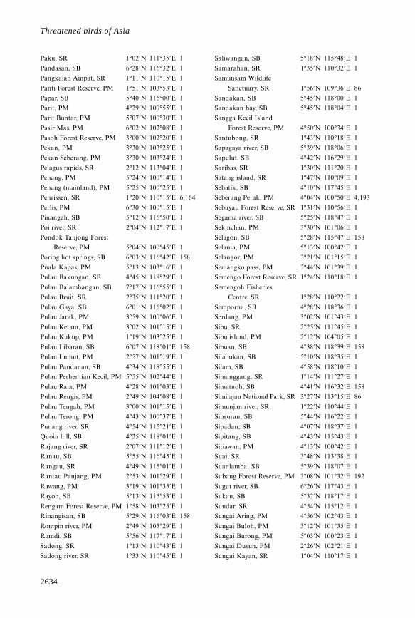
2634
Threatened birds of Asia
Paku, SR 1°02’N 111°35’E 1
Pandasan, SB 6°28’N 116°32’E 1
Pangkalan Ampat, SR 1°11’N 110°15’E 1
Panti Forest Reserve, PM 1°51’N 103°53’E 1
Papar, SB 5°40’N 116°00’E 1
Parit, PM 4°29’N 100°55’E 1
Parit Buntar, PM 5°07’N 100°30’E 1
Pasir Mas, PM 6°02’N 102°08’E 1
Pasoh Forest Reserve, PM 3°00’N 102°20’E 1
Pekan, PM 3°30’N 103°25’E 1
Pekan Seberang, PM 3°30’N 103°24’E 1
Pelagus rapids, SR 2°12’N 113°04’E 1
Penang, PM 5°24’N 100°14’E 1
Penang (mainland), PM 5°25’N 100°25’E 1
Penrissen, SR 1°20’N 110°15’E 6,164
Perlis, PM 6°30’N 100°15’E 1
Pinangah, SB 5°12’N 116°50’E 1
Poi river, SR 2°04’N 112°17’E 1
Pondok Tanjong Forest
Reserve, PM 5°04’N 100°45’E 1
Poring hot springs, SB 6°03’N 116°42’E 158
Puala Kapas, PM 5°13’N 103°16’E 1
Pulau Bakungan, SB 4°45’N 118°29’E 1
Pulau Balambangan, SB 7°17’N 116°55’E 1
Pulau Bruit, SR 2°35’N 111°20’E 1
Pulau Gaya, SB 6°01’N 116°02’E 1
Pulau Jarak, PM 3°59’N 100°06’E 1
Pulau Ketam, PM 3°02’N 101°15’E 1
Pulau Kukup, PM 1°19’N 103°25’E 1
Pulau Libaran, SB 6°07’N 118°01’E 158
Pulau Lumut, PM 2°57’N 101°19’E 1
Pulau Pandanan, SB 4°34’N 118°55’E 1
Pulau Perhentian Kecil, PM 5°55’N 102°44’E 1
Pulau Raia, PM 4°28’N 101°03’E 1
Pulau Rengis, PM 2°49’N 104°08’E 1
Pulau Tengah, PM 3°00’N 101°15’E 1
Pulau Terong, PM 4°43’N 100°37’E 1
Punang river, SR 4°54’N 115°21’E 1
Quoin hill, SB 4°25’N 118°01’E 1
Rajang river, SR 2°07’N 111°12’E 1
Ranau, SB 5°55’N 116°45’E 1
Rangau, SR 4°49’N 115°01’E 1
Rantau Panjang, PM 2°53’N 101°29’E 1
Rawang, PM 3°19’N 101°35’E 1
Rayoh, SB 5°13’N 115°53’E 1
Rengam Forest Reserve, PM 1°58’N 103°25’E 1
Rinangisan, SB 5°29’N 116°03’E 158
Rompin river, PM 2°49’N 103°29’E 1
Rumdi, SB 5°56’N 117°17’E 1
Sadong, SR 1°13’N 110°43’E 1
Sadong river, SR 1°33’N 110°45’E 1
Saliwangan, SB 5°18’N 115°48’E 1
Samarahan, SR 1°35’N 110°32’E 1
Samunsam Wildlife
Sanctuary, SR 1°56’N 109°36’E 86
Sandakan, SB 5°45’N 118°00’E 1
Sandakan bay, SB 5°45’N 118°04’E 1
Sangga Kecil Island
Forest Reserve, PM 4°50’N 100°34’E 1
Santubong, SR 1°43’N 110°18’E 1
Sapagaya river, SB 5°39’N 118°06’E 1
Sapulut, SB 4°42’N 116°29’E 1
Saribas, SR 1°30’N 111°20’E 1
Satang island, SR 1°47’N 110°09’E 1
Sebatik, SB 4°10’N 117°45’E 1
Seberang Perak, PM 4°04’N 100°50’E 4,193
Sebuyau Forest Reserve, SR 1°31’N 110°56’E 1
Segama river, SB 5°25’N 118°47’E 1
Sekinchan, PM 3°30’N 101°06’E 1
Selagon, SB 5°28’N 115°47’E 158
Selama, PM 5°13’N 100°42’E 1
Selangor, PM 3°21’N 101°15’E 1
Semangko pass, PM 3°44’N 101°39’E 1
Semengo Forest Reserve, SR 1°24’N 110°18’E 1
Semengoh Fisheries
Centre, SR 1°28’N 110°22’E 1
Semporna, SB 4°28’N 118°36’E 1
Serdang, PM 3°02’N 101°43’E 1
Sibu, SR 2°25’N 111°45’E 1
Sibu island, PM 2°12’N 104°05’E 1
Sibuan, SB 4°38’N 118°39’E 158
Silabukan, SB 5°10’N 118°35’E 1
Silam, SB 4°58’N 118°10’E 1
Simanggang, SR 1°14’N 111°27’E 1
Simatuoh, SB 4°41’N 116°32’E 158
Similajau National Park, SR 3°27’N 113°15’E 86
Simunjan river, SR 1°22’N 110°44’E 1
Sinsuran, SB 5°44’N 116°22’E 1
Sipadan, SB 4°07’N 118°37’E 1
Sipitang, SB 4°43’N 115°43’E 1
Sitiawan, PM 4°13’N 100°42’E 1
Suai, SR 3°48’N 113°38’E 1
Suanlamba, SB 5°39’N 118°07’E 1
Subang Forest Reserve, PM 3°08’N 101°32’E 192
Sugut river, SB 6°26’N 117°43’E 1
Sukau, SB 5°32’N 118°17’E 1
Sundar, SR 4°54’N 115°12’E 1
Sungai Aring, PM 4°56’N 102°43’E 1
Sungai Buloh, PM 3°12’N 101°35’E 1
Sungai Burong, PM 5°03’N 100°23’E 1
Sungai Dusun, PM 2°26’N 102°21’E 1
Sungai Kayan, SR 1°04’N 110°17’E 1
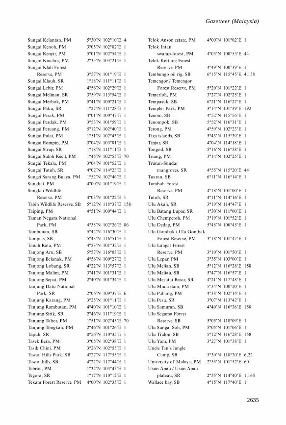
2635
Gazetteer
Sungai Kelantan, PM 5°30’N 102°10’E 4
Sungai Kenoh, PM 3°05’N 102°02’E 1
Sungai Kenyir, PM 5°01’N 102°54’E 1
Sungai Kinchin, PM 2°35’N 103°21’E 1
Sungai Klah Forest
Reserve, PM 3°57’N 101°19’E 1
Sungai Klauh, SR 1°18’N 111°11’E 1
Sungai Lebir, PM 4°56’N 102°29’E 1
Sungai Melinau, SR 3°59’N 113°54’E 1
Sungai Merbok, PM 5°41’N 100°21’E 1
Sungai Paku, SR 1°27’N 111°28’E 1
Sungai Perak, PM 4°01’N 100°47’E 1
Sungai Perdak, PM 3°53’N 101°59’E 1
Sungai Petuang, PM 5°12’N 102°40’E 1
Sungai Pulai, PM 1°51’N 102°43’E 1
Sungai Rompin, PM 3°04’N 103°01’E 1
Sungai Strap, SR 1°18’N 111°11’E 1
Sungai Suloh Kecil, PM 1°45’N 102°55’E 70
Sungai Tekala, PM 3°04’N 101°52’E 1
Sungai Tutuh, SR 4°02’N 114°23’E 1
Sungei Sarang Buaya, PM 1°52’N 102°46’E 1
Sungkai, PM 4°00’N 101°19’E 1
Sungkai Wildlife
Reserve, PM 4°03’N 101°22’E 1
Tabin Wildlife Reserve, SB 5°12’N 118°37’E 158
Taiping, PM 4°51’N 100°44’E 1
Taman Negara National
Park, PM 4°38’N 102°26’E 86
Tambunan, SB 5°42’N 116°30’E 1
Tampias, SB 5°43’N 116°51’E 1
Tanah Rata, PM 4°23’N 101°32’E 1
Tanjong Aru, SB 5°57’N 116°03’E 1
Tanjong Belanak, PM 4°56’N 100°27’E 1
Tanjong Lobang, SR 4°22’N 113°57’E 1
Tanjong Malim, PM 3°41’N 101°31’E 1
Tanjong Sepat, PM 2°40’N 101°34’E 1
Tanjung Datu National
Park, SR 2°06’N 109°37’E 6
Tanjung Karang, PM 3°25’N 101°11’E 1
Tanjung Rambutan, PM 4°40’N 101°10’E 1
Tanjung Sirik, SR 2°46’N 111°19’E 1
Tanjung Tahor, PM 1°51’N 102°45’E 70
Tanjung Tongkah, PM 2°46’N 101°26’E 1
Tapuh, SR 0°56’N 110°35’E 1
Tasek Bera, PM 3°05’N 102°38’E 1
Tasik Chini, PM 3°26’N 102°55’E 1
Tawau Hills Park, SB 4°27’N 117°55’E 1
Tawau hills, SB 4°22’N 117°44’E 1
Tebrau, PM 1°32’N 103°45’E 1
Tegora, SR 1°17’N 110°12’E 1
Tekam Forest Reserve, PM 4°00’N 102°35’E 1
Telok Anson estate, PM 4°00’N 101°02’E 1
Telok Intan
swamp-forest, PM 4°05’N 100°55’E 44
Telok Kertang Forest
Reserve, PM 4°49’N 100°39’E 1
Tembungo oil rig, SB 6°15’N 115°45’E 4,158
Temengor / Temengor
Forest Reserve, PM 5°20’N 101°22’E 1
Temerloh, PM 3°27’N 102°25’E 1
Tempasuk, SB 6°21’N 116°27’E 1
Templer Park, PM 3°14’N 101°39’E 192
Tenom, SB 4°52’N 115°56’E 1
Tenompok, SB 5°52’N 116°31’E 1
Terong, PM 4°59’N 102°23’E 1
Tiga islands, SB 5°43’N 115°39’E 1
Tinjar, SR 4°04’N 114°18’E 1
Tongod, SB 5°16’N 116°58’E 1
Triang, PM 3°14’N 102°25’E 1
Trusan-Sundar
mangroves, SR 4°55’N 115°20’E 44
Tuaran, SB 6°11’N 116°14’E 1
Tumboh Forest
Reserve, PM 4°18’N 101°00’E 1
Tutoh, SR 4°11’N 114°16’E 1
Ulu Akah, SR 3°19’N 114°47’E 1
Ulu Batang Lupar, SR 1°30’N 111°00’E 1
Ulu Chemperoh, PM 3°19’N 101°52’E 1
Ulu Dedap, PM 5°48’N 100°45’E 1
Ulu Gombak / Ulu Gombak
Forest Reserve, PM 3°18’N 101°47’E 1
Ulu Langat Forest
Reserve, PM 3°10’N 101°50’E 1
Ulu Lepar, PM 3°35’N 103°00’E 1
Ulu Melian, SB 5°12’N 116°28’E 158
Ulu Meliau, SB 5°47’N 116°57’E 1
Ulu Merutai Besar, SB 4°21’N 117°48’E 1
Ulu Muda dam, PM 5°34’N 100°20’E 1
Ulu Pahang, PM 4°38’N 102°14’E 1
Ulu Pesu, SR 3°07’N 113°42’E 1
Ulu Samuran, SB 4°40’N 116°36’E 158
Ulu Segama Forest
Reserve, SB 5°05’N 118°09’E 1
Ulu Sungai Soh, PM 5°05’N 101°06’E 1
Ulu Tiulon, SB 5°12’N 116°28’E 158
Ulu Yam, PM 3°27’N 101°38’E 1
Uncle Tan’s Jungle
Camp, SB 5°30’N 118°20’E 6,22
University of Malaya, PM 2°53’N 101°52’E 60
Usun Apau / Usun Apau
plateau, SR 2°55’N 114°40’E 1,164
Wallace bay, SB 4°15’N 117°40’E 1
Gazetteer (Malaysia)
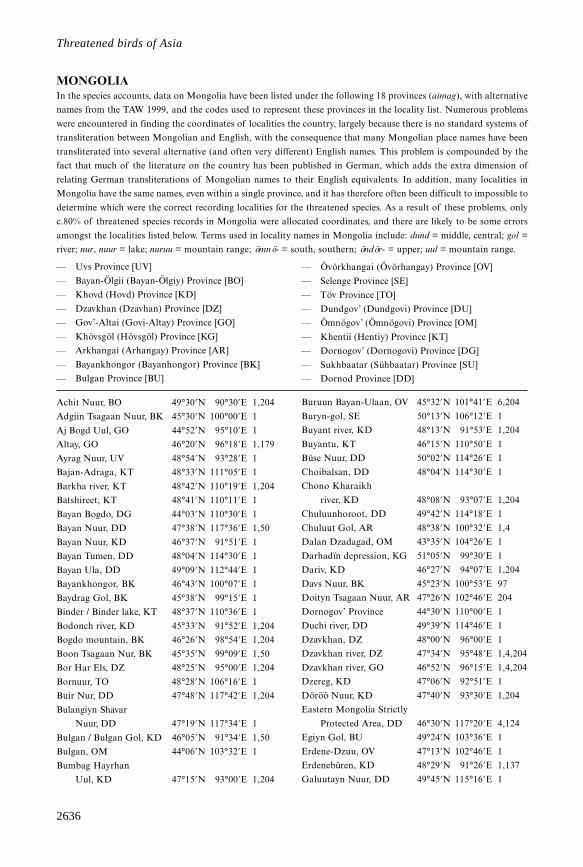
2636
Threatened birds of Asia
MONGOLIAIn the species accounts, data on Mongolia have been listed under the following 18 provinces (aimag), with alternative
names from the TAW 1999, and the codes used to represent these provinces in the locality list. Numerous problems
were encountered in finding the coordinates of localities the country, largely because there is no standard systems of
transliteration between Mongolian and English, with the consequence that many Mongolian place names have been
transliterated into several alternative (and often very different) English names. This problem is compounded by the
fact that much of the literature on the country has been published in German, which adds the extra dimension of
relating German transliterations of Mongolian names to their English equivalents. In addition, many localities in
Mongolia have the same names, even within a single province, and it has therefore often been difficult to impossible to
determine which were the correct recording localities for the threatened species. As a result of these problems, only
c.80% of threatened species records in Mongolia were allocated coordinates, and there are likely to be some errors
amongst the localities listed below. Terms used in locality names in Mongolia include: dund = middle, central; gol =
river; nur, nuur = lake; nuruu = mountain range; ömnö- = south, southern; öndör- = upper; uul = mountain range.
— Uvs Province [UV]
— Bayan-Ölgii (Bayan-Ölgiy) Province [BO]
— Khovd (Hovd) Province [KD]
— Dzavkhan (Dzavhan) Province [DZ]
— Gov’-Altai (Govi-Altay) Province [GO]
— Khövsgöl (Hövsgöl) Province [KG]
— Arkhangai (Arhangay) Province [AR]
— Bayankhongor (Bayanhongor) Province [BK]
— Bulgan Province [BU]
— Övörkhangai (Övörhangay) Province [OV]
— Selenge Province [SE]
— Töv Province [TO]
— Dundgov’ (Dundgovi) Province [DU]
— Ömnögov’ (Ömnögovi) Province [OM]
— Khentii (Hentiy) Province [KT]
— Dornogov’ (Dornogovi) Province [DG]
— Sukhbaatar (Sühbaatar) Province [SU]
— Dornod Province [DD]
Achit Nuur, BO 49°30’N 90°30’E 1,204
Adgiin Tsagaan Nuur, BK 45°30’N 100°00’E 1
Aj Bogd Uul, GO 44°52’N 95°10’E 1
Altay, GO 46°20’N 96°18’E 1,179
Ayrag Nuur, UV 48°54’N 93°28’E 1
Bajan-Adraga, KT 48°33’N 111°05’E 1
Barkha river, KT 48°42’N 110°19’E 1,204
Batshireet, KT 48°41’N 110°11’E 1
Bayan Bogdo, DG 44°03’N 110°30’E 1
Bayan Nuur, DD 47°38’N 117°36’E 1,50
Bayan Nuur, KD 46°37’N 91°51’E 1
Bayan Tumen, DD 48°04’N 114°30’E 1
Bayan Ula, DD 49°09’N 112°44’E 1
Bayankhongor, BK 46°43’N 100°07’E 1
Baydrag Gol, BK 45°38’N 99°15’E 1
Binder / Binder lake, KT 48°37’N 110°36’E 1
Bodonch river, KD 45°33’N 91°52’E 1,204
Bogdo mountain, BK 46°26’N 98°54’E 1,204
Boon Tsagaan Nur, BK 45°35’N 99°09’E 1,50
Bor Har Els, DZ 48°25’N 95°00’E 1,204
Bornuur, TO 48°28’N 106°16’E 1
Buir Nur, DD 47°48’N 117°42’E 1,204
Bulangiyn Shavar
Nuur, DD 47°19’N 117°34’E 1
Bulgan / Bulgan Gol, KD 46°05’N 91°34’E 1,50
Bulgan, OM 44°06’N 103°32’E 1
Bumbag Hayrhan
Uul, KD 47°15’N 93°00’E 1,204
Buruun Bayan-Ulaan, OV 45°32’N 101°41’E 6,204
Buryn-gol, SE 50°13’N 106°12’E 1
Buyant river, KD 48°13’N 91°53’E 1,204
Buyantu, KT 46°15’N 110°50’E 1
Büse Nuur, DD 50°02’N 114°26’E 1
Choibalsan, DD 48°04’N 114°30’E 1
Chono Kharaikh
river, KD 48°08’N 93°07’E 1,204
Chuluunhoroot, DD 49°42’N 114°18’E 1
Chuluut Gol, AR 48°38’N 100°32’E 1,4
Dalan Dzadagad, OM 43°35’N 104°26’E 1
Darhadïn depression, KG 51°05’N 99°30’E 1
Dariv, KD 46°27’N 94°07’E 1,204
Davs Nuur, BK 45°23’N 100°53’E 97
Doityn Tsagaan Nuur, AR 47°26’N 102°46’E 204
Dornogov’ Province 44°30’N 110°00’E 1
Duchi river, DD 49°39’N 114°46’E 1
Dzavkhan, DZ 48°00’N 96°00’E 1
Dzavkhan river, DZ 47°34’N 95°48’E 1,4,204
Dzavkhan river, GO 46°52’N 96°15’E 1,4,204
Dzereg, KD 47°06’N 92°51’E 1
Döröö Nuur, KD 47°40’N 93°30’E 1,204
Eastern Mongolia Strictly
Protected Area, DD 46°30’N 117°20’E 4,124
Egiyn Gol, BU 49°24’N 103°36’E 1
Erdene-Dzuu, OV 47°13’N 102°46’E 1
Erdenebüren, KD 48°29’N 91°26’E 1,137
Galuutayn Nuur, DD 49°45’N 115°16’E 1
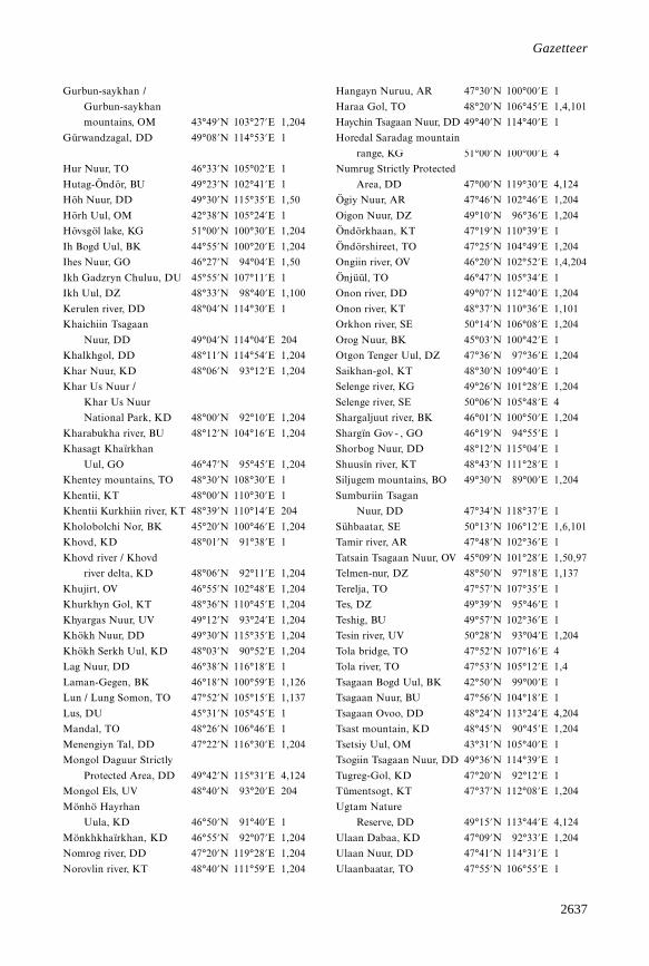
2637
Gazetteer
Gurbun-saykhan /
Gurbun-saykhan
mountains, OM 43°49’N 103°27’E 1,204
Gürwandzagal, DD 49°08’N 114°53’E 1
Hangayn Nuruu, AR 47°30’N 100°00’E 1
Haraa Gol, TO 48°20’N 106°45’E 1,4,101
Haychin Tsagaan Nuur, DD 49°40’N 114°40’E 1
Horedal Saradag mountain
range, KG 51°00’N 100°00’E 4
Hur Nuur, TO 46°33’N 105°02’E 1
Hutag-Öndör, BU 49°23’N 102°41’E 1
Höh Nuur, DD 49°30’N 115°35’E 1,50
Hörh Uul, OM 42°38’N 105°24’E 1
Hövsgöl lake, KG 51°00’N 100°30’E 1,204
Ih Bogd Uul, BK 44°55’N 100°20’E 1,204
Ihes Nuur, GO 46°27’N 94°04’E 1,50
Ikh Gadzryn Chuluu, DU 45°55’N 107°11’E 1
Ikh Uul, DZ 48°33’N 98°40’E 1,100
Kerulen river, DD 48°04’N 114°30’E 1
Khaichiin Tsagaan
Nuur, DD 49°04’N 114°04’E 204
Khalkhgol, DD 48°11’N 114°54’E 1,204
Khar Nuur, KD 48°06’N 93°12’E 1,204
Khar Us Nuur /
Khar Us Nuur
National Park, KD 48°00’N 92°10’E 1,204
Kharabukha river, BU 48°12’N 104°16’E 1,204
Khasagt Khaïrkhan
Uul, GO 46°47’N 95°45’E 1,204
Khentey mountains, TO 48°30’N 108°30’E 1
Khentii, KT 48°00’N 110°30’E 1
Khentii Kurkhiin river, KT 48°39’N 110°14’E 204
Kholobolchi Nor, BK 45°20’N 100°46’E 1,204
Khovd, KD 48°01’N 91°38’E 1
Khovd river / Khovd
river delta, KD 48°06’N 92°11’E 1,204
Khujirt, OV 46°55’N 102°48’E 1,204
Khurkhyn Gol, KT 48°36’N 110°45’E 1,204
Khyargas Nuur, UV 49°12’N 93°24’E 1,204
Khökh Nuur, DD 49°30’N 115°35’E 1,204
Khökh Serkh Uul, KD 48°03’N 90°52’E 1,204
Lag Nuur, DD 46°38’N 116°18’E 1
Laman-Gegen, BK 46°18’N 100°59’E 1,126
Lun / Lung Somon, TO 47°52’N 105°15’E 1,137
Lus, DU 45°31’N 105°45’E 1
Mandal, TO 48°26’N 106°46’E 1
Menengiyn Tal, DD 47°22’N 116°30’E 1,204
Mongol Daguur Strictly
Protected Area, DD 49°42’N 115°31’E 4,124
Mongol Els, UV 48°40’N 93°20’E 204
Mönhö Hayrhan
Uula, KD 46°50’N 91°40’E 1
Mönkhkhaïrkhan, KD 46°55’N 92°07’E 1,204
Nomrog river, DD 47°20’N 119°28’E 1,204
Norovlin river, KT 48°40’N 111°59’E 1,204
Numrug Strictly Protected
Area, DD 47°00’N 119°30’E 4,124
Ögiy Nuur, AR 47°46’N 102°46’E 1,204
Oigon Nuur, DZ 49°10’N 96°36’E 1,204
Öndörkhaan, KT 47°19’N 110°39’E 1
Öndörshireet, TO 47°25’N 104°49’E 1,204
Ongiin river, OV 46°20’N 102°52’E 1,4,204
Önjüül, TO 46°47’N 105°34’E 1
Onon river, DD 49°07’N 112°40’E 1,204
Onon river, KT 48°37’N 110°36’E 1,101
Orkhon river, SE 50°14’N 106°08’E 1,204
Orog Nuur, BK 45°03’N 100°42’E 1
Otgon Tenger Uul, DZ 47°36’N 97°36’E 1,204
Saikhan-gol, KT 48°30’N 109°40’E 1
Selenge river, KG 49°26’N 101°28’E 1,204
Selenge river, SE 50°06’N 105°48’E 4
Shargaljuut river, BK 46°01’N 100°50’E 1,204
Shargïn Gov - , GO 46°19’N 94°55’E 1
Shorbog Nuur, DD 48°12’N 115°04’E 1
Shuusïn river, KT 48°43’N 111°28’E 1
Siljugem mountains, BO 49°30’N 89°00’E 1,204
Sumburiin Tsagan
Nuur, DD 47°34’N 118°37’E 1
Sühbaatar, SE 50°13’N 106°12’E 1,6,101
Tamir river, AR 47°48’N 102°36’E 1
Tatsain Tsagaan Nuur, OV 45°09’N 101°28’E 1,50,97
Telmen-nur, DZ 48°50’N 97°18’E 1,137
Terelja, TO 47°57’N 107°35’E 1
Tes, DZ 49°39’N 95°46’E 1
Teshig, BU 49°57’N 102°36’E 1
Tesin river, UV 50°28’N 93°04’E 1,204
Tola bridge, TO 47°52’N 107°16’E 4
Tola river, TO 47°53’N 105°12’E 1,4
Tsagaan Bogd Uul, BK 42°50’N 99°00’E 1
Tsagaan Nuur, BU 47°56’N 104°18’E 1
Tsagaan Ovoo, DD 48°24’N 113°24’E 4,204
Tsast mountain, KD 48°45’N 90°45’E 1,204
Tsetsiy Uul, OM 43°31’N 105°40’E 1
Tsogiin Tsagaan Nuur, DD 49°36’N 114°39’E 1
Tugreg-Gol, KD 47°20’N 92°12’E 1
Tümentsogt, KT 47°37’N 112°08’E 1,204
Ugtam Nature
Reserve, DD 49°15’N 113°44’E 4,124
Ulaan Dabaa, KD 47°09’N 92°33’E 1,204
Ulaan Nuur, DD 47°41’N 114°31’E 1
Ulaanbaatar, TO 47°55’N 106°55’E 1
2638
Threatened birds of Asia
Uldz river, DD 49°26’N 114°00’E 4
Uliastayn Gol, KD 46°27’N 91°00’E 1,137
Umun-delger Somon, KT 47°52’N 109°55’E 1
Un’t, BU 49°08’N 102°49’E 1,137
Urd Tamir river, AR 47°50’N 101°49’E 1,204
Uureg Nuur, UV 50°10’N 91°00’E 1,204
Uvs Nuur, UV 50°20’N 92°45’E 1,204
Yolyn Am, OM 44°00’N 104°00’E 204
Zereg lake, KD 47°13’N 92°45’E 204
Zheltura, SE 50°29’N 105°07’E 1,204
MYANMARTerms used in locality names in Myanmar include: bum = mountain; chaung = river; hka = river; kyun = island; yoma
= mountain range.
Abya 17°30’N 96°46’E 1
Adung valley 28°20’N 97°45’E 96
Ahke 26°55’N 98°12’E 15
Arakan 19°00’N 94°15’E 1
Arakan hills 19°55’N 94°18’E 224
Ataran valley 16°31’N 97°40’E 1
Auk Singwe 23°55’N 95°17’E 1
Aukchindaung 17°38’N 96°08’E 1
Ayeindama 24°59’N 97°14’E 1
Bampon 20°30’N 97°45’E 1
Bandi 22°22’N 96°19’E 1
Bankachon 10°09’N 98°36’E 1
Bansadein 10°20’N 98°32’E 1
Bassein 16°47’N 94°44’E 1
Bernardmyo 23°01’N 96°27’E 1
Bhamo / Bhamo district 24°16’N 97°14’E 1
Bilugyun island 16°24’N 97°32’E 1
Bokpyin 11°16’N 98°46’E 1
Boulay 19°13’N 95°11’E 4,72
Byibon 22°20’N 96°15’E 1
Champang 10°13’N 98°31’E 1
Chaunggwa 18°52’N 96°30’E 1
Chaungwa 25°17’N 96°28’E 1
Cheduba island 18°48’N 93°38’E 1
Chimili hills 26°11’N 98°44’E 224
China Bakeer 16°21’N 96°05’E 1
Chipwi 25°53’N 98°08’E 1
Daiktu 18°13’N 96°45’E 1
Daingtaya reserve 18°09’N 96°28’E 1
Dimlo 23°20’N 93°43’E 1
Elephant Point 16°29’N 96°20’E 1
Falam 22°55’N 93°41’E 1
Fort Hertz 27°21’N 97°24’E 1
Fort White 23°14’N 93°47’E 1
Great Defile 24°40’N 97°05’E 4,138
Gwethi Reserve 19°18’N 96°26’E 1
Hainggyin 23°58’N 93°26’E 1
Haka 22°59’N 94°01’E 1
Haungtharaw river 16°30’N 98°13’E 1
Heho swamp 20°43’N 96°49’E 1
Henzada 17°38’N 95°28’E 1
Hintha 23°39’N 96°16’E 66
Hkamho 27°11’N 97°35’E 4,166
Hlawga 17°00’N 96°04’E 1
Hmawbi 16°15’N 95°42’E 1
Hnokkyo 24°16’N 96°40’E 1
Hokat / Hokat jheel 25°06’N 97°13’E 1
Homalin 24°52’N 94°55’E 1
Hpayangon 21°53’N 96°54’E 1
Hpungchanhka 26°43’N 97°35’E 1
Htawgaw hills 25°57’N 98°23’E 1
Htingnan 26°36’N 97°54’E 1
Hukawng valley 26°30’N 96°35’E 1
Indaw 11°58’N 99°03’E 1
Indawgyi lake 25°08’N 96°20’E 1
Ingade 22°39’N 95°56’E 1
Inle lake 20°32’N 96°55’E 1
Inma swamp 18°35’N 95°22’E 1
Insein 16°53’N 96°07’E 1
Irrawaddy delta 16°30’N 95°00’E 1
Jade mines 25°43’N 96°10’E 66
Kabaw valley 24°20’N 94°25’E 1
Kabo 22°54’N 95°30’E 1
Kachin hills 26°00’N 97°30’E 1
Kadan Kyun 12°30’N 98°22’E 1
Kado 16°35’N 97°40’E 1
Kadu lake 22°04’N 95°54’E 1
Kalat 24°35’N 95°57’E 1
Kalaw 20°38’N 96°34’E 1
Kalewa 23°12’N 94°18’E 1
Kambaiti 25°24’N 98°09’E 1
Kampong Pulo Tonton 10°01’N 98°31’E 37
Kanpetlet 21°11’N 94°03’E 147
Karenni 19°15’N 97°30’E 1
Karokpi 15°51’N 97°43’E 1
Kaukarit 17°22’N 97°44’E 4,128
Kaukkwe chaung 24°20’N 96°34’E 1
Kaunghein 25°41’N 95°26’E 1
Kawkarieka 16°33’N 98°18’E 6
Kawlin 23°47’N 95°41’E 1
2639
Gazetteer
Kayinlegyin 19°23’N 96°11’E 1
Kaywe 17°35’N 96°54’E 1
Keng Tang 21°18’N 99°39’E 1
Khaungpu 25°04’N 97°18’E 4,166
Kindat 23°44’N 94°26’E 1
Kinzan 22°31’N 95°10’E 1
Kolo 18°08’N 96°39’E 1
Koolay 22°34’N 96°00’E 1
Kule 20°57’N 95°20’E 1
Kunphe 24°36’N 96°38’E 66
Kyagan Kwinbauk
Reserve Forest 16°07’N 94°36’E 1
Kyaikhto 16°18’N 97°55’E 1
Kyaikkami 16°04’N 97°34’E 1
Kyeikpadein 17°15’N 96°33’E 4,127
Kyundawzu 19°12’N 96°12’E 1
Labutta 16°09’N 94°46’E 1
Laukkaung 25°54’N 98°11’E 224
Lemro river 21°35’N 93°05’E 6
Lenya 11°28’N 99°00’E 1
Letsok-aw Kyun 11°37’N 98°15’E 1
Loi Maw 20°27’N 97°24’E 1
Loi Mwe 21°11’N 99°46’E 1
Loi Un 20°46’N 99°01’E 1
Loi-San-Pa 20°53’N 98°46’E 1
Lunbye 17°12’N 96°42’E 1
Mabein 23°29’N 96°37’E 1
Magwe 20°09’N 94°55’E 1
Malewoon 10°15’N 98°46’E 4,128
Maliwun 10°14’N 98°37’E 1
Mandalay 22°00’N 96°05’E 1
Mandalay canal 21°50’N 96°12’E 1
Mansi 24°58’N 95°36’E 66
Marang 10°27’N 98°47’E 1
Maubin 16°44’N 95°39’E 1
Maubin 21°58’N 95°40’E 1
Maymyo / Maymyo lake 22°02’N 96°28’E 1
Mekh Rame 26°44’N 98°23’E 1
Mekong valley 21°00’N 100°33’E 4
Menetaung range 21°20’N 96°40’E 1
Mergui 12°26’N 98°36’E 1
Mezali weir 20°19’N 94°30’E 1
Minbu 20°11’N 94°53’E 1
Minbu district 20°15’N 94°15’E 1
Mindat 21°22’N 93°59’E 1
Minhla-Nyaung lake 20°50’N 96°02’E 123
Mogaung chaung 25°17’N 96°56’E 66
Mogok 22°55’N 96°30’E 1
Mohingyi Wetland
Sanctuary 17°33’N 96°37’E 153
Mohlaing 23°37’N 96°58’E 1
Mong Hang 21°38’N 99°31’E 1
Mong Hsawk 20°35’N 96°57’E 1
Mong Pai 20°00’N 97°00’E 123
Mong Pawn 20°49’N 97°28’E 1
Mongnai 20°41’N 97°15’E 1
Monnyin 20°20’N 94°22’E 1
Moulmein 16°30’N 97°38’E 1
Mount Victoria 21°14’N 93°55’E 1
Mu river 22°45’N 95°28’E 1,4
Mulayit 16°11’N 98°32’E 1
Myaungmya 16°36’N 94°56’E 1
Myawadi 16°41’N 98°31’E 1
Myingyan 21°28’N 95°23’E 1
Myingyan district 21°15’N 95°15’E 1
Myitkyina 25°23’N 97°24’E 1
Myitkyo 17°36’N 96°48’E 1,224
Myitmaka river 17°26’N 95°48’E 1
Myitta 14°10’N 98°31’E 1
Myohla 18°49’N 95°23’E 1
Naf river 20°43’N 92°22’E 1
Nampan lake 20°27’N 96°55’E 1
Nanyaseik 25°37’N 96°36’E 1
Nattaung 18°48’N 97°02’E 1
Needong hills 16°14’N 97°57’E 4,73
Ngabyema 16°17’N 97°52’E 1
Ngahlauk 19°21’N 95°41’E 1
Ngawchang 26°19’N 98°18’E 1
Ngawun chaung 12°05’N 99°01’E 1
Ngwedaung 22°29’N 96°05’E 1
Nogmung-Pagnamdim
track 27°22’N 97°26’E 1
North Chin hills 23°30’N 93°50’E 224
North Nawin Reserved
Forest 19°07’N 95°47’E 1
Nwalabo Reserved Forest 14°05’N 98°24’E 1
Nyaungbinhla 23°41’N 95°28’E 1
Nyaungu 21°12’N 94°55’E 6
Nyaungwun 22°29’N 96°05’E 1
Onbingwin 14°37’N 97°59’E 1
Padaung 18°43’N 95°09’E 1
Padu 20°00’N 95°20’E 1
Pagan 21°10’N 94°52’E 1
Paghein 17°47’N 96°40’E 4,128
Pakabo Reserve 15°54’N 98°05’E 1
Pakchan / Pakchan river 10°30’N 98°49’E 1
Paletwa Township Group 21°26’N 93°04’E 66
Palon 17°26’N 95°54’E 224
Pangnamdin 27°44’N 97°53’E 1
Panwa pass 25°35’N 98°23’E 224
Papun 18°04’N 97°27’E 1,4,128
Paukkaung 18°54’N 95°33’E 1
2640
Threatened birds of Asia
Paungdawthi 17°43’N 96°38’E 1
Paungde 18°29’N 95°30’E 1
Paunggyi /
Paunggyi valley 17°19’N 96°11’E 1
Paunglin lake 20°31’N 94°45’E 1
Payadaung 20°03’N 95°57’E 1
Payagale 17°30’N 96°32’E 1
Pegu 17°20’N 96°29’E 1
Penwegon 18°13’N 96°32’E 1
Pidaung Sanctuary 25°25’N 97°12’E 66
Pino 23°58’N 95°36’E 1
Putao 27°21’N 97°24’E 1
Pyinma chaung 16°15’N 94°28’E 1
Pyinmana 19°44’N 96°13’E 1
Ramkhlau 22°49’N 93°34’E 1
Ramree island 19°06’N 93°48’E 1
Ru chaung 20°51’N 93°14’E 1
Ruby mines 22°55’N 96°35’E 1
Sabyin 18°19’N 96°18’E 1
Sagagon 23°41’N 94°28’E 1
Salween river 16°31’N 97°37’E 1
Sameikkon 21°44’N 95°25’E 1
Sandoway district 18°30’N 94°30’E 1
Sangin 25°05’N 97°16’E 1
Sangpang range 26°30’N 95°50’E 1
Saramati 25°44’N 95°02’E 224
Seiktha 24°16’N 96°03’E 1
Shagribum 26°06’N 97°45’E 1
Shan hills 22°00’N 98°00’E 1
Shwe-u-daung Sanctuary 23°03’N 96°17’E 1
Shwebo 22°34’N 95°42’E 1
Shwebo district 23°00’N 95°30’E 1
Shwegyin 17°55’N 96°53’E 1
Shwelaung Kodugwe
Reserved Forest 17°45’N 96°22’E 1
Sinbo 24°46’N 97°03’E 1
Singan 23°34’N 96°48’E 1
Singon 24°08’N 95°56’E 1
Sittang estuary /
Sittang river 17°10’N 96°58’E 1
Sittwe 20°09’N 92°54’E 1
South Zamayi Reserve 18°08’N 96°04’E 1
Southern Shan States 21°00’N 98°00’E 1
Sumprabum 26°33’N 97°04’E 1
Sungei Baleihgyi 10°29’N 98°32’E 37
Ta-ok plateau 16°19’N 98°29’E 1
Tagaung 23°30’N 96°02’E 1
Taho 19°19’N 96°50’E 1
Taikkyi 17°19’N 95°58’E 1
Talawgyi 25°04’N 97°19’E 1
Tamanthi 25°19’N 95°17’E 1
Tamanthi Wildlife
Sanctuary 25°26’N 95°37’E 66
Tamu 24°13’N 94°19’E 1
Taron-Tamai junction 27°41’N 98°02’E 1
Tasang 23°24’N 98°02’E 1
Tatkon 20°07’N 96°13’E 1
Taunggyi 20°47’N 97°02’E 1
Tavoy 14°05’N 98°12’E 1
Tavoy river 13°43’N 98°13’E 1
Telok Besar 10°23’N 98°33’E 224
Thabyebin 24°13’N 96°31’E 1
Thabyegyin 21°53’N 96°25’E 1
Thagyet 12°06’N 99°07’E 1
Tharawaw 17°41’N 95°28’E 1
Tharrawaddy district 18°00’N 95°30’E 1
Thaton / Thaton district 16°55’N 97°22’E 1
Thaungyun 11°18’N 98°48’E 1
Thayawthadangyi 12°20’N 98°00’E 1
Thayetmyo 19°19’N 95°11’E 1
Thiangin 23°12’N 93°48’E 147
Thitgyi 18°15’N 96°13’E 1
Three Pagodas pass 15°17’N 98°24’E 6
Tiddim 23°22’N 93°40’E 1
Tonkwa 23°36’N 96°58’E 1
Toungoo 18°56’N 96°26’E 1
Trans-Salween Mawkmai 20°14’N 97°53’E 1
Upper Chidwin Township
Group 23°00’N 95°00’E 66
Upper Chindwin / Upper
Chindwin district 24°15’N 94°45’E 1
Upper Defile 24°40’N 97°05’E 4,138
Victoria point 9°58’N 98°33’E 1
Wadama 17°17’N 96°18’E 1
Wan Hat 20°14’N 97°53’E 1
Waw 17°28’N 96°41’E 1
Webaung 23°08’N 96°16’E 1
Wetlet / Wetlet tank 22°22’N 95°47’E 1
Wimpong / Wimpong rocks 16°49’N 97°28’E 4,128
Winyeo river 15°55’N 97°59’E 4
Yabu 13°43’N 98°09’E 1
Yangon 16°47’N 96°10’E 1
Yawnghwe 20°39’N 96°56’E 1
Ye 15°15’N 97°51’E 1
Yedaw 22°27’N 96°01’E 1
Yeni 19°29’N 96°15’E 1
Yeu canal 22°24’N 95°30’E 1
Yinke Reserved Forest 24°09’N 96°27’E 1
Yit lake 21°26’N 96°00’E 123
Yuwa 23°54’N 94°32’E 1
Zami river 16°09’N 97°58’E 1
Zigon 18°03’N 95°22’E 1
2641
Gazetteer
NEPAL
Badamachli 28°45’N 80°34’E 217
Bagarchhap 28°31’N 84°21’E 1
Baglung 28°16’N 83°36’E 1
Banke district 28°10’N 81°50’E 1
Bees Hazari Tal 27°37’N 84°26’E 203
Begnas Tal 28°11’N 84°06’E 1
Belbahadi 29°08’N 80°36’E 2
Betrawati 27°59’N 85°11’E 1
Bhairahawa 27°30’N 83°27’E 1
Bilauri 28°41’N 80°21’E 1
Biratnagar 26°29’N 87°17’E 1
Birethante 28°19’N 83°49’E 2
Birtamod 26°45’N 87°30’E 2
Butwal 27°42’N 83°27’E 1
Chainpur 27°17’N 87°19’E 1
Chandrakot 28°07’N 83°24’E 2
Dana 28°32’N 83°38’E 1
Dang district 28°00’N 82°25’E 1
Dhangarhi 28°41’N 80°36’E 1
Dhanusha district 26°50’N 86°05’E 1
Dharan forests 26°49’N 87°17’E 1
Dhorpatan 28°29’N 83°04’E 1
Dhunche 28°07’N 85°17’E 1
Dole 27°55’N 86°43’E 2
Doti 29°15’N 80°55’E 1
Gapte 28°05’N 85°18’E 2
Garuwa 26°54’N 87°50’E 4
Ghasa 28°34’N 83°38’E 2
Ghorepani 28°23’N 83°42’E 2
Godavari 27°36’N 85°24’E 1
Gokarna 27°44’N 85°24’E 1
Gokyo lake 27°57’N 86°42’E 2
Gosainkund 28°05’N 85°24’E 1
Hans Pokhari /
Hans Pokhari Danda 26°50’N 88°02’E 2
Helambu 27°57’N 85°29’E 1
Hetauda 27°25’N 85°02’E 1
Hille 28°25’N 83°45’E 2
Ilam / Ilam district 26°55’N 87°55’E 1
Itahari 26°40’N 87°17’E 1
Janakpur 26°42’N 85°55’E 1
Jhapa district 26°30’N 87°52’E 2
Jolbari 27°06’N 88°01’E 224
Jumla 29°30’N 82°15’E 1
Kagbeni 28°50’N 83°47’E 1
Kailali district 28°45’N 80°55’E 1
Kalopani 28°47’N 83°37’E 2
Kanchanpur / Kanchanpur
district 28°50’N 80°20’E 1
Kapilvastu district 27°40’N 82°55’E 1
Karnali river 28°25’N 81°12’E 4
Kathmandu 27°43’N 85°19’E 1
Kathmandu valley 27°40’N 85°21’E 1
Khangma 27°38’N 87°08’E 2
Khare 28°17’N 83°50’E 2
Kirantichap 27°38’N 86°04’E 1
Kopechani 28°37’N 83°37’E 217
Kosi Tappu Wildlife Reserve 26°38’N 86°59’E 86
Kosi barrage 26°36’N 86°55’E 2
Kyanjin Gompa 28°14’N 85°34’E 4
Langtang 28°13’N 85°35’E 1
Lete 28°38’N 83°37’E 1
Lower hills 27°12’N 85°53’E 6
Lumbini / Lumbini
Sanctuary 27°29’N 83°17’E 1
Lumle 28°19’N 83°48’E 2
Maghan Kharkaat 27°38’N 87°07’E 4,183
Mahakali 29°30’N 80°30’E 1
Mahotari district 26°55’N 85°50’E 1
Mai valley 26°40’N 87°40’E 2
Mai valley (upper) 27°04’N 87°58’E 224
Makalu Barun
Conservation Area 27°45’N 87°00’E 86
Manohara river 27°41’N 85°20’E 1
Morang district 26°40’N 87°30’E 1
Muktinath 28°49’N 83°53’E 1
Muri 28°31’N 83°21’E 224
Nagarjung 27°42’N 85°18’E 2
Narayanghat 27°41’N 84°25’E 1
Narayani river 27°36’N 84°10’E 4
Naubisse 27°43’N 85°09’E 1
Naudanda ridge 28°00’N 83°45’E 217
Navagaon 27°36’N 87°16’E 2
Nawalparasi 27°40’N 83°55’E 1
Nawalparasi district 27°40’N 83°55’E 1
Nepalganj 28°03’N 81°37’E 1
Pakhribas 27°02’N 87°18’E 217
Pangsang pass 29°28’N 82°50’E 2
Parsa Wildlife Reserve 27°21’N 84°48’E 86
Parsa district 27°20’N 84°50’E 1
Patan 27°40’N 85°20’E 1
Phewa Tal 28°13’N 83°57’E 2
Pipar 28°25’N 83°57’E 224
Pokhara / Pokhara valley 28°14’N 83°59’E 1
Pothana 28°22’N 83°48’E 217
Ragunthanpur 27°08’N 86°22’E 2
Rapti Dun 27°35’N 84°30’E 2
Rara Lake National Park 29°30’N 82°07’E 2
2642
Threatened birds of Asia
PAKISTANIn the species accounts, data on Pakistan have been listed under the following five territories (with the codes used to
represent them in the locality list). An important source used to find coordinates in the country was the gazetteer in
Roberts (1991–1992). The boundary between Pakistan and India is disputed, and records to the north and west of the
“line of control” (as mapped in the TAW 1999) have been listed under Pakistan. This does not imply the expression of
any opinion whatsoever on the part of BirdLife International concerning the legal status of any country, territory or
area, or concerning the delimitation of its frontiers or boundaries.
— North West Frontier Province [NW]
— Baluchistan Province [BA]
— Sind Province [SD]
Royal Bardia National Park 28°23’N 81°30’E 86
Royal Chitwan
National Park 27°35’N 84°20’E 1
Royal Sukla Phanta
Wildlife Reserve 28°48’N 80°15’E 2
Rupnagar 26°32’N 86°57’E 203
Santapur 27°02’N 87°56’E 217
Saptari district 26°35’N 86°45’E 1
Sarlahi district 27°00’N 85°35’E 1
Seti 29°15’N 81°10’E 1
Sheopuri 27°48’N 85°22’E 1
Shey-Phoksundo
National Park 29°25’N 82°47’E 86
Simara 27°10’N 84°59’E 1
Singalila range 27°28’N 88°04’E 1
Siraha district 26°45’N 86°20’E 1
Suikhet 28°16’N 83°57’E 2
Sukhani 26°44’N 87°57’E 224
Sukipatal 27°31’N 87°17’E 2
Sunsari 26°45’N 87°50’E 2
Sunsari district 26°40’N 87°10’E 1
Tamaspur 27°34’N 83°57’E 1
Tatopani 27°57’N 85°56’E 1
Taulihawa 27°40’N 82°55’E 1
Tikapur 28°30’N 81°10’E 2
Tikoli 27°38’N 84°30’E 1
Tribeni 26°55’N 87°10’E 1
Trisuli 27°55’N 85°09’E 1
Trisuli river 27°49’N 84°47’E 1
Tukche 28°43’N 83°40’E 2
Tumlingtar airstrip 27°17’N 87°21’E 2
Yamdi Khola 28°17’N 83°55’E 2
NORTH KOREA see KOREA
— Punjab Province [PJ]
— Kashmir Province (“Azad Kashmir”; currently
under the administration of Pakistan) [KS]
Ahmadpur Sial, PJ 30°41’N 71°46’E 1
Akara dam, BA 25°15’N 62°15’E 1
Akora, NW 34°00’N 72°08’E 1
Akri lake, SD 26°58’N 68°25’E 1
Ali Wahan, PJ 29°23’N 71°18’E 1
Alipur, PJ 29°23’N 70°55’E 1
Allai valley, NW 35°00’N 73°40’E 112,226
Atari, PJ 30°27’N 71°57’E 1
Attock, PJ 33°54’N 72°15’E 1
Ayubia National
Park, NW 33°52’N 73°09’E 86
Badin, SD 24°39’N 68°50’E 1
Bahawalnagar, PJ 29°59’N 73°16’E 224
Bahawalpur, PJ 29°24’N 71°41’E 1
Baltistan, NW 35°18’N 75°37’E 1
Band Murad Khan, BA 25°05’N 67°00’E 1
Bannu, NW 33°00’N 70°40’E 224
Bar Palas valley, NW 35°06’N 73°18’E 226
Bhamb, PJ 31°33’N 72°14’E 224
Bhegari, SD 27°43’N 68°54’E 142
Bhunja valley, NW 34°37’N 73°34’E 4
Bichla valley, NW 34°42’N 73°39’E 4
Bindi, SD 28°02’N 69°16’E 1
Bori, SD 28°15’N 69°45’E 1
Bumboret valley, NW 35°41’N 71°38’E 142
Chaman, BA 30°55’N 66°25’E 142
Charwo lake, SD 24°45’N 68°55’E 99
Chashma barrage, NW 32°27’N 71°19’E 142
Chatteji lake, SD 24°52’N 67°48’E 142
Chikarkot, NW 33°36’N 71°18’E 1
Chillianwala, PJ 32°39’N 73°36’E 1
Chiltan mountains, BA 30°03’N 66°51’E 1
Chitral, NW 35°51’N 71°47’E 1
Cholistan, PJ 28°15’N 70°45’E 1
Chuha Mal, PJ 32°28’N 74°01’E 1
Clifton beach, SD 24°49’N 67°02’E 1
Dab Kalan, PJ 30°43’N 71°53’E 224
Dabhko lake, SD 24°44’N 68°50’E 99
2643
Gazetteer
Dasht Kuar, BA 25°10’N 61°40’E 1
Deosai plains, NW 34°55’N 75°25’E 1
Dera Ghazi Khan
district, PJ 30°03’N 70°38’E 224
Dera Ismail Khan, NW 31°50’N 70°54’E 1
Dera Ismail Khan
district, NW 32°00’N 70°30’E 1
Derawar, PJ 28°46’N 71°20’E 1
Dhab Shumali, NW 32°15’N 71°15’E 4,159
Dhoro Naro, SD 25°30’N 69°34’E 1,99
Dost Ali, SD 27°40’N 67°53’E 1
Drigh Lake Wildlife
Sanctuary, SD 27°34’N 67°58’E 142
Drosh, NW 35°33’N 71°48’E 1
Duber, SD 27°32’N 68°23’E 142
Duber valley, NW 35°09’N 72°52’E 142
Dunga Gali, NW 34°03’N 73°22’E 142
Eastern Narra, SD 27°41’N 68°51’E 1
Faisalabad, PJ 31°25’N 73°05’E 1
Firoza, PJ 28°45’N 70°49’E 1
Fort Abbas, PJ 29°12’N 72°52’E 142
Fort Lockhart, NW 33°33’N 70°57’E 1
Fort Munro, PJ 29°54’N 69°58’E 1
Fyzabad, PJ 30°16’N 72°52’E 1
Gadra, SD 25°40’N 70°37’E 1
Galis, NW 34°04’N 73°24’E 2
Garhi Habibullah, NW 34°24’N 73°23’E 1
Ghaibi Dero, SD 27°36’N 67°39’E 1
Ghauspur, SD 28°08’N 69°05’E 1
Gilgit, NW 35°55’N 74°18’E 1
Gili, BA 26°20’N 65°38’E 1
Gujranwala, PJ 32°09’N 74°11’E 1
Gujrat, PJ 32°34’N 74°05’E 1
Gwadar, BA 25°07’N 62°20’E 142
Hab dam, SD 25°05’N 67°00’E 142
Hab river, BA 25°04’N 66°59’E 6
Hab valley, BA 26°05’N 67°17’E 142
Hadero lake, SD 24°50’N 67°51’E 1
Hafizabad, PJ 32°25’N 72°49’E 1
Haji Pir, KS 33°58’N 74°05’E 1
Hala, SD 25°49’N 68°25’E 1
Haleji lake, SD 24°49’N 67°46’E 1
Halkot, NW 34°37’N 73°10’E 1
Hamal, SD 27°23’N 67°37’E 1
Hamzewali, PJ 29°30’N 70°59’E 1
Haripur, PJ 33°59’N 72°56’E 1
Harunabad, PJ 29°37’N 73°08’E 1
Hazara district, NW 34°30’N 73°15’E 1
Hunza, NW 36°16’N 74°41’E 1
Hyderabad, SD 25°22’N 68°22’E 1
Indus delta, SD 24°30’N 68°00’E 1
Islamabad, PJ 33°42’N 73°10’E 1
Jacobabad, SD 28°17’N 68°26’E 1
Jahlar lake, PJ 32°30’N 72°06’E 1
Jajjah-Abbasian, PJ 28°45’N 70°34’E 1
Jallo Park, PJ 31°34’N 74°30’E 142
Jampur, PJ 29°39’N 70°36’E 1
Jamrao head, SD 26°26’N 68°52’E 1
Jamrud, NW 34°00’N 71°22’E 1
Jassar, PJ 32°06’N 74°57’E 1
Jati, SD 24°21’N 68°16’E 1
Jhang district, PJ 31°25’N 72°15’E 1
Jhelum, PJ 32°56’N 73°44’E 1
Jhelum district, PJ 32°50’N 73°00’E 1
Jherruck, SD 25°03’N 68°15’E 1
Jhimpir, SD 25°01’N 68°01’E 1
Kadhan, SD 24°29’N 68°59’E 1
Kaghan valley, NW 34°25’N 73°17’E 1
Kalabagh, PJ 32°58’N 71°34’E 1
Kalat, BA 29°02’N 66°35’E 1
Kallar Kahar /
Kallar Kahar lake, PJ 32°47’N 72°42’E 1
Kamoke, PJ 31°58’N 74°13’E 1
Kandhkot, SD 28°14’N 69°11’E 1
Kanshian nulla, NW 34°32’N 73°24’E 1
Karachi, SD 24°52’N 67°03’E 1
Karachi bay, SD 24°47’N 66°59’E 1
Karachi harbour, SD 24°47’N 66°59’E 1
Kasur district, PJ 31°00’N 74°10’E 1
Kayal valley, NW 35°12’N 73°02’E 224
Kazinag Game
Reserve, KS 34°09’N 73°57’E 1
Keshopur, PJ 32°26’N 72°50’E 1
Khabbaki lake, PJ 32°37’N 72°14’E 1
Khairpur, SD 27°32’N 68°46’E 1
Khairpur district, SD 26°55’N 69°00’E 1
Khangarh, PJ 29°55’N 71°10’E 1
Khanki, PJ 32°24’N 73°59’E 1
Khanwah, PJ 29°11’N 70°40’E 224
Khar, SD 25°17’N 67°09’E 1
Khar Roo lake, SD 25°56’N 69°19’E 67
Kharal, PJ 31°41’N 72°37’E 1
Kharan district, BA 28°00’N 64°30’E 142
Kharrar jheel, PJ 30°52’N 73°31’E 142
Khinjar lake, SD 24°56’N 68°03’E 142
Khipro, SD 25°50’N 69°22’E 1
Khiwa, PJ 31°27’N 72°28’E 224
Khushalgarh, NW 33°29’N 71°54’E 1
Khushdil Khan lake, BA 30°40’N 67°04’E 1
Khuttan, KS 34°35’N 73°45’E 142
Kohat, NW 33°35’N 71°26’E 1
Kohat district, NW 33°20’N 71°10’E 1
2644
Threatened birds of Asia
Kot Chutta, PJ 29°53’N 70°39’E 224
Kotri, SD 25°22’N 68°18’E 1
Kurram valley, NW 33°00’N 70°40’E 2
Kuz Palas valley, NW 35°00’N 73°06’E 226
Lachi, NW 33°23’N 71°20’E 1
Lahore, PJ 31°35’N 74°18’E 1
Lal Suhanra National
Park, PJ 29°24’N 72°01’E 86
Lalian, PJ 31°49’N 72°48’E 1
Lang, SD 27°30’N 68°03’E 142
Larkana, SD 27°33’N 68°13’E 1
Larkana district, SD 27°40’N 67°55’E 1
Leepa, KS 34°19’N 73°48’E 4,82
Ludha Mani, PJ 31°00’N 72°13’E 224
Machiara National
Park, KS 34°31’N 73°37’E 142
Mahboub Shah lake, SD 24°25’N 67°59’E 142
Manchar lake, SD 26°25’N 67°39’E 1
Mangla reservoir, PJ 33°10’N 73°40’E 1
Mangrani, SD 27°50’N 68°46’E 224
Manthar, PJ 28°06’N 70°10’E 1
Marala, PJ 32°39’N 74°30’E 1
Marala barrage, PJ 32°41’N 74°26’E 1
Mardan, NW 34°12’N 72°02’E 1
Margalla hills, NW 33°48’N 73°10’E 2
Mauripur, SD 24°52’N 66°55’E 1
Mehar, SD 27°11’N 67°49’E 1
Mianwali district, PJ 32°00’N 71°30’E 1
Mirpur Sakro, SD 24°33’N 67°37’E 1
Mirpurkhas, SD 25°32’N 69°00’E 1
Mithankot, PJ 28°57’N 70°22’E 1
Moach plains, SD 24°54’N 66°56’E 1
Mochiwala, PJ 31°18’N 72°34’E 1
Mohenjo Daro, SD 27°18’N 68°08’E 142
Moidan, BA 25°27’N 67°14’E 1
Mor Pati, BA 25°19’N 64°34’E 1
Mukhiana, PJ 31°23’N 72°28’E 1
Multan, PJ 30°11’N 71°29’E 1
Muradani lake, SD 24°25’N 67°43’E 1
Murdan, BA 30°15’N 67°05’E 2
Murree hills, NW 33°55’N 73°25’E 1
Muzaffarabad district, KS 34°45’N 74°00’E 1
Muzaffargarh, PJ 30°04’N 71°12’E 1
Nagar Parkar, SD 24°22’N 70°45’E 1
Nal, BA 27°40’N 66°12’E 1
Nammal / Nammal
lake, PJ 32°40’N 71°49’E 1
Naugram, KS 34°14’N 72°26’E 1
Nayabanda, NW 35°14’N 73°10’E 112,226
Neelum valley, KS 34°35’N 73°45’E 142
Nowshera, NW 34°01’N 71°59’E 1
Nurpur canal escape, PJ 31°41’N 72°36’E 4,194
Nushki, BA 29°33’N 66°01’E 1
Ormara, BA 25°12’N 64°38’E 1
Pabbi, NW 34°01’N 71°47’E 1
Padag, BA 29°01’N 65°18’E 1
Pahrwal, PJ 32°52’N 73°41’E 1
Parachinar, NW 33°54’N 70°06’E 1
Pasni bay, BA 25°17’N 63°29’E 1
Peshawar, NW 34°01’N 71°33’E 1
Phala Game Reserve, KS 33°22’N 73°59’E 4,84
Phoosani lake, SD 24°44’N 68°55’E 142
Pind Dadan Khan, PJ 32°35’N 73°03’E 1
Pir Chinari, KS 34°08’N 73°50’E 4
Pir Chinasi, KS 33°55’N 73°38’E 142
Pir Hasimar, KS 34°23’N 73°34’E 4
Pithoro, SD 25°31’N 69°23’E 1
Pugri, SD 27°18’N 68°03’E 67
Punjab salt range, PJ 32°40’N 73°25’E 2
Qambar, SD 27°36’N 68°00’E 1
Quetta, BA 30°12’N 67°00’E 1
Rawal lake, NW/PJ 33°42’N 73°10’E 1
Rawalpindi, PJ 33°36’N 73°04’E 1
Risalpur, NW 34°04’N 72°00’E 1
Rohri / Rohri district, SD 27°41’N 68°54’E 1
Rojhan, PJ 28°41’N 69°57’E 1
Sadori lake, SD 26°12’N 69°07’E 142
Sahiwal district, PJ 30°35’N 73°20’E 1
Salkala Wildlife
Sanctuary, KS 34°33’N 73°54’E 142
Samilzai plain, NW 33°30’N 70°37’E 142
Sanghar, SD 26°02’N 68°57’E 1
Sanghar district, SD 26°00’N 69°15’E 1
Sangriaro, SD 26°03’N 69°12’E 142
Sarghoda, PJ 32°04’N 72°41’E 142
Seer Chandia lakes, SD 27°47’N 67°37’E 1
Sehwan, SD 26°26’N 67°52’E 1
Shadan Lund, PJ 30°28’N 70°44’E 1
Shadiwal, PJ 32°31’N 74°02’E 1
Shahdadpur, SD 25°56’N 68°37’E 1
Shahdara, PJ 31°38’N 74°18’E 1
Shahpur, PJ 32°16’N 72°28’E 1
Shahran, NW 34°43’N 73°20’E 142
Shikarpur, SD 27°57’N 68°38’E 1
Sialkot, PJ 32°30’N 74°31’E 1
Sidhnai barrage, PJ 30°35’N 72°04’E 1
Siranda lake, BA 25°33’N 66°36’E 1
Skardu, NW 35°18’N 75°37’E 1
Sonmiani lagoon, BA 25°20’N 66°30’E 142
Sujawal bridge, SD 24°40’N 67°58’E 142
Sujawal district, SD 24°36’N 68°05’E 1
Sukkur, SD 27°42’N 68°52’E 1
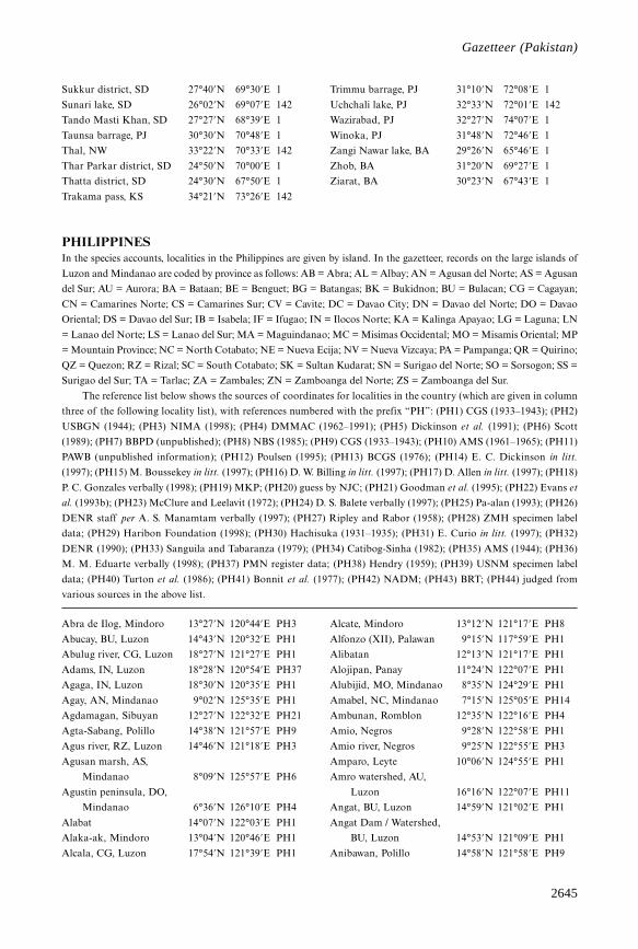
2645
Gazetteer
Sukkur district, SD 27°40’N 69°30’E 1
Sunari lake, SD 26°02’N 69°07’E 142
Tando Masti Khan, SD 27°27’N 68°39’E 1
Taunsa barrage, PJ 30°30’N 70°48’E 1
Thal, NW 33°22’N 70°33’E 142
Thar Parkar district, SD 24°50’N 70°00’E 1
Thatta district, SD 24°30’N 67°50’E 1
Trakama pass, KS 34°21’N 73°26’E 142
Trimmu barrage, PJ 31°10’N 72°08’E 1
Uchchali lake, PJ 32°33’N 72°01’E 142
Wazirabad, PJ 32°27’N 74°07’E 1
Winoka, PJ 31°48’N 72°46’E 1
Zangi Nawar lake, BA 29°26’N 65°46’E 1
Zhob, BA 31°20’N 69°27’E 1
Ziarat, BA 30°23’N 67°43’E 1
PHILIPPINESIn the species accounts, localities in the Philippines are given by island. In the gazetteer, records on the large islands of
Luzon and Mindanao are coded by province as follows: AB = Abra; AL = Albay; AN = Agusan del Norte; AS = Agusan
del Sur; AU = Aurora; BA = Bataan; BE = Benguet; BG = Batangas; BK = Bukidnon; BU = Bulacan; CG = Cagayan;
CN = Camarines Norte; CS = Camarines Sur; CV = Cavite; DC = Davao City; DN = Davao del Norte; DO = Davao
Oriental; DS = Davao del Sur; IB = Isabela; IF = Ifugao; IN = Ilocos Norte; KA = Kalinga Apayao; LG = Laguna; LN
= Lanao del Norte; LS = Lanao del Sur; MA = Maguindanao; MC = Misimas Occidental; MO = Misamis Oriental; MP
= Mountain Province; NC = North Cotabato; NE = Nueva Ecija; NV = Nueva Vizcaya; PA = Pampanga; QR = Quirino;
QZ = Quezon; RZ = Rizal; SC = South Cotabato; SK = Sultan Kudarat; SN = Surigao del Norte; SO = Sorsogon; SS =
Surigao del Sur; TA = Tarlac; ZA = Zambales; ZN = Zamboanga del Norte; ZS = Zamboanga del Sur.
The reference list below shows the sources of coordinates for localities in the country (which are given in column
three of the following locality list), with references numbered with the prefix “PH”: (PH1) CGS (1933–1943); (PH2)
USBGN (1944); (PH3) NIMA (1998); (PH4) DMMAC (1962–1991); (PH5) Dickinson et al. (1991); (PH6) Scott
(1989); (PH7) BBPD (unpublished); (PH8) NBS (1985); (PH9) CGS (1933–1943); (PH10) AMS (1961–1965); (PH11)
PAWB (unpublished information); (PH12) Poulsen (1995); (PH13) BCGS (1976); (PH14) E. C. Dickinson in litt.
(1997); (PH15) M. Boussekey in litt. (1997); (PH16) D. W. Billing in litt. (1997); (PH17) D. Allen in litt. (1997); (PH18)
P. C. Gonzales verbally (1998); (PH19) MKP; (PH20) guess by NJC; (PH21) Goodman et al. (1995); (PH22) Evans et
al. (1993b); (PH23) McClure and Leelavit (1972); (PH24) D. S. Balete verbally (1997); (PH25) Pa-alan (1993); (PH26)
DENR staff per A. S. Manamtam verbally (1997); (PH27) Ripley and Rabor (1958); (PH28) ZMH specimen label
data; (PH29) Haribon Foundation (1998); (PH30) Hachisuka (1931–1935); (PH31) E. Curio in litt. (1997); (PH32)
DENR (1990); (PH33) Sanguila and Tabaranza (1979); (PH34) Catibog-Sinha (1982); (PH35) AMS (1944); (PH36)
M. M. Eduarte verbally (1998); (PH37) PMN register data; (PH38) Hendry (1959); (PH39) USNM specimen label
data; (PH40) Turton et al. (1986); (PH41) Bonnit et al. (1977); (PH42) NADM; (PH43) BRT; (PH44) judged from
various sources in the above list.
Abra de Ilog, Mindoro 13°27’N 120°44’E PH3
Abucay, BU, Luzon 14°43’N 120°32’E PH1
Abulug river, CG, Luzon 18°27’N 121°27’E PH1
Adams, IN, Luzon 18°28’N 120°54’E PH37
Agaga, IN, Luzon 18°30’N 120°35’E PH1
Agay, AN, Mindanao 9°02’N 125°35’E PH1
Agdamagan, Sibuyan 12°27’N 122°32’E PH21
Agta-Sabang, Polillo 14°38’N 121°57’E PH9
Agus river, RZ, Luzon 14°46’N 121°18’E PH3
Agusan marsh, AS,
Mindanao 8°09’N 125°57’E PH6
Agustin peninsula, DO,
Mindanao 6°36’N 126°10’E PH4
Alabat 14°07’N 122°03’E PH1
Alaka-ak, Mindoro 13°04’N 120°46’E PH1
Alcala, CG, Luzon 17°54’N 121°39’E PH1
Alcate, Mindoro 13°12’N 121°17’E PH8
Alfonzo (XII), Palawan 9°15’N 117°59’E PH1
Alibatan 12°13’N 121°17’E PH1
Alojipan, Panay 11°24’N 122°07’E PH1
Alubijid, MO, Mindanao 8°35’N 124°29’E PH1
Amabel, NC, Mindanao 7°15’N 125°05’E PH14
Ambunan, Romblon 12°35’N 122°16’E PH4
Amio, Negros 9°28’N 122°58’E PH1
Amio river, Negros 9°25’N 122°55’E PH3
Amparo, Leyte 10°06’N 124°55’E PH1
Amro watershed, AU,
Luzon 16°16’N 122°07’E PH11
Angat, BU, Luzon 14°59’N 121°02’E PH1
Angat Dam / Watershed,
BU, Luzon 14°53’N 121°09’E PH1
Anibawan, Polillo 14°58’N 121°58’E PH9
Gazetteer (Pakistan)
2646
Threatened birds of Asia
Anislagan, Bohol 9°41’N 123°53’E PH3
Antipolo, Siargao 9°55’N 126°00’E PH2
Apalit, PA, Luzon 14°57’N 120°46’E PH1
Ara-al, Negros 10°25’N 123°01’E PH1
Arayat, PA, Luzon 15°09’N 120°56’E PH1
Argao, Cebu 9°53’N 123°36’E PH1
Asgad, Samar 11°21’N 125°07’E PH1
Atbu, NV, Luzon 16°09’N 120°57’E PH1
Atok, BE, Luzon 16°35’N 120°41’E PH1
Atong Atong, Basilan 6°39’N 121°54’E PH44
Ayala, ZS, Mindanao 6°58’N 121°57’E PH1
Baay, AB, Luzon 17°33’N 120°53’E PH1
Babulongan, Palawan 9°13’N 118°00’E PH8
Babuyan river, Palawan 10°15’N 119°00’E PH15
Bacao, Dumaran 10°27’N 119°48’E PH1
Bacauit, Palawan 11°11’N 119°23’E PH1
Baco river, Mindoro 13°24’N 121°07’E PH1
Bacolod, Negros 10°40’N 122°57’E PH1
Badajoz, Tablas 12°34’N 122°08’E PH1
Badiang, Bohol 9°41’N 123°58’E PH3
Bagamanoc, Catanduanes 13°56’N 124°17’E PH1
Baggao, CG, Luzon 17°56’N 121°46’E PH1
Baguan 6°06’N 118°27’E PH1
Baguio, BE, Luzon 16°25’N 120°36’E PH1
Baguio, DC, Mindanao 7°11’N 125°25’E PH1
Bagumbayan, Palawan 9°44’N 118°37’E PH1
Bahay Bundok, Mindoro 12°43’N 121°22’E PH3
Bahile, Palawan 10°00’N 118°47’E PH1
Bairain, Panay 11°16’N 123°01’E PH10
Bais, Negros 9°35’N 123°07’E PH1
Bajo Rio Catuiran, Mindoro13°13’N 121°08’E PH9
Bakyas, BA, Luzon 14°43’N 120°23’E PH24
Balabac 7°57’N 117°01’E PH1
Balabek, Sanga-sanga 5°04’N 119°47’E PH1
Balanan, Negros 9°08’N 123°01’E PH25
Balangbang, Negros 9°22’N 122°48’E PH5
Baler, AU, Luzon 15°46’N 121°34’E PH1
Balete, Mindoro 13°24’N 121°07’E PH1
Balian, LG, Luzon 14°24’N 121°28’E PH1
Balilihan, Bohol 9°45’N 123°58’E PH1
Balimbing, Tawitawi 5°05’N 119°58’E PH1
Balinguan, MO, Mindanao 9°00’N 124°51’E PH1
Balinsasayao, Leyte 10°40’N 124°57’E PH1
Balintad, LN, Mindanao 7°56’N 123°52’E PH1
Balitbiton, Dinagat 10°22’N 125°35’E PH1
Baluno, ZS, Mindanao 7°04’N 122°04’E PH26
Banacon islet, Bohol 10°12’N 124°10’E PH1
Banaue, IF, Luzon 16°55’N 121°04’E PH1
Ban-ban, Negros 9°52’N 123°04’E PH1
Bancaobancao point,
Palawan 9°43’N 118°46’E PH1
Banco, Masbate 12°05’N 123°56’E PH9
Bandila-an, Siquijor 9°11’N 123°35’E PH1
Bandirahan range, Negros 10°35’N 123°10’E PH10
Bangui, IN, Luzon 18°32’N 120°45’E PH1
Barangkalan, Sicogon 11°27’N 123°15’E PH1
Barawanan peak, Mindoro 13°20’N 121°05’E PH27
Barit, AB, Luzon 17°23’N 120°41’E PH1
Basay, Negros 9°25’N 122°38’E PH1
Basco, Batan 20°27’N 121°58’E PH1
Basilan 6°34’N 122°03’E PH1
Basulood, Samar 11°17’N 125°04’E PH1
Batu-batu, Tawitawi 5°04’N 119°52’E PH1
Batulao, BG, Luzon 14°02’N 120°48’E PH1
Bayabas, BU, Luzon 14°57’N 121°05’E PH1
Baybay, Leyte 10°41’N 124°49’E PH1
Bayog, Mindoro 13°18’N 121°08’E PH7
Belen Rosal, Panay 11°26’N 122°18’E PH10
Bicol National Park,
Luzon 13°55’N 122°56’E PH11
Bihid river, Samar 11°28’N 125°20’E PH1
Biliran 11°35’N 124°28’E PH1
Binahaan river, Leyte 11°07’N 125°01’E PH1
Binduyan, Palawan 10°01’N 119°04’E PH1
Bislig, SS, Mindanao 8°13’N 126°19’E PH1
Bitogan, DO, Mindanao 6°46’N 126°05’E PH1
Bivouac, Dumaran 10°34’N 119°43’E PH1
Blos, IB, Luzon 17°27’N 122°09’E PH20
Boac, Marinduque 13°27’N 121°50’E PH1
Boco-boco, Busuanga 12°00’N 120°12’E PH1
Bohol 9°50’N 124°10’E PH1
Bok-bok, Mindoro 12°49’N 121°29’E PH1
Bonawon, Negros 9°08’N 122°55’E PH1
Bonga, Samar 11°50’N 125°02’E PH1
Bongao 5°01’N 119°45’E PH1
Bongao peak, Bongao 5°01’N 119°45’E PH1
Bonifacio, MC, Mindanao 8°31’N 123°43’E PH1
Bonobono, Palawan 8°40’N 117°36’E PH1
Boracay 11°58’N 121°56’E PH4
Borongan, Samar 11°37’N 125°26’E PH1
Brooke’s point, Palawan 8°46’N 117°50’E PH1
Buad 11°40’N 124°51’E PH1
Bual, Jolo 6°01’N 121°17’E PH3
Buan, Tawitawi 5°09’N 120°03’E PH1
Bubuajan islet, Bohol 10°11’N 124°20’E PH37
Bubunaon river, BK,
Mindanao 7°50’N 125°15’E PH1
Bucay, AB, Luzon 17°32’N 120°43’E PH1
Bucobuco-onay, LN,
Mindanao 8°10’N 124°05’E PH10
Bucong, ZS, Mindanao 7°50’N 123°27’E PH28
Bud Sicali, Tawitawi 5°06’N 119°54’E PH1
2647
Gazetteer
Budaco Lumber
Concession, BK,
Mindanao 7°35’N 125°12’E PH37
Bued river canyon,
BE, Luzon 16°16’N 120°34’E PH9
Buenavista, Palawan 10°04’N 118°49’E PH1
Bugasan, MA, Mindanao 7°27’N 124°14’E PH1
Bugsanga, Mindoro 12°26’N 120°58’E PH1
Bugsanga river, Mindoro 12°26’N 120°59’E PH1
Bugsuk 8°15’N 117°18’E PH1
Buguey, CG, Luzon 18°17’N 121°50’E PH1
Buhisan, Cebu 10°18’N 123°51’E PH1
Bulabong Puti-an
National Park, Panay 11°03’N 122°40’E PH11
Bulalacao, Mindoro 12°20’N 121°20’E PH1
Bulo-bulo, Palawan 9°15’N 117°59’E PH1
Buluan, MA, Mindanao 6°44’N 124°47’E PH1
Buluan, Samar 11°38’N 125°09’E PH1
Bulusan lake, SO, Luzon 12°45’N 124°06’E PH1
Bunauan, AS, Mindanao 8°11’N 125°56’E PH1
Buradan, Catanduanes 13°47’N 124°23’E PH3
Burgos, Bohol 10°07’N 124°17’E PH3
Burgos, Catanduanes 13°52’N 124°18’E PH1
Buri, Leyte 11°00’N 124°54’E PH1
Burungkot, MA, Mindanao 6°53’N 124°07’E PH1
Butig mountains,
Mindanao 7°39’N 124°20’E PH1
Butilog peak, Negros 10°35’N 123°10’E PH10
Butuan, AN, Mindanao 8°57’N 125°33’E PH1
Butuan river, AN,
Mindanao 9°00’N 125°32’E PH4
Cabanglasan, BK,
Mindanao 8°08’N 125°14’E PH1
Caburan, DS, Mindanao 5°55’N 125°38’E PH1
Cadapnan, Bantayan 11°13’N 123°44’E PH1
Cadapnan, Samar 12°08’N 125°26’E PH1
Cadiz, Negros 10°57’N 123°19’E PH1
Cadlao, Palawan 11°13’N 119°21’E PH1
Cagayan Sulu 7°01’N 118°30’E PH1
Cagayancillo, Cagayan
Islands 9°35’N 121°14’E PH1
Cagdiano, SN, Mindanao 9°32’N 125°52’E PH1
Calagua 14°27’N 122°55’E PH1
Calamba, LG, Luzon 14°13’N 121°10’E PH1
Calamianes 12°00’N 120°00’E PH1
Calapan, Mindoro 13°25’N 121°11’E PH1
Calasuche, Masbate 12°13’N 123°32’E PH1
Calatagan, BG, Luzon 13°50’N 120°38’E PH1
Calatugas, Palawan 9°10’N 118°12’E PH1
Calauan, LG, Luzon 14°09’N 121°19’E PH1
Calauit 12°18’N 119°54’E PH1
Calawang, Mindoro 13°18’N 121°08’E PH1
Calayan 19°20’N 121°27’E PH1
Calbayog, Samar 12°04’N 124°36’E PH1
Calico-an 10°59’N 125°48’E PH1
Calinan, DC, Mindanao 7°12’N 125°23’E PH4
Caliraya, LG, Luzon 14°18’N 121°32’E PH1
Calituban islet, Bohol 10°15’N 124°18’E PH1
Caloocan, NCR, Luzon 14°39’N 120°58’E PH1
Calpi, Biliran 11°34’N 124°35’E PH1
Calpi, Ticao 12°34’N 123°38’E PH9
Calusa, Cagayan Islands 9°37’N 121°01’E PH1
Caminawit, Mindoro 12°20’N 121°05’E PH1
Camp Keithley, LS,
Mindanao 8°01’N 124°17’E PH1
Camp O’Donnell, TA,
Luzon 15°21’N 120°28’E PH4
Campong, Palawan 8°58’N 117°35’E PH1
Canabong, Palawan 10°10’N 118°52’E PH15
Canat, Marinduque 13°27’N 121°50’E PH5
Canaway, Negros 9°04’N 123°04’E PH1
Candaba marsh, PA, Luzon 15°07’N 120°50’E PH1
Candauaga, Palawan 8°51’N 117°29’E PH7
Candomao, Negros 9°22’N 122°48’E PH1
Candugay, Negros 9°08’N 123°02’E PH1
Cangclaran, Siquijor 9°08’N 123°37’E PH1
Canghaling, Siquijor 9°08’N 123°33’E PH22
Canigaran, Palawan 9°44’N 118°46’E PH1
Canili lake, AU, Luzon 15°47’N 121°19’E PH16
Canlangit, Bohol 9°49’N 124°19’E PH1
Cantaub, Bohol 9°48’N 124°18’E PH1
Cantipla, Cebu 10°17’N 123°52’E PH3
Capalasanan, Siquijor 9°09’N 123°37’E PH1
Cape Engaño, CG, Luzon 18°34’N 122°08’E PH1
Cape Melville, Balabac 7°48’N 117°01’E PH1
Car-Can-Mad-Lan, SS,
Mindanao 9°17’N 126°00’E PH37
Caramoran, Catanduanes 13°39’N 124°08’E PH1
Carcar, Cebu 10°06’N 123°38’E PH1
Carmen, DN, Mindanao 7°21’N 125°44’E PH8
Carmen, NC, Mindanao 7°13’N 124°45’E PH1
Caroland resort, DC,
Mindanao 7°03’N 125°34’E PH1
Carranglan, NE, Luzon 15°58’N 121°04’E PH1
Casibo, NV, Luzon 16°19’N 121°17’E PH1
Casili, Cebu 10°22’N 123°57’E PH3
Casing, Sibuyan 12°30’N 122°33’E PH21
Catarman, Samar 12°30’N 124°38’E PH1
Catbalogan, Samar 11°47’N 124°53’E PH1
Cateel, DO, Mindanao 7°48’N 126°27’E PH1
Cateel river, DO,
Mindanao 7°47’N 126°27’E PH1
Gazetteer (Philippines)
2648
Threatened birds of Asia
Catmon, Cebu 10°43’N 124°01’E PH1
Catubig river, Samar 12°34’N 125°01’E PH1
Cavili, Cagayan Islands 9°17’N 120°49’E PH1
Cayapa, CG, Luzon 17°35’N 121°52’E PH12
Cebu city, Cebu 10°18’N 123°54’E PH1
Central peak, Palawan 9°38’N 118°34’E PH4
Chicago, Mindoro 13°24’N 121°06’E PH1
Cogtong bay, Bohol 9°51’N 124°32’E PH1
Compostela-Cateel-Baganga,
DO, Mindanao 7°40’N 126°28’E PH1
Concepcion, Panay 11°13’N 123°06’E PH1
Coron, Busuanga 12°00’N 120°12’E PH1
Cotabato city, MA,
Mindanao 7°17’N 124°15’E PH1
Cubacub, Cebu 10°20’N 123°57’E PH1
Culasi, Panay 11°25’N 122°03’E PH1
Culasian, Palawan 8°51’N 117°29’E PH1
Dabo, Poneas 9°55’N 125°57’E PH1
Daet, CN, Luzon 14°07’N 122°52’E PH1
Dakil, QZ, Luzon 13°53’N 122°15’E PH1
Dalagsaan, Panay 11°18’N 122°14’E PH3
Dalahican 8°18’N 117°11’E PH1
Daliaon, DC, Mindanao 7°01’N 125°30’E PH8
Dalton Pass, NV, Luzon 16°07’N 120°56’E PH5
Dalupiri 19°06’N 121°13’E PH1
Dalwangan, BK,
Mindanao 8°14’N 125°02’E PH1
Dammi 5°47’N 120°24’E PH1
Danao, Panay 11°29’N 122°18’E PH3
Danao, Cebu 10°23’N 123°50’E PH1
Danau lake, Leyte 11°04’N 124°42’E PH6
Danicop, Bohol 9°47’N 124°20’E PH1
Danlag, Cebu 10°32’N 123°58’E PH3
Dapiak, ZS, Mindanao 8°15’N 123°28’E PH1
Davao, DC, Mindanao 7°18’N 125°25’E PH1
Davao gulf, Mindanao 6°40’N 125°48’E PH1
Diabut, IB, Luzon 17°06’N 122°24’E PH1
Diagopanay, IB, Luzon 16°34’N 122°08’E PH12
Diatagon, SS, Mindanao 8°43’N 126°03’E PH43
Dicabaitot, Linapacan 11°39’N 119°58’E PH9
Didian, IB, Luzon 16°58’N 122°24’E PH29
Diffun, QR, Luzon 16°34’N 121°33’E PH1
Digos, DN, Mindanao 6°45’N 125°23’E PH1
Dikayatan river, IB, Luzon 17°28’N 122°12’E PH3
Diman, LG, Luzon 14°25’N 121°31’E PH1
Dimanayat, AU, Luzon 15°44’N 121°32’E PH1
Dinagat 10°05’N 125°35’E PH1
Dinapigue, IB, Luzon 16°33’N 122°17’E PH10
Dingalan, AU, Luzon 15°24’N 121°25’E PH4
Dipalayag, IB, Luzon 16°58’N 122°15’E PH12
Disulap, IB, Luzon 16°53’N 122°09’E PH1
Diteki, AU, Luzon 15°39’N 121°26’E PH44
Diway, ZS, Mindanao 8°15’N 123°28’E PH1
Dolores, QZ, Luzon 14°01’N 121°24’E PH1
Duao, Bohol 9°45’N 124°20’E PH3
Dugui-too, Catanduanes 13°38’N 124°11’E PH1
Dulangan, Mindoro 13°18’N 121°06’E PH1
Dulang-dulang peak, BK,
Mindanao 8°06’N 124°55’E PH42
Dullao, MC, Mindanao 8°31’N 123°43’E PH9
Dumaguete, Negros 9°18’N 123°18’E PH1
Dumalneg, IN, Luzon 18°30’N 120°49’E PH1
Dumalon (Dumalinao), ZS,
Mindanao 7°49’N 123°23’E PH44
Dumaran 10°33’N 119°51’E PH1
Dumurug point, Masbate 11°57’N 124°03’E PH1
Dupax, NV, Luzon 16°17’N 121°05’E PH1
East Bolod 6°16’N 121°37’E PH37
El Nido, Palawan 11°12’N 119°24’E PH4
Esperanza, AS, Mindanao 8°42’N 125°36’E PH1
Gapan, NE, Luzon 15°19’N 120°57’E PH1
Gasaing, Marinduque 13°19’N 121°51’E PH9
Getafe, Bohol 10°09’N 124°09’E PH1
Gogong, SC, Mindanao 6°15’N 125°20’E PH30
Gov. Generoso-San Isidro,
DO, Mindanao 6°44’N 126°11’E PH1
Guadalupe, Cebu 10°20’N 123°53’E PH1
Guba, Cebu 10°19’N 123°55’E PH1
Guianga, DC, Mindanao 7°05’N 125°29’E PH1
Guimaras 10°35’N 122°37’E PH1
Guindulman, Bohol 9°46’N 124°29’E PH1
Guintubdan, Negros 10°13’N 122°57’E PH1
Gulang-gulang, Palawan 10°50’N 119°19’E PH1
Gumatos, Mindoro 12°41’N 121°22’E PH9
Hakot, Panay 11°47’N 122°02’E PH31
Helosig, Leyte 10°39’N 124°56’E PH10
Hermosa, BA, Luzon 14°50’N 120°30’E PH1
Hinoba-an, Negros 9°35’N 122°29’E PH1
Hinubungan, Negros 9°23’N 122°53’E PH9
Hinunangan, Leyte 10°24’N 125°12’E PH1
Ilog river, Palawan 8°57’N 117°34’E PH1
Iloilo, Panay 10°42’N 122°33’E PH1
Impasugong, BK,
Mindanao 8°19’N 124°59’E PH1
Imugan, NV, Luzon 16°09’N 120°54’E PH1
Inabanga coast, Bohol 10°01’N 124°04’E PH6
Inagauan, Palawan 9°33’N 118°39’E PH1
Ipil, CG, Luzon 17°44’N 121°41’E PH1
Ipil, ZS, Mindanao 7°47’N 122°32’E PH44
Ipo dam, BU, Luzon 14°50’N 121°10’E PH37
Irawan, Palawan 9°48’N 118°42’E PH1
Irisan, BE, Luzon 16°26’N 120°33’E PH1
2649
Gazetteer
Irosin, SO, Luzon 12°42’N 124°02’E PH1
IRRI, LG, Luzon 14°10’N 121°15’E PH4
Isabela, Basilan 6°42’N 121°58’E PH1
Iwahig Penal Colony,
Palawan 9°45’N 118°40’E PH23
Jagusara, SO, Luzon 12°49’N 123°57’E PH1
Jala Jala, RZ, Luzon 14°21’N 121°19’E PH1
Jamindan, Panay 11°25’N 122°30’E PH1
Jaro, Leyte 11°11’N 124°47’E PH1
Jolo 5°59’N 121°07’E PH1
Jomalig island 14°42’N 122°22’E PH1
Kabangahan, Cebu 10°22’N 123°58’E PH1
Kabasakan, Palawan 8°56’N 117°32’E PH7
Kabayan, BE, Luzon 16°39’N 120°50’E PH1
Kabiao, NE, Luzon 15°15’N 120°51’E PH1
Kabigaan, Palawan 9°29’N 118°27’E PH1
Kadanapan-an, Palawan 8°56’N 117°32’E PH7
Kalatungan, BK, Mindanao 7°54’N 124°50’E PH1
Kambinlio, Dinagat 10°25’N 125°40’E PH9
Kantulongao, Negros 9°04’N 123°02’E PH1
Katipunan, ZN, Mindanao 8°31’N 123°17’E PH1
Katulayan, Siquijor 9°10’N 123°29’E PH1
Katumbahan, Negros 9°26’N 122°45’E PH9
Kawasan, Cebu 10°10’N 123°32’E PH1
Kawitan, Negros 9°18’N 122°52’E PH9
Kiamba, SC, Mindanao 5°59’N 124°37’E PH1
Kiandang, NC, Mindanao 7°21’N 125°07’E PH14
Kibawalan, DS, Mindanao 6°37’N 125°17’E PH32
Kidapawan, NC, Mindanao 7°01’N 125°03’E PH1
Kinalaykayan, Linapacan 11°26’N 119°49’E PH1
Kinubalan, BK, Mindanao 8°13’N 124°59’E PH14
Kolambugan, LN,
Mindanao 8°07’N 123°55’E PH1
Kuden, MA, Mindanao 6°44’N 124°20’E PH1
Kumalawit, SK, Mindanao 6°42’N 124°05’E PH3
La Roxas, BK, Mindanao 7°46’N 125°00’E PH29
La Trinidad, BE, Luzon 16°28’N 120°35’E PH1
Labason mountains, ZN,
Mindanao 8°02’N 122°30’E PH10
Labo, CN, Luzon 14°15’N 122°45’E PH23
Labuyan, ZS, Mindanao 7°36’N 123°12’E PH1
Lacaron, DS, Mindanao 6°27’N 125°34’E PH1
Laconon, SC, Mindanao 6°12’N 124°34’E PH8
Lagan, Dumaran 10°28’N 119°47’E PH15
Lagawe Gorge, IF, Luzon 16°49’N 121°06’E PH1
Lagen 11°05’N 119°24’E PH1
Lagonglong, MO,
Mindanao 8°48’N 124°47’E PH1
Laguna de Bay, Luzon 14°23’N 121°15’E PH1
Lahang, Panay 11°48’N 121°59’E PH31
Lake Baao, CS, Luzon 13°28’N 123°19’E PH1
Lake Babae, Mindoro 13°16’N 120°38’E PH9
Lake Balanan, Negros 9°08’N 123°00’E PH3
Lake Balinsasayao, Negros 9°22’N 123°04’E PH6
Lake Dagun, AS, Mindanao 8°13’N 125°54’E PH10
Lake Lanao, LS, Mindanao 7°53’N 124°16’E PH1
Lake Lubao, Mindoro 12°50’N 120°53’E PH37
Lake Mainit, Mindanao 9°26’N 125°32’E PH1
Lake Naujan, Mindoro 13°10’N 121°21’E PH4
Lake Sebu, SC, Mindanao 6°10’N 124°42’E PH6
Lalaguna marsh, QZ,
Luzon 13°55’N 122°13’E PH6
Lamao, BA, Luzon 14°31’N 120°36’E PH5
Lamao river, BA, Luzon 14°30’N 120°36’E PH1
Lambingan falls, Sibuyan 12°28’N 122°36’E PH37
Lambunao, Panay 11°03’N 122°29’E PH1
Lamig river, AU, Luzon 15°40’N 121°20’E PH29
Lamitan, Basilan 6°40’N 122°08’E PH1
Langtad, Tawitawi 5°13’N 120°17’E PH1
Languyan, Palawan 10°20’N 119°20’E PH4
Languyan, Tawitawi 5°16’N 120°05’E PH1
Lantapan, BK, Mindanao 8°03’N 124°59’E PH1
Lanuza, SS, Mindanao 9°14’N 126°03’E PH1
Lapac 5°32’N 120°46’E PH1
Lasang, DN, Mindanao 7°16’N 125°40’E PH1
Libona, BK, Mindanao 8°20’N 124°44’E PH1
Liboton, Negros 10°38’N 123°13’E PH31
Libtong, AS, Mindanao 8°30’N 125°40’E PH8
Liguasan marsh, Mindanao 6°55’N 124°03’E PH6
Lilimbagan, Palawan 9°15’N 117°59’E PH1
Lilo-an, Cebu 10°24’N 124°00’E PH1
Lilo-an, Siquijor 9°09’N 123°41’E PH1
Limatok, AN, Mindanao 8°40’N 125°35’E PH33
Liwan, KA, Luzon 17°30’N 121°35’E PH8
Looc, BG, Luzon 14°10’N 120°38’E PH1
Looc, Tablas 12°16’N 121°59’E PH1
Loquilocon, Samar 11°48’N 125°06’E PH1
Loran 5°12’N 120°31’E PH1
Los Baños, LG, Luzon 14°13’N 121°11’E PH1
Los Dos Cuernos, Luzon 17°32’N 122°00’E PH1
Lubang 13°46’N 120°11’E PH1
Lubbuk, Tawitawi 5°07’N 119°58’E PH17
Luhan, SC, Mindanao 6°06’N 124°25’E PH3
Lumba-Bayabao, LS,
Mindanao 7°54’N 124°23’E PH1
Lumbucan 7°50’N 117°13’E PH1
Lumintao river, Mindoro 12°32’N 120°55’E PH1
Lunao, MO, Mindanao 8°52’N 125°03’E PH1
Lupon-Banaybanay, DO,
Mindanao 6°57’N 126°01’E PH4
Lutab, BE, Luzon 16°40’N 120°49’E PH1
Luuk Pandan, Sanga-sanga 5°05’N 119°46’E PH8
Gazetteer (Philippines)
2650
Threatened birds of Asia
Maco, DN, Mindanao 7°26’N 125°56’E PH3
Maconacon, IB, Luzon 17°24’N 122°13’E PH32
Mactan island, Cebu 10°18’N 123°58’E PH1
Madalag, Panay 11°32’N 122°18’E PH1
Madaum, DN, Mindanao 7°52’N 125°48’E PH1
Madrid / Madrid del
Carmen, SS, Mindanao 9°16’N 125°58’E PH1
Magsagaw, Tawitawi 5°10’N 119°52’E PH37
Magsaysay, DS, Mindanao 6°46’N 125°11’E PH3
Magtubog, Palawan 8°58’N 117°57’E PH37
Maguinda, AN, Mindanao 8°45’N 125°40’E PH33
Maguindanao, Mindanao 7°00’N 124°15’E PH5
Mahaba islet, Bohol 10°10’N 124°20’E PH9
Mahayahay, Siargao 9°53’N 126°02’E PH43
Maimbung, Jolo 5°56’N 121°02’E PH1
Mainit Hot Spring National
Park, DN, Mindanao 7°28’N 126°01’E PH11
Makatok, Mindoro 13°13’N 121°18’E PH9
Malabang, LS, Mindanao 7°35’N 124°04’E PH1
Malabusog, Palawan 10°04’N 119°12’E PH1
Malabuyoc, Cebu 9°39’N 123°20’E PH1
Malagos, DC, Mindanao 7°11’N 125°28’E PH1
Malalag, DS, Mindanao 6°36’N 125°24’E PH1
Malamaui 6°44’N 121°58’E PH1
Malampaya river, Palawan 10°42’N 119°28’E PH37
Malibato, MO, Mindanao 8°31’N 124°34’E PH1
Malibho, SS, Mindanao 9°12’N 125°52’E PH37
Malicboy, QZ, Luzon 13°59’N 121°47’E PH1
Malindon, Negros 9°20’N 123°14’E PH1
Malinsono 8°12’N 117°11’E PH1
Malita, DS, Mindanao 6°24’N 125°36’E PH1
Malpalon, Mindoro 12°41’N 120°57’E PH37
Malumpati, Panay 11°45’N 122°06’E PH31
Malungun, DS, Mindanao 6°16’N 125°14’E PH3
Maluso, Basilan 6°33’N 121°53’E PH1
Mamada, ZN, Mindanao 8°31’N 123°17’E PH1
Mamara, Mindoro 13°19’N 120°29’E PH1
Mambucal, Negros 10°31’N 123°05’E PH1
Manamlay lake, Mindoro 12°59’N 120°51’E PH37
Manas, Pandanan 8°17’N 117°10’E PH15
Mangsi 7°39’N 117°18’E PH1
Manila, NCR, Luzon 14°36’N 120°59’E PH1
Manito, AL, Luzon 13°08’N 123°52’E PH1
Manolo Fortich, BK,
Mindanao 8°22’N 124°51’E PH9
Mansarong, CG, Luzon 17°56’N 121°46’E PH1
Mantalungon, Cebu 9°47’N 123°27’E PH1
Manticao, MO, Mindanao 8°24’N 124°17’E PH1
Mantiquil, Negros 9°10’N 123°03’E PH1
Manuk Manka 4°48’N 119°50’E PH1
Maputi, MO, Mindanao 8°27’N 124°18’E PH3
Marasi bay, Palawan 8°46’N 117°24’E PH1
Marbel, SC, Mindanao 6°33’N 124°51’E PH44
Maria, Siquijor 9°12’N 123°39’E PH1
Maria Aurora, AU, Luzon 15°48’N 121°28’E PH4
Maria Aurora Memorial
National Park, AU,
Luzon 15°40’N 121°21’E PH11
Marinduque 13°24’N 121°58’E PH1
Mariveles, BA, Luzon 14°26’N 120°29’E PH1
Massisiat, AB, Luzon 17°35’N 120°50’E PH7
Matabungkay, BG, Luzon 13°57’N 120°37’E PH1
Matam, ZN, Mindanao 8°25’N 123°19’E PH1
Matamok, Catanduanes 13°59’N 124°08’E PH3
Mati, DO, Mindanao 6°57’N 126°13’E PH1
Matipuron, Masbate 12°13’N 123°30’E PH1
Matuguinao, Samar 12°08’N 124°53’E PH1
Matungao, Mindoro 13°11’N 121°16’E PH8
Mayana, Bohol 9°43’N 124°21’E PH1
Mayo’s Peak, Sibuyan 12°26’N 122°33’E PH21
Merit, Mindoro 13°05’N 121°19’E PH9
Metondo, DC, Mindanao 6°57’N 125°26’E PH5
Milagros, Masbate 12°13’N 123°30’E PH1
Minagas, Balabac 7°54’N 117°05’E PH35
Minasawa 14°45’N 122°09’E PH1
Minglanilla, Cebu 10°15’N 123°47’E PH1
Miniloc 11°09’N 119°19’E PH1
Minuma, IB, Luzon 17°09’N 122°06’E PH12
Mojon, Cebu 10°15’N 123°50’E PH1
Molave, ZS, Mindanao 8°01’N 123°31’E PH14
Montalban, RZ, Luzon 14°44’N 121°07’E PH1
Mt Agtuuganon, DN,
Mindanao 7°48’N 126°12’E PH14
Mt Apo, Mindanao 6°59’N 125°14’E PH1
Mt Arayat, PA, Luzon 15°12’N 120°44’E PH1
Mt Balabag, Panay 11°10’N 122°12’E PH1
Mt Balatukan, MO,
Mindanao 8°44’N 125°04’E PH1
Mt Ballong, NV, Luzon 16°11’N 120°49’E PH7
Mt Baloy, Panay 11°09’N 122°14’E PH1
Mt Banahaw, QZ, Luzon 14°04’N 121°29’E PH1
Mt Bilao, Luzon 15°40’N 121°22’E PH29
Mt Binuang, Tawitawi 5°07’N 119°56’E PH1
Mt Bulusan National Park,
SO, Luzon 12°46’N 124°03’E PH1
Mt Busa, Sarangani,
Mindanao 6°08’N 124°39’E PH1
Mt Cabaay, Sarangani,
Mindanao 6°08’N 124°39’E PH1
Mt Cagua, CG, Luzon 18°13’N 122°07’E PH1
Mt Calavite, Mindoro 13°29’N 120°24’E PH1
Mt Canlaon, Negros 10°25’N 123°08’E PH1

2651
Gazetteer
Mt Capoto-an, Samar 12°09’N 124°57’E PH1
Mt Cayapo, BA, Luzon 14°32’N 120°32’E PH1
Mt Cetaceo, CG, Luzon 17°42’N 122°03’E PH1
Mt Cleopatra, Palawan 10°07’N 118°59’E PH1
Mt Dapiak, ZS, Mindanao 8°15’N 123°28’E PH1
Mt Data, BE, Luzon 16°51’N 120°52’E PH1
Mt Dikabayo, IB, Luzon 17°05’N 122°24’E PH36
Mt Dipalayag, IB, Luzon 16°58’N 122°15’E PH12
Mt Diwata, SS, Mindanao 8°43’N 126°03’E PH1
Mt Dulangan, Mindoro 13°15’N 121°05’E PH37
Mt Duyog, DO, Mindanao 6°22’N 126°10’E PH37
Mt Gorang Bato, Palawan 8°58’N 117°50’E PH18
Mt Guiting-guiting,
Sibuyan 12°25’N 122°34’E PH1
Mt Halcon, Mindoro 13°16’N 121°00’E PH1
Mt Hilong-hilong, AN,
Mindanao 9°06’N 125°43’E PH1
Mt Iglit-Baco National
Park, Mindoro 12°49’N 121°09’E PH11
Mt Imbing, ZS, Mindanao 7°41’N 123°14’E PH1
Mt Iraan, Palawan 9°28’N 118°34’E PH3
Mt Isarog, CS, Luzon 13°39’N 123°23’E PH1
Mt Kabalanti-an, Leyte 10°50’N 124°52’E PH7
Mt Kabasalan, ZS,
Mindanao 7°49’N 122°49’E PH1
Mt Kambinlio, Dinagat 10°05’N 125°35’E PH7
Mt Kampalili, DO,
Mindanao 7°18’N 126°17’E PH1
Mt Kapiagan, MO,
Mindanao 8°40’N 125°10’E PH9
Mt Katabutabuan,
Palawan 9°26’N 118°33’E PH1
Mt Kitanglad, BK,
Mindanao 8°06’N 124°54’E PH1
Mt Larugan, BK,
Mindanao 8°01’N 124°58’E PH9
Mt Libadan, NC,
Mindanao 6°51’N 125°04’E PH1
Mt Lobi, Leyte 11°02’N 124°48’E PH1
Mt Maabubo, Panay 11°18’N 122°10’E PH8
Mt Madja-as, Panay 11°16’N 122°12’E PH9
Mt Makiling National
Park, LG, Luzon 14°08’N 121°12’E PH11
Mt Malindang National
Park, MC, Mindanao 8°17’N 123°32’E PH11
Mt Malumat, DO,
Mindanao 6°31’N 126°08’E PH37
Mt Mandalagan, Negros 10°38’N 123°14’E PH1
Mt Matutum, SC,
Mindanao 6°22’N 125°05’E PH1
Mt Mayo, DO, Mindanao 7°05’N 126°18’E PH1
Mt McKinley, DC,
Mindanao 7°03’N 125°19’E PH8
Mt Nabaluto, Samar 11°22’N 125°27’E PH1
Mt Palanan, IB, Luzon 17°03’N 122°15’E PH1
Mt Pangasugan, Leyte 10°45’N 124°52’E PH10
Mt Parker, SC, Mindanao 6°07’N 124°54’E PH1
Mt Pasian, DO, Mindanao 7°51’N 126°11’E PH1
Mt Payaopao, Tablas 12°35’N 122°03’E PH13
Mt Piapayungan, LS,
Mindanao 7°41’N 124°34’E PH5
Mt Polis, Luzon 16°58’N 121°01’E PH7
Mt Puguis, MP, Luzon 17°04’N 121°04’E PH9
Mt Pulog National Park,
BE, Luzon 16°35’N 120°55’E PH11
Mt Puting Bato, DN,
Mindanao 7°27’N 126°11’E PH
Mt Ragaang, NC,
Mindanao 7°43’N 124°32’E PH1
Mt Redondo, Dinagat 10°21’N 125°38’E PH1
Mt Roosevelt, Mindoro 12°44’N 121°12’E PH1
Mt Salangbato, LG, Luzon 14°28’N 121°28’E PH3
Mt Santa Ana, CG, Luzon 18°28’N 122°12’E PH32
Mt Sicapo-o, IN, Luzon 18°01’N 120°56’E PH1
Mt Sinaka, Mindanao 7°30’N 125°16’E PH1
Mt Stavely Range, Palawan 9°44’N 118°37’E PH1
Mt Sugarloaf, ZS,
Mindanao 7°56’N 123°13’E PH1
Mt Sungay, BG, Luzon 14°09’N 121°01’E PH1
Mt Tabuan, CG, Luzon 18°10’N 121°50’E PH7
Mt Talinis, Negros 9°15’N 123°10’E PH25
Mt Three Kings, SC,
Mindanao 6°11’N 124°41’E PH37
Mt Timolan, ZS,
Mindanao 7°48’N 123°15’E PH29
Mt Tingoy, DO, Mindanao 7°59’N 126°17’E PH37
Mt Tuduk, SC, Mindanao 5°56’N 125°29’E PH37
Mt Victoria, Palawan 9°22’N 118°20’E PH1
MUFRC Experimental
Forest, Mindoro 13°03’N 121°10’E PH34
Mulita river, AS,
Mindanao 8°07’N 125°50’E PH3
Na-awan, MO, Mindanao 8°26’N 124°17’E PH44
Nabunturan, DN,
Mindanao 7°35’N 126°01’E PH3
Naganduyan, CG, Luzon 17°45’N 121°57’E PH29
Nagoro, Negros 9°10’N 123°03’E PH1
Naliong, Negros 9°22’N 122°48’E PH1
Narra, Palawan 9°19’N 118°24’E PH3
Naujan, Mindoro 13°20’N 121°18’E PH1
Negros (northern tip),
Negros 10°59’N 123°14’E PH37
Gazetteer (Philippines)
2652
Threatened birds of Asia
Nipah 9°48’N 125°31’E PH5
NONAS (Negros Occidental
National Agricultural),
Negros 9°58’N 122°58’E PH37
Norzagaray, BU, Luzon 14°54’N 121°03’E PH1
Novaliches reservoir, RZ,
Luzon 14°45’N 121°06’E PH1
Nueva Valencia, Negros 9°27’N 123°14’E PH1
Obando, BU, Luzon 14°43’N 120°56’E PH1
Olango 10°16’N 124°03’E PH1
Omasdang, Dinagat 10°22’N 125°36’E PH3
Opol, MO, Mindanao 8°31’N 124°34’E PH1
Oras, Samar 12°08’N 125°26’E PH1
Orioung, CG, Luzon 17°51’N 121°39’E PH1
Ormoc city, Leyte 11°00’N 124°36’E PH1
Osmeña, Siargao 9°47’N 126°04’E PH3
Padada, DS, Mindanao 6°41’N 125°22’E PH1
Pagadian, ZS, Mindanao 7°50’N 123°26’E PH1
Pagbilao, QZ, Luzon 13°58’N 121°41’E PH1
Pagdanan, Palawan 10°33’N 119°17’E PH4
Pagsanjan marsh, LG,
Luzon 14°18’N 121°27’E PH1
Pagudpud, IN, Luzon 18°33’N 120°48’E PH1
Pagyabunan, Negros 9°35’N 123°07’E PH1
Pakil, LG, Luzon 14°23’N 121°29’E PH1
Palanan, IB, Luzon 17°04’N 122°26’E PH1
Palanoc, Masbate 12°19’N 123°35’E PH1
Palay, CG, Luzon 17°33’N 121°50’E PH19
Palo, Leyte 11°09’N 124°59’E PH1
Paluan, Mindoro 13°25’N 120°28’E PH1
Pan de Azucar 11°17’N 123°10’E PH1
Panacan, Palawan 9°16’N 118°25’E PH1
Panaon 10°03’N 125°13’E PH1
Panay 11°12’N 122°26’E PH1
Pangantocan, BK,
Mindanao 7°50’N 124°49’E PH1
Pangil, LG, Luzon 14°24’N 121°28’E PH1
Pangulasian 11°07’N 119°20’E PH1
Panipiason, Panay 11°30’N 122°18’E PH1
Pantar, LN, Mindanao 8°03’N 124°16’E PH1
Paoay lake, IN, Luzon 18°07’N 120°32’E PH1
Papahag 5°02’N 119°47’E PH1
Papaya, Busuanga 12°00’N 120°12’E PH1
Papaya, NE, Luzon 15°21’N 121°03’E PH1
Parañaque, NCR, Luzon 14°30’N 121°00’E PH1
Paranas, Samar 11°47’N 125°02’E PH4
Parang, MA, Mindanao 7°23’N 124°16’E PH1
Parangan, Tawitawi 5°05’N 119°56’E PH1
Pasi, Mindoro 13°06’N 121°19’E PH23
Pasonanca, ZS, Mindanao 6°58’N 122°04’E PH1
Pasong, Negros 9°13’N 122°53’E PH1
Patag, Negros 10°36’N 123°06’E PH37
Pauai, BE, Luzon 16°38’N 120°44’E PH1
Payao, Negros 10°11’N 122°56’E PH1
Peñablanca, CG, Luzon 17°37’N 121°47’E PH1
Piddig, IN, Luzon 18°10’N 120°43’E PH1
Pinagtubaan, Negros 9°59’N 122°49’E PH1
Pinamungahan, Cebu 10°16’N 123°35’E PH1
Pitogo, Panay 10°35’N 122°04’E PH1
Placer, SN, Mindanao 9°39’N 125°36’E PH1
Plaridel, Dinagat 10°12’N 125°34’E PH3
Pola, Mindoro 13°09’N 121°26’E PH1
Polillo Watershed Forest
Reserve, Polillo 14°48’N 121°57’E PH37
Poo, Siquijor 9°10’N 123°36’E PH1
Port Barton, Palawan 10°23’N 119°08’E PH15
Puerto Galera, Mindoro 13°30’N 120°57’E PH1
Puerto Princesa, Palawan 9°44’N 118°44’E PH1
Puerto Rivas, BA, Luzon 14°41’N 120°33’E PH1
Pulo, Mindoro 13°19’N 120°40’E PH9
Pulot, Palawan 8°56’N 118°01’E PH1
Quezon, Palawan 9°15’N 117°59’E PH3
Quezon National Park,
QZ, Luzon 14°01’N 121°50’E PH11
Quibal, CG, Luzon 17°44’N 121°49’E PH1
Ragay gulf, QZ, Luzon 13°35’N 122°45’E PH4
Rajah Sikatuna National
Park, Bohol 9°44’N 124°13’E PH11
Rasa 9°14’N 118°27’E PH1
Rio Grande, CG, Luzon 18°22’N 121°37’E PH1
Romblon 12°33’N 122°17’E PH1
Roxas, Palawan 10°20’N 119°21’E PH4
Sabang, Palawan 10°12’N 118°55’E PH1
Sablan, BE, Luzon 16°30’N 120°29’E PH1
Sacobia river, PA, Luzon 15°15’N 120°33’E PH1
Sacsac, Cebu 10°22’N 123°58’E PH1
Sagpangan, Palawan 9°32’N 118°33’E PH1
Saingsingan, Tawitawi 5°14’N 120°01’E PH10
Salagda-ong beach,
Siquijor 9°13’N 123°40’E PH22
Salaysay, DC, Mindanao 7°22’N 125°26’E PH29
Salcedo, Samar 11°09’N 125°40’E PH1
Salot, SC, Mindanao 6°18’N 125°02’E PH3
Salug, ZN, Mindanao 8°07’N 122°47’E PH1
Saluyong, ZN, Mindanao 8°31’N 123°17’E PH1
Salvacion, Busuanga 12°09’N 119°55’E PH35
Samal 7°03’N 125°44’E PH1
Sampunong Bolo National
Park, Panay 11°17’N 123°01’E PH1
San Agustin, Tablas 12°35’N 122°07’E PH8
San Antonio, Negros 9°20’N 123°14’E PH1
San Benito, Siargao 9°58’N 126°01’E PH10
2653
Gazetteer
San Carlos, Negros 10°29’N 123°25’E PH1
San Esteban, IN, Luzon 18°08’N 120°43’E PH1
San Fernando, Sibuyan 12°18’N 122°36’E PH4
San Isidro, AB, Luzon 17°24’N 120°48’E PH9
San Isidro, Samar 12°26’N 124°20’E PH3
San Jose, NE, Luzon 15°48’N 120°59’E PH1
San Jose, Mindoro 12°22’N 121°04’E PH32
San Jose de Buan, Samar 12°02’N 125°01’E PH1
San Jose de Buenavista,
Panay 10°45’N 121°56’E PH1
San Juan, MO, Mindanao 8°43’N 124°48’E PH1
San Luis, AU, Luzon 15°44’N 121°32’E PH1
San Luis, Mindoro 13°20’N 121°18’E PH1
San Mariano, IB, Luzon 17°00’N 122°02’E PH1
San Mateo, RZ, Luzon 14°42’N 121°06’E PH1
San Miguel, SS, Mindanao 8°55’N 126°01’E PH1
San Nicolas, Busuanga 12°03’N 120°09’E PH1
San Pablo airstrip, Leyte 10°59’N 124°56’E PH38
San Pascual, CG, Luzon 18°15’N 121°59’E PH7
San Pedro, Culion 11°51’N 120°01’E PH1
San Rafael, Samar 11°48’N 125°17’E PH29
San Vicente, CG, Luzon 17°44’N 121°27’E PH1
San Vicente, Mindoro 13°24’N 121°10’E PH3
Sandayong, Bohol 9°49’N 124°18’E PH1
Sanga-sanga 5°04’N 119°47’E PH1
Sangaya, BK, Mindanao 8°04’N 124°47’E PH3
Santa Cruz, DC,
Mindanao 6°50’N 125°25’E PH1
Santa Cruz, Leyte 10°35’N 124°57’E PH9
Santa Cruz, Marinduque 13°29’N 122°01’E PH1
Santa Cruz-Toril districts,
DC, Mindanao 6°51’N 125°17’E PH1
Santa Fe, NV, Luzon 16°10’N 120°57’E PH1
Santa Margarita, CG,
Luzon 17°54’N 122°04’E PH39
Sarangani 5°27’N 125°28’E PH1
Saray, LG, Luzon 14°23’N 121°29’E PH1
Sarong, Palawan 8°31’N 117°30’E PH1
Semirara 12°03’N 121°23’E PH1
Sevilla, Bohol 9°42’N 124°02’E PH1
Siagot, IB, Luzon 17°06’N 122°04’E PH12
Siasi 5°33’N 120°51’E PH1
Siaton, Negros 9°04’N 123°02’E PH1
Siay, ZS, Mindanao 7°43’N 122°51’E PH1
Sibahay, SS, Mindanao 9°11’N 126°03’E PH1
Sibaliw, Panay 11°49’N 121°58’E PH31
Sibuguey bay, ZS,
Mindanao 7°30’N 122°37’E PH1
Sibulan, Negros 9°22’N 123°17’E PH1
Siburan, Mindoro 12°50’N 120°47’E PH1
Sibutu 4°46’N 119°29’E PH1
Sibuyan 12°25’N 122°34’E PH1
Sicopon river, Negros 9°20’N 122°51’E PH1
Sigayan, ZN, Mindanao 8°31’N 123°17’E PH1
Siit lake, Jolo 5°59’N 121°03’E PH4
Silago river, Samar 11°25’N 124°59’E PH1
Silang, CV, Luzon 14°13’N 120°58’E PH1
Silum, Sibuyan 12°29’N 122°36’E PH1
Sinacaban, MC,
Mindanao 8°18’N 123°48’E PH1
Sindangan, ZN, Mindanao 8°14’N 123°00’E PH1
Singnapan, Palawan 8°56’N 117°32’E PH7
Sinipsip, BE, Luzon 16°40’N 120°47’E PH23
Sipalay, Negros 9°45’N 122°24’E PH1
Sipangkot 4°51’N 119°25’E PH1
Siquijor 9°11’N 123°34’E PH1
Sisim, CG, Luzon 17°37’N 121°48’E PH3
Sitankai, Tumindao 4°39’N 119°24’E PH1
Sitio Hot Springs, CG,
Luzon 17°56’N 121°46’E PH1
Sitiobaha, Tablas 12°38’N 122°09’E PH4
Sohoton, Samar 11°24’N 125°09’E PH1
Sohoton National Park,
Samar 11°22’N 125°10’E PH11
Solana, CG, Luzon 17°40’N 121°41’E PH1
Solsona, IN, Luzon 18°06’N 120°46’E PH1
South Gigante 11°36’N 123°20’E PH1
Sputon, SC, Mindanao 6°06’N 125°14’E PH1
St Paul’s Subterranean
River National Park,
Palawan 10°10’N 118°55’E PH11
Subaan, Mindoro 13°07’N 121°24’E PH1
Suba-malum, Tawitawi 5°04’N 119°52’E PH1
Subic Bay, ZA, Luzon 14°45’N 120°13’E PH1
Subic Bay Forest Reserve,
ZA, Luzon 14°47’N 120°20’E PH37
Sumile, AN, Mindanao 8°51’N 125°44’E PH37
Supit, MC, Mindanao 8°31’N 123°43’E PH1
Suwang Batang, Tawitawi 5°14’N 119°58’E PH10
Tabayong river, QR,
Luzon 15°56’N 121°27’E PH4
Tablas 12°23’N 122°02’E PH1
Tabon, Palawan 9°14’N 118°02’E PH1
Tabonan, Negros 10°33’N 123°08’E PH1
Tabunan, Cebu 10°28’N 123°51’E PH11
Tacalma, DS, Mindanao 6°16’N 125°16’E PH3
Taclobo, Sibuyan 12°20’N 122°34’E PH1
Tacuran, ZS, Mindanao 7°52’N 123°34’E PH8
Tadeco, DN, Mindanao 7°25’N 125°35’E PH4
Taft, Samar 11°54’N 125°25’E PH
Tag-ibo, Siquijor 9°08’N 123°32’E PH1
Tagaslian, Samar 11°27’N 125°24’E PH1
Gazetteer (Philippines)
2654
Threatened birds of Asia
Tagaytay, Luzon 14°07’N 120°58’E PH1
Tagbalogo, MO, Mindanao 8°25’N 124°23’E PH1
Tagbariri, Palawan 9°24’N 118°32’E PH1
Tagburos, Palawan 9°49’N 118°45’E PH40
Taglibi, Jolo 6°05’N 121°06’E PH1
Tagnipa, Palawan 10°07’N 118°49’E PH1
Taguig, RZ, Luzon 14°32’N 121°04’E PH1
Taguliat, Palawan 9°40’N 118°30’E PH37
Tagum, DN, Mindanao 7°23’N 125°50’E PH1
Taguso, Palawan 8°49’N 117°52’E PH1
Tahong-tahong islet, Bohol 10°09’N 124°20’E PH42
Tairan, Basilan 6°39’N 121°49’E PH3
Tajao, Cebu 10°20’N 123°35’E PH9
Talagutong, DS, Mindanao 6°16’N 125°40’E PH1
Talicod 6°56’N 125°42’E PH1
Talon-talon, ZS, Mindanao 6°55’N 122°06’E PH1
Talubin Bridge, MP, Luzon 17°03’N 121°00’E PH1
Tambo, LN, Mindanao 8°04’N 124°04’E PH1
Tambulig, ZS, Mindanao 8°00’N 123°35’E PH1
Tampaga, Negros 9°14’N 123°02’E PH1
Tanay, RZ, Luzon 14°30’N 121°17’E PH1
Tandag, SS, Mindanao 9°05’N 126°12’E PH1
Tapel, CG, Luzon 18°17’N 122°01’E PH1
Tapul, Patnanungan 14°47’N 122°14’E PH37
Tara, Mindoro 13°25’N 120°41’E PH3
Tarawakan, Tawitawi 5°07’N 119°51’E PH17
Tarragona-Lupon-Manay,
DO, Mindanao 7°00’N 126°15’E PH41
Tarugin, Mindoro 13°16’N 121°00’E PH1
Tataan, Tawitawi 5°11’N 119°56’E PH1
Tayabas, QZ, Luzon 14°02’N 121°35’E PH1
Tayabas bay, QZ, Luzon 13°45’N 121°45’E PH1
Tayak, Negros 9°06’N 123°04’E PH1
Taytay, Palawan 10°49’N 119°31’E PH1
Taytay bay, Palawan 10°55’N 119°35’E PH1
Tibiao, Panay 11°18’N 122°02’E PH1
Ticao 12°31’N 123°42’E PH1
Tigbao, SN, Mindanao 9°42’N 125°24’E PH1
Tigbao, Leyte 11°15’N 124°58’E PH1
Tigwayao, Palawan 8°40’N 117°38’E PH32
Tikalaan, BK, Mindanao 8°02’N 124°37’E PH1
Tilago, Mindoro 13°04’N 120°43’E PH1
Tinogyan, Panay 11°04’N 122°11’E PH9
Tipawala, Samar 11°25’N 125°33’E PH1
Toledo, Cebu 10°23’N 123°38’E PH1
Tolotolo, Cebu 10°22’N 123°58’E PH1
Tomas Oppus, Leyte 10°18’N 124°58’E PH8
Tubbataha 8°51’N 119°56’E PH1
Tubili, Mindoro 13°20’N 120°30’E PH9
Tudaya Falls, DC,
Mindanao 6°57’N 125°26’E PH5
Tugas, SO, Luzon 12°36’N 123°59’E PH1
Tugbok, DC, Mindanao 7°05’N 125°29’E PH10
Tukuran, ZS, Mindanao 7°51’N 123°35’E PH1
Tumadgo point, DO,
Mindanao 6°44’N 126°11’E PH1
Tumaga river, ZS,
Mindanao 6°55’N 122°07’E PH1
Tumamporo, Palawan 10°11’N 118°53’E PH37
Tumilhao, Cebu 10°22’N 123°57’E PH3
Tumindao 4°43’N 119°24’E PH1
Tu-od, MO, Mindanao 8°20’N 124°21’E PH2
U.P. Laguna Land Grant,
LG, Luzon 14°23’N 121°29’E PH42
U.P. Quezon Land Grant,
QZ, Luzon 14°09’N 121°25’E PH42
Upi, MA, Mindanao 6°57’N 124°09’E PH1
Upper Linan, SC,
Mindanao 6°26’N 124°59’E PH3
Ursula 8°20’N 117°31’E PH1
Valencia, BK, Mindanao 7°57’N 125°02’E PH1
Valencia, Negros 9°27’N 123°14’E PH1
Vicente, Siargao 9°58’N 126°01’E PH10
Viga, Catanduanes 13°52’N 124°18’E PH1
Viga river estuary,
Catanduanes 13°54’N 124°19’E PH3
West Bolod 6°15’N 121°35’E PH37
White beach, Palawan 9°45’N 118°46’E PH40
Zamboanga, ZS, Mindanao 7°04’N 122°06’E PH1
Zamboanguita, Negros 9°07’N 123°12’E PH4
RUSSIAThe area of eastern Russia covered in this book extends from the Yenisey river eastwards to the tip of the Chukotsk
peninsula, although a few records have also been mapped further west in Central Siberia for selected species (e.g., Siberian
Crane Grus leucogeranus). In the species accounts, data on this part of Russia have been listed under the following republics
(respublika), territories (krai), provinces (oblast) and autonomous areas (avtonomny okrug) (with alternative names from
the TAW 1999, and the codes used to represent these regions in the locality list).
— Western Siberia [WS]
— Yamalo-Nenetskiy Autonomous Area [YN]
— Taymyr (Taymyrskiy) Autonomous Area [TA]
— Evenkiy (Evenkiyskiy) Autonomous Area [EV]
— Krasnoyarsk (Krasnoyarskiy) Territory [KR]
— Khakassia (Khakasiya) Republic [KS]
2655
Gazetteer
— Altay Republic [AL]
— Tuva (Tyva) Republic [TU]
— Irkutsk (Irkutskaya) Province [IR]
— Buryatia (Buryatiya) Republic [BU]
— Chita (Chitinskaya) Province [CH]
— Yakutia (Sakha or Yakutiya) Republic [YU]
— Chukotka (Chukotskiy) Autonomous Area [CK]
— Koryakia (Koryanskiy) Autonomous Area [KO]
Abakan steppe, KR 53°30’N 91°00’E 8
Abrek bay, PR 42°56’N 132°24’E 1
Achchen lake, CK 64°50’N 174°48’W 1
Adycha river, YK 66°43’N 136°35’E 1,8
Agafonova, YK 70°25’N 160°05’E 1
Agardag massif, TU 50°15’N 94°33’E 8
Aginskiy lake district, CH 50°56’N 115°00’E 8
Agutsa river, CH 49°23’N 111°40’E 1,8
Akhtaranda river, YK 63°03’N 112°15’E 1
Al’bite lake, KH 49°37’N 136°06’E 1,8
Alazeya river, YK 70°47’N 153°53’E 8
Alazeya valley, YK 69°11’N 154°28’E 1,8
Albazin, AM 53°23’N 124°05’E 1
Alchan river, PR 46°40’N 134°20’E 1
Aldan river mouth, YK 63°28’N 129°35’E 1
Aleun river / Aleun river
mouth, AM 51°14’N 129°48’E 1,8
Allaikha river, YK 69°44’N 145°21’E 8
Alochka river, KH 52°06’N 139°42’E 1
Amakhtonskiy bay, MA 59°40’N 149°25’E 1
Amba river mouth, PR 43°13’N 131°45’E 1,8
Amgun’ river, KH 52°59’N 139°12’E 1,8
Amgun’ river (lower), KH 52°56’N 139°38’E 1,8
Amkan river mouth, AM 54°30’N 129°21’E 1,8
Amunka river, MA 59°39’N 149°02’E 8
Amur bay, PR 43°10’N 131°50’E 1,8
Amur estuary, KH 52°50’N 141°30’E 1,8
Amursk, KH 50°14’N 136°54’E 1,8
Amurskiy district, KH 50°15’N 136°55’E 1
Amursky Wildlife
Refuge, AM 49°42’N 128°13’E 1,8
Anabar river, YK 73°08’N 113°36’E 1,8
Anadyr’, CK 64°45’N 177°29’E 1,8
Anadyr’ bay, CK 64°30’N 178°00’E 1
Anadyr’ river (lower), CK 64°43’N 176°47’E 1,8
Anadyr’ river (middle), CK 65°20’N 171°30’E 1,8
Anastas’yevka, KH 48°34’N 135°35’E 1,8
Andreyevka river
mouth, KU 43°53’N 145°36’E 8
Andryushkino, YK 69°11’N 154°28’E 1,8
Anga river, IR 52°45’N 106°35’E 1
Angara river, KR 58°06’N 93°00’E 1
— Kamchatka (Kamchatskaya) Province [KA]
— Magadan (Magadanskaya) Province [MA]
— Khabarovsk (Khabarovskiy) Territory [KH]
— Amur (Amurskaya) Province [AM]
— Jewish (Yevreyska) Autonomous Region [JR]
— Primorye (Primorskiy) Territory [PR]
— Sakhalin (Sakhalinskaya) Province [SA]
— Kuril Islands (Kuril’skiye Ostrova) [KU]
Angarsk, IR 51°55’N 104°50’E 1
Angutikha, KR 66°10’N 87°14’E 1
Anikina, WS 56°24’N 84°59’E 1
Aniva bay, SA 46°40’N 142°36’E 1,8
Ankudinka river, YK 67°37’N 153°10’E 8
Anyuy river, KH 49°22’N 137°29’E 1,8
Appaya river, YK 63°00’N 115°11’E 1
Apuka river, KO 60°26’N 169°49’E 1,8
Arangatuy lake, BU 53°35’N 109°03’E 1
Arbi river, AM 53°42’N 126°39’E 1,8
Argakhtakh, YK 68°27’N 153°24’E 1,8
Argoda river, BU 54°09’N 110°14’E 1
Argun river, AM 53°20’N 121°28’E 1
Arkhara-Bureya
confluence, AM 48°54’N 130°38’E 8
Arman mountains, MA 59°49’N 149°55’E 1
Arsen’evka river, PR 44°52’N 133°35’E 1
Arylakh, YK 66°25’N 150°32’E 1
Askasai river, SA 52°21’N 142°30’E 8
Askol’d island, PR 42°45’N 132°20’E 1
Astokh bay, SA 52°50’N 143°18’E 1
Avacha river mouth, KA 53°03’N 158°30’E 1,8
Avtatkuul’ river mouth, CK 64°15’N 178°06’E 1,8
Avvakumovka river /
river mouth, PR 43°45’N 135°08’E 1,8
Ayan, KH 56°27’N 138°10’E 1
Aynskoye lake, SA 48°30’N 142°05’E 1,8
Ayrup lake, SA 46°47’N 143°24’E 1,8
Babstovo, JR 48°07’N 132°29’E 1,8
Babushkina bay, MA 59°09’N 153°19’E 1,8
Bachelaza river, PR 46°34’N 136°44’E 1
Badzhal river mouth, KH 50°58’N 134°26’E 1,8
Baikal lake, BU/IR 54°00’N 109°00’E 1
Balagansk, IR 53°43’N 103°20’E 1
Barabashevka river, PR 43°12’N 131°29’E 1
Baraksan, KR 53°50’N 92°32’E 8
Barguzin valley, BU 53°45’N 110°00’E 1,8
Barguzinskiy Nature
Reserve, BU 54°20’N 110°02’E 1
Barun-Torey lake, CH 50°10’N 115°30’E 1,8
Bashurovo village, JR 48°41’N 130°36’E 1
Batanakovskie Bolota, KS 54°29’N 89°29’E 8
2656
Threatened birds of Asia
Bayan-kol, TU 51°35’N 93°36’E 1
Bayanday, IR 53°04’N 105°30’E 1
Baykit, KR 61°41’N 96°25’E 1
Bel’kachi river, YK 59°09’N 131°52’E 1
Bele lake, KS 54°39’N 90°12’E 1,8
Belimbe mountains, PR 45°03’N 136°16’E 1,8
Beloberezovoe lake, AM 49°38’N 128°06’E 8
Bely Svet lake, AM 49°20’N 129°50’E 8
Belyaka spit, CK 67°05’N 174°30’W 1,8
Belyy Iyus
forest-steppe, KS 54°42’N 89°45’E 1
Belyy Yar, AM 50°11’N 129°11’E 1
Benevka river, PR 43°10’N 133°46’E 1,8
Berelekh river, YK 70°24’N 144°37’E 1,8
Berelekh river (lower), YK 70°59’N 149°00’E 1
Berezovka river, YK 67°36’N 155°28’E 1,8
Bering Sea, CK 60°00’N 175°00’W 1
Bering Strait, CK 66°00’N 169°00’W 1
Beringa cape, MA 59°18’N 151°44’E 1
Beringa island, KA 55°00’N 166°15’E 1,8
Beringovskiy, CK 63°03’N 179°19’E 1,8
Beyskiy district, KS 53°00’N 91°05’E 1
Beytsukhe river, PR 46°00’N 134°05’E 1
Bichi river, KH 52°29’N 139°25’E 1,8
Bichi river mouth, KH 52°11’N 139°55’E 1,8
Bidzhan river, JR 47°44’N 132°04’E 1,8
Bikin river, PR 46°34’N 134°41’E 1,8
Bikin-Alchanskaya
marr, PR 46°35’N 134°27’E 4,8,121
Bira river, JR 48°28’N 133°05’E 1,8
Birma river, AM 51°29’N 128°35’E 1,8
Blagodatnoye lake, PR 44°56’N 136°32’E 1
Blagoveshchensk, AM 50°16’N 127°32’E 1
Blagoveshchenskiy
district, AM 50°50’N 127°30’E 1,8
Boguchan mountain, AM 49°16’N 130°15’E 1,8
Bokhan, IR 53°09’N 103°48’E 1
Bokon lake, KH 54°20’N 134°11’E 1
Bol’shaya Ercha river, YK 69°34’N 147°35’E 1,8
Bol’shaya Iska river, KH 53°25’N 140°54’E 1,8
Bol’shaya Kungul’
river, AM 51°02’N 129°24’E 1,8
Bol’shaya Kuropatoch’ya
river, YK 71°04’N 156°30’E 1
Bol’shaya Kuropatoch’ya
river (upper), YK 70°11’N 156°53’E 1,8
Bol’shaya Pad’, JR 48°15’N 133°40’E 8
Bol’shaya Uangi river, SA 52°06’N 141°49’E 1,8
Bol’shaya estuary, KA 52°46’N 156°12’E 1,8
Bol’shekhekhtsirskiy
Nature Reserve, KH 48°10’N 134°50’E 1,8
Bol’shoi Ussuriyskiy
island, KH 48°21’N 134°49’E 1,8
Bol’shoy Alim river, AM 49°58’N 128°03’E 1,8
Bol’shoy Khomus-Yuryakh
river, YK 70°50’N 153°16’E 1,8
Bol’shoy Lyakhovskiy
island, YK 73°35’N 142°00’E 1
Bol’shoy Oler lake, YK 69°28’N 156°04’E 1,8
Bol’shoy Pelis island, PR 42°40’N 131°27’E 1
Bol’shoy Shantar
island, KH 55°00’N 137°42’E 1,8
Bol’shoye Kilou river, PR 46°52’N 137°22’E 1
Bol’shoye Morskoye
lake, YK 70°04’N 158°48’E 1,8
Bol’shoye Yeravnoye
lake, BU 52°35’N 111°27’E 1
Bolon’ lake, KH 49°48’N 136°22’E 1,8
Bomnak, AM 54°43’N 128°50’E 1
Borgoy steppe, BU 50°45’N 105°50’E 1,8
Borshin-Gol, TU 50°37’N 91°36’E 1,8
Borulakh river, YK 67°15’N 135°30’E 1
Borzya, CH 50°24’N 116°31’E 1
Borzya river, CH 50°25’N 116°37’E 1,4
Botchi river, KH 47°58’N 139°33’E 1,8
Boysmana bay, PR 42°47’N 131°18’E 1
Bratskoye reservoir, IR 56°05’N 101°50’E 1
Bukukun river, CH 49°15’N 111°17’E 1,8
Bulun river, MA 60°41’N 155°43’E 8
Buor-Yuryakh river, YK 70°24’N 138°00’E 1,8
Buorkhaya cape, YK 71°56’N 132°40’E 1,8
Bureya river / river
mouth, AM 49°27’N 129°30’E 1,8
Bureya-Uril interfluve, AM 49°31’N 129°45’E 1,8
Burgauli river, MA 58°52’N 151°32’E 8
Burguli river, AM 53°45’N 126°25’E 8
Burukan, KH 53°03’N 136°00’E 1,8
Bustakh lake, YK 72°32’N 142°00’E 1,8
Buylesan, CH 50°14’N 114°52’E 1,8
Bystraya, IR 54°43’N 108°35’E 8
Chagatay lake, TU 51°00’N 94°45’E 1
Chagda, YK 63°23’N 125°30’E 1
Chaivo bay, SA 52°22’N 143°10’E 1,8
Chamba river, KR 60°24’N 101°58’E 1
Chasha lake, YK 69°30’N 157°51’E 8
Chaun-Palyavaam
delta, CK 68°50’N 170°25’E 1,8
Cheder lake, TU 51°25’N 94°45’E 1
Chelomdzha river, MA 59°47’N 148°12’E 1,8
Chenka, KH 49°31’N 136°53’E 1
Chepchiki, KH 48°44’N 135°22’E 1,8
Cherkasova, AM 50°26’N 128°33’E 1
2657
Gazetteer
Chernoye lake, KS 53°17’N 91°26’E 1
Chertovo lake, KH 53°10’N 139°28’E 1,8
Chikhacheva bay, KH 51°25’N 140°50’E 1
Chikoy river, CH 50°33’N 110°00’E 1,4
Chilli river, YK 63°43’N 119°36’E 1
Chipezan, SA 46°39’N 143°05’E 8
Chita Province 52°00’N 117°00’E 1
Chita river, CH 52°00’N 113°30’E 1
Chlya lake, KH 53°27’N 140°06’E 1,8
Chona river, YK 62°54’N 111°06’E 1
Chondon river delta, YK 71°19’N 138°28’E 1,8
Chondonskaya bay, YK 71°15’N 137°58’E 1,8
Chonobul lake, YK 70°58’N 144°43’E 1,8
Chukcha river, MA 59°39’N 147°24’E 1
Chukchagirskoye lake, KH 52°00’N 136°36’E 1,8
Chuken river, KH 47°44’N 136°37’E 1,8
Chukoch’ya, YK 70°05’N 159°47’E 6,8
Chukoch’ye, YK 69°26’N 160°14’E 1
Chulym river, KR 57°30’N 90°00’E 1,4
Chuna river, KR 57°47’N 94°37’E 1
Commander islands, KA 55°00’N 167°00’E 1
Dagi bay, SA 52°07’N 143°08’E 1
Dagi river mouth, SA 52°08’N 143°05’E 1,8
Dal’zha lake, KH 53°04’N 139°14’E 1,8
Darga lake, KH 48°47’N 135°01’E 1,8
Dauria, CH 49°56’N 116°52’E 1
Daursky Nature Reserve, CH50°05’N 115°45’E 8
Davsha, BU 54°20’N 109°31’E 1
De-Livrona island, PR 42°42’N 131°22’E 1
Dep river, AM 52°52’N 127°45’E 1,8
Dep river (upper), AM 53°24’N 128°36’E 1,8
Detrin river, MA 61°14’N 149°52’E 8
Dolgoye lake, AM 49°23’N 129°42’E 1,8
Domna river, BU 52°35’N 111°50’E 1,8
Dosmi river, KH 51°40’N 136°41’E 1
Dronovo, AM 49°58’N 128°03’E 1
Dudi, KH 52°05’N 140°11’E 1
Dudinka, KR 69°24’N 86°08’E 1
Dudypta river mouth, TA 70°52’N 89°51’E 1
Duga West point, KH 59°09’N 145°59’E 1,8
Duga cape, KH 59°10’N 146°02’E 1
Dukcha estuary, MA 59°36’N 150°53’E 1
Dulgalakh river, YK 67°44’N 133°12’E 1
Durenskaya, BU 50°19’N 106°55’E 1
Durnovo island, PR 42°40’N 131°23’E 1
Durulguy river, CH 50°18’N 114°35’E 1,8
Dynda lake, KR 62°49’N 85°43’E 1
Dzhenretlen cape, CK 67°07’N 173°36’W 1,8
Dzhidinskiy district, BU 50°45’N 105°30’E 1,8
Dzhigitovka river, PR 44°55’N 136°02’E 8
Egvekinot, CK 66°19’N 179°10’W 1,8
Ekviatap lagoon, CK 68°47’N 178°57’W 1,8
Elegest river, TU 51°32’N 94°05’E 1
Elga, IR 53°08’N 107°10’E 8
Elgany river, KH 51°11’N 137°06’E 8
Emma inlet, CK 64°25’N 173°15’W 1,8
Enmyvaam river, CK 67°00’N 172°00’E 1,8
Enoura, SA 46°44’N 142°38’E 1
Enurmino, CK 66°57’N 171°49’W 1,8
Erdmana peninsula, PR 43°16’N 131°58’E 1,8
Evensk, MA 61°57’N 159°14’E 1,6
Evoron lake, KH 51°27’N 136°25’E 1,8
Evur river, KH 52°03’N 137°10’E 1,8
Evur river mouth, KH 51°30’N 136°32’E 1,8
Eyik, YK 66°02’N 117°24’E 1
Eyik lake, YK 66°00’N 117°24’E 1
Fal’shivyi island, PR 42°16’N 130°42’E 4
Fevral’skoye, AM 52°28’N 130°43’E 1
Filatovka river, KU 44°04’N 145°46’E 8
Furugelm island, PR 42°28’N 130°56’E 1
Fyrkal lake, KS 54°36’N 89°48’E 1
Gadaley, IR 54°24’N 100°45’E 1
Ganukan Game Reserve /
Ganukan river, AM 48°56’N 130°08’E 1
Garmakan river, AM 53°48’N 127°19’E 1,8
Geka cape, CK 64°25’N 178°15’E 1,8
Geka lagoon, KO 60°02’N 165°11’E 1,8
Getlyangen lagoon, CK 65°15’N 172°30’W 1,8
Gil’chin river, AM 49°58’N 128°03’E 1,8
Gil’debrandt island, PR 42°41’N 131°20’E 8
Gizhiga, MA 61°57’N 160°24’E 8
Gizhiga river / river
mouth, MA 61°57’N 160°22’E 1,8
Glinyanskaya river, JR 48°48’N 133°09’E 1,8
Gnilye lakes, PR 44°55’N 132°50’E 4
Gogolevka / Gogolevka
river, PR 45°58’N 134°06’E 1,8
Gorbyl’ river, AM 50°47’N 129°34’E 1,8
Gornozavodsk, SA 46°34’N 141°49’E 1
Goromay river mouth, SA 52°30’N 143°05’E 1
Goryun river, KH 50°47’N 137°33’E 1,8
Goryun river mouth, KH 50°45’N 137°50’E 1,8
Gribskoye, AM 50°12’N 127°45’E 1,8
Gulik, AM 53°44’N 127°06’E 1
Gulik river, AM 53°41’N 127°07’E 1
Gunda, BU 52°47’N 111°44’E 1,8
Gur river, KH 50°06’N 136°57’E 1,8
Gusinaya river, YK 71°40’N 148°50’E 1,8
Hila river, CH 52°01’N 116°25’E 8
Igarka, KR 67°28’N 86°35’E 1
Ilirgytgyn lake, YK 70°32’N 158°58’E 1,8
Imalka river, CH 50°06’N 115°25’E 1,8
Gazetteer (Russia)
2658
Threatened birds of Asia
Iman river, PR 45°57’N 133°38’E 1,8
Imeni Poliny Osipenko, KH 52°25’N 136°29’E 1
In, JR 48°36’N 133°49’E 1,8
In river, KH 48°53’N 133°15’E 1
Indigirka delta, YK 71°22’N 150°14’E 1,8
Innokent’evka, AM 49°18’N 129°42’E 1
Inya river, KH 59°23’N 144°54’E 1,8
Irengol lake, KS 53°48’N 90°40’E 8
Iretskiy cape, MA 59°54’N 154°30’E 1
Irkutsk, IR 52°16’N 104°20’E 1
Irkutskoye reservoir, IR 52°08’N 104°25’E 1
Itkul’ lake, KS 54°28’N 90°05’E 8
Iturup island, KU 45°00’N 148°00’E 1
Ivan lake, CH 52°14’N 113°00’E 1
Ivanovka, AM 50°22’N 128°00’E 1,8
Ivanovka river, PR 42°58’N 133°38’E 1
Iyi-Tal, TU 51°35’N 93°15’E 1
Kaban’ya river mouth, PR 43°45’N 135°10’E 1,4
Kachug, IR 53°58’N 105°52’E 1
Kada river, IR 55°03’N 102°04’E 1
Kafe river, KH 47°34’N 136°06’E 1,8
Kaizuka, SA 46°43’N 142°45’E 1
Kalalaga river, MA 61°10’N 156°20’E 1
Kalinino, AM 49°24’N 129°18’E 1,8
Kalkuty river, MA 59°09’N 152°07’E 8
Kamchatka, KA 52°00’N 156°30’E 4
Kamchatka estuary /
river, KA 56°15’N 162°30’E 1,8
Kamenka estuary, PR 46°21’N 138°08’E 1,4,8
Kamenka river, YK 66°49’N 152°37’E 1,8
Kan river, KR 56°31’N 93°47’E 1
Kanikheza, PR 46°32’N 134°50’E 1
Karaga, KO 59°10’N 162°52’E 1
Karaginskiy bay, KO 58°55’N 164°00’E 1
Karaginskiy island, KO 58°50’N 164°00’E 1,8
Karaksar, CH 51°16’N 115°58’E 1,8
Karbysheva, WS 56°29’N 84°26’E 1
Kasatkino, AM 48°59’N 130°04’E 1,8
Katar lake, KH 48°51’N 135°19’E 1,8
Katen river, KH 47°30’N 136°01’E 1,8
Kava river, MA 59°40’N 147°26’E 8
Kaylastuy, CH 49°50’N 118°24’E 1
Kayum lagoon, KO 58°56’N 162°51’E 1,8
Kazakevichevo, KH 48°16’N 134°46’E 1
Kazanovka, AM 49°36’N 129°41’E 1,8
Kebergene river, YK 67°38’N 143°51’E 1,8
Kedrovaya Pad’ Nature
Reserve, PR 43°12’N 131°25’E 1,8
Kekurni bay, MA 59°08’N 154°33’E 1
Kem’ river, KR 58°31’N 92°04’E 1
Kema river, PR 45°30’N 137°12’E 1
Kempendyayi river
mouth, YK 62°08’N 117°46’E 1,8
Keppekhtekh lake, YK 68°09’N 154°48’E 1,8
Keremesit river, YK 70°53’N 150°12’E 1,8
Ket’ river, KR 58°27’N 89°28’E 1,4
Khabarovsk, KH 48°30’N 135°06’E 1
Khachimcher river, YK 69°02’N 144°52’E 1,8
Khaday, IR 52°49’N 105°16’E 1
Khadyn, KR 51°57’N 92°36’E 1
Khaimkan river, AM 54°02’N 126°26’E 1
Khalan, KH 51°47’N 140°03’E 1,8
Khalanchiga river, MA 59°40’N 153°50’E 1
Khamar-Daban, BU 51°15’N 105°00’E 1
Khanka lake / Khanka
Nature Reserve, PR 45°00’N 132°24’E 1,8
Khanka lake eastern
shore, PR 44°57’N 132°45’E 1,8
Khanka lake western
shore, PR 45°15’N 131°59’E 1,8
Khantayskoye lake, TA 68°20’N 91°00’E 1
Khar-Yuryakh river, YK 70°34’N 152°10’E 1,8
Kharbatovo, IR 53°46’N 106°00’E 1
Kharchinskoye lake, KA 56°34’N 160°52’E 1,8
Kharpi river, KH 49°44’N 135°57’E 1,8
Kharpi river mouth, KH 49°44’N 136°10’E 1,8
Khasan / Khasan plain, PR 42°25’N 130°40’E 1
Khasanskiy district, PR 42°45’N 131°00’E 1
Khatyrka lagoon, CK 62°08’N 175°18’E 1
Khatyrka river, CK 62°10’N 175°14’E 1,8
Khindzha river, MA 59°09’N 151°37’E 8
Khingan, AM 48°55’N 130°37’E 1
Khinganskiy Nature
Reserve, AM 49°25’N 129°42’E 4,6
Kholan channel, KH 51°34’N 139°26’E 1
Khor river, KH 47°59’N 136°48’E 1,8
Khor river mouth, KH 47°49’N 134°41’E 1,8
Khorgo cape, YK 73°31’N 113°25’E 1
Khorinskiy district, BU 52°30’N 109°50’E 1,8
Khoruonka river, YK 67°12’N 123°10’E 1,8
Khotogor /
Khotogor bay, CH 50°07’N 115°35’E 8
Khoyambusibin river, SA 52°28’N 143°10’E 1
Khroma river, YK 70°47’N 144°13’E 1,8
Khroma river (upper), YK 70°48’N 142°48’E 1,8
Khroma-Indigirka
tundra, YK 71°30’N 147°30’E 4
Khromskaya bay, YK 71°53’N 145°00’E 1,8
Khromskaya bay
(eastern shore), YK 71°53’N 145°53’E 1,8
Khungari river, KH 50°06’N 136°53’E 1
Khuren river, MA 60°16’N 147°37’E 1
2659
Gazetteer
Khuzhir, IR 53°11’N 107°20’E 1
Kiras cape, MA 59°00’N 152°22’E 8
Kirenga river, IR 57°47’N 108°07’E 1
Kivak lagoon, CK 64°32’N 172°55’E 1,8
Kizi lake, KH 51°36’N 140°26’E 1,8
Kkhutsin river, PR 46°06’N 137°53’E 1
Klimovtsy, AM 51°28’N 127°35’E 1,8
Klykov island, PR 43°16’N 131°45’E 1
Klyuchi, KA 56°18’N 160°51’E 1
Kochechum river, KR 64°17’N 100°10’E 1
Koibal steppe, KS 53°15’N 91°30’E 1,8
Kolendu bay, SA 53°45’N 142°55’E 1
Kolumbe river, PR 45°25’N 135°33’E 1,8
Kolyma / Kolyma delta, YK 69°30’N 161°00’E 1,8
Kolyuchin bay, CK 66°50’N 174°24’W 1,8
Komissarovo river
mouth, PR 44°59’N 131°46’E 1
Komsa, KR 61°49’N 89°19’E 8
Komsomol’skiy Nature
Reserve, KH 50°35’N 137°25’E 1,8
Komsomol’skiy
district, KH 50°09’N 136°51’E 1
Kon’kovaya river, YK 69°24’N 158°35’E 1,8
Koni peninsula, MA 59°00’N 151°30’E 1,8
Konin river, KH 53°16’N 136°09’E 1,8
Konstantin bay, KH 54°04’N 137°23’E 1,8
Konstantinovskiy
district, AM 49°45’N 128°10’E 1,8
Koppi river, KH 48°34’N 140°06’E 1,8
Korf, KO 60°19’N 165°50’E 1
Korfa bay, KO 60°00’N 165°45’E 1,8
Korsakov, SA 46°38’N 142°46’E 1
Kosaya Step’, IR 52°50’N 106°06’E 1
Kotikovo, SA 49°08’N 144°15’E 1
Kotuy river, KR 71°34’N 102°51’E 1,8
Koz’modem’yanovka, AM 50°09’N 128°16’E 1,8
Kozlov island, PR 42°55’N 131°41’E 8
Krabbe peninsula, PR 42°38’N 130°53’E 1
Kraskino, PR 42°44’N 130°48’E 1
Krasnoyarovo, AM 51°27’N 128°26’E 1,8
Krasnoyarsk, KR 56°01’N 92°50’E 1
Krasnoyarskoye
reservoir, KR 55°00’N 91°05’E 1
Krasnyy Luch, AM 49°20’N 129°36’E 1,8
Krasnyy Pereval, PR 46°33’N 134°34’E 1
Kreshchenovka, AM 50°17’N 127°57’E 1,8
Krest-Mayor, YK 67°37’N 144°45’E 1
Kresta bay, CK 66°00’N 179°15’W 1,8
Krestovaya, IR 52°40’N 106°23’E 1
Kril’on peninsula, SA 46°30’N 142°10’E 1,8
Krokhalevka, WS 55°34’N 86°13’E 1
Kronotskiy Biosphere
Reserve, KA 54°31’N 160°38’E 1,6
Krotov island, PR 42°48’N 131°37’E 8
Kuda, IR 52°26’N 104°24’E 1
Kuda river, IR 52°25’N 104°08’E 1
Kukhtuy river, KH 59°24’N 143°16’E 1,8
Kulku bay, KH 59°17’N 146°19’E 1
Kulku river, KH 59°17’N 146°18’E 1
Kultushnaya river
mouth, KO 60°28’N 166°21’E 1
Kulusutay, CH 50°14’N 115°41’E 1,8
Kumara, AM 51°35’N 126°43’E 1
Kumora, BU 55°53’N 111°13’E 1
Kunashir island, KU 44°10’N 146°00’E 1,8
Kunda river, WS 59°31’N 65°54’E 8
Kunovat river basin, WS 65°00’N 65°40’E 4,6
Kur river, KH 49°34’N 134°44’E 1,8
Kuragino, KR 53°53’N 92°40’E 1,8
Kuril islands, KU 46°10’N 152°00’E 1
Kushnarikhskaya marr, PR 46°32’N 134°44’E 4,121
Kutyn river mouth, KH 53°46’N 136°48’E 8
Kuymenay lagoon, CK 64°38’N 174°18’W 1,8
Kyakhta, BU 50°20’N 106°30’E 1,6,101
Kynnerkan river, KH 58°41’N 141°40’E 8
Kyra, CH 49°36’N 111°58’E 1
Kyren, BU 51°41’N 102°08’E 1
Kyusyur, YK 70°39’N 127°15’E 1
Lakh river / river
mouth, SA 51°55’N 142°00’E 1,8
Lamanon cape, SA 48°47’N 141°51’E 1
Langeri river, SA 50°23’N 143°47’E 1
Langr island, KH 53°19’N 141°28’E 1,8
Lantar’ river mouth, KH 56°08’N 137°33’E 1,8
Lapcha river, YK 71°02’N 145°50’E 1,8
Lappy river, YK 58°56’N 131°18’E 1
Lawrence bay, CK 65°40’N 171°05’W 1,8
Lazarevka, AM 50°13’N 128°22’E 1,8
Lazo, SA 48°21’N 142°37’E 1
Lazovskiy State Reserve, PR 43°12’N 134°05’E 1,8
Lebedinoye /
Lebedinoye lake, PR 44°52’N 132°42’E 1,8
Lebedinoye lake, AM 49°58’N 127°39’E 8
Lebyazh’ye lake, SA 47°26’N 142°43’E 1,8
Lefu river mouth, PR 44°32’N 132°30’E 1,8
Lena delta, YK 72°32’N 128°20’E 1,8
Lena river, IR 58°00’N 108°00’E 8
Leninskiy district, JR 48°10’N 132°30’E 1
Leninskoye, JR 47°56’N 132°38’E 1
Lermontovka, AM 50°05’N 127°50’E 1
Linde river, YK 64°57’N 124°36’E 1
Lopatka cape, KA 50°52’N 156°40’E 1,8
Gazetteer (Russia)
2660
Threatened birds of Asia
Lososey bay, SA 46°38’N 142°37’E 1
Lun’skiy bay, SA 51°18’N 143°24’E 1,8
Lungkha river, YK 63°53’N 126°33’E 8
Lyarvo island, SA 52°08’N 143°07’E 1
Lyutoga river, SA 46°42’N 142°31’E 1,8
Magany-yuryakh river, YK 61°19’N 123°22’E 8
Mago, KH 53°15’N 140°13’E 1
Makarov, SA 48°38’N 142°48’E 1
Malaya Kema bay, PR 45°27’N 137°09’E 1
Malaya Khurba river, KH 50°24’N 136°53’E 1
Malaya Kon’kovaya
river, YK 69°24’N 158°35’E 1
Malaya Kuropatoch’ya
river, YK 70°54’N 155°30’E 8
Malaya Kuropatoch’ya
river (lower and
middle), YK 70°37’N 155°04’E 1,8
Malkachan river, MA 59°21’N 154°09’E 1,8
Malkachan river
mouth, MA 59°53’N 154°13’E 1,8
Maloye Khantayskoye
lake, TA 68°21’N 89°33’E 1
Maloye Morskoye lake, YK 69°56’N 158°36’E 1,8
Malyshevo, KH 48°44’N 135°37’E 1
Malyy Khomus-Yuryakh
river, YK 70°39’N 152°29’E 1,8
Marekta steppe, BU 52°24’N 110°40’E 1
Margaritovo river, PR 43°25’N 134°45’E 1,8
Markha river, YK 60°36’N 123°15’E 1
Markovo, AM 50°33’N 127°23’E 1,8
Matay river, KH 47°20’N 135°37’E 1,8
Mauka, SA 47°03’N 142°03’E 1
Mednyy island, KA 54°45’N 167°35’E 1,8
Medvezhiy island, KH 54°40’N 136°20’E 1,8
Mel’gunovka river
mouth, PR 44°38’N 132°14’E 1,4
Melkovodnaya bay, MA 59°13’N 152°15’E 1
Melkovodnaya bay, PR 43°11’N 131°41’E 8
Mezhegey river, TU 51°15’N 94°22’E 1
Middle Alchanskaya
marr, PR 46°40’N 134°48’E 4,121
Mikhailovskiy district, AM 49°41’N 128°48’E 8
Mikhalkino, YK 69°25’N 161°29’E 1
Mil’ river, YK 59°36’N 133°08’E 1
Minusinsk, KR 53°43’N 91°42’E 1,8
Minusinsk Basin, KR 53°30’N 92°00’E 1
Mirnoye, KR 62°18’N 89°00’E 1
Mitrofanovka river, JR 48°38’N 132°12’E 8
Mogotoyevo lake, YK 72°00’N 149°08’E 1,8
Molbo river, YK 59°45’N 119°25’E 1
Momskiy range, YK 66°21’N 143°18’E 1,8
Moneron island, SA 46°15’N 141°15’E 1
Mongugay river / river
mouth, PR 43°07’N 131°37’E 1,8
Moresa island, PR 42°36’N 130°51’E 1
Moroshechnaya estuary /
river, KA 56°08’N 156°16’E 1,8
Moskal’vo bay, SA 53°37’N 142°30’E 1
Motygino, KR 58°11’N 94°40’E 1
Motykleyka river, MA 59°26’N 148°38’E 1
Motykleyskiy bay, MA 59°24’N 148°50’E 1
Mukhen river, KH 48°47’N 136°11’E 1
Mukhorshibirskiy
district, BU 51°05’N 107°45’E 1,8
Mukhtel’ lagoon, KH 54°10’N 139°07’E 1,8
Mukhtel’ river, KH 54°09’N 139°05’E 1,8
Muksunuokha river, YK 71°58’N 140°47’E 1,8
Muksunuokha river
(upper), YK 71°47’N 141°00’E 1,8
Muksunuokha-Tas
mountain, YK 71°48’N 141°00’E 1,8
Muna river mouth, YK 67°52’N 123°06’E 1,8
Murav’evski Wildlife
Refuge, AM 49°50’N 127°44’E 1,8
Murav’inyi bay, PR 43°15’N 132°20’E 1
Murav’yev-Amurskiy
peninsula, PR 43°10’N 132°00’E 1
Muravevsky Wildlife
Refuge, AM 49°51’N 127°42’E 8
Muraviovka Wildlife
Refuge, AM 49°49’N 127°41’E 8
Murukta, KR 67°46’N 102°01’E 1
Mutnaya river, AM 48°53’N 130°36’E 1,8
Nabil’ river, SA 51°32’N 143°18’E 1,8
Nabil’skiy bay, SA 51°33’N 143°14’E 1,8
Nagornaya, PR 42°39’N 130°37’E 8
Namana river, YK 60°38’N 121°12’E 1
Namnugan-Kyuel lake, YK 72°20’N 142°52’E 8
Nanayskiy district, KH 49°19’N 136°23’E 1,8
Natalii bay, KO 61°10’N 172°22’E 1,8
Naumov island, PR 42°56’N 131°45’E 8
Nayakhan river, MA 61°59’N 158°55’E 1,8
Nayakhanskaya bay, MA 61°55’N 159°05’E 1
Nayba river mouth, SA 47°27’N 142°45’E 1
Naykhin, KH 49°17’N 136°28’E 1,8
Nedorazumeniya
island, MA 59°35’N 150°25’E 1
Nedostupnoye lake, KH 49°08’N 135°54’E 8
Nekrasovka, AM 50°41’N 128°21’E 1
Nel’gese river, YK 66°41’N 136°28’E 1
Nemptu river, KH 48°51’N 136°11’E 1
Nepa river, IR 59°16’N 108°16’E 1
2661
Gazetteer
Nerpich’ye lake, YK 69°17’N 160°08’E 1
Nevskoye lake, SA 49°20’N 143°20’E 1,8
Nikol’sk, KR 69°00’N 86°09’E 1
Nilan river, KH 52°00’N 136°09’E 1
Nimelen river, KH 52°30’N 136°36’E 1
Ninni river, AM 53°24’N 128°36’E 1,8
Nizhiaya Tambovka, AM 50°05’N 128°03’E 8
Nizhne-Kitatskiy
rapids, KR 53°44’N 94°39’E 1
Nizhnekolymsk, YK 68°32’N 160°56’E 1
Nizhnepoltavka, AM 49°40’N 128°15’E 1,8
Nizhneye Adimi, PR 42°51’N 131°16’E 1
Nizhnyaya Taymyra
river, TA 75°41’N 99°20’E 1
Nizhnyaya Tunguska
river, KR 65°48’N 88°04’E 1
Nochka river, KU 44°16’N 146°11’E 8
Norilskiye lakes, KR 69°20’N 88°06’E 1
Norsky Nature
Reserve, AM 52°20’N 129°55’E 1
Novaya Ussura, KH 49°14’N 136°13’E 1,8
Novaya river mouth, TA 74°17’N 109°30’E 1
Novo-Andreyevka, AM 50°53’N 127°53’E 1
Novokurovka, KH 48°51’N 134°20’E 1,8
Novoyegor’yevskoye, AL 51°46’N 80°53’E 1
Novy Uoyan, BU 55°52’N 112°09’E 8
Nozhiy lake, CH 50°50’N 114°50’E 1,8
Nukuty, IR 53°44’N 102°49’E 1
Nyyskiy bay, SA 51°54’N 143°10’E 1
Obusa river, IR 53°33’N 103°41’E 1
Odyan bay, MA 59°12’N 152°00’E 1,8
Odyr river mouth, KH 48°07’N 135°25’E 8
Ogoron lake, AM 53°57’N 129°06’E 1,8
Oka river, IR 56°03’N 101°50’E 1
Okhota river / river
mouth, KH 59°20’N 143°04’E 1,8
Okhotsk, KH 59°23’N 143°18’E 1
Oktyabr’skiy district, AM 50°20’N 129°00’E 1,8
Ol’doy river, AM 53°33’N 123°21’E 1
Ol’dzhikan river, KH 52°28’N 136°55’E 1
Ol’ga bay, PR 43°42’N 135°14’E 1,8
Ol’gaka river, KH 51°32’N 136°25’E 8
Ola lagoon, MA 59°36’N 151°16’E 1,8
Oler river, YK 69°49’N 155°43’E 1,8
Olimpiady cape, PR 46°14’N 138°05’E 1
Olonskaya marr, PR 46°33’N 135°15’E 4,121
Olovyannaya, CH 50°56’N 115°35’E 1,8
Olovyanninskiy
district, CH 51°00’N 116°10’E 1
Oloy, IR 52°57’N 104°58’E 1
Olyutorskiy cape, KO 59°55’N 170°27’E 1,8
Olzony, IR 52°57’N 105°13’E 8
Ommi, KH 50°06’N 136°48’E 1,8
Omolon river, CK 65°18’N 160°16’E 1,8
Omolon river (lower), YK 68°42’N 158°36’E 1
Omoloy river, YK 71°02’N 133°17’E 1
Omulevaya river, TA 72°35’N 80°53’E 1
Omullyakhskaya bay, YK 72°06’N 144°11’E 1,8
Omylen river, MA 59°45’N 148°12’E 8
Onatsevicha cape, MA 59°28’N 149°12’E 1,8
Onnekotan island, KU 49°25’N 154°45’E 1,8
Onon river, CH 51°42’N 115°50’E 1
Orel’ lake, KH 53°30’N 139°42’E 1,8
Orlik lake, KH 53°20’N 139°40’E 1,8
Orotko lake, YK 70°50’N 138°13’E 1,8
Oruktakh river, YK 62°30’N 114°19’E 8
Osa river, IR 53°37’N 103°25’E 1
Osinovaya channel, JR 48°27’N 134°53’E 1
Osman bay, KH 54°00’N 136°41’E 8
Ostrovnoy cape, MA 60°42’N 155°55’E 1
Otynda estuary, KH 58°42’N 141°40’E 1
Oyra river, MA 59°45’N 149°50’E 1
Ozernovskiy, KA 51°30’N 156°31’E 1
Ozhogina river, YK 66°40’N 148°35’E 1,8
Ozhogina river mouth, YK 66°13’N 151°06’E 1,8
Pakhtusova islands, PR 42°54’N 131°39’E 1
Paramushir island, KU 50°25’N 155°50’E 1
Pelyatka river, TA 70°10’N 82°15’E 1
Penkigney inlet, CK 64°48’N 173°00’W 1
Penzhina river, KO 62°33’N 166°34’E 1,8
Penzhina river (lower), KO 62°28’N 165°18’E 1,8
Perekatnaya river, PR 43°19’N 134°02’E 8
Pervoye lake, KH 49°17’N 136°16’E 1,8
Peschanyy peninsula, PR 43°12’N 131°42’E 1
Pestraya Dresva bay, MA 61°30’N 156°45’E 1
Peter the Great bay, PR 42°40’N 132°00’E 1
Petropavlovsk-
Kamchatskiy, KA 53°01’N 158°39’E 1
Petropavlovskiy Game
Reserve, AM 49°59’N 128°54’E 8
Petrovichi, KH 47°56’N 135°33’E 1,8
Petrovka river mouth, PR 43°08’N 132°24’E 1,8
Petrovskoye, JR 48°17’N 133°44’E 1,8
Pikan, AM 53°42’N 127°20’E 1
Pil’da river, KH 51°58’N 139°45’E 1
Pil’tun bay, SA 53°06’N 143°08’E 1,8
Pil’tun river, SA 52°43’N 142°45’E 1,8
Pionery islands, SA 47°15’N 142°02’E 1
Pitlekai, CK 67°04’N 173°23’W 8
Platono-
Aleksandrovskoye, PR 45°03’N 131°59’E 1
Plover bay, CK 64°22’N 173°21’W 1,8
Gazetteer (Russia)
2662
Threatened birds of Asia
Podbiralikha river, AM 53°44’N 127°12’E 8
Podkamennaya Tunguska
river, KR 61°36’N 90°18’E 1
Podzaplot swamps, KS 54°45’N 89°38’E 1
Pogibi cape, SA 52°13’N 141°39’E 1,8
Pogibi river, SA 52°13’N 141°51’E 1,8
Pokhval’nyy, YK 69°24’N 147°40’E 1,8
Poludennaya river, PR 45°32’N 136°00’E 8
Pompeyevka river, JR 48°22’N 130°55’E 1,8
Pompeyevka river
(lower), JR 48°21’N 130°50’E 1,8
Pomr’ bay, SA 53°42’N 142°44’E 1,8
Poronay river, SA 49°13’N 143°08’E 1,8
Poronaysk, SA 49°13’N 143°07’E 1
Pos’yeta bay, PR 42°39’N 130°54’E 1
Poyarkovo, AM 49°36’N 128°41’E 1,8
Provideniya bay, CK 64°25’N 173°24’W 1,8
Prudki, KH 47°52’N 135°37’E 1,8
Puir, KH 53°10’N 141°25’E 1
Purinskiye lakes, KR 71°47’N 88°39’E 1
Putorana mountains, KR 69°00’N 95°00’E 1
Pyasina river, TA 73°50’N 87°10’E 1
Pyasino lake, KR 69°45’N 87°45’E 1
Rauchua river, CK 69°04’N 167°20’E 8
Razdol’naya river
mouth, PR 44°50’N 132°04’E 8
Razdol’noye, AM 50°02’N 127°50’E 1
Rechnoy cape, MA 59°24’N 151°42’E 1
Rekokaurer cape, CK 67°03’N 174°35’W 8
Romnenskiy district, AM 51°00’N 130°00’E 1,8
Rossokha river, YK 69°44’N 153°63’E 1,8
Rovnyy, AM 50°19’N 127°59’E 1,8
Russko-Ust’inskaya
channel, YK 71°13’N 149°13’E 1,8
Russovka, PR 44°49’N 131°43’E 1
Rybnaya river, TA 69°25’N 88°10’E 1
Rybnoye, SA 53°25’N 141°51’E 1
Sadaga river, PR 43°46’N 135°10’E 1
Sadovoye, AM 50°20’N 128°09’E 1
Sagay steppe, KS 53°11’N 90°37’E 1
Sagibovo, AM 48°54’N 130°24’E 1,8
Saglinskaya valley, TU 50°29’N 91°20’E 8
Sakaehama, SA 47°25’N 142°50’E 1
Sakhalin Province /
Sakhalin island, SA 51°00’N 143°00’E 1
Sakpau lake, PR 42°30’N 130°48’E 8
Samarga river, PR 47°15’N 138°45’E 1,8
Sanga-Uryakh river, YK 72°16’N 143°16’E 1,8
Sanga-Uryakh river
(upper), YK 72°07’N 141°40’E 1,8
Sarapul’skoye, KH 48°53’N 135°56’E 1,8
Sarat lake, KS 54°48’N 89°52’E 1
Saratovskaya river, KU 44°16’N 146°06’E 8
Sarma, IR 53°06’N 106°48’E 1
Sayano-Shushenskiy
Reserve, KS 53°25’N 91°30’E 1
Schast’ya bay, KH 53°25’N 141°10’E 1,8
Sedimi / Sedimi river, PR 43°05’N 131°24’E 1,8
Sedimi river mouth, PR 43°00’N 131°29’E 1,8
Selenga delta, BU 52°16’N 106°16’E 1
Selenginskoye plateau, BU 50°35’N 105°48’E 8
Sellyakh river, YK 71°32’N 140°44’E 1,8
Sellyakh river (upper), YK 70°57’N 139°52’E 1,8
Semiozerka, AM 50°39’N 127°50’E 1,8
Semlyachik lagoon, KA 54°07’N 159°58’E 1
Serdtse-Kamen’ cape, CK 66°56’N 171°40’W 1,8
Sergeyeva island, PR 42°51’N 131°37’E 1
Sergeyevka, AM 50°46’N 127°18’E 1,8
Shagonar, TU 51°32’N 92°48’E 1
Shandrin river, YK 70°56’N 151°00’E 1,8
Shantarsk islands, KH 55°00’N 137°36’E 1,8
Sharga lake, KH 49°52’N 136°58’E 1
Shelikan island, MA 59°35’N 149°07’E 1
Shibotsu island, KU 43°30’N 146°09’E 1
Shikotan island, KU 43°47’N 146°45’E 1
Shira steppe, KS 54°29’N 89°56’E 1
Shirokaya river, MA 61°47’N 157°29’E 1
Shivichi lake, CH 49°37’N 115°56’E 8
Shkotovka estuary, PR 43°18’N 132°20’E 1
Shmidta peninsula, SA 54°10’N 142°35’E 1,8
Shumshu island, KU 50°45’N 156°20’E 1
Siglan bay, MA 59°02’N 152°24’E 1
Siglan river, MA 59°05’N 152°25’E 1
Sikhote-Alin’ State
Reserve, PR 45°12’N 136°30’E 1,8
Siktyakh, YK 69°55’N 125°02’E 1
Silanshanskaya marr, PR 46°21’N 134°26’E 4,121
Sileem-Badaraan
lake system, YK 63°40’N 125°00’E 8
Simmi river, KH 49°24’N 135°52’E 1,8
Simushir island, KU 46°58’N 152°02’E 1
Sitsa mountains /
Sitsa river, PR 45°09’N 136°33’E 1,8
Sivuch river, MA 59°02’N 152°24’E 1
Sivuch’ya bay, PR 42°28’N 130°44’E 1
Skobel’tsino, AM 49°25’N 129°33’E 1,8
Slautnoye river mouth, KO 63°11’N 167°51’E 1
Slava, AM 49°46’N 128°24’E 1
Smidovichskiy district, JR 48°15’N 133°32’E 1,8
Sobolinskaya marr, PR 46°40’N 135°30’E 4,121
Sogo river, YK 71°34’N 129°00’E 1
Solov’yevka, SA 46°43’N 142°45’E 1
2663
Gazetteer
Solov’yevsk, CH 49°55’N 115°42’E 1,8
Soluntakh lake, YK 71°42’N 143°14’E 1,8
Somogo river, YK 61°11’N 123°27’E 8
Spafar’yeva island, MA 59°10’N 149°03’E 1
Srednekolymsk, YK 67°27’N 153°41’E 1,8
Srednie Kormachi, CH 49°27’N 111°38’E 8
Sredniy cape, MA 59°27’N 150°45’E 1
Sredniy lagoon, MA 59°12’N 153°24’E 1,8
Srednyaya channel, YK 71°12’N 150°08’E 1,8
Sretensk, CH 52°15’N 117°43’E 1
Stanyukovicha cape, MA 59°23’N 148°58’E 1
Staritskogo peninsula, MA 59°29’N 150°45’E 1
Stolb island, YK 72°25’N 126°30’E 1
Stolbovoy island, YK 74°05’N 136°00’E 1
Storozhevoy cape, MA 61°50’N 158°53’E 1
Studenaya river, MA 59°46’N 153°34’E 1,8
Sudzukhe bay, PR 42°50’N 133°40’E 1
Sudzukhe river, PR 42°55’N 133°41’E 1,8
Sudzukhinskiy State
Reserve, PR 43°00’N 133°50’E 1
Sukpay river, KH 47°58’N 136°48’E 1,8
Sundrun river, YK 70°22’N 152°12’E 1,8
Sungacha lakes /
Sungacha river, PR 45°02’N 132°50’E 4
Suruktakh, YK 67°55’N 156°19’E 8
Susuya river mouth, SA 46°45’N 142°44’E 1
Suturuokha river, YK 69°09’N 145°24’E 1,8
Suyfun river / river
mouth, PR 43°20’N 131°49’E 1,8
Svyatorussovka, AM 50°38’N 129°08’E 1
Sylgy-Ytar, YK 68°25’N 155°45’E 1,8
Syul’dzhyukyar river, YK 63°13’N 113°41’E 1
Syuryuktyakh river, YK 71°10’N 140°43’E 1,8
Syuryuktyakh river
(upper), YK 71°02’N 142°59’E 1,8
Tabo bay, KH 51°36’N 141°00’E 1
Takema mountains, PR 45°33’N 137°05’E 1,8
Takhtoyama river, MA 60°14’N 154°44’E 1,8
Tal’mi lake, PR 42°30’N 130°45’E 1
Talakan, KH 49°38’N 133°18’E 1
Talan island, MA 59°18’N 149°02’E 1
Tambovskiy district, AM 50°05’N 128°00’E 1,8
Tannu-Ola mountains, TU 51°00’N 94°00’E 1
Tanyurer river, CK 64°43’N 174°11’E 1
Taran cape, MA 59°06’N 151°06’E 1
Tarasovo lake, YK 70°40’N 157°00’E 8
Tareya river, TA 73°15’N 90°55’E 1
Tashanta, AL 49°43’N 89°11’E 1
Tashina river, AM 51°08’N 129°36’E 1,8
Tashinskiy Game
Refuge, AM 51°05’N 129°42’E 1
Tashkay, IR 53°02’N 106°57’E 1
Tatibe river, PR 46°00’N 135°17’E 1
Tauy estuary / river /
river mouth, MA 59°40’N 149°05’E 1,8
Tavatum cape, MA 61°46’N 158°08’E 1
Tavatum river, MA 61°48’N 157°46’E 1
Tayezhnaya river, PR 45°18’N 136°58’E 8
Taygonos peninsula, MA 61°20’N 161°00’E 1,8
Taz river, YN 66°01’N 82°10’E 1
Tazheranskaya
steppe, IR 56°11’N 100°00’E 8
Teli bay, CH 50°05’N 115°40’E 1
Ten’gi river, SA 52°41’N 141°50’E 1
Terney bay, PR 45°02’N 136°39’E 1,8
Terneyskiy district, PR 46°00’N 137°30’E 1
Terpeniya bay, SA 49°00’N 143°30’E 1
Terpeniya cape, SA 48°39’N 144°44’E 1,8
Tes-Hem river, TU 50°23’N 95°01’E 8
Tilichiki, KO 60°28’N 166°06’E 1
Tok river, AM 55°11’N 129°18’E 1,8
Tok river (lower), AM 54°40’N 129°09’E 1,8
Tokhoy lake, BU 51°22’N 106°37’E 1
Tokko river, YK 59°50’N 120°24’E 1
Tom’ river, AM 51°07’N 129°36’E 1,8
Tompa river, BU 55°08’N 109°47’E 1
Tomsk, WS 56°30’N 84°58’E 1
Topolovka river, MA 61°18’N 159°55’E 1
Torey lakes, CH 50°10’N 115°30’E 1,8
Tormasu river, KH 49°22’N 137°45’E 1,8
Torom river mouth, KH 54°34’N 135°45’E 1,8
Tory, BU 51°47’N 103°00’E 1
Troitskoye, KH 49°27’N 136°34’E 1
Troitskoye, PR 44°51’N 132°02’E 1,8
Tront bay, SA 53°53’N 142°52’E 1
Tsagan-Tologoy, TU 49°59’N 95°27’E 1
Tsivil’ka island, PR 42°50’N 131°35’E 1
Tuba river, KR 53°57’N 91°31’E 1
Tugnuysky Nature
Reserve, BU 51°05’N 107°30’E 1
Tugur, KH 53°45’N 136°50’E 1,8
Tugur river, KH 53°46’N 136°47’E 1,8
Tugurski bay, KH 53°55’N 136°51’E 1,8
Tumany river, MA 60°56’N 156°00’E 1
Tumen estuary / river /
river mouth, PR 42°18’N 130°41’E 1,8
Tumnin river, KH 49°18’N 140°24’E 1
Tun’sha river, PR 45°12’N 136°33’E 1
Tunaycha lake, SA 46°47’N 143°09’E 1,8
Tungala river, AM 53°38’N 128°53’E 1,8
Tungokochen, CH 53°33’N 115°36’E 1
Tunguska river, JR 48°39’N 134°32’E 1,8
Gazetteer (Russia)
2664
Threatened birds of Asia
Tunguska river
(lower), KH 48°37’N 134°41’E 1,8
Tunka, BU 51°44’N 102°33’E 1
Turan, TU 52°08’N 93°55’E 1
Turang-El’ge river, YK 59°53’N 133°40’E 1
Turukhansk, KR 65°49’N 87°59’E 1
Tut-Balyktakh river, YK 70°54’N 140°40’E 1,8
Tyanya river, YK 59°04’N 119°48’E 1
Tyatina river, KU 44°16’N 146°10’E 1,8
Tyk bay, SA 51°47’N 141°40’E 1,8
Tyk river, SA 51°46’N 142°00’E 1,8
Tyk river mouth, SA 51°44’N 141°48’E 1,8
Tym’ river, SA 51°51’N 143°12’E 1,8
Tynda river, AM 53°53’N 126°03’E 1,8
Tynda river mouth, AM 53°40’N 126°28’E 1,8
Tyrma, KH 50°05’N 132°10’E 1
Tyukyan river, YK 66°02’N 117°24’E 1,6
Tyung river, YK 66°22’N 118°10’E 1,8
Uchur river, YK 58°48’N 130°35’E 1
Uda river / river
mouth, KH 54°42’N 135°14’E 1,8
Udskaya bay, KH 54°44’N 135°21’E 1,8
Udyl’ lake, KH 52°06’N 139°48’E 1,8
Uel’kal’ lagoon, CK 65°32’N 179°17’W 1,8
Ugol’naya bay, CK 63°00’N 179°24’E 1,8
Uklyuchan river, KH 59°16’N 146°10’E 8
Ukouge-Pil’khin
lagoon, CK 68°09’N 177°10’W 1,8
Ukraina, AM 49°27’N 129°34’E 1,8
Ukur river, KH 49°22’N 135°44’E 1,8
Ukyulyakh lake, YK 70°40’N 137°48’E 1,8
Ul’ban river / river
mouth, KH 53°33’N 137°19’E 1,8
Ul’bansky bay, KH 53°38’N 137°45’E 1
Ul’beya river, KH 59°23’N 144°25’E 1,8
Ul’ma river, AM 51°57’N 129°28’E 1,8
Ul’ya river, KH 58°52’N 141°52’E 1,8
Ulakhan-Siligile river, YK 58°37’N 130°04’E 1
Ulakhan-Yukteli river, YK 64°06’N 116°32’E 1
Ulakhan-Yuryakh river
mouth, YK 72°33’N 124°54’E 1,8
Ulan-Burga river, BU 53°55’N 110°10’E 1
Ulan-Ude, BU 51°50’N 107°37’E 1
Uldza river, CH 49°56’N 115°31’E 1,8
Ulika river, KH 48°48’N 134°11’E 1,8
Ulitka river marrs, PR 46°46’N 134°32’E 4,121
Ulminski Wildlife
Reserve, AM 51°57’N 129°30’E 8
Ulunga river, PR 46°32’N 136°56’E 1
Ulunkhan, BU 54°51’N 111°02’E 1
Umikan river, KH 51°36’N 136°40’E 8
Umlekan river, AM 53°32’N 127°30’E 1,8
Un’ya river, AM 54°24’N 129°43’E 1
Unga river, IR 53°46’N 103°15’E 1
Uol’chan river, YK 64°56’N 143°14’E 1
Uptar river, MA 59°52’N 150°37’E 1,8
Urak river, KH 59°15’N 142°48’E 1,8
Uril river, AM 48°53’N 130°18’E 1,8
Urkan river mouth, AM 53°24’N 126°55’E 1,8
Urkt bay, SA 53°34’N 143°02’E 1
Urmi river / river
mouth, KH 48°44’N 134°16’E 1,8
Urta-Khargana, CH 50°24’N 114°44’E 1,8
Urulyunguy lowlands, CH 50°28’N 118°31’E 1
Uryung-Ulakh lake, YK 71°27’N 141°40’E 1,8
Uryung-Ulakh river, YK 71°22’N 143°11’E 1,8
Us depression, KR 52°07’N 92°15’E 1
Usalgin river mouth, KH 53°29’N 138°20’E 1
Ushki bay, KH 59°20’N 146°35’E 1
Ushmyn river, AM 52°06’N 129°26’E 1,8
Usinskiy, KR 52°18’N 93°24’E 1
Uspenovka, AM 50°44’N 128°04’E 1
Ussulu river, MA 59°37’N 149°02’E 8
Ussuri river, PR 44°05’N 133°50’E 1,8
Ussuri river mouth, KH 48°28’N 135°02’E 1
Ussuri river valley, PR 45°30’N 133°24’E 1,4
Ussuriysk, PR 43°48’N 131°59’E 1
Ust’-Begreda river, TU 52°02’N 94°23’E 1
Ust’-Imalka, CH 50°09’N 115°16’E 8
Ust’-Khayryuzovo, KO 57°06’N 156°45’E 1
Ust’-Ordynskiy, IR 52°48’N 104°45’E 1
Utkolokskiy cape, KO 57°53’N 157°04’E 1,8
Utulik, IR 51°33’N 104°05’E 1
Uyuk river, TU 52°04’N 94°21’E 1
Uzhur, KR 55°18’N 89°50’E 1
Vagis river, SA 52°16’N 141°52’E 1,8
Vakhil’ river mouth, KA 53°16’N 159°38’E 1
Val river, SA 52°33’N 142°30’E 1,8
Valentin bay, PR 43°07’N 134°20’E 1,8
Vankarem lagoon, CK 67°48’N 176°00’W 1,8
Vazi river mouth, SA 51°30’N 143°13’E 1
Velikaya river, CK 64°00’N 175°40’E 1,8
Verkhniy Krasnyy
Pereval, PR 46°34’N 134°41’E 1,8
Verkhniy Sungach river
mouth, PR 45°03’N 132°52’E 8
Verkhnyaya Angara
valley, BU 55°42’N 109°54’E 1
Verkhnyaya Taymyra
river, TA 74°15’N 99°48’E 1
Viakhtu bay, SA 51°36’N 141°55’E 1,8
Viakhtu river, SA 51°42’N 142°06’E 1,8
2665
Gazetteer
Viliga river, MA 61°34’N 156°55’E 1,8
Vilyuy river, YK 64°24’N 126°26’E 1,8
Vinnikovo, AM 49°32’N 129°17’E 1,8
Vitim plateau, BU 54°00’N 113°30’E 1,8
Vladimirovka, JR 48°28’N 134°54’E 1,8
Vladimirovka river
mouth, SA 49°16’N 144°00’E 1
Vladivostok, PR 43°08’N 131°54’E 1
Volch’ya river, YK 71°40’N 147°34’E 1,8
Volchanka river mouth, SA 53°25’N 142°30’E 1
Volkovo, AM 50°15’N 127°47’E 1,8
Vudunupty bay, PR 42°31’N 130°50’E 8
Vvedenskoye, IR 52°12’N 103°57’E 1
Vyazemskiy, KH 47°32’N 134°45’E 1,8
Yama river, MA 59°35’N 154°12’E 1,8
Yana river, MA 60°07’N 148°51’E 8
Yana river (lower), MA 59°45’N 149°15’E 1,8
Yana-Indigirka
tundra, YK 71°00’N 142°00’E 4
Yapon cape, MA 59°28’N 154°58’E 1
Yarku river, KH 52°51’N 139°39’E 1
Yarok Strait, YK 71°26’N 138°20’E 1,8
Yay river, KH 51°33’N 140°11’E 1
Yedinka river, PR 47°08’N 138°42’E 1,8
Yekateriny bay, KH 53°53’N 140°25’E 1,8
Yelabuga, KH 48°48’N 135°53’E 1
Yeloguy river, KR 63°13’N 87°45’E 1
Yengarga, BU 51°46’N 102°07’E 1
Yenisey estuary, TA 71°50’N 82°40’E 1
Yeniseysk, KR 58°27’N 92°10’E 1
Yeravninskiy district, BU 53°00’N 112°15’E 1,8
Yessey lake, KR 68°28’N 102°25’E 1
Yevreinova cape, MA 58°56’N 152°56’E 1
Yevstafiya bay, PR 43°27’N 134°59’E 1
Yeyrineyskiy cape, KH 59°18’N 145°50’E 1,8
Yubat steppe, KS 53°30’N 91°00’E 8
Yuri island, KU 43°25’N 146°05’E 1
Yuzhno-Kuril’sk, KU 44°02’N 145°51’E 1
Yuzhnyi island, CK 67°04’N 174°40’W 8
Zabolochennaya river, PR 46°05’N 134°07’E 8
Zarmat, BU 53°00’N 110°00’E 8
Zav’yalova island, MA 59°03’N 150°37’E 1
Zavitinskiy Wildlife
Refuge, AM 50°07’N 129°27’E 1,8
Zeiskaya lowlands, AM 49°00’N 130°00’E 8
Zeva river, PR 46°33’N 137°41’E 1,4,8,121
Zeya river mouth /
Zeya-Bureya plain, AM 50°15’N 127°35’E 1
Zeyskiy Nature
Reserve, AM 54°30’N 128°30’E 1
Zhuravlevka, AM 49°05’N 130°00’E 1,8
Zmeinaya marrs, PR 46°29’N 134°57’E 4,121
Zun-Torey lake, CH 50°05’N 115°50’E 1,8
Zyryanka, YK 65°50’N 150°51’E 1,8
SINGAPORESee the Malaysia and Indonesia sections for lists of some of the terms used in locality names.
Alexandra Estate 1°17’N 103°49’E 1
Bukit Batok Nature Park 1°20’N 103°45’E 1
Bukit Timah Nature
Reserve 1°23’N 103°48’E 1
Central Catchment
Nature Reserve 1°22’N 103°47’E 86
Changi 1°22’N 103°59’E 1
Changi Central 1°23’N 103°58’E 1
East Coast Park 1°19’N 103°56’E 1
Holland Grove Park 1°18’N 103°46’E 1
Jurong 1°19’N 103°42’E 1
Jurong / West Coast Road 1°20’N 103°43’E 1
Kampong Tanah Merah 1°15’N 103°42’E 1
Kranji / Kranji reservoir 1°26’N 103°45’E 1
Mandai 1°24’N 103°45’E 1
Mount Faber 1°16’N 103°49’E 1
Nee Soon 1°25’N 103°50’E 1
Pasir Ris Beach Park 1°23’N 103°56’E 1
Ponggol 1°24’N 103°54’E 1
Poyan 1°22’N 103°40’E 1
Pulau Hantu 1°14’N 103°45’E 1
Pulau Ubin 1°24’N 103°58’E 1
Seletar 1°24’N 103°52’E 1
Seletar estuary 1°25’N 103°52’E 1
Senoko 1°28’N 103°48’E 1
Sentosa / Sentosa island 1°15’N 103°50’E 1
Serangoon 1°24’N 103°51’E 1
Serangoon sewage
treatment works 1°23’N 103°55’E 1
Singapore /
Singapore island 1°22’N 103°48’E 1
Sungai Buloh Nature Park 1°26’N 103°43’E 1
Tanah Merah 1°21’N 103°58’E 1
Tanjung Murai 1°24’N 103°39’E 1
Tuas 1°19’N 103°39’E 1
Tyersall Park 1°18’N 103°48’E 1
Ulu Sembawang 1°28’N 103°48’E 1
West Coast road 1°19’N 103°42’E 1
Gazetteer (Russia)
2666
Threatened birds of Asia
SOUTH KOREA see KOREA
SRI LANKA
Adams Peak 6°49’N 80°30’E 1
Agarapatana 6°52’N 80°42’E 234
Agra-Bopats 6°49’N 80°48’E 1
Amanawala Ampane 7°04’N 80°23’E 1
Ambagamuwa 7°01’N 80°29’E 1
Ambepussa 7°15’N 80°10’E 1
Ambewela 6°52’N 80°49’E 1
Ambokka 7°36’N 80°34’E 1
Ampara 7°17’N 81°40’E 1
Anuradhapura 8°21’N 80°23’E 1
Aralaganwila 7°46’N 81°11’E 1
Arippu 8°48’N 79°55’E 1
Arivu Aru 8°59’N 79°54’E 1
Avissawella 6°57’N 80°13’E 1
Ayagama 6°38’N 80°18’E 1
Badureliya 6°31’N 80°15’E 1
Balangoda 6°39’N 80°40’E 1
Bambarabotuwa 6°43’N 80°33’E 4,87
Bambarabotuwa Forest
Reserve 6°39’N 80°33’E 1
Bambrakelly 7°24’N 80°47’E 1
Bandarawela 6°50’N 80°59’E 1
Beddegama 7°23’N 80°45’E 1
Bellanwila-Attidiya
marshes 6°50’N 79°54’E 153
Bendiya Villu 7°50’N 81°04’E 1
Bentota 6°25’N 80°00’E 1
Bentota Ganga 6°25’N 79°59’E 1
Bibile 7°10’N 81°11’E 1
Bogawantalawa 6°48’N 80°39’E 1
Bolgoda 6°42’N 79°58’E 1
Bomuraella Oya 6°54’N 80°52’E 1
Botiyatenna 6°27’N 80°34’E 1
Bulatgama 6°40’N 80°40’E 1
Bundala 6°11’N 81°16’E 1
Bundala Lewaya /
Bundala National Park 6°11’N 81°14’E 1,86
Burutagolla 7°24’N 81°38’E 1
Carney 6°47’N 80°26’E 1
Castlereagh 6°52’N 80°34’E 1
Chandrika Wewa 6°19’N 80°51’E 1
Cocoawatte 7°02’N 81°13’E 1
Colombo 6°55’N 79°50’E 1
Conical Hill 6°55’N 80°44’E 4,87
Dambookke 7°26’N 80°20’E 224
Dambulla 7°52’N 80°39’E 1
Deduru Oya 7°36’N 79°47’E 1
Dehiowita 6°59’N 80°16’E 1
Dellawa 6°20’N 80°27’E 1
Delmella 6°41’N 80°12’E 1
Deltota 7°10’N 80°42’E 1
Delwala 6°31’N 80°28’E 1
Deniyaya 6°19’N 80°34’E 1
Depedene 6°27’N 80°32’E 1
Dickoya 6°53’N 80°36’E 1
Dimbula 6°58’N 80°36’E 1
Diyadawa 6°18’N 80°30’E 1
Dolekanda 6°28’N 80°32’E 1
Dumbara 6°43’N 80°13’E 1
Elk plains 6°54’N 80°47’E 1
Elkaduwa 7°25’N 80°41’E 1
Embilikala Kalapuwa 6°11’N 81°13’E 1
Embilipitiya 6°21’N 80°51’E 1
Friars Hood 7°25’N 81°30’E 6
Gal Oya National Park 7°10’N 81°25’E 86
Galagedera 7°22’N 80°31’E 6
Galboda 6°43’N 80°28’E 1
Galle 6°03’N 80°13’E 1
Galways Land Sanctuary 6°58’N 80°47’E 1
Gammaduwa 7°34’N 80°42’E 1
Gampola 7°09’N 80°34’E 1
Giant’s Tank Sanctuary 8°51’N 80°03’E 86
Gilimale /
Gilimale-Eratne 6°44’N 80°26’E 1
Giritale Wewa 7°59’N 80°55’E 1
Gurutalawa 6°51’N 80°55’E 1
Habarana 8°02’N 80°45’E 1
Hakgala 6°55’N 80°50’E 1
Hakgala Strict Natural
Reserve 6°54’N 80°47’E 1
Haldummulla 6°46’N 80°53’E 1
Halgranoya 7°00’N 80°52’E 1
Handapan Ella 6°26’N 80°35’E 1
Handapan Villu 7°49’N 81°03’E 1
Handapanagala /
Handapanagala Wewa 6°40’N 81°09’E 1
Hanwella 6°53’N 80°05’E 1
Hapugastenna 6°53’N 80°32’E 1
Haputale 6°47’N 80°57’E 1
Hataramune 6°35’N 80°47’E 1
Hatton 6°54’N 80°36’E 1
Heen Ganga 7°28’N 80°58’E 1
2667
Gazetteer
Heneratgoda 7°04’N 80°05’E 4,110
Hinedun-Pattu hills 6°19’N 80°19’E 224
Hiniduma 6°19’N 80°19’E 1
Horana 6°43’N 80°03’E 1
Horton Plains 6°49’N 80°48’E 1
Ikkaddi Barawe Forest 6°53’N 80°04’E 224
Inginiyagala 7°13’N 81°32’E 1
Ingiriya Forest Reserve 6°43’N 80°10’E 1
Jaffna 9°40’N 80°00’E 1
Jaffna peninsula 9°45’N 80°10’E 1
Jamburagala 6°19’N 81°26’E 1
Kabaragala 6°56’N 80°26’E 1
Kabillewela 6°50’N 80°59’E 1
Kala Wewa 8°01’N 80°33’E 1
Kalametya Kalapuwa
Sanctuary 6°06’N 80°57’E 153
Kalatuwawa 6°51’N 80°12’E 1
Kalebokka 7°25’N 80°43’E 224
Kalu Ganga 6°44’N 80°15’E 224
Kanadarawa tank 8°24’N 80°32’E 1
Kandalama tank 7°52’N 80°43’E 1
Kandapola 6°59’N 80°49’E 1
Kandapola Sitaeliya
Forest Reserve 6°57’N 80°49’E 1
Kandy 7°18’N 80°38’E 1
Kanneliya 6°17’N 80°20’E 1
Karagan Lewaya 6°08’N 81°07’E 153
Karawita 6°34’N 80°26’E 4,87
Katnoruwa tank 7°59’N 80°23’E 1
Kelliewatte 6°59’N 80°36’E 1
Kemagala 6°23’N 80°54’E 1
Kilinochchi 9°25’N 80°24’E 1
Kimbulwana 7°39’N 80°31’E 224
Kirimundel 8°18’N 79°45’E 1
Kitulgala 7°00’N 80°24’E 1
Knuckles 7°24’N 80°48’E 1
Koholankalla Lewaya 6°10’N 81°12’E 153
Kolonna 6°24’N 80°41’E 1
Kopay causeway 9°41’N 80°03’E 1
Kotmale 7°01’N 80°36’E 1
Kottawa Forest Reserve 6°04’N 80°20’E 1
Kudumiriya 6°28’N 80°27’E 1
Kukal Korale 6°35’N 80°21’E 224
Kumana / Kumana
Sanctuary 6°31’N 81°42’E 1
Kumbukkan Oya 6°30’N 81°42’E 1
Kurunegala 7°29’N 80°22’E 1
Kuruwita 6°47’N 80°22’E 1
Kuruwiti 6°45’N 80°22’E 1
Kuttapitiya 6°39’N 80°33’E 1
Labugama 6°51’N 80°10’E 1
Lahugala Kitulana
Sanctuary /
Lahugala tank 6°54’N 81°42’E 1
Lemastota 6°45’N 80°59’E 1
Lindula 6°55’N 80°41’E 1
Lunugamvehera 6°20’N 81°12’E 1
Madola 6°35’N 80°12’E 1
Maduru Oya National Park 7°32’N 81°11’E 86
Maha Lewaya lagoon 6°15’N 81°23’E 153
Mahara 7°00’N 79°56’E 1
Mahasilawe Wewa 6°18’N 81°26’E 1
Mahasittarakala 6°07’N 81°04’E 1
Mahaweli Ganga Forest
Reserve 8°15’N 81°13’E 1
Mahiyangana 7°19’N 80°59’E 1
Manampitiya 7°54’N 81°07’E 1
Maskeliya 6°50’N 80°34’E 1
Meepilimana 6°55’N 80°49’E 4,87
Midlands Estate 7°24’N 80°51’E 1
Mirahawatta 6°52’N 80°57’E 1
Moon Plains 6°57’N 80°47’E 1
Morahela 6°40’N 80°41’E 1
Morapitiya 6°32’N 80°16’E 1
Morawaka 6°15’N 80°29’E 1
Morningside 6°24’N 80°37’E 1
Mundel 7°47’N 79°48’E 153
Mungastenna 6°41’N 80°47’E 1
Nachchaduwa tank 8°15’N 80°29’E 1
Nahiti Mukalana 6°58’N 80°35’E 4,87
Nakiyadeniya 6°08’N 80°20’E 1
Namunukula 6°56’N 81°07’E 1
Nanuoya 6°56’N 80°40’E 1
Naula reservoir 7°43’N 80°39’E 1
Negombo 7°13’N 79°50’E 1
Neluketiya Mukalana 6°32’N 80°15’E 4,87
Nilgala 6°42’N 81°16’E 1
Norwood 6°50’N 80°37’E 1
Nuwara Eliya 6°58’N 80°46’E 1
Ohiya 6°49’N 80°50’E 1
Opanake 6°36’N 80°37’E 1
Osborne estate 6°53’N 80°33’E 1
Padawia 8°48’N 80°45’E 1
Palabaddala 6°47’N 80°27’E 1
Palatupana 6°17’N 81°24’E 1
Palatupana Maha Lewaya 6°15’N 81°22’E 1
Palavi 7°58’N 79°49’E 1
Pallemalala Sanctuary 6°11’N 81°12’E 1
Panamure 6°21’N 80°46’E 1
Panilkanda 6°21’N 80°39’E 1
Paragala 6°14’N 80°32’E 1
Pasdun Korale 6°35’N 80°13’E 224
2668
Threatened birds of Asia
Passara 6°56’N 81°09’E 1
Pattipola /
Pattipola-Ambawela 6°51’N 80°50’E 1
Peak Wilderness
Sanctuary 6°46’N 80°32’E 1
Pedro 6°55’N 81°07’E 4,87
Pelmadulla 6°37’N 80°33’E 1
Peradeniya 7°15’N 80°36’E 1
Pettiyagalla 6°39’N 80°40’E 1
Pintenne 6°39’N 80°18’E 1
Polonnaruwa 7°56’N 81°00’E 1
Poonagalla 6°45’N 81°02’E 1
Pore 6°53’N 79°59’E 1
Pothana Wewa 8°34’N 80°57’E 1
Pottuvil 6°52’N 81°50’E 1
Punduloya 7°01’N 80°40’E 1
Puswella 7°26’N 80°29’E 1
Ragala 7°00’N 80°51’E 1
Rakwana 6°28’N 80°37’E 1
Ramboda pass 7°00’N 80°46’E 1
Rangwelltenne 6°28’N 80°36’E 1
Rassagala 6°41’N 80°38’E 1
Ratnapura 6°41’N 80°24’E 1
Ridiyagama tank 6°12’N 80°59’E 1
Ruhuna National Park 6°25’N 81°30’E 1
Rygamkorale 6°46’N 80°07’E 224
Senanayake Samudra
Sanctuary 7°13’N 81°27’E 1
Sigiriya 7°57’N 80°45’E 1
Sinharaja Forest Reserve 6°24’N 80°30’E 1
Sita Eliya 6°56’N 80°48’E 1
Somawathiya National
Park 8°16’N 81°10’E 86
Tabbowa Wewa 7°24’N 79°53’E 1
Tambalagama 6°23’N 80°24’E 1
Tangalla marshes 6°01’N 80°47’E 1
Tangamalai / Tangamalai
Sanctuary 6°47’N 80°55’E 1
Tellula 6°12’N 81°17’E 1
Thotupolakanda 6°50’N 80°49’E 224
Timbulketiya 6°25’N 80°47’E 1
Tiriyai 8°52’N 81°01’E 1
Tissamaharama 6°17’N 81°17’E 1
Toppur 8°24’N 81°19’E 1
Trincomalee 8°34’N 81°14’E 1
Trincomalee district 8°35’N 81°05’E 1
Uda Pussellawa 7°00’N 80°52’E 1
Uda Walawe National Park 6°30’N 80°50’E 86
Udawalawe 6°27’N 80°52’E 1
Udawattakele 7°18’N 80°39’E 1
Uduweriya 7°51’N 80°15’E 1
Uduwila tank 6°15’N 81°15’E 1
Uragaha 6°21’N 80°07’E 1
Usgala Siyambalangamuwa
tank 7°24’N 80°30’E 1
Uva basin 7°00’N 81°00’E 1
Victoria 7°15’N 80°47’E 1
Walankanda Forest Reserve 6°28’N 80°32’E 89
Waratalgoda 6°32’N 80°20’E 4,87
Wasgomuwa / Wasgomuwa
National Park 7°38’N 80°56’E 1
Welimada 6°54’N 80°53’E 1
Wellawaya 6°44’N 81°06’E 1
Wewelkandura 6°33’N 80°38’E 4,87
Wilapala Wewa 6°18’N 81°26’E 1
Wilapattu National Park 8°34’N 80°01’E 86
Wirawila Wewa 6°16’N 81°16’E 153
Yagirala 6°26’N 80°09’E 1
Yala 6°22’N 81°31’E 1
Yala East National Park 6°36’N 81°40’E 86
Yoda Wewa tank 6°17’N 81°18’E 1
Yudaganawa 6°46’N 81°14’E 1
TAIWAN see CHINA
THAILANDTerms used in locality names in Thailand include: ao = bay; ban = village; chiang = town; khao = peak; ko = island;
laem = cape, point; mae = river; muang = town; nakhon = town; phu = mountain; thale = lake.
Ao Nang 8°02’N 98°48’E 1
Ao-Phang-nga National Park 8°10’N 98°32’E 86
Ayutthaya 14°21’N 100°33’E 1
Ban Han Not 8°55’N 99°10’E 37
Ban Kapang 8°01’N 99°38’E 1
Ban Khuan Khan 7°34’N 99°38’E 1
Ban Kok Klap 8°53’N 99°17’E 37
Ban Laem 13°13’N 99°59’E 1
Ban Lamphu La 7°41’N 99°34’E 1
Ban Muak Lek 14°39’N 101°12’E 1
Ban Mut Ka 17°53’N 98°39’E 1
Ban Na San district 8°40’N 99°10’E 1
2669
Gazetteer
Ban Nakloea 7°22’N 99°29’E 1
Ban Nong Hua Khu 16°46’N 102°47’E 1
Ban Nong Kung 17°03’N 104°34’E 6
Ban Salak Phra 16°00’N 99°51’E 1
Ban Saphan 11°13’N 99°31’E 37
Ban Suan Maphrao 8°10’N 98°18’E 37,225
Ban Talat Nua 8°50’N 98°20’E 66
Ban Tha Maphrao 8°06’N 98°21’E 1
Ban Tha Rua 7°59’N 98°22’E 235
Ban Tha Sadet 13°56’N 99°23’E 1
Ban Tha San 10°29’N 98°55’E 1
Ban Thung Luang 12°41’N 99°51’E 1
Ban Tup Takoh 13°42’N 99°40’E 171
Ban Yaha 6°28’N 101°09’E 235
Bang Lang Dam 6°33’N 101°18’E 1
Bang Nara 6°26’N 101°50’E 1
Bang Phra Horse Farm 13°11’N 100°59’E 225
Bang Pu 13°31’N 100°39’E 1
Bangkok 13°45’N 100°31’E 1
Bangsaphan Noi 11°05’N 99°29’E 1
Beung Khong Long 17°59’N 104°01’E 123
Bo Muang 7°41’N 99°13’E 1
Bung Boraphet 15°42’N 100°14’E 1
Bung Kroeng Kavia
Non-hunting Area 14°56’N 98°39’E 225
Bung Lahan 14°36’N 100°08’E 1
Cha-am district 12°45’N 99°50’E 1
Chachoengsao 13°42’N 101°05’E 1
Chaiyaphum 15°50’N 102°00’E 1
Chalerm Prakiat Wildlife
Sanctuary 6°16’N 101°53’E 86
Chanthaburi 12°36’N 102°09’E 1
Chavak lake 14°55’N 100°04’E 123
Chiang Mai 18°47’N 98°59’E 1
Chiang Rai 19°54’N 99°50’E 1
Chiang Saen 20°16’N 100°05’E 1
Chom Thong district 18°25’N 98°40’E 1
Chon Buri province 13°22’N 100°59’E 1
Den Chai 17°59’N 100°04’E 1
Doi Ang Khang 20°02’N 99°14’E 1
Doi Chiang Dao /
Doi Chiang Dao
Wildlife Sanctuary 19°23’N 98°54’E 1
Doi Inthanon
National Park 18°33’N 98°34’E 86
Doi Lang Ka 19°00’N 99°24’E 1
Doi Pha Hom Pok 20°07’N 99°12’E 1
Doi Pui 18°50’N 98°54’E 1
Doi Saket district 18°55’N 99°15’E 1
Doi Sam Muen-Mae Jok
Luang watershed 19°21’N 98°36’E 4
Doi Suthep-Pui
National Park 18°49’N 98°54’E 1
Doi Wao 19°09’N 100°37’E 225
Hala-Bala Wildlife
Sanctuary 5°55’N 101°48’E 4,193
Hua Hin 12°34’N 99°58’E 1
Huai Kha Khaeng
Wildlife Sanctuary 15°26’N 99°14’E 86
Huai Sala Wildlife
Sanctuary 14°27’N 104°14’E 86
Huai Taken Pho 12°53’N 99°17’E 1
Huai Yang 11°36’N 99°40’E 1
Hue Sai 11°55’N 99°42’E 4,69
Huey Sak 11°01’N 99°25’E 1
Kaeng Krachan
National Park 12°57’N 99°23’E 86
Kamphaeng Phet 16°28’N 99°30’E 1
Kamphaeng Saen 13°59’N 99°57’E 1
Kanchanaburi province 14°38’N 99°06’E 1
Kanduli 9°40’N 99°09’E 1
Kantang 7°25’N 99°31’E 1
Kao Luang 16°52’N 99°40’E 1
Kao Nong 8°55’N 98°45’E 108
Kapang 8°01’N 99°38’E 1
Kapoe district 9°35’N 98°40’E 1
Khao Ang Ru Nai
Wildlife Sanctuary 13°17’N 101°51’E 86
Khao Banthat Wildlife
Sanctuary 7°21’N 99°57’E 86
Khao Cha-Ngok 12°29’N 102°09’E 1
Khao Kachong 7°31’N 99°48’E 37
Khao Laem National Park 14°56’N 98°31’E 86
Khao Luang 11°39’N 99°35’E 1
Khao Luang National
Park 8°34’N 99°42’E 86
Khao Nor Chuchi 7°50’N 99°22’E 86
Khao Peng Ma 14°33’N 101°22’E 1
Khao Phanom Bencha 8°17’N 98°56’E 1
Khao Phanom Dongrak
Wildlife Sanctuary 14°25’N 104°30’E 1
Khao Phra Viharn 14°24’N 104°41’E 4,6
Khao Pra-Bang Khram
Wildlife Sanctuary 7°50’N 99°22’E 86
Khao Sabap 12°17’N 102°23’E 1
Khao Sam Roi Yot
National Park 12°13’N 99°57’E 86
Khao Soi Dao Wildlife
Sanctuary 13°06’N 102°07’E 1
Khao Sok National Park 8°55’N 98°38’E 86
Khao Yai National Park 14°21’N 101°29’E 86
Khao Yoi 13°14’N 99°50’E 1
2670
Threatened birds of Asia
Khlong Muan 7°50’N 99°33’E 1
Khlong Nakha Wildlife
Sanctuary 9°26’N 98°35’E 86
Khlong Phraya Wildlife
Sanctuary 8°26’N 98°53’E 1
Khlong Saeng Wildlife
Sanctuary 9°11’N 98°39’E 86
Khlong Yan 8°34’N 98°55’E 1
Khon Kaen 16°26’N 102°50’E 1
Khon San 16°21’N 101°50’E 1
Khun Tan 18°30’N 99°16’E 1
Khwae Noi valley 14°25’N 98°51’E 1
Kiew Kor Mah 19°20’N 98°35’E 225
Klong Bang Lai 10°45’N 99°10’E 37
Klong Kanom 9°14’N 99°52’E 1
Klong Luang Peng 13°46’N 100°54’E 1
Klong Tung Sai 8°02’N 98°23’E 37
Klong Wang Hip 8°19’N 99°42’E 37
Ko Bida 7°40’N 98°46’E 1
Ko Lanta 7°33’N 99°05’E 1
Ko Libong 7°15’N 99°23’E 1
Ko Muk 7°22’N 99°18’E 1
Ko Nakha Yai 8°03’N 98°28’E 1
Ko Phangan 9°45’N 100°00’E 1
Ko Pra Thong 9°05’N 98°17’E 1
Ko Rok 7°12’N 99°04’E 1
Ko Samui 9°30’N 100°00’E 1
Ko Tarutao 6°35’N 99°40’E 1
Koh Phra 12°39’N 100°53’E 1
Krabi 8°04’N 98°55’E 1
Krabi bay 7°57’N 98°53’E 1
Krabinburi 13°59’N 101°43’E 1
Krat 12°14’N 102°30’E 1
Laem Phak Bia 13°02’N 100°05’E 1
Lampang 18°18’N 99°31’E 1
Lawa cave 8°07’N 98°27’E 1
Li district 17°48’N 98°57’E 1
Lom Kao district 16°55’N 101°15’E 1
Mae Chai 19°21’N 99°50’E 1
Mae Jok Luang 19°21’N 98°36’E 4
Mae Ping National Park 17°35’N 99°12’E 86
Mae Wong National Park 15°54’N 99°12’E 86
Mae Yom National Park 18°43’N 100°15’E 86
Meklong 13°24’N 100°00’E 1
Mu Ko Lanta
National Park 7°32’N 99°07’E 86
Muang Fang 17°13’N 103°05’E 1
Muang Pran 12°23’N 99°55’E 1
Na Chuak 15°47’N 103°02’E 1
Nakhon Pathom 13°49’N 100°03’E 1
Nakhon Sawan 15°41’N 100°07’E 1
Nam Jarim 17°48’N 100°31’E 1
Nam Mae Kok 20°15’N 100°09’E 1
Nam Nao National Park 16°44’N 101°32’E 86
Nam Yun district 14°25’N 105°12’E 1
Non Luam 14°33’N 102°00’E 1
Nong Buk 17°24’N 104°47’E 1
Nong Han Kumphawapi 17°10’N 103°03’E 1
Nong Kok 8°04’N 98°55’E 1,66
Nong Nam Khao
Non-hunting Area 16°46’N 100°06’E 123
Nong Sano 14°53’N 102°25’E 1
Omygoy Wildlife
Sanctuary 17°37’N 98°36’E 86
Pak Chong-Lumtakong 14°42’N 101°25’E 1
Pak Pan 17°22’N 101°45’E 1
Pak Phanang 8°21’N 100°12’E 1
Pakphayun district 7°20’N 100°15’E 1
Palian 7°10’N 99°41’E 1
Patalung 7°30’N 100°05’E 1
Pathumthani bridge 14°01’N 100°32’E 1
Pattani 6°52’N 101°16’E 1
Pattani bay 6°55’N 101°18’E 1
Petchaburi district /
Petchaburi province 13°06’N 99°57’E 1
Petriu 13°42’N 101°05’E 1
Phangnga 8°28’N 98°32’E 1
Phanom Sarakham 13°45’N 101°21’E 1
Phu Jong Na Yoi
National Park 14°25’N 105°19’E 129
Phu Khieo Wildlife
Sanctuary 16°23’N 101°35’E 86
Phu Kradung National Park 16°53’N 101°53’E 1
Phu Lom Lo 17°01’N 101°04’E 66
Phu Phan National Park 17°00’N 103°56’E 86
Phuket 8°00’N 98°20’E 1
Potaram 13°42’N 99°51’E 1
Prachuap Khirikhan 11°49’N 99°48’E 1
Pranburi 12°24’N 100°00’E 1
Rangsit 13°59’N 100°37’E 1
Ranong 9°58’N 98°38’E 1
Ratburi province 13°35’N 99°32’E 1
Sai Yoke Noi 14°06’N 99°09’E 1
Salawin Wildlife Sanctuary 18°26’N 97°36’E 86
Sam Khok 14°03’N 100°33’E 1
Samut Sakhon 13°32’N 100°17’E 1
Samut Songkhram 13°24’N 100°00’E 1
Sanambin
Non-Hunting Area 14°38’N 103°05’E 66
Sarahet 12°48’N 99°46’E 1
Sathani Map Ammarit 10°55’N 99°20’E 37
Satul 6°37’N 100°04’E 1
2671
Gazetteer
Sawi bay 10°20’N 99°10’E 1
Sawi district 10°14’N 99°07’E 1
Sena district 14°17’N 100°22’E 1
Si Phang Nga National Park 9°07’N 98°27’E 86
Singora 7°12’N 100°36’E 1
Songkhla lake 7°47’N 100°00’E 225
Sriracha 13°10’N 100°56’E 1
Srisaket province 14°50’N 104°20’E 1
Suphan Buri 14°28’N 100°07’E 1
Suphan Buri province 14°28’N 100°04’E 225
Surat Thani 9°08’N 99°19’E 1
Ta Tako 13°30’N 100°25’E 1
Takua Thung 8°24’N 98°27’E 1
Tapli river 9°08’N 99°20’E 1
Tha Chalaep 12°32’N 102°04’E 1
Tha Chana 9°40’N 98°55’E 1
Tha Chang 9°16’N 99°12’E 1
Tha Law 16°32’N 100°21’E 4,68
Tha Sae district 10°45’N 99°00’E 1
Tha Ton 20°02’N 99°24’E 153
Thailand 15°41’N 100°07’E 1
Thale Noi / Thale Noi
Non-Hunting Area 7°47’N 100°10’E 1
Thale Song Hong 7°51’N 99°29’E 1
Thaleban National Park 6°42’N 100°08’E 86
Thung Kha 10°22’N 99°10’E 206
Thung Thong Wildlife
Sanctuary 8°43’N 99°15’E 4
Thung Yai Naresuan
Wildlife Sanctuary 15°25’N 98°51’E 86
Ton Nga Chang
Wildlife Sanctuary 6°57’N 100°12’E 86
Trang 7°35’N 99°35’E 1
Trang waterfall 7°30’N 99°47’E 120
Trat 12°20’N 102°40’E 1
Tung Song 8°09’N 99°54’E 1
Umphang / Umphang
Wildlife Sanctuary 15°51’N 98°58’E 86
Umphang Wildlife
Sanctuary 16°03’N 98°50’E 66
Wat Phai Lom 12°36’N 102°07’E 1
Wat Sadet 14°02’N 100°34’E 1
Yala 6°33’N 101°18’E 1
Yom river 16°50’N 100°02’E 153
Yot Dom Wildlife
Sanctuary 14°19’N 105°02’E 86
VIETNAMTerms used in locality names in Vietnam include: chu = mountain; da = river; hon = island; mui = cape, point; nam =
south, southern; ngoc = mountain; nui = mountain; phu = mountain; song = river; vinh = bay.
A Sau valley 16°23’N 107°07’E 144
A Yun Pa / A Yun Pa
district 13°25’N 108°30’E 221
An Bien 9°45’N 105°00’E 1
An Binh 11°24’N 106°50’E 1
An Hai 20°49’N 106°45’E 228
An Khe district 13°57’N 108°39’E 1
B’sré 11°53’N 107°55’E 52
Ba Long valley 16°38’N 107°01’E 1
Ba Mun 21°04’N 107°35’E 53
Ba Na Nature Reserve 15°59’N 107°59’E 1
Bac Binh / Bac Binh
district 11°12’N 108°33’E 228
Bac Kan 22°08’N 105°50’E 1
Bac Lieu 9°17’N 105°44’E 53
Bac Ninh 21°11’N 106°03’E 1
Bach Ma National Park 16°12’N 107°52’E 1
Ban Me Thuot 12°40’N 108°03’E 1
Ban Tram 22°42’N 105°25’E 1
Bao Loc district 11°32’N 107°48’E 1
Bao Ninh 17°25’N 106°20’E 228
Bau Mon 18°02’N 106°07’E 228
Bi Doup-Nui Ba
Nature Reserve 12°05’N 108°40’E 1
Bien Hoa 10°57’N 106°49’E 1
Binh Chau Phuoc Buu
Nature Reserve 10°33’N 107°33’E 53
Bu Gia Map Nature
Reserve 12°06’N 107°07’E 1
Bu Kroai 11°45’N 107°10’E 228
Buon Don district 12°54’N 107°51’E 228
Ca Mau coast 9°11’N 105°09’E 1,211
Cam Lo 16°49’N 106°59’E 1
Cam Ly 11°44’N 108°15’E 1
Cam Ranh bay 11°53’N 109°10’E 1
Can Gio’ 10°25’N 106°58’E 1
Cao Veu 18°50’N 104°56’E 1
Cat Tien National Park 11°26’N 107°28’E 53
Chieng Chang 22°11’N 103°11’E 228
Chu M’lang 13°25’N 107°47’E 109
Chu Prong 14°07’N 108°01’E 1
Chu Yang Sin Nature
Reserve 12°22’N 108°25’E 53
Cong Troi 12°09’N 108°23’E 145
2672
Threatened birds of Asia
Cong Troi 15°14’N 107°41’E 54
Cu Jut district 12°46’N 107°37’E 228
Cua Day estuary 19°56’N 106°07’E 53
Cuc Phuong National Park 20°19’N 105°36’E 53
Da Bac district 20°46’N 105°09’E 1
Da Ban 14°45’N 108°43’E 1
Da Lat 11°56’N 108°25’E 1
Dac Doa forest 13°50’N 108°09’E 221
Dac Nong district 11°53’N 107°36’E 221
Dak Bung 15°15’N 107°40’E 54
Dak Dam stream 13°01’N 107°30’E 1
Dak Mil district 12°27’N 107°38’E 1
Dak Mol 12°18’N 107°41’E 228
Dak R’Lap district 11°50’N 107°02’E 1
Dak Vien 14°57’N 107°57’E 54
Dakrong Proposed
Nature Reserve 16°35’N 107°00’E 228
Dat Mui Nature Reserve 8°35’N 104°46’E 86
Deo San 11°28’N 108°03’E 53
Di Linh 11°35’N 108°04’E 1
Dien Bien district 21°23’N 103°01’E 1
Don Son 20°43’N 106°46’E 1
Dong Che 16°38’N 106°56’E 1
Dran 11°51’N 108°35’E 1
Duyen Hai / Duyen Hai
district 10°25’N 106°58’E 219
Ea H’Leo district 13°18’N 108°00’E 228
Ea H’Leo river 13°18’N 107°37’E 228
Ea Kar district 12°41’N 108°25’E 1
Ea So 12°55’N 108°37’E 53
Ea Sup district 13°07’N 107°30’E 53
Ea Tam 12°38’N 107°59’E 1
Ea Trang 12°40’N 108°50’E 1
Eaktur 12°31’N 108°30’E 1
Fooc-Rai 13°35’N 108°13’E 221
Gat Che Me valley 18°00’N 106°05’E 219
Ha Dong 20°58’N 105°46’E 1
Ha Long bay 20°55’N 107°05’E 1
Ha Tien / Ha Tien plain 10°23’N 104°29’E 1
Ha Tinh 18°20’N 105°54’E 1
Hai Duong 20°55’N 106°20’E 1
Hai Lang 16°42’N 107°16’E 1,53
Hai Phong 20°50’N 106°35’E 1
Hai Van 16°12’N 108°09’E 52
Hanoi 21°02’N 105°51’E 1
Hill 1,978 12°08’N 108°42’E 51
Ho Chi Minh City 10°45’N 106°40’E 1
Ho Tay 21°03’N 105°49’E 1
Hoa Binh 20°50’N 105°58’E 1,53
Hoa Lu 20°16’N 105°59’E 53
Hoanh Son pass 17°59’N 106°21’E 1
Hon Dat district 10°07’N 104°55’E 1
Hon Quan 11°39’N 106°36’E 1
Hong Gai 20°57’N 107°05’E 1
Hong Ngu 10°48’N 105°21’E 1
Hue 16°28’N 107°36’E 1
Huong Hoa 16°37’N 106°44’E 1
Huong Khe district 18°13’N 105°41’E 1
Ke Go Nature Reserve 18°04’N 105°58’E 53
Khe La Mai 16°13’N 107°40’E 1
Khe Lau 16°30’N 107°13’E 228
Khe Ma Reng 18°05’N 106°05’E 228
Khe Net 17°58’N 105°55’E 1
Kien Luong district 10°03’N 104°38’E 228
Killplanol district 12°07’N 108°00’E 221
Kim Boi district 20°40’N 105°33’E 1
Kin Da 11°49’N 107°58’E 1
Kon Cha Rang Nature
Reserve 14°27’N 108°33’E 53
Kon Ha Nung 14°23’N 108°37’E 1
Kon Ka Kinh Nature
Reserve 14°19’N 108°24’E 1
Kreng 16°20’N 107°05’E 221
Krong Trai Nature Reserve 12°10’N 108°45’E 219
Ky Anh district 18°05’N 106°18’E 1
Ky Son district 20°52’N 105°22’E 221
Ky Thuong 18°02’N 106°08’E 228
Lac Son 20°28’N 105°27’E 221
Lac Thuy district 20°29’N 105°46’E 1
Lang Khoai 16°38’N 106°46’E 1
Lao Bao 16°37’N 106°36’E 1
Lao Kay 22°30’N 103°58’E 1
Lo Xo 15°14’N 107°44’E 54
Loc Dien commune 16°15’N 107°55’E 228
Long Hy 14°58’N 107°56’E 54
Long Lanh 12°08’N 108°39’E 146
Luong Son district 20°55’N 105°31’E 221
Ma Da 11°20’N 107°10’E 219
Mai Chau district 20°39’N 105°05’E 1
Mai Lanh 16°40’N 106°51’E 228
Mang Giang district 13°50’N 108°09’E 219
Mekong river 10°25’N 105°38’E 4
Moc Chau district 20°59’N 104°37’E 221
Mom Ray Nature Reserve 14°21’N 107°35’E 219
Mount Fan Si Pan 22°18’N 103°46’E 86
Mount Pantar 11°28’N 108°06’E 1
Mt Bi Doup 12°05’N 108°40’E 1
Mt Gia Rich 12°09’N 108°42’E 1
Mt Lang Bian 12°03’N 108°27’E 1
Mt Ngoc Linh 15°04’N 107°59’E 1
Muong Lay district 22°00’N 103°08’E 1
Muong Man 10°58’N 108°01’E 1
2673
Gazetteer
Muong Moun 21°40’N 103°04’E 1
Nam Ca Nature Reserve 12°24’N 107°57’E 86
Nam Can 8°42’N 106°28’E 219
Nam Dong district 16°07’N 107°41’E 1,145
Nam Nung Nature Reserve 12°20’N 107°51’E 228
Ngang pass 17°57’N 106°28’E 1
Nghia Dan 19°19’N 105°26’E 228
Nghia Hung / Nghia Hung
district 19°57’N 106°09’E 131
Ngoc Dang 14°52’N 107°54’E 228
Ngoc Linh (Kon Tum)
Nature Reserve 15°00’N 107°50’E 53
Ngoc Linh (Quang Nam)
proposed nature reserve 15°05’N 108°00’E 228
Nha Trang 12°15’N 109°11’E 1
Ninh Binh 20°15’N 105°59’E 228
O Quy Ho 22°22’N 103°48’E 221
Phan Thiet 10°56’N 108°06’E 1
Phong My 16°30’N 107°13’E 219
Phong Nha Nature Reserve 17°30’N 106°22’E 219
Phu Rieng 11°40’N 106°55’E 1
Phu Tho province 21°20’N 105°25’E 1
Phuc Yen 21°14’N 105°42’E 1
Pleiku 13°59’N 108°00’E 1
Pu Mat Nature Reserve 19°00’N 104°50’E 53
Quang Ngai 15°07’N 108°48’E 228
Quang Ninh province 21°15’N 107°20’E 1,53
Quang Phu 12°16’N 107°58’E 228
Quang Tin 12°03’N 107°20’E 228
Quang Tri 16°30’N 107°00’E 228
Quang Truc 12°17’N 107°17’E 228
Quy Chau district 19°33’N 105°06’E 1
Quy Nhon 13°46’N 109°14’E 228
Rao Bong watershed 20°32’N 105°20’E 1
Sin Ho district 22°22’N 103°14’E 1
Son Tay 21°08’N 105°30’E 1
Son Tung 17°59’N 106°08’E 219
Song Ma district 21°03’N 103°44’E 1
Ta Lung 11°44’N 108°01’E 146
Ta Phin 22°23’N 103°51’E 228
Tam Dao National Park 21°29’N 105°38’E 1
Tan Ky district 18°42’N 105°15’E 1
Tan Lac district 20°37’N 105°17’E 1
Tay Ninh 11°18’N 106°06’E 1
Thai Binh 20°39’N 106°41’E 1
Thai Thuy 20°34’N 106°34’E 1
Thanh Hoa 20°00’N 105°30’E 1
Thu Dau Mot 10°58’N 106°39’E 1
Thua Luu 16°16’N 108°00’E 53
Tien Hai 20°24’N 106°31’E 1
Tien Lang 20°38’N 106°38’E 228
Tra Vinh 9°56’N 106°20’E 1
Tram Chim Nature Reserve 10°41’N 105°34’E 219
Truong Sanh 16°40’N 107°17’E 1
Tuyen Hoa district 17°50’N 106°10’E 1
Tuyen Lam 11°52’N 108°25’E 53
U Minh Ha 9°14’N 104°57’E 85
U Minh Thuong Nature
Reserve 9°35’N 105°05’E 228
Van Uc Estuary 20°39’N 106°41’E 131
Vinh 18°40’N 105°40’E 1
Vinh Linh / Vinh Linh
district 17°05’N 106°45’E 228
Vu Quang Nature Reserve 18°18’N 105°22’E 1
Xomgom 13°37’N 109°12’E 1
Xuan Thuy Nature
Reserve 20°16’N 106°34’E 131
Ya Lop 13°18’N 107°37’E 1,53
Yen Hop river 17°40’N 105°57’E 228
Yok Don National Park 12°51’N 107°40’E 1
Gazetteer (Vietnam)