
Rosie Morris Report Habitat Regulations Assessment ... · PDF fileHabitat Regulations...
72
Habitat Regulations Assessment Screening: Brixham Peninsula Neighbourhood Plan (2012- 2030) Brixham Parish Council December 2016
Transcript of Rosie Morris Report Habitat Regulations Assessment ... · PDF fileHabitat Regulations...
Habitat Regulations Assessment Screening: Brixham Peninsula Neighbourhood Plan (2012-2030) Brixham Parish Council December 2016
Habitat Regulations Assessment Screening: Brixham Peninsula Neighbourhood Plan (2012-2030)
Brixham Parish Council
Prepared for: Brixham Parish Council
AECOM
Quality information Prepared by Checked by Approved by
Rosie Morris Senior Graduate Ecologist
Dr James Riley Associate Director
Max Wade Technical Director
Revision History Revision Revision date Details Authorized Name Position
1 11/01/16 For consultation JR James Riley Associate Director
Distribution List # Hard Copies PDF Required Association / Company Name
Habitat Regulations Assessment Screening: Brixham Peninsula Neighbourhood Plan (2012-2030)
Brixham Parish Council
Prepared for: Brixham Parish Council
AECOM
Prepared for: Brixham Parish Council
Prepared by: Rosie Morris Senior Graduate Ecologist AECOM Infrastructure & Environment UK Limited Scott House Alençon Link Basingstoke Hampshire RG21 7PP UK T: +44(0)1256 310200 aecom.com
© 2016 AECOM Infrastructure & Environment UK Limited. All Rights Reserved.
This document has been prepared by AECOM Infrastructure & Environment UK Limited (“AECOM”) for sole use of our client (the “Client”) in accordance with generally accepted consultancy principles, the budget for fees and the terms of reference agreed between AECOM and the Client. Any information provided by third parties and referred to herein has not been checked or verified by AECOM, unless otherwise expressly stated in the document. No third party may rely upon this document without the prior and express written agreement of AECOM.
Habitat Regulations Assessment Screening: Brixham Peninsula Neighbourhood Plan (2012-2030)
Brixham Parish Council
Prepared for: Brixham Parish Council
AECOM
Table of Contents 1. Introduction .................................................................................................................................................. 5
1.1 Background to the Project ................................................................................................................ 5 1.2 Legislation ........................................................................................................................................ 5 1.3 Scope of the Project ......................................................................................................................... 6 1.4 This Report ....................................................................................................................................... 6
2. Methodology ................................................................................................................................................ 7 2.1 Introduction ....................................................................................................................................... 7 2.2 HRA Task 1 – Likely Significant Effects (LSE) .................................................................................. 7 2.3 Other Plans and Projects That May Act in Combination ................................................................... 8
3. South Hams SAC ......................................................................................................................................... 9 3.1 Introduction ....................................................................................................................................... 9 3.2 Reasons for Designation .................................................................................................................. 9 3.3 Potential Environmental Vulnerabilities ............................................................................................. 9 3.4 Conservation Objectives ................................................................................................................... 9
4. HRA Screening of the Brixham Peninsula Neighbourhood Plan ................................................................ 11 5. Likely Significant Effects Test ..................................................................................................................... 23
5.1 Fragmentation, loss and disturbance of commuting routes and foraging areas for greater horseshoe bats ............................................................................................................................... 23
5.1.1 Policy J1: Employment land – proposed, retained and refurbished ................................................ 23 5.1.2 Policy H3: Delivery of New Homes ................................................................................................. 23 5.2 Recreational pressure on the calcareous grassland and European dry heath ................................ 26
6. In Combination Assessment ...................................................................................................................... 26 7. Conclusions ............................................................................................................................................... 28
7.1 Fragmentation, loss and disturbance of commuting routes and foraging areas for greater horseshoe bats ............................................................................................................................... 28
7.2 Recreational pressure on the calcareous grassland and European dry heath ................................ 29 Appendix A Map .................................................................................................................................................... 30 Appendix B ‘Tiering’ in Habitats Regulations Assessment .................................................................................... 31 Appendix C Greena Ecological Consultancy (2016). Ecological Survey Report: Brixham Peninsula
Neighbourhood Plan .................................................................................................................................. 32
Figures Figure 1: Four Stage Approach to Habitats Regulations Assessment. Source CLG, 2006. .................................... 7
Tables Table 1. Screening of Neighbourhood Plan Policies.............................................................................................. 11 Table 2. Potential effects of development at identified housing sites on greater horseshoe bats .......................... 24
Habitat Regulations Assessment Screening: Brixham Peninsula Neighbourhood Plan (2012-2030)
Brixham Parish Council
Prepared for: Brixham Parish Council
AECOM 5/33
1. Introduction
1.1 Background to the Project
AECOM was appointed by Brixham Parish Council to assist in undertaking a Habitats Regulations Assessment (HRA) of the Brixham Peninsula Neighbourhood Plan (hereafter referred to as the Neighbourhood Plan or the ‘Plan’). The objectives of the assessment were to:
• Identify any aspects of the Neighbourhood Plan that would cause an adverse effect on the integrity of Natura 2000 sites, otherwise known as European sites (Special Areas of Conservation (SACs), Special Protection Areas (SPAs) and, as a matter of Government policy, Ramsar sites), either in isolation or in combination with other plans and projects; and
• To advise on appropriate policy mechanisms for delivering mitigation where such effects were identified.
1.2 Legislation
The need for Habitats Regulations Assessment is set out within Article 6 of the EC Habitats Directive 1992, and interpreted into British law by the Conservation of Habitats and Species Regulations 2010. The ultimate aim of the Directive is to “maintain or restore, at favourable conservation status, natural habitats and species of wild fauna and flora of Community interest” (Habitats Directive, Article 2(2)). This aim relates to habitats and species, not the European sites themselves, although the sites have a significant role in delivering favourable conservation status.
The Habitats Directive applies the precautionary principle to European sites. Plans and projects can only be permitted having ascertained that there will be no adverse effect on the integrity of the site(s) in question. Plans and projects with predicted adverse impacts on European sites may still be permitted if there are no alternatives to them and there are Imperative Reasons of Overriding Public Interest (IROPI) as to why they should go ahead. In such cases, compensation would be necessary to ensure the overall integrity of the site network.
In order to ascertain whether or not site integrity will be affected, a Habitats Regulations Assessment should be undertaken of the plan or project in question:
Box 1: The legislative basis for Appropriate Assessment
Habitats Directive 1992 Article 6 (3) states that: “Any plan or project not directly connected with or necessary to the management of the site but likely to have a significant effect thereon, either individually or in combination with other plans or projects, shall be subject to appropriate assessment of its implications for the site in view of the site's conservation objectives.” Conservation of Habitats and Species Regulations 2010 (as amended) The Regulations state that: “A competent authority, before deciding to … give any consent for a plan or project which is likely to have a significant effect on a European site … shall make an appropriate assessment of the implications for the site in view of that sites conservation objectives… The authority shall agree to the plan or project only after having ascertained that it will not adversely affect the integrity of the European site”.
Habitat Regulations Assessment Screening: Brixham Peninsula Neighbourhood Plan (2012-2030)
Brixham Parish Council
Prepared for: Brixham Parish Council
AECOM 6/33
Over the years the phrase ‘Habitats Regulations Assessment’ has come into wide currency to describe the overall process set out in the Conservation of Habitats and Species Regulations from screening through to IROPI. This has arisen in order to distinguish the process from the individual stage described in the law as an ‘appropriate assessment’. Throughout this report we use the term Habitats Regulations Assessment for the overall process.
1.3 Scope of the Project
There is no pre-defined guidance that dictates the physical scope of a HRA of a Neighbourhood Plan. Therefore, in considering the physical scope of the assessment, we were guided primarily by the identified impact pathways rather than by arbitrary ‘zones’. Current guidance suggests that the following European sites be included in the scope of assessment:
• All sites within the Neighbourhood Plan area boundary; and
• Other sites shown to be linked to development within the boundary through a known ‘pathway’.
Briefly defined, pathways are routes by which a change in activity within the Neighbourhood Plan area can lead to an effect upon a European site. In terms of the second category of European site listed above, guidance from the former Department of Communities and Local Government states that the HRA should be ‘proportionate to the geographical scope of the [plan policy]’ and that ‘an AA need not be done in any more detail, or using more resources, than is useful for its purpose’ (CLG, 2006, p.6). More recently, the Court of Appeal 1 ruled that providing the Council (competent authority) was duly satisfied that proposed mitigation could be ‘achieved in practice’ to satisfied that the proposed development would have no adverse effect, then this would suffice. This ruling has since been applied to a planning permission (rather than a Neighbourhood Plan document)2. In this case the High Court ruled that for ‘a multistage process, so long as there is sufficient information at any particular stage to enable the authority to be satisfied that the proposed mitigation can be achieved in practice it is not necessary for all matters concerning mitigation to be fully resolved before a decision maker is able to conclude that a development will satisfy the requirements of the Habitats Regulations’.
There is one European designated site located within the area covered by the Brixham Peninsula Neighbourhood Plan; South Hams SAC. Lyme Bay and Torbay SAC is located adjacent to the Neighbourhood Plan area, but is designated only for reef and sea caves, neither of which are considered vulnerable to Neighbourhood Plan development. The location of the Neighbourhood Plan area and European designated sites are illustrated in Appendix A.
No other European designated sites are located within 5km of the Neighbourhood Plan area.
1.4 This Report
Chapter 2 of this report explains the process by which the HRA has been carried out. Chapter 3 details the features for which the South Hams SAC is designated and identifies potential environmental vulnerabilities. Chapter 4 is the screening assessment of the policies within the Neighbourhood Plan, and identifies policies that have been screened in for further consideration. Impact pathways and likely significant effects resulting from the Neighbourhood Plan are discussed in Chapter 5, including recommended changes. In-combination assessment is undertaken in Chapter 6, with key findings summarised in Chapter 7: Conclusions. Appendix A, Figure A1 illustrates the location of internationally designated sites in relation to the Brixham Peninsula Neighbourhood Plan area. Appendix C presents an analysis for each site proposed for allocation in the Neighbourhood Plan, which was undertaken by Geoff Billington (Greena Ecological Consultancy) and specifically considered potential use of each site by greater horseshoe bats.
1 No Adastral New Town Ltd (NANT) v Suffolk Coastal District Council Court of Appeal, 17th February 2015 2 High Court case of R (Devon Wildlife Trust) v Teignbridge District Council, 28 July 2015
Habitat Regulations Assessment Screening: Brixham Peninsula Neighbourhood Plan (2012-2030)
Brixham Parish Council
Prepared for: Brixham Parish Council
AECOM 7/33
2. Methodology
2.1 Introduction
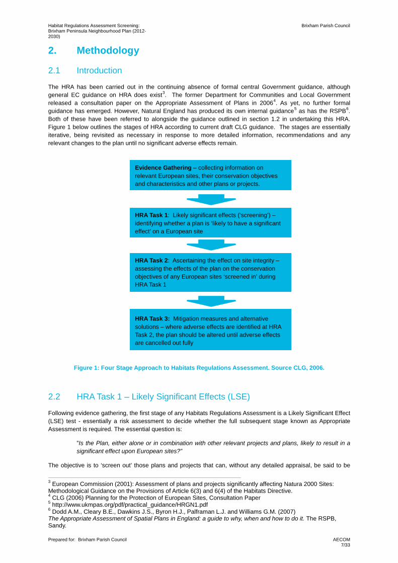
The HRA has been carried out in the continuing absence of formal central Government guidance, although general EC guidance on HRA does exist3. The former Department for Communities and Local Government released a consultation paper on the Appropriate Assessment of Plans in 20064. As yet, no further formal guidance has emerged. However, Natural England has produced its own internal guidance5 as has the RSPB6. Both of these have been referred to alongside the guidance outlined in section 1.2 in undertaking this HRA. Figure 1 below outlines the stages of HRA according to current draft CLG guidance. The stages are essentially iterative, being revisited as necessary in response to more detailed information, recommendations and any relevant changes to the plan until no significant adverse effects remain.
Figure 1: Four Stage Approach to Habitats Regulations Assessment. Source CLG, 2006.
2.2 HRA Task 1 – Likely Significant Effects (LSE)
Following evidence gathering, the first stage of any Habitats Regulations Assessment is a Likely Significant Effect (LSE) test - essentially a risk assessment to decide whether the full subsequent stage known as Appropriate Assessment is required. The essential question is:
”Is the Plan, either alone or in combination with other relevant projects and plans, likely to result in a significant effect upon European sites?”
The objective is to ‘screen out’ those plans and projects that can, without any detailed appraisal, be said to be
3 European Commission (2001): Assessment of plans and projects significantly affecting Natura 2000 Sites: Methodological Guidance on the Provisions of Article 6(3) and 6(4) of the Habitats Directive. 4 CLG (2006) Planning for the Protection of European Sites, Consultation Paper 5 http://www.ukmpas.org/pdf/practical_guidance/HRGN1.pdf 6 Dodd A.M., Cleary B.E., Dawkins J.S., Byron H.J., Palframan L.J. and Williams G.M. (2007) The Appropriate Assessment of Spatial Plans in England: a guide to why, when and how to do it. The RSPB, Sandy.
HRA Task 1: Likely significant effects (‘screening’) –identifying whether a plan is ‘likely to have a significant effect’ on a European site
HRA Task 2: Ascertaining the effect on site integrity – assessing the effects of the plan on the conservation objectives of any European sites ‘screened in’ during HRA Task 1
HRA Task 3: Mitigation measures and alternative solutions – where adverse effects are identified at HRA Task 2, the plan should be altered until adverse effects are cancelled out fully
Evidence Gathering – collecting information on relevant European sites, their conservation objectives and characteristics and other plans or projects.
Habitat Regulations Assessment Screening: Brixham Peninsula Neighbourhood Plan (2012-2030)
Brixham Parish Council
Prepared for: Brixham Parish Council
AECOM 8/33
unlikely to result in significant adverse effects upon European sites, usually because there is no mechanism for an adverse interaction with European sites. This stage is undertaken in Chapter 5 of this report.
In evaluating significance, AECOM have relied on our professional judgement as well as the results of previous stakeholder consultation regarding development impacts on the European sites listed in Section 1.3.
The level of detail in land use plans concerning developments that will be permitted under the plans will never be sufficient to make a detailed quantification of adverse effects. Therefore, we have again taken a precautionary approach (in the absence of more precise data) assuming as the default position that if an adverse effect cannot be confidently ruled out, avoidance or mitigation measures must be provided. This is in line with the former Department of Communities and Local Government guidance that the level of detail of the assessment, whilst meeting the relevant requirements of the Habitats Regulations, should be ‘appropriate’ to the level of plan or project that it addresses (see Appendix B for a summary of this ‘tiering’ of assessment).
2.3 Other Plans and Projects That May Act in Combination
It is a requirement of the Regulations that the impacts of any land use plan being assessed are not considered in isolation but in combination with other plans and projects that may also be affecting the European site(s) in question.
It is neither practical nor necessary to assess the ‘in combination’ effects of the Neighbourhood Plan within the context of all other plans and projects within Torbay (within which the Brixham Peninsula Neighbourhood Plan area is located) and the surrounding authorities. For the purposes of this assessment we have determined that, due to the nature of the identified impacts, the key other plans and project with potential for in combination likely significant effects are those schemes that can result in the fragmentation, loss and/or disturbance of commuting routes and foraging areas for greater horseshoe bats and/or increase recreational pressure on the calcareous grassland and European dry heath within the South Hams SAC.
For the purpose of this assessment, the following documents will be considered in combination with the Neighbourhood Plan as these provide for strategic levels of development within areas associated with the South Hams SAC:
• Teignbridge Local Plan 2013-2033 (adopted 6th May 2014); and
• South Hams Local Development Framework 2006-2016 (adopted July 2010).
When undertaking this part of the assessment it is essential to bear in mind the principal intention behind the legislation i.e. to ensure that those projects or plans which in themselves have minor impacts are not simply dismissed on that basis, but are evaluated for any cumulative contribution they may make to an overall significant effect. In practice, in combination assessment is therefore of greatest relevance when the plan would otherwise be screened out because its individual contribution is inconsequential.
Habitat Regulations Assessment Screening: Brixham Peninsula Neighbourhood Plan (2012-2030)
Brixham Parish Council
Prepared for: Brixham Parish Council
AECOM 9/33
3. South Hams SAC
3.1 Introduction
South Hams SAC is 129.53ha in size and is divided in to five separate sites:
• Buckfastleigh Caves SSSI;
• Bulkamore Iron Mine SSSI;
• Chudleigh Caves and Woods SSSI;
• Haytor and Smallacombe Iron Mines SSSI; and
• Berry Head to Sharkham Point SSSI.
The SAC is considered to be one of the best areas of European dry heaths and semi-natural dry grassland and scrubland facies in the UK. The SAC is thought to support the largest population of greater horseshoe bat (Rhinolophus ferrumequinum) in the UK, containing more than 1000 adult bats and supporting maternity and hibernation sites7.
The Berry Head to Sharkham Point SSSI component of the SAC is located adjacent to the town of Brixham, on the Brixham peninsula. This area of the SAC comprises open limestone grassland and sea cliffs which support the largest Guillemot (Uria aalge) colony along the south coast of England. The SSSI also supports greater horseshoe bat and lesser horseshoe bat (R. hipposideros)8.
3.2 Reasons for Designation
The site is designated as an SAC for the following features:
• European dry heaths;
• Semi-natural dry grassland and scrubland facies on calcareous substrates (Festuco-Brometalia);
• Vegetated sea cliffs of the Atlantic and Baltic Coasts;
• Caves not open to the public;
• Tilio-Acerion forests of slopes, screes and ravines; and
• Greater horseshoe bat.
3.3 Potential Environmental Vulnerabilities
• Fragmentation, loss and disturbance of commuting routes and foraging areas for greater horseshoe bats; and
• Recreational pressure on the calcareous grassland and European dry heath
3.4 Conservation Objectives9
With regard to the SAC and the natural habitats and/or species for which the site has been designated (the ‘Qualifying Features’, listed in Section 3.2), and subject to natural change, the following conservation objectives apply;
• Ensure that the integrity of the site is maintained or restored as appropriate, and ensure that the site contributes to achieving the Favourable Conservation Status of its Qualifying Features, by maintaining or restoring;
• The extent and distribution of qualifying natural habitats and habitats of qualifying species;
• The structure and function (including typical species) of qualifying natural habitats;
• The structure and function of the habitats of qualifying species; 7 JNCC (2015) Natura 2000 – Standard Data Form: South Hams SAC 8 Natural England (1986). SSSI Citation: Berry Head to Sharkham Point SSSI 9 Natural England (2014). European Site Conservation Objectives for South Hams SAC (UK0012650)

Habitat Regulations Assessment Screening: Brixham Peninsula Neighbourhood Plan (2012-2030)
Brixham Parish Council
Prepared for: Brixham Parish Council
AECOM 10/33
• The supporting processes on which qualifying natural habitats and the habitats of qualifying species rely;
• The populations of qualifying species; and
• The distribution of qualifying species within the site.
Habitat Regulations Assessment Screening: Brixham Peninsula Neighbourhood Plan (2012-2030)
Brixham Parish Council
Prepared for: Brixham Parish Council
AECOM 11/33
4. HRA Screening of the Brixham Peninsula Neighbourhood Plan
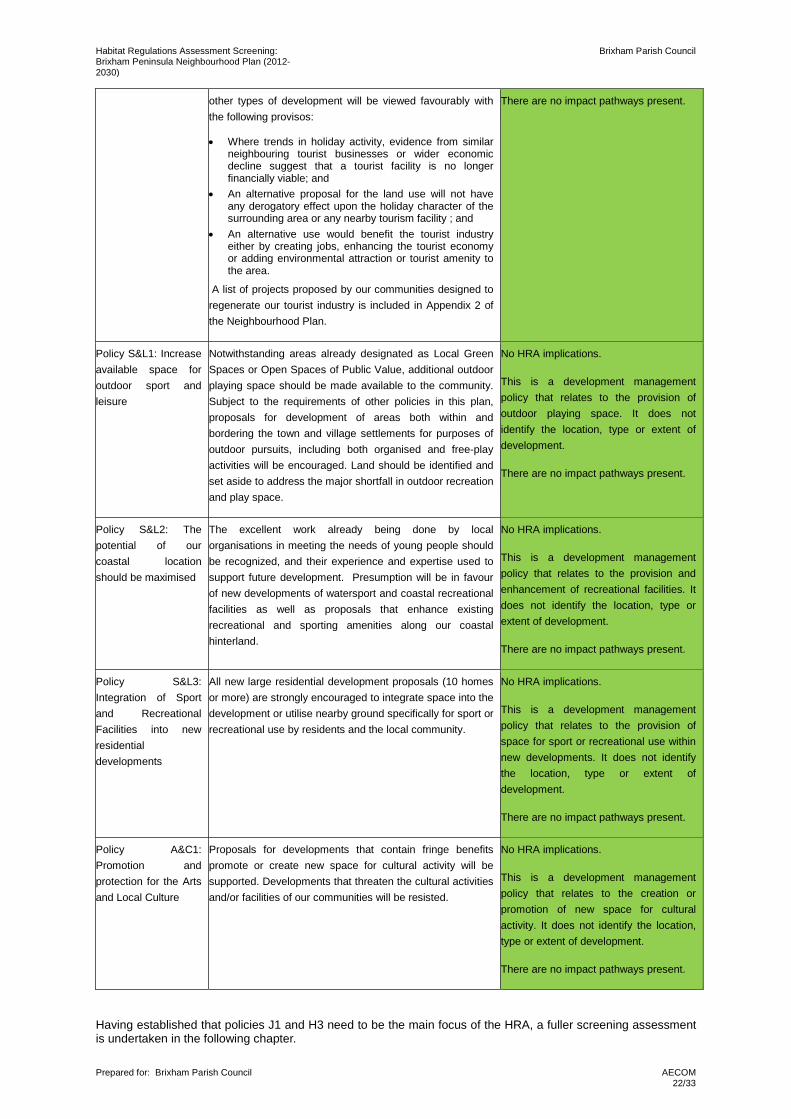
Following the analysis of the draft Brixham Peninsula Neighbourhood Plan, Table 1 provides a HRA screening assessment of the policies included. Green shading in the final column indicates that the policy has been screened out from further consideration due to the absence of any mechanism for an adverse effect on designated sites. Orange shading indicated that further assessment is required since a pathway of impact potentially exists that cannot be screened out at this point.
Table 1. Screening of Neighbourhood Plan Policies
Policy Policy Description HRA Implications
Policy F1: Future Strategy – A community led response to change
Future strategic development proposals not identified within this Neighbourhood Plan will be considered by the Brixham Peninsula Neighbourhood Forum before the Local Planning Authority provides pre-application advice or determines any planning application. When providing pre-application advice or determining applications the Local Planning Authority will pay close regard to the Forum’s recommendations.
In this context “strategic development proposals” are those which are not set out in this plan and involve either:
• New sites; or • Different uses for existing sites And are for proposals of: • 10 or more homes; or • 200sqm of employment floor space. In making recommendations the Forum will have regard to the views of Brixham Town Council, the Brixham Community Partnership and the Churston, Galmpton and Broadsands Community Partnership
No HRA implications.
This is a development management policy relating to the role of the Brixham Peninsula Neighbourhood Forum in future development planning. It does not identify any type, location or extent of development.
There are no impact pathways present.
Policy J1: Employment land – proposed, retained and refurbished
Employment land, commercial and business premises are to be retained for Class B uses unless there is no reasonable prospect of the site being used for employment purposes on grounds of viability. Viability to be proven by evidence of attempts to lease or sell premises at a reasonable market rate for a minimum of six months.
Projects that increase the diversity of industries within the town or promote key industries will be supported as will new leisure facilities which bring new employment to the sites identified. Development on Brownfield sites in preference to Greenfield sites will be promoted and supported. Those developments that generate permanent jobs will be viewed favourably provided that it can be accommodated without prejudicing the integrity of the AONB, Special Areas of Conservation and the Coastal Preservation Area.
The sites set out below are allocated for employment development. This is to ensure this plan is in general conformity with Local Plan Policy SDB1 by providing over the plan period 2012 to 2030 for a minimum of 2700 sqm of new employment floor space.
Further details on these allocated employment sites, including details maps of each site are provided in the Employment Site Assessment, a supporting document
Potential HRA implications
This policy provides details of sites allocated for employment development, providing a total of 5779 sqm of potential employment floor space, an increase on the 2700 sqm outlined in the Torbay Local Plan (Policy SDB1).
The proposed sites, with the exception of Galmpton Sewage Works, are assessed in the Torbay Local Plan.As the Galmpton Sewage Works is not assessed within the Local Plan, there is potential for HRA implications.
Potential impact pathways present include: • Fragmentation or disturbance of
commuting routes and foraging areas of greater horseshoe bats; and
• Increased recreational pressure on the habitats within the South Hams SAC.
Habitat Regulations Assessment Screening: Brixham Peninsula Neighbourhood Plan (2012-2030)
Brixham Parish Council
Prepared for: Brixham Parish Council
AECOM 12/33
which has informed Policy J1.
The allocated employment sites are:
• E1-1: Galmpton Sewage Works; • E1-2: Broadsands Overflow Car Park; • E1-3: Oxen Cove and Freshwater; • E1-4: Torbay Trading Estate; • E1-5: 74 New Road; • E1-6: Brixham Town Centre; • E1-7; Northcliff Hotel.
Policy J2: Provision of Information and Communication Technology
Where recently established and emerging new communications technologies are not currently available, major developments will be required to install the necessary infrastructure. Wherever possible, information and communication technology will be installed as necessary in line with Local Plan policy IF1. Such state-of-the-art communications infrastructure will be included in commercial and business proposals, including mixed housing live /work developments. Where this is not possible development will ensure that its future installation will be catered for in new development plans.
No HRA implications.
This is a development management policy relating to the principles of build design and provision of information and communication technology.
There are no impact pathways present.
Policy J3: Local Employment – Traditional Training and Skills
Major new developments (those that seek to employ 10 or more staff) are strongly encouraged and will be supported to link with local educational/training facilities, including South Devon University Technical College. Provision of apprenticeships and training for future job opportunities on the Peninsula will be encouraged and strongly supported.
No HRA implications.
This policy relates to major new developments liking with local educational/training facilities to provide apprenticeships and training.
There are no impact pathways present.
Policy J4: Local Employment – Increased Employment and Local Amenity
Development of start-up businesses or incubation units will be supported within settlement boundaries and where the proposal also complies with Policy J8.
Home based jobs, web-based commerce, live/work units and work hubs providing/facilitating an increase in employment will be particularly welcomed. Development will not be allowed which generates unacceptable noise, air pollution, levels of traffic or where the residential amenity of the area will be adversely affected.
Where a new employment development has 10 or more workers, travel planning is strongly encouraged to ensure that staff travel is made sustainable (e g via car share, public transport, bicycle, use of park and ride and walking)
No HRA implications.
This is a development management policy relating to start-up business. It does not identify any type, location or extent of development.
There are no impact pathways present.
Policy J5: Sustaining a Vibrant Harbour Side Economy
Brixham Harbour shall be maintained and further developed as a working harbour, to support the harbour-based economy, and harbour side businesses and to safeguard the town's heritage and image. Support will be given to applications for a range of fishing and marine related developments, including shellfish processing on the Harbour Estate that would benefit the fishing industry and harbour-side economy. Developments around the harbour will comply with Local Plan Policy TO3 but will not rely on the construction of a Northern Arm Breakwater as a prerequisite to new developments. Investigating the feasibility of this long-term project will be actively pursued.
No HRA implications.
This is a development management policy relating to Brixham Harbour. It does not identify and type or extent of development.
There are no impact pathways present.
Habitat Regulations Assessment Screening: Brixham Peninsula Neighbourhood Plan (2012-2030)
Brixham Parish Council
Prepared for: Brixham Parish Council
AECOM 13/33
Policy J6: Redevelopment of the Town Centre Car Park and Surrounding Area
A full planning brief/master-plan should be undertaken as part of any development proposal to ensure that a satisfactory and comprehensive approach is taken that ensures the safeguarding of our heritage and designated conservation zone. Hence maintaining local character and the town's attractiveness as a tourist destination. Access, connectivity, transport issues and design characteristics will be addressed in any initial development proposal.
Initial guidance can be obtained from the evolving Town Centre Master Plan.
No HRA implications.
This is a development management policy relating to the Town Centre Car Park and surrounding area. It does not identify any type or extent of development.
There are no impact pathways present.
Policy J7: Oxen Cove and Freshwater Quarry
A full planning brief/master-plan should be undertaken as part of any development proposal to ensure that a satisfactory and comprehensive approach is taken that safeguards heritage, environment and Brixham as a major tourist destination. Access and transport issues will be expected to be addressed in any initial development proposal and should include the potential short re-alignment route of the South Devon Coastal Path.
Design and development options should be informed by the Port Master Plan and the evolving Town Centre Master Plan.
No HRA implications.
This is a development management policy relating to Oxen Cove and Freshwater Quarry. It does not identify any type or extent of development.
There are no impact pathways present.
Policy J8 – Employment in the 3 Villages of Churston, Galmpton and Broadsands
New employment development in the three villages should respect the sensitive countryside and coastal setting of the Peninsula. Employment proposals should relate to the scale and nature of the existing communities and villages of Churston, Galmpton and Broadsands.
Small scale, sensitively designed proposals which provide local employment opportunities appropriate to the countryside and the rural economy (such as rural crafts, farming, heritage, marine, tourism, outdoor leisure and recreation) will be supported. There should be no adverse impact on the character of the village or amenity of residents. Any traffic generated should not adversely impact on the villages, either through impacts on their tranquillity and rural character, their environment, or through impacts on the narrow lanes including the safety of vulnerable road users.
No HRA implications.
This is a development management policy relating to employment developments in Churston, Galmpton and Broadsands. It does not identify location or extent of development.
There are no impact pathways present.
Policy H1: Affordable Housing
Affordable homes will be provided in new developments as a proportion of new open market homes as per the ratios set out in the Local Plan.
Provision of affordable homes is preferred on site and integrated into the new development.
However, where it is determined that a larger number of affordable houses could be provided by payment of a commuted sum rather than on site provision, a commuted sum may be paid but only where it can be directly allocated to the provision of affordable homes within the Peninsula.
No HRA implications.
This is a development management policy relating to provision of affordable housing. It does not identify any location or quantum of residential development.
There are no impact pathways present.
Policy H2: Allocation of New Affordable Homes
Affordable houses in the Peninsula shall only be occupied by persons (and their dependants) whose housing needs are not met by the market and:
• who have a minimum period of 5 years in the last 10
No HRA implications.
This is a development management policy relating to the allocation of new affordable homes. It does not identify any
Habitat Regulations Assessment Screening: Brixham Peninsula Neighbourhood Plan (2012-2030)
Brixham Parish Council
Prepared for: Brixham Parish Council
AECOM 14/33
years permanent and continuous residence in the Peninsula and are currently living in the Peninsula; or
• who have lived in the Peninsula for at least 5 years and whose parents or children are currently living here and have at least 10 years continuous residency; or
• who are a key worker as defined by the UK Government and are working within the Peninsula.
Where persons cannot be found to meet these criteria, affordable housing may be occupied by people and their dependents whose housing needs are not met by the market. These occupancy requirements shall apply in perpetuity, and be the subject of a legal agreement negotiated during the planning process on any development of affordable housing.
location or quantum of residential development.
There are no impact pathways present.
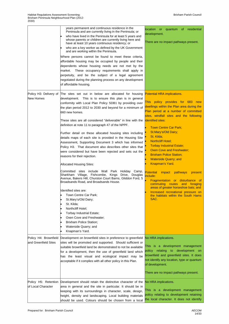
Policy H3: Delivery of New Homes
The sites set out in below are allocated for housing development. This is to ensure this plan is in general conformity with Local Plan Policy SDB1 by providing over the plan period 2012 to 2030 and beyond for a minimum of 660 new homes.
These sites are all considered “deliverable” in line with the definition at note 11 to paragraph 47 of the NPPF.
Further detail on these allocated housing sites including details maps of each site is provided in the Housing Site Assessment, Supporting Document 3 which has informed Policy H3. That document also describes other sites that were considered but have been rejected and sets out the reasons for their rejection.
Allocated Housing Sites:
Committed sites include Wall Park Holiday Camp, Sharkham Village, Fishcombe, Kings Drive, Douglas Avenue, Bakers Hill, Churston Court Barns, Gliddon Ford, 5 Broadsands Road, and Broadsands House. Identified sites are: • Town Centre Car Park; • St.Mary’s/Old Dairy; • St. Kilda; • Northcliff Hotel; • Torbay Industrial Estate; • Oxen Cove and Freshwater; • Brixham Police Station; • Waterside Quarry; and • Knapman’s Yard.
Potential HRA implications.
This policy provides for 683 new dwellings within the Plan area during the Plan period at a number of committed sites, windfall sites and the following identified sites:
• Town Centre Car Park; • St.Mary’s/Old Dairy; • St. Kilda; • Northcliff Hotel; • Torbay Industrial Estate; • Oxen Cove and Freshwater; • Brixham Police Station; • Waterside Quarry; and • Knapman’s Yard. Potential impact pathways present include: • Fragmentation or disturbance of
commuting routes and foraging areas of greater horseshoe bats; and
• Increased recreational pressure on the habitats within the South Hams SAC.
Policy H4: Brownfield and Greenfield Sites
Development on brownfield sites in preference to greenfield sites will be promoted and supported. Should sufficient or suitable brownfield land be demonstrated to not be available for a development, then the use of greenfield land which has the least visual and ecological impact may be acceptable if it complies with all other policy in this Plan.
No HRA implications.
This is a development management policy relating to development on brownfield and greenfield sites. It does not identify any location, type or quantum of development.
There are no impact pathways present.
Policy H5: Retention of Local Character
Development should retain the distinctive character of the area in general and the site in particular. It should be in keeping with its surroundings in character, scale, design, height, density and landscaping. Local building materials should be used. Colours should be chosen from a local
No HRA implications.
This is a development management policy relating to development retaining the local character. It does not identify
Habitat Regulations Assessment Screening: Brixham Peninsula Neighbourhood Plan (2012-2030)
Brixham Parish Council
Prepared for: Brixham Parish Council
AECOM 15/33
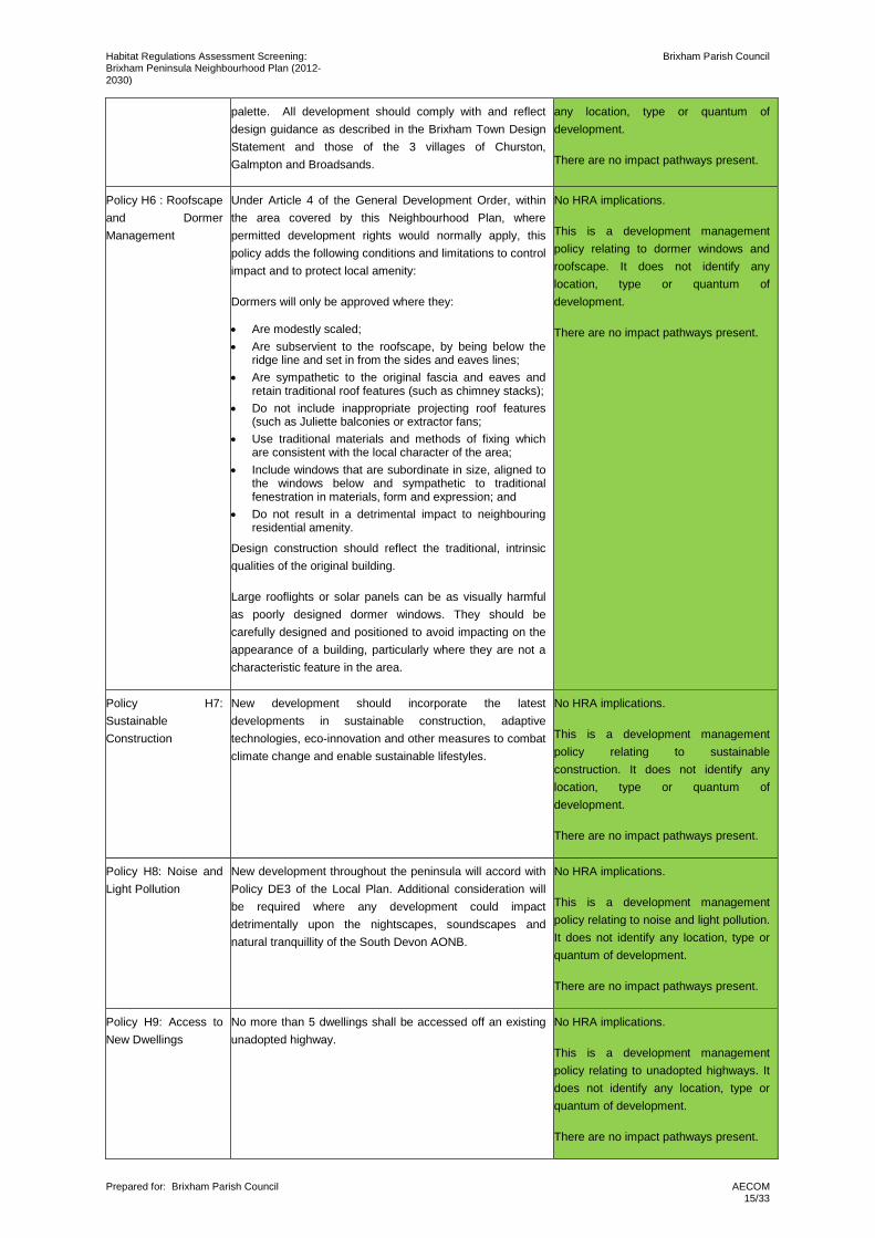
palette. All development should comply with and reflect design guidance as described in the Brixham Town Design Statement and those of the 3 villages of Churston, Galmpton and Broadsands.
any location, type or quantum of development.
There are no impact pathways present.
Policy H6 : Roofscape and Dormer Management
Under Article 4 of the General Development Order, within the area covered by this Neighbourhood Plan, where permitted development rights would normally apply, this policy adds the following conditions and limitations to control impact and to protect local amenity:
Dormers will only be approved where they:
• Are modestly scaled; • Are subservient to the roofscape, by being below the
ridge line and set in from the sides and eaves lines; • Are sympathetic to the original fascia and eaves and
retain traditional roof features (such as chimney stacks); • Do not include inappropriate projecting roof features
(such as Juliette balconies or extractor fans; • Use traditional materials and methods of fixing which
are consistent with the local character of the area; • Include windows that are subordinate in size, aligned to
the windows below and sympathetic to traditional fenestration in materials, form and expression; and
• Do not result in a detrimental impact to neighbouring residential amenity.
Design construction should reflect the traditional, intrinsic qualities of the original building.
Large rooflights or solar panels can be as visually harmful as poorly designed dormer windows. They should be carefully designed and positioned to avoid impacting on the appearance of a building, particularly where they are not a characteristic feature in the area.
No HRA implications.
This is a development management policy relating to dormer windows and roofscape. It does not identify any location, type or quantum of development.
There are no impact pathways present.
Policy H7: Sustainable Construction
New development should incorporate the latest developments in sustainable construction, adaptive technologies, eco-innovation and other measures to combat climate change and enable sustainable lifestyles.
No HRA implications.
This is a development management policy relating to sustainable construction. It does not identify any location, type or quantum of development.
There are no impact pathways present.
Policy H8: Noise and Light Pollution
New development throughout the peninsula will accord with Policy DE3 of the Local Plan. Additional consideration will be required where any development could impact detrimentally upon the nightscapes, soundscapes and natural tranquillity of the South Devon AONB.
No HRA implications.
This is a development management policy relating to noise and light pollution. It does not identify any location, type or quantum of development.
There are no impact pathways present.
Policy H9: Access to New Dwellings
No more than 5 dwellings shall be accessed off an existing unadopted highway.
No HRA implications.
This is a development management policy relating to unadopted highways. It does not identify any location, type or quantum of development.
There are no impact pathways present.
Habitat Regulations Assessment Screening: Brixham Peninsula Neighbourhood Plan (2012-2030)
Brixham Parish Council
Prepared for: Brixham Parish Council
AECOM 16/33
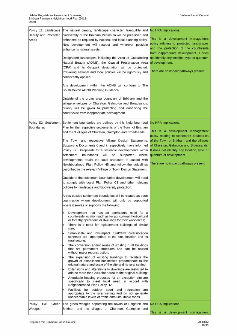
Policy E1: Landscape Beauty and Protected Areas
The natural beauty, landscape character, tranquillity and biodiversity of the Brixham Peninsula will be preserved and enhanced as required by national and local planning policy. New development will respect and wherever possible enhance its natural assets.
Designated landscapes including the Area of Outstanding Natural Beauty (AONB), the Coastal Preservation Area (CPA) and its Geopark designation will be protected. Prevailing national and local policies will be rigorously and consistently applied.
Any development within the AONB will conform to The South Devon AONB Planning Guidance
Outside of the urban area boundary of Brixham and the village envelopes of Churston, Galmpton and Broadsands, priority will be given to protecting and enhancing the countryside from inappropriate development.
No HRA implications.
This is a development management policy relating to protected landscapes and the protection of the countryside from inappropriate development. It does not identify any location, type or quantum of development.
There are no impact pathways present.
Policy E2: Settlement Boundaries
Settlement boundaries are defined by this Neighbourhood Plan for the respective settlements of the Town of Brixham and the 3 villages of Churston, Galmpton and Broadsands.
The Town and respective Village Design Statements, Supporting Documents 6 and 7 respectively, have informed Policy E2. Proposals for sustainable developments within settlement boundaries will be supported where developments retain the local character in accord with Neighbourhood Plan Policy H5 and follow the guidelines described in the relevant Village or Town Design Statement.
Outside of the settlement boundaries development will need to comply with Local Plan Policy C1 and other relevant policies for landscape and biodiversity protection.
Areas outside settlement boundaries will be treated as open countryside where development will only be supported where it serves or supports the following:
• Development that has an operational need for a countryside location such as for agricultural, horticultural or forestry operations or dwellings for their workforces;
• There is a need for replacement buildings of similar size;
• Small-scale and low-impact rural/farm diversification schemes are appropriate to the site, location and its rural setting;
• The conversion and/or reuse of existing rural buildings that are permanent structures and can be reused without major reconstruction;
• The expansion of existing buildings to facilitate the growth of established businesses proportionate to the original nature and scale of the site and its rural setting;
• Extensions and alterations to dwellings are restricted to add no more than 20% floor area to the original building;
• Affordable housing proposed for an exception site are specifically to meet local need in accord with Neighbourhood Plan Policy H2;
• Facilities for outdoor sport and recreation are appropriate to the rural setting and do not generate unacceptable levels of traffic onto unsuitable roads.
No HRA implications.
This is a development management policy relating to settlement boundaries of the Town of Brixham and the villages of Churston, Galmpton and Broadsands. It does not identify any location, type or quantum of development.
There are no impact pathways present.
Policy E3: Green Wedges
The green wedges separating the towns of Paignton and Brixham and the villages of Churston, Galmpton and
No HRA implications.
This is a development management
Habitat Regulations Assessment Screening: Brixham Peninsula Neighbourhood Plan (2012-2030)
Brixham Parish Council
Prepared for: Brixham Parish Council
AECOM 17/33
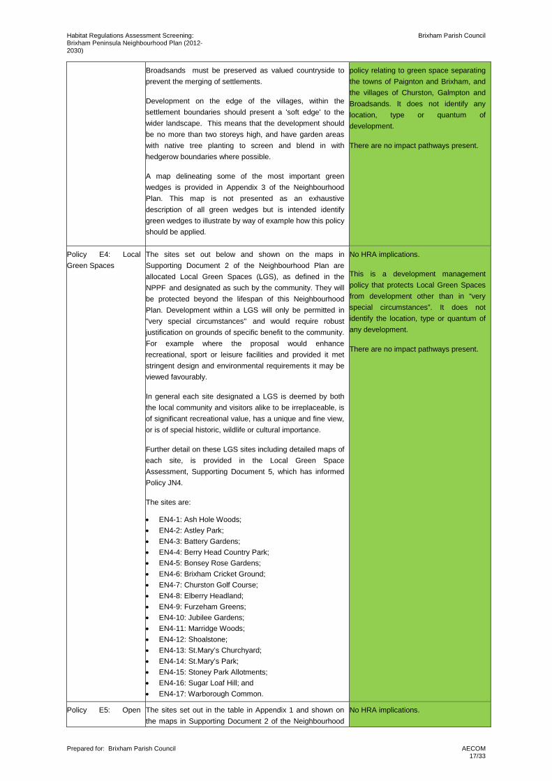
Broadsands must be preserved as valued countryside to prevent the merging of settlements.
Development on the edge of the villages, within the settlement boundaries should present a 'soft edge' to the wider landscape. This means that the development should be no more than two storeys high, and have garden areas with native tree planting to screen and blend in with hedgerow boundaries where possible.
A map delineating some of the most important green wedges is provided in Appendix 3 of the Neighbourhood Plan. This map is not presented as an exhaustive description of all green wedges but is intended identify green wedges to illustrate by way of example how this policy should be applied.
policy relating to green space separating the towns of Paignton and Brixham, and the villages of Churston, Galmpton and Broadsands. It does not identify any location, type or quantum of development.
There are no impact pathways present.
Policy E4: Local Green Spaces
The sites set out below and shown on the maps in Supporting Document 2 of the Neighbourhood Plan are allocated Local Green Spaces (LGS), as defined in the NPPF and designated as such by the community. They will be protected beyond the lifespan of this Neighbourhood Plan. Development within a LGS will only be permitted in "very special circumstances" and would require robust justification on grounds of specific benefit to the community. For example where the proposal would enhance recreational, sport or leisure facilities and provided it met stringent design and environmental requirements it may be viewed favourably.
In general each site designated a LGS is deemed by both the local community and visitors alike to be irreplaceable, is of significant recreational value, has a unique and fine view, or is of special historic, wildlife or cultural importance.
Further detail on these LGS sites including detailed maps of each site, is provided in the Local Green Space Assessment, Supporting Document 5, which has informed Policy JN4.
The sites are:
• EN4-1: Ash Hole Woods; • EN4-2: Astley Park; • EN4-3: Battery Gardens; • EN4-4: Berry Head Country Park; • EN4-5: Bonsey Rose Gardens; • EN4-6: Brixham Cricket Ground; • EN4-7: Churston Golf Course; • EN4-8: Elberry Headland; • EN4-9: Furzeham Greens; • EN4-10: Jubilee Gardens; • EN4-11: Marridge Woods; • EN4-12: Shoalstone; • EN4-13: St.Mary’s Churchyard; • EN4-14: St.Mary’s Park; • EN4-15: Stoney Park Allotments; • EN4-16: Sugar Loaf Hill; and • EN4-17: Warborough Common.
No HRA implications.
This is a development management policy that protects Local Green Spaces from development other than in “very special circumstances”. It does not identify the location, type or quantum of any development.
There are no impact pathways present.
Policy E5: Open The sites set out in the table in Appendix 1 and shown on the maps in Supporting Document 2 of the Neighbourhood
No HRA implications.
Habitat Regulations Assessment Screening: Brixham Peninsula Neighbourhood Plan (2012-2030)
Brixham Parish Council
Prepared for: Brixham Parish Council
AECOM 18/33
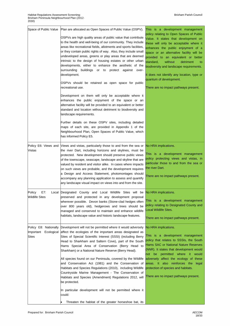
Space of Public Value Plan are allocated as Open Spaces of Public Value (OSPV).
OSPVs are high quality areas of public value that contribute to the health and well-being of our community. They include areas like recreational fields, allotments and sports facilities, or they contain public rights of way. Also, they include small undeveloped areas, greens or play areas that are deemed intrinsic to the design of housing estates or other urban developments, either to enhance the aesthetic of the surrounding buildings or to protect against over-development.
OSPVs should be retained as open space for public recreational use.
Development on them will only be acceptable where it enhances the public enjoyment of the space or an alternative facility will be provided to an equivalent or better standard and location without detriment to biodiversity and landscape requirements.
Further details on these OSPV sites, including detailed maps of each site, are provided in Appendix 1 of the Neighbourhood Plan, Open Spaces of Public Value, which has informed Policy E5.
This is a development management policy relating to Open Spaces of Public Value. It states that development on these will only be acceptable where it enhances the public enjoyment of a space or an alternative facility will be provided to an equivalent or better standard, without detriment to biodiversity and landscape requirements.
It does not identify any location, type or quantum of development.
There are no impact pathways present.
Policy E6: Views and Vistas
Views and vistas, particularly those to and from the sea or the river Dart, including horizons and skylines, must be protected. New development should preserve public views of the townscape, seascape, landscape and skyline that are valued by resident and visitor alike. In cases where impacts on such views are probable, and the development requires a Design and Access Statement, photomontages should accompany any planning application to assess and quantify any landscape visual impact on views into and from the site.
No HRA implications.
This is a development management policy protecting views and vistas, in particular those to and from the sea or the river Dart.
There are no impact pathways present.
Policy E7: Local Wildlife Sites
Designated County and Local Wildlife Sites will be preserved and protected in any development proposal wherever possible. Devon banks (Stone-clad hedges often over 800 years old), hedgerows and trees should be managed and conserved to maintain and enhance wildlife habitats, landscape value and historic landscape features.
No HRA implications.
This is a development management policy relating to Designated County and Local Wildlife Sites.
There are no impact pathways present.
Policy E8: Nationally Important Ecological Sites
Development will not be permitted where it would adversely affect the ecologies of the important areas designated as Sites of Special Scientific Interest (SSSI) (including Berry Head to Sharkham and Saltern Cove), part of the South Hams Special Area of Conservation (Berry Head to Sharkham) or a National Nature Reserve (Berry Head).
All species found on our Peninsula, covered by the Wildlife and Conservation Act (1981) and the Conservation of Habitats and Species Regulations (2010), including Wildlife Countryside Marine Management - The Conservation of Habitats and Species (Amendment) Regulations 2012, will be protected.
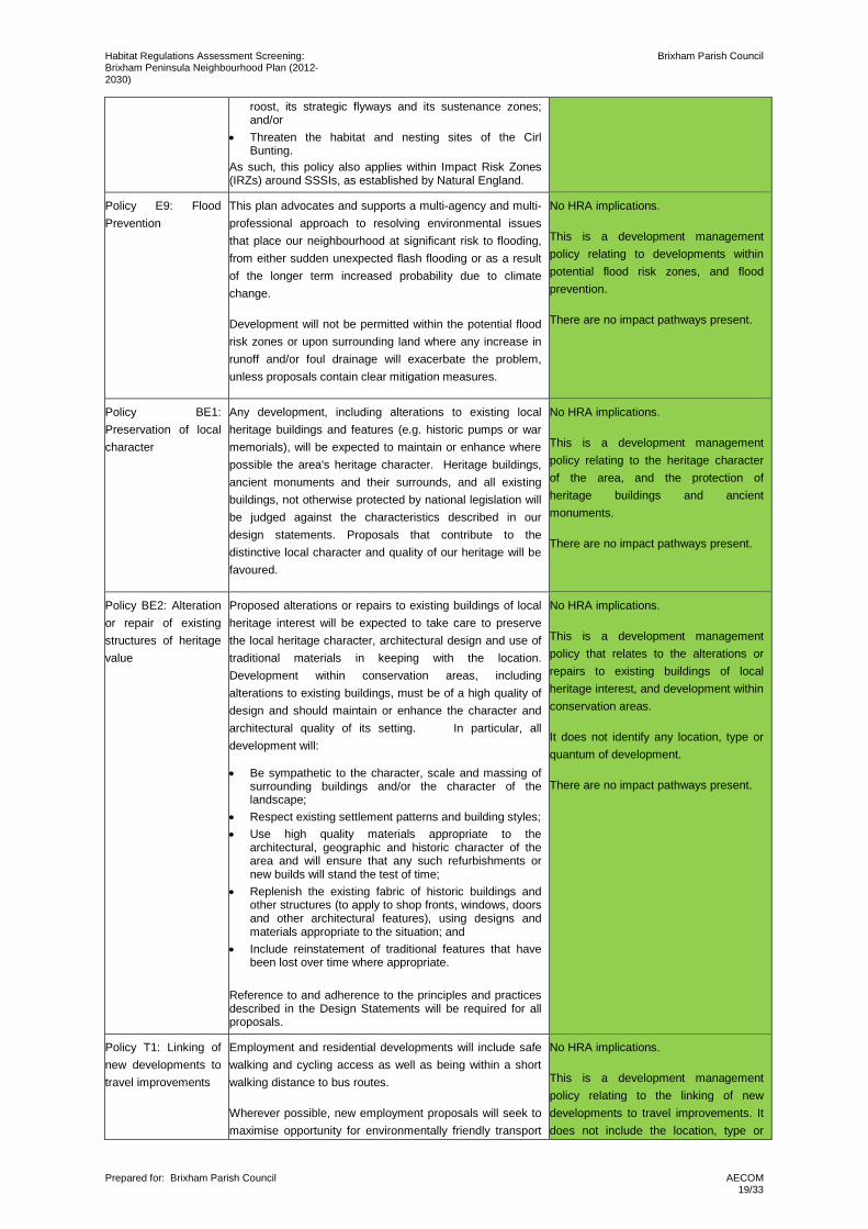
In particular development will not be permitted where it could:
• Threaten the habitat of the greater horseshoe bat, its
No HRA implications.
This is a development management policy that relates to SSSIs, the South Hams SAC or National Nature Reserves (NNR). It states that development would not be permitted where it would adversely affect the ecology of these areas. It also reinforces the legal protection of species and habitats.
There are no impact pathways present.
Habitat Regulations Assessment Screening: Brixham Peninsula Neighbourhood Plan (2012-2030)
Brixham Parish Council
Prepared for: Brixham Parish Council
AECOM 19/33
roost, its strategic flyways and its sustenance zones; and/or
• Threaten the habitat and nesting sites of the Cirl Bunting.
As such, this policy also applies within Impact Risk Zones (IRZs) around SSSIs, as established by Natural England.
Policy E9: Flood Prevention
This plan advocates and supports a multi-agency and multi-professional approach to resolving environmental issues that place our neighbourhood at significant risk to flooding, from either sudden unexpected flash flooding or as a result of the longer term increased probability due to climate change.
Development will not be permitted within the potential flood risk zones or upon surrounding land where any increase in runoff and/or foul drainage will exacerbate the problem, unless proposals contain clear mitigation measures.
No HRA implications.
This is a development management policy relating to developments within potential flood risk zones, and flood prevention.
There are no impact pathways present.
Policy BE1: Preservation of local character
Any development, including alterations to existing local heritage buildings and features (e.g. historic pumps or war memorials), will be expected to maintain or enhance where possible the area's heritage character. Heritage buildings, ancient monuments and their surrounds, and all existing buildings, not otherwise protected by national legislation will be judged against the characteristics described in our design statements. Proposals that contribute to the distinctive local character and quality of our heritage will be favoured.
No HRA implications.
This is a development management policy relating to the heritage character of the area, and the protection of heritage buildings and ancient monuments.
There are no impact pathways present.
Policy BE2: Alteration or repair of existing structures of heritage value
Proposed alterations or repairs to existing buildings of local heritage interest will be expected to take care to preserve the local heritage character, architectural design and use of traditional materials in keeping with the location. Development within conservation areas, including alterations to existing buildings, must be of a high quality of design and should maintain or enhance the character and architectural quality of its setting. In particular, all development will:
• Be sympathetic to the character, scale and massing of surrounding buildings and/or the character of the landscape;
• Respect existing settlement patterns and building styles; • Use high quality materials appropriate to the
architectural, geographic and historic character of the area and will ensure that any such refurbishments or new builds will stand the test of time;
• Replenish the existing fabric of historic buildings and other structures (to apply to shop fronts, windows, doors and other architectural features), using designs and materials appropriate to the situation; and
• Include reinstatement of traditional features that have been lost over time where appropriate.
Reference to and adherence to the principles and practices described in the Design Statements will be required for all proposals.
No HRA implications.
This is a development management policy that relates to the alterations or repairs to existing buildings of local heritage interest, and development within conservation areas.
It does not identify any location, type or quantum of development.
There are no impact pathways present.
Policy T1: Linking of new developments to travel improvements
Employment and residential developments will include safe walking and cycling access as well as being within a short walking distance to bus routes.
Wherever possible, new employment proposals will seek to maximise opportunity for environmentally friendly transport
No HRA implications.
This is a development management policy relating to the linking of new developments to travel improvements. It does not include the location, type or
Habitat Regulations Assessment Screening: Brixham Peninsula Neighbourhood Plan (2012-2030)
Brixham Parish Council
Prepared for: Brixham Parish Council
AECOM 20/33
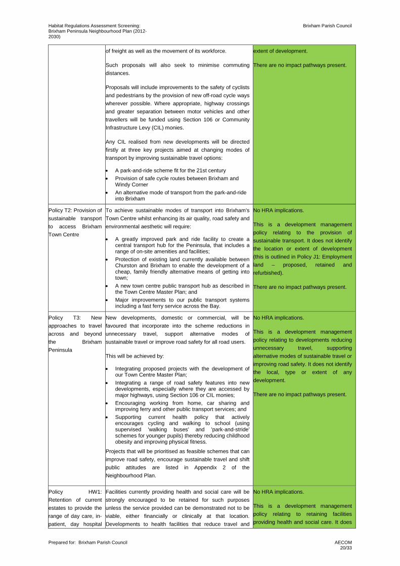
of freight as well as the movement of its workforce.
Such proposals will also seek to minimise commuting distances.
Proposals will include improvements to the safety of cyclists and pedestrians by the provision of new off-road cycle ways wherever possible. Where appropriate, highway crossings and greater separation between motor vehicles and other travellers will be funded using Section 106 or Community Infrastructure Levy (CIL) monies.
Any CIL realised from new developments will be directed firstly at three key projects aimed at changing modes of transport by improving sustainable travel options:
• A park-and-ride scheme fit for the 21st century • Provision of safe cycle routes between Brixham and
Windy Corner • An alternative mode of transport from the park-and-ride
into Brixham
extent of development.
There are no impact pathways present.
Policy T2: Provision of sustainable transport to access Brixham Town Centre
To achieve sustainable modes of transport into Brixham's Town Centre whilst enhancing its air quality, road safety and environmental aesthetic will require:
• A greatly improved park and ride facility to create a central transport hub for the Peninsula, that includes a range of on-site amenities and facilities;
• Protection of existing land currently available between Churston and Brixham to enable the development of a cheap, family friendly alternative means of getting into town;
• A new town centre public transport hub as described in the Town Centre Master Plan; and
• Major improvements to our public transport systems including a fast ferry service across the Bay.
No HRA implications.
This is a development management policy relating to the provision of sustainable transport. It does not identify the location or extent of development (this is outlined in Policy J1: Employment land – proposed, retained and refurbished).
There are no impact pathways present.
Policy T3: New approaches to travel across and beyond the Brixham Peninsula
New developments, domestic or commercial, will be favoured that incorporate into the scheme reductions in unnecessary travel, support alternative modes of sustainable travel or improve road safety for all road users.
This will be achieved by:
• Integrating proposed projects with the development of our Town Centre Master Plan;
• Integrating a range of road safety features into new developments, especially where they are accessed by major highways, using Section 106 or CIL monies;
• Encouraging working from home, car sharing and improving ferry and other public transport services; and
• Supporting current health policy that actively encourages cycling and walking to school (using supervised 'walking buses' and 'park-and-stride' schemes for younger pupils) thereby reducing childhood obesity and improving physical fitness.
Projects that will be prioritised as feasible schemes that can improve road safety, encourage sustainable travel and shift public attitudes are listed in Appendix 2 of the Neighbourhood Plan.
No HRA implications.
This is a development management policy relating to developments reducing unnecessary travel, supporting alternative modes of sustainable travel or improving road safety. It does not identify the local, type or extent of any development.
There are no impact pathways present.
Policy HW1: Retention of current estates to provide the range of day care, in-patient, day hospital
Facilities currently providing health and social care will be strongly encouraged to be retained for such purposes unless the service provided can be demonstrated not to be viable, either financially or clinically at that location. Developments to health facilities that reduce travel and
No HRA implications.
This is a development management policy relating to retaining facilities providing health and social care. It does
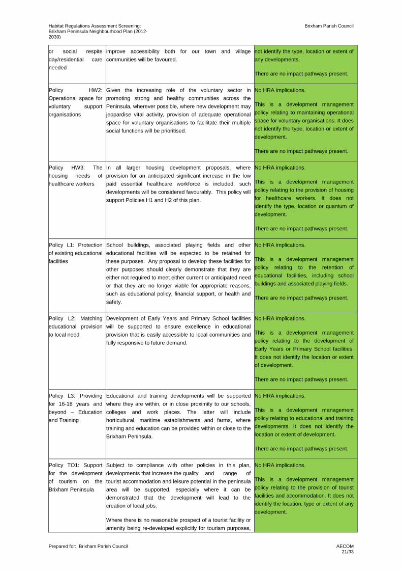
Habitat Regulations Assessment Screening: Brixham Peninsula Neighbourhood Plan (2012-2030)
Brixham Parish Council
Prepared for: Brixham Parish Council
AECOM 21/33
or social respite day/residential care needed
improve accessibility both for our town and village communities will be favoured.
not identify the type, location or extent of any developments.
There are no impact pathways present.
Policy HW2: Operational space for voluntary support organisations
Given the increasing role of the voluntary sector in promoting strong and healthy communities across the Peninsula, wherever possible, where new development may jeopardise vital activity, provision of adequate operational space for voluntary organisations to facilitate their multiple social functions will be prioritised.
No HRA implications.
This is a development management policy relating to maintaining operational space for voluntary organisations. It does not identify the type, location or extent of development.
There are no impact pathways present.
Policy HW3: The housing needs of healthcare workers
In all larger housing development proposals, where provision for an anticipated significant increase in the low paid essential healthcare workforce is included, such developments will be considered favourably. This policy will support Policies H1 and H2 of this plan.
No HRA implications.
This is a development management policy relating to the provision of housing for healthcare workers. It does not identify the type, location or quantum of development.
There are no impact pathways present.
Policy L1: Protection of existing educational facilities
School buildings, associated playing fields and other educational facilities will be expected to be retained for these purposes. Any proposal to develop these facilities for other purposes should clearly demonstrate that they are either not required to meet either current or anticipated need or that they are no longer viable for appropriate reasons, such as educational policy, financial support, or health and safety.
No HRA implications.
This is a development management policy relating to the retention of educational facilities, including school buildings and associated playing fields.
There are no impact pathways present.
Policy L2: Matching educational provision to local need
Development of Early Years and Primary School facilities will be supported to ensure excellence in educational provision that is easily accessible to local communities and fully responsive to future demand.
No HRA implications.
This is a development management policy relating to the development of Early Years or Primary School facilities. It does not identify the location or extent of development.
There are no impact pathways present.
Policy L3: Providing for 16-18 years and beyond – Education and Training
Educational and training developments will be supported where they are within, or in close proximity to our schools, colleges and work places. The latter will include horticultural, maritime establishments and farms, where training and education can be provided within or close to the Brixham Peninsula.
No HRA implications.
This is a development management policy relating to educational and training developments. It does not identify the location or extent of development.
There are no impact pathways present.
Policy TO1: Support for the development of tourism on the Brixham Peninsula
Subject to compliance with other policies in this plan, developments that increase the quality and range of tourist accommodation and leisure potential in the peninsula area will be supported, especially where it can be demonstrated that the development will lead to the creation of local jobs.
Where there is no reasonable prospect of a tourist facility or amenity being re-developed explicitly for tourism purposes,
No HRA implications.
This is a development management policy relating to the provision of tourist facilities and accommodation. It does not identify the location, type or extent of any development.
Habitat Regulations Assessment Screening: Brixham Peninsula Neighbourhood Plan (2012-2030)
Brixham Parish Council
Prepared for: Brixham Parish Council
AECOM 22/33
other types of development will be viewed favourably with the following provisos:
• Where trends in holiday activity, evidence from similar neighbouring tourist businesses or wider economic decline suggest that a tourist facility is no longer financially viable; and
• An alternative proposal for the land use will not have any derogatory effect upon the holiday character of the surrounding area or any nearby tourism facility ; and
• An alternative use would benefit the tourist industry either by creating jobs, enhancing the tourist economy or adding environmental attraction or tourist amenity to the area.
A list of projects proposed by our communities designed to regenerate our tourist industry is included in Appendix 2 of the Neighbourhood Plan.
There are no impact pathways present.
Policy S&L1: Increase available space for outdoor sport and leisure
Notwithstanding areas already designated as Local Green Spaces or Open Spaces of Public Value, additional outdoor playing space should be made available to the community. Subject to the requirements of other policies in this plan, proposals for development of areas both within and bordering the town and village settlements for purposes of outdoor pursuits, including both organised and free-play activities will be encouraged. Land should be identified and set aside to address the major shortfall in outdoor recreation and play space.
No HRA implications.
This is a development management policy that relates to the provision of outdoor playing space. It does not identify the location, type or extent of development.
There are no impact pathways present.
Policy S&L2: The potential of our coastal location should be maximised
The excellent work already being done by local organisations in meeting the needs of young people should be recognized, and their experience and expertise used to support future development. Presumption will be in favour of new developments of watersport and coastal recreational facilities as well as proposals that enhance existing recreational and sporting amenities along our coastal hinterland.
No HRA implications.
This is a development management policy that relates to the provision and enhancement of recreational facilities. It does not identify the location, type or extent of development.
There are no impact pathways present.
Policy S&L3: Integration of Sport and Recreational Facilities into new residential developments
All new large residential development proposals (10 homes or more) are strongly encouraged to integrate space into the development or utilise nearby ground specifically for sport or recreational use by residents and the local community.
No HRA implications.
This is a development management policy that relates to the provision of space for sport or recreational use within new developments. It does not identify the location, type or extent of development.
There are no impact pathways present.
Policy A&C1: Promotion and protection for the Arts and Local Culture
Proposals for developments that contain fringe benefits promote or create new space for cultural activity will be supported. Developments that threaten the cultural activities and/or facilities of our communities will be resisted.
No HRA implications.
This is a development management policy that relates to the creation or promotion of new space for cultural activity. It does not identify the location, type or extent of development.
There are no impact pathways present.
Having established that policies J1 and H3 need to be the main focus of the HRA, a fuller screening assessment is undertaken in the following chapter.
Habitat Regulations Assessment Screening: Brixham Peninsula Neighbourhood Plan (2012-2030)
Brixham Parish Council
Prepared for: Brixham Parish Council
AECOM 23/33
5. Likely Significant Effects Test
5.1 Fragmentation, loss and disturbance of commuting routes and foraging areas for greater horseshoe bats
The Brixham Peninsula Neighbourhood Plan area includes a section of the South Hams SAC, at Berry Head. The SAC is partly designated for its population of greater horseshoe bats, and supports both hibernation and maternity roost sites. Greater horseshoe bats regularly travel through South Devon between feeding sites and their roosts via a network of established flyways, and will travel greater distances between the sites designated as the South Hams SAC in the spring and autumn, between hibernacula and maternity sites.
Therefore linear features are required for the bats to move through the landscape. Greater horseshoe bats are also sensitive to light, and will actively avoid lit areas. Interruption of a flyway by light disturbance, as with physical removal or obstruction would force bats to find an alternative route and incur an additional energy burden, threatening the viability of the bat colony.
Foraging activity is concentrated within 4km of a roost. Permanent pasture grazed by cattle, hay meadows and wetland features such as stream lines and wet woodland are of importance for greater horseshoe bats10.
The following Neighbourhood Plan policies have the potential to provide for new residential and employment development, thus linking the Neighbourhood Plan to this impact pathway:
• Policy J1: Employment land – proposed, retained and refurbished; and
• Policy H3: Delivery of New Homes.
5.1.1 Policy J1: Employment land – proposed, retained and refurbished
Policy J1 includes one allocated employment site that has not previously been allocated within the Torbay Local Plan; Galmpton Sewage Works. However, protective mechanisms are in place to ensure survey of this site at the project stage as follows:
• Policy E8: Nationally Important Ecological Sites of the Brixham Peninsula Neighbourhood Plan states that “…development will not be permitted where it would threaten the habitat of the greater horseshoe bat, its roost, its strategic flyways and its sustenance zones”.
• Policies SS8: Natural Environment, SS9: Green Infrastructure and NC1: Biodiversity and geodiversity of the Torbay Local Plan all give protection to greater horseshoe bats, their flight paths, and state that developments must mitigate for the loss of any of these.
Moreover, Policy J1 of the Neighbourhood Plan allocates 5779sqm of employment land. This is greater than the 2700sqm outlined in the Torbay Local Plan (Policy SDB1). Therefore there is sufficient employment land allocated within Policy J1, even without the use of Galmpton Sewage Works, and this policy would not affect the deliverability of the Neighbourhood Plan if the Galmpton Sewage Works development was ultimately unable to be delivered. Therefore it is possible to conclude that the allocation of this site will not result in a likely significant effect on South Hams SAC.
5.1.2 Policy H3: Delivery of New Homes
Natural England recommend that a series of bat surveys are undertaken at sites with the potential to effect sustenance areas or strategic flyways to determine their use by greater horseshoe bats, and the potential effects a development may have. Although the policy precedent set by the Torbay Local Plan defers these detailed studies to individual planning applications, surveys were undertaken by Greena Ecological Consultancy in 201611 (Appendix C) at sites outlined as identified sites for housing within the Neighbourhood Plan (Policy H3: Delivery of New Homes), that had not already been assessed within the Torbay Local Plan HRA12.
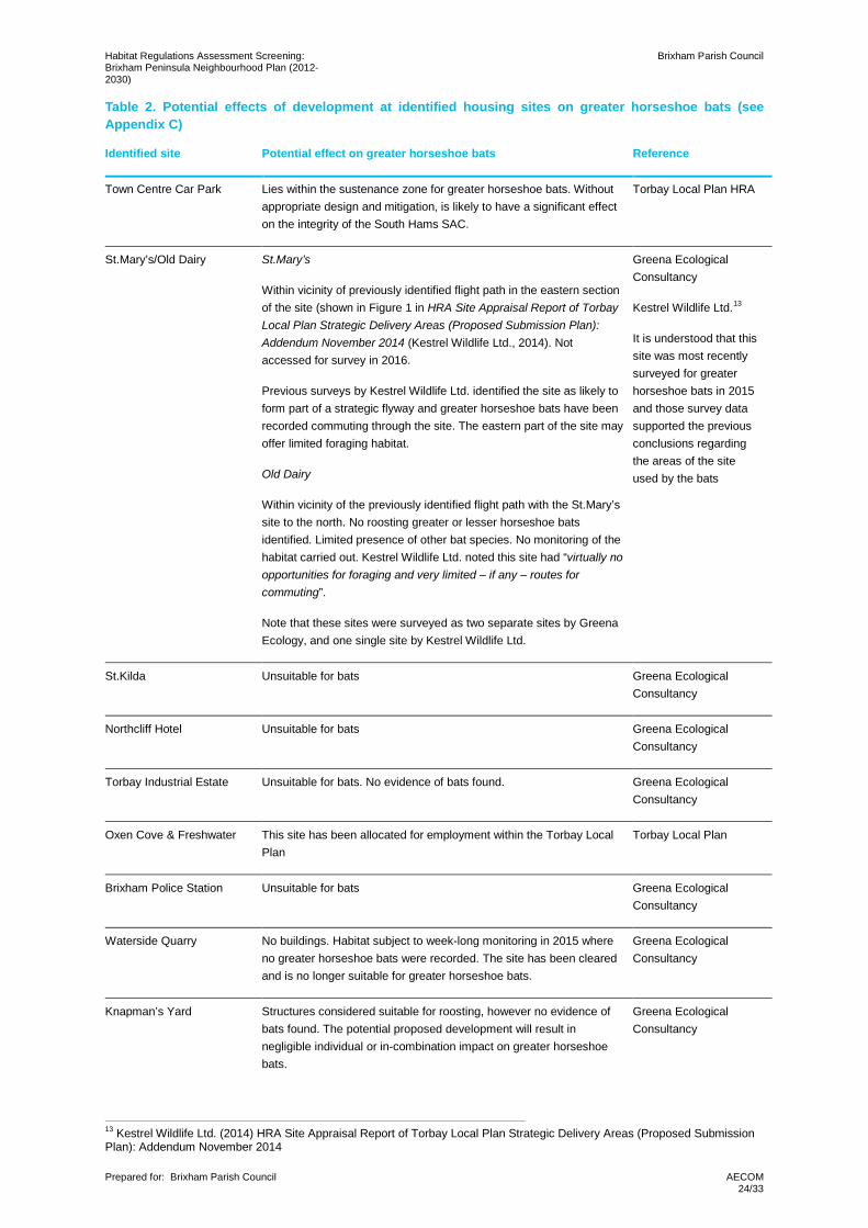
Table 2 discusses the potential effect of the development of each identified housing site on greater horseshoe bats.
10 Natural England (2010). South Hams SAC – Greater horseshoe bat consultation zone planning guidance. 11 Greena Ecological Consultancy (2016). Ecological Survey Report: Brixham Peninsula Neighbourhood Plan 12 Torbay Council (2015). Torbay Local Plan: Habitats Regulations Assessment.
Habitat Regulations Assessment Screening: Brixham Peninsula Neighbourhood Plan (2012-2030)
Brixham Parish Council
Prepared for: Brixham Parish Council
AECOM 24/33
Table 2. Potential effects of development at identified housing sites on greater horseshoe bats (see Appendix C)
Identified site Potential effect on greater horseshoe bats Reference
Town Centre Car Park Lies within the sustenance zone for greater horseshoe bats. Without appropriate design and mitigation, is likely to have a significant effect on the integrity of the South Hams SAC.
Torbay Local Plan HRA
St.Mary’s/Old Dairy St.Mary’s
Within vicinity of previously identified flight path in the eastern section of the site (shown in Figure 1 in HRA Site Appraisal Report of Torbay Local Plan Strategic Delivery Areas (Proposed Submission Plan): Addendum November 2014 (Kestrel Wildlife Ltd., 2014). Not accessed for survey in 2016.
Previous surveys by Kestrel Wildlife Ltd. identified the site as likely to form part of a strategic flyway and greater horseshoe bats have been recorded commuting through the site. The eastern part of the site may offer limited foraging habitat.
Old Dairy
Within vicinity of the previously identified flight path with the St.Mary’s site to the north. No roosting greater or lesser horseshoe bats identified. Limited presence of other bat species. No monitoring of the habitat carried out. Kestrel Wildlife Ltd. noted this site had “virtually no opportunities for foraging and very limited – if any – routes for commuting”.
Note that these sites were surveyed as two separate sites by Greena Ecology, and one single site by Kestrel Wildlife Ltd.
Greena Ecological Consultancy
Kestrel Wildlife Ltd.13
It is understood that this site was most recently surveyed for greater horseshoe bats in 2015 and those survey data supported the previous conclusions regarding the areas of the site used by the bats
St.Kilda Unsuitable for bats Greena Ecological Consultancy
Northcliff Hotel Unsuitable for bats Greena Ecological Consultancy
Torbay Industrial Estate Unsuitable for bats. No evidence of bats found. Greena Ecological Consultancy
Oxen Cove & Freshwater This site has been allocated for employment within the Torbay Local Plan
Torbay Local Plan
Brixham Police Station Unsuitable for bats Greena Ecological Consultancy
Waterside Quarry No buildings. Habitat subject to week-long monitoring in 2015 where no greater horseshoe bats were recorded. The site has been cleared and is no longer suitable for greater horseshoe bats.
Greena Ecological Consultancy
Knapman’s Yard Structures considered suitable for roosting, however no evidence of bats found. The potential proposed development will result in negligible individual or in-combination impact on greater horseshoe bats.
Greena Ecological Consultancy
13 Kestrel Wildlife Ltd. (2014) HRA Site Appraisal Report of Torbay Local Plan Strategic Delivery Areas (Proposed Submission Plan): Addendum November 2014
Habitat Regulations Assessment Screening: Brixham Peninsula Neighbourhood Plan (2012-2030)
Brixham Parish Council
Prepared for: Brixham Parish Council
AECOM 25/33
Therefore the following sites have the potential to affect foraging or commuting habitat for greater horseshoe bats:
• Town Centre Car Park; and
• St. Mary’s/Old Dairy.
Policy SS8: Natural Environment of the Torbay Local Plan states that “Sites, species and habitats protected under European, or equivalent, legislation will be protected from development. Development around the edge of the built-up area will be required to protect and manage wildlife and habitats, including corridors between them, in accordance with Policy NC1. Particular attention must be paid to Greater Horseshoe Bat flight paths, and Cirl Buntings”.
Policy SS9: Green Infrastructure of the Torbay Local Plan states that “Where necessary, green infrastructure should be designed to mitigate for loss of foraging habitat and/or linear features used as flyways by Greater Horseshoe Bats where the features lost contribute to the integrity of the South Hams SAC.”
Policy NC1: Biodiversity and geodiversity of the Torbay Local Plan states that “…development likely to have a significant effect on the integrity of the South Hams SAC will be required to provide biodiversity conservation measures that will contribute to the overall enhancement of Greater Horseshoe Bat habitats.” and “Development around the edge of the built-up area that is within the Berry Head SAC Sustenance Zone or likely to affect strategic flyways of Greater Horseshoe Bats will as appropriate be required to protect existing hedgerows that surveys show are being used as bat flyways”. This policy also states that developments should also enhance the existing flyways, including maintaining light levels at 0.5 lux.
Policy E8: Nationally Important Ecological Sites of the Brixham Peninsula Neighbourhood Plan states that “…development will not be permitted where it would threaten the habitat of the greater horseshoe bat, its roost, its strategic flyways and its sustenance zones”.
Since the Torbay Local Plan is an adopted Local Plan, the Neighbourhood Plan development must be in general conformity with its policies. Recommendations for these sites are outlined below, based on the information from Greena Ecological Consultancy, Kestrel Wildlife, the Torbay Local Plan and in the South Hams SAC planning guidance from Natural England.
Town Centre Car Park
This site is described in the Torbay Local Plan as being within the sustenance zone for greater horseshoe bats. Guidance from Natural England states that development should be managed to “ensure that there is no disturbance to greater horseshoe bat strategic flyways or sustenance areas”. However, the site itself is a hardstanding car park and is unlikely to provide foraging habitat or the linear features required for commuting routes.
The Natural England guidance also states that development “of a certain scale or type, in a strategic flyway or sustenance area will trigger a series of bat surveys”. A suitably qualified ecologist will be required to visit the site and assess the existing (and likely) greater horseshoe bat habitat.
Appropriate design and mitigation should be put in place, including limiting light spill to no greater than 0.5 lux outside the boundaries of the new development.
However, given the nature of the site, it is considered that development could be delivered without a likely significant effect on the SAC provided the aforementioned policies in the Torbay Local Plan and Policy E8 of the Neighbourhood Plan are applied.
St.Mary’s/Old Dairy
To the east of this site is a local flight line for greater horseshoe bats. Kestrel Wildlife Ltd. states that the southern section of the site (‘Old Dairy’) has “virtually no opportunities for foraging and very limited – if any – routes for commuting”.
Kestrel Wildlife recommends that this site is subject to a full suite of surveys from April to October inclusive, in line with the Natural England guidance for South Hams SAC; it is understood that the most recent suite of surveys in line with this methodology was undertaken in 2015. Kestrel Wildlife also recommends that all existing mature trees and hedge lines are retained and protected to provide commuting habitat features, and this is the expectation of the Parish Council; indeed the site presents opportunities for these features to be strengthened. There should be no light spill greater than 0.5 lux outside the boundaries of any new development, and effective mitigation measures would have to be provided to ensure no additional light spill, no loss of boundary features
Habitat Regulations Assessment Screening: Brixham Peninsula Neighbourhood Plan (2012-2030)
Brixham Parish Council
Prepared for: Brixham Parish Council
AECOM 26/33
and retention of as much of the eastern part of the site as is necessary. The Neighbourhood Plan states that St.Mary’s and Old Dairy in combination are proposed for the construction of 25 homes.
The re-development of the site (as seen in Figure 1 of HRA Site Appraisal Report of Torbay Local Plan Strategic Delivery Areas (Proposed Submission Plan): Addendum November 2014 (Kestrel Wildlife Ltd., 2014) should be undertaken at a suitable time of year to reduce disturbance to greater horseshoe bats.
Given that a large part of the site is existing hardstanding and buildings, and this will be the focus of new housing, it is considered that development could be delivered without a likely significant effect on the SAC provided the aforementioned policies in the Torbay Local Plan and Policy E8 of the Neighbourhood Plan are applied.
5.2 Recreational pressure on the calcareous grassland and European dry heath
The Torbay Local Plan HRA states that the decline in calcareous grassland and European dry heath at Berry Head indicates that current visitor numbers are beyond the carrying capacity of the site. Recommended measures to control recreational pressure include:
• Raising the awareness of visitors;
• Establishing new surfaced footpath routes;
• Reducing dog-fouling;
• Preventing unauthorised vehicle access;
• Continued management of scrub; and
• Extending grazing across the cliff slopes.
Policy NC1: Biodiversity and geodiversity in the Torbay Local Plan states “Developer contributions will be sought from development within the Brixham Peninsula towards measures needed to manage increased recreational pressure on the South Hams SAC resulting from increased housing numbers or visitor pressure”.
The Torbay Local Plan is adopted, and therefore developments within the Brixham Peninsula would need to adhere to Policy NC1. No specific policy is therefore required within the Brixham Peninsula Neighbourhood Plan as this is an issue that applies to Torbay District more widely.
6. In Combination Assessment Impact pathways that have potential to link to the Neighbourhood Plan and to act in-combination with other projects or plans are as follows:
• Fragmentation, loss and disturbance of commuting routes and foraging areas for greater horseshoe bats; and
• Recreational pressure on calcareous grassland and European dry heath.
As well as the Torbay District, the sites that make up the South Hams SAC are within South Hams District and Teignbridge District. As such these other Plans will be considered in combination with the Neighbourhood Plan:
• Teignbridge Local Plan 2013-2033 (adopted 6th May 2014); and
• South Hams Local Development Framework 2006-2016 (adopted July 2010).
The Teignbridge Local Plan was subject to HRA in June 201314. Component sites of the South Hams SAC are within this district. The HRA discusses the Likely Significant Effects of the Local Plan on the South Hams SAC. Policies within the Teignbridge Local Plan reflect this assessment and aim to protect and enhance the South Hams SAC, including the habitats and flyways used by greater horseshoe bats. Therefore impact pathways linking the Local Plan to the South Hams SAC can be screened out in-combination with the other projects or plans.
The South Hams Local Development Framework was subject to HRA, as stated in the South Hams Local Development Framework Development Plan Document15. As with Teignbridge District, component sites of the
14 Kestrel Wildlife Ltd. (2013). Habitats Regulations Assessment of the Teignbridge District Council Proposed Submission Local Plan 2013-2030. 15 South Hams District Council (2010). South Hams Local Development Framework: Development Plan Document.

Habitat Regulations Assessment Screening: Brixham Peninsula Neighbourhood Plan (2012-2030)
Brixham Parish Council
Prepared for: Brixham Parish Council
AECOM 27/33
South Hams SAC are within this district. Policy DP5: Biodiversity and Geological Conservation states that development will conserve, enhance and/or restore biodiversity by “providing the Special Areas of Conservation and Special Protection Areas with the highest level of protection and enhancement”. Therefore impact pathways linking the Local Plan to the South Hams SAC can be screened out in-combination with the other projects or plans.
Habitat Regulations Assessment Screening: Brixham Peninsula Neighbourhood Plan (2012-2030)
Brixham Parish Council
Prepared for: Brixham Parish Council
AECOM 28/33
7. Conclusions During the initial screening of the Brixham Peninsula Neighbourhood Plan, two policies (Policy J1: Employment land – proposed, retained and refurbished and Policy H3: Delivery of New Homes) were initially screened in for further assessment (see Chapter 4) as impact pathways potentially existed that could have a likely significant effect upon the South Hams SAC via the following impact pathways:
• Fragmentation, loss and disturbance of commuting routes and foraging areas for greater horseshoe bats; and
• Recreational pressure on the calcareous grassland and European dry heath.
Following this initial screening exercise, further investigation was undertaken and a Likely Significant Effect test (Chapter 5) was conducted of the two policies that could not be initially screened out during the screening exercise.
7.1 Fragmentation, loss and disturbance of commuting routes and foraging areas for greater horseshoe bats
The Neighbourhood Plan contains the following policy that aims to protect greater horseshoe bats within the South Hams SAC:
“Policy E8 – Nationally Important Ecological Sites
Development will not be permitted where it would adversely affect the ecologies of the important areas designated as Sites of Special Scientific Interest (Including Berry Head to Sharkham and Saltern Cove), part of the South Hams Special Area of Conservation (Berry Head to Sharkham) or a National Nature Reserve (Berry Head).
All species found on our Peninsula, covered by the Wildlife and Conservation Act (1981) and the Conservation of Habitats and Species Regulations (2010), including Wildlife Countryside Marine Management - The Conservation of Habitats and Species (Amendment) Regulations 2012, will be protected.
In particular development will not be permitted where it could:-
Threaten the habitat of the greater horseshoe bat, its roost, its strategic flyways and its sustenance zones.
Threaten the habitat and nesting sites of the Cirl Bunting
As such, this policy also applies within Impact Risk Zones (IRZs) around SSSIs, as established by Natural England.”
This is in addition to the policies outlined in the Torbay Local Plan, including Policy NC1: Biodiversity and geodiversity which states “Internationally important sites and species will be protected. Avoidance of likely significant effects should be the first option. Development likely to affect an international site will be subject to assessment under the Habitat Regulations and will not be permitted unless adverse effects can be fully mitigated”. This policy also states that “development likely to have a significant effect on the integrity of the South Hams SAC will be required to provide biodiversity conservation measures that contribute to the overall enhancement of Greater Horseshoe Bats”. This policy also outlines measures for development to reduce the effect on greater horseshoe bats.
One site allocated for employment within Policy J1 of the Neighbourhood Plan (Galmpton Sewage Works) has not been previously assessed. However, this policy can be screened out of this assessment due to the mechanisms in place in the Local Plan and Neighbourhood Plan to ensure greater horseshoe bat surveys at the project stage. In addition, Policy J1 allocates 3079sqm more than is required by the Torbay Local Plan, meaning there is sufficient employment land allocated without the use of Galmpton Sewage Works. Therefore this Policy would not affect the deliverability of the Neighbourhood Plan should the Sewage Works development not prove to be deliverable.
Two sites allocated for housing in the Neighbourhood Plan have been assessed as having a potential effect on greater horseshoe bats; Town Centre Car Park and St.Mary’s/Old Dairy. However, given the nature of both sites and the policy framework provided by the Torbay Local Plan and Brixham Peninsula Neighbourhood Plan, it is considered that both sites could be delivered without a likely significant effect on South Hams SAC.
Habitat Regulations Assessment Screening: Brixham Peninsula Neighbourhood Plan (2012-2030)
Brixham Parish Council
Prepared for: Brixham Parish Council
AECOM 29/33
As a general principle, all allocated sites that are deemed suitable for greater horseshoe bats should be resurveyed to support a planning application if the most recent survey data is more than 2 survey seasons in age. For example, since the most recent surveys for St Mary’s/Old Dairy were undertaken in 2015, it would be advisable to repeat them in the next (2017) survey season, unless an application is to be submitted in the next few months. However, since the Town Centre Car Park site does not itself support suitable habitat, it may be possible to avoid a need for repeat survey with careful design to ensure that the adjacent dense woody vegetation is protected from inappropriate lighting.
7.2 Recreational pressure on the calcareous grassland and European dry heath
The Torbay Local Plan HRA states that the decline in calcareous grassland and European dry heath at Berry Head indicates that current visitor numbers are beyond the carrying capacity of the site and includes measures to control recreational pressure.
Policy NC1: Biodiversity and geodiversity in the Torbay Local Plan states “Developer contributions will be sought from development within the Brixham Peninsula towards measures needed to manage increased recreational pressure on the South Hams SAC resulting from increased housing numbers or visitor pressure”.
The Torbay Local Plan is adopted, and therefore developments within the Brixham Peninsula would need to adhere to Policy NC1. No specific policy is required within the Brixham Peninsula Neighbourhood Plan. Therefore, the existing policy framework in the Local Plan means that the Neighbourhood Plan will not result in a likely significant effect on South Hams SAC through this pathway.

Habitat Regulations Assessment Screening: Brixham Peninsula Neighbourhood Plan (2012-2030)
Brixham Parish Council
Prepared for: Brixham Parish Council
AECOM 30/33
Appendix A Map
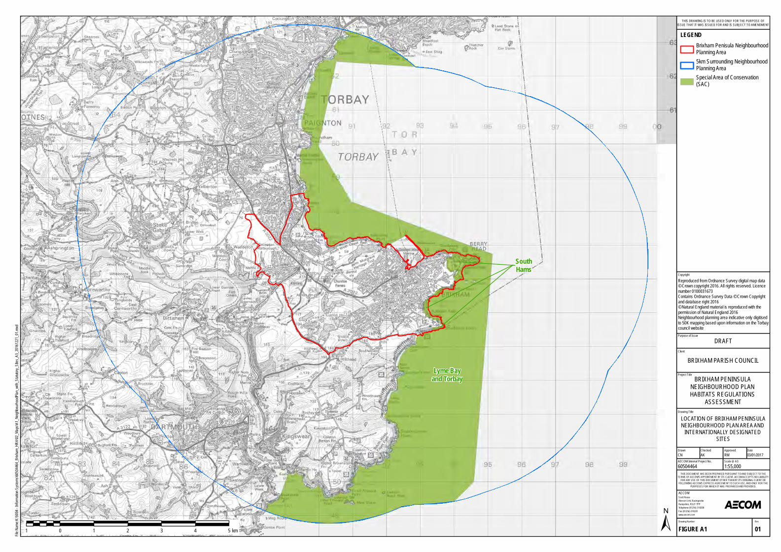
SouthHams
Lyme Bayand Torbay
Purpose of Issue
Project Title
Drawing Title
Drawn Checked
Scott HouseAlencon Link, BasingstokeHampshire, RG21 7PPTelephone (01256) 310200Fax (01256) 310201www.aecom.com
AECOM
DateApproved
RevDrawing Number
FIGURE A1 01
THIS DOCUMENT HAS BEEN PREPARED PURSUANT TO AND SUBJECT TO THETERMS OF AECOM'S APPOINTMENT BY ITS CLIENT. AECOM ACCEPTS NO LIABILITY
FOR ANY USE OF THIS DOCUMENT OTHER THAN BY ITS ORIGINAL CLIENT ORFOLLOWING AECOM'S EXPRESS AGREEMENT TO SUCH USE, AND ONLY FOR THE
PURPOSES FOR WHICH IT WAS PREPARED AND PROVIDED.
AECOM Internal Project No. Scale @ A360504464 1:55,000CN AK RM 03/01/2017
Client
File Na
me:K:
\5004
- Inform
ation S
ystem
s\6050
4464_B
rixham
_HRA
\02_M
aps\A1
_Neig
hbourh
oodPla
n_with_
Statuto
ry_SIt
es_A3
_20161
221_01
.mxd
±1 0 1 2 3 4 5 km
LEGENDBrixham Penisula Neighbourhood Planning Area5km Surrounding Neighbourhood Planning AreaSpecial Area of Conservation (SAC)
LOCATION OF BRIXHAM PENINSULANEIGHBOURHOOD PLAN AREA AND
INTERNATIONALLY DESIGNATED SITES
BRIXHAM PENINSULA NEIGHBOURHOOD PLAN HABITATS REGULATIONS
ASSESSMENT
DRAFT
BRIXHAM PARISH COUNCIL
THIS DRAWING IS TO BE USED ONLY FOR THE PURPOSE OFISSUE THAT IT WAS ISSUED FOR AND IS SUBJECT TO AMENDMENT
CopyrightReproduced from Ordnance Survey digital map data © Crown copyright 2016. All rights reserved. Licence number 0100031673Contains Ordnance Survey Data © Crown Copyright and database right 2016© Natural England material is reproduced with thepermission of Natural England 2016Neighbourhood planning area indicative only digitised to 50K mapping based upon information on the Torbay council website
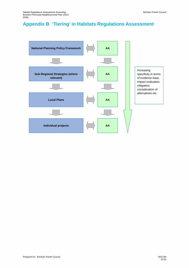
Habitat Regulations Assessment Screening: Brixham Peninsula Neighbourhood Plan (2012-2030)
Brixham Parish Council
Prepared for: Brixham Parish Council
AECOM 31/33
Appendix B ‘Tiering’ in Habitats Regulations Assessment
National Planning Policy Framework
AA
Sub-Regional Strategies (where
relevant)
AA
Local Plans
AA
AA
Individual projects
Increasing specificity in terms of evidence base, impact evaluation, mitigation, consideration of alternatives etc.
Habitat Regulations Assessment Screening: Brixham Peninsula Neighbourhood Plan (2012-2030)
Brixham Parish Council
Prepared for: Brixham Parish Council
AECOM 32/33
Appendix C Greena Ecological Consultancy (2016). Ecological Survey Report: Brixham Peninsula Neighbourhood Plan
Greena Ecological Consultancy
ECOLOGICAL SURVEY REPORT
BRIXHAM PENINSULA NEIGHBOURHOOD PLAN
November 2016 Final Report
Brixham Peninsula Neighbourhood Plan
Disclaimer: No part of this report may be copied or reproduced by any means without prior written permission from Greena Ecological Consultancy. If you have received this report in error, please destroy all copies in your possession or control and notify Greena Ecological Consultancy. This report has been prepared for the exclusive use of the commissioning party and unless otherwise agreed in writing by Greena Ecological Consultancy, no other party may use, make use of or rely on the contents of the report. No liability is accepted by Greena Ecological Consultancy for any use of this report, other than for the purposes for which it was originally prepared and provided. Opinions and information provided in the report are on the basis of Greena Ecological Consultancy using due skill, care and diligence in the preparation of the same and no explicit warranty is provided as to their accuracy. It should be noted and it is expressly stated that no independent legal verification of any of the documents or information supplied to Greena Ecological Consultancy has been made. Please note basic biological record information obtained in this report may be shared with environmental record centres; this does not include your personal information.
Brixham Peninsula
Greena Ecological Consultancy
Report compiled by
Tereza Rush
Greena Ecological Consultancy Stonehaven
Witham Friary Frome, Somerset
BA11 5HH
Email [email protected]
Mobile 07980021224
Report finalised by
Geoff Billington
Greena Ecological Consultancy Stonehaven
Witham Friary Frome, Somerset
BA11 5HH
Email [email protected]
Mobile 0774 874 2475
Client
Brixham Peninsula
Neighbourhood Forum
Agent
Geoff Melbourne
Brixham Peninsula
Greena Ecological Consultancy 1
Contents
BRIEF 2
SUMMARY 3
1. INTRODUCTION 5
2. AIMS AND OBJECTIVES 8
3. SITE DESCRIPTION 9
4. METHODS 15
5. SURVEY CONSTRAINTS 23
6. RESULTS 26
7. REFERENCES 34
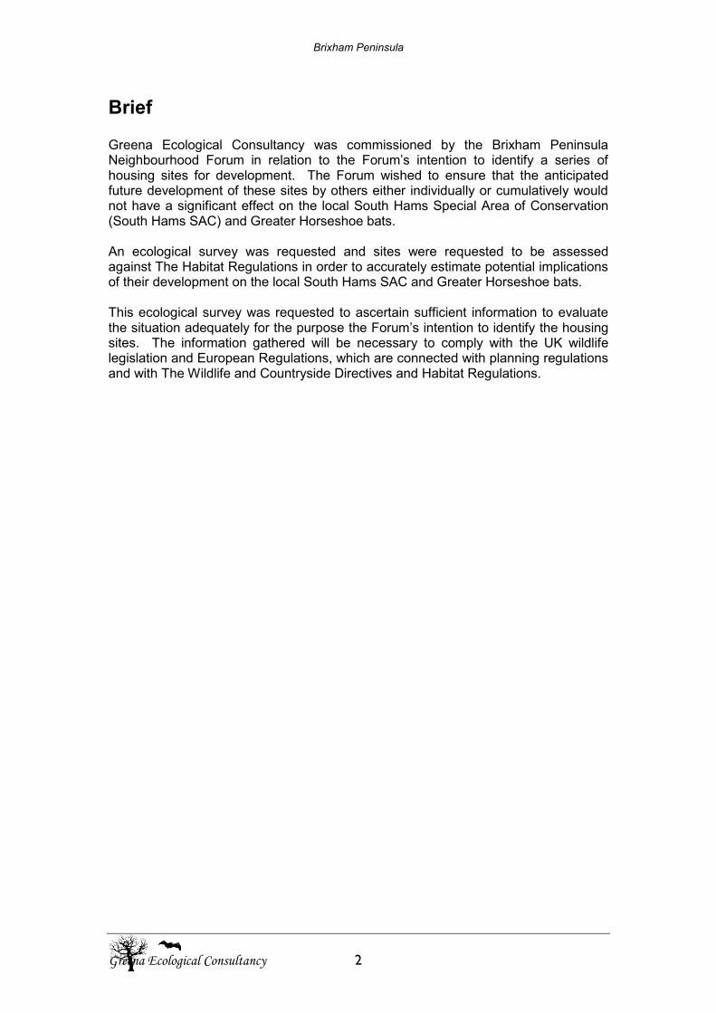
Brixham Peninsula
Greena Ecological Consultancy 2
Brief Greena Ecological Consultancy was commissioned by the Brixham Peninsula Neighbourhood Forum in relation to the Forum’s intention to identify a series of housing sites for development. The Forum wished to ensure that the anticipated future development of these sites by others either individually or cumulatively would not have a significant effect on the local South Hams Special Area of Conservation (South Hams SAC) and Greater Horseshoe bats. An ecological survey was requested and sites were requested to be assessed against The Habitat Regulations in order to accurately estimate potential implications of their development on the local South Hams SAC and Greater Horseshoe bats. This ecological survey was requested to ascertain sufficient information to evaluate the situation adequately for the purpose the Forum’s intention to identify the housing sites. The information gathered will be necessary to comply with the UK wildlife legislation and European Regulations, which are connected with planning regulations and with The Wildlife and Countryside Directives and Habitat Regulations.
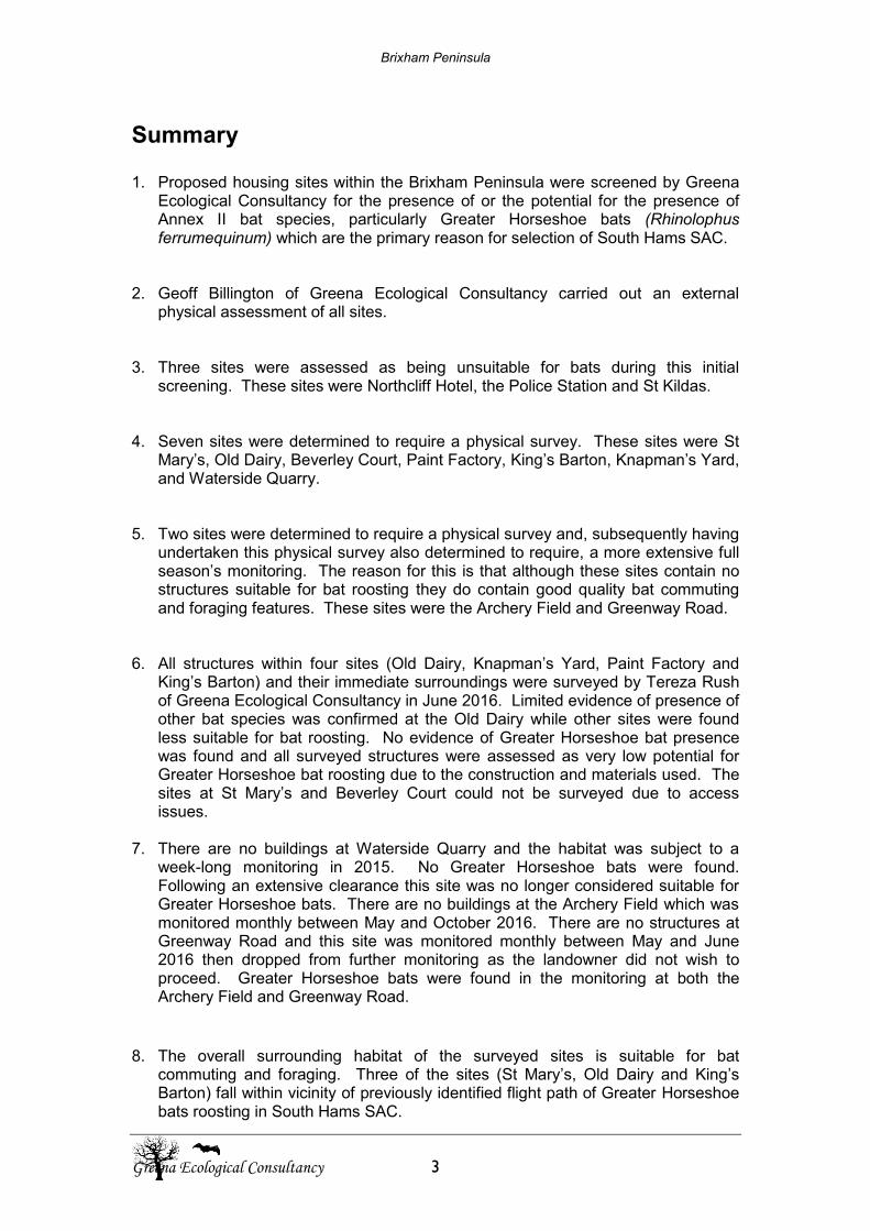
Brixham Peninsula
Greena Ecological Consultancy 3
Summary
1. Proposed housing sites within the Brixham Peninsula were screened by Greena Ecological Consultancy for the presence of or the potential for the presence of Annex II bat species, particularly Greater Horseshoe bats (Rhinolophus ferrumequinum) which are the primary reason for selection of South Hams SAC.
2. Geoff Billington of Greena Ecological Consultancy carried out an external physical assessment of all sites.
3. Three sites were assessed as being unsuitable for bats during this initial screening. These sites were Northcliff Hotel, the Police Station and St Kildas.
4. Seven sites were determined to require a physical survey. These sites were St Mary’s, Old Dairy, Beverley Court, Paint Factory, King’s Barton, Knapman’s Yard, and Waterside Quarry.
5. Two sites were determined to require a physical survey and, subsequently having undertaken this physical survey also determined to require, a more extensive full season’s monitoring. The reason for this is that although these sites contain no structures suitable for bat roosting they do contain good quality bat commuting and foraging features. These sites were the Archery Field and Greenway Road.
6. All structures within four sites (Old Dairy, Knapman’s Yard, Paint Factory and
King’s Barton) and their immediate surroundings were surveyed by Tereza Rush of Greena Ecological Consultancy in June 2016. Limited evidence of presence of other bat species was confirmed at the Old Dairy while other sites were found less suitable for bat roosting. No evidence of Greater Horseshoe bat presence was found and all surveyed structures were assessed as very low potential for Greater Horseshoe bat roosting due to the construction and materials used. The sites at St Mary’s and Beverley Court could not be surveyed due to access issues.
7. There are no buildings at Waterside Quarry and the habitat was subject to a week-long monitoring in 2015. No Greater Horseshoe bats were found. Following an extensive clearance this site was no longer considered suitable for Greater Horseshoe bats. There are no buildings at the Archery Field which was monitored monthly between May and October 2016. There are no structures at Greenway Road and this site was monitored monthly between May and June 2016 then dropped from further monitoring as the landowner did not wish to proceed. Greater Horseshoe bats were found in the monitoring at both the Archery Field and Greenway Road.
8. The overall surrounding habitat of the surveyed sites is suitable for bat commuting and foraging. Three of the sites (St Mary’s, Old Dairy and King’s Barton) fall within vicinity of previously identified flight path of Greater Horseshoe bats roosting in South Hams SAC.
Brixham Peninsula
Greena Ecological Consultancy 4
9. The potential proposed development of 8 sites within the Brixham Peninsula (Northcliff Hotel, St Kilda’s, Police Station, Old Dairy, Paint Factory, Kings Barton, Knapman’s Yard and Waterside Quarry) will result in negligible individual or in-combination impact on the Annex II species and the primary reason for SAC selection.
10. Both, the Archery Field and Greenway Road sites, serve as commuting routes to limited number of Greater Horseshoe bats. This would have to be considered in planning for the development of these sites in form of suitable mitigation measures limiting light-spill and vegetation removal.
Brixham Peninsula
Greena Ecological Consultancy 5
1. Introduction
1.1 Background A number of sites were identified as potential locations for future housing development within Brixham Peninsula. Kestrel Habitat Regulation Assessment in November 2014 highlighted four of them as sites of potential impact on the South Hams SAC. These sites were Northcliff Hotel, St Mary’s, Old Dairy (Note: in this survey St Mary’s and Old Dairy have been treated as two different sites whereas other surveys have grouped them together as one site), Beverly Court and Kings Barton, all selected due to the proximity of the confirmed flight path (‘strategic flyway’ and ‘sustenance zone’) of Greater Horseshoe bats roosting within the SAC and the primary reason for site selection. Also included in the overall assessment by Greena Ecological Consultancy were the Police Station, St. Kilda’s, Knapman’s Yard, Paint Factory, Waterside Quarry, the Archery Field and Greenway Road. Greena Ecological Consultancy was commissioned to undertake further surveys of the above listed sites in order to confirm presence or absence of Greater Horseshoe bats within the structures on the selected sites as well as to identify potential for roosting. Foraging and commuting routes of Greater Horseshoe bats were also subject to survey on selected locations. The list of potential development sites was reduced in the due course of the surveys due to access issues. Structures at the following sites were surveyed: Old Dairy, Paint Factory, King’s Barton, Knapman’s Yard. A week-long monitoring took place at Waterside Quarry in early October 2015. Monthly monitoring of bat activity was carried out on Greenway Road site between May and June and on Archery Field site from May and October 2016. The survey aimed to provide sufficient information for the decision-making as well as to satisfy requirements of Natural England and the Local Planning Authority regarding protected species on site. Further focus of the survey covered the presence or potential for presence of Greater horseshoe bats as a requirement for the updated Habitat Regulation Assessment.
1.2 Legislation
All UK bat species and their roosts are fully protected under the Wildlife and Countryside Act 1981(as amended) through inclusion in Schedule 5, under the Countryside and Rights of Way Act 2000, and under Schedule 2 of the Conservation (Natural Habitats &c) Regulations 2010 (as amended). The Conservation Regulations designate bats as European Protected Species. Taken together, the Acts and Regulations protecting bats make it an offence to:
Deliberately kill, injure, capture or take bats Deliberately disturb bats. This particularly relates to disturbance that is likely
to:
Brixham Peninsula
Greena Ecological Consultancy 6
o Impair their ability to survive, breed or reproduce, or to rear or nurture their young
o Impair their ability to hibernate or (for migratory species) migrate o Affect significantly the local distribution or abundance of the species to
which they belong Damage or destroy bat roosts Possess or transport a bat or part of a bat, unless acquired legally Sell, offer for sale or exchange bats or parts of bats.
A roost is any structure or place used for shelter or protection. Bats need to have access to a number of roosts because they use different roosts depending on season, breeding status and prevailing weather conditions. For this reason roosts are protected whether or not bats are present at the time. As bats are designated European Protected Species (EPS), development and building works that are likely to result in the disturbance of bats, damage to or destruction of their roosts, or require bats to be caught or translocated, usually require an EPS licence to be obtained from Natural England before any works begin. Obtaining a licence involves completing an Application Pack, including a Method Statement that details mitigation appropriate to maintaining the ‘favourable conservation status’ of the local bat population. Three conditions must be met before a licence can be granted:
There is no satisfactory alternative The development will not be detrimental to the maintenance of local bat
populations at a ‘favourable conservation status’ in their natural range The development must be for ‘imperative reasons of overriding public
interest including those of a social or economic nature’. An EPS licence is required for all development activities if there is a reasonable likelihood that an offence against Conservation of Habitats and Species Regulations 2010 (as amended), Wildlife and Countryside Act 1981 (as amended) or Environmental Damage Regulation 2009 (as amended) will be committed. The following offences could potentially be committed by carrying out the proposed development if any bat species are present during the demolition works:
- Capturing or killing – a wild animal of an European Protected Species (EPS) could be deliberately captured, injured or killed (Reg 41(1)(a)) - Disturbing EPS – a wild animal of an EPS could be deliberately disturbed including in particular a disturbance which is likely to impair its / their ability to survive or hibernate (Reg 41 (1)(b)) - Disturbing EPS whilst occupying a structure or place used for shelter or protection – includes intentional and reckless disturbance (s9 (4)(b)WCA) - Damage of an EPS breeding site or resting place – (Reg 41 (1)(d)) – strict liability
The above stated offences can be avoided where works are to take place when bats are not present and bat roost will be maintained. If roost is going to be available to bats at the time they usually occupy the structure, a continued ecological functionality of the site will be preserved. Suitable mitigation measures must be put in place prior, during and post works to ensure that continued ecological functionality will be maintained. An EPS licence is not required if continued ecological functionality is preserved and roosting conditions for bat will remain unchanged or will improve as a result of the proposed works. An experienced
Brixham Peninsula
Greena Ecological Consultancy 7
ecologist must attend works potentially affecting roosting bats to ensure legality of works. A simpler and faster way of carrying out development with low ecological impact has been introduced by Natural England and is now fully accepted for sites with low numbers of more commonly occurring bat species. In accordance with the Habitat Regulations, all English competent authorities, including Natural England, must undertake a formal assessment of the implications of any new plans or projects which are capable of affecting the designated interest features of European Sites before deciding whether to undertake, permit or authorise such a plan or project. This assessment comprises several distinct stages which are conveniently and collectively described as a ‘Habitats Regulations Assessment’ (or HRA). For all plans and projects which are not wholly directly connected with or necessary to the conservation management of the site’s qualifying features, this will include formal screening for any Likely Significant Effects (either alone or in combination with other plans or projects). Where these effects cannot be excluded, assessing them in more detail through an appropriate assessment (AA) is required to ascertain whether an adverse effect on the integrity of the site can be ruled out. Where such an adverse effect on the site cannot be ruled out, and no alternative solutions can be identified, then the project can only then proceed if there are imperative reasons of over-riding public interest and if the necessary compensatory measures can be secured (Natural England, 2016)
Brixham Peninsula
Greena Ecological Consultancy 8
2. Aims and Objectives The aim of the survey and supporting desk study was to satisfy the requirements of the National Planning Policy Framework (NPPF) paragraphs 109 - 125, OPDM Circular 06/05 para 116 as well as to be in line with Devon Local Plan and Core Strategy and to identify ecological features within or near the site that could potentially pose a constraint to the proposed development and opportunities for incorporating biodiversity enhancements into the development proposals. The following ecological features were relevant to the survey carried out by Greena Ecological Consultancy:
- Proximity of statutory and non-statutory designed wildlife sites
- Proximity of England Biodiversity Priority (EBP) or local Biodiversity Action Plan (BAP) habitats and networks of these habitats
- Legally protected wildlife species with focus on Annex II species potentially affected by the proposed development
- EBP or local BAP species
- All other species of wildlife potentially affected by the proposed development
- Any potential impact on the Brixham bat SAC This report has been produced with reference to current guidelines for preliminary ecological appraisal (CIEEM, 2012) and as a part of screening for any Likely Significant Effects on European Sites qualifying features.
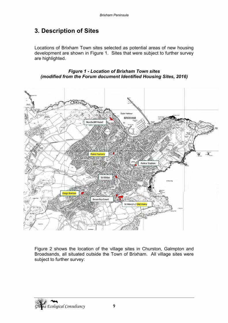
Brixham Peninsula
Greena Ecological Consultancy 9
3. Description of Sites Locations of Brixham Town sites selected as potential areas of new housing development are shown in Figure 1. Sites that were subject to further survey are highlighted.
Figure 1 - Location of Brixham Town sites (modified from the Forum document Identified Housing Sites, 2016)
Paint Factory Paint Factory
Figure 2 shows the location of the village sites in Churston, Galmpton and Broadsands, all situated outside the Town of Brixham. All village sites were subject to further survey:
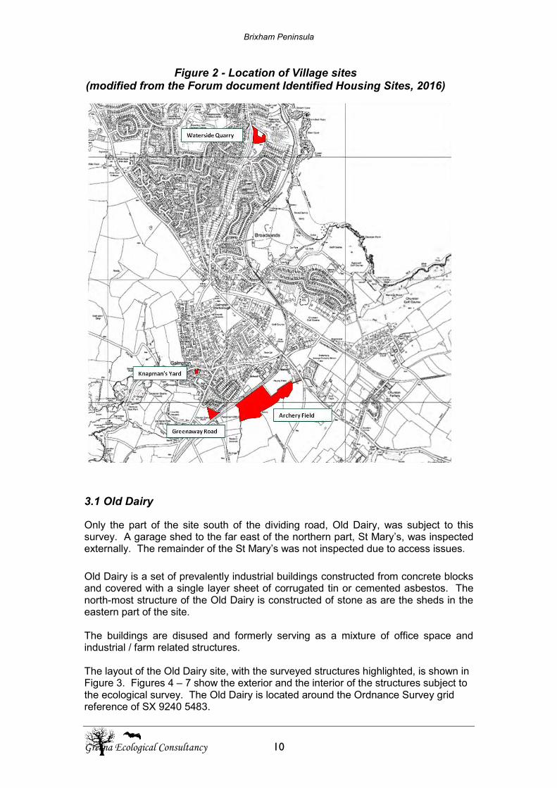
Brixham Peninsula
Greena Ecological Consultancy 10
Figure 2 - Location of Village sites (modified from the Forum document Identified Housing Sites, 2016)
3.1 Old Dairy
Only the part of the site south of the dividing road, Old Dairy, was subject to this survey. A garage shed to the far east of the northern part, St Mary’s, was inspected externally. The remainder of the St Mary’s was not inspected due to access issues.
Old Dairy is a set of prevalently industrial buildings constructed from concrete blocks and covered with a single layer sheet of corrugated tin or cemented asbestos. The north-most structure of the Old Dairy is constructed of stone as are the sheds in the eastern part of the site. The buildings are disused and formerly serving as a mixture of office space and industrial / farm related structures. The layout of the Old Dairy site, with the surveyed structures highlighted, is shown in Figure 3. Figures 4 – 7 show the exterior and the interior of the structures subject to the ecological survey. The Old Dairy is located around the Ordnance Survey grid reference of SX 9240 5483.
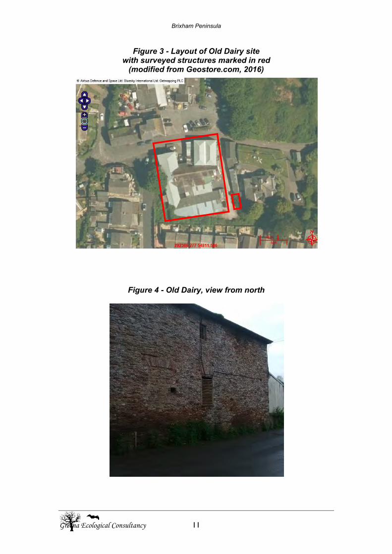
Brixham Peninsula
Greena Ecological Consultancy 11
Figure 3 - Layout of Old Dairy site with surveyed structures marked in red
(modified from Geostore.com, 2016)
Figure 4 - Old Dairy, view from north
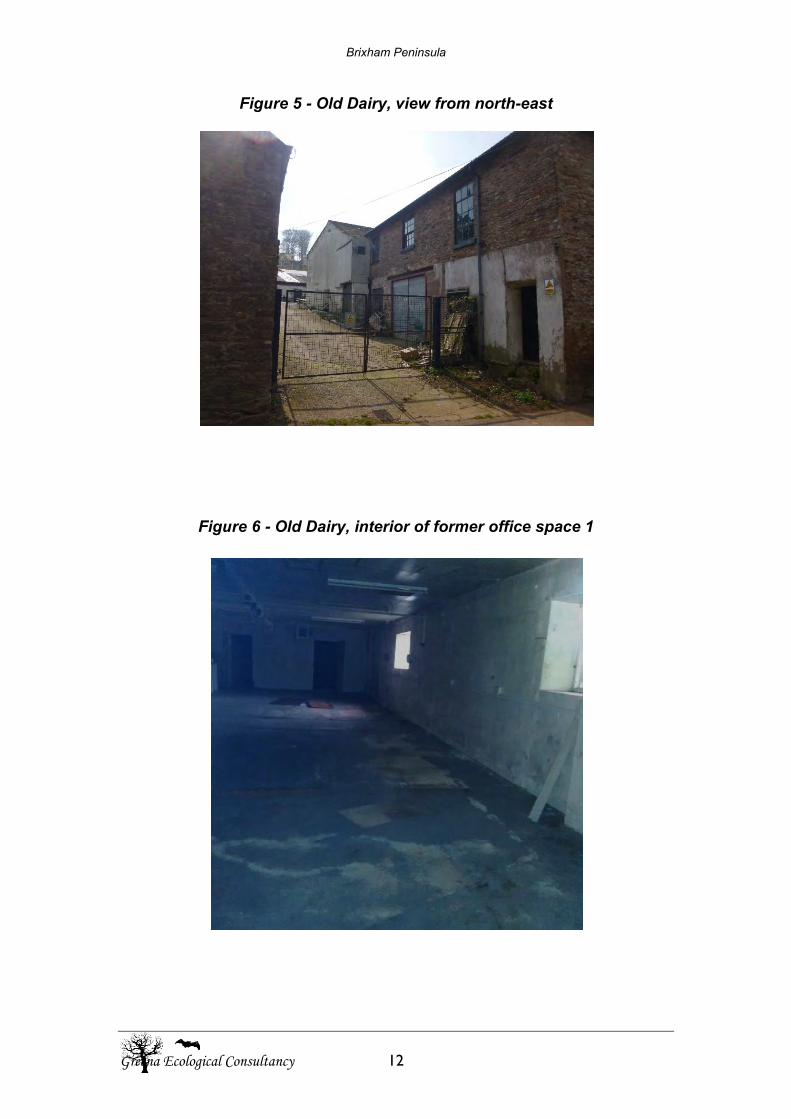
Brixham Peninsula
Greena Ecological Consultancy 12
Figure 5 - Old Dairy, view from north-east
Figure 6 - Old Dairy, interior of former office space 1
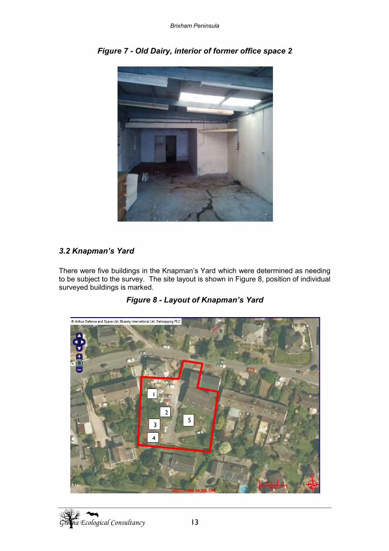
Brixham Peninsula
Greena Ecological Consultancy 13
Figure 7 - Old Dairy, interior of former office space 2
3.2 Knapman’s Yard
There were five buildings in the Knapman’s Yard which were determined as needing to be subject to the survey. The site layout is shown in Figure 8, position of individual surveyed buildings is marked.
Figure 8 - Layout of Knapman’s Yard
1
2
3
4
5
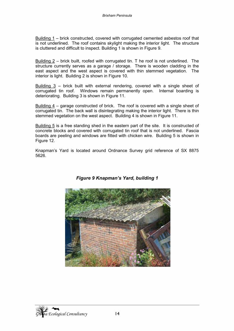
Brixham Peninsula
Greena Ecological Consultancy 14
Building 1 – brick constructed, covered with corrugated cemented asbestos roof that is not underlined. The roof contains skylight making the interior light. The structure is cluttered and difficult to inspect. Building 1 is shown in Figure 9.
Building 2 – brick built, roofed with corrugated tin. T he roof is not underlined. The structure currently serves as a garage / storage. There is wooden cladding in the east aspect and the west aspect is covered with thin stemmed vegetation. The interior is light. Building 2 is shown in Figure 10. Building 3 – brick built with external rendering, covered with a single sheet of corrugated tin roof. Windows remain permanently open. Internal boarding is deteriorating. Building 3 is shown in Figure 11. Building 4 – garage constructed of brick. The roof is covered with a single sheet of corrugated tin. The back wall is disintegrating making the interior light. There is thin stemmed vegetation on the west aspect. Building 4 is shown in Figure 11. Building 5 is a free standing shed in the eastern part of the site. It is constructed of concrete blocks and covered with corrugated tin roof that is not underlined. Fascia boards are peeling and windows are fitted with chicken wire. Building 5 is shown in Figure 12. Knapman’s Yard is located around Ordnance Survey grid reference of SX 8875 5626.
Figure 9 Knapman’s Yard, building 1
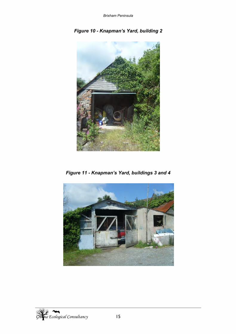
Brixham Peninsula
Greena Ecological Consultancy 15
Figure 10 - Knapman’s Yard, building 2
Figure 11 - Knapman’s Yard, buildings 3 and 4
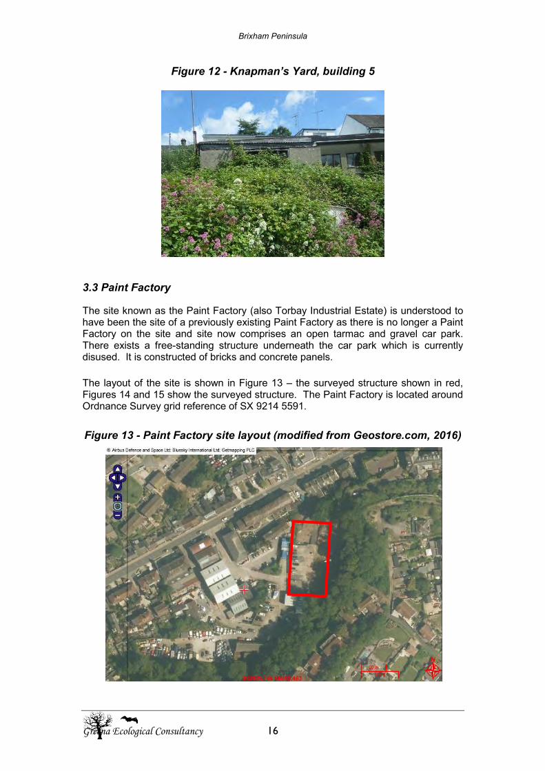
Brixham Peninsula
Greena Ecological Consultancy 16
Figure 12 - Knapman’s Yard, building 5
3.3 Paint Factory
The site known as the Paint Factory (also Torbay Industrial Estate) is understood to have been the site of a previously existing Paint Factory as there is no longer a Paint Factory on the site and site now comprises an open tarmac and gravel car park. There exists a free-standing structure underneath the car park which is currently disused. It is constructed of bricks and concrete panels. The layout of the site is shown in Figure 13 – the surveyed structure shown in red, Figures 14 and 15 show the surveyed structure. The Paint Factory is located around Ordnance Survey grid reference of SX 9214 5591.
Figure 13 - Paint Factory site layout (modified from Geostore.com, 2016)
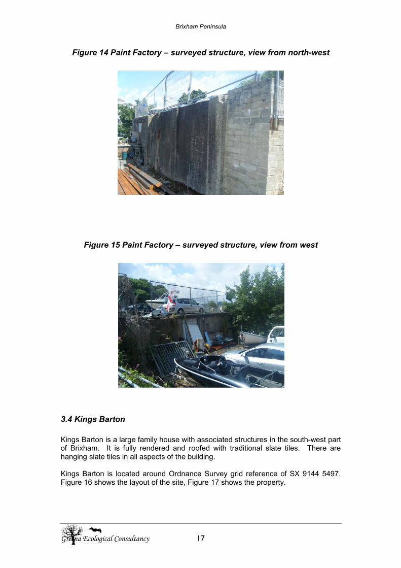
Brixham Peninsula
Greena Ecological Consultancy 17
Figure 14 Paint Factory – surveyed structure, view from north-west
Figure 15 Paint Factory – surveyed structure, view from west
3.4 Kings Barton
Kings Barton is a large family house with associated structures in the south-west part of Brixham. It is fully rendered and roofed with traditional slate tiles. There are hanging slate tiles in all aspects of the building. Kings Barton is located around Ordnance Survey grid reference of SX 9144 5497. Figure 16 shows the layout of the site, Figure 17 shows the property.
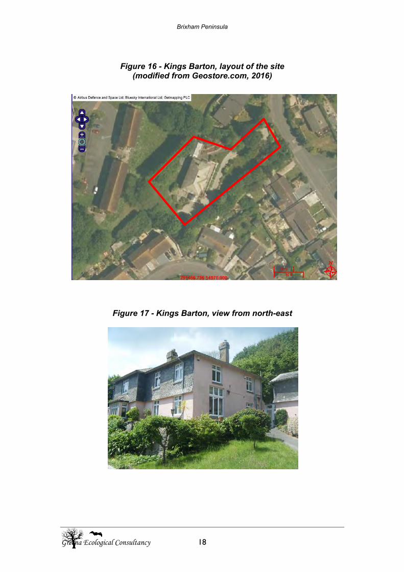
Brixham Peninsula
Greena Ecological Consultancy 18
Figure 16 - Kings Barton, layout of the site
(modified from Geostore.com, 2016)
Figure 17 - Kings Barton, view from north-east
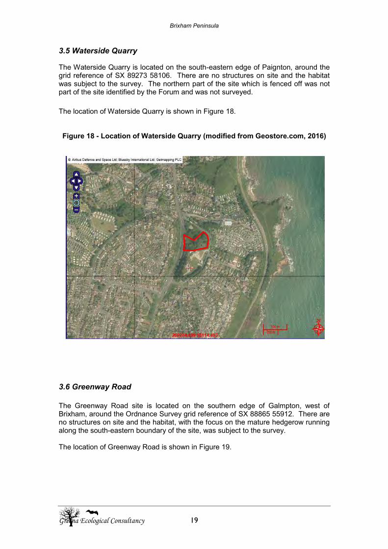
Brixham Peninsula
Greena Ecological Consultancy 19
3.5 Waterside Quarry
The Waterside Quarry is located on the south-eastern edge of Paignton, around the grid reference of SX 89273 58106. There are no structures on site and the habitat was subject to the survey. The northern part of the site which is fenced off was not part of the site identified by the Forum and was not surveyed.
The location of Waterside Quarry is shown in Figure 18. Figure 18 - Location of Waterside Quarry (modified from Geostore.com, 2016)
3.6 Greenway Road The Greenway Road site is located on the southern edge of Galmpton, west of Brixham, around the Ordnance Survey grid reference of SX 88865 55912. There are no structures on site and the habitat, with the focus on the mature hedgerow running along the south-eastern boundary of the site, was subject to the survey. The location of Greenway Road is shown in Figure 19.
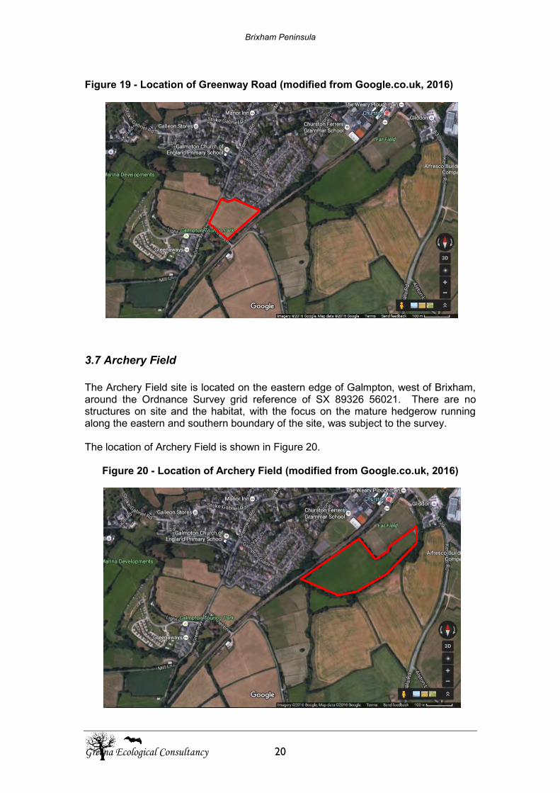
Brixham Peninsula
Greena Ecological Consultancy 20
Figure 19 - Location of Greenway Road (modified from Google.co.uk, 2016)
3.7 Archery Field The Archery Field site is located on the eastern edge of Galmpton, west of Brixham, around the Ordnance Survey grid reference of SX 89326 56021. There are no structures on site and the habitat, with the focus on the mature hedgerow running along the eastern and southern boundary of the site, was subject to the survey. The location of Archery Field is shown in Figure 20.
Figure 20 - Location of Archery Field (modified from Google.co.uk, 2016)
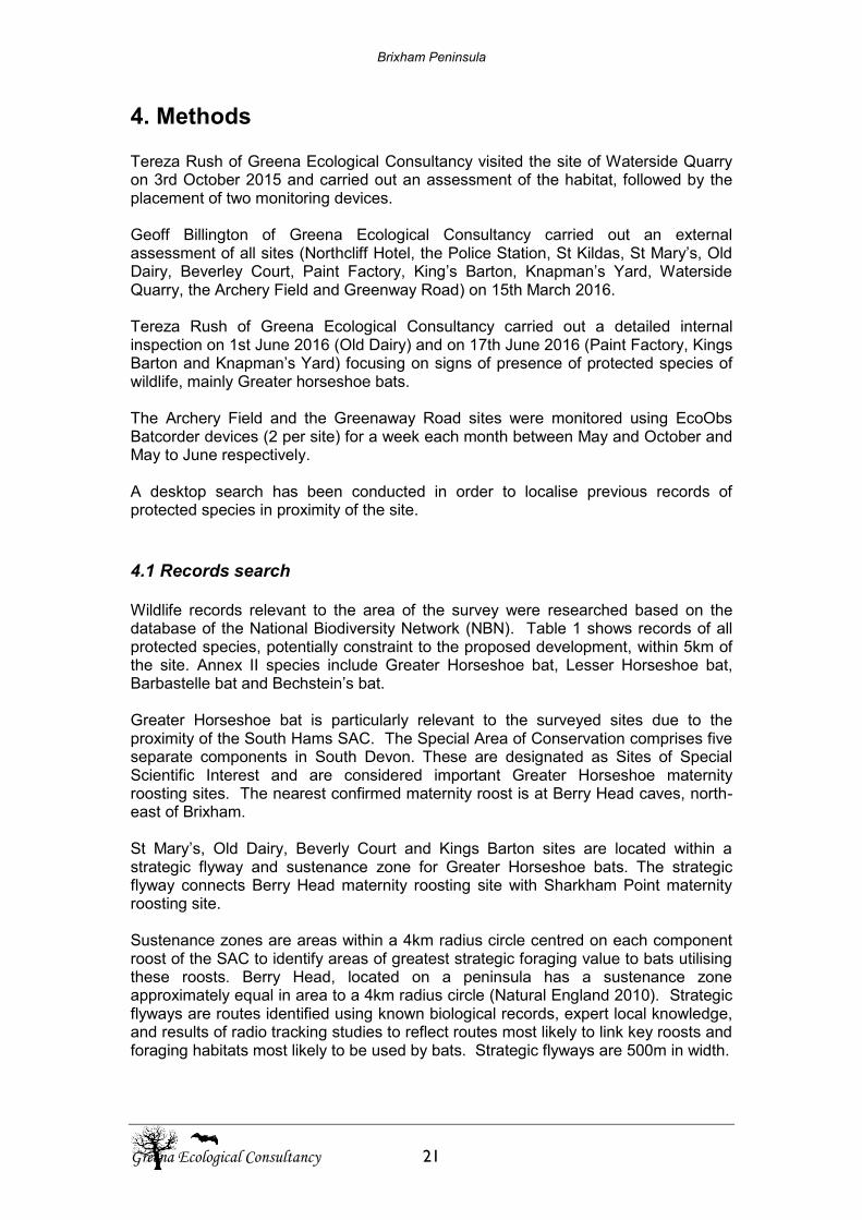
Brixham Peninsula
Greena Ecological Consultancy 21
4. Methods Tereza Rush of Greena Ecological Consultancy visited the site of Waterside Quarry on 3rd October 2015 and carried out an assessment of the habitat, followed by the placement of two monitoring devices. Geoff Billington of Greena Ecological Consultancy carried out an external assessment of all sites (Northcliff Hotel, the Police Station, St Kildas, St Mary’s, Old Dairy, Beverley Court, Paint Factory, King’s Barton, Knapman’s Yard, Waterside Quarry, the Archery Field and Greenway Road) on 15th March 2016. Tereza Rush of Greena Ecological Consultancy carried out a detailed internal inspection on 1st June 2016 (Old Dairy) and on 17th June 2016 (Paint Factory, Kings Barton and Knapman’s Yard) focusing on signs of presence of protected species of wildlife, mainly Greater horseshoe bats. The Archery Field and the Greenaway Road sites were monitored using EcoObs Batcorder devices (2 per site) for a week each month between May and October and May to June respectively. A desktop search has been conducted in order to localise previous records of protected species in proximity of the site.
4.1 Records search Wildlife records relevant to the area of the survey were researched based on the database of the National Biodiversity Network (NBN). Table 1 shows records of all protected species, potentially constraint to the proposed development, within 5km of the site. Annex II species include Greater Horseshoe bat, Lesser Horseshoe bat, Barbastelle bat and Bechstein’s bat. Greater Horseshoe bat is particularly relevant to the surveyed sites due to the proximity of the South Hams SAC. The Special Area of Conservation comprises five separate components in South Devon. These are designated as Sites of Special Scientific Interest and are considered important Greater Horseshoe maternity roosting sites. The nearest confirmed maternity roost is at Berry Head caves, north-east of Brixham. St Mary’s, Old Dairy, Beverly Court and Kings Barton sites are located within a strategic flyway and sustenance zone for Greater Horseshoe bats. The strategic flyway connects Berry Head maternity roosting site with Sharkham Point maternity roosting site. Sustenance zones are areas within a 4km radius circle centred on each component roost of the SAC to identify areas of greatest strategic foraging value to bats utilising these roosts. Berry Head, located on a peninsula has a sustenance zone approximately equal in area to a 4km radius circle (Natural England 2010). Strategic flyways are routes identified using known biological records, expert local knowledge, and results of radio tracking studies to reflect routes most likely to link key roosts and foraging habitats most likely to be used by bats. Strategic flyways are 500m in width.
Brixham Peninsula
Greena Ecological Consultancy 22
4.2 Previous surveys Survey of St. Mary’s and the Old Dairy had been previously conducted by Blackdown Environmental in 2015. The preliminary survey of the buildings identified the potential for structures to be utilised by bat species for roosting. Detailed bat survey was undertaken by the same company in 2015. A maximum count of 6 Common pipistrelles were observed from various locations around the site (please note this survey focused on all buildings of Upton Manor Farm – St Mary’s, including camping site to the east). 30 Lesser horseshoe droppings were located in one of the farm buildings (north of the dividing road, not part of this ecological assessment) and Lesser horseshoe bat calls were recorded during long term monitoring in the same structure. A single Long-eared bat was confirmed to roost in one of the north section buildings but several droppings of this species were also identified in the structures south of St. Mary’s Road in the Old Dairy.
4.3 Surveys
The day time inspection was carried out on 1st June 2016 (Old Dairy) and on 17th June 2016 (remaining structures). It aimed to gain sufficient information on the status of habitat and potentially occurring protected wildlife species. Protected wildlife species identified as a potential constraint to the proposed development included bats and nesting passerine birds. The survey focused mainly on Annex II species posing as primary reason for selection of South Hams SAC – Greater horseshoe bats. Tereza Rush (Natural England licence No. 2015-12871-CLS-CLS) carried out a detailed inspection of the properties with the aid of a high powered torch and a flexible micro-camera, focusing on signs of presence of protected species of wildlife. There are no structures requiring inspection on the following sites: Waterside Quarry, Archery Field and Greenway Road. These sites were subject to habitat monitoring.
4.3.1 Bats – daytime inspection The structures were surveyed using the following methodology:
a) Signs of residency by bat species. This consisted of a slow methodical search for roosting bats and the signs of their presence, current or past. Droppings on walls, windowsills and in roof space can be used to identify species and scratch marks and staining at roosts and exit holes shows the presence of bats. Similarly the presence of spider webs at a potential roost entry can often indicate an absence of bats.
b) An assessment of the potential of the structures to provide a roost either in the summer (maternity) or winter (hibernation).
Brixham Peninsula
Greena Ecological Consultancy 23
c) Detailed inspection of potential roosting features, with the aid of a flexible micro-camera, in order to establish previous use by bats
The overall habitat of the Brixham Peninsula was assessed as suitable for foraging and feeding of bats. The interior and exterior of all structures were inspected with the aid of a high-powered torch to locate potential roosting sites, discover possible points of egress for bats and detect bats or any signs of bats such as droppings, wear marks, staining and feeding remains.
4.3.2 Bats – Batcorder monitoring
EcoObs Batcorder static monitoring devices were used to gain a picture of bat activity on the Waterside Quarry site between 3rd and 11th October 2015. The same devices were utilised to monitor the Greenway Road site and the Archery Field site. Greenway Road was monitored for a week each month between May and June inclusive; a full long term survey work has not taken place due to landowner preferences; however, a full season of data would be required for the site to be taken forward in future housing considerations. Archery Field was monitored for a week each month between May and October, hence the full set of data from the 2016 season was obtained. Batcorder is the first worldwide data recorder that distinguishes bat calls from other sound sources in real-time (online signal analysis). Calls are recorded digitally as call sequences. Bush crickets and other sounds (e.g. wind, water, rustling of leafs) are under most circumstances not recorded at all. Batcorder was developed specifically to be used as an autonomous recording device in the field. In contrast to other such devices, each Batcorder and its microphone calibrated for a fixed sensitivity allowing the comparison of activity recorded at different locations and with different detectors (Nhbs.com, 2015). Batcorders were placed in the following locations: Waterside Quarry: BC1 at the Ordnance Survey grid reference of SX 89313 58168 and BC2 at SX89288 58144. These locations were chosen at suitable features (which existed at that time) for bat foraging and/or commuting. Each device was running throughout all nights between 3rd and 11th October 2015 from 18:30 to 07:30. The weather conditions during the nights when monitoring took place were suitable for bat emergence and foraging despite the fact that the survey was carried out relatively late in the bat active season. Greenway Road: BC1 at the Ordnance Survey grid reference of SX 88863 55857 and BC2 at SX 88932 55916. These locations were chosen at suitable features for bat foraging and/or commuting – along the south-eastern boundary of the site. Each device was running throughout all nights from 18:30 to 07:30. The recording dates are listed in Table 2. The weather conditions during the nights when monitoring took place were suitable for bat emergence and foraging. Archery Field: BC1 at the Ordnance Survey grid reference of SX 89471 56066 and BC2 at SX 89273 55936. These locations were chosen at suitable features for bat foraging and/or commuting – along the eastern and southern boundary of the site.
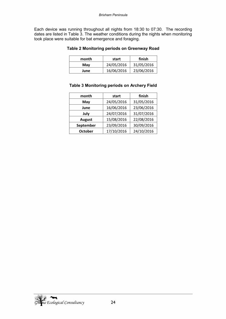
Brixham Peninsula
Greena Ecological Consultancy 24
Each device was running throughout all nights from 18:30 to 07:30. The recording dates are listed in Table 3. The weather conditions during the nights when monitoring took place were suitable for bat emergence and foraging.
Table 2 Monitoring periods on Greenway Road
month start finish
May 24/05/2016 31/05/2016
June 16/06/2016 23/06/2016
Table 3 Monitoring periods on Archery Field
month start finish
May 24/05/2016 31/05/2016
June 16/06/2016 23/06/2016
July 24/07/2016 31/07/2016
August 15/08/2016 22/08/2016
September 23/09/2016 30/09/2016
October 17/10/2016 24/10/2016
Brixham Peninsula
Greena Ecological Consultancy 25
5. Survey Constraints No emergence surveys were carried out as a part of this assessment in line with Collins (2016, 3rd ed.) due to low identified potential for presence of Greater Horseshoe bats. The same applies to Lesser Horseshoe bats despite not being the primary interest of the survey. Kings Barton was not internally inspected; the property is sealed and not accessible to Horseshoe bats. St Mary’s and Beverley Court could not be inspected due to access issues. Beverly Court site would have required an internal inspection due to the potential for bat egress points within the roof, cellar and other building features; however, this did not take place due to an inability to contact the landowner. St Mary’s site has been previously surveyed by Kestrel Wildlife. Monitoring at Waterside Quarry was limited to the end of bat active season and further surveys were originally recommended. However, an extensive clearance took place on the site making the land no longer suitable as a Greater Horseshoe foraging habitat and due to the lack of connectivity with the surrounding landscape. Further surveys were therefore no longer recommended and no further surveys took place. Monitoring at Greenway Road was limited to May and June only. Although the whole season long survey work would be preferred to take place in order to allow for robust assessment of the site, the land owners decided not to proceed beyond June. Complete data would be required for the site to be taken forward in the housing development considerations. Low numbers of bat calls were recorded at the Greenway Road BC1 in July and a possible microphone fault was considered during the survey. The microphone was factory re-calibrated prior to further use. The interiors of all other properties subject to the survey were fully inspected and no other constraints to the survey occurred.
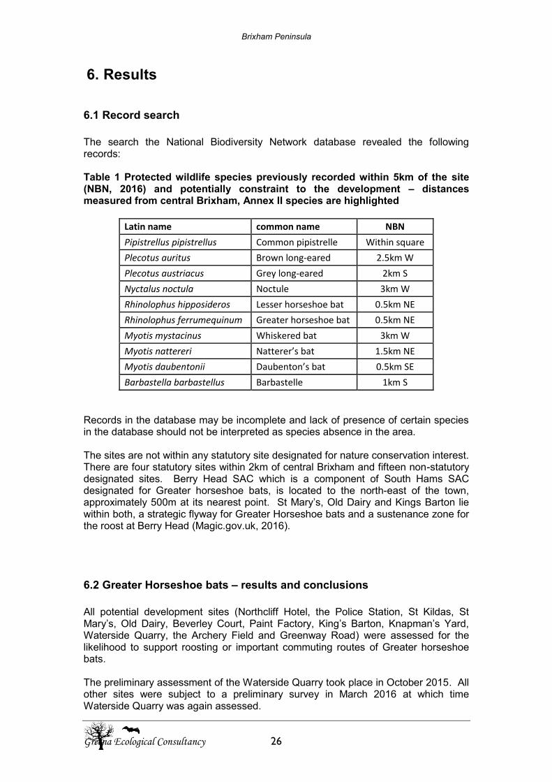
Brixham Peninsula
Greena Ecological Consultancy 26
6. Results
6.1 Record search The search the National Biodiversity Network database revealed the following records: Table 1 Protected wildlife species previously recorded within 5km of the site (NBN, 2016) and potentially constraint to the development – distances measured from central Brixham, Annex II species are highlighted
Latin name common name NBN
Pipistrellus pipistrellus Common pipistrelle Within square
Plecotus auritus Brown long-eared 2.5km W
Plecotus austriacus Grey long-eared 2km S
Nyctalus noctula Noctule 3km W
Rhinolophus hipposideros Lesser horseshoe bat 0.5km NE
Rhinolophus ferrumequinum Greater horseshoe bat 0.5km NE
Myotis mystacinus Whiskered bat 3km W
Myotis nattereri Natterer’s bat 1.5km NE
Myotis daubentonii Daubenton’s bat 0.5km SE
Barbastella barbastellus Barbastelle 1km S
Records in the database may be incomplete and lack of presence of certain species in the database should not be interpreted as species absence in the area. The sites are not within any statutory site designated for nature conservation interest. There are four statutory sites within 2km of central Brixham and fifteen non-statutory designated sites. Berry Head SAC which is a component of South Hams SAC designated for Greater horseshoe bats, is located to the north-east of the town, approximately 500m at its nearest point. St Mary’s, Old Dairy and Kings Barton lie within both, a strategic flyway for Greater Horseshoe bats and a sustenance zone for the roost at Berry Head (Magic.gov.uk, 2016).
6.2 Greater Horseshoe bats – results and conclusions All potential development sites (Northcliff Hotel, the Police Station, St Kildas, St Mary’s, Old Dairy, Beverley Court, Paint Factory, King’s Barton, Knapman’s Yard, Waterside Quarry, the Archery Field and Greenway Road) were assessed for the likelihood to support roosting or important commuting routes of Greater horseshoe bats. The preliminary assessment of the Waterside Quarry took place in October 2015. All other sites were subject to a preliminary survey in March 2016 at which time Waterside Quarry was again assessed.
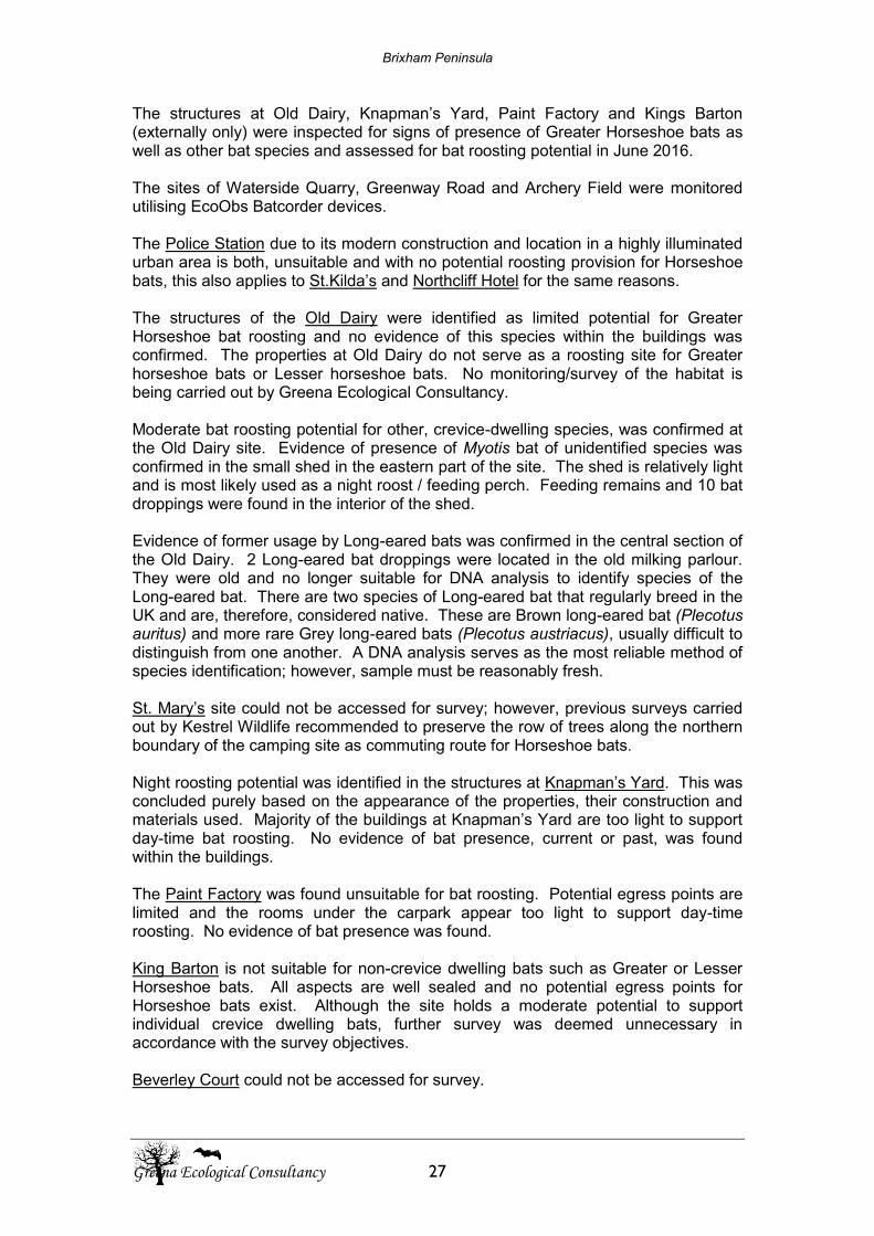
Brixham Peninsula
Greena Ecological Consultancy 27
The structures at Old Dairy, Knapman’s Yard, Paint Factory and Kings Barton (externally only) were inspected for signs of presence of Greater Horseshoe bats as well as other bat species and assessed for bat roosting potential in June 2016. The sites of Waterside Quarry, Greenway Road and Archery Field were monitored utilising EcoObs Batcorder devices. The Police Station due to its modern construction and location in a highly illuminated urban area is both, unsuitable and with no potential roosting provision for Horseshoe bats, this also applies to St.Kilda’s and Northcliff Hotel for the same reasons. The structures of the Old Dairy were identified as limited potential for Greater Horseshoe bat roosting and no evidence of this species within the buildings was confirmed. The properties at Old Dairy do not serve as a roosting site for Greater horseshoe bats or Lesser horseshoe bats. No monitoring/survey of the habitat is being carried out by Greena Ecological Consultancy. Moderate bat roosting potential for other, crevice-dwelling species, was confirmed at the Old Dairy site. Evidence of presence of Myotis bat of unidentified species was confirmed in the small shed in the eastern part of the site. The shed is relatively light and is most likely used as a night roost / feeding perch. Feeding remains and 10 bat droppings were found in the interior of the shed. Evidence of former usage by Long-eared bats was confirmed in the central section of the Old Dairy. 2 Long-eared bat droppings were located in the old milking parlour. They were old and no longer suitable for DNA analysis to identify species of the Long-eared bat. There are two species of Long-eared bat that regularly breed in the UK and are, therefore, considered native. These are Brown long-eared bat (Plecotus auritus) and more rare Grey long-eared bats (Plecotus austriacus), usually difficult to distinguish from one another. A DNA analysis serves as the most reliable method of species identification; however, sample must be reasonably fresh. St. Mary’s site could not be accessed for survey; however, previous surveys carried out by Kestrel Wildlife recommended to preserve the row of trees along the northern boundary of the camping site as commuting route for Horseshoe bats. Night roosting potential was identified in the structures at Knapman’s Yard. This was concluded purely based on the appearance of the properties, their construction and materials used. Majority of the buildings at Knapman’s Yard are too light to support day-time bat roosting. No evidence of bat presence, current or past, was found within the buildings. The Paint Factory was found unsuitable for bat roosting. Potential egress points are limited and the rooms under the carpark appear too light to support day-time roosting. No evidence of bat presence was found. King Barton is not suitable for non-crevice dwelling bats such as Greater or Lesser Horseshoe bats. All aspects are well sealed and no potential egress points for Horseshoe bats exist. Although the site holds a moderate potential to support individual crevice dwelling bats, further survey was deemed unnecessary in accordance with the survey objectives. Beverley Court could not be accessed for survey.
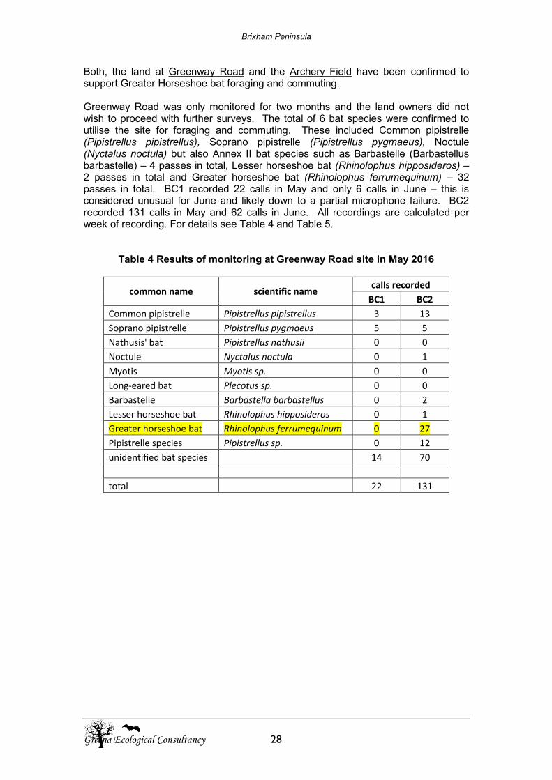
Brixham Peninsula
Greena Ecological Consultancy 28
Both, the land at Greenway Road and the Archery Field have been confirmed to support Greater Horseshoe bat foraging and commuting. Greenway Road was only monitored for two months and the land owners did not wish to proceed with further surveys. The total of 6 bat species were confirmed to utilise the site for foraging and commuting. These included Common pipistrelle (Pipistrellus pipistrellus), Soprano pipistrelle (Pipistrellus pygmaeus), Noctule (Nyctalus noctula) but also Annex II bat species such as Barbastelle (Barbastellus barbastelle) – 4 passes in total, Lesser horseshoe bat (Rhinolophus hipposideros) – 2 passes in total and Greater horseshoe bat (Rhinolophus ferrumequinum) – 32 passes in total. BC1 recorded 22 calls in May and only 6 calls in June – this is considered unusual for June and likely down to a partial microphone failure. BC2 recorded 131 calls in May and 62 calls in June. All recordings are calculated per week of recording. For details see Table 4 and Table 5.
Table 4 Results of monitoring at Greenway Road site in May 2016
common name scientific name calls recorded
BC1 BC2
Common pipistrelle Pipistrellus pipistrellus 3 13
Soprano pipistrelle Pipistrellus pygmaeus 5 5
Nathusis' bat Pipistrellus nathusii 0 0
Noctule Nyctalus noctula 0 1
Myotis Myotis sp. 0 0
Long-eared bat Plecotus sp. 0 0
Barbastelle Barbastella barbastellus 0 2
Lesser horseshoe bat Rhinolophus hipposideros 0 1
Greater horseshoe bat Rhinolophus ferrumequinum 0 27
Pipistrelle species Pipistrellus sp. 0 12
unidentified bat species 14 70
total 22 131
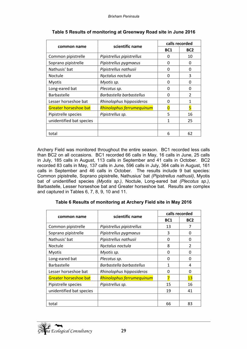
Brixham Peninsula
Greena Ecological Consultancy 29
Table 5 Results of monitoring at Greenway Road site in June 2016
common name scientific name calls recorded
BC1 BC2
Common pipistrelle Pipistrellus pipistrellus 0 10
Soprano pipistrelle Pipistrellus pygmaeus 0 0
Nathusis' bat Pipistrellus nathusii 0 0
Noctule Nyctalus noctula 0 3
Myotis Myotis sp. 0 0
Long-eared bat Plecotus sp. 0 0
Barbastelle Barbastella barbastellus 0 2
Lesser horseshoe bat Rhinolophus hipposideros 0 1
Greater horseshoe bat Rhinolophus ferrumequinum 0 5
Pipistrelle species Pipistrellus sp. 5 16
unidentified bat species 1 25
total 6 62 Archery Field was monitored throughout the entire season. BC1 recorded less calls than BC2 on all occasions. BC1 recorded 66 calls in May, 16 calls in June, 25 calls in July, 185 calls in August, 113 calls in September and 41 calls in October. BC2 recorded 83 calls in May, 137 calls in June, 596 calls in July, 364 calls in August, 161 calls in September and 46 calls in October. The results include 9 bat species: Common pipistrelle, Soprano pipistrelle, Nathusius’ bat (Pipistrellus nathusii), Myotis bat of unidentified species (Myotis sp.), Noctule, Long-eared bat (Plecotus sp.), Barbastelle, Lesser horseshoe bat and Greater horseshoe bat. Results are complex and captured in Tables 6, 7, 8, 9, 10 and 11.
Table 6 Results of monitoring at Archery Field site in May 2016
common name scientific name calls recorded
BC1 BC2
Common pipistrelle Pipistrellus pipistrellus 13 7
Soprano pipistrelle Pipistrellus pygmaeus 3 0
Nathusis' bat Pipistrellus nathusii 0 0
Noctule Nyctalus noctula 8 2
Myotis Myotis sp. 0 0
Long-eared bat Plecotus sp. 0 0
Barbastelle Barbastella barbastellus 1 4
Lesser horseshoe bat Rhinolophus hipposideros 0 0
Greater horseshoe bat Rhinolophus ferrumequinum 7 13
Pipistrelle species Pipistrellus sp. 15 16
unidentified bat species 19 41
total 66 83
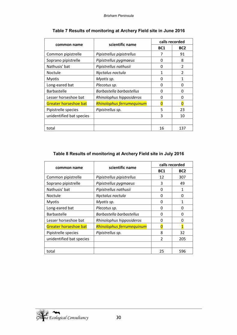
Brixham Peninsula
Greena Ecological Consultancy 30
Table 7 Results of monitoring at Archery Field site in June 2016
common name scientific name calls recorded
BC1 BC2
Common pipistrelle Pipistrellus pipistrellus 7 91
Soprano pipistrelle Pipistrellus pygmaeus 0 8
Nathusis' bat Pipistrellus nathusii 0 2
Noctule Nyctalus noctula 1 2
Myotis Myotis sp. 0 1
Long-eared bat Plecotus sp. 0 0
Barbastelle Barbastella barbastellus 0 0
Lesser horseshoe bat Rhinolophus hipposideros 0 0
Greater horseshoe bat Rhinolophus ferrumequinum 0 0
Pipistrelle species Pipistrellus sp. 5 23
unidentified bat species 3 10
total 16 137
Table 8 Results of monitoring at Archery Field site in July 2016
common name scientific name calls recorded
BC1 BC2
Common pipistrelle Pipistrellus pipistrellus 12 307
Soprano pipistrelle Pipistrellus pygmaeus 3 49
Nathusis' bat Pipistrellus nathusii 0 1
Noctule Nyctalus noctula 0 0
Myotis Myotis sp. 0 1
Long-eared bat Plecotus sp. 0 0
Barbastelle Barbastella barbastellus 0 0
Lesser horseshoe bat Rhinolophus hipposideros 0 0
Greater horseshoe bat Rhinolophus ferrumequinum 0 1
Pipistrelle species Pipistrellus sp. 8 32
unidentified bat species 2 205
total 25 596
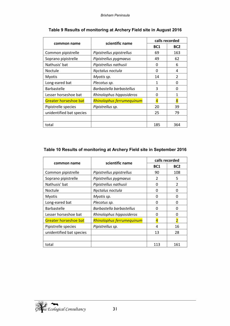
Brixham Peninsula
Greena Ecological Consultancy 31
Table 9 Results of monitoring at Archery Field site in August 2016
common name scientific name calls recorded
BC1 BC2
Common pipistrelle Pipistrellus pipistrellus 69 163
Soprano pipistrelle Pipistrellus pygmaeus 49 62
Nathusis' bat Pipistrellus nathusii 0 6
Noctule Nyctalus noctula 0 4
Myotis Myotis sp. 14 2
Long-eared bat Plecotus sp. 1 0
Barbastelle Barbastella barbastellus 3 0
Lesser horseshoe bat Rhinolophus hipposideros 0 1
Greater horseshoe bat Rhinolophus ferrumequinum 4 8
Pipistrelle species Pipistrellus sp. 20 39
unidentified bat species 25 79
total 185 364
Table 10 Results of monitoring at Archery Field site in September 2016
common name scientific name calls recorded
BC1 BC2
Common pipistrelle Pipistrellus pipistrellus 90 108
Soprano pipistrelle Pipistrellus pygmaeus 2 5
Nathusis' bat Pipistrellus nathusii 0 2
Noctule Nyctalus noctula 0 0
Myotis Myotis sp. 0 0
Long-eared bat Plecotus sp. 0 0
Barbastelle Barbastella barbastellus 0 0
Lesser horseshoe bat Rhinolophus hipposideros 0 0
Greater horseshoe bat Rhinolophus ferrumequinum 4 2
Pipistrelle species Pipistrellus sp. 4 16
unidentified bat species 13 28
total 113 161
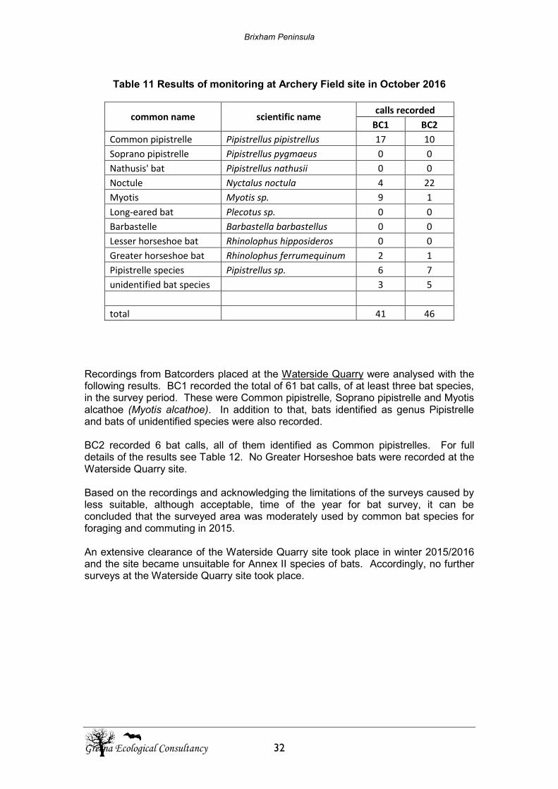
Brixham Peninsula
Greena Ecological Consultancy 32
Table 11 Results of monitoring at Archery Field site in October 2016
common name scientific name calls recorded
BC1 BC2
Common pipistrelle Pipistrellus pipistrellus 17 10
Soprano pipistrelle Pipistrellus pygmaeus 0 0
Nathusis' bat Pipistrellus nathusii 0 0
Noctule Nyctalus noctula 4 22
Myotis Myotis sp. 9 1
Long-eared bat Plecotus sp. 0 0
Barbastelle Barbastella barbastellus 0 0
Lesser horseshoe bat Rhinolophus hipposideros 0 0
Greater horseshoe bat Rhinolophus ferrumequinum 2 1
Pipistrelle species Pipistrellus sp. 6 7
unidentified bat species 3 5
total 41 46
Recordings from Batcorders placed at the Waterside Quarry were analysed with the following results. BC1 recorded the total of 61 bat calls, of at least three bat species, in the survey period. These were Common pipistrelle, Soprano pipistrelle and Myotis alcathoe (Myotis alcathoe). In addition to that, bats identified as genus Pipistrelle and bats of unidentified species were also recorded. BC2 recorded 6 bat calls, all of them identified as Common pipistrelles. For full details of the results see Table 12. No Greater Horseshoe bats were recorded at the Waterside Quarry site. Based on the recordings and acknowledging the limitations of the surveys caused by less suitable, although acceptable, time of the year for bat survey, it can be concluded that the surveyed area was moderately used by common bat species for foraging and commuting in 2015. An extensive clearance of the Waterside Quarry site took place in winter 2015/2016 and the site became unsuitable for Annex II species of bats. Accordingly, no further surveys at the Waterside Quarry site took place.
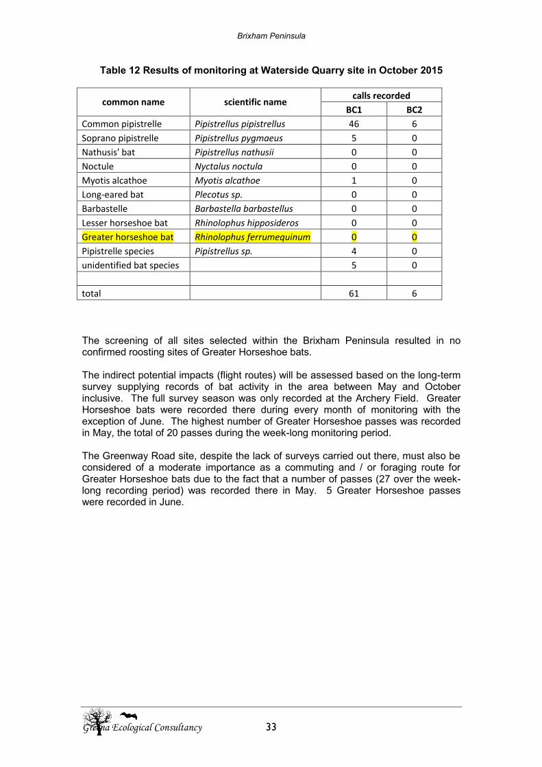
Brixham Peninsula
Greena Ecological Consultancy 33
Table 12 Results of monitoring at Waterside Quarry site in October 2015
common name scientific name calls recorded
BC1 BC2
Common pipistrelle Pipistrellus pipistrellus 46 6
Soprano pipistrelle Pipistrellus pygmaeus 5 0
Nathusis' bat Pipistrellus nathusii 0 0
Noctule Nyctalus noctula 0 0
Myotis alcathoe Myotis alcathoe 1 0
Long-eared bat Plecotus sp. 0 0
Barbastelle Barbastella barbastellus 0 0
Lesser horseshoe bat Rhinolophus hipposideros 0 0
Greater horseshoe bat Rhinolophus ferrumequinum 0 0
Pipistrelle species Pipistrellus sp. 4 0
unidentified bat species 5 0
total 61 6 The screening of all sites selected within the Brixham Peninsula resulted in no confirmed roosting sites of Greater Horseshoe bats. The indirect potential impacts (flight routes) will be assessed based on the long-term survey supplying records of bat activity in the area between May and October inclusive. The full survey season was only recorded at the Archery Field. Greater Horseshoe bats were recorded there during every month of monitoring with the exception of June. The highest number of Greater Horseshoe passes was recorded in May, the total of 20 passes during the week-long monitoring period. The Greenway Road site, despite the lack of surveys carried out there, must also be considered of a moderate importance as a commuting and / or foraging route for Greater Horseshoe bats due to the fact that a number of passes (27 over the week-long recording period) was recorded there in May. 5 Greater Horseshoe passes were recorded in June.
Brixham Peninsula
Greena Ecological Consultancy 34
7. References Article 12 Working Group (2005). Contribution to the Interpretation of Strict Protection of Species. Habitat Committee for European Commission Blackdown Environmental (2015). Bat Survey Report (Buildings Roost Assessment) Countryside and Rights of Way Act 2000 [online] available at: http://www.opsi.gov.uk/acts/acts2000/ukpga_20000037_en_1 [accessed on 29th July 2016] Collins, J. (ed.) (2016) Bat Surveys for Professional Ecologists: Good Practice Guidelines (3rd ed.) Bat Conservation Trust, London. Geostore.com, (2016). Geostore. [online] available at: http://www.geostore.com/geostore4/WebStore?xml=geostore4/xml/application.xml [accessed on 5th September 2016] Institute of Ecology and Environmental Management (2012). Guidelines for Preliminary Ecological Appraisal. [online] IEEM: Winchester. Available at: http:/www.iem.net/docs/GPEA_web.pdf [accessed on 5th October 2014]. HMSO (1981)The Wildlife and Countryside Act 1981. The Stationery Office Ltd. Norwich. HMSO (2012)The Conservation (Natural Habitats, & c) Regulations 2012. The Stationery Office Ltd, Norwich JNCC, DEFRA, (2016). Protected Sites. [online] available at: http://jncc.defra.gov.uk/ProtectedSites/SACselection/sac.asp?EUcode=UK0030052 [accessed on 20th July 2016] Magic.gov.uk, (2016). Login. [online] available at:http://www.magic.gov.uk/MagicMap.aspx [accessed on 6th September 2016] Mitchell-Jones AJ (2004) Bat mitigation guidelines (version January 2004). English Nature, Peterborough. Mitchell-Jones, A.J. & McLeish, A.P. (2004).The Bat Workers’ Manual (3rd Ed.). JNCC, Peterborough. National Biodiversity Network (2016). NBN Gateway Species Dictionary. [online] Available at: http:/nbn.org.uk/Tols-Resources/NBN-Dictionaries/Species-Dictionary.aspx [Accessed on 8th Septeber 2016]. Natural England, (2016). SSSI. [online]. Available at: http://www.sssi.naturalengland.org.uk/citation/citation_photo/1002091.pdf [accessed on 8th September 2016]
Brixham Peninsula
Greena Ecological Consultancy 35
Office of the Deputy Prime Minster, DEFRA and English Nature, (2006). Planning for Biodiversity and Geological Conservation: A Guide to Good Practice, ODPM, London Richardson, P., (2000)Distribution Atlas of Bats in Britain and Ireland, 1980-1999. The Bat Conservation Trust, London. Walkhighlands.co.uk (2016).GPS Planner. Walkhighlands.co.uk. [online] available at: http://www.walkhighlands.co.uk/maps/ [accessed on 5thSeptember 2016].

Habitat Regulations Assessment Screening: Brixham Peninsula Neighbourhood Plan (2012-2030)
Brixham Parish Council
Prepared for: Brixham Parish Council
AECOM 33/33
aecom.com