Prof. Rachel J.C. Chen, Ph.D. University of Tennessee, Knoxville, USA Senior Visiting Researcher,...
16
Prof. Rachel J.C. Chen, Ph.D. University of Tennessee, Knoxville, USA Senior Visiting Researcher, Centre for Regional and Tourism Research, Bornholm, Denmark Prof. Dimitri Ioannides, Ph.D. Southwestern Missouri State University Senior Visiting Researcher, Centre for Regional and Tourism Research Dr. Peter Billing, Director Centre for Regional and Tourism Research, Bornholm, Denmark Integration or Disintegration: The Uses of Geographic Information Systems (GIS) in Island Policy Rachel J.C. Chen, Dimitri Ioannides & Peter Billing CENTRE FOR REGIONAL AND TOURISM RESEARCH, DENMARK
-
Upload
fred-bache -
Category
Documents
-
view
219 -
download
4
Transcript of Prof. Rachel J.C. Chen, Ph.D. University of Tennessee, Knoxville, USA Senior Visiting Researcher,...
Prof. Rachel J.C. Chen, Ph.D.
University of Tennessee, Knoxville, USA
Senior Visiting Researcher, Centre for Regional and Tourism Research, Bornholm, Denmark
Prof. Dimitri Ioannides, Ph.D.
Southwestern Missouri State University
Senior Visiting Researcher, Centre for Regional and Tourism Research
Dr. Peter Billing, Director
Centre for Regional and Tourism Research, Bornholm, Denmark
Integration or Disintegration: The Uses of Geographic Information Systems (GIS) in Island Policy
Integration or Disintegration: The Uses of Geographic Information Systems (GIS) in Island Policy
Rachel J.C. Chen, Dimitri Ioannides & Peter Billing CENTRE FOR REGIONAL AND TOURISM RESEARCH, DENMARK

PROJECT PART-FINANCEDBY THE EUROPEAN UNION
ProjectGEDERI (Gestión et Development des Regiones des Isles)Manageent and Development of Island Regions (2004-2007)
Project OwnerCPMR / Island Commission Eurisles (Corse)
PurposeTo use the regional " know how " structures, in each island region in order to provide a better foundation for strategy and policy to the insular political and administrative actors. The participating islands will be studied and offered good practices analysis through the exchange of experiences, problems and themes linked to island development and management.
www.gederi.orgRachel J.C. Chen & Peter Billing CENTRE FOR REGIONAL AND TOURISM RESEARCH, DENMARK
Background

LEAD PARTNERCorse (Fr)
PARTNERSBaleares (Sp)Bornholm (Da)Crete (Gr)Gotland (Sv)Gozo (Malta)Ionia Nissia (Gr)Sardegna (It)Sicily (It)Western Isles (GB)Åland (Fi)
Rachel J.C. Chen & Peter Billing CENTRE FOR REGIONAL AND TOURISM RESEARCH, DENMARK
THEMES AND SUB-THEMES
1. Accessibility2. Sustainable Tourism3. Depopulation4. Labor market training and supply5. Marketing of local products6. Natural and environmental risks7. Towards and integrated strategy
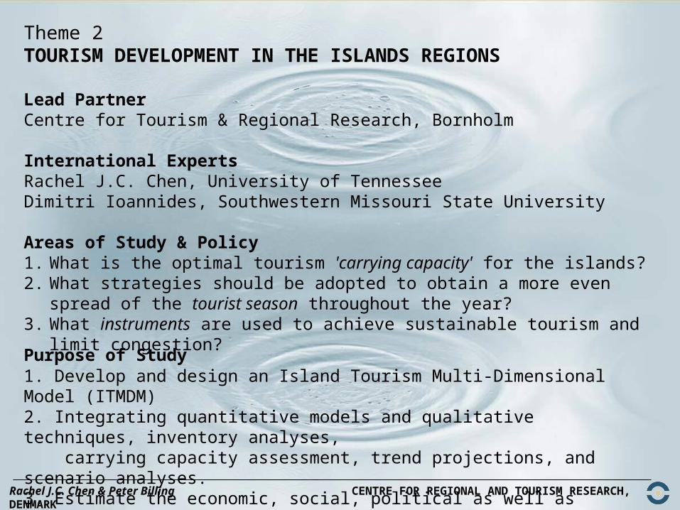
Theme 2TOURISM DEVELOPMENT IN THE ISLANDS REGIONS
Lead PartnerCentre for Tourism & Regional Research, Bornholm
International ExpertsRachel J.C. Chen, University of TennesseeDimitri Ioannides, Southwestern Missouri State University
Areas of Study & Policy1. What is the optimal tourism 'carrying capacity' for the islands?2. What strategies should be adopted to obtain a more even spread of
the tourist season throughout the year?3. What instruments are used to achieve sustainable tourism and limit
congestion?
Rachel J.C. Chen & Peter Billing CENTRE FOR REGIONAL AND TOURISM RESEARCH, DENMARK
Purpose of Study1. Develop and design an Island Tourism Multi-Dimensional Model (ITMDM) 2. Integrating quantitative models and qualitative techniques, inventory analyses, carrying capacity assessment, trend projections, and scenario analyses.3. Estimate the economic, social, political as well as environmental impacts of
tourism on island development

ForecastingForecastingModelsModels
GISGIS
EIAEIA
SeasonalitySeasonality
AlternativesAlternatives
AccessibilityAccessibility
TDCTDC
Tourism Data CenterTourism Data Center Role in Linking Modules Formation : Role in Linking Modules Formation :
Island Tourism MultiIsland Tourism Multi--Dimensional Model (ITMDM)Dimensional Model (ITMDM)
Site Selection + TDC ---> Planning Strategy
Modeling to Generate Alternatives
Impact Assessments
+ TDC
List of Models + TDC
TDC <---> The nature of data sets(price, seasonality, attendances, etc.)
Sensitivity(Parameter analysis)Cost-Benefit(Investment or maintenance)
Data mining + TDC---> Marketing
©Dr. Rachel J.C. Chen
Rachel J.C. Chen & Peter Billing CENTRE FOR REGIONAL AND TOURISM RESEARCH, DENMARK

GIS and Tourism?
• Geographic Information Systems (GIS) have been adopted as a useful tool by a wide range of disciplines such as environmental planning, property management, infrastructure siting, emergency planning, automobile navigation systems, urban studies, market analysis, and business demographics (Chen, 2002).
• However, even though tourism development is a distinctly geographical activity with serious implications for destination areas, few researchers have applied GIS to tourism policy, planning and management practices.
Rachel J.C. Chen, Dimitri Ioannides & Peter Billing CENTRE FOR REGIONAL AND TOURISM RESEARCH, DENMARK

1. Tourism Resource Inventories: This involves developing an inventory of resources in order to identify conflicting but also complementary land uses and activities, available infrastructure, and natural resources.
2. Site Selections: Appropriate site selection is critical for the future of a business or an attraction. Businesses must locate within an area that benefits not only the needs of the business, but also the consumer needs for convenience and ease. GIS is essentially a spatial database that features geographic and attribute data (Chen, 2002). It is a method used to identify suitable locations for tourism development.
3. Spatial Demonstrations of Tourism Impacts: GIS can be used to demonstrate tourism impacts on various industrial sectors in a time-series and spatial format.
Rachel J.C. Chen, Dimitri Ioannides & Peter Billing CENTRE FOR REGIONAL AND TOURISM RESEARCH, DENMARK
Possibilities for GIS Applications in Tourism Policy and Planning
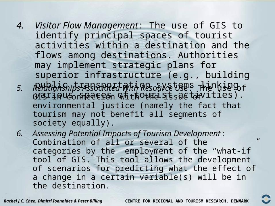
4. Visitor Flow Management: The use of GIS to identify principal spaces of tourist activities within a destination and the flows among destinations. Authorities may implement strategic plans for superior infrastructure (e.g., building public transportation systems linking various spaces of tourist activities).
Rachel J.C. Chen, Dimitri Ioannides & Peter Billing CENTRE FOR REGIONAL AND TOURISM RESEARCH, DENMARK
5. Relationships Associated With Resource Use: The use of GIS in connection with the issue of environmental justice (namely the fact that tourism may not benefit all segments of society equally).
6. Assessing Potential Impacts of Tourism Development: Combination of all or several of the categories by the employment of the “what-if” tool of GIS. This tool allows the development of scenarios for predicting what the effect of a change in a certain variable(s) will be in the destination.

Indicators
Demographics Social behavior
Tourist flows Health and safety
Employment Psychological issues
Rachel J.C. Chen, Dimitri Ioannides & Peter Billing CENTRE FOR REGIONAL AND TOURISM RESEARCH, DENMARK

1. Tourism Earnings and Investments
3. Tourism Policies
1.1 Ratio of net foreign exchange earnings relating to the tourist investments or to the functioning of tourist activity 1.2 Inflow earnings from the expenditure prior to departure 1.3 Tourism receipts in absolute terms1.4 Per capita tourist expenditure during stay
3.1 Existence of specific tourism regional development plan3.2 Participation of destination in eco-labeling program (e.g., the EU program “Blue Flag” for beaches) 3.3 Reference to tourism in broader national and/or regional development plans 3.4 Existence of specific national and/or regional tourism policy3.5 Existence of national tourism development plan making reference to specific island
2. Employment 4. Public Expenditure and Revenue
2.1 Average annual employment (directly or indirectly) in tourist sector/ Total employment 2.2 Number of seasonal workers
4.1 Tourist tax (eco-tax) revenue/total tax revenue4.2 Tourist tax (eco-tax) revenue/public expenditure on tourism development
Rachel J.C. Chen, Dimitri Ioannides & Peter Billing CENTRE FOR REGIONAL AND TOURISM RESEARCH, DENMARK

Peter Billing & Rachel J.C. Chen CENTRE FOR REGIONAL AND TOURISM RESEARCH, DENMARK
THE ISLAND OF BORNHOLM, DENMARK
Population 43.000
Size 150 km2
Sense of Independence and Identity
Decline in Traditional Industries:Fishing and Agriculture
Tourism development
BORNHOLM
BORNHOLM

74
91
113
71
127
39
2618
34
47
118
119
162
144
119
126
44 102
113
102
121
110
21
27
73
95
39
127
83
124
127
82
91
125
103
21
159
38 38
158
158
159
158
Svaneke
Malkværn
Årsdale MølleÅrsdale
Grisby
Svanemølle
Svaneke Stubmølle
Bølshavn
RokkestenenParadisbakkerne
Balka
Kannikegærdet
Klinteby
SlamrehuseNexø
Snogebæk
Salthammer Odde
Broens Odde
Brændegårdshaven
Listed
Sankt Ibs Kirke
Plantage
Gadeby
Gamleborg
GryetPlantage
Povlsker
Randkløve
Saltuna
Ypnasted
Frederiksø
Christiansø
Slusegårdens Mølle
Rispebjerg
Sankt Bodils Kirke
Stenseby
Holsmyrediget
Langedeby
Tjørneby
Sankt Povls Kirke
Bodilsker
Gamlevælde
Gudhjem
Melsted
RisenØsterlars
Randkløve Skår
BORNHOLM
Himmerigsport
Hvidhat
Louisenlund
Dalslunde
Lyrsby
Staggehuse
Østermarie
Gadeby
Pedersker Plantage
RunestenElleby
Bodilsker
Myreagre Mølle
Åker Plantage
Kællingeby
Aakirkeby
Nyby
Dueodde
StrandmarkenVester Sømarken
Boderne Æggebjerg
Øster Sømarken
Dyndeby
Grødby
Pedersker
Smålyngen
ALMINDINGEN
Åløse
SkrulleGlappe
Middelaldercenter
SaleneBugt
Øster Lars Kirke Kelseby
Myreby
Sose
Strøby
Rytterknægten
Årsballe
Travbane
Gamleborg
Gildesbo
KrashaveSpydelund
Sankt Ols Kirke
Asseregårds Huse
KlemenskerKongensmark
Splitsgård Huse
Helligdomsklipperne
Krækket
Tingsted
Kalby
Lobbæk
Nylars
Værmelandshuse
Bjergebakke
Smørenge
Lilleborg
Hundshale
Lensgård
Rø
Røbro
Rø Plantage
Bådsted
Stammershalle
Stenby Mølle
Tejn
Moseløkken
Studeby
Skarpeskade
Blemmelyng
Vestermarie
Ringeby
Rabækkeværket
Møllevangen
Kærby
Knudsker
Allinge
KåsOlsker
Sandkås
Sandvig
Hammer Odde
Slotslyngen
Madsebakke
Hammeren
Vysteby
Mæby
Bymølle
Brogårdsstenen
Rutsker
Risby
Egeshøj
Ruts Kirke
Humledal
Næbbe Bugt
Bornholm
Kanondalen
RØNNE
Grisby
Arnager
Rønne Plantage
Lundesten
Gøngeherred
Nyker
Blykobbe Plantage
Sorthat
Krummeled
Hasle
Muleby
Tofte
Våde Ovn
Hammershus
Teglkås
Helligpeder
Jons Kapel
Løvehovederne
Vang
Source: IT Department of Bornholm Regional Council
Rachel J.C. Chen, Dimitri Ioannides & Peter Billing CENTRE FOR REGIONAL AND TOURISM RESEARCH, DENMARK
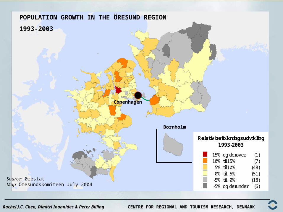
Relativ befolkningsudvikling1993-2003
15% og derover (1)10% til 15% (7)5% til 10% (48)0% til 5% (51)
-5% til 0% (18)-5% og derunder (6)
Source: ØrestatMap Öresundskomiteen July 2004
Rachel J.C. Chen, Dimitri Ioannides & Peter Billing CENTRE FOR REGIONAL AND TOURISM RESEARCH, DENMARK
POPULATION GROWTH IN THE ÖRESUND REGION
1993-2003
Copenhagen
Bornholm

Rachel J.C. Chen, Dimitri Ioannides & Peter Billing CENTRE FOR REGIONAL AND TOURISM RESEARCH, DENMARK
GROWTH IN NUMBER OF PEOPLE WORKING IN EDUCATION IN THE ÖRESUND REGION
1993-2001
Source: ØrestatMap Öresundskomiteen July 2004
Conclusions
Geographic Information Systems (GIS) can be used to identify various classes of islands throughout Europe. By using GIS as a tool for identifying types of regions (islands), recommendations could be made for a range of policies (not one size fits all) that would apply to islands according to their level of development. For instance, policy recommendations for mature tourist destinations in highly urbanized areas would not be the same for remote cold-water islands and so on.
Rachel J.C. Chen, Dimitri Ioannides & Peter Billing CENTRE FOR REGIONAL AND TOURISM RESEARCH, DENMARK

Contact Information:
Prof. Rachel J.C. Chen, Ph.D.
Prof. Dimitri Ioannides, Ph.D
Peter Billing, [email protected]
Thank you for your attention!Thank you for your attention!