Linking climate change and water resources: impacts and ... · 35 Section 3 Linking climate change...
20
Linking climate change and water resources: impacts and responses 3
Transcript of Linking climate change and water resources: impacts and ... · 35 Section 3 Linking climate change...

Linking climate change and water resources: impacts and responses
3


35
Linking climate change and water resources: impacts and responses Section 3
3.1 Observed climate change impacts
3.1.1 Observed effects due to changes in the cryosphere
Effects of changes in the cryosphere have been documented in relation to virtually all cryospheric components, with robust evidence that they are, in general, a response to the reduction of snow and ice masses due to enhanced warming.
3.1.1.1 Mountainglaciersandicecaps,icesheetsandiceshelves
Effects of changes in mountain glaciers and ice caps have been documented in runoff (Kaser et al., 2003; Box et al., 2006), changing hazard conditions (Haeberli and Burn, 2002) and ocean freshening (Bindoff et al., 2007). There is also emerging evidence of present crustal uplift in response to recent glacier melting in Alaska (Larsen et al., 2005). The enhanced melting, as well as the increased length of the melt season of glaciers, leads at first to increased river runoff and discharge peaks, while in the longer time-frame (decadal to century scale), glacier runoff is expected to decrease (Jansson et al., 2003). Evidence for increased runoff in recent decades due to enhanced glacier melt has already been detected in the tropical Andes and in the Alps. [WGI 4.6.2; WGII 1.3.1.1]
The formation of lakes is occurring as glaciers retreat from prominent Little Ice Age (LIA) moraines in several steep mountain ranges, including the Himalayas (see Box 5.4), the Andes and the Alps. Thawing of buried ice also threatens to destabilise the Little Ice Age moraines. These lakes thus have a high potential for glacial lake outburst floods (GLOFs). Governmental institutions in the respective countries have undertaken extensive safety work, and several of the lakes are now either solidly dammed or drained; but continued vigilance is needed, since many tens of potentially dangerous glacial lakes still exist in the Himalayas (Yamada, 1998) and the Andes (Ames, 1998), together with several more in other mountain ranges of the world. [WGII 1.3.1.1]
Glacier retreat causes striking changes in the landscape, which has affected living conditions and local tourism in many mountain regions around the world (Watson and Haeberli, 2004; Mölg et al., 2005). Figure 5.10 shows the effects of the retreat of the Chacaltaya Glacier on the local landscape and skiing industry. Warming produces an enhanced spring–summer melting of glaciers, particularly in areas of ablation, with a corresponding loss of seasonal snow cover that results in increased exposure of surface crevasses, which can in turn affect, for example, snow runway operations, as has been reported in the Antarctic Peninsula (Rivera et al., 2005). [WGII 1.3.1.1]
3.1.1.2 SnowcoverandfrozengroundDue to less extended snow cover both in space and time, spring peak river flows have been occurring 1–2 weeks earlier during the last 65 years in North America and northern Eurasia. There
is also evidence for an increase in winter base flow in northern Eurasia and North America, as well as a measured trend towards less snow at low altitudes, which is affecting skiing areas. [WGII 1.3.1.1]
Reductions in the extent of seasonally frozen ground and permafrost, and an increase in active-layer thickness, have resulted in:
the disappearance of lakes due to draining within the permafrost, as detected in Alaska (Yoshikawa and Hinzman, 2003) and Siberia (see Figure 5.12) (Smith et al., 2005);a decrease in potential travel days of vehicles over frozen roads in Alaska;increased coastal erosion in the Arctic (e.g., Beaulieu and Allard, 2003).
[WGII 1.3.1.1, Chapter 15]
3.1.2 Hydrology and water resources
3.1.2.1 ChangesinsurfaceandgroundwatersystemsSince the TAR there have been many studies related to trends in river flows during the 20th century at scales ranging from catchment to global. Some of these studies have detected significant trends in some indicators of river flow, and some have demonstrated statistically significant links with trends in temperature or precipitation; but no globally homogeneous trend has been reported. Many studies, however, have found no trends, or have been unable to separate the effects of variations in temperature and precipitation from the effects of human interventions in the catchment, such as land-use change and reservoir construction. Variation in river flows from year to year is also very strongly influenced in some regions by large-scale atmospheric circulation patterns associated with ENSO, NAO and other variability systems that operate at within-decadal and multi-decadal time-scales. [WGII 1.3.2.1]
At the global scale, there is evidence of a broadly coherent pattern of change in annual runoff, with some regions experiencing an increase (Tao et al., 2003a, b, for China; Hyvarinen, 2003, for Finland; Walter et al., 2004, for the coterminous USA), particularly at higher latitudes, and others a decrease, for example in parts of West Africa, southern Europe and southern Latin America (Milly et al., 2005). Labat et al. (2004) claimed a 4% increase in global total runoff per 1°C rise in temperature during the 20th century, with regional variation around this trend, but this has been challenged due to the effects of non-climatic drivers on runoff and bias due to the small number of data points (Legates et al., 2005). Gedney et al. (2006) gave the first tentative evidence that CO2 forcing leads to increases in runoff due to the effects of elevated CO2 concentrations on plant physiology, although other evidence for such a relationship is difficult to find. The methodology used to search for trends can also influence results, since omitting the effects of cross-correlation between river catchments can lead to an overestimation of the number of catchments showing significant trends (Douglas et al., 2000). [WGII 1.3.2.1]
•
•
•

36
Linking climate change and water resources: impacts and responses Section 3
Groundwater flow in shallow aquifers is part of the hydrological cycle and is affected by climate variability and change through recharge processes (Chen et al., 2002), as well as by human interventions in many locations (Petheram et al., 2001). [WGII 1.3.2.1] Groundwater levels of many aquifers around the world show a decreasing trend over the last few decades [WGII 3.2, 10.4.2], but this is generally due to groundwater pumping surpassing groundwater recharge rates, and not to a climate-related decrease in groundwater recharge. There may be regions, such as south-western Australia, where increased groundwater withdrawals have been caused not only by increased water demand but also because of a climate-related decrease in recharge from surface water supplies (Government of Western Australia, 2003). In the upper carbonate aquifer near Winnipeg, Canada, shallow well hydrographs show no obvious trends, but exhibit variations of 3–4 years correlated with changes in annual temperature and precipitation (Ferguson and George, 2003). Owing to a lack of data and the very slow reaction of groundwater systems to changing recharge conditions, climate-related changes in groundwater recharges have not been observed. [WGII 1.3.2, 3.2]
At present, no globally consistent trend in lake levels has been found. While some lake levels have risen in Mongolia and China (Xinjiang) in response to increased snow- and ice melt, other lake levels in China (Qinghai), Australia, Africa (Zimbabwe, Zambia and Malawi), North America (North Dakota) and Europe (central Italy) have declined due to the combined effects of drought, warming and human activities. Within permafrost areas in the Arctic, recent warming has resulted in the temporary formation of lakes due to the onset of melting, which then drain rapidly due to permafrost degradation (e.g., Smith et al., 2005). A similar effect has been reported for a lake formed over an Arctic ice shelf (i.e., an epishelf lake12), which disappeared when the ice shelf collapsed (Mueller et al., 2003). Permafrost and epishelf lakes are treated in detail by Le Treut et al. (2007). [WGII 1.3.2.1]
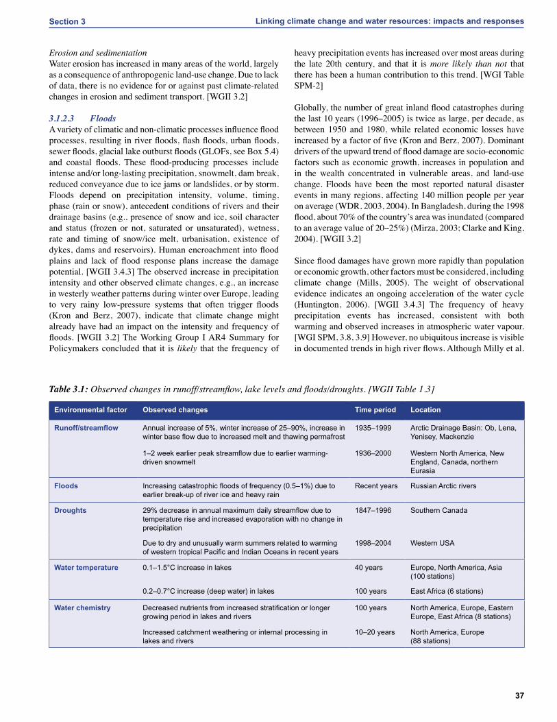
3.1.2.2 WaterqualityA climate-related warming of lakes and rivers has been observed over recent decades. [WGII 1.3.2] As a result, freshwater ecosystems have shown changes in species composition, organism abundance, productivity and phenological shifts (including earlier fish migration). [WGII 1.3.4] Also due to warming, many lakes have exhibited prolonged stratification with decreases in surface layer nutrient concentration [WGII 1.3.2], and prolonged depletion of oxygen in deeper layers. [WGII Box 4.1] Due to strong anthropogenic impacts not related to climate change, there is no evidence for consistent climate-related trends in other water quality parameters (e.g., salinity, pathogens or nutrients) in lakes, rivers and groundwater. [WGII 3.2]
Thermal structure of lakesHigher water temperatures have been reported in lakes in response to warmer conditions (Table 3.1). Shorter periods
of ice cover and decreases in river- and lake-ice thickness are treated in Section 2.1.2 and Le Treut et al. (2007). Phytoplankton dynamics and primary productivity have also been altered in conjunction with changes in lake physics. [WGII 1.3.4.4, Figure 1.2, Table 1.6] Since the 1960s, surface water temperatures have warmed by between 0.2 and 2.0°C in lakes and rivers in Europe, North America and Asia. Along with warming surface waters, deep-water temperatures (which reflect long-term trends) of the large East African lakes (Edward, Albert, Kivu, Victoria, Tanganyika and Malawi) have warmed by between 0.2 and 0.7°C since the early 1900s. Increased water temperature and longer ice-free seasons influence the thermal stratification and internal hydrodynamics of lakes. In warmer years, surface water temperatures are higher, evaporative water loss increases, summer stratification occurs earlier in the season, and thermoclines become shallower. In several lakes in Europe and North America, the stratified period has advanced by up to 20 days and lengthened by 2–3 weeks, with increased thermal stability. [WGII 1.3.2.3]
ChemistryIncreased stratification reduces water movement across the thermocline, inhibiting the upwelling and mixing that provide essential nutrients to the food web. There have been decreases in nutrients in the surface water and corresponding increases in deep-water concentrations of European and East African lakes because of reduced upwelling due to greater thermal stability. Many lakes and rivers have increased concentrations of sulphates, base cations and silica, and greater alkalinity and conductivity related to increased weathering of silicates, calcium and magnesium sulphates, or carbonates, in their catchment. In contrast, when warmer temperatures enhanced vegetative growth and soil development in some high-alpine ecosystems, alkalinity decreased because of increased organic acid inputs (Karst-Riddoch et al., 2005). Glacial melting increased the input of organochlorines (which had been atmospherically transported to and stored in the glacier) to a sub-alpine lake in Canada (Blais et al., 2001). [WGII 1.3.2.3]
Increased temperature also affects in-lake chemical processes (Table 3.1; see also WGII Table SM1.3 for additional observed changes in chemical water properties). There have been decreases in dissolved inorganic nitrogen from greater phytoplankton productivity (Sommaruga-Wograth et al., 1997; Rogora et al., 2003) and greater in-lake alkalinity generation and increases in pH in soft-water lakes (Psenner and Schmidt, 1992). Decreased solubility from higher temperatures significantly contributed to 11–13% of the decrease in aluminium concentration (Vesely et al., 2003), whereas lakes that had warmer water temperatures had increased mercury methylation and higher mercury levels in fish (Bodaly et al., 1993). A decrease in silicon content related to regional warming has been documented in Lake Baikal, Russia. River water-quality data from 27 rivers in Japan also suggest a deterioration in both chemical and biological features due to increases in air temperature. [WGII 1.3.2.3]
12 A body of water, mostly fresh, trapped behind an ice shelf.
37
Linking climate change and water resources: impacts and responses Section 3
Erosion and sedimentationWater erosion has increased in many areas of the world, largely as a consequence of anthropogenic land-use change. Due to lack of data, there is no evidence for or against past climate-related changes in erosion and sediment transport. [WGII 3.2]
3.1.2.3 FloodsA variety of climatic and non-climatic processes influence flood processes, resulting in river floods, flash floods, urban floods, sewer floods, glacial lake outburst floods (GLOFs, see Box 5.4) and coastal floods. These flood-producing processes include intense and/or long-lasting precipitation, snowmelt, dam break, reduced conveyance due to ice jams or landslides, or by storm. Floods depend on precipitation intensity, volume, timing, phase (rain or snow), antecedent conditions of rivers and their drainage basins (e.g., presence of snow and ice, soil character and status (frozen or not, saturated or unsaturated), wetness, rate and timing of snow/ice melt, urbanisation, existence of dykes, dams and reservoirs). Human encroachment into flood plains and lack of flood response plans increase the damage potential. [WGII 3.4.3] The observed increase in precipitation intensity and other observed climate changes, e.g., an increase in westerly weather patterns during winter over Europe, leading to very rainy low-pressure systems that often trigger floods (Kron and Berz, 2007), indicate that climate change might already have had an impact on the intensity and frequency of floods. [WGII 3.2] The Working Group I AR4 Summary for Policymakers concluded that it is likely that the frequency of
heavy precipitation events has increased over most areas during the late 20th century, and that it is more likely than not that there has been a human contribution to this trend. [WGI Table SPM-2]
Globally, the number of great inland flood catastrophes during the last 10 years (1996–2005) is twice as large, per decade, as between 1950 and 1980, while related economic losses have increased by a factor of five (Kron and Berz, 2007). Dominant drivers of the upward trend of flood damage are socio-economic factors such as economic growth, increases in population and in the wealth concentrated in vulnerable areas, and land-use change. Floods have been the most reported natural disaster events in many regions, affecting 140 million people per year on average (WDR, 2003, 2004). In Bangladesh, during the 1998 flood, about 70% of the country’s area was inundated (compared to an average value of 20–25%) (Mirza, 2003; Clarke and King, 2004). [WGII 3.2]
Since flood damages have grown more rapidly than population or economic growth, other factors must be considered, including climate change (Mills, 2005). The weight of observational evidence indicates an ongoing acceleration of the water cycle (Huntington, 2006). [WGII 3.4.3] The frequency of heavy precipitation events has increased, consistent with both warming and observed increases in atmospheric water vapour. [WGI SPM, 3.8, 3.9] However, no ubiquitous increase is visible in documented trends in high river flows. Although Milly et al.
Environmental factor Observed changes Time period Location
Runoff/streamflow Annual increase of 5%, winter increase of 25–90%, increase in winter base flow due to increased melt and thawing permafrost
1935–1999 Arctic Drainage Basin: Ob, Lena, Yenisey, Mackenzie
1–2 week earlier peak streamflow due to earlier warming-driven snowmelt
1936–2000 Western North America, New England, Canada, northern Eurasia
Floods Increasing catastrophic floods of frequency (0.5–1%) due to earlier break-up of river ice and heavy rain
Recent years Russian Arctic rivers
Droughts 29% decrease in annual maximum daily streamflow due to temperature rise and increased evaporation with no change in precipitation
1847–1996 Southern Canada
Due to dry and unusually warm summers related to warming of western tropical Pacific and Indian Oceans in recent years
1998–2004 Western USA
Water temperature 0.1–1.5°C increase in lakes 40 years Europe, North America, Asia (100 stations)
0.2–0.7°C increase (deep water) in lakes 100 years East Africa (6 stations)
Water chemistry Decreased nutrients from increased stratification or longer growing period in lakes and rivers
100 years North America, Europe, Eastern Europe, East Africa (8 stations)
Increased catchment weathering or internal processing in lakes and rivers
10–20 years North America, Europe (88 stations)
Table3.1: Observed changes in runoff/streamflow, lake levels and floods/droughts. [WGII Table 1.3]

38
Linking climate change and water resources: impacts and responses Section 3
(2002) identified an apparent increase in the frequency of ‘large’ floods (return period >100 years) across much of the globe from the analysis of data from large river basins, subsequent studies have provided less widespread evidence. Kundzewicz et al. (2005) found increases (in 27 locations) and decreases (in 31 locations) and no trend in the remaining 137 of the 195 catchments examined worldwide. [WGII 1.3.2.2]
3.1.2.4 DroughtsThe term drought may refer to a meteorological drought (precipitation well below average), hydrological drought (low river flows and low water levels in rivers, lakes and groundwater), agricultural drought (low soil moisture), and environmental drought (a combination of the above). The socio-economic impacts of droughts may arise from the interaction between natural conditions and human factors such as changes in land use, land cover, and the demand for and use of water. Excessive water withdrawals can exacerbate the impact of drought. [WGII 3.4.3]
Droughts have become more common, especially in the tropics and sub-tropics, since the 1970s. The Working Group I AR4 Summary for Policymakers concluded that it is likely that the area affected by drought has increased since the 1970s, and it is more likely than not that there is a human contribution to this trend. [WGI Table SPM-2] Decreased land precipitation and increased temperatures, which enhance evapotranspiration and reduce soil moisture, are important factors that have contributed to more regions experiencing droughts, as measured by the Palmer Drought Severity Index (PDSI) (Dai et al., 2004b). [WGII 3.3.4]
The regions where droughts have occurred seem to be determined largely by changes in sea surface temperatures, especially in the tropics, through associated changes in the atmospheric circulation and precipitation. In the western USA, diminishing snow pack and subsequent reductions in soil moisture also appear to be factors. In Australia and Europe, direct links to global warming have been inferred through the extreme nature of high temperatures and heatwaves accompanying recent droughts. [WGI 3.ES, 3.3.4]
Using the PDSI, Dai et al. (2004b) found a large drying trend over Northern Hemisphere land since the mid-1950s, with widespread drying over much of Eurasia, northern Africa, Canada and Alaska (Figure 3.1). In the Southern Hemisphere, land surfaces were wet in the 1970s and relatively dry in the 1960s and 1990s, and there was a drying trend from 1974 to 1998, although trends over the entire 1948 to 2002 period were small. Decreases in land precipitation in recent decades are the main cause for the drying trends, although large surface warming during the last 2–3 decades is likely to have contributed to the drying. Globally, very dry areas (defined as land areas with a PDSI of less than −3.0) more than doubled (from ~12% to 30%) since the 1970s, with a large jump in the early 1980s due to an ENSO-related precipitation decrease over land, and subsequent increases primarily due to surface warming (Dai et al., 2004b). [WGI 3.3.4]
Droughts affect rain-fed agricultural production as well as water supply for domestic, industrial and agricultural purposes. Some semi-arid and sub-humid regions, e.g., Australia. [WGII 11.2.1], western USA and southern Canada [WGII 14.2.1], and the Sahel (Nicholson, 2005), have suffered from more intense and multi-annual droughts. [WGII 3.2]
The 2003 heatwave in Europe, attributable to global warming (Schär et al., 2004), was accompanied by annual precipitation deficits up to 300 mm. This drought contributed to the estimated 30% reduction in gross primary production of terrestrial ecosystems over Europe (Ciais et al., 2005). Many major rivers (e.g., the Po, Rhine, Loire and Danube) were at record low levels, resulting in disruption of inland navigation, irrigation and power plant cooling (Beniston and Diaz, 2004; Zebisch et al., 2005). The extreme glacier melt in the Alps prevented even lower flows of the Danube and Rhine Rivers (Fink et al., 2004). [WGII 12.6.1]
3.2 Future changes in water availability iiiiiiiand demand due to climate change
3.2.1 Climate-related drivers of freshwater iiiiiiiiiiiiiiiisystems in the future
The most dominant climate drivers for water availability are precipitation, temperature and evaporative demand (determined by net radiation at the ground, atmospheric humidity and wind speed, and temperature). Temperature is particularly important in snow-dominated basins and in coastal areas, the latter due to the impact of temperature on sea level (steric sea-level rise due to thermal expansion of water). [WGII 3.3.1]
Projected changes in these components of the water balance are described in Section 2.3. In short, the total annual river runoff over the whole land surface is projected to increase, even though there are regions with significant increase and significant decrease in runoff. However, increased runoff cannot be fully utilised unless there is adequate infrastructure to capture and store the extra water. Over the oceans, a net increase in the term ‘evaporation minus precipitation’ is projected.
3.2.1.1 GroundwaterClimate change affects groundwater recharge rates (i.e., the renewable groundwater resources) and depths of groundwater tables. However, knowledge of current recharge and levels in both developed and developing countries is poor; and there has been very little research on the future impact of climate change on groundwater, or groundwater–surface water interactions. At high latitudes, thawing of permafrost causes changes in both the level and quality of groundwater, due to increased coupling with surface waters. [WGII 15.4.1] As many groundwaters both change into and are recharged from surface water, impacts of surface water flow regimes are expected to affect groundwater. Increased precipitation variability may decrease groundwater recharge in humid areas because more frequent

39
Linking climate change and water resources: impacts and responses Section 3
13 Note that the PDSI does not realistically model drought in regions where precipitation is held in the snowpack, for example, in polar regions.
Figure3.1: The most important spatial pattern (the first component of a principal components analysis; top) of the monthly Palmer Drought Severity Index (PDSI) for 1900 to 2002. The PDSI is a prominent index of drought and measures the cumulative deficit (relative to local mean conditions) in surface land moisture by incorporating previous precipitation and estimates of moisture drawn into the atmosphere (based on atmospheric temperatures) into a hydrological accounting system.13 The lower panel shows how the sign and strength of this pattern has changed since 1900. When the values shown in the lower plot are positive (or negative), the red and orange areas in the upper map are drier (or wetter) and the blue and green areas are wetter (or drier) than average. The smooth black curve shows decadal variations. The time-series approximately corresponds to a trend, and this pattern and its variations account for 67% of the linear trend of PDSI from 1900 to 2002 over the global land area. It therefore features widespread increasing African drought, especially in the Sahel, for instance. Note also the wetter areas, especially in eastern North and South America and northern Eurasia (after Dai et al., 2004b). [WGI FAQ 3.2]

40
Linking climate change and water resources: impacts and responses Section 3
heavy precipitation events may result in the infiltration capacity of the soil being exceeded more often. In semi-arid and arid areas, however, increased precipitation variability may increase groundwater recharge, because only high-intensity rainfalls are able to infiltrate fast enough before evaporating, and alluvial aquifers are recharged mainly by inundations due to floods. [WGII 3.4.2]
According to the results of a global hydrological model (see Figure 3.2), groundwater recharge, when averaged globally, increases less than total runoff (by 2% as compared with 9% until the 2050s for the ECHAM4 climate change response to the
SRES A2 scenario: Döll and Flörke, 2005). For all four climate change scenarios investigated (the ECHAM4 and HadCM3 GCMs with the SRES A2 and B2 emissions scenarios14), groundwater recharge was computed to decrease by the 2050s by more than 70% in north-eastern Brazil, south-western Africa and the southern rim of the Mediterranean Sea. However, as this study did not take account of an expected increase in the variability of daily precipitation, the decrease might be somewhat overestimated. Where the depth of the water table increases and groundwater recharge declines, wetlands dependent on aquifers are jeopardised and the base flow runoff in rivers during dry seasons is reduced. Regions in which groundwater recharge is
Figure3.2: Simulated impact of climate change on long-term average annual diffuse groundwater recharge. Percentage changes in 30-year average groundwater recharge between the present day (1961–1990) and the 2050s (2041–2070), as computed by the global hydrological model WGHM, applying four different climate change scenarios (based on the ECHAM4 and HadCM3 climate models and the SRES A2 and B2 emissions scenarios) (Döll and Flörke, 2005). [WGII Figure 3.5]
14 See Appendix I for model descriptions.
41
Linking climate change and water resources: impacts and responses Section 3
computed to increase by more than 30% by the 2050s include the Sahel, the Near East, northern China, Siberia and the western USA. In areas where water tables are already high, increased recharge might cause problems in towns and agricultural areas through soil salinisation and waterlogged soils. [WGII 3.4.2]
The few studies of climate change impacts on groundwater for individual aquifers show very site-specific and climate-model-specific results (e.g., Eckhardt and Ulbrich, 2003, for a low mountain range catchment in Central Europe; Brouyere et al., 2004, for a chalk aquifer in Belgium). For example, in the Ogallala Aquifer region, projected natural groundwater recharge decreases more than 20% in all simulations with warming of 2.5°C or greater (Rosenberg et al., 1999). [WGII 14.4] As a result of climate change, in many aquifers of the world the spring recharge shifts towards winter and summer recharge declines. [WGII 3.4.2]
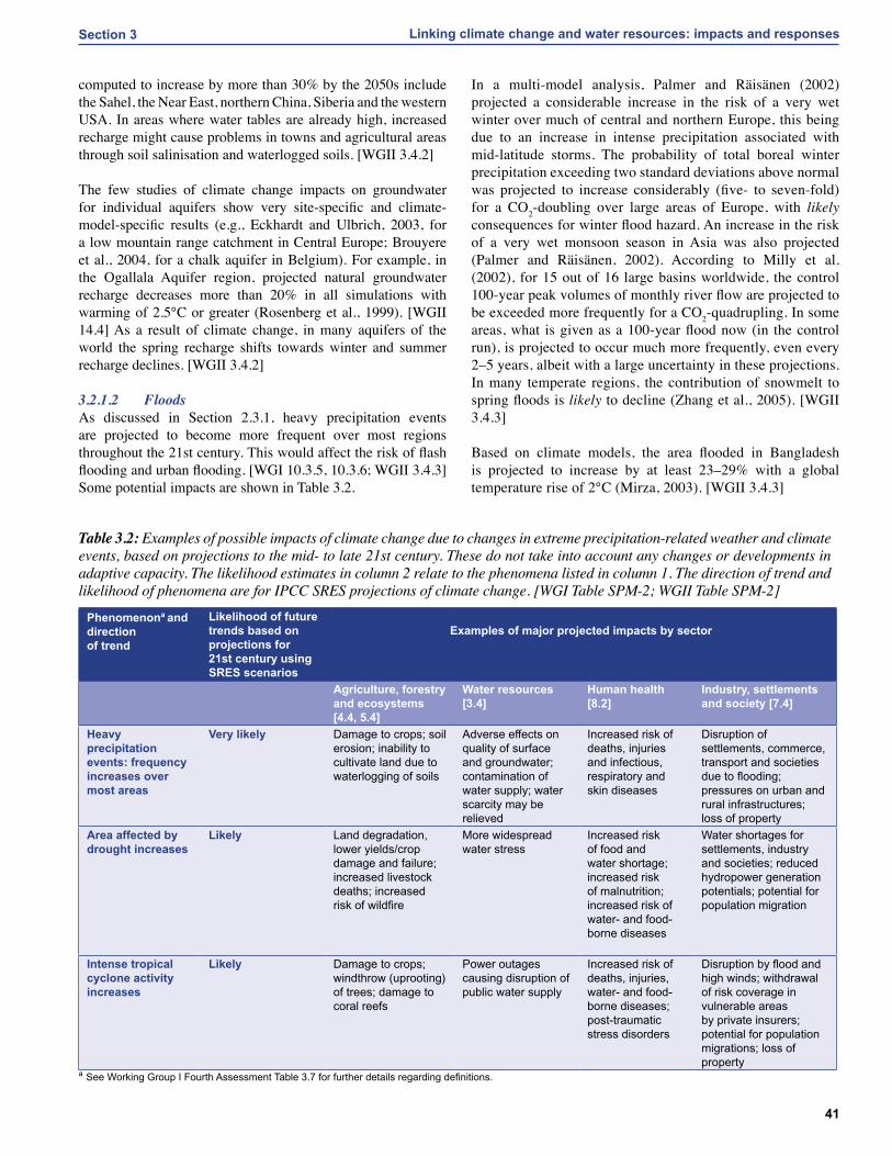
3.2.1.2 FloodsAs discussed in Section 2.3.1, heavy precipitation events are projected to become more frequent over most regions throughout the 21st century. This would affect the risk of flash flooding and urban flooding. [WGI 10.3.5, 10.3.6; WGII 3.4.3] Some potential impacts are shown in Table 3.2.
In a multi-model analysis, Palmer and Räisänen (2002) projected a considerable increase in the risk of a very wet winter over much of central and northern Europe, this being due to an increase in intense precipitation associated with mid-latitude storms. The probability of total boreal winter precipitation exceeding two standard deviations above normal was projected to increase considerably (five- to seven-fold) for a CO2-doubling over large areas of Europe, with likely consequences for winter flood hazard. An increase in the risk of a very wet monsoon season in Asia was also projected (Palmer and Räisänen, 2002). According to Milly et al. (2002), for 15 out of 16 large basins worldwide, the control 100-year peak volumes of monthly river flow are projected to be exceeded more frequently for a CO2-quadrupling. In some areas, what is given as a 100-year flood now (in the control run), is projected to occur much more frequently, even every 2–5 years, albeit with a large uncertainty in these projections. In many temperate regions, the contribution of snowmelt to spring floods is likely to decline (Zhang et al., 2005). [WGII 3.4.3]
Based on climate models, the area flooded in Bangladesh is projected to increase by at least 23–29% with a global temperature rise of 2°C (Mirza, 2003). [WGII 3.4.3]
Phenomenona and directionof trend
Likelihood of future trends based on projections for 21st century using SRES scenarios
Examples of major projected impacts by sector
Agriculture, forestry and ecosystems [4.4, 5.4]
Water resources [3.4]
Human health[8.2]
Industry, settlements and society [7.4]
Heavy precipitation events: frequency increases over most areas
Very likely Damage to crops; soil erosion; inability to cultivate land due to waterlogging of soils
Adverse effects on quality of surface and groundwater; contamination of water supply; water scarcity may be relieved
Increased risk of deaths, injuries and infectious, respiratory and skin diseases
Disruption of settlements, commerce, transport and societies due to flooding; pressures on urban and rural infrastructures; loss of property
Area affected by drought increases
Likely Land degradation, lower yields/crop damage and failure; increased livestock deaths; increased risk of wildfire
More widespread water stress
Increased risk of food and water shortage; increased risk of malnutrition; increased risk of water- and food-borne diseases
Water shortages for settlements, industry and societies; reduced hydropower generation potentials; potential for population migration
Intense tropical cyclone activity increases
Likely Damage to crops; windthrow (uprooting) of trees; damage to coral reefs
Power outages causing disruption of public water supply
Increased risk of deaths, injuries, water- and food-borne diseases; post-traumatic stress disorders
Disruption by flood and high winds; withdrawal of risk coverage in vulnerable areas by private insurers; potential for population migrations; loss of property
a See Working Group I Fourth Assessment Table 3.7 for further details regarding definitions.
Table3.2: Examples of possible impacts of climate change due to changes in extreme precipitation-related weather and climate events, based on projections to the mid- to late 21st century. These do not take into account any changes or developments in adaptive capacity. The likelihood estimates in column 2 relate to the phenomena listed in column 1. The direction of trend and likelihood of phenomena are for IPCC SRES projections of climate change. [WGI Table SPM-2; WGII Table SPM-2]

42
Linking climate change and water resources: impacts and responses Section 3
Warming-induced reduction of firn15 cover on glaciers causes enhanced and immediate runoff of melt water and can lead to flooding of glacial-fed rivers. [WGII 3.4.3]
There is a degree of uncertainty in estimates of future changes in flood frequency across the UK. Depending on which climate model is used, and on the importance of snowmelt contribution and catchment characteristics and location, the impact of climate change on the flood regime (magnitude and frequency) can be positive or negative, highlighting the uncertainty still remaining in climate change impacts (Reynard et al., 2004). [WGII 3.4.3]
3.2.1.3 DroughtsIt is likely that the area affected by drought will increase. [WGI SPM] There is a tendency for drying of mid-continental areas during summer, indicating a greater risk of droughts in these
regions. [WGI 10.ES] In a single-model study of global drought frequency, the proportion of the land surface experiencing extreme drought at any one time, the frequency of extreme drought events, and the mean drought duration, were projected to increase by 10- to 30-fold, two-fold, and six-fold, respectively, by the 2090s, for the SRES A2 scenario (Burke et al., 2006). [WGI 10.3.6; WGII 3.4.3] A decrease in summer precipitation in southern and central Europe, accompanied by rising temperatures (which enhance evaporative demand), would inevitably lead to both reduced summer soil moisture (cf. Douville et al., 2002; Christensen et al., 2007) and more frequent and intense droughts. [WGII 3.4.3] As shown in Figure 3.3, by the 2070s, a 100-year drought16 of today’s magnitude is projected to return, on average, more frequently than every 10 years in parts of Spain and Portugal, western France, Poland’s Vistula Basin and western Turkey (Lehner et al., 2005). [WGII 3.4.3]
15 Firn: aged snow (still permeable) that is at an intermediate stage towards becoming glacial ice (impermeable).16 Every year, the chance of exceedence of the 100-year flood is 1%, while the chance of exceedence of the 10-year flood is 10%.
Figure3.3: Change in the future recurrence of 100-year droughts, based on comparisons between climate and water use in 1961–1990 (Lehner et al., 2005). [WGII Figure 3.6]

43
Linking climate change and water resources: impacts and responses Section 3
Some impacts of increased drought area are shown in Table 3.2. Snowmelt is projected to become earlier and less abundant in the melt period, and this may increase the risk of droughts in snowmelt-fed basins in the low-flow season – summer and autumn. An increase in drought risk is projected for regions which depend heavily on glacial melt water for their main dry-season water supply (Barnett et al., 2005). In the Andes, glacial melt water supports river flow and water supply for tens of millions of people during the long dry season. Many small glaciers, e.g., in Bolivia, Ecuador and Peru (cf. Ramírez et al., 2001; Box 5.5), are expected to disappear within the next few decades. Water supply in areas fed by glacial and snow melt water from the Hindu Kush and Himalayas, on which hundreds of millions of people in China, Pakistan and India depend, will be adversely affected (Barnett et al., 2005). [WGII 3.4.3]
3.2.1.4 WaterqualityHigher water temperatures, increased precipitation intensity, and longer periods of low flows are projected to exacerbate many forms of water pollution, including sediments, nutrients, dissolved organic carbon, pathogens, pesticides, salt and thermal pollution. This will promote algal blooms (Hall et al., 2002; Kumagai et al., 2003), and increase the bacterial and fungal content (Environment Canada, 2001). This will, in turn, impact ecosystems, human health, and the reliability and operating costs of water systems. [WGII 3.ES]
Rising temperatures are likely to lower water quality in lakes through increased thermal stability and altered mixing patterns, resulting in reduced oxygen concentrations and an increased release of phosphorus from the sediments. For example, already high phosphorus concentrations during summer in a bay of Lake Ontario could double with a 3–4°C increase in water temperature (Nicholls, 1999). However, rising temperatures can also improve water quality during winter/spring due to earlier ice break-up and consequent higher oxygen levels and reduced winter fish-kill. [WGII 4.4.8, 14.4.1]
More intense rainfall will lead to an increase in suspended solids (turbidity) in lakes and reservoirs due to soil fluvial erosion (Leemans and Kleidon, 2002), and pollutants will be introduced (Mimikou et al., 2000; Neff et al., 2000; Bouraoui et al., 2004). The projected increase in precipitation intensity is expected to lead to a deterioration of water quality, as it results in the enhanced transport of pathogens and other dissolved pollutants (e.g., pesticides) to surface waters and groundwater; and in increased erosion, which in turn leads to the mobilisation of adsorbed pollutants such as phosphorus and heavy metals. In addition, more frequent heavy rainfall events will overload the capacity of sewer systems and water and wastewater treatment plants more often. [WGII 3.4.4] An increased occurrence of low flows will lead to decreased contaminant dilution capacity, and thus higher pollutant concentrations, including pathogens. [WGII 3.4.4, 14.4.1] In areas with overall decreased runoff (e.g., in many semi-arid areas), water quality deterioration will be even worse.
In semi-arid and arid areas, climate change is likely to increase salinisation of shallow groundwater due to increased evapotranspiration. [WGII 3.4.2] As streamflow is projected to decrease in many semi-arid areas, the salinity of rivers and estuaries will increase. [WGII 3.4.4] For example, salinity levels in the headwaters of the Murray-Darling Basin in Australia are expected to increase by 13–19% by 2050 (Pittock, 2003). In general, decreased groundwater recharge, which reduces mobilisation of underground salt, may balance the effect of decreased dilution of salts in rivers and estuaries. [WGII 11.4]
In coastal areas, rising sea levels may have negative effects on storm-water drainage and sewage disposal [WGII 3.4.4] and increase the potential for the intrusion of saline water into fresh groundwater in coastal aquifers, thus adversely affecting groundwater resources. [WGII 3.4.2] For two small and flat coral islands off the coast of India, the thickness of freshwater lenses was computed to decrease from 25 m to 10 m and from 36 m to 28 m, respectively, for a sea-level rise of only 0.1 m (Bobba et al., 2000). Any decrease in groundwater recharge will exacerbate the effect of sea-level rise. In inland aquifers, a decrease in groundwater recharge can lead to saltwater intrusion from neighbouring saline aquifers (Chen et al., 2004). [WGII 3.4.2]
3.2.1.5 WatererosionandsedimentationAll studies on soil erosion show that the expected increase in rainfall intensity would lead to greater rates of erosion. [WGII 3.4.5] In addition, the shift of winter precipitation from less erosive snow to more erosive rainfall due to increasing winter temperatures enhances erosion, with this leading, for example, to negative water quality impacts in agricultural areas. [WGII 3.4.5, 14.4.1]
The melting of permafrost induces an erodible state in soil which was previously non-erodible. [WGII 3.4.5] Further indirect impacts of climate change on erosion are related to soil and vegetation changes caused by climate change and associated adaptation actions. [WGII 3.4.5] The very few studies on the impact of climate change on sediment transport suggest transport enhancement due to increased erosion, particularly in areas with increased runoff. [WGII 3.4.5]
3.2.2 Non-climatic drivers of freshwater systems iiiiiiiiiiiiiiiiin the future
Many non-climatic drivers affect freshwater resources at the global scale (UN, 2003). Both the quantity and quality of water resources are influenced by land-use change, construction and management of reservoirs, pollutant emissions and water and wastewater treatment. Water use is driven by changes in population, food consumption, economy (including water pricing), technology, lifestyle and societal views regarding the value of freshwater ecosystems. The vulnerability of freshwater systems to climate change also depends on national and international water management. It can be expected that

44
Linking climate change and water resources: impacts and responses Section 3
the paradigm of ‘integrated water resources management’ (IWRM)17 will be followed increasingly around the world (UN, 2002; World Bank, 2004a; World Water Council, 2006), and that such a movement has the potential to position water issues, both as a resource and an ecosystem, at the centre of the policy-making arena. This is likely to decrease the vulnerability of freshwater systems to climate change. Consideration of environmental flow requirements may lead to the modification of reservoir operations so that human use of these water resources might be restricted. [WGII 3.3.2]
3.2.3 Impacts of climate change on freshwater availability in the future
With respect to water supply, it is very likely that the costs of climate change will outweigh the benefits globally. One reason is that precipitation variability is very likely to increase, and more frequent floods and droughts are anticipated, as discussed in Sections 2.1.6 and 2.3.1. The risk of droughts in snowmelt-fed basins in the low-flow season will increase, as discussed in Section 3.2.1. The impacts of floods and droughts could be tempered by appropriate infrastructure investments and by changes in water and land-use management, but the implementation of such measures will entail costs (US Global Change Research Program, 2000). Water infrastructure, usage patterns and institutions have developed in the context of current conditions. Any substantial change in the frequency of floods and droughts, or in the quantity and quality or seasonal timing of water availability, will require adjustments that may be costly, not only in monetary terms but also in terms of societal and ecological impacts, including the need to manage potential conflicts between different interest groups (Miller et al., 1997). [WGII 3.5]
Hydrological changes may have impacts that are positive in some aspects and negative in others. For example, increased annual runoff may produce benefits for a variety of both instream and out-of-stream water users by increasing renewable water resources, but may simultaneously generate harm by increasing flood risk. In recent decades, a trend to wetter conditions in parts of southern South America has increased the area inundated by floods, but has also improved crop yields in the Pampas region of Argentina, and has provided new commercial fishing opportunities (Magrin et al., 2005). [WGII 13.2.4] Increased runoff could also damage areas with a shallow water table. In such areas, a water-table rise disturbs agricultural use and damages buildings in urban areas. In Russia, for example, the current annual damage caused by shallow water tables is estimated to be US$5–6 billion (Kharkina, 2004) and is likely to increase in the future. In addition, an increase in annual runoff may not lead to a beneficial increase in readily available water resources, if that additional runoff is concentrated during the high-flow season. [WGII 3.5]
Increased precipitation intensity may result in periods of increased turbidity and nutrient and pathogen loadings to surface water sources. The water utility serving New York City has identified heavy precipitation events as one of its major climate-change-related concerns because such events can raise turbidity levels in some of the city’s main reservoirs up to 100 times the legal limit for source quality at the utility’s intake, requiring substantial additional treatment and monitoring costs (Miller and Yates, 2006). [WGII 3.5.1]
3.2.4 Impacts of climate change on freshwater demand in the future
Higher temperatures and increased variability of precipitation would, in general, lead to increased irrigation water demand, even if the total precipitation during the growing season remains the same. The impact of climate change on optimal growing periods, and on yield-maximising irrigation water use, has been modelled assuming no change in either irrigated area and/or climate variability (Döll, 2002; Döll et al., 2003). Applying the IPCC SRES A2 and B2 scenarios as interpreted by two climate models, it was projected that the net irrigation requirements of China and India, the countries with the largest irrigated areas worldwide, would change by +2% to +15% in the case of China, and by −6% to +5% in the case of India, by 2020, depending on emissions scenarios and climate model (Döll, 2002; Döll et al., 2003). Different climate models project different worldwide changes in net irrigation requirements, with estimated increases ranging from 1–3% by the 2020s and 2–7% by the 2070s. The largest global-scale increases in net irrigation requirements result from a climate scenario based on the B2 emissions scenario. [WGII 3.5.1]
In a study of maize irrigation in Illinois under profit-maximising conditions, it was found that a 25% decrease in annual precipitation had the same effect on irrigation profitability as a 15% decrease combined with a doubling of the standard deviation of daily precipitation (Eheart and Tornil, 1999). This study also showed that profit-maximising irrigation water use responds more strongly to changes in precipitation than does yield-maximising water use, and that a doubling of atmospheric CO2 has only a small effect. [WGII 3.5.1]
The increase in household water demand (for example through an increase in garden watering) and industrial water demand, due to climate change, is likely to be rather small, e.g., less than 5% by the 2050s at selected locations (Mote et al., 1999; Downing et al., 2003). An indirect, but small, secondary effect would be increased electricity demand for the cooling of buildings, which would tend to increase water withdrawals for the cooling of thermal power plants. A statistical analysis of water use in New
17 The prevailing concept for water management which, however, has not been defined unambiguously. IWRM is based on four principles that iiiwere formulated by the International Conference on Water and the Environment in Dublin, 1992: (1) freshwater is a finite and vulnerable iiiresource, essential to sustain life, development and the environment; (2) water development and management should be based on a participatory iiiapproach, involving users, planners and policymakers at all levels; (3) women play a central part in the provision, management and safeguarding iiiof water; (4) water has an economic value in all its competing uses and should be recognised as an economic good.

45
Linking climate change and water resources: impacts and responses Section 3
York City showed that daily per capita water use on days above 25°C increases by 11 litres/°C (roughly 2% of current daily per capita use) (Protopapas et al., 2000). [WGII 3.5.1]
3.2.5 Impacts of climate change on water stress in the future
Global estimates of the number of people living in areas with water stress differ significantly between studies (Vörösmarty et al., 2000; Alcamo et al., 2003a, b, 2007; Oki et al., 2003; Arnell, 2004). Nevertheless, climate change is only one of many factors that influence future water stress; demographic, socio-economic and technological changes possibly play more important roles at most time horizons and in most regions. In the 2050s, differences in the population projections of the four IPCC SRES scenarios would have a greater impact on the number of people living in water-stressed river basins than the differences in the climate scenarios (Arnell, 2004). The number of people living in water-stressed river basins would increase significantly (Table 3.3). The change in the number of people expected to be under water stress after the 2050s greatly depends on the SRES scenario adopted. A substantial increase is projected under the A2 scenario, while the rate of increase is lower under the A1 and B1 scenarios because of the global increase in renewable freshwater resources and a slight decrease in population (Oki and Kanae, 2006). It should be noted that, using the per capita water availability indicator, climate change would appear to reduce overall water stress at the global level. This is because increases in runoff are concentrated heavily in the most populous parts of the world, mainly in eastern and south-eastern Asia. However, given that this increased runoff occurs mainly during high-flow seasons (Arnell, 2004), it may not alleviate dry-season problems if the extra water is not stored; and would not ease water stress in other regions of the world. Changes in seasonal patterns and an increasing probability of extreme events may offset the effects of increased annual available freshwater resources and demographic changes. [WGII 3.5.1]
If water stress is assessed not only as a function of population and climate change but also of changing water use, the importance of non-climatic drivers (income, water-use efficiency, water
productivity, and industrial production) increases (Alcamo et al., 2007). Income growth sometimes has a larger impact than population growth on increasing water use and water stress (when expressed as the water withdrawal: water resources ratio). Water stress is modelled to decrease by the 2050s over 20–29% of the global land area and to increase over 62–76% of the global land area (considering two climate models and the SRES scenarios A2 and B2). The greater availability of water due to increased precipitation is the principal cause of decreasing water stress, while growing water withdrawals are the principal cause of increasing water stress. Growth of domestic water use, as stimulated by income growth, was found to be dominant (Alcamo et al., 2007). [WGII 3.5.1]
3.2.6 Impacts of climate change on costs and other socio-economic aspects of freshwater
The amount of water available for withdrawal is a function of runoff, groundwater recharge, aquifer conditions (e.g., degree of confinement, depth, thickness and boundaries), water quality and water supply infrastructure (e.g., reservoirs, pumping wells and distribution networks). Safe access to drinking water depends more on the level of water supply infrastructure than on the quantity of runoff. However, the goal of improved safe access to drinking water will be harder to achieve in regions where runoff and/or groundwater recharge decreases as a result of climate change. In addition, climate change leads to additional costs for the water supply sector, e.g., due to changing water levels affecting water supply infrastructure, which might hamper the extension of water supply services to more people. This leads, in turn, to higher socio-economic impacts and follow-up costs, especially in areas where the prevalence of water stress has also increased as a result of climate change. [WGII 3.5.1]
Climate change-induced changes in both the seasonal runoff regime and interannual runoff variability can be as important for water availability as changes in the long-term average annual runoff (US Global Change Research Program, 2000). People living in snowmelt-fed basins experiencing decreasing snow storage in winter may be negatively affected by decreased river flows in the summer and autumn (Barnett et al., 2005). The Rhine, for example, might suffer from a reduction of summer low flows of 5–12% by the 2050s, which will negatively affect water supply, particularly for thermal power plants (Middelkoop et al., 2001). Studies for the Elbe River Basin showed that actual evapotranspiration is projected to increase by 2050 (Krysanova and Wechsung, 2002), while river flow, groundwater recharge, crop yield and diffuse source pollution are likely to decrease (Krysanova et al., 2005). [WGII 3.5.1]
In western China, earlier spring snowmelt and declining glaciers are likely to reduce water availability for irrigated agriculture. Investment and operation costs for the additional wells and reservoirs which are required to guarantee a reliable water supply under climate change have been estimated for China. This cost is low in basins where the current water stress is low (e.g., Changjiang) and high where water stress is high
Estimated population in water-stressed river basins in the year 2050 (billions)
Arnell (2004) Alcamo et al. (2007)
1995: Baseline 1.4 1.6
2050: A2 emissions scenario
4.4–5.7 6.4–6.9
2050: B2 emissions scenario
2.8–4.0 4.9–5.2
Estimates are based on emissions scenarios for several climate model runs. The range is due to the various climate models and model runs that were used to translate emissions into climate scenarios
Table3.3: Impact of population growth and climate change on the number of people living in water-stressed river basins (defined as per capita renewable water resources of less than 1,000 m3/yr) around 2050. [WGII Table 3.2]

46
Linking climate change and water resources: impacts and responses Section 3
(e.g., Huanghe River) (Kirshen et al., 2005a). Furthermore, the impact of climate change on water supply cost will increase in the future, not only because of stronger climate change, but also due to increasing demands. [WGII 3.5.1]
For an aquifer in Texas, the net income of farmers is projected to decrease by 16–30% by the 2030s and by 30–45% by the 2090s due to decreased irrigation water supply and increased irrigation water demand. Net benefit in total due to water use (dominated by municipal and industrial use) is projected to decrease by less than 2% over the same period (Chen et al., 2001). [WGII 3.5.1]
If freshwater supply has to be replaced by desalinated water due to climate change, then the cost of climate change includes the average cost of desalination, which is currently around US$1.00/m3 for seawater and US$0.60/m3 for brackish water (Zhou and Tol, 2005). The cost for freshwater chlorination is approximately US$0.02/m3. In densely populated coastal areas of Egypt, China, Bangladesh, India and south-east Asia (FAO, 2003), desalination costs may be prohibitive. In these areas, particularly in Egypt, research in new desalination technology is required to reduce the costs, especially with the use of non-conventional energy sources that are associated with lower greenhouse-gas emissions. In addition, the desalination of brackish water can improve the economics of such projects (see Section 4.4.4). [WGII 3.5.1]
Future flood damages will depend greatly on settlement patterns, land-use decisions, the quality of flood forecasting, warning and response systems, and the value of structures and other property located in vulnerable areas (Mileti, 1999; Pielke and Downton, 2000; Changnon, 2005), as well as on climatic changes per se, such as changes in the frequency of tropical cyclones (Schiermeier, 2006). [WGII 3.5.2]
The impact of climate change on flood damages can be projected, based on modelled changes in the recurrence interval of current 20- or 100-year floods and in conjunction with flood damages from current events as determined from stage-discharge relations and detailed property data. With such a methodology, the average annual direct flood damage for three Australian drainage basins was projected to increase four- to ten-fold under doubled CO2 conditions (Schreider et al., 2000). [WGII 3.5.2]
Choi and Fisher (2003) estimated the expected change in flood damages for selected US regions under two climate change scenarios in which mean annual precipitation increased by 13.5% and 21.5%, respectively, with the standard deviation of annual precipitation either remaining unchanged or increasing proportionally to the mean. Using a structural econometric (regression) model based on a time-series of flood damage and with population, a wealth indicator and annual precipitation as predictors, the mean and standard deviation of flood damage are projected to increase by more than 140% if the mean and standard deviation of annual precipitation increase by 13.5%. This estimate suggests that flood losses are related primarily to
the exposure of people to natural hazards due to the lack of social infrastructure, since the explanatory power of the model including population and wealth is 82%, while adding precipitation increases this to 89%. [WGII 3.5.2]
Another study examined the potential flood damage impacts of changes in extreme precipitation events by using the Canadian Climate Center model and the IS92a scenario for the metro Boston area in the north-eastern USA (Kirshen et al., 2005b). This study found that, without adaptation investments, both the number of properties damaged by floods and the overall cost of flood damage would double by 2100, relative to what might be expected if there was no climate change. It also found that flood-related transportation delays would become an increasingly significant nuisance over the course of this century. The study concluded that the likely economic magnitude of these damages is sufficiently high to justify large expenditures on adaptation strategies such as universal flood-proofing in floodplains. [WGII 3.5.2]
These findings are also supported by a scenario study on the damages from river and coastal flooding in England and Wales in the 2080s, which combined four emissions scenarios with four scenarios of socio-economic change in an SRES-like framework (Hall et al., 2005). In all scenarios, flood damages are projected to increase unless current flood management policies, practices and infrastructure are changed. By the 2080s, annual damage is projected to be £5 billion in a B1-type world, as compared with £1 billion today, while with approximately the same climate change, damage is only £1.5 billion in a B2-type world. Both the B1 and B2 scenarios give approximately similar results if these numbers are normalised with respect to gross domestic product. In an A1-type world, the annual damage would amount to £15 billion by the 2050s and £21 billion by the 2080s (Evans et al., 2004; Hall et al., 2005). [WGII 3.5.2]
Increased flood periods in the future would disrupt navigation more often, and low flow conditions that restrict the loading of ships may increase. For example, restrictions on loading in the Rhine River may increase from 19 days under current climate conditions to 26–34 days in the 2050s (Middelkoop et al., 2001). [WGII 3.5.1]
Climate-change is likely to alter river discharge, resulting in important impacts on water availability for instream usage, particularly hydropower generation. Hydropower impacts for Europe have been estimated using a macro-scale hydrological model. The results indicate that by the 2070s the electricity production potential of hydropower plants existing at the end of the 20th century will increase (assuming IS92a emissions) by 15–30% in Scandinavia and northern Russia, where currently between 19% (Finland) and almost 100% (Norway) of electricity is produced by hydropower (Lehner et al., 2005). Decreases of 20–50% and more are found for Portugal, Spain, Ukraine and Bulgaria, where currently between 10% (Ukraine, Bulgaria) and 39% of the electricity is produced by hydropower (Lehner et al., 2005). For the whole of Europe (with a 20% hydropower fraction), hydropower potential is projected to decrease by 7–12% by the 2070s. [WGII 3.5.1]

47
Linking climate change and water resources: impacts and responses Section 3
In North America, potential reductions in the outflow of the Great Lakes could result in significant economic losses as a result of reduced hydropower generation both at Niagara and on the St. Lawrence River (Lofgren et al., 2002). For a CGCM1 model projection with 2°C global warming, Ontario’s Niagara and St. Lawrence hydropower generation would decline by 25–35%, resulting in annual losses of Canadian $240–350 million at 2002 prices (Buttle et al., 2004). With the HadCM218 climate model, however, a small gain in hydropower potential (+3%) was found, worth approximately Canadian $25 million per year. Another study that examined a range of climate model scenarios found that a 2°C global warming could reduce hydropower generating capacity on the St. Lawrence River by 1–17% (LOSLR, 2006). [WGII 3.5.1]
3.2.7 Freshwater areas and sectors highly vulnerable to climate change
In many regions of the globe, climate change impacts on freshwater resources may affect sustainable development and put at risk, for example, the reduction of poverty and child mortality. Even with optimal water management, it is very likely that negative impacts on sustainable development cannot be avoided. Figure 3.4 shows some key cases around the
world, where freshwater-related climate change impacts are a threat to the sustainable development of the affected regions. ‘Sustainable’ water resources management is generally sought to be achieved by integrated water resources management (IWRM: see Footnote 17 for a definition). However, the precise interpretation of this term varies considerably. All definitions broadly include the concept of maintaining and enhancing the environment, and particularly the water environment, taking into account competing users, instream ecosystems and wetlands. They also consider the wider environmental implications of water management policies such as the implications of water management policies on land management and, conversely, the implications of land management policies on the water environment. Water governance is an important component of managing water to achieve sustainable water resources for a range of political, socio-economic and administrative systems (GWP, 2002; Eakin and Lemos, 2006). [WGII 3.7]
3.2.8 Uncertainties in the projected impacts of climate change on freshwater systems
Uncertainties in climate change impacts on water resources are mainly due to the uncertainty in precipitation inputs and less due to the uncertainties in greenhouse gas emissions (Döll et al.,
18 See Appendix I for model descriptions.
Figure3.4: Illustrative map of future climate change impacts related to freshwater which threaten the sustainable development of the affected regions. 1: Bobba et al. (2000), 2: Barnett et al. (2004), 3: Döll and Flörke (2005), 4: Mirza et al. (2003), 5: Lehner et al. (2005), 6: Kistemann et al. (2002), 7: Porter and Semenov (2005). Background map, see Figure 2.10: Ensemble mean change in annual runoff (%) between present (1980–1999) and 2090–2099 for the SRES A1B emissions scenario (based on Milly et al., 2005). Areas with blue (red) colours indicate the increase (decrease) of annual runoff. [Based on WGII Figure 3.8 and SYR Figure 3.5]

48
Linking climate change and water resources: impacts and responses Section 3
2003; Arnell, 2004), in climate sensitivities (Prudhomme et al., 2003), or in hydrological models themselves (Kaspar, 2003). A further source of uncertainty regarding the projected impacts of climate change on freshwater systems is the nature, extent, and relative success of those initiatives and measures already planned as interventions. The impacts illustrated in Figure 3.4 would be realised differently depending on any adaptation measures taken. The feedbacks from adaptation measures to climate change are not fully considered in current future predictions, such as the longer growing season of crops and more regulations on river flow, with increased reservoir storage. The comparison of different sources of uncertainty in flood statistics in two UK catchments (Kay et al., 2006a) led to the conclusion that the largest source of uncertainty was the GCM structure, followed by the emissions scenarios and hydrological modelling. Similar conclusions were made by Prudhomme and Davies (2006) in regard to mean monthly flows and low-flow statistics in Great Britain. [WGII 3.3.1]
Multi-model probabilistic approaches are preferable to using the output of only one climate model, when assessing uncertainty in the impact of climate change on water resources. Since the TAR, several hydrological impact studies have used multi-model climate inputs (e.g., Arnell (2004) at the global scale and Jasper et al. (2004) at a river-basin scale), but studies incorporating probabilistic assessments are rare. [WGII 3.3.1]
In many impacts studies, time-series of observed climate values are adjusted by using the computed change in climate variables to obtain scenarios that are consistent with present-day conditions. These adjustments aim to minimise the impacts of the error in climate modelling of the GCMs under the assumption that the biases in climate modelling are of similar magnitude for current and future time horizons. This is particularly important for precipitation projections, where differences between the observed values and those computed by climate models are substantial. [WGII 3.3.1]
Changes in interannual or daily variability of climate variables are often not taken into account in hydrological impact studies. This leads to an underestimation of future floods and droughts as well as water availability and irrigation water requirements. [WGII 3.3.1] Selections of indicators and threshold values to quantify the impact of climate change on freshwater resources are also sources of uncertainty.
So as to overcome the mismatch of spatial grid scales between GCM and hydrological processes, techniques have been developed that downscale GCM outputs to a finer spatial (and temporal) resolution. [WGI TAR Chapter 10] The main assumption of these techniques is that the statistical relationships identified for current climate will remain valid under changes in future conditions. Downscaling techniques may allow modellers to incorporate daily variability in future changes (e.g., Diaz-Nieto and Wilby, 2005) and to apply a probabilistic framework to produce information on future river flows for water resource planning (Wilby and Harris, 2006). These approaches help
to compare different sources of uncertainty affecting water resource projections. [WGII 3.3.1]
Efforts to quantify the economic impacts of climate-related changes in water resources are hampered by a lack of data and by the fact that the estimates are highly sensitive to both the estimation methods and the different assumptions used regarding allocation of changes in water availability across various types of water uses, e.g., between agricultural, urban or instream uses (Changnon, 2005; Schlenker et al., 2005; Young, 2005). [WGII 3.5]
Water managers have long dealt with changing demands for water resources. To date, water managers have typically assumed that the natural resource base is reasonably constant over the medium term and, therefore, that past hydrological experience provides a good guide to future conditions. Climate change challenges these conventional assumptions and may alter the reliability of water management systems. [WGII 3.6.1] Management responses to climate change include the development of new approaches to system assessment and design, and non-structural methods through such mechanisms as the European Union Water Framework Directive. [WGII 12.2.2]
Table 3.4 summarises some supply-side and demand-side adaptation options, designed to ensure supplies during average and drought conditions. Supply-side options generally involve increases in storage capacity or abstraction from water courses and therefore may have adverse environmental consequences. Demand-side options may lack practical effectiveness because they rely on the cumulative actions of individuals. Some options may be inconsistent with mitigation measures because they involve high energy consumption, e.g., desalination, pumping.
A distinction is frequently made between autonomous and planned adaptations. Autonomous adaptations are those that do not constitute a conscious response to climate stimuli, but result from changes to meet altered demands, objectives and expectations which, whilst not deliberately designed to cope with climate change, may lessen the consequences of that change. Such adaptations are widespread in the water sector, although with varying degrees of effectiveness in coping with climate change (see Table 3.5). [WGII 3.6.1] In Latin America, some autonomous adaptation practices have been put in place, including the use of managing trans-basin diversions and the optimisation of water use. [WGII 13.5.1.3] In Africa, local communities and farmers have developed adaptation schemes to forecast rainfall using accumulated experience. Farmers in the Sahel also use traditional water harvesting systems to supplement irrigation practices. [WGII 9.6.2.1, 9.5.1, Table 9.2]
Planned adaptations are the result of deliberate policy decisions and specifically take climate change and variability into account,
3.3 Water-related adaptation to climate change: an overview

49
Linking climate change and water resources: impacts and responses Section 3
and have so far been implemented infrequently. Water managers in a few countries, including the Netherlands, Australia, the UK, Germany, the USA and Bangladesh, have begun to address directly the implications of climate change as part of their standard flood and water supply management practices. [WGII 3.2, 3.6.5, 17.2.2] These adaptations have generally taken the form of alterations to methods and procedures, such as design standards and the calculation of climate change allowances. For example, such adaptations have been implemented for flood preparedness in the UK and the Netherlands (Klijn et al., 2001; Richardson, 2002), for water supply in the UK (Arnell and Delaney, 2006), and for water planning in general in Bangladesh. [WGII 3.6.5, 17.2.2] Examples of ‘concrete’ actions in the water sector to adapt specifically and solely to a changing climate are very rare. This is partly because climate change may be only one of many drivers affecting strategies and investment plans (and it may not be the most important one over the short-term planning horizon), and partly due to uncertainty in projections of future hydrological changes.
Adaptation to changes in water availability and quality will have to be made, not only by water management agencies but also by individual users of the water environment. These will include industry, farmers (especially irrigators) and individual consumers. Although there is much experience with adaptation to changing demand and legislation, little is known about how such organisations and individuals will be able to adapt to a changing climate.
Table 3.5 outlines some of the adaptation measures, both planned and autonomous, currently in use across the world, as presented in the regional chapters in the WGII AR4. The table is not exhaustive, and many individual measures can be used in many locations.
There is high confidence that adaptation can reduce vulnerability, especially in the short term. [WGII 17.2, 18.1, 18.5, 20.3, 20.8] However, adaptive capacity is intimately connected to social and economic development, but it is not evenly distributed across and within societies. The poor, elderly, female, sick, and indigenous populations typically have less capacity. [WGII 7.1, 7.2, 7.4, 17.3]
It is possible to define five different types of limits on adaptation to the effects of climate change. [WGII 17.4.2](a) Physical or ecological: it may not be possible to prevent adverse
effects of climate change through either technical means or institutional changes. For example, it may be impossible to adapt where rivers dry up completely. [WGII 3.6.4]
(b) Technical, political or social: for example, it may be difficult to find acceptable sites for new reservoirs, or for water users to consume less. [WGII 3.6.4]
(c) Economic: an adaptation strategy may simply be too costly in relation to the benefits achieved by its implementation.
(d) Cultural and institutional: these may include the institutional context within which water management operates, the low priority given to water management, lack of co-ordination between agencies, tensions between different scales, ineffective governance, and uncertainty over future climate change (Ivey et al., 2004; Naess et al., 2005; Crabbe and Robin, 2006); all act as institutional constraints on adaptation. [WGII 3.6.4]
(e) Cognitive and informational: for example, water managers may not recognise the challenge of climate change, or may give it low priority compared with other challenges. A key informational barrier is the lack of access to methodologies to cope consistently and rigorously with climate change. [WGII 17.4.2.4]
Climate change poses a conceptual challenge to water managers by introducing uncertainty in future hydrological conditions. It may also be very difficult to detect an underlying trend (Wilby, 2006), meaning that adaptation decisions may have to be made before it is clear how hydrological regimes may actually be changing. Water management in the face of climate change therefore needs to adopt a scenario-based approach (Beuhler, 2003; Simonovic and Li, 2003). This is being used in practice in countries such as the UK (Arnell and Delaney, 2006) and Australia (Dessai et al., 2005). However, there are two problems. First, there are often large differences in impact between scenarios, requiring that analyses be based on several scenarios. Second, water managers in some countries demand information on the likelihood of defined outcomes occurring in order to make risk-based decisions (e.g., Jones and Page,
Supply-side Demand-side
Prospecting and extraction of groundwater Improvement of water-use efficiency by recycling water
Increasing storage capacity by building reservoirs and dams
Reduction in water demand for irrigation by changing the cropping calendar, crop mix, irrigation method, and area planted
Desalination of sea water Reduction in water demand for irrigation by importing agricultural products, i.e., virtual water
Expansion of rain-water storage Promotion of indigenous practices for sustainable water use
Removal of invasive non-native vegetation from riparian areas
Expanded use of water markets to reallocate water to highly valued uses
Water transfer Expanded use of economic incentives including metering and pricing to encourage water conservation
Table3.4: Some adaptation options for water supply and demand (the list is not exhaustive). [WGII Table 3.5]

50
Linking climate change and water resources: impacts and responses Section 3
Region Adaptation measure Source
Africa • Seasonal forecasts, their production, dissemination, uptake and integration in model-based decision-making support systems
• Enhancing resilience to future periods of drought stress by improvements in present rain-fed farming systems through improvements in the physical infrastructure including: water harvesting systems; dam building; water conservation and agricultural practices; drip irrigation; development of drought-resistant and early-maturing crop varieties and alternative crop and hybrid varieties
WGII 9.5, Table 9.2
Asia Improvement to agricultural infrastructure including:• pasture water supply• irrigation systems and their efficiency• use/storage of rain and snow water• information exchange system on new technologies at national as well as regional and
international levels• access by herders, fishers and farmers to timely weather forecasts (rainfall and temperature)
WGII 10.5, Table 10.8
• Recycling and reuse of municipal wastewater e.g., Singapore• Reduction of water wastage and leakage and use of market-oriented approaches to reduce
wasteful water use
WGII 10.5.2
Australia and New Zealand
• National Water Initiative• Treatment plant to supply recycled water• Reduce channel seepage and conservation measures• Pipelines to replace open irrigation channels• Improve water-use efficiency and quality• Drought preparedness, new water pricing• Installation of rainwater tanks• Seawater desalination
WGII 11.2, Table 11.2, Box 11.2; see Table 5.2 in this volume
Europe • Demand-side strategies such as household, industrial and agricultural water conservation, repairing leaky municipal and irrigation water reservoirs in highland areas and dykes in lowland areas
• Expanded floodplain areas, emergency flood reservoirs, preserved areas for flood water and flood warning systems, especially in flash floods
• Supply-side measures such as impounding rivers to form instream reservoirs, wastewater reuse and desalination systems and water pricing
• Incorporation of regional and watershed-level strategies to adapt to climate change into plans for integrated water management
WGII 12.5.1
Latin America • Rainwater catchments and storage systems• ‘Self organisation’ programmes for improving water supply systems in very poor communities• Water conservation practices, reuse of water, water recycling by modification of industrial
processes and optimisation of water use
WGII 13.2.5.3, Box 13.2, 13.5.1
North America • Improved water conservation and conservation tillage WGII 14.2.4
• Investments in water conservation systems and new water supply and distribution facilities WGII 14.5.1
• Changing the policy of the US National Flood Insurance to reduce the risk of multiple flood claims
• Households with two flood-related claims now required to be elevated 2.5 cm above the 100-year flood level, or to relocate
• Flushing the drainage systems and replacing the trunk sewer systems to meet more extreme 5-year flood criteria
• Directing roof runoff to lawns to encourage infiltration, and increasing depression and street detention storage
Polar regions • A successful adaptation strategy that has already been used to counteract the effects of drying of delta ponds involves managing water release from reservoirs to increase the probability of ice-jam formation and related flooding
WGII 15.6.2
• Flow regulation for hydro-electric production, harvesting strategies and methods of drinking-water access
• Strategies to deal with increased/decreased freshwater hazards (e.g., protective structures to reduce flood risks or increase floods for aquatic systems
WGII 15.2.2.2
Small Islands • Desalination plants• Large storage reservoirs and improved water harvesting
WGII 16.4.1
• Protection of groundwater, increasing rainwater harvesting and storage capacity, use of solar distillation, management of storm water and allocation of groundwater recharge areas in the islands
Box 16.5
Table3.5: Some examples of adaptation in practice.

51
Linking climate change and water resources: impacts and responses Section 3
2001). Techniques are therefore being developed to construct probability distributions of specified outcomes, requiring that assumptions be made about the probability distributions of the key drivers of impact uncertainty (e.g., Wilby and Harris, 2006). [WGII 3.6.4]
A second approach to coping with uncertainty, referred to as ‘adaptive management’ (Stakhiv, 1998), involves the increased use of water management measures that are relatively robust to uncertainty. Such tools include measures to reduce the demand for water and have been advocated as a means of minimising the exposure of a system to climate change (e.g., in California: Beuhler, 2003). Similarly, some resilient strategies for flood management, e.g., allowing rivers to flood temporarily, and reducing exposure to flood damage, are more robust to uncertainty than traditional flood protection measures (Klijn et al., 2004; Olsen, 2006). [WGII 3.6.4]
3.3.1 Integrated water resources management
Integrated water resources management (IWRM: see Footnote 17) should be an instrument to explore adaptation measures to climate change, but so far it is in its infancy. Successful integrated water management strategies include, among others:
capturing society’s views, reshaping planning processes, co-ordinating land and water resources management, recognising water quantity and quality linkages, conjunctive use of surface water and groundwater, protecting and restoring natural systems, and including consideration of climate change. In addition, integrated strategies explicitly address impediments to the flow of information. A fully integrated approach is not always needed but, rather, the appropriate scale for integration will depend on the extent to which it facilitates effective action in response to specific needs (Moench et al., 2003). In particular, an integrated approach to water management could help to resolve conflicts between competing water users. In several places in the western USA, water managers and various interest groups have been experimenting with methods to promote consensus-based decision making. These efforts include local watershed initiatives and state-led or federally-sponsored efforts to incorporate stakeholder involvement in planning processes (e.g., US Department of the Interior, 2005). Such initiatives can facilitate negotiations between competing interest groups to achieve mutually satisfactory problem solving that considers a wide range of factors. In the case of large watersheds, such as the Colorado River Basin, these factors cross several time- and space-scales (Table 3.6). [WGII 3.6.1, Box 14.2]
Temporal scale Issue
Indeterminate Flow necessary to protect endangered species
Long-term Inter-basin allocation and allocation among basin states
Decadal Upper basin delivery obligation
Year Lake Powell fill obligations to achieve equalisation with Lake Mead storage
Seasonal Peak heating and cooling months
Daily to monthly Flood control operations
Hourly Western Area Power Administration’s power generation
Spatial scale
Global Climate influences, Grand Canyon National Park
Regional Prior appropriation (e.g., Upper Colorado River Commission)
State Different agreements on water marketing for within and out-of-state water districts
Municipal and communities Watering schedules, treatment, domestic use
Table3.6: Cross-scale issues in the integrated water management of the Colorado River Basin (Pulwarty and Melis, 2001). [WGII Table 3.4]