HEAG238 AGRICULTURE (SSG) | Historic England
34
Agriculture Scheduling Selection Guide
Transcript of HEAG238 AGRICULTURE (SSG) | Historic England

AgricultureScheduling Selection Guide
Front coverStrip lynchets at Uploaders (Dorset), possibly of medieval date.
Summary
Historic England’s scheduling selection guides help to define which archaeological sites are likely to meet the relevant tests for national designation and be included on the National Heritage List for England. For archaeological sites and monuments, they are divided into categories ranging from Agriculture to Utilities and complement the listing selection guides for buildings. Scheduling is applied only to sites of national importance, and even then only if it is the best means of protection. Only deliberately created structures, features and remains can be scheduled. The scheduling selection guides are supplemented by the Introductions to Heritage Assets which provide more detailed considerations of specific archaeological sites and monuments.
This selection guide offers an overview of the sorts of archaeological monument or site associated with agriculture (including husbandry) which are likely to be deemed to have national importance, and for which of those scheduling may be appropriate. It aims to do two things: to set these within their historical context, and to give an introduction to the designation approaches employed. This selection guide is intended to give a very broad overview of the main phases of development, and of the main types of agricultural sites and landscapes.
This document has been prepared by Listing Group. It is one is of a series of 18 documents. This edition published by Historic England July 2018. All images © Historic England unless otherwise stated.
Please refer to this document as:
Historic England 2018 Agriculture: Scheduling Selection Guide. Swindon. Historic England.
HistoricEngland.org.uk/listing/selection-criteria/scheduling-selection/

Contents
Introduction .........................................1
1 Historical Summary .....................3
1.1 Phase I: The Prehistoric era ........................31.2 The Roman period .......................................81.3 The Anglo-Saxon period ..............................91.4 Phase II: the Middle Ages ..........................101.5 Phase III: Post-Medieval ............................16
2 Overarching Considerations ......22
2.1 Scheduling and protection .......................222.2 Heritage assets and national importance ..232.3 Selection criteria ........................................23
3 SpecificConsiderations .............24
4 Protection Through Management .............................26
5 Select Bibliography ...................27
5.1 General .......................................................275.2 Prehistoric ..................................................275.3 Roman .........................................................275.4 Anglo-Saxon ...............................................275.5 Medieval .....................................................275.6 Post-Medieval .............................................28
6 Where to Get Advice ...................29
Acknowledgments ..............................30
1< < Contents
Introduction
This selection guide offers an overview of the sorts of archaeological monument or site associated with agriculture (including husbandry) which are likely to be deemed to have national importance, and for which of those scheduling may be appropriate. It aims to do two things: to set these within their historical context, and to give an introduction to the designation approaches employed.
Until the eighteenth century most people lived on the land, with a greater or lesser involvement in farming. Agricultural landscapes often still reflect regional biases towards arable or pastoral farming, and to particular local specialisms, such as the orchards of Worcestershire’s Teme Valley or sheep farming on the northern fells.
Some landscapes are of extremely long standing, such as the ‘ancient countrysides’ of the south-west, where the small and irregular fields surrounded by hedges and earth and stone banks are in some cases (but not invariably) several thousand years old. Others are more recent, such as the hawthorn-hedged grid-fields of the English midlands, generally laid out from scratch in the eighteenth and nineteenth centuries. These replaced earlier agricultural landscapes, some of which have left highly visible reminders like the curving ridge and furrow of the medieval and later open fields which still underlies much permanent pasture.
Agricultural landscapes are dynamic. While there are notable exceptions, in most parts of England pre-medieval agricultural features, such as land boundaries, are generally reckoned to have been largely swept away at least insofar as the naked eye is concerned, although techniques like aerial photography, lidar (Light Detection And Ranging), geophysical survey and area excavations
are increasingly revealing extensive buried landscapes. A further rider should be offered, as current research is suggesting that rather more pre-medieval landscapes survive, fossilized in the present countryside, than was previously thought.
This selection guide is intended to give a very broad overview of the main phases of development, and of the main types of agricultural sites and landscapes. In terms of survival, three broad phases can be defined. The first covers the prehistoric, Roman and Anglo-Saxon periods. While there are exceptions – notably in uplands such as Dartmoor, the Yorkshire Dales and the north Pennines – most of what remains from this phase is buried invisibly below ground as archaeological features and deposits. Over the last decade the potential for the archaeological survival of extensive ‘invisible’ agricultural landscapes of early prehistoric and later date has been shown by large-scale excavations such as those in advance of Heathrow Terminal 5 and the Channel Tunnel Rail Link (Kent), as well as by ever-more rapid geophysical survey methods as exemplified by work at West Heslerton (North Yorkshire). For this essentially prehistoric phase, before the advent of large-scale written record keeping, archaeological investigation is the principal avenue for understanding farming regimes, from how the land was laid

1 2< < Contents
out, to what stock was kept and how it was managed – in the latter case principally via the recovery of vertebrate remains from well-sealed contexts (such as middens, ditches and pits).
The second phase of development is the Middle Ages, the five centuries following the Norman Conquest, when as well as below-ground archaeological remains there is a great richness of visible earthworks, complemented from the thirteenth century by abundant historical evidence such as manorial accounts.
The third phase of development covers the post-medieval centuries. Here, because of the large number of surviving structures, there is a greater emphasis on listing and other means of protection, including those supported by historic landscape characterisation; the relevant criteria are set out in a complementary Agricultural Buildings listing selection guide.

3< < Contents
1 Historical Summary
1.1 Phase I: The Prehistoric era
Sometime around 4000 BC people switched from procuring food by a combination of hunting and gathering to growing cereals and raising domestic livestock – traits which define the Neolithic period. There remains much debate, however, about how many of the population were settled farmers; unequivocal evidence for permanent dwellings is rare and cereals (which imply a settled population) may not have been the major element in people’s diet. It is certainly possible that many Neolithic communities were semi-mobile pastoralists (with growing evidence for the movement of domestic animals over large distances), who also practised cereal cultivation on small plots of land and gathered wild plants.
Visible traces of these early farmers are rare; although excavations have occasionally found the score-marks left by early ploughs hidden beneath prehistoric burial mounds they are not necessarily representative of routine land-use. Some clearance cairns and banks (see below) may be this early. The remains of domestic animals provide evidence for their introduction, husbandry and transport.
Around 1500 BC, in the Middle Bronze Age, the English landscape began to change, as alongside settlements (see the Settlements scheduling selection guide) relatively large areas of countryside began to be divided up into blocks of fields (see Field Systems IHA). That perhaps indicates a larger population and a greater demand for food, as well as developments in agricultural technology allowing agricultural expansion.
This period saw the continuation of broadly warm and dry conditions, and upland areas such as
Dartmoor, the North York Moors, the Pennines and the Cheviots all saw fairly intensive farming up to altitudes of over 250 metres above sea level – much higher than was ever the case again. Superficially the agricultural landscapes created at this time can look similar, with blocks of small square or rectangular fields defined by hedges and ditches or walls lying alongside tracks and droveways which connected settlements and gave access to outlying pastures. Then, around 1250 BC, the climate deteriorated; exploitation of many upland areas decreased leaving the settlement remains fossilized, and sometimes heath and moorland developed and peat growth began.
Somewhat later, changes in social organisation and agricultural practices in the Iron Age seem to have led to the abandonment or reduced maintenance of lowland field systems and their replacement by more extensive systems of linear ditches and pit alignments; examples of both have been scheduled. What follows is a broad indication of some of the main regional variety in prehistoric agricultural remains; it does not attempt a comprehensive summary.
Dartmoor and the south-west The use of stone for their construction, and the relative absence of later human activity, means that the prehistoric landscapes of Dartmoor are exceptionally legible. By or soon after 1300 BC Dartmoor had been divided up into separate land units, each with valley land, hill-slopes and high open moorland, the last probably used for common grazing.
Defining these areas, and on the better land subdividing them into field systems, are multiple parallel stone banks, locally called ‘reaves’ (Fig 1). Only in plan can the remarkable regularity of the field systems (called ‘co-axial’

3 4< < Contents
Figure 1A section of the scheduled reave system, Holne Moor, Dartmoor. Regular, apparently planned, land divisions called reaves were laid out over much of Dartmoor from around 1700 BC. They were also laid out off the
moor, but there survive far less well. The reason for this extensive land-gridding remains unclear: demarcating land ownership, and agricultural exploitation, are assumed to be involved.
by archaeologists) be fully appreciated, with the reaves dividing up extensive blocks of land, in one case (around Rippon Tor) covering some 3,300 hectares (about 6 by 6 kilometres). The consensus is that this represents landscape replanning on a major scale, presumably ordered or initiated by the political elite, though others see the alignments of reaves as emergent within older traditions of tenure and land use, rather than consciously structured and planned.
This makes the point that these types of remains can yield some of the clearest evidence for social change, and are not just about food production. Elsewhere in the south-west other types of field system have been found both on the mainland and on the Isles of Scilly where some have been submerged by the sea. For
instance, the West Penwith coastal strip in Cornwall is typified by small, irregular, fields of prehistoric origin bounded by stone banks, demonstrably of more than one phase (Fig 2). Elsewhere on Dartmoor and in Cornwall Middle Bronze Age Fields include extensive patterns of small enclosures with curving boundaries associated with stone round enclosures.
Later in the Iron Age, what was perhaps increasing specialism in animal husbandry and herding gave rise to a distinctive type of enclosed settlement with a long narrow approach, ditched on either side, which flared outwards near the outer entrance to facilitate stock management (although other activities have been evidenced too). Found elsewhere in England, and especially Wessex (in all some 200 examples are known in

5< < Contents
England), these are called banjo enclosures as in plan they resemble that musical instrument. Typically these are scheduled. As in parts of upland northern England, groups of small cairns of stones (and single larger cairns) indicate prehistoric land clearance. Examples are scheduled, for instance on Bodmin Moor.
Wessex and the southSettlement was relatively dense on the Wessex chalklands, on the surrounding heaths and vales, and on the Sussex Downs. Here are some of the best-known prehistoric agricultural landscapes, still known to many by their traditional name of ‘Celtic fields’. However, this ethnic label has been discarded by archaeologists who now divide early fields into a number of different classifications. Before
farming intensified in the mid-twentieth century these field systems were widespread on the downlands and elsewhere, but now mainly survive on steep slopes and in woods which have escaped modern ploughing, as well as on the Salisbury Plain military estate where farming ceased over a century ago. These are generally fairly small square or rectangular fields defined by low banks, and are sometimes so regularly laid out and so extensive, covering five square kilometres or more, that they can be thought of as co-axial systems; as with the Dartmoor reaves, large-scale landscape re-organisation is suggested. Similar field systems are also found in Sussex. However, despite the ambition of their conceivers and their scale, there is strong evidence that some systems in Wessex, at least, were abandoned in the centuries after 1000 BC.
Figure 2Survey confirms irregular fields on the coastal plateau at Bosigran, near Zennor, Cornwall have prehistoric origins, contemporary with round houses and courtyard houses (Iron Age and Romano-British; not scheduled) right of centre. Most fields are farmed;
abandoned ones lie on the margins, especially on the higher cliff slopes. Cliffs and the downs above provided summer grazing. Part of the Cornwall and West Devon Mining Landscape World Heritage Site.

5 6< < Contents
That evidence comes in the form of sinuous, long-distance bank-and-ditch boundaries which cut across them, boundaries (‘ranch boundaries’ is the usual term used) which look as if they demarcate some form of land ownership. The Salisbury plain settlements and field systems are extensively scheduled, particularly where they are associated with settlement.
In some areas valley sides and hill slopes carry steeply-stepped cultivation terraces called strip lynchets. The dating of these is problematic, and certainly they were being used and even still created in the Middle Ages. However, some clearly are of prehistoric origin (as suggested by excavation of a series of lynchets at Horton, near Devizes, Wiltshire), and archaeology suggests a date between 1500 and 1000 BC for their earlier origins. Examples are scheduled, especially in conjunction with other features.
Later on in the Iron Age the appearance of large numbers of banjo enclosures across Wessex might suggest a reorientation to a more pastoral economy, perhaps reflecting impoverishment of the downland soils. A half-dozen Wessex examples are scheduled.
The Midlands Although almost wholly erased by later agriculture, air photography and archaeological excavations indicate that here too there were co-axial field systems, abandoned at the end of the Bronze Age. North of a line between the Severn estuary and the Wash, however, such systems are much rarer. The Trent Valley, for instance, seems to lack any formal field boundaries, remaining unenclosed well into the 1st millennium BC. Then, in the later Iron Age, the Trent and other midland river valleys were divided up by field systems and long-distance boundaries. Such land boundaries were banks and ditches, but sometimes alignments of closely-spaced pits, a metre or so wide and deep. Often running off at right-angles from a river these boundaries suggest territories each with a range of resources from river-valley meadows and grassland, via an arable zone, to upland woodland and grazing.
Air photography has shown how many river valleys, especially gravelly ones like those of the Thames and Trent, had complex prehistoric agricultural landscapes taking advantage of the fertile and free-draining soils. Some of these have seen excavation in advance of gravel extraction. In Derbyshire’s Peak District cairnfields from land clearance and Bronze Age field walls show that here too the uplands were farmed in prehistory.
East Anglia Here evidence of the organisation of the prehistoric countryside has come largely from air photography and archaeological excavation; there was little stone so fields were bounded not by walls but by ditches and hedges, and these rarely survive as earthworks.
Once again, extensive co-axial field systems have been identified in a number of places, as in central-north Suffolk and Cambridgeshire, sometimes fossilized in the modern field pattern. One of the best known is the Scole-Dickleburgh System of south Norfolk; there remains much debate about its date, although it is generally accepted that a Roman road bisects (and thus post-dates) it. Not surprisingly, areas around the wet fen edge with its abundant lowland grassland and marshes seem to have largely relied on pastoralism, and at places like Fengate, near Peterborough, small rectangular fields (some with wells) and droveways bounded by ditches and hedges were presumably for stock. Indeed, some complex Bronze Age enclosure systems at Fengate and elsewhere can be interpreted as stockyards and ‘races’ for herding large flocks of sheep.
Work in advance of clay extraction at Must Farm, also east of Peterborough, also emphasises the potential for the survival of extensive and high-quality buried landscapes, here waterlogged and with excellent preservation of organic remains. An area at Fengate, associated with the Flag Fen Visitor Centre and the excavations it interprets is scheduled, but otherwise schedulings in this area of monuments of this type and date are rare given that so many are integral parts of modern landscapes, often under arable cultivation, or are sufficiently deeply buried as to be hard to define spatially.

7< < Contents
Figure 3High Close, Grassington, North Yorkshire. Underlying the generally straight-edged field walls dating from enclosure in 1792 is an older co-axial fieldscape,
largely scheduled (‘Grassington enclosures’). Its origins appear to be late prehistoric; use and modification may have continued for many centuries.
Northern England Unsurprisingly, patterns similar to those in upland south-west England recur. On the high uplands of the Yorkshire Dales – in Swaledale, Wensleydale, Ribblesdale, Littondale and Wharfedale – extensive co-axial field systems are found (Fig 3) and also cairnfields suggesting land improvement, perhaps for arable cultivation. Lynchets occur on steeply sloping ground; mostly these seem medieval, but as elsewhere prehistoric origins cannot be ruled out.
Elsewhere, more discrete farming landscapes are suggested; in the Cheviots, for instance, one group of five or six stone-built roundhouses stood within a field system of 2.75 hectares or so. L- and C-shaped enclosures and short dykes on the hills of Northumbria and elsewhere are assumed to
represent shelters for grazing animals. The point that prehistoric agriculture, and thus landscapes, was in some cases highly regionally distinctive, is made emphatically on the chalk Wolds of east Yorkshire where aerial photography has revealed about 125 so-called ladder settlements of the later Iron Age. These comprise small, contiguous, agricultural enclosures (the ‘settlement’ element of the name is something of a misnomer) arranged alongside one or both sides of a trackway, extending from a few hundred metres to more than a mile. They seem well suited to stock rearing, but also provided segregated areas for growing crops and other tasks.
Another example is provided by the distribution of cord rig, parallel cultivation ridges apparently

7 8< < Contents
normally of later prehistoric date, found principally on uplands in the border counties. Eleven examples are scheduled in Northumbria, all associated with settlement remains. That agricultural landscapes were far from static has been shown, for instance, by excavation and geophysical survey at Wharram Percy (North Yorkshire), where fields and roads were re-ordered several times from the prehistoric period onwards.
There is an increasing body of evidence regarding the management of wild resources in the prehistoric period, for instance woodland management. Mostly this is in the form of biological remains and artefacts recovered from excavation. Structural evidence is much rarer, although weirs and traps (river and coastal) of Neolithic and later date attest to fishing and wildfowling (see River Fisheries and Coastal Fish Weirs IHA).
Sea fish is thought to have been an important part of the diet of coastal dwellers from early prehistory, as evidenced by large shell and fish bone middens (waste heaps); examples are scheduled on the Isles of Scilly and Northumberland, in the latter case as part of a larger site. Active methods of fishing, with nets or lines from boats, whether on the coast or on rivers, leave little or no archaeological trace. Passive fishing, however (using constructed weirs and traps within estuaries and inter-tidal areas), is evidenced from the early Neolithic onwards.
Numbers of Bronze Age wickerwork fish traps have been identified eroding from the Humber foreshore; although these may be reckoned of national importance, none has been recommended for scheduling (see Specific Considerations below). Bronze Age wicker fish (or eel) traps were also among the finds at Must Farm (Peterborough) in 2011.
1.2 The Roman period
Traditionally the Roman conquest of Britain in AD 43 was seen to herald dramatic change with towns linked by straight roads, and in the countryside opulent villas with lavish bath suites, presumed to be estate centres (for villa complexes see the
Settlement scheduling selection guide and the Prehistoric and Romano-British Settlements with Structures IHA).
After the Second World War archaeology in particular markedly revised this rather simplistic picture, showing how much continuity there was from the Iron Age and increasingly how, just as later, there was considerable regional variation across England in the character of the countryside and the types of farming practised. Many field systems and agricultural landscapes established in the prehistoric era continued to be used and to evolve further; others were new. But whatever the form of the fields, the working rural lowland landscape can be characterised as one of dispersed farms and hamlets, each surrounded by its own fields; other resources (for instance, grassland and woodland) may have been shared. Overall, it seems that imperial control and demands for tax and surplus produce like grain had a radical impact on the countryside in parts at least of England; this will undoubtedly be the focus of future research.
In some areas, as in the East Anglian Fens and the Severn Estuary Levels, there were major land drainage and reclamation schemes using sea banks with ditch systems behind them (see Roman and Medieval Sea and River Flood Defences IHA). Lush pastureland may have been the main new resource, and inland the improvement by ditching of riverside hay meadows may have been practised. On the Fens, which may then have been an imperial estate, the reclamation was on a huge scale suggesting state promotion, as indeed occurred in other parts of the Empire. Air photos and excavation have revealed extensive areas of small, squarish, fields laid out with considerable regularity. Some of the Fenland watercourses were large-scale, and the main function of the scheduled Car Dyke which runs for 85 miles through Lincolnshire and Cambridgeshire, long thought to be a canal for grain transport, may have been drainage.
In some places at least corn was ground using a watermill (see Mills IHA); only about ten examples are known or suspected, but this probably hugely
https://www.historicengland.org.uk/images-books/publications/iha-river-fisheries-coastal-fish-weirs/
9< < Contents
under-represents what may have been a relatively commonplace type of structure. Both corn drying and bread ovens seem to have been fairly common, suggesting the importance of grain-based staples. Scheduled examples are invariably known from excavation and form part of wider designated sites.
As in other periods, the production of particular high status foodstuffs may have left archaeological traces. Bone evidence shows fallow deer were kept, and presumably hunted, at first-century Fishbourne (West Sussex). Vineyards are suggested by historical sources, and parallel planting trenches found during excavations in the Nene Valley in Northamptonshire are indicative of viticulture. About twenty artificial fishponds, small, lined with stone or clay and often associated with villas, have been discovered through excavation; many more undoubtedly remain to be identified (see Animal Management IHA). Fresh-water and sea fishing is evidenced by bone evidence (although as yet there is no evidence of coastal fish traps), while the quantities of oyster shells typically found on Roman sites suggest industrial-scale gathering of shell fish.
1.3 The Anglo-Saxon period
Much remains to be discovered about agriculture in the half millennium and more after the end of formal Roman rule. Very few historic documents survive from the period, and those that do are more concerned with political change than with the practicalities of everyday life. Archaeology, therefore, has an important part to play in revealing the story.
In some parts of the country (and pollen evidence from bogs is a key source for this) land was abandoned at the end of the Roman period and reverted to woodland; Wychwood, in Oxfordshire, is one area where this took place. However, this may have been less common than was thought 30 years ago. Elsewhere, and field walking in Northamptonshire has provided evidence of this in the form of concentrations
of pottery sherds marking settlement sites, the land continued to be cultivated from hamlets or perhaps farm groupings representing extended families. Much more research is needed before we can speak with certainty about whether the fields and land units associated with these were inherited and longstanding, or whether there was reconfiguration. There is, for instance, growing evidence that in the mid-Saxon period rounded fields (sometimes termed oval enclosures) of between 30 and 200 acres surrounded by hedges were laid out around settlements in many parts of England, seemingly shared by the place’s farmers, although sometimes forming the demesne (that is the lord’s) land.
By the tenth century furlongs, subdivided into strips, are documented, although this is not to suggest that the true, large-scale open fields of medieval England (or two or three-course rotations) had yet evolved (or been deliberately created by replanning). Some of this evidence comes from documents, but increasingly archaeology is supplying data, as at Frocester (Gloucestershire) where excavation revealed the gradual encroachment of arable cultivation, probably in an open field, first up to and then over the rubble of a Roman villa.
It must also be acknowledged that the impact of the Scandinavian settlers (Vikings) on how the land of northern and eastern England was organised and farmed from the later ninth century remains unclear, and specifically Scandinavian farms or settlements from which land was farmed remain hard to identify. However, a case has recently been made for a Viking origin for co-axial field systems in north-east Suffolk.
As always, there was geographical as well as chronological variation in farming landscapes and methodologies. For instance, it seems to be in the Anglo-Saxon period that large, open greens or commons became a typical feature of the Cambridgeshire, Hertfordshire, Essex and East Anglia countrysides. Many appear to be cleared woodland, and to have been associated with stock management and droving.

9 10< < Contents
Archaeology is also our principal source for Anglo-Saxon technology, such as watermills, where crops were processed. As yet there is no evidence for Roman mills being kept in use; rather it looks as if watermills (predominantly simple horizontal ones) were reintroduced at some stage, became relatively common (as indicated by charters and place-names) by the ninth century and proliferated in the tenth and eleventh centuries as agricultural production intensified. Domesday Book lists over 5,000. Where examples have been located and excavated, especially where waterlogged conditions have preserved woodwork (as at Tamworth, in Staffordshire), the insights provided, not least into technology and woodworking, can be vivid and compelling (see Mills IHA). Exceptional both in scale (this may have been a royal enterprise) and preservation is the late seventh-century tidal mill (its pound-ponds filled by the tide) discovered at Northfleet (Kent) in 2002.
Exploitation of wild resources continued during this period, and is sometimes alluded to in documentary sources. Domesday Book, for instance, indicates the presence of numerous large-scale fisheries, both inland and coastal. Archaeological evidence of inland fisheries is generally lacking, although seventh-century and later fish weirs, some of them V-plan structures over 300 metres from end to end, have been found at several coastal locations including the Severn Estuary, north Norfolk, Suffolk, and the Isle of Wight. Examples on the Essex coast have been scheduled (see River Fisheries and Coastal Fish Weirs IHA).
1.4 Phase II: the Middle Ages
In the late Saxon period (around the tenth century AD) there was a huge reorganisation of the countryside over much of lowland England. Across much of midland and southern England compact nucleated villages replaced the scattered hamlets and single farms which had been the norm. Around these new villages the arable land was reorganised into large, prairie-like open fields which were predominantly devoted to cereal
cultivation, and which have long been recognised as a classic form of historic agricultural landscape, which in some parts of especially midland England dominated the countryside for a thousand years (see Field Systems IHA). These open fields were subdivided into furlongs, themselves split into long, narrow allotments or strips. Each farmer (other than the poorest) would have twenty or so such strips, scattered throughout the open fields ensuring that everyone had a share of good land and bad.
Importantly, probably after the Norman Conquest as land became scarcer, the communal regulation of fallow (unsown) arable land was introduced. This defines the arrival of a key feature of the management of true common, as opposed to open, fields: typically, that each year one of a settlement’s three common fields would be left uncultivated and grazed communally to allow some fertility to be regained. Especially where the land was heavy, particularly clay-based, farmers ploughed their strips so that they were ridged towards the middle, allowing rainwater to run off in the intermediate furrows (Figs 4-5). This ridge and furrow form of cultivation, used well beyond the Middle Ages in parts of the country, produced one of the most distinctive, and once one of the commonest, types of archaeological earthwork in lowland England.
In the 1970s and 1980s, however, European subsidies and more powerful tractors and ploughs saw the ploughing flat of huge swathes of ridge and furrow and it is now far scarcer than previously. Some examples have been scheduled, generally in association with designated settlement remains, demonstrating the relationship between the two.
Either side of central England, large villages were rarer, and for the most part people lived in various types of what geographers call dispersed settlements: scattered hamlets and farms. Smaller-scale open fields were sometimes found in these areas and, for instance, were common in parts of south-west England where they were associated with hamlets or a handful of farmsteads. More typically, field patterns
https://www.historicengland.org.uk/images-books/publications/iha-river-fisheries-coastal-fish-weirs/

11< < Contents
Figure 4 (top)Medieval and later ridge and furrow at Nobold, Northamptonshire. To the right, ridging stops at the edge of the settlement remains, suggesting cultivation while the village remained occupied. Left of the hollow way, however, remains are overlain by ridges, post-dating settlement desertion (which occurred by the 1670s). Settlement and ridge and furrow are scheduled. Modern ploughing has eradicated surrounding ridge and furrow beyond the scheduled area.
Figure 5 (bottom)Fields have buried archaeologies. Here the dark, parallel, furrows of ploughed-out ridge and furrow are revealed by large-scale earth stripping across an Iron Age settlement at Coton Park near Rugby, Warwickshire. The furrows’ straightness and regularity suggests they were created by post-medieval horse ploughing.

11 12< < Contents
outside central England tended to be more varied, often reflecting a greater emphasis on animal husbandry. Again, some examples have already been scheduled, such as at Butleigh, Somerset.
For several hundred years, up until the early fourteenth century, the population of England grew steadily, and more and more land was devoted to cereal cultivation. By the thirteenth century land hunger led to a great deal of inherently poor land being ploughed up, and in hillier parts of England – Wessex, the Cotswolds, Herefordshire and parts of Yorkshire, for instance – cultivation terraces or lynchets were created (or prehistoric ones reoccupied) to allow the cultivation of steep hillsides (Fig 6).
Figure 6Lynchets – cultivation terraces – in the Ingram Valley, Northumberland. Examples nearby have prehistoric origins but clear, pronounced, examples such as these were probably constructed in the twelfth and thirteenth centuries when population levels and land
hunger were at their greatest. Medieval ridge and furrow to their right partly overlies the lynchets. About 30 examples of lynchet systems are scheduled in England, although not this.
The villages, hamlets and farms from which fields were worked are the subject of a separate Settlement Sites scheduling selection guide, but it may be noted that at some scheduled sites, normally
where the site is deserted (for instance, Hound Tor, Devon) earthworks and collapsed stone walls reveal the remains of longhouses where people shared their dwellings with their stock, as well as barns, and other agricultural structures such as corn drying kilns.
Standing medieval agricultural buildings (for which see the Agricultural Buildings listing selection guide) survive in some numbers, notably barns. Used both for threshing and storage, these structures, often built on a monumental scale and incorporating extremely sophisticated carpentry, bear witness to the scale and organisation of farming on major estates. Among the earliest identified are two at Cressing Temple (Essex), where the timbers for the Barley Barn were felled between 1205-1235. Dovecotes are the second type of medieval agricultural building to survive in considerable numbers: over 100 are scheduled and over
13< < Contents
2,200 listed. As providers of fresh meat and eggs to high-status households, and of fertiliser, these structures sometimes received careful architectural treatment, as with the fourteenth-century example at Kinwarton, Warwickshire.
Monastic investment, in particular, can be seen in upland and other ‘marginal’ areas where land was improved to make it more productive and profitable. Outlying monastic territories were often cultivated from new farm complexes, which the Cistercians called granges; where appropriate, their sites are scheduled. Many survive as modern farms, others are marked by earthworks. Some had a specialist function, like dairying.
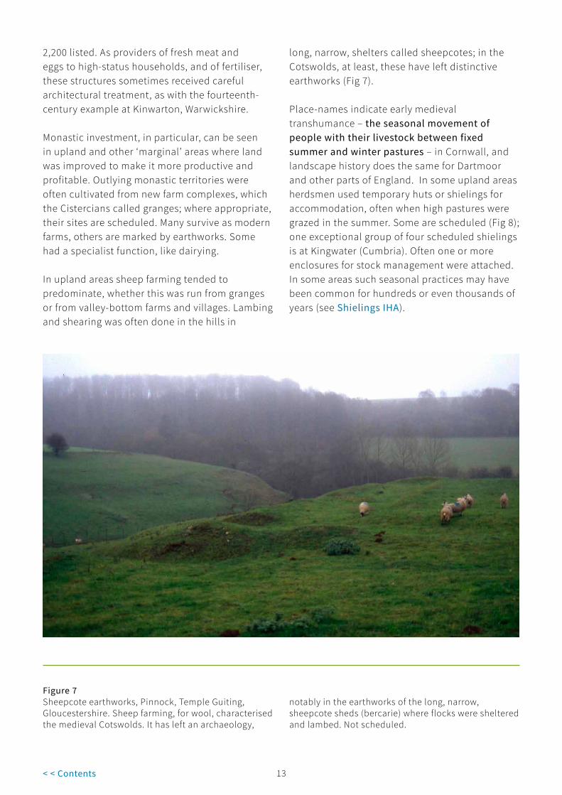
In upland areas sheep farming tended to predominate, whether this was run from granges or from valley-bottom farms and villages. Lambing and shearing was often done in the hills in
long, narrow, shelters called sheepcotes; in the Cotswolds, at least, these have left distinctive earthworks (Fig 7).
Place-names indicate early medieval transhumance – the seasonal movement of people with their livestock between fixed summer and winter pastures – in Cornwall, and landscape history does the same for Dartmoor and other parts of England. In some upland areas herdsmen used temporary huts or shielings for accommodation, often when high pastures were grazed in the summer. Some are scheduled (Fig 8); one exceptional group of four scheduled shielings is at Kingwater (Cumbria). Often one or more enclosures for stock management were attached. In some areas such seasonal practices may have been common for hundreds or even thousands of years (see Shielings IHA).
Figure 7Sheepcote earthworks, Pinnock, Temple Guiting, Gloucestershire. Sheep farming, for wool, characterised the medieval Cotswolds. It has left an archaeology,
notably in the earthworks of the long, narrow, sheepcote sheds (bercarie) where flocks were sheltered and lambed. Not scheduled.

13 14< < Contents
In the Middle Ages a great deal of effort went into water management. In low-lying fenland and coastal areas the medieval land hunger stimulated often highly ambitious and well-capitalised schemes to drain land to create more farmland, and dykes, banks and sea defence banks (often now well inland) can survive as evidence (see Roman and Medieval Sea and River Flood Defences IHA).
Riverside hay meadows were generally highly valued, and channels and sluices may have been used, for instance on monastic estates, to improve their quality by controlled irrigation. Identification of these on the ground has hardly begun, but it seems likely that some will have already been included in the more extensive schedulings of monastic complexes. Religious observance meant a great deal of fresh fish was eaten – bream, tench, pike, and, from the later Middle Ages, carp – and most monasteries and manor houses had their
own fishponds. Where there was a convenient valley-bottom stream, one or more ponds could be created using earth dams. Elsewhere large, shallow, rectangular ponds were often dug, sometimes in a linked sequence of three or four of different sizes to allow the management of fish of different types and ages. Where they survive in good condition, without later scouring which will have removed bottom deposits, and especially where they are parts of wider medieval complexes, fishponds will typically be recommended for scheduling. Riverine and coastal fisheries supplied commercial stocks (see River Fisheries and Coastal Fish Weirs IHA), although the large coastal fish traps which were operational from the seventh century seem to have fallen out of use by the thirteenth. One possible reason for that is that by then fishing boats were active in large numbers, landing commercial catches of cheap fish like herring, as well as larger species like cod.
Figure 8A scheduled shieling 3 kilometres north of Carrawbrough in Northumberland on Hadrian’s Wall. The shelter-complex lies next to a stream, with land that at some stage was under the plough on the far
side. Most shielings are of twelfth to seventeenth century date; normally only excavation will date specific examples.
15< < Contents
Dams, ponds and channels (or leats) were also engineered to power the many thousands of watermills. Most manors had one by the time of Domesday (1086); investment in mills with vertical wheels, which became the norm, and the installation of professional millers by lords of the manor, may well have been elements of post-Conquest manorialisation.
Windmills, which were always rarer (not least because they cost even more to build than vertical watermills), arrived in England about 1200. Their sites, usually on hills or raised ground to catch the breeze, are often marked by low, round mounds which helped anchor the ‘cross-trees’, the huge cross-shaped timber base of the mill. These mill mounds can be easily mistaken for prehistoric burial mounds; a cross-shaped depression across the centre where the cross-tree has rotted is a
sure indicator that a mound once supported a mill (see Mills IHA). Confirmed examples of medieval mill sites which survive in good condition will always be strong candidates for scheduling, especially when in association with settlement remains, fishponds, and so on.
Larger landowners, whether lords of manors, aristocrats or monasteries, engaged in other specialist forms of resource management to provide further high-status foodstuffs, and some have left distinctive archaeological remains (see the Animal Management IHA).
Deer hunting was popular as the chase simulated aspects of warfare – thus providing training in horsemanship and weapon-handling – and because it supplied venison, always one of the most prestigious of meats. The king tended to
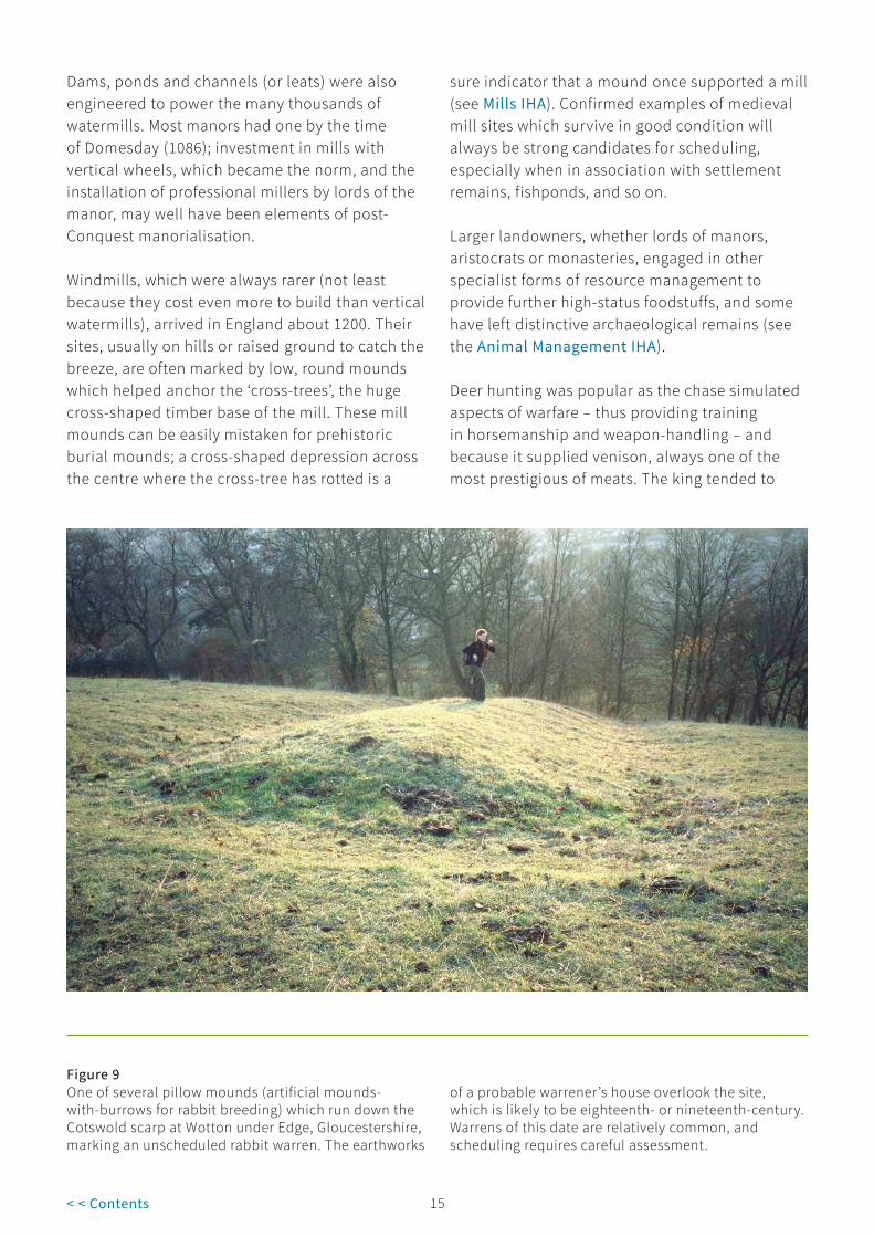
Figure 9One of several pillow mounds (artificial mounds-with-burrows for rabbit breeding) which run down the Cotswold scarp at Wotton under Edge, Gloucestershire, marking an unscheduled rabbit warren. The earthworks
of a probable warrener’s house overlook the site, which is likely to be eighteenth- or nineteenth-century. Warrens of this date are relatively common, and scheduling requires careful assessment.

15 16< < Contents
hunt over open countryside, especially in his forests. Other lords created parks (for which see the designed landscapes selection guide on Rural Landscapes) where deer were managed before being hunted. Keeping high-leaping deer in captivity was always a problem, and parks were usually bounded by a pale comprising a tall oak fence set on a bank; an inner ditch made any attempted escape both a long as well as a high jump. The earthworks of these park pales sometimes survive, whether as wood boundaries or beneath hedges in open countryside. Examples, as at Tutbury (Staffordshire), have been scheduled, especially where other components of the park survive. Where stone was readily to hand, especially in upland areas, the bank might be surmounted by a wall rather than a fence. Here listing rather than scheduling may be favoured for designation. Deer poaching was a problem, so the deer manager or parker usually lived within the park in an isolated lodge, ideally on high ground for good visibility, but elsewhere surrounded with a water-filled moat for security. Good examples are scheduled.
Rabbits, introduced along with fallow deer by the Normans, and game birds like partridges, were kept in warrens; again, banks, ditches and walls kept them in, and predators and poachers out. These often contained specialist structures such as vermin traps, and especially the earthwork ‘pillow’ mounds which provided rabbits with artificial burrows (Fig 9). Over fifty examples of pillow mounds are scheduled, typically where a whole warren survives or as elements of multi-period sites, as on Minchinhampton Common (Gloucestershire); early (that is medieval or early modern) examples will be favoured over eighteenth or nineteenth century ones which are far commoner.
At Colmworth (Bedfordshire) a scheduled earthwork associated with a moated site is interpreted as having been for fowling. Until the later Middle Ages, when the climate became wetter and cooler with the Little Ice Age starting about 1550 (and continuing until about 1850), vineyards remained relatively common, although their English heyday seems to have been the
eleventh and twelfth centuries. Sunny, south-facing hillsides were probably the favoured location, modified by terracing and the digging of planting trenches.
Another aspect of agricultural activity of considerable importance was woodland management and forestry. This is now well understood from the documentary record, from the timbers in surviving medieval buildings and from palaeoenvironmental investigations. Archaeology also has a part to play: notably along riverfronts, as in London, excavations have revealed further massive timber structures, further enhancing our knowledge of woodland management and woodworking techniques. Survey of ancient woodlands often reveals the banks and ditches which defined and protected compartments where coppice wood was grown, although the dating of such features is difficult without corroborative documentary evidence, notably early maps. A few are scheduled. Charcoal burning was a related activity which is indicated archaeologically by the platforms where stacks of wood were slowly burnt and transformed into charcoal. These are difficult to date without excavation, however, and only one platform, in Derbyshire, is scheduled.
1.5 Phase III: Post-Medieval
1550-1750 From this period onwards, designation of agricultural sites becomes increasingly a matter of listing of buildings, which has already gone some considerable way towards capturing the transformation of the countryside seen between the sixteenth and twentieth centuries. This was the period which saw the majority of medieval open fields enclosed to create the modern landscape of hedged and walled fields. Initially this tended to be a gradual process, with the new field boundaries fossilising the curving ones of strips and furlongs. At the same time many of the extensive areas of woods and forests which had survived clearance in the medieval centuries were felled and the land divided into fields. Commons and heaths were similarly portioned out and improved.

17< < Contents
Figure 10Watermeadow management at Charlton-All-Saints, Wiltshire in the 1920s. A drowner cleans a channel which carries water, brought off the River Avon, along the ridged pane. As it flows along, water trickles down
the sides of the pane, irrigating the grass. Drains in the furrows carry the water away. Controlling the level of channels and drains was complex.
Much of this land was of inherently poor quality, and lime kilns (used to burn limestone to make lime) and marl pits (where marl, a chalky subsoil spread to improve soil quality, was dug) show how attempts were made to overcome this. Over 150 lime kilns are designated via listing and scheduling; henceforward listing is likely to be the favoured approach for standing examples.
Surviving wetlands, like the Somerset Levels and the East Anglian Fens (here, in the mid-seventeenth century, with the assistance of the Dutchman, Sir Cornelius Vermuyden), saw another phase of drainage; windmill-driven pumps were among the new technologies employed to achieve this. The countryside we see today frequently carries evidence of these transformations.
Notably in the flat, chalkland, valley bottoms of Wessex – Hampshire, Dorset and Wiltshire – it was the sixteenth to eighteenth centuries that saw the creation of floated water meadows (see Water Meadows IHA). They remained characteristic of this part of England until they fell out of use in the earlier twentieth century, in part because of changes in the dairying economy. Networks of channels were cut to carry water from valley-bottom rivers and streams across the adjacent meadows and, at certain times of the year, to flood them when the channels were deliberately blocked (Figs 10-11). This promoted grass growth, giving sheep an early bite in the spring and heavy hay crops in high summer. Taken together these things enabled more stock to be kept, and made livestock farmers wealthier.

17 18< < Contents
Figure 11Flooding reveals the pattern of extensive post-medieval water meadows in the Lugg Valley, Herefordshire. Relict farming landscapes such as this provide designation challenges given their extensiveness; because the land
remains in active agricultural use; and because it often has environmental significance because of its flora and wildlife.
Other parts of England were less well suited in terms of topography and climate for water meadows, but even so local adaptations promoted the same ends. In some hilly areas, for instance, ‘catchwork’ meadow systems channelled water along valley sides before it was run down the hillside to irrigate the grass. To date, ten examples of water meadows have been scheduled, mostly in southern England; that at Clattinger Farm, Oaksey (Wiltshire), is a typical Wessex example. Other meadowlands are included in the schedulings of monastic and other extensive sites; these include examples of medieval water and meadow management systems such as channels and ditches, the forerunners of the later, more formally engineered, water meadows. These have a particular interest, as how meadowland was managed in the Middle Ages (and before) remains poorly understood.
Another seventeenth-century innovation was the decoy pond, used to capture ducks and other wildfowl in nets carried on frames over curving channels called pipes leading off a main pond (see Animal Management IHA). These ponds were especially numerous in the extensive wetland areas of East Anglia and Somerset, where several are scheduled. Their hey-day was in the eighteenth and nineteenth centuries, and most had fallen out of use by the early twentieth century. Overall forty-seven have been scheduled to date, and a few remain working or have been revived: one at Boarstall (Buckinghamshire) is operated by the National Trust. Rabbit warrens remained a popular lordly use of land, especially marginal ground.

19< < Contents
Figure 12Dead straight late eighteenth- or early nineteenth-century enclosure-period field walls run uphill from an abandoned farm at Gossipgate, Cumbria. This
stands at the traditional divide between farmland and uncultivated upland grazing.
Throughout history the control of grazing animals has been problematic. Pounds, small brick- or stone-walled enclosures typically on greens or open spaces in settlements, were used to confine strays. Most surviving examples are post-medieval, at least in terms of their fabric, although the use of the location for this purpose may have been longstanding. Pounds have sometimes been scheduled in the past; listing will now generally be the preferred option for walled examples.
1750-1875 Even fewer historic agricultural assets are scheduled from this period, although very many historic farm buildings have been listed. In the later eighteenth century the pace of improvement in the countryside picked up as higher prices encouraged landlords to invest, ushering in
the era known to historians as the Agricultural Revolution. While not to ignore the growing evidence of earlier innovations, key ‘improvers’ like Robert Bakewell and Thomas Coke introduced new ways of farming and rethought agricultural infrastructure. Alongside new farm complexes, with Georgian farmhouses standing alongside well laid-out courtyard farms housing improved breeds of stock, came a countryside where Acts of Parliament were used to enable the last phase of enclosure. Much of the midlands’ open field systems survived until this era, for instance, when they were enclosed and replaced with extremely regular grid-plan fields.
During the Revolutionary and Napoleonic wars with France (1793-1815) corn prices rose to unprecedented levels, and attempts – often

19 20< < Contents
unsuccessful – were made to enclose and then bring into cultivation some of England’s highest land (Fig 12). This has left a distinct archaeology, of abandoned fields (some with narrow and straight ridge and furrow showing attempts at cereal cultivation) typically demarcated by small and crude drystone walls, often all but invisible under bracken. Sometimes the barns and outfarms (see the listing selection guide on Agricultural Buildings for Field Barns) built to cultivate this land still stand; elsewhere they have become ruins or earthworks. Artificial saucer-shaped ‘dewponds’ (some are scheduled, normally as elements of wider landscapes) provided watering places for stock in what were otherwise waterless landscapes (Fig 13). The Knight family’s efforts to improve Exmoor provides a dramatic example of a large-scale attempt at
upland improvement; roads, farms, fields, ponds, and lime kilns were built, trees planted, and quarries opened to provide sturdy gate posts.
Figure 13A dewpond (an artificial stockpond, carefully lined with clay, chalk, straw and cobbles) next to a Birdsall Estate high barn on the arid Yorkshire Wolds. Out-farm, pond and the surrounding enclosed
landscape of large, straight-edged fields are all broadly contemporary, and late eighteenth-century. Dewponds are sometimes scheduled as elements of wider landscapes of national importance.
Rabbit warrens proliferated in the eighteenth and nineteenth centuries, especially on uplands and moorlands where previously they had been rare; several well-preserved examples, such as at Merrivale, are scheduled on Dartmoor, for instance.
It was also during this period, in part enabled by new technology like steam engines, that some of the last, and inherently most difficult, drainage schemes were undertaken: the final drainage of the Somerset Levels, for instance, was achieved by the construction in the years after 1791 of the 12 mile-long King’s Sedgemoor Drain, to replace the

21< < Contents
River Cary. Many of the drainage cuts and banks created were massive and ran for miles; in some cases existing watercourses were adapted, and the direction of flow reversed. And it was only in the earlier nineteenth century that the Great Level of the Fens in eastern England was finally made dry and productive. The 1831 Stretham pumping engine (Cambridgeshire), south of Ely, with a tall brick chimney visible from far afield and inside a massive beam engine, is a Scheduled Monument, although today listing would be the preferred option for this and similar structures.
With industrialisation, mainly in the mid- to late nineteenth century, the traditional exploitation of wild resources fell away, although far from ceased. Fish-weirs, for instance, survived on the River Severn into the twentieth century, and still remain in use in Minehead Bay (Somerset), little-different in form and function from their predecessors over thousands of years (see River Fisheries and Coastal Fish Weirs IHA).
1875 to the present In the later 1870s English agriculture entered its Great Depression as cheap grain from across the Atlantic and frozen meat from New Zealand and Argentina combined with poor harvests to make life difficult for all involved in farming. By this time the greater part of the population had ceased to
live on the land, and had become predominantly urban. Investment effectively ceased, land became neglected, and the great estates began to break up as farms were sold to tenants, a process which continued well into the 1920s.
The two world wars increased short-term demands for home-grown food and introduced government support for agriculture (huge acreages of permanent pasture and upland were ploughed up to increase arable production), but it was only after the Second World War that farming became relatively prosperous again. Then, in 1973, Britain’s entry into the European Union (the Common Market) made subsidies available to farmers; grain production in particular expanded, and larger machinery meant that fields were enlarged and hedges – often of considerable historic and botanic interest in their own right and as boundary markers – were grubbed up to facilitate this.
More recently, balances between arable and pasture have been affected by support systems designed, in part, to encourage environmentally sustainable farming regimes. All changes have had, and will have, implications for above- and below-ground archaeological remains of all types, not just those relating to past agricultural systems.

21 22< < Contents
2 Overarching Considerations
2.1 Scheduling and protection
Archaeological sites and monuments vary greatly in character, and can be protected in many ways: through positive management by owners, through policy, and through designation. In terms of our designation system, this consists of several separate approaches which operate alongside each other, and our aim is to recommend the most appropriate sort of protection for each asset. Our approach towards designation will vary, depending on the asset in question: our selection guides aim to indicate our broad approaches, but are subordinate to Department for Digital, Culture, Media and Sport (DCMS) policy.
Scheduling, through triggering careful control and the involvement of Historic England, ensures that the long-term interests of a site are placed first. It is warranted for sites with real claims to national importance which are the most significant remains in terms of their key place in telling our national story, and the need for close management of their archaeological potential. Scheduled monuments possess a high order of significance: they derive this from their archaeological and historic interest. Our selection guides aim to indicate some of the grounds of importance which may be relevant. Unlike listed buildings, scheduled sites are not generally suited to adaptive re-use.
Scheduling is discretionary: the Secretary of State has a choice as to whether to add a site to the Schedule or not. Scheduling is deliberately selective: given the ever-increasing numbers of archaeological remains which continue to be identified and interpreted, this is unavoidable. The Schedule aims to capture a representative sample of nationally important sites, rather than be an inclusive compendium of all such assets.
Given that archaeological sensitivity is all around us, it is important that all means of protecting archaeological remains are recognised. Other designations such as listing can play an important part here. Other sites may be identified as being of national importance, but not scheduled. Government policy affords them protection through the planning system, and local authorities play a key part in managing them through their archaeological services and Historic Environment Records (HERs).
The Schedule has evolved since it began in 1882, and some entries fall far short of modern standards. We are striving to upgrade these older records as part of our programme of upgrading the National Heritage List for England. Historic England continues to revise and upgrade these entries, which can be consulted on the Historic England website.

23< < Contents
2.2 Heritage assets and national importance
Paragraph 194 and footnote 63 of the National Planning Policy Framework (July 2018) states that any harm to, or loss of, the significance of a designated heritage asset should require clear and convincing justification and for assets of the highest significance should be wholly exceptional; ‘non-designated heritage assets of archaeological interest that are demonstrably of equivalent significance to scheduled monuments, should be considered subject to the policies for designated heritage assets’. These assets are defined as having National Importance (NI). This is the latest articulation of a principle first raised in PPG16 (1990-2010) and later in PPS5 (2010-2012).
2.3 Selection criteria
The particular considerations used by the Secretary of State when determining whether sites of all types are suitable for statutory designation through scheduling are set out in their Scheduled Monuments Policy Statement.

23 24< < Contents
3 Specific Considerations
As much of the country has been farmed for thousands of years the potential number of agricultural sites and landscapes is very considerable indeed. Notably within upland areas which in modern times have been lightly (if at all) cultivated, relatively large numbers of sites associated with agriculture are scheduled. These include some very extensive field systems, sometimes together with associated settlement remains, and ceremonial or funerary monuments. Typically, schedulings include associated remains such as settlements, cairns and boundaries. However, such extensive schedulings remain the exception rather than the rule. Elsewhere scheduling has tended to be reserved for discrete sites or structures, and often very function-specific ones: shielings (the sites of upland herdsmens’ huts) and pillow mounds are good examples.
In the past, scheduling was not generally seen as an appropriate mechanism for the protection of extensive archaeological landscape features surviving as earthworks in England’s lowlands because of the strict controls it introduces over large, actively farmed, areas. That was notably the case with extensive areas of ridge and furrow, and designated examples usually had a clear association with contemporary settlement remains. Given the enormous losses of ridge and furrow to agricultural intensification since the 1970s, protection of more examples may well be warranted; one of the Activities within the recent National Heritage Protection Plan was a renewed assessment of survival rates.
There has also been limited scheduling of agricultural sites surviving as crop-mark complexes in intensively-farmed arable landscapes, but generally these are focussed on ‘set pieces’ such as Roman villas with surrounding enclosures. This has been because the interpretation of crop-mark complexes can be difficult (making a robust case for designation difficult), and also because designation would not necessarily bring the remains into more favourable management (due to an agricultural class consent which underpins scheduling, and which allows specified agricultural activity to continue).
Similarly, scheduling’s strict controls means it has not been applied to exceptional examples of working relict landscapes, such as the strip fields at Braunton (Devon; Fig 14) or actively managed water meadows, as this would interfere with beneficial management practices. Scheduling is also unlikely to be a useful or appropriate course of action – because they are so extensive – for previously unknown and apparently well-preserved relict agricultural landscapes revealed by scientific survey techniques such as rapid geophysical survey and lidar. In some cases these stretch for many miles: the multi-period prehistoric and later landscape at West Heslerton (North Yorkshire) is one spectacular discovery of this type.
While there is little doubt about the importance of these wide landscapes of considerable time-depth, there is little purpose in scheduling such huge tracts of land, and other management measures beside scheduling are likely to be more effective in delivering appropriate protection.

25< < Contents
Figure 14Braunton Great Field, Devon. One of England’s few working survivals of open-field agriculture. Turf baulks separate individual strips.
25 26< < Contents
4 Protection Through Management
As well as being of interest in their own right, agricultural landscapes have always provided the setting for our farms, villages and towns, combining with them to form the English countryside we know and value. Today, this is increasingly appreciated and managed in its totality. Historic landscape characterisation is one current approach which seeks to systematically link the character of fieldscapes to that of agricultural buildings. Appreciation of character and protection through planning policy works alongside designation in upholding the significance of the countryside. The National Planning Policy Framework (2018) emphasises the importance of local distinctiveness.
The countryside is not, and never has been, static. Archaeological designation can and must co-
exist alongside farming and other land-use. Considerable effort has been made in the past to work with farmers, to communicate the interest of the sites they own and care for, and to encourage positive management through guidance and grant aid, most notably Countryside Stewardship. Various designation and management regimes dealing with the natural environment also impact on the historic environment. One example is the Hedgerow Regulations, 1997, which provide a measure of protection for historic semi-natural boundaries; other types of boundary (walls and banks, for instance) and the related patterns of boundary and field trees, however, lie beyond the Regulations’ scope. As with characterisation, heritage designations operate alongside other mechanisms to ensure appropriate protection of significance.

27< < Contents
5 Select Bibliography
5.1 General English Heritage, England’s Landscape (eight regional volumes, various authors, 2006)
Pryor, F., The Making of the British Landscape (2011)
Rackham, O., The History of the Countryside (1986)
Taylor, C., Fields in the English Landscape (1975)
Taylor, C., Village and Farmstead (1983)
Thirsk, J. (general ed.), The Agrarian History of England and Wales (8 vols, 1967-2000)
Thirsk, J. (ed.), Rural England: An Illustrated History of the Landscape (2000)
Yalden, D., The History of British Mammals (1999)
Yalden, D. and Albarella, U., The History of British Birds (2009)
5.2 PrehistoricBarrett, J., Fragments from Antiquity (1994)
Bradley, R., The Prehistory of Britain and Ireland (2007)
Cunliffe, B., Iron Age Communities in Britain (4th edn, 2005)
Darvill, T., Prehistoric Britain (1987)
Fairbairn, A. (ed.), Plants in Neolithic Britain and Beyond (2000)
Fleming, A., The Dartmoor Reaves (revised edn, 2007)
Haselgrove, C. and Moore, T. (eds.), The Later Iron Age in Britain and Beyond (2007)
Haselgrove, C. and Pope, R. (eds.), The Earlier Iron Age in Britain and the Near Continent (2007)
Parker-Pearson, M., Bronze Age Britain (2005 edn)
Pryor, F., Farmers in Prehistoric Britain (1998)
Pryor, F., Britain BC (2003)
Thomas, J., Understanding the Neolithic (1999)
Yates, D., Land, Power and Prestige: Bronze Age Field Systems in Southern England (2007)
5.3 RomanDark, K. and P., The Landscape of Roman Britain (1997)
Mattingley, D., An Imperial Possession: Britain in the Roman Empire (2006)
5.4 Anglo-SaxonHamerow, H., Hinton, D.A. and Crawford, S. (eds), The Oxford Handbook of Anglo-Saxon Archaeology (2011), Part IV (pages 315-401), Food Production
5.5 MedievalCampbell, B.M.S.,The Geography of Seigneurial Agriculture in Medieval England (2000)
Hall, D., Turning the Plough: Midland Open Field: Landscape Character and Proposals for Management (2001)
Martin, E. and Satchell, M., Wheare Most Inclosures Be: East Anglian Fields: History, Morphology and Management (2008)
Williamson, T., Shaping Medieval Landscapes: Settlement, Society, Economy (2003)
Wrathmell, S. and Roberts, B., An Atlas of Rural Settlement in England (2000)

27 28< < Contents
5.6 Post-MedievalBeckett, J.V., The Agricultural Revolution (1990)
Brown, J., Agriculture in England: A Survey of Farming, 1870-1947 (1987)
Mingay, G. E. (ed.), The Victorian Countryside (2 vols, 1981)
Overton, M., Agricultural Revolution in England: The Transformation of the Agrarian Economy, 1500-1850 (1996)
Tarlow, S., The Archaeology of Improvement in Britain, 1750-1850 (2007)
Wade Martins, S., Farms and Fields (1995)
Wade Martins, S., Farmers, Landlords and Landscapes: Rural Britain 1720-1870 (2004)
Williamson, T., The Transformation of Rural England. Farming and the Landscape 1700-1870 (2002)

29 30< < Contents
6 Where to Get Advice
If you would like to contact the Listing Team in one of our regional offices, please email: [email protected] noting the subject of your query, or call or write to the local team at:
North Region 37 Tanner Row York YO1 6WP Tel: 01904 601948 Fax: 01904 601999
South Region 4th Floor Cannon Bridge House 25 Dowgate Hill London EC4R 2YA Tel: 020 7973 3700 Fax: 020 7973 3001
East Region Brooklands 24 Brooklands Avenue Cambridge CB2 8BU Tel: 01223 582749 Fax: 01223 582701
West Region 29 Queen Square Bristol BS1 4ND Tel: 0117 975 1308 Fax: 0117 975 0701

29 30< < Contents
Acknowledgments
Images© Historic EnglandAll images except those listed below
© OtherFigure 2: Historic Environment, Cornwall Council, 2008; F88-37
Figure 5: Andy Holland/Northamptonshire Archaeology
Figure 6: Al Oswald
Figures 7, 9, 12-14: Paul Stamper
Figure 10: Museum of English Rural Life
Figure 11: Clwyd-Powys Archaeological Trust.
Every effort has been made to trace the copyright holders and we apologise in advance for any unintentional omissions, which we would be pleased to correct in any subsequent editions.

HEAG238 Publication date: September 2012 © English Heritage Reissue date: July 2018 © Historic England Design: Historic England
Please consider the environment before printing this document
We are the public body that helps people care for, enjoy and celebrate England’s spectacular historic environment.
Please contact [email protected] with any questions about this document.
HistoricEngland.org.uk
If you would like this document in a different format, please contact our customer services department on:
Tel: 0370 333 0607 Email: [email protected]
All information and weblinks accurate at the time of publication.