1 Introduction - Historic England
17
1 Introduction & me they turned me inside out For sand and grit and stones & turned my old green hills about & pickt my very bones John Clare, The Lament of Swordy Well This publication presents the pre-Iron Age aspects of the Raunds Area Project, which was undertaken between 1985 and 1993 in north-east Northamptonshire, in an area about to be transformed by gravel extraction and road and housing construction. The project identified more than twenty Neolithic and Early Bronze Age monu ments, as well as smaller contemporary features and evidence for the establishment of agricultural land divisions after the last monuments had been built. This is comple mented by an impressive body of informa tion on the wider development of the landscape during these periods, derived from environmental analysis, fieldwalking survey and geophysical survey. 1.1 Location and topography The Raunds Area is centred at TL000730, 25km downstream from Northampton and 35km upstream from Peterborough, and covers the parishes of Ringstead, Raunds (including the medieval parish of Stanwick and the deserted hamlet of West Cotton) and Hargrave, with parts of Irthlingbor ough, Denford and Shelton. It provides a 40km 2 sample of the middle Nene valley and the interfluve between the Nene and the Ouse to the south-east. Relief is undulating, with the valley sides rising to 80m OD and the present valley floor lying at 32 to 36m. The gentle gradient makes the Nene slow- flowing and anastomosed. To the north west lie the Northamptonshire Uplands, the northern end of the Cotswolds, where the Nene, Ouse and Welland rise. To the south east and east extend the lower, flatter lands of East Anglia through which all three rivers drain to the Fenland basin and the Wash (Fig 1.1). At Irthlingborough the Nene divides into two channels, the north-western one canalised in the 18th century, which join again at Stanwick, forming Irthlingborough ‘island’, an area of approximately 70ha. The plateau and the valley sides are cut by tributaries. At the time of the fieldwork described in this publication the embank ment of a disused railway ran across the island and along the floodplain (Fig 1.2). The floodplain in the study area has been almost entirely quarried for gravel. The plateau to either side is capped with chalky, probably Anglian, Boulder Clay, the chief erratics of which are ironstone, sand stone, Jurassic limestone, quartzite, flint and chalk. There are patches of plateau gravel. Jurassic strata of the Great Oolite series underlie the Boulder Clay and are exposed in the valley sides, comprising – from the base upwards – Upper Lias Clay, Northampton Sand with Ironstone (often quarried), sands, clays and gravels of the Lower and Upper Estuarine Series, Great Oolite Limestone and Clay, Cornbrash Limestone, Kellaways Clay and Sand, and Oxford Clay (Fig 1.3). The Northampton Sand with Ironstone lines the valley on both sides as a narrow and discontinuous outcrop of near-level bedded deposits. Solid deposits below the Lias Clay are masked by gravel terraces and fans, while the lowest slopes and the Devensian periglacial gravels and sands of the valley floor are covered by fine-grained silty and clayey alluvium, which became extensive in late Saxon and early medieval times (A Brown 2006; Chapman forthcoming a). This has buried the original soils to a substantial depth in some cases and has obscured the former riverscape under a blanket of recent sedi ments, which has had the effect of both hiding and preserving features of the past landscape. Beneath the alluvium, the surface of the gravels and sands is uneven and dissected by palaeochannels that silted at various dates (Ch 2; A Brown and Keough 1992c, 186–7), with numerous small gravel ‘islands’, a few breaking the surface, most of them completely alluvium 1
Transcript of 1 Introduction - Historic England

1 Introduction
& me they turned me inside out For sand and grit and stones & turned my old green hills about & pickt my very bones
John Clare, The Lament of Swordy Well
This publication presents the pre-Iron Age aspects of the Raunds Area Project, which was undertaken between 1985 and 1993 in north-east Northamptonshire, in an area about to be transformed by gravel extraction and road and housing construction. The project identified more than twenty Neolithic and Early Bronze Age monuments, as well as smaller contemporary features and evidence for the establishment of agricultural land divisions after the last monuments had been built. This is complemented by an impressive body of information on the wider development of the landscape during these periods, derived from environmental analysis, fieldwalking survey and geophysical survey.
1.1 Location and topography The Raunds Area is centred at TL000730, 25km downstream from Northampton and 35km upstream from Peterborough, and covers the parishes of Ringstead, Raunds (including the medieval parish of Stanwick and the deserted hamlet of West Cotton) and Hargrave, with parts of Irthlingborough, Denford and Shelton. It provides a 40km2 sample of the middle Nene valley and the interfluve between the Nene and the Ouse to the south-east. Relief is undulating, with the valley sides rising to 80m OD and the present valley floor lying at 32 to 36m. The gentle gradient makes the Nene slow-flowing and anastomosed. To the northwest lie the Northamptonshire Uplands, the northern end of the Cotswolds, where the Nene, Ouse and Welland rise. To the southeast and east extend the lower, flatter lands of East Anglia through which all three rivers drain to the Fenland basin and the Wash (Fig 1.1). At Irthlingborough the Nene
divides into two channels, the north-western one canalised in the 18th century, which join again at Stanwick, forming Irthlingborough ‘island’, an area of approximately 70ha. The plateau and the valley sides are cut by tributaries. At the time of the fieldwork described in this publication the embankment of a disused railway ran across the island and along the floodplain (Fig 1.2). The floodplain in the study area has been almost entirely quarried for gravel.
The plateau to either side is capped with chalky, probably Anglian, Boulder Clay, the chief erratics of which are ironstone, sandstone, Jurassic limestone, quartzite, flint and chalk. There are patches of plateau gravel. Jurassic strata of the Great Oolite series underlie the Boulder Clay and are exposed in the valley sides, comprising – from the base upwards – Upper Lias Clay, Northampton Sand with Ironstone (often quarried), sands, clays and gravels of the Lower and Upper Estuarine Series, Great Oolite Limestone and Clay, Cornbrash Limestone, Kellaways Clay and Sand, and Oxford Clay (Fig 1.3). The Northampton Sand with Ironstone lines the valley on both sides as a narrow and discontinuous outcrop of near-level bedded deposits. Solid deposits below the Lias Clay are masked by gravel terraces and fans, while the lowest slopes and the Devensian periglacial gravels and sands of the valley floor are covered by fine-grained silty and clayey alluvium, which became extensive in late Saxon and early medieval times (A Brown 2006; Chapman forthcoming a). This has buried the original soils to a substantial depth in some cases and has obscured the former riverscape under a blanket of recent sediments, which has had the effect of both hiding and preserving features of the past landscape. Beneath the alluvium, the surface of the gravels and sands is uneven and dissected by palaeochannels that silted at various dates (Ch 2; A Brown and Keough 1992c, 186–7), with numerous small gravel ‘islands’, a few breaking the surface, most of them completely alluvium
1

A N E O L I T H I C A N D B R O N Z E A G E L A N D S C A P E I N N O RT H A M P T O N S H I R E
N Peterborough
Northampton
0 100km
a
b
covered. The main components of the gravels are flint, quartzite and ironstone, with some sandstone, limestone and chalk.
A range of soils has developed on these deposits, but the coverage of the area is available only at 1:250,000 scale (Soil Survey of England and Wales 1983). However, detailed maps are available of some areas of soils in the valleys of the Nene, Welland and Windrush within the same geological series and similar environments (Burton 1981; Jarvis and Hazelden 1982; Reeve 1978). In the absence of detailed soil survey prior to the beginning of excavation and gravel extraction, a detailed picture of the site can be constructed only
5 0000010 20 30 4090807060
Riv
erN
ene
River Welland
River Great O
use
Raunds Area Project Survey Area
The Fens
Land above 100m O.D.
Aldwincle
Barnack
Brampton
Briar Hill
Buckden/Diddington
Bunyan Centre
Chapel Brampton
Cardington
Cowthick
Dallington
Deeping St. Nicholas
Duston
Earls Barton Ecton
Elton
Etton/Maxey
Eynesbury
Fengate/Flag Fen
Gayhurst Quarry
Godmanchester
Goldington
Grendon
Gretton
Haddenham
Harringworth
Kelmersh
Orton Meadows
Radwell
Ravenstone
Roxton
Southwick
Tansor Crossroads
West Deeping
Willington
Warren Farm
Upton
Uffington
Over
Northborough
Milton Keynes ring ditch
Little Pond Ground
Husbands Bosworth
Eyebury Farm
Cotton Valley Farm
Barleycroft Farm
Barholm
0 10km
b 10
3 00000
90
80
70
50
60
40
2

I N T R O D U C T I O N
by analogy with these other locations. The soils on the first terrace, and presumably on any of the formerly exposed glacial sands and gravels, appear as one of three major soil types. Those with a high carbonate content in a freely drained environment are typical brown calcareous earths; those that are freely drained but on older deposits, usually with a lower carbonate content, are argillic brown earths; and those in lower situations in the valleys are cambic gleys. Where soils have been covered by later alluvium it may not be easy to distinguish which of these types was initially present. The in situ ironstones give a sequence of soils varying from a brown ranker through a ferritic brown earth to an argillic brown earth; it is possible, in some locations where the terrace gravels have a high carbonate content, that a brown rendzina is also found. Therefore, there is likely to be some similarity of soils between those from the
terrace gravels, the fluvioglacial gravels and the Northampton Sand with Ironstone. The alluvium has also given rise to a number of soils. These vary from the brown alluvial soils on the higher areas, sometimes on top of river terrace soils or soils formed on fluvioglacial sands and gravels, through to the very wet alluvial gleys, some of which are peaty. The extent of profile development within these alluvial soils varies considerably, largely due to difference in age, and some have buried palaeosols at depth within them. On the till-covered plateau, present soils are typically fine-textured calcareous pelosols of the Hanslope series (Hodge et al 1984, 209–12). Post-Roman settlements are concentrated on the valley sides, along the tributaries. The surviving farmland is used mainly for general cropping and cereal cultivation with some dairying. The traditional use of the floodplain was as pasture and hay meadow.
Figure 1.1 (opposite) Location, showing selected sites mentioned in the text. The courses of rivers are shown dotted once they enter the Fenland Basin because they have altered considerably in historical times.
Figure 1.2 (above) The area today and the area of the Raunds Area Project.
3

A N E O L I T H I C A N D B R O N Z E A G E L A N D S C A P E I N N O RT H A M P T O N S H I R E
Figure 1.3 Geology of the area shown in Figure 1.2.
1.2 Previous and subsequent work in the area At the beginning of the 20th century, the area was thought to have been little occupied in the Neolithic and Bronze Age. According to George (1902), there was ‘one vast forest… lying between the two valleys now occupied by the fertile meadows of the Nene and the Welland, which were at this early period but marsh and morass’, and prehistoric populations would have favoured upland areas. There were few flint and stone implements, no known settlements, no Neolithic burials, and few round barrows
compared with other regions. Shortly after George’s paper was published, many of his conclusions were negated, when observation of gravel quarrying on the fen edge east of Peterborough, principally by Wyman Abbott, led to the identification of Neolithic, Beaker and Iron Age settlements at Fengate (Abbott 1910; Hawkes and Fell 1943; Leeds 1922), and barrows were excavated a little to the north (Leeds 1912; 1915). A summary of the prehistory of the county published in the middle of the 20th century was essentially a fusion of George’s synthesis and Wyman Abbott’s discoveries (Fell 1953).
4

One barrow at Raunds (Northamptonshire SMR 1344/1/0, close to Barrow 9, which is described in this publication) was investigated by a local GP, Dr Robb of Irthlingborough, as it was being quarried away in the 1930s (RCHME 1975, 78, fig 6: 1). Photographs, notes and sketches preserved in Northampton Museum are difficult to decipher. He seems to have observed the truncated base of a barrow with at least two concentric ditches, and to have cut a trench into it. One photograph shows an inverted Food Vessel Urn, another shows heaps of burnt stone removed from the trench. Burnt stone and burnt earth both figure in the notes. A cutting from either the Northampton Evening Telegraph or the Kettering Telegraph – probably (on the evidence of the international news on the reverse) from an edition published in July 1936 – reads:
‘The discovery of a number of burnt patches in the ground, in which the heat had been so intense that the constituent parts of the gravel bed had been converted into a conglomerate mass, was the first indication that the workmen had made a discovery of some importance… There were five distinct rings of fire, indicating the holding of ancient burial rites at different times.’
When the wealth and vulnerability of the archaeology of English river gravels was brought to attention by the publication of A Matter of Time in 1960, the lower reaches of the Nene and Welland, where they entered the Fens, stood out as rich in cropmarks, in contrast to the almost bare upper reaches of the valleys, where many prehistoric monuments were rendered invisible by alluvium (RCHME 1960, figs 1–3). Large-scale investigation of prehistoric landscapes and sites proceeded on the lower reaches, accelerated by the development of Peterborough New Town (RCHME 1969). The spectacular results are summarised by Pryor (1991) and reported in numerous publications (eg Donaldson 1977; French 1994a; 1994b; French and Pryor 1992; 2005; Hall 1987; Pryor 1974a; 1978a; 1980; 1984; 1998a; 2001a; Pryor et al 1985; W Simpson 1967; 1976; 1981; W Simpson et al 1993). In the 1970s, prehistoric activity in the upper reaches of the Nene still seemed slight (RCHME 1975, figs 5–8). The Neolithic record for Raunds and Irthlingborough consisted of a group of flint axeheads found in Stanwick village in 1938; the Bronze Age record consisted of an ‘overhanging rim urn’
(ie a Collared Urn) found in Irthlingborough and since lost, and six possible round barrows, including the one investigated by Dr Robb (RCHME 1975, 56–7, 78–9). There was also a single ring ditch in Ringstead (RCHME 1975, 83). A large circular crop-mark on the gravel terrace at Raunds, identified by Dr J K S St Joseph in the course of aerial reconnaissance in 1962 (Fig 1.4: ap_id 038700270001) seems to have aroused little interest, although most of it was plotted by RCHME (1975, fig 88). Where fieldwork was done, it was generally in and around Northampton, the main centre of population, as reflected in distribution plots published in 1980 (RCHME 1980). These show the same barrows in Irthlingborough and Raunds as the earlier Inventory, although by then two stone axeheads were recorded from Irthlingborough and increased air photographic coverage was reflected by a cropmark henge monument on the valley side in Raunds (the Cotton ‘Henge’) and an additional ring ditch.
The extent of Neolithic and Bronze Age sites on the alluvium-covered floodplain gravels of the Nene was, however, already becoming apparent from rescue excavations undertaken in advance of, and sometimes in the course of, quarrying – again almost all in the Northampton area. Among these were a ‘Wessex’ burial from a partly alluvium-covered mound at Earl’s Barton in 1969 (Jackson 1984), Middle Neolithic settlement at Ecton in 1971–2 (W Moore and Williams 1975), and Neolithic and Early Bronze Age funerary monuments at Grendon in 1974–5 (Gibson and McCormick 1985; Jackson 1995) and at Aldwincle in 1975–6 (Jackson 1976). Further downstream, well-preserved alluvium-covered Neolithic and Bronze Age barrows in Orton Meadows, on the eastern outskirts of Peterborough, were excavated in 1980–81 (Mackreth forthcoming). Extensive field survey emphasised the concentration of Neolithic and Bronze Age monuments in the Nene and Great Ouse valleys by locating scarcely any among numerous newly discovered sites of later periods on the interfluves, in a distribution that prompted the conclusion that forest on the interfluve claylands was first cleared in the Late Bronze Age and Early Iron Age (Hall and Hutchings 1972, 8). Aerial reconnaissance was also making headway. By the time barrows and ring ditches were plotted for the first Grendon report, there was a scatter of sites along the valley (Gibson and
I N T R O D U C T I O N
5

A N E O L I T H I C A N D B R O N Z E A G E L A N D S C A P E I N N O RT H A M P T O N S H I R E
Figure 1.4 The Nene valley in the Raunds area, showing Neolithic and Bronze Age monuments and main flint concentrations. Palaeochannels that were possibly, but not definitely, active at the time are diagonally hatched.
McCormick 1985, fig 26), among a palimpsest of other, mainly later, cropmarks on the terraces. Neolithic and Early Bronze Age pits discovered in the course of several of the rescue excavations showed that barrows and ring ditches were only the more conspicuous part of the contemporary record, as did a probably Neolithic multiple burial with no trace of any accompanying
monument at Elton (French 1991; French 1994b). The location of this site, and of an Early Bronze Age barrow covering an earlier mortuary enclosure excavated at Tansor Crossroads in 1995, showed that burial and monument-building had extended up the valley side (Chapman 1997a).
Aerial photography has also shown that there is a cluster of causewayed enclosures in
6

and around the Nene and Welland valleys, concentrated near the fen edge, but extending up the Nene to Briar Hill and Dallington, both just upstream from Northampton (Oswald et al 2001, figs 5.1, 6.3). The Raunds area lies approximately mid-way between the two enclosures at Briar Hill and Dallington, upstream to the south-west, and the single one at South-wick, near Oundle, downstream to the north-east. The excavation of Briar Hill in 1974–8 showed that this monument – and, by inference, the other comparable crop-mark sites – was indeed of Early Neolithic date (Bamford 1985). This helped to demonstrate an extension of contemporary enclosure-building, and the gamut of associated practices, across a far wider area than had appeared likely in previous decades. The subsequent excavation of Etton, in the lower Welland valley near Peterborough, has enriched the record for the period with evidence for the distinct use of the two halves of the enclosure and for the contemporary working and use of organic materials (Pryor 1998a). Evaluation at Dallington has also demonstrated a Neolithic date (Keevill 1992a).
Beyond the excavations and cropmarks, extensive human presence from the Mesolithic onwards was evidenced by artefact finds, whether collected from the surface or recovered during the excavation of later sites (P Martin and Hall 1980; RCHME 1980). An exceptional find is a uniserial barbed bone point found in gravel workings at Grendon and dated to 9200–7900 Cal BC (9240±160 BP; OxA500; Gowlett et al 1986, 120; W Moore 1985). Duston, in the Nene valley opposite Briar Hill, is distinguished by a large collection of Mesolithic to Bronze Age lithics, some of it of a heavy, industrial aspect, made over an area of about 50ha (Bamford 1985, 5). The wealth of resources that the diverse environments of the valley floor and sides would have offered to prehistoric inhabitants is outlined by Gibson (1995a).
To the south-west, the Great Ouse valley presents a similar picture of much-used low terraces in the upper and middle reaches, and substantial activity near the fen edge (Dawson 2000). There is a further causewayed enclosure at Cardington, near Bedford, in a cropmark complex that includes a cursus, further examples of which occur in the middle and lower reaches (Malim 1999). One post-dates a
so-far unique trapezoid Early Neolithic enclosure at Godmanchester, near Huntingdon, Cambridgeshire (McAvoy 2000; Parker Pearson 1993, 65). On the middle and upper Ouse, an abundance of ploughed-out ring ditches became evident rather sooner than those on the Nene, largely due to a lack of alluvial cover (Field 1974; RCHME 1960, figs 1 and 2). The result has been a series of excavations such as those carried out in advance of the development of Milton Keynes, Buckinghamshire, in 1971–2 (H Green 1974) and of gravel quarrying, as at Roxton, Bedfordshire, in 1972–4 (A Taylor and Woodward 1985), Radwell in the same county in 1974–5 and again in the 1980s (Hall and Woodward 1977; Pinder 1986a), Willing-ton on the outskirts of Bedford in the 1980s (Dawson 1996; Pinder 1986b), in Bedford itself in the 1990s (Steadman 1999), at Ravenstone, Buckinghamshire, in 1978 (D Allen 1981), and Gayhurst, in the same county (Chapman et al 1999; Chapman 2004; Chapman forthcoming b).
1.3 The Raunds Area Project The project took shape in the late 1970s and early 1980s, following the excavation of Furnells Manor in Raunds (Boddington 1996) and an examination of priorities for rescue in Northamptonshire (Foard 1979), which identified Raunds as the most intact area of historic landscape in the upper Nene valley, a conclusion that owed much to fieldwork by David Hall who had documented the extent and survival of its open fields (eg Hall 1988). This landscape was likely to be destroyed during the 1980s by gravel extraction, road building and housing construction. The project was designed to link the large-scale rescue excavations prompted by these threats into a single exercise in landscape history, integrating them with fieldwalking, earthwork and geophysical survey, environmental investigations and documentary research (Foard and Pearson 1985). The main partners were the then Central Excavation Unit of English Heritage and the then Northamptonshire Archaeology Unit (now Northamptonshire Archaeology). Alongside the formerly constituted Raunds project, a Middle Iron Age settlement and an undated stone and brushwood platform near the river were recorded during a watching brief on the construction of a silt pond in Stanwick
I N T R O D U C T I O N
7

A N E O L I T H I C A N D B R O N Z E A G E L A N D S C A P E I N N O RT H A M P T O N S H I R E
Figure 1.5 (opposite) Trench layout. Numbers prefixed with ‘B’ denote trenches in the Irthlingborough area (ie the ‘Barrow’ area). Mounds are shown in solid black, ditches in outline.
quarry in 1984 (Fig 1.5: Stanwick Silt Pond; Jackson 1985 (SMR 5235/0/1)). The combination of intensive excavation, extensive fieldwork and multi-disciplinary investigation followed the pattern of other projects of the period, such as the Stonehenge Environs Project (J Richards 1990) or the South Dorset Ridgeway Project (P Woodward 1991). In this case, however, the emphasis was initially on landscape development from the Late Iron Age onwards, and the boundaries of the survey area were fixed to permit full examination of the surviving open-field landscape. As work progressed, the scale and significance of the area’s prehistory became apparent, and three main foci emerged: the development of a large and diverse monument complex through the 4th and 3rd millennia BC; agricultural expansion in the Iron Age and Roman periods, with the development of a complex rural economy in the latter; and the formation of villages during the Saxon period (Dix 1987).
The results of area survey, which are particularly relevant to the Iron Age and later settlement and land use, have been published by Northamptonshire Archaeology (Parry 2006). Where the pre-Iron Age use of the area is concerned, the most significant contribution of the survey has been the lithics from fieldwalking, which complement the evidence of excavation by reflecting Mesolithic and Early Neolithic activity on the valley floor and sides, especially along streams, with some expansion onto the Boulder Clay plateau in the later Neolithic and the Bronze Age (Humble 2006). Iron Age and Roman aspects of the project are undergoing analysis by English Heritage (Crosby in prep). The Saxon and medieval archaeology has been analysed by Northamptonshire Archaeology, who will complete the series with a further volume.
In 1989 the Oxford Archaeological Unit (OAU) carried out an assessment for ARC of an area of c 86ha immediately south of Irthlingborough island, mainly on the floodplain. This was carried out under a PPG 16 brief from Northamptonshire County Council, as part of the conditions attached to planning permission for gravel extraction (J Moore and Jackson 1990). The assessment led to the excavation of a long barrow, round barrows, other prehistoric features, and a Roman villa (Keevill 1992b). For the purposes of publication, the results of this fieldwork have been combined with those of the Raunds Area Project.
1.4 The prehistoric project
1.4.1 Irthlingborough island At the start of the project, Irthlingborough island was identified as the main focus for the investigation of the prehistory of the area. It combined the potential for preservation of earlier land surfaces and of waterlogged environmental evidence beneath the alluvium with clear evidence of prehistoric activity in the form of cropmark ring ditches and of upstanding round barrows, projecting above the alluvium on the higher part of the island, originally identified by David Hall (Hall and Hutchings 1972, 2–3, 14). An evaluation of the island was undertaken by Paul Garwood in 1985 with the aim of assessing the nature and archaeological potential of the three known mounds and two ring ditches, determining whether there was a buried suballuvial landscape, and defining the possibilities for palaeoenvironmental work. This established that there had been some pre-Bronze Age activity; that all three mounds (Barrows 1, 2 and 3) and one ring ditch (Barrow 4) were, or were likely to be, barrows, in one case of multiphase construction; that they were sited on the north or north-west ends of low north-south spurs or ridges on the higher, southern part of the island; that they had undergone considerable erosion before alluviation began; and that beneath the alluvium there was a buried soil that had been ploughed at least up to Roman times and was crossed by a Late Iron Age/early Roman ditch and gully (Garwood 1985). It was thought that ground conditions were not conducive to the recovery of environmental data, with only carbonised organic remains likely to survive because of decalcification, a basic-to-neutral pH, high faunal activity (especially by rabbits and moles), and a Bronze Age water table lower than the present one. It was therefore concluded that landscape history would be best defined by pedological and sedimentological investigations between and below the mounds. Garwood recommended that all the mounds should be fully excavated in advance of quarrying; that open areas between the mounds should be further tested to establish the use of the area before, during and after the life of the cemetery; that pedological, sedimentological and geomorphological survey should be undertaken to place the mounds and other sites in a clear framework of landscape change; and that a research design be
8


A N E O L I T H I C A N D B R O N Z E A G E L A N D S C A P E I N N O RT H A M P T O N S H I R E
formulated to elucidate the wider social, cultural, economic and temporal context of the mounds, perhaps by the sampling of plough-damaged barrows and ring ditches in the region, and by fieldwalking followed by selective excavation of likely prehistoric settlements.
The following years saw the execution of many of these recommendations. Work was undertaken by the Central Excavation Unit of English Heritage, largely under the direction of Claire Halpin (1987). All the barrows identified during the assessment were excavated, except for Barrow 2, which survives unquarried. Machine trenches sampled much of the available area of the island. A programme of environmental research was integrated with the excavation. Flint scatters within the project area were recorded and collected by the Northamptonshire County Council Archaeology Unit in the course of the landscape survey. The trial excavation of scatters was, however, confined to those that happened to coincide with Iron Age or later sites, except in the case of a cropmark Neolithic enclosure (the Cotton ‘Henge’). Geophysical survey of this monument, Barrow 2 and several ring ditches was undertaken by the Ancient Monuments Laboratory of English Heritage. Work did not, however, extend to barrows and ring ditches outside the project area.
1.4.2 West Cotton
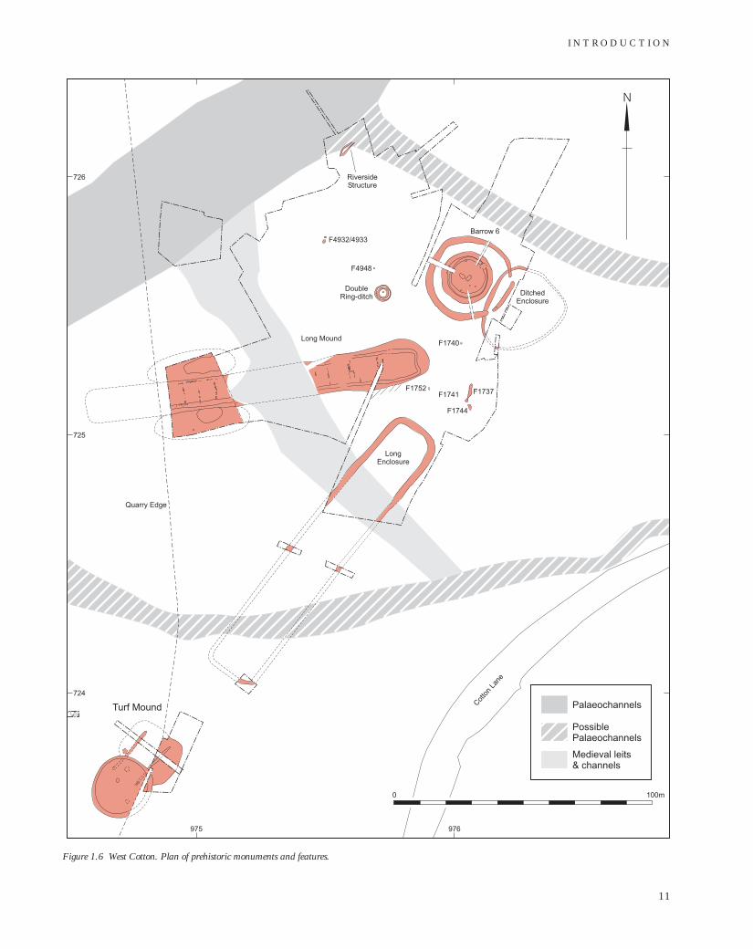
To the north-east of the island, on a slightly elevated gravel terrace at the edge of the floodplain, hitherto unknown monuments of exceptional forms were revealed during the Northamptonshire County Council Archaeology Unit’s excavation of the deserted Saxon and medieval hamlet at West Cotton, directed by David Windell and Andy Chapman. Beneath the settlement were largely turf-, earth- and timber-built Neolithic and Bronze Age monuments, including the Long Mound and the Long Enclosure, both over 100m long and oriented on a single point, as well as the ovoid Ditched Enclosure, the Turf Mound, the large and elaborate Barrow 6 and the much smaller Double Ring Ditch (Fig 1.6). Immediately adjacent ploughed-out ring ditches beyond the alluvium to the northeast were not investigated. The West Cotton excavations also provided a section across a timber structure of the 3rd millennium Cal BC at the edge of a palaeochannel of the Nene, with the concomitant wealth of
contemporary waterlogged environmental data (Windell 1989; Windell et al 1990; M Robinson 1992a).
In 1993, the Cotton ‘Henge’, which was visible in air photographs as two concentric, irregular ditches with a maximum diameter of some 75m on the valley side above the West Cotton complex (Fig 1.4), was investigated by means of topographical and geophysical survey and limited excavation, under the direction of Jon Humble for English Heritage (Humble 1994).
1.4.3 Stanwick
To the east of the island, the excavation of the Stanwick Iron Age and Roman settlement by the Central Excavation Unitformed part of the project from the outset (Neal 1989a; 1989b). As work progressed, Neolithic and Bronze Age features were identified. Chief among these was the Neolithic Causewayed Ring Ditch and the Early Bronze Age Barrow 5. In addition, an extensive system of ditched enclosures and droveways, with associated post-built structures, pre-dated the Iron Age and later features.
In 1991 a short season of excavation was undertaken by the Central Archaeological Services’ Mobile Field Team led by Frances Blore, in order to recover dating evidence from the ditched enclosure system and to complete trial trenching of the remaining unquarried fields to the south of the Stan-wick Iron Age and Roman settlements. The trial trenching revealed the undated, possibly prehistoric, Southern Enclosure, as well as a small post-built round house and fence-lines apparently related to the ditched enclosure system, all of which were investigated more fully by the same team the following year. Stripping in advance of this 1992 season revealed a further two previously unknown prehistoric monuments, theAvenue and the Segmented Ditch Circle (Fig 1.4), which were also investigated.
1.4.4 Redlands Farm
The Oxford Archaeological Unit’s investigations were initially independent of the Raunds Area Project and funded entirely by ARC. They entailed the excavation of the Long Barrow and Barrow 9, and limited excavation of Barrows 7 and 8. The results enhanced and complemented those of the Project, especially in recovery of waterlogged Early Neolithic deposits from the
10
I N T R O D U C T I O N
Figure 1.6 West Cotton. Plan of prehistoric monuments and features.
11
A N E O L I T H I C A N D B R O N Z E A G E L A N D S C A P E I N N O RT H A M P T O N S H I R E
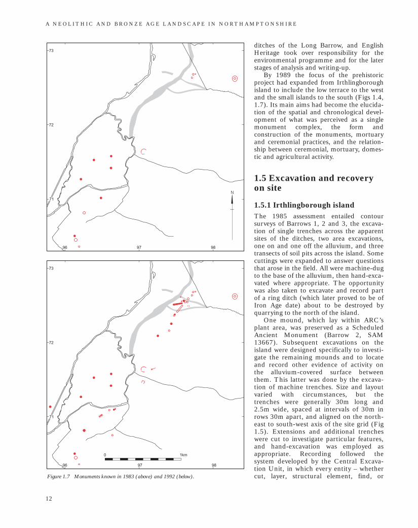
Figure 1.7 Monuments known in 1983 (above) and 1992 (below).
ditches of the Long Barrow, and English Heritage took over responsibility for the environmental programme and for the later stages of analysis and writing-up.
By 1989 the focus of the prehistoric project had expanded from Irthlingborough island to include the low terrace to the west and the small islands to the south (Figs 1.4, 1.7). Its main aims had become the elucidation of the spatial and chronological development of what was perceived as a single monument complex, the form and construction of the monuments, mortuary and ceremonial practices, and the relationship between ceremonial, mortuary, domestic and agricultural activity.
1.5 Excavation and recovery on site
1.5.1 Irthlingborough island The 1985 assessment entailed contour surveys of Barrows 1, 2 and 3, the excavation of single trenches across the apparent sites of the ditches, two area excavations, one on and one off the alluvium, and three transects of soil pits across the island. Some cuttings were expanded to answer questions that arose in the field. All were machine-dug to the base of the alluvium, then hand-excavated where appropriate. The opportunity was also taken to excavate and record part of a ring ditch (which later proved to be of Iron Age date) about to be destroyed by quarrying to the north of the island.
One mound, which lay within ARC’s plant area, was preserved as a Scheduled Ancient Monument (Barrow 2, SAM 13667). Subsequent excavations on the island were designed specifically to investigate the remaining mounds and to locate and record other evidence of activity on the alluvium-covered surface betweenthem. This latter was done by the excavation of machine trenches. Size and layout varied with circumstances, but thetrenches were generally 30m long and 2.5m wide, spaced at intervals of 30m in rows 30m apart, and aligned on the northeast to south-west axis of the site grid (Fig 1.5). Extensions and additional trenches were cut to investigate particular features, and hand-excavation was employed as appropriate. Recording followed thesystem developed by the Central Excavation Unit, in which every entity – whether
cut, layer, structural element, find, or
12

sample – is given an unique number from a single sequence (Jefferies 1977). A watching brief was maintained when the overburden was later stripped from the area prior to gravel extraction.
1.5.2 Stanwick
Neolithic and Bronze Age features were excavated and recorded according to the CEU system as they were encountered during the area excavation of the later complex.
1.5.3 West Cotton
The location of the main part of the excavations was determined by the route of the A45/A605, which was about to be built. The excavated area was originally designed to encompass the medieval tenements that lay within the road corridor, extending beyond it in an attempt to investigate entire medieval plots. This part of the investigation was completed in 1985–6. Excavation was extended to the west in 1987–8, when it became apparent that the remaining area of the hamlet was to be destroyed by gravel quarrying. Strategies for identifying and recording the Neolithic and Bronze Age archaeology were developed as its extent and significance were realised (Fig 1.6). The triple ring ditch of Barrow 6 was recognised when an area was stripped down to gravel at the beginning of the first season in 1985, to test the depth and nature of the stratigraphy. By the end of that season, the progressive removal of medieval and Saxon deposits had revealed that the barrow mound and another prehistoric monument, the Long Mound, survived as earthworks beneath the deposits that underlay the settlement. Extension of the excavated area to the west in advance of gravel quarrying conformed to the visible limits of the hamlet, and, in the event, fell short of the west end of the Long Mound. The recognition of the monuments prompted machine-stripping of the intervening gravel, in order to find minor features. A watching brief on stripping by ARC in 1987 located the Turf Mound (already suspected from a buried soil at the south of the excavated area) and the west end of the Long Mound. The timber structure to the north of the excavated area was discovered during the cutting of a palaeochannel section for environmental sampling in the same year, and was further investigated in later seasons.
Single numerical sequences wereemployed throughout the excavation for
contexts, plans, sections, small finds, flotation samples, other samples, and photographic films. Artefacts and samples from known or possible prehistoric contexts were recorded three-dimensionally, except at the north end of the Long Mound, where they were recorded two-dimensionally within 100mm spits.
1.5.4 Redlands Farm
The evaluation of c 86ha was undertaken by fieldwalking, geophysical survey, andtrenching. One discrete area of settlement defined during the evaluation was set aside from gravel extraction. The Long Barrow mound and ditches, and the underlying old land surface were excavated in quadrants, with some machining as an adjunct to hand-excavation. Sieving of a five per cent sample of mound layers and ditch fills was abandoned when few artefacts were retrieved. Discrete features were half-sectioned or totally excavated as appropriate. Barrows 7 and 8, discovered during ARC’s stripping in advance of gravel extraction, were set aside from quarrying once limited excavation had established their date and character. Both circuits of Barrow 9, a double cropmark ring ditch, were investigated by a combination of hand- and machine-excavation, the central graves being excavated by hand. During the 1989 excavation of the long barrow and Barrows 7 and 8, recording followed a method devised by the OAU for use on rural sites (the ‘Thornhill Farm system’, Wilkinson 1992). Each feature was numbered in a continuous sequence; each excavated segment or section of that feature was then given a letter (A for the first to be excavated, B for the second, etc); and each fill or spit within that segment or section was given a number (1 for the topmost deposit, 2 for the next, etc). Thus, in the case of the Redlands Farm long barrow, 161/A/8 represents the lowest layer (8) of the north-west section (A) of the façade trench (161) (Fig 3.26). The section letter was omitted where features or layers were excavated in plan, as was the layer or spit number where there was only a single fill. Where stratigraphy was complex, as in the long barrow ditches (Fig 3.27), layers were given individual numbers from the same sequence as the features. The 1990 excavation of Barrow 9 employed a single-number recording system similar to that of the Central Excavation Unit, although section
letters were retained.
I N T R O D U C T I O N
13

A N E O L I T H I C A N D B R O N Z E A G E L A N D S C A P E I N N O RT H A M P T O N S H I R E
1.6 Strategies of environmental recovery Gill Campbell and Mark Robinson
All the monuments were sampled.Particular attention was paid to those contexts that produced significantquantities of charcoal. There was not, however, a policy of sampling allprehistoric contexts. Samples formicromorphology, recovery of insect and waterlogged plant remains, molluscs and so forth, were taken either by the specialists themselves or by their assistants. Details of these samples and their contexts are given in the digital publication.
At West Cotton, nearly 250 samples for flotation and wet-sieving were taken from prehistoric contexts and, in a few cases, from the overlying soil horizon. Samples were typically c 10 litres, although some of c 20 litres were taken from mound or ditch contexts, and 100% samples of between 1 and 5 litres were taken from some small features such as cremation burials or stake-holes.
Around 430 samples were taken from prehistoric features during the main excavations at Irthlingborough between 1985 and 1987. Samples were typically 20 litres, although some features, such as the central pits of some of the barrows, were sampled in their entirety.
During the 1991 and 1992 seasons at Stanwick, where one of the main aims was to date the ditched enclosure system, 100 litre samples were taken from each excavated length of ditch, 80 litres of each sample being wet-sieved and 20 litres reserved for flotation. Both processes were carried out on site. At least two 50-litre samples were taken from each pit of the segmented ditch circle and at least one 50litre sample from other features. Cremation deposits were bagged whole.
Each of the units involved in the excavations used a different system to float its samples, although the same mesh sizes were used throughout: 500 microns for the flot, and 1mm for the residue. All residues were sorted for bone, artefacts, and material that had failed to float, down to 4mm, and a minimum of 25% down to 2mm. The remaining portions of the residues were retained for possible further processing, dependent on the results of this sorting, but, in the event, no further work on them was required.
1.7 The physical survival of the evidence
1.7.1 Earthworks
The later alluvium ensured the survival of unditched turf and earth monuments of which there would have been no trace had there been no buffer between medieval and later ploughing and the Saxon land surface. However, an interval of at least three thousand years between construction and alluviation meant that they and other mounds were subject to prolonged degradation by humans, animals and other agents of disturbance and erosion. In the case of the upper parts of the mounds that projected above the alluvium on Irthlingborough island, these processes continued to the time of excavation. Barrow 1, for example, survived to 0.50m at most above the underlying old land surface, much of the visible mound consisting of alluvium and topsoil. At West Cotton, the Long Mound and Long Enclosure were not only ploughed but were also cut by a mill leat, and their survival varied laterally according to whether they lay within, under or outside the embankment that surrounded the later hamlet. The monuments were better-preserved than those of much of lowland Britain, but they were still severely reduced, and may not provide complete sequences, whether structural or depositional. The surfaces between and beyond the barrows were exposed up to the Saxon period, subject, even beyond the limits of ploughing, to continued soil formation, bioturbation, and perhaps erosion.
1.7.2 Environmental evidence
Despite the valley-bottom location, the preservation of waterlogged organic material is very uneven. In the upper and middle Nene valley, dates for palaeochannels, their associated deposits and land surfaces sealed by fluviatile deposits cluster between 10–9,000 BP (c 9600–8200 Cal BC) and 4–2,000 BP (c 2600 Cal BC–Cal AD 50). This probably reflects the stability of the mid-Holocene channels in the valley (A Brown and Keough 1992b, 193, fig 18.9), and perhaps the erosion of channel deposits. The dearth of mid-Holocene channel deposits is seen in the direct superimposition of Late Neolithic deposits over Pleistocene ones in the West Cotton palaeochannel (M Robinson 1992a, fig 19.2). As a result, the
14

reconstruction of landscape and vegetation for the Mesolithic and earlier Neolithic rests on a narrower base than for later periods, although the lack of palaeochannel deposits is to some extent balanced by the waterlogged fills of the Long Barrow ditches, an effect of proximity to the Nene. Insects, wood, seeds and pollen from these ditches vastly expand a record otherwise confined to soils sealed under monuments and to charred plant remains. Neolithic and Bronze Age archaeological deposits were decalcified, so that, despite extensive sampling, molluscan analysis was possible only for the West Cotton palaeochannel and a couple of dry land features. Bone preservation was correspondingly less than optimal. The survival of a cairn of numerous cattle skulls and other bones in Barrow 1 may owe something to the locally more calcareous environment created by such a mass of bone and by the limestone cairn over which it was placed.
1.8 Other implications for the limits of inference While most excavations were planned and thorough, ongoing gravel extraction meant that some were salvage. This occurred where monuments were unknown prior to the stripping of overburden, as in the case of Barrow 5 or the Turf Mound, or where their extent was unknown, as in the case of the west end of the Long Mound. Information is therefore of uneven quantity and quality.
It is impossible to tell how complete the picture of the complex presented here is. Excavation was focused on areas under immediate threat. Work at West Cotton, for example, did not extend east of the road line, despite the continuation of a monument, known as the Ditched Enclosure, beyond that limit (Fig 1.6), and the presence to the north and east of the excavated area of ring ditches identified by aerial photography and geophysical survey.Indeed, the density of Saxon and early medieval features in the unexcavated parts of the West Cotton settlement is such that other features identified by geophysical survey there may or may not be further prehistoric monuments (Payne SS5). The fringes of the Stanwick area, where Iron Age and Roman settlement traces were becoming thin, were explored by trenching rather than area excavation (Fig 1.5), so that features between the trenches would have gone undiscovered. Barrow 2 remains unex
cavated, as do ring ditches identified by
aerial and geophysical survey and a possible barrow still standing in an unquarried field (Payne SS5). South-west of Irthlingborough island, two ring ditches and an isolated Middle or Late Bronze Age cremation burial, identified during evaluation in advance of commercial development, show that burials extend beyond the previously investigated area (Parry 1995a; 1995b). The ring ditches are preserved unexcavated beneath the all-weather training pitch of the Rushden and Diamonds Football Club.
Parts of the valley floor were inaccessible. The disused railway embankment running along the floodplain covered, with its flanking quarries, a band at least 50m wide. The south-east quarter of Irthlingborough island, between the embankment and the Nene, was occupied by ARC’s sorting plant, and there were disused sludge beds on the bank of the Nene in the north-west of the island. Fieldwalking on both the valley sides and the plateau was restricted by the presence of built-up areas, woodland and pasture, as well as former and current quarries (Dix 1987, fig 1).
Neolithic and Bronze Age artefacts in Iron Age and later contexts may well reflect the disturbance of earlier deposits. The large areas covered by the Stanwick and Redlands Farm settlements may have entailed significant destruction of earlier archaeology. It is unlikely to be a coincidence that pre-Iron Age features seem more frequent at the south and north ends of the Stanwick settlement, where later features were scattered, than in the centre, where later features were dense (Fig 1.5). Some surviving earlier features may have gone undetected here, as not all pits in the area were excavated and not all of it was excavated down to undisturbed natural deposits. Destruction was certainly effected by quarrying on the valley floor prior to the project, as in the case of the barrow recorded by Dr Robb (1.2), and a record of an ‘overhanging rim urn’ found in Irthlingborough (RCHME 1975, 57) points to destruction of another burial.
The incidence of evaluation trenches in the alluvium was uneven (Fig 1.5). Even on Irthlingborough island, where trenching was most intensive and systematic, the 30m interval between trenches will have favoured the location of extensive or of linear features. Any relatively substantial archaeology between the trenches would have been recorded in the subsequent watching brief, as was an ovoid slot-and-post structure, surrounded by a gully – probably dating to
I N T R O D U C T I O N
15

A N E O L I T H I C A N D B R O N Z E A G E L A N D S C A P E I N N O RT H A M P T O N S H I R E
the Late Bronze Age or Early Iron Age – in Scours Field, at SP 968 721 (Tomalin 2006). Small, discrete features, like the isolated pits and cremation deposits found in area excavations off the island, may have escaped discovery. Perhaps also relatively unlikely to have been found are small-scale living sites exemplified by concentrations of Early Mesolithic artefacts and animal bone on a land surface sealed under fluviatile deposits at Thatcham, Berkshire, which measured at most 12m across (Wymer 1962, figs 3–5), or by a localised Neolithic artefact scatter associated with nebulous features at Ecton (W Moore and Williams 1975, figs 4–5).
The data from the project are nonetheless of high quality. There have still been relatively few investigations of substantial parts of Neolithic and Bronze Age monument complexes, let alone one as diverse and long-lived as this. The most comparable in these respects may be Barrow Hills, Radley, Oxfordshire (A Barclay and Halpin 1999). Even fewer such complexes have been so effectively embedded in the history of local landscape and settlement. The record of the Raunds area furthermore complements that of the very different and thoroughly researched environment of the fen edge to the north-east.
1.9 Post-excavation strategies Analysis began in parallel with the later stages of fieldwork, largely co-ordinated by Jon Humble, who was Project Director from 1991 to 1997. Initially, the stratigraphy of each excavated monument was analysed, radiocarbon samples were submitted, and detailed site descriptions were written. Finds were analysed and recorded by the appropriate specialists during this stage. There were interim publications of spectacular finds (eg Davis and Payne 1993), and the project figured in general publications (eg Parker Pearson 1993). The blocks in which the data were described and analysed became formalised as Landscape Units, some of them single monuments (like the Long Mound), others groupings of apparently related features (like parts of a field system). It was intended to publish the pre-Iron Age material in a series of monographs, with a concluding synthetic volume. However, the expanding role and increased responsibilities of the Central Excavation Unit, as it became Central Archaeological Services, made progress increasingly difficult. The passing of time also entailed shifts
in perspective and priorities, especially as the value of traditional archaeological monographs, sometimes so coldly neutral and monolithic as to be estranged from present and past human experience, was increasingly questioned, as by Hodder (1989) and Tilley (1989).
While the vast body of data from the project, much of it of high quality, could be applied to pursue any number of questions, there was a need to focus on some of the more important issues. These were defined as the spatial and chronological development of the monument complex; the processes of monument-construction; mortuary and ceremonial practice; the relationship between ceremonial, mortuary, domestic and agricultural activity; the possible importance of spatial alignments between the monuments; and the establishment of a methodology for the analysis and dissemination of the project results. These issues constituted a distinct agenda around which to structure the future development of the project, and, given the interpretive emphasis of these themes, the decision was taken in 1998 to pass their execution to the Department of Archaeology at the University of Newcastle upon Tyne. The remit of this final stage of the project, which was under the management of Jan Harding, was to complete the post-excavation analysis and produce a bipartite publication, consisting of a synthetic text that focused on the main issues already defined, linked to a digital publication in which the data and specialist analyses could be made fully available (J Harding and Rault 1999).
1.10 Report structure The bipartite publication strategy reflects the importance of both disseminating the full range of specialist data and writing a detailed interpretation of the evidence. In many monographs the two are combined in a text that first describes methods and empirical results, and then interprets them. Yet the outcome of this approach is often less than satisfactory. What can result is an excessively long but fragmented and often unreadable account in which key discursive themes are marginalised at the end of a text mostly concerned with catalogue-type data. At the same time, this traditional format was considered as practically unrealistic given the sheer wealth and diversity of the specialist data generated by the Raunds Area Project. A different approach was consequently
16

required and the outcome is this synthetic volume, which brings together the evidence in an interpretative overview of the Neolithic and Bronze Age landscape, supported by a supplementary studies volume, its chapters prefixed with ‘SS’ in which the full and extensive range of specialist analyses is presented. Providing both volumes as electronic publications on the Internet, plus availability in printed form as print-ondemand, enables the large number of detailed datasets, including an impressive range of graphical material, to be made fully available. As a result, future researchers will have access to the primary evidence and will be able to develop their own models in relation to the sites and landscape.
The synthetic volume is structured into thematic chapters that reflect the research goals of the project (1.9). Each chapter draws from and refers to the data contained in the supplementary volume, emphasising the quality and range of evidence relevant to each of the themes. This is an approach that provides flexibility in terms of the cross-referencing and integration of information. The varied evidence will be combined for the purpose of creating interpretations and models. This is the means by which the available evidence is provided with a narrative or ‘story-line’, and the approach is particularly apparent in chapters 4 and 5. Indeed, the contents of both these chapters reflect many general research concerns of Neolithic and Bronze Age studies.
Lines by the Northamptonshire poet John Clare (1793–1864) introduce the synthetic chapters. Clare’s feeling for his
native countryside and its traditional landscape and lifeways, which he saw as despoiled by enclosure in the early 19th century, makes his voice a fitting echo of a far older past.
Panels have been employed to emphasise particularly pertinent specialist data or to present analyses in more detail than is available elsewhere in the synthetic text. These act as bridges between the thematic structure of the synthetic volume and the detailed analysis contained within the supplementary volume. But the panels also refer to the debate, uncertainty and disagreements about the data, and, accordingly, highlight the ambiguity and complexity of the interpretive process. The panels are designed so that the reader can either continue with the narrative flow of the text or break off to follow a particular topic.
The supplementary volume complements the synthetic volume. It principally includes detailed data, including catalogues, databases and associated graphics, and photographic data. A significant part of this data consists of the full Landscape Unit Reports and extensive sections, written by the specialists, on the artefactual and environmental evidence. It also contains a range of GIS images, relating the local topography to the distribution of both monuments and artefacts, and an account of the project’s archive.
Published on the English Heritage web site, both the synthetic and supplementary volumes are separately available in print as print-on-demand bound volumes from English Heritage Publishing.
I N T R O D U C T I O N
17