Furopean Heritage Asses5ment prepared by Rein Warry and Co ...
34
I European Heritage Assessment prepared by Rein Warry and Co. Picton 10/10/2012 EUROPEAN HERITAGE ASSESSMENT PTTAG STUDY AREA r.i C I I I: - Z __ REIN, WARRY & CO CONSULTING LAND & ENGINEERING SURVEYORS, & PROJECT MANAGERS Page 1 of 34
Transcript of Furopean Heritage Asses5ment prepared by Rein Warry and Co ...
I
European Heritage Assessment prepared by Rein Warry and Co. Picton 10/10/2012
EUROPEAN HERITAGE ASSESSMENT PTTAG STUDY AREA
r.i
C
I I
I: - Z__ REIN, WARRY & CO
CONSULTING LAND &
ENGINEERING SURVEYORS,
& PROJECT MANAGERS
Page 1 of 34

Furopean Heritage Asses5ment prepared by Rein Warry and Co. Pir.ton 1011012012
This study relates solely to the European Heritage only. The Aboriginal Heritage Study is a separate document, prepared by the Tharawal Aboriginal Land Council.
The brief below was extracted from the combined Aboriginal and European Heritage Brief so as to only relate to European Heritage
European Heritage Study
Output
1 Preparation of a European Heritage Assessment of known and potential heritage values based on Council's existing mapping for the whole of Shire LEP 2011.
2 Develop appropriate strategies and recommendations for further assessment at the development application stage to manage these heritage values for the Study Area.
Obiectives - European
1 Provide an overview of significant existing or potential cultural landscapes, conservation areas, view and vistas within the Study Area. Council's heritage mapping for the whole of Shire LEP 2011 is to be used as the basis for this assessment.
2 Identification of appropriate zone boundary definitions and development control recommendations to conserve significant items, settings and to manage possible land use conflicts.
Task s/Meth odolog y - European
1 Provide an overview of significant existing or potential European heritage within the Study Area based on Council's own heritage mapping carried out with the Shire wide draft LEP 2010
2. Identify, assess and map any European cultural heritage places, values and archaeological potential within the Study Area
3 The Heritage Act 1997, National Trust and the NSW National Parks and Wildlife Serve heritage databases should be consulted in order to identify any existing items of heritage significance in the area affected by the proposal.
4 Develop recommendation for the management of any European heritage values within the Study Area is required
Page 2 of 34

European Heritage Assessment prepared by Rein Warry and Co. Picton 10/10/2012
Table of Contents
Part1 The Study Area .................................................................................................................... 4
Part 2 Analysis of previous reports and studies ............................................................................. 4
2.1 WOLLONDILLY LOCAL GOVERNMENTAREA THEMATIC HISTORY. ........ ........................... 4
2.2 Review of Hertage Items for Draft WLEP 2009 ......................................................................... s Part 3 Investigation of European Heritage ..................................................................................... 7
3.1 Suburban allotments ................................................................................................................ 7
3.2 Large Portions ......................................................................................................................... 7
3.3 Sources of Current Data collection ......................................................................................... 10
Part 4 Views, vistas and streetscapes .......................................................................................... 12
4. 1 Suburban allotments roads .................................................................................................... 12
4.2 Large Portion roads ............................................................................................................... 13
4 .3 Rita Street ....................................... ....................................................................................... 18
4 .4 Hilton Park Road.................................................................................................................... 20
4.5 Gienanne Place ..................................................................................................................... 23
Part S Identified Heritage Items .................................................................................................. 24
5 .1 No 10 Hilton Park Road ......................................................................................................... 24
5 2 No.49 Hilton Park Road ......................................................................................................... 26
5.3 No. 100 Hilton Park Road....................................................................................................... 28
5 .4 No 70 Tickle Drive ............................... .................................................................................. 30
Part 6 Confirmation of addressing the European Heritage Study Brief ........................................ 31
Part 7 Recommendations for assessment of future development applications .................................. 34
Page 3 of 34
European Heritage Assessment prepared by Rein Warry and Co. Picton 10/10/2012
/ Formatted: Normal, Justified, No j . .j widow/orphan control, Doni adjust
ioce between Latin and Asian text. adjust space between Asian text
- . cJ uimciars
k -
•.'
-
.'•
:- •
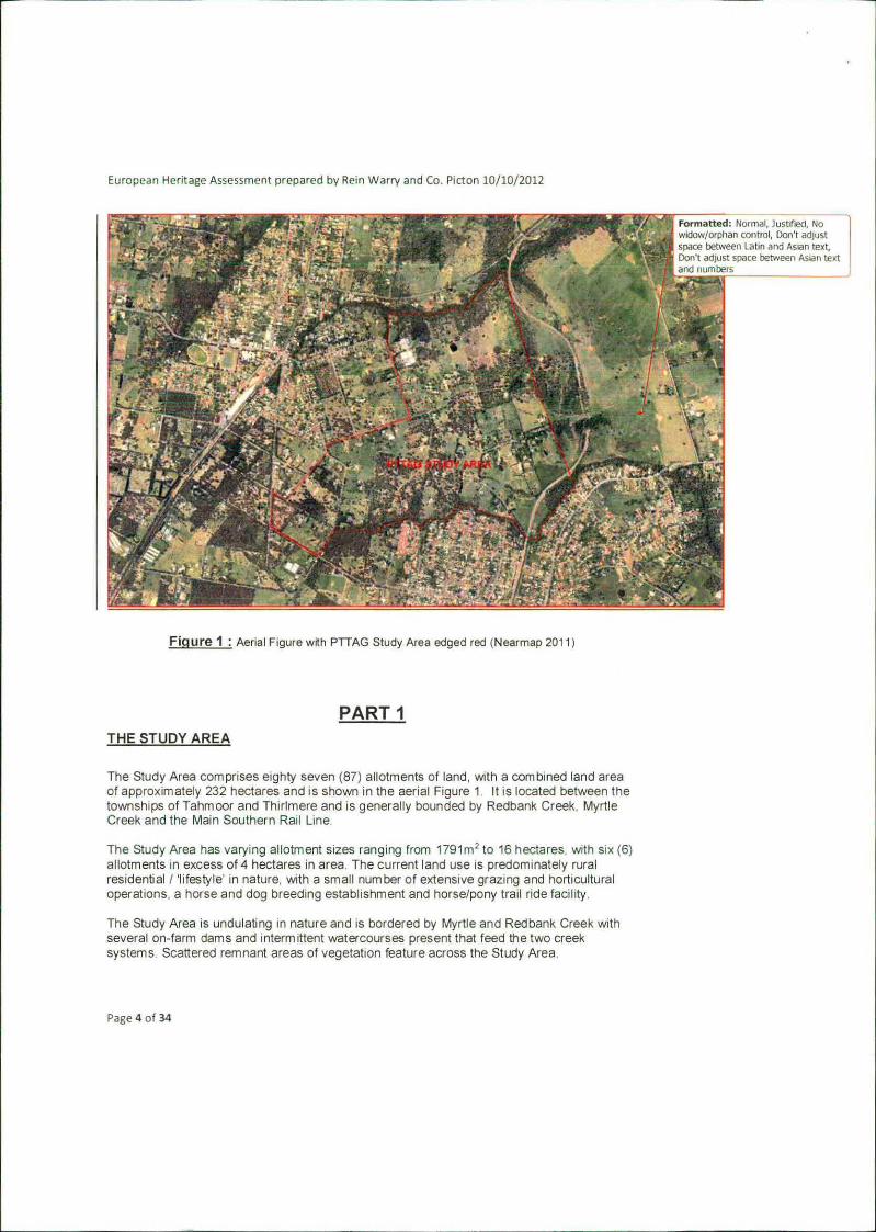
Figure 1: Aerial Figure with PTTAG Study Area edged red (Nearmap 2011)
PART I THE STUDY AREA
The Study Area comprises eighty seven (87) allotments of land, with a combined land area of approximately 232 hectares and is shown in the aerial Figure 1 It IS located between the townships of Tahmoor and Thirlmere and is generally bounded by Redbank Creek, Myrtle Creek and the Main Southern Rail Line.
The Study Area has varying allotment Sizes ranging from 1791m 2 to 16 hectares, with six (6) allotments in excess of 4 hectares in area The current land use is predominately rural residential I lifestyle in nature, with a small number of extensive grazing and horticultural operations, a horse and dog breeding establishment and horse/pony trail ride facility.
The Study Area is undulating in nature and is bordered by Myrtle and Redbank Creek with several on-farm dams and intermittent watercourses present that feed the two creek systems. Scattered remnant areas of vegetation feature across the Study Area.
Page 4 of 34
European Heritage Assessment prepared by Rein Warry and Co. Picton 10/10/2012
PART 2 AN ANALYSIS OF PREVIOUS REPORTS AND STUDIES:
2.1 WOLLONDILLY LOCAL GOVERNMENT AREA THEMATIC HISTORY
Wollondilly Shire Council as part of its Shire Wide LEP commissioned a report titled: WOLLONDILL Y LOCAL GOVERNMENT AREA THEMA TIC HISTORY whose principal author was Andrea Oehm with reference to previous work by Sonja den Hertog, L. R. Fowler, Liz Vincent, JRC Planning Services, Syd Percival and Peter Mylrea.
This report has a specific reference to the Thirimere Township quoted directly from that report as follows
Thirimere Thirirnere, like much of the Wollondilly district, was initially settled by pastoralists in the 1820s; farmers on small acreages of 30-60 acres followed to the north of what is now Oaks Road. Parts of Lakesland had been taken up by 1824 and settlers produced horse feed. poultry and vegetables for the Sydney and local trade. Town settlement did not occur until the mid-1860s when fettlers working on the Great Southern Railway erected temporary accommodation for themselves. A railway siding was built in 1867 and called Redbank. However, confusion with another Redbank (at Upper Picton) resulted in a name change to Thirlmere. Although part of the line construction to Mittagong, the siding was originally constructed to facilitate the supply of timber from the area to Sydney.
Despite the railway fettlers being the first town inhabitants, Thu/mere was primarily a timber town with, perhaps, "the largest timber dump in NSW' at the railway siding and various sawmills in the vicinity. Railway sleepers and mine props were milled as well as block-wood and large quantities of "bundle-wood" supplied by individual timber cutters. The association with the timber industry was so prevalent that members of the local football team were called "wood bugs."
Until the 1880s most of the town accommodation was of a temporary nature and it was not until after 1880 that permanent settlement began to take place. The first houses were slab huts with bark roofs and tents covered with bark. No roads to Thirlmere had yet been built and the settlement remained a tiny outpost. linked to the wider world only by the narrow thread of iron rails.
The first major impetus to development was the 1882 subdivision of Creighton 's 1850 grant. Three main subdivisions were completed during the 1880s forming the basis of Thin/mere 's settlement pattern today: to the north, between the Railway Station and to the road to Picton towards the Queen Victoria Hospital; to the south towards the cemetery, along the eastern side of the railway line; and the whole of the central business district and Westbourne Avenue. This minor land boom led to construction of several substantial buildings including shops, the Welcome Inn, the public school and the railway station. A Mr F/udder built the first town ha/I, which in
Page 5 of 34

European Heritage Assessment prepared by Rein Warry and Co. Picton 10/10/2012
time became a cinema with a cricket pitch at the rear— something for everyone. Most of the towns growth took place between 1890 and WW1 and the town became the main construction trading centre for the building of the railway deviation and the timber industiy. The decline of the local timber iridusty in the early 2Otn centui'y coupled with the main line deviation undermined the town economy and after WNI it declined as a settlement.
Thirimere's only 201h century boom was the arrival in 1928 of an Estonian teacher who in turn encouraged the migration of family and friends. In all, 20 Estonian families arrived in Thirimere during the 1930s and a further 120 people came after VVWII. The Estonians established their, own community in the Lakesland area, concentrating on growing fruit and vegetables and raising poultry. The Estonian settlement includes two churches, a co-operative society, a club and a geriatric hospital and retirement village. It is believed to be the only wholly Eston inn settlement in NSW.
Today Thirimere is known to railway enthusiasts as the home of the NSW Rail Transport Museum. It seems somehow fitting that a town whose first settlers were railway workers and whose development and economy depended too heavily 00 the construction of and proximity to the Great Southern Railway, should now be the home of the State's most important collection of railway memorabilia.
2.2 Review of Heritage Items for Draft WLEP 2009
In 2006, Council engaged a heritage consultant to undertake a review of heritage items throughout the Shire to assist in the preparation of the Draft Wollondilly Local Environmental Plan (LEP) 2009. This LEP was finally gazetted in February, 2011 and is known as Wollondilly LEP 2011. The consultant included a review of heritage Items that were previously listed in the Wollondilly LEP 1991 and identified additional items worthy of heritage preservation
As a result of that review, the current Wollondilly LEP 2011 contains over 300 items and places and eight (8) heritage conservation areas. These places reflect the rich history of the Shire and include houses, farming estates, commercial centres. indigenous places of significance, mining, archaeological sites, schools and churches. (Source: informabon sheet WSC Heritage) After completion of the heritage consultant's work's, Council prepared and adopted a Heritage map for the various towns and villages of Wollondilly
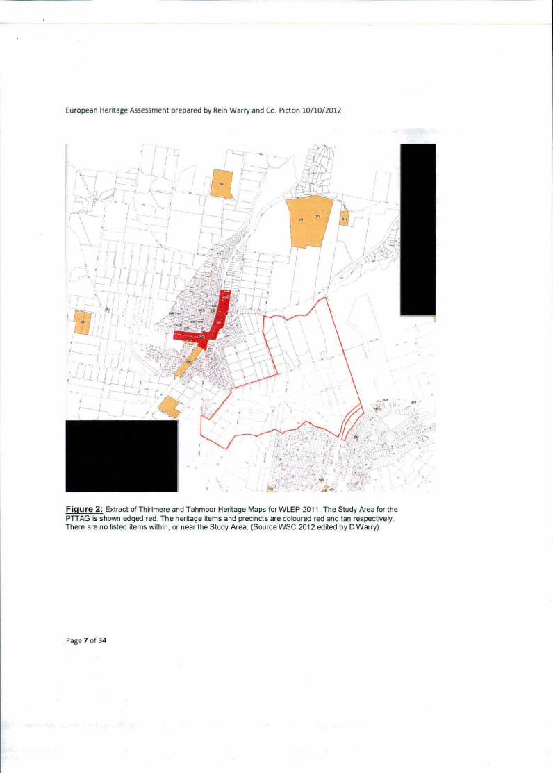
These two previous reports have not identified any European Heritage that specifically relates to the Study Area An extract of that map pertaining to ThirlmerelTahmoor is shown below in Figure 2 below
Page 6 of 34
European Heritage Assessment prepared by Rein Warry and Co. Picton 10/10/2012
/ I
;,
Figure 2: Extract of Thrimere and Tahmoor Heritage Maps for WLEP 2011. The Study Area for the PTTAG is shown edged red. The heritage items and precincts are coloured red and tan respectively. There are no listed items within, or near the Study Area. (Source WSC 2012 edited by D Warry)
Page 7 of 34

European Heritage Assesrnent prepared by Rein Warry and Co. Picton 1011012012
PART 3
INVESTIGATION OF EUROPEAN HERITAGE
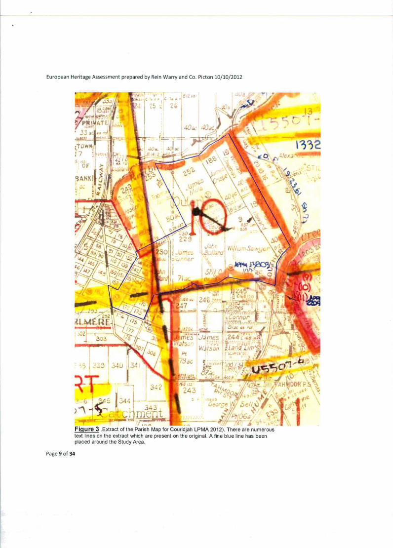
The Study Area is located within the townships of Tahmoor and Thirimere It is wholly contained within the Parish of Couridjah County of Camden. An investigation of the Parish Map for Couridjah reveals the following. The Study Area originally consisted of two different corn ponents.
3.1 SUBURBAN ALLOTMENTS
The first component is the Small Portions being referred to as Suburban Allotments created in 1888 on the Parish Map and referred to as the Village of Thirlmere. a Portion 140, b Portion 141: c. Portion 142, d Portion 143:
Portion 153. Portion 154. Portion 155. Portion 156:
i Portion 157: Portion 158: Portion 167:
I. Portion 169, m Portion 170, n. Portion 172: a Portion 173:
These portions are all relatively small parcels of land (9700 m up to 3.64 ha) and still exist in the same form as when first prepared for sale and alienation from the Crown in 1888.
3.2LARGE PORTIONS
The second component is the Large Portions which were granted as early as 1855. The Large Portion component has been fragmented with subdivisions since the 1920's however, the original Portions are as follows.
Portion 9 purchased by William Sa'er -100 acres (40ha), Portion 188 purchased by James Crisp -40acres (16ha): Portion 190 purchased by John Howard- 40acres (16ha),
s Portion 191 purchased by William Chapman- 40 acres (16ha): Portion 228 purchased by John Bollard -51 acres (20.6 ha): Portion 229 purchased by James Turner-71 acres(28.7 ha), Portion 230 purchased by John Bollard- 37 acres(15ha) Portion 252 purchased by James Mills- 77 acres (31 ha): Part Portion 253 purchased by Thomas James- 80 acres (32ha);
Figure 3 shows an extract of the original Parish Map as it pertains to the PTTAG Study Area, which has been edged in blue.
Page 8 of 34
European Heritage Assessment prepared by Rein Warry and Co. Picton 10/10/2012
IV
13 -1 pi
4 f - r - t U.-
•.r
CIF
7 -1
-1.•. -:
\ :. /
* - =
er
- :.O.L
• . 1 - . _t•,
.......... -
3 : t IV,,.;
I
- -
)1.ç Figure 3 Extract of the Parish Map for Couridjah LPMA 2012). There are numerous text lines on the extract which are present on the original. A fine blue line has been placed around the Study Area.
Page 9 of 34
European Heritage Assessment prepared by Rein Warry and Co. Picton 10/19/2012
3.3 SOURCES OF CURRENT DATA COLLECTION
Enquires have been made of the following local sources of historical knowledge about the Study Area. These include:
Picton & District Historical Society - no knowledge of relevant buildings but provided the names of the following 2 persons for useful local knowledge
Mr Frank Baker, 24 Macquarie Place, Tahmoor - Historian— no knowledge of relevant buildings
- Mr Cohn Miller, 20 Mallam Road, Picton - Ancestors built "Brundah
lnformaton from these people has been incorporated into this report.
A questionnaire was submitted to residents in the Study Area. Not all residents in the Study Area received the questionnaire as some have expressed opposition to the planning proposal. The questionnaire was supplemented by a visual inspection of the Study Area
This questionnaire and visual inspection revealed the following -
YORK STREET— No response received;
VISUAL INSPECTION This section involves two parcels of land. One parcel is attached to a larger section on the western side of the railway line and the second discrete parcel contained a single 1970's brick veneer residence.
HILTON PARK ROAD —20 properties of which 12 responses were received
No. 10 - Residence built circa 1860/1880, since modihed, with underground brick lined well.. (See Part 5.1 for details)
No 49 - Residence (' Brundah") built circa 1914/1918, since modified, with underground brick lined well. Data from Mr C Miller (see Part 5 2 for details)
No 100 - Residence built circa 1930 since modfied and extended (See Part 5 3 for details
No 15, 20 50, 65 75, 85, 90, 95 - Residences built since 1970
No. 55—Vacant lot
VISUAL INSPECTION This revealed that the remaining properties have buildings dating from 1970 to the present
BRUNDAH ROAD - 15 properties of which 10 responses were received I
No 40, 60: 85, 100 109, 110, 115. 135 139- Residences built since 197
No 80 - Vacant c:
Page 10 of 34
European Heritage Assessment prepared by Rein Warry and Co. Picton 10/10/2012
VISUAL INSPECTION This revealed that the remaining properties have buildings dating from the 1970's to the present. Three (3) properties are part of an approved retirement village and demolition of all buildings has been approved as part of that development application process.
GLENANNE PLACE —8 properties of which I response was received
No. 10 - Residence built since 1950.
VISUAL INSPECTION This revealed that the remaining properties have buildings dating from the 1970's to the present.
TICKLE DRIVE - 9 properties of which 9 responses were received
No. 70- Residence built circa 1900, since modified, with underground brick lined well. No record of residence having been built at either Council, local historical society or any local person of suitable age. Local word of mouth indicates the building is pre-1900. (See Part 5.4 for details)
No 9, 19, 25, 30, 35, 60, 65 - Residences built since 1970's. No. 40 - Vacant lot.
RITA STREET —6 properties of which 4 responses were received
No's 69, 77, 85, 105- Residences built since 1970's.
VISUAL INSPECTION This revealed that the remaining properties have buildings dating from the 1970's to the present.
BELL STREET - 2 properties no responses
VISUAL INSPECTION This revealed that the remaining properties have buildings dating from the late 1970's to the present.
DENNIS STREET— 3 properties 1 response
No. 25 - Residence built since 1950.
VISUAL INSPECTION This revealed that the remaining properties had buildings dating from the late 1970 to the present,
DENMEAD STREET— 9 properties of which 2 responses were received No. 25.60- Residences built since 1950.
VISUAL INSPECTION This revealed that the remaining properties had buildings dating from the 1970 2 s to the present.
Page 11 of 34
European Heritage Ascssment prepared by Rein Warry and Co. Picton 10/10/2012
LEONARD STREET— 3 properties with no responses
VISUAL INSPECTION This revealed that the remaining properties had buildings dating from the 1970's to the present
THIRLMERE WAY— 2 properties of wtiich 2 responses were received
No 195. 235 - Residences built since 1970
PART 4
VIEWS, VISTAS AND STREETSCAPES
The Study Area is accessed by a number of roads that date back to the time of the original grants that began as early as 1555. For the purposes of views vistas and streetscapes the Study Area can be separated into five (5) distinct sections as follows -
- The "Suburban Allotments' roads; - The Large Portion roads: - Rita Street: - Hilton Park Road and: - Glenanne Place.
Each of these sections has distinct characteristics as discussed below.
4.1 THE "SUBURBAN ALLOTMENTS" ROADS
This section of the Study Area has allotments that were created in 1888 and the road pattern remains identical with the original plan. This section includes Thirlmere Way, Leonard Street, Jarvis Street, Dennis Street and Denmead Street.
There are no particular or unique characteristics about these streetscapes other than Denmead Street. This street contains a cycleway constructed by Wollondilly Shire Council. This cycleway is integrated into the streetscape and is separated from the bitumen roadway by a significant line of trees as shown on Figure 4 below.
Page 12 of 34

European Heritage Assessment prepared by Rein Warry and Co. Picton 10/10/2012
Figure 4. View south along Denmead Street showing the road pavement, a line of native trees and the cycleway. The road pavement is offset to the western side of the centre of the road reserve, (DWarry 2012)
42THE "LARGE PORTION" ROADS
This section of the Study Area comprises Brundah Road and Tickle Drive These roads have been the subject of some minor re-alignment, but their form and horizontal alignment has remained the same since the original grants. Both of these roads are quite elevated and have some distance glimpses of views. The bitumen road surface and the utility services have been provided to the allotments in this road by generally clearing one side of the road and leaving a large number of trees on the opposite side. This is characteristic of many of the rural roads within Wollondilly Shire and is also an identified characteristic of these old Portion roads.
From the south and north ends of Tickle Drive there are some distance glimpses of views but they are mostly obscured by the tree vegetation.
The horizontal geometry of the roads retain the alignment put in place prior to any thought of motor vehicles. Each road has sharp turns with little in the way of sight distance:
The characteristics of these streetscapes is shown in Figures 5 to 13 inclusive.
Page 13 of 34
1.• *
)q ,. .".&
—.
/1 •;
.r 7ii-..
*-tl
ropen Heritage Assessment prepared by Rein Warry and Co. Picton 10110/2012
77,
•• •
* i:
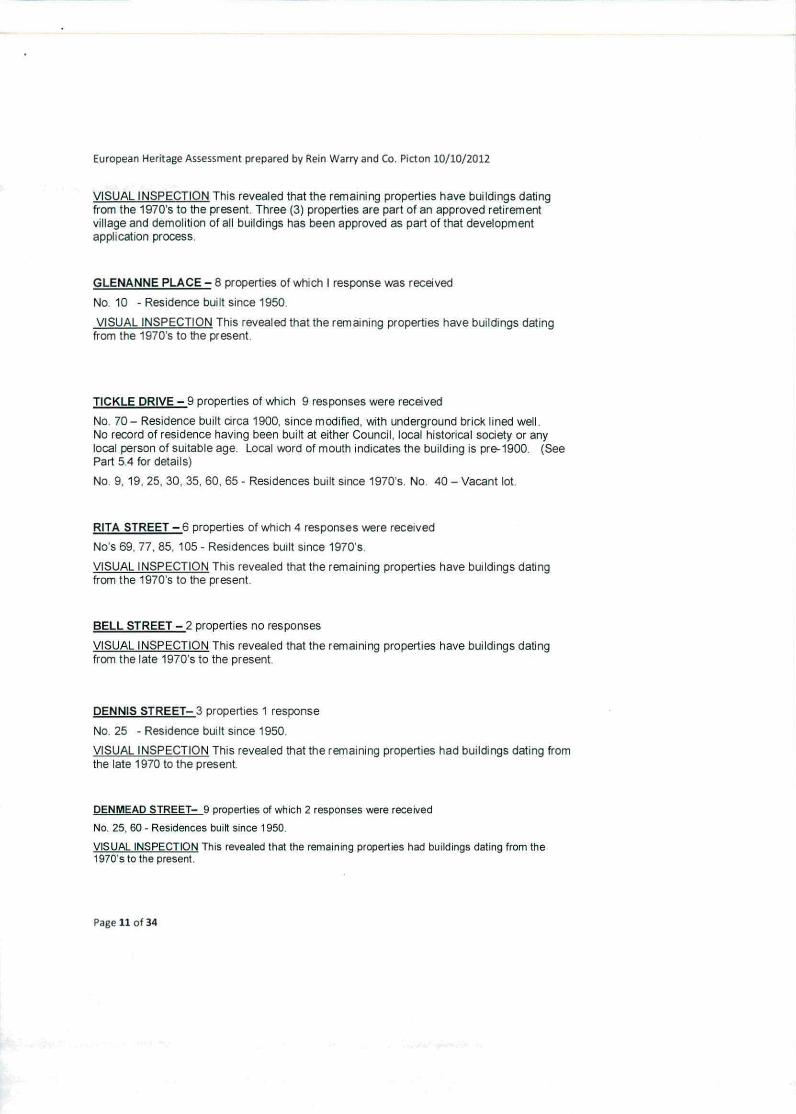
mq i Figure 5 View of distant glimpse to the south from the ridge on Brundah Road (DWarry 201 2i
Figure 6 View west along Brundah Road towards Turner Street Note that the native trees rernwn on the southern side with trees removed for the electricfy service on the northern side IDWarry 2012:
Page 14 of 34

European Heritage Assessment prepared by Rein Warry and Co. Picton 10/10/2012
Ficiure 7 .View east along Brundah Road showing significant remaining native trees (DWarry 20 12)
.-:•
L
Ficiure 8 - View east along Bruridah Road towards Glenanne Place showing significant remaining native trees and exotic tree planting (Cypress). (DWarry 2012)
Page 15 of 34
F• t II:
4 !L -
•t( •1 •
4-Aul4 -
A,
-
ii1k 't1
European Heritage Assessment prepared by Rein Warry and Co. Picton 10110/2012
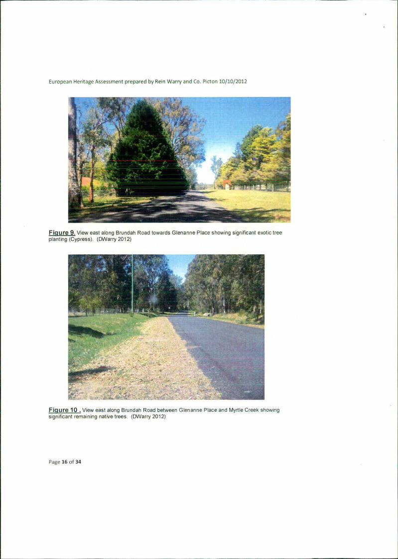
Figure 9. Vow east along Brunoah Road towards Glenanne Place showing significant exotic tree planting (Cypress). (DWarry 2012)
.:
•• -liii ;
Figure 10 .View east along Brundah Road between Glenanne Place and Myrtle Creek showing significant remaining native trees. (DWarry 2012)
Page 16 of 34
European Heritage Assessment prepared by Rein Warry and Co. Picton 10/10/2012
d
.I''.• .. r
op -
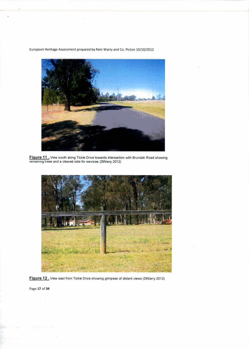
Figure 11 • View south along Tickle Drive towards intersection with Brundah Road showing remaining trees and a cleared side for services (DWarry 2012)
At r
11 i
L
• ?:/' L1 ...
-1' i11 xT ¶0•
1 .1
- ?-
. J•_• - a. .- •'r''• -. .,• .-
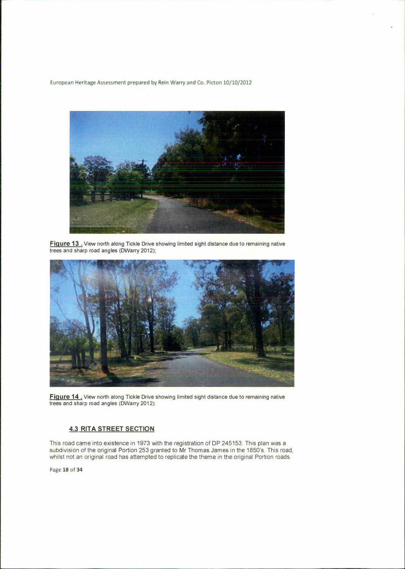
Figure 12 • View east from Tickle Drive showing glimpses of distant views (DWarry 2012)
Page 17 of 34
Europn Hentge /'.ssemenl llrepjlred by Ren Warry 3fld C0 Ptcfl 10/10/2012
Figure 13 View north along Tickle Drive showing limited sight distance due to remaining native trees and sharp road angles (DWarry 2012):
Alp
- '-
_
Figure 14 . View north along Tickle Drive showing limited sight distance due to remaining native trees and sharp road angles (DWarry 2012):
4.3 RITA STREET SECTION.
This road came into existence in 1973 with the registration of DP 245153 This plan was a subdivision of the original Portion 253 granted to Mr Thomas James in the 1850s This road whilst not an original road has attempted to replicate the theme in the original Portion roads
P2ge 18 of 34

European Heritage Assessment prepared by Rein Warry and Co. Picton 10/10/2012
It has extensive tree planting to one side and the utility services, especially overhead electricity has been located on a cleared side. It also has, from the highest point, distant glimpse views.
Figure 15 . View north west along Rta Street showing distant views and the tree line along one side only with the electricity along the opposite side (DWarry 2012)
Page 19 of 34

European Heritage Assessment prepared by Rein Warry and Co. Picton 10/10/2012
'
-
-. -
Figure 16 . View north from Rita Street showing distant views although obscured partly by trees. (DWarry201 2)
4.4 HILTON PARK ROAD
This road came into existence in 1922 with the registration of DP 11936. Its form and shape has remained the same since that time despite several small subdivisions in more contemporary times. For the majority of this road there is a distinctive streetscape of street planting of tall poplar trees which date back to the original subdivider. Other sections have pine tree plantings within the road reserve. From a number of locations along Hilton Park Road there are glimpses of distant views This road also was designed at a time when cars were not considered and it has a number of sharp bends with limited sight stopping distance.
Page 20 of 34
European Heritage Assessment prepared by Rein Warry and Co. Picton 10/10/2012
L
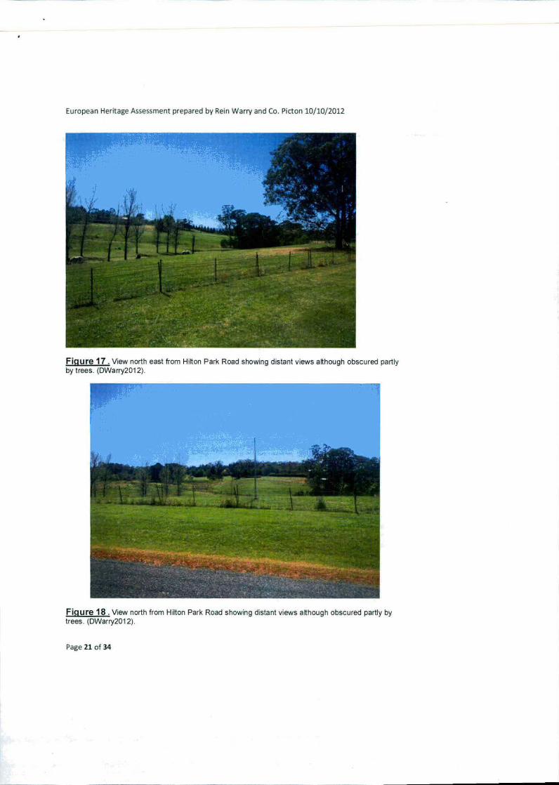
Figure 17 . View north east from Hion Park Road showing distant views although obscured partly by trees. (DWarry2012).
Figure 18 View north from Hilton Park Road showing distant views although obscured partly by trees. (DWarry201 2).
Page 21 of 34

Eumpean Heritage Assessment prepared by Rein Warry and Co. Picton 10/10/2012
Ik
31
ir
1 .. . -
.. __
Figure 19. View south west along Hilton Park Road showing extensive tree plantings in the road reserve. Note that the electricity line is not confined to one side of the road only. (DWarry2012).
-
h-
Figure 20 . View south west along Hilton Park Road showing tine of Poplar trees that exist along the majority of this road (DWarry2012).
Page 22 of 34

European Heritage Assessment prepared by Rein Warry and Co. Picton 10/10/2012
45GLENANNE PLACE
This road came into existence in 1973 with the registration of DP 245495. Its form and shape has remained the same since that time and each of the eight lots created have remained intact without subdivision. Unlike the "Portion Roads no native vegetation was left in the road reserve. Some street planting exists but is not remnant vegetabon. Overhead electricity services each allotment.
I 1
., t4
Ir ..
• :• .'••
. . .
Figure 21 . View south west along Glenanne Place showing the lack of native vegetation in the road reserve (OWarry 2012)
Page 23 of 34

European Heritage Assessment prepared by Rein Warry and Co. Picton 10/10/2012
•1 -.,.. ..- ..,_. .
*A .e;.MQ T
.-
I~Xf
AW
4h • •
7ii;1t , -• - 2
-U.- WI.'
14
Figure 22. View south west along Glenanne Place showing the lack of native vegetation in the road reserve (DWarry 2012)
PART 5
IDENTIFIED HERITAGE ITEMS
5.1 No. 10 Hilton Park Road Tahmoor 2573 - built circa 1860/1880.
The current allotment is Lot 1 DR 11938 and contains an area of 4.148ha. This cottage was originally built on Portion 9 containing 100 acres and granted to William Sawyer around 1855.
The property is described as follows
Dwelling as at 1933
• Purchased by H Bowden and family
Page 24 of 34

European Heritage Assessment prepared by Rein Warry and Co. Picton 10/10/2012
. Main residence plus annexe
• Residence comprised of 4 ground floor rooms and 2 attics. Timber verandas all round. Timber Mndows and doors, slab timber floors. Electric light in each room. Outdoor toilet.
Brick lined well of 6000 gal capacity
Changes since 1933
1945 tongued and grooved flooring replaced the slabs.
1956 Change of ownership to John C Bowden
• 1956 Roof replaced with Marley tiles
• 1965 Interior walls replastered, house rewired, exterior painted. Kitchen and bathroom renovated.
1981 Change of ownership to the current Owner -Yvonne Bowden
. 1982 back verandah glassed in
• 1983 Annexe rebuilt retaining the integrity of the original building.
Heritage Importance:
Example of early rural settlement of Thirlmere/ Tahmoor
Page 25 of 34

European Heritage A ssesrnent prepared by Rein Warrv and Co. Picton 10/1012012
ir F'-'. I ,5
T.
=--
Figure 23: No 10 Hilton Park Roaa north eastern elevation of dwelling in 2012 lM Cr,nin 201 2)
5.2 No. 49 Hilton Park Road Tahmoor 2573 - built circa 1914/1918 Cottage known as "Brundah" The current allotment is Lot 13 DP 716677 and contains an area of 2,07ha. This cottage was originally built on Portion 228 containing 51 acres and granted to John Bollard around 1855.
In 1985 a subdivision took place between Lot 9 in DP 11938 and the adjoining Lot 1 DP 74308 This subdivision took the original "Brundah' homestead and placed it on a new allotment Lot 13 DP 716677. This subdivision had the effect of relocating the access for "Brundah" from Brundah Road to Hilton Park Road Details of Brundah" are as follows:-
Dwelling as at 2001 (when purchased by current owner).
At the time of purchase by the current owner the house was a basic 2 bedroom residence on brick piers. It consisted of 1 bathroom (recently renovated), small kitchen, lounge room and a family area (previous extension). It had a pitched iron roof, timber flooring throughout, asbestos sheeting on interior walls and asbestos lined, vinyl cladding on the exterior walls The windows and doors were timber on original entries and aluminium in the family area The original timber verandah was enclosed on 2 sides leaving a small open verandah on the front of the house. A timber verandah had been recently added to the length of the rear of
Page 26 of 34
European Heritage Assessment prepared by Rein Warry and Co. Picton 10/10/2012
the house. Town water and a septic drainage system were in place. The original water supply in the form of a brick well was present, but covered and not in use at the time. There was also an outside toilet present that was not in use at the time of purchase. One aged timber and iron shed was present, partially standing.
Condition of House at 2001: Aged but partially (poorly) renovated. The tin roof was aged, leaking and in need of replacement. The timber floor was in need of replacement in some areas with boards showing visible borer damage. Timber windows were in poor condition with some painted shut.
Chanaes to dwellina since 2001
Side verandahs have been reopened. Interior and exterior asbestos sheeting has been professionally removed . Exterior walls have been replaced with fibre cement cladding and interior walls now plasterboard / timber lining boards Part of the lounge room area has been separated and altered to form a 3rd bedroom and ensuite. The kitchen has been removed and transformed into a dining area. The family room has been converted into a new kitchen I family room with the timber floor replaced. The laundry has been replaced and tiled. Bathroom area replaced and tiled. Aluminium doors and windows have been removed and replaced with timber. House fully rewired A two car colorbond garage has been built. Previous shedding has been removed
Future of the Dwelling
The dwelling is located in a Mine Subsidence District. There has been a number of dwellings in the area affected by Mine Subsidence. The dwelling is on piers so there is a possibility of mining subsidence damage. Wollondilly Shire Council has approved plans for a 2 bedroom extension with erisuite and entertainment area that will be constructed on the southern side of the house.
Heritage Importance:
Example of early rural settlement of Thirlmere/ Tahmoor
Page 27 of 34

European Heritage Assessment prepared by Rein Warry and Co. Picton 10/10/2012
.,
. ..4* . LP..4J1j 140 &
S
Figure 24: Brundah homestead No.49 Hilton Park Road Tahmoor (M Cronin 2012)
5.3 No. 100 Hilton Park Road Tahmoor 2573 - built circa 1914/1918 The current allotment is Lot 3 DP 599811 and contains an area of 10.81ha This cottage was originally built on Portion 190 containing 40 acres and granted to John Howard mid 1800's The subject Portion 190 was granted prior to the construction of the Great Southern Railway line. This railway severs the land which now exists as two distinct parcels. One parcel on the southern side of the railway line and bounded by Myrtle Creek and the larger parcel on the northern s:de where all of the improvements are located.
The property is described as follows:-
• Anecdotally the house was built in crca 1525 and 000uDied unti circa 560 s by Tickle family who moved from 10 Hilton Park Road referred to above. It was later purchased by the Murray-Lesley family who sold itto Helmet Schneckar of the Burning Log Company. Marhold Pty Ltd. a McPhee family company, purchased it 1987 The Murray-Leslie family had extended and renovated in the 70s anrl furt:e rxl.uiuior v:s Ruluc r :lu
European Heritage Assessment prepared by Rein Warry and Co. Picton 10/10/2012
• The house and surrounding outhouses have remained as they were in 1987. However, extensive maintenance has been carried out on the gardens and buildings.
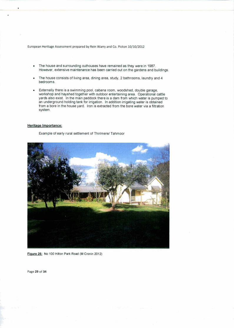
• The house consists of living area, dining area, study, 2 bathrooms, laundry and 4 bedrooms.
• Externally there is a swimming pool, cabana room, woodshed, double garage, workshop and hayshed together with outdoor entertaining area. Operational cattle yards also exist. In the main paddock there is a dam from which water is pumped to an underground holding tank for irrigation. In addition irrigating water is obtained from a bore in the house yard. Iron is extracted from the bore water via a filtration system.
Heritage Importance:
Example of early rural settlement of Thirlmere/ Tahmoor
Figure 25: No 100 Hiton Park Road (M Cronin 2012)
Page 29 of 34
European Hentage Assessment prepared by Rein Warry and Co. Piston 10/10/2012
54 70 Tickle Drive, Thirlmere 2572 The current allotment is Lot 2 DP 920876 and contains an area of 7.64ha. and was originally granted to William Chapman around 1855. The cottage was originally built on Portion 191 containing 40 acres but there is no record of the actLial constrLlction of the builder and who the owner was at that time
Dwelling as at 1974 (when purchased by current owner)
Small residence comprising 3 rooms wide and 2 rooms deep (total 8 rooms - 2 x 4m x 3 3m with back to back fireplaces. 2 x 3 Om x 3.3m (now 1 dining, 1 bed), 1 x 3 5m x 3m (kitchen) 1 x 1.3m x 2.1m (bath), 1 x 1.3m x 1.1m (pantry) and a meat safe/cool room 1.9m x 3 2m - all dimensions approximate), pitched iron roof, brick walls, stone foundations, generally timber floors but 3 concrete. plastered walls and ceilings, timber verandah all round, open 2.5 sides and enclosed 1.5 sides. Timber windows and doors
No formal running water, galvarrised tank and well supply, 2 waste water drains to paddock. Separate bucket toilet. One light in each room and 2 power points. Brick well 4m diameter x 5m deep. To storey timber shed, which collapsed from old age.
Condition of house - Aged. Walls and plaster badly cracked due to shallow foundations, ground water flow and droughts. Ceilings badly cracked Borers in internal floors Verandah floor in need of replacement
Changes to Dwelling since 1974
Kitchen had 5 doors —2 doorways bricked up. Bathroom and pantry joined to make 1 x 1.3m x 3.3m pantry. Window enlarged to form a doorway from verandah to (now) dining room Two timber floors replaced. Pantry floor tiled. Four ceilings replaced. Verandah floor replaced. Rear verandah enclosed and provided with a pair of glazed entry door (not matching original cedar doors) plus fly screens. Fly screens added to the 3 original front entry doors. House fully rewired. Running hot and cold water and waste drainage provided to kitchen. House invaded by termites over many years until effective treatment annihilated them. Significant damage to ceiling joists, some rafters and adjoining timber work.
Bathroom, 3m x 2.8m built against rear verandah. Two car carport built on north end with fibro sheeting and skillion iron roof. Most rainwater connected to well with remainder connected to a new 25,0001 plastic rainwater tank. Town water supply provided from Hilton Park Road. Septic drainage system installed. Extension built from south-west corner providing a lounge. 5 bedrooms bathroom, toilet and rumpus room/office Construction of timber on brick piers, fibro dadding and pitched iron roof.
Future of No.70 Tickle Drive Thirlmere
Discussions have taken place with Xstrata and the Mine Subsidence Board about the risk of serious damage occurring when the house in undermined. The owner expects that The house may suffer irreparable damage but the MSB is more optimistic.
Page 30 of 34

European Heritage Assessment prepared by Rein Warry and Co. Picton 10/10/2012
Figure 26: No 70 Tickle Drive Thirlmere (M Cronin 2012)
Heritage Importance:
Example of early rural settlement of Thirlmerel Tahmoor
PART 6 CONFIRMATIOIN OF ADDRESSING THE EUROPEAN HERITAGE STUDY BRIEF.
Output
1 Preparation of a European Heritage Assessment of known and potential heritage values based on Councils existing mapping for the whole of Shire LEP 2011.
Comment: This Heritage Assessment has prepared a detailed investigation of the known and potential heritage values based on the whole of Shire LEP 2011.
2 Develop appropriate strategies and recommendations for further assessment at the development application stage to manage these heritage values for the Study Area
Page 31 of 34
European Heritage Assessment prepared by Rein Warry and Co. Picton 10110/2012
Comment: The strategies and recommendations for further assessment at the development application stage are listed below under Tasks/Methodology below.
C)biect'ves - Eumoean
Provide an overview of significant existing or potential cultural landscapes. conservation areas, view and vistas within the Study Area. Councils heritage mapping for the whole of Shire LEP 2011 is to be used as the basis for this assessment.
Comment: This has been done in detail in Parts 4 and 5 of this assessment
2 loenhificarion of appropriate zone boundary definitions and development control recommendations to conserve significant items, settings and to manage possible land use conflicts.
Comment: This has been done under Tasks/Methodology below.
lirisk s.'r.1erhodoloo.y - E uropea 1
1 Provide an overview of significant existing or potential European heritage within the Study Area based on Council's own heritage mapping carried out with the Shire wide draft LEP 2010
Comment: Wollondilly Shire wide LEP review in 2009 did not identify any existing or potential European heritage within the Study Area. As a result of this new assessment there has been the identification of four (4) properties. Each of these four (4) properties although exhibited considerable changes from their original form, are examples of early European settlement of Thirlmere and Tahmoor.
This assessment has also identified distant views and vistas at various localities throughout the Study Area. Furthermore, significant streetscape elements have been identified, including significant remaining native vegetation in the road reserve and roads that deviate around significant vegetation such as Denmead Street.
2 Identify, assess and map any European cultural heritage plac:es, values and archaeological potential within the Study Area.
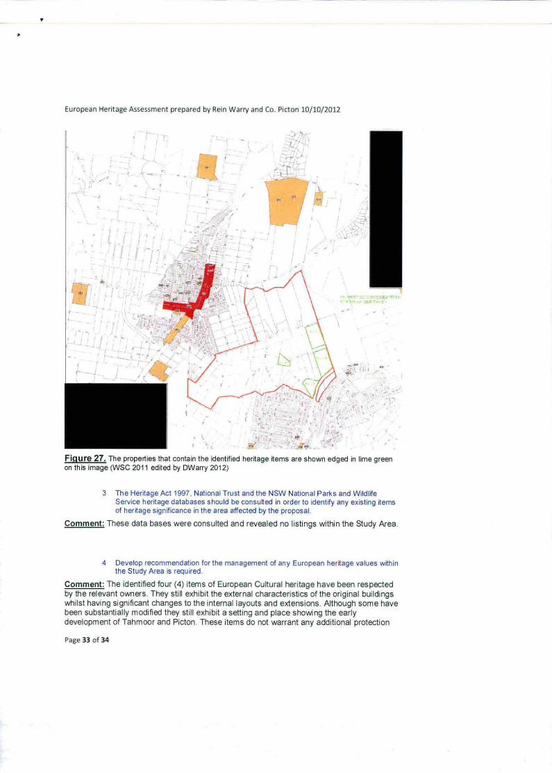
Comment: This Heritage Assessment has identified the four (4) heritage items that are located within the Study Area on relatively large parcels of land. Figure 25 below indicates the location of these properties
Page 32 of 34
European Heritage Assessment prepared by Rein Warry and Co. Picton 10/10/2012
. 3
- -
- S - t
'S. \
I
Figure 27. The properties that contain the identified heritage items are shown edged in lime green on this image (VVSC 2011 edited by DWarry 2012)
3 The Heritage Act 1997, National Trust and the NSW National Parks and Wildlife Service heritage databases should be consuited in order to identify any existing items of heritage significance in the area affected by the proposal
Comment: These data bases were consulted and revealed no listings whhin the Study Area
4 Develop recommendation for the management of any European heritage values within the Study Area is required
Comment: The identified four (4) items of European Cultural heritage have been respected by the relevant owners. They still exhibit the external characteristics of the original buildings whilst having significant changes to the internal layouts and extensions. Although some have been substantially modified they still exhibit a setting and place showing the early development of Tahmoor and Picton These items do not warrant any additional protection
Page 33 of 34
European Heritage Assessment prepared by Rein Warry and Co. Pictcn 10110/2012
other than the current requirements contained within Wollondilly LEP 2011 clause 5 10 Heritage Conservation.
PART 7
RECOMMENDATIONS FOR ASSESSMENT OF FUTURE DEVELOPMENT APPLICATIONS
These recommendations are-
Recommendation 1: For each of the identified four (4) items, at the development application stage a more detailed curtilage assessment should be carried out This assessment should identify an appropriate curtilage that will contain the heritage item and any landscaping and setting features
For development applications for subdivision this curtilage assessment should include the requirements of any Bushfire Risk assessment
For development applications for other uses of the property, an assessment to evaluate any possible land use conflicts. This is especially necessary if the heritage items are going to be used for any other purpose than as a private residence
Recommendation 2: The historic road pattern for the area should be retained and these roads should be the principal roads for the development of the Study Area:
Recommendation 3: The existing bitumen surface alignment of the roads should be retained and that road pavements remain offset where this situation currently exists such as Denmead Street to retain as much of the native vegetation in the road reserve as possible.:
Recommendation 4: That only minor road 'Mdenings be carried out to improve sight stopping distances.
Recommendation 5: That the development applications for any subdivisions include an assessment of the views in the public realm that may be impacted as a result of that development This should include the location of future building envelopes and height restrictions if significantly different to the Wollondilly Height of Buildings Map.
Recommendation 6: Wollondilly Councils Heritage Map be updated with the information shown on Figure 25
Recommendation 7: Schedule 5 of Wollondilly LEP 2011 be updated to include the properties listed above in Part 4
Darryl Warry
Page 34 of 34