
ENVIRONMENTAL ASSESSMENT REPORT -...
185
Narayanghat - Mugling Road Page | 1 Government of Nepal Ministry of Physical Planning and Works Department of Roads Upgrading of Narayanghat – Mugling Road (Chainage: km 2+425 – km 35+677) ENVIRONMENTAL ASSESSMENT REPORT December 2012 (Draft Version) MMM Group Ltd. (Canada) in JV with SAI Consulting Engineers (P) Ltd. (India) in association with ITECO Nepal (P) Ltd. (Nepal) & Total Management Services (Nepal) Public Disclosure Authorized Public Disclosure Authorized Public Disclosure Authorized Public Disclosure Authorized Public Disclosure Authorized Public Disclosure Authorized Public Disclosure Authorized Public Disclosure Authorized Public Disclosure Authorized Public Disclosure Authorized Public Disclosure Authorized Public Disclosure Authorized Public Disclosure Authorized Public Disclosure Authorized Public Disclosure Authorized Public Disclosure Authorized
Transcript of ENVIRONMENTAL ASSESSMENT REPORT -...

Narayanghat - Mugling Road
Page | 1
Government of Nepal
Ministry of Physical Planning and Works Department of Roads
Upgrading of Narayanghat – Mugling Road (Chainage: km 2+425 – km 35+677)
ENVIRONMENTAL ASSESSMENT REPORT
December 2012 (Draft Version)
MMM Group Ltd. (Canada) in JV with
SAI Consulting Engineers (P) Ltd. (India) in association with
ITECO Nepal (P) Ltd. (Nepal) & Total Management Services (Nepal)
Pub
lic D
iscl
osur
e A
utho
rized
Pub
lic D
iscl
osur
e A
utho
rized
Pub
lic D
iscl
osur
e A
utho
rized
Pub
lic D
iscl
osur
e A
utho
rized
Pub
lic D
iscl
osur
e A
utho
rized
Pub
lic D
iscl
osur
e A
utho
rized
Pub
lic D
iscl
osur
e A
utho
rized
Pub
lic D
iscl
osur
e A
utho
rized
Pub
lic D
iscl
osur
e A
utho
rized
Pub
lic D
iscl
osur
e A
utho
rized
Pub
lic D
iscl
osur
e A
utho
rized
Pub
lic D
iscl
osur
e A
utho
rized
Pub
lic D
iscl
osur
e A
utho
rized
Pub
lic D
iscl
osur
e A
utho
rized
Pub
lic D
iscl
osur
e A
utho
rized
Pub
lic D
iscl
osur
e A
utho
rized
wb350881
Typewritten Text
E4146

Narayanghat - Mugling Road
Page | 2
Table of Contents
1. INTRODUCTION .............................. ERROR! BOOKMARK NOT DEFINED.
1.1 Background ............................ Error! Bookmark not defined.
1.2 Objectives of Study ................. Error! Bookmark not defined.
1.3 Methodology ........................... Error! Bookmark not defined.
1.4 Limitation of Study .................. Error! Bookmark not defined.
2. DESCRIPTION OF THE PROPOSAL ..... ERROR! BOOKMARK NOT DEFINED.
3. REVIEW OF RELEVANT ACTS, REGULATIONS AND GUIDELINESERROR! BOOKMARK NOT
4. BASELINE ......................................................................................... 29
4.1 Physical Environment .................................................................. 29
4.1.1 Topography and Geomorphology ......................................... 29
4.1.2 Geology and Soils .............................................................. 30
4.1.3 Landslides and Slope Stability ............................................. 31
4.1.4 Source of Construction Materials ......................................... 34
4.1.5 Land Use Forms ................................................................ 35
4.1.6 Climate and Rainfall ........................................................... 35
4.1.7 Air, Noise and Water Quality ............................................... 37
4.1.8 Hydrology and Drainage System.......................................... 36
4.1.9 Existing Traffic .................................................................. 37
4.2 Biological Environment ................................................................ 37
4.2.1 Vegetation and Forest ........................................................ 37
4.2.2 National Forest .................................................................. 37
4.2.3 Community Forest ........................................................... 378
4.2.4 NTFPs .............................................................................. 45
4.2.5 Terrestrial Wildlife ................... Error! Bookmark not defined.
4.2.6 Protected and Endangered Species of Flora and FaunaError! Bookmark not d
4.2.7 Aquatic Life....................................................................... 38
4.2.8 Biodiversity............................. Error! Bookmark not defined.
4.3 Socio-Economic and Cultural EnvironmentError! Bookmark not defined.
4.3.1 Population and Demography .................................................... 46
4.3.2 Ethnic Groups ........................................................................ 47
4.3.3 Population distribution by caste and ethnicity ........................ 48
4.3.4 Migration .......................................................................... 48

Narayanghat - Mugling Road
Page | 3
4.3.5 Settlement and Housing Patterns ......................................... 48
4.3.6 Occupation and Livelihoods ................................................. 49
4.3.7 Agriculture ........................................................................ 49
4.3.8 Human Resources .............................................................. 49
4.3.9 Literacy and Education ....................................................... 50
4.3.10 Food Security ................................................................. 50
4.3.11 Administration and other Services ..................................... 51
4.3.12 Health Status ................................................................. 51
4.3.13 Basic Utilities & Services .................................................. 51
4.3.14 Land Type and Holding Size ............................................. 52
4.3.15 Types of food grains produced .......................................... 53
4.3.16 Markets ......................................................................... 53
4.3.17 Small/Cottage Industries ................................................. 54
4.3.18 Income and Expenditure .................................................. 54
4.3.19 Gender Issues ................................................................ 54
4.3.20 Religious Activities .......................................................... 54
4.3.21 Social Activities .............................................................. 55
4.3.22 Public Utilities ................................................................. 55
5. IDENTIFICATION AND EVALUATION OF IMPACTS, BENEFIT AUGMENTATION AND MITIGATION/ ENHANCEMENT MEASURES ............................................ 61
5.1 Beneficial Impacts ....................................................................... 117
Construction Stage ........................... Error! Bookmark not defined.
Operation Stage ............................... Error! Bookmark not defined.
5.2 Adverse Impacts ............................................................................. 64
Construction Stage ..................................................................... 64
5.1.2 Operation Stage ................................................................ 81
6 ALTERNATIVE ANALYSIS .................. ERROR! BOOKMARK NOT DEFINED.
6.1 Construction Approach ..................................................... 116
6.2 Project Site (Route) ................. Error! Bookmark not defined.
6.3 Time Schedule ................................................................ 116
6.4 Materials to be used......................................................... 116
6.5 Others No Action Option ........... Error! Bookmark not defined.
6.6 Proposal Alternatives for Transportation ............................... 87
7. ENVIRONMENTAL MANAGEMENT ACTION LAN (EMP) ............................ 107
7.1 Environmental Management AgenciesError! Bookmark not defined.

Narayanghat - Mugling Road
Page | 4
7.2 Environmental Management Action PlanError! Bookmark not defined.
7.3 Environmental Management Cost ...................................... 137
7.4 Types of Monitoring and Monitoring Parameters .................. 144
ANNEXES
Annex-1 A : Community Forest Along the Road Alignment
Annex 1 B: Vegetation Found in the Project Area
Annex-1 C: Compilation of Felled Trees Information
Annex-1 D: Detail Information of Animals
Annex -1 E: Detail Information of Birds
Annex -1 F: Aquatic life of Narayani River
Annex -1 H: Potential Area for Rest Place for Vehicles
Annex -1 I: Animal crossing area
Annex -1 K: Detail of Compensatory Plantation Cost calculation
Annex -1 L: Detail of Bioengineering Cost calculation
Annex-2 : Biodiversity Management Plan (BMP)
Annex-5 : Reference Point of GPS

Narayanghat - Mugling Road
Page | 5
Abbreviations
ADB Asian Development Bank AIDS Acquired Immune Deficiency Syndrome APs Affected Peoples B/C BFC
Benefit/Cost Barandabhar Forest Corridor
BOQ Bill of Quantities CBO Community Based Organization CBS Central Bureau of Statistics CDO Chief District Officer CFC Compensation Fixation Committee CFUG Community Forest User Group CGI Corrugated Iron Ch. Chainage (km) CMS Consolidated Management Service Nepal (P) Ltd. DADO District Agriculture Dev Office dB (A) Decibel (A) DDC District Development Committee DFO District Forest Office DoR Department of Roads DWSC Department of Watershed and Soil Conservation EIA Environmental Impact Assessment EMP Environmental Management Plan EPA Environmental Protection Act EPR Environmental Protection Regulation FGD Focus Group Discussion FRCU Foreign Cooperation Unit, DoR FS Feasibility Study FY Fiscal Year GDP Gross Domestic Product GESU Geo-Environmental and Social Unit GI Galvanized Iron GIS Geographical Information System GNP Gross National Product GoN Government of Nepal GRC Grievance Redress Committee HIV Human Immunodeficiency Virus I/NGO International/Non-Governmental Organization IEE Initial Environmental Examination LFB Local Forum of Beneficiaries MoEST Ministry of Environment, Science and Technology

Narayanghat - Mugling Road
Page | 6
MoF Ministry of Forest MoPPW Ministry of Physical Planning and Works Msl Mean Sea Level mt Metric Ton NPC National Planning Commission NTFP Non Timber Forest Product PAF Project Affected Family PAP Project Affected Person RAP Resettlement Action Plan RCC Reinforced Cement Concrete RM Running Meter RMDP Road Maintenance and Development Project RoW Right of Way RRA Rapid Rural Appraisal SIA Social Impact Assessment SLC School Leaving Certificate (Class 10) SRN Strategic Road Network STD Sexually Transmitted Disease SWRP Sector Wide Road Programme ToR Terms of Reference VDC Village Development Committee TSP Total Suspended Particulates vpd Vehicles per day WB The World Bank

Narayanghat - Mugling Road
Page | 7
Name of the Report
‘Environmental Assessment (EA) Report for the Proposed Upgrading Works of
the Narayanghat – Mugling National Highway (H05)
in Chitwan District.
Proponent and Address
The proponent is the Planning and Design Branch, Geo-Environment and Social Unit, Department of Roads, Govt. of Nepal. The Department of Roads (DoR) is the leading agency for road development under Ministry of Physical Planning and Works (MoPPW) and is responsible for translating government policies for the road sub-sector into the provision of infrastructure services. The services provided by DoR include planning, design, construction and maintenance of the Strategic Road Network, and provisions to ensure a reasonable level of safety for all road users.
The address of proponent is:
Planning and Design Branch,
Geo-Environment and Social Unit,
Department of Roads,
Babar Mahal, Kathmandu, Nepal
Telephone Number: 4262693 #104, and #139;
Fax Number: 4262993.
Email: [email protected] ; [email protected]

Narayanghat - Mugling Road
Page | 8
Chapter 1 : Introduction
1.1 Project Background
Enhancing trade competitiveness is one of six priorities of the Government of Nepal’s development plan. For this, the Government of Nepal (GoN) has requested the World Bank to provide IDA financing, to support Nepal in addressing its commitments to enhancing regional trade including along the Kathmandu-Kolkata Corridor. The GoN’s 2010 Trade Integration Strategy (NTIS) seeks to enable inclusive growth in Nepal through enhancing the competitiveness of Nepal’s exports and reducing the cost of trade.
The priorities of this strategy include: (i) reducing the time and cost of trade-related transactions through efforts at simplification, harmonization, and automation; (ii) building the capacity of domestic trade-related institutions including for sanitary and phytosanitary inspections, trade negotiations, trade facilitation and logistics, and monitoring and regulating trade-related sectors; and, (iii) enhancing the Government’s ability to coordinate trade-related institutions and development partners.
Towards meeting the priorities identified in the NTIS, the World Bank is currently implementing the Nepal Regional Trade Non-Lending Technical Assistance Program (NLTA) designed to enhance the government’s capacity to implement the NTIS by providing technical assistance to the key trade-related institutions to: (a) develop plans for trade facilitation and logistics; (b) put in place an effective monitoring system; (c) undertake key sector studies and receive just-in-time expertise (as needed) and; (d) draft capacity development plans (including for HR development, change management and coordination).
Institutions covered by this NLTA include the Ministry of Commerce and Supplies (and its agencies Nepal Intermodal Transport Development Board Secretariat and Trade and Export Promotion Council), Department of Customs, and Ministry of Physical Planning, Works and Transport Management. Key results expected include: (i) Enhanced capacity to monitor transport time and costs at Nepal’s main trade corridor, the Kolkata-Raxaul-Birgunj-Kathmandu Corridor; (ii) Enhanced capacity to coordinate trade-related institutions and development partners; and (iii) Enhanced capacity/knowledge in trade facilitation and logistics.
To take forward the actions/activities identified by the NLTA, the Nepal India Trade and Transport Facilitation Project (NITTFP) is being designed. The main objective of the proposed project is to facilitate efficient goods trade between Nepal and India. Apart from improving road segments within Nepal in need of repair and expansion, reforms will be sought to address the fragmented supply chains arising from operational, organizational, procedural, regulatory issues and business practices, and to modernize the transit regime within Nepal and between Nepal and India.

Narayanghat - Mugling Road
Page | 9
1.2 Objectives of the NITTFP
The proposed development objective is to facilitate efficient goods trade between Nepal and India. This will be done by removing key trade-related infrastructure constraints within Nepal, and by alleviating soft barriers to trade between Nepal and India including those related to policy, procedures, and systems for international trade transiting between the two countries. The expected outcome as a result of project interventions is a reduction of transport time and logistics costs for Nepal’s international trade.
1.3 Estimated Project Cost
The estimated total project cost is US$101 million. IDA would finance US$99 million, and the IFC will provide US$2 million in support from its South Asia Regional Trade and Integration Program (SARTIP). The projected costs allotted to sub-components may change when all feasibility studies are finalized.
1.4 Project Components
The project will have three components. The proposed activities under each of these components have been briefly described below.
Component 1: Modernize transport and transit arrangements
Through this component, the project seeks to improve the efficiency of the systems used to manage and control the movement of Nepal and India’s third country trade by providing technical assistance to: (a) Nepal to propose evidence based amendments to the Transit Treaty and Rail Services Agreement in order to expedite the movement of third country trade passing through the two countries; (b) Nepal and Indian Customs to simplify and harmonize customs and border management procedures, processes and systems, especially to provide for electronic interchange of data; (c) Road Transport Regulatory Authority in Nepal to strengthen and modernize the regulation of international trucking services; and (d) Introduce a modern and effective transit regime between the two countries.
Component 2: Strengthen Trade Related Institutional Capacity in Nepal
a) Trade Portal and Single Window System Development: The project will finance the design and development of a Trade Information Portal and a Single Window system and related governance arrangements that will collectively allow traders to obtain all relevant information and undertake most regulatory requirements associated with clearing import, export and transit consignments via a single web-based gateway. Preparatory work for this component, including work planning and change management has already begun under the Bank-managed NLTA Program.

Narayanghat - Mugling Road
Page | 10
b) Institutional strengthening and Inter-agency Coordination including financing of PCO: Support human skills development and other strategic institutional strengthening measures for targeted trade-related agencies so that they can better support and promote international trade. Specific activities include: (i) Support the implementation of the Customs Human Resources Development Plan; (ii) Support capacity development and institutional strengthening for the Ministry of Commerce and Supplies; and, (iii) Establishment of the PCO including strengthening the M&E capacity of the NITDB.
Component 3: Improve Select Trade-Related Infrastructure
a) Expand and upgrade the Narayanghat-Mugling road section: This road section is one of the most congested in Nepal with 90 percent of Nepal’s international trade passing through this road. The Project will support upgrading 33km of this road to a two-lane Asian Highway Standard from an existing intermediate carriageway and finance road safety, axle load control and environmental management measures.
b) Build a distribution/warehousing/logistics centre or ICD in Kathmandu. Currently there are no parking or warehouse facilities available for trucks carrying international goods trade from or to Kathmandu, placing significant burdens on traders, freight forwarders, transporters/truckers, and increasing further the time and cost of transport. With heavy traffic congestion in and around Kathmandu, truckers have nowhere to park to off-load imported goods or load goods for export.
c) Improve the infrastructure at Birgunj ICD through the extension of the warehouse shed and removal of unused rail tracks at the Birgunj ICD. Currently, the warehouse shed covers only half the length of a train shipment. During the rainy season, the remaining goods are exposed to the elements and perishables goods would rot or suffer damage. Removal of a set of unused tracks would create space for loading and unloading of Nepal’s international goods trade, which would also speed up these processes.
d) Develop Multi-Functional Joint Analysis Laboratories (including for Customs and SPS inspections including food, plant, and animal quarantine): a) Finance the refurbishment or construction, provision of equipment, IT systems and connectivity, technical assistance, staffing and human resources capacity development to develop new multi-functional, multi-agency, joint analysis laboratories at the Central Laboratory in Kathmandu and at select border posts; and, b) Support the international accreditation of the laboratories with Indian expertise and technical assistance.
1.5 Narayanghat-Mugling Road Section
Infrastructural development, particularly faster movement and transportation of goods in a country like Nepal, is a guiding factor for economic development. Proper transportation

Narayanghat - Mugling Road
Page | 11
of goods requires a comprehensive transport system and increasing road traffic requires better riding quality of roads and uninterrupted movement. Hence, it becomes necessary to develop and upgrade roads.
As part of the Component 3 under the proposed NITTFP, a 33km long road section between Narayanghat and Mugling, carrying a substantial percentage of Nepal’s international trade has been proposed for upgrading. The Project would support upgrading of this road to a two-lane Asian Highway Standard from an existing intermediate carriageway and finance associated costs including road safety, axle load control and environmental management measures. The proposed works would provide smoother, faster and comfortable access by eliminating traffic jams/congestion that frequently occurs on this road section.
1.6 Environmental Assessment Study
The proposed upgrading work was earlier being considered for inclusion under ‘Additional Financing’ of the Road Sector Development Project (RSDP). In line with the scope of the engineering works, the proposition for road upgrading required an Initial Environmental Examination (IEE) as per Govt. of Nepal’s Environmental Protection Act (EPA 1997) and Environmental Protection Rules (EPR’97) 3, Schedule 1(D)(6) that deals with the improvement, rehabilitation and reconstruction of a Highway. Thus, an IEE was conducted and a report was prepared in April 2008 in line with the mandatory requirements set forth in the said regulations. Subsequently, the IEE report was also approved by the authorised agency, Ministry of Planning and Physical Works.
The Govt. of Nepal has now decided to include the proposed upgrading works for Narayanghat-Mugling Road under NITTFP. The IEE undertaken by the Department of Roads through its consultants in April 2008 has been revised/updated and improved in the last one year to meet the requirements of Bank’s operational policies.
The main objective of this exercise was to fill the gaps identified in the IEE report and contribute towards avoidance, minimization and mitigation of the likely adverse impacts through mainstreaming the study findings into the various stages of the project cycle. The revised version of IEE (this report) is now titled the ‘Environmental Assessment Report’ in line with operational policy requirements set forth in Bank’s OP 4.01.
Based on comments and suggestions provided by the World Bank since the inclusion of the road under NITTFP, specific assessment was carried out, with a particular focus on bio-physical aspects. The revision of the report also targeted strengthening of the baseline information, carrying out analysis of alternatives, renewed consultations with key stakeholders and reinforcement of the Environment Management Plan with specific additional measures to deal with biodiversity issues.
More specifically, the environmental assessment study in the last one year sought to:
• Strengthen baseline information by including secondary and primary (including field surveys) information, particularly on the biodiversity aspects

Narayanghat - Mugling Road
Page | 12
Primary Sources/Surveys
- Natural/Biological aspects (including biodiversity/wildlife aspects)
- Physical Aspects
- Social Aspects
Secondary Sources
- Reports/information of DoR (IEE version of 2008, DoR statistics)
- BPF Management Plan of DoF, GoN
Consultations
- Ministries/Government Departments (MoE, DoF, DoNPWC, DoR)
- Non-Govt. Organizations
- Local People and their Representatives
- Community Forest User Groups
- Road Users (Truck/Bus Operators)
• Identify areas/stretches of concern and presence of endangered species of flora, fauna and aquatic life, if any
• Identify the major issues that may arise as a result of the proposed works on bio-physical environment of the project area
• Provide information to the decision-makers about the environmental implications/ impacts of the proposed project and its associated cost for mitigation.
• Recommend practical and site specific environmental management and mitigation measures as may be necessary and include these in the Environmental Management Plan for the project
1.7 Methodology
Data/information on natural/biological, physical and social parameters has been generated through field surveys and literature review. Questionnaire and formats were developed for survey and necessary data collection.
Secondary information was collected through published and unpublished reports and maps. One of the important sources of secondary information that this environmental assessment study has relied on is the ‘Barandabhar Management Plan’ prepared by the Department of Forest, Govt. of Nepal.
Primary data and information was generated through field observations and surveys, questionnaire, focus group discussion, consultation with key stakeholders and professional judgment. GPS has used for to take reference.

Narayanghat - Mugling Road
Page | 13
The consultation process includes interviews and discussion with officials from Department of Roads, District Forest Office, Range Officers, Community Forest Users, local people, fishermen along the project route and road users.
The field work also includes jungle treks and quadrate survey. The quadrate method was used for generating the information about the density of floral species within the specific area. The quadrate survey was done in the Barandabhar Forest Corridor. The quadrates were taken of 30x50 m along the area of forest at four different locations.
The findings from the assessment of social impacts, in particular have been presented in a standalone report.

Narayanghat - Mugling Road
Page | 14
Narayanghat-Mugling Road ….. Salient Features
Important Link (designated as H-05) of Strategic Highway Network of Nepal
Connects Narayanghat located at east-west Mahendra Highway (H-01) to
Mugling located at east-west Prithvi Highway (H-04)
Section included in the current project: Aaptari (Bharatpur bypass junction, km
2+400) to Mugling (km 35+677), total length 33.277 km
Part of Asian Highway AH-42 (297 in Nepal from Kodari to Birgunj) as
categorized by UN ESCAP (IGA Nov 18, 2003). AH42 is a route of the Asian
Highway Network, running 3,754 km from AH5 in Lanzhou, China to AH1 in
Barhi, India. It passes along Kodari, Kathmandu, Narayangarh, Pathlayia and
Birganj.
Traffic volume: AADT 5968
Aligned along river valley along left bank of Trishuli river.
Lesser Himalaya and Siwalik geological belts encountered.
Crosses a number of cross drains: tributaries at eastern bank of Trishuli river.
18 existing medium bridges across the cross drains along the road link.
Chapter 2 : Project Description
Upto the 1970’s, the only link between Kathmandu and Birgunj was the Tribhuvan Rajpath (H-02). This road is narrow and involves steep gradients. In the 70’s, the Chinese constructed the Prithvi Rajpath (H-04) linking Kathmandu to Mugling and Pokhra. Thereafter, they also constructed the Narayanghat to Mugling highway (H-05), as an alternative to the Tribhuvan Rajpath. The road was constructed initially as a single lane road. Later it was widened to intermediate lane with additional structures.
2.1 Features of the Existing Road
The Narayanghat-Mugling road follows the left bank of the Trishuli river and does not involve steep gradients. For this reason, the road has been the preferred route to and from Kathmandu, specifically for trade traffic moving from/towards Biratnagar, Birgunj and Siddhrathnagar. The road lies in Chitwan district of Central Development region of Nepal.
The road starts at Narayanghat (km. 0+000) but the proposed section under the project would start at Aaptari (km 2+425), the junction where the bypasss road to Bharatpur meets. The road ends at Mugling (km 35+677) in Chitwan district, where the road meets the east-west Prithvi Highway. The total length of the road under the project is therefore 33.2 km.

Narayanghat - Mugling Road
Page | 15
The topographical setting of the road alignment area is characterized by hill and river basin. It is largely a rugged terrain consisting of north-west to south-east and north to south trending ridges.
The Narayanghat-Mugling road gradually ascends from Narayanghat (chainage 0+000; 200 m above msl) to Ramnagar (chainage 5+500; 250m above msl) along northern face of the hilly terrain. From Narayanghat, the road alignment runs nearly in flat terrain formed by the old river deposits. After Ramnagar (km 5+500) the road runs along the Trishuli River and the alignment gradually ascends towards Bhateri (km 8+00; 300m above msl). After crossing Bhateri, the road alignment toward Mugling becomes steeper (chainage 35+677; 1250m above msl).
The road follows the left bank of the Trishuli River from Ramnagar (km 5+500) up to Mugling (km 35+677). The project road has bridge crossings over 18 tributaries of Trishuli River. The location of the project road is illustrated in Figures 1.1 and 1.2 and a few other features are provided in the table below.
Other Features of the Existing Road

Narayanghat - Mugling Road
Page | 16
Name of Road Narayanghat – Mugling Road
Geographical Location Central Development Region
Zone Narayani Zone
District Chitwan
Altitude of the lowest point 200m
Altitude of the highest point 265m
Climate Sub-tropical
Total Road Length 36 km
Road Length in the Project 33.2 km
Class of Road National Highway - H05
Presently, the width of road is 6m to 10 m. The pavement of the road is bituminous and the riding quality varies across the various sections. Traffic movement is around 6000 vehicles per day.
The road passes through forest area, settlement and cultivated land. Major settlements along the road alignment are Aptari, Ramnagar, Jugedi, Dasdhunga, Ghumaune, Simaltar, Khahare, Syauli Bazar and Mugling.

Narayanghat - Mugling Road
Figure 2.1: Location Map of Narayanghat – Mugling Road

Narayanghat - Mugling Road
Page | 18
Figure 2.2: Topo Map of the Narayanghat – Mugling Road
Starting Point : Aptari (Km 2+425)
End Point : Mugling (Km 35+677)

Narayanghat – Mugling Road
Page | 20
2.2 Need for Upgrading of Narayanghat-Mugling
The Narayanghat-Mugling road is an important link between the commercial transit points of the country with India through which commodities to the capital city and others part of country are supplied. It also helps to facilitate the trade between India and Nepal and is a part of the key trade transit corridor with India.
The proposed upgrading works are needed on
account of the following reasons:
• Currently, the existing intermediate lane width of 5.5 m often faces traffic congestion.
• Road width is affected by landslips frequently experienced during monsoons which further reduce the width for traffic flow.
• There are no alternative efficient road links connecting traffic from east-west Mahendra Highway to capital city of Kathmandu.
• Road link is a traffic bottleneck in the core road network of Nepal as there are no efficient alternative north-south links.
• The Narayanghat-Mugling road would remain a vital link till the completion of the proposed fast track and/or Kathmandu-Hetauda tunnel way, both of which are not likely to be completed in the next at least 10 to 15 years.
The widening/expansion and upgrading of the Narayanghat-Mugling road is therefore necessary to cater to the growing traffic and meet the requirements of trade and transport between India and Nepal.
2.3 Proposed Interventions
The following engineering interventions have been proposed for the Narayanghat-Mugling road:
• Widening of the road was found feasible with 11 m carriageway width from km 2 to km 16 and 9 m carriageway width has been proposed from km 16 to km 36
• Widening at mountainous section from km 16 to km 36 is mostly towards valley side to avoid hazardous and unstable conditions on the hill side.
• Pavement strengthening is proposed for entire carriageway width in view of the increased traffic volume and projected cumulative axle load.
Narayanghat – Mugling Road
Page | 21
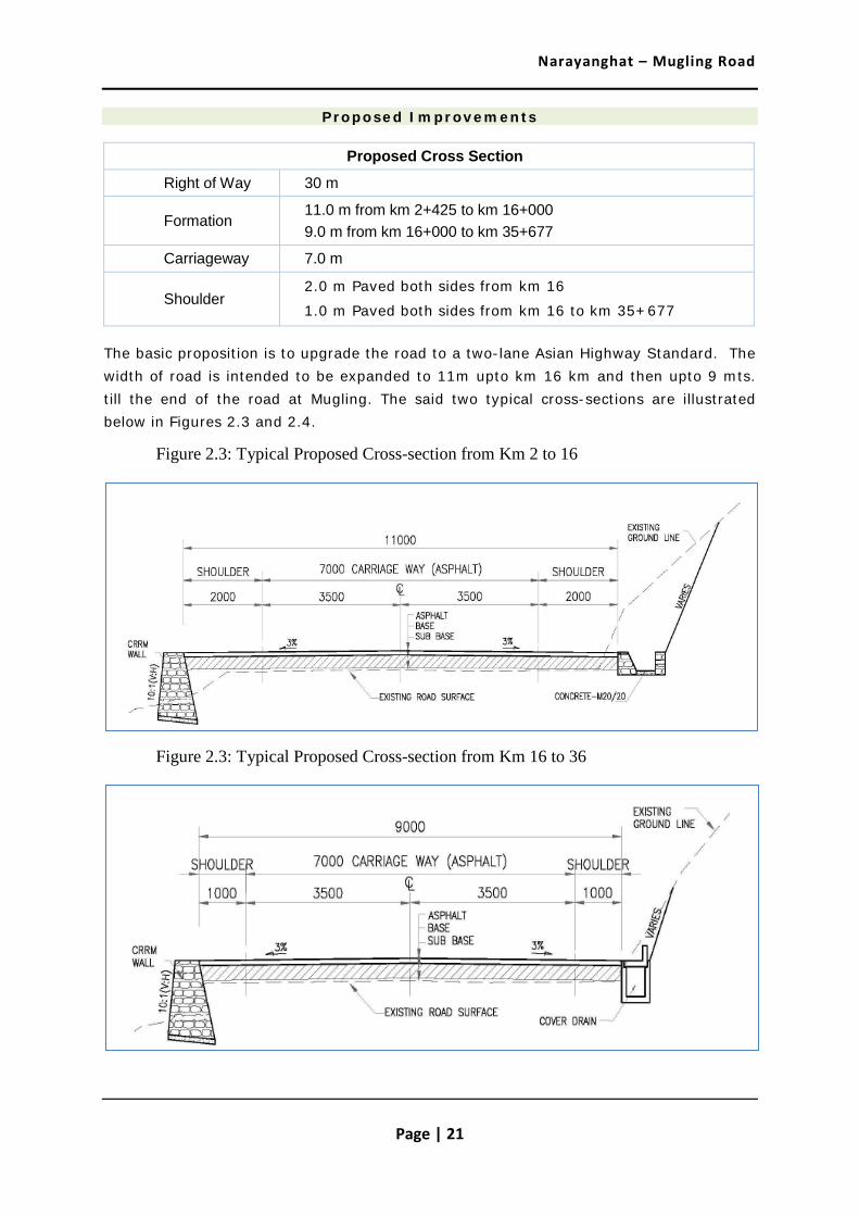
Proposed Improvements
Proposed Cross Section
Right of Way 30 m
Formation 11.0 m from km 2+425 to km 16+000 9.0 m from km 16+000 to km 35+677
Carriageway 7.0 m
Shoulder 2.0 m Paved both sides from km 16
1.0 m Paved both sides from km 16 to km 35+677
The basic proposition is to upgrade the road to a two-lane Asian Highway Standard. The width of road is intended to be expanded to 11m upto km 16 km and then upto 9 mts. till the end of the road at Mugling. The said two typical cross-sections are illustrated below in Figures 2.3 and 2.4.
Figure 2.3: Typical Proposed Cross-section from Km 2 to 16
Figure 2.3: Typical Proposed Cross-section from Km 16 to 36

Narayanghat – Mugling Road
Page | 22
The widening of the road link was found economically viable in the feasibility study that was undertaken. For the current AADT 5968 vehicles, an EIRR of 19.9 percent has been estimated. Apart from the widening of carriageway, a separate study for widening of bridges is underway.

Narayanghat – Mugling Road
Page | 23
Chapter 3 : Regulatory and Legal Requirements
This section is provided as a reminder that all activities under the proposed project must be consistent with all applicable laws, regulations, notifications that are relevant in the context of the proposed project interventions. It is the responsibility of the various Project Implementing Entities to ensure that proposed activities are consistent with the regulatory/legal framework, whether national or local. Additionally, it is also to be ensured that activities are consistent with World Bank’s operational policies and guidelines.
3.1 Relevant Acts and Regulations
The Government of Nepal has adopted various acts and regulations to ensure the integration of protection/conservation of environment in the process of development. The environmental study for Narayanghat-Mugling road was being guided by the various requirements and provisions of the applicable acts and regulations, which are summarised in Table 3.1 below.
Table 3.1: Applicable Acts and Regulations
Act/Regulation Key Requirement/s
Environmental Protection Act, 2053 BS (1997 AD)
Any development project, before implementation, to pass through environmental assessment, which may be either IEE or an EIA depending upon the location, type and size of the project.
Environmental Protection Rule, 2054 BS (1997, amendment, 1999 AD)
Obliges the proponent to inform the public on the contents of the proposal in order to ensure the participation of stakeholders.
Forest Act, 2049 BS (1993 AD)
Section 68 of the Forest Act, 1993 empowers the Government in case of no alternatives, to use the Forest Area for the implementation of the plan having national priority. If there are no significant adverse effects on the environment while conducting such a plan, the Government may give assent to the use any part of the Government Managed Forest, Community Forest, Leasehold Forest or Religious Forest for the implementation of such a plan.
Forest Rules, 2051 BS (1995 AD)
Elaborates legal measures for the conservation of forests and wildlife.

Narayanghat – Mugling Road
Page | 24
Act/Regulation Key Requirement/s
Rule 65 of the Forest Regulation stipulates that in case the execution of any project having a national priority in any forest area causes any loss or harm to any local individual or community, the proponent of the project itself shall bear the amount of compensation to be paid.
Forest Policy, 2000 Policy emphasizes the conservation of natural resources and biodiversity. The Forest Policy has re-emphasized the conservation of forests, species and soil, and their sustainable use. The policy calls upon enhancing people’s participation in the development and management of forests, and promotes to include the communities in the decision-making process. The policy also promotes benefit sharing, which are accrued from natural resources management, particularly the forests. The policy instruments oblige the project proponent to least damage and/or affect the environmental resources while implementing project and/or programme.
The Labor Act, 2048 BS (1992 AD)
Regulates the working environment and deals with occupational health and safety aspects.
National Park and Wildlife Conservation Act, 2029 BS (1973 AD)
Addresses conservation of ecologically valuable areas and indigenous wildlife. The Act prohibits wildlife hunting, construction of houses and huts, damage to plants and animals etc. within the park and reserve, without the written permission of authorized agency/official-in-charge.
Local Self Governance Act, 2055 BS (1999 AD)
Empowers the local bodies for the conservation of soil, forest and other natural resources and implements environmental conservation activities. Sections 28 and 43 of the Act provide the Village Development Committee (VDC) a legal mandate to formulate and implement programmes related to protection of environment during the formulation and implementation of a district level plan.
Land Acquisition Act, 2034 BS (1977 AD) and Land Acquisition Rules, 2026 BS (1969 AD)
Government can acquire land at any place in any quantity by giving compensation pursuant to the Act for any public purposes or for operation of any development project initiated by government institutions.

Narayanghat – Mugling Road
Page | 25
Act/Regulation Key Requirement/s
National Environmental Impact Assessment Guidelines, 1993 (2050 BS)
The guidelines provide guidance to project proponent on integrating environmental mitigation measures, particularly on the management of quarries, borrow pits, stockpiling of materials and spoil disposal, operation of the work camps, earthworks and slope stabilization, location of stone crushing plants, etc.
The National Transport Policy, 2001 (2058)
The policy emphasizes construction and improvement of the road/s that provide beneficial environmental impacts (MPPW, 2001). The policy also focuses on making arrangement to dispose battery, waste oil, grease and other oily substances at designated places.
Three Years Interim Plan, 2007/08 to 2009/10
Requires all projects will be formulated and constructed based on methods that optimally utilize the local skill and resources and generate employment opportunities.
The Interim Constitution of Nepal, 2063 (2007 AD).
It has provision of right regarding environment and health - Every person shall have the right to live in clean environment; Every citizen shall have the right to get basic environmental service free of cost from the State as provided for in the law.
Convention on Biological Diversity, 1992
The Convention on Biological Diversity was signed by Nepal at Rio de Janeiro on June 12, 1992. The convention and particularly Article 14 provides a broad framework on the need for carrying out EIA to minimize adverse impacts of the projects and programmes on biodiversity.
International Legal Instruments
Nepal is signatory to many international conventions, which deal with the protection of environment. The two relevant to the proposed project include:
• Plant Protection Agreement for the South East Asia and the Pacific (as amended), 1956,
• Convention on International Trade in Endangered Species of Wild Fauna and Flora, (CITES), 1973.
The upgrading of feeder roads and Highways requires an Initial Environmental Examination (IEE) before its implementation as per the Environmental Protection Act (EPA 1997) and Environmental Protection Rules (EPR’97) 3, Schedule 1(D)(6). Thus, an IEE was conducted and a report was prepared in April 2008 in line with the mandatory requirements set forth in the said regulations of Govt. of Nepal, which was

Narayanghat – Mugling Road
Page | 26
approved by the authorised agency, Ministry of Planning and Physical Works on ------- vide letter number ----------.
3.2 Relevant Guidelines
The environmental study for Narayanghat-Mugling road also used the relevant guidelines, which are summarised in Table 3.2 below.
Table 3.2: Applicable Guidelines
Guideline/s Key Requirement/s
Environmental Management Guidelines, GESU/DoR, July, 1999
The guidelines have been prepared as part of the programme undertaken jointly by the Govt. of Nepal and the World Bank under the Road Maintenance and Rehabilitation Project. This guideline is formally approved by a Minister level decision on Kartik 22, 2053 BS (1997). The guidelines are a part of operational practices for all road maintenance, rehabilitation and construction activities undertaken by the Department of Roads.
These guidelines consist of environmental mitigation measures to be incorporated into DoR’s project/s, and define the procedure for public participation. The environmental mitigation measures are broken down into twelve categories including: (i) Quarries; (ii) Borrow Pits; (iii) Spoil and Construction Waste Disposal; (iv) Work Camp Location and Operation; (v) Labour Camp Location and Operation; (vi) Earthwork/Slope Stabilization; (vii) Use of Bitumen; (viii) Stockpiling of Materials; (ix) Explosive, Combustible and Toxic Materials Management; (x) Setting Up and Operation of Stone Crushing Plants; (xi) Water Management; (xii) Air and Noise Pollution.
Implementation methods for undertaking mitigation measures for each of the activities are also given in the guidelines. It suggests methods for determining how and when the public should be consulted/involved in the environmental analysis. The guidelines also advise on socio-economic impacts, and strategies for reducing or avoiding the potential negative impacts, and for maximizing the beneficial impacts to local residents.
Socio-economic impacts include issues of land acquisition, compensation and other economic impacts related with markets for agriculture production, agriculture inputs, nutrition, extraction of natural resources beyond replenishment, migration and influx of migrants, land speculation, illegal logging and mining etc. It also deals with impacts on cultural heritage.

Narayanghat – Mugling Road
Page | 27
Guideline/s Key Requirement/s
Reference Manual for Environmental and Social Aspects of Integrated Road Development, 2003 (2060 BS)
The manual helps to integrate environmental and social considerations, including public involvement strategies, with the technical stages. It suggests step-wise process of addressing environmental and social issues alongside the technical, financial and other aspects of project preparations. The Manual recommends environmental and social approaches, actions and strategies to assist developers.
3.3 Applicable World Bank Policies
The World Bank's environmental and social safeguard policies (ten of them) are a cornerstone of its support to sustainable poverty reduction. The objective of these policies is to prevent and mitigate undue harm to people and the environment in the development process. These policies provide guidelines for the identification, preparation, and implementation of programs and projects.
The following operational policies of the World Bank are relevant in context of this Project from an environmental viewpoint:
1) Environmental Assessment (OP 4.01)
Environmental Assessment is used in the World Bank to identify, avoid, and mitigate the potential negative environmental impacts associated with Bank’s lending operations early-on in the project cycle. The policy states that Environment Assessment (EA) and mitigation plans are required for all projects having significant adverse environmental impacts or involuntary resettlement. Assessment should include analysis of alternative designs and sites, or consideration of “no option” and require public participation and information disclosure before the Bank approves the project.
In World Bank operations, the purpose of Environmental Assessment is to improve decision making, to ensure that project options under consideration are sound and sustainable, and that potentially affected people have been properly consulted and their concerns addressed. The World Bank's environmental assessment policy and recommended processing are described in Operational Policy (OP)/Bank Procedure (BP) 4.01: Environmental Assessment.
2) Natural Habitat (OP 4.04)
The policy implementation ensures that Bank-supported development projects give proper consideration to the conservation of natural habitats, in order to safeguard their unique biodiversity and ensure the sustainability of the environmental services and products which natural habitats provide to human society.

Narayanghat – Mugling Road
Page | 28
This policy is applicable when a project (including any subproject under a sector investment or financial intermediary loan) with the potential to cause significant conversion (loss) or degradation of natural habitats, whether directly (through construction) or indirectly (through human activities induced by the project).
3) Forest Policy (OP 4.36)
The implementation of the policy ensures that envisaged forest sector activities and other Bank sponsored interventions which have the potential to impact significantly upon forested areas:
(a) Do not encroach upon significant natural forest areas that serve important social, environmental or local economic purposes.
(b) Do not compromise the rights of local communities to continue their traditional use of forests in a sustainable fashion.
(c) Do not finance commercial logging operations, in the case of primary tropical moist forest, nor any purchase of equipment for this purpose.
4) Cultural Property (OP 4.11)
The World Bank Policy OP/BP 4.11 defines physical cultural resources as movable or immovable objects, sites, structures, groups of structures, natural features and landscapes that have archaeological, paleontological, historical, architectural, religious, aesthetic, or other cultural significance. Physical cultural resources may be located in urban or rural settings, and may be above or below ground, or under water. Their cultural interest may be at the local, provincial or national level, or within the international community.
The Bank assists countries to avoid or mitigate adverse impacts on physical cultural resources from development projects that it finances. The impacts on physical cultural resources resulting from project activities, including mitigating measures, may not contravene either the borrower’s national legislation, or its obligations under relevant international environmental treaties and agreements. The borrower addresses impacts on physical cultural resources in projects proposed for Bank financing, as an integral part of the environmental assessment (EA) process.

Narayanghat – Mugling Road
Page | 29
Chapter 4 : Baseline Environmental Conditions
As a precursor for the prediction of various types of environmental impacts likely to arise due to implementation of the project in question, it is essential to establish the base line environmental status. This includes a thorough appreciation of the physical, natural and socio-cultural environment along the project roads and within the project influence area. An understanding the baseline environmental parameters/characteristics is necessary for the decision making from an environmental point of view about the design, implementation and operational issues of the project. The data and information presented in this chapter has been collected from primary surveys and reliable secondary sources.
For this study, the direct area of influence that has been considered is the Right of Way (30 mts.) along with the sources of raw materials (sand, water, aggregate, earth), haul roads and debris disposal areas. The indirect area of project influence includes natural, social features and land uses located within one kilometre from the Right of Way edge.
4.1 Physical Environment
4.1.1 Topography and Geomorphology
The road traverses through a terrain that is characterized by hill and river basin. The topography of and near the road alignment is largely a rugged terrain consisting of north-west to south-east and north to south trending ridges.
The road starts at an elevation of 200 m at Narayanghat and ends at 1,800 m at Mugling. More specifically, the Narayanghat-Mugling road gradually ascends from Narayanghat (chainage 0+000; 200m above msl) to Ramnagar (chainage 5+000; 250m above msl) along northern face of the hilly terrain. After Ramnagar, the road gradually ascends towards Bhateri (chainage 8+00). After Bhateri, the road alignment passes gradually toward Mugling (chainage 36+000, 265 msl).
Photo 4.1 and 4.2 : Two views of the critical sections of N-M Road

Narayanghat – Mugling Road
Page | 30
Initially, the road alignment follows the flat land of the Chitwan Dun valley and then runs in northern face of the hill just below the ridge and just above the Trisuli River valley.
There are critical sections, which would need special design considerations and careful executing during the widening of the road. These critical sections are located at chainage 16+300, 21+000, 22+425 to 22+550, 28+300, 29+830, 32+120 to 32+240 and 34+200 to 35+00.
4.1.2 Geology
Geologically, the road alignment runs through the sediments of the Chitwan Dun valley and Siwaliks comprised of inter-bedded sandstone and mudstone. Road alignment traverses through rocks of the Lower Nuwakot Group and upper Nuwakot Group. The lower Nuwakot Group is composed of Kuncha Formation, Fagfog Quartzite, Dandagaon Phyllite, Nourpul Formation and Dhading Dolomite. The Upper Nuwakot Group contains Benighat Slate, Malekhu Limestone and Robang Formation.
The Kuncha Formation consists of alteration of phyllite, phyllitic quartzite. The Fagfog Quartzite contains thick-bedded white, coarse-grained quartzite with frequently developed rippled marks and the Dandagoan Phyllite consists of phyllite. The Nourpul Formation has metasandstone and phyllite and Dolomite. The Dhading Dolomite is represented by the presence of bluish grey dolomite. The Benighat Slate is composed of dark slate. Along the road alignment only slate, metasandstone, quartzite, dolomite, phyllite, sandstone and mudstone are exposed.
In general, the sediments of the Dun valley are composed of boulders, cobbles and pebbles, which are loose recent sediment and deposited by river. After crossing Dun valley, the road alignment passes through rocks of the Siwaliks (mainly the sedimentary rocks) and finally it crosses through low-grade metamorphic rocks of the Lesser Himalaya of the Central Nepal.
The road runs on the flat land of the Dun valley, foothill of the Siwaliks and through the mountains of the Lesser Himalaya and crosses the Das dung Khola, Jugedi Khola, Khahare Khola, Rowan Khola, Seti Khola and other tributaries which are not dry even during the dry season and drain out in Trisuli River.
Along the road, sandstone, mudstone of the Siwaliks; slate, meta-sandstone of the Nourpu formation; dolomite, quartzite and schist of the Kuncha formation are exposed. Inter-bedded sandstone and mudstone are found between km 13+500 to 13+900. Dhading Dolomites are observed in sections from km 15+950 to 16+800. Quartzite and intercalation of phyllite, slate and meta-sandstone are found between km 17+000 to 19+500, km 20+300 to 20+600, km 21+900 to 23+200, km 27+600 to 27+850, km 28+250 to 30+250 and km 32+100 to 35+900.
Thick colluviums, residual soil and alluvium deposits are found along the road. Alluvium deposits are found in chainage sections 0+000 to 13+500, 13+900 to 15+600 and 19+500 to 20+250. Significant thickness of colluviums deposits are encountered in chainage sections 20+600 to 21+800, 24+650 to 27+600, 27+900 to 28+150 and

Narayanghat – Mugling Road
Page | 31
30+300 to 31+800. Residual soils deposits of more than 3m and reddish brown to yellowish brown in colour are found in chainage section 3+500 to 3+800.
In general, the road passes through weathered slate, limestone, quartzite, dolomite and colluviums, residual and alluvium deposits. Thickness of the colluviums and residual deposits are less than to more than 3 m and alluvium deposits in excess of 5 m respectively. Natural hill slope varies from 20 degrees to 70 degrees.
Alluvium deposits are found in sections 0+000 to 13+500, 13+900 to 15+600 and 19+500 to 20+250. Significant thickness of colluviums deposits are encountered in sections 20+600 to 21+800, 24+650 to 27+600, 27+900 to 28+150 and 30+300 to 31+800. Residual soils deposits, reddish brown to yellowish brown in colour are found in section 3+500 to 3+800. The summary about type of rock found along the road is presented in Table 4.1.
Table 4.1: Distribution of the Common Rock Types along the Road
S.No. Common rock type Coverage
(percent of road length) Length (m) Remarks
1 Hard rock 15.28% 6,300 Dolomite, Quartzite
2 Soft rock 17.5% 5,500 Slate, Phyllite
Source: Geological Survey Report, 2011
In general, the type of soil found in the project area is presented in Table 4.2.
Table 4.2: Distribution of the Soils along the Road Alignment
S.No. Common Soil Type Coverage
(percent of road length) Length (m) Remarks
1 Boulder mixed soils
67.22% 24,200 Alluvium and colluvium soils
Source: Geological Survey Report, 2011
For the purpose of delineating different sections of this road with similar engineering geological properties as well as similar hazard potential, the road alignment has been divided into five sections. The input parameters for hazard assessment included information carried out on landslides, major gully erosion, debris flow, soil and rock along the alignment including classification, depth, angle of internal friction and cohesion for soil and rock type, geological structures, rock strength, weathering grade, joint spacing, aperture filling materials, continuity, roughness, and waviness for rocks.

Narayanghat – Mugling Road
Page | 32
The result from this analysis is summarised below:
Section of road with Similar Geological Conditions Hazard category
Section I: Narayanghat – Jugedi (0+000 to 10+500) Low to Medium
Section II: Gagedi-Gaigaht (10+500 to 18+500) Low to Medium
Section III: Gaighat-Simaltar (18+500 to 24+500) Medium to High
Section IV: Somaltar-Mugling (24+500 to 36+000) Medium
4.1.3 Landslides and Slope Stability The Narayanghat- Mugling road has been subjected to severe stability problems associated with flash floods and intense raining in 1993 and 2003. A number of slides occurred along this road. Some of these include slides at chainage 12+043-12+080; 13-20+840; 23+410 – 23+430; 23+760 23+770, 24+770; 26+220 -26+270; 27+058-27+090; 27+534 -27+56; 30+520-30+590. While some of them have occurred due to increased pressure from water seepage, some others were triggered by debris moving along the dry nalas. In these cases, the culverts were mostly blocked and the debris flows caused extensive damage also downhill by overtopping the road bed and/or or cause ways.
In all these cases, the road bed has remained more or less intact although the existing stone masonry walls were slightly damaged for example at Km 23+000, 24+000, 27+500 and 20+830–20+840. While damage to existing stone masonry walls at Km 23+000, 24+000, 27+500 was caused by increased pore pressure, damage to existing walls at Km 20+830–20+840 was due to debris flow which caused serious scouring of the bed slope downhill of the existing road. Debris flow also caused serious bed erosion downhill at Km 23+060. In both the cases, debris flow choked the existing culverts and slide material led to extensive scouring of the bed slope downhill of existing culverts.
Cut slopes in rocks are stable. Wedge and/or plane failure was noticed in one place in phyllitic rocks. This, however, does not pose a serious problem as the volume of the slid material is small and slide material can occupy only small portion of the road bed.
The road can thus be considered as stable but this stability is dependent on the performance of the installed drainage systems which includes French drains as well as sub-surface horizontal drains. Displacement of cement masonry breast walls between Km 23 +000 and 27+500 is attributed to malfunctioning of horizontal subsurface drains.
Extension of the carriageway width in rocky areas is unlikely to be a problem but design of retaining walls downslope of the existing road bed will be a problem from two points of view. One of the problems will be associated with ensuring the stability of existing road bed. This will require support of the road bed by sheet piling. The other will be

Narayanghat – Mugling Road
Page | 33
related to the assessment of the bearing capacity of the foundation material for retaining structures
Photo 4.3 : Existing Landslide at Km 17 +800
At a few places flash floods also lead to toe cutting of the slope (Km 16+860; 16+848; also between Km 24+025 and 24+600). Although there was no imminent threat to the road bed measures were taken to safeguard against this threat by constructing concrete aprons in conjunction with gabion and concrete walls along the river bank and installing anchored retaining walls at the road side.
The existing stone masonry walls were found to be damaged at km 23+000, 24+000, and 27+500 - caused by increased pore pressure. The damage to existing walls between km 20+830 to 20+840 was due to debris flow which caused serious scouring of the bed slope downhill of the existing road. Debris flow also caused serious bed erosion downhill at km 23+060. In both the cases, flow of debris choked the existing culverts and the slide material led to extensive scouring of the bed slope downhill of existing culverts.
Bio-engineering works has been done in locations such as at km 17+600, 18+700, 20+300, 20+600, 21+620, 22+750, 23+300 and 32+525 primarily using grass plantation, shrub and tree plantation techniques.

Narayanghat – Mugling Road
Page | 34
An analysis of stereographic projections of rock mass data at twenty-six locations indicates that slope stability condition in rock is not good at some locations. There are some highly unstable zones with rock beds dipping towards the road that may lead to plane failures, wedge failures and toppling failures.
Thick piles of the colluviums on the hill slopes can be considered to be at limiting equilibrium and occasional hill slope failures are not uncommon. However, except in a few cases where the road alignment crosses gulleys, the hill side slope has now been stabilized and stability problems are unlikely to arise if toe cutting is avoided on the hill side. Hill side widening is therefore not recommended.
4.1.4 Source of Construction Materials
Environmentally acceptable and technically viable sources of construction materials are listed below. They include four sources identified by the previous consultant during the 2008 study and four additional sources identified during the present study.
i. Narayani River Bank Material 1.5Km.
ii. Confluence of Turishuli & Jugedi Khola, 10+335
iii. Khahare khola at km 11+300
iv. Trishuli River Bank, 15+000
v. Ghaighat Trishuli River, 18+300
vi. Mahadev besi at about 50 km away towards Kathmandu on H 02
vii. Jhari Khola, EW-HW 17Km west of Narayanghat
viii. Kawaswoti Khola, EW-HW 35 Km west of Narayanghat
ix. Phampha Khola, EW-HW 12 Km East from Bypass Road
All these sites are major alluvial and naturally occurring construction material sources that can be used to obtain boulder, cobble, gravel and sand as well as aggregates for concrete. Of these, the first five sources are along the Narayanghat-Mugling road.
The Khahare khola site mentioned in the previous report has been excluded due to existing check dams that are close to the bridge as mining of river bed material is prohibited.
Construction material can be mined only during the dry season from Trishuli River Bank (15+00) and Ghaighat Trishuli River (18+300). However, river bed material can be mined through the years from other sources. A number of stone crushing plants are operational in Mahadev besi which is about 50 km away from Mugling towards Kathmandu on H-02. These plants are producing crushed stone aggregate of various sizes, which could be used as supplementary sources.

Narayanghat – Mugling Road
Page | 35
Photo 4.4 : Existing source of construction materials (Jugedi River)
4.1.5 Land Use
The road passes through dry and wet cultivated land, forest and villages/town such as Ramnagar, Jugedi and Mugling. The existing over-all land use along the road between Narayanghat to Mugling is: (i) forest (all categories, including that with sparse or little vegetative cover) (79.1%), (ii) Cultivated Land (18.4%) and, (iii) Settlement Area (2.5%).
4.1.6 Climate and Rainfall
This road lies in the sub-tropical climatic zone. Generally, rainy season starts from June and ends in September. The meteorological record shows unevenly distributed monsoon rain in the project area with a total average annual rainfall of about 2743 mm.
Table 4.3: Rainfall intensities at Daman Met station near the Project Site
Duration Years Annual Rainfall (mm)
Intensity I2-Yr I5-Yr I10-Yr I20-Yr I50-Yr I100-Yr
1970-2008 39 1799.5
mm/day 105.19 184.00 243.62 303.24 382.05 441.67
mm/hr 36.85 64.47 85.36 106.25 133.86 154.75
Figure 4.1: Intensity Duration Frequency (I-D-F) curve

Narayanghat – Mugling Road
Page | 36
The Intensity Duration Frequency (I-D-F) curve derived from daily maximum rainfall of the above station is presented in Figure 4.1. About seventy five percent of the total rainfall is received during the monsoon season itself. The maximum recorded temperature in Chitwan district is around 40.0 degree celsius and minimum temperature is 4.2 degree celsius. (Source: District Profile of Chitwan, 2010).
4.1.7 Hydrology and Drainage System
There are eighteen (18) major river crossings with existing bridges. The details of these drainage crossings are provided in the table below:
Table 4.4: River/Stream Crossings Along the Road Alignment
S. No. Chainage River Name Structure
1 10+326 Jugedi River (Khola) Existing Bridge
2 11+239 Khahare River (Khola) Existing Bridge
3 12+650 Dasdhunga River (Khola) Existing Bridge
4 13+758 Fohor River (Khola) Existing Bridge
5 16+325 Lamobaluwa River (Khola) Existing Bridge
6 16+728 Khani River (Khola) Existing Bridge
7 19+368 Bhorle River (Khola) Existing Bridge
8 21+480 Mauri River (Khopla) Existing Bridge
9 21+800 Dumre River (Khola) Existing Bridge
10 24+162 Simaltal River (Khola) Existing Bridge
0.1
1.0
10.0
100.0
1000.0
1 10 100 1000
Duration (hr)
Rai
nfa
ll i
nte
nsi
ty (
mm
/hr)
2 yr5 yr10 yr20 yr50 yr100 yr

Narayanghat – Mugling Road
Page | 37
S. No. Chainage River Name Structure
11 25+450 Rigdi River (Khola) Existing Bridge
12 29+000 Jalbire River (Khola) Existing Bridge
13 32+470 Nyanse River (Khola) Existing Bridge
14 32+650 Tope River (Khola) Existing Bridge
15 33+140 Kali River (Khola) Existing Bridge
16 34+440 Gairi River (Khola) Existing Bridge
17 34+800 Chinsenji River (Khola) Existing Bridge
18 35+300 Khahare River (Khola) Existing Bridge
Source: Field survey, 2012
All drainage channels of this road drop into Narayani (Trisuli) river. In addition, there are many dry streams along the road alignment. On small to medium streams, slab culverts and box culverts have been provided. Most of the existing pipe, slab and box culverts on this road are in working condition. A few pipe culverts were found to be chocked or blocked by debris.
4.1.8 Existing Traffic
Daily 863 truck, 1256 heavy truck, 167 light truck, 944 bus, 341 mini bus, 258 micro bus, 400 car/taxi, 275 our wheel, 1150 Motorcycle, 266 Utilities vehicle, 43-tractor ply (total 5963) on the road.
4.1.9 Air, Noise and Water Quality
The air, noise quality parameters in the project area are all well within permissible limits. The water quality is good and people use springs, pipe/tap water and small streams to meet drinking water requirements.
4.2 Biological Environment – Along/Close to the N-M Road Corridor
4.2.1 Vegetation
The dominant tree species along the corridor of the road alignment is Sal (Shorea robusta). The other major species include Padke (Albizia lucida), Sisam (Dalbergia sissoo), Simal (Bombax ceiba), Aanp (Magnifera indica), Neem (Azadirachta indica), Rajbrikshya (Cassia fistula), Kadam (Anthocephalus chinensis), Khayer (Acacia catechu), Jamun (Syzygium cumini), Bhellar (Trewia nudiflora ), Bet (Calamus acanthospathus), Pipal (Ficus religiosa), Amala (Phyllanthus emblica), Dhayero (Woodfordi fruticosa), Bhalayo (Semecarpus anacardium), Kusum (Karthamus tinctorius), Asana (Terminalia alata), Chandmaruwa (Rauvolfia serpentine), Imli (Tamarindus indica), Harro

Narayanghat – Mugling Road
Page | 38
(Terminalia chebula), Barro (Terminalia bellirica), Mauwa (Engelhardia spicata), Bhorla (Bauhinia vahlii), Satisal (Dalbergia latifolia), Bijaysal (Pterocarpus marsupium), Siris (Albigia spp.), Tatari (Dillenia pentagyna) and Bayer(Zizyphus mauritiana). More details are provided in Annex 4.1.
4.2.2 Aquatic Life
The road passes along the left bank of Trishuli River. This river is wide and choked with many large boulders, which provide habitat for fish shelter and spawning. The river varies from clear (low turbidity) with moderate velocities to extremely high flows with high suspended sediment concentrations in the monsoon. The dominant fish species in the river are Faketa, Patanga, Setala, Bam, Gurdi, Garela, Chadke, Asala, Sahar, Jalkapur and Bhaichari according to the local fishermen respondents near these rivers. Fishermen catch and sell fish at/near settlements such as Jugedi, Dasdhunga, Ghumaune and at times in Mugling. More details are provided in Annex 4.2.
4.2.3 Forest
The Narayanghat-Mugling road traverses in a north-south direction through the BFC’s western fringe. A small section of the said road (about 6 km, from Km 2+425 to 8+ 500) falls within the Barandabhar Forest Corridor (BFC) that has been gazetted as a Protected Forest by Govt. of Nepal in February 2012.
Photo 4.5: Existing Road through Protected Forest of Barandabhar
While a part of the BFC lies within the buffer zone of Chitwan National Park), the proposed project road is entirely located outside this ecologically sensitive buffer zone of
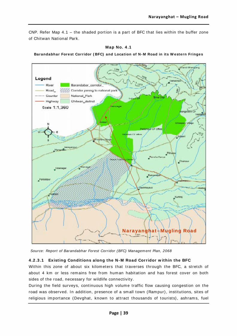
Narayanghat – Mugling Road
Page | 39
CNP. Refer Map 4.1 – the shaded portion is a part of BFC that lies within the buffer zone of Chitwan National Park.
Map No. 4.1
Barandabhar Forest Corridor (BFC) and Location of N-M Road in its Western Fringes
Source: Report of Barandabhar Forest Corridor (BFC) Management Plan, 2068
4.2.3.1 Existing Conditions along the N-M Road Corridor within the BFC Within this zone of about six kilometers that traverses through the BFC, a stretch of about 4 km or less remains free from human habitation and has forest cover on both sides of the road, necessary for wildlife connectivity. During the field surveys, continuous high volume traffic flow causing congestion on the road was observed. In addition, presence of a small town (Rampur), institutions, sites of religious importance (Devghat, known to attract thousands of tourists), ashrams, fuel
Narayanghat–Mugling Road

Narayanghat – Mugling Road
Page | 40
stations and other factors of anthropogenic disturbance were noted along and close to the road. Several forms of human interferences have impacted the integrity of the forest corridor through fragmentation and other induced activities.
Photo 4.6: Milk Processing Unit in the BFC’s western Fringe close to the Road
4.2.3.2 Flora Found along the N-M Road Corridor within the BFC The vegetation along the road is dominated by Sal (Shorea robusta) and the associated species such as Semecarpus anacardium, Terminalia bellirica, Terminalia tormentors. A large number of shrubs, creepers, ferns, flowers and grasses also grow among or under the Sal. 4.2.3.3 Fauna Found close to the N-M Road Corridor within the BFC Wildlife such as Bandel (Sus scrofa cristatus), Syal (Canis aureus), Hanuman Langur (Semenopithecus), Rato Bandar (Macaca mulatta), Chituwa (Panthera pardus), Jarayo (Cervus unicolor), Chital (Axis axis), Harin (Muntiacus muntijac), Ghoral (Naemorhedus goral), Nilgai (Boselapus tragacamelus), Monkey (Macaca mulatta) and Ban Biralo (Felis chaus), are known to move across the road, particularly in the night.
4.3 Biological Environment – General
In view of the fact that the project setting is within the BFC’s western fringe and the forest corridor is a part of the project’s influence area, it is important to appreciate the

Narayanghat – Mugling Road
Page | 41
characteristics and importance of this natural environment feature. A brief description of the over-all BFC and its biodiversity values is provided here to help attain this objective.
4.3.1 Barandabhar Forest Corridor (BFC)
Barandabhar Protected Forest is a 29 km long forest patch, extending from Mahabharata range in the north to Chitwan National Park to the south. The Barandabhar forest covers an area of 87.9 sq. km and bisects the Chitwan District in east and west Chitwan.
Map No. 4.2
Barandabhar Forest Corridor (BFC) – Linking Mahabharat Range and Terai
Major tree species are Sal at the Terai and mixed Sissoo-khair forest at the hill side. It is rich in biological diversity both in terms of the plant and animal species found here. This forest is also an important corridor for the one-horned rhinoceros, a globally threatened

Narayanghat – Mugling Road
Page | 42
species. The rich biological diversity of BFC has witnessed severe pressure from human interferences, leading to forest clearance and adverse impact on wildlife.
Map No. 4.3
Forest Types in Barandabhar Forest Corridor (BFC)
The forest is bisected by many roads, including the east-west Mahendra Highway, which has fragmented the natural habitat creating a barrier to the free movement of wildlife. This fragmentation results in a 56.9 sq.km area in the buffer zone of Chitwan National
Narayanghat–Mugling Road

Narayanghat – Mugling Road
Page | 43
Park (CNP) lying south of the said highway and 31 sq. km is under the District Forest Office, located north of the Mahendra Highway. The project road is located in the north-western portion of the BFC, outside the buffer zone of the Chitwan National Park.
4.3.2 Flora
The flora of Barabdabhar forest is dominated mainly by sal forest and partly by riverine, tall grassland and short grassland. The percentage of vegetable of Chitwan Valley consists of (70%) sal forest (a moist deciduous type), grassland (20%), Riverine forest (7%) and sal with Chir Pine (3%).
4.3.3 Area and Land Uses
The BFC holds 48.016 sq. km of forest, 5.01 sq. km of grassland, 3.276 sq. km of shurb land and 0.5 sq. km of water bodies collectively called Bishazari lake. The surrounding six VCDs of this forest are Bachhauli, Gitanagar, Patihani, Jutpani, Pithuwa, Padampur (new) and 2 Municipalities, Ratnanagar (Ward Number 5,6,7,8 and 10), Bharatpur (Ward Number 8,9,11 and 12).
4.3.4 Hydrology
The major rivers around the forest area are Rapti, Budhi Rapti and Khageri. The Beeshazari lake, which is located at an altitude of 256m from sea level, is considered as the second largest natural wetland of Nepal and is a Ramsar site.
4.3.5 Fauna
Sal forest dominated Barandabhar forest contains 22 species of mammals including Rhinoceros, Asian Elephant, Tiger, Sloth Bear, Wild Boar, Sambar Deer, Spotted Deer, Hog Deer, Barking Deer, and 280 species of Birds including Gaint Hornbill, Hill Myna, Storks. More than 45 species of herpeto fauna represented by frog, toad, lizards, python, and crocodile are also found in the Barandabhar Forest Corridor. The comprehensive study under the aegis of Department of Forests has also mapped out the Wildlife Presence/Movement Areas. Map 4.4 depicts the Rhino movement area in the northern (green) and southern (shaded) parts of the BFC. It has found both through consultations (with experts as well as locals) and field observations that owing to existing traffic, other urban/semi-urban disturbances and lesser availability of feeding ground in the areas close to the road, the animal movement (such as that of Rhinos and occasional movement of a tiger) is confined to the core areas of the BFC.
The major wild mammals found in the BFC include Bandel (Sus scrofa cristatus), Syal (Canis aureus), Hanuman Langur (Semenopithecus entellus), Rato Bandar (Macaca mulatta), Chituwa (Panthera pardus), Jarayo (Cervus unicolor), Chital (Axis axis), Harin (Muntiacus muntijac), Ghoral (Naemorhedus goral), Gaurigai (Bos gaurus), Nilgai (Boselapus tragacamelus), Fyauro (Vulps bengalensis), Monkey (Macaca mulatta), Bagh

Narayanghat – Mugling Road
Page | 44
(Panthra tigris), One horn rhino (Rhinoceros unicornis) and Ban Biralo (Felis chaus), Leutrogale Perspicillata, Bear (Melursus ursinus), Nyauri Musa, Khayaro (Lepus nigricollis), Dumsi etc..
Map No. 4.4
Rhino Movement Pattern of BFC Area
Suga, Dhukur, Dangree and Bhangera are reputed to be major crop raiders.
Major species of birds documented from field observations and from secondary information are Kalij (Lophura leucomelana), Kaag (Corvus splendens), Bhangera (Passer domesticus), Suga (Psittacula spp.), Dangree (Acridotheres fuscus), Mayur (Pavo cristatus), Maina (Gracula religiosa), Jureli (Pycnonotus spp.), Chibe Chara (Dicrurus

Narayanghat – Mugling Road
Page | 45
aeneus), Phusree Dhanesh (Ocyeros birostris), Thulo Dhanesh (Buceros bicornis), Pangree Dhanesh (Anthracoceros albirostris), Nyauli (Megalaima zeylanica), Kuthurke (Megalaima lineate), Dhukur (Streptopelia spp. & Chalcophaps spp.), Karangkurung (Anthropoides virgo), Chil (Hieraaetus kienerii), Khar mujur (Choriotis nigriceps), Luiche (Gallus gallus) and Haleso (Treron spp.).
Among the herpeto fauna, Chheparo, Ajingar (Python molurus), Dhaman (Ptyas mucosus), Karet, and Anda Khane Sarpa (Elachistodon westermanni) have been reported in the BFC.
Both wild animals and bird presence is more in the southern part of BFC (shaded area), which adjoins the Chitwan National Park
Satisal(Dalbergia latifolia), Bijayasal (Pterocarpus marsupium), Chadmaruwa (Rauvolfia serpentine), Sugandawal (Cinnamomum glaucescens), Sal (Shorea robusta), Simal (Bombax ceiba) and Khayer (Acacia catechu) are protected species according to Forest Act (1983).
Out of the mammals reported in the area, Gaurigai (Bos gaurus) and Bagh (Panthra tigris), Rhino (Rhinoceros unicornis) are protected species according to the National Park and Wildlife Conservation Act (1963). Ghoral, Gaurigai, Bagh, Rhino, and Chituwa, have been included in CITES - I category. Rato Bandar and Ban Biralo in CITES-II and Syal in CITES-III category.
Out of birds reported in the Project area, Thulo dhanesh, and Khar Mujur are protected species according to the National Park and Wildlife Conservation Act (1963). Thulo Dhanesh, and Khar mujur have been included in CITES-I category, Phusree Dhanesh in CITES-II category. Maina, Suga & Dhukur in CITES-III category.
Out of the reptiles, Ajinger is the protected species according to the National Park and Wildlife Conservation Act (1963). Ajingar has been included in the CITES-I category and Anda khane Sarpa and Dhaman in the CITES-II category.
4.3.6 NTFPs
Chutro (Berberis aristata), Kurilo (Asparagus racemosus), Sugandawal (Cinnamomum glaucescens), Bajradanti (Potentilla fulgens), Allo (Diospyros malabarica), Siltimur (Lindera neesiana), Dhasingare (Gaultheria fragrantissima), Banmara (Eupatorium adenophorum), Amliso (Thysanolaena maxima) and Titepati (Artemisia vulgaris) are found.
4.3.7 Community Forest
The alignment crosses through nine (9) different community forests. All the community forests have good floral and faunal diversity. Details are about theses community forests are given in Table 4.5.

Narayanghat – Mugling Road
Page | 46
Table 4.5: Road Alignment Passing Through Community Forest
Name From To Major Species
Jaldevi 2+425 4+000 Saal, Chattiwan, Rajbrikshya, Sindhure
Satanchuli 4+000 8+500 Saal, Bodh Dhairo, Rajbrikshya
Indreni 8+500 11+050 Saal, Kadam, Khayer, Bodh Dhairo
Jurethum 11+050 12+850 Khayer, Buyalo
Akladevi 13+500 16+500 Khayer, Kadam, Sissoo
Siddhadevi 17+300 18+700 Khayer, Padke, Sissoo
Ratamata 21+800 23+300 Khayer, Buyalo
Salbishna 24+000 26+200 Khayer, Padke, Kadam, Saal
Luvkush 32+727 33+900 Khayer, Sissoo
Source: Field survey, 2012
4.4 Socio-Cultural Environment
This section presents the over-all socio-economic profile of the study area. More details are available in the Social Assessment Section of the Resettlement Action Plan.
4.4.1 Population and Demography
According to the District Profile 2006, the total population of the Chitwan district is 472,048 consisting of 235,084 males and 236,964 females. The average household size is 5.08, which is slightly higher than the national average (5.44). The male population is 49.8 % and female constitute 50.2 %.
Table 4.6: Population and Average Household Size in Chitwan District
Average HH Size Total No. of Households Total Population Male Female
5.08 92,863 472,048 235,084 236,964
Source: District Profile 2064, District Statistics Office, Chitwan
The population of the VDCs coming along the road alignment is presented in Table 4.7 below.

Narayanghat – Mugling Road
Page | 47
Table 4.7: VDC wise distribution of Population in the Zone of Influence
VDC/Municipality No. of Households
Total Population Male Female
Bharatpur (Municpality) 19,992 89,323 45,858 43,465
Kabilash 985 5,513 2,765 2,748
Chandibhanjyang 813 4,553 2,279 2,274
Darechok 1,648 9,109 4,790 4,319
Dahakhani 589 3,751 1,807 1,764
Total 24,027 1,12,069 57,499 54,570
Source: District Profile, 2006, District Statistics Office, Chitwan
Darechowk is highly populated among the VDCs and second to Bharatpur Municipality among sampled the VDCs. It is because Darechok has fertile land in a gentle slope, irrigation facility from the natural sources and access to road, market areas, education, and health services. Economically, this VDC has high potentiality of off session vegetable and fruit farming apart from agriculture.
4.4.2 Ethnic Groups
Field data shows that Chitwan is composed of different caste and ethnic groups of people, Janajati (53%) , especially Tamangs in majority, Dalits (25%), Brahmins/ Chhetries (20%) and Chepangs (2%) and others (1%) in the zone of influence. But the road project has different characteristics as presented in Table 4.8 below.
Table 4.8: Composition of Ethnic Groups
Caste/ Ethnicity Total Population Percentage
Brahman 20 16.9
Chhetri/Thakuri 20 16.9
Gurung 34 28.8
Tamang 2 1.7
Chepang/Praja 7 5.9
Magar 14 11.9
Medheshi 1 0.8

Narayanghat – Mugling Road
Page | 48
Caste/ Ethnicity Total Population Percentage
Rai 1 0.8
Newar 4 3.4
Dalit 15 12.7
Total 118 100.0
Source: Consultants Filed Survey, 2010.
4.4.3 Population distribution by caste and ethnicity
Like in the project area, the affected VDCs/municipality are also dominated by Janajati (52%) followed by Bramhin(14%), Chepang(14%), Chhetri(7%), Newar(5%), Dalit(5%) and others(4%).
4.4.4 Migration
Permanent migration is not a common factor in this road section. There are only eight migrated households in this road alignment out of the 118 sampled cases. The reason for migration is the transport facility. The duration of migration is relatively recent. Seven households have migrated within last two years and one household had migrated two years ago. Majority (75%) of the households migrate from neighbouring districts like Dhading and Ghorkha and 25% from neighboring VDCs or from the same VDC. The seasonal migration for employment is common and nearly 40% youth migrate seasonally to urban areas and abroad.
4.4.5 Settlement and Housing Pattern
The settlement pattern of the project area is distinct according to caste and ethnicity in the interior settlements. But in the road heads the mixed type of settlement was reported. People migrate to the road side for business and settle in temporary houses. In most of the areas the road corridor (ROW) is encroached by the people for business and to acquire other development. This area is in between two markets Narayanght and Mugling bazar. The small shanty local markets are grown along the road between two market centres. Along the road side in the newly grown bazar area majority (60%) of the houses are made temporarily, with mud mortar with corrugated iron sheet. The wall of the houses is of wooden planks supported by wooden pillars. The RCC structures are about 40% which are constructed in private land nearby road. About 40% houses are single storied, otherwise the houses are constructed multy story specially two story. People normally do not live in the ground floor to be protected from insects and snakes. In the hot area, the ground floor is used for business. About 20% structures are animal’s sheds apart from the residential houses. The proposed design of this road suggests that the road widening will be on the west side of the road to avoid land acquisition and resettlement as far as possible.

Narayanghat – Mugling Road
Page | 49
Houses of project area are constructed with mud wall with slate/ tin roof (62%), mud wall with thatch roof (24%) and Wall of cement brick/stone with RCC roof (14%). Most of the houses are two storied. Courtyards in the front of the houses are used for various activities such as resting, meeting people, and for drying/sorting/processing of agri products. Almost all households own a shed for keeping livestock and other purposes.
4.4.6 Occupation and Livelihoods
The main occupation of the people in the district is agriculture and services (75%), followed by trade and business (11%), which includes small and cottage industries also. Non-agricultural labour is adopted by 40% households along with agriculture and trade. About 10% people are employed in foreign countries.
4.4.7 Agriculture
Almost 19% households in the project area are landless. 24% people have about 1 to 5 ropani land, 22% people have 5 to 10 ropani land. Though 1% people have more than 20 ropani land about 41 percent people don’t have more than 6 month food sufficiency because their land is almost ‘pakho/bari’ and only a little land is ‘khet’. Almost 15% of households have food sufficiency for 3 months only.
The major cereal crops grown in the project area are paddy, maize and wheat and among the cash crops pulses, fruits and vegetables are grown.
Animal husbandry (cow, buffalo, goats, ox, pig, and buffalo) and poultry are major contributors to the household income of the local population. Cow and buffalo are kept for milk, ghee and manure; while goats are kept for meat and for sale. Poultry is kept for eggs, meat production and sale. Oxen are kept for ploughing. Of the total livestock population of 6,93,276 in the project VDCs, chicken (92.3%) and cow (4.4%) constitute the largest number. Buffalo (1.3%), goat (1%), Ox (0.8%) and pig (0.2%) constitute the remaining.
4.4.8 Human Resources
Availability of human resources in any area is an indicator of the well-being of the people. In absence of availability of trained and skilled manpower locally, people depend on expensive and outside sources. It seems (from the available data) that the project area VDCs/municipality has only limited number of skilled manpower mainly in the field of carpentry (420 persons), masonry(940 persons) and plumbing (96 persons). Maximum numbers of the skill persons are found in Bharatpur municipality. There is remarkable numbers of un-skilled labour available in project area. Availability of skilled and unskilled labour in presented in Table below.
Table 4.9: Available Skilled Manpower in the Project VDCs by type
Availability of Local Labor Force

Narayanghat – Mugling Road
Page | 50
VDCs /municipality Carpenters Masonry Plumbers Unskilled Labors Total
Darechok 85 200 25 3500 3810
Kabilas 70 175 12 2200 2457
Dahakhani 50 125 5 1600 1780
Chandibhanjyang 65 140 9 2000 2214
Bharatpur Municipality 150 300 45 6000 6495
Total 420 940 96 15300 16756
4.4.9 Literacy and Education
Chitawan is educated district as compared to national average. The literacy status of this district is (71.10%) whereas the national average is 60.98%. Female literacy of this district is also higher than the national average.
Table 4.10: Literacy Status of Chitwan district
Districts Total (%) Female (%) Male (%)
Nepal* 60.98 34.9 62.7
Chitwan 71.10 63.31 79.31
Source: Human Development Report, 2004
Chitwan district has better access to education, with 71% literacy. The female literacy is also good (63%) in comparison to other terai districts. It is because of availability of transport, access to market and nearness to Kathmandu. This district is the junction of east to west and even north to south connectivity through East West High way. This road connects Kathmandu with Indian industrial cities through Raxaul (Birgunj).
4.4.10 Food Security
A large proportion of the households reported food deficit for part of the year. About 55% of the households have sufficient food for less than 3 months a year from their farm products. 15 % have sufficient for 6 months, approximately 8% have 9 months and 20 % can manage food for a whole year.
Table 4.11: Food Sufficiency Situation of the Project Area Households
12 month and more
9 to 12 month
6 to 9 month
3 to 6 month
less than 3 month Total

Narayanghat – Mugling Road
Page | 51
No. % No. % No. % No. % No. % No. %
20 17 .0 15 133 10 8 18 15 55 47 118 100
4.4.11 Administration and Other Services
There are 2 Police Posts, 4 agriculture Services Centres, 4 additional post offices, 1 district post office, 18 Agro vets, 1 forest post, 1 irrigation office and 1 water supply office within the Project Area. Most such services are available in Bharatpur municipality. It needs to be noted that large numbers of people are not in a position to take benefits from the existing service centres for different reasons such as lack of awareness, poor service delivery, distances, lack of resources and/or the persisting conflict situation with law & order in the area.
4.4.12 Health Status
One Hospital, 4 sub-health posts, 2 family planning clinics and 28 private clinics are providing health service in the area. 52 health technicians and workers are involved in the services. Last year about 10000 patients had received health cure services from them It is recorded that in most of the health centres medicines as demanded by local people are commonly in shortage. People, therefore visit private clinics and shops for serious health problems. Some patients go to District or to Zonal hospitals. However, due to poverty majority of population are not capable to visit further than at District Hospital.
4.4.13 Basic Utilities and Services
Although the majority of the sample households (80%) in the Project Area have piped water supply as the source of drinking water, 20 % still using the natural springs and stone spouts.
Field data supports that more than 90 percent households have access to electricity for lighting. More than 80% households have been using firewood as a cooking energy. Firewood is managed from community forestry and the private land such as bari and pakho. Fodder and crop residue are the best source of firewood.
About 10% households have been using have been using electricity and solar energy along with firewood for cooking food. There is no use of kerosene as cooking energy.
All district level offices are concentrated in Narayanghat, like district hospital, police office, telephone, veterinary services and agriculture support services. Mugling bazaar is one of the market centres along this road having with health post, police station, post office and telephone booths (private and public). The primary schools are available in each settlement and high school as well higher education is also not far from this road section as the distance of the road is only 36km, so people in between can be benefited from higher education travelling 15 to 20 km from the settlement. The distantly located

Narayanghat – Mugling Road
Page | 52
households also can get graduate and above level education at Narayanghat (about 1 hour by bus).
4.4.14 Land Type and Holding Size
More than 90% households covered by this sample survey have their own land. The agriculture practitioners are 75% but some households those who have been residing in urban areas have rented out their land to the tenants. There are about 15% tenants cultivating other’s land on contract.
Table 4.12: Land Ownership Status of the Sampled Households
Types of land
No. of owner cultivators
No. of Renting-in
No. of Renting –
out
No. % No. % No. %
Irrigated low land (KHET) 10 11.8 3 75.0 4 30.8
Unrrigated low land (KHET) 3 3.5 0 0.0 1 7.7
up-land (PAKHO) 70 82.4 1 25.0 7 53.8
Kharbari 2 2.4 0 0.0 1 7.7
Others 0 0.0 0 0.0 0 0.0
Total 85 100.0 4 100.0 13 100.0
The land fragmentation is high and small in the project area as presented in Table 4.13. Majority of the households own less than 0.5 hectare of land and 97 % households cultivate their land on their own. The average land holding size of the sampled households is small and fragmented.
Table 4.13: Land Holding Size by Types of Land
Types of land
No. of Land owners
Less than 0.5 Hac. 0.5 - 1 Hac. 1 - 2 Hac. Total
No. % No. % No. % No. % No. %
Irrigated low land (KHET) 103 87.3 12 10.2 2 1.7 1 0.8 118 100

Narayanghat – Mugling Road
Page | 53
Types of land
No. of Land owners
Less than 0.5 Hac. 0.5 - 1 Hac. 1 - 2 Hac. Total
No. % No. % No. % No. % No. %
Unrrigated low land (KHET)
114 96.6 3 2.5 1 0.8 - - 118 100
Up-land (PAKHO)
42 35.6 67 56.8 7 5.9 2 1.7 118 100
KHARBARI 115 97.5 2 1.7 1 0.8 - - 118 100
Others 118 100.0 - - - - - - 118 100
Total 492 83.4 84 14.2 11 1.9 3 0.5 590 100
Majority of bari land prevails in the project area (owned by 57% households exclusively). The land along the road side is also a dry and used for commercial purposes, such as small business and vegetable farming.
4.4.15 Types of Food Grains Produced
The major cereal crop is maize and wheat followed by paddy in the project area. More than 70% of food grain is contributed by maize and paddy. Wheat, millet also has an importance for the Janajati people. At least two crops (one dry and one and more seasonal vegetable) are grown annually. Paddy is a luxurious production for the area.
Animals are the partial sources of agriculture practitioners. This area is in fact not comfortable for livestock rising. The steep slope and smaller patches of land is not permissible for livestock movement, thus little number of goats and sheep are domesticated.
4.4.16 Markets
Narayanghat, Ramnagar and Mugling are the major markets for the people of the project area. These markets are the supply centres of all daily consumer goods, construction materials, agricultural inputs to other surrounding small bazaars, shops and households of project area. Few small grocery shops are found in the villages along the foot trail, where all the consumer goods such as, pulses, salt, edible oil, kerosene, biscuits, noodles, candles, shoes and other consumer goods are sold.

Narayanghat – Mugling Road
Page | 54
4.4.17 Small/Cottage Industries
There are number of water mill, rice mill, tailoring shop, furniture and blacksmith shop in the VDCs/municipality. Water mill (24), rice mills (29) and furniture(41) are the most important cottage industry in the area that process the locally produced agriculture products. Tailor (54), blacksmith (49) and goldsmith (84) are available in the municipality/VDCs which serves the local people.
4.4.18 Income and Expenditure
Average per capital annual income of a household of the area is NRs 40,764. The main sources of income generating sources are agriculture, wage labour and livestock, trade, service and remittance. The annual income of a household of the area from agriculture and fisheries is Rs 25000; animal husbandry and poultry is Rs. 9000; services and works and others is Rs. 30900.
The average per capital annual expenditure of the surveyed households is Rs 22,384. People of the area spend high amounts of money for purchasing rice/pulses/maize (35%), meat/fish (10%), education (8.3%), cloths (8%) and vegetables (5.9%) and less amount for purchasing fuel wood (2.8%), tea/sugar (2.5%), electricity (1.9%), salt (1.6%) and maize (0.3%). Fuel wood is mainly collected individually from the forest.
4.4.19 Gender Issues
It is reported that women are discriminated and exploited by their own family members. Due to seasonal migration of male, women carry out both household and outside farm related works. Many women of the area have no property in their name. Hence, they are not entitled to get loans from banks and other financial institutions. The society also imposes restrictions on the mobility of women and their participation in the public sphere. The travel restrictions have been seen as a barrier for women in exploiting the opportunities for their social and economic enhancement.
About 24 percent of the population in the Project Area are Dalit/Indigenous community, i.e. members of a highly marginalised group because of lack of education, job opportunity, economic condition, health facilities as compared to other ethnic groups. Among them, Dalit women become double victims, one by patriarchy and another by untouchables. Both practices are deep rooted and have significantly disadvantaged Dalit women. Most of Dalit/Indigenous community parents do not send their daughters to school although they are entitled to get free education up to grade five.
4.4.20 Religious Activities
Hindu festivals and rites prevail in this region as Chhetri/Thakuri, Dalit, Magar, and Brahmin are the major castes, most of which are Hindus. Dashain, Tihar; Shivaratri; Tij; Janai Purnima and Fagu Purnima are the major festivals observed by different communities. Major historical area in the project influenced area are Chisha pani gadhi (Chandibhanjyang VDC), Devghat, Bageshwori, Ganeshthan, Shivaghat(Bharatpur

Narayanghat – Mugling Road
Page | 55
municipality), Uppardang gadhi and Kabilashpur gadhi (Kabilash VDC). Another temple at Jalbire is also an important temple located along the road alignment.
4.4.21 Social Activities
In the Project Area 119 different social community are functioning actively, about 22.5% female are involved as members of those user committees and groups. Males are commonly more active in the users groups.
4.4.22 Public Service and Utilities The details are presented in the table below:
Table 4.14: Public Services and Infrastructure along the Road Alignment
Type of Infrastructure Chainage/ Location Distance from the Road
Water Supply Pipe
13+250 (40 cm dia. GI pipe), 19+600 (HDP )
Crossing
Foot Trail 11+920, 12+950, 22+950, 31+020
Roadside

Narayanghat – Mugling Road
Page | 56
Type of Infrastructure Chainage/ Location Distance from the Road
Water Source 12+425, 13+360
Roadside
Access road
4+420, 5+800, 5+950, 10+350, 11+000, 11+080, 14+600, 18+410, 19+200, 19+500, 25+950, 29+200
Roadside
Open space
12+580, 14+550, 15+200, 15+800, 18+600, 19+850, 21+500, 22+950, 25+770, 28+000, 33+200,
Roadside

Narayanghat – Mugling Road
Page | 57
Type of Infrastructure Chainage/ Location Distance from the Road
Existing resting place 4+260, 23+650, 29+050, Roadside
Park Madan Bhandari + Jivraj Asrit park 13+365
Roadside
Temple
Gaikhure Temple (18+500), Panch Kanya Mai (24+400), Jalbire Temple(29+070), Pathi Devi (32+900)
Roadside
Electric Pole Many
4.4.22 Settlements and Other Features Along the Road The alignment passes through a number of built-up areas as listed below:
Aaptari Km 2+425 Ram Nagar Km 5+500
Jugedi Km 10+200 Simaltar Km 12+400
Gaighat Km 18+200 Ghumaune Km 22+500
Simaltar Km 24+500 Khahare Km 25+900
Syauli Bazar Km 35+250 Mugling Km 35+677
A few other important existing features and observations along the road are summarised through the photo plates and the table below:

Narayanghat – Mugling Road
Page | 58
Check dam has to be improved.
Already unstable, proper care is required
Vegetation and pipe that could be damaged
Water pipe along the road corridor
Illegal Settlement along the road corridor
Water pipe line that could be damaged

Narayanghat – Mugling Road
Page | 59
Resting place that would be affected.
Temple within corridor of impact.
Scattered Trees that would.
Landslide along the road.
Debris deposited on check dam
Forest along the road corridor

Narayanghat – Mugling Road
Page | 60
Table 4.15 : Some Features of the Road Alignment
Road section
Length (km)
Average width (m)
Surface Further requirement in the alignment
Aptari–Ramanagar (2+425 -5+500)
3.1 10, 8.5, 7.5
Blacktop 3.1 km stretch of the road alignment has been passed through dense forest area. Existing road formation width from Aaptari to Ramnager is sufficient except bend area.
Tree cutting would be required.
Ramnagar Area
Ramnagar –Jugedi
5+500 -10+200
4.7 8.5,7.5 " Road passes through dense forest area. Ramnagar to Jugedi section need widening average width is 8.5m, some section 7.5m.
Tree cutting is required.
Jugedi – Dasdhunga (10+200-12+425)
2. 10, 8.5
"
Road pass through settlement area and cultivated land.
Tree cutting is required.
Dasdhunga - Simaltar (12+425 -24+500)
12.1 7.5, 6
"
The alignment passes through top of difficult rocky cliff in some section geological week area.
Simaltar -Mugling (24+500-35+677)
7, 6
"
It is one of the most critical sections of the road for widening. The alignment passes through top of difficult rocky cliff. Careful construction will be required.

Narayanghat – Mugling Road
Page | 61
Chapter 5 : Assessment of Impacts and
Possible Management Measures
The identification and prediction of impacts has been made by giving due consideration to the proposed actions/activities during construction and operation stages of the Project. Both beneficial and potential adverse impacts were analysed/assessed and the main findings are presented in this chapter.
5.1 Likely Positive Impacts
The anticipated benefits or positive impacts likely to arise on account of the proposed project are being briefly described below:
Likely Positive Impacts – Construction Stage
Employment and Income
One of the major direct beneficial impacts of the road during construction stage is the creation of employment opportunity to the local community. The construction approach, which emphasizes using local people, tends to benefit directly to the people living in the roadside VDCs of the directly affected areas .This road upgrading will create about 200000 person/day unskilled and 100000 skilled labour opportunity. The impact is thus direct, high significance, local but short term in nature.
Priority for employment will be given to local people. They will be given training to do the job. Proponent will implement skill training, awareness, and income generation programs encouraging them to utilize their money earned through wage.
Enterprise Development and Commercialization
Due to the road construction activity, different types of commercial activities will emerge in order to meet the demand of construction worker. For meeting these needs, enterprises like food and tea shops, groceries, lodges and restaurants will be developed for serving large numbers of people. It also exerts demand on the local production like pulses, milk, meat, vegetables, fruits etc. which may provide added impetus for local production and marketing. This will contribute to the local rural economy and may help reduce rural poverty. Such benefits may contribute to enterprise development which often continues to entrench beyond construction period. Main market centres are Narayanghat, Ramnagar, Jugedi, Dasdhunga, Gunmune, and Mugling. This impact will be direct, medium significance, local and long term in nature.

Narayanghat – Mugling Road
Page | 62
Skill Enhancement
The road construction activities need to employ large number of labour force during the construction period. One of the strategies of the road project is to give much emphasis for the employment of local people who are living along the road corridor and are supposed to be affected by the road project. These strategies not only provide employment opportunities to the local poor people but also supports in transfer of skills and technical know-how while working in construction works. It will enable them to get jobs in similar activities in other projects. These skills will benefit the locals in getting long-term employment opportunity in other road construction projects in future. The impact is indirect, medium significance, local and long-term in nature.
Training on masonry, gabion work, bioengineering works, and roadside tree plantation will be given. Livelihood Enhancement Skills Training (LEST) programs under social plan will be provided.
Development of Services
Increase in income will have direct input for the development of social service sector including health and education facilities. Local people will have the opportunity to develop their educational and health facilities and the road project may also indirectly contribute/support to uplift these facilities. This will be direct, medium significance, local and long term impact.
Utilization of Open Space
Open space are available along the road corridor for vehicle stop, toilet, tree plantation, recreation. Possible locations are Ch 12+580, 14+550, 15+200, 15+800, 18+600, 19+850, 21+500, 22+950, 25+770, 28+000, 33+200. Traveller, local people will get facilities. This will be direct, medium significance, local and long term impact.
Likely Positive Impacts – Operation Stage
Improved Access
The upgraded road will offer easy, comfortable and quick access to the people and commodities to be transported from other parts of the country as well as from India to the Capital City of Kathmandu. New market areas and settlements will develop, urbanization and industrialization will be possible, and all this will lead to the regional development of the area. This will be direct, medium significance, regional and long term impact.
Proponent will undertake regular maintenance of the road.
Asian Highway
The proposed upgrading works will make the existing Highway into Asian Highway standard. It will assist to create trade and transit corridor between India and China. This

Narayanghat – Mugling Road
Page | 63
will immensely enhance the economic benefits for Nepal. Such impacts are direct, of high significance, regional to trans-boundary extent and long term in nature.
Promotion of Industries in the area
The upgrading of road can enhance industries in these areas due to wider and smooth-road. Such Impacts are direct, of high significance, regional extent and long term in nature.
Rise of Land Values
Road upgrading often leads to rising land values along the road corridor. Increased land values also enhance farmers’ capability for borrowing loans on collaterals. High value lands are easily acceptable to banks and micro-finance institutions to provide loans. This impact will be an indirect, high significance, local and long term in nature.
Women Empowerment
Road transportation will strengthen women in particular while providing better access to schools, health centres, and markets. Women will also have better access to women development training institutes, offices and various administrative line agencies located in the district headquarters. Frequencies of visit to such organizations will increase and women's knowledge, awareness and confidence level will intensify through these contacts. There will be more women development focused NGOs/ CBOs, operating in the Project Area, resulting eventually in a number of awareness programmes that will address problems like HIV/AIDS, safe sex, girl and boy trafficking – all of which are serious concerns in the region. The impacts on women and gender issues associated with road development are seen as indirect, medium significance, local to regional and long-term.
Decline in Soil Loss
The proposed road project will apply slope protection measures extensively mainly through civil engineering structures and bio-engineering methods. This will contribute to stabilize the existing slope along the road and expose cut slope. Bio-engineering will help to minimize the loss of nutrient-rich top soil and enhance to create habitat of wildlife. This will be indirect, medium significance, local and long term impact.
Management of Biological Resources
During site clearance, about 261 nos of tree will be removed. Compensatory tree plantation will be done. In addition, various plant species will be introduced for slope stabilization, thereby improving both road safety and the green cover. It will help to increase forest product, soil conservation and habitat of wildlife. To facilitate the wildlife movement, special measures will be provided such as signboard, under pass, drain cover etc. This will be direct, medium significance, local and long term impact.

Narayanghat – Mugling Road
Page | 64
Benefit augmentation measures
These beneficial impacts could be augmented by involving the local people during the construction and operation of this road project. These impacts should be augmented by:
Dissemination of the information of the project about the possible beneficial and adverse impact.
Providing employment opportunities to the affected and local people in order to avoid increased number of outside labour force whom requires the operation of labor camp which may adversely impact on socio-culture aspects and forest resources.
Contributing a small portion of the project fund for community development, particularly for the development of education health facilities and bio-diversity conservation re-forestations to provide additional opportunities for work force and their dependents.
Providing training to unskilled or semi-skilled local and affected people for road construction and maintenance, Bio-diversity conservation.
Selecting the locally available plants for road slope stabilization and introduction of indigenous plants for plantation, open spaces,
Compensatory plantation with support of DFO/CGUG which makes easier for project.
Treating ecologically and geologically vulnerable sites such as landslides along the road alignment through bio-engineering applications.
Providing safety measures for the work force.
Open space will be used for vehicle stop, public toilet, tree plantation, recreation.
Involving local VDCs and social groups and ethnic leaders in mitigating project- people conflict, if any.
Environmental unit ( nvironmntal Specialist) will be establish to regular monitor of all positive and negative impacts
5.2 Potential Adverse Impacts
The project activities during construction and in the operation of the road may create a number of adverse impacts on the local environment. These are discussed briefly in the following Sub-sections.
5.2.1 Construction Stage
(i) Physical Environment
Change in Land Use
Impacts: Construction of road may impact cultivated land, forest/scrub land and built up area along the road. The impact will be permanent, irreversible, direct, medium, local and for long term.

Narayanghat – Mugling Road
Page | 65
Measures: Compensation will be given for affected private properties. Plantation of trees will be done on all available areas and roadside slopes to increase greenery in the area. This adverse impact cannot be mitigated fully.
Impacts due to Slope Instability
Impacts: Soil erosion will mainly occur during the construction period due to excavation, cutting and removal vegetation cover. There are existing landslide prone areas at Ch 11+080, 12+043-12+080; 13+600; 17+800, 20+700, 23+410–23+430; 28+800, 29+050, 31+600, and 33+160 30+520 -30+590 along the road alignment. Deep and steep slope excavation may cause instability of slope and cause landslide.
Few flooding related problems can be seen along road alignment where natural drainage crosses the road at ch: 20+800, 21+620, 23+060, 25+200 kholsi, 27+980. During construction period some landslide will active due to slope cutting. The impact due to this will be direct, of medium significance, local, and long-term in nature.
Measures: The mitigation measures will minimise cut slope activities. In design, back cutting will be avoided in vertical rocky area and fragile locations. River training works, gully protection works will be included in design. Bio-engineering techniques such as grass seeding, turfing, grass plantation, brush layering, tree/shrub plantation, bamboo plantation, dry stone rip rap will be proposed. Additional civil engineering structures should be provided for slop protection, flood protection, drainage management at ch 14+087, 20 +700, 28+900. The tentative bio-engineering quantities have been given below which should be included in contract document/BoQ and tentative cost required NRs. 8.6 million.
Table 5.1: Proposed Bio-engineering items and Quantities
S. No. Item Description Unit Quantity
1 Slope preparation for bio-engineering works. Sq.m 25000.00
2 Supply and planting rooted grass slips at spacing of 100 mm in row and 250 mm spacing between two rows.
Sq.m 15000.00
3 Supply and planting tree/shrubs seedling No 10000.00
4 Brush layering. Rm 5000.00
5 Supply and broadcasting grass seeds @ 25 gms/m2.
Sq.m 10000.00
6 Supply and laying grass turfing on the various slope with cutting, watering and transportation etc.
Sq.m 4000.00
7 Supply and planting large bamboos Nos. 200.00
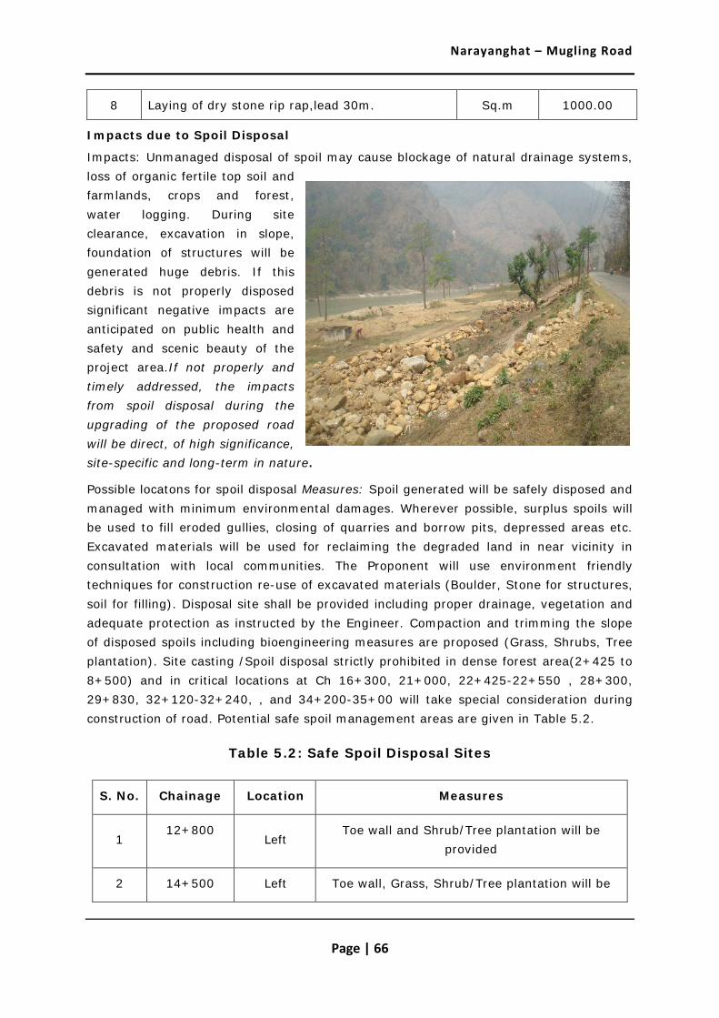
Narayanghat – Mugling Road
Page | 66
8 Laying of dry stone rip rap,lead 30m. Sq.m 1000.00
Impacts due to Spoil Disposal
Impacts: Unmanaged disposal of spoil may cause blockage of natural drainage systems, loss of organic fertile top soil and farmlands, crops and forest, water logging. During site clearance, excavation in slope, foundation of structures will be generated huge debris. If this debris is not properly disposed significant negative impacts are anticipated on public health and safety and scenic beauty of the project area.If not properly and timely addressed, the impacts from spoil disposal during the upgrading of the proposed road will be direct, of high significance, site-specific and long-term in nature.
Possible locatons for spoil disposal Measures: Spoil generated will be safely disposed and managed with minimum environmental damages. Wherever possible, surplus spoils will be used to fill eroded gullies, closing of quarries and borrow pits, depressed areas etc. Excavated materials will be used for reclaiming the degraded land in near vicinity in consultation with local communities. The Proponent will use environment friendly techniques for construction re-use of excavated materials (Boulder, Stone for structures, soil for filling). Disposal site shall be provided including proper drainage, vegetation and adequate protection as instructed by the Engineer. Compaction and trimming the slope of disposed spoils including bioengineering measures are proposed (Grass, Shrubs, Tree plantation). Site casting /Spoil disposal strictly prohibited in dense forest area(2+425 to 8+500) and in critical locations at Ch 16+300, 21+000, 22+425-22+550 , 28+300, 29+830, 32+120-32+240, , and 34+200-35+00 will take special consideration during construction of road. Potential safe spoil management areas are given in Table 5.2.
Table 5.2: Safe Spoil Disposal Sites
S. No. Chainage Location Measures
1 12+800
Left Toe wall and Shrub/Tree plantation will be
provided
2 14+500 Left Toe wall, Grass, Shrub/Tree plantation will be

Narayanghat – Mugling Road
Page | 67
provided
3 18+000 Left River Bank, Shrub/Tree plantation
4 33+140
Right Limited quantity, Left bank of kali khola, toe wall
and Shrub/Tree plantation will be provided
Impacts on Water Resources by Inadequate Drainage
Impacts: River Crossing and natural drainage will get blocked due to construction of road. This may be happen especially during the construction of embankments, shoulders, re-construction/repairing of culverts etc. The main impact of this is creation of temporary inundation areas closer to the above locations during rainy season. The impact due to this will be direct, of high significance, site specific, and long-term in nature.
Measures: The mitigation measures will be to provide adequate numbers of drainage structures in order to have minimum interference with natural drainage pattern of the area; channelize surface water discharge from side drains; do not block or divert water away from natural watercourse. Details about additional cross drainage structures to mitigate the water induced adverse impacts are as given in Table 5.3.
Table 5.3: Proposed Additional Cross Drainage Structures
Design Ch.
Q20
E/P Type
Size
Remarks
m3/s M
8+530 1.0 P HPC 0.9 New
11+675 0.8 P HPC 0.9 New
14+575 6.7 P SC 2.2x1.5 New
14+977 7.0 P SC 2.2x1.5 New
20+730 3.3 P SC 1x1.5 New
21+630 1.7 P HPC 0.9 New
22+685 0.7 P HPC 0.9 New
22+814 0.7 P HPC 0.9 New
22+980 3.1 P SC 1x1.5 New
23+235 0.8 P HPC 0.9 New
23+675 7.1 P SC 2.2x1.5 New
24+694 3.4 P SC 1x1.5 New

Narayanghat – Mugling Road
Page | 68
Design Ch.
Q20
E/P Type
Size
Remarks
m3/s M
26+880 1.6 P HPC 0.9 New
26+975 6.4 P SC 2x1.5 New
27+060 4.7 P SC 2x1.2 New
31+330 15.0 P SC 3x2 New
Source: Design Report, 2011
Impacts due to Quarrying Materials and Borrow Pit Operation
Impacts:Large amount of construction material such as the boulders, sand and aggregates material are required for pavement, retaining wall, breast wall, gabion wall and other structures. These materials are obtained from quarry site. The quarry site for these materials will be largely on local streams and hill slopes near the road alignment, which is adequate to meet the requirement. The extraction of materials from inappropriate places or in excessive amount can seriously damage the local environment. For example, quarrying from a high slope and fragile area can result slope instability, extraction of sand and gravel in excessive amount from river can cause riverbank cutting and erosion and changes in river regime. It may cause landslide, erosion or box cutting of agriculture land, impact on sensitive environmental areas etc. This will eventually affect the livelihood of local people. Impacts from quarrying and borrowing will be of direct, medium significance, site-specific and long-term in nature.
Measures: Quarry and borrow operation plan will be prepared and approved by Environmental Engineer; unstable sites, erosion prone area, forest area, settlements, fertile farm land will be avoided for quarry / borrow operation; quarry sites will be rehabilitated by providing appropriate civil engineering structures and bioengineering measures after the extraction is complete. Recommended quarry sites in the area are given below.
i. Narayani River Bank Material 1.5Km.
ii. Confluence of Trishuli & Jugedi Khola, 10+335
iii. Khahare khola at km 11+300
iv. Trishuli River Bank, 15+000
v. Ghaighat Trishuli River, 18+300
vi. Mahadev besi at about 50 km away towards Kathmandu on H 02
vii. Jhari Khola, EW-HW 17Km west of Narayanghat
viii. Kawaswoti Khola, EW-HW 35 Km west of Narayanghat

Narayanghat – Mugling Road
Page | 69
ix. Phampha Khola, EW-HW 12 Km East from Bypass Road
Impacts from Air, Noise and Water Pollution
The main construction activities that cause air pollution are earth works excavation, quarry operations, crushers, asphalt plants etc. These activities generate dust and noise, which directly affect the air quality. In addition vehicles and machinery emit smoke and fine particles. These substances will increase the local air pollution significantly during the construction stage. Air pollution will cause inconvenience to local people who reside closer to the proposed road or quarries etc. Burning of fossil fuel would result in far more environmental pollution due to emission of sulfur oxides (SOx), nitrogen oxide (NOx), Carbon dioxide (CO2) and particulates. Asphalt plants would also create problems of ash disposal and thermal pollution. Combustion of fossil fuels is considered to be the largest contributing factor to the release of greenhouse gases into the atmosphere.
Noise impacts will be significant during construction periods due to increase of vehicular movements and machinery and crushing operations, material transport etc. Increased noise will affect the nearby communities and wild animals.
During construction, exposed soil, excavated soil and excess soil can be washed off into river. Emissions from machinery, equipments, vehicles, quarries, crushes and asphalt plants can be dispersed with the wind and deposited in nearby water bodies.
Contaminated top soil due to oil, liquid and other chemicals from construction vehicles /equipment, sewerage, garbage and waste water from worker camps will washed out to nearby water sources causing water pollution and consequently affecting aquatic fauna and flora, farmlands and creating health hazards.
The anticipated impacts on air, noise and water pollution will be direct, low significance, local and short term in nature.
Measures: The following mitigation measures will be adopted to minimize the impacts.
Use of masks by the workers operating in the areas of high dust generation; avoid disposal of excavated materials in the water bodies; Use of ear muffles, helmet to lessen noise pollution during rock breaking and quarrying; cover dry material or make it wet during transportation. Ones a day water sprinkling will do during construction period.
Camp Sites and Storage Depots
Impacts: Contractor will establish camp if he bring labors from outside the area. Siting of camp may cause encroachment of agriculture land and alteration of drainage, solid waste and waste water problems. Impact will be direct, medium significance, site specific and short-term.
Measures: The mitigation measures will be use of local labors to avoid camp; rent local house instead of camp to keep labors; sitting camp away from productive lands areas; pay compensation for using private farm or lands for storage or camp. Appropriate camp

Narayanghat – Mugling Road
Page | 70
sites and storage depots have been observed at Jugedi, Dasdhunga, area where available private house and land.
Construction Equipment and Vehicles
Impacts: The Machine Intensive Road Construction Approach will use machineries and tools (Rollers, tippers, spreader, asphalt plant, water tanker etc.). The related negative impacts are increase in air, noise pollution due to emission of smoke, increase in vibration due to vehicular movement. Impact will be direct, high significance, site specific and short-term.
Measures: The safety gadgets should be provided for the labour during construction work. The equipment/vehicles deployed for construction activities shall be regularly maintained. All the vehicles deployed for material movement shall be spill proof to the extent possible.
Crusher Plants
Impacts: The establishment and operation of and crusher can be source of air pollution, noise pollution and even water pollution if it is placed near built up area and near the water sources. The impact is direct, low significance, local and short term in nature.
Measures: Crusher plant should be far from settlement, forest area. Better to buy from existing markets, to avoid all impacts.
Asphalt Concrete Plant
As the proposed road is asphalt concrete road, the operation of asphalt concrete plant can produce emission of carbon into the atmosphere. The impact is direct, medium significance, site specific and short term in nature.( New Addition)
Measures: To mitigate these impacts, following mitigation measures are adopted.
• Asphalt plant metal crusher activities should be controlled. (eg. Asphalt hot-mix plants should be downwind of close sensitive receptors such as schools, religious places, forest area etc.)
• Sites should be selected for these plants at least 500m away from the sensitive receptors.
• Temperature of the asphalt concrete plant should be controlled at appropriate level in order to control exhaust gasses to comply relevant emission standards.
Impact on Community Infrastructure
Impacts and Measures: The community infrastructure that requires reconstruction/ rehabilitation during construction works, and the mitigation measures are as presented in following Table 5.4.
Table 5.4: Impact on Community Infrastructure and Mitigation Measures

Narayanghat – Mugling Road
Page | 71
Infrastructure Chainage/ Location Distance from the
Road
Potential Impact
Mitigation Measure
Water Supply Pipe 13+250 (40 cm dia. GI pipe), 19+600 (HDP )
Crossing Damaged Will be
relocated.
Foot Trail
11+920, 12+950, 22+950,
31+02011+920, 12+950, 22+950,
31+020
Adjacent Damaged during road construction
Will be Reinstated
Water Source 12+425, 13+360 Adjacent Damaged Will be
protected.
Access road
4+420, 5+800, 5+950, 10+350, 11+000, 11+080, 14+600, 18+410, 19+200, 19+500, 25+950,
29+200
Damaged during road construction
Will be reinstated.
Existing resting place
4+260, 23+650, 29+050,
RoW No impacts
Open space
12+580, 14+550, 15+200, 15+800, 18+600, 19+850, 21+500, 22+950, 25+770, 28+000,
33+200,
RoW
Will be used for vehicle
stop, resting place (Toilet),
tree plantation, recreation
Park Madan Bhandari +
Jivraj Asrit park 13+365 Adjacent
Compound wall damaged during road construction
Will be reinstated.
Temple
Gaikhure Temple (18+500), Panch Kanya Mai (24+400), Jalbire
Temple(29+070), Pathi Devi (32+900)
RoW Damaged during road construction
Will be reinstated, protected
Electric Pole Many Damaged during road construction
Will be reinstated.

Narayanghat – Mugling Road
Page | 72
Infrastructure Chainage/ Location Distance from the
Road
Potential Impact
Mitigation Measure
Settlement area Open drain,
difficult to cross, block the drain
Drain cover/ Slab to cross the drain for
house
Stockpiling of Construction Materials
Construction material storage site pose adverse impact during construction stage. Erosion from stockpiled material will cause water pollution, land value degradation, loss of agricultural productivity, and nuisance. This impact is short term in duration, local in scale and short in magnitude.
The land for storing the construction material should be far from the agriculture land , forest and water bodies. As a procedural respect, concerned contractor need to fill in standard pro-forma – developed for this issue – and submit it to and secure approval from the Resident Engineer/Environmental engineer (including from the owner as and if required). Avoid leakage.
Decline in Aesthetic Value
Landscape degradation relates particularly to poorly designed or monitored activities resulting from quarrying operations and from indiscriminate dumping of spoil material. Road induced activities may lead to the generation and mismanagement of wastes in the roadsides and create scars on the landscape. The likely impact will be direct, low in magnitude, local nature and short term in duration.
The following mitigation measures will be adopted:
Indiscriminate dumping of spoil material will be discouraged.
After the extraction is completed, the quarry site will be rehabilitated to suit the local landscape.
Plantation of local species along the roadside/ open space will be done.
(ii) Chemicals
Use of Bitumen
Impacts: Bitumen is required for black topping. Spillage of bitumen damage soil productivity and pollution. Accident will occur. Moreover, it also bring adverse impact to human health as it can causes skin burning if not properly handled, distributed during construction period etc. It also causes water pollution. The impact will be indirect, high significance, local and short-term
Measures: The following mitigation measures will be adopted

Narayanghat – Mugling Road
Page | 73
• Use kerosene for heating and strict prohibition to heat bitumen by using fuelwood.
• Appropriate storage of material.
• Use of appropriate safety gears to ensure safe health of workers such as masks, boot, gloves, hat.
• The bitumen storage must not be on fertile land and nearby water bodies.
• Bitumen related work should not be carried out during the rainy condition.
Impact due to Accidental leakage of Fossil Fuel, Lubricants, Oil, Acids and other Chemicals used in Vehicle, Crusher Plants, Equipment etc.
During construction period, large number of vehicles, crusher plants and several other equipment will be operating in the field. Due to significant number of vehicles, there is likely of accidental leakage of fossil fuel, lubricants, oil, acid and other chemical used in vehicles, crusher plants, and equipment if all these are not properly maintained and repaired from time to time. It could bring malefic effects to the environment. If it is exposed to the human being, aquatic animal, it even brings carcinogenic effects (Cancer induced effect) to the human being. The impact will be indirect, high significance, local and short-term.
(iii) Biological Environment
Impact on Vegetation and Forest Resources
Impacts: The proposed road passes through forest areas at various stretches. Accordingly, the existing road in its nearly 30 years of existence has created some ecological impacts, including those related to habitat fragmentation and affecting free movement of wildlife in forest landscape. The upgrading of the road will slightly result in acerbating this effect due to widening of the formation width.
The proposed road passes through 9 community forests and Government forest. From the community forest and government forest, total 261 numbers of various species and 3.97 Ha.
Table 5.6 : Forest Area to be diverted for the Project
Chainage Total Length,
m
Average Existing width,m
Additional width
required
Additional Area sq. m
Additional Area in
Ha. Remarks
From To
2+425 5+500 3100 9 2 6200 0.62 Dense forest, GF, CF
5+500 8+500 2900 8 3 8700 0.87 Dense forest, GF,CF
12+850 16+500 3650 7.5 3.5 12775 1.28 CF

Narayanghat – Mugling Road
Page | 74
17+300 18+700 1400 7 2 2800 0.28 CF
21+800 23+300 1500 6.5 2.5 3750 0.37 CF
24+000 26+200 2200 6.5 2.5 5500 0.55 CF
32+727 33+900 1173 7
0 0 CF
Total 39725 3.97
Forest area will be removed during road construction. Sal, Simal and Khayer are found in abundance and by removal of few trees will not cause any adverse impact on the species.
In addition, all felled trees are subject to compensatory plantation as specified by the Department of Forest in the ratio of 1:25. The impact of this will be confined to the road alignment and thus will be local, direct, long-term and of medium significance. Vegetation that fall within Construction width (11 m and 9 m): About 261 nos trees found to fall within road width of 11 upto 16 KM and 9 m upto Mugling. Data of every tree has been given distance from road edge, girth of tree and tentative height of tree, Location and chainage. The details are given in Annex 5.1.
Measures: The loss of trees is largely not significant and has been minimised to the possible extent. However, even this small loss can be compensated by the plantation. According to the Work Procedure for Providing the Forest Land for Other Use, 2063 of Government of Nepal, project has to carry out plantation (with protection for five years) equivalent to the forest area lost from the construction of the road or pay for the plantation and protection cost to the District Forest Office(DFO). If the trees lost are having more than 10 cm diameter than 25 times more trees will be planted. Table 5.7 shows the number of trees to be removed and compensatory plantation cost in forest, community forest. This cost will be provided to the concerned District Forest office/ Community Forest user groups (CFUGs) by the project. Location and type of species for the plantation will be selected by the concerned DFO/CFUGs.
Table 5.7: Compensatory Plantation Requirements
Chainage Name of Forest Major Species
Trees to be
removed
Compensatory plantation no. (1:25 ratio)
2+425 -8+500
Government forest, Community Forest
Sal, Chatiwan, Bod dhayaro,
Rajbrikshya 39 975
8+500 – 35+677
Community Forest Padke, Khayer, Saj, Velder,
222 5550

Narayanghat – Mugling Road
Page | 75
Chainage Name of Forest Major Species
Trees to be
removed
Compensatory plantation no. (1:25 ratio)
Chatiwan,Bod dhayaro
Total 261 6525
However, emphasis will be given to local, rare, endangered and protected species. The forest products from the CFs will be utilized by the CFUGs according to their operational plans. For the plantation of 6525 trees, total estimated cost is NRs. 1305000 (plantation cost is NRs. 200/plant with protection 5 years).
Legal process/procedure for Tree Cutting
Impact on Wildlife Habitat and Movement
The road is already of 8-9 m width in BFC section (Ch 2+425 to 8+500) and therefore the impact from the proposed project is not very significant. Only 2-3m additional will be required. The anticipated impacts will be of medium significance, locally confined but long-term. However, the existing road has fragmented the natural wilderness area when it was first constructed about 30 years ago. This impact of this fragmentation and to avoid future induced impacts will require certain management measures to restore the free movement of wild animals to the possible extent and avoid accidents with heavy traffic that is using this road. During field survey mainly between Km 3+550 and 7+600, some wildlife crossing/ movement area was found.
Concern Project DoR MoPPW
MoF
Verify P1 Project from NP, If Yes,
DoF
DFO for verification
Government (Cabinet) decision for approval
With support of DFO

Narayanghat – Mugling Road
Page | 76
Table 5.5 : Wildlife Crossing Area
Chainage Location Duration
3+550 Right - Main Habitat Mostly in night and during silent time of the day
7+600 Right - Main Habitat Mostly in night and during silent time of the day
Measures: Site clearance for construction shall be limited to the minimum width. No tree or vegetation shall be cut unless absolutely necessary. Afforestration program shall be done in open space in forest area. The construction activities near forest area will be appropriately managed so that there will be least disturbance to the wildlife and birds. Workers shall be actively discouraged from collecting fuel wood from forest or Poaching/harassing of birds or animals. Project will coordinate with DFO/CFUG to control the activities like illegal Poaching and poaching by enforcing acts and regulations strictly.
Also, there are critical sections, on the valley side, which directly fall into the river. Improper construction practices may affect the aquatic life of Trishuli river. During widening the road, special considerations are needed in these locations. These are: Km 16+300, 21+000, 22+425-22+550 , 28+300, 29+830, 32+120-32+240, and 34+200-35+00. The anticipated impacts will be of medium significance, locally confined and long-term
Wildlife crossing area at Ch 3+550 Wildlife crossing area at Ch 7+600
Measures: The construction activities near forest area and areas of wildlife habitat should be managed so that least disturbance to the wildlife occurs. Following recommendations are being made:
• Under passes and traffic calming measures to facilitate wildlife crossings (3m height and 6m length)
• Develop/improve water holes for wildlife within the BFC core area

Narayanghat – Mugling Road
Page | 77
• Support habitat improvement for wildlife within the BFC core area with DoF’s help (possible areas for such development can be referred in the Map 5.1).
• Workers should be educated through an awareness program about the importance of wildlife for maintaining the ecosystem.
• It is recommended to work during day time to minimize the disturbances to the wildlife.
• Provision of drain covers from 2+425 to 8+500 to be incorporated in design.
• Posting of environmental signboards (illustrated and in local language) will be displayed in more wildlife occurrence zone.
• The Contractor will be obliged to instruct the work personnel and enforce action for preventing access of labourers to nearby sensitive areas, as identified by the Consultant.
• Harassment to wildlife by the workforce will be strictly restricted.
• In critical locations will not through excavated materials in downhill/river will be transport in designated locations.
Map No. 5.1
Grassland and Wetlands within BFC Area

Narayanghat – Mugling Road
Page | 78
• Biodiversity management plan will be developed.
• Afforestration program shall be done in open space in forest area. Make additional wetlands for wildlife.
• Environmental unit (Environmental Specialist) of the project will monitor regularly.
It is assumed, with appropriate control and enforcement measures at hand, that such impacts on wildlife along the roadside corridor will be of low significance.

Narayanghat – Mugling Road
Page | 79
Impact on forest resources due to Source of Energy/Fuel
Construction Crew/Contractor will use forest resources within vicinity by illegally collecting firewood for cooking and heating purpose, and for construction. This is an adverse impact of short-term duration, local in scale and medium significance.
Following mitigation measures will be adopted for avoiding the use of forest wood for cooking and heating.
• For construction crews stationed at the camp, contractor will provide kerosene or gas for cooking and heating.
• Kerosene will be used for heating of bitumen/asphalt plant.
• Use of forest wood will be restricted for meeting the fuel needs.
• Respective provisions will be included in the contract agreement document with contractor.
Effect on Aquatic Life
The road alignment passes through left bank of Trisuli river which is rich in fish fauna. The road construction activities foundation excavation in valley, slope cutting will likely increase sediment load in this river.
Measures: In design, the slope cutting has been minimized as far as possible. For widening the road special retaining structures has been proposed to reduce excess excavation materials in valley side. Site casting will be strictly prohibited in critical locations. During road construction will be given priority for fishery men in road construction, will provide them skill enhancement training which help to preserve aquatic life of Trishuli river.
(iv) Socio- economic Environment
Impacts due to Traffic
During construction period, especially during the spreading the bitumen surface, no vehicles are allowed to come for some interval of time till it completely dry up. These could lead to traffic congestion. It will increase the travel time of local people.
Traffic congestions will occur during the construction period especially near townships and buildup areas due to increment in number of vehicles brought for construction activities. Generally traffic jam will be significant during morning and afternoon rush hours. This kind of impact is direct, low significance and short term in nature.
Impacts on Community Infrastructure
Few temporary structures (encroachment of the RoW used to build temporary boutiques retail centers, fences, & front walls etc.) of the road side may need to be shifted.

Narayanghat – Mugling Road
Page | 80
These houses will be compensated under land acquision act; other affected structures include a number of drinking water sources, chautaries and temples. Moreover, few water drinking pipe need to remove due to road widening activities.
Any damages during construction of road are subject to immediate repair under the responsibility of the Contractor. The impacts (immediate loss of assets) will be direct, irreversible, medium significance on community level, site-specific and long-term in nature.
Table 5.7: Religious Sites along the Road Alignment Likely to be Affected
Type of Public Service and Infrastructure
Chainage/ Location and side of road
(left / right)
Distance from of Road
Edge (m)
Potential Impact
Madan bhandari+ Jivraj asrit park
Left; 13+500 1 Public
infrastructure can be damaged
Temple on block factory
Left; 15+050 1.5 Can be damaged
Gaikhure temple Left; 18+500 0.5 Can be Damaged
Pancha kanya mai Left; 24+400 12 No
Jalbire temple+ Chautari
Left; 29+070 3 Can be affected
during construction
Pathi devi mai temple Left; 32+900 2.5 Can be affected
during construction
Impact on health of workers and local people living along the road corridor. Occupational Health and Safety, STDs
As the construction activity requires works such as rock cutting, slope cutting, handling of hazardous material, machinery movement, bitumen work, the workers and general local people will be prone to risk of accidental damage at construction sites.
Other impact could be due to from poor labour camp condition. Unsafe water sources and unhygienic conditions (lack of latrines and washing facilities) bear the risk of additional and often endemic diseases, such as dysentery, diarrhoea and cholera. Uncontrolled water logging and badly managed borrows pits bear the risks of spreading water-borne diseases like malaria and dengue fever. Sexually transmitted diseases and HIV/AIDs as a result of the possible influx of migrant labourers / construction workers is

Narayanghat – Mugling Road
Page | 81
rather low due to the priority to be given to local hiring of labor and the still strong social control in the villages.
Other potential impacts to health are respiratory and eye disease due to exposure to dust and emissions. In the absence of stringent health & safety regulations and regular training through the Contractor, the identified impacts will be, with exception of HIV/AIDS, direct, high significance, local and short-term in nature.
Measures: The workers shall be provided and made mandatory the use of helmets, safety belts, masks, gloves and boot depending on nature of work; provide clean drinking water at sites and camp; pit toilets at sites and camp; first aid facilities at sites and camp with training to use them; provide group accidental insurance for workers. Awareness generation to local people and workers on HIV/AIDS and other communicable diseases
Pressure on Social Service Facilities
For road construction activity, there will be requirement of large numbers of construction labur force. For meeting the need of the construction worker, there is likely of having pressure on existing local social service facilities such as telephone, water supply, solid waste management, health and medicine, transportation and school (if they come with family) etc. This impact will be indirect, low significance, short-term and local in nature.
Conflicts due to Influx of Construction Workers
The amount of money that enters into the area during construction phase as wage payment may induce local inflation. Increased income of local labours and construction crews of contractor can lead to negative impacts such as spread of alcohol consumption, gambling and prostitutions. Influx of migrant workers also bears potential dangers of girl and boy trafficking, as well as HIV/AIDS as mentioned before. These impacts leading possibly to social and cultural conflicts will be indirect, medium significance, local, and short-term in nature.
Impact due to unawareness on camp sanitation issues by the laour
The labours in camp are source of production of huge solid mass. If it is not properly addressed then there is likely of spreading and emergence of disease among the labour in camp. The impact from unawareness on camp sanitation by the labour will be direct, local and short term in nature.
Impairment in existing environmental condition due to influx of labour
Because of huge dependency on the fossil fuel, vehicles, and other natural resources, the environment could b be impaired. The impact from unawareness on camp sanitation by the labour will be direct, local and short term in nature.
5.2.2 Operation Stage
(i) Physical Environment

Narayanghat – Mugling Road
Page | 82
Landslide and slope failure
As the road alignment area is geologically weak area, Landslide will occur at ch 14+000, 17+000-17+500, 23+000, 26+500 area. It will block the road ach year and require for the rehabilitation and maintenance. This may cause damage to road. The impacts will be direct, low significance, site-specific and long-term in nature.
The following mitigation measures will be adopted:
• Maintenance of the slope protection measures and drainage works
• Minor landslide and mass wasting will be immediately cleared and slope restored with appropriate technology (bioengineering)
• Soil conservation activities such as tree shrub plantation will be promoted in the right of way and vulnerable areas beyond the road alignment
• Environmental awareness programs will be organized for local communities so that quarrying in road side hill slopes, grazing cattle on unstable areas will be controlled.
Impacts on Water Resources caused by Poor Drainage
The road project aims to improve the road drainage facilities by constructing proper drain and rehabilitating culverts to facilitate better flow especially during rainy season. It will be constructed as per design. But on operation phase, the drain and culvert may block due to sediments, improper disposal of debris or disposing garbage into side drain by the general public. It will create overflow of drains and alteration of surface runoff paths causing soil erosion and health hazards, sometimes, it also bring completely failure of drainage structure. It will also induce siltation in nearby stream which can bring flood as well as affects the flora and fauna living in nearby water bodies, if maintenance activity is not carried out from time to time.
In order to avoid such impacts, the following mitigation measures will be adopted:
• To minimize the impact it is proposed to close the side drains especially near towns and maintain regularly to avoid blockage of water.
• Maintenance of smooth discharge across culverts and cross drainages by cleaning and maintaining them regularly so that water logging on adjacent land due to road do not occur.
• Roadside drain water will not be discharged into farmland or environmentally sensitive locations.
• Regular cleaning of roadside channels to avoid any blockage of drainage.
Impact Due to Air, Noise, Water and Soil Pollution
Impacts:. As the road is Asian Highway category and the vehicular movement is expected to be very high, noise pollution will be high. However it may cause nuisance to wildlife, local resident. Noise may disturb wildlife of the area, particularly birds which

Narayanghat – Mugling Road
Page | 83
may get scared by the sound of vehicle and horn. Aptati to Jugedi area are more sensitive to wildlife.
The impact due to air and noise pollution will be direct, low, local and long term.
Increase in settlements, hotels and lodges will result in increased organic and inorganic solid and liquid wastes. The disposal of household wastes, washing of vehicles in water bodies will degrade the water quality. The impact will be direct, low, local and long term.
Measures: Measures to be adopted will include plantation of trees on both sides of the road as far as possible; Speed limit of maximum 40 km/hr in forest area mainly from 2+425 to 8+500 section, awareness program for drivers to drive below design speed to avoid wildlife accident; Minimal or no use of horn; Erect signs at wildlife crossing areas. To control vehicle speed, mechanism will be developed (fixed time to reach one place to another place in Forest area (2+425 to 8+500) by providing ticket to all vehicle operators) in coordination with environment management committee involving DoR, DFO, CFUG, Traffic Police etc.
Impact on Sanitation of the Area
Impacts: Increased traffic volume will also bring several problems including solid waste management problems, open urination and defecation along the road, open disposal of food packages and plastic water bottles and bags that will pollute the area. Travelers can also throw such packages from vehicles. They might cause adverse impact on wildlife if they consume the plastic materials. The impact will be direct, medium, local and long term nature.
Measures: The mitigation measures to be adopted will be plastic bags will be banned in the area. Restrict haphazard throwing of garbage by the travelers. A system of travelers carrying back their water bottles can and garbage can be introduced, or tax levied for cleaning them by local authorities. Awareness programs organized, notice boards shall be erected and travelers requested not to pollute the area. Public urinals shall be constructed every 10 KM at vehicle stops, and open defecation shall be fully restricted. The possible locations are 12+580, 14+550, 15+200, 15+800, 18+600, 19+850, 21+500, 22+950, 25+770, 28+000, 33+200. Drivers, lodge owners and local residents shall be given awareness and orientation trainings on maintaining clean and sanitary environment.
(ii) Biological Environment
Impacts on Forest Resources
The pressure on forest and forest resources during operation phase will result indirectly from the improved public/vehicular access to forest lands. Undesired cumulative and induced impacts may include accelerated logging, illegal extraction of timber and other forest products, incidental forest fires, and the introduction of invasive species (weeds, pests). Depending on the setting and the incidence, impact prediction may range from low to high significance, locally and regionally, and medium to long-term.

Narayanghat – Mugling Road
Page | 84
Measures: With support of DFO/CFUG and VDCs/DDC and local community in controlling illegal harvesting of forest resources.
• Provide awareness program to local communities for preserving specific forest products
• Promote the cultivation of Rare species, NTFPs
• Promote replacement of firewood by non-forest energy sources such as biogas, subsidized kerosene, gas.
Disturbance to Wildlife and/or Poaching
Fast vehicular movement (especially during night time) and excessive use of horn in forest and other habitats may disturb wildlife. Poaching and killing can increase due to access facility. Important wildlife including Leopards, Deer, Wild boar, Chittal, Syal, Harin, Monkey, Khayaro, Dumsi live in the Barandabar Forest Corridor. The impact will be indirect, high significance, local and long term in nature.
Measures: Erect appropriate sign boards like 'no horn area', provide 'under passage for wildlife', informing drivers on prohibition of blowing horns in the forest areas. Rule will be made (make a fixed time to reach from starting point of forest to end point of forest area by providing ticket to vehicle operators). Wildlife crossings shall be provided at regular intervals in potential habitat areas. Vehicles shall not be stopped in between dense forest area (From Ch 2+425 to 8+500). DFO/CFUG has been well managing the conservation area. Monitoring and punishment to defaulters will be done by DFO. Poaching of wildlife should be strictly restricted in cooperation with DFO/CFUG. Community and authorities will remain vigilant and alert on killing of wildlife. Afforestration program shall be done in open space in forest area. Make additional wetlands. Provide additional forest guard.
It is assumed, with appropriate control and enforcement measures at hand, that such impacts on wildlife along the roadside corridor will be of low significance.
Pollution of Water Sources
As the road is in operation, more vehicles will be moving on the upgraded road surface. So it is common to see the inappropriate driver practices connected with car/truck washing in streams and rivers which can cause local water pollution by leakage of fuel, lubricants and hydrocarbons that may not only affect the aesthetic value of the water body, but also put hazards on people and animals using these as drinking sources. Continual water pollution will also affect the aquatic biota, with subsequent negative consequences for fisheries and the economic return of fisher folk depending on these natural resources.
Measures: The washing of cars in rivers and creeks should be strictly controlled (by road police and/or CBOs) and violators be penalized. In places where car washing habits have evolved, it is advised to erect signboards (illustrated and in local language) that explain the inherent risks for people utilizing the source for drinking and aquatic life, and also

Narayanghat – Mugling Road
Page | 85
indicate penalties for violators. The vehicles are regularly checked whether it is in good condition or not by the government. It should be within government policy.
iii) Social, Economic and Cultural Environment
Population Pressure and Impact due to New Settlement along the Road
After the construction, the Row can be encroached at any time mainly for putting up small boutiques, vegetable and fruit sales stalls, or demarcating land boundaries. The encroachers will build permanent or temporary structures within the existing reservation causing damages to pavements, side drains or even for the soft shoulder of the RoW. It was observed during the field investigations that some people have put up live fences or temporary sales huts Encroachment of the RoW directly affect the pedestrian, regular maintenances as well as future expansions of the road.
Ribbon settlement can cause significant and long-term adverse impacts if such activities cannot be avoided in time by enforcing strict legal action and social pressure.
Discouraging ribbon settlements along the road awareness raising programme through local organizations to plan proper settlements Enforce regulate settlement growth in RoW. Promote tree plantation program in Row which makes barrier.
Social Conflicts
Access facilities will bring social nuisance like increase in alcohol consumption, gambling, prostitution, and will increase girl trafficking. The impact will be indirect, medium, local and long term in nature.
Support awareness raising programs against such nuisances.
Road Accidents
The widening and improving of the surface conditions induces high vehicular speed. As a result, there will be a risk of increased of road accidents, impacts on wildlife. The proposed road passes forest area, small settlements. These places are susceptible to accidents. Moreover there are many residents, shops and small boutiques located closer to the road. Therefore high speed vehicle movements will cause road accidents. The anticipated impacts will be direct, medium significance, local and long term in nature.
After the operation of road services, chances of accidents increase. In order to minimize such incidents following safety measures and restriction on speed will be adopted.
Table 5. : Potential/Critical Accident Areas
Chainage Location
16+300 Left

Narayanghat – Mugling Road
Page | 86
21+000-21+300 Left
22+425-22+550 Left
28+300 Left
29+400-29+900 Left
32+120-32+240 Left
33+000-33+175 Left
34+200- 35+000 Left
• Required delineators, safety signs etc. will be included in design appropriate along the road.
• Road safety awareness programs will be conducted
• It is also recommended to place illustrated sign boards at accident-prone spots and bus bays.
• Speed limit, No horn, warning signboard in forest, animal crossing area.
The potential impacts have been predicted in terms of their magnitude of significance (low, moderate and high), extent (site specific, local and regional) and duration (short term, medium term and long term) as well as their nature (reversible, irreversible).
Chapter 6 : Consultations with Stakeholders

Narayanghat – Mugling Road
Page | 87
6.1 Introduction
The project organized consultations/meetings with key stakeholders, including the local communities. The communities and other stakeholders were informed on the
proposed project’s scope, design interventions, resettlement principles, environmental safeguard provisions and Entitlement Framework. These meetings
were used to get wider public inputs from both the primary and secondary stakeholders. The consultation process and disclosure of information about the
project was primarily aimed to share information about the following:
a) Relevant details of the project scope and schedule b) Potential impacts and degrees of likely project impact c) Details of the entitlements and the eligibility for R&R benefits d) Implementation Schedule with a timetable for the delivery of entitlements e) Detailed explanation of the grievance process and other support in arbitration f) Special consideration and assistance of all vulnerable groups and g) Various environmental management measures to avoid/minimise issues, including
those pertaining to health and safety
6.2 Stakeholders Consulted
The project consulted both primary and secondary stakeholders during the environmental and social assessment. These consultations/meetings with key stakeholders included the local communities and persons likely to be affected by the project. These meetings were conducted at Ramnagar Bazar, Jugedi, Debitar, Dasdhunga, Simaltal, Santibazar and Mugling located along the existing road.
Additionally, the government organizations and officials from these concerned government departments such as Road Project Office, District Administration Office, District Land Survey Office, District Land Revenue Office, District Development Committee (DDC) Office, District Forest Office and District Agriculture Office were consulted in the District Headquarters.
Along the project road stakeholders that were involved in the consultation process included:
a) Village Development Committee (VDC) representatives: Though there are no elected VDC representatives when the environment and social assessments were carried out , the VDC secretary has been deputed as VDC chief or office-in-charge by law. And so, the VDC secretary was included in the consultation process as a responsible person for local affairs and who also served as a source of information about the area represented.
b) The group of women in different sections were consulted to understand and to assess the access to development infrastructure as well as the pattern of economic subsistence. The women were selected from different sections of the

Narayanghat – Mugling Road
Page | 88
society that included women from different economic strata, literacy levels and from different caste groups.
c) Political party representatives from different ideologies were consulted to facilitate the discussion and with an objective to neutralize the local conflict/s, if any during the disbursement of compensation for the structures and R&R assistance.
6.3 Methods Used
The task of public consultation was carried out in different settlements during various stages of project preparation. In fact, from the earlier stage of the reconnaissance survey to the period of census surveys (for RAP preparation), the team consulted the community at every stage.
Table 6.1: Method/s Employed for Consultations
Stakeholders Purpose Method
Department of Roads at Central Level
To collect government's policy, guidelines and appreciate priorities on the project, and to seek advice for initiating work.
Frequent individual meetings with the officials of DoR and Project Directorate.
Local Community in the different settlements located along the project road.
To assess the over-all perception and importance about the project road and local people’s felt need for improvement
Consultations through village meetings and focus group discussions at different locations during reconnaissance survey, social survey and survey of affected households.
District level line departments/ agencies (Divisional Roads Office, Land Revenue Office, Land Measurement Office)
To assess the existing operational status of the road, to verify the land likely to be acquired based on design drawings, to collect cadastral maps and land price fixed by District Land Revenue Office.
Individual meetings with the officials of the concerned departments.
Persons Likely to be affected by the (identified based on the design drawings)
To prepare inventory of the affected assets and get measurement and conduct interview with the affected
Individual interview of the affected households by means of a structured questionnaire

Narayanghat – Mugling Road
Page | 89
Stakeholders Purpose Method
families about the affected assets and on the household matters
Individual consultations with district level government authorities/officials in the district headquarters were conducted to understand their perspective, administrative structure and seek feedback on proposed project interventions (design, environment as well as social). Several rounds of consultations were carried out along the project road. The last round of consultation was carried out between December 1, 2012 to December 4, 2012 at all major settlements along the corridor. Prior to this, consultations were carried out during March 2012. The number of participants in each consultation and issues raised by the participants is presented in Table 6.2 and 6.3.
The scope of consultations, especially with the local people and project affected persons was focused to inform them about the nature of the proposed project and its activities. During the consultations, people were also informed about the possibilities of acquisition of private land and other physical assets by the project. Likewise, the people were also made aware about the acquisition of community properties like public taps. Options of relocation, shifting and loss of employment and provision of livelihood support to the vulnerable groups were some of the other issues discussed during the consultations. In addition, along with information

Narayanghat – Mugling Road
Page | 90
dissemination, the consultations also aimed at taking people’s opinion and their suggestions on the project design and possible ways to enhance the benefits and reduce impacts.
The consultation process has also specifically sought inputs on the availability and use of local resources (including the forest and water sources), wildlife sightings/presence, animal kills due to accidents on the road, NTFPs etc. While useful information was obtained that has presented in other relevant sections of this report, from a local perspective, issues around the likely impact on property, compensation/assistance and employment were the pre-dominant ones in the minds of the people.
6.4 Key Issues/Concerns Raised and Suggested Measures
On the whole, there was complete willingness on the part of the local people to cooperate in all matters related to the project and they completely supported the project. However, a few key issues were raised by stakeholders during the meetings which are summarised below:
a) Involvement of local people in project design finalization: Being the major stakeholders and the people directly affected by the project, the local communities/ people voiced that they must be kept informed and consulted with regard to the project design and any changes thereof.
b) Employment opportunity for local people should be ensured during project construction by hiring of locals as skilled and unskilled labour.
c) Fair and timely compensation rate: The local community was quite positive towards the project and had no reservations regarding the project provided they are adequately compensated for all their losses whether partial, complete, agricultural, residential or commercial.
d) Special consideration was sought for the vulnerable households affected by the project - either by changing the technical design or through supplementary compensation.
e) Regular monitoring of the project during implementation by the project authority to ensure the technical quality of work and environmental conservation (particularly to prevent/minimise landslides).
f) Provision of a separate unit in the project to listen to the suggestions and grievances of the local people.
Most of the issues raised are related to appropriate valuation and compensation of land and other assets of project affected people. People have demanded for Life Skill Enhancement Training (LEST) and employment opportunities. Based on the consultations, the RAP has the provisions of LEST, income generating activities, and preferential employment of PAPs in the construction works.

Narayanghat - Mugling Road
Page | 91
Table 6.2 : Public Consultation Matrix - March, 2012
VDC/ Municipality
Settlement Date Participants Issues Raised in
Consultation Suggested Measures to Resolve the
Issues Responsible
Agency
Bharatpur Ramnagar 2067-11-13 and 2068-11-23
32+ ROW of this road section should be declared to only 30 meter as of Mugling-Naubise road.
Reasonable compensation should be provided for the affected structures.
The land within ROW was acquired by the government and so people are asking for compensation in any form of payment.
Community services.
Department of road will take necessary action against definition of RoW of this road section.
Appropriate compensation will be provided to the affected persons.
Community services support needs to be provided, such as school buildings, libraries, drinking water supply system, market sheds, hospitals and ambulances for the local people as part of rehabilitation and income restoration plan.
DOR, CDC, Project
Kabilas Simaltal 2068-11-23 27 Notification to the people before commencement of upgrading the Road.
Demanded declaration of 15 meter ROW in hill side
Local community will have full support to the project during the construction
Appropriate compensation to the affected persons.
Updated information to the local people to be provided at least three months earlier in case of translocation.
Priority to the local labour Similar types of land should be
made available for the resettlement purpose to continue the present occupation
More attention to be given to check human trafficking and HIV/AIDS
DoR, CDC, Project

Narayanghat - Mugling Road
Page | 92
VDC/ Municipality
Settlement Date Participants Issues Raised in
Consultation Suggested Measures to Resolve the
Issues Responsible
Agency
Kabilash Jugedi 2067-11-13 11 Affected public utilities should be relocated with the participation of local community.
Consideration should be given for the appropriate management of drainage.
Consultation and participation of local people during construction period is necessary.
Local community will fully support the project during the construction.
Loss of electric polls, drinking water taps and provision of public resting place from one kilometer to Jugedi bridge
Consideration will be given to relocate the public utilities with the consultation of local people.
Attention will be given to provide and maintain the appropriate drainage during construction.
Consideration will be given for participation and involvement of the local people during the construction period.
Local support will be appreciated for smooth construction of road.
Proper rehabilitation of all such impacts prior to the construction of road.
Project, Contractor

Narayanghat - Mugling Road
Page | 93
VDC/ Municipality
Settlement Date Participants Issues Raised in
Consultation Suggested Measures to Resolve the
Issues Responsible
Agency
Chandibhan jyang
Khahare khola
2067-11-17 22 Road construction should be reliable and sustainable.
Drainage should be properly managed during construction
Employment priority should be given to the affected family.
Appropriate compensation should be given to the affected households.
Affected public structures like toilets should be relocated in the presence of local people.
Efforts will be made to incorporate suggestion of local people.
Attention will be given to proper management of drainage.
Employment priority will be provided to the affected family.
Compensation will be provided to the affected households.
Affected public structure will be relocated with consultation of local people.
Covered drain systems should be maintained in the settlement areas.
CDC, Project, Contractor

Narayanghat - Mugling Road
Page | 94
Table 6.3: Public Consultation Matrix - December, 2012
VDC/ Municipality
Settlement Date Participants
Issues Raised in Consultation Suggested Measures to
Resolve the Issues
Responsible Agency
F M T
Chandibhanjyang
Khahare khola (Santibazar)
2069-08-15 12 14 26 Compensation for loss (Private structure and business).
Community services like Public water supply, Public Toilet, Temple will be affected by the project.
Suitable location to set culvert outlet.
Appropriate compensation will be provided to the affected persons.
Community services like Public water supply, Public Toilet, Temple to be reconstructed by the project if damaged during construction.
Project to set the culvert outlet in suitable location consulting the local people during construction of this project.
DOR, CDC, Project
Bharatpur Municipality
Ramnagar 2069-08-16 12 25 37 Compensation for loss (Private structure and business).
Community services like public water supply, Public Toilet, Temple will be affected by the project. Similarly they made request about waiting place /public resting places and guesthouse for YATRU.
Appropriate management of drainage.
Consultation and participation of
Consideration will be given to relocate the public utilities with the consultation of local people.
Attention will be given to maintain the appropriate drainage during construction.
Consideration will be given for participation and involvement of local people during construction period.
Local support is appreciated.
Project, Contractor

Narayanghat - Mugling Road
Page | 95
VDC/ Municipality
Settlement Date Participants
Issues Raised in Consultation Suggested Measures to
Resolve the Issues
Responsible Agency
F M T
local people during construction period is necessary.
Local community will have full support to the project during the construction.
Appropriate compensation will be provided to the affected persons.
Kabilas Debitar 2069-08-16 18 8 26 Notification to the people before commencement of upgrading the Road.
Request to reduce RoW
Local community will have full support to the project during the construction
Appropriate compensation to the affected persons.
Community services like public water supply, Public Toilet, Temple will be affected by the project. Similarly they made request about waiting place /public resting places and guesthouse for YATRU.
Human Trafficking and HIV/AIDS.
Updated information to the local people to be provided at least three months earlier in case of translocation
Priority to the local labour
Similar types of land should be made available for the resettlement purpose to continue the present occupation
More attention to be given to check human trafficking and HIV/AIDS
DOR, CDC, Project
Kabilas Simaltal 2069-08-16 13 42 55 Compensation for loss (Private structure and business).
Appropriate compensation will be provided to the affected persons.
CDC, Project, Contractor

Narayanghat - Mugling Road
Page | 96
VDC/ Municipality
Settlement Date Participants
Issues Raised in Consultation Suggested Measures to
Resolve the Issues
Responsible Agency
F M T
Community services like public water supply, Public Toilet, Temple will be affected by the project.
Drainage should be properly managed during construction.
Employment priority.
Appropriate compensation.
Affected public structures like toilets should be relocated in the presence of local people.
Community services like Public water supply, Public Toilet, Temple should be reconstructed by the project if damage during construction.
Efforts will be made to incorporate suggestion of local people.
Attention will be given to proper management of drainage.
Employment priority will be provided to the affected family.
Compensation will be provided to the affected households.
Affected public structure will be relocated with consultation of local people.
Covered drain systems to be maintained in the settlement areas.

Narayanghat - Mugling Road
Page | 97
VDC/ Municipality
Settlement Date Participants
Issues Raised in Consultation Suggested Measures to
Resolve the Issues
Responsible Agency
F M T
Kabilas Dasdhunga 2069-08-17 11 41 54 Compensation for loss (Private structure and business).
Community services like Public water supply, Public Toilet, Tample will be affected by the project.
Drainage should be properly managed during construction.
Employment priority.
Appropriate compensation.
Affected public structures like toilets should be relocated in the presence of local people.
Reloction of Madan-Asrit Park.
Appropriate compensation will be provided to the affected persons.
Community services like Public water supply, Public Toilet, Tample should reconstruct by the project if damage during construction.
Efforts will be made to incorporate suggestion of local people.
Attention will be given to proper management of drainage.
Employment priority will be provided to the affected family.
Compensation will be provided to the affected households.
Affected public structure will be relocated with consultation of local people.
Covered drain systems should be maintained in the settlement areas.
DoR, Project
Darechok Mugling 2069-08-17 7 8 15 Compensation for loss (Private structure and business).
Appropriate compensation will be provided to the affected persons.

Narayanghat - Mugling Road
Page | 98
VDC/ Municipality
Settlement Date Participants
Issues Raised in Consultation Suggested Measures to
Resolve the Issues
Responsible Agency
F M T
Community services like Public water supply, Public Toilet, Tample will be affected by the project.
Drainage should be properly managed during construction.
Employment priority.
Appropriate compensation.
Affected public structures like toilets should be relocated in the presence of local people.
Community services like Public water supply, Public Toilet, Tample should reconstruct by the project if damage during construction.
Efforts will be made to incorporate suggestion of local people.
Attention will be given to proper management of drainage.
Employment priority will be provided to the affected family.
Compensation will be provided to the affected households.
Affected public structure will be relocated with consultation of local people.
Covered drain systems should be maintained in the settlement areas.
Kabilas Jugedi 2069-08-18 27 35 62 Compensation for loss (Private structure and business).
Community services like Public water supply, Public Toilet, Tample will be affected by the project.
Appropriate compensation will be provided to the affected persons.
Community services like Public water supply, Public Toilet, Tample should reconstruct by the project if

Narayanghat - Mugling Road
Page | 99
VDC/ Municipality
Settlement Date Participants
Issues Raised in Consultation Suggested Measures to
Resolve the Issues
Responsible Agency
F M T
Drainage should be properly managed during construction.
Employment priority.
Appropriate compensation.
Affected public structures like toilets should be relocated in the presence of local people.
damage during construction.
Efforts will be made to incorporate suggestion of local people.
Attention will be given to proper management of drainage.
Employment priority will be provided to the affected family.
Compensation will be provided to the affected households.
Affected public structure will be relocated with consultation of local people.
Covered drain systems should be maintained in the settlement areas.

Narayanghat – Mugling Road
Page | 99
6.5 Stakeholder Consultation at the National Level
Working in mountainous terrain and an environmentally sensitive bio-diverse country such as Nepal requires mainstreaming of environmental and social concerns through sensitive planning and design of infrastructure projects. There is also an increasing realization that a lackadaisical approach in developing linear infrastructure can prove to be one of the most pervasive intrusions in the protection of ecological integrity of landscapes. In order to seek feedback from key stakeholders at the national level on the preliminary draft Environment and Social Safeguard reports, a consultation workshop was organized on December 20, 2012 as part of the project preparation process.
6.5.1 Purpose and Objectives
The primary objective of the meeting was to have a formal feedback from the key players (government and non-governmental agencies) on:
i) the over-all approach used for the environment and social safeguards work
ii) key findings, including the concerns related to biodiversity/wildlife and slope stability
iii) the adequacy of recommendations being made for addressing identified concerns (particularly in handling biodiversity related aspects)
iv) ensuring that messages and feedback received from earlier consultations are incorporated in the project design and implementation plan
v) exploring opportunities for convergence/dovetailing efforts being made by other agencies/projects and;
vi) introducing the opportunity for engaging at a more strategic level on issues of linear-infrastructure inclusion in biodiversity landscapes through solicitations for feedback on proposed regional environmental/biodiversity study to encompass the project corridor landscape
The consultation forum offered an opportunity to bring together key stakeholders to deliberate and identify means (and specific measures) through which responsible development of linear infrastructure can be promoted by securing habitat integrity and promoting social benefits, particularly in the context of the Barandabhar Forest Corridor through which a small portion of the Narayanghat-Mugling road traverses. The outcomes/suggestions from this workshop have been/are being incorporated/considered, as appropriate, in the over-all sub-project design.
6.5.2 Participants
The participants included staff and representatives from:

Narayanghat – Mugling Road
Page | 100
1. Project proponent/implementing agency: Department of Roads, GoN (Ministry of Physical Planning and Works) including the Project Coordinator
2. Staff of the Geo-Environment and Social Unit (GESU)
3. Consultants/staff from ITECO, Nepal and TMS
4. Line departments/agencies: Department of Forest and Soil Conservation (Ministry of Forest and Soil Conservation)
5. NGOs/Development partners: World Wide Fund for Nature, Nepal Office (WWF-Nepal) and Nepal Trust for Nature Conservation (NTNC)
6. Academicians/think-tanks: Representatives from Tribhuvan University
7. World Bank - South Asia Region’s Environment; Social; Climate Change and Disaster Risk Management teams.
6.5.3 Key Messages/Outputs
a. Overall, the participants appreciated the approach used for environmental study and the proposed environmental and biodiversity management plans comprising both engineering and non-engineering interventions. It was mentioned that a comprehensive approach for addressing the critical environmental issues identified through the impact assessment studies is agreeable and the stakeholders should be kept in loop on the progress of the project.
b. Participants noted that in addition to the wildlife and biodiversity conservation concerns identified in the 6.1km transecting the Barandabhar Forest Corridor from Aaptari to Jugedi, issues with landslips along the hill slopes and on the river banks of the Trishuli River have been duly recognized in the feasibility studies and reflected in the engineering designs.
c. Participants welcomed the broader scope for integrating biodiversity assessment and conservation priorities in a linear infrastructure project such as this.
d. A participant from WWF-Nepal specifically raised the issue regarding climate change and vulnerability and its implications on the hill road, which was not explicitly mentioned in the environmental presentation. It was flagged that climate change induced effects such as increased frequency and intensity of precipitation could influence the slope stability factor and subsequently increase the risk of land slips. It was recommended that these issues should be explained in detail in the environmental study/assessment report.
e. Participants also flagged inherent opportunities for minimizing carbon emissions from the road civil works and road maintenance operation.

Narayanghat – Mugling Road
Page | 101
f. The DoR acknowledged feedback from the participants and expressed interest to sustain the engagement with line agencies and development partners to facilitate knowledge sharing on avenues for mainstreaming environmental and social issues in road infrastructure at a more strategic level.
The table below summarizes the main clarifications, questions and inputs received from the participants:
Comments/Inputs/Clarifications Response from the Project Team
WWF – Nepal
1. How is DoR looking into the issue of changing climate and its potential implications for road infrastructure in the long run? Effects of climate change such as increased frequency and intensity of precipitation, increased variation in mean temperatures could trigger more landslides and other related natural disasters. In this view, how is DoR considering these factors in road infrastructure designs and civil engineering works, maintenance practices, etc? It is suggested that DoR explores climate smart road planning and engineering designs.
The project team duly acknowledged and agreed with the observation and has agreed to explicitly bring out the ‘climate smart road planning and design’ dimensions in the engineering and environment reports.
2. Nepal National Planning Commission is looking into climate smart development.
The DoR will consult with the Planning Commission and find out applicable/ practical requirements that the sub-project design could benefit from.
3. Is the project team monitoring carbon footprint of the proposed sub-project?
The project team is already putting together a table showing broad estimates for environmental (including carbon) footprint of the sub-project. The mid and end term monitoring will also capture the numbers to track the over-all environmental footprint.

Narayanghat – Mugling Road
Page | 102
Comments/Inputs/Clarifications Response from the Project Team
4. The attempt to include non-engineering interventions like habitat improvement provisions to target the key wildlife/ biodiversity spots in the Barandabhar Forest Corridor are commendable.
The project team thanked the WWF specialist for the comment and mentioned that consultations will continue in the project preparation and implementation stages to work out further/specific details.
5. How do the engineering designs address slope cutting or excavations considering issues with stability of the slope along the road? What is the maximum cutting involved in the project?
The engineering design has taken care of slope stability issues by minimizing slope cutting requirements (keeping in mind the terrain characteristics). Largely, road widening will be eccentric towards the river side without much disturbance to the River Trishuli. The maximum cutting would be about 3 mts or so.
Also, bio-engineering measures to stabilize the hill slopes, which are environment friendly and cost effective, are being incorporated into the project design.
6. If widening of the road will be done eccentrically towards the river side taking into consideration risks of destabilizing the hill slopes from hill cutting, there are concerns about capacity of the reinforcements/ cantilever structures to withstand the increased traffic frequency and freight weight. And therefore is the project design team considering tunnels to bifurcate the traffic?
The DoR engineering consultant informed that the idea of tunneling as an alternative is not at all economically viable. And given the current and projected traffic needs, tunneling as an option has been ruled out.
7. Why not maintain the lane at 7 meters considering the geological issues of the terrain?
The widening (including paved shoulders in some sections) will cater to emergency parking requirements, bus/truck lay-bye, and will serve two-wheelers and slow moving vehicles like motorbikes.

Narayanghat – Mugling Road
Page | 103
Comments/Inputs/Clarifications Response from the Project Team
8. In the project description, recognize the GoN’s plans to double tiger population in Nepal by 2022. How this operation can bridge the knowledge and communication gap between key line agencies to facilitate more integrated planning/decision-making in biodiversity sensitive landscapes.
The project team is well aware of the Government of Nepal’s goals under the Global Tiger Initiative operation.
The project envisages that through the proposed regional biodiversity studies and a small demonstration through the N-M road’s environmental assessment approach, opportunities for information/ knowledge sharing will be built. The regional study seeks to explore mechanisms for improved biodiversity conservation/management in the process of transport infrastructure development.
More so, the project team plans to periodically consult, collaborate and update the key stakeholders (including participants present in this meeting) on the taking forward the ‘biodiversity mainstreaming’ effort forward.
9. Projections showed that traffic will double within ten years of completion of construction of the road. How is this scenario factored into the long term vision of this road widening component? Will the net cost-benefits be still positive if this scenario is factored in?
The upgrading proposition has duly factored-in projected traffic numbers. The road improvement will cater to short and medium term needs. The project has also noted and accounted for other alternatives that may come-up or are proposed to be developed in the medium/long term by GoN.
Nepal Trust For Nature Conservation (NTNC)
10. It is good that road infrastructure development/widening that could potentially affect wildlife movement in some sections has been considered in project design. Recommendations for provision for underpass and other non-engineering interventions are agreeable and may help in minimizing hindrance to movement to wildlife.
The project team thanked NTNC’s specialist and sought the agency’s continual involvement in future consultations/meetings towards finalization and implementation of the proposed biodiversity related interventions.

Narayanghat – Mugling Road
Page | 104
Comments/Inputs/Clarifications Response from the Project Team
Department of Forest, Ministry of Forest and Soil Conservation
11. The trade corridor talked about in the project is the Kolkatta-Birgunj-Kathamandu. It is recommended that the project broadens its scope beyond the traffic feeding into the Kathmandu valley only, considering that the western region of the country including Pokhara, Manang, Mustang are booming with high growth and also have future development potential. From a strategic stand point, how will the proposed project support the traffic from this region?
While the proposed operation will only focus on the Kolkota-Raxaul-Birgunj-Hetauda-Narayanghat-Mugling road corridor, GoN has a Strategic Transport Plan that looks at the complete analysis of long term development of road network in Nepal. The national level transport strategy may look into the broader regional/multiple links.
12. Local communities and forest User groups if partnered with and involved in project implementation, monitoring and maintenance can contribute to sustaining project outcomes. For example, Barandapur Forest Protection Management Council comprising of representatives from community forest groups and other apex district forest committees could be consulted and involved.
The project team clarified that during site visits/consultation/field work, the team met with the Forest User Group members (eg: Satanchuli) and local inhabitants operating/residing along the corridor. Further consultations are also planned with other Forest User groups including those of Devghat, Pidarigari and Susidas to identify partnership opportunities for project implementation, wildlife monitoring, and maintenance of non-engineering interventions under the guidance/support of the District Forest Officer, Department of Forest, GoN.
13. How does the project address safety issues of corridor settlers and workers?
The operation will prepare an Occupational Health and Safety plan (as part of EMP) which will address such issues. These measures will include provisions for handling accidents, worker safety aspects, pollution management, traffic

Narayanghat – Mugling Road
Page | 105
Comments/Inputs/Clarifications Response from the Project Team
management during construction, worker safety issues etc. along with monitoring arrangements to check compliance.
14. The project design should institute measures to prevent ‘leakage’ whereby the problems being addressed in the project corridor shift to other locations outside the project jurisdiction.
The project team noted the stated risk. More deliberations would be organized to find measures that can address such concerns.
15. A cursory review of the resettlement and rehabilitation gives the impression that squatters and encroachers on Government land within the project corridor will be ‘rewarded’. What if because of this provision, the same case gets repeated in other road projects? In forestry projects, encroachers are not compensated.
The rehabilitation and resettlement provisions under the operation will not pay compensation to encroachers. It will however, ‘assist’ the squatters to support them in restoring their living standards. All said, the idea is not to legalize squatters and encroachers.
16. It may be useful to categorize the Project Affected Persons (PAPs) during follow-up surveys to determine actual compensation distribution arrangement, where duly justified.
It was clarified that through the social assessment study, 74 households (414 individuals) have been recorded as the Project Affected households.
Tribhuvan University
17. What are the types/lists of livelihood support activities envisaged? Activities proposed should recognize that most of the affected persons are small business owners.
The Vulnerable Community Development and livelihood plans present a broad scope of activities. Additional needs assessment would be carried out to fine-tune with stakeholder needs and priorities.

Narayanghat – Mugling Road
Page | 106
District Forest Officer, Department of Forest, Chitwan District
In a separate meeting following the multi-stakeholder consultation forum, the DFO, Chitwan District concurred with the environmental issues identified and the proposed measures suggested in the environmental/biodiversity management plans. The project suggestions to incorporate various measures were discussed in detail and agreed.
It was noted that the District Forest Office could support information and awareness activities, compensatory re/afforestation; and working with community forest user groups for partnering in monitoring and implementation.

Narayanghat – Mugling Road
Page | 107
Chapter 7 : Analysis of Alternatives
The consideration of alternatives is one of the more proactive sides of environmental assessment enhancing the project design through examining options to avoid or minimize impacts that would be inevitable, even if technically the best-fit alignment is followed (based on design speed and geometrics). This calls for the systematic comparison of feasible alternatives for the proposed project. Alternatives are compared in terms of their potential environmental, social impacts, capital costs, suitability under local conditions, including institutional, training and monitoring requirements. The environmental costs and benefits are quantified to the extent possible, economic values are assessed where feasible on the basis for the selected alternatives.
7.1 “With” and “Without” Project Scenario
The “with” and “without” project scenarios are analyzed with respect to the development of the state by the back-drop of requirement of reliable quality infrastructure for sustained growth economy and consequent well-being of its citizens. The comparison of both the scenario is presented at Table 7.1.
Table 7.1 : Comparison “with” and “without” the Project
S.No Parameters Without Project Impacts With Project Impacts
Positive Negative Positive Negative
1. All weather Accessibility
_
Due to inadequate drainage system and poor riding conditions of road except in some sections, road gets blocked for traffic during heavy rains
Road will be accessible throughout the year since drainage and pavement will be improved along all sections.
-
2. Road Safety/
Accident rate
_
Road safety is an issue at present and due to this accidents take place, which end-up creating bottlenecks for smooth flow of traffic, particularly at a few critical road sections.
Proposal includes sufficient safety provisions, including those to address issues at the critical sections. Will help in reducing accidents.
-

Narayanghat – Mugling Road
Page | 108
S.No Parameters Without Project Impacts With Project Impacts
Positive Negative Positive Negative
3. Transportation /vehicle maintenance /operating cost
_
Operating and maintenance cost of vehicles running on project road is quite high as pavement conditions need improvement. The wear and tear is more because of frequent/sudden application of brakes.
Operating and maintenance cost of vehicles will significantly reduce with a smoother road and driving will be more comfortable. Savings in VOCs are expected.
-
4. Travel time / increased speed
_
Travel time is more due to less speed & congestion.
Reduction in travel time and speed will increase.
5. Change in Land use pattern
Area proposed to be diverted for bypasses is under agriculture practice.
_ _ Minor change in land use pattern will take place at bypasses and curve improvement locations
6. Loss of Property and livelihood
- There are no commercial establishments in area due to bad connectivity.
Project may provide job/ livelihood opportunities to people through commercial establishment in area due to good connectivity with other cities and towns.
Some people will lose their property and livelihood due to land acquisition for bypasses and widening of existing road where ROW is not sufficient to accommodate the road design.

Narayanghat – Mugling Road
Page | 109
S.No Parameters Without Project Impacts With Project Impacts
Positive Negative Positive Negative
7. Change in Environmental quality during construction
_
Slow speed of vehicles on rough road emit high level of particulate matters and gases which cause air pollution and drivers use horn during congestions which lead noise pollution.
_ • Temporary degradation of air quality because of hot mix plant, stone crusher, generator and other machinery during construction
• Machinery will cause noise pollution
• Construction
spills, wastes, degraded materials will cause deterioration of soil quality and surface water.
8. Change in Environmental quality after construction
_
Deterioration of air quality through dust, gasses and noise pollution because of vehicles speed and congestions.
Less Noise pollution because of ease in congestion and diversion of traffic through bypasses
-
9. Loss of vegetative cover
_
Vegetative cover will be removed within corridor of Impact.
Compensatory plantation will enhance vegetative cover of area after 3-4 years.

Narayanghat – Mugling Road
Page | 110
S.No Parameters Without Project Impacts With Project Impacts
Positive Negative Positive Negative
10. Access to basic facilities such as Markets, schools, Hospitals etc.
_
Difficulty in accessing the basic facilities due to heavy traffic.
Easy access to basic facilities due to fine road
11. Employment opportunities & local economy growth.
_
Very limited business opportunities. Very poor economic condition of local public
Business opportunities will create and life style will improve due to well connectivity with state capital and other areas
-
12. Others (Fuel consumption, Tourism, Prostitution)
_
Increase in fuel consumption, dust pollution because of rough road
1. Fuel consumption will be reduced due to smooth road
2. Tourism opportunity may be developed after road improvement as project road comes at international border of Nepal
Prostitution can take place in case of tourism as economic condition of most of inhabitants is very poor
Based on analysis of “with” and “without” project scenario presented in the table above, “with” project scenario, with its minor adverse impacts is more acceptable than the “without” project scenario which would mean an aggravation of the existing problems. The potential benefits of the proposed road improvements are substantial and far-reaching both in terms of the geographical spread and time. Hence, it is clear that the implementation of the project will have definite advantage to area in development of its economy and progress for its people.
If the proposal is not implemented, the people have to face the difficulties from delay during traffic jam as people are facing traffic jams frequently along this road. More so, the trade and transport, which is vital for Nepal’s sustenance and growth will be affected. Since the adverse impact is of minimal nature in this road, the alternative of ‘do nothing’ is regarded as not viable.

Narayanghat – Mugling Road
Page | 111
7. 2 Analysis of Alignment Alternatives
The BFC expands from the flood plains of Narayani River at the foothills of the Mahabharat ridge to the edge of the Chitwan National Park buffer zone in the south. Ideally, re-route of the 6.1 km stretch of the existing road from Jugedi-Aaptari should follow existing or new alignments outside the demarcated forest corridor area and outside other areas considered important for ecological or socio-cultural values.
The potential route from Jugedi to Aaptari follows along an existing foot trail (2.5km from Jugedi to Thimura village), a 3.2 km one lane earthen/rural road from Thimura to Devghat and a 3.3km feeder road from Devghat to Aaptari. The foot trail passes through closed canopy Sal Forest and the nearest location to the Nararani River is about 120 meters downslope. From the thickness of accumulated biomass, the forest area is not disturbed by its use as a foot trail and therefore maintains its value for wildlife protection. By virtue of being in close proximity to the River, wildlife are likely to use this route to the river especially during the peak pre and post monsoonal season when the water table in watering holes are very low in the adjoining forest. Converting the foot trail to a two-lane road will require a minimum of 20 meter wide area, with an estimate of about 1600 trees to be felled.
Alternative to the foot trail, a 1.5km track road has been opened through the Sathe-Chuli Community Forest to connect to Thimura Municipality from the main highway. Currently a 3-meter one lane road with no embankment, the road was constructed to connect the Chitwan Milk Factory (coordinates) and has so far been maintained as a gravel road. From 0+700 stretch of the road goes through the forested area and the remaining stretch traverses a densely populated part of Thimura town flanked on both sides with food-crop farms, residential properties, small/medium scale business including a cattle ranch that supplies milk to the factory, goat pens, objects of religious/cultural heritage values and electric and cable utility lines.
The 4meter wide track/earthen road linking Thimura to Devghat traverses the forested area with sections running along the flood plain of the Narayani River. The road has recently been opened by the District Development Committee. Considered a religious destination, the road facilitates movement of religious devotees particularly during the festive season to Devghat from the neighboring communities and villages. About a third of the road corridor is inhabited with residential properties, burial grounds, aged home, family shrines, schools, religious sites and other building infrastructure. It is worth noting that trees in the religious grounds are left intact although undergrowth has been completely cleared. Widening the road from a 4m wide earthern/rural road to a 9-11 m wide two-lane Asian Highway would require felling of about 800 trees, destruction of rivulets and beels that drain into the river and serve as watering holes for both domestic and wildlife, further obstruction to migration, risk of collision with motorable vehicles, and extensive relocation of culturo-religious buildings and objects. Particularly because Devghat is considered a religious area, the social impacts are likely to be high.

Narayanghat – Mugling Road
Page | 112
The 3.3 km feeder road connecting Devghat to Aaptari (0+000) has been constructed by DoR as an intermediate lane with black topping. The road is currently in poor condition. Road construction designs adopted by DoR have consciously included dual purpose culverts (2.5m by 1.5m) which allow wildlife to cross the road embankment to the river flood plains and also for flood waters to drain from the forest. Pug marks and faecal deposits found in the culvert indicate use by animals.
With an intermediate carriageway, road widening along this stretch may require a minimum of 250 trees, and similar to the stretch from Jugedi-Thimura-Deghat relocation of cultural and personal properties would be significant including the parts of the College of Medical Sciences.
Conclusion: The alternative route bypassing the core forest corridor from Jugedi-Aaptari (6.1km) was proposed as the Jugedi-Thimura-Devghat-Aaptari (9.0km). Contrary to expectations, about 65% ( approximately 6km) traverses dense forest with the remaining going through built up and culturo-religious heritage sites. A cursory estimate of trees that would have to be felled is about 2,650. The primary objective for protecting the forest which is to enhance its value for wildlife protection and wildlife mobility would be compromised significantly as a result of the direct civil works from clearing the forest, and constructing road embankments. Additionally, indirect and induced development impacts from new illegal and infrastructure springing up in the area could further reduce forest cover. Already a 2.8 km forest track connecting road has been opened from Devghat to the 500m blacktopped road in Ramnagar to likely to facilitate transporting devotees during religious festivals.
Since wildlife movement from the Barandabhar forest to the Siwalik and Maharabhat ranges is not directly impeded by the River and considering that wildlife are likely to move upland during the monsoon flooding season, risks from obstruction and fragmentation of the alternative 9 km route is likely to be higher. From cursory assessment carried out from June 10-11, 2012, of the Jugedi-Thimura-Devhgat-Aaptari route, it was determined this alignment would have significantly larger ecological footprints than the existing road.
Prior discussions with a team from the USAID-WWF office in Kathmandu who are managing the Hariyo Bank Project reflected the findings from the field and recommended focusing on the existing alignment but ensuring to incorporate the necessary due diligence to avoid or mitigate any irreversible impacts. The District Forest Officer, Chitwan District made has also made the same observation and recommendation.
After having examined the feasibility of the road-improvement along the existing alignment, it is concluded that following the existing alignment is the most feasible option with least damages to environment.

Narayanghat – Mugling Road
Page | 113
7. 3 Upgrading Alternatives
To achieve the Asian Highway Standards (Class III) minimum formation width should be 7.5m (6m carriage way plus 0.75m shoulder at each side). Existing formation width (FW) is found to be varying. At many places FW is less than 7.5m, specially after Km 28 to towards. Mugling From Aaptari to Km 28 FW is less than 7.5m in about 15% of the length where as for Km 28+000 to Km 36+210 more than 35% of the length is less than 7.5m FW. Therefore, the Consultant has considered four options for the formation width according to the available formation width. They are:
Option I : 11 m FW (7 m carriage way plus 2 m shoulder on each side) throughout the
section. Option II : 9 m FW (7 m carriage way plus 1 m shoulder on each side) throughout the
section. Option III : 11 m FW ( From Km 24+425 to Km 16+000) and 9 m ( from Km 16+000 to
36+210)
Option IV : 11 m FW ( From Km 2+425 to Km 29+000) and 9 m (from Km 29+000 to
36+210)
After weighing the costs and other benefits (refer details in Design Report), Option IV has been selected.

Narayanghat – Mugling Road
Page | 114
Figure 7.1: Cross Section of the Road for Option I & II

Narayanghat – Mugling Road
Page | 115
Figure 7.2: Cross Section of the Road for Option III & IV

Narayanghat – Mugling Road
Page | 116
7. 4 Analysis of Other Possibilities
Construction Approach
The proposed road has been designed considering conventional approach with equipment based construction to some extent. Due to this some local people will be benefited by availability of work in the project and earning from it.
Time Schedule
During the rainy season, the earth work construction has to be stopped. The construction period of earth work and pavement work is more appropriate between October and June.
Materials to be used
The raw material to be used are boulders (stones) for gabion and dry walls gabion wires, aggregates of different sizes for sub-base, base course, surfacing and concreting. Other local resources will be sand retrieved from local river beds. Moreover, reinforcement steel, cement and bitumen will also be used during construction activities.

Narayanghat – Mugling Road
Page | 117
Chapter 8 : Environmental Management Plan
Based on the environmental impacts predicted, an environmental management plan, has been prepared for the proposed project and would be incorporated in the bidding/contract documents.
The Environmental Management Plan (EMP) consists of the set of mitigation, monitoring and institutional measures to be taken during pre-construction, construction and operation stages of the project to eliminate/reduce adverse environmental impacts. The plan also includes the actions, needed for the implementation of these measures. The EMP has been prepared as per the requirements of World Bank OP 4.01- Annex C. The major components of the Environmental Management Plan are:
• Mitigation of potentially adverse impacts;
• Environment Enhancement Measures
• Monitoring during project implementation and operations;
• Institutional Capacity Building and Training;
• Implementation Schedule
• Integration of EMP with Project planning, design, construction and operation.
• Environmental Budget
8.1 Objectives of the EMP
The main aim of the Environmental Management Plan is to ensure that the various adverse impacts associated with the project are properly mitigated. The objectives of the EMP are as follows.
Design Stage
• To have minimum impact on roadside trees, forests and ground cover;
• To provide maximum safety to the highway user and road side communities as well as segregation of local and slow moving traffic in the congested areas, by preparing road designs to meet these needs;
• To develop a design that incorporates environmental safeguards and
• To define mitigating measures that effectively reduce the expected environmental degradation to an acceptable level.
Construction Stage
• To prevent and reduce the negative environmental impacts of the project by implementable, economically feasible mitigation measures, to be carried out by the Contractor.

Narayanghat – Mugling Road
Page | 118
• To ensure that the provisions of the EMP are strictly followed and implemented by strengthening implementation arrangements.
Operation Stage
• To prevent deterioration of environment components of air, water, soil, noise etc;
• To improve the safety of the highway users and road side communities
The application and implementation of the EMP therefore, will:
1. Support the integration of environmental aspects into the decision making process of all stages related to planning, design, execution, operation and maintenance of sub-project in question, by identifying, avoiding and/or minimizing adverse environmental impacts early-on in the project cycle.
2. Enhance the positive/sustainable environmental and social outcomes through improved/sensitive planning, design and implementation of various activities.
3. Minimize environmental degradation resulting from direct or indirect effects of the project, to the extent possible.
4. Protect human health and 5. Minimize impacts on social and cultural environment.
The use / implementation of the EMP will also support the achievement of compliance with applicable laws and regulations of Nepal as well as with the requirements of relevant Bank policies on environment aspects.
8.2 Avoidance Measures
The over-all approach has been to avoid and reduce adverse impacts in the design process itself with due consideration to the environmental and social aspects. This is reflected in the alignment selection, designs of the cross sections and in proposed construction methodology. Site investigations have been carried out so that sensitive environmental resources are effectively avoided and lead to the environmentally best-fit alignment option.
8.3 Environmental Mitigation and Management Measures
PRE-CONSTRUCTION STAGE
Pre-construction activities by DoR / Construction Supervision Consultant
Prior to the contractor mobilization, the PRBDB will ensure that an encumbrance free Corridor of Impact is handed over to enable the start of construction. Clearance involves the following activities:
• Removal and felling of trees.

Narayanghat – Mugling Road
Page | 119
• Relocation of common property resources and community assets like electric poles and hand pumps.
• Consultations, as needed for CPR relocation and enhancement site development.
• Modification (if any), of the contract documents by the Engineer of the Construction Supervision Consultant.
Pre-construction activities by Contractor
Pre-construction stage involves mobilisation of the contractor and the activities undertaken by the contractor pertaining to the planning of logistics and site preparation necessary for commencing construction activities. The activities include:
• Joint field verification of EMP by the Environment Specialist of the Constuction Supervision Consultant and Contractor.
• Identification and selection of material sources (quarry and borrow material, water, sand etc).
• Procurement of construction equipment / machinery such as crushers, hot mix plants, batching plants and other construction equipment and machinery.
• Selection, design and layout of construction areas, hot mix and batching plants, labour camps etc.
• Apply for and obtain all the necessary clearances from the agencies concerned.
• Planning traffic management including arrangements for temporary land, if required.
CONSTRUCTION STAGE
Construction activities by the Contractor
• Construction stage is the most crucial stage in terms of activities that require careful management to avoid environmental impacts.
• There are several other environmental issues that have been addressed as part of good engineering practices, the costs for which has been accounted for in the Engineering Costs. They include providing roadside drainage, provision of cross drainage structures etc.
• Reference for this will be the detailed EMP provided in Table 8.1 and the ESMF document of Department of Roads.
Activities by the DoR / Construction Supervision Consultant
The Client/ Construction Supervision Consultant shall be involved in the smooth execution of the project and assisting the contractor during this phase. Their work shall include but not limited to:

Narayanghat – Mugling Road
Page | 120
• Monitoring and guiding the contractor on adopting good environmental and engineering practices.
• Arrangement of plantation through the Forest Department
• Arranging training to the contractor and other stakeholders according to the needs arising.
OPERATIONAL STAGE
The operational stage involves the following activities by DoR:
• Monitoring of environmental conditions through approved monitoring agency.
• Monitoring of operational performance of the various mitigation/enhancement measures carried out.
Details of various mitigation measures to be implemented during pre-construction, construction and operation stage are presented in Table 8.1. The table also gives the details of those responsible for the implementation, supervision and monitoring of the project.
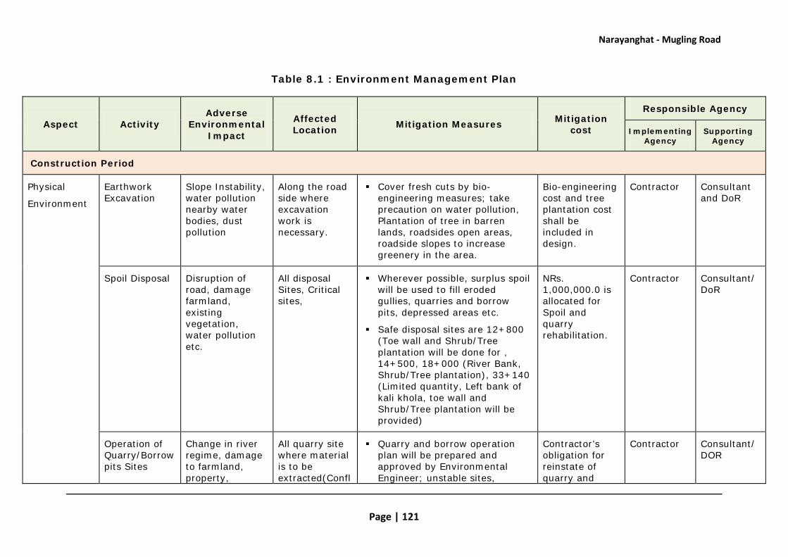
Narayanghat - Mugling Road
Page | 121
Table 8.1 : Environment Management Plan
Aspect Activity Adverse
Environmental Impact
Affected Location Mitigation Measures Mitigation
cost
Responsible Agency
Implementing Agency
Supporting Agency
Construction Period
Physical
Environment
Earthwork Excavation
Slope Instability, water pollution nearby water bodies, dust pollution
Along the road side where excavation work is necessary.
Cover fresh cuts by bio-engineering measures; take precaution on water pollution, Plantation of tree in barren lands, roadsides open areas, roadside slopes to increase greenery in the area.
Bio-engineering cost and tree plantation cost shall be included in design.
Contractor Consultant and DoR
Spoil Disposal
Disruption of road, damage farmland, existing vegetation, water pollution etc.
All disposal Sites, Critical sites,
Wherever possible, surplus spoil will be used to fill eroded gullies, quarries and borrow pits, depressed areas etc.
Safe disposal sites are 12+800 (Toe wall and Shrub/Tree plantation will be done for , 14+500, 18+000 (River Bank, Shrub/Tree plantation), 33+140 (Limited quantity, Left bank of kali khola, toe wall and Shrub/Tree plantation will be provided)
NRs. 1,000,000.0 is allocated for Spoil and quarry rehabilitation.
Contractor Consultant/DoR
Operation of Quarry/Borrow pits Sites
Change in river regime, damage to farmland, property,
All quarry site where material is to be extracted(Confl
Quarry and borrow operation plan will be prepared and approved by Environmental Engineer; unstable sites,
Contractor’s obligation for reinstate of quarry and
Contractor Consultant/DOR

Narayanghat - Mugling Road
Page | 122
Aspect Activity Adverse
Environmental Impact
Affected Location Mitigation Measures Mitigation
cost
Responsible Agency
Implementing Agency
Supporting Agency
sensitive areas uence of Trishuli & Jugedi Khola, Ghaighat Trishuli River, Phampha Khola etc
erosion prone area, forest area, settlements, fertile farm land will be avoided for quarry / borrow operation; quarry sites will be rehabilitated by providing appropriate civil engineering structures and bioengineering measures after the extraction is complete.
borrow pits
Cut and fill activities
Slope Instability and Soil Erosion
Locations prone to landslides are at Ch 11+080, 12+043; 12+080; 13+600; 17+800, 20+700, 23+410; 23+430; 28+800; 29+050; 31+600 and 33+160. Also, along km 30+520 to 30+590.
In design, back cutting will be avoided in vertical rocky area and fragile locations. River training works, gully protection works will be included in design. Bio-engineering techniques such as grass seeding, turfing, grass plantation, brush layering, tree/shrub plantation, bamboo plantation, dry stone rip rap will be proposed. Additional civil engineering structures should be provided for slop protection, flood protection, drainage management at ch 14+087, 20 +700, 28+900.
Civil engineering structures are proposed in design and Bio-engineering cost is proposed NRs.8.6 million.
Contractor/ Consultant
Consultant/DOR
Construction activity
Air Pollution, Noise and water
All along the road
Use of face mask by the workers working in the areas of high dust generation; avoid disposal
Included in Contract
Contractor/ Consultant
Consultant and DOR

Narayanghat - Mugling Road
Page | 123
Aspect Activity Adverse
Environmental Impact
Affected Location Mitigation Measures Mitigation
cost
Responsible Agency
Implementing Agency
Supporting Agency
polluting of excavated materials in the water bodies; Use of ear muffles, helmet to lessen noise pollution during rock breaking and quarrying; cover dry material or make it wet during transportation. Ones a day water sprinkling will do during construction period.
document
Disruption in natural water flow due to construction of water related structure
Causes a number of risks , impairment in water bodies
Risk to downstream, aquatic life
All area where such structures are proposed for made.
16 number of additional cross drainage structures (Ch 8+530, 11+675, 14+575, 14+977, 20+730, 21+630, 22+685, 22+814, 22+980, 23+235, 23+675, 24+694, 26+880, 26+975, 27+060, 31+330) are proposed in order to have minimum interference on natural drainage pattern of the area
Avoid any blockage or diversion of natural channels due to (intended or incidental) disposal of spoil.
Install cascades, steps, energy dissipaters, and check dams including bio-engineering measures as per design for gully protection to avoid depth and side erosion of natural course
Included in contract document
Contractor/Consultant
Consultant and DOR

Narayanghat - Mugling Road
Page | 124
Aspect Activity Adverse
Environmental Impact
Affected Location Mitigation Measures Mitigation
cost
Responsible Agency
Implementing Agency
Supporting Agency
including river beds.
Stockpiling of Constructions materials
Possible leakage of hazardous materials, Blockage of drain, damage to forest or agricultural land, forest area, dust generation
Place where construction material is piled.
The land for storing the construction material should be far from the agriculture land , forest and water bodies.
As a procedural respect, concerned contractor need to fill in standard pro-forma – developed for this issue – and submit it to and secure approval from the Resident Engineer/Environmental engineer (including from the owner as and if required).
Avoid leakage.
Contractor obligation
Contractor Consultant and DOR
Establishment, Operation and Closure of Crusher Plant
Local people, labor force prone to air noise and water pollution
Crusher plant location.
Bring necessary aggregates, gravel for road from market. So no need to install crusher plants. If required, Sitting of crusher plants should be done as much away from the forest, residential areas.
Apply, seek and secure approval from SC prior to establishing and operating plants
Identify owner of plants site -
Contractor obligation document
Contractor Consultant and DOR

Narayanghat - Mugling Road
Page | 125
Aspect Activity Adverse
Environmental Impact
Affected Location Mitigation Measures Mitigation
cost
Responsible Agency
Implementing Agency
Supporting Agency
local people, Municipality, DDC or VDC as appropriate.
Strike an agreement with the local stakeholders - local people, Municipality, DDC or VDC as appropriate.
Fit and operate Stone crushing equipment with dust control devices.
Road construction
Impact on Community Infrastructure
Water supply pipe will damage, Water source will affected
Along the road, Water Supply Pipe(13+250 (40 cm dia. GI pipe), 19+600 (HDP), Water Source (12+425, 13+360),
All Water supply pipe will be relocated, Water source will protected.
Cost will be included in design (Resettlement)
Contractor/Consultant
Consultant and DOR
Foot trail,
Access road will damage
Foot Trail: Km 11+920, 12+950, 22+950, 31+020
Access road:
Affected Foot trail will be reinstated, Access road will maintain and black top will be done 5-10 m length in access road. Foot trail at 22 +950 is below the road. It is access trail to the suspension bridge it is
Cost will be included in design
Project Consultant and DOR

Narayanghat - Mugling Road
Page | 126
Aspect Activity Adverse
Environmental Impact
Affected Location Mitigation Measures Mitigation
cost
Responsible Agency
Implementing Agency
Supporting Agency
Km 4+420, 5+800, 5+950, 10+350, 11+000, 11+080, 14+600, 18+410, 19+200, 19+500, 25+950 and 29+200.
needed reinstate.
Park, Temple
Compound of park will affected, Temple at 18+500, 24+400 will affected.
Madan Bhandari + Jivraj Asrit park (13+365), Temple(18+500), Panch Kanya Mai (24+400), Jalbire Temple(29+070), Pathi Devi (32+900)
Reinstated the compound wall of Madan Bhandari + Jivraj Asrit park, Temple will relocated
Cost will be included in design(Resettlement)
Project
Consultant and DOR
Many numbers of Electric pole affected
Along the road All affected electric pole will be relocated
Cost will be included in design
Project
Consultant and DOR

Narayanghat - Mugling Road
Page | 127
Aspect Activity Adverse
Environmental Impact
Affected Location Mitigation Measures Mitigation
cost
Responsible Agency
Implementing Agency
Supporting Agency
Work camp/ Labour camp
Pressure on public utilities, forest,
Jugedi, Dasdhunga for Work camp and Labour camp can be used small open space and private houses along the road
Use of local labors to avoid labour camp; rent local house instead of camp to keep labors; sitting camp away from forest areas; pay compensation for using private farm or lands for storage or camp; fuel and chemical storage areas will be on paved surface with surrounding catch drain to protect soil from leakage. Camp sites will be provided with first aid facility and pit latrine; soak pit will be provided for water and solid waste management. Appropriate camp sites have been observed at Jugedi, Dasdhunga for Work camp.
Included in contract document
Contractor/ Consultant
Consultant and DOR
Construction Equipment and Vehicles (Crusher plants, Rollers, tippers, spreader, asphalt plant, water tanker etc)
Risk to human health, disturbance to the local nearby, Wildlife, Air pollution
Work where such work has to be done.
- The safety gadgets should be provided for the labour during construction work
- The equipment/vehicles deployed for construction activities shall be regularly maintained. All the vehicles deployed for material movement shall be spill proof to the extent possible.
Included in Contract document
Contractor , Consultant
Consultant and DOR

Narayanghat - Mugling Road
Page | 128
Aspect Activity Adverse
Environmental Impact
Affected Location Mitigation Measures Mitigation
cost
Responsible Agency
Implementing Agency
Supporting Agency
Chemical storage/handling and distribution of Bitumen
Risk to human health, water pollution, soil pollution
Area where storage and spreading bitumen has to be carried out.
- The permission from the land owner must be obtained before commencing the storage activities.
- The bitumen storage must not be on fertile land and nearby water bodies.
- The bitumen handler must be careful while handling the bitumen with safety gears.
Bitumen related work should not be carried out during the rainy condition.
Included in Contract document
Contractor Consultant and DOR
Storage/ handling of chemicals toxic and non-toxic
Impact on human health, flora and fauna living nearby
Areas where work should be done related to chemicals
Use safety gears during its handle.
No hazardous materials allowed to store near surface waters, forest area between 2+425 to 8+500.
Overlay plastic sheeting under hazardous material storage area
Pack contaminated and worn plastic sheeting into drums and disposed it off site.
The vehicles and equipment should be maintenance time to time to ensure any leakage from
Included in Contract document
Contractor, consultant
Consultant and DOR

Narayanghat - Mugling Road
Page | 129
Aspect Activity Adverse
Environmental Impact
Affected Location Mitigation Measures Mitigation
cost
Responsible Agency
Implementing Agency
Supporting Agency
them.
Biological Environment
Vegetation and Forest Resources
261 nos of different types of tree and 3.97 Ha. forest area will be loss
At the area where trees has to be cut.
Trees shall be cleared after the permission of forest authority.
Compensation by planting trees. Compensatory plantation will be in the ratio of 1:25. Total 6525 nos of trees will be plated.
Estimated cost is NRs. 1305000 (plantation cost is NRs. 200/plant with protection 5 years) Include in Project cost
DFO/CFUG Consultant/NGO
Consultant and DOR/DFO
Fragmentation of Wildlife Habitat
Disturbance to Wildlife
Mainly From 2+425 to 8+500 section
Site clearance for construction shall be limited to the minimum width. No tree or vegetation shall be cut unless absolutely necessary. The construction activities near forest area will be appropriately managed so that there will be least disturbance to the wildlife and birds. Workers shall be actively discouraged from collecting fuel wood from forest or Poaching/harassing of birds or animals. Coordination with DFO/CFUG to control the activities like illegal Poaching and poaching by enforcing acts and regulations strictly.
Project DFO/CUG Consultant

Narayanghat - Mugling Road
Page | 130
Aspect Activity Adverse
Environmental Impact
Affected Location Mitigation Measures Mitigation
cost
Responsible Agency
Implementing Agency
Supporting Agency
Impact on Biodiversity and Natural Habitats
Regular vehicular movements, which may further increase the adverse effects of habitat fragmentation, particularly in forest sections and increase incidences of vehicle hit on the wildlife trying to cross the road, impact in aquatic life.
Mainly From 2+425 to 8+500 section, During field survey mainly at ch 3+550 and 7+600 area is wildlife crossing /movement area. Critical locations Ch 16+300, 21+000, 22+425-22+550 , 28+300, 29+830, 32+120-32+240, and 34+200-35+00
Under passes, Culvert for wildlife crossing (ch 3+550 and 7+600, about 4 nos is required: size 3m height and 6m length), drain covers in from 2+425 to 8+500) area will be incorporated in design. If technically suitable, turfing will be done in shoulder area, which will help to make wild animals friendly.
Illegal hunting and fishing during construction period by the involved construction workforce and project staff will be strictly controlled. Posting of environmental signboards (illustrated and in local language) will be displayed in more wildlife occurrence zone
In critical locations will not through excavated materials in downhill/river will be transport in designated locations
Include in project cost/design
Project/Contractor
DFO/Consultant and DOR
Labor camp need of fuels for bitumen heating, operation of
Exerted pressure on fossil fuel impacting as loss of forest
Entire Road For construction crews stationed at the camp, contractor will provide kerosene or gas for cooking and heating.
Kerosene will be used for
Included in Contract document
Contractor DFO/CFUG
Consultant and DOR

Narayanghat - Mugling Road
Page | 131
Aspect Activity Adverse
Environmental Impact
Affected Location Mitigation Measures Mitigation
cost
Responsible Agency
Implementing Agency
Supporting Agency
crusher plant heating of bitumen/asphalt plant
Use of forest wood will be restricted for meeting the fuel needs.
Effect on Aquatic Life
The road construction activities foundation excavation in valley, slope cutting will likely increase sediment load in this river.
Critical locations Ch 16+300, 21+000, 22+425-22+550 , 28+300, 29+830, 32+120-32+240, and 34+200-35+00
In design, the slope cutting has been minimized as far as possible. For widening the road special retaining structures has been proposed to reduce excess excavation materials in valley side. Site casting will be strictly prohibited in critical locations. Give priority for fishery men in road construction, provide them skill enhancement training which help to preserve aquatic life of Trishuli river.
Contractor Consultant and DOR
Socio-economic environment
Construction camp establishment
Pressure on public utilities by the huge mass of the labour resulting impairment in existing environmental condition.
Camp area The resource need by the labour should be provided by contractor not disturbing the public utilities.
- Contractor Consultant

Narayanghat - Mugling Road
Page | 132
Aspect Activity Adverse
Environmental Impact
Affected Location Mitigation Measures Mitigation
cost
Responsible Agency
Implementing Agency
Supporting Agency
Construction camp establishment
Social Conflict due to influx of labour
Camp area and market area
The labour should comply with the code of conduct set by the contractor
- Contractor DPO
Construction camp establishment
Impairment in existing environmental condition due to influx of labour
Entire road section
The labour should respect the environment of the working area
They should discharge the waste into proper place
The labour should be strictly prohibited for noise disturbance
- Clear and restore contractor’s work force camps to natural or stable conditions with vegetative cover
- Contractor Consultant
Road construction
Impact on community infrastructure
Water pipe line Restore all disturbed infrastructures to the condition before disturbance or improve where appropriate in coordination with local people.
Included in contract document
Contractor Consultant
Road construction
Impact on religious places
At chainage 15+050, 18+500,24+400, 29+070
The impact can be minimized by widening the road on other side of the road
- Contractor Consultant
Road construction
Grievance Redressal
On need basis location
- Form, activate and maintain GRIEVANCE REDRESSAL MECHANISM for each site of
- - -

Narayanghat - Mugling Road
Page | 133
Aspect Activity Adverse
Environmental Impact
Affected Location Mitigation Measures Mitigation
cost
Responsible Agency
Implementing Agency
Supporting Agency
Mechanism road constructions
- Activate and maintain GRIEVANCE REDRESSAL MECHANISM in concerned project manager’s office, Resident Engineers office, contractor’s office for each site of road constructions
- Inform local stakeholders of Grievance Redressal Mechanism’s existence
- Inform local stakeholders about how they can lodge grievance against contractor’s fault work for his rectification Undertake and correct fault works by contractor to grievance lodger’s satisfaction
Operation Stage
Physical Environment
Operation of road
Slope Instability and Erosion
More susceptible location
at ch 14+000, 17+000-17+500, 23+000, 26+500
- Correction of maintenance of the slope protection measures and drainage works
- Minor landslide and mass wasting will be immediately cleared and slope restored with appropriate technology (bioengineering)
Road maintenance cost should be allocated.
Road division office after DLP period and Contractor during DLP period
Road Division Office

Narayanghat - Mugling Road
Page | 134
Aspect Activity Adverse
Environmental Impact
Affected Location Mitigation Measures Mitigation
cost
Responsible Agency
Implementing Agency
Supporting Agency
Soil conservation will be promoted in the right of way and vulnerable areas
Operation of road
Air, Noise and Water Pollution
Entire Road section
- Vehicle emission standard will be maintained
- Speed limit of the vehicles will be maintained
Plantation will be done
- DOR and DDC/VDC/DFO
DFO/CFUG/DDC/VDC
Operation of road
Impact on Sanitation of the Area
Along the road Public urinals shall be constructed every 10 KM at vehicle stops, and open defecation shall be fully restricted. The possible locations are 12+580, 14+550, 15+200, 15+800, 18+600, 19+850, 21+500, 22+950, 25+770, 28+000, 33+200. Drivers, lodge owners and local residents shall be given awareness and orientation trainings on maintaining clean and sanitary environment
Include in project cost
Project/Contractor
Consultant
Biological Operation of road
Depletion of Forest Resources
Along the forest area
- CFUGs will be supported to conserve and manage their CFs according to operational plans.
- DFO/CFUG/VDC/DDC
DFO/VDC/DDC

Narayanghat - Mugling Road
Page | 135
Aspect Activity Adverse
Environmental Impact
Affected Location Mitigation Measures Mitigation
cost
Responsible Agency
Implementing Agency
Supporting Agency
Operation of Road
Disturbance to wildlife and birds
Mainly 2+425 to 8+500
- Prohibition of blowing horns in the dense forest areas
- Erect appropriate sign boards like 'no horn area', provide 'under passage for wildlife', informing drivers on prohibition of blowing horns in the forest areas. Rule will be made (make a fixed time to reach from starting point of forest to end point of forest area by providing ticket to vehicle operators)
Afforestation program shall be done in open space in forest area. Make additional wetlands Provide additional forest guard.
- DOR/DFO/CFUG
DFO/CFUG
Vehicle movement
Water pollution At Water source area
The washing of cars in rivers and creeks should be strictly controlled (by road police and/or CBOs) and violators be penalized. In places where car washing habits have evolved, it is advised to erect signboards (illustrated and in local language) that explain the inherent risks for people utilizing the source for drinking and aquatic life, and also indicate penalties for violators
DOR/Traffic Police
VDC/Local people

Narayanghat - Mugling Road
Page | 136
Aspect Activity Adverse
Environmental Impact
Affected Location Mitigation Measures Mitigation
cost
Responsible Agency
Implementing Agency
Supporting Agency
Socioeconomic and Cultural Environment
Operation of Road
Road Accident Entire Road - Required delineators, safety signs will be used as appropriate along the road.
Road safety awareness programs will be conducted- Speed limit, No horn, warning signboard in forest, animal crossing area
Included in contract documents
Project/Contractor
Consultant/DoR
Operation of Road
New Settlement Along the Road
Along the road , probably more near the market area
• Discouraging ribbon settlements along the road awareness raising programme through local organizations to plan proper settlements
• Regulate settlement growth with proper panning along RoW
• Plantation of trees along the road.
- Road Division Office, Ministry of Physical Planning
Road Division Office/VDC/DDC
Operation of Road
Change in Social Behavior
Entire Road area dn adjoining village
Facilitating awareness raising programmes to the communities about negative social behavior like gambling, excess use of alcohol.
- VDC/DDC/ NGO
VDC/DDC

Narayanghat – Mugling Road
Page | 137
8.4 Biodiversity Management
The EMP includes several provisions, which will help in avoiding and minimising damages to the wilderness area. Additionally, the following measures have been identified to manage and mitigate adverse impacts resulting from the proposed project. These measures include:
• Provision of underpass for wildlife crossing at Km 3+550 and 7+600) (3x6 mts.)
• Provision of traffic calming measures in the 300 mts. stretch around Km 7+600 to minimise chances of accidents, particularly during night time
• Prohibiting night time construction work in wildlife sensitive stretches.
• Prohibition for construction camp/office/plant locations in forest areas.
• Workers awareness program/s
• Provision of Warning Signage for road users in wildlife sensitive zone
• Exploring creation/improvement of water holes for wildlife to minimise movement across the road for finding water
• Provision of signboards to raise general awareness on various environmental issues.
• Afforestration/compensatory program, specifically targeted to improve wilderness/vegetation in the core area of BFC and Community Forests
• Specific Monitoring / auditing arrangements involving wildlife expert and the Department of Forests
• Dove-tailing with other Forestry and Biodiversity management programmes under implementation in BFC
8.5 Augmentative Measures/Enhancement
Table 8.2: Augmentative Measures/Enhancement Measures
Beneficial Environmental
Impact
Affected Location
Beneficial Augmentation
Measure Cost
Responsible Agency
Implementing Agency
Supporting Agency
Construction Stage
Employment Generation and Increase in Income
Entire project area
Involve local people to extent possible
Construction Contract
Project/ Contractor
Consultant

Narayanghat - Mugling Road
Page | 138
Beneficial Environmental
Impact
Affected Location
Beneficial Augmentation
Measure Cost
Responsible Agency
Implementing Agency
Supporting Agency
Construction Stage
Skill Enhancement
On need base location
Organize skill training programs and
Construction Contract
Contractor/Consultant
Consultant/ DOR
Increase in land value
Entire Project area
Promotion of land development activities and control of encroachment within RoW.
- VDC/DDC/NGO VDC/DDC
Utilization of Open Space
12+580, 14+550, 15+200, 15+800, 18+600, 19+850, 21+500, 22+950, 25+770, 28+000, 33+200
Open space will be used for vehicle stop, toilet, tree plantation, recreation
Include in Project cost
Project Consultant and DOR
Operation Stage
Improved Access Entire Project area
proper maintenance of the road during DLP period and after DLP period
- Contractor during DLP and Road division office after DLP period
DOR
Asian Highway N-M road It will assist to create trade and transit corridor between India and China. This will immensely enhance the economic benefits for Nepal.
DOR Government
Reaping the Benefits of Increased Land Value
Entire Project area
Proper maintenance of the road during DLP and
- Contractor during DLP and Road division office after DLP period
DOR
Decline in Soil Loss
Entire Project area
The proposed road will apply slope protection measures extensively mainly through civil engineering structures and bio-engineering methods
Include in Project cost
DoR/Consultant Consultant

Narayanghat - Mugling Road
Page | 139
Beneficial Environmental
Impact
Affected Location
Beneficial Augmentation
Measure Cost
Responsible Agency
Implementing Agency
Supporting Agency
Construction Stage
Management of Biological Resources
Entire Project area, from 2+425-8+500
Compensatory tree plantation will be done. Various plant species will be introduced for slope stabilization, in open space. It will help to increase forest product, soil conservation and habitat of wildlife. For wildlife movement area special measures will be provided such as signboard, under pass, drain cover etc
Include in Project Cost
DoR/Consultant/DFO
Consultant/DFO
8.6 Institutional Arrangements
The responsibility for environmental management associated with the proposed road upgrading involves a number of roads building parties, each with specific responsibilities for particular activities. Main parties responsible for the implementation of environmental safeguards measures prior to -, during - and following - proposed road upgrading are:
• MoPPW
• DoR (including GESU)
• World Bank
• Project Design and Supervision Consultant
• Contractor – construction / bio-engineering works
The summary of the role and responsibility for implementing the EMAP is as follows.
Table 8.3: Roles and Responsibilities for EMP implementation
Institution Role Responsibility in the Project
Ministry of
Environment
Mandated to formulate and implement environmental policies, plans and programs at national Level
Facilitate when needed on environmental
safeguards , Review IEE and Approve IEE

Narayanghat - Mugling Road
Page | 140
Institution Role Responsibility in the Project
Ministry of physical planning work (MPPW)
It is concerned line ministry, executive agency for managing the construction and maintenance of the proposed road.
Coordinate with project on safeguard issues
Conduct environmental monitoring from central level.
Department of Roads
Department under MPPW responsible to execute RSDP projects
Ultimate responsibility for the supervision of proposed road upgrading including environmental safeguards fully respected.
GESU (Geo- Environment and Social Unit)
Unit under division of road responsible for reviewing IEE
Review, comment, and forward IEE ToR and Report for review for approval to Ministry of environment
Design consultant
All environmental work related to feasibility and design period
Get approval from Ministry of environment. Conduct IEE Study, Public Consultation and prepare IEE Report , Receive comments and modify accordingly. Conduct environmental safeguard monitoring and Reporting
Supervision consultant (Environmntal Specialist)
Role in checking compliance of environmental measures in road construction work as per EMAP
Oversee the overall implementation of the EMAP (for overall package), provide expertise knowledge, suggestions and recommendations when and where necessary to minimize/avoid/prevent any adverse environmental impacts
Construction contractor
Role of complying environmental measures into the Road construction work
The contractor/s must implement all the mitigation measures described in the EMAP during the construction period to mitigate all environmental impacts associated with the construction activities, bio-diversity monitoring.

Narayanghat - Mugling Road
Page | 141
Institution Role Responsibility in the Project
District Forest Office
Support implementation of EMP, including biodiversity measures
Directly involved during construction as a lead agency for forestry, tree cutting, bio-diversity monitoring.
The Project Proponent, being the Department of Roads under the Ministry of Physical Planning and Works (MoPPW), is the main responsible agency for managing the construction and maintenance of the proposed road.
In most cases DoR the Proponent and as the principal responsible agency for monitoring, direct involvement of the Geo-Environment and Social Unit (GESU) of the Department in foreseen. The organisational chart for implementing the EMAP is illustrated in the following diagram:
Figure 8.1: Environmental Management Organizational Structure
Other institutions directly involved are the forestry and agriculture agencies, at district level. Next to the DFO, the CFUGs play an important role in the protection of flora and fauna. DDC and VDCs will be more involved as local level authorities. Road security and
MPPW - Environment Section
CDO Department of Roads
DDC/VDC
District Land Revenue Office
GESU Project Proponent Local Forum of
Beneficiaries
Consultant/Environment Specialist
Local Labour Groups in Labour Intensive works (if
needed)
Contractors
Technical Staff
- Dist. Forest Office - Dist. Agriculture Office - Dist. Watershed Office - Department of Wildlife
CFUGs
NGOs/
CBOs
CFC

Narayanghat - Mugling Road
Page | 142
enforcement of traffic regulations comes under the mandate of the TrafficPolice under the Ministry of Home Affair.
NGOs/CBOs are indirectly involved in carrying out awareness generation and social development programs. The construction supervision and monitoring will be entrusted to a Supervision Consultant by establishing environmental unit in the project. In Environmental unit minimum an Environmental Specialist shall be deploy for assisting the Proponent to ensure proper construction practices and implementation of the management options and mitigation measures proposed in the Environmental Management Action plan. Environmental Specialist will be required whole project period for close monitoring.
8.7 Budgetary Provisions
The budgetary estimates are provided in the table below:
Table 8.4: Cost Estimate for Enhancement and Mitigation Measures
S. No..
Environmental Protection Measures
Estimated Budget (NRs.) Remarks
Benefits Augmentation Measures
1.1 Environmental awareness training to Contractor 100,000.00
1.2 Bio-diversity awareness/Management training 200,000.00
Sub-Total (1) 300,000.00
Adverse Impacts Mitigation Measures
2.1 Bio-engineering work 8,633,000.00
2.2 Information Signboard (6 nos) in wildlife crossing areas 90,000.00 @15,000.00
2.3 Under pass for wildlife crossing To be included in detail design
3m height and 6m Length
2.4 Drain cover in forest area for easy access to wildlife
To be included in detail design
2.5
Reinstate, relocation of public structures (Water supply pipe, Foot trail, Access road, Electric pole, Etc.)
To be included in project cost
2.6 Restoration of spoils disposal 2,000,000.00

Narayanghat - Mugling Road
Page | 143
S. No..
Environmental Protection Measures
Estimated Budget (NRs.) Remarks
site management and rehabilitation, reinstate of quarry borrow pit.
2.7 Compensatory plantation 1,310,000.00
2.8 Additional Afforestration program in CF
To be included in project cost
2.9 WetLand Construction in forest area for wildlife
To be included in project cost
2.10 Social cost
2.11
Occupational health and safety; First aid boxes, campsite sanitation (Pit latrine); solid waste management, Safety measures for workers (Helmets, gloves, masks, boots, etc,)
500,000.00
2.12 Sanitation (Toilet for every bus stop station)
To be included in Design
2.13 Shed for Bus stop 3 nos To be included in Design
2.14
Seed Money to establish a fund for Biodiversity management during
Operation and Maintenance stage (Forest guard, Afforestration, wetland development etc)
1,000,000.00
2.15 Establishment of Environmntal Unit (Environmntal Specialist)
4,140,000.00
Sub-Total (2) 17,673,000.00
Total 17,973,000.00
Table 8.5: Costs for Environmental Monitoring
Specifications MM Rate Amount
Environmental Specialist/ 18 150,000 2,700,000

Narayanghat - Mugling Road
Page | 144
8.8 Types of Monitoring and Monitoring Parameters
Site supervision, monitoring and reporting are an integral part of the EMAP. All these activities should be strictly carried out to ensure effective implementation of mitigation measures into the field level.
The monitoring task and reporting work are undertaken by the concerned road builders – supervising consultants/Environmental Specialist and contractors - prior to and during road upgrading as outlined in EMAP framework.
Monitoring can be done regularly or intermittently, depending upon the nature of the activity and its likely impact. Compliance monitoring is necessary to conduct regularly whereas impact monitoring can be done once the primary construction is completed to observe visible environmental impacts, if any. In general, monitoring can be done by observation, inspection, interview, counting and measurement. Environmental monitoring parameters, methods, schedules, responsibilities for monitoring are listed as follows:
Table 8.6: Monitoring Schedules and Responsibility
Parameters Method Schedule responsibility
Compliance Monitoring
Inclusion of mitigation measures in the design and tender
Review process During approval MOPPW
Integration of this report as a part of project administration Review process During approval
MOPPW
Allocation of adequate budget for implementing mitigation measures
Review and observation During approval MOPPW
Biodiversity-expert
Stationary and Computer LS 120,000
Transportation LS 720,000
Cost for Monitoring by GESU LS 200,000
Cost for Monitoring by MoPPW LS 100,000
Cost for Monitoring by DFO LS 300,000
TOTAL 4,140,000

Narayanghat - Mugling Road
Page | 145
Parameters Method Schedule responsibility
Compensation for building land and forest
Inquiry and consultation
Before construction at site MOPPW/DOR
Use of explosives and toxic materials
Observation/inquiry After their use
Project
Drainage management Site observation After construction Project
Other conditions Observation,
study, inquiry, survey etc
During construction stage
Project
Impact Monitoring – Construction Stage
Noise level Measurement Once a month during dry season Project
Water sprinkling Observation and inquiry Regularly Project
Quantity of disposal materials Observation and measurement Thrice a year Project
Slope protection measures Observation Immediately after rainy season
Project and DSCO
Drainage facility Observation and measurement Once a year Project
Number of safety equipment such as mask helmet and glove
Counting Once a year Project
Number of safety and no horn signs Counting Once a year Project
Biological
Number of Trees Cut Measurement and inquiry After clear felling District forest
office
Volume of wood extracted Measurement and inquiry After clear felling District forest
office
Actual loss of the forest area Measurement and inquiry After clear felling District forest
office
Fuelwood trade Observation and inquiry Thrice a year District forest
office or check

Narayanghat - Mugling Road
Page | 146
Parameters Method Schedule responsibility
post
Location of timber and / or forewood depot Observation Once a year District forest
office
Use od firewood, LP gas, kerosene, electricity etc by construction workers
Observation and inquiry Twice a year Road project
Trade of medicinal plants Observation and inquiry Thrice a year Forest check
post
Death or killing of wildlife Inquiry and observation When reported District forest
office/CFUG
Increase or decrease of fishes Inquiry Two times in winter season Road project
Condition of plantation forest Observation Two times in winter season
District forest office/CFUG
Socio-economic
Employment to local people File record Twice a year
Road project in collaboration
with respective VDCs
Number of total and local construction labourers File record Twice a year Project
Number of women employed Attendance record Twice a year Project
Number and type shop Observation Twice a year Project
Health and sanitation facilities at work camp and labor camp
Observation and inquiry Thrice a year Project
Enrollment of workers children at local school School record Once a year
Project in collaboration
with respective school
Labor force collecting the drinking water from the public tap
Observation and inquiry
Thrice a year during dry season Project

Narayanghat - Mugling Road
Page | 147
Parameters Method Schedule responsibility
Type of compensation File record After compensation Project
Type of damage to local infrastructures
Observation and inquiry
Twice a year during construction
months Project
Rate of compensation File record After compensation Project
In-migration Inquiry Once a year Project
Out-migration Inquiry Once a year Project
Price of essential commodities Inquiry Once a year Project
Number of accident Inquiry As reported Project
First-aid and emergency services
Observation and inquiry Thrice a year Project
Awareness on occupational safety Inquiry Twice a year Project
Cases of prostitution, liquor drinking and related disputed Inquiry Thrice a year Project
Cases of respiratory diseases Inquire and health record
Twice a year during dry season Project
Disposal of construction wastes near the temples
Observation and inquiry Twice a year Project
Operational stage
Air quality and noise level Survey and measurement Once in two years Project
Slope destabilization Observation and measurement
Each year after rainy season
Project in collaboration with DSCO
Number of accidents Inquiry As reported Road project and district police office
Condition of the forest Observation and inquiry Once a year District forest
office/CFUG
Wildlife movement Inquiry Once in two years District forest office/CFUG
Changes in socio-economic conditions Survey Once in after
construction stage Road project
Rehabilitation of work camp and labor camp
Observation and inquiry
Once in after construction stage Road project

Narayanghat - Mugling Road
Page | 148
Annexures

Narayanghat - Mugling Road
Page | 149
Annex 4.1
Commonly Found Vegetation in the Project Area
S. No. Local Name Scientific Name Abundance
1 Sal Shorea robusta High
2 Bodh dhairo Woodfordi fruticosa Medium
3 Karam Adina cardifolia Medium
4 Simal Bombax ceiba Medium
5 Padke Albizia lucida
Medium
6 Sirsh Albizia procera Medium
7 Khayer Acacia catechu Medium
8 Bhayalo Rhus succedanea Medium
9 Mango Mangifera indica Medium
10 Bhellar Trewia nudiflora Medium
11 Rajbrikshya Cassia fistula Medium
12 Peepal Ficus religiosa Medium
13 Ban bohari Cordia dichotoma Medium
14 Badh kaule Persea bombycina Medium
15 Sissoo Dalbergia sissoo Medium
16 Bokaino Melia azedarch Medium
17 Mewa Carica papaya Medium
18 Khanayo Castonopsis indica Medium
19 Bamboo Dandrocalamus strictus Medium
20 Uniyo Diplazium esculentum Medium
21 Banana Musa paradasica Medium
22 Buyalo - Medium
23 Kapro Ficus lacor Medium
24 Dumri Ficus racemosa Medium
25 Neem Azadirachta indica Medium
26 Rudhilo Bengal Pogostemon Medium
27 Titepati Artimisia indica Medium

Narayanghat - Mugling Road
Page | 150
S. No. Local Name Scientific Name Abundance
28 Amriso Thysanolaena maxima Medium
29 Jhalleri - Medium
30 Imli Tamarindus indica Medium
31 Kharane Symplocos ramosissima Medium
32 Ritha Sapindus mukorossi Medium
33 Amba Psidium guajava Medium
34 Majhi Bhatta Eulaliopsis binata Medium
35 Kury patta Murraya koenigii Medium
36 Sarpagandha Rauvolfia serpentine Medium
37 Kurilo Asparagus officinalis Medium
38 Harro Terminalia chebula Medium
39 Barro Terminalia belerica Medium
40 Amala Phyllanthus emblica Medium
41 Nagbeli Aconitum heterophyllum Medium
42 Ban tarul Dioscorea deltoid Medium
43 Vyakur Dioscorea deltoidea. Medium
44 Gurjo Tinospora Cordifolia Medium
46 Lajjawati Mimosa pudica Linn Medium
47 Sami Prosopis cineraria Medium
48 Aankha tare - Medium
49 Chattiwan Alstonia scholaris Medium
50 Mauwa Madhuca longifolia Medium
51 Sahaj Terminalia elliptica Medium
52 Sindhure Mellotus philippensis Medium
53 Bael Aegle marmelos Medium
54 Khirro Sapium insigne Medium
55 Satisal Dalbergia latifolia Medium
56 Angeri Lyonia ovalifolia Medium
57 Banmara Eupatoreum adenophorum Medium
58 Kali lahara Ficus lacor Medium
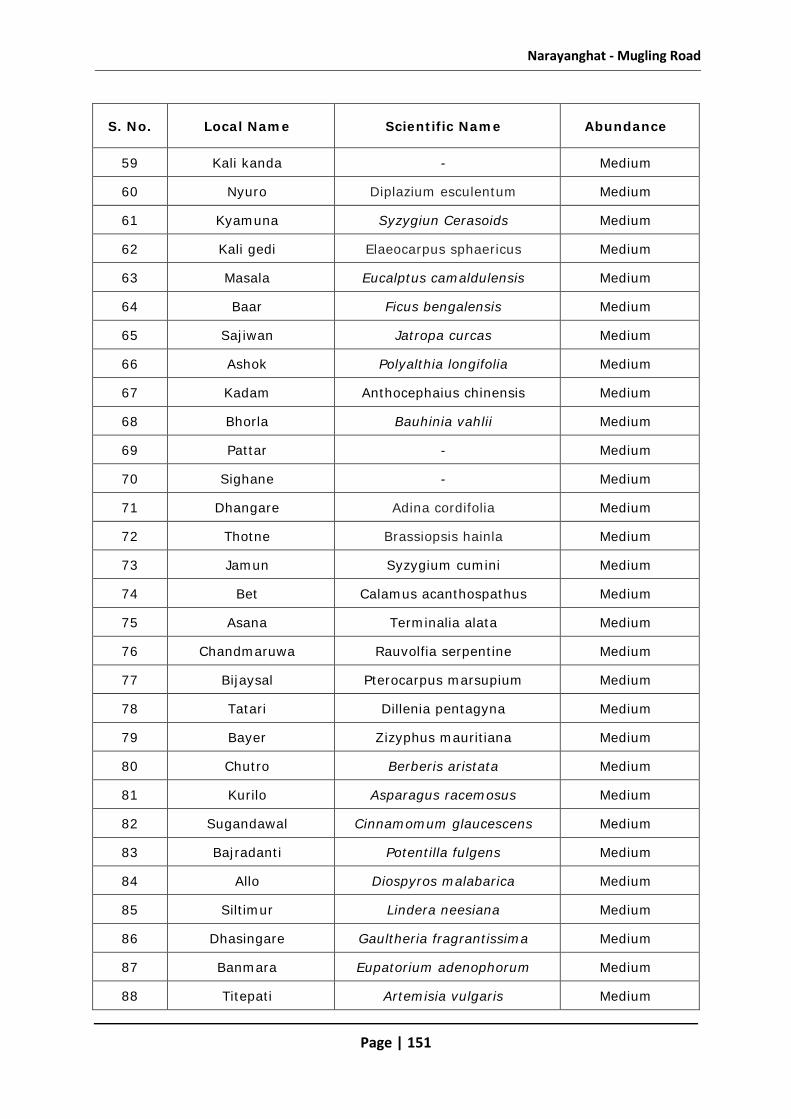
Narayanghat - Mugling Road
Page | 151
S. No. Local Name Scientific Name Abundance
59 Kali kanda - Medium
60 Nyuro Diplazium esculentum Medium
61 Kyamuna Syzygiun Cerasoids Medium
62 Kali gedi Elaeocarpus sphaericus Medium
63 Masala Eucalptus camaldulensis Medium
64 Baar Ficus bengalensis Medium
65 Sajiwan Jatropa curcas Medium
66 Ashok Polyalthia longifolia Medium
67 Kadam Anthocephaius chinensis Medium
68 Bhorla Bauhinia vahlii Medium
69 Pattar - Medium
70 Sighane - Medium
71 Dhangare Adina cordifolia Medium
72 Thotne Brassiopsis hainla Medium
73 Jamun Syzygium cumini Medium
74 Bet Calamus acanthospathus Medium
75 Asana Terminalia alata Medium
76 Chandmaruwa Rauvolfia serpentine Medium
77 Bijaysal Pterocarpus marsupium Medium
78 Tatari Dillenia pentagyna Medium
79 Bayer Zizyphus mauritiana Medium
80 Chutro Berberis aristata Medium
81 Kurilo Asparagus racemosus Medium
82 Sugandawal Cinnamomum glaucescens Medium
83 Bajradanti Potentilla fulgens Medium
84 Allo Diospyros malabarica Medium
85 Siltimur Lindera neesiana Medium
86 Dhasingare Gaultheria fragrantissima Medium
87 Banmara Eupatorium adenophorum Medium
88 Titepati Artemisia vulgaris Medium

Narayanghat - Mugling Road
Page | 152
Annex 4.2
Details About Wildlife Found in the Project Area
S.
No. Local Name
Scientific Name
Presence / Sightings Wildlife movement Habitat /
Location / Area
Common Frequent Rare Day Night
1 Bandel Sus scrofacristatus √
√
Jaldevi and Satanchuli community forest area
2 Ghoral Naemorhedus goral
√
√
Jaldevi and Satanchuli community forest area
3 Bagh Panthera tigris
√
√ BFC
4 Jarayo Cervus unicolar
√
√ BFC
5 Chittal Axis axis
√
√ BFC
6 Syal Canis aureus √
√ In all
community forest areas
7 Harin Muntiacus muntijac
√
In all community forest areas
8 Fyauro Vulpes bengalensis
9 Ban biralo Felis chaus √
√ √ In all
community forest areas
10 Chituwa Panthera pardus
√
√ BFC
11 Nilgai Boselapus tragacamelus
√
√
BFC

Narayanghat - Mugling Road
Page | 153
S.
No. Local Name
Scientific Name
Presence / Sightings Wildlife movement Habitat /
Location / Area
Common Frequent Rare Day Night
12 Gaurigai Bos gaurus
√ √
BFC
13 Rato badar
Macaca mulatta √
√
In all community forest areas
14 Hanuman Langur
Semenopithecus
√
√
BFC/CF
15 Genda Rhinoceros unicornis
√
BFC
16 Bhalu Melursus ursinus
√
BFC
17 Nyauri Musa
Herpestes edwardsi √ √
In all community forest areas
18 Kharayo Lepus nigricollis √
√
In all community forest areas
19 Dumsi Huttitau Muntiacus
√
√
In all communit f t

Narayanghat - Mugling Road
Page | 154
Annex 4.3
Commonly Found Birds in the Project Area
S.No. Local Name Scientific Name Habitat
1 Ban kukhuri Balbus busbolis Forest, Bush
2 Suga Psittacula spp. Forest
3 Kalij Lophura leucomelana Bush
4 Koyal Eudynamys scolopacea Forest
5 Mayur Pavo Cristatus Bush
6 Chibe Dicrurus aeneus Bush
7 Dhukur Streptopelia spp Forest, Bush
8 Saras Grus antigone Wetland area/Forest
9 Bhangera Java Sparrow Bush
10 Chil Hieraaetus kienerii Forest
11 Maina Gracula reliosa Forest
12 Latokoshero Bubo virginianus Forest
13 Nyauli Megalaima zeylanica Forest
14 Khar major Choriotis nigriceps Bush
15 Dangree Acridotheres fuscus Forest
16 Jureli Pycnonotus spp. Forest
17 Phusree Dhanesh Ocyeros birostris Forest
18 Thulo Dhanesh Buceros bicornis Forest
19 Pangree Dhanesh Anthracoceros albirostris Forest
20 Kuthurke Megalaima lineate Forest
21 Karangkurung Anthropoides virgo Forest/Bush
22 Luiche Gallus gallus Forest
23 Haleso Treron spp. Forest

Narayanghat - Mugling Road
Page | 155
Annex 4.4
Aquatic life in Narayani/Trishuli Rivers
S. No.
Local Name Scientific Name
Abundance
Common Frequent Rare
1 Patanga Ailia coila √
2 Faketa Barilius tileo
√
3 Thinge Bagarius yarelli
√
4 Jal kapur Clupissoma Montana
√
5 Baam Monopterus cuchia
√
6 Gurdi Labeo gonius √
7 Goch Keiko Kiele √
8 Sahar Tor tor √

Narayanghat - Mugling Road
Page | 156
Annex 4.5
Reference Point/s of GPS
GPS No. N E Reference
4 27°42'31.49" 84°26'25.27" Aaptari
5 27°42'40.70" 84°26'25.66" Simal Tree
6 27°42'37.96" 84°26'21.42 Starting Point
7 27°42'40.65" 84°26'25.53" Simal needs to be cut
8 27°42'49.55" 84°26'26.99 Bodh Dhairo needs to be cut
9 27°42'41.97" 84°26'26.68 Chautari + Community Forest Compound
10 27°42'53.51" 84°26'37.40 Chhatiwan Tree needs to be cut
11 27°42'53.52" 84°26'37.41 Chitwan (2)Tree needs to be cut
12 27°42'53.78" 84°26'37.34 Drainage Starts
13 27°42'55.53" 84°26'39.3" Rajbrikshya Need needs to be cut
14 27°43'09.40" 84°26'51.77" Drainage Ends
15 27°43'11.31" 84°26'53.11" Veldar Need needs to be cut
16 27°43'12.01" 84°26'54.07 Drainage Ends
17 27°43'13.02" 84°26'54.26" Red Soil Extraction which affects vegetation
20 27°43'21.97" 84°26'52.12" Sindhure and Sal need to be cut
21 27°43'23.85" 84°26'50.87" Temple and 2 Sal Trees
22 27°43'27.33" 84°26'51.54" Starting of Satanchuli ; Community Tree
23 27°43'43.09" 84°26'36.62" Rajbrikshya and Sindhure to be cut
24 27°43'59.83" 84°27'13.45" Water Tank
25 27°44'15.18 84°27'26.23" Area can be used as Rest Place for Public Vehicle
26 27°44'15.17" 84°27'26.36" Ram Nagar Area
27 27°44'15.73" 84°27'26.36" Embankment
28 27°44'25.16" 84°27'34.37" Access Road ; Open Space
29 27°44'50.87" 84°28'17.73" Embankment
30 27°44'58.79" 84°28'28.68" Curve Tree
31 27°45'19.83" 84°28'32.92" Km Post
32 27°45'37.42" 84°28'29.41" Kholsi

Narayanghat - Mugling Road
Page | 157
GPS No. N E Reference
33 27°45'46.04" 84°28'19.24" Police Beet
34 27°45'51.44" 84°28'15.51" Petrol Pump
35 27°45'58.75" 84°28'12.38" Gogedi Bridge
36 27°46'02.29" 84°28'10.54" Access Road
37 27°46'12.86" 84°28'02.91" Way to Army Camp Access Road
38 27°46'22.52" 84°27'49.65" Landslide
39 27°46'31.23" 84°27'36.42" -
40 27°46'39.30" 84°27'21.93" Water Spring
41 27°46'42.52" 84°27'15.92" Open Space
42 27°46'45.08" 84°27'03.16" Compound Wall
43 27°46'44.57" 84°26'58.50" Compound Wall
44 27°46'45.71" 84°26'55.65" Foot Trial
45 27°46'45.10" 84°26'48.97" -
46 27°46'45.11" 84°26'45.06" Compound of Madan Bhandari
47 27°46'45.94" 84°26'36.74" Landslide
48 27°46'46.15" 84°26'29.17" Bridge
49 27°46'46.20" 84°26'23.40" 14km Post
50 27°46'49.42" 84°26'16.73" Weak Area ; Needs Breast Wall
51 27°46'56.27" 84°26'11.95" -
52 27°47'00.73" 84°26'09.46" Access Road Way to River
53 27°47'05.67" 84°26'06.01" Open Space
54 27°47'20.59" 84°25'56.38" Block Factory
55 27°47'37.30" 84°25'52.26" Open Space
56 27°47'42.63" 84°25'53.44" Km Post
57 27°47'48.37" 84°25'53.25" -
58 27°47'53.53" 84°25'54.21" Critical Section
59 27°48'07.54" 84°25'53.80" Khadegi Bridge
60 27°48'14.98" 84°25'54.97" Weak Area
61 27°48'21.92" 84°25'54.47" Weak Area
62 27°48'33.72" 84°25'58.02" Bio-engineering Work

Narayanghat - Mugling Road
Page | 158
GPS No. N E Reference
63 27°48'43.87" 84°26'01.85" Spoil Disposal Location
64 27°48'45.98" 84°26'03.35" Pipal Tree
65 27°48'50.92" 84°26'13.90" Access Way to River for Borrow Area
66 27°48'54.08" 84°26'19.93" Temple within 10.3m
67 27°48'56.90" 84°26'28.28" Existing Bio-Works in Hill Slope
68 27°49'09.67" 84°26'36.27" Access Road
69 27°49'12.34" 84°26'40.07" Bhorle Bridge
70 27°49'14.89" 84°26'41.74" Access Road
71 27°49'16.68" 84°26'44.36" Water Supply Pipe Crossing with Drain
72 27°49'16.62" 84°26'51.83" Open Space
73 27°49'15.21" 84°26'56.89" Km Post
74 27°49'14.27" 84°27'02.37" -
75 27°49'12.92" 84°27'07.43" Existing Bio-engineering Works
76 27°49'11.94" 84°27'11.38" Open Space
77 27°49'09.44" 84°27'18.15" -
78 27°49'06.00" 84°27'21.61" Possible Bio-engineering Site
79 27°49'07.60" 84°27'29.28" Existing Bio-engineering Works
80 27°49'06.04" 84°27'42.81" Open Space
81 27°49'04.18" 84°27'46.10" Kholsi ; Bio-engineering can be Done
82 27°49'06.02" 84°27'55.76" -
83 27°49'08.28" 84°27'59.22" Bridge Dumne
84 27°49'20.69" 84°28'00.28" Settlement
85 27°49'25.63" 84°28'00.14" Settlement
86 27°49'25.02" 84°28'05.93" -
87 27°49'24.64" 84°28'14.22" Km Post
88 27°49'22.16" 84°28'25.72" Narrow Road Width
89 27°49'21.76" 84°28'27.65" Tree
90 27°49'20.54" 84°28'36.30" Resting Place
91 27°49'17.49" 84°28'44.30" Curve Way
92 27°49'16.22" 84°28'48.90" Km 24

Narayanghat - Mugling Road
Page | 159
GPS No. N E Reference
93 27°49'14.74" 84°28'54.13" Tree Cutting Required
94 27°49'13.36" 84°28'59.76" Simtal Bridge
95 27°49'13.78" 84°29'09.38" 6m Without Drain
96 27°49'13.23" 84°29'16.50" 6m without Drain ; Bio-engineering Required
97 27°49'09.15" 84°29'25.03" Km Post
98 27°49'06.86" 84°29'32.87" Kholsi
99 27°49'08.97" 84°29'40.88" Open Space
100 27°49'09.91" 84°29'42.49" Open Space
101 27°49'09.58" 84°29'45.36" Rigdi Bridge
102 27°49'10.90" 84°29'50.23" Open Space and House
103 27°49'09.71" 84°29'56.74" Access Road
104 27°49'09.41" 84°29'58.11" Km 26
105 27°49'07.96" 84°30'05.10" Tree - may need cutting
106 27°49'04.63" 84°30'15.53" Road Settled; Crack
107 27°48'55.42" 84°30'30.04" Km Post
108 27°48'52.56" 84°30'37.71" Kholsi
109 27°48'41.37" 84°31'49.36" Kholsi
110 27°49'05.52" 84°31'49.36" Starting of Critical Area
111 27°49'10.24" 84°31'13.55" Critical Area
112 27°49'23.88" 84°31'18.13" Landslide
113 27°49'25.14" 84°31'17.91" Km Post
114 27°49'29.94" 84°31'17.18" Jadevi Temple
115 27°49'30.77" 84°31'21.79" Access Road
116 27°49'37.59" 84°31'15.65" Critical Section - Valley
117 27°49'44.31" 84°31'15.28" Critical Section - Valley
118 27°49'50.19" 84°31'17.25" -
119 27°49'58.25" 84°31'36.85" House Settlement
120 27°49'57.22" 84°31'51.46" Foot Brail
121 27°49'57.82" 84°32'14.31" Landslide
122 27°49'57.73" 84°32'26.61" Km 32

Narayanghat - Mugling Road
Page | 160
GPS No. N E Reference
123 27°49'56.03" 84°32'30.16" Critical Area
124 27°49'53.88" 84°32'34.30" Critical Area
125 27°49'51.33" 84°32'43.92" -
126 27°49'51.37" 84°32'48.92" Namsi Bridge
127 27°49'52.37" 84°32'55.65" Tope Bridge
129 27°49'57.26" 84°33'04.08" Landslide
130 27°49'58.39" 84°33'06.13" Kali Khola Settlement
131 27°50'01.02" 84°33'09.35" Kali Khola Bridge
132 27°50'03.06" 84°33'11.80" Access Road Way to River
135 27°50'22.96" 84°33'27.28" Curve
136 27°50'34.55" 84°33'30.34" Bridge Critical Area
137 27°50'40.37" 84°33'30.92" Both sides Road
139 27°50'49.87" 84°33'32.83" Bridge
140 27°50'52.43" 84°33'32.36" Both sides Road
143 27°51'13.68" 84°33'29.25" Critical
144 27°51'15.52" 84°33'32.74" Critical
145 27°51'20.49" 84°33'36.68" Critical
159 27°42'44.75" 84°26'23.88" Jungle Dhara
160 27°42'44.31" 84°26'24.51" Small Pond Made for Wild Animals inside Forest
161 27°43'00.66" 84°26'51.46" Quadrate
177 27°46'30.91" 84°27'01.22" Rajbrikshya and Bodh Dhairo - to be cut
182 27°51'44.26" 84°29'55.17" Water Tank
186 27°43'49.68" 84°27'04.63" Small Water Source of Water for Animals
187 27°43'49.68" 84°27'04.63" Quadrate
188 27°43'49.68" 84°27'04.63" Small Wetland for Wild Animals
189 27°43'49.68" 84°27'04.63" Quadrate
198 27°44'45.91" 84°28'01.29" Animal Crossing Area

Narayanghat - Mugling Road
Page | 161

Narayanghat - Mugling Road
Page | 162
Annex 5.1
Details about Trees to be Cut for the Project
Chainage Side Forest / Private Species
Number of Trees
Girth of Tree* (cm) Height (m)
Timber Volume
Distance from existing road
edge (m) Local Name Scientific Name
2+425 Left Govt. Forest/ Jaldevi CF Simal Bombax ceiba 1 220, 15 33 3.2
2+415 Left Govt. Forest/ Jaldevi CF Bodh dhairo Woodfordi fruticosa 1 152,8 12.16 4.3
2+435 Left Govt. Forest/ Jaldevi CF Chhatiwan Alstonia scholaris 1 100,5 5 3.1
2+550 Left Govt. Forest/ Jaldevi CF Chattiwan Alstonia scholaris 2 80 & 70, 6 & 5.5 4.8,3.85 2.9
2+660 Left Govt. Forest/ Jaldevi CF Rajbrikshya Cassia fistula 1 120,7 8.4 3.3
2+700 Left Govt. Forest/ Jaldevi CF Bhellar Trewia nudiflora 1 80,8 6.4 3.4
2+780 Left Govt. Forest/ Jaldevi CF Rajbrikshya Cassia fistula 1 80,8 6.4 3.7
3+400 Left Govt. Forest/ Jaldevi CF Sindhure Mellotus philippensis 1 60,5 3 3.8
3+520 Left Govt. Forest/ Jaldevi CF Rajbrikshya Cassia fistula 1 80,5 4 3.7
3+550 Left Govt. Forest/ Jaldevi CF Bodh dhairo Woodfordi fruticosa 1 90,7 6.3 4.1
3+700 Left Govt. Forest/ Jaldevi CF Sal Shorea robusta 1 180,12 21.6 4.2

Narayanghat - Mugling Road
Page | 163
Chainage Side Forest / Private Species
Number of Trees
Girth of Tree* (cm) Height (m)
Timber Volume
Distance from existing road
edge (m) Local Name Scientific Name
3+720 Left Govt. Forest/ Jaldevi CF Sal Shorea robusta 1 200,13 26 3.9
3+800 Left Govt. Forest/ Jaldevi CF Sirish Albizia procera 1 160,10 16 4.4
3+900 Left Govt. Forest/ Jaldevi CF Sal Shorea robusta 4 120, 110, 150,
210; 10,12, 10 ,14 10,13.2,1
5,29.4 3.8
4+000 Left Governmnt Forest/ Satanchuli CF Sal Shorea robusta 4 30,35,30,40;
5,4,4,3 1.5,1.4,1.
2,1.2 3.1
22
4+100 Left Governmnt Forest/ Satanchuli CF Rajbrikshya Cassia fistula 1 110,7 7.7 3.6
4+100 Left Governmnt Forest/ Satanchuli CF Sindhure Mellotus philippensis 1 90,5 4.5 3.6
6+010 Left Governmnt Forest/ Satanchuli CF Sal Shorea robusta 2 80, 65; 5,6 4,3.9 3.3
7+000 Left Governmnt Forest/ Satanchuli CF Sal Shorea robusta 4 35,25,30,20;
4,3,5,4 1.4,.75, 1.5,0.8 3.3
7+250 Left Governmnt Forest/ Satanchuli CF Bodh dhairo Woodfordi fruticosa 1 60,7 4.2 2.9
7+400 Left Governmnt Forest/ Satanchuli CF Sal Shorea robusta 1 25,3 0.75 2.8
8+190 Left Governmnt Forest/ Satanchuli CF Sal Shorea robusta 4 35,45,60,25;
4,5,4,3 1.4,2.25,2
.4,0.75 3.1
8+195 Left Governmnt Forest/ Satanchuli CF Bhellar Trewia nudiflora 1 80,7 5.6 3.2

Narayanghat - Mugling Road
Page | 164
Chainage Side Forest / Private Species
Number of Trees
Girth of Tree* (cm) Height (m)
Timber Volume
Distance from existing road
edge (m) Local Name Scientific Name
8+195 Left Governmnt Forest/ Satanchuli CF Rajbrikshya Cassia fistula 1 60,6 3.6 3.4
8+197 Left Governmnt Forest/ Satanchuli CF Bodh dhairo Woodfordi fruticosa 1 90,6 5.4 3.1
17
8+500 Right Indreni CF Chatiwan Alstonia scholaris 3 70,40,25; 5,3,5 3.5,1.2,1.25 2.7
8+500 Right Indreni CF Bodh dhairo Woodfordi fruticosa 3 140,80,60; 8,5,4 11.2,4,2.4 2.8
8+500 Right Indreni CF Sal Shorea robusta 1 40,4 1.6 2.9
8+620 Right Indreni CF Bhellar Trewia nudiflora 2 85,60; 6,5 5.1,3 2.3
8+680 Right Indreni CF Bamboo Dandrocalamus strictus 1 2.6
9+100 Right Indreni CF Dumri Ficus racemosa 1 400,12 48 3.8
9+105 Right Indreni CF Bodh dhairo Woodfordi fruticosa 1 350,10 35 3.4
9+105 Right Indreni CF Karam Adina cardifolia 1 550,10 55 3.4
9+250 Right Indreni CF Mango Mangifera indica 1 80.6 4.8 2.7
9+300 Right Indreni CF Kapro Ficus lacor 1 120,7 8.4 2.3

Narayanghat - Mugling Road
Page | 165
Chainage Side Forest / Private Species
Number of Trees
Girth of Tree* (cm) Height (m)
Timber Volume
Distance from existing road
edge (m) Local Name Scientific Name
Indreni CF Peepal Ficus religiosa 1 80,5 4 2.3
Indreni CF Baar Ficus bengalensis 1 60,4 2.4 2.3
Indreni CF Mango Mangifera indica 1 50,5 2.5 2.4
Indreni CF Sami Prosopis cineraria 1 40,6 2.4 2.4
9+350 Right Indreni CF Sissoo Dalbergia sissoo 1 45,5 2.25 2.9
Simal Bombax ceiba 1 70,6 4.2 3.1
Left Indreni CF Kapro Ficus lacor 1 60,6 3.6 2.8
9+420 Right Indreni CF Simal Bombax ceiba 2 70,90; 7,8 4.9, 7.2 3.1
11+300 Right Jurethum CF Khayer Acacia catechu 3 60,80,40; 4,4,5 2.4,3.2,2 3.2
Jurethum CF Bodh dhairo Woodfordi fruticosa 1 40,6 2.4 3.2
Jurethum CF Chattiwan Alstonia scholaris 2 80,70; 5,6 4, 4.2 3.1
Jurethum CF Khanayo Castonopsis indica 1 30,4.5 1.35 3
Jurethum CF Jhalleri - 1 70, 5.5 3.85 3.2

Narayanghat - Mugling Road
Page | 166
Chainage Side Forest / Private Species
Number of Trees
Girth of Tree* (cm) Height (m)
Timber Volume
Distance from existing road
edge (m) Local Name Scientific Name
Jurethum CF Buyalo - 1 25,4 1 3.1
Jurethum CF Sirish Albizia procera 1 60,6 3.6 3.1
Jurethum CF Simal Bombax ceiba 1 30,4 1.2 2.9
Jurethum CF Sahaj Terminalia elliptica 1 270,6.5 17.55 3
12+000 Right Jurethum CF Khayer Acacia catechu 2 40,55; 6,5.5 2.4, 3.025 3.3
Jurethum CF Sissoo Dalbergia sissoo 2 35,65; 6,4 2.1,2.6 3.1
Jurethum CF Masala Eucalptus camaldulensis 1 40,7 2.8 3.2
12+050 Right Jurethum CF Mango Mangifera indica 1 60,5 3 3.4
12+150 Jurethum CF Khayer Acacia catechu 2 40,35; 3.5,5 1.4,1.75 3.3
Jurethum CF Simal Bombax ceiba 1 150,5.5 8.25 3.6
Jurethum CF Sighane - 1 65,5 3.25 2.8
12+800 Right Jurethum CF Chattiwan Alstonia scholaris 3 30,40,25; 6,5.5,4 1.8,2.2,1 3.1
Jurethum CF Sissoo Dalbergia sissoo 1 40,4.5 1.8 3.2

Narayanghat - Mugling Road
Page | 167
Chainage Side Forest / Private Species
Number of Trees
Girth of Tree* (cm) Height (m)
Timber Volume
Distance from existing road
edge (m) Local Name Scientific Name
Jurethum CF Rajbrikshya Cassia fistula 1 35,5.5 1.925 3.4
Jurethum CF Simal Bombax ceiba 1 200,8 16 3.3
12+850 Right Jurethum CF Sissoo Dalbergia sissoo 1 60,5 3 3
Jurethum CF Bodh dhairo Woodfordi fruticosa 1 120,6 7.2 3.2
13+500 Right Akladevi CF Chattiwan Alstonia scholaris 1 70,5 3.5 2.9
Jurethum CF Sighane - 1 60.,4.5 2.7 3.2
Jurethum CF Bhellar Trewia nudiflora 1 50, 5,5 2.75 3.1
13+550 Right Jurethum CF Kharane Symplocos ramosissima 6 30-40 in avg.; 3-
3.5 in avg. 1.1375 3
Jurethum CF Ritha Sapindus mukorossi 1 60,4.5 2.7 2.9
Jurethum CF Sahaj Terminalia elliptica 1 70,5 3.5 3.1
Left Jurethum CF Khirro Sapium insigne 1 40,6 2.4 3
Jurethum CF Khayer Acacia catechu 1 60,5.5 3.3 3.3
14+000 Right Jurethum CF Kharane Symplocos ramosissima 2 60,40; 5,6 3, 2.4 2.8

Narayanghat - Mugling Road
Page | 168
Chainage Side Forest / Private Species
Number of Trees
Girth of Tree* (cm) Height (m)
Timber Volume
Distance from existing road
edge (m) Local Name Scientific Name
Jurethum CF Khayer Acacia catechu 2 70,65; 6.5,8 4.55,5.2 3.3
14+150 Right Jurethum CF Imli Tamarindus indica 1 80,7 5.6 3.1
Jurethum CF Chattiwan Alstonia scholaris 1 80,6 4.8 3
Jurethum CF Rajbrikshya Cassia fistula 1 80,5 4 3
Jurethum CF Khayer Acacia catechu 1 60.6.5 3.9 3
Jurethum CF Kharane Symplocos ramosissima 1 45, 4.5 2.025 2.9
14+350 Left Jurethum CF Buyalo - 1 80,5.5 4.4 3.4
Jurethum CF Bhellar Trewia nudiflora 2 120,90; 6,4 7.2, 3.6 3.3
Jurethum CF Chattiwan Alstonia scholaris 1 70,5 3.5 3.1
14+500 Left Jurethum CF Sissoo Dalbergia sissoo 1 50,6 3 3.2
Jurethum CF Khayer Acacia catechu 2 60,45;4,5 2.4,2.25 3.2
14+600 Left Jurethum CF Mango Mangifera indica 1 50,4.5 2.25 3.1
Jurethum CF Bhellar Trewia nudiflora 1 65,5.5 3.575 3

Narayanghat - Mugling Road
Page | 169
Chainage Side Forest / Private Species
Number of Trees
Girth of Tree* (cm) Height (m)
Timber Volume
Distance from existing road
edge (m) Local Name Scientific Name
Jurethum CF Chattiwan Alstonia scholaris 1 55,5 2.75 2.9
Right Jurethum CF Rajbrikshya Cassia fistula 1 60,6 3.6 3.3
Jurethum CF Chattiwan Alstonia scholaris 1 70,5 3.5 3.2
14+850 Left Jurethum CF Sissoo Dalbegia sissoo 4 60,50,70,50; 6,5,6,4.5
3.9,3,4.2,2.25 3
14+960 Right Jurethum CF Bokaino Melia azedarch 1 100,5.5 5.5 2.8
15+150 Right Jurethum CF Bokaino Melia azedarch 1 40,6 2.4 3.1
Jurethum CF Karam Adina cardifolia 1 40,8 3.2 3.2
15+200 Left Jurethum CF Karam Adina cardifolia 1 120,9 10.8 3.1
Jurethum CF Khayer Acacia catechu 3 80,90,70; 6.5,7,6 5.2,6.3,4.2 3.7
Jurethum CF Bodh dhairo Woodfordi fruticosa 1 90,7 6.3 3.2
Jurethum CF Simal Bombax ceiba 2 130,110;7,6 9.1,6.6 3.4
15+650 Right Jurethum CF Bodh dhairo Woodfordi fruticosa 1 70,6.5 4.55 3.1
16+370 Right Jurethum CF Simal Bombax ceiba 1 30,5 1.5 2.9

Narayanghat - Mugling Road
Page | 170
Chainage Side Forest / Private Species
Number of Trees
Girth of Tree* (cm) Height (m)
Timber Volume
Distance from existing road
edge (m) Local Name Scientific Name
Jurethum CF Satisal Dalbergia latifolia 1 45,6 2.7 3.3
Left Jurethum CF Sighane - 1 70,7 4.9 3
Jurethum CF Kadam Anthocephaius chinensis 1 40,6 2.4 3
16+550 Right Jurethum CF Kadam Anthocephaius chinensis 1 40,6 2.4 3
Jurethum CF Bhorla Bauhinia vahlii 1 30,5 1.5 3.3
16+800 Left Jurethum CF Bhellar Trewia nudiflora 1 35,5 1.75 3.6
Jurethum CF Simal Bombax ceiba 1 50,8 4 2.8
Jurethum CF Pattar - 1 70,6 4.2 3.3
17+000 Left Jurethum CF Kadam Anthocephaius chinensis 1 90,6 5.4 3.1
Right Jurethum CF Sahaj Terminalia elliptica 1 80,6.5 5.2 3.2
Jurethum CF Simal Bombax ceiba 2 60,50;5,6 3,3 3
17+255 Right Siddhadevi C.F. Kadam Anthocephaius chinensis 1 90,7 6.3 3
17+750 Right Siddhadevi C.F Kadam Anthocephaius chinensis 1 90.6.5 5.85 2.7

Narayanghat - Mugling Road
Page | 171
Chainage Side Forest / Private Species
Number of Trees
Girth of Tree* (cm) Height (m)
Timber Volume
Distance from existing road
edge (m) Local Name Scientific Name
Siddhadevi C.F Rajbrikshya Cassia fistula 1 40,4.5 1.8 3
Siddhadevi C.F Khayer Acacia catechu 2 60,40; 5,6 3,2.4 3.3
Siddhadevi C.F Khirro Sapium insigne 3 90,70,60; 5,4,5 4.5,2.8,3 3.7
Siddhadevi C.F Bodh dhairo Woodfordi fruticosa 1 60,5.5 3.3 3.2
Siddhadevi C.F Bhellar Trewia nudiflora 1 70,6 4.2 3.3
Siddhadevi C.F Sindhure Mellotus philippensis 1 40,5 2 3
18+000 Right Siddhadevi C.F Dhangare Adina cordifolia 1 70,5 3.5 3.2
18+280 Right Siddhadevi C.F Bhellar Trewia nudiflora 1 35,5 1.75 3.4
Siddhadevi C.F khirro Sapium insigne 2 70,60;5,5.5 3.5,3.3 3.7
Left Siddhadevi C.F Chattiwan Alstonia scholaris 1 120,6 7.2 3.8
Siddhadevi C.F Amba Psidium guajava 1 30,4 1.2 3.1
18+500 Left Siddhadevi C.F Baar Ficus bengalensis 1 180,7 12.6 3.3
Siddhadevi C.F Peepal Ficus religiosa 1 220,7 15.4 3.2

Narayanghat - Mugling Road
Page | 172
Chainage Side Forest / Private Species
Number of Trees
Girth of Tree* (cm) Height (m)
Timber Volume
Distance from existing road
edge (m) Local Name Scientific Name
18+420 Right Siddhadevi C.F Pattar - 1 30,4 1.2 3
Siddhadevi C.F Chattiwan Alstonia scholaris 1 60,5 3 3
Siddhadevi C.F Padke Albizia lucida 1 60,5.5 3.3 3
18+750 Right Siddhadevi C.F Padke Albizia lucida 1 65,6 3.9 3.6
19+300 Right Siddhadevi C.F Padke Albizia lucida 1 90,6 5.4 3.7
19+380 Right Siddhadevi C.F Padke Albizia lucida 1 70,5 3.5 3.8
Siddhadevi C.F Khirro Sapium insigne 1 50,5.5 2.75 3.5
20+400 Right Siddhadevi C.F Mauwa Madhuca longifolia 2 70,40;6,,5 4.2,2 3.3
Siddhadevi C.F Sirish Albizia procera 1 30,5 1.5 3.5
Siddhadevi C.F Peepal Ficus religiosa 1 170.6 10.2 3.1
21+850 Right Ratamata C.F. Mauwa Madhuca longifolia 1 80,5 4 3
22+000 Right Ratamata C.F. Mango Mangifera indica 1 60,6 3.6 3
Ratamata C.F. Bhellar Trewia nudiflora 1 70,5 3.5 3.1

Narayanghat - Mugling Road
Page | 173
Chainage Side Forest / Private Species
Number of Trees
Girth of Tree* (cm) Height (m)
Timber Volume
Distance from existing road
edge (m) Local Name Scientific Name
Ratamata C.F. Thotne Brassiopsis hainla 1 50,5 2.5 3.2
22+050 Right Ratamata C.F. Bhellar Trewia nudiflora 3 80,70,40;5,4,7 4,2.8,2.8 3.3
Left Ratamata C.F. Mango Mangifera indica 1 60,6 3.6 2.9
Ratamata C.F. Khayer Acacia catechu 3 60,70,60; 5,4,7 3,2.8,4.2 3.3
Right Ratamata C.F. Khayer Acacia catechu 1 70,6 4.2 3.2
22+200 Right Ratamata C.F. Khayer Acacia catechu 2 80,60; 6,5 4.8,3 3.3
22+280 Left Ratamata C.F. Bodh dhairo Woodfordi fruticosa 1 45,5 2.25 3.3
Ratamata C.F. Buyalo - 5 35 in avg. avg 4 1.4 3.1
Ratamata C.F. Kharane Symplocos ramosissima 1 40,5 2 3.1
Ratamata C.F. Khayer Acacia catechu 2 60,40;5,6 3,2.4 3
23+100 Right Ratamata C.F. Khirro Sapium insigne 2 60,50;5,6 3,3 3.6
Ratamata C.F. Sahaj Terminalia elliptica 1 70,6 4.2 3.8
Ratamata C.F. Bodh dhairo Woodfordi fruticosa 3 70,60,40;4,5,7 2.8,3,2.8 3.6

Narayanghat - Mugling Road
Page | 174
Chainage Side Forest / Private Species
Number of Trees
Girth of Tree* (cm) Height (m)
Timber Volume
Distance from existing road
edge (m) Local Name Scientific Name
Ratamata C.F. Khayer Acacia catechu 2 60,40;5,6 3,2.4 3.7
23+985 Right Salbishna C.F. Padke Albizia lucida 1 70,5 3.5 3.5
25+200 Right Salbishna C.F. Padke Albizia lucida 2 30,70;5,4 1.5,2.8 3.2
Salbishna C.F. Mauwa Madhuca longifolia 1 40,5 2 3.7
25+700 Right Salbishna C.F. Mauwa Madhuca longifolia 2 60,45;5,6 3,2.7 3.1
Salbishna C.F. Saal Shorea robusta 4 30,40,35,45; 5 in avg.
1.5,2,1.75,2.25 3
25+830 Left Salbishna C.F. Bodh dhairo Woodfordi fruticosa 4 80,70,75,60;5.5 in avg
4.4,3.85,4.125,3.3 3.4
Salbishna C.F. Buyalo - 1 35,5.5 1.925 3.5
26+100 Right Salbishna C.F. Buyalo - 4 50,40,35,30;5 in avg
2.5,2,1.75,1.5 3.6
Salbishna C.F. Khayer Acacia catechu 3 50,60,45; 5.5 in avg
2.75,3.3,2.475 3.6
28+200 Right Salbishna C.F. Kadam Anthocephaius chinensis 1 70.6 4.2 3.1
Left Salbishna C.F. Buyalo - 3 60,40,45; 5 in avg. 3,2,2.25 2.8
Salbishna C.F. Kharane Symplocos ramosissima 1 70,6.5 4.55 3.1

Narayanghat - Mugling Road
Page | 175
Chainage Side Forest / Private Species
Number of Trees
Girth of Tree* (cm) Height (m)
Timber Volume
Distance from existing road
edge (m) Local Name Scientific Name
Salbishna C.F. Bodh dhairo Woodfordi fruticosa 3 60,65,60;6,5,6 3.6,3.25,3.6 3.2
29+000 Left Salbishna C.F. Chatiwan Alstonia scholaris 1 35,7 2.45 2.7
Salbishna C.F. Saal Shorea robusta 1 120,8 9.6 2.6
Salbishna C.F. Karam Adina cardifolia 1 110,9 9.9 2.5
29+080 Left Salbishna C.F. Sissoo Dalbergia sissoo 5 120,90,30,110,45;7,6,7,7.5,6.5
8.4,5.4,2.1,5.5,2.92
5 1.5
Salbishna C.F. Baar Ficus bengalensis 1 130,6.5 8.45 1.5
Salbishna C.F. Peepal Ficus religiosa 1 120,6 7.2 1.5
30+780 Right Salbishna C.F. Chatiwan Alstonia scholaris 1 80,6 4.8 2.8
Salbishna C.F. Kadam Anthocephaius chinensis 1 60,5.5 3.3 3.2
31+080 Right Salbishna C.F. Bodh dhairo Woodfordi fruticosa 1 70,5 3.5 2.9
Salbishna C.F. Sissoo Dalbergia sissoo 1 30,6 1.8 3.2
31+100 Right Salbishna C.F. Chatiwan Alstonia scholaris 1 70,6 4.2 3.1
Grand Total 261 - -

Narayanghat – Mugling Road
Page | 176
Annex 6.1
List of Persons Consulted
S.No. Name Designation Place
1. Dr. Indra Pd. Sapkota District Forest Officer Bharatpur, Chitwan
2. Bishnu Paudel Asst. District Forest Officer Bharatpur, Chitwan
3. Purna Bahadur Shrestha
Chairperson of Jaldevi Community Forest Group
Bharatpur Municipality, Narayanghat
4. Sugmaya Bhujel
Committee Member of Jaldevi
Community Forest Group Bharatpur Municipality,
Narayanghat
5. Keshab Bahadur Nepal
Committee Member of Jaldevi Community Forest Group
Bharatpur Municipality, Narayanghat
6. Devi Bahadur Nepal
Committee Member of Jaldevi Community Forest Group
Bharatpur Municipality, Narayanghat
7. Rishikesh Aryal
Committee Member of Jaldevi
Community Forest Group Bharatpur Municipality,
Narayanghat
8. Krishna Maya Gurung
Committee Member of Jaldevi Community Forest Group
Bharatpur Municipality, Narayanghat
9. Krishna Kumari Gurung
Committee Member of Jaldevi Community Forest Group
Bharatpur Municipality, Narayanghat
10. Kamal G.C. Committee Member of Jaldevi Community Forest Group
Bharatpur Municipality, Narayanghat
11. Namuna Shrestha
Committee Member of Jaldevi
Community Forest Group Bharatpur Municipality,
Narayanghat
12. Narayan pokharel Forest Guard of Satanchuli CF Ramnagar
13. Amar praja Forest Guard of Satanchuli CF Ramnagar
14. Tilak Praja Forest Guard of Satanchuli CF Ramnagar
15. Sombahadur Gurung Chairperson of Indreni CF Jugedi
16. Kabiraj Gurung Vice-chairperson of Indreni CF Jugedi
17. Dhan Bahadur Gurung
Committee member of Akladevi Community Forest Dasdhunga

Narayanghat - Mugling Road
Page | 177
S.No. Name Designation Place
18. Santa Gurung Committee member of Salbishna Community Forest Simaltaal
19. Jit Bahadur Gurung Fisher man Gaighat
20. Raj Kumar Gurung Fisher man Gaighat
21. Tej Bahadur Yar Fisher man Ghumaune
22. Prem Thapa Priest of Jalbire Temple Jalbire
23. Biru Gurung Committee Member of Luvkush Community Forest Kali khola
24. Prakash Gurung Shopkeeper Ghumaune
25. Uttam Gurung Farmer Jugedi
26. Yam pd. Gurung Farmer Jugedi
27. Bishnu Gurung Farmer Dasdhunga

Narayanghat - Mugling Road
Page | 178
Annex 6.2
Records of Meetings with Community Forest User Groups

Narayanghat - Mugling Road
Page | 179
Narayanghat - Mugling Road
Page | 180

Narayanghat - Mugling Road
Page | 181

Narayanghat - Mugling Road
Page | 182
Annex 8.1
Bioengineering Cost Calculation
S.No. Item Description Unit Quantity Rate
Amount
(in NRs.)
1 Slope preparation for bio-engineering works. Sq.m 25000 25 625,000
2 Supply and planting rooted grass slips at spacing of 100 mm in row and 250 mm spacing between two rows.
Sq.m 15000 250 3,750,000
3 Supply and planting tree/shrubs sedling Nos 10000 80 800,000
4 Brush layering. Rm 8000 120 960,000
5 Supply and broadcasting grass seeds @ 25 gms/m2. Sq.m 10000 100 1,000,000
6 Supply and laying grass turfing on the various slope with cutting, watering and transportation etc.
Sq.m 4000 250 1,000,000
7 Supply and planting large bamboos Nos. 200 240 48,000
8 Laying of dry stone rip rap (lead 30m) Sq.m 1000 450 450,000
Total - - - 8,633,000

Narayanghat - Mugling Road
Page | 183
Annex 8.2
Compensatory Plantation - Cost Calculation
S. No. Description Unit Total quantity
Rate (NRs.) Amount Remarks
Seedling cost No. 1760 10 17600 1600*1.1=1760
20 Plantation per ha
20.2(b) Site clearance Person days 10 300 3000
20.5(a) 1 Pitting 45X30X30 cm pit Person days 32 300 9600
20.6(a) Seedling transportation Person days 5 300 1500
20.6(b) Seedling transportation (within) Person days 2 300 600
20.7(a) Plantation Person days 20 300 6000
32.1(b) Weeding Person days 18 300 5400
32.3 Replacement plantation (10%) Person days 5 300 1500
33.1(b) Prunning Person days 25 300 7500
Sub-total
52700
35 Fencing per 100 running m.

Narayanghat - Mugling Road
Page | 184
S. No. Description Unit Total quantity
Rate (NRs.) Amount Remarks
35.2(a)i Preparation of 100 poles of 30-40cm girth and 1.8m
height Person days 8
0 Per ha cost
35.4 Five line barbed wire fencing (100 running meter)
Per ha cost
35.4(a) Barbed wire (14 gauge) Kg 71.5
0 Per ha cost
Wooden pole (10cmx10cmx1.8m) No 44
Unail Kg 2.1
0 Per ha cost
35.4(b) Pitting for poles Person days 5
0 Per ha cost
35.4(c) Stretching and tightening of barbed wire Person days 12
0 Per ha cost
Grand total
52700
Plantation protection cost Year 5 60,000 300000 1 watch and ward
Total 352700
Per Tree cost
200.397727
Total Cost 6525 200
1305000

Narayanghat – Mugling Road
Page | 185


![[XLS] · Web viewSummary LIFT Fire Fighting Summary-FIRE FIGHTING BOQ_PLUMBING SUMMARY PLUMBING BOQ PART E - SUBSTATION BOQ PART D- LV BOQ PART C- DG BOQ PART B-COMMON BOQ PART A-FLAT-108](https://static.fdocuments.us/doc/165x107/5b0da56a7f8b9a2f788e0961/xls-viewsummary-lift-fire-fighting-summary-fire-fighting-boqplumbing-summary.jpg)