Application of Space Syntax and GIS in Assessment of ... · Thuy Le, Tuan Pham and Binh Tran...
16
Application of Space Syntax and GIS in Assessment of Accessibility Factors Affecting Urban Residential Land Values (a Case Study in Trung Hoa – Nhan Chinh Area, Hanoi City) Phuong-Thuy LE, Le-Tuan PHAM, Quoc-Binh TRAN, Vietnam Key words: Space syntax, accessibility factors, urban land value, Trung Hoa-Nhan Chinh area SUMMARY Transport network is an underlying force in location, growth, rank-size and functional differentiation of cities. Apart from economic role, transport network plays an important role in formation of urban societies, because it exhibits a very close relation to the style of life, and meets requirement of connection with society of people, such as working, shopping, studying, etc. The more easy access from land parcels to recreation sites (e.g. parks), schools, or urban centers, the higher land values are, and vice versa. The objective of this study is to assess those accessibility factors that have the most impact on urban residential land values in Trung Hoa – Nhan Chinh area. Trung Hoa – Nhan Chinh area is located in the South-western of Hanoi City, and it is considered as one of "new centers" of Hanoi. The accessibility factors are analyzed by space syntax, network analysis, as well as correlation analysis methods. The space syntax method is used to calculate street configuration measures (connectivity, integration). The network analysis method is used to calculate distances from each parcel to the nearby urban blocks, hospitals, markets and parks. GIS is a foundation to integrate the results of space syntax analysis and network analysis in a geodatabase. Finally, correlation analysis is carried out to reveal those factors that have most impact on urban residential land values. In the study area, we identified five main accessibility factors: 1) street ranking, 2) location of land parcel, 3) integration, 4) distance to the urban blocks, and 5) connectivity.
Transcript of Application of Space Syntax and GIS in Assessment of ... · Thuy Le, Tuan Pham and Binh Tran...

This is a Peer Reviewed Paper
FIG W
orking Week 2019
Application of Space Syntax and GIS in Assessment of Accessibility Factors Affecting Urban Residential Land Values
(a Case Study in Trung Hoa – Nhan Chinh Area, Hanoi City) (9830)
Thuy Le, Tuan Pham and Binh Tran (Vietnam)
FIG Working Week 2019
Geospatial information for a smarter life and environmental resilience
Hanoi, Vietnam, April 22–26, 2019
Application of Space Syntax and GIS in Assessment of Accessibility Factors
Affecting Urban Residential Land Values
(a Case Study in Trung Hoa – Nhan Chinh Area, Hanoi City)
Phuong-Thuy LE, Le-Tuan PHAM, Quoc-Binh TRAN, Vietnam
Key words: Space syntax, accessibility factors, urban land value, Trung Hoa-Nhan Chinh
area
SUMMARY
Transport network is an underlying force in location, growth, rank-size and functional
differentiation of cities. Apart from economic role, transport network plays an important role
in formation of urban societies, because it exhibits a very close relation to the style of life, and
meets requirement of connection with society of people, such as working, shopping, studying,
etc. The more easy access from land parcels to recreation sites (e.g. parks), schools, or urban
centers, the higher land values are, and vice versa.
The objective of this study is to assess those accessibility factors that have the most impact on
urban residential land values in Trung Hoa – Nhan Chinh area. Trung Hoa – Nhan Chinh area
is located in the South-western of Hanoi City, and it is considered as one of "new centers" of
Hanoi. The accessibility factors are analyzed by space syntax, network analysis, as well as
correlation analysis methods. The space syntax method is used to calculate street configuration
measures (connectivity, integration). The network analysis method is used to calculate distances
from each parcel to the nearby urban blocks, hospitals, markets and parks. GIS is a foundation
to integrate the results of space syntax analysis and network analysis in a geodatabase. Finally,
correlation analysis is carried out to reveal those factors that have most impact on urban
residential land values. In the study area, we identified five main accessibility factors: 1) street
ranking, 2) location of land parcel, 3) integration, 4) distance to the urban blocks, and 5)
connectivity.

Application of Space Syntax and GIS in Assessment of Accessibility Factors
Affecting Urban Residential Land Values
(a Case Study in Trung Hoa – Nhan Chinh Area, Hanoi City)
Phuong-Thuy LE, Le-Tuan PHAM, Quoc-Binh TRAN, Vietnam
1. INTRODUCTION
Urban residential land values are formed by various factors, which are determined by land
characteristics, distinctive environmental qualities, as well as interrelation of all other urban
components. In an urban structure, transport network is one of the most important components,
defining the accessibility of urban objects, including land parcels. In network theory, the
accessibility is defined as “the extent of overcoming friction that acts spatially and the
characteristics of the related space itself” (Min, Moon, & Kim, 2007). Here, the friction can be
travel time, travel cost, or travel distance to pass between two nodes (Min et al., 2007). In space
syntax theory, accessibility could be analyzed by spatial configuration according to the street
network. Configuration is defined not simply as connections, but as “relations that take into
account other relations” (Hillier, 2007). It refers to the way in which spaces are related each to
others, not only pair-wise but also the overall pattern that they constitute. These are topological
relations.
The Space Syntax and GIS have been successfully applied to many urban studies, including
urban residential land value studies. Kahraman and Kubat (2015) confirmed that Space Syntax
plays a significant role in estimating tax values in central business districts in the accessibility
context with reference to Izmir, a coastal city of Turkey (Kahraman & Kubat, 2015). Lee and
Kim (2009) found that space configurational characteristic factors have greater influence on the
formation of land price than that of land use characteristic variables in Seochodong area in
Seoul, Korea (Lee & Kim, 2009). Topcu (2009) analyzed accessibility effect on urban land
values in Istanbul, Turkey using the following parameters: 1) metric distance between every
single street and public service units stand at the nearest location of the streets (16 parameters),
and 2) spatial integration value in urban and neighborhood scales. Stepwise regression analysis
revealed five most relevant parameters: 1) distance of the street from the sea, 2) distance to
central business districts (CBDs), 3) integration values, 4) distance from the universities, and
5) distance from sanitary facilities (Topcu, 2009). Morales et al. (2017) developed a
multivariate regression model that used the following access metrics in Guatemala City: 1)
geographic access indexes that were computed using time-based analyses per transport mode
(including public transport and private vehicle); 2) geometric access metrics estimated via
Space Syntax at various spatial scales; 3) a proposed geometric via geographic access metric
computed as a potential access to network centrality as analysed in Space Syntax. The study
showed that geometric accessibility brings spatialized and localized information that
contributes to a parsimonious model and better explains the variability of land-values (Morales,
Flacke, & Zevenbergen, 2017). Up until now, research on accessibility considered the distance,
time and spatial configuration of street network. However, in reality, the urban transport
network is a collection of different levels of streets based on many criteria. The above reviewed
Application of Space Syntax and GIS in Assessment of Accessibility Factors Affecting Urban Residential Land Values
(a Case Study in Trung Hoa – Nhan Chinh Area, Hanoi City) (9830)
Thuy Le, Tuan Pham and Binh Tran (Vietnam)
FIG Working Week 2019
Geospatial information for a smarter life and environmental resilience
Hanoi, Vietnam, April 22–26, 2019

researches focused on the spatial configuration, but did not show the difference in the
hierarchical attributes of streets. Moreover, the access factors should be considered in terms of
the accessibility of vehicles to land parcels depending on the width of the road. For example,
there are narrow alleys of less than 2m width, so cars cannot enter. Hence, that is also one of
the limitation factors negatively affecting on land prices.
In Vietnam, for the purpose of valuation, urban land parcels in each province or city are
classified into four location groups based on their relative position with streets. In Hanoi City,
the first group consists of land parcels that are adjacent to named street; the second, third and
fourth groups consists of land parcels adjacent to the streets or branches of streets with the width
of more than 3.5m, 2.0-3.5m, and less than 2.0m accordingly (People's Committee of Hanoi,
2014).
With a desire to improve the accuracy of urban land valuation, this study aims to evaluate the
accessibility factors affecting urban residential land values. Accessibility factors are defined by
the metric distance measures from each land parcel to facility locations, the topological distance
measures through spatial configuration analysis, as well as the location of land parcel relative
to adjacent street(s). However, the streets were not considered as the same, they were classified
by level.
2. THEORETICAL BACKGROUND
2.1. Status – Quality Trade Off theory (SQTO)
Urban land value is fundamentally determined by its locational attributes. “Where is the land
located?” is one of the seven questions should be carefully analyzed for an accurate
measurement of urban land value (Özdilek, 2011). However, to answer this question depends
on various approaches. In this study, the concept of accessibility is used to assess the location.
Segal (1979) identified that “Accessibility of the neighborhood in terms of the sites to which
the household commonly travels” is one of the five major characteristics used when evaluating
the attractiveness of a residential location (Jordaan, Drost, & Makgata, 2004).
Most studies analyzed accessibility based on the theory developed by Alonso (1964) and Muth
(1969), which indicates that urban land value depends on distance from the city centers
(Morales et al., 2017). However, with the development of urban infrastructure and policies of
management bodies, the number of centers or poles of the city tend to increase to become the
multi-polar cities and the physical distance has become less important. Moreover, the demand
for living space is increasingly diverse. Status – Quality Trade Off theory (SQTO), which was
developed by Hoang Huu Phe and Patrick Wakely, proved that Alonso’s model was a case of
SQTO (Phe & Wakely, 2000). According to SQTO, residential areas in cities make up largely
continuous and overlapping rings around the status pole or poles. The ring pattern is the
outcome of a trade-off between that desirable status and an acceptable level of dwelling quality
(Phe & Wakely, 2000). Status poles represent the highest points of social desire (such as
environmental quality, education, culture, etc.). Especially, in the quality – status model, the
physical distance can be calibrated to become the status distance. Because each status pole has
a different range of influence. And so, the accessibility based on SQTO implies the distance
Application of Space Syntax and GIS in Assessment of Accessibility Factors Affecting Urban Residential Land Values
(a Case Study in Trung Hoa – Nhan Chinh Area, Hanoi City) (9830)
Thuy Le, Tuan Pham and Binh Tran (Vietnam)
FIG Working Week 2019
Geospatial information for a smarter life and environmental resilience
Hanoi, Vietnam, April 22–26, 2019

from the land parcel to status poles. Figure 1 illustrates the multi-polar city and the status
distance.
SQTO is the dynamic description of the formation and development of urban residential areas
in various socio-economic forms. In general, it is increasingly well-known in the field of urban
studies (Hoffman, Belsky, & Lee, 2006) and applying in many researches related to choice of
urban living space (Jun, 2006; Kim, 2010) as well as housing price estimation (Comber et al.,
2016; Thanh, Hiep, & Phe, 2017).
Figure 1. Model of multi-polar city (Phe & Wakely, 2000)
2.2. Space Syntax
Space Syntax, developed by Hillier and Hanson in the 1970s, is a theory, as well as a method
for analyzing patterns of architectural space, at both the building and the urban level. It attempts
to explain human behaviors and social activities from a spatial configuration point of view
(Hillier, 2007). Configuration describes the position of each space in relation to all the others.
Likewise, Space Syntax measures the configuration based on topological relationships rather
than on metric distances.
The unit of Space Syntax technique can be described in three geometric types: 1) linearly (or
axial lines) to study movement, 2) convex space (in which every point can see each other), and
3) isovist (often spiky visual field). In urban level, an important spatial data is the street network,
which are axial lines in the terminology of Space Syntax.
The most commonly used Space Syntax measure is integration. A global integration analysis
implies calculating how spatially integrated a street axis in term of the total number of
directional changes to all others streets in a city (Nes, 2014). A space is said to be integrated
when all the other spaces of the streets are relatively shallow from it. It is clear that the center
has the highest integration, and that integration reduces evenly in concentric rings around the
center. This concerns the degree of accessibility, in terms of the fewest changes of direction.
Figure 2 illustrates the integrated space and segregated space. The left part of this figure is the
most segregated space (calculated for space 1) because from the space 1, in order to access
space 4, we have to pass 3 steps. In contrast, in the right part of Figure 2, there is only 1 step
Application of Space Syntax and GIS in Assessment of Accessibility Factors Affecting Urban Residential Land Values
(a Case Study in Trung Hoa – Nhan Chinh Area, Hanoi City) (9830)
Thuy Le, Tuan Pham and Binh Tran (Vietnam)
FIG Working Week 2019
Geospatial information for a smarter life and environmental resilience
Hanoi, Vietnam, April 22–26, 2019

from space 1 to space 4. Therefore, the right part is the most integrated space (calculated for
space 1).
Connectivity is another important Space Syntax measure. This refers to the number of other
axial lines or spaces that are directly connected to any one line or space.
4
3
2
1 1
2 3 4
The most segregated space The most integrated space
Figure 2. Illustration of segregated space and integrated space
Based on the ability of definition of urban space, as well as techniques for analyzing cities as
networks of space formed by the placing, grouping and orientation of buildings, Space Syntax
makes it possible to develop a set of theories about how urban space networks relate in general
to the social, economic and cognitive factors which shape them, and how they are affected by
them (Hillier, Turner, Yang, & Park, 2007).
3. METHODOLOGY
This study was conducted in 3 stages (Figure 3).
- Network analyst
- Location of land parcel
Field survey
(collect the land price information)
Questionaires
GIS analysis
- Integration
- Connectivity
Space Syntax analysis
Correlation analysis
(to find the factors mostly affecting
on urban residential land values)
Stage 1
Stage 2
Stage 3
Figure 3. Research stages
Application of Space Syntax and GIS in Assessment of Accessibility Factors Affecting Urban Residential Land Values
(a Case Study in Trung Hoa – Nhan Chinh Area, Hanoi City) (9830)
Thuy Le, Tuan Pham and Binh Tran (Vietnam)
FIG Working Week 2019
Geospatial information for a smarter life and environmental resilience
Hanoi, Vietnam, April 22–26, 2019

Stage 1: Field survey
The purpose of field survey is to collect information about land parcels traded on the market.
The most important information is land price. This survey was conducted by using
questionnaires during fieldwork (December 2017-January 2018). There were 32 questions
grouped by 4 sections including: landowner information (occupation, number of family
members, phone number,…); land parcel information (address, area, shape, location, year of
transaction, land price, land tenure certificate,…); house information (house type, number of
floors, year of construction, house price,…); and supplement information (electricity and water
supply service, security situation, the nearest favorite areas,…). The sampling method is based
on streets in all four location groups of each street. The sampling is limited to transactions
within timeframe of recent 3 years (from 2015 to 2017 year) under normal trading conditions
(e.g. excluding transaction within a family, or under forced conditions,…). Sources of price
information mainly come from land owners. Moreover, we also refer to the basic prices from
the third parties (e.g. real estate agents) in order to detect abnormal land prices. The sample
locations are indicated on a cadastral map to check for correctness and to manage a good
distribution over the study area.
After surveying, the data set was analyzed to make adjustment and filter out samples with
inappropriate land prices, such as outdated (normally more than 3 years old) transactions, or
abnormal prices. Sometimes, house prices should be separated from land prices by traditional
land valuation methods, such as income analysis, cost analysis. The land prices are normalized
in local currency of million VND per square meter and stored in a GIS database.
Stage 2: GIS and Space Syntax analysis
The purpose of GIS analysis is to classify the location of each parcel relative to the adjacent
street into one of four location group as described in session 1, and calculate the distance from
each parcels to the nearest amenities, e.g. hospital, parks. Based on GIS database, using Select
by Location and Select by Attribute tools according to the width of streets in ArcGIS software,
location group of each parcel can be identified. In this step, land parcels and streets are stored
as polygon feature classes. However, to run Network Analyst tools to define distance value, the
street feature class must be converted to lines, meanwhile, land parcels and amenities are
converted to points. This street network is also used in Space Syntax analysis in DEPTHMAP
software and it is called axial map. This street network not only covers the case study area but
also expanded to cover neighborhood areas. In this study, the expanded street network is a
whole street network in urban districts of Hanoi City.
The purpose of Space Syntax analysis is to calculate the integration value and connectivity
value. Connectivity is the number of lines directly linked to each individual line. For instance,
line 1 in Figure 4 has connectivity of 2, and line 2 has connectivity of 3.
The axial map is transferred to segment map in DEPTHMAP software and spatial integration
values are calculated by segment map at global level. The street segment is the section of axial
line or street between two intersections. The integration value of a street segment is based on
the mean depth or topological distance to all other segments in the network. Depth is measured
Application of Space Syntax and GIS in Assessment of Accessibility Factors Affecting Urban Residential Land Values
(a Case Study in Trung Hoa – Nhan Chinh Area, Hanoi City) (9830)
Thuy Le, Tuan Pham and Binh Tran (Vietnam)
FIG Working Week 2019
Geospatial information for a smarter life and environmental resilience
Hanoi, Vietnam, April 22–26, 2019

in steps. The sum of the depths of a line to all the other lines of the axial map is called the total
depth of that line (Teklenburg, Timmermans, & Wagenberg, 1993). The total depth values tend
to get very large and are not easy to work with. Therefore, Space Syntax works with the mean
depth of lines, which is defined as (Teklenburg et al., 1993):
𝐷 ̅ =𝐷𝑇
𝐿 − 1
Figure 4. Illustration of connectivity value
The values of 𝐷𝑇 and �̅� depend on the number of lines of an axial map. In order to be able to
compare axial maps of different size, standardization value of integration measures is
introduced. It is the relative asymmetry (RA) value and the real relative asymmetry (RRA)
value (Teklenburg et al., 1993). Then the integration value is the inverse of RRA value (1/RRA).
𝑅𝐴 =2 × (�̅� − 1)
𝐿 − 2
𝑅𝑅𝐴 =𝑅𝐴
𝐷𝐿
𝐷𝐿 = 2 × {𝐿 × [𝑙𝑜𝑔2 (𝐿 + 2
3) − 1] + 1} (𝐿 − 1) × (𝐿 − 2)⁄
The result is then exported to the GIS database and attached (joined by location) to each land
parcel sample.
Figure 5 provides an example of how to calculate the global integration of one street (number
4) to all other streets. The street number 4 is represented at the bottom of the graph, thus at step
zero (or level 0). The streets number 2, 3, and 5 have step of 1 (level 1). The streets number 1,
6, and 7 have step of 2 (level 2).
(4)
DL: diamond value
(3)
�̅�: Mean depth
𝐷𝑇 : Total depth (1)
L: Numbers of lines in network
(2)
Application of Space Syntax and GIS in Assessment of Accessibility Factors Affecting Urban Residential Land Values
(a Case Study in Trung Hoa – Nhan Chinh Area, Hanoi City) (9830)
Thuy Le, Tuan Pham and Binh Tran (Vietnam)
FIG Working Week 2019
Geospatial information for a smarter life and environmental resilience
Hanoi, Vietnam, April 22–26, 2019

Figure 5. Example of how to calculate the global integration value
Stage 3: Correlation analysis
Correlation analysis is a method of statistical evaluation to study the strength of a relationship
between two, numerically measured variables X and Y. In this study, this is the final stage to
define correlation value between land price and each factor affecting urban residential land
price. The correlation value is in the range of -1 to 1. The higher absolute correlation value is,
the more strongly correlated to the land price, and vice versa. Therefore, the factors mostly
affecting urban residential land values could be found. The correlation trend can be either
positive or negative. Positive correlation exists if one variable increases simultaneously with
the other. In constrast, negative correlation exists if one variable decreases when the other
increases.
In this study, Pearson correlation (r) was used to measure the degree of correlation. The
following formula is used to calculate the Pearson correlation with expected value µX and µY
and standard deviations 𝜎𝑋 and 𝜎𝑌
𝑟 =𝑐𝑜𝑣(𝑋, 𝑌)
𝜎𝑋 𝜎𝑌 =
𝐸[(𝑋 − 𝜇𝑋)(𝑌 − 𝜇𝑌)]
𝜎𝑋 𝜎𝑌
where E is the expected value operator, cov means covariance.
This stage was conducted by SPSS software.
4. CASE STUDY AREA AND INPUT DATA
4.1. Description of case study area
The case study was carried out in Trung Hoa – Nhan Chinh area, which consists of 2 wards:
Trung Hoa ward and Nhan Chinh ward. This area is located in the south-west of Hanoi City,
and considered as one of new centers of Hanoi (Figure 6). A variety of remarkable objects are
listed in this area, such as Vietnam National Convention Center, Big C Thang Long (Hanoi’s
largest retail hypermarket), new urban areas, and main City's arteries, such as Tran Duy Hung,
Le Van Luong streets. There are 22 named streets in this area and they can be classified in 3
levels (high, medium and low level) according to the State regulations (People's Committee of
Hanoi, 2014). Apart from the main streets, there is also a large network of alleys. According to
statistics from GIS database of study area, the number of alleys with a width of less than 2m
accounts for about 60%. Trung Hoa ward is a well planned area, so the transport network
(5)
Application of Space Syntax and GIS in Assessment of Accessibility Factors Affecting Urban Residential Land Values
(a Case Study in Trung Hoa – Nhan Chinh Area, Hanoi City) (9830)
Thuy Le, Tuan Pham and Binh Tran (Vietnam)
FIG Working Week 2019
Geospatial information for a smarter life and environmental resilience
Hanoi, Vietnam, April 22–26, 2019

structure is quite regulated. Meanwhile, Nhan Chinh ward is an older area, so there are more
alleys. The new urban lifestyle trend, which has been formed in Trung Hoa – Nhan Chinh,
although not yet completely stabilized, is the living in high apartment buildings. The target
customer group of the area is mostly yuppie (young urban professionals).
Figure 6. Location of the study area in Hanoi City
4.2. Input data
In order to determine the input data, it is important to identify the variables that need to be
analyzed. In fact, those are the proposed factors affecting the urban residential land price in
Trung Hoa – Nhan Chinh area. The criteria to propose those factors are 1) the characteristics of
the study area and 2) the dimensions of urban quality of life. Firstly, Trung Hoa – Nhan Chinh
area are well known with many urban blocks. Therefore, the distance from land parcel to urban
blocks is one of the priority factors. Secondly, according to the urban quality of life dimensions
in the study of Din et al. (2013), there are seven main dimensions: environmental; physical;
mobility; social; psychological; economical; and political urban quality of life. The scope of
this study only covers four dimensions: The first (environmental) dimension refers to the natural
aspects of the neighborhood. The second (physical) dimension refers to facilities and services.
The third (mobility) dimension focuses on the accessibility, transportation issues. The fourth
dimension (economical) is related to the neighborhood as a place of economic activities (Din,
Shalaby, Farouh, & Elariane, 2013). Hence, the proposed factors in this study are identified:
distance to markets, distance to schools, distance to urban blocks, distance to parks and
recreation objects, distance to hospitals, spatial configuration (including integration and
connectivity). Moreover, factors related to ranking of street as well as location of land parcel
are also proposed. In the correlation analysis, these factors are called independent variables and
the land price is called the dependent variable. Table 1 describes the dependent variable and
independent variables in this study.
Application of Space Syntax and GIS in Assessment of Accessibility Factors Affecting Urban Residential Land Values
(a Case Study in Trung Hoa – Nhan Chinh Area, Hanoi City) (9830)
Thuy Le, Tuan Pham and Binh Tran (Vietnam)
FIG Working Week 2019
Geospatial information for a smarter life and environmental resilience
Hanoi, Vietnam, April 22–26, 2019

Table 1. Dependent variable and Independent variables
Type of variable Name of variable Notes
Dependent variable Urban residential land price Market price
Independent variable Integration
Connectivity
Distance to hospitals Include hospitals and clinics
Distance to schools Include high schools, secondary schools, and primary schools
Distance to markets Include supermarkets and markets
Distance to urban blocks
Distance to parks Include parks and urban green spaces, recreation objects
Ranking of street Include high, medium, and low level
Location of land parcel Classified into one of location groups 1, 2, 3 and 4
Input data used in this study consists of spatial data and attributive data. Spatial data include
street network of Hanoi City (Figure 7a), cadastral maps of Trung Hoa and Nhan Chinh wards,
and 76 standardized survey samples as a point layer (Figure 7b). Other spatial data related to
facilities can be extracted from the cadastral map, including points of hospitals, points of
schools, points of markets, points of urban blocks, points of parks. The attribute data is the
information of samples. The most important attribute is urban residential land market price.
Figure 7. Spatial data of the case study in Trung Hoa – Nhan Chinh Area
5. RESULTS AND DISCUSIONS
5.1. Network analysis
The Closest Facility tool in Network Analyst extension of ArcGIS software was used to
calculate the shortest distance from each land parcel to the closest facilities. For using this tool,
it is necessary to identify two components: 1) “Incident” refers to land parcel and 2) “Facility”
refers to points of urban blocks, markets, or parks. Figure 8 illustrates the routes of shortest
(a)
West
Lake
(b)
Big C super
market
Mandarin
urban block
Trung Hoa-Nhan Chinh
urban block
Application of Space Syntax and GIS in Assessment of Accessibility Factors Affecting Urban Residential Land Values
(a Case Study in Trung Hoa – Nhan Chinh Area, Hanoi City) (9830)
Thuy Le, Tuan Pham and Binh Tran (Vietnam)
FIG Working Week 2019
Geospatial information for a smarter life and environmental resilience
Hanoi, Vietnam, April 22–26, 2019

distance to urban blocks. Table 2 shows the statistics of distance value.
Figure 8. Analysis of the shortest distance to the closest urban block
Table 2. Statistics of distance value (n=76, unit: meter)
Measures Minimum Maximum Mean Standard Deviation
Distance to hospitals 46.89 1743.47 598.85 422.16
Distance to schools 14.8 736.60 354.93 162.99
Distance to markets 73.38 1348.83 664.08 316.74
Distance to urban blocks 305.25 2021.24 948.04 312.27
Distance to parks 10.5 509.2 184.89 125.11
According to Table 2, we can see distances to facilities with a mean of less than 1000m, the
maximum distance is about 2000m. This indicates the easy accessibility from the land parcels
to facilities. It also implies a well-balanced distribution of facilities in the study area. In fact,
the rationality of urban planning in Trung Hoa – Nhan Chinh area is highly appreciated by
specialists and community.
5.2. Integration analysis
In order to examines the the global integration of the street network in Trung Hoa – Nhan Chinh
area, the integration analysis should be carried out in the scale of street network of Hanoi City.
Figure 9 shows the result of integration analysis of Trung Hoa – Nhan Chinh area within the
network of Hanoi City with red and yellow colors represent the highest and the lowest
integration, respectively. We can see that the highest integration values are observed mostly
500 0 500250 Meters
Nam Trung Yen
Urban area
Mandarin
Urban area
Trung Hoa-Nhan Chinh
Urban area
Application of Space Syntax and GIS in Assessment of Accessibility Factors Affecting Urban Residential Land Values
(a Case Study in Trung Hoa – Nhan Chinh Area, Hanoi City) (9830)
Thuy Le, Tuan Pham and Binh Tran (Vietnam)
FIG Working Week 2019
Geospatial information for a smarter life and environmental resilience
Hanoi, Vietnam, April 22–26, 2019

near main streets (high and medium level). Meanwhile, the lower integration values are
observed around branch streets in the residential area.
Figure 9. Integration values of street network in Hanoi City (9a)
and in Trung Hoa – Nhan Chinh area (9b)
Table 3 shows statistics of integration values of Trung Hoa – Nhan Chinh area in comparison
with those data of Hanoi City. Comparing the relative position of Trung Hoa – Nhan Chinh area
to Hanoi City, Trung Hoa – Nhan Chinh area is surrounding by streets with high value of global
Legend
Trung Hoa - Nhan Chinh
Integration
176.7 - 700.0
700.0 - 900.0
900.0 - 1000.0
1000.0 - 1200.0
1200.0 - 1428.3
250 0 250125 Meters
Big C supermarket
Nam Trung Yenurban block
Trung Hoa - Nhan Chinhurban block
Mandarin Gardenurban block
Vietnam National Convention Center
LANG HA WARD
ME TRIWARD
THANH XUAN BACWARD
University of Labour and Social Affairs
Nhan Chinh High School Nhan Chinh
Elementary School
Trung Hoa Elementary and Secondary school
(a)
(b)
Application of Space Syntax and GIS in Assessment of Accessibility Factors Affecting Urban Residential Land Values
(a Case Study in Trung Hoa – Nhan Chinh Area, Hanoi City) (9830)
Thuy Le, Tuan Pham and Binh Tran (Vietnam)
FIG Working Week 2019
Geospatial information for a smarter life and environmental resilience
Hanoi, Vietnam, April 22–26, 2019

integration. According to Table 3, the highest integration value in Trung Hoa – Nhan Chinh is
1428.3, which is comparable to the highest value of Hanoi City. As such, we can consider this
area as one of centers of Hanoi City.
Table 3. Statistics of the integration value
Measures Minimum Maximum Mean Standard Deviation
Integration value of Trung Hoa – Nhan
Chinh area
176.7 1428.3 1136.04 98.97
Integration value of urban districts of Hanoi
City
3.14 1458.4 1006.72 196.79
5.3. Correlation analysis
Correlation analysis was conducted by using SPSS software. The result of correlation analysis
is shown in Figure 10. In this study, the Pearson coefficient is used to filter the factors that are
closely correlated to urban residential land price. This value is computed by dividing the
covariance of the two variables with their standard deviation. In order for this coefficient to be
statistically significant, the significant value of the Pearson test must be less than 0.05,
equivalent to level of reliability more than 95%.
Land_price
D_Urban D_Hospital D_School D_Market Location Rank_street
D_Park Connectivity Integration
Land_Price Pearson Correlation 1 -.378** -.005 -.051 -.144 -.506** -.533** -.116 .253* .435**
Sig. (2-tailed) .001 .967 .662 .213 .000 .000 .320 .027 .000
N 76 76 76 76 76 76 76 76 76 76
Figure 10. The result of correlation analysis
Figure 10 shows the result of correlation analysis, from which we can identify five of the nine
factors that significantly affect on residential land price in the study area: 1) ranking of street,
2) location of land parcel, 3) integration, 4) distance to urban blocks, and 5) connectivity. Four
factors have significant value at the 0.01 level, and one factor (connectivity) has significant
value at the 0.05 level. Ranking of street and location of land parcel factors have a negative
impact on the value of land. Meaning that the land prices at the 1st rank of streets and the 1st
location are more expensive than others. In fact, this is quite appropriate for Trung Hoa – Nhan
Chinh area because in the State price table, it also shows that land prices in type 1 streets and
the 1st location are particularly higher. For example, Table 4 shows the State land price table at
some streets in Trung Hoa – Nhan Chinh area.
In addition, distance to urban blocks factor has also a negative sign. This indicates that the more
land parcels close to urban blocks, the higher the price is. Integration and connectivity factor
have expected positive sign. It means higher values of these variables are associated with higher
land price.
Application of Space Syntax and GIS in Assessment of Accessibility Factors Affecting Urban Residential Land Values
(a Case Study in Trung Hoa – Nhan Chinh Area, Hanoi City) (9830)
Thuy Le, Tuan Pham and Binh Tran (Vietnam)
FIG Working Week 2019
Geospatial information for a smarter life and environmental resilience
Hanoi, Vietnam, April 22–26, 2019

Table 4. Illustration of the State land price in Trung Hoa – Nhan Chinh area
(Unit: 1000 VND/ m2) (People's Committee of Hanoi, 2014)
Name of street Rank of street 1st location 2nd location 3rd location 4th location
Tran Duy Hung 1 48 000 24 960 20 160 17 760
Hoang Dao Thuy 2 37 000 19 980 16 280 14 430
6. CONCLUSION AND FUTURE RESEARCH
In this study, the authors have analyzed the correlation between accessibility factors and urban
residential land values in Trung Hoa – Nhan Chinh, Hanoi City. This study identified five
factors which have major effects on urban residential land price: 1) ranking of street, 2) location
of land parcel, 3) integration, 4) distance to urban blocks, and 5) connectivity. Among them,
integration factor showed the degree of center of space. Therefore, it could be used as one of
the criteria in order to determine status poles in the multi-polar city (the highest points of social
desire or the most attractive poles).
Since the scope of this study was limited to the small area, hence, the influence of the status
poles on land parcels may be quite similar. If the research would be done in a larger scale, with
the bigger samples, the range of influence of the status poles would be clearer. And therefore,
the applications of SQTO theory could be applied effectively. This research is also a supplement
to support SQTO in identifying status poles.
Despite of such limitation, this study offered a possibility of integrating different approaches
including space syntax, which assesses factors affecting urban residential land values. This
study could be improved by increasing the bigger samples and it contributes the further studies
in urban planning, land valuation.
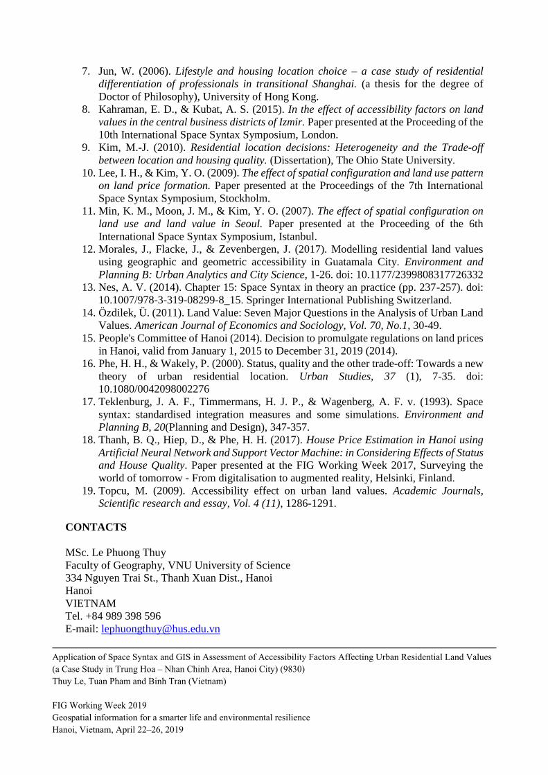
REFERENCES
1. Comber, A., Harris, P., Quan, N., Khanh, P. C., Hung, T., & Phe, H. H. (2016). Local
variation in hedonic house price, Hanoi: a spatial analysis of SQTO theory. Paper
presented at the International Conference on GIScience.
2. Din, H. S. E., Shalaby, A., Farouh, H. E., & Elariane, S. A. (2013). Principles of urban
quality of life for a neighborhood. HBRC Journal (Housing and Building National
Research Center), 9, 86-92.
3. Hillier, B. (2007). Space is the machine (pp. 368). London, United Kingdom.
4. Hillier, B., Turner, A., Yang, T., & Park, H.-T. (2007). Metric and topo-geometric
properties of urban street networks: some convergences, divergences and new results.
Paper presented at the 6th International Space Syntax Symposium, İstanbul.
5. Hoffman, A. V., Belsky, E. S., & Lee, K. (2006). The Impact of Housing on
Community: A review of scholarly theories and empirical research. Harvard University.
6. Jordaan, A. C., Drost, B. E., & Makgata, M. A. (2004). Land value as a function of
distance from the CBD: the case of the Eastern suburbs of Pretoria. The South African
Journal of Economic and Management Sciences (SAJEMS), Vol. 7, 532-541.
Application of Space Syntax and GIS in Assessment of Accessibility Factors Affecting Urban Residential Land Values
(a Case Study in Trung Hoa – Nhan Chinh Area, Hanoi City) (9830)
Thuy Le, Tuan Pham and Binh Tran (Vietnam)
FIG Working Week 2019
Geospatial information for a smarter life and environmental resilience
Hanoi, Vietnam, April 22–26, 2019
7. Jun, W. (2006). Lifestyle and housing location choice – a case study of residential
differentiation of professionals in transitional Shanghai. (a thesis for the degree of
Doctor of Philosophy), University of Hong Kong.
8. Kahraman, E. D., & Kubat, A. S. (2015). In the effect of accessibility factors on land
values in the central business districts of Izmir. Paper presented at the Proceeding of the
10th International Space Syntax Symposium, London.
9. Kim, M.-J. (2010). Residential location decisions: Heterogeneity and the Trade-off
between location and housing quality. (Dissertation), The Ohio State University.
10. Lee, I. H., & Kim, Y. O. (2009). The effect of spatial configuration and land use pattern
on land price formation. Paper presented at the Proceedings of the 7th International
Space Syntax Symposium, Stockholm.
11. Min, K. M., Moon, J. M., & Kim, Y. O. (2007). The effect of spatial configuration on
land use and land value in Seoul. Paper presented at the Proceeding of the 6th
International Space Syntax Symposium, Istanbul.
12. Morales, J., Flacke, J., & Zevenbergen, J. (2017). Modelling residential land values
using geographic and geometric accessibility in Guatamala City. Environment and
Planning B: Urban Analytics and City Science, 1-26. doi: 10.1177/2399808317726332
13. Nes, A. V. (2014). Chapter 15: Space Syntax in theory an practice (pp. 237-257). doi:
10.1007/978-3-319-08299-8_15. Springer International Publishing Switzerland.
14. Özdilek, Ü. (2011). Land Value: Seven Major Questions in the Analysis of Urban Land
Values. American Journal of Economics and Sociology, Vol. 70, No.1, 30-49.
15. People's Committee of Hanoi (2014). Decision to promulgate regulations on land prices
in Hanoi, valid from January 1, 2015 to December 31, 2019 (2014).
16. Phe, H. H., & Wakely, P. (2000). Status, quality and the other trade-off: Towards a new
theory of urban residential location. Urban Studies, 37 (1), 7-35. doi:
10.1080/0042098002276
17. Teklenburg, J. A. F., Timmermans, H. J. P., & Wagenberg, A. F. v. (1993). Space
syntax: standardised integration measures and some simulations. Environment and
Planning B, 20(Planning and Design), 347-357.
18. Thanh, B. Q., Hiep, D., & Phe, H. H. (2017). House Price Estimation in Hanoi using
Artificial Neural Network and Support Vector Machine: in Considering Effects of Status
and House Quality. Paper presented at the FIG Working Week 2017, Surveying the
world of tomorrow - From digitalisation to augmented reality, Helsinki, Finland.
19. Topcu, M. (2009). Accessibility effect on urban land values. Academic Journals,
Scientific research and essay, Vol. 4 (11), 1286-1291.
CONTACTS
MSc. Le Phuong Thuy
Faculty of Geography, VNU University of Science
334 Nguyen Trai St., Thanh Xuan Dist., Hanoi
Hanoi
VIETNAM
Tel. +84 989 398 596
E-mail: [email protected]
Application of Space Syntax and GIS in Assessment of Accessibility Factors Affecting Urban Residential Land Values
(a Case Study in Trung Hoa – Nhan Chinh Area, Hanoi City) (9830)
Thuy Le, Tuan Pham and Binh Tran (Vietnam)
FIG Working Week 2019
Geospatial information for a smarter life and environmental resilience
Hanoi, Vietnam, April 22–26, 2019

Web site: http://geogvnu.edu.vn
MSc. Pham Le Tuan
Faculty of Geography, VNU University of Science
334 Nguyen Trai St., Thanh Xuan Dist., Hanoi
Hanoi
VIETNAM
Tel. +84 396 831 089
E-mail: [email protected]
Web site: http://geogvnu.edu.vn
Assoc. Prof. Dr. Tran Quoc Binh
Faculty of Geography, VNU University of Science
334 Nguyen Trai St., Thanh Xuan Dist., Hanoi
Hanoi
VIETNAM
Tel. +84 912 856 926
E-mail: [email protected]
Web site: http://geogvnu.edu.vn
Application of Space Syntax and GIS in Assessment of Accessibility Factors Affecting Urban Residential Land Values
(a Case Study in Trung Hoa – Nhan Chinh Area, Hanoi City) (9830)
Thuy Le, Tuan Pham and Binh Tran (Vietnam)
FIG Working Week 2019
Geospatial information for a smarter life and environmental resilience
Hanoi, Vietnam, April 22–26, 2019