69 Bath Road, Thatcham, West Berkshire
13
69 Bath Road, Thatcham, West Berkshire An Archaeological Evaluation for Renaissance Habitat by Sian Anthony Thames Valley Archaeological Services Ltd Site Code 69BRT04/112 November 2004
Transcript of 69 Bath Road, Thatcham, West Berkshire

69 Bath Road, Thatcham, West Berkshire
An Archaeological Evaluation
for Renaissance Habitat
by Sian Anthony
Thames Valley Archaeological Services Ltd
Site Code 69BRT04/112
November 2004

i
Summary
Site name: 69 Bath Road, Thatcham, West Berkshire Grid reference: SU 50820 67650 Site activity: Evaluation Date and duration of project: 9th November 2004 Project manager: Steve Ford Site supervisor: Sian Anthony Site code: 69BRT04/112 Area of site: 510 sq m of total site area of 2300 sq m Summary of results: An undated gully and a possibly prehistoric posthole were located. A previous evaluation on an adjacent site revealed a gully of Roman date. Monuments identified: Gully and posthole Location and reference of archive: The archive is presently held at Thames Valley Archaeological Services, Reading and will be deposited at West Berkshire Museum in due course. This report may be copied for bona fide research or planning purposes without the explicit permission of the copyright holder Report edited/checked by: Steve Ford 12.11.04 Steve Preston 12.11.04

1
69 Bath Road, Thatcham, West Berkshire An Archaeological Evaluation
by Sian Anthony
Report 04/112
Introduction
This report documents the results of an archaeological field evaluation carried out in the rear garden of 69 Bath
Road, Thatcham, West Berkshire (SU50820 67650) (Fig. 1). The work was commissioned by Mr Sean Bates,
Renaissance Habitat, Old Henwick Cottage, Ashmore Green Road, Henwick, West Berkshire, RG18 9EP.
A planning application (app no 04/02284/OUT/Maj) has been submitted to West Berkshire Council for the
construction of new apartments with basement carparking on a plot of land at 69–71A Bath Road. The fieldwork
described below assesses only part of the site, the rear garden of 69 Bath Road. An earlier evaluation took place
in the rear garden of 71A Bath Road and those results have been integrated with this report (Taylor 2002).
This is in accordance with the Department of the Environment’s Planning Policy Guidance, Archaeology
and Planning (PPG16 1990), and the West Berkshire County ’s policies on archaeology. The field investigation
was carried out to a specification approved by Mr Duncan Coe, Archaeological Officer, West Berkshire Council.
The fieldwork was undertaken by Sian Anthony and Sarah Coles on the 9th November 2004 and the site code is
69BRT04/112. The archive is presently held at Thames Valley Archaeological Services, Reading and will be
deposited at West Berkshire Museum in due course.
Location, topography and geology
The site is located on the western side of Thatcham, on the northern side of the Bath Road and south of
Whitakers Close (Fig. 2). The underlying geology of the site is river and valley gravels (BGS 1971), which was
observed in both trenches. The site lies at a height of 78.6m above Ordnance Datum.,Tthe site has been levelled
to form the garden but overall the site remains higher than the Bath Road to the south.
Archaeological background
The site lies within an area of Roman Thatcham. Various observations were made during development of the
area in the 1930s (Harris 1930; 1937) and revealed deposits spread over c. 600m along the Bath Road with some
stretching up to 150m away from the road to the north. Finds included footings for stone buildings, stone-lined
wells, and a flue. Dating evidence spans the 1st–4th centuries AD with an emphasis on a later Roman date.

2
Harris concluded that this was the Roman town of Spinae sited on the Roman road from Silchester to
Cirencester: Margary route 41A (Margary 1973). However, Margary’s assessment of the distances recorded in
the Antonine Itinerary between Spinae or Spinis, Cirencester and Silchester would better fit with a location near
to the modern village of Speen, west of Newbury, which also has the attraction of the etymological similarity.
An evaluation on the western margins of Thatcham (now Henwick playing fields) carried out in 1992 located a
large number of Roman deposits including ditches, gullies, pits and postholes (Ford 1992) although a recent
evaluation north-west of the site revealed no archaeology (Pine 2004). Previous excavations on the western part
of the site located the terminal end of a north–south gully (Taylor 2002).
Objectives and methodology
The purpose of the evaluation was to determine the presence/absence, extent, condition, character, quality and
date of any archaeological deposits within the area of development.
Specific aims of the project are:
a) Determine if archaeologically relevant levels have survived on site.
b) Determine if archaeological deposits of any period are present on the site.
c) Determine if deposits forming part of the Roman settlement are present on the site.
Two trenches were proposed for excavation, sited to examine an area of the garden that could be accessed
at this time. Machining was to be supervised by an archaeologist and all spoil monitored. All archaeological
deposits to be hand cleaned and excavated.
A complete list of trenches giving lengths, breadths, depths and a description of sections and geology is
given in Appendix 1.
Results
Trench 1 (Plate 1)
This trench was located at the eastern limits of the garden, aligned south–north, it measured 9.6m long. The
stratigraphy consisted of turf and topsoil 0.58m deep lying over a mid brown-clayey silt subsoil 0.22m deep.
Undisturbed natural geology consisting of patches of gravel and sandy silt lay underneath. Two features were
located; a curvilinear gully [1] and a posthole [2]. The gully measured 0.30m wide and 0.16m deep and no finds
were recovered. The posthole measured 0.48m in diameter and 0.28m deep, however, there was considerable

3
root action within the feature potentially making it larger than originally dug. A piece of prehistoric pottery was
recovered from the fill.
Trench 2 (Plate 2)
This trench was located at the eastern limits of the garden, aligned south–north, it measured 9.8m long. The
stratigraphy consisted of turf and topsoil 0.5m deep lying over a deep mid brown clayey silt subsoil 0.2m deep.
Undisturbed natural geology consisting of patches of gravel and sandy silt were again observed to lie underneath.
No archaeological features or finds were located and the only aspect of note was that the centre of the trench
showed a raised patch of natural gravel which was approximately 0.16m deep.
Finds
Pottery by Steve Ford One single sherd of pottery weighing 4g was recovered from posthole [2]. It was flint tempered, hand made with
a soft fabric, oxidised red brown on the outer surface and black on the inner. It is of prehistoric date, probably
later Bronze Age or early Iron Age in date.
Conclusion
This evaluation has located a modest amount of archaeology comprising a curvilinear gully and posthole. The
features were not closely dated (the gully was in fact undated) but they are certainly of archaeological interest.
The gully is likely to be of Roman date given its similarity to the one previously examined, but the presence of a
sherd of prehistoric pottery, even if residual in a feature of later date, may point to some Bronze Age activity in
the area also. These modest deposits also need to be considered and interpreted along with the findings of the
earlier evaluation to the rear of 71A Bath Road (Taylor 2002). For that evaluation again, only a modest amount
of archaeology was recorded comprising the terminal of a gully from which was recovered two pieces of pottery
dated to the Roman period. With the combination of the information of these two evaluations, it confirms the
identification of significant archaeological activity on this site either representing occupation (if the curvilinear
gully is the site of a roundhouse) or a series of paddocks or plot boundaries adjacent to an occupied area. Any
development on the site would need to take account of these remains. As the proposed development will include
deep basement carparking this will lead to the wholesale truncation of archaeological deposits.

4
References
BGS, 1971, British Geological Survey, 1:50000, Sheet 267, Drift Edition, Keyworth Ford, S, 1992, ‘Henwick Lane, Thatcham, Berkshire, An archaeological evaluation’, Thames Valley
Archaeological Services report 92/1, Reading Harris, W E, 1930, ‘A Romano-British settlement at Thatcham Newtown, Berkshire’, Trans Newbury Dist Fld
Club, 6, 6–17 Harris, W E, 1937, ‘The Romano-British settlement at Thatcham Newtown, Berkshire’, Trans Newbury Dist Fld
Club, 7, 219–55 Margary, I D, 1973, Roman Roads in Britain (3rd Edition), London Pine, J, 2004, ‘Land to the rear of 21 Henwick Lane, Thatcham, Berkshire, An archaeological evaluation’,
Thames Valley Archaeological Services report 04/30, Reading Taylor, A, 2002, ‘Land to the rear of 71A Bath Road, Thatcham, Berkshire, An archaeological evaluation’,
Thames Valley Archaeological Services report 02/58, Reading PPG16, 1990, Archaeology and Planning, Dept of the Environment Planning Policy Guidance 16, HMSO

5
APPENDIX 1: Trench details 0m at south end
Trench No. Length (m) Breadth (m) Depth (m) Comment 1 9.6 1.2 0.85 Turf and topsoil (0-0.58m), onto, mid brown clayey silt subsoil (0.58-
0.8m) onto undisturbed natural layers of gravel and silty clay. Gully 1 and posthole 2. [Plate 1]
2 9.8 1.2 0.85 Turf and topsoil (0-0.5m), onto, mid brown clayey silt subsoil (0.5-0.7m) onto undisturbed natural layers of gravel and silty clay. [Plate 2]

6
APPENDIX 2: Feature details Trench Cut Fill (s) Type Date Dating evidence 1 1 52 Gully Undated - 1 2 53 Posthole Prehistoric Pottery

69 Bath Road, Thatcham, West Berkshire, 2004Archaeological Evaluation
Figure 1. Location of site within Thatcham andBerkshire.
Reproduced from Ordnance Survey Pathfinder 1187 SU46/56 at 1:12500
Ordnance Survey Licence AL100025880
67000
68000
SU50000 51000
SITE
69BRT04/112
SITE
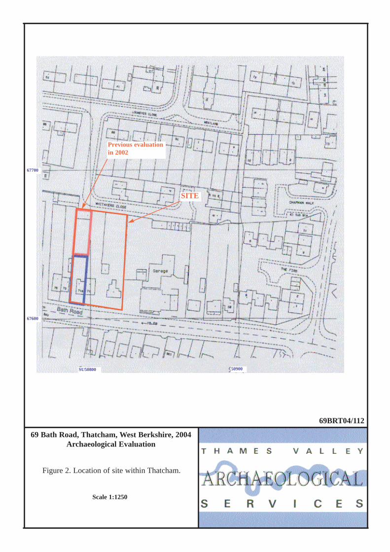
69 Bath Road, Thatcham, West Berkshire, 2004Archaeological Evaluation
Figure 2. Location of site within Thatcham.
67600
SU50800 50900
67700
SITE
Previous evaluationin 2002
69BRT04/112
Scale 1:1250

N
Bath Road
7171A7375
Whitakers Close
69 Bath Road, Thatcham, West Berkshire, 2004
Trench 1
Trench 2
Figure 3. Detailed location of evaluation trenches including those excavated in 2002. 69BRT04/112
SU50800
67650
50850
67600
0m 50m
Trench 1
Trench 2
69
1
2
2002 evaluation
SITE
1

69 Bath Road, Thatcham, West Berkshire, 2004
69BRT04/112Figure 4. Plans and sections of features.
0 2.5m
2
1
50
51
52
53
0 5m
21
Trench 1
Trench 2
Dark grey gravelLight grey gravelSilty clay Silty clay
1m 6m
2m 7m
NN
E W
S N
(scale for plan only)

Plate 1. Trench 1 looking south, horizontal scales 1m and 0.5m.
Plate 2. Trench 2 looking south, scale 1m.
69BRT04-112