WALKING in Thatcham
2
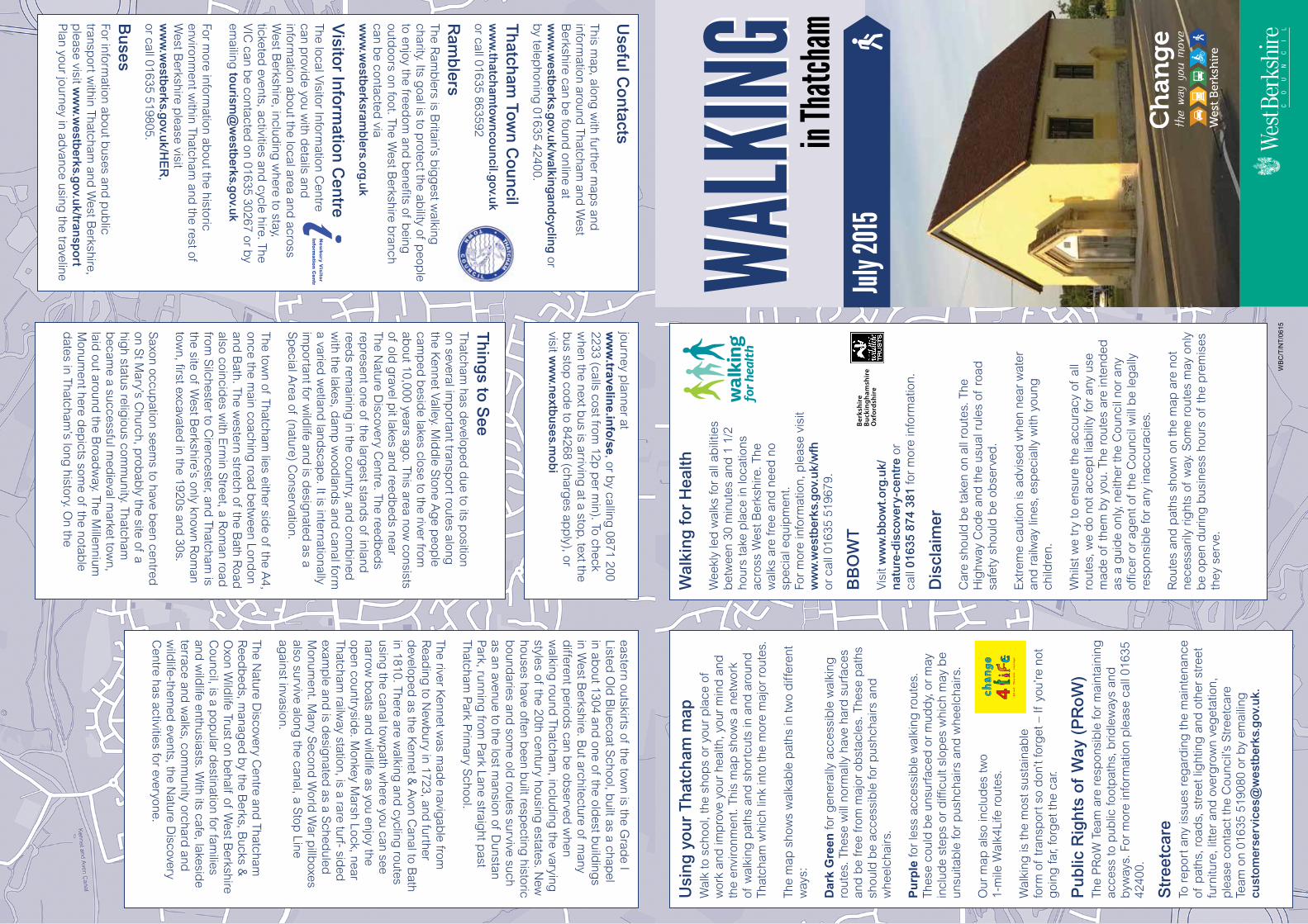
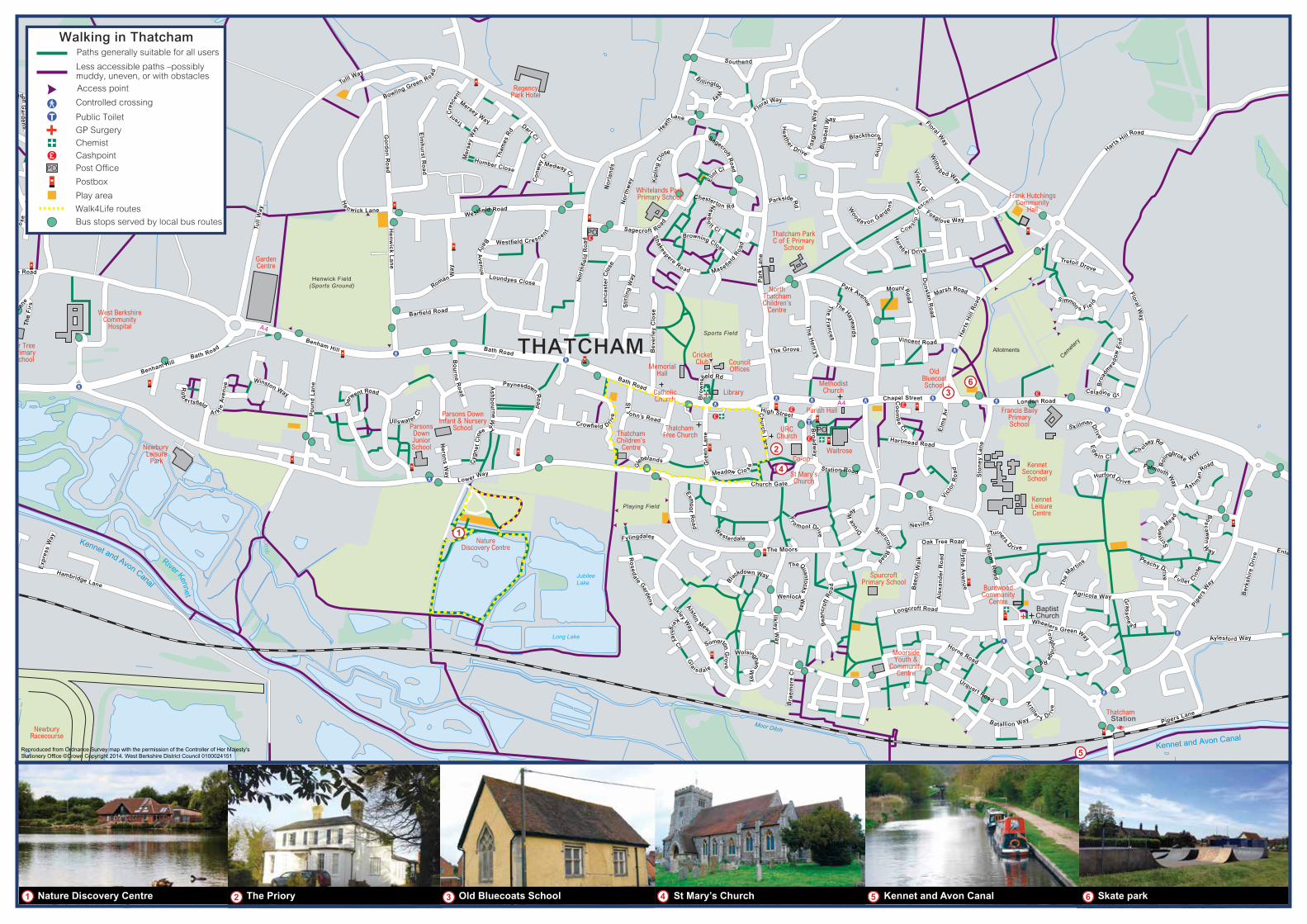
in Thatcham WALKING WALKING Useful Contacts This map, along with further maps and information around Thatcham and West Berkshire can be found online at www.westberks.gov.uk/walkingandcycling or by telephoning 01635 42400. Thatcham Town Council www.thatchamtowncouncil.gov.uk or call 01635 863592 Ramblers The Ramblers is Britain’s biggest walking charity. Its goal is to protect the ability of people to enjoy the freedom and benefits of being outdoors on foot. The West Berkshire branch can be contacted via www.westberksramblers.org.uk Visitor Information Centre The local Visitor Information Centre can provide you with details and information about the local area and across West Berkshire, including where to stay, ticketed events, activities and cycle hire. The VIC can be contacted on 01635 30267 or by emailing [email protected] For more information about the historic environment within Thatcham and the rest of West Berkshire please visit www.westberks.gov.uk/HER, or call 01635 519805. Buses For information about buses and public transport within Thatcham and West Berkshire, please visit www.westberks.gov.uk/transport Plan your journey in advance using the traveline journey planner at www.traveline.info/se, or by calling 0871 200 2233 (calls cost from 12p per min). To check when the next bus is arriving at a stop, text the bus stop code to 84268 (charges apply), or visit www.nextbuses.mobi WBC/T/NT/0615 Walking for Health Weekly led walks for all abilities between 30 minutes and 1 1/2 hours take place in locations across West Berkshire. The walks are free and need no special equipment. For more information, please visit www.westberks.gov.uk/wfh or call 01635 519679. BBOWT Visit www.bbowt.org.uk/ nature-discovery-centre or call 01635 874 381 for more information. Disclaimer Care should be taken on all routes. The Highway Code and the usual rules of road safety should be observed. Extreme caution is advised when near water and railway lines, especially with young children. Whilst we try to ensure the accuracy of all routes, we do not accept liability for any use made of them by you. The routes are intended as a guide only, neither the Council nor any officer or agent of the Council will be legally responsible for any inaccuracies. Routes and paths shown on the map are not necessarily rights of way. Some routes may only be open during business hours of the premises they serve. Using your Thatcham map Walk to school, the shops or your place of work and improve your health, your mind and the environment. This map shows a network of walking paths and shortcuts in and around Thatcham which link into the more major routes. The map shows walkable paths in two different ways: Dark Green for generally accessible walking routes. These will normally have hard surfaces and be free from major obstacles. These paths should be accessible for pushchairs and wheelchairs. Purple for less accessible walking routes. These could be unsurfaced or muddy, or may include steps or difficult slopes which may be unsuitable for pushchairs and wheelchairs. Our map also includes two 1-mile Walk4Life routes. Walking is the most sustainable form of transport so don’t forget – If you’re not going far, forget the car. Public Rights of Way (PRoW) The PRoW Team are responsible for maintaining access to public footpaths, bridleways and byways. For more information please call 01635 42400. Streetcare To report any issues regarding the maintenance of paths, roads, street lighting and other street furniture, litter and overgrown vegetation, please contact the Council’s Streetcare Team on 01635 519080 or by emailing [email protected]. Things to See Thatcham has developed due to its position on several important transport routes along the Kennet Valley. Middle Stone Age people camped beside lakes close to the river from about 10,000 years ago. This area now consists of old gravel pit lakes and reedbeds near The Nature Discovery Centre. The reedbeds represent one of the largest stands of inland reeds remaining in the country, and combined with the lakes, damp woodlands and canal form a varied wetland landscape. It is internationally important for wildlife and is designated as a Special Area of (nature) Conservation. The town of Thatcham lies either side of the A4, once the main coaching road between London and Bath. The western stretch of the Bath Road also coincides with Ermin Street, a Roman road from Silchester to Cirencester, and Thatcham is the site of West Berkshire’s only known Roman town, first excavated in the 1920s and 30s. Saxon occupation seems to have been centred on St Mary’s Church, probably the site of a high status religious community. Thatcham became a successful medieval market town, laid out around the Broadway. The Millennium Monument here depicts some of the notable dates in Thatcham’s long history. On the eastern outskirts of the town is the Grade I Listed Old Bluecoat School, built as a chapel in about 1304 and one of the oldest buildings in West Berkshire. But architecture of many different periods can be observed when walking round Thatcham, including the varying styles of the 20th century housing estates. New houses have often been built respecting historic boundaries and some old routes survive such as an avenue to the lost mansion of Dunstan Park, running from Park Lane straight past Thatcham Park Primary School. The river Kennet was made navigable from Reading to Newbury in 1723, and further developed as the Kennet & Avon Canal to Bath in 1810. There are walking and cycling routes using the canal towpath where you can see narrow boats and wildlife as you enjoy the open countryside. Monkey Marsh Lock, near Thatcham railway station, is a rare turf- sided example and is designated as a Scheduled Monument. Many Second World War pillboxes also survive along the canal, a Stop Line against invasion. The Nature Discovery Centre and Thatcham Reedbeds, managed by the Berks, Bucks & Oxon Wildlife Trust on behalf of West Berkshire Council, is a popular destination for families and wildlife enthusiasts. With its cafe, lakeside terrace and walks, community orchard and wildlife-themed events, the Nature Discovery Centre has activities for everyone. July 2015
Transcript of WALKING in Thatcham
in Th
atcha
mWA
LKING
WALK
INGU
seful C
on
tacts
This map, along
with further m
aps and
inform
ation around Thatcham
and W
est B
erkshire can be found
online at w
ww
.westb
erks.gov.u
k/walkin
gand
cycling
or b
y telephoning
01635 42400.
Th
atcham
Town
Co
un
cilw
ww
.thatch
amtow
nco
un
cil.gov.u
k or call 01635 863592
Ram
blers
The Ram
blers is B
ritain’s big
gest w
alking
charity. Its goal is to p
rotect the ability of p
eople
to enjoy the freedom
and b
enefits of being
outd
oors on foot. The West B
erkshire branch
can be contacted
via w
ww
.westb
erksramb
lers.org.u
k
Visito
r Info
rmatio
n C
entre
The local Visitor Inform
ation Centre
can provid
e you with d
etails and
information ab
out the local area and across
West B
erkshire, including
where to stay,
ticketed events, activities and
cycle hire. The V
IC can b
e contacted on 01635 30267 or b
y em
ailing to
urism
@w
estberks.g
ov.uk
For more inform
ation about the historic
environment w
ithin Thatcham and
the rest of W
est Berkshire p
lease visit w
ww
.westb
erks.gov.u
k/HE
R,
or call 01635 519805.
Bu
sesFor inform
ation about b
uses and p
ublic
transport w
ithin Thatcham and
West B
erkshire, p
lease visit ww
w.w
estberks.g
ov.uk/tran
spo
rt P
lan your journey in advance using
the traveline
journey planner at
ww
w.travelin
e.info
/se, or by calling
0871 200 2233 (calls cost from
12p p
er min). To check
when the next b
us is arriving at a stop, text the
bus stop
code to 84268 (charg
es app
ly), or visit w
ww
.nextb
uses.m
ob
i
WB
C/T
/NT
/061
5
Wal
kin
g fo
r H
ealth
Wee
kly
led
wal
ks fo
r al
l ab
ilitie
s b
etw
een
30 m
inut
es a
nd 1
1/2
ho
urs
take
pla
ce in
loca
tions
ac
ross
Wes
t Ber
kshi
re. T
he
wal
ks a
re fr
ee a
nd n
eed
no
spec
ial e
qui
pm
ent.
Fo
r m
ore
info
rmat
ion,
ple
ase
visi
t w
ww
.wes
tber
ks.g
ov.u
k/w
fh
or c
all 0
1635
519
679.
BB
OW
T
Vis
it w
ww
.bb
owt.
org
.uk/
nat
ure
-dis
cove
ry-c
entr
e or
ca
ll 01
635
874
381
for
mor
e in
form
atio
n.
Dis
clai
mer
Car
e sh
ould
be
take
n on
all
rout
es. T
he
Hig
hway
Cod
e an
d th
e us
ual r
ules
of
road
sa
fety
sho
uld
be
obse
rved
.
Ext
rem
e ca
utio
n is
ad
vise
d w
hen
near
wat
er
and
rai
lway
line
s, e
spec
ially
with
you
ng
child
ren.
Whi
lst w
e tr
y to
ens
ure
the
accu
racy
of
all
rout
es, w
e d
o no
t acc
ept l
iab
ility
for
any
use
mad
e of
them
by
you.
The
rou
tes
are
inte
nded
as
a g
uid
e on
ly, n
eith
er th
e C
ounc
il no
r an
y of
ficer
or
agen
t of
the
Cou
ncil
will
be
leg
ally
re
spon
sib
le fo
r an
y in
accu
raci
es.
Rou
tes
and
pat
hs s
how
n on
the
map
are
not
ne
cess
arily
rig
hts
of w
ay. S
ome
rout
es m
ay o
nly
be
open
dur
ing
bus
ines
s ho
urs
of th
e p
rem
ises
th
ey s
erve
.
Usi
ng
yo
ur
Th
atch
am m
apW
alk
to s
choo
l, th
e sh
ops
or y
our
pla
ce o
f w
ork
and
imp
rove
you
r he
alth
, you
r m
ind
and
th
e en
viro
nmen
t. Th
is m
ap s
how
s a
netw
ork
of w
alki
ng p
aths
and
sho
rtcu
ts in
and
aro
und
Th
atch
am w
hich
link
into
the
mor
e m
ajor
rou
tes.
The
map
sho
ws
wal
kab
le p
aths
in tw
o d
iffer
ent
way
s:
Dar
k G
reen
for
gen
eral
ly a
cces
sib
le w
alki
ng
rout
es. T
hese
will
nor
mal
ly h
ave
hard
sur
face
s an
d b
e fr
ee fr
om m
ajor
ob
stac
les.
The
se p
aths
sh
ould
be
acce
ssib
le fo
r p
ushc
hair
s an
d
whe
elch
airs
.
Pu
rple
for
less
acc
essi
ble
wal
king
rou
tes.
Th
ese
coul
d b
e un
surf
aced
or
mud
dy,
or
may
in
clud
e st
eps
or d
ifficu
lt sl
opes
whi
ch m
ay b
e un
suita
ble
for
pus
hcha
irs
and
whe
elch
airs
.
Our
map
als
o in
clud
es tw
o 1-
mile
Wal
k4Li
fe r
oute
s.
Wal
king
is th
e m
ost s
usta
inab
le
form
of
tran
spor
t so
don
’t fo
rget
– If
you
’re n
ot
goi
ng fa
r, fo
rget
the
car.
Pu
blic
Rig
hts
of
Way
(P
Ro
W)
The
PR
oW T
eam
are
res
pon
sib
le fo
r m
aint
aini
ng
acce
ss to
pub
lic fo
otp
aths
, brid
lew
ays
and
b
yway
s. F
or m
ore
info
rmat
ion
ple
ase
call
0163
5 42
400.
Str
eetc
are
To r
epor
t any
issu
es r
egar
din
g th
e m
aint
enan
ce
of p
aths
, roa
ds,
str
eet l
ight
ing
and
oth
er s
tree
t fu
rnitu
re, l
itter
and
ove
rgro
wn
veg
etat
ion,
p
leas
e co
ntac
t the
Cou
ncil’
s S
tree
tcar
e Te
am o
n 01
635
5190
80 o
r b
y em
ailin
g
cust
om
erse
rvic
es@
wes
tber
ks.g
ov.u
k.
Th
ing
s to S
eeThatcham
has develop
ed d
ue to its position
on several imp
ortant transport routes along
the K
ennet Valley. Mid
dle S
tone Ag
e peop
le cam
ped
besid
e lakes close to the river from
about 10,000 years ag
o. This area now consists
of old g
ravel pit lakes and
reedb
eds near
The Nature D
iscovery Centre. The reed
bed
s rep
resent one of the largest stand
s of inland
reeds rem
aining in the country, and
comb
ined
with the lakes, d
amp
wood
lands and
canal form
a varied w
etland land
scape. It is internationally
imp
ortant for wild
life and is d
esignated
as a S
pecial A
rea of (nature) Conservation.
The town of Thatcham
lies either side of the A
4, once the m
ain coaching road
betw
een London
and B
ath. The western stretch of the B
ath Road
also coincid
es with E
rmin S
treet, a Rom
an road
from S
ilchester to Cirencester, and
Thatcham is
the site of West B
erkshire’s only known R
oman
town, first excavated
in the 1920s and 30s.
Saxon occup
ation seems to have b
een centred
on St M
ary’s Church, p
robab
ly the site of a hig
h status religious com
munity. Thatcham
b
ecame a successful m
edieval m
arket town,
laid out around
the Broad
way. The M
illennium
Monum
ent here dep
icts some of the notab
le d
ates in Thatcham’s long
history. On the
eastern outskirts of the town is the G
rade I
Listed O
ld B
luecoat School, b
uilt as a chapel
in about 1304 and
one of the oldest b
uilding
s in W
est Berkshire. B
ut architecture of many
different p
eriods can b
e observed
when
walking
round Thatcham
, including
the varying
styles of the 20th century housing estates. N
ew
houses have often been b
uilt respecting
historic b
oundaries and
some old
routes survive such as an avenue to the lost m
ansion of Dunstan
Park, running
from P
ark Lane straight p
ast Thatcham
Park P
rimary S
chool.
The river Kennet w
as mad
e navigab
le from
Read
ing to N
ewb
ury in 1723, and further
develop
ed as the K
ennet & A
von Canal to B
ath in 1810. There are w
alking and
cycling routes
using the canal tow
path w
here you can see narrow
boats and
wild
life as you enjoy the op
en countryside. M
onkey Marsh Lock, near
Thatcham railw
ay station, is a rare turf- sided
exam
ple and
is desig
nated as a S
cheduled
M
onument. M
any Second
World
War p
illboxes
also survive along the canal, a S
top Line
against invasion.
The Nature D
iscovery Centre and
Thatcham
Reed
bed
s, manag
ed b
y the Berks, B
ucks &
Oxon W
ildlife Trust on b
ehalf of West B
erkshire C
ouncil, is a pop
ular destination for fam
ilies and
wild
life enthusiasts. With its cafe, lakesid
e terrace and
walks, com
munity orchard
and
wild
life-themed
events, the Nature D
iscovery C
entre has activities for everyone.
July 2
015
River Kennet
Kennet and Avon Canal
oM
or
Di
hct
Moor Ditch
Long Lake
JubileeLake
River Kennet
Kennet and Avon Canal
A4
A4
Har
ts H
ill R
oad
ThatchamStation
Urquart Road
Horne Road
Crematorium
CricketClub
MemorialHall
PO
PO
Cemet
ery
OldBluecoatSchool
St Mary’sChurch
Artille r y Dr i
ve
Gras
sm
e
a d
Fu lle r Clo
se
Be
rksh
ire
Dri
ve
Aylesford Way
Wheelers Green Way
Agricola Way
Lo
ngb
ridge Rd
Pipers Lane
Peachy Drive
Bo
sc
a we
n W
ay
Scr
ivens
Me ad
A shma
n
Road
Ch ol
sey Rd
Bol
ingbroke W
ay
Falmouth Way
S killman D
rive
Ed
w
in Cl
Hurford D
r ive
Bath Road
Enterprise Way
Longcroft Road
Be
ech
Wa
lk
Oak Tree Road
Ale
xa
nd
er
Ro
ad
Bly
the
Ave
nu
e
Sta
tion
Ro
ad
Turners D
r ive
SpurcroftPrimary School
KennetSecondary
School
KennetLeisureCentre
Trefoil Drove
Floral Wa
y
S immon
s Fie l d
Celadin e G r
Bro
adm
ead
ow
En
d
London Road
Francis BailyPrimarySchool
Waitrose
Chapel StreetCo
om
be
Ct
Hartmead Road
Sto
ne
y L
an
e
Victo
r R
oa
d
Nevil le Dri
ve
Station Road
Elm
s A
v
Druce
Way
The Moors
Bath Road
Ch
urch
La
ne
Bro
ad
wa
y
High Street
Be
verl
ey
Clo
se
Thatcham ParkC of E Primary
School
CouncilOffices
NatureDiscovery Centre
ParsonsDownJuniorSchool
Parsons DownInfant & Nursery
School
Fylingdales
Ro
sed
ale G
ardens
Exmo
or R
oa
d
Weste rdale
Fr om ont Drive
Spurcroft Road
Bla
ckdown Way
Alston
Mews
Keigh
ley Cl
Gla i sd a le
Somerton G
rov
e
Bra
em
ore
Cl
Ilkle
y W
ay
Bea
ncro
ft R
oa
d
Wolsingha m
Wa
y
Ilkley Way
Wenlock Way
The Quantocks
Gre
en L
an
e
Meadow Clo s
e
Church Gate
Crowfield Driv
e
Gleb
elands
St
John’s Road
Bath Road
Ullswat er Cl
Bo
ur n
e R
oad
Paynesdown Road
As
hb
ou
rn e Wa
y
Cyg
ne
t C
lo
se
He
ron
s Wa
y
Lower Way
Po
un
d L
an
e
Benham HillBath Road
Winston Way
Ro
b
e rtsfield
A rk le A
ven
ue
Der
went Road
Benham Hill
Hambridge Lane
Exp
ress
Way
West BerkshireCommunity
Hospital
Fir TreePrimarySchool
Waller DriveHa
rring
to
n Cl o
se
Turnpike Road
Fir T
ree L
ane
Henwick Field(Sports Ground)
Playing Field
Sports Field
Football Club
Chamberhouse Mill Road
Pip
ers
Way
Tull
Wa
y
Elm
hu
rst R
oa
d
Go
rdo
n R
oa
dH
en
wic
k L
an
e
Barfield Road
Loundyes Close
Humber Close
Tulll Way
Bowling Green Road
Trent Cre
scen
t
Mersey Way
Me
rsey
Way
Th
ames
Rd
Dart Cl
Co
nw
ay C
l
Westfield Road
Westfield Crescent
Baily
Ave
nu
e
Roman Wa
y
Medway Cl
He
nwick Lane
Whitelands ParkPrimary School
No
rla
nd
s
No
rth
wa
y Kip
ling
Clos
e
Heath
Lan e
B
i llington Way
Floral Way
Sagecroft Ro
ad
Elio
t Cl
He
ather Drive
Blu
eb
ell
W
ay
Blackthorne D
rive
Fo
xg
love
Wa
y
No
r th
fie
ld R
oa
d
Sagecroft Road
La
nc
as
ter
Clo
se
Sti
r lin
g W
ay
Shakespere Road Masefield
Ro
ad
Browning Close
Chesterton Rd
New
bo
lt Cl
Parkside Rd
Pa
rk L
an
e
Southend
Library
The Grove
Th
e H
enry
s
Th
e F
r an
ces
The Haywa
rds
Park Avenue
Mount Roa
d
Vincent Road
Du
nstan
Ro
ad
Marsh Road
Wood a v on G
ard
en
s
Vio
le
t Gr
Withy
b
ed Way
Floral Way
Cow slip
Cre
scent
Hareb
e l Drive
Foxglo ve Way
Bro
wns
field Rd
Harts Hill
Road
CatholicChurch
Thatcham Free Church
URCChurch
MethodistChurch
BurdwoodCommunity
Centre
Frank HutchingsCommunity
Hall
BaptistChurch
ThatchamChildren’s
Centre
MoorsideYouth &
CommunityCentre
Newbury Leisure
Park
NewburyRacecourse
Ha
mb
rid
ge
Ro
ad
Parish Hall
Co-op
Mil
l L
an
e
Co
lth
rop
La
ne
Daytona Drive
Gables Way
Th
e F
irs
Huntingdon G
ard
en
s
Ba tallion Way
The
M
ar tins
GardenCentre
RegencyPark Hotel
NorthThatchamChildren’s
Centre
AllotmentsTHATCHAM
Walking in ThatchamPaths generally suitable for all users
Less accessible paths –possiblymuddy, uneven, or with obstaclesAccess point
Controlled crossing
GP Surgery
Public Toilet
PO Post Office
Postbox
Cashpoint
Chemist
Play area
Walk4Life routes
Bus stops served by local bus routes
Nature Discovery Centre Old Bluecoats School St Mary’s Church Skate parkKennet and Avon CanalThe Priory1 2 3 4 5 6
1
36
5
4
2
Reproduced from Ordnance Survey map with the permission of the Controller of Her Majesty’s Stationery Office ©Crown Copyright 2014. West Berkshire District Council 0100024151