Worth Township Comprehensive Development Plan 1...
82
Worth Township Comprehensive Development Plan Final Draft April 1995 DATAPLAN, INC. 347 FRANKLIN STREET, SLIPPERY ROCK, PA 1 16057
Transcript of Worth Township Comprehensive Development Plan 1...
Worth Township
Comprehensive
Development Plan
Final Draft April 1995
DATAPLAN, INC. 347 FRANKLIN
STREET, SLIPPERY ROCK, PA 1 16057
WORTH TOWNSHIP
COMPREHENSIVE DEVELOPMENT PLAN
TABLE OF CONTENTS
WORTH TOWNSHIP
BUTLER COUNTY, PENNSYLVANIA
EXISTING CONDITIONS AND RESEARCH ELEMENT
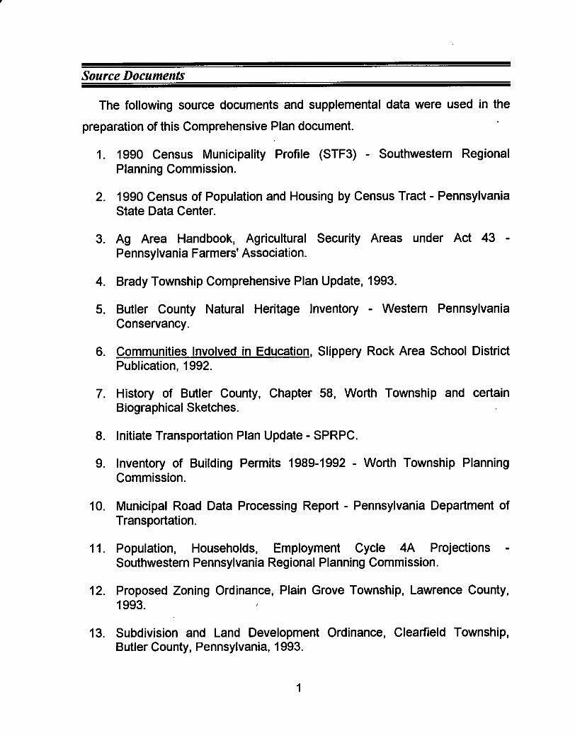
The following source documents and supplemental data were used in the
preparation of this Comprehensive Plan document.
1. 1990 Census Municipality Profile (STF3) - Southwestern Regional Planning Commission.
2. 1990 Census of Population and Housing by Census Tract - Pennsylvania State Data Center.
3. Ag Area Handbook, Agricultural Security Areas under Act 43 - Pennsylvania Farmers' Association.
4. Brady Township Comprehensive Plan Update, 1993.
5. Butler County Natural Heritage Inventory - Western Pennsylvania Conservancy.
6. Communities Involved in Education, Slippery Rock Area School District Publication. 1992.
7. History of Butler County, Chapter 58, Worth Township and certain Biographical Sketches.
8. Initiate Transportation Plan Update - SPRPC.
9. Inventory of Building Permits 1989-1992 - Worth Township Planning Commission.
IO. Municipal Road Data Processing Report - Pennsylvania Department of Transportation.
11. Population, Households, Employment Cycle 4A Projections - Southwestern Pennsylvania Regional Planning Commission.
12. Proposed Zoning Ordinance, Plain Grove Township, Lawrence County, 1993.
13. Subdivision and Land Development Ordinance, Clearfield Township, Butler County, Pennsylvania, 1993.
1
14. Summary Groundwater Resources of Butler County, PA - Pennsylvania Department of Environmental Resources Bureau of Topographic and Geologic Resources.
15. Traffic Counts Interstate 79 and Route 108 - Southwestern Pennsylvania Regional Planning Commission.
2
Introduction and Purpose
This planning document represents the efforts of the members of the Worth
Township Board of Supervisors and Planning Commission to prepare for the
future of the Township as it relates to new development, and that development's
impact on the present and future residents of the community, as well as the
impact of growth on the natural environment.
This process began in the spring of 1992 with the realization that external
influences are being introduced into the community because of its geographic
location in the northwestern portion of Butler County. Access to U.S. Interstate
79, a major northlsouth transportation facility in Western Pennsylvania and to
Pennsylvania State Route 108 and U.S. Route 422, east/west arterial
roadways, is an important factor in the projection of Worth Township's
development potential.
With full interchanges near both the northern and southern boundaries of the
Township, the ability to reside in Worth Township and to commute to work in
urban and suburban areas to the south and west makes Worth Township an
attractive option both to young families and to empty nest couples looking for
second or seasonal homes. This document will present a comprehensive look
at the elements which will stimulate growth and the constraints which will
discourage it.
Information has been accumulated during the last year and Township
officials have initiated a series of work sessions, including the drafting of a
community attitude questionnaire, which is included in the text. Response from
the residents was positive and additional input on matters of concern to the
people of this community will play an important role in the production of a
development plan which reflects their hopes for the future.
3
This planning process will culminate in the creation of a specific set of
community goals designed to accomplish both long range and short term
objectives. The identification of human resources, available funding sources for
community development grants, state and county agencies which offer
community development assistance, and local officials and staff willing to
devote their time and energy to document specific features of the physical or
social environment are keys to the successful attainment of the identified
community objectives.
Worth Township, primarily an agricultural area in northern Butler County,
western Pennsylvania, has begun to experience the residential growth that
comes with the availability of regional recreational opportunities within the
municipal boundaries and in adjacent communities. Moraine State Park, and to
a lesser extent, McConnell's Mills State Park and Jennings Nature Preserve,
attract thousands of visitors annually to this area of Butler County. The
physiography of the region leaves positive impressions on people from
intensely developed urban and suburban areas as far west as Youngstown,
Ohio and from the Pittsburgh Metropolitan Statistical Area. The rolling hills,
clean streams, heavily wooded tracts, and scenic beauty are internal factors
which are attracting residential development from all directions.
The Township has entered another stage in its evolution from it's mid-I 800's
agricultural and extractive industries roots to the early 21st century rural
suburban community it is moving toward. Agricultural activities and residential
subdivisions are not mutually exclusive land uses, however, each use should be
provided for in the plan. Each requires its own guidelines and community
awareness to minimize any negative impacts one may have on the other. This
development plan addresses that issue and recommends measures to achieve
a harmony of purpose.
4
The lack of community and private facilities and utilities such as water and
sanitary sewerage, cable T.V. and community services such as police and fire
protection will deter major development in the short term, however, as the
technology advances making private sanitary treatment facilities more
cost-effective, the potential for substantial development exists. The
proliferation of on-lot wastewater disposal systems and deep wells is not the
most efficient method of delivering individual amenities. As more homes are
built in certain areas of the Township, system failures due to soil saturation may
cause residents to consider other options.
.
A low tax burden and minimal local government services may provide area
residents with a sense of independence. However, as more people migrate to
the community, the desire for additional services will be voiced. A plan to
monitor this issue and react in an efficient, cost-effective manner is the goal of
any community in the path of growth. Worth Township has committed itself to a
self-evaluation at its present stage of maturity through the creation of a
comprehensive development plan.
The implementation of a strategic plan is the business of the elected
officials, appointed officials and staff with assistance from state and county
agencies and the support of the community's residents. The development plan
represents the needs and wants of the people who live in the community and is a conceptual blueprint for managed growth. Its success depends on the
sensibility of its community objectives and the determination of its people.
5
Worth Township is a township of the second class in Butler County, which is
the most common form of local government in the Commonwealth of
Pennsylvania, numbering 1,458 municipalities. There are currently three (3)
supervisors elected at large for six (6) year terms, with not more than two (2)
supervisors elected in any given local election year.
Primary responsibilities of the elected officials include road maintenance,
expenditure of Township funds, liaison with State Police for patrol coverage,
implementation of a township-wide recycling program, and the day-to-day
operations of the local government. There have been no major bond issues
passed for capital improvements within the municipality, and none are expected
in the short term.
The Board of Supervisors have appointed a seven (7) member Planning
Commission, charged with the review and recommendation of applications for
land development and subdivision. Butler County Planning Commission also
reviews subdivision plats submitted in Worth Township and approvals and
correspondence are coordinated by the Township Planning Commission
Secretary.
The Planning Commission is also assigned tasks deemed appropriate by
the Board of Supervisors. One such project is the creation of the Township's
first Comprehensive Development Plan, as per Section 301 of the Pennsylvania
Municipalities Planning Code, Act 170, as amended. Public meetings are held
by both the Board of Supervisors and the Planning Commission, as required by
Act 170.
There are, at present, two (2) full time employees on the road crew, a part
time Township Secretary, an appointed Sewage Enforcement Officer for the
6
issuance of Department of Environmental Resources on-lot wastewater
disposal permits, an appointed Solicitor and a consulting engineer, employed
on an as-needed basis. The Secretary issues building permits and is
responsible for the filing and referral of official Township correspondence.
The Board of Supervisors currently hold a monthly business meeting in the
Worth Township Maintenance Building, off of West Park Road, on the second
Tuesday of each month. The Township Planning Commission meets on the
fourth Thursday of each month, also in the maintenance building.
7
Histnrv and Earlv Characteristics
Settlement
The area of Butler County incorporated as Worth Township in 1854 was '
comprised of a large portion of Muddy Creek Township and a smaller portion of
Slippery Rock Township. The land is situated between the Muddy Creek and
Slippery Rock Creek drainage basins in the northwestern portion of the County
abutting both Mercer and Lawrence Counties. While agriculture dominated
early activities in the northem half of the Township, coal and natural gas were
extracted in the southem portion during the late 1800's. The Township was
named for General Worth, a hero of the Mexican War fought between 1846 and
1848.
In 1790 the first non-native people, David Studebaker and Abraham Snyder,
both from Westmoreland County, hunted and fished the area exploring the
region through the winter and eventually built a cabin. In 1793, Studebaker
returned with his father, Joseph, and a sister. Settlers during this period were
said to have fought well in the Revolutionary War; some of these early settlers
were William and John Elliott, John Dennison, David, George and Rebecca
Armstrong, Henry Stinetorf, John and Jacob Pisor, Thomas, David, William and
Samuel Cross, David and William McConnell. William McNees, and Benjamin
Jack.
During the later years of the last decade of the eighteenth century, Jonathan
Kelly, a blacksmith, Archibald, Michael and Joseph Kelly, Thomas Clark, also a
Revolutionary War soldier, and his sons, Andrew and John, settled in Worth
Township. In 1798. Thomas Humphrey, Andrew, Edward and James ,Douglas
and Charles Coulter arrived from Northern Ireland. Soon thereafter,
Christopher Wimer, Charles Martin, John Martin Sr., and John Martin Jr., John
8
Taggert, Hugh Henderson, who was famous for his whiskey, and John Moore
had established permanent homesteads before 1800.
In the first years of the new century, Worth Township became the home of
Isaac Cornelius, whose wife and twelve children settled on what was known as
Hogback Ridge. Casper Hockenberry located on the North Bank of Muddy
Creek in 1810. Robert Glenn and Alexander McBride, who was a miller and a
school teacher and George Taylor, had settled in the Township by 1820, in the
vicinity of the mouth of Wolf Creek.
Of course all of the early settlers, beginning in 1790 when the first white men
Studebaker and Snyder entered the region, had to coexist with the Delaware
Indians who had established several permanent settlements along Slippery
Rock and Wolf Creeks. A treaty, entered into by regional government officials
from Allegheny and Erie Counties, with several local tribes was signed in
Greenville, Pennsylvania, reducing tensions between the native Indian
inhabitants and European settlers looking for new opportunities in what was the
United States' first frontier. By 1860, six years after the creation of Worth
Township, nine hundred and twenty eight persons populated the municipality.
Eorlv Schools
Five pioneer subscription schools were constructed in Worth Township
during its settlement period. Attendees were charged $6.00 a term for the
instruction. Before the year 1835 when the common school law was adopted,
two of the one room schools were built in the northwest comer of fhe
community, one north of what is now called Route 108 and one south on
Brandon Road in the Slippery Rock Creek watershed. School No. 1, at the
confluence of Wolf Creek and Slippery Rock Creek, was relocated from its
9
place beside the United Presbyterian Church on Route 108 in 1991, and is now
situated in Slippery Rock Township, restored as a restaurant.
School No. 3, which was actually the first one built, on Pisor Road in the
southwestern comer of Worth Township, provided educational opportunities to
settlers in the Muddy Creek basin. Subsequent school buildings were located
centrally to areas being settled within the boundaries of the Township and were
later incorporated as a part of the public school system. Eight districts were
eventually created before consolidation occurred.
Early Industry
In 1803, a saw mill built by Thomas Coulter was the first enterprise of its
type in the region. Grist mills built by Alexander McBride, an Irish immigrant,
and Franklin Elliott were in operation by 1830. Log buildings constructed for the
purpose of housing these fledgling enterprises were probably the first
established businesses in the Township.
A carding mill, used to prepare wool and cotton fabrics for weaving, was
established by Charles Coulter after the War of 1812 in Jacksville, which was
prior to this period called Mechanicsburg. That mill was expanded in 1854 and
used throughout the years of the Civil War, to produce blankets and flannel.
A number of distilleries were established early in the Township's history.
Hugh Henderson was considered to be the maker of the best whiskey during
the period, and Jonathan Dean and William Vogan both competed with
Henderson in what was considered to be a brisk market until the temperance
movement forced most whiskey producing enterprises out of business.
10
A tavern, started in 1803 by James Coulter, and subsequently owned by
Alexander Balph, did a good business through the mid-1800's south of
Jacksville.
Cli urches
The United Presbyterian Church at Wolf Creek was organized in 1809, and
the building later constructed is still used by today's congregation, on the north
side of what is now identified as Route 108, as the Wolf Creek Presbyterian
Church. Alexander Murray was its first ordained pastor and the church building
was completed in 1811. In 1839 the original log church burned and a new
frame church built.
Zion Baptist Church was organized in 1841, by families from Muddy Creek
Township and several local families. A brick building was erected on lands
donated by Jacob Fisher in 1843 and the first pastor was Rev. Daniel Daniels.
In 1871, the Mount Union Church of God was organized and a church
building erected in 1873, on land donated by John Updegraph. Rev. Joseph
Grimm was its first pastor.
villa,ee.s
One settlement attained the status of village in Worth Township at the
intersection of Reichert Road and Humphrey Road, where Humphrey Road
crossed Black Run. A post office begun in William Jack's store in the
mid-I 860's (date approximate), near the settlement, caused most early
residents to refer to the village as Jacksville or Jacksville Post Office. The
original name of Mechanicsburg was attributed to the fact that at one time a
number of people with mechanical skills lived in the village.
11
At its peak in the late 1800s, there were a dozen houses, a general store,
harness shop, post office, blacksmith shop, town hall, a wagon shop, a woolen
mill and a tannery occupied in the village of Jacksville.
Earlv Corporations
The Worth Township Mutual Fire Insurance Company, chartered in 1875,
insured farm buildings and the products of early industries in a twelve township
area, and at one time, provided approximately $1,000,000 in total coverage.
The Worth Township Gas Company was formed in 1892 to operate gas wells
on the Glenn and McClymonds farms.
12
Education Opportunities
School aged children in Worth Township attend the Slippery Rock Area
School District facilities in Prospect Borough at the Moraine Elementary School,
Slippery Rock Borough at the Slippery Rock Elementary School, and Slippery
Rock Township at the Middle School and High School, depending on their age.
The Slippery Rock Area School District is one of the largest, geographically, in
Western Pennsylvania, encompassing all of Mercer, Slippery Rock, Worth,
Brady, Muddy Creek and Franklin Townships, plus the Boroughs of Harrisville,
Slippery Rock, West Liberty, Portersville and Prospect.
During the 1993-94 school year, the district will be engaged in long range
planning activities at the request of the Pennsylvania Department of Education.
Rapid growth in the southern portion of the district and the consolidation of
facilities in light of expected enrollment projections have necessitated these
planning activities.
In all, the district operates three elementary schools, a middle school and a
high school with a current budget of approximately $14,000,000.00. There are
one hundred fifty-five (155) people on the professional staff, sixty percent (60%)
of which have achieved a masters degree. The average teacher has fifteen
(1 5) years of teaching experience.
The six townships total one hundred and twenty-one square miles and the
five boroughs in the school district total ten and one half square miles, making
the logistics of busing critical, especially during the winter months when road
conditions are a factor in the safe and timely delivery of students to their
schools. The district anticipates the occurrence of at least four "snow days"
annually and as a result school classes begin in late August. West Liberty
Borough is actually closer to the geographic center of the district than Slippery
13
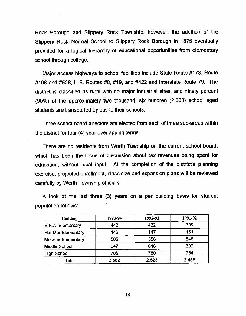
Rock Borough and Slippery Rock Township, however, the addition of the
Slippery Rock Normal School to Slippery Rock Borough in 1875 eventually
provided for a logical hierarchy of educational opportunities from elementary
school through college.
Major access highways to school facilities include State Route #173, Route
#I08 and #528, US. Routes #8, #19, and #422 and Interstate Route 79. The
district is classified as rural with no major industrial sites, and ninety percent
(90%) of the approximately two thousand, six hundred (2,600) school aged
students are transported by bus to their schools.
Three school board directors are elected from each of three sub-areas within
the district for four (4) year overlapping terms.
There are no residents from Worth Township on the current school board,
which has been the focus of discussion about tax revenues being spent for
education, without local input. At the completion of the district's planning
exercise, projected enrollment, class size and expansion plans will be reviewed
carefully by Worth Township officials.
A look at the last three (3) years on a per building basis for student
population follows:
14
Clearly the school aged population in the region and in the Township is
increasing. At a two percent (2%) increase annually, the student-teacher ratio
may become unacceptable within the next two contract periods.
15
Conimumity Facilities amd Services
At present, the business of the Worth Township government is conducted in
a portion of the community's maintenance garage on the south side of West
Park Road and on the west side of the Interstate 79 right-of-way. The structure
is a steel-sided pole building of approximately two thousand (2,000) square feet
which houses the Township's road maintenance equipment and tax records.
Two full time road crew employees and a part-time Township secretary
comprise the community's work force and approximately ninety percent of all
annual tax revenues are assigned to road maintenance. A major portion of
West Park Road, which functions as Worth Township's major interior
north-south collector roadway, was widened and repaved in 1992.
Including Act 32 "Tumback" mileage, 14.57 miles of roads which were once
owned by the State but subsequently improved and turned back to the
municipality, the Township maintains 43.35 lineal miles of roads and the State
maintains 3.25 miles. All potable water and sanitary sewerage disposal and
treatment is provided for "on-lot", through private wells, and private on-lot
wastewater disposal systems, with the exception of a private treatment plant on
the Slippery Rock Campgrounds site which is designed to accommodate the
effluent from 1,100 sites.
Public Utilities
Both Columbia and Peoples Gas Company provide service to portions of
Worth Township while United Telephone provides communication via several
exchanges. Armstrong Utilities supply cable television service along Route 108
right-of-way west to the Slippery Rock campground site along Slippery Rock
Creek. Electricity is distributed through the Central Electric Co-op and West
Penn Power and all areas within the municipal boundaries are serviced.
16

Housing and Houseliolds
Owner Occupied Renter Occupied Vacant Seasonal Unit
Total
Information for this element of the comprehensive plan for Worth Township
was derived from several sources and minor discrepancies exist among the
data collected. For the purpose of this discussion, the data made available
through the Southwestern Pennsylvania Regional Planning Commission's
municipality profile is considered the most accurate. This data was condensed
and revised based on post-census housing counts and attached to the
Summary Tape File 3 data for analysis of economic elements.
1970 1980 1990
182 247 287 44 42 47 21 19 40 74 92 102 32 1 400 476
A comparison of housing units from 1970 to 1990 indicates a steady rate of
residential growth in Worth Township. While statistics vary depending on the
source of the data, total population has increased by approximately two
hundred persons over the last two decades, representing an overall rate of
growth of approximately 1.3% annually. Between 1980 and 1990 the rate
increased to 1.5% and building permit records from 1990 to 1992 indicate an
increase, if sustained, of more than 3% annually, or double the rate of the
previous decade.
HOUSING I Number of Housina Units I
Average household sizes for the same period have been steadily decreasing
while the rate of construction of new dwelling units has been on the rise. This is a county-wide trend and reflects the increase in two income families with no
17
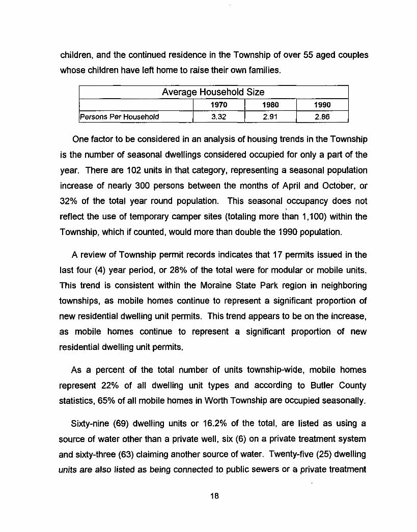
children, and the continued residence in the Township of over 55 aged couples
whose children have left home to raise their own families.
1970 1980 1990
reflect the use of temporary camper sites (totaling more than 1,100) within the
Township, which if counted, would more than double the 1990 population.
Persons Per Household
A review of Township permit records indicates that 17 permits issued in the
last four (4) year period, or 28% of the total were for modular or mobile units.
This trend is consistent within the Moraine State Park region in neighboring
townships, as mobile homes continue to represent a significant proportion of
new residential dwelling unit permits. This trend appears to be on the increase,
as mobile homes continue to represent a significant proportion of new
residential dwelling unit permits.
3.32 2.91 2.86
As a percent of the total number of units township-wide, mobile homes
represent 22% of all dwelling unit types and according to Butler County
statistics, 65% of all mobile homes in Worth Township are occupied seasonally.
Sixty-nine (69) dwelling units or 16.2% of the total, are listed as using a
source of water other than a private well, six (6) on a private treatment system
and sixty-three (63) claiming another source of water. Twenty-five (25) dwelling
units are also listed as being connected to public sewers or a private treatment
18
plant. Slippery Rock Campgrounds provides the majority of these alternative
facilities, but the vast majority of dwellings rely on private wells and on-lot
septic systems.
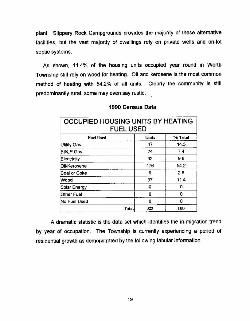
As shown, 11.4% of the housing units occupied year round in Worth
Township still rely on wood for heating. Oil and kerosene is the most common
method of heating with 54.2% of all units. Clearly the community is still
predominantly rural, some may even say rustic.
Fuel Used
1990 Census Data
Units 'Yo Total
I OCCUPIED HOUSING UNITS BY HEATING
Utility Gas BtllLP Gas Electricity OillKerosene Coal or Coke Wood Solar Energy Other Fuel
FUEL USED
47 14.5 24 7.4 32 9.8 176 54.2 9 2.8
37 11.4 0 0
0 0 No Fuel Used 0 0
Total
19
325 100
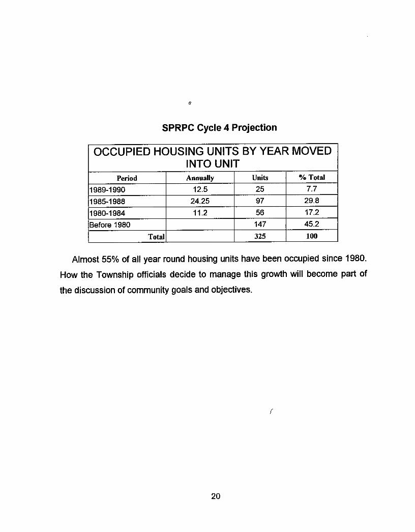
SPRPC Cycle 4 Projection
I OCCUPIED HOUSING UNITS BY YEAR MOVED I Period
1989-1 990 1985-1 988 1980-1 984 Before 1980
Total
INTO UNIT Annually Units Yo Total
12.5 25 7.7 24.25 97 29.8 11.2 56 17.2
147 45.2 325 100
Almost 55% of all year round housing units have been occupied since 1980.
How the Township officials decide to manage this growth will become part of
the discussion of community goals and objectives.
20
Transportation and Circulatiotr
The total mileage of all public Township and State roads presently being
maintained is 46.6. Aside from Interstate Route 79, a major highway which
runs north to south roughly through the center of the Township, State Route 108
(3.25 miles), which lies east to west in the northernmost portion of the
community, is the only other transportation facility classified as a major
collector. This roadway connects the city of New Castle with Slippery Rock
Borough, and also provides access to Interstate Route 79.
Immediately south of the southern Township boundary line, State Route 422,
which connects the cities of Butler and New Castle, runs east to west and is
accessible via a full interchange off of Interstate Route 79. With access to and
from a major highway at both the northern and southern perimeter, Worth
Township's accessibility to large volumes of traffic is evident.
Traffic Volumm
Hourly traffic counts taken by the Southwestern Pennsylvania Planning
Commission on January 8, 1992, approximately midway between Exits #29 and
#30, total 17,663 vehicle trips both north and south. Peak hours were between
11 a.m. and noon (1,189 vehicles) and between 4 p.m. and 5 p.m. (1,294
vehicles). More trips were heading south than north, 9,716 to 7,947.
Similar counts taken on State Route 108 between the Lawrence County line
and the Interstate Route 79 ramps, between August 29 and August 31, 1989,
indicate an average twenty-four (24) hour weekday count of 4,545 vehicles in
both directions. The peak hours were between 7 a.m. and 8 a.m.. (350
vehicles) and between 4 p.m. and 5 p.m. (327 vehicles). These peak hours
correspond to daily work schedules at Slippery Rock University, which is the
regions largest employer.
21
Roadway Segments Survee
PennDOT's District 10 Municipal Road Data Report surveyed forty-eight (48)
roadway segments in Worth Township for surface conditions, cartway width,
right-of-way width and length. All Township road rights-of-way were recorded
at thirty-three feet (337, an archaic standard, two (2) rod width, except for a .5
mile segment of Church Road (T371) which was recorded at forty feet (40'). An
unnamed segment of only .25 miles in length (T661), and an unnamed segment
of only .08 miles (T662), were recorded at a sixty foot (60') right-of-way width in
the same survey.
The nominal cartway width for the vast majority of Township roads is
eighteen feet (18), with portions of Pisor Road, Camelot Road, Swope Road,
Corry Road and English Road at only fourteen feet (14'). Segments of Brandon
Road, Humphrey Road and T663, an unnamed roadway, were reported with
sixteen foot (16') cartways. As is the case in rural communities, the
transportation network was built by simply clearing old paths, tractors roads and
trails, for use by automobiles. Design standards were nonexistent when most
roads were graded for use and the lane widths (cartway) are not sufficient to
carry even moderate volumes of traffic.
A list of roads surveyed by PennDOT and for which liquid fuels
reimbursements are received, follows. It should be noted that the entire length
of West Park Road, Windy Knob Road (?), Drake Road (?) and Mount Union
Road have been "turned back" to Worth Township by the State.
22
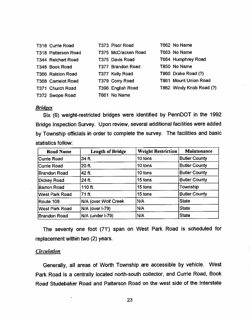
T318 Cunie Road T318 Patterson Road T344 Reichert Road T348 Book Road T366 Ralston Road T368 Camelot Road
T371 Church Road T372 Swope Road
T373 Pisor Road T662 NoName T375 McCracken Road T663 NoName T375 Davis Road T377 Brandon Road T850 NoName
T377 Kelly Road T379 Cony Road T396 English Road T661 NoName
T664 Humphrey Road
T860 Drake Road (7) T861 Mount Union Road T862 Windy Knob Road (7)
Bri&a Six (6) weight-restricted bridges were identified by PennDOT in the 1992
Bridge Inspection Survey. Upon review, several additional facilities were added
by Township officials in order to complete the survey. The facilities and basic
statistics follow:
The seventy one foot (71') span on West Park Road is scheduled for
replacement within two (2) years.
Circulation
Generally, all areas of Worth Township are accessible by vehicle. West
Park Road is a centrally located north-south collector, and Currie Road, Book
Road Studebaker Road and Patterson Road on the west side of the Interstate
23
Route 79 right-of-way, carry traffic north and south. On the east side of the
Interstate Route 79 right-of-way, Ralston Road, Reichert Road, Swope Road,
Barron Road, Taggart Road and Mount Union Road all provide north-south
access.
Brandon Road in the northern half of Worth Township provides interior
access east and west, as do Kelly Road, McCoy Road, Cornelius Road, Church
Road, Cooper Road, Davis Road, Dickey Road and Harlansburg Road. In the
south, Pisor Road and West Liberty Road carry traffic east and west. None of
these transportation facilities is sufficient to carry significant volumes of traffic
without major improvements. Vertical and horizontal realignment, drainage
facilities, additional binding material and minimal wearing surfaces will be
necessary to accommodate increases in vehicle trips safely.
With Slippery Rock University to the northeast and Moraine State Park in the
south, both accessible from Interstate Route 79, roadways adjacent to these
facilities will see the largest increase in volumes in the long term. However,
with the construction of seasonal or even permanent homes around Moraine
State Park, along Muddy Creek or by Coopers Lake and Tamarack Lake, the
secondary local roads which provide direct access to certain areas of the
Township may also need to be considered for improvement along with
segments of the collector roadway system.
24
Economic Profire
The median household income in Worth Township where a family occupies
the household is currently $31,509.00. Seventy-seven percent (77%) of all
wage eamers are salaried employees earning an average of $34,536.00
annually, and one hundred and thirty (130 or 47%) of the two hundred and
seventy-three (273) families reporting in the 1990 decennial census claimed
two persons working.
In owner occupied housing, the median value of the home is $50,200.00,
and the average mortgage payment on that house is $532.00. In renter
occupied housing, which represents about ten percent (10%) of the total
number of dwelling units, the median gross rent is $279.00 per month and yet
twenty-two percent (22%) of those households reported no cash rent or rent of
less than $100.00 per month.
Travel to Work
Of the 398 working residents over the age of sixteen (16) who responded,
360 of them said that they drive alone to their place of employment. In a
related category, only twenty-five (25) persons reported working in Worth
Township, while 246 reported being employed somewhere in Butler County.
Sixty-six percent (66%) of the households in Worth Township reported having
two (2) or three (3) vehicles available and eight percent (8%) reported having
four (4) or more vehicles available.
Average travel time to work is 26.1 minutes, but 23.4 percent of the
residents responding said it took less than fifteen (15) minutes to get to work.
These are the people working within or near the Township, while sixty-three
(63) persons (16% of the total) reported driving more than forty-five (45)
minutes to their place of employment.
25
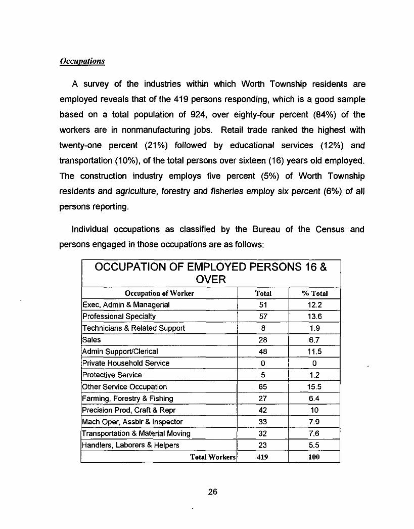
Occunatirins
Occupation of Worker Exec, Admin & Managerial Professional Specialty Technicians & Related Support Sales
A survey of the industries within which Worth Township residents are
employed reveals that of the 419 persons responding, which is a good sample
based on a total population of 924, over eighty-four percent (84%) of the
workers are in nonmanufacturing jobs. Retail trade ranked the highest with
twenty-one percent (21 %) followed by educational services (12%) and
transportation (1 O%), of the total persons over sixteen (1 6) years old employed.
The construction industry employs five percent (5%) of Worth Township
residents and agriculture, forestry and fisheries employ six percent (6%) of all persons reporting.
Total Ya Total 51 12.2 57 13.6 8 1.9
2% 6.7
Individual occupations as classified by the Bureau of the Census and
persons engaged in those occupations are as follows:
I OCCUPATION OF EMPLOYED PERSONS 16 & I OVER I
26
There are 261 men and 158 women living in the Township over the age of
sixteen (16) who are employed full-time. Unemployment stands at 5.8 percent
which is low for the region. These statistics indicate a blue-collar work force
with a high percentage of skilled workers. Half of the residents have high
school diplomas and another thirty-one percent (31 %) have attended college or
attained a degree.
27
As previously stated, Worth Township's population at the time of the first
birthldeath count in 1860 is almost identical to the present population at the
time of its first planning exercise, according to excerpts from the Historv of
Butler County. PA, Volume 1, published by R.C. Brown, 1895 and reprinted in
1977. Fluctuations in population have occurred over the years, but the most
recent twenty (20) year trend indicates a steady increase in population.
The Southwestern Pennsylvania Regional Planning Commission
(S.P.R.P.C.) Cycle 4A forecast for the year 2000 is 986 persons. However,
based on the current person per household figure multiplied by the number of
new residential units permitted through 1992, that forecasted increase of
sixty-two persons (986 from 924) in population has already been tripled, and in only the first two (2) years of the decade. There is no recognition by the
SPRPC of the growth rate factors which are bringing people to Worth
Township.
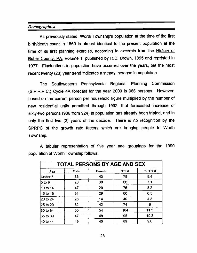
A tabular representation of five year age groupings for the 1990
population of Worth Township follows:
28
TOTAL PERSONS BY AGE AND SEX Age Male Female Total % Total
150 to 54 I 6 I 14 I 20 I 2.2 I 45 to 49 31 9 40 4.3
A comparison of these numbers with non-regular interval statistics kept by
Butler County for the twenty (20) years beginning in 1970 shows that the
greatest difference in population has occurred in the 30 to 44 age range. This
is the result of in-migration to the Township as opposed to movement through
the aging process into upper aged survival age groupings.
55 to 59 60 to 64 65 to 69 70 to 74 Over 74
Total
Another marked increase has occurred in the 0 to 14 age range. In 1980,
persons 0-14 represented twenty-one percent (21 %) of the population, while in
1990 the same age range represents twenty-six percent (26%) of the total
population. Raising families appears to be a popular activity in the Township,
and that characteristic will continue to attract couples of child bearing age to the
rural atmosphere and pace of living found in this community.
21 0 29 3.1 36 34 70 7.6 22 16 30 4.1 4 12 16 1.7 12 17 29 3.1 411 447 924 100
An interesting statistic relative to the natural aging of the Township's
population has to do with persons aged 55 (fifty-five) to 64 (sixty-four). In the
previous two (2) decades, the number of persons in the preceding age
grouping, aged forty-five (45) to fifty-four (54) was larger by approximately
twenty percent (20%) from the next range, fifty-five (55) to sixty-four (64) years
of age, however in the 1990 decennial census the upper range age grouping
exceed the preceding one by ten percent (10%). This is an indication that
in-migration may be occurring, and this time with persons of retirement age. It
29
is likely that a larger percentage of the "seasonal" housing units along Slippery
Rock and Wolf Creeks, are owned and occupied by persons of retirement age,
as opposed to persons of child-bearing age establishing "starter" homes.
Population Proiection
Using the previous five (5) year period as a benchmark trend and
extrapolating growth rates based on 1970 and 1980 statistics, a high and low
projected population for Worth Township can be made. In terms of probability,
the conservative estimate will appeal to persons who expect little change and
the higher population projection will act as a "worst-case" scenario to those who
acknowledge the potential for significant change. The actual count will be
somewhere in between based on the parameters considered, unless certain
aberrations in the statistics were overlooked or misinterpreted.
The twenty (20) year growth rate between 1970 and 1989 average
approximately 1.4% annually in Worth Township and beginning in 1990 that
rate doubled. Low tax rates, minimal government regulation, accessibility to
employment centers, a good school system and, of course, the intangible
factors of the environment, geography and proximity to recreational
opportunities continue to stimulate residential development.
A straight line projection of 1.4% annually will result in a year 2000
population of 1,054 persons as the conservative number and high projection of
1,202 persons. Using the same analysis parameters, the year 2010 population
based on the year 2000 conservative projection is estimated at 1,202 persons.
With no major public utility construction providing infrastructure for more intense
development, and with the potential for private sanitary sewerage treatment
facilities based on improvements in effluent treatment, the projected year 201 0
high end population estimate is 1,371 persons.
30
If the year 2000 population reaches the upper range projection as opposed
to the conservative estimate, the Township could see as many as 1,563
persons, depending on the factors discussed.
31
Regional Considerations
Municipal Neighbors
To the west in Lawrence County, Plain Grove Township, Scott Township and
Slippery Rock Township share portions of their municipal boundaries with
Worth Township.
Plain Grove Township has begun to plan for its future, and with the help of
the Lawrence County Planning Commission has completed a comprehensive
development plan as well as basic zoning regulations designed to protect
agricultural uses while providing for a variety of housing opportunities and
limited commercial land use.
Brady Township has also begun to look to the future as it develops its first
comprehensive development plan. Although more than 5,000 acres of Brady
Township is now a part of Moraine State Park, the remaining acreage has
accommodated a twenty two percent (22%) increase in population from 1980 to
1990. With good access to Routes 8 and 173 and indirect access to Interstate
79 through Franklin Township, Brady Township has experienced the same type
of development pressure being felt by neighboring municipalities. Worth
Township still has the greatest growth potential due to its location within the
region, its access and its relatively flat topography.
These communities exhibit similar characteristics to Worth Township, but
they do not share the same ease of access to Interstate 79. McConnell's Mills
State Park, in Slippery Rock Township, Lawrence County, attracts thousands of
visitors annually, many of whom travel through Worth Township to get there.
This state park and historic grist mill which is in close proximity to Moraine
State Park provides recreational opportunities on a regional basis.
32
On the east, Slippery Rock Township in Butler County, Brady Township and
Franklin Township, as well as West Liberty Borough which, at 2,309 acres, is
geographically, the largest, in the State of Pennsylvania, share common
municipal boundaries with Worth Township. Again, the common characteristics
are evident, and Slippery Rock Township is also currently considering zoning
regulations, as a way to manage the expected growth.
Muddy Creek Township abuts Worth Township to the south and is also in
the path of growth with access to Interstate Route 79, subdivision regulations
are being considered there presently. The rustic environment is an element of
potential growth and U.S. Route 8 provides access to areas exhibiting
conditions amenable to suburban growth. With the completion of Interstate
Route 279, the Pittsburgh metropolitan center is less than an hour away.
ReRional Facilities
Moraine State Park, which opened in 1970, provides for seasonal
recreational activities at the regional level, including three campgrounds in
Brady Township with approximately 1,100 camper pads and tent sites. These
campgrounds rely on private water and sanitary sewerage facilities as does the
Slippery Rock Camp Ground Association, which provides for another 1,100
camper pads in Worth Township.
The success of these camping facilities has made Worth Township, Brady
Township, and Slippery Rock Township very attractive to urban area residents
looking for a few days of slower paced living. Of course, with the influx of
seasonal visitors, local stores and businesses benefit from the tourist trade. A
one hundred and fifty (150) store retail outlet mall is currently into Phase IV of
construction south of the intersection of Interstate Route 79 and Interstate
33
Route 80, approximately eight miles to the north of Worth Township in Mercer
County at the Grove City exit.
It is likely that the impact of this regional shopping facility, less than ten
minutes from the Township, will add additional development pressure as
employees and service industries look for undeveloped areas convenient to
their source of income for residences and to establish businesses. Springfield
Township is projecting the development of at least two (2) motels, in addition to
the restaurants under construction. In the development cycle unfolding in this
region, residential housing plans will follow commercial development within two
(2) to four (4) years of occupancy.
34
Environmentally Sensitive Areas
In July of 1991, the Butler County Natural Heritage Inventory was produced
by the Western Pennsylvania Conservancy. Several significant natural features
are situated within or immediately adjacent to Worth Township. These areas
have been identified and documented for the purpose of conservation.
The four (4) areas delineated within the Worth Township municipal
boundaries are the Lower Wolf Creek Valley, the Slippery Rock Creek
Property, the Slippery Rock Creek Gorge, and the Miller Esker. The first three
natural areas listed are classified as high or moderate significance natural
communities and the Miller Esker Natural Area to the south of Tamarack Lake
is a managed area. All occur generally in the northeast quadrant of the
Township.
Clearly these environmentally sensitive areas will see no development,
however, development on land in close proximity may degrade or pollute
existing stream channels not regulated locally. Excerpts from the Natural
Heritage Inventory which include descriptions and characteristics of each of the
four areas follow:
SLIPPERY ROCK QUADRANGLE
The glaciers that once covered this northwest portion of the county
account for many of its unique natural qualities. The majority of the land in
this quadrangle is farmland. Mineral extraction is also common and
includes not only strip mining, but also limestone and gravel mining. Wolf
Creek and Slippery Rock Creek are the most prominent natural features in
this area. These streams exhibit and number of unique habitats along their
banks including ravines, floodplain forests, oxbow formations, and
35
wetlands. A large number of the quality natural heritage sites in Butler
County are located in this quadrangle.
Wolf Creek is a medium gradient-clearwater creek community (NC013)
that flows from Mercer County into Butler County and empties into Slippery
Rock Creek in the vicinity of Moores Corners. The section of Wolf Creek
that flows within Butler County, in addition to the land that borders it has
been designated the Wolf Creek Conservation Area. Wolf Creek and
the large tracts of land that surround it are significant for Butler County in
that they provide unique habitats and undeveloped space that merit
protection.
Wolf Creek is an important ecosystem and, therefore, it should be
protected. A potential threat to the stream is the rapidly developing
residential areas outside of the town of Slippery Rock. As these areas
grow, the buffer area around Wolf Creek will be reduced. Erosion,
sedimentation, and pollution of the stream will result. Other activities such
as mineral extraction and logging within the Wolf Creek Conservation Area
or upstream outside of Butler County can also have a detrimental impact
on the stream and its associated communities. Altering the flow of Wolf
Creek, by creating a dam or levee, would not only impact the aquatic
resources, but would have a damaging effect on the floodplain and
wetland communities that exist along the stream.
The Lower Wolf Creek Valley is a large site located at the southern
end of the Wolf Creek Conservation Area. This site is significant for its
biodiversity, which is represented by five communities. One of these
communities is Wolf Creek (NC013). Wetland communities are prevalent
in this lower portion of Wolf Creek in old channel scars created by the
36
stream hundreds of years ago when it ran closer to the hillsides. along the
base of the slope on both the east and west sides of Wolf Creek wetlands
have formed on the floodplain. Most of these have been degraded by acid
mine drainage and surface runoff and sedimentation from farm fields. Two
communities exist, however, that have been left relatively undisturbed.
NC009 is a spring run community that originates in limestone bedrock.
This results in alkaline water that cascades down the slope and produces
unusual pools of calcareous deposits. The spring run and associated
pools are teaming with aquatic life: algae, mosses and invertebrates. The
spring waters flow into both Wolf Creek and an emergent marsh wetland at
the base of the slope. The clean calcareous spring water is important to
the maintenance of water quality in both Wolf Creek and the marsh, the
latter being one of the most diverse marsh communities in the county.
Unfortunately, sedimentation runoff from the higher agricultural fields
nearby is deposited in the marsh and is damaging its quality. Additionally,
it appears as though the entire Spring run may have flowed into the
adjacent marsh, however, and that a portion of its discharge was then
diverted to Wolf Creek. If further investigation indicates that this is true,
the flow of the spring run should be returned to its original course into the
marsh. Even more important is the protection of the quality and quantity of
the water in the aquifer that produces the spring. More information is
needed regarding the limestone layer and how much drainage basin
produces the aquifer and thus the spring. Certainly any limestone mines
near this area should be carefully reviewed. The spring, spring run and
wetland should all be protected from agricultural runoff of any kind.
Farther upstream from NC009 is a series of seepage wetlands that
result from the out flow of groundwater at the base of the northern slope of
37
the Wolf Creek valley. These wetlands exhibit a wide variety of natural
community types that are moderately diverse in both species and habitat,
although most have been damaged to some degree by adjacent mining
and agriculture. However, the condition of the westem-most wetland is
relatively high. This wetland is a circumneutral shrub swamp community
(NCOIO) in which the herbaceous plants and shrub species grow on peaty
humioc soils that appear calcareous in chemistry. Groundwater seeps and
rivulets are visible. Although the dominant vegetation consists of willows
(m spp.). alder (m sp.), sedges (Carex spp.) and marsh marigold
Caltha Palustris), a few of the plants, for example stany Solomon's-seal
(Smilacina stellata), which known from no other locality in Butler County,
indicate that some of the habitat here is similar to that of a rare wetland
community type known as a "calcareous fen. "
Threats to the wetlands include surface runoff from surrounding
agricultural fields, as well as contamination from acid mine drainage.
Protection should include maintenance of the upland areas that are
hydrologically linked to the wetlands and any alteration in the hydrology of
the floodplain should be avoided. This includes changing the level or flow
of Wolf Creek. Any disturbance to the forested buffer should also be
avoided.
Slippery Rock Creek, like Wolf Creek, also harbors significant
communities along its banks. Just west of the confluence of these two
streams in the area of Moores Comers is a site referred to as the Slippery
Rock Creek Property, which is owned and managed by the Department
38
of Environmental Protection - Bureau of State Parks.
undisturbed communities exist at this site.
Three relatively
A floodplain forest community (NC006) dominated by maturing sugar
maple (Acer saccharum), black maple (A niqra), and black cherry (Prunus
serotinal borders the south side of Slippery Rock Creek. This community
extends along the stream edge to the base of the slope in the southern
portion of the site where it grades into open canopy wetlands. The
floodplain forest is characterized by its rich, highly organic soils that
provide suitable conditions for a huge variety of herbaceous species. This
forest community helps to buffer the wetland communities that are located
at the base of the slope of the southern side of the Slippery Rock Creek
valley. The slope, which is formed of glacial rubble, and the uplands
harbor a fairfy diverse mesic central forest community (NC007). Included
are northern red oak (Ouercus borealisJ, American basswood (m americana) and American beech (faaus arandifolia) on the slope, while a
drier forest of white oak (0. alba) and black oak (0. veluntinal grows on
the uplands. In some portion of the site the forest is young and more
recently disturbed, while more mature stands with colonies of spring
wildflowers occur elsewhere. Also included is a rare shrub for the county:
running strawbeny-bush (Euonymus obovatus). The small stream flowing
north through the eastem side of the site appears to be of good quality as
indicated by its sandy bottom and stonefly population.
The wetlands, referred to previously, at the base and mid-points of the
forested slope are several small springs and seeps that emerge from the
glacial till and drain to form seepage wetlands of various descriptions. The
small wetlands that form at seep and spring heads along the mid-slope
harbor several wetland plants and numerous invertebrate animals that
39
indicate good water quality. At the base of the slope these water merge to
form a larger wetland dominated by alder (& sp.) and skunk cabbage
(Svmplocamus foetidus). A separate adjacent wetland to the west
provides a more acidic habitat and is dominated by several shrubs,
herbaceous plants and mosses, including spiraea (Spiraea sp.). highbush
blueberry (Vaccinium CONmbOSUm), sedges ( m x spp.), and mosses,
especially peatmoss (SphaUnUm sp.). This unusual wetland community is
considered an acidic shrub swamp (NCOOS) and has been left relatively
undisturbed.
The natural resources at this site will be besf protected by an
expansion of the present state park holdings to include more of the area. Some of the area has been disturbed by recent logging and pasturing, and
past quarrying on the east side. In any case, the state park land at this
site should be dedicated as a natural area and managed as such. Protection for the wetlands should include the maintenance of the glacial
till uplands hydrologically linked to them. Quarrying, or other earth
disturbances in this area will potentially impact the quality and quantity of
the water supporting the wetland communities. Forested land will most
effectively protect this hydrology.
Downstream from the Slippery Rock Creek Property along Slippery
Rock Creek is a site referred to as Slippery Rock Creek Gorge. The
forest along both sides of the stream is a northern hardwood-conifer forest
community (NC004) with eastern hemlock (Tsuua canadensis) and sugar
maple (Acer saccharum) dominating the steep gorge sides and more
northern hardwoods, particularly sugar maple and yellow birch (Betula
alleuhaniensis), sominating the upland areas. The gorge is underlain by
limestone, as is evidenced by the numerous rock outcrops and
40
herbaceous vegetation growing on them. These calcareous cliff
communities (NC005) are uncommon in Butler County and help to
characterize the gorge and its smaller tributary valleys. NC005 provides
habitat for vegetation that requires calcareous conditions to grow.
The quality of the site is high although land for grazing and farming
extends, in many places along the gorge, to the very edge of the upper
slope, thereby restricting the forest community (NC004) to the sides of the
gorge. Some of the bordering areas of the site have been impacted by
recent logging practices. To accommodate these logging practices, roads
have been built and this has resulted in increased erosion and
sedimentation in the gorge. Another threat to the Slippery Rock Creek
Gorge communities is a strip mine that border the northern section of this
site. This strip mine was not reclaimed properly and as a result non-native
species of conifers have established themselves.
To protect the gorge and the limestone communjties, a substantial
buffer zone should be maintained so that these habitats continue to
function ecologically as a northern hardwood-conifer forest and calcareous
cliff community, logging and any other activities such as grazing and strip
mining should be avoided. An evaluation of the strip mined area to the
north of NC005 should be made to determine if conditions are suitable for
the successful regeneration of native species that comprise this
community. An analysis should be made of the soil to determine if the
topsoil is suitable or if it needs to be developed in order to sustain a forest
community.
41
The Miller Esker Natural Area represents one of the best examples of
a glacial esker in western Pennsylvania. The esker itself is nearly 5 km
long, however much of the total formation has been excavated or
otherwise disturbed. The least disturbed portion of the esker is preserved
within the 32 acre Natural Area. This site is owned and managed by the
Western Pennsylvania Conservancy.
An exhibit is included in this plan document which delineates the areas
being discussed. It should be noted that within the Slippery Rock Quadrangle
(U.S.G.S.), twenty-nine (29) natural communities, special plants and indigenous
animal life have been selected for protection.
Current land use in buffer areas adjacent to the environmentally sensitive
land consists predominantly of agricultural uses. While erosion and
sedimentation from active farming activities has the potential to adversely effect
the ecosystems within the Slippery Rock and Wolf Creek stream valleys, the
use of appropriate earth disturbance techniques is encouraged by the Butler
County Conservation District.
Projected land use categories which consider the sensitivity of these
defined areas will provide guidelines for future local regulatory legislation. In
addition, land which exhibits steep slopes, unsuitable soil types for on-lot septic
disposal, or are located within floodplains or wetlands are also limited for
development. A variety of constraints will prevent significant development in
certain areas, but a major portion of Worth Township is considered
developable.
42
Development Constraints
While several elements of this plan document have identified factors which
will potentially stimulate residential growth, there are conditions which will
discourage development in Worth Township. Chief among the constraints to
growth is the lack of public utilities.
Without public water and sanitary sewerage treatment facilities, the rate of
new residential construction will depend on the intangible factors previously
identified. The low tax burden, a visually stimulating environment, and minimal
government regulation are elements which will attract some new people, but
public water and sewerage have become the staples of targe scale
development.
The condition of interior roadways will also discourage, to some extent, the
location of more intense development in given areas of the Township. With
nominal eighteen feet (18') wide surfaces, poor or nonexistent road drainage,
and deficient visibility to traveling motorists due to horizontal curves in the
roadways, only limited subdivision and development can occur without major
transportation improvements.
This situation is not bad news to residents who have witnessed the increase
in traffic on roads in the southern half of Worth Township. Boating and sailing
enthusiasts, fishermen, campers, and picnickers seeking access to one of the
many attractive recreation areas in Moraine State Park have explored all the
access roads and new users will follow their lead.
In areas where unsuitable soil types prevent on-lot wastewater disposal,
private treatment plants or public sewage treatment facilities are the only
option. Both are expensive and potentially prohibitive. Until a large number of
43
failures occur on existing septic systems, there is no political expediency to
offering public sanitary sewerage treatment.
The same can be said for private wells. Where a number of wells become
contaminated or where recharge does not occur as needed, the option is public
water, through extensions from an existing public system (the closest is in
Slippery Rock Borough) or public wells. Because of a high iron and acidic
content, most private wells in Worth Township produce water that needs to be
treated. If enough users determine that a community sized system is more cost
effective, local officials may have to consider that option.
In terms of steep slopes, floodplains, wetlands or severe climatic trends,
significant areas exhibiting one or more of these elements in combination, are
not prevalent within the municipal boundaries. The humid continental climate
produces wet autumns and moderate winters with few cloudless days. Annual
rainfall in the Lake Arthur region is somewhat higher than elsewhere in Butler
County which receives between 36 and 40 inches of precipitation and between
40 and 48 inches of snowfall, however this weather pattern is not excessive to
the point of being considered as a development constraint.
The desire for "green space," and country living is gaining in importance to
the aging populations of Pittsburgh's northern suburbs and Youngstown's
eastern urbanized areas. Inexpensive land and the security of a modem day
homestead offer attractive alternatives to "cookie-cutter" subdivisions and
sprawling development with little or no recreational opportunities.
A regional police force may prove to be a viable alternative to the
intermittent coverage provided by the State Police, and certainly
inter-community cooperation through the creation of a northern Butler County
44
Council of Governments should be considered at this point, to improve the
delivery of services.
The same development pressures being experienced by Worth Township
are being felt by all of its municipal neighbors and the rate of residential
development in the Township and the region may well exceed current
projections given the external factors at work.
45
SURVEY QUESTIONNAIRE
Strongly Disagree Undecided Agree Strongly Disagree Agree
1 0 1 53 38
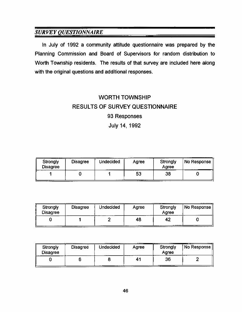
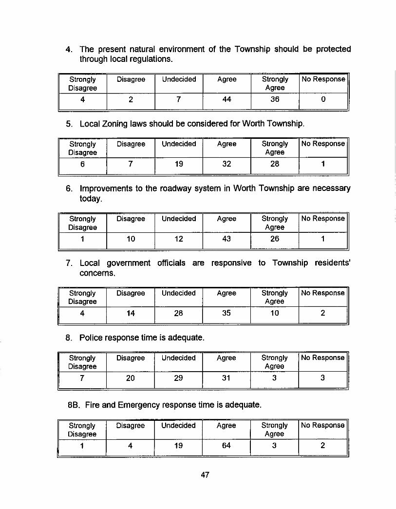
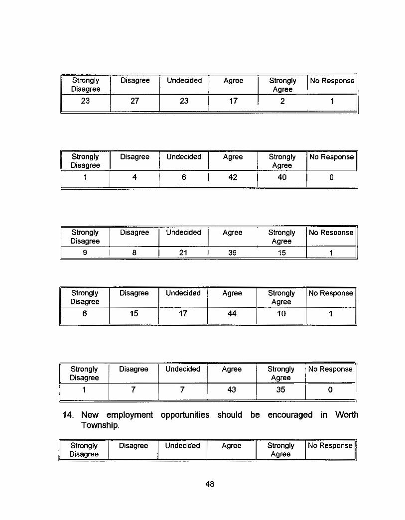
In July of 1992 a community attitude questionnaire was prepared by the
Planning Commission and Board of Supervisors for random distribution to
Worth Township residents. The results of that survey are included here along
with the original questions and additional responses.
No Response
0
WORTH TOWNSHIP
RESULTS OF SURVEY QUESTIONNAIRE
93 Responses
July 14, 1992
Strongly Disagree
0
Disagree Undecided Agree Strongly No Response Agree
1 2 48 42 0
46
Strongly Disagree
0
Disagree Undecided Agree Strongly No Response Agree
6 8 41 36 2
Strongly Disagree Undecided Disagree
4 2 7
Agree Strongly No Response Agree
44 36 0
6 7 19 32 28 1
Strongly Disagree Undecided Agree Disagree
Strongly No Response Agree
1 10 12 43 26 1
47
Strongly Disagree Undecided Disaaree
Agree Strongly No Response Aaree
7 20 29 31 3 3
Strongly Disagree Undecided Agree Strongly Disagree Agree
1 4 19 64 3
No Response
2
Strongly Disagree Undecided Agree Strongly Disagree Agree
23 27 23 17 2
c Strongly Agree Strongly No Response
No Response
1
11 Disaaree I I I I Aaree I II 1 4 6 42 40 0
Strongly Disagree Undecided Agree Disagree
9 8 21 39
Strongly No Response Agree
15 1
14. New employment opportunities should be encouraged in Worth Township.
Strongly Disagree Undecided Agree Strongly Disagree Agree
1 7 7 43 35
48
No Response
0
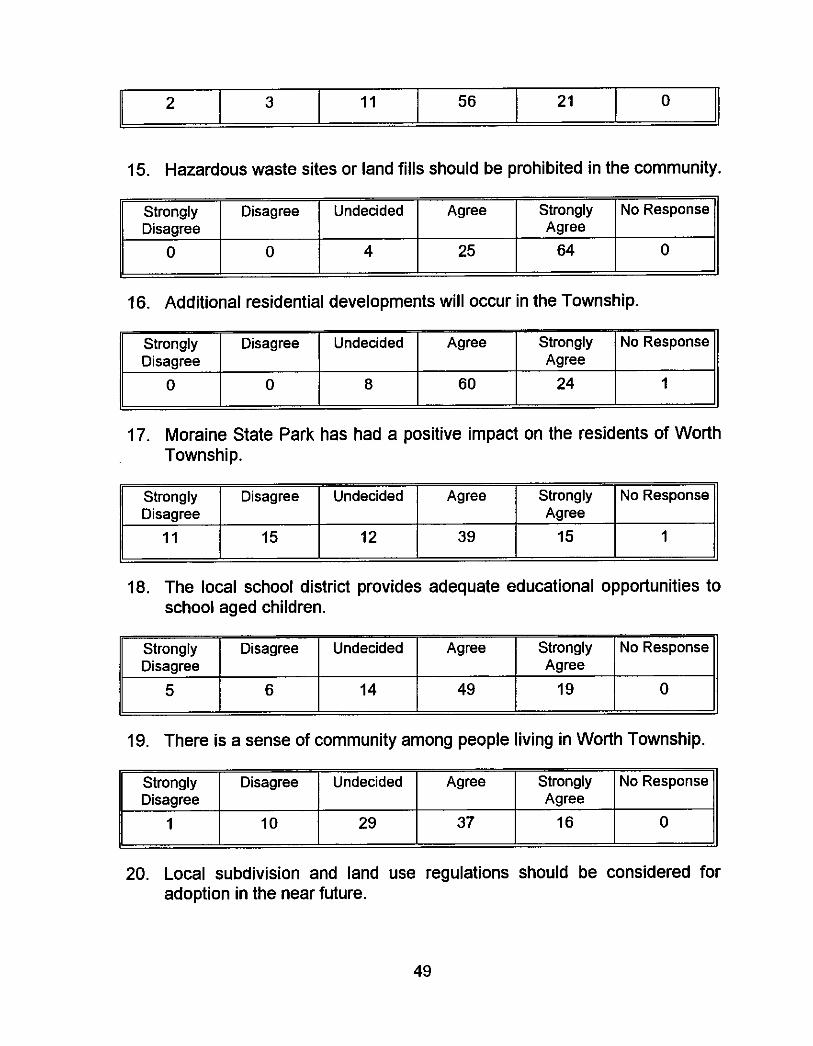
2 3 11 56 21 0
Strongly Disagree Undecided Agree Strongly No Response Disagree Agree
0 0 4 25 64 0 -
49
Strongly Disagree Undecided Agree Strongly Disagree Agree
11 15 12 39 15
No Response
1
Strongly Disagree Undecided Disagree
5 6 14
Agree Strongly No Response Agree
49 19 0
Strongly Disagree
1
Disagree Undecided Agree Strongly No Response Agree
10 29 37 16 0
Strongly Disagree Undecided Agree Disagree
3 13 23 26
Question #3 Growth should be managed so as to limit its impact on existing
properties:
Strongly No Response Agree
28 0
But not necessarily by the local government.
Question #5 Local Zoning laws should be considered for Worth Township:
I would like to see something done about undrivable vehicles parked on peoples property where everyone can see them.
Question #6 Improvements to .the roadway system in Worth Township are
necessary today:
Cooper Brothers should be responsible for maintaining the roads which they use daily in the community.
Doing good so far.
The berms should be mowed so people could walk, also for safety.
Question #7 Local qovernment officials are responsive to Township residents'
concerns:
Some are, some aren't.
Question #8 Police response time is adequate:
"Adequate" is not good enough in an emergency. We need local protection.
One hour to answer a disturbance call in 1990.
50
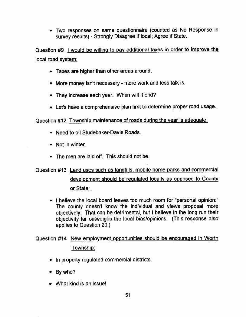
+ Two responses on same questionnaire (counted as No Response in survey results) - Strongly Disagree if local; Agree if State.
Question #9 I would be willinq to pay additional taxes in order to improve the
local road system:
+ Taxes are higher than other areas around.
More money isn't necessary - more work and less talk is.
They increase each year. When will it end?
Let's have a comprehensive plan first to determine proper road usage.
Question #I2 Township maintenance of roads durinq the year is adequate:
+ Need to oil Studebaker-Davis Roads.
+ Not in winter
+ The men are laid off. This should not be.
Question #I3 Land uses such as landfills, mobile home parks and commercial
development should be regulated locally as opposed to County
or State:
+ I believe the local board leaves too much room for "personal opinion:" The county doesn't know the individual and views proposal more objectively. That can be detrimental, but I believe in the long run their objectivity far outweighs the local bias/opinions. (This response also' applies to Question 20.)
Question #I4 New emplovment opportunities should be encouraaed in Worth
Township:
In property regulated commercial districts.
Bywho?
What kind is an issue!
51
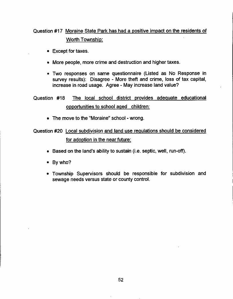
Question #I 7 Moraine State Park has had a positive impact on the residents of
Worth Township:
Except for taxes.
More people, more crime and destruction and higher taxes.
Two responses on same questionnaire (Listed as No Response in survey results): Disagree - More theft and crime, loss of tax capital, increase in road usage. Agree - May increase land value?
Question #I 8 The local school district provides adequate educational
opportunities to school aqed children:
The move to the "Moraine" school - wrong.
Question #20 Local subdivision and land use requlations should be considered
for adoption in the near future:
Based on the land's ability to sustain (Le. septic, well, run-omf).
Bywho?
Township Supervisors should be responsible for subdivision and sewage needs versus state or county control.
52
WORTH TOWNSHIP
BUTLER COUNTY, PENNSYLVANIA
IMPLEMENTATION PLAN . . , . . , , . . , . . . , . . . . . . . . . . . . . . . . . . . . . . . . . . . . . . . . . .
Summary of Planning Process
The Worth Township Planning Commission began to actively plan for
their community's future in the fall of 1991. Together with the Board of
Supervisors, they chose a planning consultant to assist them in the preparation
of a comprehensive development plan for their community. At both regularly
scheduled monthly meetings and special work sessions, commission members
assembled information and discussed specific aspects of their community.
Township residents with knowledge of the history of Worth Township, new
arrivals with investments in the community's future, and interested citizens
attended Planning Commission and Board of Supervisor's meetings over a
three (3) year period. The Planning Commission conducted a series of
windshield surveys in order to identify existing land uses. Residential
structures, commercial uses and structures, accessory uses such as agricultural
related structures and recreation uses were located on a set of paper maps.
A base map of the municipality prepared at Slippery Rock University was
used to locate the information collected in the field. The base map was derived
from Butler County assessment maps and contains recorded parcels and road
names and was produced digitally, which provides a more efficient revision
process in the future. Additional thematic maps designed to present
information about natural and man-made features were also produced in
conjunction with this planning project.
Discussions about the diversity of the population, the regional recreational
facility (Moraine State Park) in the southern portion of the Township and its
positive and negative impacts on the community, and the desire to preserve the
area's working farms, took place at many of the work sessions. The consensus
53
of the group is that their local government should evolve slowly and in a
structured, conservative manner.
Focus Groups
At the conclusion of the information gathering stage which occurred in
mid-year of 1993, a series of informational hearings were scheduled in order to
solicit input from Township residents. The results of a random sample attitude
survey conducted in 1992 was the starting point for these in-depth work
sessions. This survey response represents ten percent (10%) of the estimated
1990 population based on Census data, and was conducted door to door and
through general distribution throughout the Township. A copy of the survey
results is included in the existing conditions portion of this document.
In December of 1993, two public meetings, advertised as public hearings,
took place in order to focus on specific issues facing the Township in the years
to come. Approximately seventy (70) persons were in attendance at each
meeting and four (4) focus groups were formed. Copies of the Existing
Conditions Report were made available and a Worth Township General
Knowledge Quiz was administered.
Having discussed the external factors which helped to create the
municipality, Township residents began to identify internal factors impacting on
their day to day lives by listing Worth Township’s strengths and its weaknesses.
During this exercise it became clear that preservation of the rural character of
Worth Township, retaining a low individual tax burden, providing a high
standard of roadway maintenance and accessibility and improving police and
fire emergency response time were issues of concern. It was noted that these
same issues were common themes facing residents of many neighboring
communities in the region.
54
From the lists of specific strengths and weaknesses, general short and long
range community goals were articulated by each group for comparison and
discussion at the public meetings. In addition, comments relative to those
positive and negative characteristics were prepared for review. The extent of
commitment from elected officials to achieve the goals, was a point of
discussion and relates to the inclination by the Board of Supervisors to provide
only those basic services necessary without generating additional tax revenues.
Strategic Plan and Plan Elements
The culmination of the planning process in Worth Township is the
preparation of "action plans" which involve strategies for the achievement of
community objectives. The first step involved a fine tuning of goal statements
from the broad areas originally identified, to practical activities aimed at
compliance with the intent of the plans. These goals and the resources
committed to attaining them, reflect a collective vision for the future of this
community.
Rural areas with agricultural roots are the last areas in Western
Pennsylvania to experience the kind of in-migration experienced by the
urbanized settlements in the late 19th century and early 20th century. Following
World War II, and with the mobility ushered in by automobiles, long commutes
to employment centers and the development of the suburbs occurred.
It is the task of local governments to provide its' citizens with the services
and amenities they need and want, within a defined budget. However, where
the community is in transition, and fixed income or low income groups comprise
a significant percentage of a community's population, the job becomes more
difficult. Worth Township is such a community. The long term fiscal policy has
been conservative and for at least the next several years, the status quo may
55
be maintained. There are, however, increasing influences from external
sources which will impact on this community before the turn of the century.
Northern Butler County has been the scene of accelerated residential growth
in the first third of the 1990's. Local officials in some jurisdictions welcome
moderate growth which brings with it additional employment opportunities.
Local land use regulations have been adopted in most neighboring
municipalities in order to manage the growth that appears to be on the horizon.
Worth Township will take the same path, albeit more cautiously than some.
The plan elements and supplemental documentation which follow, present a picture of a rurallagricultural community with much to offer new residents in
terms of the pace and cost of living. People with deep roots and years of family
commitment to Worth Township have known about its attributes and have
learned to live with its simplicity. Balancing the interests of those property
owners and taxpayers with a more recent investment in the community's future
is the challenge ahead. This planning document with community goals and
objectives should act as a set of guidelines and policy statements to be used in
the evaluation of development proposals by local officials.
56
Community Goals & Objectives
Consensus Building
In the Fall of 1993, two (2) public meetings were advertised and held in the
Worth Grange building on West Park Road. One of the purposes of these
meetings was to acquaint Township residents with the vital statistics of their
community and to review the Worth Township Existing Conditions and
Research Elements Document developed during the preceding year and a half.
A second purpose was the listing of perceived strengths and weaknesses of
Worth township, and general comments about day to day living, local
government, services, road maintenance and resource protection.
These activities eventually resulted in the identification of community goals
and objectives which provide the framework for the action plans which follow.
The General Knowledge Quiz successfully brought many basic pieces of
information to the group's attention and clarified some misconceptions. It should be noted that many of the residents in attendance were very
knowledgeable about their community and provided additional input for
discussion.
The quiz and appropriate responses are included here:
A Worth Township
General Knowledge Quiz
1. Worth Township was incorporated in 1854 as parts of Muddy Creek and Slippery Rock Township. I
2. Worth Township is more than twenty-five square miles in land area. 25.3 sauare miles.
57
3. The 1990 Census counted nine hundred and fifty five (955) persons as permanent year round residents of Worth Township. T - current population estimated at 1.140 based on permit reconls.
4. The largest percentage of working people in Worth Township are employed in agricultural and forestry businesses. F - 1. retail trade; 2. educational services; 3. transportation: 4. auriculturalfforestry
5. School aged children represent less than one quarter (114) of the Township's population. T - ages 519 totals 22%
6. Only twenty five (25) persons of the three hundred and ninety eight (398) Worth Township residents who reported being employed, actually work in Worth Township. I
7. The Township maintains thirty six (36) miles of public roadways during the year. F - actuallv 46.6
8. There are more than two thousand (2,000) seasonal camper pads in the four (4) campgrounds in Brady and Worth Townships. T - 2.220 at capacity
9. Worth Township is the only municipality in Butler County with both north and south access at two interchanges with Interstate 79. 1
10. The median value of a home occupied in Worth Township year round is seventy thousand dollars ($70,000). F - $50,200 average mortuaue payment is $532.00
11. More than seventeen thousand (17,000) vehicle trips are registered on Interstate Route 79 during a twenty four (24) hour period. T - 17,663 counts bv SPRPC. Jan. 8. 1992.
12. The Slippery Rock Area School District, which includes Worth Township, is more than one hundred twenty-five (125) square miles in area. 131.5 su. miles. 6 townshim (121 so. miles) and 5 boroughs (10.5 su. mrles)
13. More than half of all year round housing units in Worth Township have been occupied since 1980. T - 55% (147 before 1980 119791: 178 affer 19801
58
14. The population of Worth Township in 1990 is about the same as the population was in 1860. T - 1990 (955 - one source says 924); 1890 (928)
15. School aged children in Worth Township represent twenty five percent (25%) of the 1993-94 school district enrollment. F - 202 of 2,582 total 8%
- Group #I
Positive Characteristics Negative Characteristics close to a number of interstates ]limited shopping
Following a review of responses to the quiz, the group was divided into four
(4) "focus groups" of approximately seventeen (1 7) persons. Instructions for
this exercise were to identify those positive aspects of living in Worth Township
and those deficiencies or negative elements which could be improved. While
all responses were to be recorded by a group facilitator, a planning commission
member or Township supervisors, only those statements which were generally
supported by the group would evolve into a community goal or a step in the
process of achieving a stated objective.
A summary report of the first focus group work sessions is included here:
Summary of Focus Group Exercise
Public Hearing held December 6,1993
59
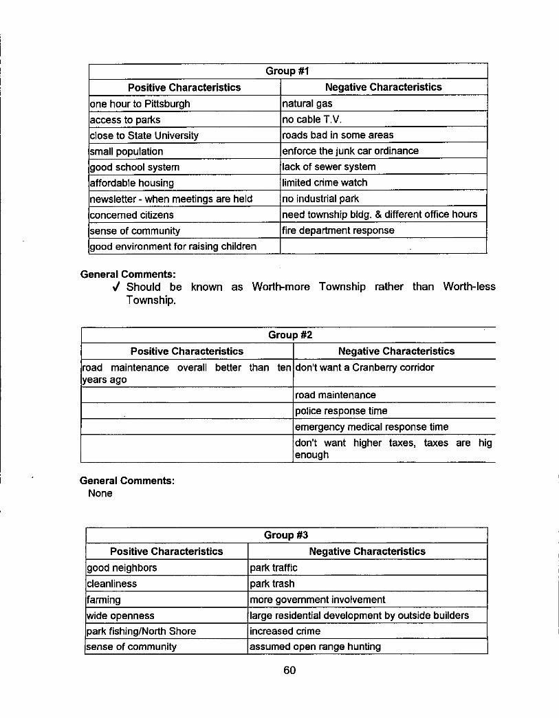
Positive Characteristics Negative Characteristics
sense of community good environment for raising children
lfire department response
General Comments:
Township. J Should be known as Worthmore Township rather than Worth-less
one hour to Pittsburgh access to parks close to State University small population good school system affordable housing newsletter - when meetings are held concerned citizens
Group #2
natural gas no cable T.V. roads bad in some areas enforce the junk car ordinance lack of sewer system limited crime watch no industrial park need townshio blda. & different office hours
I Positive Characteristics I Negative Characteristics road maintenance overall better than ten years ago
don't want a Cranberry corridor
road maintenance police response time emergency medical response time don't want higher taxes, taxes are hig enough
General Comments: None
Positive Characteristics Negative Characteristics good neighbors cleanliness farming wide openness Dark fishina/North Shore (sense of community lassumed open range hunting
60
park traffic park trash more government involvement large residential development by outside builders increased crime
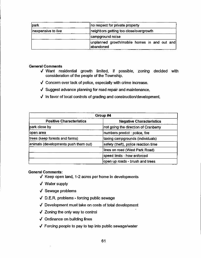
park inexpensive to live
Ino respect for private property I neighbors getting too close/overgrowth
park close by open area trees (keep forests and farms) animals (developments push them out)
campground noise unplanned growthhobile homes in and out and abandoned
not going the direction of Cranbeny numbers predict : police, fire taxing campgrounds (individuals) safety (theft), police reaction time lines on road (West Park Road)
General Comments d Want residential growth limited, if possible, zoning decided with
J Concern over lack of police, especially with crime increase.
J Suggest advance planning for road repair and maintenance,
J In favor of local controls of grading and constructionldevelopment.
consideration of the people of the Township.
I Group #4 I I Positive Characteristics I Negative Characteristics I
(speed limits - how enforced lopen up roads - brush and trees
General Comments: J Keep open land, 1-2 acres per home in developments
J Water supply
J Sewage problems
J D.E.R. problems - forcing public sewage
J Development must take on costs of total development
J Zoning the only way to control
J Ordinance on building lines
J Forcing people to pay to tap into public sewagelwater
61
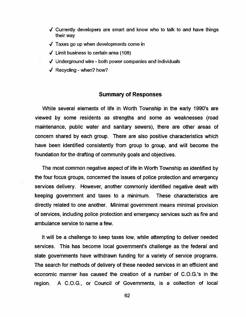
J Currently developers are smart and know who to talk to and have things
J Taxes go up when developments come in
J Limit business to certain area (108)
J Underground wire - both power companies and individuals
J Recycling - when? how?
their way
Summary of Responses
While several elements of life in Worth Township in the early 1990's are
viewed by some residents as strengths and some as weaknesses (road
maintenance, public water and sanitary sewers), there are other areas of
concern shared by each group. There are also positive characteristics which
have been identified consistently from group to group, and will become the
foundation for the drafting of community goals and objectives.
The most common negative aspect of life in Worth Township as identified by
the four focus groups, concerned the issues of police protection and emergency
services delivery. However, another commonly identified negative dealt with
keeping government and taxes to a minimum. These characteristics are
directly related to one another. Minimal government means minimal provision
of services, including police protection and emergency services such as fire and
ambulance service to name a few.
It will be a challenge to keep taxes low, while attempting to deliver needed
services. This has become local government's challenge as the federal and
state governments have withdrawn funding for a variety of service programs.
The search for methods of delivery of these needed services in an efficient and
economic manner has caused the creation of a number of C.O.G.3 in the
region. A C.O.G., or Council of Governments, is a collection of local
62
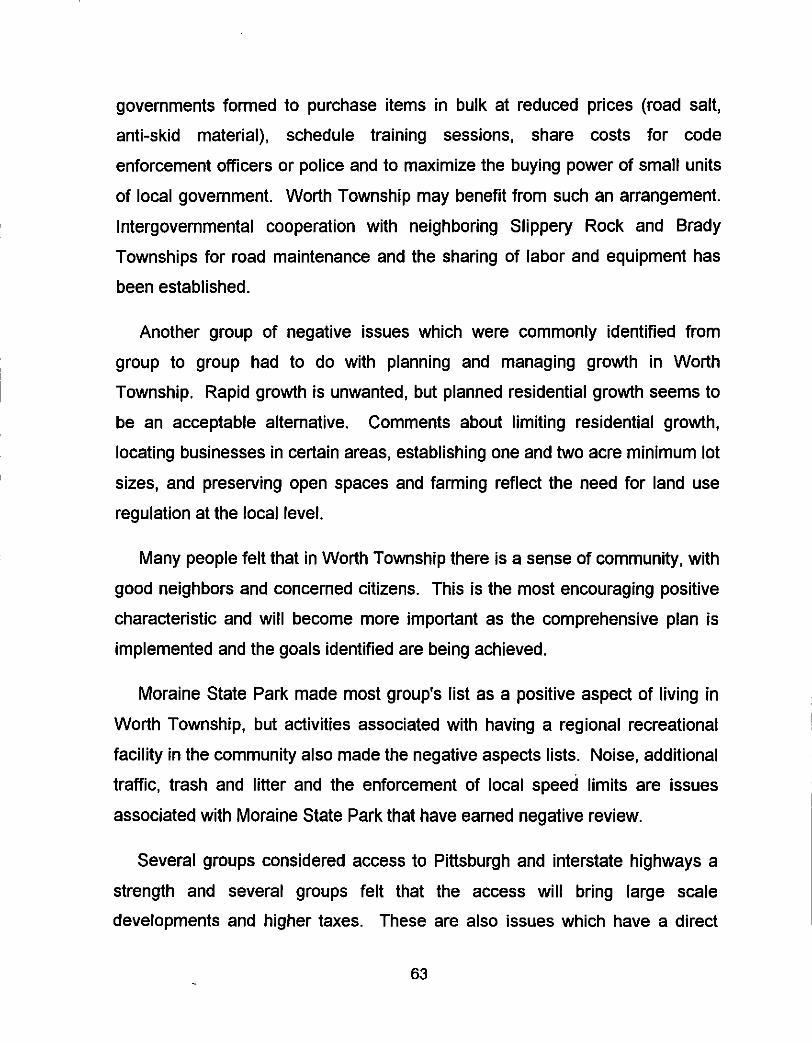
governments formed to purchase items in bulk at reduced prices (road salt,
anti-skid material), schedule training sessions, share costs for code
enforcement officers or police and to maximize the buying power of small units
of local government. Worth Township may benefit from such an arrangement.
Intergovernmental cooperation with neighboring Slippery Rock and Brady
Townships for road maintenance and the sharing of labor and equipment has
been established.
Another group of negative issues which were commonly identified from
group to group had to do with planning and managing growth in Worth
Township. Rapid growth is unwanted, but planned residential growth seems to
be an acceptable alternative. Comments about limiting residential growth,
locating businesses in certain areas, establishing one and two acre minimum lot
sizes, and preserving open spaces and farming reflect the need for land use
regulation at the local level.
Many people felt that in Worth Township there is a sense of community, with
good neighbors and concerned citizens. This is the most encouraging positive
characteristic and will become more important as the comprehensive plan is
implemented and the goals identified are being achieved.
Moraine State Park made most group's list as a positive aspect of living in Worth Township, but activities associated with having a regional recreational
facility in the community also made the negative aspects lists. Noise, additional
traffic, trash and litter and the enforcement of local speed limits are issues
associated with Moraine State Park that have earned negative review.
Several groups considered access to Pittsburgh and interstate highways a strength and several groups felt that the access will bring large scale
developments and higher taxes. These are also issues which have a direct
63
cause and effect relationship and for which comprehensive planning was
designed. Once there is a consensus on which issues to address and how to
address them, a strategic plan can be drafted and implemented.
The range of goals and objectives will vary depending on the variety of
issues and concerns identified by Worth Township residents. There are several
areas of concern which may be beyond the elected officials ability to resolve.
However, there are other strengths and weaknesses which will be drafted as
statements of community development objectives attainable through active
citizen participation.
At the second focus group work session, an inventory of broad ranged,
generalized objectives were distributed for discussion. The preceding summary
was used to solicit specific comments about the degree of support for the
preliminary community goals and objectives statements. As each topic of
concern was reviewed, general discussion followed. The keys to the attainment
of the goals in Worth Township are the commitment of the elected officials to
support the policies derived from the stated goals and the maturation of Worth’s
citizens to implement the steps necessary to work toward achievement.
64
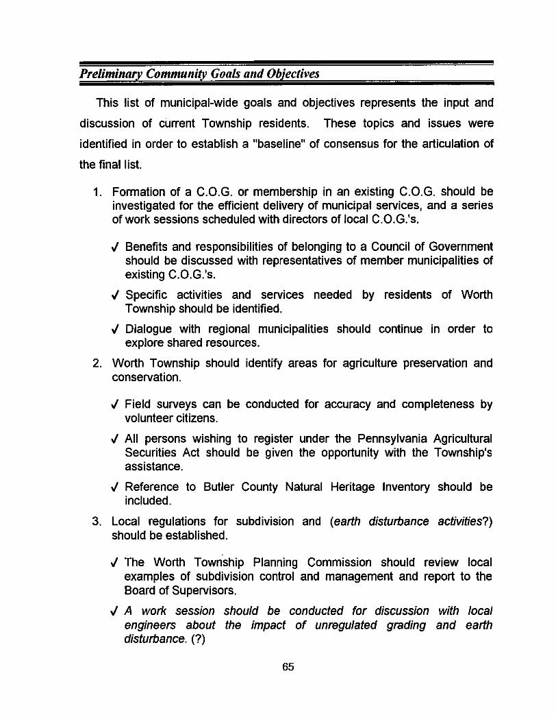
Preliminary Comniunity Coals and Objectives
This list of municipal-wide goals and objectives represents the input and
discussion of current Township residents. These topics and issues were
identified in order to establish a "baseline" of consensus for the articulation of
the final list.
1. Formation of a C.O.G. or membership in an existing C.O.G. should be investigated for the efficient delivery of municipal services, and a series of work sessions scheduled with directors of local C.0.G.k.
J Benefits and responsibilities of belonging to a Council of Government should be discussed with representatives of member municipalities of existing C.0.G.k.
r/ Specific activities and services needed by residents of Worth Township should be identified.
J Dialogue with regional municipalities should continue in order to explore shared resources.
2. Worth Township should identify areas for agriculture preservation and conservation.
J Field surveys can be conducted for accuracy and completeness by volunteer citizens.
J All persons wishing to register under the Pennsylvania Agricultural Securities Act should be given the opportunity with the Township's assistance.
J Reference to Butler County Natural Heritage Inventory should be included.
3. Local regulations for subdivision and (earth disturbance activities?) should be established.
J The Worth Township Planning Commission should review local examples of subdivision control and management and report to the Board of Supervisors.
J A work session should be conducted for discussion with local engineers about the impact of unregulated grading and earth disturbance. (?)
65
J The Township should apply for State Planning Assistance grant money to fund the preparation of a local subdivision and grading ordinance.
4. The Township officials will review the practicality of various types of anti-skid and salt for icy and snowy roadways.
5. The Township officials will review the practicality of lane markers for Township maintained roads.
J Information on traffic characteristics and projected volume increases should be collected on roads adjacent to Moraine State Park and points adjacent to the 1-79 ramps.
J Estimates for improvements should be prepared and discussed with Pennsylvania Department of Transportation officials.
6. A long range system of land use regulation or zoning, should be implemented prior to the introduction of large scale development in Worth Township.
J State Planning Assistance grant money should be applied for in order to fund preparation of a local ordinance.
J The Butler County Planning Commission should be contacted and a work session scheduled to discuss funding sources.
J Local municipalities in the process of preparing their own land use regulations should be contacted and a dialogue begun to address common issues.
J The Planning Commission should request and review local examples of zoning regulations and report to the Board of Supervisors.
Clearly, Worth Township's residents favor growth management, however the
degree to which they will intervene as concerned citizens or as elected officials
to enact local standards is still not clear. Many comments about the ability to
enforce local subdivision and land use regulations indicate that there is not a
high degree of support for additional staff, part-time or otherwise.
Through the spring and summer of 1994, additional mapping products were
created and the preliminary goals and objectives were fine-tuned. New
members of the planning commission were introduced to the process begun in
66
1991 and offered additional input and new perspectives on a variety of issues
facing the Township.
A State Planning Assistance Grant application was submitted in the Spring
of 1994 in an effort to provide funding assistance for the completion of the
Comprehensive Development Plan, preparation of a Subdivision and Land
Development Ordinance, and basic land use regulations. The application was
not funded, however, reapplication should occur in 1995.
The following list of goal statements represents the culmination of three (3) years of input from local residents, and a concerted effort to educate those
residents about the need to plan for their community's future. As indicated,
information from a variety of sources both public and private were also included
in this document. Community objective statements are listed in order of priority.
Final Goals and Objectives
Short Term Goals 1995-2002
1. Register working farms under the State's Agriculture Security Act.
J Encourage purchase of development easements through the Butler County Farmland Preservation Board.
2. Identify green space and significant stands of mature trees without general restrictions for agricultural activities.
3. Consider basic local land use regulations to preserve the rural character of the community. (?)
4. Consider local regulations for mobile home parks and travel trailer parks. (7)
J Include in Subdivision and Land Development Ordinance.
5. Establish local regulations for subdivisions and land developments.
67
6.
7.
8.
9.
10.
11.
12.
13.
J Research cost sharing for administration with neighboring
Apply for funding assistance to develop local subdivision and land development regulations.
J Use application fees to pay for administration and enforcement.
J Research SPAG (State Planning Assistance Grant) and SCPAP (Small
Coordinate emergency service coverage to all areas of the Township with appropriate medical and law enforcement organizations.
J Include Slippery Rock, Portersville and Prospect Volunteer Fire Departments and emergency medical services (EMS).
J Determine Pennsylvania State Police coverage.
J Research aid agreements with local police forces within a fifteen (15)
Conduct a Roadway Sufficiency Analysis of all Township owned collector roads.
Research benefits of membership in a regional Council of Governments to reduce road material costs.
communities.
Communities Planning Assistance) programs.
mile radius.
Long Range Objectives 2003-2010
Research the need for additional Township staff.
J Provide scheduled hours for Township administrative business.
Expand municipal garage facility to accommodate additional maintenance equipment.
Acquire funding for major improvements to Township collector roadways.
J Community development block grant with neighboring municipalities.
J Utilize turn-back program funds for improvements.
Continue to upgrade computerized municipal tax and permit records for efficient administration.
68
14. Worth Township officials should contact neighboring municipalities in an effort to identify the need for an intermunicipal police force.
J Initial correspondence should survey elected officials in neighboring communities in order to establish common goals.
J A work session should be held at which representatives from the Pennsylvania Department of Community Affairs will present options and methods for financing such a project.
J Crime statistics from the Pennsylvania State Police, Slippery Rock Borough Police, Muddy Creek Township Police and appropriate local law enforcement agencies should be requested and reviewed in order to assess the magnitude of the problem.
15. The Township will identify its traffic circulation deficiencies through the conduct of a roadway sufficiency analysis.
J Elected officials should seek funding from Butler County's discretionary fund for a transportation impact analysis.
J Information on traffic characteristics and volumes should be collected on roads adjacent to Moraine State Park and points adjacent to the 1-79 ramps.
J Estimates for improvements should be prepared and discussed with Pennsylvania Department of Transportation officials.
The goals articulated do not include references to the types of housing
anticipated, the provision of public water or sanitary sewer systems or the
efficient delivery of anything but the most basic of local government services.
Worth residents equate even basic amenities such as fire-protection, police and
emergency services, and community facilities such as the construction of a
municipal building or recreation facilities with more government and higher
taxes. At this point in time, having considered the options, they have chosen to
live without the services in favor of lower tax burdens and less interference in
their private lives.
69
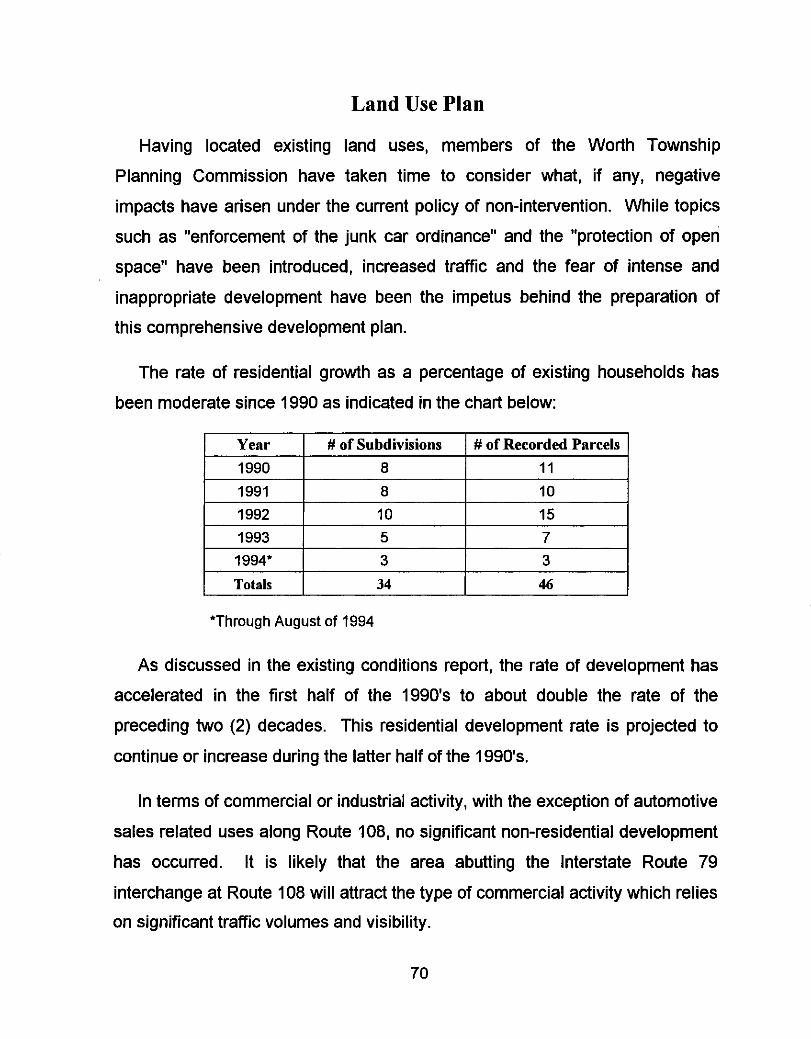
Land Use Plan
1991 1992 1993 1994'
Totals
Having located existing land uses, members of the Worth Township
Planning Commission have taken time to consider what, if any, negative
impacts have arisen under the current policy of non-intervention. While topics
such as "enforcement of the junk car ordinance" and the "protection of open
space" have been introduced, increased traffic and the fear of intense and
inappropriate development have been the impetus behind the preparation of
this comprehensive development plan.
0 10
10 15 5 7 3 3
34 46
The rate of residential growth as a percentage of existing households has
been moderate since 1990 as indicated in the chart below:
Yenr I # of Subdivisions I # of Recorded Pnrcels I I 1990 I 0 I 11 I
As discussed in the existing conditions report, the rate of development has
accelerated in the first half of the 1990's to about double the rate of the
preceding two (2) decades. This residential development rate is projected to
continue or increase during the latter half of the 1990's.
In terms of commercial or industrial activity, with the exception of automotive
sales related uses along Route 108, no significant non-residential development
has occurred. It is likely that the area abutting the Interstate Route 79
interchange at Route 108 will attract the type of commercial activity which relies
on significant traffic volumes and visibility.
70
The Planning Commission has selected a Land Use Plan (See attached
exhibits) which seeks to encourage agriculture, provide for moderate density
housing, light industrial and limited commercial opportunities. Where access
and roadway conditions are sufficient, more intense land use is planned for.
Roadway sufficiency limited in Worth Township as most of the collector roads
within the community have evolved from wagon trails and farm lanes used to
transport coal or tim6er from remote areas or to get produce and grains to
markets in Plain Grove, Slippery Rock, Prospect and Portersville.
Generally, the topography of the Township presents no significant constraint
to development activities and site preparation. The fact, however, that large
tracts of land are not easily accessible except by unimproved roadways
presents the prospective developer with an economic dilemma. To improve a segment of a secondary roadway to PennDOT's specifications is a very
expensive proposition. Failure to improve the primary access limits the ability
to market lots in a residential subdivision, and the cost may prohibit the
improvement. This cost goes in the negative column and is a factor in the
decision to develop in Worth Township.
Specific geographic areas earmarked for certain categories of land use are
illustrated on the attached Land Use Map, included as an exhibit. Broad
categories of use are proposed in anticipation of a range of housing types and a
mix of non-residential uses in appropriate areas of the Township.
71
Infrastructure Plan
Throughout the planning process, officials and residents of Worth Township
compared their quality of life and pace of living to those internal factors over
which they have some control. Taxes, road maintenance, educational
opportunities and property rights dominated this planning process. State,
county, and local government intrusion on their day to day lives was considered
to be unnecessary and unwanted.
Because preservation of the agricultural heritage of their community through
a program funded by the Commonwealth of Pennsylvania and administered at
the County level goes against that basic mistrust of government intentions, it is
a program they will participate in. And yet, with the Department of
Environmental Resources' enforcement of the Clean Streams Law, specifically
Article 102, Erosion & Sedimentation Control Regulations and regulations
controlling the location and use of jurisdictional wetlands (a similarly funded and
administered program), the impact is viewed as unwarranted and unwelcomed.
Herein lies the dichotomy of purpose of government's role perceived by the
residents and local elected officials of Worth Township.
This same problem occurs with the drafting of an action plan fon,&
provision of community facilities, public utilities, .hou$ng needs, trayportation 7
that measures will be taken and local resources will be committed &,the
improvements and overall government responsiveness. An action plan implies \ *
achieving of certain community-wide goals. Where the goals are in line withlhe
conservative practices followed by the current Board df Supervisors (and past
boards), the goal is supported.
\ .J
Where there is an expectation that the provision of public services will
increase local government's intrusion into the affairs of it's citizens, the goals
72
are not supported. Absent an application for a major residential subdivision, or
retail center, the planning of community facilities and the funding of support
infrastructure for significant development may be premature. There is the
recognition of the potential for growth in the community and the
acknowledgment that growth may bring unwanted changes. The preparation of
a Comprehensive Development Plan is a real effort to deal with anticipated
growth through the commitment of local resources.
Because of the geographic location of this community and because of its
accessibility to a major north/south roadway, Interstate Route 79, Worth
Township is considered by the Southwestern Pennsylvania Regional Planning
Commission, to be in a major growth corridor. The indicators have pointed to
development. Township officials have taken the position that public services
add to the tax burden unnecessarily.
In a real sense, the provision of public utilities (water and sewer), local
parks, a municipal building, increased police protection and road improvements
will be driven by the residents who now or will in the future, elect officials who
share the same philosophy of government. For now and for the foreseeable
future, private wells and on-lot septic systems will be sufficient. For now and
for the foreseeable future, adequate housing for the projected population is not
a concern.
~ Local tax revenues will be spent on basic road maintenance, correction of
minor drainage problems, snow removal, and the operation of a minimal local
government. The plan is simple and at present, effective. There is no urgency
to develop a Comprehensive Growth Management ' Plan which requires
compliance with locally adopted regulations and the associated costs of
enforcement. The external growth factors are not real enough yet to cause
73
Planning Commission members and elected officials to consider an expanded
role for their local government.
In 1994, the private sector is expected to provide the "public" utilities,
housing and transportation improvements associated with development in
Worth Township. The policies in place dictate a passive acknowledgment of a
future need for those facilities discussed throughout this planning document.
Slippery Rock University has an excellent library and Moraine State Park is only
minutes away. The amenities offered by these state government entities are
available to the public and Worth Township residents are part of that public.
Implementation of a strategic plan to provide public water and sewer
systems, however limited, neighborhood recreation, senior citizen housing or
additional road improvements, to name several of the issues discussed will
have to wait. In this community, the status quo will give way to changes
brought about by government intervention only when the residents' perspective
of the present is threatened. The future will come and with it a set of challenges
requiring the reaction of community leaders. At that point, the reaction may be
too little, too late. It is not a perfect plan, but it is their plan.
74
Region-Wide Characteristics
In recent years neighboring communities have chosen to regulate
development within their municipal boundaries. Moderate growth, due in part to
regional public recreation facilities such as McConnell's Mill State Park and
Moraine State Park has occurred in northern Butler County, eastern Lawrence
County and southern Mercer County and the trend is projected to continue.
Generally the region in question is predominantly rural with agriculture and
extractive industries having deep roots in the settlement patterns. Timbering,
and strip mining are still visible, but to a much lesser extent. Natural gas wells,
however, have begun to appear with some regularity throughout the three (3) county area. Boroughs, such as Volant, Leesburg, Slippery Rock, Grove City,
Prospect, Portersville, West Liberty, Harlansburg and Plain Grove, represent
the most densely populated places in this region of western Pennsylvania.
Until the 1970's it was in these downtown shopping areas that the primary
retail activities occurred. Supermarkets, hardware stores, restaurants, doctors
and dentists offices, clothing and sporting goods stores, automotive service
stations, and drug stores, provided basic goods and services at these small
urbanized centers. As was the case earlier during the suburban boom of the
1950's and 1960's, the introduction of regional shopping centers with easy
access to stores, free parking and one stop shopping, proved to be the demise
of the small town "downtown".
The rural areas surrounding these small urban centers produced the food
and provided the energy to run the mills and to supply the electricity to
dwellings and stores. They also became home to more people moving out of
the city and town environments north of Pittsburgh and east of Youngstown.
Worth Township is located at the convergence of three counties - Butler,
75
Lawrence and Mercer - and is influenced to some extent by transportation
routes and common characteristics of existing land use in all three areas.
While the Mercer County communities of Pine Township and Grove City
Borough introduced iand use regulations more than twenty (20) years ago, as
did Slippery Rock Borough in Butler County, for the most part, only recently
have neighboring communities followed suit. In 1993, Plain Grove Township in
Lawrence County, which is contiguous to Worth Township to the west, and
Slippery Rock Township to the northeast, both passed zoning ordinances.
Brady Township to the east began a comprehensive development plan and
Muddy Creek and Franklin Township to the south and southeast are considering
subdivision regulations.
With the opening of the Grove City Factory Shops, a major retail center, in Springfield Township, Mercer County (northwest of Worth Township) in 1994,
that community is now in the process of adopting subdivision and land
development regulations. This outlet mall, in addition to a planned expansion of
the Slippery Rock Plaza has brought home the development potential of the
region. A check of permit records for Slippery Rock Township indicates that
new housing units constructed between 1991 and 1994 exceed the total for the
immediately preceding twenty (20) year period.
It is likely that residential development will continue along the Route 108
corridor through Worth Township and at points of access within the community
where connections with Interstate Route 79 and Route 422 are convenient.
While the lack of adequate public facilities has prevented significant growth
from becoming a reality, technological advances in the treatment and
distribution of water, and the treatment and collection of sanitary sewerage may
impact the rate of development within the next five to ten (5-10) years.
76
Issues such as fire protection and a higher rate of failed septic systems will
certainly have a bearing on when public utilities are considered viable.
However, at this point, no plan for their provision has been articulated as a
result of this process.
77