
Working Paper Series - GRINCOH
22
Working Paper Series This paper was funded under the FP7 project “Growth– Innovation – Competitiveness: Fostering Cohesion in Central and Eastern Europe (GRINCOH)” under the Programme SSH.2011.2.2-1: Addressing cohesion challenges in Central and Eastern Europe; Area 8.2.2 Regional, territorial and social cohesion. Project Nr. 290657 Serie 6 Spaces, Territories and Regions *Karelian Institute – University of Eastern Finland (UEF); † TÁRKI Social Research Institute, Budapest Paper No. 6.06.01 2014 www.grincoh.eu James Scott * , Boglárka Szallai † Case Study Report: Budapest Agglomeration (Central Hungarian Region)
Transcript of Working Paper Series - GRINCOH

Working Paper Series
This paper was funded under the FP7 project “Growth– Innovation – Competitiveness: Fostering Cohesion
in Central and Eastern Europe (GRINCOH)” under the Programme SSH.2011.2.2-1: Addressing
cohesion challenges in Central and Eastern Europe; Area 8.2.2 Regional, territorial and social cohesion.
Project Nr. 290657
Serie 6
Spaces, Territories and Regions
*Karelian Institute – University of Eastern Finland (UEF);†TÁRKI Social Research Institute, Budapest
Paper No. 6.06.01
2014
www.grincoh.eu
James Scott*, Boglárka Szallai†
Case Study Report: Budapest Agglomeration
(Central Hungarian Region)
1
James Scott, [email protected] Karelian Institute – University of Eastern Finland (UEF) www.uef.fi Boglárka Szalai, [email protected] TÁRKI Social Research Institute, Budapest www.tarki.hu
Please cite as: Scott J., Szalai B.,(2014), ‘Case Study Report: Budapest Agglomeration (Central Hungarian Region)’, GRINCOH Working Paper Series, Paper No. 6.06.01
Case Study Report: Budapest Agglomeration (Central Hungarian Region)
Content
Part 1: Metropolitan region and its constituents. ..................................................................... 2
Part 2: Strengths and weaknesses of the metropolis and the region: ....................................... 4
Part 3. Relationship between the metropolis and the region ................................................. 12
Part 4. Governance and local/regional development policies ................................................ 14
Part 5. External interventions: national and eu policies .......................................................... 16
Part 6. Future prospects ........................................................................................................... 17
Part 7. Conclusions ................................................................................................................... 17
Literature .................................................................................................................................. 19
List of interviewees .................................................................................................................. 20

2
Part 1: Metropolitan region and its constituents.
1.1. What is the spatial range of the metropolitan centre’s (city’s) influence on its
surrounding area?
The Budapest Metropolitan Area (BÁFT in its Hungarian acronym) is located within the so-called
Central-Hungarian Region (CHR, one of Hungary’s seven NUTS II-regions) and has a 2012 population
of almost 3 million inhabitants (2.985.089 persons) in 2012.1 The surface area is 2538 km
2 (2,7% of
Hungary’s surface area) and it accounts for 45% of Hungary’s GDP. The metropolitan area is divided
into 6 sectors and includes 81 settlements within a radius of 40 km around the capital city. Budapest
with its metropolitan region is a highly fragmented space with regard to public administration; the
city is an autonomous level of government, while the metropolitan area with 80 settlements is only
very weakly institutionalised. The Development Council for the Agglomeration was eliminated by the
Orbán government and basically speaking, general plans and strategies, many of them non-binding
documents, serve as coordinating mechanisms. Growth in the Agglomeration has ben vigorous: in
2001 there were 17 towns/78 settlements, in 2011 these numbers had increased to 32 towns/80
settlements. The south-eastern part is the most urbanized (6 towns/9 settlements), while the north-
western one is the sparsest populated area (5 towns/23 settlements).
Figure 1. The metropolitan area of Budapest2 indicating different settlement sizes.
1 http://www.ksh.hu/interaktiv/terkepek/mo/_tabla.html
2 Source: KSH Közlemények a budapesti agglomerációról 16. , page 2.
3
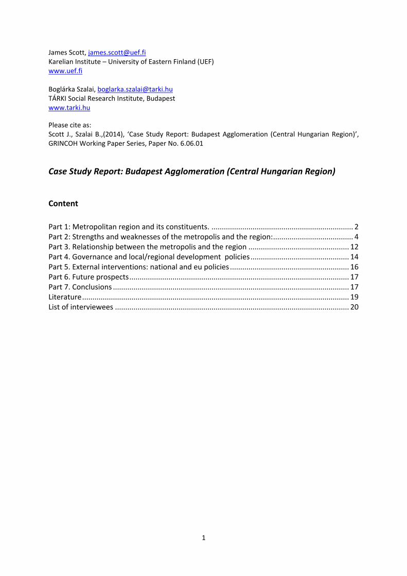
Figure 2. Population of Budapest metropolitan area, 2011 (1dot=100 inhabitants)3.
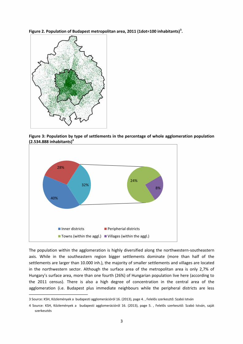
Figure 3: Population by type of settlements in the percentage of whole agglomeration population (2.534.888 inhabitants)4
The population within the agglomeration is highly diversified along the northwestern-southeastern
axis. While in the southeastern region bigger settlements dominate (more than half of the
settlements are larger than 10.000 inh.), the majority of smaller settlements and villages are located
in the northwestern sector. Although the surface area of the metropolitan area is only 2,7% of
Hungary’s surface area, more than one fourth (26%) of Hungarian population live here (according to
the 2011 census). There is also a high degree of concentration in the central area of the
agglomeration (i.e. Budapest plus immediate neighbours while the peripheral districts are less
3 Source: KSH, Közlemények a budapesti agglomerációról 16. (2013), page 4. , Felelős szerkesztő: Szabó István
4 Source: KSH, Közlemények a budapesti agglomerációról 16. (2013), page 5. , Felelős szerkesztő: Szabó István, saját
szerkesztés
40%
28%
24%
8% 32%
Inner districts Peripherial districts
Towns (within the aggl.) Villages (within the aggl.)

4
densely populated (see Figure 2). The whole area can be characterised by this concentric pattern
regarding the population density: directly by the city live much more people than in the peripheral
north-western or south-eastern sectors. Good (public) transport facilities have also determining
roles; settlements located by the railway, local trains (HÉV), highway are more densely populated
because these facilities make the commuting from the area to the city easier.
40% of total population of the agglomeration live in the inner districts (which are 9% of the whole
agglomeration’s surface area)5.
1.2. Is there a commonly accepted delimitation of the city’s metropolitan area and
what are its criteria?
Officially, the settlements and the territory belonging to the Budapest metropolitan area are defined
by Hungarian law.6 Thus we find a legal definition of the “Agglomeration” but without a
commensurate institutional expression. This legalistic understanding is based on criteria which stress functional relationships, urban densities, commuting patterns, infrastructure networks etc (Kőszegfalvi 1995, Nemes Nagy 2005, Perger 2006).
1.3. Does the dominant city have an administrative or statistical counterpart reflecting
the area of its influences (metropolitan macro-region)?
The Agglomeration is not represented by a regional institution that can carry our coordinating
activities. As such the capital city does not have an administrative counterpart within the
metropolitan aside from Pest County which accounts a much larger area. Since the elimination
and/or centralisation of regional planning bodies, volunteerist forms of cooperation, local
government associations in suburban areas as well as regional plans for the agglomeration serve as
the primary - and very weak - foundation for regional governance. Furthermore, the proliferation of
different agencies at local, county, Budapest and national levels providing public services contributed
to the highly fragmented situation.
1.4. Does the existing administrative division on the regional level (NUTS 2) and
subregional level (NUTS 3) correspond to the city’s influence areas, i.e.: a) the
metropolitan area, b) the metropolitan region?
The NUTS divisions are more or less in line with Budapest’s area of influence. However, they are not
operational in terms of public administration and no longer relevant in terms of regional planning.
Part 2: Strengths and weaknesses of the metropolis and the region:
2.1. What are the most important strengths and weaknesses of the metropolis (the
metropolitan area)?
The Budapest metropolitan is almost by default the most dynamic region of Hungary. The capital city
function is enhanced by an almost absolute centrality in terms of economic activity, culture,
international investment, tourism, logistics, financial services and banking. As a result, Budapest and
its agglomeration could be understood as “automatic” winners of transformations in
5 Inner districts: 1,2,3,5,6,7,8,9,10,11,12,13,14. Peripherial districts: 4, 15-23.
6 2005 évi LXIV törvény (http://net.jogtar.hu/jr/gen/hjegy_doc.cgi?docid=A0500064.TV)

5
contradistinction to the many regions, especially in the East, that have experienced dramatic decline.
However, Budapest’s strengths must be seen in relative terms – it is the best performing region in a
country that has been chronically underperforming since the early 2000s. In addition, the
metropolitan region has lost competitiveness with regard to other Central European capitals such as
Prague and Warsaw. Instead of developing into a “world class” financial and management centre, it
is very much a second-tier regional centre within the larger European context.
Strengths of the metropolitan area:
Central location and connections to other capitals
Concentrated economic activity
Touristic attractiveness
Developed (if overburdened) infrastructure Weaknesses:
Transport congestion and lack of planning coordination
Lack of innovation, especially with regard to SMEs
High level of regional disparity
High levels of environmental stress
Loss of relative importance and competitiveness within Central Europe
2.2. What factors have been the most important in development of metropolitan area
in recent years?
In terms of growth sectors in the metropolitan region these are without doubt related to service
sector development, tourism, logistics and retailing. Logistics and mass retailing have located to the
outer areas of the metropolitan area (the suburban ring) while tourism and services remain
concentrated in the central city. Development in financial services and real estate as well as new
investments in high value-added firms has stagnated. Budapest has been a target of steady migration
as persons seeking employment leave regional centres and towns.
2.3. What are the most important strengths and weaknesses of the regional
hinterland?
The hinterland enjoys advantages to the extent that road and rail accessibility are good. This is by no
means the case for the entire zone. Areas that are located near the principal East-West axis or the
southern areas near the M-0 motorway enjoy many of the locational advantages of the capital city,
available space for development and very attractive prices for new construction. These areas are also
seen as attractive in terms of their residential function. On the other hand, these centres within the
regional hinterland are characterised by mono-functional centres. Despite the existence of some
local jobs there is a high degree of dependence on the central city for many important public services
(health). In addition, much of the regional hinterland is in fact rural periphery, characterised by small
settlements, low level of amenities and poor accessibility. Paradoxically, proximity to Budapest is a
liability in terms of Cohesion Policy as the existence of a rich, powerful centre skews the overall
eligibility towards competition rather than development. A lack of forceful cooperation between
Budapest and its hinterland reinforces the isolated nature of much of the regional periphery in
planning and development terms.

6
2.4. What factors have been the most important in development of regional hinterland
in recent years?
The most important factors have been some industrial development along East-West axes (Budapest-
Vienna, Budapest-Komárom) and ongoing outmigration from smaller regional settlements. The result
is a highly fragmented picture of partial growth and development and a wider pattern of
depopulation.
2.5. Whether the example of successful local development in regional hinterland may
be indicated?
Here: see WP 6 RT 3 (Esztergom-Komárom) There are very few successful examples in the direct
hinterland but the case of Tatabánya, a former mining and heavy industrial community, is frequently
mentioned as a positive case of rebranding peripheral cities. In the case of Tatabánya, vigorous place
marketing, lobbying and networking by a new local elite seems to have had a decisive impact.
Exploiting proximity to Budapest and the accessibility to rails links westwards and with Vienna,
Tatabánya succeeded in attracting considerable new investment in the 1990s.
2.6. Are there large differences between the metropolitan area and regional hinterland
regarding the following aspects: a. economic, b. social? Does the metropolis and
its surrounding region become homogenous in respect of: a) economic structure b)
social structure?
There are enormous differences between Budapest, the immediate agglomeration and the wider
hinterland which is the rest of Pest County. All of these make up the region of Central Hungary. The
Central Hungarian Region is by no means homogeneous. The Budapest Agglomeration, and the city
of Budapest and several important suburban towns in particular, form Hungary’s economic core and
thus, almost by default, are the most dynamic areas of the country. At the same time, many of the
communities within the region more distant from the BAFT are plagued by high unemployment and
characterised by low development indicators. The major regional development problems of the CHR
were and remain to this day the following:
In terms of Cohesion Policy coverage, the Central Hungarian Region - as Hungary’s most prosperous
region despite great socio-economic disparities - lost its development area status after 2007 when it
was designated a phasing-in area within the Regional Competitiveness and Employment objective.
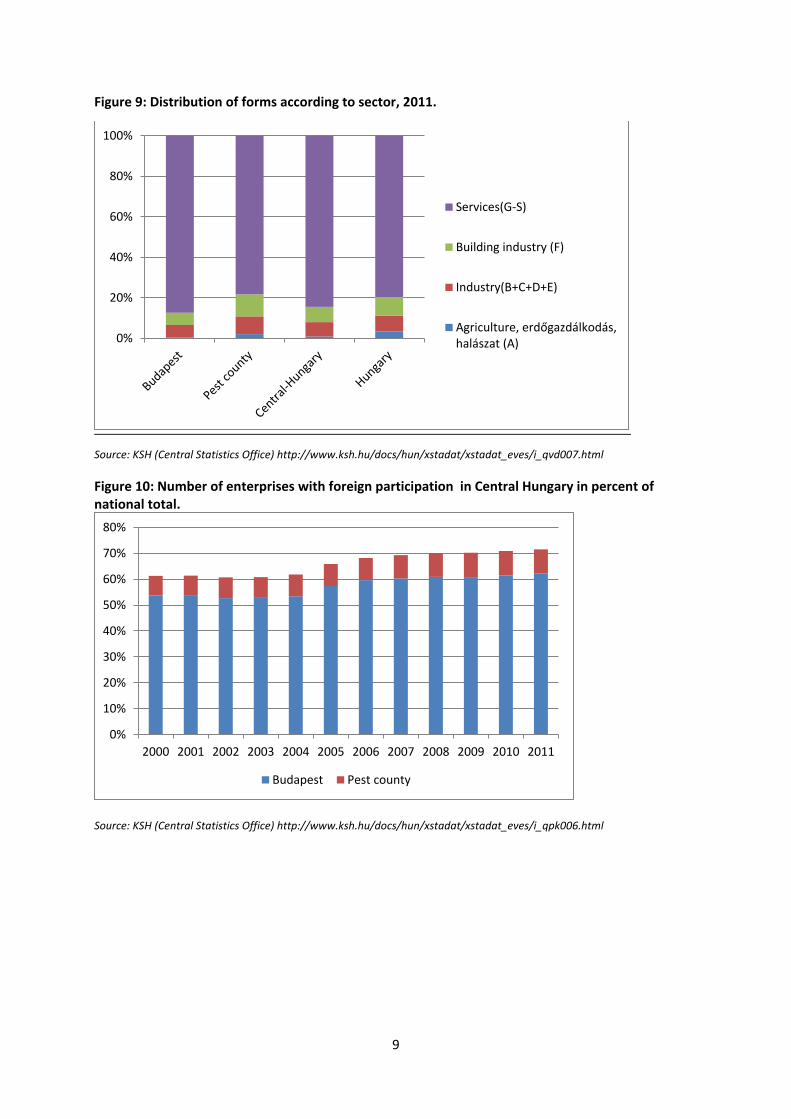
In terms of its economic structure, the Budapest Agglomeration is very strong in service industries
(within Budapest making up for 80% of all firms) and trade. 50% of all Hungarian trade companies are
located here. The immediate suburban ring also has a high concentration of enterprises. Since 1990,
multinational companies have improved industrial performance in the Agglomeration but this is
primarily in the area of logistics and storage. Similarly to the overall national pattern, while the
dominant proportion of businesses are small and medium size enterprises, a few big companies
account for the largest share of export activity. While large enterprises are generally located in the
capital, smaller enterprises have their headquarters in the surrounding metropolitan region.
The overall picture is skewed however when we take into consideration all of Pest County as a
natural hinterland. Here the differences between the urban core of the Agglomeration and the
peripheral are quite astonishing, giving Budapest and its suburban ring a rather ‘island-like’ quality:

7
an economically dynamic region surrounded by a dependent and stagnating hinterland. As such,
there does not appear to be an appreciable multiplier affect operating regionally in terms of job
creation or more general development.
Figure 5: Labour Participation Rates of Persons Aged 15 to 74. Source: KSH (Central Statistics Office),
http://www.ksh.hu/docs/hun/xstadat/xstadat_eves/i_qlf025.html#
Figure 6: Unemployment rate of Persons Aged 15 to-74. Source: KSH,
http://www.ksh.hu/docs/hun/xstadat/xstadat_eves/i_qlf027.html
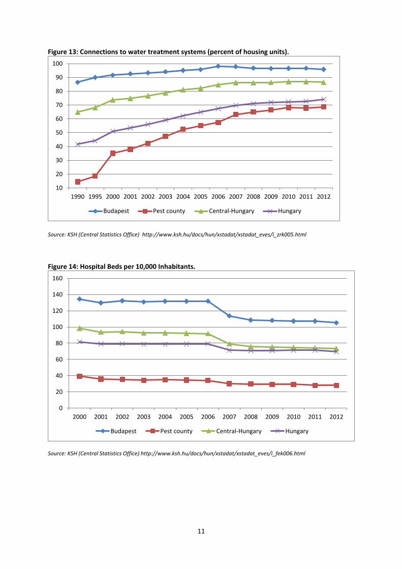
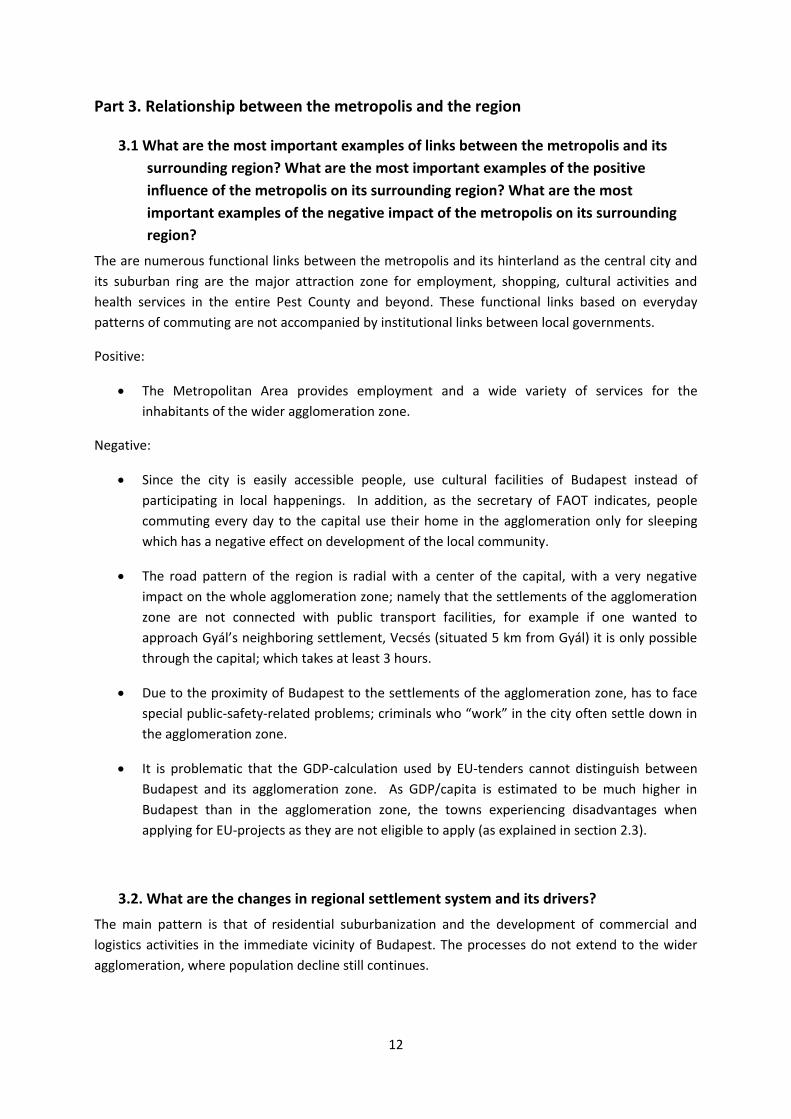
The figures that follow indicate a wide gap in economic and social indicators between Budapest and
the ‘non-Budapest’ Agglomeration.7 This data, collected from Hungary’s Central Statistics Office,
7 Source: Gazdaság 6
50
52
54
56
58
60
62
64
2000 2001 2002 2003 2004 2005 2006 2007 2008 2009 2010 2011 2012
Budapest Pest county Central-Hungary Hungary
2
3
4
5
6
7
8
9
10
11
12
2000 2001 2002 2003 2004 2005 2006 2007 2008 2009 2010 2011 2012
Budapest Pest county Central-Hungary Hungary
8
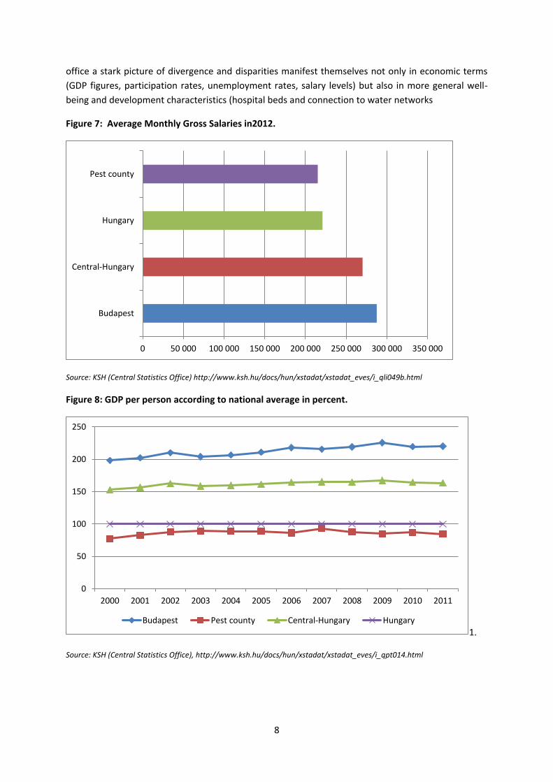
office a stark picture of divergence and disparities manifest themselves not only in economic terms
(GDP figures, participation rates, unemployment rates, salary levels) but also in more general well-
being and development characteristics (hospital beds and connection to water networks
Figure 7: Average Monthly Gross Salaries in2012.
Source: KSH (Central Statistics Office) http://www.ksh.hu/docs/hun/xstadat/xstadat_eves/i_qli049b.html
Figure 8: GDP per person according to national average in percent.
1.
Source: KSH (Central Statistics Office), http://www.ksh.hu/docs/hun/xstadat/xstadat_eves/i_qpt014.html
0 50 000 100 000 150 000 200 000 250 000 300 000 350 000
Budapest
Central-Hungary
Hungary
Pest county
0
50
100
150
200
250
2000 2001 2002 2003 2004 2005 2006 2007 2008 2009 2010 2011
Budapest Pest county Central-Hungary Hungary
9
Figure 9: Distribution of forms according to sector, 2011.
Source: KSH (Central Statistics Office) http://www.ksh.hu/docs/hun/xstadat/xstadat_eves/i_qvd007.html
Figure 10: Number of enterprises with foreign participation in Central Hungary in percent of national total.
Source: KSH (Central Statistics Office) http://www.ksh.hu/docs/hun/xstadat/xstadat_eves/i_qpk006.html
0%
20%
40%
60%
80%
100%
Services(G-S)
Building industry (F)
Industry(B+C+D+E)
Agriculture, erdőgazdálkodás,halászat (A)
0%
10%
20%
30%
40%
50%
60%
70%
80%
2000 2001 2002 2003 2004 2005 2006 2007 2008 2009 2010 2011
Budapest Pest county
10
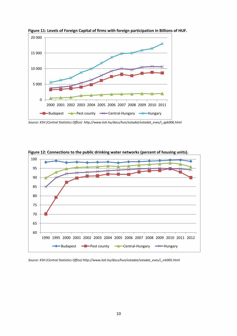
Figure 11: Levels of Foreign Capital of firms with foreign participation in Billions of HUF.
Source: KSH (Central Statistics Office) http://www.ksh.hu/docs/hun/xstadat/xstadat_eves/i_qpk006.html
Figure 12: Connections to the public drinking water networks (percent of housing units).
Source: KSH (Central Statistics Office) http://www.ksh.hu/docs/hun/xstadat/xstadat_eves/i_zrk005.html
0
5 000
10 000
15 000
20 000
2000 2001 2002 2003 2004 2005 2006 2007 2008 2009 2010 2011
Budapest Pest county Central-Hungary Hungary
60
65
70
75
80
85
90
95
100
1990 1995 2000 2001 2002 2003 2004 2005 2006 2007 2008 2009 2010 2011 2012
Budapest Pest county Central-Hungary Hungary
11
Figure 13: Connections to water treatment systems (percent of housing units).
Source: KSH (Central Statistics Office) http://www.ksh.hu/docs/hun/xstadat/xstadat_eves/i_zrk005.html
Figure 14: Hospital Beds per 10,000 Inhabitants.
Source: KSH (Central Statistics Office) http://www.ksh.hu/docs/hun/xstadat/xstadat_eves/i_fek006.html
10
20
30
40
50
60
70
80
90
100
1990 1995 2000 2001 2002 2003 2004 2005 2006 2007 2008 2009 2010 2011 2012
Budapest Pest county Central-Hungary Hungary
0
20
40
60
80
100
120
140
160
2000 2001 2002 2003 2004 2005 2006 2007 2008 2009 2010 2011 2012
Budapest Pest county Central-Hungary Hungary
12
Part 3. Relationship between the metropolis and the region
3.1 What are the most important examples of links between the metropolis and its
surrounding region? What are the most important examples of the positive
influence of the metropolis on its surrounding region? What are the most
important examples of the negative impact of the metropolis on its surrounding
region?
The are numerous functional links between the metropolis and its hinterland as the central city and
its suburban ring are the major attraction zone for employment, shopping, cultural activities and
health services in the entire Pest County and beyond. These functional links based on everyday
patterns of commuting are not accompanied by institutional links between local governments.
Positive:
The Metropolitan Area provides employment and a wide variety of services for the
inhabitants of the wider agglomeration zone.
Negative:
Since the city is easily accessible people, use cultural facilities of Budapest instead of
participating in local happenings. In addition, as the secretary of FAOT indicates, people
commuting every day to the capital use their home in the agglomeration only for sleeping
which has a negative effect on development of the local community.
The road pattern of the region is radial with a center of the capital, with a very negative
impact on the whole agglomeration zone; namely that the settlements of the agglomeration
zone are not connected with public transport facilities, for example if one wanted to
approach Gyál’s neighboring settlement, Vecsés (situated 5 km from Gyál) it is only possible
through the capital; which takes at least 3 hours.
Due to the proximity of Budapest to the settlements of the agglomeration zone, has to face
special public-safety-related problems; criminals who “work” in the city often settle down in
the agglomeration zone.
It is problematic that the GDP-calculation used by EU-tenders cannot distinguish between
Budapest and its agglomeration zone. As GDP/capita is estimated to be much higher in
Budapest than in the agglomeration zone, the towns experiencing disadvantages when
applying for EU-projects as they are not eligible to apply (as explained in section 2.3).
3.2. What are the changes in regional settlement system and its drivers?
The main pattern is that of residential suburbanization and the development of commercial and
logistics activities in the immediate vicinity of Budapest. The processes do not extend to the wider
agglomeration, where population decline still continues.

13
3.3. What are the changes in regional production system and its drivers?
The de-industrialisation of Budapest began already in the 1970s (Kiss 2009). The city is now
characterised by a large and variegated service economy that includes finance, investment banking
and tourism. Industry and logistics have developed in the Budapest agglomeration, which is linked to
the neighbouring areas of Esztergom, Tatabánya and Komárom. Nevertheless, this overall picture of
strength masks the fact that the CHR is also characterised by large gaps in GDP and other
development indicators; the Budapest agglomeration is in fact surrounded by numerous smaller
municipalities that lack many social amenities, are poorly connected to transportation and public
utility infrastructures and where outmigration remains a serious problem.
Furthermore, the Budapest Agglomeration (BAFT), has also faced major challenges in responding to
suburbanisation tendencies and addressing the resulting need for greater inter-municipal political
cooperation and development dialogue. Budapest must resolve problems caused by the
overconcentration of economic and political functions in the central city and a lack of
structural/functional cohesion between the capital and its surroundings and environmental concerns.
This manifests itself in problems of accessibility, poor interconnectivity, traffic congestion and a lack
of overall planning coordination within the BAFT which could seriously handicap the region.
Decentralisation and comprehensive urban renewal remain central priorities for BAFT. As a result,
large projects with symbolic and concrete spillover effects for urban renewal were made a CP
priority. In terms of employment development and enterprise support, the agglomeration in
particular has pointed to a need for development in the area of business and production-oriented
services, vocational training and more effective support to enterprise networks (BAFT 2007).
3.4. What are the labour commuting patterns at regional level and its drivers?
More than 100.000 people (2007) commute each day between the city and the agglomeration zone, and the commuting shows a two-way pattern; 2/3 of people commuting work in Budapest, as it is the
main employer of the region8. On the other hand multinational companies settled down in the
metropolitan area hire a number of employees from Budapest. The secretary of FAOT estimates that 90% of Gyal’s population work in the capital. In addition they can use all the facilities provided by the city. After 1990 a number of multinational enterprises appeared in the agglomeration, especially in the zones with an adequate infrastructural network (Budaörs, Szentendre) that also supported economic suburbanization processes. The biggest settlements where people commute: Budaörs, Törökbálint, Dunaharaszti, Dunakeszi, Gödöllő, Budakalász, Érd, Fót.
3.5. Are there examples of cooperation / competition of public administration actors
within the metropolitan region? Which one dominates?
A general critique regarding the settlements of the agglomeration is their incapability for cooperation
illustrated by several telling examples. The leader of Pro Regio considers the agglomeration as a
mosaic with very different and fragmented pieces, they do not constitute a network, and information
flow is not sufficient. FAÖT is the only lobbying organization but they cannot work properly as the
institutional system is changing. There used to be a regional development and lobbying organisation
called BAFT (see 4.2. below) but it was eliminated as it had no political support behind it. Its functions
were not defined well as it was not embedded into the institutional structure and it hasn’t received
any funding either from the municipalities or from the EU. David Szebeni takes an example for non-
8Source, KSH(2007): http://mek.oszk.hu/06000/06090/06090.pdf

14
cooperating municipalities that although the parts of road4 from Budapest to Szolnok is considered
one of the most dangerous roads of Hungary the majors cannot persuade the governance to finalize
the renovation (after 10 years). According to him the reasons behind are that municipalities are
overburden, have no capacity to contact and maintain a relationship with other municipalities within
the agglomeration.
We found one single example for actual cooperation within the agglomeration, namely that FAÖT
tries to co-operate and lobby with those settlements who pay a fee at BKK (public transport
company) in order to reduce their obligations by renewing the contract between the transport
company and the settlements.
Part 4. Governance and local/regional development policies
4.1. Whether local/regional policies have significant impact on metropolis-region
relationship? If, yes which one? Please indicate the most effective and efficient
policies.
In terms of regional policy governance, there were coordination bodies (Regional Development
Agency and Council) that were installed for the region as a part of Hungary’s regionalization process
after 1996. These helped create a certain degree of dialogue between the capital city and its
hinterland within the context of Cohesion Policy. However, the loss of convergence region status for
the Central Hungarian Region (because of Budapest’s sheer statical weight) ironically helped
fragment the region yet again. In addition, the regional coordination bodies were dissolved n 2012.
Since then, largely volunteerist forms of cooperation have been practiced.
In terms of concrete development policies our informants argue that it is in the area if transport
development and water treatment where the relationships between metropolitan centre and
hinterland have been most visibly effected: quality of service, accessibility and interregional
connections have been improved
4.2. What actions are taken in order to increase the positive influence of the
metropolitan centre on its surrounding region?
The long-term (15 year) Development Strategy of Budapest, Known as the “the New Development
Concept”, aims to involve civil society such as the municipalities of the agglomeration in order to
create a poly-centric structure of the region9. At present they have not produced any tangible results.
In May 2005 the BAFT10
(Development Council of Budapest Agglomeration) was founded in order to
develop the economy of the whole agglomeration region by harmonizing the development aims of
the agglomeration. This organisation also aimed turn the metropolitan region from Budapest-centric
to a polycentric one with developing the cohesion, cooperation and coordination. BAFT promoted
the following:
initiating active participation of all actors in the regions in forming common development
strategies
9 Pongrácz Katalin (2012) „A fővárosi városfejlesztési koncepció újragondolásának folyamata és az agglomerációt érintő
irányai” c. előadás a Budapesti Agglomerációs konferencián, 2012, konferenciakiadvány.
10 In Hungarian: Budapesti Agglomerációs Fejlesztési Tanács
15
providing organizational frames for the participants
building up coordinational plans
On January 1st
, 2012 a new law came into force11
that aimed to rationalize the organization of regional development with a centralization process, which meant that former regional, micro-regional and BAFT was melted into the county and Budapest municipality.
4.3. What actions are taken in order to limit the negative impact of the metropolitan
area on its surrounding region?
In order to prevent the deterioration of local communities, NGOs in Gyal and FAÖT members try to
organize several festivals and happenings to encourage people to spend their money where they live.
In addition the settlements of FAÖT promote other FAÖT settlements in the local newspapers,
homepages in order to improve local tourism instead of tourism to the capital. FAÖT is also
promoting subregional fora in order to improve public safety within the agglomerations, but these
have resulted in discussion rather than practical solutions (they met 2 times a year plus ad-hoc
problem-solving sessions.)
4.4. Are the actions of various actors coordinated within: a) the metropolitan area b)
the metropolitan macroregion?
At this stage this answer is clearly no. what remains from the governance mechanisms that were
eliminated by the present government are framework plans for the Budapest Agglomeration which
are supposed to guide/orient local planning decisions. There are however first indications of
voluntary municipal organisations within the Agglomeration that are aiming at joint strategies and
project development
4.5. What is the role of authorities at regional level in co-ordination of development
process in metropolitan region? Whether existing public authorities at this level
are effective?
Existing public authorities were not regarded effective by any of our interviewees that has several
reasons behind. According to David Szebeni’s explanations, people working at municipalities are
contra selected, as they are underpaid so those people would like to work there, who are not the
’most hardworking, and innovative’ ones. Another reason for not being effective is that they have
very tight budget (with very serious debts), some settlements of the agglomeration could not join
FAOT as were not able to pay the annual contribution which is 10 HUF (0,03 EUR) /inhabitant/year.
The third reason mentioned by interviewees were the lack of cooperation between municipalities
(see at Chapter 3.5)
11 A területfejlesztésről és a területrendezésről szóló 1996. évi XXI. törvény módosítása

16
Part 5. External interventions: national and eu policies
5.1. Which type of external interventions have had the most significant impact on
metropolis-region relationship?
Large investments in the area of infrastructure (transport, energy, water) have facilitated the growth
of local labour markets and increased traffic flows between Budapest and hinterland. In particular,
the development of the motorway network and suburban trains have increased the functional
interdependence between metropolitan core and larger settlements in the hinterland. In terms of
more place-specific interventions, urban redevelopment on an important scale, environmental
improvements and investments is public amenities (green, spaces, cultural centres, etc.) has also had
a major impact on the capital city region. Thanks to these measures, the centrality of Budapest has
been considerably enhanced and greater interaction between the centre and its hinterland have
been the most visible effect (including increasing traffic congestion). At the same time, external
interventions that have enhanced interregional connectivity have also made the more sparsely
populated hinterland more accessible as a recreational space and area for acquiring more affordable
houding.
5.2. Does the structure of external intervention address needs of a) metropolitan area
b) regional hinterland?
External interventions – both public and private - have tended to one-sidedly favour the central city
and its immediate hinterland. The greater region lacks attractiveness for private investment and is
not considered a priority area for public policy.
5.3. Does the outcome of Cohesion Policy implementation affect more economic
competitiveness or social well-being? Is the outcome similar in metropolitan area
and regional hinterland?
Based on the information we have collected on Cohesion Policy up to 2013 the results appear rather
modest. Furthermore, CP has benefitted the central area of the region more in terms of absolute
expenditures, but this has not appreciably affected the competitiveness issue. This goes for both the
metropolis and its hinterland. In terms of social well-being, CP has indirectly contributed to this goal
by financing social infrastructure, both in the metropolis and the greater region. Welfare effects of
CP are seen to have been indirect, primarily by supporting social infrastructure, creating employment
and freeing up national funds for welfare measures.

17
5.4. Does external intervention properly coordinated in metropolitan region?
Part 6. Future prospects
6.1. Will the differences between the metropolis and the region increase or diminish?
What is going to be the main driver of this process?
6.2. What are recommended future objectives (spheres) of national development
policy regarding metropolis-region relationship?
6.3. What are recommended future objectives (spheres) of the EU Cohesion policy
regarding metropolis-region relationships?
All indicators point to increasing disparities between the hinterland and the metropolitan core. For
those areas of the Central Hungarian Region that do not directly profit from proximity to the core
and have established functional relationships that will stabilise local populations and economies the
prognosis is one of continuing outmigration and marginalisation. This follows a more general national
trend of metropolisation and concentration in urban centres to the detriment of rural and semi-rural
communities. As local services of all kind (education, health, transportation, markets, etc.) diminish,
the ability to maintain population will also decrease. Centralization has not helped the situation as it
has tended to reduce the decision-making and action spaces of local governments in their search for
solutions. In terms of a solution, only a forceful and inclusive regional context for development can
address increasing imbalances as well as promote an implementation of Cohesion Policy that is based
on local needs. This is however seen less to be an EU problem than a national issue – Hungarian
regional policy has simply failed to provide a platform for openly addressing urban-rural disparities
and the hegemony of Budapest.
Part 7. Conclusions
7.1. How does the metropolis perform at the international scale? What are the main
drivers of its success/failure? Are their nature exogenous or endogenous?s
7.2. How does the regional hinterland perform in comparison to the metropolis? What
is the role of natural resources in the development process? Does the success in
regional hinterland rely on exogenous or endogenous factors?
7.3. What is the role of migration processes in relation between metropolis and their
region? Could we observe segmentation of migration (eg. young to the core,
elderly to hinterland)? How the quality of life in regional hinterland does affect
this process?
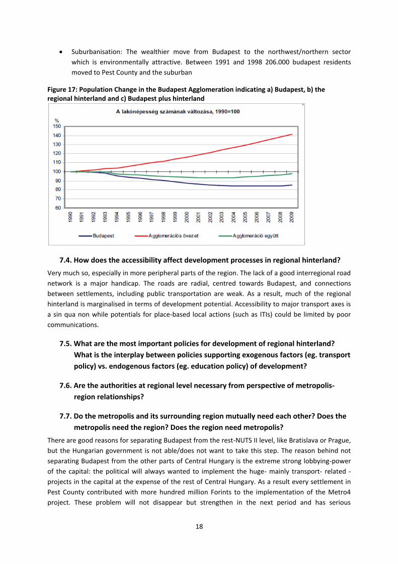
The metropolitan area has a positive migration balance since the second half of the 1990s (+15-
18.000 people/year). Determining factors of these migration processes include the following:
for job opportunities in-migration from all of Hungary to Budapest and the agglomeration
zone
18
Suburbanisation: The wealthier move from Budapest to the northwest/northern sector
which is environmentally attractive. Between 1991 and 1998 206.000 budapest residents
moved to Pest County and the suburban
Figure 17: Population Change in the Budapest Agglomeration indicating a) Budapest, b) the regional hinterland and c) Budapest plus hinterland
7.4. How does the accessibility affect development processes in regional hinterland?
Very much so, especially in more peripheral parts of the region. The lack of a good interregional road
network is a major handicap. The roads are radial, centred towards Budapest, and connections
between settlements, including public transportation are weak. As a result, much of the regional
hinterland is marginalised in terms of development potential. Accessibility to major transport axes is
a sin qua non while potentials for place-based local actions (such as ITIs) could be limited by poor
communications.
7.5. What are the most important policies for development of regional hinterland?
What is the interplay between policies supporting exogenous factors (eg. transport
policy) vs. endogenous factors (eg. education policy) of development?
7.6. Are the authorities at regional level necessary from perspective of metropolis-
region relationships?
7.7. Do the metropolis and its surrounding region mutually need each other? Does the
metropolis need the region? Does the region need metropolis?
There are good reasons for separating Budapest from the rest-NUTS II level, like Bratislava or Prague,
but the Hungarian government is not able/does not want to take this step. The reason behind not
separating Budapest from the other parts of Central Hungary is the extreme strong lobbying-power
of the capital: the political will always wanted to implement the huge- mainly transport- related -
projects in the capital at the expense of the rest of Central Hungary. As a result every settlement in
Pest County contributed with more hundred million Forints to the implementation of the Metro4
project. These problem will not disappear but strengthen in the next period and has serious

19
consequences for the Central Hungary region; right under the agglomeration area there is a half-
moon shaped area bounded by Ipoly, Aszód, Nagykáta, Tápiószele, Cegléd, Ráckeve ( purple line on
the map) that has been decaying.
This underprivileged region should be a convergence region regarding their economic indexes. As a
result of the underprivileged situation the workforce moves to the western, the capital to eastern
parts of Hungary from here; the enterprises choose Szolnok or Kecskemét instead this region as they
can be supported in the east part from EU-sources while here they can’t. People living in the half-
moon area mostly work in Budapest or Szolnok. In addition there are no universities in the region
because of the proximity of Budapest which is well- supplied with universities. As a result it is difficult
for companies to find not only well- educated workforce but also financial support in the area. He
has a very negative picture in his mind about the future of this “dead space”, that is reflected by the
low real estate prices, and lacking economic links to its environment. The other problematic issue,
not only in this region but in the whole agglomeration area, is that municipalities do not cooperate at
all, they simply cannot lobby together for a common aim because they are overburdened, have no
capacity to contact and maintain a relationship with other municipalities. As an example for the lack
of any cooperation and lobbying activity he points that although the parts of National Route 4 from
Bp. to Szolnok is considered one of the most dangerous roads of Hungary the majors cannot
persuade the governance to finalize the renovation (after 10 years). The problem is that this road is
not part of trans-European network, and if “there is no EU-money to build a road, than no roads will
be built.”
Literature
Cseppentő László: A fővárosi munkaerőpiac és az agglomeráció kölcsönhatása, in: Hátrányból előnyt!
Válaszok a munkaerő-piaci (re) integráció kihívásaira, szerk.: Rostásné Pátkai Zsuzsanna, 2009, Kiadó:
Fővárosi Közhasznú Foglalkoztatási Szolgálat Kht
BAFT munkaszervezet: Bevezető gondolatok a Budapesti Agglomerációról, in: Hátrányból előnyt!
Válaszok a munkaerő-piaci (re) integráció kihívásaira, szerk.: Rostásné Pátkai Zsuzsanna, 2009, Kiadó:
Fővárosi Közhasznú Foglalkoztatási Szolgálat Kht
Közlemények a Budapesti agglomerációról 15. Gyermekvállalás a budapesti agglomerációban 1990-
2009, KSH, 2011, Szerk. Szabó István
20
Dr. Tóth Géza-Schuchmann Péter: A budapesti agglomeráció területi kiterjedésének vizsgálata, in.
Területi statisztika, 13. (50.)évf. 5. szám, 20120. szept.
Budapest városfejlesztési koncepciója, 6. Budapest gazdasága, 2011
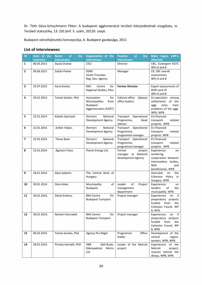
List of interviewees
ID Date of the interview
Name of the interviewee
Organisation of the interviewee
Position of the interviewee
Main topics (WP-s affected)
1 06.05.2013 Gyula Ocskay CECI
Director CBC, Esztergom EGTC WPs 6 and 8
2 06.06.2013 Zoltán Pamer DDRF South Transdan. Reg. Dev. Agency
Manager CP, CBC overall assessments WPs 6 and 8
3 25.07.2013 Ilona Kovács RKK- Centre for Regional Studies, Pécs
Former Director Expert assessments of ROPs and CP WPs 6 and 8
4 20.01.2014 Tamás Sándor, Phd Association for Municipalities from Budapest Agglomeration (FAÖT)
Cabinet-office (deputy office leader)
Co-operation among settlements of the aggl. zone, main problems of the aggl. WP6, WP8
5 22.01.2014 Katalin Gyertyán (former) National Development Agency
Transport Operational Programme, Head Advisor
EU-financed transport- related projects. WP8
6 22.01.2014 Zoltán Takács (former) National Development Agency
Transport Operational Programme, programme manager
EU-financed transport- related projects. WP8
7 22.01.2014 Tímea Baán (former) National Development Agency
Transport Operational Programme, programme manager
EU-financed transport- related projects. WP8
8 23.01.2014 Ágoston Flaisz Planet Energy Ltd. Former project manager at National Development Agency
Experiences on tendering, cooperation between intermediary bodies, NDA and beneficiaries. WP8
9 28.01.2014 Géza Salamin The Central Bank of Hungary
Overview on the Cohesion Policy in Hungary. WP8
10 30.01.2014 Dóra Kókai Municipality of Budapest
Leader of Project management department
Experiences on tenders of the municipality. WP8
11 30.01.2014. Dávid Ambrus BKK-Centre for Budapest Transport
Project manager Experiences on 4 preparatory projects funded from the Cohesion Found, WP 8, WP6
12 30.01.2014. Norbert Konradek BKK-Centre for Budapest Transport
Project manager Experiences on 4 preparatory projects funded from the Cohesion Found, WP 8, WP6
13 06.02.2014
Tamás Gordos, Phd. Agency Pro Régió Programme Office leader
Development of the central region, tenders. WP6, WP8
14 28.02.2014 Piroska Horváth, PhD DBR (Dél-Buda-Rákospalota) Metro Ltd
Leader of the Metro4 project
Experiences of the Metro4 project, reasons behind the delays, WP8, WP6

21
15 28.02.2014 Ágota Csuka DBR (Dél-Buda-Rákospalota) Metro Ltd
PR associate Development of the project WP6, WP8
16 28.02.2014 Zsuzsanna Kondor
(former) National Development Agency
Former leader of the Coordination MA
Experiences on the 2007-2013 period; institutional structure, tendering system, evaluations of programs. WP8
17 04.03.2014 József Fehér MAG – Hungarian Economic Development Centre (intermediary body)
Managing director Institutional system, cooperation with NDA and EU-bodies, evaluation of programs WP8.
18 06.03.2014 Tamás Tóth (former) National Development Agency
Leader of the Coordination MA
Development of tendering system, program coverage. WP8
19 21.05.2014 Zoltán Pitti Corvinus University of Budapest, Societal Policy Research Center
Researcher The situation of SME-sector in Hungary.
20 04.06.2014. Dávid Szebeni Corvinus University of Budapest, Societal Policy Research Center
Lecturer WP8, WP6
21 23.06.2014. Gyula Ocskay ex-VÁTI employee WP8, WP6-Esztergom