Transportation Infrastructure Bond Corridor Mobility Improvement Account.

URS CorporationAnd
INCA Engineers, Inc.
WASHINGTON STATEDEPARTMENT OF TRANSPORTATION
EASTSIDE CORRIDOR PROJECT
SECOND LEVEL SCREENING ANALYSIS
DRAFT FINAL REPORT
REVISED AUGUST 3, 2001

Draft Final Second Level Screening Analysis ReportAugust 3, 2001
URS CorporationAnd
INCA Engineers, Inc.
TABLE OF CONTENTS FORSECOND LEVEL SCREENING ANALYSIS
DRAFT FINAL REPORT
EXECUTIVE SUMMARY Page 1
INTRODUCTION Page 3
FUTURE NORTH/SOUTH CORRIDIOR CAPACITY NEEDS Page 3
OVERVIEW OF SCREENING ANALYSIS PROCESS Page 6
CONCEPTUAL ALTERNATIVES CONSIDERED IN SECOND Page 8LEVEL SCEEENING ANALYSIS
RIVER OR WESTERN ROUTES Page 8
LOWER BENCH Page 8
ONE-WAY COUPLETS Page 10
IMPROVEMENTS TO EXISTING SUNSET HIGHWAY Page 10
IMPROVEMENTS AND EXTENSIONS TO Page 11LOCAL STREETS
SECOND LEVEL SCREENING CRITERIA AND CONCEPTUAL Page 12ALTERNATIVE SCORING
TRANSPORTATION Page 12
COMMUNITY / LAND USE Page 15
ENVIRONMENTAL Page 18
ENGINEERING FEASIBILITY Page 21
RESULTS, CONCLUSIONS AND RECOMMENDATIONS Page 25
Draft Final Second Level Screening Analysis ReportAugust 3, 2001
1 URS CorporationAnd
INCA Engineers, Inc.
EXECUTIVE SUMMARY
The purpose of the Eastside Corridor effort is to identify a transportation alternative that willenhance safety and increase mobility, including the movement of people, goods, and services onthe Sunset Highway Corridor (SR 28) in the East Wenatchee urban area from 9th Street to theOdabashian Bridge. Any proposal must meet the needs of the community, and comply with allFederal and State environmental laws. The Washington State Department of Transportation(WSDOT) has contracted with URS Corporation (URS) and their subconsultants (the projectteam), to develop an Environmental Impact Statement (EIS), which would assess theenvironmental impacts of a range of transportation alternatives and ultimately identify apreferred alternative.
A screening analysis, which was carried out in two stages was used by the project team to selectthe alternatives for detailed assessment in the EIS. The initial screening analysis involvedbrainstorming conceptual alternatives within the East Wenatchee urban area, and the creation ofrating criteria with input from WSDOT, the interdisciplinary team (IDT), and the community.The conceptual alternatives were then rated against the screening criteria and the most promisingalternatives were selected for further engineering consideration and analysis. A total of 16conceptual alternatives were selected and carried through to the second stage of the screeningprocess. These alternatives were grouped into the following five categories:
• Two conceptual alternatives located between Sunset Highway and the Columbia River (theRiver or Western Routes).
• Six conceptual alternatives located on the lower bench.• Two conceptual alternatives which are one-way couplets on existing streets.• Two conceptual alternatives involving improvements to the existing Sunset Highway.• Four conceptual alternatives involving local street widening and extensions to SR 2/
Odabashian Bridge.
The second stage of the screening process involved more focussed analysis and discussion inorder to develop more detailed screening criteria and determine the weight to be applied to eachcriterion. Development of the detailed screening criteria involved expanding the criteria, whichhad been used in the initial screening analysis, and incorporating feedback received from thecommunity. It was determined that there were four major categories that the criteria would fallunder; Transportation, Community/Land Use, Environmental and Engineering Feasibility. Itwas also determined that each of the four major categories was of equal importance and wouldreceive equal weighting. Each of the 16 conceptual alternatives carried through from the initialscreening analysis was then rated according to the second level screening criteria.

Draft Final Second Level Screening Analysis ReportAugust 3, 2001
2 URS CorporationAnd
INCA Engineers, Inc.
The second level screening was completed and the results were presented to the interdisciplinaryteam, the citizens advisory committee, and to the public at an open house. Based on the resultsof the second level screening analysis, and input received from the IDT and the community theproject team recommends the following conceptual alternatives be studied in detail in the EIS:
• 1f Western Route 300’ from OHWM, Parkway.• 4a One-Way Couplet – Sunset Highway/ Cascade Avenue• 5i Sunset Highway Four Lane Freeway.• 6d Cascade Avenue Improvements and Widening.
It is important to note that the above recommendation was made based on preliminaryenvironmental information, traffic data and engineering considerations. While this level ofinformation is appropriate for carrying out a screening analysis of conceptual alternatives, theproject team recognizes that additional environmental or design information may arise as a resultof the detailed environmental studies and design work which will be carried out as part of theEIS process. Further evaluation of the recommended alternatives may warrant adjusting theoriginal conceptual alignment of an alternative. Additionally, elements of some of thealternatives discounted during the second level screening process may be incorporated in order toovercome environmental or design constraints, and avoid potential impact issues.
Draft Final Second Level Screening Analysis ReportAugust 3, 2001
3 URS CorporationAnd
INCA Engineers, Inc.
INTRODUCTION
The purpose of the Eastside Corridor effort is to identify a transportation alternative that willenhance safety and increase mobility, including the movement of people, goods, and services onthe Sunset Highway Corridor (SR 28) in the East Wenatchee urban area from 9th Street to theOdabashian Bridge. Any proposal must meet the needs of the community, and comply with allFederal and State environmental laws. The Washington State Department of Transportation(WSDOT) has contracted with URS Corporation (URS) and their subconsultants (the projectteam), to develop an Environmental Impact Statement (EIS), which would assess theenvironmental impacts of a range of transportation alternatives and ultimately identify apreferred alternative.
An EIS for the SR 28 corridor was prepared by WSDOT in the mid-1980s. Each of thealternatives presented in the 1980s EIS were analyzed in the initial part of the process ofselecting alternatives to be assessed in the current EIS. As detailed in the Eastside CorridorProject Final Initial Screening Analysis Report, two of the original alternatives (Previous EISRoutes 3 and 5) were carried through to this second level screening analysis.
FUTURE NORTH/ SOUTH CORRIDOR CAPACITY NEEDS
The alternatives being considered in the Eastside Corridor effort must accommodate trafficcapacity needs in the build year, assumed to be 2006, and 20 years into the future, or on into theyear 2025. The qualitative evaluation of the different alternatives is based upon traffic modelspreviously undertaken and engineering judgment obtained from experience with similar types offacilities.
In 1997, a study was prepared which assessed the regional transportation needs of the WenatcheeUrban Area. The study known as WATS (Wenatchee Area Transportation Study), originallyassessed the capacity needs up to the year 2010. The traffic model developed for WATS waslater extrapolated to 2017 at the request of Douglas County. The extrapolation of the volumeforecast predicted that by 2017 there would be demand for about 2500 vehicles traveling in thecorridor in each direction. It is anticipated that the volume forecasts for 2025 that will bedetermined during the EIS process will be similar or higher.
The design and type of access control that is used on a roadway has an effect on the capacity ofthe roadway. Access control refers to the number and kind of access points that are found on theroadway. Different kinds of access points include driveways, intersections (signalized andunsignalized), and interchanges. Fewer access points result in fewer potential conflict points andincreased capacity. More access points create more potential conflict points requiring thedriver’s attention and decreased capacity.
Draft Final Second Level Screening Analysis ReportAugust 3, 2001
4 URS CorporationAnd
INCA Engineers, Inc.
Capacity is determined by methodology defined in the Highway Capacity Manual, 2000,published by the Transportation Research Board of the National Research Council. In additionto access control, factors that can affect capacity include lane width, grade, shoulder width,interchange or intersection spacing, traffic stream composition, parking, bus operations, turningmovements, signal timing, pedestrian and bicycle use, and weather. These factors were takeninto consideration when determining the expected available capacity for the alternatives.
The kind of access control and the resulting expected capacity used for roadways varies byfacility type. The following assumptions were used for the screening alternatives:
• Full Control Limited Access Facility – Freeway. For a freeway, full control of access isestablished. This means that access to the freeway is limited to interchanges only. This kindof a facility has no driveways or road approaches. No pedestrians are allowed, and there isno parking. Typical capacity ranges between 2250 and 2400 vehicles per hour per lane basedupon Chapter 23 of the Highway Capacity Manual. However, for the specific case of theEastside Corridor, a relatively short stretch of freeway with an access point and minimaldriver experience with freeways a likely capacity range would be 1800 to 2200 vehicles perhour.
• Managed Access Control Facility – Parkway or New Principal Arterial. For a parkway ornewly constructed principal arterial, managed access control will be used in this study.Managed access control for a parkway or principal arterial means that access will be allowedonly at intersections. Pedestrian facilities will be provided adjacent to the roadway, andparking is not allowed. Capacity is controlled mainly by the intersections. Typically, thefactor with the most significant impact is available green time (how long a traffic signalshows green) for each traffic movement. The ideal saturation flow rate is 1900 vehicles perhour per lane based upon Chapter 16 of the Highway Capacity Manual. Because the crosstraffic or turning movements are expected to take one-half of the green time, the availablecapacity is reduced by one-half, or to approximately 950 vehicles per hour per lane.
• No Access Control Designation – Existing Principal Arterial or Rural Arterial. Forexisting principal arterials or new or existing rural arterials, no formal access controldesignation will be used for the roadway. Roadway approaches for driveways or otheraccess roads will be permitted for existing access points or new accesses as requested andapproved. New access points will be granted based on engineering safety criteria such assight distance and stopping distance. Capacity would be similar to that described forManaged Access Control Facilities, however it would be further reduced for traffic conflictsat each of the access points. This would reduce the capacity to an expected range of between750 and 900 vehicles per hour per lane.
Draft Final Second Level Screening Analysis ReportAugust 3, 2001
5 URS CorporationAnd
INCA Engineers, Inc.
• Primary Arterials with One-Way Operation (Couplets). The access control requirements forthe one-way couplets have not been determined. The couplets will operate more efficientlybecause one-way traffic results in a reduced number of conflicting movements at theintersections. Couplets are analyzed in a manner similar to the Managed Access Control andNo Access Control discussions. The primary increase in capacity is achieved due to theincrease in the amount of green time available for the primary movements. In addition, leftturns operate similar to right turn movements in two-way operation, and traffic signalprogression can be improved resulting in even more efficiency and higher capacities. Theexpected capacity for one-way couplets would be between 1000 and 1350 vehicles per hourper lane.
Based on the type of facility and the type of access control, lane requirements for thepreliminary alternatives were developed. Fewer lanes are needed for limited access orfreeway facilities due to the higher design capacity, and more lanes were needed for arterialsand parkways. The expected volume based on the previous modeling would result in theneed for approximately four additional (two in each direction) arterial travel lanes for a totalof six arterial lanes in the north-south corridor. Four freeway lanes (two in each direction)would be required in the corridor.
Draft Final Second Level Screening Analysis ReportAugust 3, 2001
6 URS CorporationAnd
INCA Engineers, Inc.
OVERVIEW OF SCREENING ANALYSIS PROCESS
The screening analysis used to select alternatives for detailed assessment in the current EIS wasconducted in two stages as described below.
Initial Screening Analysis
The first step of the screening process involved brainstorming conceptual alternatives within theEast Wenatchee urban area. The introductory open house held March 21, 2001 provided the firstopportunity to develop possible alternatives. Representatives from URS, INCA Engineers, JDLand TModel met in April and again in May of 2001 to brainstorm alternatives. A coordinationmeeting with WSDOT was held to discuss specifics of each alternative that had been generatedto date. Input from the Stakeholders Workshop held on May 16, 2001, continued to developpotential concepts and established rating criteria that is most important to the community as wellas reinforce the alternatives that had been brainstormed previously. On May 25, 2001, the groupcarried out an initial screening of the conceptual alternatives against the following set ofscreening criteria:
• Does the concept improve level of service in the existing SR 28 corridor?• Does the concept improve safety?• Is the concept constructable, and can it meet engineering criteria?• Would the concept likely receive required permits and approvals?• Does the concept minimize displacements?
The objective of the initial screening was to identify the most promising alternatives for furtherengineering consideration through a process of major flaw identification. Based on the initialscreening, 16 of an original 34 conceptual alternatives were carried forward for further analysis.The initial screening process is described in detail in the Eastside Corridor Project FinalInitial Screening Analysis Report dated July 13, 2001.
Second Level Screening Analysis
The second stage of the screening process involved a more focused analysis and discussion inorder to develop more detailed screening criteria and determine the weight to be applied to eachcriterion. The screening criteria and weighting were developed by roadway design engineers,traffic engineers and environmental planners from URS, INCA Engineers and JDL at a meetingheld on June 8, 2001. The development of the criteria included expanding the criteria which hadbeen used in the initial screening. Also, additional criteria emphasized at the StakeholdersWorkshop were included in the analysis. Examples of the most commonly discussed criteria atthe Stakeholders Workshop include neighborhood connectivity, impacts to parks, recreationalfacilities, cultural resources, prime farmland, and biological resources. The people whoperformed the second level screening are as follows:

Draft Final Second Level Screening Analysis ReportAugust 3, 2001
7 URS CorporationAnd
INCA Engineers, Inc.
Jim Catterfeld, URS CorporationGary Harshman, URS CorporationSarah Townsend, URS CorporationChuck Hathaway, INCA EngineersSandy Glover, INCA EngineersKen Wiley, INCA EngineersMolly Johnson, JDLBob Shull, TModel
The 16 conceptual alternatives carried through from the initial screening analysis were scoredagainst this second set of more detailed screening criteria. The section of this report titledCONCEPTUAL ALTERNATIVES CONSIDERED IN SECOND LEVEL SCREENINGANALYSIS provides a description of the 16 alternatives considered in the second levelscreening analysis. The sections titled SECOND LEVEL SCREENING CRITERIA ANDCONCEPTUAL ALTERNATIVE SCORING and RESULTS, CONCLUSIONS, ANDRECOMMENDATIONS describe the criteria selected to compare the alternatives and theranking given to each. The objective of the second level screening analysis was to identify anumber of alternatives, which would be suitable for detailed assessment and consideration in thecurrent EIS.
Draft Final Second Level Screening Analysis ReportAugust 3, 2001
8 URS CorporationAnd
INCA Engineers, Inc.
CONCEPTUAL ALTERNATIVES CONSIDERED IN SECOND LEVEL SCREENINGANALYSIS
Detailed descriptions of the 16 conceptual alternatives carried through from the initial screeninganalysis for assessment in the second level screening analysis are provided below. Thealternatives have been grouped into five like-categories.
RIVER OR WESTERN ROUTES
• Conceptual alternative 1e, Western Route Freeway would be located to the west of SunsetHighway and would extend from the Odabashian Bridge to the existing Sunset Highway at9th Street. The alignment of this alternative was selected based on available aerialphotographs and an extensive field survey of the area in order to minimize impacts toexisting houses and businesses. It is located a minimum of 300 feet from the ordinary highwater mark (OHWM) with the exception of the south end connection to existing SunsetHighway, which is within 300 feet of the OHWM. The alternative has full access control(freeway) with two lanes in each direction with a _ cloverleaf interchange at the OdabashianBridge, diamond interchanges at 19th Street, 9th Street and 27th Street. It is anticipated thattwo underpasses/ overpasses along the route would provide access across the freeway. Thesouth end of the route would be located within the 200-foot shoreline management zone foraligning with and widening the existing Sunset Highway.
• Conceptual alternative 1f, Western Route 300’ from Ordinary High Water Mark OHWM,Parkway would be a western route from the Odabashian Bridge to 15th Street with wideningof existing Sunset Highway from 15th Street to 9th Street. The alignment was selected on thebasis that it falls just outside of the 300’ zone of the OHWM (west of conceptual alternative1e) and thereby complies with the provisions of the Endangered Species Act (ESA). Thesouthern end of the route would be within the 200-foot shoreline management zone foraligning with and widening the existing Sunset Highway. This alignment would maximizethe use of the existing state highway right-of-way, while remaining outside of the shorelineand ESA regulatory jurisdictional area. This alternative is proposed as a parkway, with twolanes in each direction, a raised median and managed access control (access only at keyintersections).
LOWER BENCH
• Conceptual alternative 3a, Lower Bench (Previous EIS Route 5) starts at the SR 2/ SR 28intersection, shares the alignment of Union Avenue west of the Airport, and meets theexisting Sunset Highway north of Hurst Landing. The alternative is proposed to havemanaged access control (access only at key intersections) for those areas not traversingexisting residential zones, with two lanes in each direction. If this alternative is considered

Draft Final Second Level Screening Analysis ReportAugust 3, 2001
9 URS CorporationAnd
INCA Engineers, Inc.
for further evaluation, the northern end of the alignment would be revised to take intoaccount houses constructed along the alignment since the mid-1980s. Access for existinghouses not directly impacted along the alignment may remain.
• Conceptual alternative 3b, Lower Bench to Grant Road/ Batterman Road would start at theSR 2/ SR 28 intersection, and would be located east of the residences at the northern end ofthe alignment to minimize impacts to houses. It has managed access control (access only atkey intersections) for those areas not traversing existing residential zones, with two lanes ineach direction. The alignment follows 5th Street, Grant Road and Batterman Road. Accessto existing houses along the alignment may remain.
• Conceptual alternative 3d, Lower Bench to Airport Way/ Batterman Road would follow thesame alignment as conceptual alternative 3b on the northern end, but on the southern end ituses Airport Way (entrance to Pangborn Airport), 4th Street and Batterman Road. It wouldhave modified access control (access only at key intersections) for those areas not traversingexisting residential zones, with two lanes in each direction. Access to existing houses alongthe alignment may remain.
• Conceptual alternative 3e, Lower Bench to Eastmont Avenue/ 4th Street would follow thesame alignment as conceptual alternative 3b on the northern end, but on the southern end ituses Eastmont Avenue, crosses Grant Road and connects into existing Sunset Highway at 4th
Street. It would have managed access control (access at all intersections) with two lanes ineach direction. Access to existing houses along the alignment may remain.
• Conceptual alternative 3f, Lower Bench to 8th Street/ Batterman Road would follow the samealignment as conceptual alternative 3b on the northern and southern ends, but in the middle,from Valley View Blvd to just south of Airport Way it would pass further to the east, toprovide a different alternative than utilizing existing roads in the area. It has managed accesscontrol (access at all intersections) with two lanes in each direction. Access for existinghouses along the alignment may remain.
• Conceptual alternative 3g, Lower Bench to Mary Avenue would follow the same alignmentas conceptual alternative 3f on the northern end but then would follow the alignment of MaryAvenue (along the eastern urban growth boundary) to join the existing Sunset Highway. Itwould have managed access control (access at all intersections) with two lanes in eachdirection. Access to existing houses along the alignment may remain.
It should be noted that the EIS study team recognizes drivers using the lower benchconceptual alternatives may use the existing roadway network (including Grant Road,Eastmont Avenue and Kentucky Avenue) to access Sunset Highway and the SR 285 bridgeacross the Columbia River to Wenatchee. Detailed traffic modeling will be performed during

Draft Final Second Level Screening Analysis ReportAugust 3, 2001
10 URS CorporationAnd
INCA Engineers, Inc.
the EIS process to determine the number of these trips and the subsequent effect on the levelof service on current existing streets. If a lower bench alternative is analyzed in the EIS,traffic modeling will be conducted to determine the potential impacts and appropriatemitigation measures would be recommended for these streets.
ONE-WAY COUPLETS
• Conceptual alternative 4a, One-Way Couplet – Sunset Highway/ Cascade Avenue (PreviousEIS Route 3) would be a one-way couplet (a pair of one-way streets) with existing SunsetHighway (northbound) and Cascade Avenue (southbound). Cascade Avenue would beextended at the south end to connect with existing SR 28. Sunset Highway would bewidened from this connection point to 9th Street. It would have managed access control(access at all intersections) with three lanes in each direction. Access to existing housesalong the alignment may remain.
• Conceptual alternative 4b, One-Way Couplet – Cascade Avenue/ Empire Avenue/ ColumbiaAvenue would be a one-way couplet with Cascade Avenue and Empire Avenue or ColumbiaAvenue. Empire Avenue and Columbia Avenue would require extensions north to SR 2.Cascade Avenue and Columbia Avenue or Empire Avenue would require extensions south toa connection with SR 28. It would have managed access control (access at all intersections)with three lanes in each direction. Access to existing houses along the alignment mayremain.
IMPROVEMENTS TO EXISTING SUNSET HIGHWAY
• Conceptual alternative 5d, Sunset Highway Seven Lanes would require Sunset Highway tobe widened to seven lanes, with three lanes in each direction and a center lane for left-turnchannelization. It is assumed that the widening would be non-symmetrical, to minimize theimpacts to residences along the existing alignment. It would have a combination of managedaccess control and no access control with existing access remaining for residents/businessesnot fully impacted by the improvements. Current street access points (intersections) wouldremain.
• Conceptual alternative 5i, Sunset Highway Four Lane Freeway would include wideningSunset Highway to four lanes, with two lanes in each direction from SR 2 to 9th Street. Itwould have full access control (freeway) with three interchanges, one at either end (at theintersection of SR 28 and SR 2 and one at 9th Street) and one in the center. Two underpasses/overpasses would be located along the route to provide access across the freeway. Accessalong the freeway would be provided where possible through the use of the local streetsystem or newly constructed frontage roads.

Draft Final Second Level Screening Analysis ReportAugust 3, 2001
11 URS CorporationAnd
INCA Engineers, Inc.
IMPROVEMENTS AND EXTENSIONS TO LOCAL STREETS
• Conceptual alternative 6a, Columbia Avenue Extension and Widening would requirewidening and extension of Columbia Avenue between the Odabashian Bridge and 13th Street,and widening of the existing Sunset Highway between 13th Street and 9th Street. ColumbiaAvenue would have five lanes, with two lanes in each direction, and would have left-turnchannelization and managed access control (access at all intersections). Access to existinghouses along the alignment may remain.
• Conceptual alternative 6b, Empire Avenue Extension and Widening would require wideningand extension of Empire Avenue between the Odabashian Bridge and 13th Street, andwidening Sunset Highway between 13th Street and 9th Street. Empire Avenue would havefive lanes, with two lanes in each direction, and would have left-turn channelization andmanaged access control (access at all intersections). Access for existing houses along thealignment may remain.
• Conceptual alternative 6d, Cascade Avenue Improvements and Widening would requirewidening and extension of Cascade Avenue between the Odabashian Bridge and 13th Street,and widening Sunset Highway between 13th Street and 9th Street. Cascade Avenue wouldhave five lanes, with two lanes in each direction, and would have left-turn channelization,and managed access control (access at all intersections). Access to existing houses along thealignment may remain.
• Conceptual alternative 6e, Sunset Highway Five Lanes, Cascade Avenue Three Lanes wouldrequire widening and extension of Cascade Avenue to three lanes between the OdabashianBridge and 13th Street with widening of existing Sunset Highway to five lanes between theOdabashian Bridge and 9th Street. It is assumed that the widening of Sunset Highway wouldbe non-symmetrical to minimize impacts to the residences along the existing alignment.Sunset Highway would have managed access control with existing access remaining toresidences/businesses not fully impacted by the improvements. Cascade Avenue would havemanaged access control with potential retention of access to existing houses along thealignment.
The approximate location of each of the conceptual alternatives described above is shown on thesecond level-screening map.
Draft Final Second Level Screening Analysis ReportAugust 3, 2001
12 URS CorporationAnd
INCA Engineers, Inc.
SECOND LEVEL SCREENING CRITERIA AND CONCEPTUAL ALTERNATIVESCORING
The screening criteria developed at the June 8, 2001, screening meeting were based on thepurpose and need of the project and input from the Stakeholders Workshop. It was determinedthat there are four major categories that the criteria would fall under; Transportation,Community/ Land Use, Environmental and Engineering Feasibility. It was also determined thateach of the four major categories was of equal importance and would receive equal weighting inthe analysis.
Each of the 16 conceptual alternatives were rated according to the second level screening criteriaon a scale of 1 to 10, 1 being the least favorable and 10 being the most favorable. Theconceptual alternatives were rated qualitatively and ranked against all other conceptualalternatives. A description of the second level screening criteria and how each of the conceptualalternatives performed against the criterion is provided below. The attached matrix shows thescore given to each conceptual alternative for each criterion.
The numbers shown below in parenthesis for each of the criteria correspond to the first columnof the attached rating matrix.
(1.0) TRANSPORTATION
(1.1) Does the concept improve level of service in the existing SR 28 corridor?
This is part of the purpose and need of the project, and is a cornerstone to itssuccess. The rating is a qualitative judgment and factors considered wereproximity to trip generators, service of future growth areas that would likely useexisting Sunset Highway including SR 2 around the Odabashian Bridge, FancherHeights, and near the airport, and whether the concept would improve level ofservice in the year 2025.
The lower bench conceptual alternatives (3a-3g) generally scored lower becausethey are located a greater distance to the north and east of the traffic generatorsand destinations than the other alternatives. 3e had a higher score than the otherlower bench alternatives because it would serve a large amount of traffic that iscurrently using the SR 28 corridor. The routes west of Sunset Highway arefarther to the west of most of the traffic generators than the routes that would usethe existing Sunset Highway. Also conceptual alternatives 1e and 6a through 6escored better than 1f because they provide more mobility, including higher speedsand capacity. The couplets (conceptual alternatives 4a and 4b) scored wellbecause of the ability to time the signals for through progression, resulting inincreased mobility. Couplets also minimize the number of conflicting movementsand in-turn increase capacity. Conceptual alternatives 5d and 5i were given veryhigh scores because of their proximity to the traffic generators and the fact that

Draft Final Second Level Screening Analysis ReportAugust 3, 2001
13 URS CorporationAnd
INCA Engineers, Inc.
they could serve all traffic that is currently using the SR 28 corridor. 5i scoredhigher because it would be a full access control (freeway) facility.
(1.2) Does the concept improve freight mobility in area?
The rating is a qualitative judgment. Factors considered were sustained roadwaygrades, the amount of stopping and starting required, and truck origins anddestinations (proximity to traffic generators). Information obtained on truckmovements within East Wenatchee indicate that many fruit trucks use existingroutes along the river (Empire, Columbia, and Cascade) to access the numerousorchards which are located on the banks of the Columbia River. Also, whentrucks are loaded and headed to markets outside the Wenatchee area, SR 28 toI-90 is the preferred route over SR 2.
Conceptual alternatives 1e and 1f received high scores because they reduce theneed for traffic to stop and start, and they minimize long stretches of steeproadway grade. Conceptual alternatives 3a through 3g scored lower because ofthe steeper roadway grades and greater distance to traffic generators. 3e and 3gscored the lowest because of the additional stopping and starting required onEastmont Avenue. Conceptual alternatives 4a and 4b had high scores becausethey provide less sustained steep grades and minimize the number of start/stopmovements. In addition, there is improved flow of freight movements on one-way couplets with the ability to time signal systems, however, there is morestopping and starting than on a freeway (full access control) facility. 4b scoredhigher than 4a because it would have slightly better sustained grades.
Conceptual alternative 5i scored better than 5d because a freeway reduces theneed for trucks to stop and start. Conceptual alternatives 6a through 6e receivedmedium to high scores because although they have some stopping requirementsfor a managed access facility, they have more sustained flatter roadway gradesthat the conceptual alternatives on the lower bench or that utilize existing SunsetHighway.
(1.3) Does the concept improve safety in the existing SR 28 corridor?
The need to improve road safety for traffic moving through East Wenatchee is animportant, objective of the project. This rating is a qualitative judgment. Factorsconsidered were the formation of snow and ice, speed, change in severity ofaccidents, change in number of conflicts, and proximity to schools, parks andneighborhoods.
Conceptual alternatives 1e and 5i received the highest scores on the basis thatfreeways have full access control and thereby reduce conflicts (vehicle/vehicleand vehicle/pedestrian). The fact that the severity of accidents on freeways isgreater than on other types of roads due to higher vehicle speeds was also taken

Draft Final Second Level Screening Analysis ReportAugust 3, 2001
14 URS CorporationAnd
INCA Engineers, Inc.
into consideration in the scoring. Conceptual alternative 1f also received a highscore because it would be designed as a parkway with reduced conflict points forcross traffic. Conceptual alternatives 3a through 3g scored lower than many ofthe other alternatives because of the greater likelihood of snow and ice forming onthe steep roadway grades. Alternative 3e scored lower than the other lower benchalternatives because of the additional conflict points associated with schools,houses and access points on Eastmont Avenue. Conceptual alternative 4a wasrated lower than 4b because of additional school bus conflicts, but overall,couplets have a reduced number of conflict points because of the one-way flow oftraffic.
Conceptual alternative 5d scored lower than 5i because it would not be designedas a freeway and therefore would have a greater number of conflict points. Also,with the seven lanes on the 5d alternative, vehicles and pedestrians would haveadditional conflicts when crossing. Conceptual alternatives 6a through 6e scorefairly well as they would reduce conflicts at driveways and intersections.Conceptual alternative 6d and 6e did not score as well as 6a and 6b given that the6d and 6e alignments include greater lengths of existing roadways and wouldhave more driveways and intersection conflict points.
(1.4) Does the concept improve LOS on local roadway system and accommodatealternative transportation modes?
This rating is a qualitative judgment on how the level of service on the adjacentlocal street network would be affected if a particular conceptual alternative was tobe constructed. It should be noted however, that each of the conceptualalternatives being considered would result in some degree of improvement in thelevel of service on local streets. It should also be noted that provisions foralternative transportation modes such as bicycle lanes, sidewalks, and crosswalkscould be incorporated into the design for a majority of conceptual alternative,however, pedestrian and bicycles would not be accommodated on freeways.
Conceptual alternatives 1e and 5i would be designed as freeways and thereforewould be used mainly by those vehicles with a destination or origin near theinterchanges. As a result, these alternatives would be less attractive for use byvehicles making short trips within the area as some of the other alternatives.Additionally, the freeways would not be conducive to pedestrian or bicycle traveland would require public transit to use the interchanges or other routes.Conceptual alternatives 1e and 1f are less attractive for vehicles making local tripsbecause they are located to the west of the existing SR 28 alignment and a greaterdistance from traffic origins and destinations.
Conceptual alternatives 3a and 3g scored better than 3b through 3f as they aremore attractive to vehicles making local trips and may be more effective at

Draft Final Second Level Screening Analysis ReportAugust 3, 2001
15 URS CorporationAnd
INCA Engineers, Inc.
splitting the number of trips using Eastmont Avenue and the segments of the newalignment east of Eastmont Avenue. Conceptual alternative 3e scored lower thanthe other lower bench routes because it may exacerbate existing lower levels ofservice in the Grant Road / Eastmont Avenue area.
Conceptual alternatives 4a and 4b scored well because couplets provide goodaccess to existing streets compared to a freeway such as 1e and 5i, which makes iteasy for one to travel short or long distances. Conceptual alternative 5d scoredlower than 4a and 4b because it would have level of service impacts atintersections with cross streets. This alternative would require a longer signalgreen time to clear the intersections of cars crossing the seven-lane roadwaywidth. Which would be expected to impede local circulation to some degree.Conceptual alternatives 6d and 6e scored better than 6a and 6b because they arelocated closer to the traffic generators.
(2.0) COMMUNITY/ LAND USE
(2.1) Does the concept displace businesses and/or residents?
Displacements of residences and businesses would be disruptive to thecommunity and costly to tax payers depending on the scale. This rating is aqualitative judgment, and is scored based on the numbers of residences andbusinesses likely to be displaced by each conceptual alternative. It should benoted that the numbers are preliminary and were calculated by counting thenumber of impacted houses, businesses, vacant land and, farm land. The right-of-way impact was determined from an aerial map of the project area taken in 1998.Allowances were made for the new housing developments which have beenconstructed along the alignments since 1998.
Conceptual alternatives 1e and 1f scored higher than the other conceptualalternatives because 1e was specifically aligned to minimize impacts, and 1f ,being partially located in existing DOT right-of-way, minimizes the impacts toexisting houses. Conceptual alternative 4a also scored higher than the otherconceptual alternatives because a lesser amount of widening is required along theexisting alignments for one-way couplets and therefore minimizes displacements.Conceptual alternative 3e scored lower than the other lower bench conceptualalternatives because of the major impacts along Eastmont Avenue which is verydeveloped. Conceptual alternative 3g scored higher than 3e because MaryAvenue is less developed than Eastmont Avenue, however, is more developedthan Conceptual alternatives 3a, 3b, 3c, and 3f. Conceptual alternatives 3a, 3b, 3dand 3f are scored relative to the residential and business impacts along theiralignments. Conceptual alternative 6e also scored lower than other conceptualalternatives because it is assumed that widening Sunset Highway to five lanes

Draft Final Second Level Screening Analysis ReportAugust 3, 2001
16 URS CorporationAnd
INCA Engineers, Inc.
would have significant impacts along Sunset Highway, in addition to the impactsof widening Cascade Avenue.
Conceptual alternative 4b scored lower than 4a because it has less existingroadway along its alignment resulting in higher impacts. 5d and 5i scoredrelatively lower than other conceptual alternatives because of the significantimpacts along the existing Sunset Highway. Conceptual alternatives 6a, 6b and6d are scored relative to impacts along their alignments.
(2.2) Does the concept minimize neighborhood connectivity impacts and accessimpacts to local businesses and residents?1
Residents may be inconvenienced if access to their residences or places ofbusiness becomes circuitous due to reduced connectivity of neighborhoods andthe associated closure of existing access points. Residents may have to drivefarther or through more congested areas.
Freeways typically divide neighborhoods, reducing access to and from businessesand residences. For this reason, conceptual alternatives 1e and 5i were given lowscores. Conceptual alternative 1f scored well because it was assumed that noresidences or businesses would be located on the western side of the parkway andtherefore neighborhood connectivity would not be impacted. Conceptualalternative 3e scored lower than the other lower bench routes because thisconceptual alternative would attract a significant volume of additional traffic to anarea which is used primarily for local circulation. In addition, the level of serviceat the Grant Road/ Eastmont Avenue intersection would likely be compromised.
Conceptual alternatives 4a and 4b would require some circuitous routing forvehicles travelling in the area due to the nature of one-way streets. Conceptualalternatives 5d and 6e received low scores given that seven and five lanes ofSunset Highway would be difficult for vehicles and pedestrians to cross.Conceptual alternatives 6a, 6b and 6d have low scores because vehicles andpedestrians are required to cross 5 lanes of traffic; but are higher than most otherconceptual alternatives because there are fewer crossing points, more signalcontrols and the access points can be controlled.
(2.3) Does the concept serve economic development areas?
Providing access to economic growth areas would help relieve future congestionas development continues, and can make growth areas more attractive for futuredevelopment and increase the economic viability of the region by attractingbusinesses. The growth areas within the urban growth boundary are near
1 This criteria was strongly voiced at the open house held on June 28, 2001 and rating changes have been made toreflect this concern
Draft Final Second Level Screening Analysis ReportAugust 3, 2001
17 URS CorporationAnd
INCA Engineers, Inc.
Pangborn Airport (especially southwest and northeast), south of the OdabashianBridge, the Baker Flats area and the existing main urban centers (Valley Mall, olddowntown and Grant Road).
All of the conceptual alternatives address future development areas by improvingcirculation in the region. Conceptual alternative 3g received the highest scorebecause it provides easy access to the airport and surrounding area which is likelyto be developed for industrial purposes in the future. It is also closer to theexisting urban center than the other lower bench routes (excluding conceptualalternative 3e). Conceptual alternative 3a received a lower score than 3g as itwould not provide access to some of the existing urban areas. Conceptualalternatives 3b, 3d and 3f received slightly lower scores than the other lowerbench routes because their connections to future development areas and theexisting urban center are not as good. All of the lower bench routes provideaccess to the planned commercial area near the Odabashian Bridge. Conceptualalternatives 1e, 1f, 4a, 4b, 5d, 5i, 6a, 6b, 6d and 6e each serve the plannedcommercial area near the Odabashian Bridge and the existing urban center tosome extent. However, they do not provide access to the airport.
(2.4) Is the concept acceptable to the community?
The following community meetings were held during the screening process:
March 21, 2001 Introductory Open House (Scoping Meeting)
May 16, 2001 Stakeholders Workshop
June 27, 2001 Citizen Advisory Committee
June 28, 2001 Alternatives Open House (Scoping Meeting)
These meetings in conjunction with public comments received via Stakeholderinterviews, the Eastside Corridor website (www.eastsidecorridor.org) and other meansprovided community input on the conceptual alternatives, criteria and the initialand secondary screening processes. Some members of the community disagreewith the lower bench routes because of neighborhood disruption, high cost,additional noise impacts and the fact that the state owns land in the vicinity of the“river route” or western route. Some members of the community disagree withthe “river route” or western route because of the potential impacts to recreationalfacilities, particularly the Columbia River Trail. Additional concerns were voicedon widening of Sunset Highway and the use of Cascade Avenue and EmpireAvenue due to residential displacement and additional safety concerns. Given thedifference of opinion expressed by the community with regard to the mostappropriate alternative, a medium score of 5 was given to all.

Draft Final Second Level Screening Analysis ReportAugust 3, 2001
18 URS CorporationAnd
INCA Engineers, Inc.
(3.0) ENVIRONMENTAL
(3.1) Does the concept minimize noise and air quality impacts?
Air and noise quality surrounding a neighborhood affect the quality of life ofresidents. In addition, air quality can have health impacts. Stopping and startingof vehicles increase the noise and air quality impacts. Free flow speeds generallyimprove air quality and noise impacts. Steep roadway grades increase noise astrucks and cars operate in lower gears and apply breaks.
Conceptual alternative 1f received the highest score as it allows vehicles to travelat the optimum speed in terms of air quality impacts, provides for minimalstopping and starting, and is a greater distance from noise receptors (residences,businesses, schools) than the other conceptual alternatives. Noise mitigation isalso possible, however, this concept does not receive a higher score because itwould be difficult to dissipate noise and maintain river views for the driver.Conceptual alternative 1e is closer to noise receptors than 1f, and would provedifficult to dissipate noise and maintain river views, therefore received a lowerscore than 1f.
Conceptual alternatives 3a through 3g all have roadway grade issues, whichcontribute to noise generation. Both conceptual alternatives 3a and 3e have moreconcentrated grades than the other lower bench route alternatives. Conceptualalternative 3e scores lower than the other lower bench route alternatives becausevehicles would have to stop and start more often, it has steeper grades and it isalso located near a greater number of noise receptors with little opportunity fornoise mitigation because of the presence of numerous driveways. Conceptualalternative 3g is located closer to noise receptors than alternatives 3a, 3b, 3d and3f.
Conceptual alternatives 4a, 4b and 6a through 6e are all located close to noisereceptors, but with the ability to time the traffic signals on a one-way couplet, thestopping and starting would be less on 4a and 4b than on 6a through 6e.Conceptual alternative 5i was given a low score because of its proximity to noisereceptors, even though the freeway would allow for noise mitigation measuresdue to the reduced access points. Conceptual alternative 5i received a lower scorethan 5d because increased speeds associated with a freeway associated with afreeway would increase the noise levels.
(3.2) Does the concept provide opportunities to improve water quality?
This is a qualitative judgment based in part on the proximity of the conceptualalternative to the Columbia River. The closer the conceptual alternative to theColumbia River, the higher the potential for impacts to wetlands with lessopportunity to control or eliminate downstream impacts to critical habitat. The
Draft Final Second Level Screening Analysis ReportAugust 3, 2001
19 URS CorporationAnd
INCA Engineers, Inc.
proximity of the conceptual alternatives to the wellhead protection areas identifiedin the Douglas County Wellhead Protection Program, December 1998 was alsotaken into consideration. Two wellhead protection areas are located along theColumbia River; one is located in the vicinity of 19th Street and the other in thearea surrounding Kentucky Avenue.
Conceptual alternatives 1f, 4b, 6a and 6b were given the lowest score on the basisthat they are located closer to the Columbia River than all other conceptualalternatives and they also pass through the wellhead protection area located in thevicinity of 19th Street. Conceptual alternatives 1e, 4a, 5d, 5i, 6d and 6e arelocated further away from the river than these alternatives so were given a betterscore. Alternatives 1e, 4a, 6d and 6e were given lower scores than 5d and 5i asthey pass through the wellhead protection area at 19th Street. The lower benchroutes were given the highest scores as they are located further away from theriver than the other routes. However, conceptual alternative 3e and 3g were givenlower scores than the other lower bench routes given that 3e is located closer tothe river than the other lower bench routes and 3g passes through the KentuckyAvenue wellhead protection area. None of the conceptual alternatives were givena very low score based on the assumption that appropriate water quality controlmeasures would be incorporated into the design of the road.
(3.3) Does the concept minimize impacts to parks, schools, recreation areas,cultural resources and farmland?
Factors considered include the proximity to existing parks, schools, recreationareas (the trail), cultural resources and farmland. Conceptual alternatives thatwould impact a smaller area of open land and other recreation areas than othersgenerally scored the highest. It is important to note that the cultural resourcesconsidered in this analysis were those listed in the WSDOT EIS and the parks,schools, and recreation areas considered were those either identified during theinitial site visit or listed in the Douglas County Capital Facilities Plan prepared inOctober 1995.
Those conceptual alternatives that require existing facilities such as SunsetHighway and Cascade Avenue to be widened including 5d and 5i, and to a lesserextent 4a, 6d and 6e, scored the highest since very little open land recreation areaswould be affected and the likelihood that undisturbed cultural resources arepresent is minimal given the urban nature of the land along the alignments. Thesealternatives would not impact recreation areas, parks and schools. Conceptualalternative 1f received a fairly high score because even though it is closer to theriver and the Columbia River Trail, there may be an opportunity to provideadditional parkland areas and improved access to existing areas. Concerns raisedby the community in relation to the impact of the alternative 1f on the recreationalvalue of the trail were taken into consideration in the scoring. Conceptual
Draft Final Second Level Screening Analysis ReportAugust 3, 2001
20 URS CorporationAnd
INCA Engineers, Inc.
alternative 1e did not score as well as 1f as it would disturb existing orchards.Neither alternative 1e or 1f would disturb known cultural sites located along theColumbia River. The lower bench conceptual alternatives, 3b through 3f, scoredlower because these alternatives impact a larger quantity of open land.Conceptual alternatives 3a and 3g would impact less open land than the otherlower bench alternatives and were given higher scores accordingly. None of thelower bench alternatives would disturb cultural sites, recreational areas and parks.The location of 3e and 3g in the vicinity of schools was also taken into account.Conceptual alternative 4b did not score as well as 4a as the northern portion of theroute passes through orchards. Conceptual alternative 6b scores higher than 6abecause Empire Avenue passes through an area more built up than ColumbiaAvenue, and therefore, a smaller area of open land would be disturbed.Alternatives 4a, 4b, 6a or 6b would not disturb recreational areas, cultural sites orschools.
(3.4) Does the concept minimize impacts to biological resources (Columbia River,wetlands, wildlife or vegetation?2
Preliminary field investigations have revealed that there are several wetlandslocated near the Columbia River. Therefore those conceptual alternatives that arelocated closest to the river were given the lowest scores. Conceptual alternativesthat impact open land were also given a low score because of the likelihood thatconstruction would result in the clearance of native vegetation.
Conceptual alternative 1f scored the lowest because of its proximity to the riverand the likelihood that the construction works would require the clearance ofsome areas of native vegetation. The next lowest scores were given to alternative1e based on its proximity to the river and the amount of open land likely to bedisturbed, and 3f on the basis that it passes through a significant area of openland. The other bench route alternatives would disturb less open land, particularlyalternative 3e, which follows the alignment of Eastmont Avenue. Conceptualalternatives 4a, 5d, 5i, 6d and 6e were given high scores because these routesfollow existing roads for part of their length and pass through areas that are morebuilt up than all the other areas affected by the conceptual alternatives.Conceptual alternatives 4b, 6a and 6b pass through less built up areas and followfewer existing roads.
2 A representative from the Washington State Department of Fish and Wildlife who attended the Open House onJune 28, 2001 provided a comment to reduce the rating for conceptual alternative 1e from a 5 to a 4 for thiscriterion.

Draft Final Second Level Screening Analysis ReportAugust 3, 2001
21 URS CorporationAnd
INCA Engineers, Inc.
(3.5) Is the concept likely to receive permits/ environmental approvals?
If a conceptual alternative is not likely to receive the required permits orNEPA/SEPA approval, it can not be constructed. Included in NEPA/SEPAapproval is consideration of the federal requirement that any irreversible andirretrievable commitments of resources be addressed. An irreversiblecommitment could include removal of habitat requirements while an irretrievablecommitment might include the energy used in construction. This rating is aqualitative judgment, where an average permitting effort scores a 5. For thepurposes of this analysis, it was assumed that permitting would be easier for thosealternatives which have the least impact on residences and businesses, and arelocated further away from the Columbia River.
Conceptual alternative 1f received the lowest score because of its proximity to theColumbia River and the concerns expressed by the National Marine FisheriesService (NMFS) about downstream impacts associated with the construction of aroad close to the river. Conceptual alternatives 1e, 3a through 3g, and 6a through6e received a higher score reflective of an average permitting effort. Conceptualalternatives 4a and 4b received higher scores because they are set back from theriver and would impact fewer residences and businesses than some of the otheralternatives. Conceptual alternatives 5d and 5i also received higher scoresbecause even though there would be a moderate impact on businesses andresidences, the area is already developed and is set back from the Columbia River.
(4.0) ENGINEERING FEASIBILITY
Engineering feasibility generally involves the physical aspects of the project thatmust be built for each of the alternatives considered. Facilities that have beenidentified below are the major components that would likely be required includingearthwork, structures, utilities, storm drain systems, and pavement. The followingcriteria were evaluated with respect to the magnitude of initial construction,maintenance requirements, how the facility would appear, and the overall impactto undisturbed areas due to each alternative.3
(4.1) Would the concept minimize future maintenance?
Conceptual alternatives that require heavy maintenance for asphalt pavement,drainage systems, retaining walls, guardrail and fencing puts a strain on agencyresources.
The lower bench conceptual alternatives generally received the lowest scoresbecause the large earth cuts and fills would require greater guardrail, slope and
3 Cost has continually been identified by the public at the open houses, workshop, and through comments. Cost isshown on the attached rating matrix for comparison purposes only, but is not considered in the overall rating ofalternatives.

Draft Final Second Level Screening Analysis ReportAugust 3, 2001
22 URS CorporationAnd
INCA Engineers, Inc.
retaining wall maintenance. In addition, the lower bench alternatives would besubject to more snow removal than other conceptual alternatives, resulting inincreased asphalt pavement repairs and more application of snow inhibitors inwinter. Conceptual alternatives 3b, 3d and 3f received the lowest scores becauseof their long lengths, which would require more asphalt, drainage and fencingrepair. Conceptual alternatives 3a, 3e and 3g were also rated on the basis oflength.
Conceptual alternative 5d received the highest score because of its short distance,and because it follows an existing road which already requires maintenance. 5ireceived the second highest score because of its short distance, however it scoredlower than 5d because the additional freeway ramps, bridges, frontage roads andfences would require additional maintenance. Conceptual alternatives 1f, 4a, 4b,6a, 6b, 6d, and 6e received the same scores because of their similar total lengthand length of new alignment. Conceptual alternative 1e scored slightly lowerbecause of the freeway ramps, fences and bridges, but lower than 5i because it is anew alignment.
(4.2) Does the concept minimize utility impacts?
Conceptual alternatives with existing high development along their routes wouldhave more existing utility conflicts than alternatives that pass through areas ofopen land. In addition, conceptual alternatives with a longer length also have ahigher potential for impacting existing utilities.
Conceptual alternative 3e scored the lowest because of the large amount ofexisting development along Eastmont Avenue. Conceptual alternatives 5d and 5iscored the second lowest because of the large amount of development with 5iscoring lowest because freeway ramps and frontage roads would increase theutility impacts. Conceptual alternative 3g received the second lowest scorebecause of its longer length even though it has less development along itsalignment than 3e, but more than 3a, 3b, 3d and 3f. Conceptual alternatives 3a,3b, 3d and 3f received medium scores because of their long lengths. 1e scoredlower than 1f because it is closer to developed areas and includes freeway ramps.4a scored lower than 4b because existing Sunset Highway has more existingdevelopment and utilities. Conceptual alternative 6e scored slightly lower than6a, 6b and 6d because of the use of existing Sunset Highway as the 5-lanewidening which as mentioned above, has more existing development and utilities.
(4.3) Does the concept require high aesthetic treatment?
High aesthetic treatment includes the construction of attractive retaining walls,bridge enhancements, and landscaped slopes, due to alternatives that would behighly visible from the surrounding area. Conceptual alternatives that are higherin elevation and are visible from the surrounding area, including from the west

Draft Final Second Level Screening Analysis ReportAugust 3, 2001
23 URS CorporationAnd
INCA Engineers, Inc.
side of the Columbia River, would require greater aesthetic treatment. Inaddition, conceptual alternatives that utilize existing roads would not require asmuch aesthetic treatment as a new road.
Conceptual alternatives 3a, 3b, 3d and 3f scored the lowest because of their higherelevation, longer length and retaining wall and cut and fill slope potential.Conceptual alternative 3g scored lower than 3e because of its longer length andhigher elevation at the southern end. In addition, conceptual alternative 3e usesEastmont Avenue, a road that is already highly developed. Conceptual alternative1e scored lower than 1f because of its longer length, higher elevation, freewayramps and bridges.
Conceptual alternative 4b scored lower than 4a because the couplet combinationof Cascade Avenue and Empire Avenue/ Columbia Avenue have less existingdevelopment than the Sunset Highway and Cascade Avenue couplet combination.Conceptual alternative 5i scored lower than 5d because of the freeway ramps andbridges. Conceptual alternative 6a scored lower than 6b, 6d and 6e because it hasless existing development.
(4.4) Does the concept minimize earth grading and related impacts?
Conceptual alternatives that have large amounts of earth grading and relatedimpacts have, increased constructability issues, increase the amount of disturbedarea, have the potential to more readily erode, and can leave the perception ofscarred terrain.
Conceptual alternatives 3a, 3b, 3d, 3e, 3f and 3g scored lower than all otheralternatives because they would require large cuts of up to 200 feet at theirnorthern end. 3d and 3f received the lowest scores because of their long lengthsand need for filling areas to the northwest of Pangborn Airport. 3e scored higherbecause of its shorter length and its use of the existing grade along EastmontAvenue. Conceptual alternative 1e scored lower than 1f because the freewaywould require ramps, bridges and other interchange grade construction.
Conceptual alternative 4b scored lower than 4a because 4a maintains the existingSunset Highway alignment which would minimize grading requirements.Conceptual alternative 5i scored lower than 5d because of frontage road, ramp,bridge, and other intersection grade construction. Conceptual alternative 6escored lower than 6a, 6b and 6c because it requires grading for the widening oftwo streets - Sunset Highway and Cascade Avenue.
Draft Final Second Level Screening Analysis ReportAugust 3, 2001
24 URS CorporationAnd
INCA Engineers, Inc.
(4.5) Does the concept minimize profile grades?
Conceptual alternatives that have steep profile grades are more difficult to paveand grade, have additional drainage issues, and may have difficult intersectionconnections.
Conceptual alternatives 3a, 3b, 3d, 3e, 3f and 3g scored lower than all otheralternatives because of the 7% profile grade required at the northern end of theiralignments. 3e received a slightly higher score because of its shorter length anduse of existing Eastmont Avenue grade. Conceptual alternative 1e scored higherthan 1f because 1e is a freeway, and its grade can be more controlled becausethere are no intersection connections. In addition, conceptual alternative 1ewould require steeper grades to match into existing Sunset Highway on thesouthern end.
Conceptual alternative 4a scored higher than 4b because it uses the existing gradeof Sunset Highway, and the profile grade of Cascade Avenue on the southern endis less steep to match into existing Sunset Highway than for Empire Avenue orColumbia Avenue. Conceptual alternatives 5d and 5i generally scored higherbecause they use the existing Sunset Highway alignment and grade, with 5iscoring higher because the freeway profile would be easier to control due to nointersection connections. Conceptual alternatives 6d and 6e scored higher than 6aand 6b because they use the existing alignment and grades of Sunset Highway andCascade Avenue, and the profile grade is less steep at the southern in to matchinto existing Sunset Highway.
(4.6) Does the concept minimize added impervious area and related drainagerequirements?
Conceptual alternatives that add more impervious area have increased potentialdrainage issues such as water quality, water detention, and conveyance whichincrease the need for more engineered treatments such as detention vaults and wetponds.
Conceptual alternatives 3a, 3b, 3d, 3e, 3f and 3g generally scored lower than allother alternatives because of their longer lengths, with 3e and 3g scoring higherbecause of their relatively shorter lengths. Conceptual alternative 4a scoredhigher than 4b because it uses existing Sunset Highway as one of the couplets.Conceptual alternative 5i scored lower than 5d because of additional impervioussurfaces with ramps and frontage roads. Conceptual alternative 6d and 6e scoredhigher than 6a and 6b because they use existing Sunset Highway and CascadeAvenue which already have existing pavement, where 6a and 6b would requiremore new pavement surfaces.
Draft Final Second Level Screening Analysis ReportAugust 3, 2001
25 URS CorporationAnd
INCA Engineers, Inc.
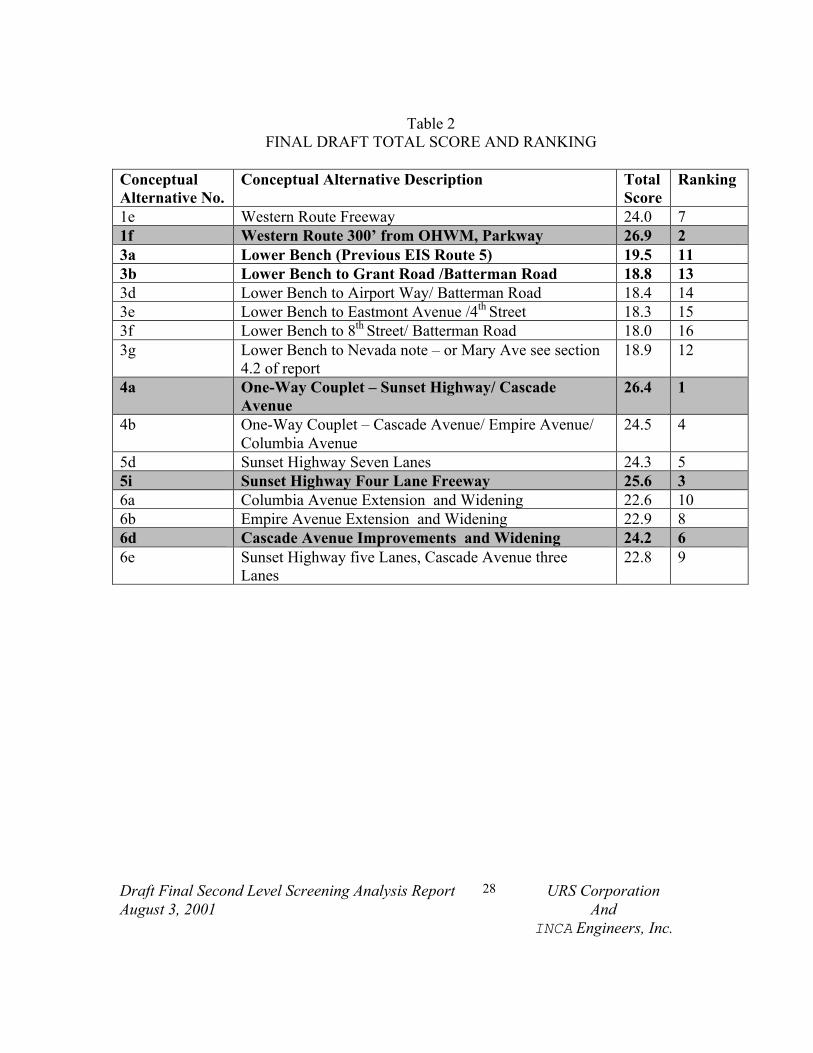
RESULTS, CONCLUSIONS AND RECOMMENDATIONS
DRAFT SECOND LEVEL SCREENING
An average subtotal score was developed for each of the conceptual alternatives within the fourmajor categories (transportation, community/land use, environmental, and engineeringfeasibility). A total score (out of 40 possible points) was then generated by adding up theaverage score for each major category (all four major categories have been given equalweighting) for each conceptual alternative. The conceptual alternatives were then ranked, with aranking of one being given to the alternative with the highest total score and a ranking of 16being given to the alternative with the lowest total score.
The highest ranked alternative in each grouping was then presented to the Citizens AdvisoryCommittee held June 27, 2001 and at the community Open House, held on June 28, 2001. Theywere also presented at an IDT meeting held on June 20, 2001. The highest ranked alternativesfrom each group are listed below:
• 1f Western Route 300’ from OHWM, Parkway.• 3a Lower Bench (Previous EIS Route 5).• 4a One-Way Couplet – Sunset Highway/ Cascade Avenue (Previous EIS Route 3).• 5i Sunset Highway Four Lane Freeway.• 6d Cascade Avenue Improvements and Widening.
A summary of the results of the draft screening exercise is presented in Table 1. These resultsreflect the scoring and ranking prior to the incorporation of comments received from the CitizensAdvisory Committee and the comments received at the Open House.

Draft Final Second Level Screening Analysis ReportAugust 3, 2001
26 URS CorporationAnd
INCA Engineers, Inc.
Table 1DRAFT TOTAL SCORE AND RANKING
ConceptualAlternative No.
Conceptual Alternative Description TotalScore
Ranking
1e Western Route Freeway 24.63 61f Western Route 300’ from OHWM, Parkway 26.91 23a Lower Bench (Previous EIS Route 5) 20.28 113b Lower Bench to Grant Road /Batterman Road 19.61 133d Lower Bench to Airport Way/ Batterman Road 19.2 143e Lower Bench to Eastmont Avenue /4th Street 18.78 153f Lower Bench to 8th Street/ Batterman Road 18.59 163g Lower Bench to Nevada note – or Mary Ave see section
4.2 of report19.74 12
4a One-Way Couplet – Sunset Highway/ CascadeAvenue
27.30 1
4b One-Way Couplet – Cascade Avenue/ Empire Avenue/Columbia Avenue
25.18 4
5d Sunset Highway Seven Lanes 24.17 75i Sunset Highway Four Lane Freeway 25.40 36a Columbia Avenue Extension and Widening 23.36 96b Empire Avenue Extension and Widening 23.6 86d Cascade Avenue Improvements and Widening 24.74 56e Sunset Highway five Lanes, Cascade Avenue three
Lanes23.06 10
Draft Final Second Level Screening Analysis ReportAugust 3, 2001
27 URS CorporationAnd
INCA Engineers, Inc.
FINAL SECOND LEVEL SCREENING
After evaluating comments from the interdisciplinary team meeting, citizens advisory committeemeeting, and the open house, the rating was modified. The intent was to incorporate commentsthat impacted how the project team had originally rated the alternatives with respect to thecriteria.
The modified rating increased the difference between the lowest rated set of alternatives (LowerBench) and the other categories of alternatives. The lower bench alternative also predominantlyreceived public opposition with no support; where as the other alternatives received dividedopposition and support. Because of the overall lower scoring of the lower bench alternatives andthe predominant opposition by the public to the lower bench alternative the project teamrecommends that these alternatives not be considered for further evaluation in the EIS.
Table 2 summarizes the scoring of each alternative and the ranking. The recommendedalternatives to be carried into the EIS for further evaluation are shown shaded. The attachedmatrix provides a detailed analysis of the scoring.
Draft Final Second Level Screening Analysis ReportAugust 3, 2001
28 URS CorporationAnd
INCA Engineers, Inc.
Table 2FINAL DRAFT TOTAL SCORE AND RANKING
ConceptualAlternative No.
Conceptual Alternative Description TotalScore
Ranking
1e Western Route Freeway 24.0 71f Western Route 300’ from OHWM, Parkway 26.9 23a Lower Bench (Previous EIS Route 5) 19.5 113b Lower Bench to Grant Road /Batterman Road 18.8 133d Lower Bench to Airport Way/ Batterman Road 18.4 143e Lower Bench to Eastmont Avenue /4th Street 18.3 153f Lower Bench to 8th Street/ Batterman Road 18.0 163g Lower Bench to Nevada note – or Mary Ave see section
4.2 of report18.9 12
4a One-Way Couplet – Sunset Highway/ CascadeAvenue
26.4 1
4b One-Way Couplet – Cascade Avenue/ Empire Avenue/Columbia Avenue
24.5 4
5d Sunset Highway Seven Lanes 24.3 55i Sunset Highway Four Lane Freeway 25.6 36a Columbia Avenue Extension and Widening 22.6 106b Empire Avenue Extension and Widening 22.9 86d Cascade Avenue Improvements and Widening 24.2 66e Sunset Highway five Lanes, Cascade Avenue three
Lanes22.8 9
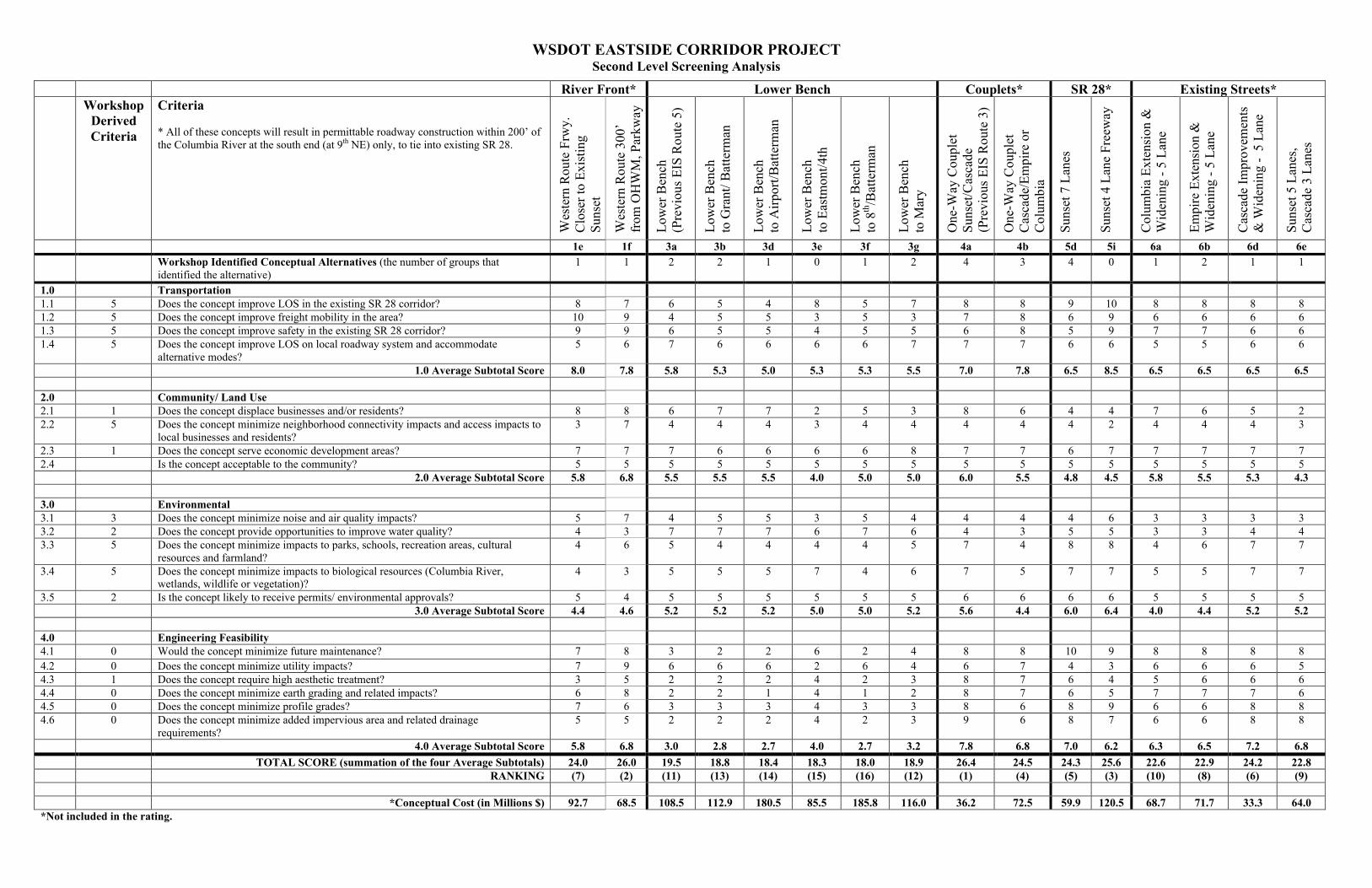
WSDOT EASTSIDE CORRIDOR PROJECTSecond Level Screening Analysis
River Front* Lower Bench Couplets* SR 28* Existing Streets*Workshop
DerivedCriteria
Criteria
* All of these concepts will result in permittable roadway construction within 200’ ofthe Columbia River at the south end (at 9th NE) only, to tie into existing SR 28.
Wes
tern
Rou
te F
rwy.
Clo
ser
to E
xist
ing
Suns
et
Wes
tern
Rou
te 3
00’
from
OH
WM
, Par
kway
Low
er B
ench
(Pre
viou
s E
IS R
oute
5)
Low
er B
ench
to G
rant
/ Bat
term
an
Low
er B
ench
to A
irpo
rt/B
atte
rman
Low
er B
ench
to E
astm
ont/4
th
Low
er B
ench
to 8
th/B
atte
rman
Low
er B
ench
to M
ary
One
-Way
Cou
plet
Suns
et/C
asca
de (
Prev
ious
EIS
Rou
te 3
)
One
-Way
Cou
plet
Cas
cade
/Em
pire
or
Col
umbi
a
Suns
et 7
Lan
es
Suns
et 4
Lan
e Fr
eew
ay
Col
umbi
a E
xten
sion
&W
iden
ing
- 5
Lan
e
Em
pire
Ext
ensi
on &
Wid
enin
g -
5 L
ane
Cas
cade
Im
prov
emen
ts&
Wid
enin
g -
5 L
ane
Suns
et 5
Lan
es,
Cas
cade
3 L
anes
1e 1f 3a 3b 3d 3e 3f 3g 4a 4b 5d 5i 6a 6b 6d 6eWorkshop Identified Conceptual Alternatives (the number of groups thatidentified the alternative)
1 1 2 2 1 0 1 2 4 3 4 0 1 2 1 1
1.0 Transportation1.1 5 Does the concept improve LOS in the existing SR 28 corridor? 8 7 6 5 4 8 5 7 8 8 9 10 8 8 8 81.2 5 Does the concept improve freight mobility in the area? 10 9 4 5 5 3 5 3 7 8 6 9 6 6 6 61.3 5 Does the concept improve safety in the existing SR 28 corridor? 9 9 6 5 5 4 5 5 6 8 5 9 7 7 6 61.4 5 Does the concept improve LOS on local roadway system and accommodate
alternative modes?5 6 7 6 6 6 6 7 7 7 6 6 5 5 6 6
1.0 Average Subtotal Score 8.0 7.8 5.8 5.3 5.0 5.3 5.3 5.5 7.0 7.8 6.5 8.5 6.5 6.5 6.5 6.5
2.0 Community/ Land Use2.1 1 Does the concept displace businesses and/or residents? 8 8 6 7 7 2 5 3 8 6 4 4 7 6 5 22.2 5 Does the concept minimize neighborhood connectivity impacts and access impacts to
local businesses and residents?3 7 4 4 4 3 4 4 4 4 4 2 4 4 4 3
2.3 1 Does the concept serve economic development areas? 7 7 7 6 6 6 6 8 7 7 6 7 7 7 7 72.4 Is the concept acceptable to the community? 5 5 5 5 5 5 5 5 5 5 5 5 5 5 5 5
2.0 Average Subtotal Score 5.8 6.8 5.5 5.5 5.5 4.0 5.0 5.0 6.0 5.5 4.8 4.5 5.8 5.5 5.3 4.3
3.0 Environmental3.1 3 Does the concept minimize noise and air quality impacts? 5 7 4 5 5 3 5 4 4 4 4 6 3 3 3 33.2 2 Does the concept provide opportunities to improve water quality? 4 3 7 7 7 6 7 6 4 3 5 5 3 3 4 43.3 5 Does the concept minimize impacts to parks, schools, recreation areas, cultural
resources and farmland?4 6 5 4 4 4 4 5 7 4 8 8 4 6 7 7
3.4 5 Does the concept minimize impacts to biological resources (Columbia River,wetlands, wildlife or vegetation)?
4 3 5 5 5 7 4 6 7 5 7 7 5 5 7 7
3.5 2 Is the concept likely to receive permits/ environmental approvals? 5 4 5 5 5 5 5 5 6 6 6 6 5 5 5 53.0 Average Subtotal Score 4.4 4.6 5.2 5.2 5.2 5.0 5.0 5.2 5.6 4.4 6.0 6.4 4.0 4.4 5.2 5.2
4.0 Engineering Feasibility4.1 0 Would the concept minimize future maintenance? 7 8 3 2 2 6 2 4 8 8 10 9 8 8 8 84.2 0 Does the concept minimize utility impacts? 7 9 6 6 6 2 6 4 6 7 4 3 6 6 6 54.3 1 Does the concept require high aesthetic treatment? 3 5 2 2 2 4 2 3 8 7 6 4 5 6 6 64.4 0 Does the concept minimize earth grading and related impacts? 6 8 2 2 1 4 1 2 8 7 6 5 7 7 7 64.5 0 Does the concept minimize profile grades? 7 6 3 3 3 4 3 3 8 6 8 9 6 6 8 84.6 0 Does the concept minimize added impervious area and related drainage
requirements?5 5 2 2 2 4 2 3 9 6 8 7 6 6 8 8
4.0 Average Subtotal Score 5.8 6.8 3.0 2.8 2.7 4.0 2.7 3.2 7.8 6.8 7.0 6.2 6.3 6.5 7.2 6.8
TOTAL SCORE (summation of the four Average Subtotals) 24.0 26.0 19.5 18.8 18.4 18.3 18.0 18.9 26.4 24.5 24.3 25.6 22.6 22.9 24.2 22.8RANKING (7) (2) (11) (13) (14) (15) (16) (12) (1) (4) (5) (3) (10) (8) (6) (9)
*Conceptual Cost (in Millions $) 92.7 68.5 108.5 112.9 180.5 85.5 185.8 116.0 36.2 72.5 59.9 120.5 68.7 71.7 33.3 64.0*Not included in the rating.


![Welcome! []2009/06/10 · cap of $12-15 167 *funding possible from savings within the corridor Eastside Corridor Tolling Study November 2009 – Eastside Corridor Tolling Study Open](https://static.fdocuments.us/doc/165x107/5f3d24148273ad608a0dfb40/welcome-20090610-cap-of-12-15-167-funding-possible-from-savings-within.jpg)