Energy Corridor District - Unified Transportation Plan
16
ENERGY CORRIDOR DISTRICT UNIFIED TRANSPORTATION PLAN ACHIEVE MOBILITY THROUGH ENERGY energycorridor
-
Upload
energy-corridor-district -
Category
Documents
-
view
569 -
download
0
description
The Corridor provides an environment that inspires productivity, creative thinking and drive to succeed. And that includes our quest to continually seek smarter, more efficient transportation alternatives that are safe, help preserve the environment and are, in some cases, fun.
Transcript of Energy Corridor District - Unified Transportation Plan

ENERGY CORRIDOR DISTRICTUNIFIED TRANSPORTATION PLAN
ACHIEVE MOBILITY THROUGH ENERGY energycorridor

The Energy Corridor – A Thriving Business Community
4 Located along Interstate 10 between Kirkwood and Barker Cypress Road
4 One of the three largest employment centers in the region
4 More than 300 multinational, national and local companies
4 Over 1,500 acres
4 18 million square feet of office space
4 Over 4 million square feet of retail space
4 Home to over 73,000 employees
4 Population of 40,000 is expected to increase by over 12% in the next 5 years
4 By 2025, an anticipated additional 9 million square feet of office, industrial
and retail space
energycorridor
144444444444444444444444444444444444444444444444444444444444444444444
T H E B E S T B U S I N E S S D I S T R I C T I N T H E B E S T B U S I N E S S C I T Y I N T H E U . S . A . 4444444
BP America is one of many leading national and international companies located in the Energy Corridor.
The third largest employment center in the Greater Houston Area, the Energy Corridor is a major center of commerce and home to leading companies including BP America, CITGO, ConocoPhillips, Foster-Wheeler USA Corp, ExxonMobil Chemical, Shell Oil Company and Worley Parsons. The Energy Corridor also includes more than 19,000 single and multi-family homes.
But beyond the numbers, the Energy Corridor is more than acres, cubicles and population statistics – it’s a community distinguished by energetic lifestyles. The Corridor provides an environment that inspires productivity, creative thinking and drive to succeed. And that includes our quest to continually seek smarter, more efficient transportation alternatives that are safe, help preserve the environment and are, in some cases, fun.
With projections that West Houston will exceed a population of 1.8 million by 2035, the Energy Corridor is emerging as one of the region’s most vital economic hubs. This thriving community is poised for growth through the vision and strategic planning led by the Energy Corridor District. Founded in 2001, the Energy Corridor District is taking the lead in working with local and state officials to provide transportation, mobility, infrastructure and safety programs to preserve and enhance the quality of life for the community. As new challenges arise to meet the needs of our growing city, the Energy Corridor District remains committed to playing a key role in planning, developing and promoting smart mobility options for Houstonians who live, work and play within the Corridor community.

Regional Transportation OverviewThe Energy Corridor is easily accessible from numerous interstate highways, toll roads and thoroughfares. Conveniently located in West Houston, the Corridor can be accessed from Interstate Highway 10, State Highway 6, Westpark Tollway and the West Sam Houston Tollway (Beltway 8). And, with the connection of the Grand Parkway from US 290 to IH 10 underway, commuters traveling from Northwest Houston will soon have even easier access.
Working with State and County Agencies to Improve Mobility
The Energy Corridor District worked closely with the Texas Department of Transportation (TxDOT) during the recent $2.8 billion reconstruction of IH 10, the largest reconstruction program undertaken in Texas. To accommodate the significant growth throughout the region, the Interstate was widened to 16 lanes, which serve more than 219,000 vehicles per day. A unique feature of IH 10 is the Katy Managed Lanes, the first multi-lane electronic tollway in the nation that operates within the right of way of an interstate highway, providing multiple entrance and exit locations to drivers. Beginning west of State Highway 6, the Managed Lanes continue to the IH 10/IH 610 Interchange and consist of two express lanes in each direction.
energycorridor
R E D U C I N G O U R C A R B O N F O O T P R I N T B Y L I M I T I N G G R E E N H O U S E G A S E M I S S I O N S 444 44444444444444444444444444444444444444444444444444444444444444444444 444444444444444444444444444444444444444444444444444444444444444444444 44444444444444444444444444444444444444444444444444444444444444444444
The new Interstate Highway 10 and Katy HOV Managed Lanes make traveling to the Energy Corridor District easier than ever.
2

R E D U C I N G O U R C A R B O N F O O T P R I N T B Y L I M I T I N G G R E E N H O U S E G A S E M I S S I O N S 444 44444444444444444444444444444444444444444444444444444444444444444444 444444444444444444444444444444444444444444444444444444444444444444444 44444444444444444444444444444444444444444444444444444444444444444444
TOLL ROAD (FUTURE)
GRA
ND
PA
RKW
AY
W. S
AM
HO
UST
ON
TO
LLW
AY
KATY MANAGED LANES
ENERGY CORRIDOR
*
*
*
*
Full freewaysToll roadsState-numbered roads, non-freeways, non-tollThoroughfaresProposed roadsExisting roads to be improved
* The year's noted on future projects are provided by the respective agencies and are subject to change.
*
*
Located in West Houston, the Energy Corridor is easily accessible via numerous interstates and thoroughfares. And, the expansion of roadways to and within the Energy Corridor continues to evolve to meet the growing population of the area. Equally important, the Corridor is central to regional public and private airports.
3
SUGAR LAND REGIONAL AIRPORT
(FUTURE)

energycorridor
B E T T E R T R A F F I C F L O W M E A N S L E S S P O L L U T I O N 444444444444444444444444444 44444444444444444444444444444444444444444444444444444444444444444444444444444444444444444444444444444444444444444444444444444444444444444 44444444444444444444444444444444444444444444444444444444444444444444
Local AccessibilityVital to the success and growth of the Corridor are transportation and mobility. The District is continually working with the City of Houston to improve local street access and roadway conditions to ease congestion and increase traffic flow throughout the area.
Currently, more than 20 Capital Improvement Projects are proposed in and around the Energy Corridor through 2014. Among the improvements are:
4Creating a finer street grid4Widening streets4Adding turn lanes at intersections4Improving traffic signal operations4Adding pedestrian and bicycle infrastructure
To better distinguish the Energy Corridor and provide clear navigation, the District has installed a new wayfinding system. The street and directional signage features a vibrant green background with bold white lettering to ensure the greatest ease in getting around the area.
The Energy Corridor District is working closely with the City of Houston to widen N. Eldridge Parkway between Memorial Drive and IH 10 to six lanes.
4

B E T T E R T R A F F I C F L O W M E A N S L E S S P O L L U T I O N 444444444444444444444444444 44444444444444444444444444444444444444444444444444444444444444444444444444444444444444444444444444444444444444444444444444444444444444444 44444444444444444444444444444444444444444444444444444444444444444444
6
Lang
hem
Cre
ek
Buffalo Bayou
Buffalo Bayou
GRISBY
MEMORIAL
BRIAR FOREST
PARK ROW
EL
DR
IDG
E
EG
DIR
DL
E
BA
RK
ER
CY
PR
ES
S
DA
IRY
AS
HF
OR
D
KIR
KW
OO
D
WESTHEIMER
ENC
LA
V
E PARK
WA
Y
27
Memorial Reconstruction Phase 1 - COH
Addicks Howell Reconstruction *
Memorial Dr. / Addicks Howell Intersection *
WestLake Park Blvd. / Grisby Intersection *
Enclave / Eldridge Intersection - COH
Memorial Drive Sidewalks SH 6 to N. Eldridge Parkway
Cullen Park Hike & Bike Trail & Barker Cypress Sidewalk *
20
21
22
23
Bush Park Hike & Bike Trail - HC#32414
18
Addicks Dam Hike & Bike Trail W. *17
19Park Row Extension SH 6 to Eldridge
Dairy Ashford / Eldridge Intersection - COH
6 Lane Eldridge - COH
Memorial / Eldridge Intersection - COH
Kendall Library - COH
N. Eldridge Parkway Hike & Bike Trail *
*
West Houston Hike & Bike Trail - COH
Eldridge / Briar Forest Intersection - COH
Memorial Reconstruction Phase 2 - COH
11
13
9
10
12
15Terry Hershey Hike & Bike Trail N. - HC#316 26
25
Grisby Reconstruction *
HFD Station 90 - COH
Grisby / SH 6 Traffic Signal - TxDOT
Grisby / Addicks Howell Intersection *Park Row Sidewalks
Fort Smith Pilot Project *
SH 6 Pedestrian / Bicycle Improvements * IH 10 Reconstruction Project TxDOT
2
3
4
5
6
7
81
Addicks Reservoir
Barker Reservoir
2
237
1
24
6
3 456
7
21
22
8
1 16
11
20
9
10
1913
12
14
26
2515
10 10
27
18
* Projects proposed by Energy Corridor District
5
2010-2014 Capital Improvement Plan Map

energycorridor
B E I N G S O C L O S E T O E V E R Y T H I N G M E A N S L E S S D R I V I N G 44444444444444444444 44444444444444444444444444444444444444444444444444444444444444444444444444444444444444444444444444444444444444444444444444444444444444444 44444444444444444444444444444444444444444444444444444444444444444444
Aerial OverviewAs West Houston continues to experience significant growth, the Energy Corridor District is taking the initiative to lead transportation initiatives to meet the needs of the increase in residents, businesses and visitors.
6
Increase Capacity Signal ImprovementsAccess Management Alternative Modes
BARKER RESERVOIR
BARKER-CYPRESS
PARK TEN BLVD
PARK ROW
KINGSLAND
10

B E I N G S O C L O S E T O E V E R Y T H I N G M E A N S L E S S D R I V I N G 44444444444444444444 44444444444444444444444444444444444444444444444444444444444444444444444444444444444444444444444444444444444444444444444444444444444444444 44444444444444444444444444444444444444444444444444444444444444444444
7
DAIRY ASHFORD
ELDRIDGE PKWY
MEMORIAL DR.
LANGHAM CREEK
ADDICKS PARK & RIDE
KIRKWOOD
HIGHWAY 6
KATY MANAGED LANES
BUFFALO BAYOU
CULLEN PARK
TERRY HERSHEY PARK
10
Pedestrian and Bicycle FriendlyWith more than 50 miles of trails, the Energy Corridor is ideal for cyclists, joggers and hikers. Many Corridor employees navigate the trails and roadways each day to cycle to work.
To further the connection of trails throughout West Houston, the Energy Corridor District was selected by the Rivers, Trails, and Conservation Assistance Program of the National Park Service to receive planning assistance for a West Houston Trail System Master Plan. Working collaboratively with partners and stakeholders including the United States Army Corps of Engineers, Harris County Precinct 3, Harris County Public Infrastructure, Harris County Flood Control District, the City of Houston and Houston Community College, as well as numerous Municipal Utility Districts, Super Neighborhoods and corporations, the District is developing the plan, which will cover a 6-mile radius from the intersection of IH 10 to State Highway 6 and consists of 113,000 acres. The additional trail connections will provide further options for those who choose to ride their bike to work.
The Energy Corridor’s extensive public parks, greenbelts and trails are attractive to employees and residents who walk to lunch, client meetings and local retailers. With increased foot traffic, the District initiates numerous sidewalk improvement projects including the widening of walkways along State Highway 6, IH 10, Eldridge Parkway and Park Row.
energycorridor
M O R E P E O P L E O N T H E P A T H S M E A N S L E S S T R A F F I C O N T H E S T R E E T S 44444444444 44444444444444444444444444444444444444444444444444444444444444444444444444444444444444444444444444444444444444444444444444444444444444444 444444444444444444444444444444444444444444444444444444444444444444444
8
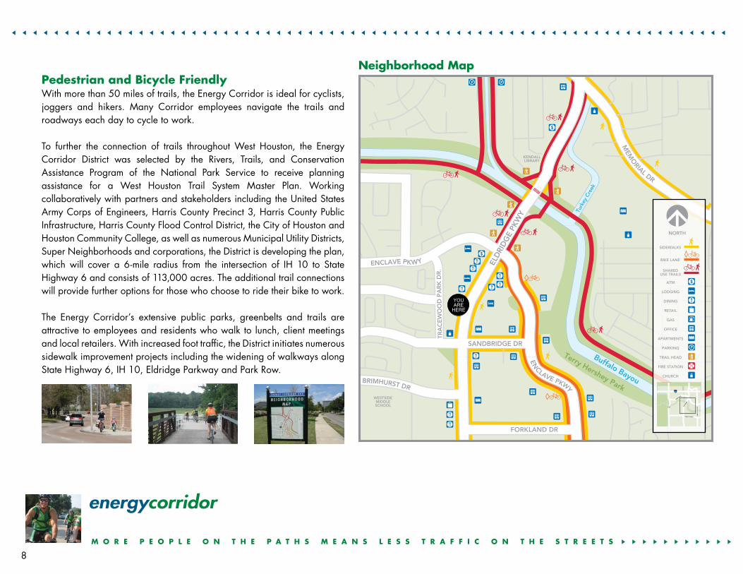
Neighborhood Map

M O R E P E O P L E O N T H E P A T H S M E A N S L E S S T R A F F I C O N T H E S T R E E T S 44444444444 44444444444444444444444444444444444444444444444444444444444444444444444444444444444444444444444444444444444444444444444444444444444444444 444444444444444444444444444444444444444444444444444444444444444444444
GRISBY
BRIAR FOREST
INTERSTATE
HIG
HW
AY
EL
DR
IDG
E
ELD
RID
GE
DA
IRY
AS
HF
OR
D
ENC
LAVE
MEMORIAL
MEMORIAL
keerC
mehgnaL
Buffalo Bayou
Buffalo Bayou
Transit and Trails
131 Memorial Express
67 Dairy Ashford Crosstown53 Briar Forest Limited
Enclave & Briar ForestBike Lanes
Terry HersheyTrail
Barker DamTrail
Addicks DamTrail
221, 222,228, 229, 298
Park & Ride Routes
221, 222, 229, 298Park & Ride Routes
Addicks Park & Ride Lot 228, 229, 298
Dairy AshfordBikeLanes
Parking
Proposed Trails
Major Highways
Metro Bus Routes
Existing Trails
Bike Lanes
Barker Resevoir
10
6
6
10
Addicks Reservoir
9
Transit and Hike & Bike Trail Map
Pantone 2738 Solid Coated
Pantone 1235 Solid Coated
Texas Bicycle Coalition
Primary
Secondary
Texas Bicycle Coalition
Optional/Available Color Treatment Examples

Commute SolutionsThe Energy Corridor District is instrumental in providing convenient, efficient transportation options that move employees, residents and visitors to and throughout the Corridor. Working strategically with organizations including METRO and Houston-Galveston Area Council, the Corridor offers a variety of transportation solutions to meet the community’s needs.
Alternative transportation options include:4NuRide is an online community where riders can save money and earn rewards by participating in a carpool or vanpool, walking, cycling, telecommuting or riding public transportation. For more information, visit www.nuride.com.4METRO’s Bikes on Buses program allows cyclists to ride their bikes to their bus and bring their bikes along. Local buses equipped with bike racks on the front of the bus and commuter coach buses with storage inside the luggage compartment enable commuters to truly ride from door to door. 4The Addicks Park & Ride, located at IH 10 east of Highway 6, offers convenient transit service to the Central Business District, Uptown/Galleria, Houston Center and Texas Medical Center. Grand Parkway and Kingsland Park & Rides are available for commuters living further west along IH 10. For more information including a complete list of routes and schedules, visit www.ridemetro.org.4For getting around the Corridor and West Houston area, METRO offers local bus service on Westheimer, Briar Forest, Memorial Drive and Dairy Ashford.4Star, the region’s new vanpool program operated by METRO, provides an alternative for commuters who live or work in areas where bus service is not convenient. For more information, call 888-606-RIDE.4RideShare is a free service that matches commuters who live and work in close proximity so that they can form vanpools and carpools. For information, call 888-606-RIDE.4 The METRO 75 Energy Corridor Circulator connects existing METRO bus routes to the
Addicks Park & Ride lot serving Energy Corridor residents, workers and businesses.
energycorridor
S A V E G A S – T E L E C O M M U T E , S I G N U P F O R A V A N P O O L O R O R G A N I Z E A C A R P O O L 444 44444444444444444444444444444444444444444444444444444444444444444444444444444444444444444444444444444444444444444444444444444444444444444 44444444444444444444444444444444444444444444444444444444444444444444
10

S A V E G A S – T E L E C O M M U T E , S I G N U P F O R A V A N P O O L O R O R G A N I Z E A C A R P O O L 444 44444444444444444444444444444444444444444444444444444444444444444444444444444444444444444444444444444444444444444444444444444444444444444 44444444444444444444444444444444444444444444444444444444444444444444
Lang
hem
Cre
ek
Buffalo Bayou
Buffalo Bayou
GRISBY
BRIAR FOREST
BRIAR FOREST
DA
IRY
AS
HF
OR
D
MEMORIAL
MEMORIAL
EL
DR
IDG
E
131 Memorial Limited
221, 222, 228, 229, 298Park & Ride Routes
221, 222, 229, 298Park & Ride Routes
METRO 75 EnergyCorridor Circulator
Addicks Park & RideLot 228, 229, 298
Park & Ride Routes
82 Westheimer
53 Briar ForestLimited
67 Dairy AshfordCrosstown
AddicksReservoir
10 10
6
6
WESTHEIMERE
LD
RID
GE
The Energy Corridor is accessible via mass transportation services including METRO Park & Ride, local METRO buses, vanpools and the METRO 75 Energy Corridor Circulator.
11
METRO 75 Energy Corridor Circulator

energycorridor
Livable CenterBusiness location decisions require proximity to employees, access, quality development and confidence in the future. The Energy Corridor’s central location in West Houston on IH 10 provides exceptional mobility and access that allows employees to live in high-performing public school districts near their work. Our quality developments give employers an edge in recruiting and retaining the best and the brightest in their industry.
The Energy Corridor District provides an added level of confidence in the future to protect corporate investment while maintaining the quality of life and sustainable place demanded by environmentally conscious employees. The District’s plans encourage a mixture of land uses supported by transportation infrastructure in a walkable and transit-oriented place – a master planned-business center with: 4Authenticity and sense of place 4Quality streetscape improvements 4Sidewalks and outdoor places to meet others 4Leisure dining, spas, coffee houses and shops 4Hotels with meeting and training facilities 4Parks and hike and bike trails 4Desirable places to live 4Places of worship and excellent schools
12
The Energy Corridor is a pedestrian and bicycle friendly community. Business thrives in a friendly place with trouble-free mobility and access, convenient transit, great public spaces, lush landscaping and distinctive
architecture – the kind of place where business and leisure fulfill your life.
A G R E E N E R L I F E S T Y L E I S W I T H I N Y O U R R E A C H 4444444444444444444444444444444444444444444444444444444444444444444444444444444444444444444444

A G R E E N E R L I F E S T Y L E I S W I T H I N Y O U R R E A C H 44444444444444444444444444
The Energy Corridor Mobility Strategy
4Increase Capacity •StreetWidening •IntersectionImprovements •CompletionofThoroughfareSystem
4Signal Improvements •Timing •Coordination
4Access Management •LimitMedianOpenings •ShareDriveways
4Alternative Modes •Pedestrian-andCyclist-FriendlyEnvironment –Shared-useTrails –PedestrianFacilitiesatIntersections •Transit •Ridesharing •VanPools

energycorridor14701St.Mary’sLaneSuite290Houston,TX77079281-759-3800www.energycorridor.org