United of Sites Northern Cumber
80
United States , Depadmenr of -J Agr~calftrre Forest Sewtce assif ieation and Eva Forest Sites on the Northern Cumber New Orleans, Lrsbrsrana Gererai i echr,cai F3epr~ff SO-C-;O March 1986 Glendon M ! . Smaiiey
Transcript of United of Sites Northern Cumber

United States , Depadmenr of
-J Agr~calftrre
Forest Sewtce
assif ieation and Eva Forest Sites on the
Northern Cumber New Orleans, Lrsbrsrana
Gererai i echr,cai F3epr~ff SO-C-;O March 1986 Glendon M!. Smaiiey

SU&f MARY
n i s paper presents a comprehensive &arest site srkassification system for the nodhem Cu~~berland Plateau in north central Tennessee and eastern Ken- tucky. The sysbm i s based on physiogaphy, geology, soils, topography? and vegetation. Twenty-dour 'landtypes are described and evaluated in t e rns of productivity and desirability of selected pines and hardwoods for timber pro- duction. Also, each taradtype is rated for five soil-related probfems that can afFc?ct forest management operations.
ACKNOWLEDGMENTS
I am indebted to my eolleapes, past and present, for their scientific input, reviews, and stimulating discussions. 1 am also gateful to the soil scientists? silviculturists, plant ecologists, and practicing foresters who have reviewed this p ide .

CONTENTS ..................................................... Intrduction
............................. Nodhem Gkmzberland Pladc?au &@on
............................. Su>re@ons and Larrdtme Assxiations ....................................................... Landtmes
Forest AIParrrtagenrzent Ira~qredations ............................... Using f i e Sysdem ................................................ Landtme Descriptions and Forest Managment Inbqretations ...... Literature Cited .................................................. Appmdix-Comty Soil S eys Available for the No&hem
........................................... Cumberland PjIat;eau

Figure 1.-Physiographic provinces and regions of the Interior Uplands.
Classification and Evaluation of Forest Sites on the Northern Cumberland Plateau
Glendon W. Smalley
This reps& classifies and evaluaks forest siks on the Northern Cumberland Plateau (fig. 1) for the managerrred of several commercially valuable tree species. It pmrrides foreat managers with a land ctassi- fieation syskm that will enable them to subdivide forest 1 and into l o@cal m p e n t s (landtmes), allow them to rate productivity, and ale& them Lo any lirn- ihtions and hazards IsE%at the landtmes impoae on forest management activities, Though soils infoma- tion is am internal p a e of this ~ysteruz, users rnrill me need to identify and classify soils or to make labora- &ory deteminatioms, This repoFL is oriented to t imba production because timber is usually a major manage- ment objective* However, Iaarpdt~es can also be the basis for the mmagement and inteqretation of other forest resowces.
1 have drawn freely on much published infomation on gmlogy., physiopaphy, soils, sites, and yields, liPn many cases, data specific to this area were not avail- able and irrfsrmation was extrapolated from adjacent regions, Extrapolation was particularly necessary with productivity data. All sources of data are docu- mented, so the user can gauge the accuracy a d reli- ability sf the infomation.
Productivity and management problem informa- tion is presented in a fomat that follows the outfine used by the Soil Conservation Senice (SCS) in the Woodland Suitability sections of county soil s This similarity should facilitate the integation of in- fomaliorr wntained in eounty oil sumegrsl iitlLo tl.lis classification system,
This wide represents the best infomation and eol- le&ive judpent plow available. Neve&heleaa, it is still incomplete, I trust that forest managers, afkr applying this ~ i t e classification system, will share their experience with me and make me avare of any sho%-Lcomirngs or needed revisions,
lSee Apwn& fop available mil s w e y s ,
me rationale and methodology of the system and st;%lrrs of rep* appeared in the proceedings of the Second Central Hardwod Forest Coderenee (Smal- ley 1978), the Forest Soils and Site Quality Workshop (Smalley 1979a), and the 12th Annual Hardwood Symposium (Smalley 1984a). Site classification guides lFor the Southern Cumberland Plateau, the Western Highland Rim and Pennyroyal, the Mid- Cumberland Plateau, the Eastern Highland Rim and Pennvoyal, and the Cumberland Mountains regions have been published (Smalley 19798, 1980, 1982, 1983, 1984b),
NORTHERN CUMBERLAND PLAmAU REGION
This region covers about 6,900 mi2 in all or parts of three counties in Tennessee and 23 in Kentucky. It extends south to north from about north latitude 36"38% 37O55' and east to west fiom about west lon@tude 82"35' to 85"1OP. The region extends from south of Oneida in Scott County, TN to the northern wakrshed boundary of the Kentucky River, including the b d River in Powell, Menifee, and Wolfe Counties, KY, a distance of about 120 mi (fig. 2). North of the Kentwky River watershed the Cumberland Plateau is called the Allegheny Plateau (Fenneman 1938).
Gm~aphicallgr, the Northern Cumberland Plateau consists of the southern two-thirds of the Mountains a d Eastc?m Coalfield reeon in Kentucky (Bailey and Winsar 1964) plus parts of three northern counties in Tennessee, In Tennessee, i t joins the Mid- Cumberland Plateau about on a line from Oneida to Jarnestom in Fentress County (Smalley 1982). The Nodhem Plateau is bounded on the southeast by the Jellieo Mountains and Pine Mountain of the Cumber- land Mounhin reb;l;ion (Smalley 1984b).
Glendon W., Smalley is Rineipal Soil Sientist at the Silviculture hboretlorlr. maiprdainecl at &wan%, Tennessee, by the Southern Forest Expe~mernt Station, Forest %m-ice-USDA, in coopration with the Univergity sf the South.

FCNTRESS SCOTT
+ * "\.
i I
Figure ~ * - - - - A % % ~ P " ~ ~ E O P ~ S and kndtype assochfltrons ofthe N o r t k m Cumberland P t a k u region and location of weather stations (Heidelberg Wtlkzamsburg).

The Nss%hem Cumberland Plakau has three dis- tinct sections. The largest section is the Rugged East- ern Area (Braun 1950, Bailey and Winsor 1943.4). It is also called the Mountain. and Greekbotl;on? Area by McFarlan 61943) and Bladen (19";i"). West of the Ruggd Eastem Area is the h w Hills Belt (Braun. 1950, Bailey and Winsor 1964), The section is ca l l4 the Cumberland Pilahala by Eladerr (319";93). m e west- ernmost section is the Westem Escarpment (Bailey and Winsor 1964). Braran (1950) called this area the Cliff Section, and McFarlan (1943) called it the Ridgebp and Limestone Valley Sett1er;nen.k Asea.
The Western Escarpment has two distinct p a h . South of" the junction of the Muldrsaughk Hill e s c q - ment with the Western or Podtsville escarlpment in Roekcarst%e County, KY, the bPl'orLhern Cumberland Plateau faces the Eastern Highland Rim and Penny- royal region ISmaIley 19833, No&h of the jurmction, the Plateau faces the Kentucky Bluesass r e ~ o n (Fen- neman 1938, McFarlan 194.3)' The belt of conical hills known as the knob^, bedween the Bluegass re@on and the Western Esca~ment of the Northem Cum- berland Plateau, was included in the Eastern High- Band Rim and Pennyroyal re@on (Smalley 1983).
The region has a bmperature elirmak characterized by long moderately hot summers and shod mild to moderately cold winders, According to Tbornthwaite's (1948) classification o f climate, it is humid nnesofier- ma1 with adequate pl-eeipitation at all seasons. Daily and seasonal weather are emtrolled largely by alter- nating cold, dry continental air masses from Canada and warm, moist air from the Gulf of Mexico. During the stammer, complete exchanges of air masses are few, and tropical maritime air masses persist for ex- tended periods, Long periods of mild, sunny weather- dpieally occur in the fall. Tables 11 and 2 show aver- age month ly and annual precipitation and temperatme values, average frost-free periods, and elevation above sea level for two stations in Kentucky located in bwns on the Cumberland and Kentucky Rivers (fig, 21, Consequently, the data do not indicate climatic conditions in! narrow mountain. valleys or on high ridges,
Table 1 .--A slerage monthly and annual preeipibtkn (in iracksi and c @umbrkand Pla&au
Mean kmperatwe for the redon is about 56"F, The dak o f last freeze is mid- to late April, and the dab of fired freeze is mid-October, The Grost-free period ranges from 188 .tr, 190 days but is probably 10 .kQ 20 days s h o ~ r at higher elevations. The temperatwe often falls below freezing ad night in December, dartu-. al-;v, and Febmav* The upper 6 $0 8 in of soils in narsctw mountain valleys and on cool slopes may stay frozen much of the winter. Internittent freezing and thawing occur on south- and west-facing slopes, mountain ridges, and broader ridges, and in hollows at Zswer elevations, n o u g h air kmperature does not appear to varJI much across the re@on, local kmpera- tures v a y csnsiderab%y because of relieB-, aspect, and cloud cover. In summer, the valleys are very wa rn and occasionally hot, and the mountains are warm Clwing the day but are coo% at nigh&, In winter, the valleys are very cool with occasional cold and warn spells, and upper slopes and mountaintops are genes- ally cold.
Southerly winds prevail from May do Sepkmbes and nodlnerly winds from November to March, Aver- age ve%oc=iLy ranges from 6 -B;o 14. mph but probably exceeds f 1 mph on the mountaintops* Severe winds are infrequent and most are associated with late spring and summer thundershowers.
Annual precipitation averages about 46 in and o d i - rial-ily i s well distributed throughout the year. Sea- sonal precipitation i s geatest in the winter and least in the fall, but the wettest month i s July, Shod peri- ods of v e v wet or very dry weather are common, Thunderstorms that commonly occur from March through Auwst are of shod duration but o&en are accompanied by high-intensity rainfall, Steady rain- falls lasting several. days sometimes occur in winder and late spring* Those storms "ire likely to cause BocaB flooding in. the msrmtains because soils are saturakd, frozen, or snow-covered, In "&he winter, precipitation i s chiefly rain the valleys and snow, sleet, or freezing rain on the mountaintops. Average annual snoda21 i s 10 Lo 16 in, but snow persists for period8 longer than a few days only at the highest elevations* Soils are wetbst from December through April and driest from July do BeLcsber, On the average, tree p o d h i s prsb- ably retarded for periods sf a few days to ;a week or more several times each. @owing season, Soil rrsois-
vlebtg-kbn above m a n sea level for two meather stations on the N o d k r n
Station and Years of Elevation county rword (R) Jan. Feb. Mar. Apr. May J m e July Aug. Sept. Ocd. Nov. D m Year

Years W Stationand of Jan. Feb. Mar. Apr. May June July Aug. Sept. Oet. Nov. Dee. Year period
eomty m o d Bery132
lU.8, Depbrnent of Co 2hrlean perid from last 32°F to fir& 32°F" (U.S. Dep&metat of A~cuftrase 19411, 3Value for BeaM,Mlle, Lee County, KY.
ture stress is more common and severe on u p p r mountain slopes facing south and weart, on shallow soils, and on sandy-textured soils.
Geology, Topo@apfi3T, and 8 0 ~ s
The Northern Cumberland Plateau is uderlain mostly by Pennsylvanian sandstone, conglomerate, siltstone, shale, and coal belon@ng to the Grab QP-
chard and Crooked Fork groups in. Tennessee (Swingle and others 1966) and the Lee and Bseathidt formations in Kentucky (McDowell and others 1981)- In Tennessee, the Rockcastlie member of the Crab Qr- chard group is most extensive, while the Breathitt is most extensive in Kentucky. Generally, these sedi- mentary strata dip gently to the southeast but become nearly level in the Rugged Eastern area.
North of the junction with the MulclraugWs Hill escarpment in Rockcastle County, ECU, the VVestem Escarpment lies east of the traditional mar@n of the Plateau. The Western Escarpment lacks the pmmi- nence of farther south because of the thinning of the Itockcastle sandstone and the pronounced southeast- erly dip of strata away from the Cincinnati Arch ceaz- tered under the Kentucky Bluegrass region (see Braun 1950, p. 89). Here the Weshm Escavment is a transition zone consisting of laamow ridges and hills capped with Lower Pennsylvanian sandsdone and underlain by mid- and upper Mississippian rwks,
South of the junction, the Wesbm Escaqment is fairly thick, nearly continuous, and very ragged, Below the Rockcastle sandstone escaqment the s c a v slope cuts across nearly horizonhl strata of Mississip- pian limestone, dolomite, sandstone, and shale, 1x1 places, the slope is smooth, but in other places, the slope is intempted with benches suppasled by mere resistant Mississippian rocks.
Alluvial deposits of Quaternary age occur along the Cumberland, Kentucky, and &d Rivers and some sf the major tributaries (MeDoweB1 and o%hg?r~ 19813,
&@anal hpspaphy ranges from gentle in pa& of the h w Hills Belt to spagged and complex it% the Ruggd Eashm k e a and the Westem Escbaqme~bt~ Slope vanies &om nearly level $XI v e q 8kepe
The maturely dissected Rugged Eastern Area is characterized by narrow winding ridgetops, steep sideslopes, and namsw winding vailleyg. Some of the roughest Band in the Eastern Unikd Stabs is in the upper basin of the Kentucky River, Elevation padu- ally increases toward the southeast where some mountain crests near pine Mountain are about 2,060 fi above mean 8ea Bevel, Relief is 500 Lcs 900 %L in the western pa& and increases to about 900 to 1,800 fi in the eastern pa&. mere is little flat land except on a few broader ridges and in river and creek botbms. Sideslops are oRen benched, reflecting %he presence of thin, more resistant layers of sandsbne sandwiched between thick labgress sf shale.
m e Low Hills Belt, characterized by submatwe dissection and undulating topography, is the ~nraoodhe& pa& of the Nodkern Plateau, The belt, about 25 mi wide, extends h m miitley and Kmsx Cowties noAhward to Wol& County, Valleyfa v a ~ in width and are moi~t, evela ~wampy in places. Larger streams and rivers have cut moderakly deep gorges in the la;iskau s d a e e that w e rimmed with discon- tiaruious sands%one cIliE8, SBogea below the cliEs me sbep and strem with r ~ k s . hlief is only 100 to 158 if% in the undulating pa* but i s 380 fi sr more in. the vicinity 06 gorges. Elevation ranges from 1,300 to 1,560 R in the no&h and decreases padually ds 1,186 Ls 1,200 R in &e south,
The Western. Escaqment Area is maturely dis- %r~Ld , more so in the n o ~ h e m prn-& than in. the south- em part because of ra. more prssnsrrsaeed dip of the smks and exposwe of less resistant carbonak rwks fiarthes xlodh. m e mea i s characterized lrsy long, namow do m08erakBy broad ridgebps, sbep ~ideslopes, and wm- row to moderakly broad valleys, %me gently mllirng ta rolling broad ridges occur in southern Kentucky

The average elevation of the 1,400 ft in the vicinity of the
Rivers and rises to 1,800 to 2,000 ucky and northern Tennessee. Re-
lief averages 200 R in the rricinity of small creeks and stream but increases to 600 to 800 R near larger streams and rivers.
Streams are entrench4 in sleep-sided valleys whose walls are ofbn cappd with san&bne cliBs. Bverhan@ng rock shelters and natusal bridges are firequerrt. b p i d s and watedalls are typical in kee- Rowing creek and stream. These features are well
ver Gsrge and along the South
of the Western Escarpment has long, narrow, convex ridgetops and long, narrow streambothms that gradually widen westward. Sideslopes are divided by a nearly continuous lime- stone escarpment higher on the slope from east to west. h a 1 relief is fkom 400 to 600 R.
In the southern part, sideslopes are broken with nearly continuous sandstone cliffs, but limestone crops out on lower slopes and on convex spur ridges extending out into the Highland Rim and Pennyroyal.
The Northern Plateau is drained by the Cumber- land and Kentucky River systems (McDowell and oth- ers 1981, Swingle and others 1966, Bladen 1973). The Cumberland River breaches Pine Mountain a t Pineville, KY, in a narrow walergap at an elevation of about 1,000 R, then turns northeastward and follows the backslope of Pine Mountain for nearly 60 mi (Smalley 1984b). Lake Cumberland, formed behind Wolfe Creek Dam, has a normal level of 723 R and extends nearly to Cumberland Falls State Park and a short distance up the Rockcastle River. Laurel River Lake, west of Corbin, was built by the U.S. Army Corps of Engineers for flood control and recreation. South Fork, another tributary, originates on the Cumberland Plateau in northern Tennessee; it has been desieated a Wild and Scenic River.
The Kentucky River used to be the only navigable river that crossed the Western Escarpment of the Plateau. Barge trafPie was possible io Beattpille in Lee County, where the main river branched into three forks. In 1983, commercial use of the river was sus- pended upstream from Fradfort in Franklin County. The Nodh Fork originates 168 mi upstream near the Virdnia state line. 'Fhe Middle Fork originates 97 mi upstream in hs l ie County. Buckhorn Lake, on the Middle Fork west of Hazard, is a 1,200-acre manmade
od control and recreation. The 75 mi upstream at the conflu- d the Red Bird River.
The Red River Gorge, in Menifee and Powell Coun- ties, is a scenic geological area on the Daniel Boone National Forest. Westward, the Red River flows through the Knobs reaon in a moderately wide valley
before joirring the Kentucky River rmo&he%sd of Rich- mond.
Most of these rivers and stre flow in deep, fairly w valleys on the Plateau, except in the upper- reaches where stream profiles are broad V-
shaped to U-shaped. Many to , including several. county seats, are lmted on the Rood p built-up areas e*nding up nearby slopes. Rood plains is frequent; extent and severi incmase domstreanr.
m material weathered from a rocks. Gnerally, Lhwe soils
are pale, loamy to clayey, friable, and low in fertility, and vary in content of rock firagmenk. The more ex- tensive soils are classified as loamy or clayey, mixed or siliceous, mesic Dystrochrepts and Hapludulb. Some Hapludalfs occur in the northern part of the Western Escarpment. Soils forming in spoil material from surface mining of coal are classified a s Udorthents.
In the Rugged Eastern Area, soils on upper moun- tain slopes and ridges formed in material weathered from shale or sandstone, depending on elevation. Probably two-thirds or more of the soils are colluvial. On some slopes, colluvium extends three-fourths or more of the way to the mountain crests. On some mountain slopes, a series of narrow benches and short cliffs fom a stairstep pattern. Soils on Pidgecresh are 2 to 4 ft deep; soils on steep, convex upper slopes and points of ridges are I to 3 ft deep; and soils on colluvial slopes are 5 to 15 ft deep. In coves and on cool slopes at higher elevations, soils have dark surface horizons. In the Rugged Eastern Area, soils are mostly well- drained and are generally somewhat heavier textured than soils common to the smoother part of the Low Hills Belt and the Western Escarpment. Shale- derived soils are about as clayey as those formed over Mississippian limestone, shale, and siltstone in the northern part of the Western Escarpment.
In the Low Hills Belt, soils on gently sloping to sloping broader ridges and short smooth slopes are moderately deep to deep and well-drained; they formed in material weathered mostly from sandstone and conglomerate. Loamy colluvial soils have devel- oped on long, strongly sloping to steep sideslopes. Also, colluvial soils occur on steep, rocky slopes below sandstone cliEs in gorges along major creeks and strems.
In the southern se~tion of the Western Escarpment Area, soils on narrow ridges and hills above the sand- stone cliffs are typically moderately deep and well- drained with loamy subsoils. Colluvial soils that occur on steep upper scarp slopes are loamy, deep, and vvell- drained. On lower scarp slopes, colluvial soils are bisequal with subsoil horizons foming in material weathered &om the underlying Mississippim lime- stone, and soils on toeslopes formed almost entirely in limestone material.

In the no&hem seetion of the Weskm E w a ~ m e a t Area, soil8 on namow ~dges and hills fomed in ma&-. ~ a l weatherd from khin smdsbne md eonglomerak caprwk, Below the relativeiy ~hor$ sandsbne eliEs, on some gpw firlges, and on the asmciakd sbep sideslops, mila famed in residarm or cslluvi wea$%remd &om Mississippian iimesbae, si~ale, silt- sbne, and sandstoxbe,
Mderakly exknsive deep, wel-&ained to p r l y hained, mostly loamy alluvial soils wet= on Good plaias m d bmaees along the Cumberland and Ken- tucky Rivers and major tributaries, Fa&her up- ~tream, b t b m oils are deep, mderabfy well- &e%ined to weBl-&ained, and loamy. Gneualy, alluvial soils are mderakIy ferdile and wel-suiikd to apicultme, but ~a sona l wetness lidts &eir sage,
Common residual upland Dekalb, Gilpin, Latham, Li1 sey, Common eol%uvial soils Cuhkin, Grimsley, JeEerson, Rigley, Sheloeta, and Zenith, Common alluvial soils are Atking, Bonnie, Clifiy, Combs, Cuba, Ealy, Grigsby, Pkilo, Pope, Swanee, Stemdalr, and SWkly,
mere is little smooth land in &he Nodhem Cum- bedand Momtain Regan, and most of it is used for a@cultwe or bailding sites, Forests occupy 48 to 95 percent of No&bern Cumberland Plakrau counties. Sevenken of the 26 counties are more than three- forll.a;l;hs foreskd [Stag9 &newable Resources Evalua- tion bsemch Work Unit 1982, Kingsley and %"owell 1978). Gounties having the lowest percentages of forest laad lie in the Highland ~irus-~enz%i~nroy8~ phys- i o ~ a p h i c province as well ass the Cumberland PZabau. Large tracts are o m e d by 1 companies, All of five ranger districts and pad of an- other district of the Daniel Boone National Pores% lie in the Ho&Bm.em Cumberland Plateau Re&on,
Considerable land has been disturbed by s d a c e mining for coal and drilling for natwal gas and oil, Federa% reelations now require the n;s;habili%adisrra of sudace-mined land and &illixlag siks, Same reclaimed land is being used fir shopping cerzkss, aehsofs, atb- letic fields, a i v & s , and subdivisions. n o s e uses de- pend on easy accessibili& an&sr proximi@ b existirag developed areas. The potential for using reclaimed Band for improved pasture and forests is high, b.tp$ i s
ntly not being rea%ized. Most Iand disturbed be- fore passage of reclamation laws gadually reve&a ta forest, but soil erosion, stream sedimentation, a d S ~ & C @ and eound-watar pollution wi11 be segous problems for many years, Bvan and Hewlee (1981) found that average sbm flows from six small water- sheds in Breakhitt County: KY, were not changed by s d a c e mining, whereas average peak flaws in- creased 36 percent, but only in the summer. Small peak Wows doubled, moderate flows increased about one-third, peak flows sf about 100 csm wem largely
unaEwM, a d larger peak sows may have been re- dwed by s d a c e mining. m e mmirn flows, usually w e u ~ n g in winkr slightly reducro?tr3, No time trend in either s b m flows or pealr flows was detabd. mey eoneluded that E~UT- face mining was not a serious Bodwaler disehmge problem.
Gradient, aspect, slope lerr@h, and goil moistwe me impoptant facbrs in the delineation of landtwes de- sc~bed lahr, Stope skelpnrssr~, soil thickness, and b- popapbic position d e e t the ra& and a r n ~ ~ & of botb. sdaee runoff and subsurface movement of sail wlater. Solil loss by lerosion increases as padient and len&h of slope increase. Although s d a c e mnoE and mil era- sion me rare under foreskd conditions, they arc im- podant 1Fachrs during road construetion, log@ng, and
rations. Slumping of the
by road corastrue"&ion. Soils an short, sbep slopes are o&en shallower than soils on more nearly level bmain, while those on long s k q slopes are ofien rreq deep. Dewsition of sediments olia gen.tly temain by s d a e e mnoB is peatest below the longer and steeper slopes.
hnesally, the skeper the padierat and the longer the slope, the pester the sllbsurfaee flow of soil water demis~lolp-e. As a consequence, plants on lower slopes p w for longer periods without moistwe sb;h"ess, Sub- sudaee flow may result in excessively wed soils bav- ing poor aeration at the base of slopes, especially those mderlain by shale,
Aspet af%"ecds air and soil kmpesatwes by altering insolation. Generally, soil demperatures are lower on rmodh-facing than on south-facing slopes. Because sails on nolrfch-facing slopes tend Lo retain moistwe for longer periods dwing the growing season, r a k of tree p o d h is faskr, a d species composition, is nieher, Frammeier and others (1969) in a study of soil proper- ties on sleep mort;h- and south-facing slopes of the Ns&kzem Cumberland Plakau in McCreary County, KY. found that, at ia depth sf 20 in, lower slopes were cooler I;han mid- and upper slopes. Lower slopes were shaded in the morning and evening by adjacerae msua- "Gains in this sbep, highly dissected landscape, Also, lower slopes bnded Lo be more moist than upper slopes because of internal moisture flow, These
more slowly because sf the rela- tively high specific heat of water and s h s d r periods of time they are exposed to direct sunlight,
However, h e and SS"I,O~L 11974) suggestdsd that in areas of high s preeipiladisr~, such as the
lsrleau, marked diEerences in tree g o w h are mt associated with soil moisture dif- ferences. Drrrirng midday o t;la-facing slopes, it ap- pears that (1) super-opdi kmpesatures $lor net assimilation frequently occur in iforest canopies, (2) lower soil demperatrares limit the absoqtisn of

av~PaFa;le wakr, and (3) higher cmopy kmpratmes tran~piration demrmrd, create leaf water er in the day, m d m a p i e the midday
depreaisn of net assisrriilatiora. $Irzadirng by m adjacent fmba~ls is an impoffa;kant
8ih faebs in &ghly di~smkd fanbcaps. Although ammpLha B;o quanLi@ the effecb sf shading generally have b n n ~ u c ( f ; e s s ~ I ~ the eRecb are e+dent both in &rest shmd co.etmpositiosa and tree p o e h rates, Shad- ing eflecb are now being receomized by sail swJeyaars, e.g,, in the mil of hslie and P e q C o m t i e ~ , KY (Hayes 1982), the Sheloch-Cutshin association, clan~isting of deep, well-haikzed ijoiia on no&$lerly mountain sliopesa, in coves, and on benches was ex- Lexaded 10 to 15 percent up tbe opposing southerly slopes before changing t o a SPsels@La-Gilgsin m~wiation *
h Soil TIaon~my, bmperatwe re@me i s one of wveral differentiae u~ed to paup soils within a sub- pow having similm physical and cB1emicaB proper- ties (&il Sumey StaE 19"a). On the Nodhem Cum.- bedand Plakarx, rzezrffly all soils me classed as mesic, bra6; a few @Ire themic, me! bmperatwe re@me o f mesic soils ranges from 8" ta 16°C (417" to 5g8F'), and the redme of themic soils ranges from 15" to 22°C (59" $(s 72"F), Both classes also have a diflerence of5"C (9°F) or more between mean swastaer sand mean win- h r @oil hmperatwe. AH bmperature meaawements me at a depth of 50 cm or at a lithie or paralithic codact, whi~bever is sha11ower. In the dewriptions of landk~es that follow, both mesic and themic soils are lisbd as occuming on a few landtmes to consfom
art SCS classification, Soils diRerissg only in kmperatwe re@nrre seem to have similar tree ~ o d h pbratial and management problem intesgaretatisns. However, average annual soil kmperature does not reflect the daily and seasonal fluctuations, padicu- lar11y in the dop few inches. mese fluctuations proba- bly innfluenee tree growth more than average bmperatme.
1% is common%y thought $hat soils 0x1 ~ k e p mountain 81ope8 have thin, weakly developed so%a over bedrock, hils developed from acid sandsloners, siltstones, and shales on the No&hersrr Cumberland Plateau have deep, well-developed ssla and appear re%ativeDiy stable d e s p i ~ fairly steep slopes (Frammeier and others 19691, Soils on midslopes contain more rock frag- men& than those on upper dlap lower slopes. Soils on lower slopes have higher base status, Most soils on south slopes have ar&Ilic horizons, whereas most soils on nodh slops have cambic horizons. %i%s on ns&h slopes have almost 2°C lower mean annual tempera- due, contain more organic matter, are darker in color, and hold more wabr dwing periods of water stress thaw. soils on south slopes,
Bailey and Avers (1971) studied colluvian soils on slopes east and west o f the Prstdsville escavment in
Kentucky, East of the escarpment Pennsylvanian- age rocks of the Breathitt or Lee formations underlie relatively s%%or%, smooth, concave slopes that average 34 percent in gradient, West of the escarpment, Mississippian-age rocks of the New Rovidence For- mation underlie relatively long, smooth, convex slopes that average 48 percent in gradient, VThite oak, pignut and mockernut hickories, and scarlet oak dem- inated both areas, East sf the escapment, yellow- poplar, bhxk@m, and Virginia and shodleaf pines were common associates. Slopes west of the e s c q - men$ had more scaled oak, and common associates were chestnut oak and sassafras,
Sils over Pennsylvanian rocks were classified in the Shelocta series (fine-loamy, mixed, mesic m i c HapluduBt), and those over Mississippian rocks were classified in the Craneton series (coarse-loamy, mixed, mesic Typic HapludalD. Cransbn soils have since been reclassified into the u%tic subpoup of Hap-. ludaBfs, Cransbn soils have coarser texture, higher pH, and higher percentage of base satusation, and they provide si~ificantly better forest poWh eondi- tions than Shelocta soils, On northeast slopes, yellow- poplar and oaks grew better on rans st on soils than on. Shelocta soils, and oaks p e w ad about the same rab on southwest slopes on both soils, On Cranston soils, site index of oaks varied by 14 R between cool and warm aspects; on Shelocta soils, oak site index varied by only 7 ft between cool and warm aspects,
The late Br* E, Lucy Braun conducted extensive vegetation studies on the Cumberland Plateau and Cumberland Mountains in the 1930" and 1940ks, This research formed the basis for her concepts o f deciduous forest development and succession, which were synthesized in her book Deciduous Forests of &%&stern North America (Braun 19501, This volume remains the only authoritative description o f the east- ern deciduous forest,
The centrum sf Braunh mixed mesophytic forest region ia in $he Cumberland Mountains (Smalley 198481, southeast 06 the Northern Cumberland Plateau, However, the mixed mesophytie forest occurs throughout the Cumberland and Allegheny Plateaus in Tennessee and Kentucky. Nodheastward on the Allegheny Plateau the mixed mesophykic forest changes gradually to northern forest types dominated by American beech, sugar maple, eastern hemlock, and eastern whike pine. Southward on the Cumber- land Plateau oaks become more common, and yellow pines dominab certain topopapfair: situations, The true mixed mesophytie communities are confined to coo% valley slopes (Smalkey 19""%9b, 1982)- In Braunk mixed mesophflic forest, the dominaasg;
climax species o f American beech, yellow-poplar,

whib basswood, sugm maple, h e yellow buckeye, northern red oak, e ~ k r n hemlock were not uiversally present. Phys- i o sapkc climwes were num diversity of the region. Othe
yellow birch, river birch, bl ee, Fvhite asb, red maple, hagbark hickou, and bi
Composition and relative abundance varied greatly from place to place because of the large number of dominants in the climax. A dozen or more additional tree species seldom or never attained The shrub and herbaceous vegetation was rich and varied.
Recently, Ware (1982) clarified, by a Bray-Curtis polar ordination, the distributional relationships among species in the Cumberland Mountains. Yellow buckeye, white basswood, and sugar maple were con- centrated in stands a t the opposite end of the vegeta- tional gradient from eastern hemlock and white oak. The distribution of yellow-poplar overlapped that of all five of these species. American beech was impor- tant all across the ordination except in stands con- taining a high proportion of white basswood and yel- low buckeye. The ordination supported Braun's treatment of the mixed mesophytic forest as a single integrating complex rather than several remotely re- lated forest communities.
Braun (1950) described the primary forest of the Rugged Eastern Area of Kentucky as a mosaic of cli- max and subclimax communities. Diversity of topog- raphy, soils, and micro-climate was largely responsi- ble for the complexity of the forests. Generally, the mixed mesophytic forest occurred on slopes, with white basswood most conspicuous on cool slopes and American beech proportionately more on warm slopes. Also, oaks, particularly white oak, were con- spicuous on warm slopes. Eastern hemlock occurred in some ravines and was usually accompanied by rhododendron. Umbrella magnolia was conspicuous in ravines, whereas bigleaf magnolia was sometimes dominant in second-aowth stands. On soils formed mostly from sandstone, pitch pine and shortleaf andl or Virginia pine were dominant. On ridgetops and upper slopes, mixed oak and oak-hickory comrnuni- ties were common. Chestnut, white and black, were the most common oaks, while post oak was prevalent on the driest sites. In saddles of ridges, the mixed mesophytic forest commmities mingled with mixed oak and oak-hickory communities.
In the Low Hills Belt, the mixed mesophytic forest was not as extensive as in the Rugged Eastern Area or the Western Escarpment. In this topographically sub- dued area, mid- and lower slopes supported a white oak-American beech comuni ty that changed to mixed oaks or oak-hickory on upper slopes and ridges. Broad, saucer-shaped valleys, typical of streamheads,
were moist or even swmpy. m e w streambottom forests were composed mostly of red maple, meetgum, pin oak, bl and swamp whik oak; pakhes of alder were . In legs-wet meas, white oalk and American beech were common. River birch was corn- mon along the banks of larger stre tfie s t r ems flow westward, t h y k a m e entrenched into strata of lower Pennsylvania age. The mixed mesophflic forest occupied these coves and ravine slopes.
In the Western Escarpment, margins above the sanbtone cliEs were dominated by pines, mountain-
s, and other heath s h b s . Scarlet and chestnut oaks were often mixed with the pines. In places, open pine stands supprted extensive grass cover. Slopes, except those that had been cleared, were occupied by mixed rnesophflic communities. Eastern hemlock was dominant in the narrow gorges and on north-facing talus slopes below the sandstone cliffs. Here rhododendron formed impenetrable thick- ets. Umbrella, bigleaf, and Fraser magnolias, and American holly were also common understory species. As the gorges widen and the streams emerged from between the bordering cliffs, American beech domi- nated the sloping terraces and valley flqors. White oak and American beech were most abundant on southerly slopes, while more typical mixed meso- phytic communities were on cool slopes. Chinkapin oak occurred on calcareous soils formed from parent material of Mississippian origin. Occasionally, east- ern white pine occurred with eastern hemlock in the gorges.
Existing forests bear little or no resemblance to those that Braun described 40 to 50 years ago. Amer- ican chestnut is gone, and extensive logging, coal mining, and wildfire have all caused drastic changes in tree size and composition of Northern Cumberland Plateau forests. Also, the absence or reduction in oc- currence of wildfire since organized fire protection be- gan has altered forest composition and succession pat- terns. Selectively logged stands have similar composition and frequencies of occurrence but lack the large trees wen in photos illustrating Braun's book (1950, chapter 4). The species composition of most s e c o n d - a o ~ h stands originating after commer- cial clearcutting is similar to the cornpsition of the original stands, but frequencies of occurrence differ considerably. A few scattered o ld-godh remnants of the mixed mesophytic forest remain.
Martin (1975) described the largest protected rem- nant, the Lilley Cornett b d s , in LRkher County in the Rugged Eastern Area of Kentucky about 5 mi northwest of Pine Mountain, the northwest boundary of the Cumberland Mountains Region (Smalley 1984). This old-growth forest is registered as a National Landmark with the U.S. Department of Interior and as a Natural Area with the Society of American
Foresters* A sugar maple-white basswood-yellow- poplar community occurs on the cool cer%luviad slopes of a large east-facing cove but occupies less than 10 percent of the o ld-noeh area. The major species in the community are recognized mesophytes, East- ern hemlock occurs throughout the forest but domi- nates only about 5 percent of the area,
Nearly 50 percent of the old-growth forest is occu- pied with communities dominated by American beech in association with yellow buckeye: sugar maple, and white oak, Chestnut oak, white oak, and other mix& oak eommuni%ies are common on warm slopes, ridge- tops, and upper convex slopes on ail aspects. These oak communities occur on about 36 percent of the 8P"&3,
This o%d-@o'iiaPeh mixed mesophytic forest is continu- oresly disturbed by scattered tree falls (Romme and Ma&in 1982). Nearly half of the gaps in the dominant canopy were caused by uprooting or stem breakage of American bewh, The 'Bargest number o f gaps were formed in the summer months, Tree fall was unre- lated do regional weather pakterns but was strongly influenced by local windstoms of high velocity and short duration. This disturbance pattern suggests a ""shiRing mosaic skady-state"" model of forest develop- ment. Based OW 2 short period ofmsnitoring, the aver- age life expechncy 06 dominant trees was estimated to be 269 years,
Another remnant of the mixed mesopbytic forest is in Rock Creek Gorge, Laurel County, KY, and repre- sents the Western Escaqment o f the Northern Cum- berland PBabau region (Winstead and Nicely 1976)- The gorge has been des ipabd a natural area, The gorge, bounded by a sandstone cliff* averages about 160 f& deep and 0.25 mi wide, It extends about 1-2 mi from the head o f the gorge to the confluence with the Rockcastle River. Eighty-two percent 0% the total &ad basat area of 209 R2 a c L i s dominated by east- ern hemlock, yellow-poplar, sweet birch, and red maple. Minor species are northern red oak, American holly, blackwm, black cherry, American beech, white oak, bigleaf mamslia, American hornbeam, and flow- ering dogwood, Several of the largest eastern hem- locks were 30 in d,b,h, and larger; several yellow- poplars exceeded $0 in d,b.h,
Muller (1982, 1983) compared an sld-gro~vth por- tion of the Lillsy Cornett Woods (Big Everidge 3301- low) with an adjacent 35-year-old secsnd-growth forest (Pollbranch HoBXowj- Basal area of trees 2 4 in d h h , was 121 R2 ae.' in the old-growth hollow and 107 R%c-%ina the second-podh hollow, There were more white oak, sugar mapje, American beech, and white ash kess in the old-growth forest than in the s e c o n d - g o ~ h forest but Emre nrsrkhern red oak and yel80w-poplar in the second grov&h than in the old growth, Only white oak and white ash had signifi- cantly more basal area in the old p o ~ % h than in the
second po&h. Basail area of non-commercial spe- cies-black locus%, sassafras, eastern redbud, and flowering domood-in the second growth was nearly double that in the old eo*h, suggesting that some f o m sf Limber stand improvement might substan- tially inerea~e the compssitisra and growth ofcaomme~ cia1 s p ~ i e s . m e si?cond-@o&h forest has no% exhib- ited a strang species shiR, The diameter distribution of both the o l d - ~ o h h and second-ps~h forests was described v e q well by inverse J-shaped functions,
Hemm and %e (1973) reps&ed on succe~sion fol- lowing a seemingly moderately hot wildfire in Tight Hollow, an old-aovvtkz. mesic %rest located on a tribu- tasy of the Middle Fork ofthe b d Rives, Tight Hollow is tmieal of keadwakr areas in the Low Wills section of' the Mo~hem Cumberland Plateau. The hollow is ringed with a sandstone eliE9 and local relief i s about 240 &, Fody-sewn year8 8 h r the %Ire, the overshs_y in the bwned area consists of yellow-pplar and over- mature eastern hemlock that survived the fire. Y ellow-poplar comprises 71 percent of the stand basal area, Minor overstow species are bigleaf maeolia, mbrella magnolia, sweet birch, and red maple. Major understoq species are eastern hemlock, ht-sdoden- dron, sweet bireh, ye%1ow-popla~, and red maple?. The unburned pad of the holliow suppods an eastern hem- lock----yellow-poplar community, with extensive windthrow of the hemlock, Rhododendron, flowering dopood, and umbrella and bigleaf maeolias domi- nate the un&rstory.
FifGJr years a h r being commereia~ly elearcut and subjected do frequent wil&res, s"creambattoms and nadh slopes in the h g g e d Eastern Area were domi- nabd by yellow-poplar and contained a Bush under- s t o q of' American hornbeam, cueumbe&re6;., bigleaf magnolia, umbrella mamolia, and American beech (Carpenter 1976). South-facing slopes were domi- nated by white oak, American beech, nodherrl, red oak, and hickories, Onjay 10 of25 major woody species were common to all three siks--sugar maple, sweet bireh, Amefican hornbeam, American beech, while ask, yellow-poplar, bigleaf mapolia, cucumbe&ree, umbrella magnolia, and sassafras. Slippery elm, American sycamore, and red m u l b e ~ occumed only in the sdreambstdo~lls~ whereas pignut hickoq, shag- bark hickov, mockernut hickory, and nodhern red oak oceumed only on south slopes, American bass- wood was the omsly species restricted to north slopes. Despite strong differences in soils and microclimate, black walnut, soumood, red maple, blackem, and w h i k oak occurred on south slopes and in streambot- toms. Only eaghm hemlock was restricted to nodh slopes and streambcbtdoms. Basal area per acre of a11 trees hBler than 4 5 R was 185 f%%n sdreambstbms, 140 R2 on north slopes, and 137 ft2 on south slopes.
Fedders (1983) studied the vegetation of the 3120- acre Spencer-Mso-leon Presewe in Powell County, KY.

.suo?ssaaas aldglnur qsaq ayq Lq paulaidxa S ~ M U O ~ q E ~ J B h j O qunoura IlBuIs L~UO qnq 'sa-[qayran aqrs purr lros leraaas oq paqalar Glqua:, -gruS?s araM saara lesrrq pue "auanbag 'aaualn;cn:,:,o sapads qayq punoj ( ~ ~ 6 1 ) srappad ' a ~ a s a q , uopop~ -ra:,uads ayq jo uo~qaqaSan ayq Buyqyasap sapfsag .sl!os x p a d s 203 ~ 3 s Aq paysllqnd asoyq pua salpnqs OM$ asayq jo r a y p ul saxpul q!s uaahqaq apew araM suos~redmo:, ON *qua:,gruS!s SBM dnoa zayqla ul srpd uaakqaq saauaraglp ayq JO %ua 3.1 'y3~ynn aqa:,lpul ol ~ a ~ F f 3 aJaM Sa'qSlqEqS ON '(96) SWO$qOq~@a;rlS < (66) sadolsap!~ < (LOT) saao:, safi sqls Suoura pua '(16) u!d113 < (96) adod < (66) a330layS < (201) UlyS?n3 saM silos Suoma xapur aqls jo Sulyuar aya ~ ~ o z ~ r o y v ayq jo ~d PUG 'urnlos ayq jo ssauyaryq 'aara ~asaq puaqs 'uozyoy y ayq jo ssauyafyq 'uozy~oy v ayq jo ququo:, raqr)am :,~ua%ro 'aSa aaq or) pal)le.yar Glqurr:,gldls s w ~ ~ l d o d - ~ o l l a ~ jo yWoa V@?ay ayl 119y3 Pun03 (2861) srayqo pue laBfg ' a a q ~ msqsleg paSfSn8 a q u! o s ~ v
.saqls ro slios rayqla JOJ
pqodar araM saxput q l s uaam ON *r)ua:,y!u8!s Alp33 -!+sf-')t?)s araM sqrrd lie uaaMqaq sa:,ua;rapp purr 'sadols - p y < saBp!r paorq < sadols raMol saM saqs Buoura Bu! yuar ayA -qua:, y ~uSls d~la:,!qs!wqs s r r ~ slios La1393 purr aq:,olayS uaaMqaq xapu! aqis u! a:,ua~ag!p ayr) Aluo r)nq 'dal%?8 < r)ualJen urrroj y:,ourah < aq:,olau[s SVM
silos Buourrr xapur ~ 1 s jo Suyyusr ayA .uozlroy 8 aqq 30 ssauy:,lqq purr 'uorqpod adols 'q:,adsa 'uoz~roy v ayq JO paquo:, uaSorqru "8% aarq oq paplar Llqua~gluS!s s@M T O QlIYM 30 9 ~ 0 s rly8lay aril 7Wr) Pun03 (Z86 T) srayqo pua qqn:,Lauo~[ 'sarv waqsag paSSn8 ayq UI
.sadols qsafiyqnos uo asoyq urryq saara lasaq raySly pay sadols qseaypou uo spusqs .sayroy:,ry pua syao jo Llqsour pasodmo:, araM pua asrah!p ssal a2aM sa!q!unururo:, quaid 'sadols qsaMyqnos uo .aarpaq -urnan:, purr 'poo~ssaq ua:,!ramv 'rqdod-~ollab Bu!pnl:,ul 'sauo :,lqGydosaur arow ayq aq g papuar) asayq purr 'sadols qsrraypou uo *q.q.p uy p< saazq 30 sapads arour araM arayA .sadop qseaypou uo urryq qsaMyqnos uo raqrrad 111quaq9~.@1s 11s araM asnqwad -mar) 110s jo uolqan);;>nU lanuua pua 'amqrrradurq pas "lrrjySnoxyq 'amqvraduraq x y .sadols qsaMyqnos uo padolahap pay slros L a ~ 8 ~ 8 Gmaol-asseo:, pua 'sadols qsaaywou uo padolanap p ~ 4 silos q:,ofayS Aurrrol -au!d *prrrm~j[ raau Gy3nquax jo rraw w q s a 3 pa13Snx ayq ul sado~s 13ul3aj-qsa~yqnos p m -qsaaypou pasod -xa uaaMqaq Xllq~a& paragyp uoyqrrqaSa~ purr 'qamll:, -o;c:,p % ~ O S qrtc[l punoj (9~61) smyqo purr suryqnH
*Su!wrrld quamaSaurrrxx rlsaroj ~ o j uolq~:,lfddrr qsarrp anrry sa:,uaragTp quarap! a s a u -~rrt')uqod qp aA!qalar purr '&l~~qrrqdrrprr s a ~ ~ a d s rxr uo!qalm~ "uolssaa~ns ller -nqau jo siqar quaraglp U! paqlnsa2 6lqrtqo;td: ssauy3lqq put? asnr)xq flus UT, sa~uaragyp quarayul ?;f3yq papnp -uo:, d a u "2f P;TOL jo xapu? q l s uaaur e pay 1.1 's~los uqslla& uo pue '"2f LS~-: 19 30 (sz%aA 09 88% aseq) xapuf qrs uaam a pey surd jsalpoys 'ST?OS qIrryaa[ u g * b o -231~ ?nard pue %uyd e f u p ~ f ~ %a!d jrrala;roys jo sat:,
-uanbaq rassal y q ! ~ 'syao yaqq pure 'qnuqsay:, ' a q f y ~ "3alra:,s Lq p ~ u ~ u r o p azaM silos uoqsIIah .koy:,ly qnwayaou pug 'syao 'auld rtru9r.r~ 30 sar~uanbag rassal y q ~ ~ 'aufd jrrapaoys Gq pqaururop arann spas qlayaa[ 'f17m03 b e a r 3 3 ~ [ u! sdoqaBpfr Sfurdols 613uaS ' ~ o u a u uo sfros uwsllah purr qlayaa JO a3uar -m:,:,o ayq q arnq:,mqs purrqs purr uorqlsodmo:, qsaroj 30 UOl313la2 ay? PalPnP (9961) sraylo PUa a d ~ f
'srg3aj :,lydaSodq pua salpadord lros q saraads aaxq aIqanlaa dffa;:,raurmo:, par):,alas jo y ~ o s ayq aqalar g paqdmaqqa a~rt-y srqrr8!qsahur rac[r)O .sag -lunururo:, qsaroj y~ojtS3-puoaas PUB y ~ o s - p l o Sul -qslxa tS,T!ssal:, PUB Ilj.l3.rrap!oq qySnos salpnqs asayA
.uogaz qsalog a!?.i:ydosa~[ paxrjjy ayq JO uolq3a~ 33'113 a q jo :,!qsyraq:,arey;, ST yrro aqryM jo a:,uau!uro(-~ .uo@ar qsacxod :,yr)llydosal~y waqsalyl ayq JO sadAq hoy:,!y-qvo pug uo9a.x qsarod :,lGydo -saM paxgq ayq uaaMqaq uo?qlsodmo:, ul aqalpaurxaqul s r r ~ uo!qsr)aSan '['fa.xano ' S ~ S paqwqo~d asow ayq oq pq3lrqsa.z araM sadAlr) r)saroj :,!pCydosaur paxgq *sadAq qsa.xoj aa rq dluo u! quaulturop SBM y:,aaq ua3lraurv '2 AIUO u! $uau!wop S ~ M qnq s a w qsaroj g~ ul pam3 -30 y:,oTmay mar)sa3 *squau?wop alos ayq sraj!uo:, a~a~-au-fd aqlyM u~qsaa-au!d rrfupr!~ PUB rapa:,par war)saa-o~r) dluo u! r)nq 'sadkq qsaloj qyS!a ul queul -mop araM auld jaalq..zoqs purr 'auld arulSx?~ 'rvpa:,par uxaqsrrg -2 uy guaup~~op s r r ~ yao par waypou pule '9 u! quau!urop saM yrro qnuqsay:, "1 ul quaulurop SGM
yao aqy~-pag!quap! arann sadA:q qsaroj OM?-Aqua- .aassauua& maqpou pua Gy:,nquallif uxayqnos u; rani8 puaI;taqurn=) ayq 3s yrsd yylpnog ayq jo paysraqeilh ayq u! su!x~unojq o:,!~ap qua:,aFpa ayq jo u~r)~rod ~ ~ a u r s rr purr 'dol) naqald paq:,ass!p Glarnqrrurqns ayq 'saSroS ayr)jo uo!q.t27aBan ayq paqy:,sap (0~61) Gapas
.arnqnj ayq uf uo!q!soduro:, sa!:,ads alqaqs a sqsaSSns 1Cxoqsrapun ayq u! saf-zoy:,ly purr syao jo a:,uasard larquaqsqns ay& Squasqa d l l ~ n l ; ~ ! ~ 6 3 ~ a ~ - a [ d ~ ~ xaSns pua 'abayanq ~ o l l a d 'poo~ssaq aq!yM ":,aaq ua:,?ravurv-sqsaroj :,rr)llydosam paxlur jo squaulurop la:,ldAq a u *sapads bgsrapun quau.yurop aqq araM poo~2op S u p a ~ o ~ purr 'aldeur pa2 'svq~ssas pua 'sa!:,ads Xjrqs~aho quaulurop ayq aza& boy:,!y qnway our purr ' yao y 3sjq "eo aqg& '16roy3!y q n d ~ d 'qao $nu$saq=) 'awmg quavualqqasard u! aluasaq aqq u! quasard aJa& sqsaq sl~ydosaur p a x p qaqq salq!unmuro3 1Cxoy3yy pua qao qua moq uo!qa3~pu! ou 8 " a ~ aJayq %tare sly3 u! sadols ayq jo Garrur p!dn:,m aauo qsa~oj- ~lflydosaur paxfm qrryq Pa3Jasga 1096T) anBJ8 cfSnoy?lv "(El361 d a l l a ~ ~ ul W -v&q am) ladoauuad pula puafyfl31~ ua3sex ayq jo uo@aa sqoullif ayq q qou PUB naqlz~d uaqpou aqqjo uoyqm quaur&a;wa w q s a ~ a q q paarssrr aq pljnoys a u a s a q aqq ley3 B~;r~q~"lpuf "nsq~fg pas~jraqwm3 aqq q uoururo:, a u a s a q ayq jo slfos ay;t eauqs -pms pau!a;cS3-aug PUB 'alaqs %aucr)sqlls urr ldd~ss~ssr~ yl)p u~rrl~apun azab sadols slt?aray& 'sqe;1amol8uo~ PUB SaUO)SPUC1SB U B T U G A I ~ S U U ~ ~ E#I)lNL p d d ~ 3 a2aM PUB uoy.)rraalja u! y 00~" qnoqa araM saSpp qsaq8lq aq&

The e&rt by SCS to detemine mean site indices of selected tree species by soil series and the few studies mentioned above are the only attempts to detemine relative or absolub prductivity of Northern Cumber- land Plakau forest sites other than on a regional basis CShE sf &newable rlbPmuree~ Evaluation %- search Work Unit 1982, Kingsley and Powelf 1978).
I divided the Northern Cumbrland Plateau Region into three subreaons: (1) mountains and dissected plateau, (2) Western Escarpment, and (3) major river bottoms (fig. 2). Minor river bottoms and streambottoms are included in Subregions 1 and 2. Subregions 2 and 3 were divided into two landtype associations (LTA's) each, whereas Subre@on 3 has only one Iandtype association. Landtype associations correspond closely to soil associations on general soil maps for Tennessee and Kentucky (Soil Conservation Service 1975, Springer and Elder 1980) (table 3). A description of these landtype associations follows.
Subregion 1: Mountains and Ilissected Plateau
Landtype Association-A: Rugged Eastern Area.- This LTA bears the name assigned to the area by Braun (1950) and coincides with the more mountain- ous eastern area of Bailey and Winsor (1964). It corre- sponds to the eastern part of soil association G-3 (Jefferson-Shelocta-Steinsburg) in Kentucky. Also in- cluded is a portion of soil association G-2 (Latham- Shelocta) south of the Cumberland River in eastern Wit ley and southern Knox Counties, KY. This por- tion of soil association G-2 borders on the Cumberland Mountain Region (Smalley 1984). Topopaphically, it is too rugged to be included in soil association G-2, an area of more subdued relief assigned to LTA-B.
Table 3.-Subregions and land&p msociations of the Northern Cumberknd Plateau region
Subregion
1. Mountains and dimcted A. Rugged Eastern Area plateau
B. Low Wills Belt
2. Western Escarpment C . Western esearpent facing the Eastern Highland Rim and Pennyroyal
D. Western eseqment facing the Bluepass
3. Major river bottoms E. Cumberland and Kentucky River8 and major tribu- taries.
Landtype Association-A is a maturely dissected plateau having a charact-eristic dendritic drainage pattern. Elevation ranges from 1,000 to more than 2,500 R. Relief ranges %om 300 to nemly 1,000 ft, being neatest in the southeast and diminishing to- ward the ~o-anthwe~t and the nodhwest.
Terrain consists of nmow, winding ridge crests; steep, often benched sideslopes; and narrow, winding valleys, Small areas of gmaoth land occur on moun- tainbps, footslopes, benches, and streambotloms.
The bedrock is interbedded sandstone, silbtone, shale, and coal. Soils on ridges and convex upper slopes formed in resid . Soil kxture is a function of elevation because strata are nearly horizontal. Soils from shale are clayey, and those h a n sandstone are loamy. Nearly half of LTA-A consists of soils formed in colluvitun.
Narrow benches and short sandstone clifTs oectlr on some of the steeper slopes. Soils on ridgetops average 2 to 4 R to rock; those on upper slopes average 1 to 3 R, and those on colluvial slopes are 5 to more than 15 ft deep. These soils are mostly pale, loamy and clayey, firiable, with varying amounts of rock fragments. Soils having dark surface layers occur in places a t higher elevations and in cool, moist coves.
The narrow, winding valleys represent the majority of smooth land in L'I'A-A, and most of the sparse pop- ulation live here. These alluvial soils are mostly deeper than 5 R, pale, loamy, and friable. Rock frag- ments are common on the s d a c e and throughout the profile of these soils.
Large tracts are owned by timber and coal compa- nies. The Red Bird Ranger District of the Daniel Boone National Forest is located in LTA-A. Contour mining has disturbed thousands of acres and has re- sulted in the acidification and siltation of streams. By altering the landform, surface mining has changed drainage patterns and has affected the rate of physi- cal and chemical processes of soil fornation. Soils de- veloping in mine spoil contain 35 to 80 percent rock and coal fragments. These young soils are well- drained, with moderately slow pemeability; mn-off is rapid. Reaction ranges from neutral to extremely acid.
Nearly 90 percent of LTA-A is forested with a mix- ture of hwdwoods and conifers, Species composition and stand density vary aeat ly with aspect, slope posi- tion, and degree of shading from acljacent land masses. mirteen landtypes (table 4) are recowized: 1-13.
h n d t y p e Association-B: Low Hills Belt.- This LTA bears the name assigned to the area by Braun (1950) and coincides with the West Central Plateau Area of Bailey and Winsor (1964). It corresponds to most of soil association G-2 (Latham-Sheloeta) in Kentucky. Also included are smooth, broad areas interspersed with the more rugged terrain of LTA-C along the

Table 4,-Summry of hadtypes a d their F.equency of oeeumnce by submgiom a d ladtype assockhl t l~
Subregioml
Lmdtype nmtter and name
1. N a m w san&bne ridges and convex uppr slopes
2. Nanow shale ridges, pin&, and convex u p p r slopes
3. Shallow soils and smdstone outcrops
4. Broad sandstone ridges-nod aspeet
5. Broad sandstone ridges-south wpect
6. Undulating shale uplands
7. Upper mountain slopes-north aspect
8. Upwr mountain slopes-south aspect
9. Colluvial mountain slopes, benches, and coves-nortb aspect
10. Colluvial mountain slopes, benches, and coves-south aspect
11. Sudacc? mines
12. Mountain footslopes, fans, terraces, and streambottoms with good drainage
1 3. Mountain terraces and streambottoms with poor drainage
14. Undulating sandstone uplands
15. Uppr escarpment slopes and benches- north aspect
16. Upper escarpment slopes and benches- muth aspect
17, h w e r escarpment slopes and benches- north aspect
18. tower esearp~lnent slopes and benches- south aspect
19. Shallow soils and limestone outcrops
21. GoLluvial silbbne slopes-south aspect
22, Limestone ridges and convex upper s lops
23. Fmklows, terraces, and flood plains with good drainage
24. Terraces and flood plains with poor drainage ***
1See table 3 for names of subregions and 1 2Frequency of occmence is common (***I, occasional (*I. Ratings are made within each ladtype Csmp;u~ison of lmdtype frequency among tions (horizontally) is not valid.
Tennessee-Kentucky border (fig- 2%- n e s e areas were delineated as soil associations H- 1 l (Lily-Lonewsd- bmsey-Gilpin) and H-12 (Lily-kmsey-Gilpin) in Tennessee but were not recognized on the Kentucky Gneral Sail Map (Soil. Con~emation Service 19751-1 exknded soil a~~sociadisns H- 1 1 and H- $2 along broad ridges inta h4cCrear-y and Wayne Counties, KY, in- cluding an area near Gilreath and Pine Kseot desiig- naM as Clymer-Dekalb soil assmiation in the Mecream-R%itZey area mil. swkrey (Bme anst9 others 91370), These smmther areas along the Tennessee- Kentucky hrder me continuatisas sf similar exbn- ~ i v e areas in l;he Mid-CumberIaad P1akau &@on. (Smalley 1982)- It would have been more appropriate to a s s i p them %s .I;he Mid-Plateau rather than have them as disccrndirnuos%~ pa&s of LTA-B in the Nal4%hermz Plakau reglion,
Soil association G-2, lying south of the Cumber1 and River, was excluded from LTA-B, Nearly all sf this exclusion is in the Jellieo Mountains, which are pad of the Cumberland Msuntains Region (Smalley 1984b)- The remainder sf the excluded p& of soil! associatiom G-2 was placed in LTA-A,
Laadtme Association-B is a sasbmature1y dissected plabau with a m~derak%y dense dendritic drainage pattern. Elevation ranges from 900 ds 1,500 f%* &lief ranges from 150 to nearly 500 fi, Streams become more entrenched from east to west, Temain consists of namcsw winding to moderately broad ridgetops; shorrl, steep sideslspes; rand narrow V-shaped valleys. A moderahly extensive acreage of smooth land occurs on ridgetops, and small discontinuous patches of level land occur in the namow valleys, This smooth land is suitable for hay and pasture, and bbaeco, corn, and small grains are the major fam crops,
Sandsbraies and csnglsmerraks of lower Penrsgylva- nian age are dominant in the western pad of LTA-B, but eastward younger Pennsylvanian shales and silt- stsnes are more C O ~ T P P O ~ . Loamy soils on broad ridges and upper slopes fomed in residuum weathered from sandstone and conglomerab, Clayey soils on namow convex ridges and upper slopes formed in residuum weathered from siltshne and shale, In the western p& of LTA-BO a sandstone eliff separates the ridge- bps from the sideslspes in places, F h h e r east, inter- mittent sandstone cligs are common an sideslspes, One-third or more of LTA-B consists of %oils famed in co2lsnvirsm, S i l s on ridgebps average 2 I;s 4 f t b rock, whereas those on upper slopes are somewhat shall- lower. s i l s on cslluvial slopes are 5 & or more deep. Upland soils are mostly pale, loamy and clayey, and eiable, e t b vargrling amounts o f rock d"l.apenb, AZ- luvial soils are mostly deeper than 5 R, pale, loamy, and friable.
Timber and coal companies own some large tracts, A small acreage sf the Daniel Borsne National Forest lies in LTA-B, Sudace mining for coal is not as exten-
sive as in LTA-A, There is some 8d@@t3 mining for fire clay and gome prduetion of oil and natural gm. Problems associated with surface mining are the same as those discussed mder LTA-A, but they are not as extensive or erious. Soils developed ' *
spoil contain 35 ta $0 prcend rock and cad &a These young oils are well-QG"Etinf?d, with moderately slow pemeability; -off is rapid. Eleaction rmges from neutral Lgl extremely acid, Despite its over 70 perced of $"PA-B is foreskd +th a hardwoods and eonifess. Speicies composition and sbnd density p r q sea t ly with aspect md slope mil tion, Becaum LTA-B is not as mgged as LTKs A, C , and 13, the depee of shading from adjacent land masses hag only a. minor iduenice on s p i e s cornpsi- tion and stand density. Fsu*en landtypes (table 4) are recs~ized: 1-43 and 9-16. Subree;ion 2: Western Escamment ,
Landtype Assmktion-C: Wed4;;tern Escarpmnt fac- iw the Emitern Highland Rim and Pennyroyal.-ms LTA bears the name assiped by Bailey and Windor (1964)- However, LTA-C is restricted to the part south of bckeastle County that borders on LTA-D (weakly disseckd plakiau---red soils) in the Eastern Highland Rim and Bennnsyal re@on (Smalley 1983). It also comesponds to .elne souGhc?m part of Braun's (1950) Cliff% Sction,
LaP46,tme Bh~1"3e~~ia%ion-C coincide~ ea;kl the weskm block of soil association G-3 (Jefferson-shelocta- Steinsbmg) in Kentucky and extends into north cen- tral Tennessee, where it corresponds to soil associa- Lion H-22 (hmsey-Lily-Grimsley-Gilpin).
Landtme Association-6 represents the dissected western or Pstbville escmment of the Cumberland Plakau. m e western margin is incised by numerous coves cut by the Cumbrland River and its major trib- utalries. Elevation ranges firom 1,200 to 2,200 R, and local relied" is less than 60 ft; an a few smooth broad areas and 588 to 800 f% in the incised gorges and in the vicinity of points of the Plateau jutting into the High- land Rim and E"ennpoya1.
This LTA consis& mostly of nmow, winding ridge- bps flanked by moderably steep to steep sideslopes. Low kills protrude above the general level of the Plateau, and moderately broad ridgetops occur in places, Stream channels m incised into the Plateau surdace, and the narrow 87-shaped or 'bT-shaped croM- sections me bounded by nearly continuous sandstone cliE~, Close ta the Plateau edge, stream channels are narrow, steep-sided, and roek-strewn. They end inbmptly at "dhe Plabau escarpment.
S i I s on. n m o w r idgekp~ and upper slopes are 2 to 4 f"d deep, a d those olpr broader, smoother ridgetops are somewhat &@per, S i l s &om aarmdlshne are loamy; those shale are clayey. Colluvial soils on sideslopes and sn slopes of protmding shale hills are deeper than 4 %%, Deep, stcPny, colluvial soils are com-
mon b l o w the ssaradsbne free face, m e boulder- gtra?:m eseaqment usually coasis-t;s of a ~eries of 8ho&, skep slops broken e t h narrow sloping bnches, On beslops of the e~aqrment, mils are famed &om limeslone and ealcar-w shale. Outcrops sf limes-lcone me common.
Timbr and coal companies o m some large trads, Almo~t dl of the 8bams, &merset, and bndon hnger D i ~ ~ c t s of the Daniel Boone National Forest me situakel! in LTA-C, $dace mining for coal is not as exhrrsive as in! LTA-A, mere is some produetion of oil and naGwa1 gas, parC;ic-urlarlg in Wape Comty, KY, hoblems ixsswiaLed e t h s d a c e mining are the same 8s those di~ewsed in. LTA-A but Enre not as ex- knsive or as serious, Soils cikeveloped in mine spoil conbin, a high plereentage of rwk and coal &%-en&. mese young mils me well-&aind, wi& moiferately slow pemeability; mn-ofS is rapid. &action ranges &om neutral Lo extremely acid,
Nearly thee-fohhs of LTA-C is forested with a mixtare of hardwoods and conifers, Species coqosi- tion and stand density v w ~ e a d l y with aspect, slop, and cteaee of sllrdirrg by adjacent l a d masses, partlc- ularly in the aamow heads of gorges, F ihen land- tmes (hble 4) are recopireed: 1, 3-6, 11-19, and 22.
LczdtJqpe Assoeklion-13: Wes2ferrt Escarpment fac- ~PL& the Bluegrass,-This LTA bears the name as- s i sed by Bailey and Winsor (1964). However, LTA-D is r e ~ t ~ e k d to the part nodh of hekeastle County that Exes the Blrsegassa ~ @ O I P , It 8180 corresponds to the nodhem pa& of Braurak (1950) CliB Section. Landtme Association-D coincides w i f i Kentucky soil asssciistLiorr G-5 (Sheloeta-BrooBside-JeEerson).
Landtme Association-D lies between the Low Hills Belt (LTA-ZS) on the east and the Eastern Kentucky Knobs (LTA-H) of the Eastern Highlaad Rim and Penaa~oyaZ &@ow (Smalley 1983) on the west. The h r n n d a ~ between the poorly d e h d weskm escarp- ment of the Cumbedand Pladeiau and the strongly &ssecLe($ belt of Knobs is iuzdisdjinet,
mis area of ridges sand valleys, underlain by mid- and upper Mississippian strata, has traditionally been considered pa& of the Cumberland Plateau. Pennsylvmian rocks cap the higher ridges and be- come more prominent eastward, The Potdsville es- camment is v e q ragged because of the numerous coves cut by the Kentucky River and ids major t ~ b u -
es, Streams are entrenched in ~bep-sided, namaw valleys ringed with sandsbrae cliffs, Valleys are corn- =only 0.1 mi wide or less, but they gadually widen as streams process into the Knobs %@on. ]Rock shel- k r a , natural bfidges, and wabI-%alls me eo kmitbLire lirnesbrne cliEs are common on mid- to lower slopes* Elevdicm ranges fmm 600 b 1,200 ft in the wo&hesn p a t a d 1,000 Lo 1,500 ft in the southern e d , &liefv;llldes most%gt. &am 150 to 400 EL but ranges to 600 6% in places.
&ils on aramow to mdesakly broad ridgetogs are
mostly 2 to 4 R deep, loamy, well-&aine$, and &rriable, Those on steep convex uppr slopes are mt as deep, Colluvial soils on sbep hillaides and on steep, benchy, side slopes of gorges are deeper than 5 R, Ioamy, and Kable. n o s e below smdstone cliEs have a high csn- b n t of sandsbne rock frapenls, and Imge samr%stone hulders cover the au&ace, Those b l o w Bime8Gone cliffs have a lower conlent of limeshne and sandsdtsne: rmk f"raeenb in the mil mass and fewer boulders on the sdaee , S i l s in streambotI;oms are deep, loamy, friable. Internal cfrainage rmges from wel-drained to p r l y drained.
Timbr and coal co~lpanies s m some large tracts. Newly all of the Berea and Stantors hrrger Districts are loefzded in LTA-I), Sdace mining for coal is not as exknrsive as in ETA-A, mere is considerable produe- t i ~ t y of oil and natural gas, pea;rh;ieularly in Powell, Estill, and Lee Counties. Problems associated with s d a c e mining are the same as those discussed in LTA-A but are not as e;?rdeasive or as serious; salt water pollution is a problem with oil and gas drilling, Soils developed in mine spoil contain a high percent- age of rock and coal &agrments. mese young mi l s are well-drained, with moderately slow permeabi%iQy;
-off is rapid. Reaction ranges from neutral to ex- tremely acid.
Nearly three-fourl2ls of LTA-D is forested with a mktwe of hardwoods and conifers, Species composi- tion and stand density v a q geatiy with aspect, slope3 and degree of shading by adjacent land masses, partic- ularly in narrow gorges. Eighteen ladtmes (table 4) are recognized: 1-6 and 11-22,
Landtypes Association-E: Cumberland and Ken- t w k y Rivers and 2MaJ"or Tribuhr ies . This ETA corre- sponds to soil associations A-8 (Pope-Bonnie- Allegheny) and A-9 (Morehead-mitley-Cuba) on the Kentucky General Soil Map. Sail association A-8 occurs along the C erland River from the Widlkey- McCreary County line east to WiZBiamsburg and south along Clear Greek. Soil association A-9 occurs along the Cumberland River upstream from Williamsburg nearly La Pinevile and along the Red River in Powell County, Landtype Association-E cor- responds to the Adkins-Pope-Tate soil association in the McCrew-Widley area soil, sumey (Byme and others 1970). A soil survey in progress assigns bottoms of the Cumberland River and its major t r ibata~es in the eastern half of Witley County and in Enox County, KV, Lo either the Allegheny- Huntington-Newark or the Allegheny-Cotacs- Huntington soil association2. Another survey in prog-
Paul M. Love, Chief of S w e y P&y, Khox and Ed-7Khitley Counties, KU. Soil C o n ~ ~ a d i o r n

sem wsims the Elk Valley and the lower reaches of EPL Creek in Campbell Gatlnty, lLTM to the Atkins- mi"&ey-Ealy soil fassmiixlion, an edns ion of Ken- tucky general soil association A-83. In Estill County,
sr md od&lers (19"34) placed ky River anid iGrJ lmger tri
Hunt~m%@~n~Newmk-Morehead 88mlation. L a n d t p ass~1~:iaitic)n-E is the same m LTA-H in the
Cumberland Mountain &@on (Smdley 1984b). Domstream, b t h m s OQ the Cermhrlmd River and ib major tribubies are des isabd as LTA-M in. the Emkm Highland Rim. md Pennyrsyal &@on (Smalley 1983) and as LTA-L in. the Western High- land Rim and Bennvoyal. &@on (Smalley 1980).
Lmdtme Association-E con~isLf3 of well-drained to somewhat poorly drained, loamy and silty soils famed in ofd m i x 4 aidlu~ram on derraces, and vvell- haiabed ko pwrlg drained silty soils formed in more recent mixed atluvi on flood plains.
These bod;C;sms v a v from broad extensive areas neat-ly a mile k d e &o, namow discontinuous strips less than 1,000 R wide, Flood plains are nearly level or v e q gently sloping, with 5 C;o 30 Ed of relief. Terraces and footslopes are steeper, and relief may exceed 100 ff*
Fluctuating wak r tables and Wooding limit the use 06 this LTA and affect its management. Most of the bottoms of the @umbes%and Kentucky Rivers and their major tributaries have been cleared for agricul- ture, but woodlands, some efiensive, are scattered all along these rivers. Same poorly cBrained land has been tile-drained to make it suitable for cultivation. Corn, small pains, soybeans, and lewmes and tall grasses for hay a& pasture are major crops.
*o l and t~es (table 4) me recomized: 23 and 24. Bottoms of smaller rivers, creeks and streams in the Nodhem Cumberland Plakau, r e ~ o n are assifled to Landtmes 12 rand 13, Fooblopes, terraces, alluvial fans, and streambsthmrs in the long namow coves that finger deeply into Landtme Association-C were described as Landtme 21 in. the Eastern Highland Rim and Pennpoyal re@on (Smalley 1983).
T have dit<ded each landtwe association into land- types, which are the smaiblest unit of the laradseape reeomized in this classificaLiors 8ysbm. wedz and
old 41975) describe lasadtmes as visually identifi- able areas that have similar soils and productivity and that have resulted from sirnil= climatic and geo- %s@cal prwesses.
Pergttnal communicatisn with. Clrarenee T. Conner, Chief of Survey Party, Cmpk16. County9 TN. Soil Ccammation Service, Jacksbra, TN* 1982,
The Nis&hem Cumberland Pliakau re@on. has 24 l and tms djlstribuhd among thee subreeons and five landtme associations (bble 4). Many are commons to two sr more, asswiatiorms, while others are ehmae- teristic of only one landtms association. In table 4, the frequency of wcumence of each landtme is qurali- tativellg rakd as common, frequent, or O C C I I S ~ C ) ~ ~ ~ ,
based on acreage within each larrddwe association, For example, Landtmes 7 do 10 in LTA-A domiaak the land~caw; tandtmes 1 fk 3 and 11 to 13 are not as exhnsive, and Lrandtmes 4 6 comprise only a small portion of LTA-A, Comparison sf landtme fre- quencies m o n g 1andtme associations is not valid, F i p e s 3 t;e, 6 depict krsw these landtpes OCCUE" on the lanbcape.
Letkrs in the upper rig& comer of' each landtme kseription (see ""Landty~le Descriptions and Forest Management Inkr3pretations9') identify the landtlype asswiaticsn(s) in which each landtme occurs. Aspect distinguishes some landtypes and is recorded as either nodh or south, Nahh iaspeets inelude all az- imuths from 315" (aorLhwest) to 136" (southeast), The remainder of the azimuth circle: represents south aspects.
Each landtme is described in kmrs of nine ele- ments in. "Landtme Deseriptions and Forest Manage- ment Enterpretatrion~.'~ me! GecowapEe Seb;dhg pro- vides a n overall description of the landtype, speci@ing bath h e r e id occurs on -&Ere landscape and its relation to sther Pandtmes. Sllspe was classified in accordance with SCS standard8 (Soil Survey Staff 1951).
Slope Classes and Gsmesporsding Percent of Slops;
Slope percent @Bass
0--2 Level or nearly level 2-6 Gently sloping 6-10 Sloping
10---I5 SLraagZy sloping 15-25 Moderately steep 25-45 Steep 45 -1- V e q steep
The most prevrr%ent soil series are listed under aart SoBs, These series link this site ctassificsa-
tion rayskm with county soil ys pIsblished by SCS. Users who wish more de idomation can refer Lo soil series descriptions issued by SCS,
m e kind of 1EflecXa:oek or So3 Parera& Marbdsa% and Depth b Be&sek are l i s k d next, SOB Texhre is described in terms 06 the 12 eonventionali elasses, which are baaed a3in percentages sf sand, silt, and clay (Soil Stamey Staff 195%),
m e coaventionaf seven Sofi Dr very poorly drained, poorly drained, somewhat poorly

drained, moderately well drained3 well drained, some- what messively h i n e d , and aceissibiely drcaiwtk (Soil
1951). ]Etel&a~6;1: 882 w8bzr" S U P ~ ~ Y of each l a n d t m is raLed in five classes: u e ~ kow, low,
, high, and vety h&h. This qualita.t;ive rating on the availiablle wahr-holdix~g capacity sflhe
dominant mils (a h e t i a n of soil bxture and thick- ness), but allowances are made for the iduence of soil dr&nage, topo&3i"aphic position, and aspect.
is desc~bed as: u e v low, low, mder - ate& low, moderate, mderakty high, high, or very h&h . Most soils are hisly acid and d e ~ v e d from rocks with few matherable minerals, Consequently, the most fertile soils of the Nodhem Cumberland Plakau region are rated only naoderekk, except that those along mountain streams and the Cumberlaad and Kentucky Rivers, which m e more fertile,
Thie most common woody species in the overst0li.y- are listed under Vegetaaon in approximate order of abundance. Impstant understoq species are listed also, including some distinctive herbaceous psups- Although not listed, reproduetion sf oversbry species is usually present in. the u n d e r ~ t o ~ . Species nomen- clature follows Little (19"7) and Femald (1958),
FOREST MmAGEMZGNT INTFERPRETATIONS
Each landtype is evaluakd in terns o%prodl~dl;%i~ity for selected species of trees and species desiraltPility for timber production (tables 5-28). Also, each Baradtype is rated for five soil-related problems that may aRect forest management operations.
Productivity
Eoductivity of connmerc=ially valuable species irr ex- pressed as site index and as average amual aovril;h in cubic feet per acre. Site index is the total height at- tained by dominant and csctcrminant trees at some specified age.
For all naturally wculpring species, site indices are the means of values from soil s ey intevretatiosas for dominant soils in each landtype. Inte1~pretations are issued by SCS as part of each soil series descsig- tion. SCS prsonnel obtained heights and age mea- surementis in well-stocked, even-aged, essentially un- managed stands tha t had no& been damaged excessively by fire, inseeb, disease, or pazing. n e s e stand^ were locakd an goills representing, as nearly as possible, the modal concept of each soil series, SCS personnel then used publish4 site index cwves (Beck 1962, Broadfoot 1960, Broadfoot and Krinard 1959, Nelson and others 1961, SGhniur 1937, Tennessee Val- ley Authority 1948,4 and U.S. Forest Service 1929) Lo
4Site index curves for eastern rdeedar" ba8& on data from 291 plob throughout the Teme
csnved height and age data to site indices. Base age is 50 years for all species except eastem co t tonwd, for which it is 30 yews, Sometimes, when s i k indices were available for one species, estimaks fbr other spe- cies were made by using Drdbolittle9s (1958) site index ccampa~sons. M e n necessq , E adjusted these SCS site index values for aspect and slope position b a d on experience and soil-site research (Camean 19"35), In a few cases when no values were available, ~ i t e
indices sf imgodarst species were estimakd; where they WCUF in tables 5--28, these estimated values are enclosed in parenthesea.
Average annual e o d h expressed in cubic feet per acre was calculated from available yield tables (Boolittle 1956, McCaPdhy 1933, Nelson and others 1961, Schratar 1937, U,S. Forest Service 1929, and Winters and Osbme 19351, The yield tables repre- sent either nomal or fully stocked conditions. Annual po&h rates for all naturally occuming species or forest tmes were averaged over 50 years,
Though our productivity data are the best avail- es and yield tables were developed
either for gespaphic amas larger than baat including the $\Jo&kaem Cumberlmd Plateau 0%. for are88 Ithat do not include the Ns&hern Cumberland Plateau.
Yields were not expressed in a common mer- chantability standard, so care should be exercised in comparing average annual yields o f species both wi(;lhin and between landtypes. Footnotes to table 5, which apply a;Q subsequent tables, specify the mer- chantability standards used,
Management Problems
Plant Gompe~tiom rates the invasion sf tnnwkarzted plants a h r openings are made in the campy. Plant competition is slight. if unwanted plants do not pre- vent adequate natural regeneration, intedese with early growth, or restrict normal development, of planted or seeded seedlings, Gslampetition is moderate if unwanted plants delay establishment and hinder the p o d l a . sf regenerated seedlings or if they retard the eventual development of a fully sbclked stand. Competition is severe if unwanted plants prewrat ade- quak sestseking without extensive s i k preparation or special maintenance practices. Competition ratings in tables 5-28 represent reeonat averages, and com- petition on a @vew landtme may vary as a result of past land use,
g Mo&ali& i s khe Boss of adificially estab- lished tree seedlings as influenced by soils and bpo- flaphis: csnditisns, assuming that planting is done properZy and plant csrnpetiti~na is irrasiwificant, Rat- ing is slight if expecbd mosdaliw is zero to25 pel-celnt, mobrate if expected modality is 26 to 50 percent, and severe if morLality is more than 50 percent. If the rating i s modesak or severe, special preparaLian of the seedbed and special planting techniques are often necessary do insure a fully stocked stand,
tations are restrictions on the wheeled or tracked equipment.
&il and -topographic charac:teristics such as slope, drainage, Lexture, atld rockiness iduence quipment timibtions, sometimes necessitating the urn of differ- ent kin& of equipment and methods of operation or r e s t ~ c t i ~ g the semon when quipmen-t is used. &n- erallg, limitrition is slkht if slope is 20 percent or less
machinery e m operate emciently during all seamn, The rating is te if s lop is 20 to 30 percent, limiting the nary farm machin- ery and requiring track-type equipment or if soil wet- ness prevents the use of logging vefricles for 2 to 6 months in a year. The rating is severe if slope exceeds 30 percent, m&ing track-type equipment inadequate and requiring power vehicles and other ~peciaf. quip- ment, or if wetness prevents use of vehicles for 6 months or more in a year.
Erosion Hazard is the degree of potential soil em- sion that can occur during and after forest manage- ment operations that expose soil along roads, skid trails, fire lanes, and landing areas. The ratings as- sume that the forest is well-managd and protected from fire and grazing. Soil and topographic character- istics considered in rating hazard of erosion include slope, irufiltration, pemeability, water-holding capac- ity, and resistance to detachment of soil particles by rainfall and run-off. Slight indicates that no special measures are needed, moderate indicates that some attention needs to be given to erosion control, and severe indicates that intensive erosion-control mea- sures are needed.
Ufindtbow Hazard measures how soils affect root development and how firmly soils hold trees. The haz- ard is slkht if rooting depth is more than 20 in and trees withstand most winds, mderate if effective root- ing depth is 10 to 20 in and some trees are blown down dwing excessive soil wetness and strong winds, and severe if effipctive rooting depth is 10 in or less and trees will not stand alone in strong winds.
Speeies Reskabfity
mree categories are used for rating Species Desir- abfiw of species that commonly occur on each land- t p e . lMost Desirable species are those with potential for fast t;ovvth, high value, or both. Acceptable species are those with moderate grovvth rate or value. Least Dlesirabb speeies are those with slow pourth, poor $r~laliLy, or both. These ratings represent the average situation for the re@on. 'Fhe presence or absence of local markets could result in a species being assigned to another category.
USING THE SYSTEM
m i s s i d e will allow professional foresters, forest landomers, landuse specialists, forest researchers,
and other remwce professionals to make on-side de- tehnat ions of site prductivity and will provide a site-dependent framework for forest management plaming and forest research.
To make on-site deteminations ofprductiviw on a particular tract of land, the user must first deternine the subreaon and land riation in which the
referring to table 3 each landtme as-
sociation and their frequencies of occurrenee are shown. in table 4. L m d t m descriptions and land-- s a p e dra.t7pings (figs. 3-6) will enable the user rt;o idear- ti@ s ~ f i c landtypes. Idomation about prcrductiv- ity, severity of management problems, and species desirability are shown on pages facing the landtwe deacfiptions (tables 5-28).
".his site classification system provides a sound birr- logical basis far forest management planning because
s inherent site differences and soil-relabd hazards. When the system is adopted, landtypes be- come the basic unit of management. Continuous Forest Inventory or other forest inventory systems can easily be incorporated into this site classification system to obtain infomation on acreage, stocking, comwsition, and growth of forests by landtypes. Once productivity data are available for landtypes on a specific tract, they should be substituted for the re- gional values in the appropriate tables.
Users should be aware that productivity will vary within a landtype. This variation should be handled as a sampling problem dependent on the desired preci- sion of the productivity information. To adequakly sample some landtypes, users with existing inventory systems may be required to install new plots or points, Excessive variation in productivity within a landtne may indicate the need to divide that landtype into more homogeneous units.
A logical vehicle to transfer this site classification system into a valuable forest management bo l is a. landtype map (fig. 7) that can be used in all phases of management from day-to-day activities to long-range planning. The number and scale of maps will depend on size of ownership and how intensively one wishes to manage. Landtypes can be mapped at scales of 1:10,000 to 1:60,000, and at these scales, areas as small as 2 acres can be recognized on the larger scale maps. Smoothness of the terrain will determine mm- imum size. So the U.S. &olol;l;ical Sunrey 7lia-minute quadrangle sheets (1:24,000) make excellent base maps on which to delineate landtypes. Black and white or color aerial photos, particulasly skreo pairs, can also serve as base maps. A reasonable amount of ground checking should be part of the mapping groc- ess. Omers or managers of large tracts should ex- plore the advantages of computer-generated rnwping of landtypes and other physical and biologeal fea- tures of the landscape (Beeman 1978).
For forest researchers, this site classification sys-

Figure 3 . - h n d t y p characteristic of h n d t y p Association A (Rugged Eastern Area) in Subre- gion 1 . Adapted from figures 3 and 5 in Hayes (1982).
LEGEND
Marrow sandstone ridges and convex upper slopes. Narrow shale ridges and convex upper slopes. Shallow soils and sandstone outcrops. Broad sandstone ridges-south aspect. Upper mountain slopes-north aspect. Upper mountain slopes-south aspect. Ccllluvial mountain slopes-north aspect. Golluvial mountain slopes-south aspect. Sudace mines. Mountain foodslopes, fans, Lerraces, and streambottoms with good drainage. Mountain terraces and streambottoms with poor drainage.
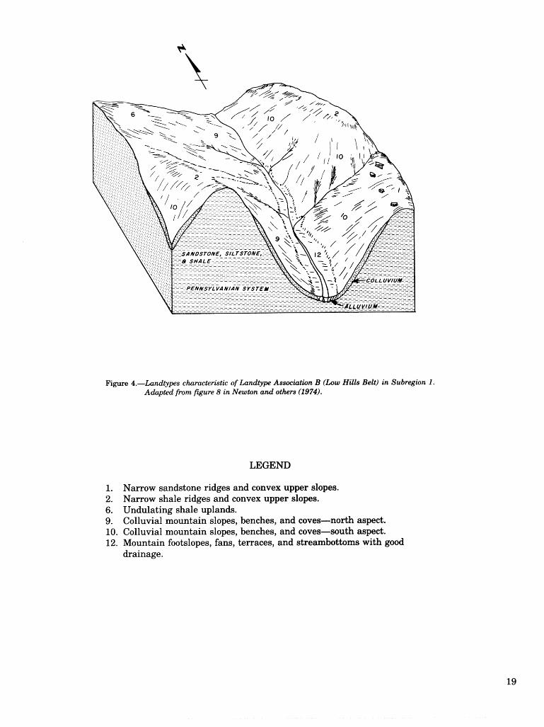
Figure 4.-Landtypes characteristie of Landtype Association B (Low Hills Belt) in Subregion 1. Adapted from figure 8 in Newton and others (1974).
LEGEND
1. Narrow sandstone ridges and convex upper slopes. 2. Narrow shale ridges and convex upper slopes. 6. Undulating shale uplands. 9. Colluvial mountain slopes, benches, and coves-north aspect. 10. Colluvial mountain slopes, benches, and coves-south aspect. 12. Mountain footslopes, fans, terraces, and streambottoms with good
drainage.

SANDS TONE'
CAL CARPBUS SHALE
Figure 5,-LandLy~s ehrat@ri"er&& of h n d t y p Assmkthn C Western Escarpmnt faing the EasEern Highland Rim a d f i n n y ~ ~ b . 0 in Subregion 2,
LEGEND
Narrow sandstone ridges and convex upper slopes. ShdZow soils and sandsdone csuLcrops, Brad sandstone ridges---nodh aspect. Broad sandsitam P;idges-----south aspect. Undulating shale uplands. Upper escarpment slopes and benches-north aspect. Upper escarpment slopes and benches--south aspect. Lower escarpment slopes and benches-north aspect. Lower escarpment slopes and benches-south aspect. Shallow soils and limestone oukrops. Limestow ridges and convex upper slopes,

F i p e 6.-Landtypes chamteristic of landtype Association D (Western Escarpment facing the Bluegrass) in Subregion 2 and Landtype Association E (Cumlierhnd and Kentucky Rivers and naajor tributaries) in Subregion 3. Adapted f i m Fgure d in Newton and others (1 974).
LEGEND
2. Narrow shale ridges and convex upper slopes. 6. Undulating shale uplands.
17. Lower escarpment slopes and benches-north aspect. 18. Lower esarpment slopes and benches-south aspect. 19. Shallow soils and limestone outcrops. 20. Colluvial siltstone slopes-north aspect. 21. Colluvial siltstone slopes-south 23. Footslops, terraces, and flood plains with good drainage. 24. Terraces and flood plains with poor drainage.

tern pmades a basis for stratifying study areas, %he syskm 8180 aids in identifying and isslating prob~ems that need to be researched, For example, it became apparent in compiling site index and g ~ o d h idorma- tion that little menswation data specific b the region. are available, Finally, the system provides re- @archers with 8 vehicle for quick transfer of research resralb to the practitioner, S%udy results can be re-. p o h d on $he basis of their applicability to specific landtmes. An insight into multiple-use evaluations can be
found in nimble and others (1974) for the Central Appalachians, the northern edension of the Cumbw- Band Plateau and Mountains, McCamb (1982) has summarized the knowledge on integrating forestry
and wildlife managemear8; in the central hardwood re- gion, Vogel(1981) has provided comprehensive wide- lines for revegetating minesoils,
Although the nodhem geersaphical extent of the Northern Cumberland Plateau i s the watershed boundaq of the Kentucky River, landtmes occusE.?ing in LTAk A (Rugged Eastern Area) and B Q h w Hills Belt') are applicable to the souehem part of the Al- legheny Plabau in ncbdheast Kendracky-esse-n:d;iaIfy general soil. map associations 42-3 iJeEeracrrrr-Sbe2oeta- Steinsbwg) and 6-2 (Latham-Shelocta), respectively (Soil Conservation %mice 19"35). However, landtmes in this publication should not be applied Ls Kentucky soil association^ G-1 (Berks-Cranstoll) and G-6 (Vandalia-Upshrrr).
Figure ?.---A sample landtype map showing Landtype A s s o c ~ t i o n - meskm Escarpmnt fmtng tbze Emtern Ht'ghiand Rim and Pennyroyal) in Subregion 2, Map covers a tract of about 700 acres En the southwest quarter of the Livingston Quadrang& along the Laurel- XocKcastle County Line, AT. Scale is E°S:f2,0$)0. See table 4 fir mmes of landtypes. Compare with Map 89, Soil Survey of Laurel and RmkemtEe Counties> (Boss and others 2981)-

LANDTYPE DESCRIPTIONS AND FOREST MANAGEMENT INTERPRETATIONS

Occurs in LTA"s-A, B, C, and D
Description of Landtype 1: Narrow Sandstone Ridges and
Convex Upper Slopes G e o ~ a p h i c Se g-Shallow to moderately deep
soils on gently sloping to sbep, straight to winding, nmow ridgetaps and adjoining convex upper slopes in Subregions 1 and 2. Slope ranges from 5 to 40 percent. Typically, these ridgetops are less than 300 R wide. Soils fomed mostly in loamy r e s i d u u from sandstone. Outcrops of sandstone and rock fragments on the surface are common and, in places, extensive enough to recopize Land tm 3 (shallow soils and sandstone outcrops). L a n d t p 1 occurs frequently in LTA's A, C, and D and occa- sionally in LTA-B. It usually is found in association with Landtypes 7 and 8 and, in places, with Land- types 4,5, and 14. Landtypes 7 and 8 usually occupy the steep upper slopes below Landtype 1, but, in places, Landtypes 9 and 10 may extend upsloge to join Landtype 1. Landtype 1 also occurs in associa- tion with Landtype 11 and may be replaced by Landtype 11 following surface mining. Areas of shallow soils and sandstone outcrops may be exten- sive enough to recognize Landtype 3.
Dominant Soils--Rarnsey , Alticrest , Wallen, Muskingum, Steinsbwrg, and Dekalb.
Bedrock-Horizontal to slightly tilted acid sand- stone, conglomerate, and quartzite, with thin strata of siltstone and shale in places.
Depth to Bedrock-7 to 40 in. Texture-Loam, sand loam, fine sandy loam; occa-
sionally silt loam. Often gravelly, stony, or chan- nery. Rock firagment content usually does not ex- ceed 35 percent in the solum, except Wallen soils may have up to 70 percent rock fragnnents in the E3 horizon. Steinsburg and Dekalb soils may have 60 percent or more rock fragnnenb in the C horizon.
Soil Drainage-Well-drained to somewhat exces- sively drained.
Relative Soil Water Supply-Low. Soil Fertility-low. Vegetatjon-Chestnut oak, red maple, scarlet oak,
hickories, black oak, white oak, V i r ~ u i a pine, and southern red oak; occasional post oak, shol-tleaf pine, pitch pine, blackjack oak, black locust, black- gum, eastern redcedar, and eastern white pine. Sas- safras, soumood, flowering dogwood, vacciniums, sumac, persimmon, buffalo-nut, Carolina buck- thorn, mountain-laurel, and azaleas are common understory species.

Table 5,-Forest mna&ement interpretcett'om for Landtype I: Narrow sandstone ridges and convex upper stopes
PRODUCTIVITY
Site index1 Average annual gro7ntth2 (elacre)
E, white pine Shodleaf pine Vir&nia pine M i t e oak
IMANAGEMENT PROBLEMS
Plant Seedling competition mortality
Equipment Erosion Windthrow limitations hazard hazard
Slight to moderate
Moderate to Moderate to Slight to Moderate to severe severe severe severe
SPECIES DESIRABILITY
Most desirable
Acceptable Least desirable
E. white pine Shortleaf pine Virginia pine Black oak m i t e oak S. red oak
Pitch pine Hickories Chestnut oak Scarlet oak
E. redcedar Blackjack oak Sassafras Black locust Red maple Blackgum Flowering dogwood Somood Persimmon
lSite indices for each naturally occunring species, except those enclosed in parentheses, are the means of values from soil survey interpretations issued by SCS for the dominant soils in each landtype, but sometimes adjusted for aspect and slope position (Beck 1962, Broadfoot 1960, Broadfoot and Krirriard 1959, Nelson and others 1961, Schnur 1937, and U.S. Forest Service 1929). Estimated site indices are enclosed in parentheses, Base age is 50 years for all species except cottonwood, for which it is 30 years.
Xnnual movvth of natural stands calculated from published yields at 50 years: eastern white pine IDoolittle 19561, inside-bark volume of total @&ern, at1 trees; shortleaf pine (U.S. Forest Service 1929, table log), total volume outside-bark, trees > 3.5 in d.b.h.; Virginia pine (Nelson and others 1961, table 41, outside-bark volume to a 4.0-in 0.b. top, trees > 3.5 in d.b.h.; upland oaks (Schnur 1937, table 2, column 121, outside-bark volume to 4.0-in o.b. top, trees > 4.5 in d.b.h.; yellow-poplar (McCarthy 1933, table 171, imide-bark volume to 3.0-in i,b. top, trees > 4.5 in d.b.h.; sweetgum (Winters and Osborne 1935, table 131, inside-bark volume do a 4.0-in i.b. top, trees > 4.5 in d.b.h.

Occurs in LTA7s-A, B, C, and D
Description of Landtype 2: Narrow Shale Ridges, Points, and
Convex Upper Slopes GeopapMc g-Shallow to moderately deep,
loamy and ils on sloping to very steep ridge- tops, pointis of ridges, and adjoining convex upper slopes in Subregions 1 and 2. Typically, these shale ridges are less than 350 R wide. Slope ranges from 6 to 80 percent and is usually more than 15 percent. On these steep, convex ridges, surface and subsur- face run-off is rapid, resulting in a dry site. Aspect does not seem to be a dominant site factor. Soils formed in loamy and silty residuum from shale, silt- stone, and, in places, fine-grained sandstone. Shale fragments are common on the surface. Landtype 2 occurs extensively on mountain crests at varying elevations in LTA-A and on tops of hills and ridges that project above the general level of the sandstone uplands in LTA's B and C in association with Land- types 6, 7, and 8. Ofbn Landtype 2 is disturbed or entirely removed during surface mining of coal if seam(s) are a t relatively shallow depths (Land- type 11). Landtype 2 also occurs with Landtype 6 on hills and ridges underlain by Mississippian shales and siltstones in LTA-L) in association with Land- types 20 and 21.
Dominant Soils-Petros, Weikert, Berks, and Muskingum; possibly Gilpin, Wernock, and Latham.
Bedrock-Shale, siltstone, coal, clay, and fine- grained sandstone.
Depth to Bedrock-10 to 40 in. Texture-Silt loam, loam, and fine sandy loam; often
shaly or channery. Rock fragment content may ex- ceed 35 percent in the solum and may be as much as 85 percent in C horizons.
Soil Drainage-Excessively drained to well-drained. Water Supply-Very low to low.
Vegetation-Chestnut oak, scarlet oak, black oak, shortleaf pine, pitch pine, and Virginia pine; occa- sional red maple, blackgum, black locust, southern red oak, northern red oak, blackjack oak, post oak, white oak, and hickories. Flowering dogurood, vac- ciniums, sumac, sassafras, sourwood, buf'falo-nut, azaleas, and mountain-laurel are common under- story species.

Table @.-Forest ma ment ilztetpretations for Ladtype 2: Marrow s h k riclges, points, and convex upper slopes
PRODUCTIVITY
Species
Shortled pine Virginia pine Chestnut oak Black oak S. red oak N. red oak
I MmAGEMENT PROBLEMS
Plant Seedling Equipment Erosion Windthrow competition mortality limitations hazard hazard
Slight Severe Moderate to Slight to Moderate to severe moderate severe
-
SPECIES DESIRABILITY
Most desirable
Acceptable Least desirable
Shortleaf pine Virginia pine White oak Chestnut oak N. red oak Black oak
Pitch pine Hickories Post oak S. red oak Scarlet oak
Blackjack oak Sassafras Black locust Sumac Red maple Blackgum Flowering dogwood Soururood
See footnotes 1 and 2 to table 5, p. 25.

Description of Landtype 3: Shallow Soils and
Sandstone Outcrops Geographic Setting-Small to moderately large
areas of exposed sandstone, conglomerate, and quadzite and shallow to moderalely deep, loamy soils fomed in residuum from these same rwks in Subregions I and 2. Slope ranges from 8 to 70 percent. The area of exposed rock varies from a few square feet to several acres, mostly in narrow strips. Slope of the rock is nearly level. Landtype 3 is frequent in LTA's A, 6, and D; occasional im LTA-B. It represents the thin to moderably thick sandstone free faces that occur intemithntly on steep mountain slopes and benches (Landtypes 9 and 10). Landtype 3 occurs frequently in association with upper mountain slopes (Landtypes 7 and 8) and narrow sandstone ridges (Landtype 1) in LTA's A, B, C, and D. It occurs above the free face of the escarpment in LTAs C and D in association with sandstone ridges (Landtypes 1, 4, and 5). Land- type 3 also occurs extensively along deeply incised streams and creeks (Landtypes 12 and 13) in LTA-B and occasionally in LTA's C and I?.
Dominant Soils-IRamsey and sandstone outcrops; possible Alticrest, Wallen, Steinsburg, and Dekalb.
Bedrock-Sandstone, conglomerak, and quartzite. Depth to Bedrock-Usually less than 20 in but occa-
sionally ranges up to 40 in in places. Texture-Loam, sandy loam, and fine sandy loam;
often stony. Rock fragment content in the solum is usually less than 35 percent, but it is more in places. Amount and size of fragments usually in- crease with depth.
Soil Drainage-Well-drained to somewhat exces- sively drained.
Relative Soil Water Supply-Very low. Seepage above exposed rock is common in wet weather, but the soil dries quickly,
Soil Fea ty-Very low. Vegetation-Chestnut oak, white oak, post oak,
blackjack oak, scarlet oak, southern red oak, and blackem; occasional Virginia pine, shortleaf pine, pitch pine, hickories, red maple, and eastern red- cedar. Soumood, Bornring dogrvood, winged elm, bdalo-nut, mountain-laurel, vacciniurns, lichens, mosses, grasses, and Carolina buckthorn are com- mon mderstory species.

Table 7.-Fawn" m n t interpretatbm for Landepe 3: Shl low soib and sadtone outemps
PRODUCT
Species Site index1 Average annual growth2 (Rs/acre)
Shortleaf pine Vir@nia pine E. m i t e oak
mEjTAGEMENT PROBLEMS
Plant Seedling competition mortality
- --
Equipment Erosion Windthrow limitations hazard hazard
Slight Moderate to Slight to Slight to Severe severe severe severe
SPECIES DESIRmILmY
Most desirable
Acceptable Least desirable
Shortleaf pine Virginia pine
Pitch pine E. redcedar Hickories White oak Post oak Chestnut oak S. red oak Scarlet oak
Blackjack oak Winged elm Red maple Blackgum Flowering dogwood Sourwood
See footnotss 1 and 2 to table 5, p. 25.

Description of Landtype 4: Broad Sandstone Ridges-
North Aspect -Moderately deep, loamy soils
moderably steep nodh-facing portions of broad ridgebps and aaoining convex upper slopes in Subre@ons 1 and 2. This landtme extends from the ridge crest dovvn to where the slope becomes linear or nearly so, At this point, gradient usually increases noticeably. Slope ranges firom 6 to 20 percent and is dominantly @eater than 10 percent. Soils fomed in loamy residuum from sandstone or from interbedded sandstone, siltstone, and shale. Rock firapents occur on the surface in places. Landtme 4 is common in LTA-B, frequent in LTA-C, and occasional in LTA's A and D, It is asso- ciated with other sandstone ridges and uplands (Landtypes 1, 5, and 14). Wills, ridges, and associ- ated slopes that occur above the general level of the sandstone uplands are dominated by shale and silt- stone (Landtypes 2,6, and 9). Most sandstone ridges end abruptly at the sandstone free face (Land- type 15) or merge with Landtme 3, Landtme 4 may merge with Landtmes 12 or 13 in .the heads of hol- lows.
D o m i n a n t Soils-Lily, Al t ic res t , Wallen, Muskingum, Steinsburg, and Dekalb. Wallen soils are more common on south and west aspects.
Bedrock-Sandstone and conglomerate, with thin strata of shale and siltstone in places.
Depth to Bedlroeb-20 to 40 in. Texture-Loam, fine sandy loam, and sandy loam;
occasionally silt loam, and sometimes gravelly, stony, or flaggy. Volume of sandstone and, in places, shale f agnzents, in the solum is usually less than 35 percent, but deeper horizons may contain more.
Soil Drainage-Well-drained to somewhat exces- sively drained.
&la Wager Supply-Medium. Soil --Moderabfy low. Vegetation-Whj;te oak, scarlet oak, red maple,
southern red oak, chestnut oak, hickories, black oak, blackman, shodleaf pine, and Vir@nia pine; occasional yellow-poplar, northern red oak, black c h e q , black locust, post oak, white ash, eastern white pine, and eastern redcedar. Flowering dog- wood, sassafras, servicebemy, soumood, persim- mon, buffalo-nut, lespedezas, sumac, viburnums, rracciniums, azaleas, and smilax are common understory species.

Table 8.-Forest ma m n t tntevretatiom for Landfype 4: B s o d sandstone riees---north aspect
Species Site index1 Average annual growth2 (R31acre)
E, white pine Shortleaf pine Vir@nia pine N, r d oak. Yellow-ppim
MANAGEMENT PROBLEMS
Plant Seedling Equipment Erosion Windthrow competition modality limitations hazard hazard
Moderate Slight to moderate
slight to Slight to Slight to mderak moderate moderate
SPECIES DESIRABILITY
Most desirable
Acceptable Least desirable
E. white pine Shortleaf pine Virginia pine m i t e oak Yellow-poplar Black cherry
Hickories Post oak Chestnut oak N. red oak Black oak S. red oak Scarlet oak n ib ash
E. redcedar Sassafras Serviceberry Black locust Red maple Blackmm Flowering dopood
Persimmon
See footnotes 1 and 2 t;o table 5, p, 25.
O c e w in L'PA3s-A, B, C, and D
Description of Landtype 5: Broad Sandstone Ridges-
South Aspect Geowapbic Se g-Moderately deep, loamy soils
on gently sloping to moderately steep south-facing portions of broad ridgetops and adjoining convex upper slopes in Subredons 1 and 2, This landtype exknds from the ridge crest d o m to where the slope becomes linear or nearly sa. At this point, padient usually increases noticeably. Slope ranges from 6 to 20 percent and is dominantly greater than 10 percent. Soils fomed in loamy residuum from sandstone or from interbedded sandstone, siltstone, and shale. b c k f r a ~ e n t ; ~ occur on the surface in places. Landtype 5 is common in LTA-B, frequent in LTA-C, and occasional in LTKs A and D. It is asso- ciated with other sandstone ridges and uplands (Landtypes 1, 4, and 14). Hills, ridges, and associ- ated slopes that occur above the general level of the sandstone uplands are dominated by shale and silt- stone (Landtypes 2, 6, and 10). Most sandstone ridges end abruptly a t the sandstone free face (Landtype 16) or merge with Landtype 3. Landtype 5 may merge with Landtypes 12 or 13 in the heads of hollows.
D o m i n a n t Soils-Lily, Al t ic res t , Wallen, Muskingum, Steinsburg, and Dekalb. Wallen soils are more common on south and west aspects.
Bedrock-Sandstone and conglomerate with thin strata of shale and siltstone in places.
Depth to Bedrock-20 to 40 in. Texture-Loam, fine sandy loam, and sandy loam;
occasionally silt loam, and sometimes gravelly, stony, or flaggy. Volume of sandstone and, in places, shale fragments, in the solum is usually less than 35 percent, but deeper horizons may contain more.
Soil Drainage-Well-drained to somewhat exces- sively drained.
Relative Soil Water Supply-Mediu to low. ------Moderately low.
Vegetation-Chestnut oak, white oak, scarlet oak, red maple, southern red oak, hickories, black oak, post oak, blackgum, Virginia pine, and shortleaf pine; occasional black locust, yellow-poplar, eastern redcedar, and eastern white pine. Dowoods, sas- safras, soumood, persimmon, vacciniums, sumac, viburnums, buffalo-nut, serviceberry, mountain- laurel, and smilax are common understory species.

Table 9.-firest mnagement interpretations fir Landtype 5: Broad sandstone ridges-south aspect
Species Site index1 Average annual grovvth2 (@/acre)
E. white pine Shortleaf pine Vir@nia pine
MANAGEMENT PROBLEMS
Plant Seedling competition mortality
- -
Equipment Erosion Windthrow limitations hazard hazard
Moderate Slight to rnoderak
Slight to moderate
Slight Slight to moderate
SPECIES DESIRABILITY
Most desirable
Acceptable Least desirable
E. white pine Shortleaf pine Virginia pine
Hickories White oak Chestnut oak Black oak S. red oak Scarlet oak
E. redcedar Post oak Sassafras Serviceberry Black locust Red maple Blackgum Dognroods Soumood Persimmon
See footnotes 1 and 2 to table 5, p. 25.
Description of Landtype 6: Undulating Shale Uplands
Geographic Setthg-Moderately deep, silty and clayey soilis on gently sloping .to moderately steep, rounded ridges and adjoining convex upper slopes in Subregions 1 and 2. mical ly these undulating uplands are wider than 350 fZ, and maybe 1,000 ft or more wide. Slope ranges from 5 to 15 percent, but the area with slope greater than 10 percent is small and aspect is not a dominant site factor, Soils formed in silty and clayey residuw &om shale, siltstone and, in places, fine-mained sandstone. Landtype 6 occurs frequently in LTA-B and only occasionally in LTA's A, C, and D. It represents the broader crests of mountains in LTA-A, the tops of higher hills and ridges that occur above the general level of the sandstone uplands in LTA's B and C, and the crests of hills and ridges in LTA-D.
Landtype 6 occurs mostly in association with Landtypes 2, 4, 5, 14, 20, and 21. In the Rugged Eastern Area (LTA-A), it occurs above Landtypes 7 and 8 and occasionally above Landtypes 9 and 10 in gaps. Landtype 6 is often disturbed by surface min- ing.
Dominant Soils-Latham, Sequoia, Wernock, and Gilpin.
Bedrock-Shale, siltstone, coal, clay, and fine- grained sandstone.
Depth to Bedrock-20 to 40 in. Texture-Silt loam, loamy, and silty clay loam; occa-
sionally shaly or channery. Rock fragment content usually is less than 35 percent in the solum but may exceed 35 percent in the C horizon.
Soil Drainage-Well-drained to moderately well- drained.
Relative Soil Water Supply-Low to medium. Soil Fertility-Moderately low. Vegetation-Chestnut oak, red maple, scarlet oak,
black oak, hickories, shortleaf pine, Virginia pine, and white oak; occasional nortlhern red oak, sugar maple, yellow-poplar, black locust, blackgum, elms, eastern white pine, and Fraser magnolia. Vaccini- ums, flowering dogwood, sumac, sassafras, sour- wood, buEalo-nut, and smilax are common under- story species.

Table 10.-Forest mtikagement interpretations for Landtyp 6: B shctle rises and eonvex upper s l o p
PRODUCTIVITY
Average annual growth2 (fi3/acre)
Shortleaf pine Virginia pine N. red oak Y ellow-poplar
MANAGEMENT PROBLEMS
Plant Seedling competition mortality
Equipment Erosion Windthrow limitations hazard hazard
Slight to moderate
Slight Slight to moderate
Slight Slight
SPECIES DESIRABILITY
Most desirable
Acceptable Least desirable
E. white pine Shortleaf pine Virginia pine White oak N. red oak Yellow-poplar
Hickories Chestnut oak Black oak Scarlet oak Elms Sugar maple
Fraser magnolia Sassafras Black locust Sumac Red maple Blackgum Flowering dogwood Sourwod
See footnotes 1 and 2 to table 5, p. 25.

Description of Landtype 7: Upper Mountain Slopes-
North Aspect h o g r a p h i e Setthg-Moderately deep, loamy and
silty soils on the mderak ly s b q do very skep upper one-fourth to one-third ofnodh slopes in Sub- region 1. These convex to line= slopes range from 16 to 75 percent in padient. Soils fsmed in loamy residuum from acid siltstone, shale, and sandstone. Landtype '7 is limlkd to LTA-A, where it wcurs below Landtypes 2,6, and occasionally 1 and 4 and above Landtyppe 9. Upper reaches sf Larmcttrnes 12 and 13 may extend into Larrdtme 7, Areas of shal- low soils and sandstone ledges may be extensive enough to recosize Landtype 3. Surface mines (Landtype 11) occur extensively in association with Landtype 7.
Dominant Soils-Muskingum, Gilpin, and Berks; possibly Dekalb and Steinsbwg. Zenith and Cut- shin occur on cool slopes and in coves, particularly in LTA-A. Of'ten mapped as soil complexes.
Bedroek-Siltstone, shale, coal, and ellay; possibly sandstone and conglomerate.
Depth to Be&ock-20 to 40 in, Zenith and Cutshin soils are 70 to 80 in to rock.
Texture-Silt loam, loam, fine sandy loam, and sandy loam; possibly sandy clay loam and clay loam. Rock fragment content is usually less than 35 percent in the solum, but is more in Berks and Dekalb soils. Deeper horizons may contain as much as 75 percent rock fragments.
Soil Drainage-Well-drained to somewhat exces- sively drained.
Relative Soil Water Supply-Medium to low. Soil Featy-Moderate to moderately low. Vegetation-Mite oak, chestnut oak, red maple,
yellow-poplar, northern red oak, black oak, and sugar maple; occasional black locust, white bass- wood, blackgum, shortleaf pine, Virginia pine, hickories, eastern. white pine, yellow bwkeye, east- ern hemlock, cucumberlree, black walnut, white ash, and sweet birch. Flowering domood, sassafras, sumac, eastern redbud, rhododendron, service- berry, hydrangea, mountain-laurel, bufhlo-nut, and grape are common understory species,

Table 11.-Forest ma m n t interpretations for Landtype 7: Upper mountain slopes-north. aspect
Species Site index1 Average annual growth2 [R3f acre)
E. white pine Shortleaf' pine Virginia pine White oak. N. red oak Black oak Yellow-poplar
NAGEMENT PROBLEMS
Plant Seedling Equipment Erosion Windthrow competition mortality limitations hazard hazard
Moderate Slight to Moderate to Moderate Slight to to severe moderate severe to severe moderate
---
SPECIES DESIMBILmY
Most desirable
Acceptable Least desirable
E. white pine Shortleaf pine Virginia pine Black walnut White oak N. red oak Yellow-poplar White ash
Hickories Chestnut oak Black oak Cucumbertree Sugar maple Yellow buckeye White basswood
E, hemlock Sweet birch Sassafras Serviceberry E, redbud Black locust Sumac Red maple Flowering dogwood
See footnotes 1 and 2 to table 5, p. 25.

Description of Landtype 8: Upper Mountain Slopes-
South Aspect GeoljrapEc Settjing---Moderately deep, loamy and
silty soils on moderately steep to very steep upper one-third to one-half of south slopes in Subregion 1. mese convex Lo linear slopes range from 16 Lo 75 percent in gradient. Soils formed in loamy residuum from acid siltstone, shale, and sandstone. Landtype 8 is limited to LTA-A, where it occurs below Landtypes 2,6, and occasionally 1 and 5, and above Lf-mdtme 18. Upper reaches of Landtnes I2 and 13 may extend into Landtme 8. Areas of shal- low soils and sandstone ledges may be extensive enough to seeomize Landtype 3. Surface mines (Landtme 11) occur efiensively in association with Landtme 8.
Dominant Soils-Muskinmm, Gilpin, and Berks; possible Dekalb and Steinsburg. Often mapped as soil complexes.
Bedrock-Siltstone, shale, coal, and clay; possible sandstone and conglomerate.
Depth to Bedroek-20 to 40 in. Texture-Silt loam, loam, fine sandy loam, and
sanety loam. Roek frawent content is usually less than 35 percent in the solum, but is more in Berks and Dekalb soils. Deeper horizons may contain as much as 75 percent rock fragnaents.
Soil Drainage-Well-drained to somewhat exces- sively drained.
Relative Soil Water Supply-Low. Soil Feraity-Moderate to moderately low. Vegetation-mite oak, chestnut oak, scarlet oak,
black oak, blackmm, red maple, and shortleaf pine; occasional yellow-poplar, northern red oak, hicko- ries, black locust, Virginia pine, elms, and eastern white pine. Flowering dogvvood, sassafras, sour- wood, servicebev, sumac, viburnums, vacciniums, mountain-laurel, bugalo-nut, and grape are corn- mon understory species.

Table l2.-Forest ma ment int;erpretations for Landt3rpe 8: Upper muntain slop-south aspect
PRODUCTIVITY
Species Site index1 Average zmnual @owh2 (ft3/acre)
- - -* < -- N- *
E. white pine 75 126 Shortleaf pine 60 102 Vir@raia pine 60 53 N. red oak 65 48 Black oak 60 43 Yellow-poplar 175) 63
MANAGEMENT PROBLEMS
Plant Seedling Equipment Erosion Windthrow competition modality limitations hazard hazard
Slight Moderate Moderate to Moderate Slight to severe to severe moderate
SPECIES DESPRABBLITY
Most desirable
Acceptable Least desirable
E. white pine Shortleaf pine Virginia pine m i t e oak N. red oak Yellow-poplar
Hickories Chestnut oak Black oak Scarlet oak Elms
Sassafras Sen-iceberry Black locust Sumac Red maple Blackmm Flowering domood
See footnotes 1 and 2 to table 5, p. 25.
Description of Land Colluvial Mountain Slopes, Benches,
and Coves-North Aspect lomy, often pavelly,
ping to steep lower
ularly the coves, that are shaded e*nsively by ad;jacent land masses shodd be claif ied m Land- type 9. Landtype 9 is common in LTA-A and fre-
ent in LTA-B. Landtype 9 occurs below Land- 7 but may border on Land tms 1,2,4,6, or 14
in gaps. Upper reaches of Landtypes 12 and 13 usu- ally extend into Landtype 9, and, in places, they merge with major river bottoms (Landtypes 23 and 24). Surface mines (Landtype 11) occur extensively in association with Landtype 9.
Dominant SoilsAeEerson, Grimsley, Shelocta, and Rigley. Zenith and Cutshin occur on cool slopes and in coves, particuldy in LTA-A. Often mapped as soil complexes.
Be&ock-Siltstone, shale, coal, and clay; possibly sandstone and conglomerate.
Depth to Bedrock-40 to 120 in or more. Texture-Loam, fine sandy loam, sandy loam, and
silt loam; occasionally sandy clay loam and clay loam. Rock fkagrnent content varies considerably, and boulders and cobbles are common on the sur- face, particularly in coves.
Soil &&age-Well-drained. l%elative Soil Water Supply-Medim to high. Soil FeaW-Moderate to moderately high. Vegekabion-Yellow-poplar, northern red oak, white
oak, hickories, red maple, and American beech; oc- casional sugar maple, cucunnbe*~, yellow buck- eye, eastern hemlock, eastern white pine, black oak, white ash, black-, white basswood, and black birch. Flowedng domood, American horn- beam, vacciniums, grape, viburnms, hybangea, spicebush, pawpaw, and s t r a w b q - b w h are com- mon mderstory species.

Table 13.-Forest nza merit i n t e r ~ r e t a t i ~ m for L a n d t ~ e 9: Coll@ubl mountain slopes, bemhes, and coves-north mpeci-
PRODUCTIVITY
Site index1 Average annual growth2 Stlecies (fit3/acre)
E, wkik pine Shortleaf pine Virginia 75 mite oa 75 57 N. red oak 80 62 Y elllow-poplar 100 107
competition
Moderate Slight to Moderate to Moderate Slight to severe moderate severe to severe
SPECIES DESIRABILITY
Most Acceptable Least desirable desirable
E. white pine M i t e oak N. red oak Black oak Yellow-poplar VVhite ash
Hickories American beech Cucumbertree Sugar maple Y ellow buckeye M i t e bass wood
E. hemlock Black birch American hornbeam Serviceberry Sumac Red maple Blackgum Flowering dogwood Sourvvood
See footnotes 1 and 2 to table 5, p. 25.

Occurs in LTA's-A and B
Description of Landtype 10: Colluvial Mountain Slopes, Benches,
and coves-south Aspect g-Deep, lomy, often aavelly ,
cobbly, or stony soils on the sloping to steep lower one-half to two-thirds of south slopes in Subre- gion 1, The linear to concave slopes range from 15 to 60 percent. Soils formed in loamy colluviunn from acid silbtone, shale, and sandstone. Lower parts of these slopes part;icularly the coves, may be shaded extensively by adjacent land masses and should be classified as having a north aspect (Landtype 9). Landtype 10 is common in LTA-A and frequent in LTA-B. Landtype 10 occurs below Landtype 8, but may border on Landtypes 1, 2, 5, 6, or 14 in gaps. Upper reaches of Landtypes 12 and 13 usually ex- tend into Landtype 10, and, in places, it merges with major river bottoms (Landtypes 23 and 24). Surface mines (Landtype 11) occur extensively in association with Landtype 10.
Dominant Soils-Jefferson, Grimsley, Shelocta, and Rigley. Often mapped as complexes.
Bedrock-Siltstone, shale, coal, and clay; possibly sandstone and conglomerate.
Depth to Bedrock-40 to 120 in or more. Texture-Loam, fine sandy loam, sandy loam, and
silt loam; occasionally sandy clay loam and clay loam. Rock fragment content varies considerably within short distances. Boulders and cobbles are common on the surface, particularly in coves.
Soil Drainage-Well-drained. Relative Soil Water Supply-Medium, Soil Fertility-Moderate to moderately high. Vegetation-White oak, chestnut oak, scarlet oak,
red maple, hickories, black oak, Virginia pine, and shortleaf pine; occasional northern red oak, yellow- poplar, sugar maple, black locust, eastern hemlock, American beech, blackgum, and white ash. Flower- ing dogwood, American hornbeam, sassafras, east- ern redbud, grape, hydrangea, sumac, pawpaw, and spicebush are common understory species.

Table 14.-firest ma m n t interpretations for Landtype 10: Colluvbl mountain slopes, bemhes, and coves-south aspect
PRODUCTIVITY
Species Site index" Average annual growth2
(fi3lacre)
Shortleaf pine Virginia pine m i t e oak N. red oak Y ellow-poplar
UNAGEMENT PROBLEMS
Plant Seedling Equipment Erosion Windthrow competition mortality limitations hmard hazard
Moderate Moderate Moderate to Moderate Slight severe to severe
SPECIES DESIRABILITY
Most Least Acceptable desirable desirable
Short leaf pine Hickories E. hemlock Virginia gine American beech American hornbeam White oa Chestnut oak Sassafras N. red oak Black oak E. redbud Yellow-poplar Scarlet oak Black locust White ash Sugar maple Sumac
&d maple Blackgum Flowering dowood
See footnotes 1 and 2 to table 5, p. 25.

Occurs in LTKs-A, B, C , and D
Description of Landtype 11: Surface Mines
Geopaphic Setting--Nearly vertical high walls and young, lomy, rocky soils neous s p i l resulting &om area, contour, and auger types of @ d a c e mining for coal in Subregions 1 and 2. No dirstinction is made between mreelaimed (or- phan) and reclaimed @ d a c e mines, ln contour and auger mining (common in LTA-A)
the spoil is gmdhed Lo f o m benches with shep Lo vergt steep outer slopes and to p&ially cover the high wall. Benches ranges from '70 to 150 R or more in vvidth, and the high walls are generally 60 R or more high. Contour mines occur a t all elevations on mountain sides and tops, Nearly on the contom, they extend around the mounhins in strips that range from a few hundred y a r b to several miles and encompass areas as large as 250 acres. Slopes are dominantly 12 to 20 percent on benches and 25 to 80 percent on outslopes. Ponds between the high wall and the spoil bank are common on orphan mines.
In area mining (common in LTKs B, C, and D) reclamation standards require restoration to about pre-mining topography. Area mining operations may cover several hundreds of acres. Slopes are usually less than 15 percent except in the vicinity of the final trench and in the heads of hollows a t the margins of operations. Siltation ponds are now re- quired on area mines.
Dominant Soils-Fairpoint and Bethesda. Formerly mapped as minespoils and surface mines. Reaction of Fairpoint soils is neutral to medium acid; that of Bethesda soils is strongly acid to extremely acid.
Parent Matcsrid-Formed in acid to neutral regolith firom s d a c e mining and occasionally in refuse f'rom deep mining. Rock framents consist of siltstone, shale, coal, and fine and medium-grained sand-
sbne, Fine-ea&h makrial, is pa~ ia l ly weatherd rock f r a p e n b .
Depth Ix, Bedrock-50 in to 50 R or more, Textwe-The A horizon of unreelaimed areas is
shaly, channeq, or gavelly clay loam, silty clay loam, or silt loam. Reclaimed areas have 4- to 12-tn- thick A horizons &om natwal soil mabriat ~ t h texture of silt loam, loam, silty clay Isam, or clay loam. nidy-five to 80 percent of t;he C horizons are esmpssed of rock &awen.i;s.
-Well-drained. Water Supply-Low to medium,
---Low. Soil reaction ranges Erom neu- tral to extremely acid, except surface layers that have been limed. Toxicities and deficiencies of plant nutrients are common in strongly and extremely acid soils. Shrink-swell potential is moderate,
Vegetation-Reclaimed areas have been seeded to grasses andlor legumes. Plantings of black locust, shortleaf pine, Vir@nia pine, and eastern whib pine are common on all sites while yellow-poplar, green ash, American sycamore, and sweetwm have been planted on cool andlor moist to wet sites, &re- claimed mine soils have slowly revegetated natu- rally, and species occurrence depends cm age of the spoil. Common native woody species are eastern redcedar, yellow-poplar, black locust, red maple, Virginia pine, shortleaf pine, American sycamore, winged elm, hickories, white oak, scarlet oak, blackgum, post oak, blackjack oak, chestnut oak, black oak, sweetgum, black willow, cottonwood, river birch, sumac, persimmon, and sassafras. ~o comrnon exotic species are white poplar and royal paulomia. Consult Vogel's (1981) wide for specific recommendations for revegetating mine soils.

Table f 5 . F o r e s t ma ment interpretations for Landtype I I : Suqaee mines1
Plant Seedling Equipment Erosion W i n d t b w comptition mo*lity limibtions h
Slight Severe Slight to severe
Severe Slight
Most desirable
Acceptable Least desirable
E. white pine Shortleaf pine Virginia pine E. cottonwood White oak Y ellow-poplar Svveetgum American sycamore
E. redcedar Hickories Post oak Chestnut oak Black oak Scarlet oak Black locust Red maple Green ash
White poplar Black willow River birch Blackjack oak Winged elm Sass& as Sumac Black- Persimmon Royal paulownia
lData not available on productivity (species, site index, and average annual growth).

Occurs in LTA's-A, B, C, and D
Description of Landtype 12: Mountain Footslopes, Fans,
Terraces, and Streambottoms with Good Drainage
Geogrrapbic Se g-Deep, silty and loamy alluvial soils with good internal drainage on level to strongly sloping footslopes, fans, terraces, and strearmbottoms along streams and creeks in Subre- dons 1 and 2, Slope ranges from 8 to 15 percent but is generrlly less than 6 percent. Landtme 12, in asswiation with Landtme 13, occws as long, nar- row, Prinding, sometimes discontinuous strips of land bordering drainages. shod sandstone cliflfs (Landtype 3) often sepasab the slopes and ridges from the terraces and streambottoms. Upper reaches of Landtype 12 extend into Landtmes 9 and 10 and occasionally. into Landtmes 7 and 8 in LTA- A, In less mgged terrain, heads of hollows may ex- tend into Landtypes 4, 5, and 14. Below the sand- stone free face, Landtype 12 occurs in association with Landtmes 15 to 18, 20, and 21.
Dominant Soils-Whitley, Rowdy, Cotaco, Bar- bourville, and Combs on footslopes, fans, and ter- races; Cuba, SteE, Clifty, Grigsby, Pope, Philo, Skidmore, Ealy, and Sewanecj on streambottoms.
Pa ren t Material-Al1uVium washed frorn soils formed in residuum and colluvium from acid sand- stone, siltstone, and shale, and possibly limestone and calcareous shale.
Depth to Bedrock-40 in to 20 R or more. Texture-Loam, silt loam, fine sandy loam, and
sandy loam; occasionally gavelly. Rock fragment content ranges frorn O to 35 percent in the solum and to 60 percent in lower B and C horizons.
Soil Drainage---Well-drained to moderately well- drained.
Relative Soil Water Supply-High. Irrigated by subsudace flow. Seeps oecur on footslopes in winter and spring. Streambottoms have seasonal water table at depths of 2 to 5 R for 1 to 3 months. This landtype is subject to frequent flash floods following shod, high intensity stoms and occasional general floodi wing long, sustained stoms.
Soil Fe Moderately high to high, Vegetat;lioai---Wite oak, yellow-poplar, red maple,
blackgum, sweetwm, and blaek oak; occasional nortkern red oak, Amelpican sycamore, scarlet oak, eastern white pine, eastern hemlock, shagbark hickory, shostleaf pine, black willow, American elm, American beech, boxelder, black walnut, and river birch. Dowoods, sassafras, soumood, um- brella magnolia, American hornbeam, eastern hophornbeam, sumac, mountain-laurel, vibur- nums, azaleas, and cane are common understory species.

ism for hndtype 12: Mountain footslopes, fans, terraces, and
PRODUGTIWTY
Site index1 Average annual growth2 (R3/acre)
E. white pine 90 154 Shortleaf pine 80 148 Virginia pine 75 120 N. red oak 80 62 Yellow-poplar 100 107 Sweet 90 81 American sycamore (90) ....
=NAGEMEN PROBLEMS
Plant Seedling Equipment Erosion Windthrow competition mortality limitations hazard hazard
Severe Slight Slight to Slight Slight moderate
SPECIES DESIRABILITY
Most desirable
Acceptable Least desirable
E, white pine Shagbark hickory E. hemlock Shortleaf pine Black oak Black willow Black walnut Scarlet oak River birch White oak llnnerican elm American hornbeam N. red oak E. hophornbeam Y ellow-poplar American beech Sweetgun Umbrella magnolia American sycamore Sassafras
Red maple Boxelder Black Dogwoods Sourvvood
See footnotes 1 and 2 to table 5, p. 25.

O c c m in Ll'Ak-A, B, C , and D
Description of Land Mountain Terraces and Stream-
bottoms with Poor Drainage Deep, silty and loamy alluvial a1 drainage on level to gently
sloping terraces and streambottoms along stream and creeks in Subregons 1 and 2. Slope ranges from 0 to 4 percent. Landtype 13, in assmiation with Landtype 12, occurs as long, nmow, discontinuous strips of land bordering mountain streams. Short sandstone cliffs (Landtme 3) often separate the slopes and ridges from the terraces and streambot- toms. Upper reaches of Landtme 13 extend into Landtmes 9 and 10, and oecasionally into Land- types 7 and 8 in LTA-A. In less rugged terrain, heads of hollows may extend into Landtypes 4, 5, and 14. Below the sandstone free face, Landtype 13 occurs in association with Landtypes 15 to 18, 20, and 21.
Dominant Soils-Morehead on terraces; Stendal, Bonnie, Atkins, Stokly, and Bonair on streambot- toms.
Pa ren t Material-Alluvium washed from soils formed in r e s iduu and colluvium from acid sand- stone, siltstone, and shale.
Depth to Bedrock-40 in to 10 fZ or more. Texture-Silt loam and silty clay loam; occasionally
sand loam and loam. Rock fragment content is 20 percent or less in the solum, but ranges to 40 per- cent in lower B and C horizons.
Soil Drdage-Somewhat poorly drained to poorly drained.
Relative Soil Water Supply-High to very high. Water stands on the surface or the water table is a foot or less below the surface for appreciable peri- ods. This landtype is subject to frequent flash floods following short, high-intensity storms and occa- sional general flooding following long, sustained storms.
@-Moderately high to high. Vegetation-Red maple, sweetgum, blackgum,
yellow-poplar, white oak, American sycamore; oeca- sional E. cottonwood, pin oak, h e r i c a n elm, Amer- ican beech, black willow, boxelder, and silver maple. Viburnums, azaleas, mountain-laurel, rhododendron, American holly, cane, sphagnum moss, alder, dowoods, grasses, and sedges are com- mon in the understory.

Table 17.-firest ma nt interpretations for LandQpe 13: Mountain terraces and streambottom with poor e
Species Site index" Average annual grovvth" (R3f acre)
E , cottonwood Pin oak Yellow-poplar S w e e t ~ m American sycamore
MLANAGEMENT PROBLEMS
Plant Seedling Equipment Erosion Windthrow competition mortality limitations hazard hazard
Moderate Moderate to Severe Slight Lo severe severe
Slight
- --
SPECIES DESIRABILITY
Most desirable
Acceptable Least desirable
E. cottonwood M i t e oak Pin oak Yellow-poplar Sweet American sycamore
American elm Red maple Boxelder
Black willow American beech American holly Silver maple Blackgum Dowoods
-- -
See footnotes 1 and 2 to table 5, p. 25.
O c c w ~ in LTA's-B, C, and B
Description of Landtype 14: Undulating Sandstone Uplands
Geographic Setting-Moderately deep to deep, loamy and silty oils on newly level to rolling broad uplands that typically occupy tbe smoother, but not necessarily the hibest parts, of the landscape in Subre@ons 1 and 2. Slope does not exceed 15 per- cent, but the area with slope @eater than 10 per- cent is small and aspect is not a dominant site fac- tor. These b rod ridges range up to 0.5 mi in width. Soils fomed in loamy residu from acid sand- stone, siltstone, and shale. Landtype 14 is most common in LTA-B but occurs in LTKs C and D, It occurs in association with other sandstone ridges (Landtmes 1,4, and 5). Hills and ridges that occur above these uplands are dominated by shale and siltstone (Landtypes 2, 6, and 9). The heads of hol- lows (Landtwes 12 and 13) may extend into Land- type 12,
Dominant Soils-Lily, Clarkrange, Lonewood, Crossville, Tilsit, and Clymer.
Bedrock-Acid sandstone, conglomerate, siltstone, and shale,
Depth of Be&ock-20 to 90 in. Clarkrange and Tilsit soils have fragipans at depths of 18 to 28 in.
Texture-Loam, fine sandy loam, sandy loam, and possibly silt loam. Rock f r a p e n t content is 10 per- cent or less in the solum, but deeper horizons rnay contain as much as 70 percent.
Soil Drainage-Well-drained, except for Clarkrange and Tifsit, which are moderately well-drained.
Relative Soil Water Supply-Medium. Soil Ferwty-Moderately low. Vegetation-White oak, scarlet oak, chestnut oak,
red maple, southern red oak, hickories, black oak, blackgum, shortleaf pine, and Virginia pine; occa- sional yellow-poplar, post oak, northern red oak, sweetprn, black locust, eastern white pine, black c h e q , and eastern redcedar. Flowering dogwood, sassafras, sourwood, serviceberry, sumac, haw- thorns, viburnums, azaleas, American holly, and smilax are common understory species.

Table 18.-Forest management interpretations for Landtype 14: Undulating sandstone mountain uplan&
PRODUCTIVITY
Site index1 Average annual growth2 Species (R3/acre)
E. white pine 80 136 Shortleaf pine 65 113 Virginia ine '70 92 White oaj: N, red oak 52 Yellow-poplar 90 90
MANAGEMENT PROBLEMS
Plant Seedling Equipment Erosion Windthrow competition mortality limitations hazard hazard
Slight to Slight Slight Slight Slight moderate
SPECIES DESIRABILITY
Most desirable
Acceptable Least desirable
E. white pine Hickories E. redcedar Shortleaf pine Post oak Sassafras Virginia pine Chestnut oak Serviceberry White oak Black oak Hawthorns N. red oak S. red oak Black locust Y ellow-poplar Scarlet oak Sumac Black cherry Sweetgum American holly
Eted maple Blackgum. Flowering dogwood Sourwood
See footnotes 1 and 2 to table 5, p. 25.
Description of Landtype 15: Upper Escarpment Slopes and
Benches-North Aspect
Deep to v e v deep, loamy soils rn sandratone, raiftsbne, and
shale and underlain by similar rocks in subre- gions 1 and 2. Land tm 15 occupies the gently slop- ing to very steep upper one-third to one-half of no~her ly slopes that extend fiom the Plateau sand- stone free face to the adjacent Eastern Highland Rim and Penp71;yrroyal rand Bluegass wgiowcs sr it borders coves and gorges that may extend several miles into the interior of the Plateau. Slope ranges from 5 to 70 percent. Much of the s d a c e is covered with sandstone boulders and fraeents . In LTA-B, the sandstone free face may occur one-fomh to one- third of the distance from the ridgetop to the streambottom. Here a short colluvial slope, similar to Landtype 15, may occur between the free face and the ridge (Landtypes 1,2,4, or 6). Landtype 15 occurs above Landtypes 12 and 13 or 23 and 24 in gorges of the Plateau interior where streams have not cut through the sandstone caprock. Where streams have cut through the sandstone caprock into the underlying Mississippian rocks, Landtype 15 occurs above Landtype 17. In the upper reaches of narrow gorges, the lower one-fourth to one-half of south-facing upper slopes (Landtype 16) should be included with Landtype 15 because shading molli- fies the normal warm microclimate. As gorges widen, the effect of shading diminishes.
Dominant Soils--Grimsley, Jefferson, Sheloeta, Rigley, a d Zenith; possibly pockets of Ramsey, Al- ticrest, and Steinsburg. Fomerly mapped as sand- stone roebland or bouldery calluvial land,
Bedrock-Sandstone, silktone, a d shale. Depth to Be&ock-40 to 60 in or more, except for
bmsey, Alticrest, and Steinsburg, which are less khan 40 in deep.
Tex-e-Gravelly or cobbly loam, silt loam, sandy clay loam, or clay loam.
Water Supply-Veq high to high, Ir- ubsudace flow and seepage.
Moderate to moderahly low. Vegetation-WiLe oak, northern red oak, yellow-
poplar, chestnut oak, sugar maple, hickories, Amer- ican beech, black oak, white ash, white basswood, yellow buekeye, and black locust; occasional black- gum, elms, red maple, southern red oak, eastern hemlock, eastern white pine, chinkrapin oak, sweet birch, black cherry, black walnut, and cucum- bertree. Dogurood, eastern redbud, bigleaf mapo- lia, spicebush, bladdernut, hydrangea, viburnums, azaleas, rhododendrons, somood, grape, and paw- paw are common understory species. This landtype also supports a rich herbaceous flora.

Table 19.--Fiest nanagement interpretations for Landtype 15: Upper escavnaent slopes and benches-
Species Site index1 Average annual growth2 (fi3/acre)
Black walnut White oak N* red oak S. red oak Yellow- plar Black c g r r y White ash
W A G E M E N T PROBLEMS
Plant Seedling Equipment Erosion competition mortality limitations hazard
Windthrow hazard
Moderate Slight Moderate to Slight to severe moderate
Slight
SPECIES DESIRABILITY
Most desirable
Acceptable Least desirable
Black walnut White oak N. red oak Yellow-poplar Black cherry White ash
E. white pine Sweet birch Chinkapin oak Black oak S. red oak Elms Cucumbertree Sugar maple Yellow buckeye White basswood
E. hemlock American beech E. redbud Black locust Red maple Blackgum Dogwood Sourwood
See footnotes 1 and 2 to table 5, p. 25.

Oeew in LTAk-B, C , and D
Description of Landtype 16: Upper Escarpment Slopes and
South Aspect Deep Lo v e q deep, l omy soils
~ 1 1 sandstone, sillstone, and shale and underlain by similar rocks in Subre- darts I. and 2. Landtme 16 occupies the gently slop- ing to v e q steep upper one-third to one-half of southerly slopes that ex-tend &om the Plakau sand- sbne free face to the aaacent Eastern Highland Rim and Penn~oyal and Bluegrass regons or it borders coves and gorges that mag extend several miles into the interior of the Plakau. Slope ranges h r m 5 I;o 70 pement. Much of the s d a c e is covered with sandstone boulders and f i a ~ e n b . In LTA-B, the sandstone free face may ocew one-fourth to one- third of the distance from the ridgetop to the strearnbotd.om. Here a shod colluvial slope, similar Ls Landtme 16, may oeeur between the free face and the ridge (Landtypes 1,2,5, or 6). Landtme 16 occurs Aove Landtnes 112 and 13 or 23 and 24 in gorges of the Plateau interior where streams have not cut through the sandstone capsoelre Where streams have cut through the sandstone caprock into $he underellying Mississippian rocks, Landtype 16 occws abwe Landtype 18. In the upper reaches of narrow gorges, the lowr o n e - f o ~ h to one-half of Landtype 116 should be included with norlh-facing upper slopes ( L a n d t ~ e '15) because shading molli- fies the normal warm microclimate. As gorges widen, the effect of shading diminishes.
a ~ t Soas---Grimsley, JeEerson, Sheloeta, and Rigley; possibly pockets of Ramsey, Alticrest, and Steinsburg. Fomerly mapped as sandstone rock- land or bouldey colluvial land.
Bedrock-Sandslone, siltstone, and shale. Depdb (lo Bediroek-40 to 60 in. or more, except fbr
Etamsey, Alticrest, and Steinsbwg, which are less than 40 in deep.
Tex&we-Gravellgr or cobbly loam, silt loam, sandy clay loam, or clay loam,
Son Drahage-Well-drained. Elelaarse Sa2 W a h r Supply-Medi
gabb by subsudaee flow and seepage. mis land- Gme is no& as moiat as Lrandtme 15.
Sea Fermdy-Moderate low Lo low. Vegeta~on-mi te oak, ehe~tnut oak, nodhem red
oak, hickories, black oak, red maple, yellow-poplar, and black loeast; occasional blaekl;yum, elms, east- em white pine, white ash, black cherry, southern red oak, shortleaf pine, and Virginia pine. lidq-~w~od~ vibum~ams~ eaelermr redbud, sourwood, maleas, and pape are eommon understory species,

Table 20,-Forest- management interpretations for Landtype 16: Upper e s e a q m n t slopes and benehes- south q e c t
PRODUCTIVITY
Species Average annual po&b2 (e3daatse)
- - -
Shortfed pine Vir&da pine m i t e oak N. red oak S. red oak
MANAGEMENT PROBLEMS
Plant Seedling Equipment Erosion Windthrow competition mortality limitations hazard hazard
Slight Moderate Moderate to Slight to Slight severe moderate
SPECIES DESIIRABILITY
Most desirable
Acceptable Least desirable
E. white pine Shortleaf pine Virginia pine White oak Chestnut oak Black oak S. red oak
Hickories Black locust N. red oak Elms Yellow-poplar Black c h e w m i b ash
E. redbud Red maple Blackgum Dogwood
See footnotes 1 and 2 to table 5, p. 25.

Description of Land Lower Escarpment Slopes and
Benches-North Aspect
Geographic Setting-Moderately deep to deep type 1'7 k a u s e shading mollifies the normal warm lomy and clayey sails famed in colluvi micraclimah, As gorges widen, the eEect of shading limesbne, shale, siltstone, and smdstone and in diminishes. limestone residuum, and underlain by limestone, siltslone, and shale in Subre@on 2. L a n d t m 17 wcupies the gently sloping to very steep lower one- half do two-thirds of north slopes that extend from the Plateau sandstone free face to the adjacent Eastesn Highland Rim and Pennyroyal and Blue- grass re@ons or i t borders coves and gorges that may extend several miles into the interior of the Plakau. It also occurs on nodhern slopes of namow spur ridges below Landtype 22 in LTA-C and collu- vial slopes below intemittent limestone cliACs in LTA-D. Slope ranges from 2 to 75 percent. Outcrops of limestone may cover up to 40 percent of the sur- face, but sandstone boulders also may be present. Shallow soils and limestone outcrops may be exten- sive enough to recognize Landtype 19; often mapped as soil complexes. Landtype 17 is absent in gorges of the Plateau where streams have not cut through the sandstone caprock. Where streams have cut through the sandstone caprack into the underlying Mississippian rocks, this landtype usually occurs downslope from Landtype 15 and above Landtypes 12 and 13 or 23 and 24. In the lower reaches of
ant Soils-Bouldin, Brookside, Shelocta, and Talbott. Fomerly mapped as limestone rockland or bouldery colluvial land.
Bedrock-Limestone; occasionally siltstone and shale.
Depth to Be&ock-Mostly 60 in or more but may be 20 to 40 in where Talbott soils occur.
Texdure-Channery to stony loam, sandy loam, silt loam, and silty clay loam.
Soil Drhage-Well-drained and moderately well- drained.
Relative Soil Water Supply-Medium to low. Usu- ally soil water percolates deep into the limestone, but seeps and springs are associated with Brookside soils.
ty-Moderate to moderately low. Vegetation-mite oak, chestnut oak, northern red
oak, black oak, hickories, scarlet oak, and yellow- poplar; occasional blackgum, red maple, sugar maple, eastern white pine, post oak, eastern red- cedar, chinkapin oak, hackberry, black walnut, and elms. Dogwood, eastern redbud, winged elm, vibur-
narrow gorges, some or all of south-facing lower nums, sumac, ironwood, and hawthorns are com- slopes (Landtme 18) should be included with Land- mon in the understory.
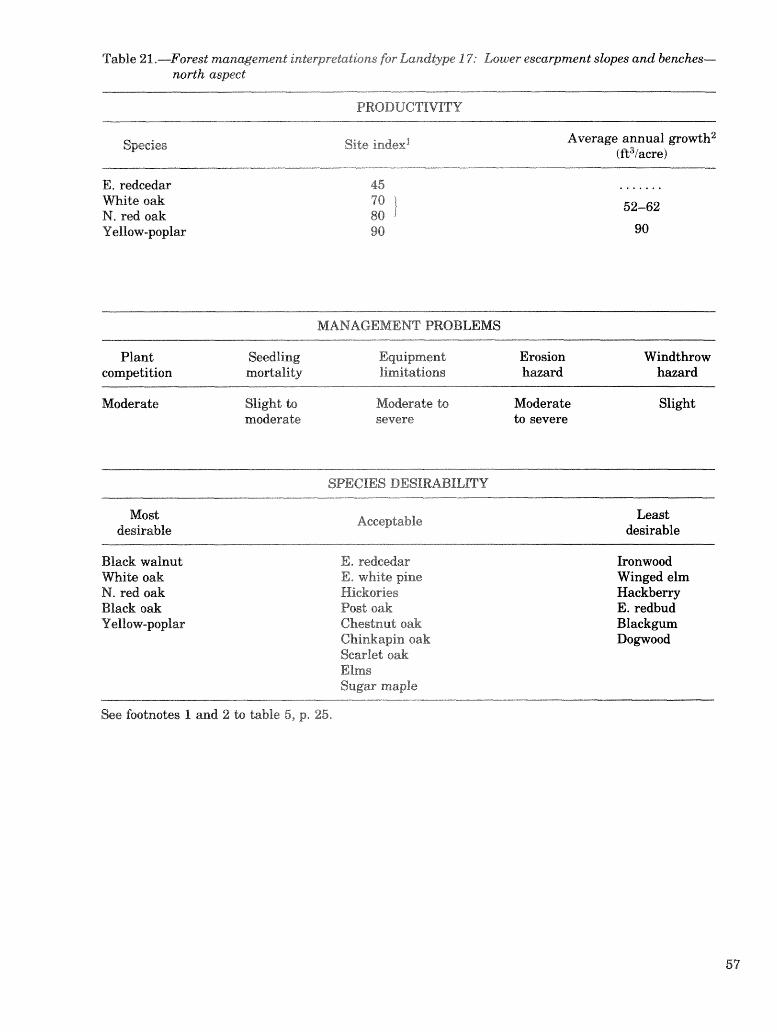
Table 21,-Forest mamgement interp~tatioisds for Landtype 17: Lo~r~er escarpmenl slopes and benches- north aspeed
PRODUCTIVITY
Species Site index' Average annual powth2 (fit3iacre)
Wide oak N, red oak Yellow-poplar
MANAGEMENT PROBLEMS
Plant Seedf ing Equipment Erosion Windthrow competition mordalirdy limitations hazard hazard
Moderate Slight to Moderate do Moderate Slight moderate Lo severe
SPECIES DESIRABILITY
Most desirable
Acceptable Least desirable
Black walnut Es redcedar Ironwood M i t e oak E, white pine Winged elm N. red oak Hickories Hackberry Black oak Post oak E. redbud Yellow-poplar Chestnut oak Blackgum
Chinkapin oak D o ~ o o d Scarlet oak Elms Sugar maple
See focrtrrote~ 1 and 2 Lo table 5, p. 25.
Occurs in L'I'Ks-C and B
Description of Landtype 18: Lower Escarpment Slopes and
Benches-South Aspect
$-Moderately deep to very deep, loamy and clayey soils fomed in colluviu &om limestone, shale, siltstone, and sandstone and in limestone residuum, and mderlain by limestone, siltstone, and shale in Subregion 2. Landtype 18 occupies the gently sloping to very steep lower one- half to two-thirds of south slopes that extend from the Plateau sandstone free face to the adjacent Eastern Highland Rim and Pennyroyal and Blue- grass regions or it borders coves and gorges that may extend several miles into the interior of the Plateau. It also occurs on southern slopes of narrow spur ridges below Landtype 22 in LTA-C and on colluvial slopes below intermittent limestone cliffs in LTA-D. Slope ranges from 2 to 75 percent. Out- crops of limestone may cover up to 40 percent of the surface, but sandstone boulders also may be present. Shallow soils and limestone outcrops may be extensive enough to recognize Landtype 19; often mapped as complexes. Landtype 18 is absent in gorges of the Plateau where streams have not cut through the sandstone caprock. Where streams have cut through the sandstone caprock into the underlying Mississippian rocks, this landtype usu- ally occurs downslope from Landtype 16 and above Landtypes 12 and 13 or 23 and 24. In the lower reaches of narrow gorges, some or all of Landtype 18 should be included with north-facing lower
slopes (Landtme 17) because shading mollifies the noma1 warn micrwlimak. As gores widen, the effect of shading diminishes.
ant Soils-Bouldin, Brookside, Shelocta, and Talbott. Fomerly mapped as limestone rockland or bouldery colluvial land.
Bedrock-Limestone; occasionally siltstone and shale.
Depth to Bedrock-Mostly 60 in or more but may be 20 to 40 in where Talbott soils occur.
Texture-Channery to stony loam, sandy loam, silt loam, and silty clay loam.
Soil Drainage-Well-drained to moderately well- drained.
Relative Soil Water Supply-Low to very low. Usu- ally soil water percolates deep into the limestone, but seeps and springs are associated with Brookside soils.
Soil Fedity-Moderate to moderately low. VegetaLion-Mite oak, scarlet oak, chestnut oak,
hickories, eastern redcedar, white ash, post oak, black oak, and elms; occasional red maple, black- gum, black locust, hackberry, chinkapin oak, honeylocust, blue ash, American beech, Virginia pine, and shortleaf pine. Eastern redbud, dogwood, winged elm, viburnums, ironwood, hawthorns, and sumac are common in the understory.

Table 22.-Forest management interpret-ations for Landtype 18: Lower escarpment slopes and bemhes- south aspect
Species Site index1 Average annual gavvth2 f R3iacre)
Shortleaf Pine Virginia pine E. redcedar m i t e oak
MANAGEMENT PROBLEMS
Plant Seedling Equipment Erosion Windthrow competition mortality limitations h a d hazard
Slight Moderate to Moderate to Moderate Slight severe severe to severe
SPECIES DESIRABILITY
Most desirable
Acceptable Least desirable
Shortleaf pine Virginia pine E. redcedar m i t e oak White ash
Hickories Post oak Chestnut oak Chinkapin oak Black oak Scarlet oak Elms Black locust Blue ash
Ironvmod American beech Winged elm Hackbew E. redbud Honey locust &d maple Blackem Dopood
See footnotes 1 and 2 to table 5, p. 25.
O c c m in LTA'k-l2 and r)
Description of Landtype 19: Shallow Soils and
Limestone Outcrops g-Small e&nsive &area of s interspersed with patches of
shallow to moderately deep, clayey soils in Subre- gion 2. In LTA-C, this i n t~ca le pat;tem of soils and rock oukrops wcwg in gorges of s t ems that have cut through the sand~tone caprwk and on footslopes of Plateau spur ridges bordering the Eastern High- land Rim and Pennyroyal in association with Land- types 17 and 18. In LTA-D, L a n d t p 19 represents the internittent liarae~ibnaz: clliEi and bands of shal- low soils immediately above these cliEs. Limestone or shale ridges (Landtmes 22,6, or 2) and, in a few places, shale slopes (Landtypes 20 and 21) occur above the cliffs, and Landtypes 17 and 18 occupy the rocky colluvial slopes below the cliffs. Eastern redcedar often dominates this landtype. Slope ranges from 2 to 60 percent. The soil mass rnay contain up to 65 percent limestone slabs. More than 50 percent of the soil surface rnay be exposed lime- stone, and, where exposure is extensive, the lime- stone is often terraced, The intemithnt cliffs in LTA-H) are not quite vertical h a u s e of the regional dip to the southeast.
Dominant Soils-Bar%leld, Faimount, Gladeville, and limestone rockland. Pockets of moderately deep Talbott, Colbert, and Caneyville may occur in this landtype.
Bedrock-Limestone and thin strata of calcareous clay shale.
Depth to Bedrock-Mostly less than 20 in but ranges up to 40 in where Talbott, Colbert, and Caneyville soils occur.
-Silty clay loam, silty clay, and clay. age-Well-drained to excessively drained,
Colbert; soils, which are moderately well- drained.
Relative Soil WafRr Supply-Low. Seepage is com- t the soil dries quickly.
Vegeta.tjon-Eastern redcedar, hickories, blue ash, haekbev, white ash, and elms; occasional honey- locu~t, Virginia pine, blackjack oak, black walnut, butternut, yellow-poplar, southern red oak, and osae-orange. Forbs, masses, smac , eastern red- bud, winged elm, Carolina buckthorn, msty black- haw, ha*homs, and prieklypear are common in the understory. Very small openings (<I acre) of native grassland occur in this landtype. Little blueskrn is dominant, while big bluestem, Indian- pass, side-oats &rama, and other grasses and forba are eelquent constituents.
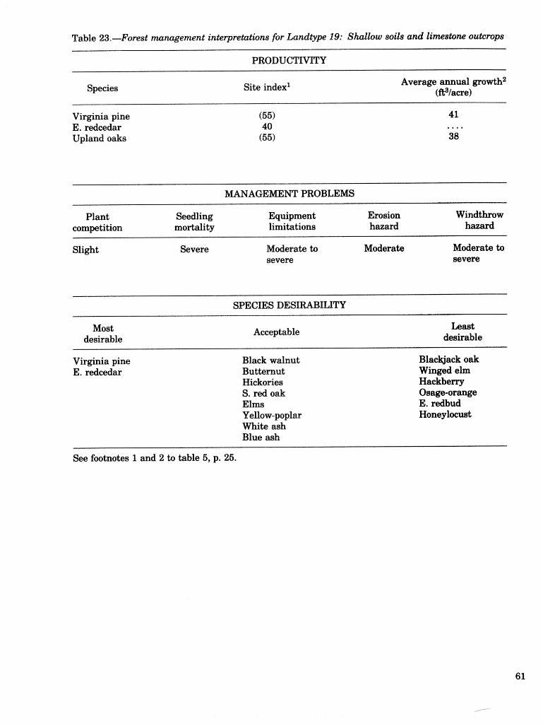
Species Site index1 Average annual growth2 (fi3/awe)
Virginia pine E. redcedar Upland oaks
MNAGEMENT PROBLEMS
Plant Seedling Equipment Erosion Windthrow competition mortality limitations hazard hazard
Slight Severe Mdercate to Moderate Moderate to severe severe
SPECIES DESIRBILRY
Most desirable
Acceptable Least desirable
Virginia pine E. redcedar
Black walnut Butternut Hicko~es S. red oak Elms Y ellow-poplar White ash Blue ash
Blackjack oak Winged elm Hackberry Osage-orange E. redbud Honeylocust
See footnotes 1 and 2 to table 5, p. 25.

Description of Landtype 20: Colluvial Siltstone Slopes
North Aspect Geographic Y egging----Deep, loamy, and $ravel ly
goits srr sfoping do very skep lower two-t;hirds to three-fora&hs of nodh slopes west of the Plat;eau sandstone free face in LTA-D, S-ubre~on 2. The lin- ear do convex sideslopes and concave toeslopes range fmm 2 to 60 percent but are dominantly peat;es than 12 percent, Soils formed. in coarse, Isiamy colluvium wasbed from acid sittsbne and shale of lower Mississippian orien, Landtwe 20 occurs below shale ridges (Larzdtmes 2 and 6) and abwe Lemaees, ~treamlaoddoms, and flood plains (Lrtndtmes f 2 and 13 or 23 and 241, In places, Land- tme 20 occurs between shale ridges and limestone cliE8 (Landtpe 191,
Ddadrmasrrt SOB-Cransbn. Bedrock-Siltstone and shale. Depth (tc, Behock-4 do 20 %It. "kex&e-----Grave1Zy silt loam. The weighted averap
06 pebbles and chanmers of acid siltstone in. the con- trol section is less than 35 percent by volume but may range up to 68 percent in the A and C horizons and up to 45 percent in the B horizon.
ge-Well-drained* i.8 W a k r Supply-Medium to high. y-Moderate,
Vegeta~csn-mite oak, searlet oak, black oak, and hickories; occasional chestnut oak, shodleaf pine, American beech, cucumbertree, yellow-poplar, northern. red oak, while ash, southern red oak, blackgum, red maple, and black locust. Dowood, sassafras, servicebew, soumood, and smilm are common undergksn"(rr species.

Table 24.-Farest m ment ii.k&rpred;.;Etions for %andtype 20: ColEuvial ~hk41 slopes--ns&h aspect
Average annual @o&h2 (R3taere)
N. red oab: Y ellow-poplar
AGEMENT PROBLEMS
Plant Seedling Equipment Erosion Windthrow competition mortality limitations haard hmard
Severe Slight Moderate to Moderate Slight severe to severe
SPECIES DESIRABILITY
Most desirable
Acceptable Least desirable
M i t e oak N. red oak Yellow-poplar m i t e ash
Shordled pine Hickories Chestnut oak Black oak $3. red oak Scarlet oak
American beech Sassafras Black locust Red maple Bllacllrwm D c ~ ~ Q o ~
See footnotes 1 and 2 to table 5, p. 25.

Description of Landtype 21: Colluvial Siltstone Slopes--
South Aspect Geopaph ic Settirmg-Deep, loamy, and gravelly
soils on sloping to very steep lower two-thirds to three-foulrths of south slopes west of the Plateau s a n d s h e fkee face in LTA-D, SubrelJion 2. The lin- ear to convex sideslopes and concave toeslopes range from 2 to 60 percent but are dominantly greater than 12 percent. Soils formsd in coarse, loamy colluvium washed from acid siltstone and shale of lower Mississippian origin. L a n d t m 21 occurs below shale ridges (Landtms 2 and 6) and above terraces, streambottoms, and flood plains (Landtms 12 and 13 or 23 and 24). In places, Land- type 20 occurs between shale ridges and limestone cliffs (Landtype 19).
Dominant Soil-Cranston. Bedrock-Siltstone and shale. Depth to Bedrock-4 to 20 R. Texture-Gravelly silt loam. The weighted average
of pebbles and channers of acid siltstone in the con- trol section is less than 35 percent by volume but may range up to 60 percent in the A and C horizons and up to 45 percent in the B horizon.
Soil Drhage-Well-drained. Relative Soil Water Supply-Medium. Soil Fertility-Moderate. 'Vegetation-White oak, scarlet oak, chestnut oak,
shortleaf pine, and hickories; occasional red maple, northern red oak, scarlet oak, black oak, blackgum, and black locust. Sassafras, dogwood, soumood, serviceberry, and smilax are common understory species.

Table 25 ,Fores t mat m n t interpretations for Landtype 21: Colluvial shale slopes-south aspect
Site index1 Average annual growth2 (R3/acre)
Shortleaf pine Scarlet oak
NIANAGEMENT PROBLEMS
Plant Seedling Equipment Erosion Windthrow competition mortality limitations hazard hazard
Moderate Moderate Moderate to Moderate Slight severe to severe
SPECIES DESIRABILITY
Most desirable
Acceptable Least desirable
Shortleaf pine M i t e oak Chestnut oak Black oak S, red oak
Hickories Black locust N. red oak
Sassafras Red maple Blackgum Dogwood Sourwood
See footnotes 1 and 2 to table 5, p. 25.

Description of Landtype 22: Limestone Ridges and Convex Upper Slopes
Geo~apoEc: Se g-Moderately deep to deep, silty and clayey soils on gently sloping to steep, nanow to modertelly broad crests and convex upper slopes of hills and ridges in Sublre@on 2. Slope ranges up to 60 percent but is dominantly les than 30 percent; aspect does not seem to be an importilnt site factor. Width of ridges range from 300 to 500 R. Landtme 22 occurs occas"romal1y in LTA-C and in the north- western part of LTA-D adjacent to and sometimes irrlemingledl with shallow soils and limestone out- crops (Landtype 19). Colluvial limestone slopes (Landtlypes 17 and 18) occur below Landtype 22 in both landtype associations. In LTA-D, Landtme 22 is often bounded by limestone scliffs (Landtype 191, and shale ridges (Landtypes 2 or 6) may project above the general level of the limestone uplands. Sinkholes oecur in places.
Dorniraant Soil-Caneyville and Hagerstown. Bedrock-Limestone. Depth to Bedrock-20 in to more than 4 ft but
mostly less than 40 in. Textare-Loam, silt loam, and silty clay loam; rock
content is less than 15 percent. %if Drabage-Well-drained. Relative Soil Water Supply-Medium. Deep perco-
lation in karst areas. Soil Feraty-Moderate. Vegetation-White oak, southern red oak, black
oak, hickories, blackgum, and shortleaf pine; occa- sional scarlet ocak, northern red oak, chestnut oak, elms, red maple, Virginia pine, yellow-poplar, black walnut, and whik ash. Domood, soumood, eastern hophornbeam, winged elm, sassafras, vacciniums, wild plum, persimmon, and eastern redbud are com- mon understory species.

Table 26.-Forest ma nent interpretations for Ladtype 22: Linestom ridges and convex: upper slopes
PRODUCTIWTY
Species Site index1 Average annual growtb2 (fi3/8ere)
E. redcedar N. red oak Black oak Scarlet oak Yellow-poplar
MANAGEMENT PROBLEMS
Plant Seedling Equipment Erosion competition mortality limitations hazard
Windthrow hazard
Slight to Slight to Moderate to Moderate Slight moderate moderate severe to severe
SPECIES DESIRABILITY
Most desirable
Acceptable Least desirable
Shortleaf pine Black walnut White oak N, red oak Y ellow-poplar m i t e ash
Virginia pine Hickories Chestnut oak Black oak S. red oak Scarlet oak Elms
E. hophornbeam Winged elm Sassafras E. redbud Red maple Blackgum I~ogwood Sourwood Persimmon
See footnotes 1 and 2 to table 5, p. 25.

Description of Landtype 23: Footslopes, Terraces, and Flood
Plains with Good Drainage g-Deep, loamy, and silky aflu- d internal drainage on level to
strongly sloping footslopes, terraces, and flood plains along the Cumberland and Keducky Rivers and their major tributaries in Subre@o%z 3, Slope ranges from O to 20 percent on fmtalopes and kr- races but is 5 percent or less on flood plains. "rjhis landtme occurs in association with Landtme 24, which has poor internal. drainage,
Soas-Allegheny, Monongahela, Cotaco, , and Elk on. footslopes and bmaees; Cuba,
Steff, Pope, Philo, Huntington, Lindside, and Combs on floor plains,
Parent Matesjid-On tearsraces, soils formed in old silty alluvium, and on flood plains, parent makrial consists of more recent alluvium, Alluvium washed from soils formed in residuum or colluvium weath- ered from acid sandstone, siltstone, shale, and lime- stone.
Depth d&) Behock-3812 to more than 10 fd, Monoa- gahela and Captina soils have fra@pans ad depths ran@ng &om 18 Lo 30 in and 16 da 30 in, respec- tively.
Texture--Silt loam, loam, and fine sandy loam; oeca- sionally sandy loam and silty clay loam, Solurns usually contain less than 35 percent roek fag- ments. C horizons may contain more khan 35 per- cent roek fraggllents or lenses sf r?rl;.avel, En CapGina soils, the lower pa& of the fragipan may eorrtaimrr. try, to 75 percent ched Graeents.
Soil E)rainage-'We1I.-drained to moderately well- drained.
Relative Sea W a b r Supply------High* LOW areas flood oc
Soil -Moderately high to high. Vegetation-Wide oak, s w e e t ~ m , yellow-poplar,
blackgum, elms, red maple, nodhem red oak, river birch, and hickories; occasional American beech, black willow, pin oak, boxelder, bkack oak, Ameri- can sycamore, black walnut, silver maple, southern red oak, shingle oak, soumood, eastem hemlock, Vir@nia pine, shs9Lleaf pine, eastern white pine, persimmon, and sassdras, Dowoods, easkrra red- bud, eastern hsphornabeamf American hornbeam, cane, viburnums, American hazel, sumacs, and e lderbeq are common understom species.

Table 27.-Forest manage interpretations for hnd&p 23: Foo&lops, terraces, and with good dmi
PRODUG
Species Site index1 Average annual ~ f r o l t ~ t h ~ (R3/acre)
E. white pine 86 148 Shortleaf pine 75 136 Virginia pine 75 120 Northern red oak 80 62 Y ellow-poplar 95 98 Sweet 90 81 Sycamore (90) ....
W A G E M E W PROBLEMS
Plant Seedling Equipment Erosion Windthrow competition mortality limitations hazard hazard
Moderate to severe
Slight Slight to Slight moderate
SPECIES DESIRABILITY
Most desirable
Acceptable Least desirable
E. white pine Shortleaf pine Virginia pine Black walnut White oak N. red oak Pin oak Y ellow-poplar Sweetgum American sycamore
Hickories American beech Black oak Southern red oak Shingle oak Elms
E. hemlock River birch American hornbeam E. hophornbeam Sassafras American hazel E. redbud Sumacs Red maple Boxelder Blackgum Dogwoods
Persimmon
See footnotes 1 and 2 to table 5 , p. 25.

Description of Landtype 24: Terraces and Flood Plains
with Poor Drainage Geo~apllzraic: Se g-Deep, lomy, and silty allu-
vial soils with poar internal b i n a g e on level to gently slrzping brraces and flood plains along the Cumberland and Kentucky Rivers and their major tribubries in Subredon 3, Slope is 4 percent or less. This landtme wcurs in association with Landt;ype 23, which has g o d inLerna1 &ainag~.
Dominant Soils-Morehead on tersaces; Stendal, Mkins, Sdokly, Melvin, and Newark on fawd $airas*
Parent Mad;efial-On bmaees, soils fomed in old silty alluvium, and on flood plains, parent m a b ~ a l consists of more recent alluvium. Alluvium washed h m soils fomed in residum or colluvim weath- ered &om acid sandstone, siltstone, shale, and lime- slone.
Depth b Bedrock-5 to 10 ft or more. r\ex&ure-Silt loam, loam, and silty clay loam; oeca-
sionally sancEy loam and fine sandy loam. Coarse f r a p e n t conknt is usually less than 20 percent in the solurn but may range up to 60 percent below 40 in.
Sail Drainage--Somewhat po~brly drained and poorly hained.
Rel&tl;live SO^ Wabr Supply-High to very high. A fluctuating water table is near the surface part of the time, and the landtme is subject to occasional
ty-Moderately high to high. Vegeb16ion-Pin oak, sweetpm, swamp white oak,
red maple, qeen ash, elms, and blackhjum; occa- sional American sycamore, silver maple, shagbark hickory, shellbark hickory, river birch, yellow- poplar, black willow, hackberry, boxelder, and cot- tonwood. Dogvtroods, cane, gasses, sedges, ferns, alder, common poison-ivy, and common trumpet- creeper are common in the understory.

Table 2 8 . h r e s t ma m n t interpretations for hndtype 24: Termes and flood plains with poor drai
S p i e s Site index1 Average annual growth2 (fi3/awe)
Yell ow-poplar Sweet Pin oak
--
AGEMENT PROBLEMS
Plant Seedling Equipment Erosion competition mortality limitations hazard
Windthrow hazard
Moderate to severe
Moderate to Moderat~e to Slight severe severe
Slight
Most desirable
Acceptable Least desirable
E. coetonwood Swamp white oak Pin oak Yellow-poplar Sweet American sycamore Green ash
Shagbark hickory Shellbark hickory Elms Hackberry Red maple
Black willow River birch Silver maple Boxelder Blackem Dogwoods
See footnotes 1 and 2 to table 5, p. 25.

Bailey, H. IT,; Avers, P. E. Classification and compsi- tion of mils fiom mounhin coll Kentucky and their imprdance
Kentucky oils. Mime 308. ity of Kentucky Agricul-
tural Experiment Station; 1964. 174 p. Beck, D. E. Yellow-poplar site index curves. Res.
Nok 180. Asheville, NC: U.S. Department of Agri- culture, Forest Service, Southeastern Forest Exper- iment Station; 1962. 2 p.
Beeman, L. E. Computer-assisted resource manage- ment. In: fiweedings, workshop on integrated in- venbries of renewable natural resowces, 1978 Jan. 8-12; Tucson, AZ. Gen. Tech. Rep, RM-55. Fort Collins, 60: U.S. Department of Agriculture, Forest Service, Rocky Mountain Forest Experiment Station; 1978: 375-381.
Bladen, W. A. The mountains. In: Karan, P. P., ed. Kentucky, a regional geography. Dubuque, IA: KendalllHunt Publishing Co.; 1973: 22-51.
Braun, E. L. Deciduous forests of eastern North America. Philadelphia, PA: The Blakiston Co.; 1950. 596 p.
Broadfoot, VV. M. Field guide for evaluating cotton- wood sites. Occas. Pap, 178. New Orleans, LA: U.S. Department of Agriculture, Forest Service, South- ern Forest Experiment Station; 1960. 6 p.
Broadfoot, W. M.; Krinard, R. M. Guide for evaluating sweetgum sites. Occas. Pap. 176. New Orleans, LA: U.S. Department of Agriculture, Forest Service, Southern Forest Experiment Station; 1959. 6 p.
Bryan, B. A.; Hewlett, J. D. Effect of surface mining on storm flow and peak flow from six small basins in eastern Kentucky. Water Res. Bull. 17: 290-299; 1981.
Byrne, J. G.; Gass, C. R.; Losche, C. K. Relation of forest composition to certain soils in the southern Appalachian Plateau. In: Youngberg, C. T., ed. Forest-soil relationships in North America. Second North American Forest Soils Conference, 1963. Corvallis, OR: Oregon State University Press; 1965: 199-214.
B p e , J. G; Losche, C. K.; Gass, C. R.; Bottrell, G. D.; Avers, P. E.; Long, J. K.; Manhart, L. G. Soil survey of the McCreary-Wlnitley area, Kentucky. Wash- ineon, D, C.: U.S. Department of Agriculture, Soil Conservation Service; 1970. 83 p. + maps.
Camean, W. H. Forest site quality evaluation in the United States. Advances in Agronomy 27: 209-269; 1975.
Carpenter, S. B. Stand structure of a forest in the Cumberland Plateau of eastern Kentucky fifty
r logging and burning. Castanea 41: 325- 336; 1976.
Doolittle, W. T. Yield tables for white pine. (Unpub- lished data adapted from Gevorkiantz, S. R. and R. Zon. Second aovvth white pine in Wisconsin. Res. Bull, 98,1930,40 p.). hheville, NC: U.S. Department of Agriculture, Forest Sewice, Southeastern Forest E x p ~ m e n t Station; 1956. Dwli&;t;le, W. T. Site index comparisons far several forest species in the southern Appalachians, Soil Sci- ence Society of America Proceedings 22: 455-458; 1958. Eigel, R. A.; Blevins, R. L.; Wittwer, R. F.; Liu, C. J. Site index of yellow-poplar in relation to soil and to- pography in eastern Kentucky. In: Muller, R. N., ed. fiweedings, Fourth Central Hardwood Forest Con- ference, 1982 November 8-10. Lexin&on, KY: Uni- versity of Kentucky; 1982: 207-2 19. Fedders, J. M. The vegetation and its relationship with selected soil and site factors of the Spencer-Mor- ton Preserve, Powell County, KY. Richmond, KY: Eastern Kentucky University; M.S. thesis; 1983. 146 P Fenneman, N. M. Physiography of eastern United States. New York, NY: McGraw-Hill Book Co.; 1938. 714 p. Fernald, M. L. Gray's manual of botany. 8th ed. New York, NY: American Book Co.; 1950. 1,632 p. Franzmeier, D. P.; Pederson, E. J.; Longwell, T. J.; Byme, J. G.; Losche, C. K. Properties of some soils in the Cumberland Plateau as related to slope, aspect, and position. Soil Science Society of America Proceed- ings 33: 755-761; 1969. Hayes, R. A. Soil Survey of Leslie and Perry Counties, Kentucky. Washington, DC: U.S. Department of Agriculture, Soil Conservation Service; 1982. 69 p. + maps. Herman, T.; See, M. G. Secondary succession follow- ing fire in "Tight Holler," Kentucky. Castanea 38: 275-285; 1973. Honeycutt, C. W.; Blevins, R. L.; Wittwer, R. F. Growth of white oak (Quercus aZba L.) in relation to soil and site properties in eastern Kentucky. In: Muller, R. N., ed. Proceedings, Fourth Central Hard- wood Forest Conference, 1982 November 8-10, Lex- ington, KY: University of Kentucky; 1982: 193-206. Hutehins, R. B.; Blevins, 18. L.; Hill, J. D.; White, E. H. The influence of soils and microclimate on vegetation of forested slopes in eastern Kentucky. Soil Science 121: 234-241; 1976. Kingsley, N. P.; Powell, D. S, The forest resources of Kentucky. Resour. Bull. NE-54. Broomall, PA: U.S. Depastment of Aaiculture, Forest Service, North- eastern Forest Experiment Station; 1978. 97 p. Lee, R.; Sypolt, C. R. Toward a biophysical evaluation of forest site potential. Forest Science 20: 145-154; 1974. Little, E. L., Jr. Checklist of United States trees (na-

tive and naturalized), Agric. Handb. 541. Washing- ton, DC: U.S. Department of Agriculture, Forest Service; 1979. 375 p,
McCarthy, E. F. Yellow-poplar characteristics, growh, and management. Tech. Bull. No. 356. Washinmn, DC: U.S. Department of Agricultme; 1933.58 p.
McComb, W. C, Forestv and wildlife habitat manage- ment in central hardwoods. Journal of Fores- 80: 490492; 1982.
McDowell, R. 6.; Grabwski, G, J., Jr.; Moore, S. L. Geologic map of Kentucky. Lexington, KY: U.S. Ge- olodcal Survey in cmperation with Kentucky Geo- logical Survey; 1981. Scale 1:250,000.
McFarlan, A. C. Geology of Kentucky. Baltimore, MD: Waverly Press; 1943. 531 p.
Martin, VV. H. The Lilley Cornett Woods: A stable mixed mesophytic forest in Kentucky. Bot. Gaz. 136: 171-183; 1975.
Muller, R. N. Vegetation patterns in the mixed meso- phytic forests of eastern Kentucky. Ecology 63: 1901-1917; 1982.
Muller, R. N. Forest regrowth on the Cumberland Plateau and implications for productive manage- ment. South. J. Appl. For. 7: 208-212; 1983.
Nelson, T. C.; Clutter, J. L.; Chaiken, L. E. Yield of Virginia pine. Stn. Pap. 124. Asheville, NC: U.S. Department of Agriculture, Forest Service, South- eastern Forest Experiment Station; 1961. 11 p.
Newton, J. H.; Hail, C. W.; Leathers, T. R.; Love, P. M.; Stapp, J. G.; Vaught, V.; Avers, P. E. Soil survey of Estill and Lee Counties, Kentucky. Wash- ington, DC: U.S. Department of Agriculture, Soil Conservation Service; 1974. 87 p. + maps.
Romme, W. H.; Martin, W. H. Natural disturbances by tree falls in old-growth mixed mesophytic forest: Lilley Cornett Woods, Kentucky. In: Muller, R. N., ed. Proceedings, Fourth Central Hardwood Forest Conference, 1982 November 8-10. Lexington, KY: University of Kentucky; 1982: 367-383.
Ross, J. 6.; Johnson, A. S.; Avers, P. E. Soil survey of Laurel and Rockcastle Counties, Kentucky. Wash- ington, DC: U.S. Department of Agriculture, Soil Conservation Service; 1981. 95 p. + maps.
Safley, J . M., Jr. Vegetation of the Big South Fork, Cumberland River, Kentucky and Tennessee. Knoxville, TN: University of Tennessee; 1970. 148 p, M.S. thesis.
Schnur, G, L. Yield, stand, and volume tables for even-aged upland oak forests. Tech. Bull. 560. Wgshington, DC: U.S. Department of Agriculture; 1937 (reprinted 1961). 87 p.
Smalley, G. W. Classification and evaluation of forest sites in the Interior Uplands. In: Pope, P. E., ed. Proceedings, 2nd Central Hardwood Forest Confer- ence, 1978 November 14-16. West Lafayette, IN: Pwdue University; 1978: Addendum, 1-20.
Smalley, G. VV. Classification and evaluation of forest sites for timber produetion: Introduction of a new system for classifj.ing forest sites b ical features of the landscape. In:
lity workshop; 1979 May 8-9. Auburn, AL: University; 1979a: 2847.
Smrtlley, @. W. Cl~~ssifieationn a d eva1aatim of fore& sites on the southern Cumbrland Plateau. Gen. Tech. Rep. SO-23. New Orleans, LA: U.S. Depart- ment of Agriculture, Forest Service, Southern Forest Experiment Station; 197923. 59 p.
Smalley, G. W. Classification and evaluation of forest sites on the western Highland Rim and Pennyroyal. Gen. Tech. Rep. 50-30. New Orleans, LA: U.S. De- partment of Agricultwe, Forest Service, Southern Forest Experiment Station; 1980. 120 p.
Smalley, G. W, Classification and evaluation of forest sites on the Mid-Cumberland Plateau. Gen. Tech. Rep. SO-38. New Orleans, LA: U.S. Department of Agriculture, Forest Service, Southern Forest Ex- periment Station; 1982. 58 p.
Smalley, G. VV. Classification and evaluation of forest sites on the eastern Highland Rim and Pennyroyal. e n . Tech. Rep. SO-43. New Orleans, LA: U.S. De- partment of Agriculture, Forest Service, Southern Forest Experiment Station; 1983. 123 p.
Smalley, G. W. Landforms: A practical basis for clas- sifying forest sites in the Interior Uplands. In: Pro- ceedings, 12th Annual Hardwood Symposium, Hardwood Research Council, Cashiers, NC; 1984 May 8-11. Asheville, NC: Hardwood Research Council: 92-112; 1984a.
Smalley, G. W. Classification and evaluation of forest sites in the Cumberland Mountains, Gen. Tech. Rep. SO-50. New Orleans, LA: U.S. Department of Agriculture, Forest Service, Southern Forest Ex- periment Station; 198413. 84 p.
Soil Conservation Service. General soil map, Ken- tucky. Lexington, KY: U.S. Department of Agricul- ture, Soil Conservation Service in cooperation with the Kentucky Agricultural Experiment Station and Division of Conservation, Department of Natural Etesources and Environmental Protection; 1975. Scale 1:750,000.
Soil Survey Staff. Soil survey manual. Agric. Handb. 18. Washington, DC: U.S. Department of Agricultwe, Soil Conservation Service; 1951.503 p.
Soil Survey Staff. Soil taxonomy: A basic system of soil classification for making and inteqreting soil surveys. Agric. Handb. 436. Washington, DC: U.S. Department of Agriculture, Soil Conservation Ser- vice; 1975. 754 p.
Springer, M. E.; Elder, J. A. Soils of Tennessee. Agric. Exp. Bull. 596. Knoxville, TN: University of Ten- nessee Agricultural Experiment Station; 1980. 66 p + map.
Staff of Renewable Resources Evaluation Research

Work Unit. Forest statistics from plateau Tennes- see counties, haour. Bull. SO-80. New Orleans, LA: U.S. Department of Aaicultwe, Forest Ser- vice, Southem Forest; Experiment Station; 1982. 21 p.
Swingle, 6. I).; Miller, R. A,; Luther, E. T.; H d e - m a , W . D.; Fdlehn, D. S.; Sykes, C. a,; Gaman,
logy map of Temessee, east-central sheet. Nashville, TN: Tennessee Division of k l - ow; 1966. Scale 1:260,008.
mornthwaite, 6. W. An appmach toward a rational classification of climate. G-eographical Review 38: 55-94; 1948.
nimble, G. R., Jr.; Patric, J. H.; Gill, d. 13.; Moeller, G. H.; Kochendeder, J. N. Some options for manag- ing forest land in the Central Appalachians. Gen. Tech. Rep. NE-12. Upper Darby, PA: U.S. Depafi- ment of Agriculture, Forest Service, Nodheastern Forest Experiment Station; 1974. 42 p.
U.S. Departnnent of Agricultwe. Climate and man. Yearbook of agriculture. House Document No. 27, 77th Congress, 1st Session. Washington, DC : U.S. Government Printing Oflice; 1941. 1,248 p.
U.S. Department of Commerce. Climatolo@cal data, Kentucky annual summary 7 1 (13). Asheville, NC: U.S. Department of Commerce; 1976. 14 p.
US. Forest %mice, Volume, yield, and stand tables for second-growth southern pines. Misc. Pub. No. 50. Washington, DC: U.S. Bepawen t of A p i - culture, Forest Service; 1929 (slightly revised 1976). 202 p.
'fiogiel, W. G. A guide for revegetating coal mine spoils in the eastern United States, Gene Tech, Rep, HE- 68. Broomall, PA: U.S. Department of Apiculture, Forest Semice, Northeastern Forest Experiment Station; 1981, 190 p,
Ware, S. Polar ordination of Braurn%% mixed meso- phflic forest, Casttanea 4 2 4003-407; 11982,
We&z, W. A,; Amold, J. F, Land stratification for land-use planning. In: Bernier, B,; Winget, 6, H,, eds. Porest soils and forest l a d management, Que- bec Ci&, Quebec: Les Presses de I'Universite Laval; 1975: 697-729.
Winstead, J. E.; Nicely, K. A. A preliminary study of a vir@n forest tract of the Cumberland Plateau in Laurel County, Kentucky. Trans. Ky. Aead. Sci. 37: 29-32; 1976,
Winters, R. K.; Osborne, J. 6. GroWh and yield of second-grovsrl;h redwm in fully stocked stands on alluvial lands in the South. Oecas. Pap, 54. New Orleans, LA: U.S. Department of Agriculture, Forest Service, Southern. Forest Experiment Sta- tion; 1935. 12 p.
APPENDIX
COUNTY SOIL SURVEYS AVAILABLE FOR THE NORTHERN CUMBERLAND PLATEAU
*Avers, P. E.; Austin, J. S.; Long, J. K.; Love, P. Me; Hail, C. W. Soil survey of Menifee and Rowan Coun- ties and Northweshm Morgan County, Kentucky. Washington, DC: U.S. Depadment of Agriculture, Soil Conservation Service; 1974. 88 p. + maps.
*Byme, J. G.; Losche, C. K.; Gass, C. R.; Bottrell, G. D.; Avers, P. E.; Long, J. K,; Manhart, L, 6.. Soil survey of the McCreary-Witley area, Kentucky. Washingtan, DC: U.S. Department of Ae;riculture, Soil Conservation Service; 19'70. 83 p, + maps.
*Hayes, R. A. Soil survey of Leslie and Pemy Coun- ties, Kentucky. Washington, DC: U.S. Department of Agriculture, Soil Conservation Service; 1982. 69 p. + maps.
McDonald, H. P.; Blevins, R. L. Reconnaissance soil survey of fourteen counties in eastern Kentucky.
Soil Consem. Serv. Series 1962, No. 1. Washington, DC: U.S. Depastment of Apiculture, Soil Conser- vation Service; 1965. 72 p. + maps.
"Nevvton, J. El.; Hail, C. W.; Leathers, I\, R,; Love, I?. M.; Stapp, J. G.; Vaught, V.; Avers, P. E. Soil suwey o f Estill and Lee Counties, Kentucky. Wash- in@on, DC: U.S. Depadment of Agriculture, Soil Consernation Sewice; 1974, 87 g. + maps.
"Ross, J, 6. Soil suvliey of Putaski County, Kentucky, Washington, DC: U.S. Department of Agieulture, Soil Conservation Service; 19M4. 121 p. + maps.
"Ross, J. C.; Johnson, A. S.; Avers, I". E. Soil survey of Laurel and Rockcastle Counties, Kentucky. Wash- ington, DC: U.S. Department of Agriculture, Soil Conservation Sewice; 1981. 95 p, -+ maps,

METRIC EQUIVALENTS
1 inch = 2.54 centimeters (exactly)
1 foot -: 0.3048 meter (exactly)
1 acre = 0.4047 hectare
1 square footlaere =. 0.2296 square meterheetare
I. cubic foot/iicre =. 0.86991 cubic meter/%ectare
I mile = 1,6093 kiIometers
1 square mile == 2.5900 square kilometers
'6 ==: ("F-32111.8

Smalley, Glendon W. 1986 Classification and evaluation of forest sites on the Northern Cumberland Plateau. U.S. Dep. Agric. For. Serv. Gen. Tech. Rep. SQ-6OS 74 p.
Presents a comprehensive forest site classification system for the North- ern Cumberland Plateau in north-central Tennessee and eastern Ken- tucky. The system is based on physiography, geology, soils, topography, and vegetation.
Additional keywords: Site index, mean annual increment, soil proper- ties, pines, hardwoods.
drU.S. G O m M E N T PRINTING OFFICE: 198 6 -6 59 - 0 8 (3 4 O 0 2 1 REGION NO. 4