Universitystudentsrepo.um.edu.my/9663/6/A_study_of_Fajr_and_Isha...A STUDY OF FAJR AND ISHA PRAYER...
74
A STUDY OF FAJR AND ISHA PRAYER TIMES AT HIGH LATITUDE REGIONS BETWEEN 48° TO 67° SITI ASMA’ BT MOHD NOR FACULTY OF SCIENCE UNIVERSITY OF MALAYA KUALA LUMPUR 2016 University of Malaya
Transcript of Universitystudentsrepo.um.edu.my/9663/6/A_study_of_Fajr_and_Isha...A STUDY OF FAJR AND ISHA PRAYER...
A STUDY OF FAJR AND ISHA PRAYER TIMES AT HIGH LATITUDE REGIONS BETWEEN 48° TO 67°
SITI ASMA’ BT MOHD NOR
FACULTY OF SCIENCE
UNIVERSITY OF MALAYA KUALA LUMPUR
2016Univ
ersity
of M
alaya
A STUDY OF FAJR AND ISHA PRAYER TIMES AT HIGH LATITUDE REGIONS BETWEEN 48° TO 67°
SITI ASMA’ BT MOHD NOR
[THESIS] SUBMITTED IN [FULFILMENT] OF THE
REQUIREMENTS FOR THE DEGREE OF [MASTER IN SCIENCE]
FACULTY OF SCIENCE UNIVERSITY OF MALAYA
KUALA LUMPUR
2016 Univers
ity of
Mala
ya
ii
UNIVERSITY OF MALAYA
ORIGINAL LITERARY WORK DECLARATION
Name of Candidate: SITI ASMA BT MOHD NOR
I.C/Passport No:
Matric No: SGR100119
Name of Degree: MASTER OF SCIENCE
Title of Project Paper/Research Report/Dissertation/Thesis (“this Work”):
A STUDY OF FAJR AND ISHA PRAYER TIMES AT HIGH LATITUDE
REGIONS BETWEEN 48° TO 67°
Field of Study: ASTRONOMY
I do solemnly and sincerely declare that:
(1) I am the sole author/writer of this Work; (2) This Work is original; (3) Any use of any work in which copyright exists was done by way of fair
dealing and for permitted purposes and any excerpt or extract from, or reference to or reproduction of any copyright work has been disclosed expressly and sufficiently and the title of the Work and its authorship have been acknowledged in this Work;
(4) I do not have any actual knowledge nor do I ought reasonably to know that the making of this work constitutes an infringement of any copyright work;
(5) I hereby assign all and every rights in the copyright to this Work to the University of Malaya (“UM”), who henceforth shall be owner of the copyright in this Work and that any reproduction or use in any form or by any means whatsoever is prohibited without the written consent of UM having been first had and obtained;
(6) I am fully aware that if in the course of making this Work I have infringed any copyright whether intentionally or otherwise, I may be subject to legal action or any other action as may be determined by UM.
Candidate‟s Signature Date:
Subscribed and solemnly declared before,
Witness‟s Signature Date:
Name:
Designation:
Univers
ity of
Mala
ya
iii
ABSTRACT
Study of prayer times was done at selected high latitude regions. Research is
focusing on the night prayer times which is Subh and Isha Prayer times. Study included
selected cities locate at 48°N until 67°N latitude. Studies is to ensure the existing way to
determine the prayer times at high latitude regions (higher than 48°) can be adopted or
need to be adjusted to the alternative way. Thus the existence alternative ways which
are nearest latitude, nearest day, middle of night and seventh part of night been discuss
in physic perspective. Research is focusing on the standardizing the alternative way.
Research covers the perspective of physic (astronomical view) which explains that
abnormality in these regions by focusing in the sun‟s altitude. The method used in this
research is by using prayer time software Accurate Times and astronomical software
which is The Sky Sixth. The used of this software is to simulate prayer time and
simulate the sun path. The sun altitude pattern then is analyzed to see the effect of the
latitude to the starting of the astronomical twilight and starting of Subh and Isha prayer
times.
Research finding shows that for cities locate at 48°N until 51°N still could determine
starting of Fajr and Isha prayer times by using Accurate Time software. For cities locate
above than 51°N until 65° latitude where prayer times undetermined by compute the
software thus need to be calculate by alternative way. Research found that by dividing
the night by two gives the prayer time start late but gives the more time for the sun to go
deeper below horizon where it is most fitted the requirement of fiqh. The changing
pattern in the sun‟s altitude will shift the times of prayer.
Univers
ity of
Mala
ya
iv
ABSTRAK
Kajian waktu solat telah dilakukan di kawasan-kawasan latitud tinggi terpilih.
Penyelidikan menumpukan pada waktu solat malam iaini Subuh dan Isyak. Kajian telah
memilih beberapa bandar yang terletak pada 48 °U hingga 67 °U latitud. Kajian
dilakukan adalah untuk memastikan cara yang sedia ada untuk menentukan waktu solat
di kawasan latitud tinggi (lebih tinggi daripada 48 °) boleh diguna pakai atau perlu
disesuaikan dengan cara alternatif. Justeru itu perbincangan ke atas cara alternatif dalam
aspek fizik ini telah dilakukan termasuk penggunaan waktu solat di latitud berhampiran,
penggunaan waktu solat di hari berhampiran, pembahagian malam kepada separuh
malam dan pembahagian malam kepada tujuh bahagian. Satu garis panduan harus
ditentukan dalam menentukan cara alternatif yang sedia ada. Kajian meliputi dari sudut
fizik (pandangan astronomi) bagi kawasan-kawasan yang mengalami keadaan tidak
normal ini dengan memberi tumpuan dalam ciri ketinggian matahari. Perubahan corak
dalam ketinggian matahari berubah mengikut latitud. Kaedah yang digunakan dalam
kajian ini adalah dengan menggunakan perisian waktu solat iaitu Accurate Times dan
perisian astronomi yang The Sky Sixth. Tujuan digunakan perisian ini adalah untuk
mensimulasikan waktu solat dan simulasi pergerakan matahari. Perubahan ketinggian
matahari kemudian dianalisis untuk melihat kesan latitud kepada permulaan senja
astronomi dan permulaan dan Subuh Isyak waktu solat.
Dapatan kajian menunjukkan bahawa untuk bandar-bandar pada garis lintang 48 ° U
hingga 51 ° U masih boleh menentukan permulaan Subuh dan Isyak dengan
menggunakan Accurate Times. Untuk bandar-bandar di atas daripada 51 ° U hingga 65
° latitud di mana waktu solat tidak dapat ditentukan dengan menggunakan perisian itu
perlu mengira dengan cara alternatif. Penyelidikan mendapati bahawa dengan
membahagikan malam itu dengan dua bahagian akan menghasilkan masa solat bermula
Univers
ity of
Mala
ya
v
lewat tetapi memberikan lebih banyak masa untuk matahari untuk pergi lebih rendah di
bawah garis ufuk di mana ia memenuhi fiqah.
Univers
ity of
Mala
ya
vi
ACKNOWLEDGEMENTS
Praise to Allah and for the Prophet Muhammad for giving me the strength, ability,
health, and enough time, in addition the maturity of mind to complete this study in such
a way. Thank you, to my supervisor Professor Dato‟ Dr. Mohd Zambri Zainuddin and
Dr Nazhatul Shima from Department of Physic from Faculty of Science for such a big
help, guidance, admonition and advice so useful throughout the study.
I would also like to extend my thanks to Syed Ali Al-Atas for helping me to translate
and understand most of the references in Arabic. Thank you for Mohd Hanis Mohd Nor
for helping my field research in Kelantan and Terengganu.
Great appreciations for my mother, my father and my husband since their love are my
strength to complete this study. I also extend my acknowledgments to my family
members that give me support to complete my research. The same applies to all those
involved in helping me to complete the study.
Univers
ity of
Mala
ya
vii
TABLE OF CONTENTS
Abstract ............................................................................................................................ iii
Abstrak ............................................................................................................................. iv
Acknowledgements .......................................................................................................... vi
Table of Contents ............................................................................................................ vii
List of Figures ................................................................................................................... x
List of Tables.................................................................................................................... xi
List of Symbols and Abbreviations ................................................................................. xii
List of Appendices ......................................................................................................... xiii
CHAPTER 1
1.0 Introduction.............................................................................................................. 1
1.1 Problem Statement ................................................................................................... 5
1.2 Significance of Study ............................................................................................... 6
1.3 Objectives ................................................................................................................ 7
1.4 Scope/Limitation of Study ....................................................................................... 8
1.5 Methodology ............................................................................................................ 9
CHAPTER 2: LITERATURE REVIEW .................................................................... 10
2.0:Introduction ............................................................................................................... 10
2.1: Twilight ................................................................................................................... 10
2.1.1 Civil Twilight ........................................................................................... 11
2.1.2 Nautical Twilight ...................................................................................... 12
2.1.3 Astronomical Twilight ............................................................................. 12
2.1.4 Effect of Latitude on Twilight .................................................................. 13
Univers
ity of
Mala
ya
viii
2.2: Prayer Times as in Astronomical View ................................................................... 15
2.2.1 Subh Prayer Time ..................................................................................... 16
2.2.2 Zuhr Prayer Time ..................................................................................... 16
2.2.3 Asr Prayer Time ....................................................................................... 18
2.2.4 Length of Shadow at Sun Transit,X ......................................................... 19
2.2.5 Angle of Sun at Asr Prayer Times ............................................................ 22
2.2.6 Maghrib Prayer Time ............................................................................... 23
2.2.7 Isha Prayer Time ...................................................................................... 25
2.3: Latitude .................................................................................................................. 26
2.4: Previous Studies ...................................................................................................... 27
2.5: Description on the Software ..................................................................................... 28
CHAPTER 3: METHODOLOGY ............................................................................... 30
3.0: Introduction ............................................................................................................. 30
3.1: Description on Accurate Times ............................................................................... 31
3.2: Description on The Sky Sixth software .................................................................. 32
3.3: Determination of prayer times by using the Accurate Time software .................... 32
3.4: Sun calculation ......................................................................................................... 35
CHAPTER 4: RESULT AND ANALYSIS ................................................................. 38
4.0: Introduction ............................................................................................................. 38
4.1: Time of Data Taken ................................................................................................. 39
4.2: Latitude of Studies ................................................................................................... 39
4.3: Duration of Day and Night on Summer 2012 .......................................................... 40
4.3.0: Determination of Fajr and Isha During Summer 2012 ................................ 44
4.4: Duration of Day and Night on Winter 2012 ............................................................ 48
4.4.0: Determination of Fajr and Isha During Winter 2012 .................................. 50
4.4.1: Effect of Latitude and Longitude on Prayer Times ..................................... 52
Univers
ity of
Mala
ya
ix
CHAPTER 5: RECOMMENDATION AND CONCLUSION ................................. 54
5.0: Introduction .............................................................................................................. 54
5.1: Conclusion on Factors in Determination of Night Prayer ....................................... 54
5.2: Conclusion on Implementing the Alternative Way in Starting Night Prayer .......... 55
5.3: Recommendation ..................................................................................................... 57
References ....................................................................................................................... 59
List of Publications and Papers Presented ...................................................................... 60
Appendix ......................................................................................................................... 61
Univers
ity of
Mala
ya
x
LIST OF FIGURES
Figure 2.0: Description on twilight ................................................................................ 11
Figure 2.1: Diagram on the maximum sun rays on Equinox and summer solstice ........ 14
Figure 2.2: Diagram of the sun position slip to the west ............................................... 17
Figure 2.3: Position of the sun slip and transit ............................................................... 17
Figure 2.4: Diagram of the sun during transit and zenith .............................................. 18
Figure 2.5: Diagram of the shadow when Asr prayer begin .......................................... 19
Figure 2.6: Length of the shadow during the sun‟s transit, X ........................................ 20
Figure 2.7: Position of the observer at O in the System Sphere Celestial ..................... 20
Figure 2.8: Diagram of Sun altitudes at Asr Prayer Time.............................................. 22
Figure 2.9: Diagram of sun position when Maghrib prayer time begins ....................... 23
Figure 2.10: Diagram of the sun position is at 18° below the horizon .......................... 25
Figure 3.0: Diagram of the components in Accurate Times. ......................................... 31
Figure 3.1: Flow process for assigning input ................................................................. 33
Figure 4.0: Graph of Duration of Day and Night vs Latitude on 21st June 2012 ........... 41
Figure 4.1: Sun path on 21st June 2012 at Rovaneimi,Finland (66°N) .......................... 42
Figure 4.2: Graph of Duration of Night and Day vs Latitude on
21st December 2012........................................................................................................ 49
Figure 4.3: Graph of Fajr and Isha / Sunrise and Sunset vs Latitude at winter ............. 50
Univers
ity of
Mala
ya
xi
LIST OF TABLES
Table 1.0: Solar depression angle for beginning of Fajr and Isha according to the various convention ............................................................................................................ 2
Table 2.0: Twilight angle ................................................................................................ 11
Table 4.0: Latitude of Cities‟ studies .............................................................................. 39
Table 4.1:Duration of day and night on 21st June 2012 .................................................. 40
Table 4.2: Table of Fajr and Isha times on 21st June 2012 for cities‟ of studies............. 45
Table 4.3:Duration of day and night on 21st December 2012 ......................................... 48
Table 4.4: Prayer times of Fajr and Isha at 21st December 2012 .................................... 51
Table 5.0: Sun altitude for Fajr and Isha by using Seventh part of night and Middle of night method ................................................................................................................... 57
Univers
ity of
Mala
ya
xii
List of Symbols and Abbreviations
δ : Delta
° : Degree sign
λ : lamda
ϕ : phi
θ : theta
α : alpha
± : plus minus sign
sin : sin function
cos : cos function
tan : tan function
Sin-1 : Sin inverse function
Cos-1 : Cos inverse function
Univers
ity of
Mala
ya

xiii
Univers
ity of
Mala
ya
1
CHAPTER 1
1.0 Introduction
For Muslims, it is obligatory to perform prayers five times per day. Five times
prayers are known as Subh (Fajr prayer), Zuhr (Midday prayer), Asr (Evening prayer),
Maghreb (Sunset prayer) and Isha (Night prayer). Fajr prayer is the prayer that must be
performed when the sky begins to lighten, sometime before the sun itself appears. Zuhr
prayer is performed when the sun appears in its highest position in the sky during its
journey from sunrise to sunset. There are two opinions that define Zuhr prayer which
are Shia and Sunni. In Shia opinion, Zuhr prayer starts once the sun has crossed the
celestial meridian called true noon. This is when the sun is at the highest point in the
sky. The difference in Sunni opinion is that when the sun is transit after reach its highest
point.
Meanwhile, Asr prayer is also defined differently by the two main Islamic sects.
According to Sunni point of view, Asr prayer begins when the length of any object‟s
shadow equals the length or twice the length of the object itself plus the length of that
object‟s shadow at noon. In Shia, there is a different point of view for determining the
Asr prayer time. The Asr prayer begins when the Zuhr prayer has been recited.
Univers
ity of
Mala
ya
2
Maghrib prayer is performed when the redness in the eastern sky appears after sunset
has passed over the head. Sunset is defined as the disappearance of the sun below the
horizon. Lastly, Isha prayer is the time at which darkness falls and there is no scattered
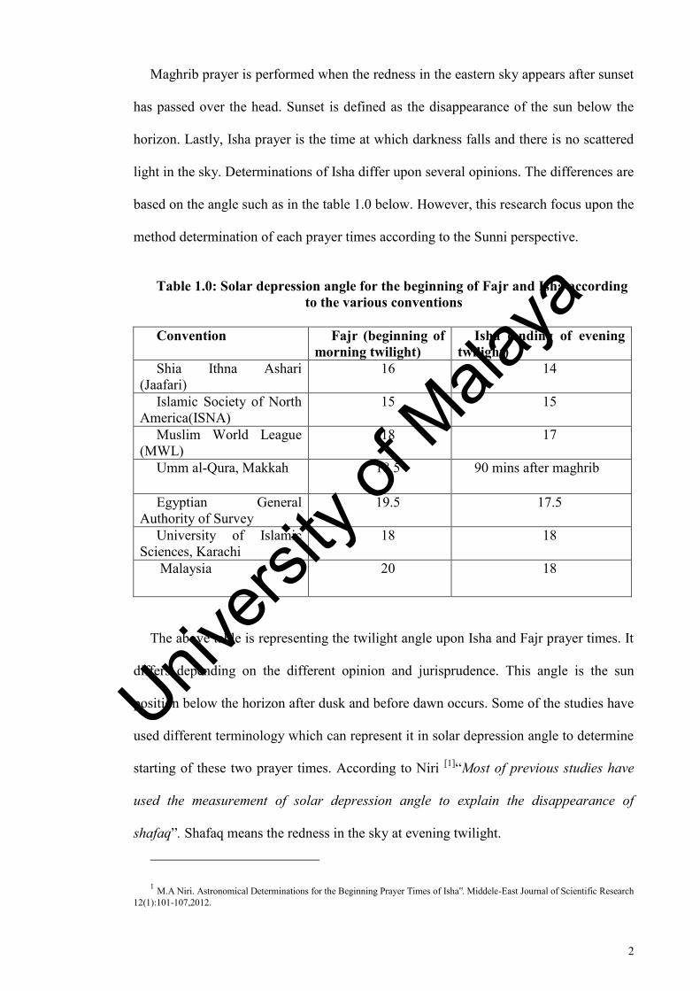
light in the sky. Determinations of Isha differ upon several opinions. The differences are
based on the angle such as in the table 1.0 below. However, this research focus upon the
method determination of each prayer times according to the Sunni perspective.
Table 1.0: Solar depression angle for the beginning of Fajr and Isha according to the various conventions
Convention Fajr (beginning of morning twilight)
Isha (ending of evening twilight)
Shia Ithna Ashari (Jaafari)
16 14
Islamic Society of North America(ISNA)
15 15
Muslim World League (MWL)
18 17
Umm al-Qura, Makkah 18.5 90 mins after maghrib
Egyptian General Authority of Survey
19.5 17.5
University of Islamic Sciences, Karachi
18 18
Malaysia 20 18
The above table is representing the twilight angle upon Isha and Fajr prayer times. It
differs depending on the different opinion and jurisprudence. This angle is the sun
position below the horizon after dusk and before dawn occurs. Some of the studies have
used different terminology which can represent it in solar depression angle to determine
starting of these two prayer times. According to Niri [1]“Most of previous studies have
used the measurement of solar depression angle to explain the disappearance of
shafaq”. Shafaq means the redness in the sky at evening twilight.
1 M.A Niri. Astronomical Determinations for the Beginning Prayer Times of Isha‟. Middele-East Journal of Scientific Research 12(1):101-107,2012.
Univers
ity of
Mala
ya

3
To calculate the prayer times for the regions that included in the study, some of the
parameters needed are latitude (ϕ), local time zone, the longitude (λ) of the location
studies, equation of time (EqT) and declination of the sun (δ). The equation of time is
the difference between time as read from a sundial and a clock. While the declination of
the sun represents the angle between the rays of the sun and the plane of the equator.
Zuhr time can be obtained through the calculation below:
Zuhr=12+Time Zone-
Asr time can be obtained by using the following equation:
Asr(k)=
From the Asr equation, k represents the times of the length of the object. As
mentioned in the definition of the Asr time above, there are two opinions on how to
calculate it. The majority of the schools say it is at the time when the length of the
object‟s shadow equals the length of the object itself plus the length of the object‟s
shadow at noon. Only the Hanafi school of thought defined it as the length of any
object‟s shadow is twice the length of the object plus the length of the object‟s shadow
at noon. Thus the Asr time could be determined as in below equation:
Standard thought;
Asr=Zuhr+A(1)
When substitute the k is equal to 1
Hanafi‟s thought;
Univers
ity of
Mala
ya

4
Asr= Zuhr+A(2)
When substitute the k is equal to 2
While Maghreb time can be obtained by considering two points of view which are
Sunni‟s and Ja‟fary‟s (Shia). For Sunni, Maghreb is equal to sunset where the prayer
time begins once the sun has completely set beneath the horizon while for Shia, it
begins when the redness in the eastern sky passes overhead by assumed a twilight angle
as equal to four.
The equation below is how to get the beginning time for Maghreb from the opinion
in Shia.
Maghreb=Zuhr+T(4)
Where T is represented as the twilight angle.
In the regions of higher latitude, twilight may persist throughout the night during
some months of the year. To overcome this abnormal period in determination of Isha
and Fajr prayer times, some modifications are needed on the formulas mentioned. In
this study, the proposed solutions are by calculating the period of day and night for
regions that include in the abnormality. The period from sunset to sunrise is divided into
two halves. The first half will be considered as day and the other half will be night. Fajr
and Isha in this method are assumed to be at the midnight during this abnormal period.
In Muslim countries, the prayer times will usually be announced through Athan that
comes from mosque nearby. Unfortunately, in Non-Muslim countries, there is no call
for Athan coming from the mosque. Thus, Muslims who live in such countries need the
Univers
ity of
Mala
ya
5
prayer time table to alert themselves for the prayer times. It is common for those
Muslims who live in regions of higher latitude use the prayer time table of the nearby
cities which are situated at the normal latitude which is below 48°.
Generally, this prayer time table is not precise enough to be used by the residents
living in countries located in latitude between 48° and above up to the Arctic Circle. So,
this study will come up with an alternative solution to calculate prayer times in these
regions by using the software that needs some modification which is explained further
in the methodology.
1.1 Problem statements
Previous studies have proved that there is no standard and accurate method to
determine prayer times at high latitude areas (latitude higher than 48°). Thus, this
research is to improve the prayer times table that have less disadvantages compared to
the existing method. Muslims living in these areas (latitude higher than 48°) have
difficulties to perform prayer in precise (fixed) time. [2] „In some Muslim countries and
in most Non-Muslim countries, the above-mentioned tables are just for big and major
cities and villages in non-Muslim countries don’t have that’s. ’ (Aghighi, 2008). So, the
residents living in these areas need to refer to prayer times used by nearby countries.
This matter will lead to late performing of the prayers by Muslims living in these areas.
2 Aghighi, H. & Alimohammadi, A. & Ghahareh, M.S. 2008. Prayer Times Modeling With GIS: A Case Study for Iran and Its Surrounding. Journal of Computer Science 4 (10): 807-814.
Univers
ity of
Mala
ya
6
It absolutely contradicts the Muslims‟ belief where it is stated in Holy Quran (4:103)
to perform the prayer on stated times (precise). Allah most High says: Then there
succeeded them a generation which neglected prayers and followed lusts. They will
meet with destruction (Ghayy), except the one who repents and believes and acts
righteously. (Quran 19:59-60) And Ibn Abbas (RAA) explained that it does not mean
that they completely abandoned prayers, but that they delayed them to the end of their
prescribed times.
1.2 Significance of study
The importance of this research is to provide scientific documentation on the most
appropriate method to determine the prayer times in areas having the latitude higher
than 48°. Abnormality occurs in the regions which are beyond the 48°. The duration of
the night and day is not equal. It occurs during winter and summer seasons where day
time is longer during summer and the night time is longer than the day time during the
winter. In the astronomical terminology, it can be explained as [3]“The solstice is an
astronomical event that occurs twice each year as the sun reaches its highest or lowest
excursion relative to the celestial equator on the celestial sphere. On the day of the
solstice, the sun appears to have reached its highest or lowest annual altitude in the sky
above the horizon at local solar noon”. Thus, some modification should be made to
standardize the time which is called daylight saving time. This study will lead to
improve the knowledge about this abnormality that happens in these regions.
3 Philip&Deborah Scherrer. Solstice and Equinox(“Suntrack”)Model,page3. http://solar-center.stanford.edu/AO/Sun-Track-Model.pdf
Univers
ity of
Mala
ya
7
Furthermore, the study of twilight is also looked at in this research because the regions
situated beyond 48° have different phenomenon of twilight. The definition of dawn and
dusk might be different in these regions because in some countries, the twilight might
persist throughout the day. The solar elevation is defined differently in these abnormal
regions.
Also, the position of the sun is different in these high latitudes regions. This study
improves the knowledge of the behavior of the sun altitude throughout the year in these
regions as well. Thus, it will give the people who live in these regions to implement this
knowledge to make their daily activity easier. This study also approaches an alternative
solution to calculate the precise prayer times in the regions having latitude higher than
48°.
1.3 Objectives
The objective of this research is to investigate the effect of the latitude on starting the
prayer times. Due to the abnormalities that occur in the regions situated in latitude of
48° and above, research needs to be done to know how this latitude affects the sun
altitude for a certain time. This research must be carried out to find out whether the
existing way is suitable to determine prayer time for these regions or some
modifications need to be applied upon the method and to see which is the most
convenient to be used. Thus, the research will focus more on the abnormalities that
occur in these regions by focusing on the case of twilight and also the sun motion for
the certain period of time when these abnormalities happen.
Univers
ity of
Mala
ya
8
1.4 Scope/ limitation of study
The limitations of the study cover the countries which are at latitude higher than 48°.
The timing of sunrises varies throughout the year, as determined by the viewer's
longitude and latitude of the reference. In the summertime, the days get longer and
sunrises occur earlier every day until the day of the earliest sunrise, which occurs before
the summer solstice. In the Northern Hemisphere, the earliest sunrise does not fall on
the summer solstice around June 21, but occurs earlier in June. Sunset is the daily
disappearance of the sun below the horizon. The timing of sunsets varies throughout the
year, as determined by the viewer's longitude and latitude of the reference.
In the summertime, the days get longer and sunsets occur later every day until the
day of latest sunset, which occurs after the summer solstice. In the Northern
Hemisphere, the latest sunset does not fall on the summer solstice around June 21, but
occurs later in June or in early July. In addition, for some regions, sunset and sunrise are
not occurring at all. These regions in which the latitude is higher than 48° will be
covered in this study because the full darkness would not occur for some times which
lead to the problem in the determination of Fajr and Isha times. But the limit of the
research will stop at the 67° latitude. It is because the latitude above this limit will be
treated to the same way as in the case in 67° latitude. Phenomenon of no true darkness
occurs starting from latitude 66.5° and above. [4]“This latitude is the Arctic Circle
which the sun does not set for one day at summer solstice on 21st June and does not rise
for one day at winter solstice on 21st December”.
4 Paula Messina, Geology 103. „Day and Night in Alaska‟.
Univers
ity of
Mala
ya
9
1.5 Methodology
The method that will be used in this research is software computation method. The
Accurate Times 5.3 software version is used to calculate the prayer times for a year of
this study. Then research will use The Sky Sixth software to implement the time of this
prayer time to generate the sun motion for two prayer times which are Fajr and Isha.
Then the abnormalities which appear from the data will be analyzed. Later on, the
research will be done a comparison method of determining the Isha and Fajr prayer
times by using several alternative methods that are proposed to be used in high latitude
countries. A few cities have been selected for this purpose. The reason of choosing these
cities will be explained in chapter 3. The comparison will be made upon the existing
method in determining the prayer times at high latitude regions. Comparison will be
made upon these three methods to the reading of prayer time that has been computed by
using Accurate Times. These four methods include:
a) Nearest Day
b) Nearest Latitude
c) Middle of the Night
d) Seventh Part of the Night
Comparison should be made to determine which is the most convenient to be used
and also which one is most accurate. Then the research also will find out the changing
of the sun altitude during the abnormal periods in the selected regions which are used to
investigate the effect of the latitude in determining the prayer times.
Univers
ity of
Mala
ya
10
CHAPTER 2
LITERATURE REVIEW
2.0 Introduction
This chapter discusses the title of the research, previous studied and the parameters
that involve in this research. The title of this research is a study of prayer times at
selected regions that are higher than 48° latitude. In regions that are higher than 48°
latitude, the determination of prayer times differ from countries located in regions that
are below 48° latitude. It is because the sun appears at different times in the regions
which are higher than 48°latitude. This abnormality will affect the determination of
prayer times. The definition of each prayer time in terms of astronomical is discussed in
this chapter as well.
2.1 Twilight
Twilight is the time between dawn and sunrise or between sunset and dusk during
which sunlight scattered in the upper atmosphere illuminates the lower atmosphere, and
the surface of the earth is neither completely lit nor completely dark. Because it is below
the horizon, the sun itself is not directly visible.
Univers
ity of
Mala
ya
11
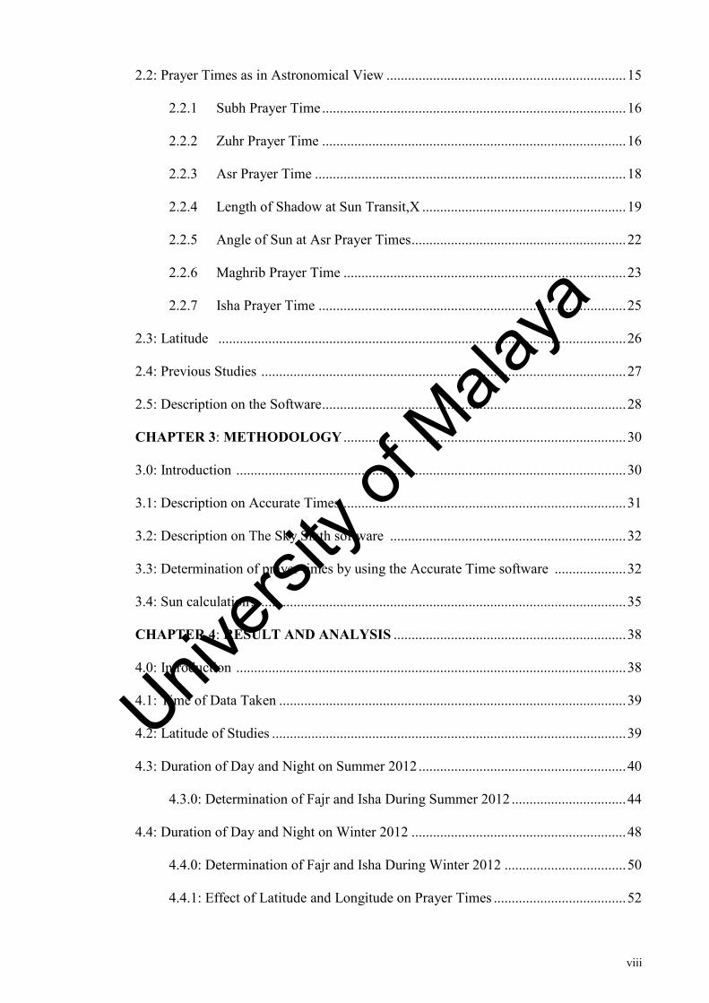
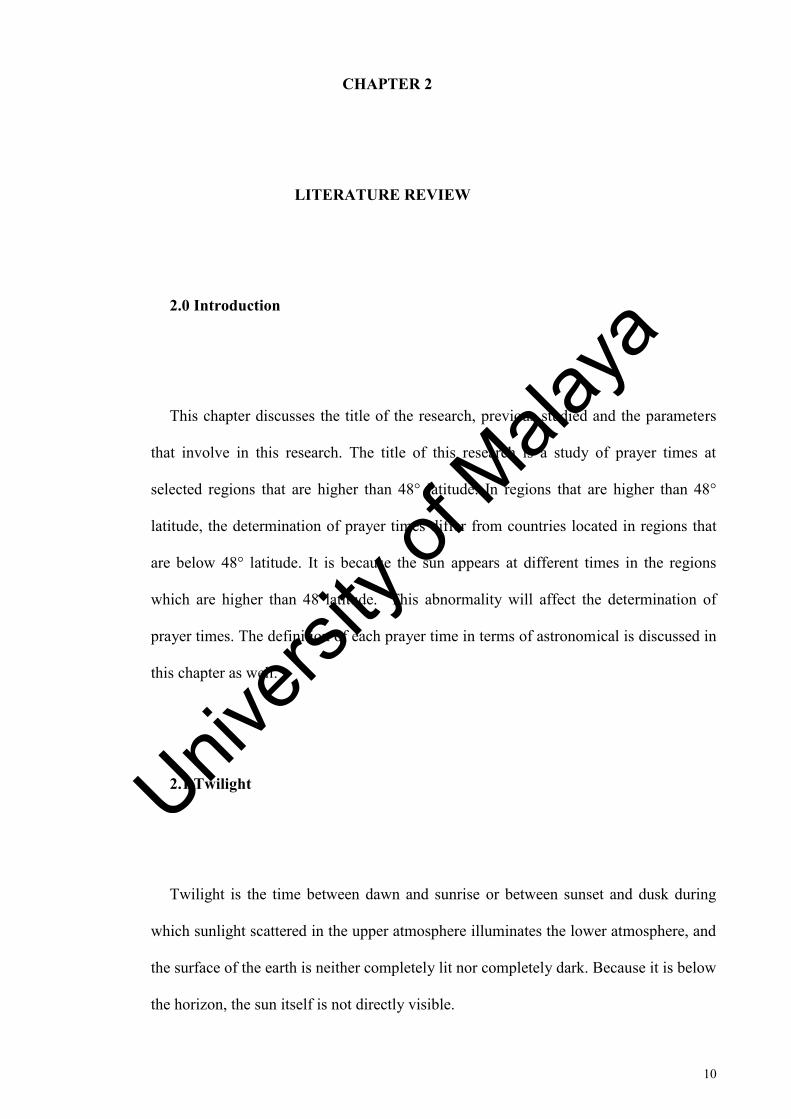
Figure 2.0 Description on twilight
There are three types of twilight which are civil twilight, nautical twilight, and
astronomical twilight. Twilight is defined based on the solar elevation which refers to
the position of the center of the sun relative to the horizon. Civil twilight is known as
the brightest while the astronomical is the darkest. The description of the twilight based
on the solar elevation is given in the following table.
Table 2.0 Twilight Angle
Types of twilight Solar elevation angle Civil twilight -6°≤ θ <0° Nautical twilight -12°≤ θ <-6° Astronomical twilight -18°≤ θ <12°
2.1.1 Civil Twilight
Civil twilight is roughly equivalent to lighting up time which the brightest star is
visible and the horizon is clearly visible at the sea. Morning civil twilight begins when
the center of the sun is 6° below the horizon which is known as civil dawn and ends at
the sunrise. While the evening civil twilight begins at the sunset and ends when the
center of the sun reaches 6° below the horizon which is known as civil dusk. Civil
twilight can also be described as the limit at which twilight illumination is sufficient
under clear weather conditions where terrestrial objects can be distinguished. At the
Univers
ity of
Mala
ya
12
beginning of morning civil twilight or end of evening civil twilight the horizon is clearly
defined and the brightest stars are visible under clear atmospheric conditions.
2.1.2 Nautical Twilight
Nautical twilight is the time when the center of the sun is between 6° and 12° below
the horizon. The horizon at the sea ceases to be clearly visible and it is impossible to
determine altitudes with reference to the horizon. During nautical twilight, sailors can
take reliable star sighting of well-known stars using horizon for reference. The end of
this period in the evening or its beginning in the morning is also the time at which traces
of illumination near the sunset or sunrise point of the horizon are very difficult if not
impossible to discern where this is often being referred to as the first light before civil
dawn and nightfall after civil dusk. At the beginning of nautical twilight in the morning
known as nautical dawn or at the end of nautical twilight in the evening known as
nautical dusk under good atmospheric conditions and it occurs in the absence of other
illumination. In this case, the general outlines of ground objects may be distinguishable
but detailed outdoor operations are not possible and the horizon is distinct.
2.1.3 Astronomical Twilight
Astronomical twilight is the time when the sun is between 12° and 18° below the
horizon. From the beginning of astronomical twilight in the evening to the beginning of
Univers
ity of
Mala
ya
13
astronomical twilight in the morning, the sky is dark enough for all astronomical
observation. It is the condition where truly dark and no perceptible twilight remains.
Astronomical twilight is when the sun is geometrically 18° below the horizon. It is
completely dark when this astronomical twilight ends. It is suitable to start the
astronomical observation. According to Goldstein, [5]“Astronomical twilight is the time
from sunset to the disappearance of the twilight glow on the western horizon (and
similarly in the morning)”.
2.1.4 Effect of Latitude on Twilight
At latitude higher than 48°, the length of twilight after sunset and before sunrise is
influenced by latitude of the observer. In the Arctic and Antarctic regions, twilight can
last for several hours. There is no civil twilight at the poles within a month on either
side of the winter solstice. At the poles, civil twilight can be as long as two weeks while
at the equator the conditions where day change into night is just takes twenty minutes.
This is because at lower latitudes, the sun‟s apparent movement is perpendicular to the
observer‟s horizon. The sun‟s disk moves toward the observer‟s horizon at a lower
angle when one gets closer to the Arctic and Antarctic circles.
In the polar circles, twenty four hour daylight is encountered in summer and in
regions very close to the poles, twilight can last for weeks on the winter side of the
equinoxes. Meanwhile, at the outside of the polar circles, the angular distance from the
polar circle is less than the angle which defines twilight as above. Twilight can continue
5 Bernad.R.Goldstein, Ibn Mucadh‟s Treatise on Twilight and the Height of Atmosphere, Communicated by A.Aaboe, pg 98.
Univers
ity of
Mala
ya
14
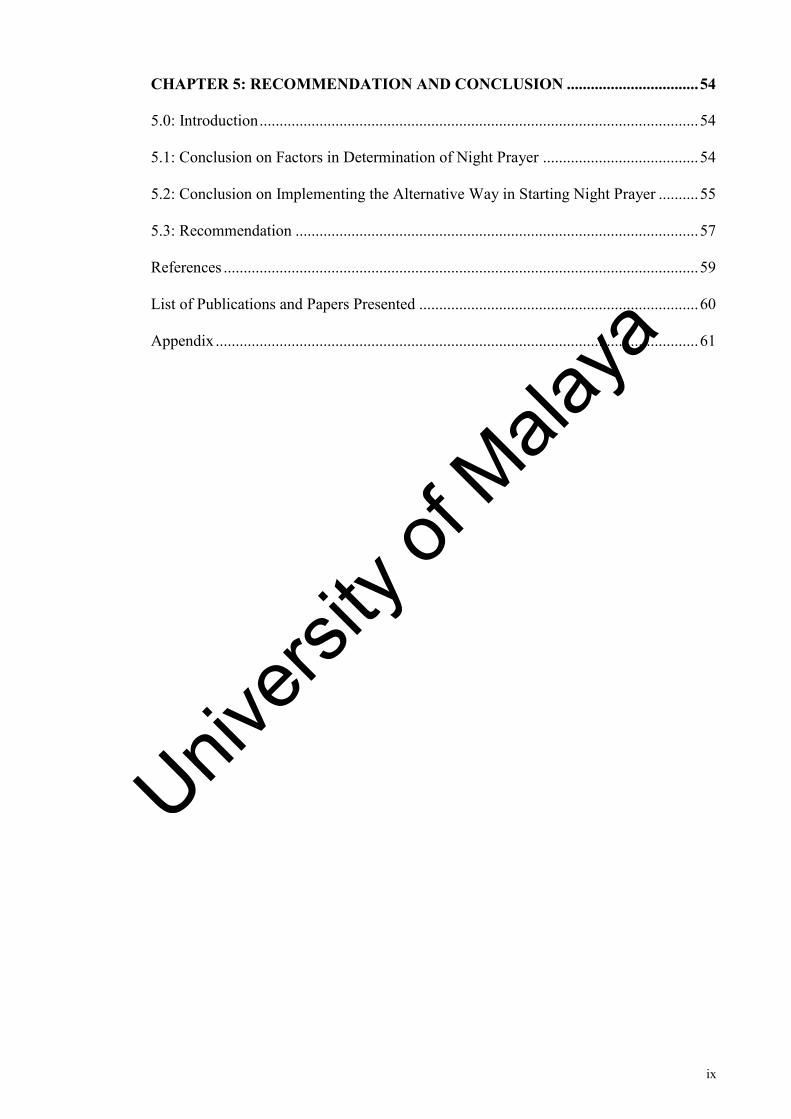
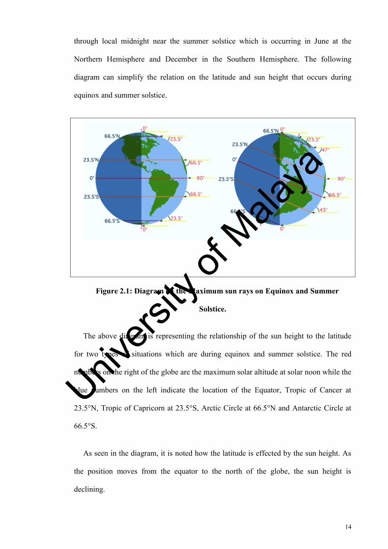
through local midnight near the summer solstice which is occurring in June at the
Northern Hemisphere and December in the Southern Hemisphere. The following
diagram can simplify the relation on the latitude and sun height that occurs during
equinox and summer solstice.
Figure 2.1: Diagram on the Maximum sun rays on Equinox and Summer
Solstice.
The above diagram is representing the relationship of the sun height to the latitude
for two types of situations which are during equinox and summer solstice. The red
numbers on the right of the globe are the maximum solar altitude at solar noon while the
blue numbers on the left indicate the location of the Equator, Tropic of Cancer at
23.5°N, Tropic of Capricorn at 23.5°S, Arctic Circle at 66.5°N and Antarctic Circle at
66.5°S.
As seen in the diagram, it is noted how the latitude is effected by the sun height. As
the position moves from the equator to the north of the globe, the sun height is
declining.
Univers
ity of
Mala
ya
15
2.2 Prayer Times as In Astronomical View
For Muslims, it is obligatory to perform five prayers throughout the day and night.
There are five types of it such as Subh which is also known as Fajr prayer, then Zuhr or
Midday prayer, Asr or evening prayer, Maghrib and the last at night is known as Isha or
night prayer. According to Hajewaming [6] “the most of islamic prayer times
correspondence with astronomical phenomena such as the time of Zuhr starts when sun
passes its zenith, Asr begins when the length of the shadow of a vertical rod is equal to
the length of the rod plus its shadow at noon. Maghrib begins immediately after sunset
while Isha begins when the sky is completely dark and Subh begins before sunrise”.
These all five prayer times can be defined according to the astronomical changing.
According to Alnaser [7], “the prayer time varies according to the latitude and all
depend on the position of the sun”. As stated in previous paragraphs, twilight may differ
according to the latitude which is explained in the twilight part. There are two types of
prayer times that are related to the astronomical twilight which are Subh and Isha times.
Meanwhile, the daylight prayer times is just referring to the shadow which relates to the
sun appearing. The definitions of each prayer times are given below.
6 Hajewaming, N. 2002. Astronomucal Calculation of Islamic Times and Qilat Direction. 33rd Congress on Science and Technology of Thailand. Available online: http://repo.unnes.ac.id/dokumen/astrodb/pdf/astroomical-calculation.pdf. 1-6.
7 Alnaser, WE & Alnaser, NW. 2009. The Solar Connection in the Muslim Community. ISESCO Science and Technology Vision Vol 5 (7): 41-44.
Univers
ity of
Mala
ya
16
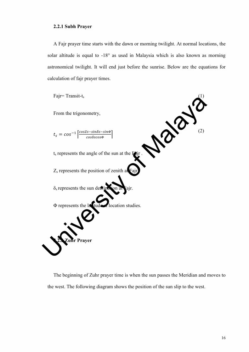
2.2.1 Subh Prayer
A Fajr prayer time starts with the dawn or morning twilight. At normal locations, the
solar altitude is equal to -18° as used in Malaysia which is also known as morning
astronomical twilight. It will end just before the sunrise. Below are the equations for
calculation of fajr prayer times.
Fajr= Transit-ts (1)
From the trigonometry,
⌈
⌉
(2)
ts represents the angle of the sun at the Fajr .
Zs represents the position of zenith at Fajr.
δs represents the sun declination at Fajr.
Φ represents the latitude at location studies.
2.2.2 Zuhr Prayer
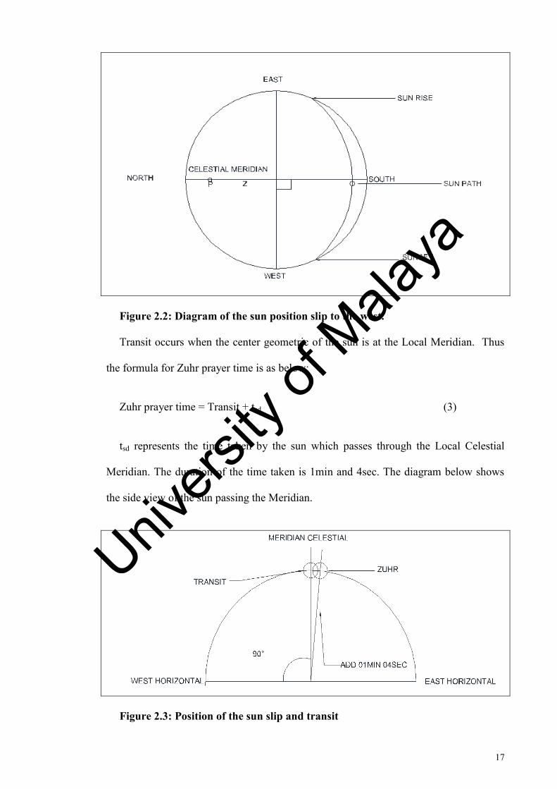
The beginning of Zuhr prayer time is when the sun passes the Meridian and moves to
the west. The following diagram shows the position of the sun slip to the west.
Univers
ity of
Mala
ya
17
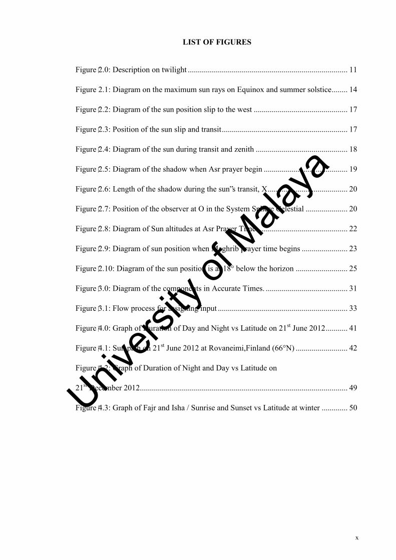
Figure 2.2: Diagram of the sun position slip to the west.
Transit occurs when the center geometric of the sun is at the Local Meridian. Thus
the formula for Zuhr prayer time is as below:
Zuhr prayer time = Transit + tsd (3)
tsd represents the time taken by the sun which passes through the Local Celestial
Meridian. The duration of the time taken is 1min and 4sec. The diagram below shows
the side view of the sun passing the Meridian.
Figure 2.3: Position of the sun slip and transit
Univers
ity of
Mala
ya
18
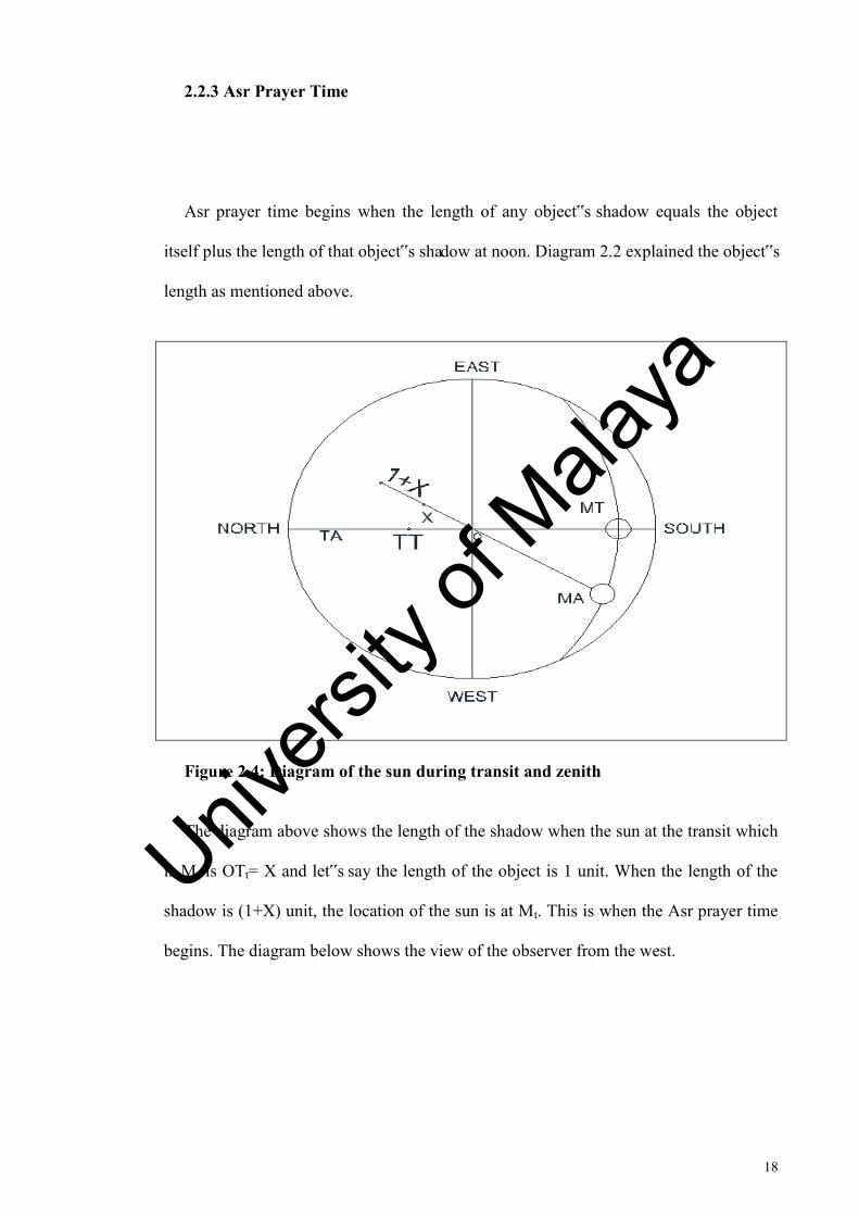
2.2.3 Asr Prayer Time
Asr prayer time begins when the length of any object‟s shadow equals the object
itself plus the length of that object‟s shadow at noon. Diagram 2.2 explained the object‟s
length as mentioned above.
Figure 2.4: Diagram of the sun during transit and zenith
The diagram above shows the length of the shadow when the sun at the transit which
is Mt is OTt= X and let‟s say the length of the object is 1 unit. When the length of the
shadow is (1+X) unit, the location of the sun is at Mt. This is when the Asr prayer time
begins. The diagram below shows the view of the observer from the west.
Univers
ity of
Mala
ya
19
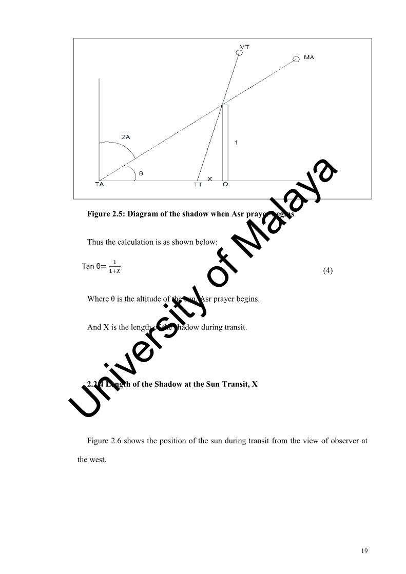
Figure 2.5: Diagram of the shadow when Asr prayer begins
Thus the calculation is as shown below:
(4)
Where θ is the altitude of the sun, Asr prayer begins.
And X is the length of the shadow during transit.
2.2.4 Length of the Shadow at the Sun Transit, X
Figure 2.6 shows the position of the sun during transit from the view of observer at
the west.
Tan θ
+𝑋
Univers
ity of
Mala
ya
20
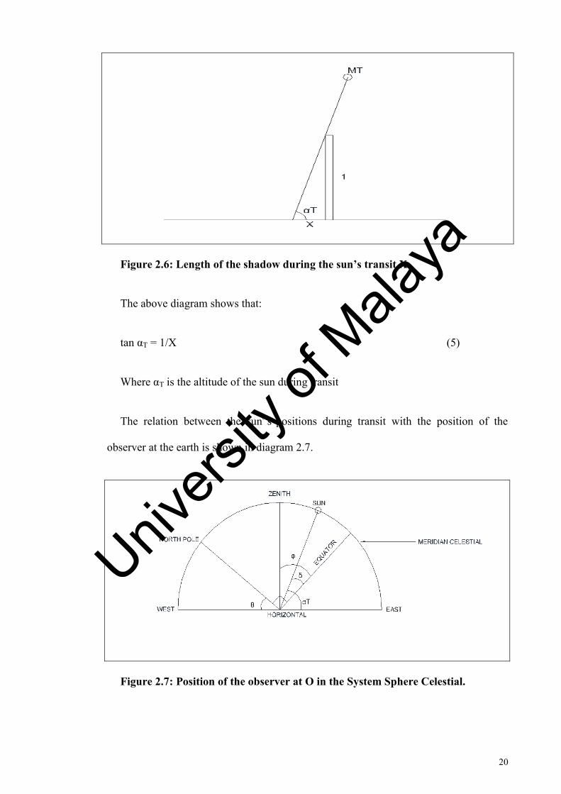
Figure 2.6: Length of the shadow during the sun’s transit,X
The above diagram shows that:
tan αT = 1/X (5)
Where αT is the altitude of the sun during transit
The relation between the sun‟s positions during transit with the position of the
observer at the earth is shown in diagram 2.7.
Figure 2.7: Position of the observer at O in the System Sphere Celestial.
Univers
ity of
Mala
ya
21
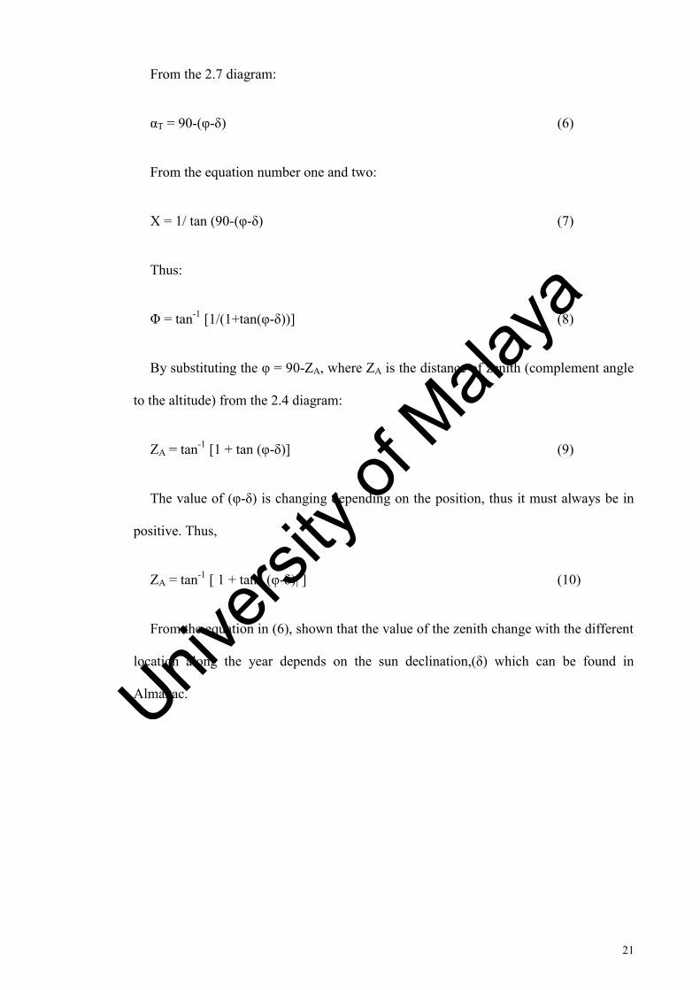
From the 2.7 diagram:
αT = 90-(φ-δ) (6)
From the equation number one and two:
X = 1/ tan (90-(φ-δ) (7)
Thus:
Φ = tan-1 [1/(1+tan(φ-δ))] (8)
By substituting the φ = 90-ZA, where ZA is the distance of zenith (complement angle
to the altitude) from the 2.4 diagram:
ZA = tan-1 [1 + tan (φ-δ)] (9)
The value of (φ-δ) is changing depending on the position, thus it must always be in
positive. Thus,
ZA = tan-1 [ 1 + tan | (φ-δ)| ] (10)
From the equation in (6), shown that the value of the zenith change with the different
location along the year depends on the sun declination,(δ) which can be found in
Almanac.
Univers
ity of
Mala
ya
22
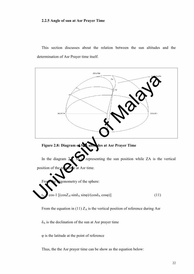
2.2.5 Angle of sun at Asr Prayer Time
This section discusses about the relation between the sun altitudes and the
determination of Asr Prayer time itself.
Figure 2.8: Diagram of Sun altitudes at Asr Prayer Time
In the diagram 2.8, M is representing the sun position while ZA is the vertical
position of the reference at Asr time.
From the trigonometry of the sphere:
tA = cos-1 [(cosZA-sinδA sinφ)/(cosδA cosφ)] (11)
From the equation in (11) ZA is the vertical position of reference during Asr
δA is the declination of the sun at Asr prayer time
φ is the latitude at the point of reference
Thus, the the Asr prayer time can be show as the equation below:
Univers
ity of
Mala
ya
23
Asr = Transit + tA (12)
tA represents the angular of the sun‟s time during Asr
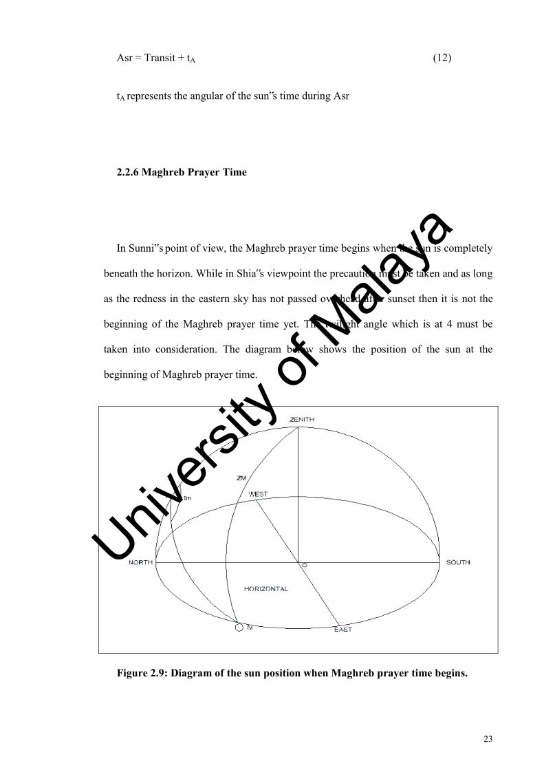
2.2.6 Maghreb Prayer Time
In Sunni‟s point of view, the Maghreb prayer time begins when the sun is completely
beneath the horizon. While in Shia‟s viewpoint the precaution must be taken and as long
as the redness in the eastern sky has not passed overhead after sunset then it is not the
beginning of the Maghreb prayer time yet. The twilight angle which is at 4 must be
taken into consideration. The diagram below shows the position of the sun at the
beginning of Maghreb prayer time.
Figure 2.9: Diagram of the sun position when Maghreb prayer time begins.
Univers
ity of
Mala
ya
24
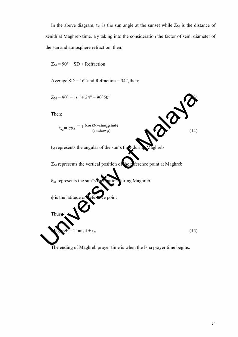
In the above diagram, tM is the sun angle at the sunset while ZM is the distance of
zenith at Maghreb time. By taking into the consideration the factor of semi diameter of
the sun and atmosphere refraction, then:
ZM = 90° + SD + Refraction
Average SD = 16‟ and Refraction = 34‟, then:
ZM = 90° + 16‟ + 34‟ = 90°50‟ (13)
Then;
(14)
tM represents the angular of the sun‟s time during Maghreb
ZM represents the vertical position of the reference point at Maghreb
δM represents the sun‟s declination during Maghreb
ϕ is the latitude on reference point
Thus,
Maghreb = Transit + tM (15)
The ending of Maghreb prayer time is when the Isha prayer time begins.
tM 𝑐𝑜𝑠
1 ZM 𝛿𝑀 𝜙
𝛿𝑐𝑜𝑠𝜙
Univers
ity of
Mala
ya
25
2.2.7 Isha Prayer Time
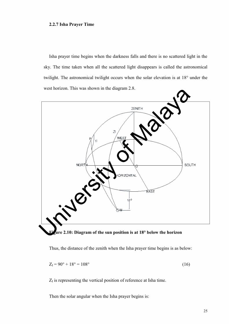
Isha prayer time begins when the darkness falls and there is no scattered light in the
sky. The time taken when all the scattered light disappears is called the astronomical
twilight. The astronomical twilight occurs when the solar elevation is at 18° under the
west horizon. This was shown in the diagram 2.8.
Figure 2.10: Diagram of the sun position is at 18° below the horizon
Thus, the distance of the zenith when the Isha prayer time begins is as below:
ZI = 90° + 18° = 108° (16)
ZI is representing the vertical position of reference at Isha time.
Then the solar angular when the Isha prayer begins is:
Univers
ity of
Mala
ya
26
(17)
ZI represents the vertical position of reference at Isha time
δI is the declination of the sun during Isha time
ϕ is the latitude of the reference
Thus:
Isha =Transit + tI (18)
tI represents the angular of the sun‟s time at Isha time
2.3 Latitude
Latitude refers to the geographic coordinate that specifies the position from north to
south on the earth surface. Latitude can be noted in the range of angle between 0° to 90°
to the North or to the South Pole. Latitude can be distinguished by terminology into five
categories which are geodetic, geocentric, spherical, and geographic and latitude itself.
In this research, most of the terminology used refers to the geographical latitude or
alternatively called astronomical latitude. The astronomical latitude (Φ) refers to the
angle between equatorial planes to the true vertical at the point of the surface. This true
vertical can be defined as the direction of the gravity field to that point. The
astronomical latitude can be obtained by measuring the angle between zeniths to
tI 𝑐𝑜𝑠
1 ZI 𝛿I 𝜙
𝛿𝐼𝑐𝑜𝑠𝜙
Univers
ity of
Mala
ya
27
celestial pole or else can be obtained by measuring the angle between the zenith and the
sun when the elevation of the latter has been obtained from almanac.
2.4 Previous Studies
Study on determination of prayer times at high latitude regions is an ongoing
discussion. Many studies came up with the alternative method to improve this type of
problem. Muslims who live in this region need to refer to prayer times of the nearby
countries. It is because the twilight may persist throughout the night during some of the
months. This needs some modification to divide daylight and night equally. Also,
countries in these regions perform the daylight saving time during spring and autumn.
Typically, clocks are adjusted one hour during the spring and adjusted to minus one
hour during the autumn. This fact needs to be considered in this study so that the
calculation on determination of prayer times would not be wrong and becomes more
precise. According to Muneer8, “it must be borne in mind that during the “abnormal”
period there is room in the jurisprudence to follow the alternative ways to determine the
limit time for Fajr and Isha”. The alternative could be the solution to determine the
prayer time so that Muslims can perform the prayer at precise time.
Hamid Zarrabi Zadeh[9] who has studied this issue states that:
8 Muneer, T. 2007. The Islamic Prayer Times – Computational Philosophy with Particular Reference to the Lack of Twilight Cessation at Higher Latitudes. Available online: http://www.islamicity.com/prayertimes/Salat.pdf. 1-6.
9 Zadeh, HZ. 2010. Prayer Times Calculation. Available online: http:/tanzil.info/prayertime/doc/calculation. 1-5.
Univers
ity of
Mala
ya

28
there are some adjustment has to be made in the way to calculate the prayer
time at higher latitude regions where twilight may persist throughout the night
in several months along the year.. The third and the last method are called angle
based method. In this case, let a be the twilight angle for Isha and let t = a/60.
The period of sunset until sunrise will be dividing into t parts. The Isha prayer
will begin after the first part.
The other method proposed by Zarrabi Zadeh is the same as the one proposed by
Muneer which is the middle of the night and the seventh part of the night.
2.5 Description on the Software
There are a few types of software that can be used to determine prayer times. This
software includes Athan Pro 4.2, Prayer Time PC Pro and Salaat Time. Athan Pro 4.2
has many features such as Automatic Athan (Azan) at every prayer time. Another
feature is minute‟s adjustment to make the prayer times more precise according to local
Mosque. Qiblah direction is also available in this software in graphical format. But this
software is not suitable to be used in this research because it cannot calculate prayer
times at high latitude regions.
Other software available is Prayer Time PC which can be used to calculate the prayer
times. The special feature in this software is that it can adjust the prayer times by
individually each prayer time. Unfortunately, it is not suitable to be used because it does
not have adjustment for summer time. Lastly, the software that is suitable to calculate
Univers
ity of
Mala
ya
29
the five daily prayer times is Salaat Times software. It can both calculate the period of
the middle of the night or the last one third of the night and it has additional precision
for longitude and latitude. This features help to calculate night prayer.
In this research, the software that has been used is Accurate Times for determination
of prayer time. This software manages to do the calculation for prayer times at high
latitude cities. Also, it can do some adjustment for summer time. This research focuses
on the extreme periods of time which are during summer time on 21st of June and winter
time on 21st of December. Comparison has to be made later on the alternative way that
has been proposed in the previous study on calculating prayer time at high latitude.
The other software used in this research is The Sky Sixth. It is an astronomical
software that is used to simulate many astronomical events. It has been built and
developed by Software Bisque. It is used here to simulate the sun Path. The data is
accurate and it can capture a good image as well.
Univers
ity of
Mala
ya
30
CHAPTER 3
METHODOLOGY
3.0 Introduction
This chapter discusses how the research has been done. The research used the
software called Accurate Time to calculate the prayer times at high latitude regions for
the selected cities. Later, the findings have been compared to the alternative way of
determination of prayer times in the high latitude regions. The alternative ways
proposed:
a) Nearest day
b) Nearest Latitude
c) Middle of night
d) Seventh part of night
An experimental comparison should be made to find out which way is the easiest to
carry out and also the applicability to use which will give the precise time. Analysis will
be carried out upon the effect of increasing the latitude on the determination of prayer
time. This will focus on the atmospheric effect to do the analysis. Research will focus
on the extreme periods of time when the abnormalities occur which are during the
summer solstice and the winter solstice.
Univers
ity of
Mala
ya
31
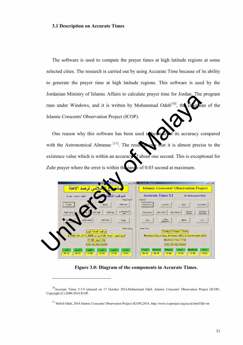
3.1 Description on Accurate Times
The software is used to compute the prayer times at high latitude regions at some
selected cities. The research is carried out by using Accurate Time because of its ability
to generate the prayer time at high latitude regions. This software is used by the
Jordanian Ministry of Islamic Affairs to calculate prayer time for Jordan. The program
runs under Windows, and it is written by Mohammad Odeh[10], the chairman of the
Islamic Crescents' Observation Project (ICOP).
One reason why this software has been used is because of its accuracy compared
with the Astronomical Almanac [11]. The result shows that it is almost precise to the
existence value which is within an accuracy of about one second. This is exceptional for
Zuhr prayer where the error is within the range of 0.03 second at maximum.
Figure 3.0: Diagram of the components in Accurate Times.
10Accurate Times 5.3.9 released on 17 October 2014,Mohammad Odeh ,Islamic Crescents' Observation Project (ICOP). Copyright (C) 2000-2014 ICOP.
11 Moh'd Odeh, 2014 Islamic Crescents' Observation Project (ICOP),2014, http://www.icoproject.org/accut.html?&l=en
Univers
ity of
Mala
ya
32
3.2 Description on The Sky 6 software
The Sky sixth is generated and developed by software Bisque. It was used in many
observatories around the world. It has good features that make it suitable to be used for
many studies and observations. It is suitable for this research because it could be used to
generate the sun path at the required locations. Thus, for certain locations in this study
where it needs to see the sun position; the path can easily be simulated here. Therefore,
it makes the results so clear and the study so easy to understand.
Also, the images captured are in a very good condition and magnification. This
program can operate in Windows 98/Me/2000/XP Home/XP Professional and others.
The most important thing is to identify the exact location of the study and time need to
change relative to the position studies.
This software manages to be used to learn basic astronomy concepts as well. Users
can also use it to view simulation of astronomical events. The most important part is to
generate and export customs reports of astronomical data.
3.3 Determination of Prayer Time by Using the Accurate Time Software
This study uses the software to calculate some measurement such as prayer times and
sun position. This software is the official program adopted by the Jordanian Ministry of
Islamic Affairs to calculate the prayer times in Jordan. Accurate Times calculates the
following astronomical events and the following list is a component that relates to this
study;
Univers
ity of
Mala
ya
33
i) Islamic prayer times (Fajr, Zuhr, Asr, Maghreb, and Isha).
ii) Sun times (Beginning and end of twilight, sunrise, sunset, and Sun transit).
Components that have been used in this software are Prayer Time, Location and
Preferences. Accurate Times can used to calculate the prayer times at high latitude
regions. The research focuses on the prayer times at Fajr and Isha times because
abnormalities occur at high latitude regions when sun does not set below the horizon.
Therefore, the twilight may persist throughout the night. The components can be used in
Accurate Times to indicate the beginning and ending of twilight.
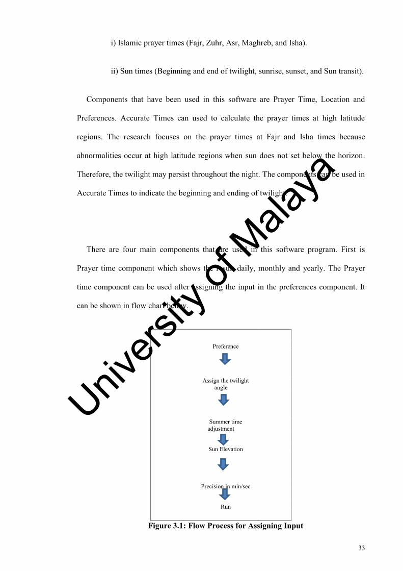
There are four main components that are used in this software program. First is
Prayer time component which shows the result daily, monthly and yearly. The Prayer
time component can be used after assigning the input in the preferences component. It
can be shown in flow chart below.
Preference
Assign the twilight
angle
Summer time
adjustment
Sun Elevation
Precision in min/sec
Run
Figure 3.1: Flow Process for Assigning Input
Univers
ity of
Mala
ya
34
In the preferences part, some data is needed such as twilight angle, summer time
adjustment and addition in time, precision and language used. For the twilight input
data, the angle used for countries studied need to be kept in. This depends on the
scholars and their opinion which vary from 14° up to 18°. While in the summer time
adjustment, the countries using the daylight saving time, additional time of one hour
during summer or subtraction of one hour in the winter needs to be done. For the
precision, data need to be assigned in minute or second. The next part used in this study
is location. Location needs to be chosen in this software. In this research, the countries
chosen are at the high latitude regions. This research chooses to study four cities from
high latitude regions at 48° up to 67°. While in date part, user needs to decide whether
to assign the data in yearly, monthly or daily. Also, this research focuses on changes of
sun altitude and the relation to the prayer times.
This research focuses on the cities in high latitude regions which include twenty
cities in different latitude. There are cities in latitude at 48° up to 67°. These cities have
abnormality in twilight present. The selected cities have been chosen because a lot of
Muslims are living in these areas. Research starts at 48° because “the abnormalities
begin here when the duration of night and day is not equal” [12]. Comparison needs to
be made for these four different cities as the latitude increases. The highest is at 67°
where these cities have habit here and they are included in this research because there
are Muslims living there. It is also the upper limit in this research because cities in this
latitude are situated in the Arctic Circle.
12 Philip & Deborah Scherrer, Solstice and Equinox (“Suntrack”) Model, pg3, Standford Solar Center.
Univers
ity of
Mala
ya
35
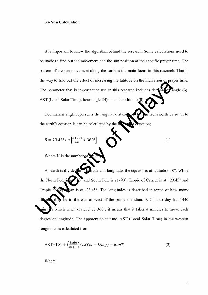
3.4 Sun Calculation
It is important to know the algorithm behind the research. Some calculations need to
be made to find out the movement and the sun position at the specific prayer time. The
pattern of the sun movement along the earth is the main focus in this research. That is
the way to find out the effect of increasing the latitude on the indication of prayer time.
The parameter that is important to use in this research includes declination angle (δ),
AST (Local Solar Time), hour angle (H) and solar altitude (β).
Declination angle represents the angular distance of the sun from north or south to
the earth‟s equator. It can be calculated by the following equation;
* +
+ (1)
Where N is the number of the day
As earth is divided into latitude and longitude, the equator is at latitude of 0°. While
the North Pole is at +90° and South Pole is at -90°. Tropic of Cancer is at +23.45° and
Tropic of Capricorn is at -23.45°. The longitudes is described in terms of how many
degrees they lie to the east or west of the prime meridian. A 24 hour day has 1440
minutes which when divided by 360°, it means that it takes 4 minutes to move each
degree of longitude. The apparent solar time, AST (Local Solar Time) in the western
longitudes is calculated from
AST LST (
) (2)
Where
Univers
ity of
Mala
ya
36
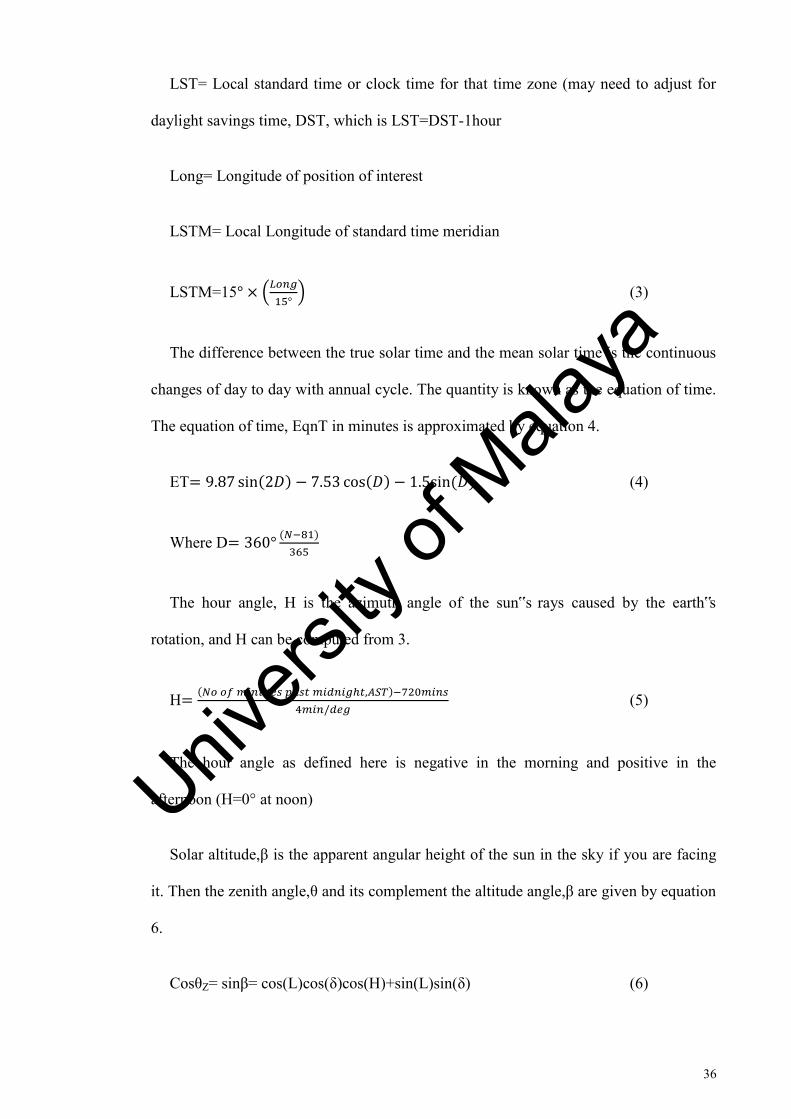
LST= Local standard time or clock time for that time zone (may need to adjust for
daylight savings time, DST, which is LST=DST-1hour
Long= Longitude of position of interest
LSTM= Local Longitude of standard time meridian
LSTM=15 (
) (3)
The difference between the true solar time and the mean solar time is the continuous
changes of day to day with annual cycle. The quantity is known as the equation of time.
The equation of time, EqnT in minutes is approximated by equation 4.
ET 1 (4)
Where D
The hour angle, H is the azimuth angle of the sun‟s rays caused by the earth‟s
rotation, and H can be computed from 3.
H
(5)
The hour angle as defined here is negative in the morning and positive in the
afternoon (H=0° at noon)
Solar altitude,β is the apparent angular height of the sun in the sky if you are facing
it. Then the zenith angle,θ and its complement the altitude angle,β are given by equation
6.
CosθZ= sinβ= cos(L)cos(δ)cos(H)+sin(L)sin(δ) (6)
Univers
ity of
Mala
ya
37
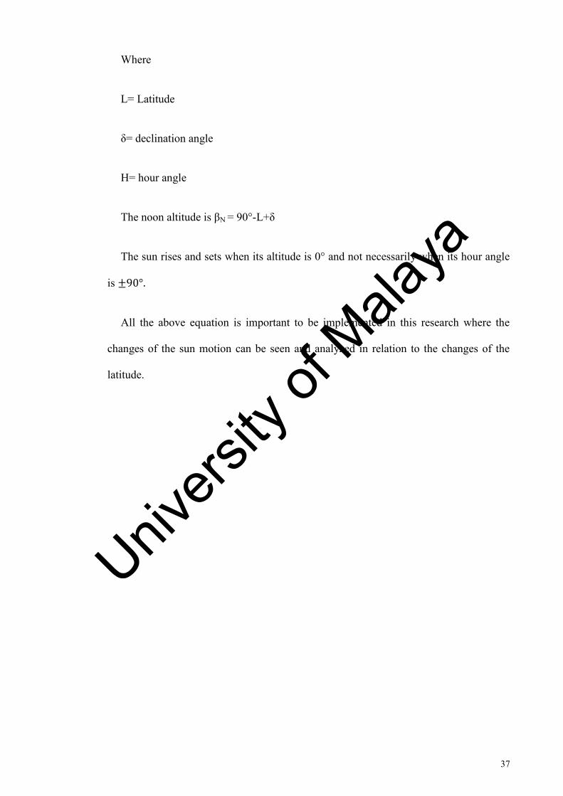
Where
L= Latitude
δ= declination angle
H= hour angle
The noon altitude is βN = 90°-L+δ
The sun rises and sets when its altitude is 0° and not necessarily when its hour angle
is
All the above equation is important to be implemented in this research where the
changes of the sun motion can be seen and analyzed in relation to the changes of the
latitude.
Univers
ity of
Mala
ya
38
CHAPTER 4
RESULT AND ANALYSIS
4.0 INTRODUCTION
This chapter discusses the results from the research and analyzes the data taken.
Discussion is made upon two of the prayer times which are Subh and Isha. The prayer
times have been determined using Accurate Times Software. Then they have been
compared with other alternative ways of calculation of the prayer times at high latitude
cities. The alternative ways proposed are:
a) Middle of night
b) Seventh part of night
c) Nearest latitude
d) Nearest day
The comparison made would examine the easiest way to use, the accessibility to use
and the most convenient way to be used.
Univers
ity of
Mala
ya
39
4.1 Time of Data Taken
There are two periods of time where the research has focused on which are on winter
and summer time. During this period of time, the abnormalities could occur on the
pattern of the sunset and sunrise. The exact time is upon 21st of June 2012 and 21st
December 2012. Discussion is made upon these two cases of time periods. Summer
solstice is taken on the 21st of June while winter solstice has been taken on 21st
December 2012. This research focuses on the changing of the sun motion that occurs
depending on the changing of the latitude. The reason of selecting the above mentioned
date is because 21st December is known as winter solstice when the shortest day and
longest night occur. While 21st June is known as summer solstice when the longest day
and the shortest night is occurs. This research focuses on the extreme cases for both of
these two periods of time.
4.2 Latitude of Studies
The cities that are located at latitude of 48° up to 67° to the North Pole are the main
focuses of this research. Ten cities are included in this study. The list of cities and their
location are mentioned in the following table.
Univers
ity of
Mala
ya
40
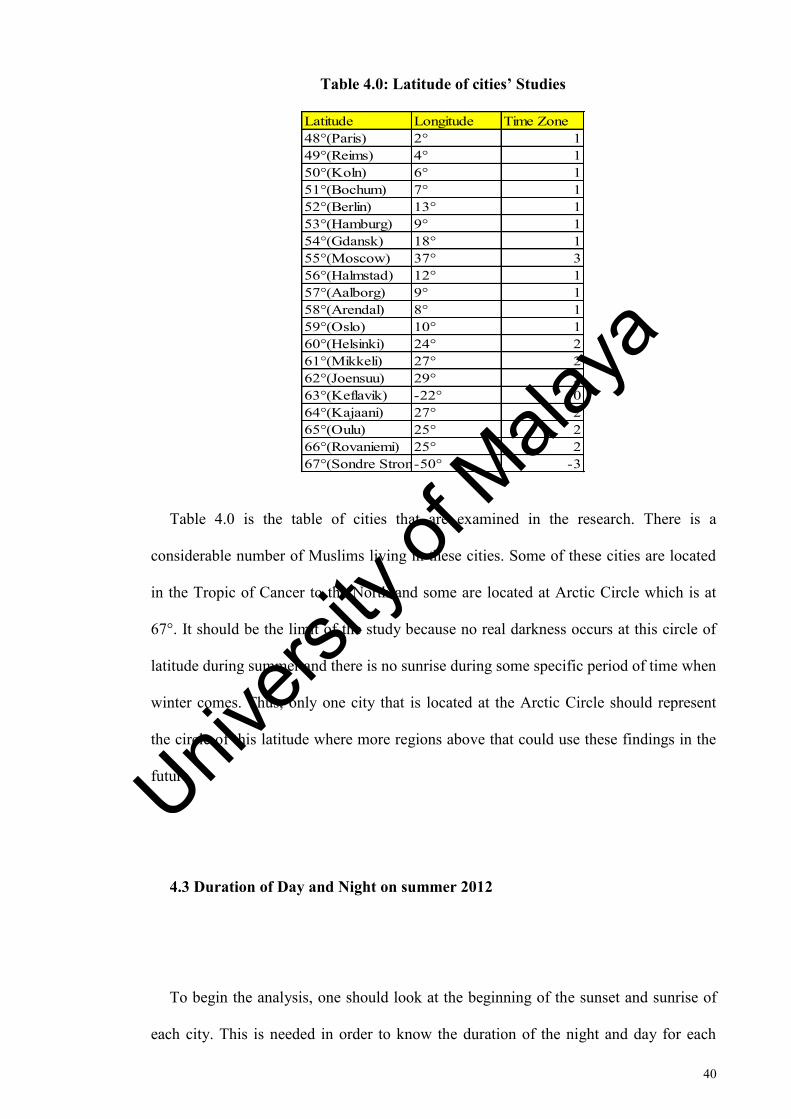
Table 4.0: Latitude of cities’ Studies
Table 4.0 is the table of cities that are examined in the research. There is a
considerable number of Muslims living in these cities. Some of these cities are located
in the Tropic of Cancer to the North and some are located at Arctic Circle which is at
67°. It should be the limit of the study because no real darkness occurs at this circle of
latitude during summer and there is no sunrise during some specific period of time when
winter comes. Thus, only one city that is located at the Arctic Circle should represent
the circle of this latitude where more regions above that could use these findings in the
future.
4.3 Duration of Day and Night on summer 2012
To begin the analysis, one should look at the beginning of the sunset and sunrise of
each city. This is needed in order to know the duration of the night and day for each
Latitude Longitude Time Zone48°(Paris) 2° 149°(Reims) 4° 150°(Koln) 6° 151°(Bochum) 7° 152°(Berlin) 13° 153°(Hamburg) 9° 154°(Gdansk) 18° 155°(Moscow) 37° 356°(Halmstad) 12° 157°(Aalborg) 9° 158°(Arendal) 8° 159°(Oslo) 10° 160°(Helsinki) 24° 261°(Mikkeli) 27° 262°(Joensuu) 29° 263°(Keflavik) -22° 064°(Kajaani) 27° 265°(Oulu) 25° 266°(Rovaniemi) 25° 267°(Sondre Stromfjord)-50° -3
Univers
ity of
Mala
ya
41
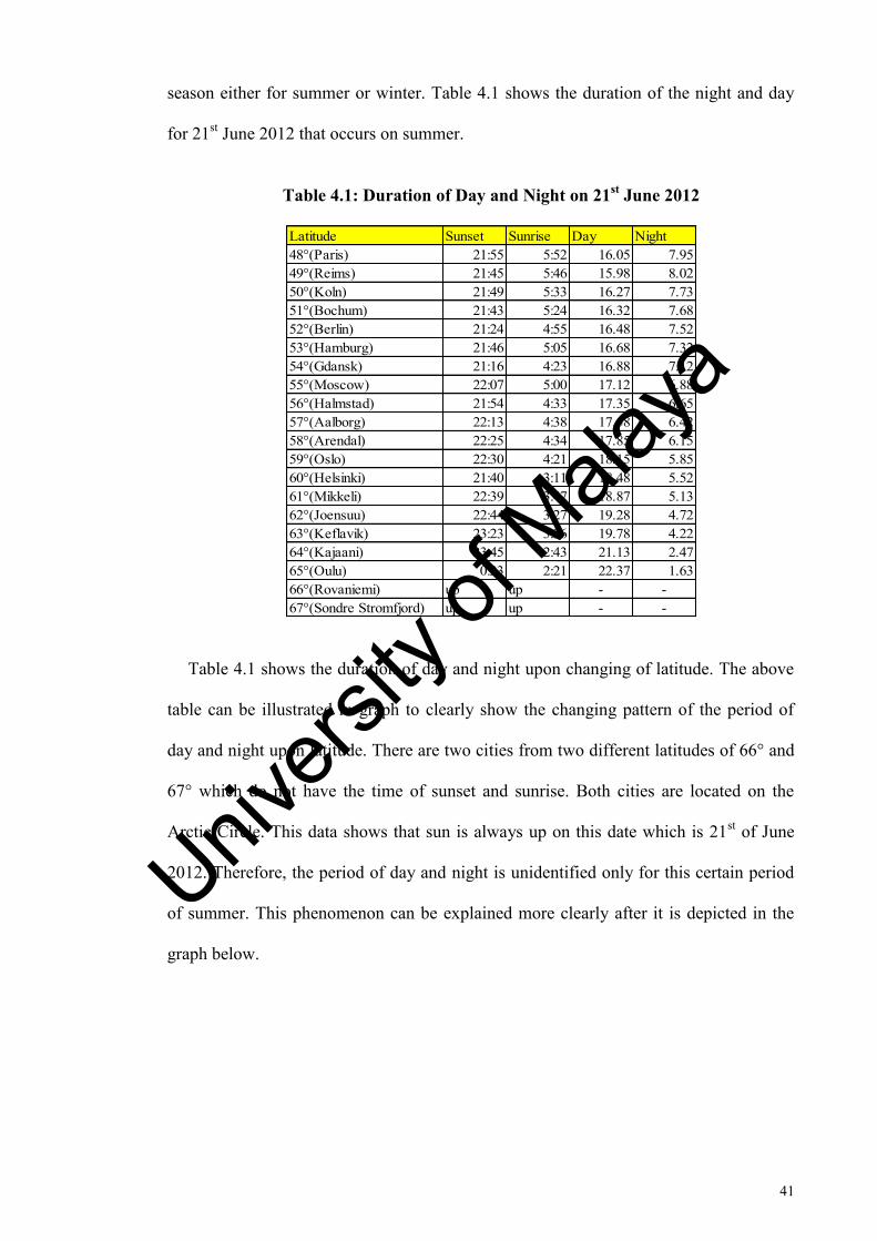
season either for summer or winter. Table 4.1 shows the duration of the night and day
for 21st June 2012 that occurs on summer.
Table 4.1: Duration of Day and Night on 21st June 2012
Table 4.1 shows the duration of day and night upon changing of latitude. The above
table can be illustrated in graph to clearly show the changing pattern of the period of
day and night upon latitude. There are two cities from two different latitudes of 66° and
67° which do not have the time of sunset and sunrise. Both cities are located on the
Arctic Circle. This data shows that sun is always up on this date which is 21st of June
2012. Therefore, the period of day and night is unidentified only for this certain period
of summer. This phenomenon can be explained more clearly after it is depicted in the
graph below.
Latitude Sunset Sunrise Day Night48°(Paris) 21:55 5:52 16.05 7.9549°(Reims) 21:45 5:46 15.98 8.0250°(Koln) 21:49 5:33 16.27 7.7351°(Bochum) 21:43 5:24 16.32 7.6852°(Berlin) 21:24 4:55 16.48 7.5253°(Hamburg) 21:46 5:05 16.68 7.3254°(Gdansk) 21:16 4:23 16.88 7.1255°(Moscow) 22:07 5:00 17.12 6.8856°(Halmstad) 21:54 4:33 17.35 6.6557°(Aalborg) 22:13 4:38 17.58 6.4258°(Arendal) 22:25 4:34 17.85 6.1559°(Oslo) 22:30 4:21 18.15 5.8560°(Helsinki) 21:40 3:11 18.48 5.5261°(Mikkeli) 22:39 3:47 18.87 5.1362°(Joensuu) 22:44 3:27 19.28 4.7263°(Keflavik) 23:23 3:36 19.78 4.2264°(Kajaani) 23:45 2:43 21.13 2.4765°(Oulu) 0:23 2:21 22.37 1.6366°(Rovaniemi) up up - -67°(Sondre Stromfjord) up up - -
Univers
ity of
Mala
ya
42
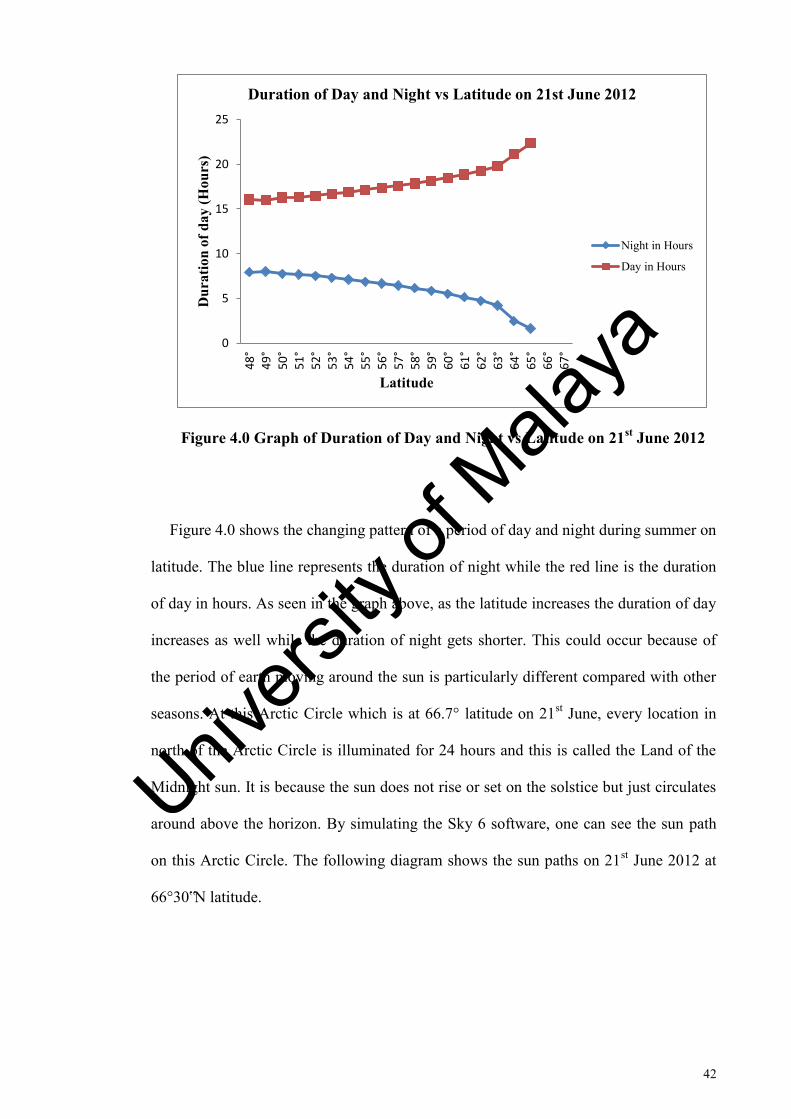
Figure 4.0 Graph of Duration of Day and Night vs Latitude on 21st June 2012
Figure 4.0 shows the changing pattern of a period of day and night during summer on
latitude. The blue line represents the duration of night while the red line is the duration
of day in hours. As seen in the graph above, as the latitude increases the duration of day
increases as well while the duration of night gets shorter. This could occur because of
the period of earth moving around the sun is particularly different compared with other
seasons. At this Arctic Circle which is at 66.7° latitude on 21st June, every location in
north of the Arctic Circle is illuminated for 24 hours and this is called the Land of the
Midnight sun. It is because the sun does not rise or set on the solstice but just circulates
around above the horizon. By simulating the Sky 6 software, one can see the sun path
on this Arctic Circle. The following diagram shows the sun paths on 21st June 2012 at
66°30‟N latitude.
0
5
10
15
20
25
48
°
49
°5
0°
51
°
52
°
53
°5
4°
55
°
56
°
57
°5
8°
59
°
60
°6
1°
62
°
63
°6
4°
65
°
66
°
67
°
Dur
atio
n of
day
(Hou
rs)
Latitude
Duration of Day and Night vs Latitude on 21st June 2012
Night in Hours
Day in Hours
Univers
ity of
Mala
ya
43
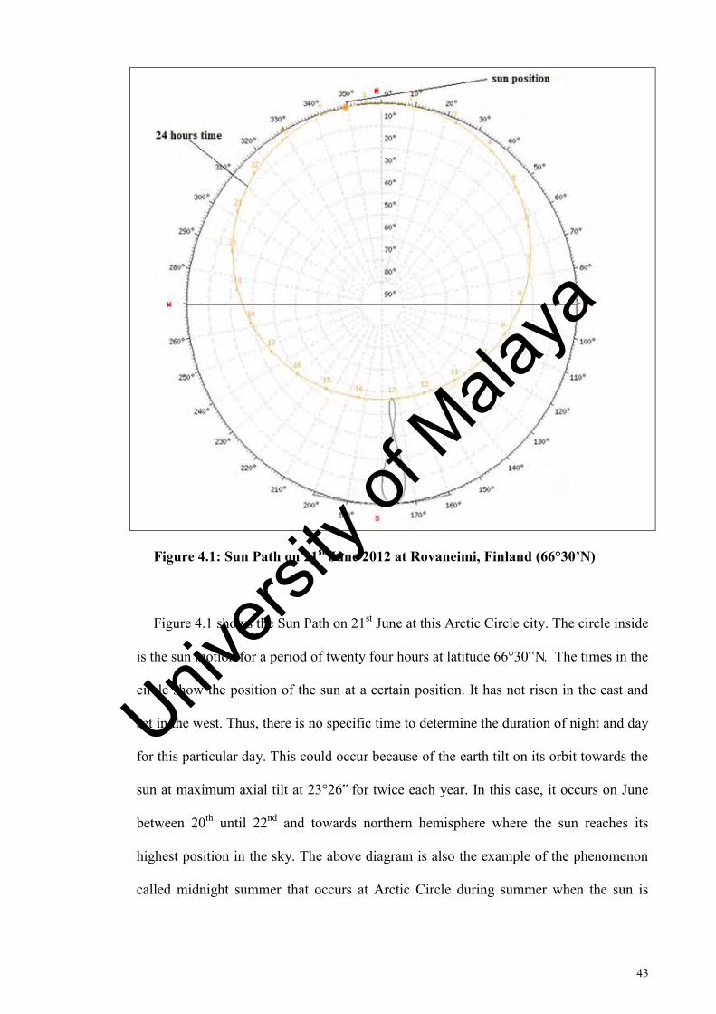
Figure 4.1: Sun Path on 21st June 2012 at Rovaneimi, Finland (66°30’N)
Figure 4.1 shows the Sun Path on 21st June at this Arctic Circle city. The circle inside
is the sun motion for a period of twenty four hours at latitude 66°30‟N. The times in the
circle show the position of the sun at a certain position. It has not risen in the east and
set in the west. Thus, there is no specific time to determine the duration of night and day
for this particular day. This could occur because of the earth tilt on its orbit towards the
sun at maximum axial tilt at 23°26‟ for twice each year. In this case, it occurs on June
between 20th until 22nd and towards northern hemisphere where the sun reaches its
highest position in the sky. The above diagram is also the example of the phenomenon
called midnight summer that occurs at Arctic Circle during summer when the sun is
Univers
ity of
Mala
ya
44
visible at full twenty four hours. In the above diagram, the highlighted number in degree
is the sun altitude at each time. The lowest the sun can go is at 0.95° above the horizon.
The previous diagram shows the sun movement for a period of twenty four hour on
21st June 2012. The location of the sun at 0:30am~01:00am can be assumed as its lowest
position below horizon. Looking at the alphabets E and W which stand for the east and
the west, it is the point where the sun starts to rise and then set in west. However, in this
abnormal case, the sun does not set and rise. Thus, the research focus on the deepest
point of the sun can go below the horizon at the time which can be considered as night
in a normal case. Thus, for determining Subh and Isha prayer times, we should use the
alternative method that has been proposed and it is when the sun could not reach 18°
below horizon in normal cases and at 15° below horizon in the extreme cases at high
latitude cities.
4.3.0 Determination of Fajr and Isha during summer 2012
As discussed earlier in the previous chapter, we need to use an alternative way in
order to determine the Fajr and Isha prayer time in some cities that lie in high latitude.
The reason of propose this alternative ways is because of these cities do not have sunset
and sunrise for a certain period of time. The alternative ways proposed are:
a) Middle of night
b) Seventh part of night
c) Nearest Latitude
d) Nearest day
Univers
ity of
Mala
ya
45
However, the way to select which way is the most appropriate way to be used is
discussed in this part. Nearest day is suitable to be used for cities that do not have
ending of twilight for a certain period of time. Hence, the last day of twilight that
appears for those cities can be used. While for the nearest latitude define as when the
differences between starting of twilight until sunrise at latitude 48° have been
calculated. The same value was used to implement these differences for these cities in
order to evaluate the beginning of Fajr. Then, for Middle of the night is when the
specific time starting from sunset until sunrise has been divided into two halves when
the first half is considered as night and the other half as daybreak and the midpoint is
considered as the limit to stop the Sahur and begin the Fajr time. Lastly, is the seventh
part of night that is when the period between sunset and sunrise has been divided into
seven parts. The last one seventh part of the night will be considered as beginning of
Subh.
Thus, these alternative ways best fit for the certain period of time for the certain
cities that experience the abnormal period. The following table is the table of prayer
times for Subh and Isha which is computed by Accurate Times for cities that include in
this research.
Univers
ity of
Mala
ya
46
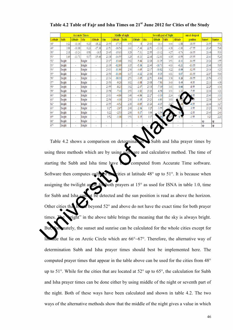
Table 4.2 Table of Fajr and Isha Times on 21st June 2012 for Cities of the Study
Table 4.2 shows a comparison on determination of Subh and Isha prayer times by
using three methods which are by using software and calculative method. The time of
starting the Subh and Isha time have been computed from Accurate Time software.
Software then computes only for the cities at latitude 48° up to 51°. It is because when
assigning the twilight angle for both prayers at 15° as used for ISNA in table 1.0, time
for Subh and Isha cannot be detected and the sun position is read as above the horizon.
Other cities that locate beyond 52° and above do not have the exact time for both prayer
times. The “bright” in the above table brings the meaning that the sky is always bright.
But, fortunately, the sunset and sunrise can be calculated for the whole cities except for
latitude that lie on Arctic Circle which are 66°~67°. Therefore, the alternative way of
determination Subh and Isha prayer times should best be implemented here. The
computed prayer times that appear in the table above can be used for the cities from 48°
up to 51°. While for the cities that are located at 52° up to 65°, the calculation for Subh
and Isha prayer times can be done either by using middle of the night or seventh part of
the night. Both of these ways have been calculated and shown in table 4.2. The two
ways of the alternative methods show that the middle of the night gives a value in which
Univers
ity of
Mala
ya
47
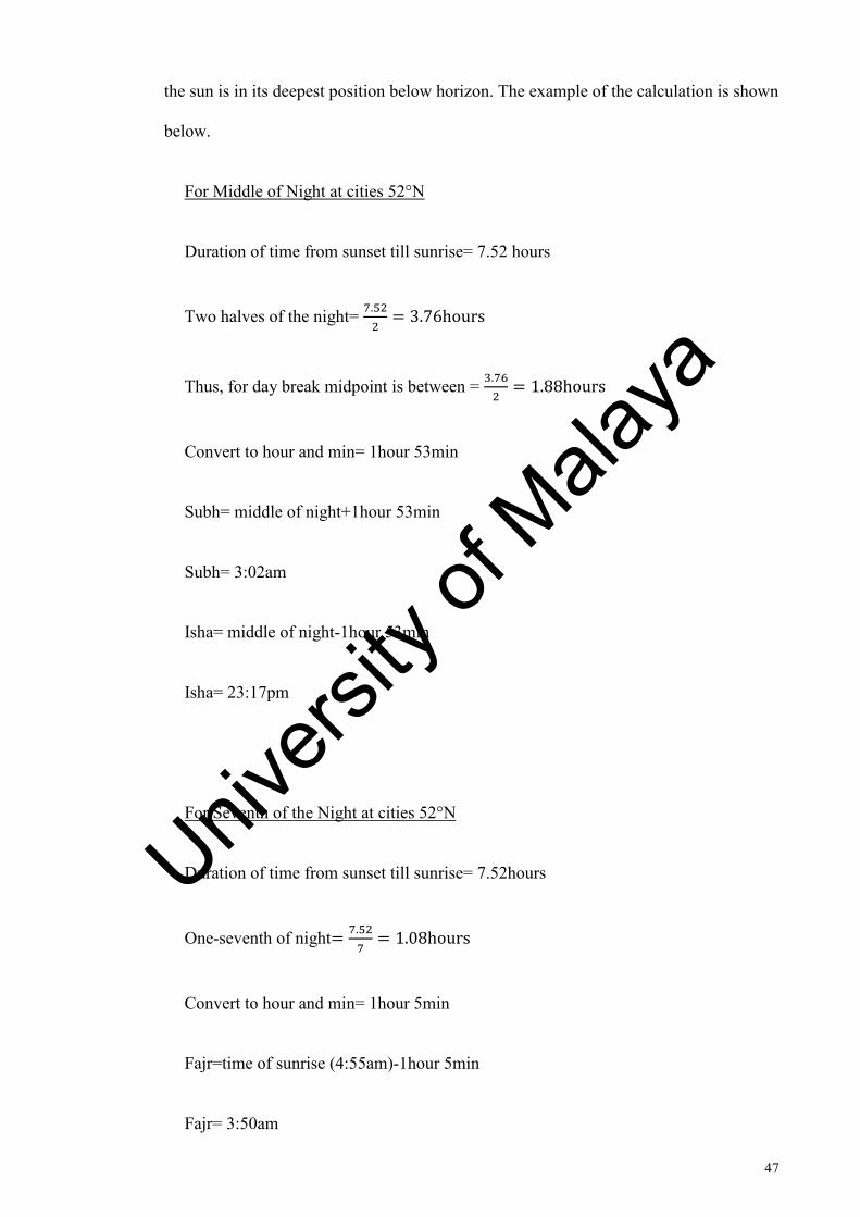
the sun is in its deepest position below horizon. The example of the calculation is shown
below.
For Middle of Night at cities 52°N
Duration of time from sunset till sunrise= 7.52 hours
Two halves of the night=
Thus, for day break midpoint is between =
1
Convert to hour and min= 1hour 53min
Subh= middle of night+1hour 53min
Subh= 3:02am
Isha= middle of night-1hour 53min
Isha= 23:17pm
For Seventh of the Night at cities 52°N
Duration of time from sunset till sunrise= 7.52hours
One-seventh of night
1
Convert to hour and min= 1hour 5min
Fajr=time of sunrise (4:55am)-1hour 5min
Fajr= 3:50am
Univers
ity of
Mala
ya
48
Isha=first one-seventh of night
Isha=22:28pm
For cities that lie at 66°~67°N latitude, there is no sunrise and sunset on 21st June
every year. Thus, these two methods would not match and would not be suitable to use
because the duration of night is undefined. Therefore, the second method shall be used.
The method is called nearest day. The last day of sunset at the cities shall be used as the
time of sunset for 21st June when the sun just circulates above the horizon. Sunset on
20th June can be used then.
4.4 Duration of Day and Night on winter 2012
After looking at the sun movement pattern on summer, one should look into sun
movement pattern on winter as well. This movement should be looked upon and
discussed because the research needs to focus on the effect of changing of the solstice
that might affect the determination of prayer times especially on Fajr and Isha prayers.
Solstice is the astronomical phenomenon which occurs twice each year where the sun
reaches the highest and lowest point on its excursion that is relative to the celestial
equator on its celestial sphere. In both cases, for the differences on the duration of night
and days for summer and winter, one should see the table 4.3.
Univers
ity of
Mala
ya
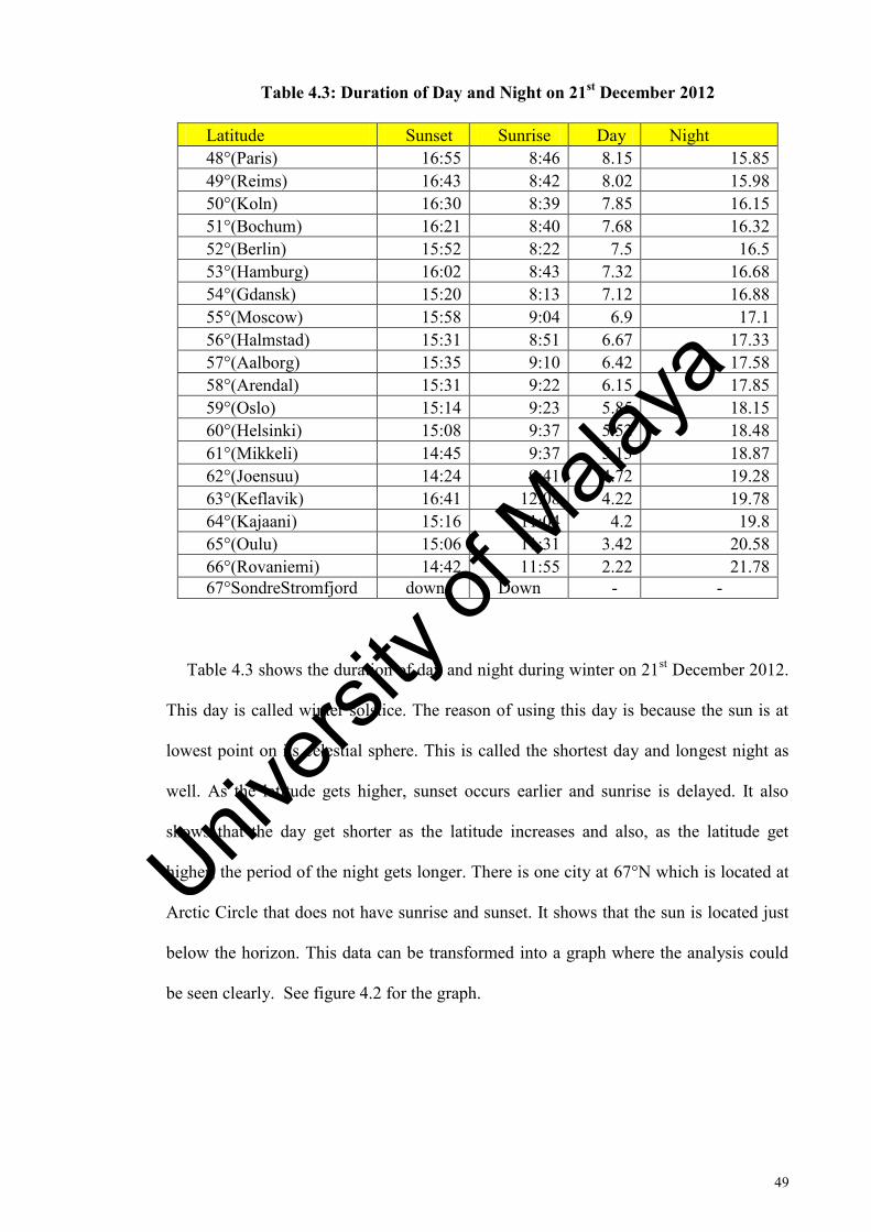
49
Table 4.3: Duration of Day and Night on 21st December 2012
Latitude Sunset Sunrise Day Night 48°(Paris) 16:55 8:46 8.15 15.85 49°(Reims) 16:43 8:42 8.02 15.98 50°(Koln) 16:30 8:39 7.85 16.15 51°(Bochum) 16:21 8:40 7.68 16.32 52°(Berlin) 15:52 8:22 7.5 16.5 53°(Hamburg) 16:02 8:43 7.32 16.68 54°(Gdansk) 15:20 8:13 7.12 16.88 55°(Moscow) 15:58 9:04 6.9 17.1 56°(Halmstad) 15:31 8:51 6.67 17.33 57°(Aalborg) 15:35 9:10 6.42 17.58 58°(Arendal) 15:31 9:22 6.15 17.85 59°(Oslo) 15:14 9:23 5.85 18.15 60°(Helsinki) 15:08 9:37 5.52 18.48 61°(Mikkeli) 14:45 9:37 5.13 18.87 62°(Joensuu) 14:24 9:41 4.72 19.28 63°(Keflavik) 16:41 12:08 4.22 19.78 64°(Kajaani) 15:16 11:04 4.2 19.8 65°(Oulu) 15:06 11:31 3.42 20.58 66°(Rovaniemi) 14:42 11:55 2.22 21.78 67°SondreStromfjord down Down - -
Table 4.3 shows the duration of day and night during winter on 21st December 2012.
This day is called winter solstice. The reason of using this day is because the sun is at
lowest point on its celestial sphere. This is called the shortest day and longest night as
well. As the latitude gets higher, sunset occurs earlier and sunrise is delayed. It also
shows that the day get shorter as the latitude increases and also, as the latitude get
higher, the period of the night gets longer. There is one city at 67°N which is located at
Arctic Circle that does not have sunrise and sunset. It shows that the sun is located just
below the horizon. This data can be transformed into a graph where the analysis could
be seen clearly. See figure 4.2 for the graph.
Univers
ity of
Mala
ya
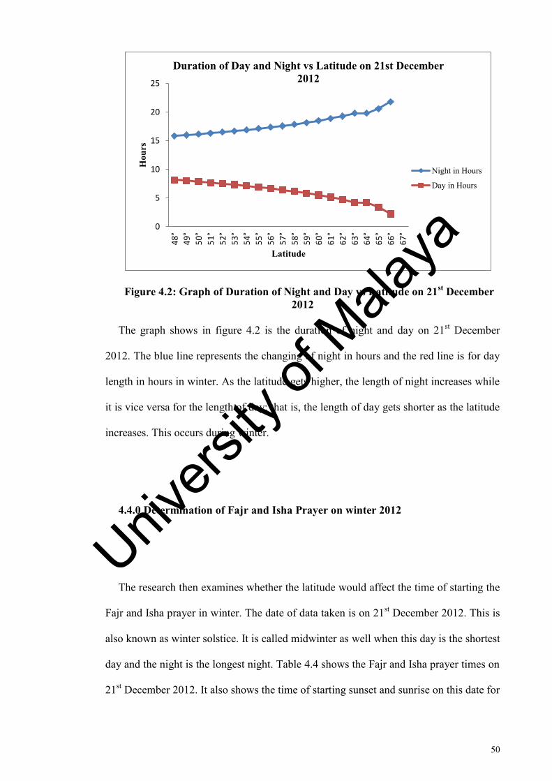
50
Figure 4.2: Graph of Duration of Night and Day vs Latitude on 21st December 2012
The graph shows in figure 4.2 is the duration of night and day on 21st December
2012. The blue line represents the changing of night in hours and the red line is for day
length in hours in winter. As the latitude gets higher, the length of night increases while
it is vice versa for the length of day; that is, the length of day gets shorter as the latitude
increases. This occurs during winter.
4.4.0 Determination of Fajr and Isha Prayer on winter 2012
The research then examines whether the latitude would affect the time of starting the
Fajr and Isha prayer in winter. The date of data taken is on 21st December 2012. This is
also known as winter solstice. It is called midwinter as well when this day is the shortest
day and the night is the longest night. Table 4.4 shows the Fajr and Isha prayer times on
21st December 2012. It also shows the time of starting sunset and sunrise on this date for
0
5
10
15
20
25
48
°
49
°
50
°
51
°
52
°
53
°
54
°
55
°
56
°
57
°
58
°
59
°
60
°
61
°
62
°
63
°
64
°
65
°
66
°
67
°
Hou
rs
Latitude
Duration of Day and Night vs Latitude on 21st December 2012
Night in Hours
Day in Hours
Univers
ity of
Mala
ya
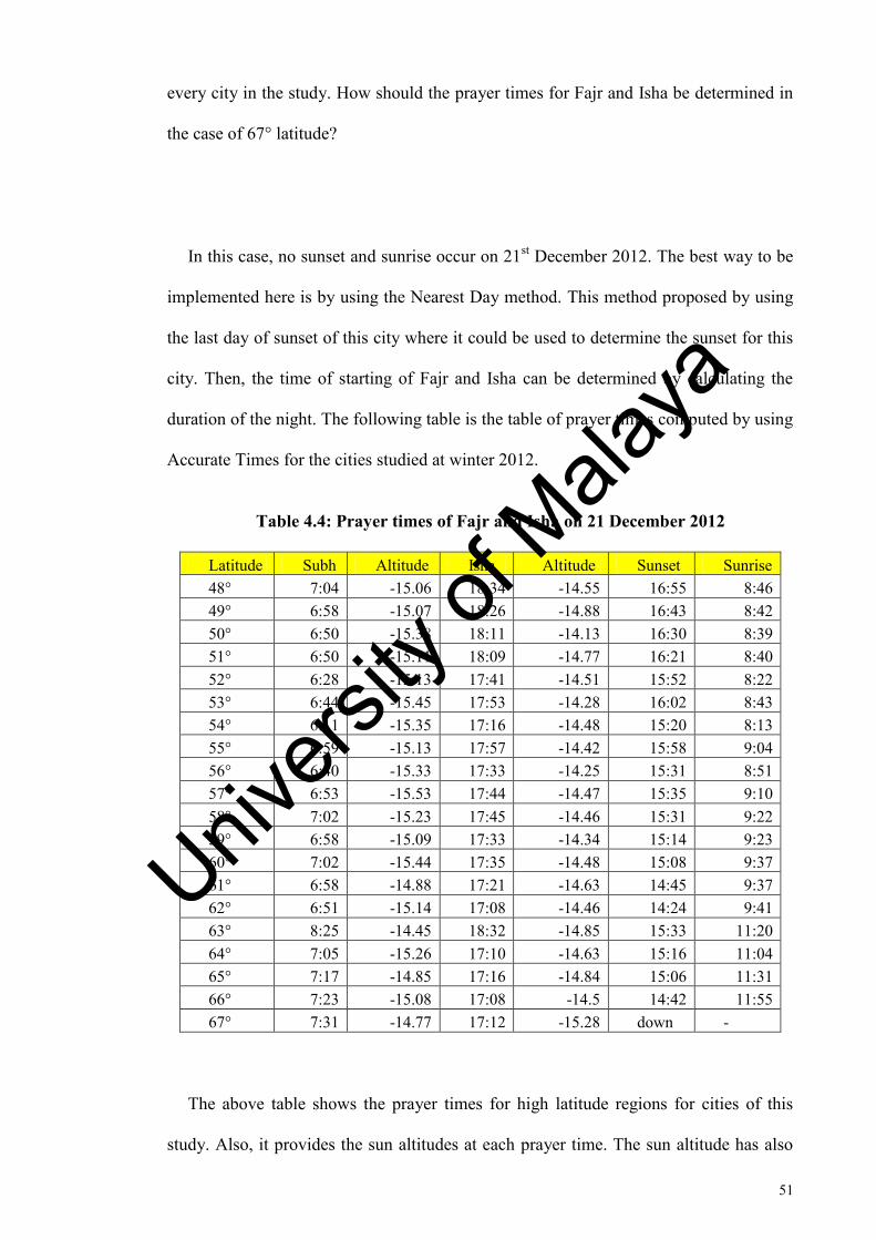
51
every city in the study. How should the prayer times for Fajr and Isha be determined in
the case of 67° latitude?
In this case, no sunset and sunrise occur on 21st December 2012. The best way to be
implemented here is by using the Nearest Day method. This method proposed by using
the last day of sunset of this city where it could be used to determine the sunset for this
city. Then, the time of starting of Fajr and Isha can be determined by calculating the
duration of the night. The following table is the table of prayer times computed by using
Accurate Times for the cities studied at winter 2012.
Table 4.4: Prayer times of Fajr and Isha on 21 December 2012
Latitude Subh Altitude Isha Altitude Sunset Sunrise 48° 7:04 -15.06 18:34 -14.55 16:55 8:46 49° 6:58 -15.07 18:26 -14.88 16:43 8:42 50° 6:50 -15.38 18:11 -14.13 16:30 8:39 51° 6:50 -15.11 18:09 -14.77 16:21 8:40 52° 6:28 -15.13 17:41 -14.51 15:52 8:22 53° 6:44 -15.45 17:53 -14.28 16:02 8:43 54° 6:11 -15.35 17:16 -14.48 15:20 8:13 55° 6:59 -15.13 17:57 -14.42 15:58 9:04 56° 6:40 -15.33 17:33 -14.25 15:31 8:51 57° 6:53 -15.53 17:44 -14.47 15:35 9:10 58° 7:02 -15.23 17:45 -14.46 15:31 9:22 59° 6:58 -15.09 17:33 -14.34 15:14 9:23 60° 7:02 -15.44 17:35 -14.48 15:08 9:37 61° 6:58 -14.88 17:21 -14.63 14:45 9:37 62° 6:51 -15.14 17:08 -14.46 14:24 9:41 63° 8:25 -14.45 18:32 -14.85 15:33 11:20 64° 7:05 -15.26 17:10 -14.63 15:16 11:04 65° 7:17 -14.85 17:16 -14.84 15:06 11:31 66° 7:23 -15.08 17:08 -14.5 14:42 11:55 67° 7:31 -14.77 17:12 -15.28 down -
The above table shows the prayer times for high latitude regions for cities of this
study. Also, it provides the sun altitudes at each prayer time. The sun altitude has also
Univers
ity of
Mala
ya
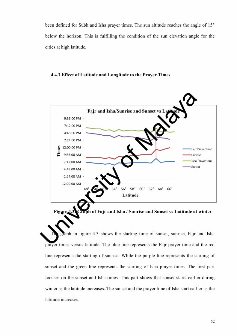
52
been defined for Subh and Isha prayer times. The sun altitude reaches the angle of 15°
below the horizon. This is fulfilling the condition of the sun elevation angle for the
cities at high latitude.
4.4.1 Effect of Latitude and Longitude to the Prayer Times
Figure 4.3: Graph of Fajr and Isha / Sunrise and Sunset vs Latitude at winter
The graph in figure 4.3 shows the starting time of sunset, sunrise, Fajr and Isha
prayer times versus latitude. The blue line represents the Fajr prayer time and the red
line represents the starting of sunrise. While the purple line represents the starting of
sunset and the green line represents the starting of Isha prayer times. The first part
focuses on the sunset and Isha times. This part shows that sunset starts earlier during
winter as the latitude increases. The sunset and the prayer time of Isha start earlier as the
latitude increases.
12:00:00 AM
2:24:00 AM
4:48:00 AM
7:12:00 AM
9:36:00 AM
12:00:00 PM
2:24:00 PM
4:48:00 PM
7:12:00 PM
9:36:00 PM
48° 50° 52° 54° 56° 58° 60° 62° 64° 66°
Tim
es
Latitude
Fajr and Isha/Sunrise and Sunset vs Latitude
Fajr Prayer time
Sunrise
Isha Prayer time
Sunset
Univers
ity of
Mala
ya
53
On the second part, the time of sunrise changes when latitude increases. The time of
Fajr starts earlier as the latitude moves upward. This occurs because of the fact that
longitude and the latitude do effect the starting of sunrise and sunset. This is because of
the region of sky visibility as the location of the observer will set the horizon. The
horizon moves parallel to the observer. Because of the earth tilt, the latitude determines
the duration of day and night throughout the year. As latitude moves upward, the
duration of day gets longer in summer and shorter in winter. As the observer moves
towards the pole either to the north or south, the sun‟s path makes lower angle relative
to the observer‟s horizon. Thanks to this reason, as the latitude gets higher, the sun path
takes a longer time to move between twilight. Thus, at the nearest to the Pole, the civil
twilight might occur for more than one week.
Furthermore, the vertical red line intersects the graph to shows the time of sunset,
sunrise, Fajr and Isha for cities at 63°N latitude (Keflavik) which are located in Iceland.
How should this difference in time compared to other cities in the high latitude regions
be explained? As latitude gets higher, the sunset sets earlier in winter. In this case, not
only the latitude should be focused on but also the time zone plays an important role in
explaining why the sun sets earlier. Keflavik is located in time zone 0 and longitude of -
22° to the west. Because of the earth steady rotation, the longitude is affecting the
timing of many events such as sunrise and sunset. The earth rotates 15° for every an
hour. Whether it moves earlier or later depends on its move to the west or to the east.
The sun moves later an hour if it moves to the west and vice versa. That is the reason
why the sunrise and sunset of the city of Keflavik is later compared to the other cities
nearby.
Univers
ity of
Mala
ya
54
CHAPTER 5
DISCUSSION AND CONCLUSION
5.0 Introduction
This section discusses about the factors that mostly affect the starting of prayer times
for Fajr and Isha at high latitude regions. In an early discussion in the previous chapter,
the research discusses that latitude plays a role in determination of prayer times of Fajr
and Isha. The research needs to find out whether or not the change of the latitude effect
the starting of prayer times of Fajr and Isha at cities located in high latitude.
5.1 Conclusion on Factors in Determination of Night Prayers
In conclusion, the results show that change of latitude does effect the determination
for starting Fajr and Isha prayer times. It also shows two different findings in two main
seasons. In summer, the sun sets later and rises earlier which would result in short
nights for cities in high latitude. As latitude gets higher, the period of night gets shorter.
Some cities at extreme case occur at 66°N to 67°N which do not have sunset and
sunrise. This occurs on 21st June 2012 or it can be called summer solstice where the sun
Univers
ity of
Mala
ya
55
does not set below the horizon. These cities belong to the Arctic Circle where the
extreme cases occur.
Results show that, at winter, as the latitude increases, the sun sets earlier and the
sunrise occurs later. This leads to the longer period of night which occurs as latitude
increases. At 67°N of latitude, the sun does not appear at all on 21st December 2012.
The sun does not rise above the horizon. This can be called midnight winter where night
appears longer.
The research also finds out that there are other reasons or factors in determination of
starting Fajr and Isha prayer times. As seen in result and analysis chapter, it shows that
longitude and time zone define the starting of prayer times as well. In this research, the
cities which are located at 63°N, the sunset, sunrise and the beginning of both prayer
times start late because the cities are located at the longitude more to the west compared
to other cities which are located at the east.
5.2 Conclusion on Implementing the Alternative Way in Starting Night Prayers
There are four alternative ways to define the starting of Fajr and Isha prayer times.
These are nearest day, nearest latitude, middle of the night and seventh part of the night.
Which way is the best to be used and easiest to be implemented in daily usage? It
depends on the situation. As in normal case, the angle of beginning of the Isha and Subh
prayer is at 18° below horizon. But at the high latitude case where the sun could not
reach at 18°, several opinions are proposed to use 15° as starting the both prayers. The
results show that in summer, some cities at high latitude regions, the sun does not reach
Univers
ity of
Mala
ya
56
15° below the horizon to start the Fajr and Isha prayer time. Refer to table 4.2 in chapter
on result and analysis. But the sun can still set and rise at a certain period of time. Thus,
for cities located at 48°N up to 51°N there is still a way which can determine starting of
Fajr and Isha prayer times by using computer software. For cities located above 51°N
up to 65° latitude where prayer times are undetermined by computer software, it needs
to be calculated by an alternative way. There are two ways of calculating it either by
middle of the night or seventh part of the night. During summer where sun does not set
18° below the horizon, one should select which is the easiest way to calculate the night
prayer. The research found out that by dividing the night by two, the Middle of the
Night method gives the prayer time start, late but it gives more time for the sun to go
deeper below horizon where it is most fitted with the requirement of fiqh. According to
Katiya[13] In summer, at latitudes higher than 48.5° (extreme northern regions), the sun
does not go 18° below the horizon and at the latitudes higher than 51.5°, the sun does
not go 15° below horizon, for example Manchester England and Edmonton Canada, in
summer, the sun hardly goes beyond 13.5° below the horizon thus full darkness does not
occur, in such cases several alternative methods are suggested by the leading
scholars.(Katiya,2007)
For cities at Arctic Circle, no sunset and sunrise occur at summer solstice where the
sun does not set below the horizon. These cities could use the nearest day method where
the last day of sunset at the cities can be used as the time of sunset for 21st June 2012.
Then same goes here where the period of the night can be calculated.
Meanwhile, for the winter discussion, it is easier to calculate the prayer times here.
As agreed by most experts, the sun angle 15° when starting the Fajr and Isha prayer
13Aisha Charitable Support Services Montreal Canada Siddique Katiya, 15 September 2007 ,www.as-sidq.org
Univers
ity of
Mala
ya
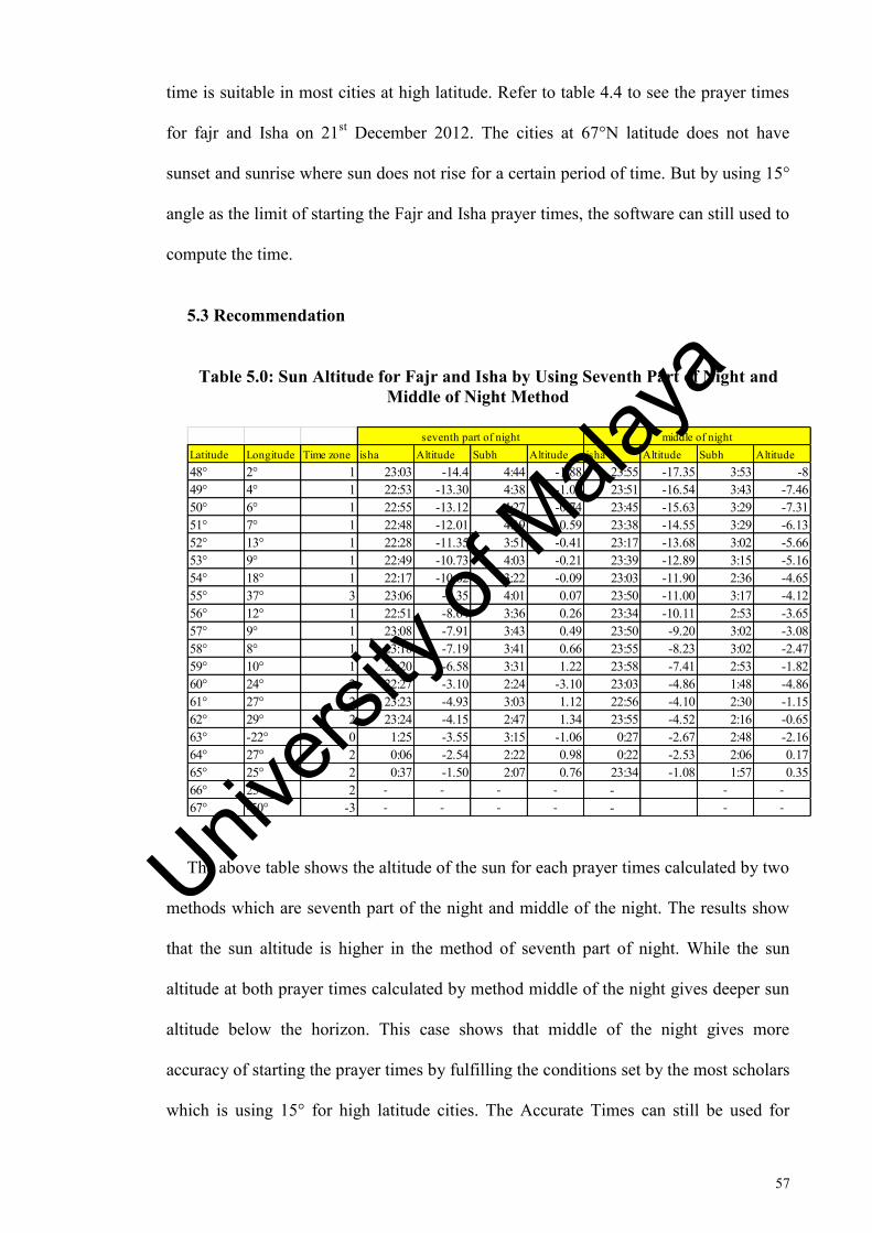
57
time is suitable in most cities at high latitude. Refer to table 4.4 to see the prayer times
for fajr and Isha on 21st December 2012. The cities at 67°N latitude does not have
sunset and sunrise where sun does not rise for a certain period of time. But by using 15°
angle as the limit of starting the Fajr and Isha prayer times, the software can still used to
compute the time.
5.3 Recommendation
Table 5.0: Sun Altitude for Fajr and Isha by Using Seventh Part of Night and Middle of Night Method
The above table shows the altitude of the sun for each prayer times calculated by two
methods which are seventh part of the night and middle of the night. The results show
that the sun altitude is higher in the method of seventh part of night. While the sun
altitude at both prayer times calculated by method middle of the night gives deeper sun
altitude below the horizon. This case shows that middle of the night gives more
accuracy of starting the prayer times by fulfilling the conditions set by the most scholars
which is using 15° for high latitude cities. The Accurate Times can still be used for
Latitude Longitude Time zone isha Altitude Subh Altitude isha Altitude Subh Altitude48° 2° 1 23:03 -14.4 4:44 -1.88 23:55 -17.35 3:53 -849° 4° 1 22:53 -13.30 4:38 -1.00 23:51 -16.54 3:43 -7.4650° 6° 1 22:55 -13.12 4:27 -0.74 23:45 -15.63 3:29 -7.3151° 7° 1 22:48 -12.01 4:19 -0.59 23:38 -14.55 3:29 -6.1352° 13° 1 22:28 -11.35 3:51 -0.41 23:17 -13.68 3:02 -5.6653° 9° 1 22:49 -10.73 4:03 -0.21 23:39 -12.89 3:15 -5.1654° 18° 1 22:17 -10.02 3:22 -0.09 23:03 -11.90 2:36 -4.6555° 37° 3 23:06 -9.35 4:01 0.07 23:50 -11.00 3:17 -4.1256° 12° 1 22:51 -8.64 3:36 0.26 23:34 -10.11 2:53 -3.6557° 9° 1 23:08 -7.91 3:43 0.49 23:50 -9.20 3:02 -3.0858° 8° 1 23:18 -7.19 3:41 0.66 23:55 -8.23 3:02 -2.4759° 10° 1 23:20 -6.58 3:31 1.22 23:58 -7.41 2:53 -1.8260° 24° 2 22:27 -3.10 2:24 -3.10 23:03 -4.86 1:48 -4.8661° 27° 2 23:23 -4.93 3:03 1.12 22:56 -4.10 2:30 -1.1562° 29° 2 23:24 -4.15 2:47 1.34 23:55 -4.52 2:16 -0.6563° -22° 0 1:25 -3.55 3:15 -1.06 0:27 -2.67 2:48 -2.1664° 27° 2 0:06 -2.54 2:22 0.98 0:22 -2.53 2:06 0.1765° 25° 2 0:37 -1.50 2:07 0.76 23:34 -1.08 1:57 0.3566° 25° 2 - - - - - - -
67° -50° -3 - - - - - - -
seventh part of night middle of night
Univers
ity of
Mala
ya
58
cities between 48° up to 51° to get the Subh and Isha prayer times. The middle of the
night method can fulfill the requirements at latitude of 52° up to 65° where Isha starting
time would fulfill the fiqh requirements where the sun is still below the horizon. But it
still does not fulfill the requirement or the condition for Subh prayer time where at
latitude 63°, the sun just raises which it does not fulfill the requirement of performing
the Subh before beginning the Shuroq or sunrise time. Thus, the recommendation here
is to standardize the method of determination of Isha and Subh prayer time where at 48°
up to 51° latitude, those cities can use the Accurate Times to get both prayer times. As
for cities located between 52° up to 65° latitude, the method of Middle of the Night can
be used where it shows the increasing of the sun altitude is stable as the latitude
increases. For latitude of 65° and above, further studies need to be done to determine the
Isha and Subh prayer times which can fulfill the fiqh requirements.
Univers
ity of
Mala
ya
59
REFERENCES
Aghighi,H, Alimohammadi,A and Ghahareh (2008). Prayer Times Modeling With GIS:A Case Study for Iran and its Surrounding . Journal of Computer Science 4(10):807-814
Alnaser,WE and Alnaser,NW. (2009). The Solar Connection in the Muslim Community. ISESCO Science and Technology Vision Vol5(7);41-44. Goldstein,B.R. (1977). Ibn Mucadh's Treatise on Twilight and the Height of
Atmosphere,Communicated by A.Aaboe;pg98. Hahewaming,N (2002). Astronomical Calculation of Islamic Times and Qiblat
Direction. 33rd Congress on Science and Technology of Thailand.pg1-6 Katiya,S. (2007) Aisha Charitable Support Services Montreal Canada. www.as-sidq.org
Muneer, T (2007). The Islamic Prayer Times. Computational Philosophy with Particular Reference to the Lack of Twilight Cesssation at Higher Latitudes. Pg 1-6
Messina, P. (2009) Day and Night in Alaska .Geology 103,pg1.
Niri, M.A. (2012). Astronomical Determination for the Beginning Prayer Times of Isha'. Middle East Journal of Scientific Research 12(1);pg101-107
Odeh,M. (2014). Islamic Crescents' Observation Project (ICOP).
http://www.icoproject.org/accut.html?&l=en Scherrer, P&D (2015). Solstice and Equinox ("Suntrack") Model. Standford Center. pg3
Zadeh,H.Z.(2010)PrayerTimes Calculation. http:/tanzil.info/prayertime/doc/calculation. Pg1-5.
Univers
ity of
Mala
ya

60
LIST OF PUBLICATIONS AND PAPERS PRESENTED
Sky Brightness and determination of Subh and Isha Prayer by Using Sky Quality
Meter, International Journal of Scientific & Engineering Research Volume3, Issue 8,
August 2012.
Paper 50, 1st Global Conference for Academic Research Kuala Lumpur, Managing
Technology and Innovation in 21st Century, 8-11June 2012,Kuala Lumpur
Univers
ity of
Mala
ya