Traffic Management Study - urbantransport.kar.gov.in
56
TRAFFIC MANAGEMENT STUDY SADASHIVANAGAR AND BELLARY ROAD DIRECTORATE OF URBAN LAND TRANSPORT JUNE 2013
Transcript of Traffic Management Study - urbantransport.kar.gov.in

TRAFFIC MANAGEMENT STUDY SADASHIVANAGAR AND BELLARY ROAD
DIRECTORATE OF URBAN LAND TRANSPORT
JUNE 2013

TABLE OF CONTENTS
1 INTRODUCTION- TRAFFIC MANAGEMENT STUDY ................................................................... 1
1.1 CURRENT SCENARIO IN BANGALORE ................................................................................. 1
1.2 OBJECTIVE OF THE STUDY ................................................................................................. 1
I. Sadashivanagar ..................................................................................................................... 1
II. Bellary Road .......................................................................................................................... 2
1.3 METHODOLOGY................................................................................................................ 2
2 SADASHIVANAGAR ............................................................................................................... 4
2.1 LANDUSE ........................................................................................................................... 5
2.2 ROADWAY SEGMENTS AND INTERSECTIONS ..................................................................... 6
Major Roadway Segments include:................................................................................................. 6
Major Intersection in study area: ................................................................................................... 6
2.3 SURVEYS .......................................................................................................................... 7
2.4 EXISTING CONDITION ....................................................................................................... 7
Roadway Segments: ........................................................................................................................ 7
Intersections: .................................................................................................................................. 9
2.5 ISSUES AND INTERVENTIONS ........................................................................................... 10
2.5.1 Cauvery Junction ................................................................................................................. 10
Issues ................................................................................................................................... 11
Interventions ....................................................................................................................... 11
2.5.2 Bhashyam Circle .................................................................................................................. 18
Issues ................................................................................................................................... 18
Intervention ........................................................................................................................ 18
2.5.3 CNR Rao Circle ..................................................................................................................... 20
Issues- Concern by the residents ........................................................................................ 21
Intervention ........................................................................................................................ 21

2.5.4 Traffic congestion in the residential roads of Sadashivanagar ........................................... 24
2.5.5 Unauthorized parking in the residential roads of Sadashivanagar ..................................... 28
Interventions ....................................................................................................................... 28
3 BELLARY ROAD ................................................................................................................... 29
3.1 LANDUSE ........................................................................................................................ 30
3.2 ROADWAY SEGMENTS AND INTERSECTIONS ................................................................... 31
3.3 EXISTING OPERATIONAL CONDITIONS ............................................................................. 32
Roadway Segments: ...................................................................................................................... 32
Intersections ................................................................................................................................. 34
3.4 ISSUES AND INTERVENTIONS .......................................................................................... 35
3.4.1 Kempapura Entrance .......................................................................................................... 35
Issues ................................................................................................................................... 35
Interventions ....................................................................................................................... 36
3.4.2 Kodigehalli Gate .................................................................................................................. 41
Issues ................................................................................................................................... 41
Interventions ....................................................................................................................... 42
3.4.3 Accessibility issues to Bus Stops ......................................................................................... 43
4 CONCLUSION ...................................................................................................................... 50

LIST OF FIGURES
Figure 1: Growth Rate of Bangalore ....................................................................................................... 1
Figure 2: Study Area-Sadashivanagar ..................................................................................................... 4
Figure 3: Land use- Sadashivanagar ........................................................................................................ 5
Figure 4: Major Roadway Segments and Intersections .......................................................................... 7
Figure 5: Existing operating LOS condition ............................................................................................. 9
Figure 6: Existing scenario at Cauvery Junction .................................................................................... 11
Figure 7: Proposed scenarios at Cauvery Junction ............................................................................... 12
Figure 8: Existing scenario at Bhashyam, Cauvery Junction and Windsor manor Circle ...................... 14
Figure 9: Proposed Traffic Circulation at Bhashyam, Cauvery Junction and Windsor manor Circle .... 15
Figure 10 : Proposed scenario at Cauvery Junction .............................................................................. 17
Figure 11: Existing and proposed signal phasing .................................................................................. 19
Figure 12: Alignment at proposed underpass ....................................................................................... 20
Figure 13: Concerned issues on the proposed CNR Rao underpass ..................................................... 21
Figure 14 : Commuters Volume Count at IISc plying towards Yeshwantpur ........................................ 22
Figure 15 : Commuters Volume Count at IISc plying towards Mekhri Circle ........................................ 23
Figure 17: Issues with accessibility to bus stops ................................................................................... 23
Figure 16: Trip Purpose ......................................................................................................................... 23
Figure 18: Proposed bus shelter at IISc ................................................................................................. 24
Figure 19 : Existing Traffic scenario in Sadashivanagar residential layout ........................................... 25
Figure 20 : Traffic Calming Measure ..................................................................................................... 26
Figure 21 : Traffic Calming Streets ........................................................................................................ 27
Figure 22: Parking Survey Analysis-Sadashivanagar ............................................................................ 28
Figure 23: Study area -Bellary Road ...................................................................................................... 29
Figure 24: Land use-Bellary Road .......................................................................................................... 30
Figure 25: Major Roadway Segments and Study Intersection .............................................................. 31
Figure 26: Major Roadway Segments and Study Intersection .............................................................. 34
Figure 27: Identified issues at Kempapura Entrance ........................................................................... 36
Figure 28: Proposed intervention for the Elevated Road, Bellary Road ............................................... 37
Figure 29: Concept Plan of Skywalk-Kempapura Entrance ................................................................... 38
Figure 30: Issues at Kempapura Entrance ............................................................................................. 39
Figure 31: Proposed intervention at Kempapura Entrance .................................................................. 40
Figure 32: Existing scenario at Kodigehalli Gate. .................................................................................. 42
Figure 33: Issues at Kodigehalli Gate .................................................................................................... 42
Figure 34: Proposed interventions at Kodigehalli Gate. ....................................................................... 43

Figure 35: Existing scenario at Mekhri Circle ........................................................................................ 44
Figure 36: Survey Analysis at Mekhri Circle Bus Stop ........................................................................... 45
Figure 37: Proposed Improvement at Mekhri Circle ............................................................................ 46
Figure 38: Existing Scenario at Mekhri Circle ........................................................................................ 46
Figure 39: Cross section at A-A ............................................................................................................. 47
Figure 40: Survey Analysis at Anandnagar Bus Stop ............................................................................. 47
Figure 41: Proposed Improvement at Anand Nagar ............................................................................. 48
LIST OF TABLES
Table 1: Study Methodology ................................................................................................................... 3
Table 2: Existing V/C and LOS of Roadway segments ............................................................................. 8
Table 3: Existing V/C and LOS of the study corridors .............................................................................. 8
Table 4 : Existing Operating Conditions at the Study Intersections ...................................................... 10
Table 5 : Proposed Signal Phase for Cauvery Jucntion ......................................................................... 13
Table 6 : Operating Conditions at Cauvery Junction ............................................................................. 13
Table 7 : Operating Conditions on the implementation of the change in traffic circulation plan. ....... 16
Table 8: Operational efficiency of Cauvery Junction ............................................................................ 17
Table 9: Operational efficiency of Bhashyam Circle ............................................................................. 20
Table 10: Proposed Signal Phase at CNR Rao Circle ............................................................................. 22
Table 11 : Operational Efficiency of CNR Rao circle .............................................................................. 24
Table 12 : Existing V/C and LOS for study corridors .............................................................................. 33
Table 13: Existing Operating Conditions at the Study Intersections .................................................... 35
Table 14: Operational efficiency at Kempapura Entrance .................................................................... 40
Table 14: Operational Efficiency of Anand Nagar ................................................................................. 49
Table 15: Proposed Improvement with their Implementing Agencies ................................................. 50

Traffic Management Study Introduction
DULT 1 | P a g e
1 INTRODUCTION- TRAFFIC MANAGEMENT STUDY
Bangalore is India's third most populous city and a well known hub of India's information technology
sector, ranked among the top 10 preferred entrepreneurial locations in the world. As a growing
metropolitan city in a developing country, Bangalore confronts substantial to its increase in the number of
vehicles and a huge increase in the demand on land.
With increasing population and a growing economic base, Bangalore has witnessed a tremendous rise in
vehicular growth. The resultant pressure on road spaces is very high, and traffic conditions are
increasingly difficult. Nonetheless, there is urgent pressure to find solutions, both short-term and long-
term, the ones that can begin to grapple with the complex demands of traffic and transport management.
What adds to the traffic pressure in Bangalore in particular is its very little scope for expansion of roads
and the need to use existing roads for smooth movement of vehicles.
1.1 CURRENT SCENARIO IN BANGALORE
The population in Bangalore Urban Region and Municipalities has increased from 30 lakh to 101 lakh
over the past four decades. The increase from 41 lakh in
1991 to a drastic increase of 96 lakh in 2011 along with
the increasing vehicular growth may be considered the
trigger for increased traffic volume leading to delay and
congestion.
Fig. 1 represents the population versus vehicular growth
over the past four decades. Alongside the exponential
growth rate for the year 2021 has also be projected.
1.2 OBJECTIVE OF THE STUDY
A meeting was held under the chairmanship of the Chief Secretary on 26th
Feb 2013, to identify and
address the traffic issues of Sadashivanagar and Bellary Road. During which, the following travel
constraints were highlighted, namely:
I. Sadashivanagar
1. Traffic congestion on inner residential roads.
Figure 1: Growth Rate of Bangalore

Traffic Management Study Introduction
DULT 2 | P a g e
2. Unauthorized parking in residential areas (especially evening & weekends)
3. Delays in on-going projects- CNR Rao junction, Sankey Road widening, Ramana Maharishi road
widening- between Cauvery junction and Mekhri Circle.
II. Bellary Road
4. Effect of elevated road constructed by NHAI on NH-7
5. Accessibility and Pedestrian infrastructure issues between Mekhri circle and Kodigehalli cross.
In order to identify the existing travel constraints and improve ease of accessibility, as well as decongest
the residential ward of the Sadashivanagar, Directorate of Urban Land Transport (DULT) has taken up the
study on Traffic Management for Sadashivanagar and Bellary Road.
1.3 METHODOLOGY
The traffic management plan of Sadashivanagar and Bellary Road was aimed to ease and regulate the
travel constraints prevailing within the study area. A reconnaissance survey was done to identify the
issues pertaining to the intersections, parking, black spots, etc as well as identify the traffic circulation
pattern in and around the study area. This was followed by the data collection effort in the from of
primary and secondary surveys where primary surveys like traffic volume counts, bus boarding &
alighting, Bus passenger opinion, parking surveys, etc were carried out to obtain an idea of the traffic
scenario of the study area. The secondary data collected from various agencies comprised of the existing
land use patterns, accident details from Traffic Police, Bus route details from BMTC and the proposed
improvements in and around the study area which would have a significant effect on the operation
conditions of the roadways. The collected data was analyzed to identify the Roadway Segments capacity
and Level of Service (LOS), based on the Indian Roads Congress (IRC) standards sourced from
Guidelines for Capacity of Urban Roads in Plain Areas IRC 106-1990. Whereas, the delay and queue
lengths at the intersections are estimated using a micro simulation based software. The parking surveys
were also carried out to ascertain the number of parking space available within the residential area to that
of the owned vehicles by residents. The next step was to propose section specific interventions to the
identified issue and prepare their of implementation plan. Based on the need of urgency, the interventions
were classified as short, medium and long term measures.
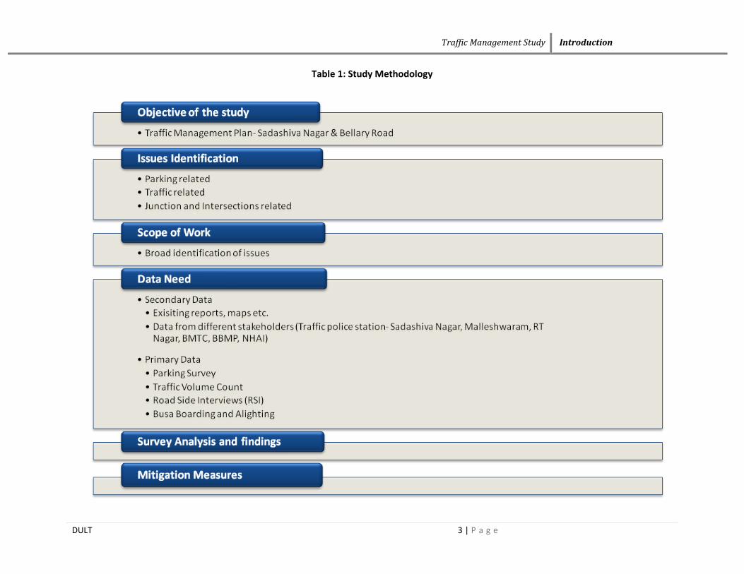
Table 1 illustrates the methodology adopted to carry out “Traffic Management Study”.
Traffic Management Study Introduction
DULT 3 | P a g e
Table 1: Study Methodology

Traffic Management Study Sadashivanagar
DULT 4 | P a g e
2 SADASHIVANAGAR
In 1960s and early 1970s, the gardens of the Bangalore Palace (a summer home of the Wodeyar dynasty
of Mysore) were converted into a residential neighbourhood. Until 1990s, Sadashivanagar was known as
"Palace Orchards," as it was built in the former royal grounds. It was renamed in honor of Karnad
Sadashiva Rao, a freedom fighter and philanthropist. Situated right opposite to what is left of the official
palace grounds is now a home to many highly placed government officials, ex-governors, film stars and
millionaire businessmen. The neighbourhood is also home to various Wodeyar royals.
Figure 2: Study Area-Sadashivanagar

Traffic Management Study Sadashivanagar
DULT 5 | P a g e
2.1 LANDUSE
One of the important characteristics in the preparation of a traffic management plan is to study and
understand the land use pattern of the study area. Sadashivanagar is a well established posh residential
neighbourhood of Bangalore. The land use is mainly of mixed residential type with public spaces such as
Indian Institute of Science, the Raman Research Institute, Microsoft Research India, etc. to the north of
the study area and an open space of Palace Ground to the east. Although the inner core of Sadashivanagar
is mainly residential, the main arterial roads are attracting a lot of commercial activities.
Figure 3 shows the existing land use pattern of the study area.
Figure 3: Land use- Sadashivanagar

Traffic Management Study Sadashivanagar
DULT 6 | P a g e
2.2 ROADWAY SEGMENTS AND INTERSECTIONS
The study area is located around 3.5 km from the CBD of Bangalore, runs along from Mehkri Circle in
the north to Bashyam Circle a little way south with Vasanth Nagar towards East and Gutthalli towards
South. The major roadway segments surrounding the study area are CV Raman Road,Bellary Road and
Sankey Tank Road.Amoung which CV Raman Road,Bellary Road and Sankey Road (between Cauvery
Junction / Bhashyam) are six lane divided road and Sankey Road (between Bhashyam and CNR Rao
road) is four lane divided road.
Major Roadway Segments include:
The major roadway segments that state the characteristics of the study area are:
1. Sankey Tank Road (CNR Rao Circle–Cauvery Junction)
2. C V Raman Road (Mekhri Circle- CNR Rao Circle)
3. Bellary Road (Cauvery Junction-Mekhri Circle)
Major Intersection in study area
The major intersections that are expected to impact the operational efficiency of the study area are:
1. CNR Rao Circle (Sankey Road/C V Raman Road)
2. Sadashivanagar Police Station (C V Raman Road/New BEL Road)
3. Mekhri Circle (Bellary Road/C V Raman Road)
4. Cauvery Junction (Sankey Road/Bellary Road)
5. Bhashyam Circle (Sankey Road/13th Cross Road)
Figure 4 represents the major roadway segments and study intersections of the study area.

Traffic Management Study Sadashivanagar
DULT 7 | P a g e
Figure 4: Major Roadway Segments and Intersections
2.3 SURVEYS
A set of primary traffic surveys such as traffic volume counts, speed and delay surveys, road inventory
survey, parking opinion Surveys & Bus passenger opinion and boarding and alighting survey, etc were
conducted during March- April 2013 in order to assess the traffic and transport scenario.
2.4 EXISTING CONDITION
The existing operation conditions of the study roadway networks and intersections were evaluated with
respect to the following to identify the issues with respect to vehicular and pedestrian traffic
1. Roadway Segments- Volume to Capacity Ratio and LOS
2. Intersections- Delay and Queue Length
Roadway Segments:
The Level of Service (LOS) and the capacity of the Roadway segments computed is based on the Indian
Roads Congress (IRC) standards sourced from Guidelines for Capacity of Urban Roads in Plain Areas
IRC 106- 1990. Table 2 provides the LOS standards adopted based on the volume to capacity (V/C) ratios
at the intersections and its performance.

Traffic Management Study Sadashivanagar
DULT 8 | P a g e
Table 2: Existing V/C and LOS of Roadway segments
Note: V= Volume in PCU’s/hr& C= Capacity in PCU’s/ hr
The existing conditions of the Sadashivanagar Study area reveal that all the study roadway segments in
the study area are operating at an acceptable LOS D or better during existing peak hour conditions with
V/C ratio equal to or less than 0.77 except the Sankey Road segment between Bhashyam Circle to Circle
Maramma Circle which is operating at V/C ratio of 1.46. Table 3 shows the Existing traffic operation
conditions of the study roadway segments and Figure 5 depicts the same.
Table 3: Existing V/C and LOS of the study corridors
Road Name Segment Direction of Traffic
Flow
Existing Peak
hour Volume
(PCU/ Hr)
V/C LOS
Sankey Tank Road Bhashyam- Cauvery
East Bound (LCW) 2401 0.72 D
West Bound (RCW) 1097 0.33 B
Sankey Tank Road Bhashyam- Maramma Circle
East Bound (LCW) 3124 1.43 F
West Bound (RCW) 3027 1.46 F
Sankey Tank Road CNR Rao- Maramma Circle
East Bound (LCW) 1390 0.35 B
West Bound (RCW) 1081 0.27 B
C V Raman Road CNR Rao- New BEL Road
East Bound (LCW) 3124 0.54 C
West Bound (RCW) 3207 0.56 C
C V Raman Road New BEL Road - Mekhri Circle East Bound (LCW) 1064 0.27 B
V/C LOS Performance
0.0 - 0.2 A Excellent
0.2 - 0.4 B Above Average
0.4 - 0.6 C Average
0.6 - 0.8 D Below Average
0.8 - 1.0 E Poor
1.0 - 1.2 F Very Poor

Traffic Management Study Sadashivanagar
DULT 9 | P a g e
West Bound (RCW) 2150 0.54 C
Bellary Road Cauvery- Mekhri Circle
North Bound (LCW) 3523 0.26 B
South Bound (RCW) 9389 0.68 D
Figure 5: Existing operating LOS condition
Intersections:
The traffic analyses at the identified intersections are tabulated in table 4. All these intersection generate
large amount of traffic and are particularly choked up during the peak hours. CNR Rao circle has
recorded a delay of 18.6 sec/veh with queue of 141.2 m in the east bound direction. This queue is only
temporary and will be minimized once the proposed underpass at CNR Rao circle is completed and is
operational.

Traffic Management Study Sadashivanagar
DULT 10 | P a g e
Cauvery Junction has over the past years become inadequate to cater to the huge growth of vehicular
volume. This inefficient carrying capacity of Cauvery junction has also reduced the operational efficiency
of Bhashyam circle as well. This may be the reason why Bhashyam circle and Cauvery junction have
queue lengths of 293.7m and 511.5 m reported in the south and east bound directions. Windsor Manor has
recorded a delay of 192.7 sec/veh with a queue length of 203.4 m in the south bound direction.
Table 4 : Existing Operating Conditions at the Study Intersections
Road Name Delay (sec/veh) Queue Length (m) Throughput
(Vehicles)
CNR Rao Circle
(Sankey Road/C V Raman Road) 20 141.1(EB) 3143
Cauvery Junction
(Sankey Road / Bellary Road) 128.5 108.9(SB) 3223
Bhashyam
(Sankey Road / 13th Cross Road) 108.5 155.1 (EB) 408
Windsor Manor
(Golf Course/Bellary Road) 192.7 203.4 (SB) 1610
2.5 ISSUES AND INTERVENTIONS
This section lists out the issues and relevant interventions proposed to address the travel constraints of
Sadashivanagar. The traffic management plan is composed of Short, Middle and Long-Term
Plans/measures, where short term measures are the most simplest and immediate to implement with less
capital intensive whereas middle term and long term are more section specific measures and more capital
intensive.
The approach is as described in sections below.
2.5.1 Cauvery Junction
Bangalore’s first “magic box” underpass built under the new cost-effective technology in 2008 was an
attempt made by Bruhat Bangalore Mahanagara Palike’s to ease traffic congestion on Bellary Road.
However, over the recent years the junction has become incompetent to cater to the large volume of
traffic (especially the BIA traffic) leading to traffic congestion and delay.

Traffic Management Study Sadashivanagar
DULT 11 | P a g e
Issues
1. Especially during the peak hours, vehicles particularly buses bound to Mekhri Circle from Windsor
Manor are trapped in the bottleneck created on the covered portion of the “magic box” leading to delay
and queue length extending from Windsor Manor to Mekhri Circle.
2. The ‘magic box’ is now insufficient to cater increased volume of right turning traffic. Vehicles
plying through the “Magic Box” were found to be standing on an unsafe gradient.
Figure 6 illustrate the junction alignment and the traffic volume in PCUs at the Cauvery Junction.
Figure 6: Existing scenario at Cauvery Junction
Interventions
In order to address the immediate need of traffic management at Cauvery Junction, a set of interventions
have been suggested.
1. Short Term Measures :
a. Signalization of Cauvery Junction: As a short term measure, an installation a traffic signal has
been suggested. As per the existing scenario, the vehicles plying through the magic box find

Traffic Management Study Sadashivanagar
DULT 12 | P a g e
themselves trapped between the longer queues and steep gradients. Thus, Signalization of Cauvery
Junction was checked as an alternative for its operational efficiency under two scenarios:
Scenario 1 will include signalization of the junction with vehicles bound right (from Sankey Road
towards Winsor Manor) traversing through the “Magic Box” whereas Scenario 2 will include
signalization of the junction with vehicles bound right (from Sankey Road towards Winsor Manor)
moving at ground gradient i.e the magic box will be closed/filled to provide a safe and effective
gradient for the vehicles to traverse upon.
The two scenarios are illustrated in figure 7 below:
Figure 7: Proposed scenarios at Cauvery Junction
Based on the vehicular volume and the available Right of way, signalization of the Cauvery junction has
been designed. A total signal phasing plan of 250 seconds with Sankey Road phasing of 70 seconds,
Bellary Road phasing of 60 seconds and a pedestrian signal phase of 10 seconds has been proposed.
The proposed signal phase is shown in table 5.

Traffic Management Study Sadashivanagar
DULT 13 | P a g e
Table 5 : Proposed Signal Phase for Cauvery Junction
Proposed Signal Phase
Road From 1 2 Cycle Time
A Sankey Road R L L
Ex
clu
siv
e
Ped
estr
ian
B Bellary Road L L S
Peak Hour 70 60 10 250
Table 6 represents a comparison of the scenarios proposed for Cauvery Junction. As per the results, the
installation of a signal will drastically improve the operational efficiency of the junction i.e the existing
delay of 128.5 sec/veh will be reduced to 69.4 sec/veh whereas queue length has increased from 108.9 m
to 390.9 m and 511.5 m in the south bound direction with the magic box open and closed scenario
respectively. Among the two scenarios, the scenario with magic box closed may be feasible over the
magic box open conditions as a queue length of 390.9 m can be accommodated within the available
storage length whereas the queue length of 511.5m cannot be accommodated within the available storage
length.With respect to throughput, the existing throughput of 3223 will be increased to 4625 and 4631
with the magic box open and closed scenarios respectively.
Table 6 : Operating Conditions at Cauvery Junction
Cauvery Junction Delay (sec/veh) Queue Length (m) Throughput
Existing 128.5 108.9(SB) 3223
Signal + With Magic Box 69.4 511.5 (SB) 4625
Signal + Without Magic Box 69 390.9 (SB) 4631
b. Change in Traffic Circulation Plan: Another alternative short term measure is to change in the traffic
circulation pattern. This alternative will provide a free right turn for vehicles plying from Bhashyam to
Windsor Manor and reduce the conflict between vehicles moving north and vehicles bound from west to
south. The change in traffic circulation plans requires the traffic to change lane at Bhashyam Circle on
the leg between Bhashayam Circle to Cauvery on the Sankey road owing to which a free right turn will

Traffic Management Study Sadashivanagar
DULT 14 | P a g e
be provide at the Cauvery junction. This right turn will be made available on a 5 m wide road which is
currently being operated as a 2lane bus bay and a left turning lane for the vehicles traversing from
Guttahalli onto Cauvery.
In order to achieve this, there is a need to minimize the conflict points at the Guttahalli, interventions
like restricting the left turn and shifting of the bus stop on to the refuge island which located adjacent to
the existing bus bay may be necessary. As this change in traffic lane will merge onto the normal traffic at
the Palace road vehicular underpass; the vehicular under pass at the Palace road intersection should be
made one way ie the vehicles will only traverse from Guttahalli onto Winsor Manor and Vasanthnagar.
This making of Vehicular underpass into a one way flow will reduce the conflicts points at the Palace
Road intersection.
For a better illustration of the proposed plan, both scenarios i.e existing and proposed traffic circulation
plans are illustrated in figure 8 and 9 respectively.
Figure 8: Existing scenario at Bhashyam, Cauvery Junction and Windsor manor Circle

Traffic Management Study Sadashivanagar
DULT 15 | P a g e
Figure 9: Proposed Traffic Circulation at Bhashyam, Cauvery Junction and Windsor manor
Circle
The above mentioned alternative will affect the operational conditions at the intersections. Improvement
in operational efficiency were observed at few intersections like Cauvery, Guttahalli and Place Road
junctions but have negative impacts at Bhasyam and Winsor Manor. The implementation of this
alternative has drastically reduced the operations at Winosr Manor where the throughput reduced from
2146 to 1610. Similarly, the likely volume from the banned right turn of Guttahalli has added onto
Bhashyam reducing the throughput from 432 to 408 vehicles. Table 7 shows the comparison between the
existing and proposed scenario at Cauvery, Bhashyam, Guttahalli, Palace Road and Windsor Manor.

Traffic Management Study Sadashivanagar
DULT 16 | P a g e
Table 7 : Operating Conditions on the implementation of the change in traffic circulation plan.
Intersection
Existing Proposed
Delay
(sec/veh)
Queue Length
(m) Throughput
Delay
(sec/veh)
Queue Length
(m) Throughput
Bhashyam 104.5 511.5 (EB) 432 108.5 155.1 (EB) 408
Cauvery 128.5 108.9(SB) 3223 113.3 130.6 (SB) 2834
Guttahalli 90 154.2 (WB) 3517 54.8 121.7 (WB) 4095
Palace Road 49.3 262.5 (WB) 4257 38.2 221.2 (WB) 4693
Windsor Manor 150.2 270.3 (SB) 2146 192.7 203.4 (SB) 1610
2. Medium Term Measure:
As a medium term measure, a 2 lane one directional grade separator has been proposed. This includes the
construction of a grade separator along the west south direction (ie for vehicles from Sankey Road onto
Winsor Manor). This proposal has to go alongside the road widening proposal of BBMP to a Right of
way of 24m so as to provide 2 lanes for right turning vehicles as well as provide 2.5 lanes for the straight
turning vehicles.
This intervention will provide a signal free junction at Cauvery, thereby reducing increased queue lengths
at Winsor manor and Mekhri Circle.
Note: This two lane flyover over can also be substituted with a single lane flyover. However, a 2 lane
grade separator may be necessary estimating the likely increase of traffic on Bellary Road.

Traffic Management Study Sadashivanagar
DULT 17 | P a g e
Figure 10 : Proposed scenario at Cauvery Junction
The scenarios with their operational efficiency are tabulated in table 8.As per the analysis, the existing
delay of 128.5 sec/veh has been reduced to 8.6 sec /veh and 4.8 sec/veh under the single lane and two lane
scenario respectively. The implementation of either a signal or two lanes will increase double the
throughput when compared to the existing scenario. Queue lengths have also been reduced from the
existing 108.9 m to 71.4 and 43 m in the south bound direction under the single and two lane grade
separator scenario.
Table 8: Operational efficiency of Cauvery Junction
Scenario Delay (sec/veh) Queue Length (m) Throughput
Existing 128.5 108.9(SB) 3223
1-lane flyover 8.6 71.4 (SB) 5820
2-lane fylover 4.8 43.0 (SB) 5867

Traffic Management Study Sadashivanagar
DULT 18 | P a g e
2.5.2 Bhashyam Circle
Bhashyam Circle is a four arm signalized junction located adjacent to Sankey Tank catering to traffic
moving in and out of Sadashivanagar and Malleshwaram. This intersection houses a large number of
commercial establishments and has witnessed a large increase in vehicular volume over the recent years.
Issues
Although the increase in vehicular volume has no drastic effect on the operational efficiency of the
junction, it is observed that the roadway segment of Sankey Tank road between Mariamma Circle and
Bhashyam with a narrow carriageway width of 12m is reported to be creating bottle neck leading to
longer queue of vehicular traffic during peak hour.
Intervention
As per Revised Master Plan 2015, a proposal to widen the Sankey Road to a ROW 30m has been made.
However, due the land acquisition and tree cutting objections the road widening proposal has been
delayed.
As a short term proposal, improvising of the signal timing plan has been suggested. The short term
proposal is as illustrated below.

Traffic Management Study Sadashivanagar
DULT 19 | P a g e
Figure 11: Existing and proposed signal phasing
The illustrated short term proposal of improvising the signal phasing plan proposes the following changes
in signal plan:
1. Increasing the signal phasing time for the circle Mariamma leg from existing 70 seconds to 100
seconds.
2. Decreasing the signal phasing time for the Sadashivanagar leg from existing 60 seconds to 50 seconds.
3. Increasing the signal phasing time for the Cauvery leg from existing 50 seconds to 55 seconds.
Note: The above proposed signal phase is based upon the existing vehicular volume at Bhashyam Circle.
The results on the operational efficiency of Bhashyam Circle are tabulated in table 9. All three parameters
ie delay, queue length and throughput have shown better results when compared to the existing
conditions. The existing delay of 145.9 sec/veh has reduced to 102.7 sec/veh with increase of throughput
from 642 vehicles to 3530 vehicles.

Traffic Management Study Sadashivanagar
DULT 20 | P a g e
Table 9: Operational efficiency of Bhashyam Circle
Scenario Delay (sec/veh) Queue Length (m) Throughput
Existing Conditions 145.9 511.5 (EB) 642
Proposed Conditions 102.7 497.3 (EB) 3530
2.5.3 CNR Rao Circle
The proposed underpass by BBMP at CNR Rao Circle, likely to be opened by July 2013 has few concerns
that have been raised by the residents with respect the safety of vehicles and pedestrians.
In order to analyse the safety issues, it is first necessary to understand the BBMP proposal of the CNR
Rao underpass.
CNR Rao underpass is aligned along the East-West direction (Overall length of 330m) as well as East-
North direction (Overall length of 145m). The proposed underpass will provide a signal free flow for
vehicles bound from Yeshwanthpur to Circle Mariamma and vice versa as well as for vehicles bound
from Yeshwanthpur to Mekhri Circle. The proposed alignment is as shown in figure 12.
Figure 12: Alignment at proposed underpass

Traffic Management Study Sadashivanagar
DULT 21 | P a g e
Issues- Concern by the residents
1. The left turning lane from Mekhri Circle to Cirlce Maramma may not be sufficient to cater to the
left turning vehicular volume.
2. Conflict between vehicles bound from Circle Maramma to Mekhri Circle and vehicles bound
from Mekhri Circle to Yeshwantpur.
3. No designated bus stop on the C V Raman Road between Sadashivanagar and CNR Rao Circle.
Figure 13: Concerned issues on the proposed CNR Rao underpass
Intervention
1. As per IRC 38-1988, design of horizontal curves, the maximum turning radius required for a
vehicle greater than 10.973 (bus) m is 13m .The existing alignment has a turning radius of
15m.Thus, the left turning lane may be sufficient to cater to the vehicular volume 1535veh/hr (no.
of vehicles turning left).
2. In order to minimize the conflict between vehicles bound from Circle Maramma to Mekhri Circle
and vehicles bound from Mekhri Circle to Yeshwantpur, a two phase signal with a pedestrian
signal phase of ten second has been proposed. The two signal phasing has been distributed with
45 seconds to the leg moving from Mekhri Circle to Yeshwantpur and 40 seconds to the leg
movong from Maramma Circle to Yeshwanthpur. The total signal phasing will be 95 seconds
during the peak hour.

Traffic Management Study Sadashivanagar
DULT 22 | P a g e
The proposed signal phasing plan is as shown in table 10 below.
Table 10: Proposed Signal Phase at CNR Rao Circle
Proposed Signal Phase
Road From 1 2 Cycle Time
A Mekhri Circle R L
Ex
clu
siv
e
Ped
estr
ian
B Maramma Circle R
Peak Hour 45 40 10 95
3. For better analysis of the need for bus stops with shelters at CNR Rao Circle, a bus stop
passenger count and bus passenger opinion survey was conducted. The results of bus stop
passenger count are shown in figure 14 and figure 15. As per the survey analysis, the peak hour at
CNR Rao Bus stop was found to be between 4:30 PM to 5:30 PM, with a total of 68 and 169
commuters commuting by buses from IISC towards Yeshwanthpur and towards Mekhri Circle
respectively.
Figure 14 : Commuters Volume Count at IISc plying towards Yeshwantpur

Traffic Management Study Sadashivanagar
DULT 23 | P a g e
Figure 15 : Commuters Volume Count at IISc plying towards Mekhri Circle
Further to the Bus Stop passenger count surveys, a set of bus passenger opinion survey were also
conducted to identify the accessibility issues at CNR Rao Bus Stop. The results of bus Passenger opinion
survey are shown in figure 16 and figure 17.
During the peak hour, majority of the trips made by commuter were found to be work based trips (65%)
when compared to the study based trips (35%). The main issues with respect to bus stop accessibility
were: no bus shelter (55%) which in turn leads to insufficient passenger service time (30%) or leads to
increased walking time (15%).
In order to facilitate the safe and convenient accessibility to the commuters of IISc and BHEL, two bus
stops on either side at C V Raman Road about 30 m away from exit ramp of the CNR Rao Underpass has
Figure 17: Trip Purpose Figure 16: Issues with accessibility to bus stops

Traffic Management Study Sadashivanagar
DULT 24 | P a g e
been proposed. These bus stops will be connected with table top crossing in order to ensure safe
pedestrian crossing facility.
Figure 18: Proposed bus shelter at IISc
The existing operational efficiency at CNR Rao Circle were compared to the operational efficiency with
the implementation of the above mentioned interventions, the comparisons are as tabulated in table 11.As
per the analysis, the above mentioned interventions will help achieve higher throughput, ie the existing
throughput of 3143 will be increased to 3238 and a slight decrease in delay from 20 sec/veh to 19.7
sec/veh.
Table 11 : Operational Efficiency of CNR Rao circle
CNR Rao Junction Delay (sec/veh) Queue Length (m) Throughput
Existing Scenario 20 141.1(EB) 3143
Proposed Scenario 19.7 141.1 (EB) 3238
2.5.4 Traffic congestion in the residential roads of Sadashivanagar
The rapid growth in vehicular volume and the insufficient roadway capacity has force motorists to
commute through the residential roads (roads adjacent to the main arterial roads).This commute of
motorist through the residential roads is mainly to avoid delay and congestion that they will/might incur

Traffic Management Study Sadashivanagar
DULT 25 | P a g e
if they traverse through the main arterial roads. A similar case of passing traffic traversing through the
residential roads of Sadashivanagar has been reported by the residents of Sadashivanagar.
The residential roads that were found to have increased volume of passing traffic were: 8th Main, 9th
Main, 10th Main, 11th Cross,18th Cross and 5
th Cross. As per the existing scenario, vehicles bound to
Mekhri Circle or Sadashivanagar Police Station from Cauvery or Bhashyam Circle traverse along 18th
Cross or 13th Cross road and deviate onto 8
th Main before moving onto Mekhri Circle or Sadashivanagar
Police Station and this scenario is true in the opposite direction as well.
The number of motorists plying through residential roads during the recent years may also have
outnumbered due to the increased delay at Cauvery Junction or due to the delay in the on-going underpass
construction at CNR Rao Circle.
This scenario has been represented in figure 19 below.
Interventions
In order to discourage passing traffic from plying through the residential roads of Sadashivanagar, traffic
calming measures such as Kerb Treatment, Mini Roundabouts, Serpentine Roadway, etc may be
implemented. These are cost effective measures short term traffic management measures which help
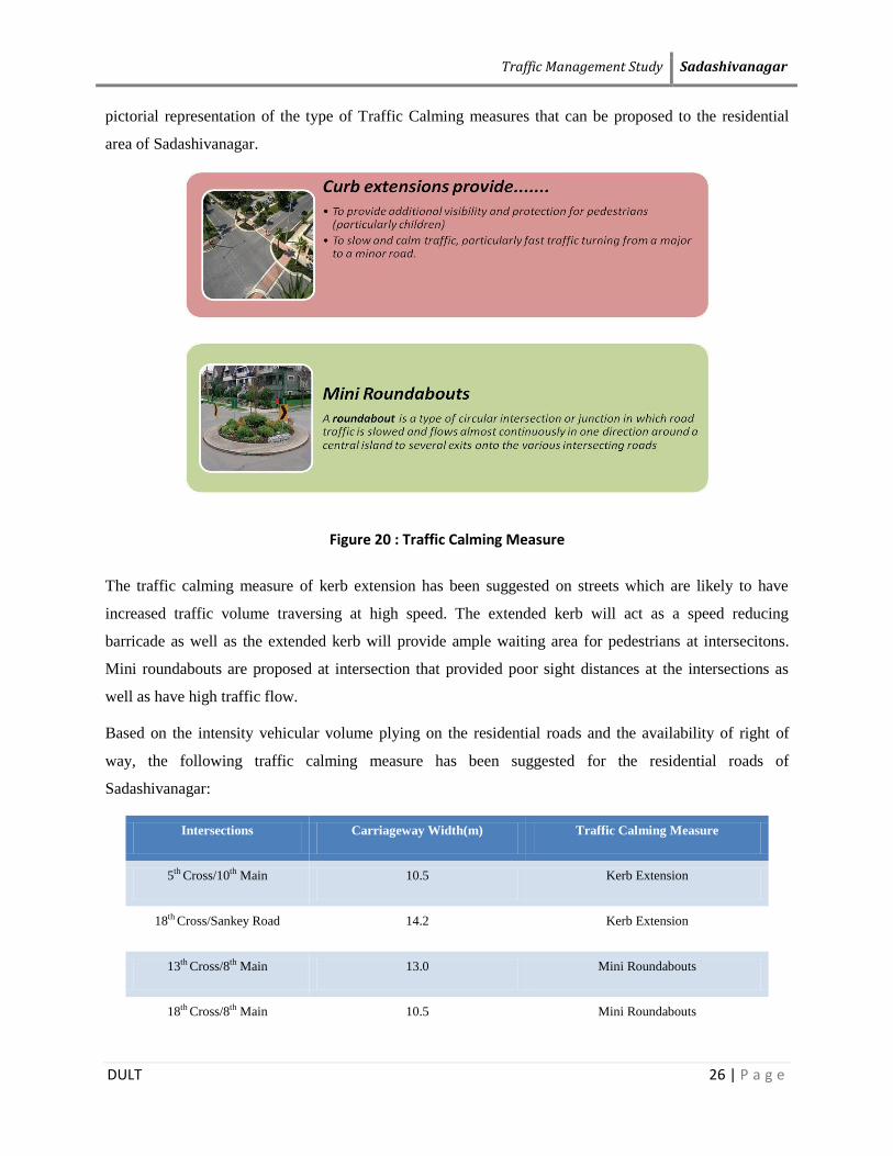
divert non-residential traffic as well as help retain the aesthetic value of the neighbourhood. Figure 20 is a
Figure 19 : Existing Traffic scenario in Sadashivanagar residential layout
Traffic Management Study Sadashivanagar
DULT 26 | P a g e
pictorial representation of the type of Traffic Calming measures that can be proposed to the residential
area of Sadashivanagar.
Figure 20 : Traffic Calming Measure
The traffic calming measure of kerb extension has been suggested on streets which are likely to have
increased traffic volume traversing at high speed. The extended kerb will act as a speed reducing
barricade as well as the extended kerb will provide ample waiting area for pedestrians at intersecitons.
Mini roundabouts are proposed at intersection that provided poor sight distances at the intersections as
well as have high traffic flow.
Based on the intensity vehicular volume plying on the residential roads and the availability of right of
way, the following traffic calming measure has been suggested for the residential roads of
Sadashivanagar:
Intersections Carriageway Width(m) Traffic Calming Measure
5th Cross/10th Main 10.5 Kerb Extension
18th Cross/Sankey Road 14.2 Kerb Extension
13th Cross/8th Main 13.0 Mini Roundabouts
18th Cross/8th Main 10.5 Mini Roundabouts

Traffic Management Study Sadashivanagar
DULT 27 | P a g e
The above tabulated traffic measures are pictorially represented in Figure 21. The suggested traffic
calming measures are only effective at the intersections and will not hinder either the aesthetics of the
neighbourhood or cause any discrepancy to the residential traffic.
Figure 21 : Traffic Calming Streets

Traffic Management Study Sadashivanagar
DULT 28 | P a g e
Unauthorized parking in the residential roads of Sadashivanagar
Another issue that was raised by the residents of Sadashivanagar is Unauthorized parking by the passing traffic.
However, as per the field observations and the parking surveys carried out, it was found that most of vehicles parked on the residential roads belong to the
residents and the number of vehicles parked by the passing traffic was found negligible. Surveys finding reveal the following results:
The number of vehicles owned by the residents is more than the availability of parking space within the premises.
During the day, most residents were found to park their vehicles on-street, reducing the effective carrying capacity of the roadway segment.
Figure 22 is an illustration of the residential parking scenario of Sadashivanagar.
Figure 22: Parking Survey Analysis-Sadashivanagar

Traffic Management Study Bellary Road
DULT 29 | P a g e
3 BELLARY ROAD
Bellary Road also known as the NH-7 is located in the north of Bangalore. The main connector
connecting Tumkur, Hyderabad, Dobbaballapur, Devanhalli,etc has in the recent years seen rapid growth
both with respect to traffic and land development. The opening of Bangalore International Airport (BIA)
in 2008 has also led to the increased vehicular volume on Bellary Road. This unplanned increase in
vehicular growth has led the planning/opening of several grade separators in order to ease the increased
delay and congestion.
Figure 23: Study area -Bellary Road

Traffic Management Study Bellary Road
DULT 30 | P a g e
3.1 LANDUSE
Bellary Road has mixed land use pattern with residential, commercial and industrial establishment’s
bordering the main arterial corridors. Major residential areas include R T Nagar, Anand Nagar,
Kempapura, Sanjaynagar,Ganganagar,etc. It also houses education institutes such as GKVK, Government
Vertinary College, Government Flying Training School, Atria Institute of Technology.
The Hebbal Lake is one of the major tourist attractor, located on the eastern side of the Bellary Road
Figure 24: Land use-Bellary Road

Traffic Management Study Bellary Road
DULT 31 | P a g e
3.2 ROADWAY SEGMENTS AND INTERSECTIONS
A roadway segment of 7.8 km from Mekhri Circel to Kodigehalli Cross has been selected for the study.
Amoung which the roadway segments connecting Bellary Road are Outer Ring Road, Kodigehalli Main
Road, CV Raman Road. The sudy intersection are listed below:
Major Intersection are:
1. Mekhri Circle (Bellary road/ CV Raman road)
2. Hebbal (ORR/ Bellary road )
3. Kodigehalli cross (kodigehalli main road/ Bellary road)
Figure 25: Major Roadway Segments and Study Intersection

Traffic Management Study Bellary Road
DULT 32 | P a g e
3.3 EXISTING OPERATIONAL CONDITIONS
Based on the survey analysis,The existing operation conditions of the study roadway networks and
intersections near the study area were evaluated to identify the deficiencies with respect to vehicle and
pedestrian traffic
1. Roadway Segments- Volume to Capacity Ratio and LOS
2. Intersections- Delay and Queue Length
Roadway Segments:
The Level of Service (LOS) and the capacity of the Roadway segments computed is based on the Indian
Roads Congress (IRC) standards sourced from Guidelines for Capacity of Urban Roads in Plain Areas
IRC 106- 1990 as tabulted in table 2.
The results/ outcomes of the survey analysis, the roadway segments along Bellary Road show varying
LOS values. This is mainly due to the incresed number of vehicular traffic as well as the on going
construction activity by NHAI. The roadway segments are operating at a LOD D or better i.e the V/C
ratio is equal to or less than 0.8 except the Hebbal flyover segment which is operating at LOS F and E i.e
the V/C ratio ranges between 0.8-1.2.
Table 12 shows the existing traffic operation condition of the study area roadway segments and figure 26
depicts the same.

Traffic Management Study Bellary Road
DULT 33 | P a g e
Table 12 : Existing V/C and LOS for study corridors
Road Name Segment Direction of Traffic
Flow
Existing Peak hour
Volume (PCU/ Hr) V/C LOS
Bellary Road Jakkur-Kodigehalli
North Bound (LCW) 2495 0.43 C
South Bound (RCW) 3750 0.63 D
Bellary Road Kodigehalli-Kempapura
North Bound (LCW) 2850 0.57 C
South Bound (RCW) 3350 0.67 D
Bellary Road Kempapura-Hebbal
North Bound (LCW) 1020 0.20 B
South Bound (RCW) 1060 0.21 B
Bellary Road Hebbal-flyover
North Bound (LCW) 2150 1.65 F
South Bound (RCW) 2402 1.85 F
Outer Ring Road
(ORR) ORR-Hebbal
West Bound (LCW) 1300 0.50 C
East Bound (RCW) 650 0.25 B
Hennur Hennur-Hebbal
West Bound (LCW) 2470 0.42 C
East Bound (RCW) 2700 0.38 B
Bellary Road Hebbal-Rajgopal road
North Bound (LCW) 2898 0.45 C
South Bound (RCW) 1600 0.30 B
Bellary Road Rajgopal Road-
Mekhri
North Bound (LCW) 3500 0.45 C
South Bound (RCW) 1631 0.21 B
NOTE: *Capacity of the roadways was based on the IRC 106- 1990.*
**LCW-Left of Carriageway, RCW-Right of Carriageway, 4L-Four Lane, D-Divided, UD- Undivided,
2W-Two-way.**

Traffic Management Study Bellary Road
DULT 34 | P a g e
Figure 26: Major Roadway Segments and Study Intersection
Intersections
During the existing conditions, the delay at the study intersections was found be less than 30 seconds
except at the Kodigehalli and Hebbal intersection, which have recorded a significant delay at the
intersections greater than 30 seconds. The delay at Kodigehalli was found to be 72 seconds per vehicle,
whereas the delay at Hebbal was found to be 42.6 seconds per vehicle.
The maximum queue lengths at the study intersections were found to be less than the available storage
length at the intersections,with Kodigehalli having recorded a maximum queue length of around 466
meters in the southbound direction.
Table 13 shows the delay and queue lengths at the study intersections.

Traffic Management Study Bellary Road
DULT 35 | P a g e
Table 13: Existing Operating Conditions at the Study Intersections
Road Name Delay (sec/veh) Queue Length (m) Throughput
Kodigehalli 72 466(SB) 6439
Kempapura 12 189(NB) 5765
Hebbal 42.6 203 4364
Anandnagar 0.9 0 3117
3.4 ISSUES AND INTERVENTIONS
This section lists out the issues and relevant interventions proposed to address the travel and safety issues
of Bellary Road.
3.4.1 Kempapura Entrance
Kempapura entrance, located adjacent to the Esteem Mall on Bellary Road is the entrance to the two lane
Kempapura Main road. It connects institutes like Presidency College, HKBK College, etc.
In order to minimize the traffic congestion and delay on Bellary Road, NHAI have proposed a set of
seven grade separators along Bellary Road between Hebbal and Bangalore International Airport.
Amongst one of which is located adjacent to Kodigehalli with its ramp starting around 500 meters from
the Kempapura Entrance. This elevated road would results in high speed traffic reaching the Kempapura
Entrance causing chaos to both vehicular as well as pedestrian traffic. The identified issues are as listed
below.
Issues
1. The Elevated road would generate high speed vehicular traffic reaching the Kempapura entrance
causing bottleneck and congestion at the Kempapura Junction as well as the Hebbal flyover
located approximately 100m from the Kempapura Junction.
2. Commuter and pedestrian safety has been a major concern. The road widening of Bellary Road to
a ROW of 24m, increased vehicular volume plying at higher speed, no bus shelters, irregular
median opening have risked the safety of pedestrian at Kempapura Entrance.

Traffic Management Study Bellary Road
DULT 36 | P a g e
3. The 8 lane traffic from the Elevated road (after the construction of the expressway) which
squeeze into 6 lanes traffic on the Hebbal Flyover creating chaos.
Figure 27 illustrate issues at the Kempapura Entrance.
Interventions
1. As a part of short term measure to control the difference in vehicular speed (i.e speed of the
elevated road = 80kmph (proposed) and speed of Bellary road=50kmph), a traffic calming
measure of provision of rumble strips has been suggested. This will only be provided on the down
ramp reaching from BIA to Hebbal. The implementation of which will enable the elevated road
vehicles to lower their speed to the speed of the at grade vehicles of Bellary Road. The design
criterion is as shown in figure 28 below.
Figure 27: Identified issues at Kempapura Entrance

Traffic Management Study Bellary Road
DULT 37 | P a g e
Figure 28: Proposed intervention for the Elevated Road, Bellary Road
2. The following short term measures have been suggested at the Kempapura Entrance in order to ensure
safe accessibility to pedestrians:
a. Skywalk at the Kempapura entrance
The existing signal of 20 second at a 5 min interval is insufficient for pedestrians to cross the 6-lane
Bellary road. Adding to that, the median also doest provide ample waiting/refuge area to pedestrians.
Considering the future growth of vehicles on Bellary Road, the pedestrian signal may tend to increase the
vehicular delay and congestion. Thus, removal of the pedestrian signal with a replacement of a 2m wide
skywalk will provide safe accessible path to the pedestrian.
Design Elements:
1. Minimum width of walkway should be 2m.
2. A slope of 8% (1 in15) on footbridge ramps, with appropriate resting place/landing is preferable.
3. Tactile tiles with proper lighting are suggested.
Figure 29 is a concept of the proposed Skywalk at Kempapura Entrance.

Traffic Management Study Bellary Road
DULT 38 | P a g e
>>Section at A-A
Figure 29: Concept Plan of Skywalk-Kempapura Entrance

Traffic Management Study Bellary Road
DULT 39 | P a g e
b. Shifting of Bus Stop
The existing bus stop without shelter at the Kempapura entrance (eastern side) is located on the shoulder
that separates the main lane and the service lane. The 3m wide shoulder is not uniformly barricaded
leading to haphazard movement of vehicles to and from the main road. These vehicular movements
hinder the pedestrian access to the bus stop. Thus, a suggestion of shifting the bus stop 10 m southwards
from the existing bus stop has been suggested. A bus stop with 2 no’s bus bays can be constructed
adjacent to the Esteem Mall and connected to the proposed skywalk for better accessibility.
c. Uniform barricades
In order to resist the haphazard movement of vehicular and pedestrian traffifc an uniform barricading of
the shoulder with 10 m wide opening at a 100 m interval will resist the haphazard of vehicles to and from
the main road.
Figure 30 and Figure 31are the illustration of the existing and proposed scenario for the Kempapura
entrance.
Figure 30: Issues at Kempapura Entrance

Traffic Management Study Bellary Road
DULT 40 | P a g e
The above mentioned scenarios i.e both existing and proposed condition were evaluated in order to check
their operational efficiency. As per the analysis, the replacement of pedestrian signal with a skywalk for
pedestrian access will reduce the delay at the Kempapura Junction from 12 sec/veh to 0.7 sec sec/veh.
Thus, reducing the delay by 11.3 sec/veh. This will also reduce the queue length from 189m to 37 m in
the north bound direction. Table 14 refers to the proposed operational conditions at Kempapura Entrance.
Table 14: Operational efficiency at Kempapura Entrance
Scenario Delay (sec/veh) Queue Length (m) Throughput
Existing 12 189(NB) 5765
Proposed 0.7 37(NB) 5800
Operational Efficiency +11.3 +152 +35
Figure 31: Proposed intervention at Kempapura Entrance

Traffic Management Study Bellary Road
DULT 41 | P a g e
3. As per the inspection report on the improvements required on NH-7 from Hebbal and Bangalore
International Airport (BIA), a 3 lane extra limb would be created for traffic from the city to airport with
partial modifications to the other limbs of the Hebbal Flyover. This modification will ease the chaos
created by the 8 lane traffic from the Elevated road (after the construction of the expressway) squeezing
into 6 lanes traffic on the Hebbal Flyover
3.4.2 Kodigehalli Gate
Kodigehalli gate is a 3 arm signalized intersection located adjacent to the Godrej Woodsman Estate on
Bellary Road.
Issues
1. Longer queues, delay and congestion is a common observation found both during peak and off-
peak. This may be due to the construction work for elevated flyover.
2. Despite heavy traffic with high speed there is no exclusive pedestrian signal phasing is provided
in the existing signal phasing plan.
3. There are no bus shelters/bus bays, resulting a chaotic movement of pedestrians/commuters to
access the buses.
4. Absence of footpath connectivity has forced pedestrian to move on the carriage way.
Figure 32 represents the existing scenario at Kodigehalli Gate.

Traffic Management Study Bellary Road
DULT 42 | P a g e
Figure 32: Existing scenario at Kodigehalli Gate.
Figure 33: Issues at Kodigehalli Gate
Interventions
1. As a part of short term measure, to protect pedestrians from the high speed vehicular traffic at the
intersection, a traffic calming measure of provision of curb ramps has been suggested. This will
limit vehicular right of way as well as the speed while giving pedestrians a refuge island at the
intersection. Curb radii should be designed accordingly to balance the need to accommodate large

Traffic Management Study Bellary Road
DULT 43 | P a g e
vehicle movements and pedestrian safety. Open drains can be covered to increase the extra
walkway width.
2. The existing signal doesn’t have an exclusive pedestrian phasing. Considering the width of the
carriageway and the future growth of vehicles on Bellary Road, there is a need to provide the
pedestrian phase of 15 seconds.
3. The existing bus stops are without shelters on either side of the roadway are located on the main
carriageway which creates obstruction in the traffic movement. Thus bus bays on either side with
shelter should be relocated on the service lanes to provide a safe and accessible path to the bus
stops.
Figure 34 is a pictorial representation of the proposed interventions.
Figure 34: Proposed interventions at Kodigehalli Gate.
3.4.3 Accessibility issues to Bus Stops
Higher vehicular speed, grade separators with insufficient pedestrian walkway and insufficient pedestrian
signal phase at the intersections are creating an unsafe environment to the pedestrian traffic. Although a
couple of grade separators on Bellary road like the Ganganagar, CBI, Hebbal have subway facilities for

Traffic Management Study Bellary Road
DULT 44 | P a g e
pedestrian access, grade separators at Anandnagar and bus stops like Mekhri Circle lack pedestrian
facilities.
3.4.2.1 Mekhri Circle and Ganganagar Bus Stops
Isssues:
The 6-lane Bellary road is divided into 3 lane on either side by high raised median of 2.5m tall .Two bus
stops (ie) Mekhri Circle and Ganganagar Bus Stops are located 280m away on either side. However, these
two bus stops are not connected or accessible. As per the existing condition, pedestrian and commuters
are using a narrow 2m wide median opening adjacent to the Air Force Office to cross the 6 lane Bellary
Road. This median opening is connected to a pedestrian traffic signal which is not operational.
Figure 35: Existing scenario at Mekhri Circle
In order to analyse the issues of accessibility, a set of surveys namely, bus stop passenger opinion and
count surveys were conducted. The results are as shown Figure 36 below.

Traffic Management Study Bellary Road
DULT 45 | P a g e
Figure 36: Survey Analysis at Mekhri Circle Bus Stop
As per the analysis, the commuter accessing the Mekhri Circle and Ganganagar Bus Stops have expressed
their difficulties with respect accessibility bus stop stating problems like no crossing facility (63%),
increased speed of vehicles on Bellary Road (13%) and median too high (23%).When questioned about a
suitable preference of crossing facility, they suggested that considering the lane width and high vehicular
speed, they would prefer a skywalk.
Interventions:
The skywalk of 2m wide connecting the two bus stops (Mekhri Circle and Ganganagar Bus Stops)
has been proposed by BBMP. This skywalk will be set up adjacent to the HMT Bhavan. The proposed
skywalk will be accessed through a flight of stair with a minimum of two landings. The existing footpath
width of 3m may not be feasible to provide ramp access. Elevators will also provide an alternate access to
the proposed skywalk. Thus a skywalk with vertical clearance of 5.5m with a slope of 1 in 20 has been
designed. The project is in tendering stage. The alignment is as illustrated below in figure 37.

Traffic Management Study Bellary Road
DULT 46 | P a g e
Figure 37: Proposed Improvement at Mekhri Circle
4.5.1.1 Anand Nagar Bus Stops
Isssues:
Absence of a Bus shelter, high vehicular speed and no crossing facilities are the issues observed with
respect to accessibility at Anand Nagar Bus Stop. At present the pedestrian use the vehicular underpass to
access the bus stop. However, the vehicular underpass doesn’t have any space for pedestrian walkway.
Figure 38 and 39 is an illustration of the Existing scenario at the Anand Nagar Bus Stop.
Figure 38: Existing Scenario at Mekhri Circle

Traffic Management Study Bellary Road
DULT 47 | P a g e
Figure 39: Cross section at A-A
In order to identify the need safe pedestrian crossing, a set of surveys at the Anandnagar Bus stop were
conducted during the morning peak hour (9:00 to 10:00am). The results are as shown in figure 40 below.
Figure 40: Survey Analysis at Anandnagar Bus Stop

Traffic Management Study Bellary Road
DULT 48 | P a g e
The following results were analysed from the surveys conducted:
1. The number of commuters accessing the bus stop towards BIA is comparitively low when
compared to the commuters accessing the bus stop towards Mekhri Circle.
2. The resons given by the commuters when questioned about poor ridership on the bus stop
towards BIA were: no dedicated crossing facility,higher speed on the main lane, poor lighting on
the service lane,etc.
3. In order of preferance, they suggested grade crossing followed by grade separated facility ie
either a skywalk or a subway.
Intervension:
Short Term Measure:
In order to provide a safe and convineint pedestrain crossong facility, raised table top crossing adjacent to
the bus stop towards Mekhri Circle has been suggested. This facility will also act as a speed breaker and
also provide better visibility of the pedestrian to the motorist.
Note: It has been assumed that the vehicular speed will be reduced to 5kmph.
Medium Term Measure:
In future, if either the vehicular volume or the pedestrian volume are likely to increse, a pedestrian signal
can replace the table top crossing.
Figure 41: Proposed Improvement at Anand Nagar

Traffic Management Study Bellary Road
DULT 49 | P a g e
Table 14 tabulates the improved opreational efficiency at Anand Nagar on the implementation of the
proposed interventions.
Table 15: Operational Efficiency of Anand Nagar
Scenario Delay (Veh/sec) Queue Length (m) Throughput
Existing 0.9 0 3117
Short Term
(Table Top Crossing) 5 49.1(SB) 3089
Medium Term
(Table Top Crossing+Pedestrian Signal) 11.2 68.3(SB) 3093

Traffic Management Study Conclusion
DULT 50 | P a g e
4 CONCLUSION
In view of rapid urbanization, the city is experiencing change in environmental conditions and
disintegrated physical developments. Thus, there is a need to approach the entire galaxy of urban
problems in a more comprehensive manner and plan for its orderly development. The study aims at
achieving sustainable transport, increased public transport ridership, safe and comfortable walkways, etc
by minimizing the traffic impact on the study area.
Table 15 is a list of section specific proposals that have been suggested in the study.
Table 16: Proposed Improvement with their Implementing Agencies
SN Interventions Type of Measure Implementing Agencies
Sadashivanagar
1 Cauvery Junction: Signalization Short Term Traffic Police
2 Cauvery Junction: 2-lane grade separator for vehicles moving from west
to south.
Medium Term BBMP
3 Cauvery Junction: Change in traffic Circulation Pattern Short Term Traffic Police
4 Bhashyam Circle: Change in Signal Plan Short Term Traffic Police
5 CNR Rao Circle: Signalization and Bus Stop Short Term Traffic Police + BMTC
6 Traffic Calming on the residential roads Short Term BBMP
Bellary Road
7 Elevated Road on Bellary Road: Rumble Strips Short Term NHAI + Traffic Police
8 Kempapura Entrance: Skywalk + Uniform Barricades Medium Term BBMP
9 Kempapura Entrance: Shifting of Bus Stop Short Term BBMP + BMTC
10 Anandnagar Bus Stop: Table Top Crossing Short Term BBMP + Traffic Police
11 Anandnagar Bus Stop: Pedestrian Signal Medium Term Traffic Police
12 Mekhri Circle: Skywalk Short Term BBMP

Traffic Management Study Conclusion
DULT 51 | P a g e
This page has been intentionally left blank.