The Biosphere reserve of the Sierra Nevada de Santa...
43
SOUTH-SOUTH CO-OPERATION PROGRAMME ON ENVIRONMENTALLY SOUND SOCIO-ECONOMIC DEVELOPMENT IN THE HUM/D TROPlCS WORKING PAPERS N"30,1999 b --2+--J-L .?XL “Sk,, . ,;.,. ‘1. . ..*.?r, .,, .\ ., ‘.Ti, _- . - UNITED NATIONS THE UNtSCO UNITED NATIONS THIRD WORLD EDUCATIONAL, MAN AND THE BIOSPHERE UNIVERSITY ACADEMY OF = SCIENTIFIC AND PROGRAMME SCIENCES CULTURAL ORGANIZATION
Transcript of The Biosphere reserve of the Sierra Nevada de Santa...

SOUTH-SOUTH CO-OPERATION PROGRAMME ON ENVIRONMENTALLY
SOUND SOCIO-ECONOMIC DEVELOPMENT IN THE HUM/D TROPlCS
WORKING PAPERS
N"30,1999
b --2+--J-L
.?XL “Sk,, .
,;.,. ‘1. .
..*.?r, .,, .\ ., ‘.Ti, _- .
- UNITED NATIONS THE
UNtSCO
UNITED NATIONS THIRD WORLD EDUCATIONAL, MAN AND THE BIOSPHERE UNIVERSITY ACADEMY OF
= SCIENTIFIC AND PROGRAMME SCIENCES CULTURAL ORGANIZATION

F
The Working Paners series is a publication of the South-South Co-operation Programme for Environmentally Sound Socio-Economic Development in the Humid Tropics.
~The series aims to disseminate the results of the research on Biosphere Reserves on such
topics as (i) the prevailing conservation and resource-use patterns and, (ii) the ways of
improving the traditional practices and orientation for applied research aimed at a more
intensive and sustainable use’of the biodiversity to provide a better livelihood to the local
population in the buffer and transition zones. On more general issues, the Working Papers are
also an attempt to identify key problems that will become areas of concentration for
international co-operation.
The map on the front page has been produced by using a commercial software programme. The boundaries do not imply official endorsement or acceptance by UNESCO or the United Nations. Neither do the ideas and opinions expressed in the Working Papers series, which are solely engaging their authors.
The Working Papers series is published as necessary either in English, French or Spanish depending of the language used by the author.
0 Permission to reproduce any material of the Workinq Papers series will be given without any previous authorization, provided that full reference to the author, title, series title, date, institution editor and place of publication are given.
All correspondence should be addressed to the Administrative Editor.
Edited by : UNESCO Division of Ecological Sciences South-South Co-operation Programme 7 place de Fontenoy 75 700 PARIS (FRANCE)
Telephone : 33 m 1.45.68.41.46 Telefax : 33 - 1.45.68.58.04 E-mail : m.clusener-godt @ unesco.org
The South-South Co-operation Programme on Environmentally Sound Socio- Economic Development in the Humid Tropics is on INTERNET :
http://www.unesco.org/mab/activity/s-s/s-home. html
lgnacy SACHS Miguel CLhENER-GODT
tc0t.E DES HAuTES ETUDES EN SCIENCES SOCIALES (EHESS) Centre de Recherches sur le Bresil Contemporain (CRBC) 54 Bd. Raspail 75 270 PARIS Cedex 06 FRANCE
UNITED NATIONS EDUCATIONAL, SCIENTIFIC AND CULTURAL ORGANIZATION (UNESCO) Division of Ecological Sciences South-South Co-operation Programme 1 rue Miollis 75 732 PARIS Cedex 15 FRANCE Telephone : 33 - 1.45.68.41.46 Telefax : 33 - 1.45.68.58.04
Telephone : 33 - 1.49.54.20.85 Telefax : 33 - 1.45.48.83.53
Yann GUILLAUD
CcoLE DES HAUTES ETUDES EN SCIENCES SOCIALES (EHESS) Centre de Recherches sur le Bresil Contemporain (CRBC) 54 Bd. Raspail 75 270 PARIS Cedex 06 FRANCE
Telephone : 33 - 1.49.54.20.85 Telefax : 33 - 1.45.48.83.53
1
Biosphere Reserves or similarly managed areas that are part of the South-
South Co-operation Programme, are requested to produce an overview of their
covering area containing first hand information on its conditions and urging problems.
These reports will be primarily used as background materials for the
comparative projects agreed upon in the programme of activities established at the
Chiang Mai meeting, held in May 1994. For more details please report to the
newsletter South-South Perspectives (N” 1, October 1994 [28 pp.], UNESCO, Paris [France]).
Given the rich information content of these reports, there are being made
available to a wide audience. They may be obtained by contacting UNESCOMAB
Secretariat, Division of Ecological Sciences.
For other documents available in the series, see the back-cover.
Working Paper N” 30,1999, UNESCO (South-South Co-operation Programme), Paris (France)

2
The Sierra Nevada de Santa Marta is a mountainous system independent of the Andean Belt. It rises to a height of 5 775 m at a distance of only 42 km from the Caribbean coast. It is the highest coastal mountain in the world and covers an area of 17 000 km2. It has been designated as a strategic ecosystem (i.e., of fundamental importance for conservation as it produces environmental goods and services necessary for social development) by the National Environmental Plan because of its special characteristics in terms of biological diversity, endemism, hydrological resources, etc.
Thirty principal rivers run down the Sierra Nevada and irrigate coastal alluvial plains used principally for the cultivation of banana; the Cesar and Ariguani rivers used for livestock farming; the Rancheria valley in the semi-arid Guajiran peninsula prone to desertification; other lands for coffee, rice and African palm farming and the aqueducts which supply water to fourteen major settlements around the massive mountainous system. In addition, the coal fields in the departments of Cesar, Guajira and Magdalena count on this precious liquid. In turn, the water itself depends upon conditions and utilities given to the ecosystem as a whole. The area of influence of the Sierra Nevada de Santa Mar-ta extends beyond the limits of its river basins. Because most of its rivers discharge their waters into the Caribbean sea (either directly or indirectly through other rivers), their influence reach thus international waters. These rivers are thus ecological niches for both sea-water and fresh-water species.
Given that the Sierra Nevada includes such a varied extreme of altitudes with its tropical location, it is able to represent almost the complete spectrum of climates and ecosystems, not only of Colombia but of the rest of tropical America. Nine types of life zones or vegetation (biomes) independent of soil characteristics, are to be found in the Sierra: dry tropical forest, very dry tropical forest, semi-desert, tropical rain forest, sub-Andean woodland, Andean woodland, Alpine meadow (PLZ~LZVZO), tundra, and permanent snow. The geographical isolation of the Sierra Nevada and the climatic conditions of its recent geological past have fostered a surprising diversity of fauna and flora and the development of a high level of endemism in mountain biomes located above 800 to 1 000 m. It is thus considered one of the nine areas with the greatest level of endemism in the country.
At least 600 botanical genera, and no fewer than 3 000 species of higher plants, are to be found in the Sierra Nevada. On the basis of studies undertaken up to now, it is known that of a total of about 5 14 species, 16 species and subspecies of birds are endemic to the Sierra. With respect to the herpetofauna, there are 46 species of amphibians and 86 of reptiles, of which 32.5 % are endemic to the Sierra. Finally, of the 120 species of mammals one is known to be endemic. It has been estimated that at levels above 3 000 m, all amphibians and reptiles are endemic. A study of gastropods (snails) shows that of 31 species identified, 19 are reported exclusive to the zone. Of the 12 species of scorpions which have been found up to now, 6 are endemic. With regard to butterflies, it is known that there are 146 species and subspecies. In the Tayrona National Park, which is part of the massive, more than 100 species of mammals have been reported of which about 70 are bats.
This information shows the great biological importance of the Sierra. However, despite numerous studies and most recently a rapid ecological assessment, the results remain preliminary and more systematic studies are needed in order to establish with greater certainty the extent of the biological richness of the Sierra Nevada. The Foundation Pro-Sierra Nevada de Santa Marta, founded in 1986, currently concentrates its efforts upon implementing the Sustainable Development Plan and consolidating projects aimed at the conservation of this region which is considered one of the most biodiverse of the planet. In its effort to make a significant contribution, the work of the Foundation has been widely recognised and has been found deserving, among other marks of its merit, the Clifford E. Messiger Prize for Conservation Achievement presented by The Nature Conservancy.
M.C.D.G. TRIBIN et al. : The Biosphere Reserve of Sierra Nevada de Santa Mat-ta (Colombia)

La Sierra Nevada de Santa Marta est un systeme montagneux independant de la cordillbre des Andes. Elle atteint une altitude de 5 775 m a une distance de seulement 42 km de la tote des Caraibes. C’est la montagne cotiere la plus Clevee du monde et elle couvre une superficie de 17 000 km2. Elle a 6tC d&la&e Ccosysteme strategique (c’est-a-dire d’importance fondamentale pour ]a conservation en raison de sa production de biens et services environnementaux necessaires au developpement social) par le Plan environnemental national en raison de ses caract&istiques particulieres en termes de diversite biologique, d’espbces endemiques, de ressources hydrologiques, etc.
Trente rivieres principales descendent de la Sierra Nevada et irriguent les plaines c&i&-es alluviales utilisdes principalement pour la culture de la banane ; les rivieres Cesar et Ariguani utilisCes pour l’elevage de b&ail ; la vallee de la Rancheria dans la peninsule semi&de de Guajiran est encline a la desertification ; d’autres terres sont utilisees pour la culture du riz et du palmier africain et les aqueducs foumissent en eau quatorze installations humaines principales autour de l’important massif montagneux. En outre, les bassins houillers des departements de Cesar, de Guajira et de Magdalena dependant de ce precieux liquide. A son tour, I’eau elle-meme depend de l’Etat et de l’utilisation de l’ecosysteme dans son ensemble. La zone d’influence de la Sierra Nevada de Santa Mar-ta depasse de loin les limites de son bassin versant. La plupart de ses rivibres se jettent en effet dans la mer des Caraibes (soit directement soit indirectement par l’intermediaire d’autres rivieres), leur influence atteint done les eaux intemationales. Ces rivibes sont ainsi des niches ecologiques a la fois pour des especes d’eau de mer et d’eau deuce.
Comme la Sierra Nevada est localisee sous les tropiques et comporte une telle variete d’altitudes extremes, elle contient le spectre presque complet des climats et des Ccosystemes, pas seulement de la Colombie mais aussi du reste de 1’AmCrique tropicale. I1 existe neuf zones de vie ou de vegetation (biotopes) independantes des caracteristiques du sol dans la Sierra : for& tropicale s&he, for&t tropicale tres s&he, semi-desert, foret tropicale humide, boisement sub-andin, boisement andin, paturages alpins @ramo), toundra et neiges ttemelles. L’isolement geographique de la Sierra Nevada et les conditions climatiques de son passe recent ont stimule une diversite de la faune et de la flore surprenante et developpe un haut niveau d’endemie pour les biotopes montagneux se situant entre 800 et 1 000 m d’altitude. Elle est ainsi consideree comme l’une des neuf regions du pays ayant le niveau le plus ClevC d’especes endemiques.
I1 existe au mains 600 genres botaniques et pas moins de 3 000 especes de plantes de haute taille dans la Sierra Nevada. Sur la base des etudes me&es jusqu’a present, sur un total connu d’environ 5 14 especes, il y a 16 espbces et sous-especes d’oiseaux qui sont endemiques B la Sierra. En ce qui conceme l’herpetologie, il y a 46 especes d’amphibiens et 86 de reptiles, dont 32,5 % sont endemiques a la Sierra. Finalement, des 120 especes de mammiferes une est connue comme endemique. I1 est estime qu’au-dessus de 3 000 m, tous les amphibiens et les reptiles sont endemiques. Une etude des gasteropodes (escargots) montre que sur 3 1 especes identifiees, 19 sont rapportees comme exclusives a la zone. Des 12 espbces de scorpions qui ont CtC trouvees jusqu’a present, 6 sont endemiques. En ce qui conceme les papillons, il y a 146 espbces et sous-especes connues. Dans le Part national de Tayrona, qui fait pat-tie du massif, plus de 100 espbces de mammifires ont 6tC recensees dont 70 sont des chauves-souris.
Cette information montre la grande importance biologique de la Sierra. Cependant, malgrt de nombreuses etudes et plus recemment une evaluation ecologique rapide, les resultats restent prtliminaires et des etudes plus systematiques sont necessaires afm d’etablir avec une plus grande certitude l’etendue de la richesse biologique de la Sierra Nevada. La Fondation Pro-Sierra Nevada de Santa Marta, c&e en 1986, concentre actuellement ses efforts sur la mise en place du Plan de developpement durable et sur la consolidation des projets visant la conservation de cette region qui est consideree comme ayant l’une des diversites biologiques les plus grandes de la plan&e. Dans son effort de faire une contribution significative, le travail de la Fondation a &tC largement reconnu et a ete considere comme digne, entre autres merites, de recevoir le Prix Clifford E. Messiger pour l’accomplissement d’actions de conservation dClivr6 par la Commission de protection de la nature.
Working Paper No 30,1999, UNESCO (South-South Co-operation Programme), Paris (France)

4
I- DESCRIPTION OF THE AREA . . . . . . . . . . . . . . . . . . . . . . . . . . . . . . . . . . . . . . ..*.....................................* 5
1) Phvsical qeoqrauhy ..................................................................................................................... 5 2) Hvdroqraohy ................................................................................................................................ 7 3) Climate .......................................................................................................................................... 8 4) Bioaeoqraphy ............................................................................................................................. 10 5) Biomes ........................................................................................................................................ 10 6) The flora of the Sierra Nevada .................................................................................................. 12 7) The fauna of the Sierra Nevada ................................................................................................ 14 8) Species present and vulnerability ........................................................................................... 18
II- THE RECENT PAST . . . . . . . . . . . . . . . . . . . . . . . . . . . . . . . . . . . . . . . . . . . . . . . . . . ..‘....................................... 20
Ill- CULTURAL DIVERSITY . . . . . . . . . . ..~........................................................................ 21
1) The indiqenous peoples ........................................................................................................... 21 2) The peasants from the interior mountainous reqion ............................................................. 25 3) The peasants from the coastal reqion ..................................................................................... 25 4) The industrial sector ................................................................................................................. 26 5) The administrative system ....................................................................................................... 28
IV- THE FOUNDATION PRO-SIERRA NEVADA DE SANTA MARTA . . . . . . . . . . . . ..a . . . . . 29
1) The development of the strateqv for the conservation of the Sierra Nevada de Santa Marta ........................................................................................................................................... 30
2) The Sustainable Development Plan for the Sierra Nevada de Santa Marta ....................... .36 3) The forum for the sustainable development of the Sierra Nevada de Santa Marta............ 7 4) The rapid ecoloqical assesment .............................................................................................. 38 5) Pilot proiects arising from the Conservation Strateqv.. ........................................................ 39
V- LESSONS LEARNED AND A PERSPECTIVE OF THE FUTURE . . . . . . . . . . . . . . . . . . . . . . 39
BIBLIOGRAPHY . . . . . . . . . . . . . . . . . . . . . . . . . . . . . . . . . . . . . . . . . . . . . . . . . . . . . . . . . . . . . . . . . . . . . . . . . . . . . ..*...................... 40
Maria Camila Diaz Granados TRIBIN, Guillermo E. RODdGUEZ Navarro
and Maryi VALDERR4MA are of the Fundacidn Pro-Sierra Nevada de Santa Marta. The
English translation was undertaken by Maria Rosario Ferro U., Mauricio Gonzalez, Rosario
Lawrence and Guillermo E. Rodriguez N.
M.C.D.G. TRIBIN et al. : The Biosphere Reserve of Sierra Nevada de Santa Mat-ta (Colombia)

5
I- DESCRIPTION OF THE AREA
1) Phvsical neoqraphv
The Sierra Nevada de Santa Marta is a mountainous system independent of the
Andean Belt, located in the northern part of Colombia (C’ MAP l), between the latitudes
10” 01’ 05” and 1” 20’ 11” North and longitudes 72” 36’ 16” and 74” 12’ 49” West, in the
extreme north-west of South America.
MAP 1: Location of the Sierra Nevada
REPUBLICA DE
VENEZUELA
REPUBUCA 4 DE
In appearance, the Sierra Nevada is a pyramid with a triangular base of an area taken
200 m above the sea level, of approximately 12 230 km2 (Cl’ MAP 2). The northern limit,
which lies along the edge of the Caribbean sea, extends from the flat and arid plains of the
Guajira peninsula to the outskirts of Santa Marta, at the mouth of the river Manzanares. The
western edge is bounded by the Caribbean sea (Cf: PHOTO l), the swamplands of the Cienaga
Grande de Santa Marta and the alluvial plain of the Magdalena river from the mouth of the
river Manzanares to the town of Bosconia. Finally, the eastern limit is marked by the valleys
Working Paper No 30,1999, UNESCO (South-South Co-operation Programme), Paris (France)

6
of the Cesar river towards the south and the Rancheria river towards the north. The chain of
peaks, with a permanent snow cover (Cfr PHOTO 2), lies on an east-west axis located above
3 000 metres. There are numerous lakes of glacial origin from where start the rivers that run
down the three main slopes of the Sierra.
PHOTO 1: Coastal zone of the Sierra Nevada
PHOTO 2: Peaks covered of permanent snow in the Sierra Nevada
M.C.D.G. TRIBIN et a/. : The Biosphere Reserve of Sierra Nevada de Santa Marta (Colombia)

7
MAP 2: Political and administrative limits of the Sierra Nevada
2) Hvdroqraphv
The Sierra Nevada is divided into three main basins or watersheds feeding a system
of 29 principal rivers. The Caribbean watershed includes all the rivers that flow directly into
the sea and covers the whole of the northern face of the massive, the extreme north of the
western slope and the river Rancheria. The second watershed consists of the rivers of the
western flank which drains into the swamps of the Cienaga Grande de Santa Mar-ta. The third
basin is composed of catchment areas of the river Cesar on the eastern face and the extreme
south of the western face. The Sierra is the source of water for the aqueducts that supply all
the surrounding settlements of a total population of around 1.5 million inhabitants. The Sierra
also provides the water for agricultural, livestock and mining activities in its area of influence.
The flow from the rivers of the massive amounts to approximately ten thousand million cubic
meters of water annually.
Working Paper No 30,1999, UNESCO (South-South Co-operation Programme), Paris (France)

8
However, the present decrease or loss of vegetation cover in the majority of the
basins, the steep slopes characteristic of the geomorphology and the seasonal nature of the
rainfall accentuate the instability of the hydrodynamic regime and thus generate great
variations in the flow of the rivers: water shortages, during periods of low rainfall, and
flooding of the low-lying areas in the rainy season.
3) Climate
The elements that influence the particular climate of each of the three faces of the
mountainous system are principally: the position with respect to the Equator, the extreme
variation of altitude, the location with respect to the sea and the north-east trade winds to
which the massive presents an obstacle facing the Perija mountain range and the grasslands
and lagoons of the lower Magdalena. In general terms, one could say that the northern face is
the wettest and the eastern face the driest, with the western face presenting an intermediate
condition. The Caribbean plain which surrounds the massive bears a hot and dry climate. Like
the rest of Colombia, the rainfall regime in Sierra Nevada is largely determined by the
movement of the Intertropical Convergence Zone which defines two rainy seasons, one from
April to June and the other from August to November, alternating with dry seasons from
December to March and from June to August. However, each of the three flanks of the
massive has its own particular characteristics determined by the factors mentioned above,
which largely modify the patterns of rainfall (Cf: FIGURE 1).
One can say that the distribution of rainfall depends on the position of the mountain
and that it varies as much in low-level stations as in those at medium heights. There is no data
available for stations above 2 500 m for any part of the Sierra, but it is to be expected that the
behaviour of the rainfall relates, as it does in all mountain belts, with increase in altitude.
Based on data from the stations established during the execution of the “Transact Buritaca -
La Cumbre” study and from currently existing stations, van der Hammen states: “the average
annual rainfall over the greater part of the transact must be more than 2 000 mm. At heights
above 3 500 m it must be less than this figure. The maximum, at approximately 1 400 m
above the sea level, may be more than 4 000 mm”. This interpretation is corroborated by the
annual rainfall data obtained over two consecutive years at the Alto de Mira Station, in the
upper valley of the Buritaca River, with values around 4 500 m. IGAC notes that the highest
figures for rainfall in the whole of the Sierra, 4 000 mm annually, are reached in the
Guachaca, Buritaca, Don Diego and Palomino rivers at 2 500 m above the sea level.
M.C.D.G. TRIBIN et al. : The Biosphere Reserve of Sierra Nevada de Santa Marta (Colombia)

9
FIGURE 1: Month/y rainfall at stations located between 500 and 2 500 m above the sea /eve/ in the Sierra Nevada
Another important aspect of the climate of the Sierra Nevada is the atmospheric
temperature. The monthly means behave in a regular fashion with an average amplitude of
less than 2.5 “C. During April, May and June, and in certain areas up to July and August, the
temperatures are a little higher than other months. The diurnal temperature range is greatest
during the dry seasons. The behaviour of the relative humidity is closely related to the rainfall
regime. The atmospheric temperatures recorded by IGAC during a field study show that this
climatic factor varies according to the location. The highest temperatures are found on the
eastern side, varying from 24.4 to 32.4 “C. In the north-eastern sector of this slope the air
temperature varies from 22.9 to 28.5 OC, while on the western face the variation is from 22.7
to 28.7 “C. The northern face displays the lowest values: 23.8 and 25.8 “C. In all cases the
minimum values refer to calculations at 400 m above the sea level. The gradient difference
can be explained by the Foehn effect which causes the temperature and the air saturation to
alter as the air crosses a mountain barrier.
Working Paper No 30,1999, UNESCO (South-Sooth Co-operation Programme), Paris (France)

10
4) Bioneocwaphv
Although it is always maintained that humid tropical ecosystems host the greatest
biodiversity in the world, it is important to stress the special nature of the biota of high
mountains: it is less diverse but nevertheless it has a greater richness of endemism. The
greatest biological diversity in Colombia is found in the foothills and interior spurs of the
belts. One can note a marked relationship between levels of diversity and rainfall: the higher
the rainfall is, the greater is the biological wealth.
The Sierra Nevada de Santa Marta shows both features mentioned above, foothills
and high mountains, together with two other elements which make its conditions of diversity
even more favourable: proximity to the sea and isolation from the rest of the mountain
systems of Colombia. These elements have persisted throughout the geological history of the
Sierra, but its current biota took shape in the Quaternary, when the northern and possibly the
western face of the massive constituted a refuge for humid forest and continued as cloud
forest as far as the mountain tops, even in the arid phases of the Pleistocene. On the northern
flank of the Sierra Nevada the biotic zones display an altitudinal depression. Temperate zone
elements are found at uncharacteristically low altitudes, down to 200 m above the sea level.
One could speculate that the northern and western flanks of the Sierra were biogeographically
separated, as two humid refugee. In fact, the birds Henicorhina Zeucouhrvs that are found in
each one of them, represented by two different subspecies H. 1. anachoreta and H. I banasi.
Hemandez-Carnacho and Sanchez show that the Sierra Nevada de Santa Marta corresponds to
a centre of endemism, together with 26 other areas around the country. The theory of refugee,
as proposed by Halffier in 1969, recognises major changes in the vegetation cover and in the
distribution of plant and animal species during the Pleistocene, as a result of climatic changes
during the glacial and interglacial periods. These changes, which according to some authors
may have continued as far as the Miocene, triggered various mechanisms of speciation and of
diversification of species, causing different biomes to grow or reduce in size depending on the
reigning conditions of aridity or humidity.
5) Biomes
In Colombia, Hemandez-&macho and Sanchez establish a classification based upon
the characteristics of the vegetation depending upon climatic conditions, soil types and
floristic, physiognomic and structural particularities for each region of the country. These
M.C.D.G. TRIBIN et al. : The Biosphere Reserve of Sierra Nevada de Santa Matfa (Colombia)

11
major ecosystems, with similar characteristics, are called biomes of which those that depend
upon soil characteristics are called azonals, those that are found in mountainous areas are
orobiomes, and those that occur in lowlands are called zonal biomes or zonals. There are eight
biomes described in total for the Sierra Nevada: of which four are lowland or zonal biomes
and four are orobiomes. Their characteristics are presented below.
Humid equatorial zonal biome. It corresponds to humid forests of the
isomegathermic zone where the high rainfall favours the presence of hygrophytic and
subhygrophytic vegetation, and the majority of the woody plants are evergreens. This zone is
principally found on the northern face between the rivers Palomino and Mendihuaca up to a
height of approximately 1 000 metres.
Seasonal tropical zonal biome. It corresponds to the woodlands of the
isomegathermic zone in areas with a dry season which may last up to six months, during
which the majority of the trees lose their foliage. In the remaining months of the year there is
no hydric deficit and the plants replace their foliage, so that the area looks much like the
evergreen forest. This zonal biome is found on the northern face, in the extreme north-east, to
the west of Santa Marta and in the greater part of the western and south-eastern faces around
the Sierra up to a height of 500 to 700 m with some local variations because of the
characteristics of the massive.
Subxerophytic tropical zonal biome. This zone is made of wood and scrub-land in
the isomegathermic zone in areas where the dry season is prolonged, lasting up to nine
months of the year. In these conditions the most common plants present xeromorphic
adaptations. It is found at the edges of the northern face and in part of the valley which
separates the Sierra Nevada from the Serrania de Perija. This area is the most important in the
neighbourhood of Santa Marta.
Tropical desert zonal biome. This area is made of plants which develop in an
isomegathermic climate with low annual rainfall and a dry season of at least ten months. The
plant cover consists of sparse or very scarce low woodland or xerophytic scrub. It is
distributed on the level plain which borders the massive between the south of the Guajira
peninsula and the outskirts of Santa Max-ta towards the north-west.
Sub-Andean forest orobiome. It corresponds to the hygrophytic and
subhygrophytic cloud forests in the isomesothermic and isomicro thermic levels with dense
cover and frequent mists. It is found on all three faces at altitudes between 2 300 and 3 500 m
above the sea level, with mild variations.
Working Paper No 30,1999, UNESCO (South-South Co-operation Programme), Paris (France)

12
Moorland orobiome (paramo). Arborescent, shrub like and herbaceous vegetation
that develops in areas at the oligothermic level between the tree line and the snow line. The
dominant plants are Graminacea: and low woody shrubs. It can be seen as composed of three
sectors: sub-moorland, with woody and arborescent vegetation, just above the tree line; the
paramo proper; and the highparamo, with scant cover occurring in rocky outcrops below the
snow line. It is found mainly at altitudes of 3 500 to 4 800 or 5 000 m in the high parts of the
Sierra.
Permanent snow orobiome. This area is made of a permanent snow cover where
there may appear, here and there in sheltered crevices, some cryptogams and sparse low-lying
plants. Its lowest limit is at approximately 5 000 m above the sea level.
6) The flora of the Sierra Nevada
Ever since the earliest explorations of the Sierra Nevada, the remarkable nature of its
flora has been extolled (Cf: PHOTO 3). However, we still lack an inventory that approximates
a complete quantification. Various researchers have pointed out the limitations of our
knowledge, considering it to be one of the regions of the country with the lowest levels of
collection and floristic analysis, with less than fifty specimens per km2 and therefore one of
the least known regions of Colombia from a botanical point of view. The Sierra Nevada is
thus one of the most important tropical woodland zones with regard to future plans for
collection. Additionally, it is regarded as one of the areas of tropical woodland under threat of
conversion or destruction.
PHOTO 3: Totumo, in the Tayrona Park
M.C.D.G. TRIBIN et al. : The Biosphere Reserve of Sierra Nevada de Santa Marta (Colombia)

13
The earliest floristic investigations of the Sierra Nevada were begun around 1840 by
James Linden, when he arrived at Dibulla from Riohacha and continued up the basin of the
river Ancho, all the way to the paramo zone of the northern face. The expeditions undertaken
by William Pudre stand out for their important contributions to floristic knowledge. In 1844
he travelled in the basin of‘the Palomino river on the same northern face, collecting samples
of the moorland. In the same period Heman Karsten gathered collections in the basin of the
river Ancho. The best known samples of plants of the Sierra Nevada were those collected
from 1898 to 1904 by Herbert Smith in the basins of the Gaira, Manzanares and Piedra rivers.
In 1927 William Seifriz published characterizations of the floristic features and vegetation of
the basin of the river Ancho from its mouth up to the moorland, based upon his expedition in
that region. There is also the study made in 1930 by Simule Record and Henry Kyulen of the
flora of the basins of the Gaira and Manzanares rivers. Other expeditions that provide
important floristic information include the travels of Funk and Schlim in the basin of the river
Frio in 1847, of Arnold Schultze in the north-western region of the Sierra Nevada and
especially in the basin of the river Frio in 1927, and of Ramon Espina and Juan Giacometto in
the basins of the Manzanares, Gaira and Toribio rivers in 1930. Studies and collections were
undertaken in the upper and head water areas of the rivers Donachui and Mamancanaca by
Jose Cuatrecasas and Rafael Romero-Casttieda in 1959. The same year, Harte Barclay and
Pedro Juajibioy carried out an important exploration of the Sevilla, Frio and Ancho rivers.
Other explorations that have contributed to the knowledge of the flora and vegetation of this
tropical mountain were made by Joseph Kirkbride and Enrique Forero in 1972 in the basin of
the river Frio and by Antoine Cleef, Roberto Jaramillo and Orlando Range1 in the Buritaca
and Frio rivers during 1977. There are also the results of the collection of lichens of the river
Buritaca published by Norwak and Winkler in 1970 and of bryophytes and lichens of the river
Buritaca by Guido van Reenen, Dana Griffin and Orlando Range1 in 1977.
According to specialists, the floristic diversity of the Sierra Nevada is considered
low, particularly in respect to the humid forests of the northern face. Estimates constructed on
the basis of information from the Buritaca - La Cumbre transact and other publications
indicate some 1 800 species of flowering plant in the Sierra Nevada, grouped in 636 genera
and 164 families.
Levels of endemism in the higher plants
The upper and intermediate altitudes of the Sierra Nevada are the most important
with respect to levels of endemism in higher plants. There are a total of 96 species known
Working Paper No 30,1999, UNESCO (Sooth-South Co-operation Programme), Paris (France)

14
particularly to the Sierra, indicating endemism of 5.33 % for the flowering plants. Most of the
endemism is found in the sub-Andean forest orobiome, the Andean forest orobiome and the
paramo orobiome. The basins of the Donachui, Ftmdacion, Mamancanaca, Sevilla, Frio,
Manzanares, Gaira, Guachaca, Buritaca, Don Diego, Palomino and Ancho rivers are well-
known in this respect (Cf: TABLE 1).
TABLE 1: Endemism of phanerogams by biome in the Sierra Nevada
Biome Number of species Paramo 57 Andean forest 20 Sub-Andean forest 19
% of total 59.38 20.83 19.79
The family with the greatest number of endemic species is the Asteracese
(Compositz), with 38, of which 32 are found in the paramo, and the rest in the Andean
forest. The second is the Melastomatacea, with 16; in this case 10 occur in the sub-Andean
forest and the remainder in high Andean areas. In the Apiacea and Brassicacere families the
endemic species are limited to the high mountains; the first has six from the genera
Cotooaxia, MicroDleura, Niuhoaetum and Perissocoelum, and the second has three species of
Draba which are only found in the paramo. Actually, three genera are recognized as
belonging only to the Sierra Nevada: Kirkbridea (Melastomataces), Castenedia and
Raoulioasis (Asteraceae). No families of phanerogams are known as restricted to that region.
7) The fauna of the Sierra Nevada
The Sierra Nevada contains faunistic elements in common with those of the
ecoregions around it as well as elements peculiar to its powerful process of speciation,
demonstrated by its levels of endemism as a result of its isolated character as a mountain
system. Among the elements shared with other ecoregions one finds species in common with
the Serrania de Perija, the low swampy areas to the south-west, the lower Magdalena valley
and the coastal and continental plains respectively to the north and to the east. Principal
faunistic similarities with the Serrania de Perija, to the east, are to be found among birds and
mammals. Fish and reptiles are closer to those of marine areas and the lacustrine areas to the
south. The river Rancheria shows as much marine influence as the Lower Magdalena,
possibly as a result of interconnection at sometime in the past or during the formation of the
Sierra itself.
M.C.D.G. TRIBIN et al. : The Biosphere Reserve of Sierra Nevada de Santa Mafia (Colombia)

15
In general terms, the Sierra Nevada shows a diversity of vertebrate fauna (without
including data on fish) of which 4.59 % are endemic and represents about 30 % of the species
registered in Colombia.
Levels of endemism in vertebrate fauna
The levels of endemism in the Sierra Nevada previously mentioned depends,
however, on the group of animals used for the analysis and the altitude, since the level of
endemism of the vertebrate fauna (C.’ FIGURE 2), like that of the vegetation, increases with
altitude (even though the number of actual species decreases).
FIGURE 2: Endemism of vertebrate species registered for the Sierra Nevada and for Colombia by c/asses
I I 70
60
s
50 -I
40 '
30 I
10 -I
FISH AMPHIBJA REPTILES BIRDS MAMMALS
CLASS
q Proportion of endemic species/total of species in the Sierra
Cl Proportion of species registered in the Sierra/those registered for the rest of Colombia
With respect to fish, there are no reliable data for the Sierra Nevada de Santa Marta.
However, due to the isolated nature of the Sierra, it may be supposed that there exists some
level of endemism. It is possible that only fish of the genera Astroblevus and Pwidium are to
be found in its rivers.
The amphibian is the group of which we have the greatest knowledge and the
greatest number of collections, although the latter are principally of the Serrania of San
Lorenzo, 34 % of the amphibian of the Sierra Nevada are endemic species with the highest
values found at altitudes of 1 500 to 4 950 m above the sea level. These represent
Working Paper No 30,1999, UNESCO (South-South Co-operation Programme), Paris (France)

16
approximately 38.64 % of the vertebrate fauna which are unique to the massive. The
amphibian of the Sierra Nevada represent approximately 8.4 % of the total of species of
amphibian in Colombia, with an endemic proportion of 2.91 % with respect to the total. The
endemic species of the Sierra Nevada represent some 12 % of the total of species endemic to
Colombia.
As for reptiles, 25 % of those registered for Colombia are found in the Sierra
Nevada. They present 27.27 % of the endemism of the mountain, with a level of endemism of
16.6 % with respect to the reptiles of the massive, 4 % with respect to the total of the reptile
species of Colombia and 15.38 % of the endemic reptile species of Colombia. The data
presented by the International Union for the Conservation of Nature (IUCN), in 1995, with
regard to the wealth of reptile species in Colombia indicate a total of 383 species. However,
according to data obtained only for the orders Sauria and Serpentia, these by themselves
amount to 446 species. The Serpentia are the most abundant of the orders present in this
group, followed by the Sauria. There is insufficient information for a preliminary analysis
with regard to the Testudinata and the Crocodylia. This difference could be explained as many
authors refer to species of amphibian and reptiles whose taxonomic identification is uncertain
and have not been included in the production and quantification of those generally listed. This
could be either because they are new species whose taxonomic identification is still pending
or because they have been collected outside the Sierra. In the Colubridae family one endemic
species is found in each of the genera Atractus, Leptophis and Liophis. In the
Gymnophthalmidae endemism is found in the genera Anadia with two species and Bachia
with one. In the Iguanidae family endemism is found only in the genus AnoZis with three
species. Finally, in the Gekkonidz family one is to be found in the genera Lepidoblepharis,
Pseudogonatodes and Sphaerodactylus. The endemic species of the Colubrida family and the
Gekkonidae, Iguanidae and Teiida families are found in the sub-Andean forest band. In the
middle and upper parts of the massive on the northern face of the Sierra, endemism makes
itself evident in the species of the genus Anadia. This may be due to the geographical
isolation of the Andean forest and high plateau regions, as well as the presence of a refuge of
the humid Pleistocene in this part of the massive (Hemandez-&macho).
With regard to the endemic species of birds in the Sierra, the Global Strategy for the
Conservation of Biodiversity assigns high priority to regions with a high level of endemism
and species at risk. The Sierra Nevada and the lower regions of the Guajira are included in the
network of reserves protecting up to 89.3 % of all avian species. As in the case of previous
groups mentioned, the centres of endemism can be interpreted as refuge of the Pleistocene
M.C.D.G. TRIBIN et al. : The Biosphere Reserve of Sierra Nevada de Santa Marfa (Colombia)

17
woodlands. The birds of the Sierra Nevada constitute 31.82 % of the endemic species of
vertebrate fauna of the massive, 14 endemic species are described, of which nine belong to the
Passeriformes, four to the ADodiformes and one to the Psittaciformes. In the first group,
endemic species are mainly found in the families Parulidze and Furnarida. There are three
endemic species in the Parulicke family, a group that is not very abundant amongst mountain
birds. They are small, delicately proportioned, with thin beaks of insectivorous habit and only
found in the New World.
Amongst mammals, five endemic species, all rodents, have been described of which
only one is truly unique, the Thomasomvs monochromus, a small rodent found in the cold
woodlands and moorland. It represents 1.92 % of the endemism of the Sierra. A bibliographic
revision indicates that the species Orizomis villosus, one of those registered as endemic is not
valid and of the remaining four, Proechimvs mincR, Proechimvs canicollis, Dit2omis
rufodorsalis and Thomasomvs monocromos, only the endemism of the last one can be
sustained. Although the IUCN indicates that Colombia has 22 endemic species of mammals,
it is necessary to update the information before one can establish with certainty the level of
endemism in this group. As things currently stand, this level represents 0.52 % of the Sierra,
0.28 % of the country, 4.54 % with respect to the endemic species in Colombia and 2.27 % of
the endemism of vertebrate species in the Sierra.
FIGURE 3: Relative endemism (in %) of vertebrates species registered for the Sierra Nevada by classes
Finally, the isolation by altitude of the Sierra has favored speciation amongst the
relatively immobile animals (Cf: FIGURE 3), such as the amphibian and reptiles, on the one
hand, and the smaller birds and mammals on the other. Although work has been done on
Working Paper No 30,1999, UNESCO (South-South Co-operation Programme), Paris (France)

18
faunistic inventories for some zones, sampling is still needed in order to specify the biological
richness over the total area of the Sierra. Nevertheless, the need for protection and
management of an area that is so important from a biogeographical point of view is evident.
TABLE 2: Number of endemic species by biome in the Sierra Nevada
I Birds I 1 Mammals Total 2 2
Sub-Andean forest
3 6
10
19 -+-E--l The existence of endemic vertebrates in various biomes presents the typical
difficulties of classification for species with a wide vertical dispersal in terms of habitat use.
Therefore, except for species which are found only in the paramo, the remainder may register
either as part of the lowland forest or the Andean woodlands. For this reason (Cf. TABLE 2),
the Andean woodlands tend to show the highest figures of endemic species. There is an
inverse ratio between height above the sea level and biodiversity and a direct relation between
height above the sea level and endemism.
8) Species present and vulnerabilitv
A great deal has been written on the disappearance of species, and the conclusion is
that it is directly related to human activity. Well recognized experts have tried to measure the
extent of the threat of species and their risk of extinction. One of the most important studies is
the one undertaken by the IUCN which establishes criteria and categories for the classification
of species, either plant or animal, according to the degree of “risk of extinction”. In this
section we shall analyse what we know of threatened species of flora and fauna with a list of
their degree of vulnerability.
Plant species under threat
Of a total of 327 endangered plant species in Colombia, 26 species of phanerogam
and ferns have been found in the Sierra Nevada as well as two rare species. This conclusion is
based on published lists and analysis on the decline of natural populations as a result of over
exploitation or modification of wild habitats. Of the 26 species in the Sierra Nevada which
have been regarded as subject to threat and in need of protection, 13 belong to woodlands or
low altitude forests, that is to say up to 1 000 metres. Several are timber-yielding trees whose
M.C.D.G. TRIBIN et al. : The Biosphere Reserve of Sierra Nevada de Santa Marta (Colombia)

19
wild population has been considerably reduced as a result of continuous extraction. In the
middle and upper parts of the mountain, 13 species have been identified as meriting
protection, of which one belongs to moorland. In these cases, it is necessary to bear in mind
the limitation imposed by absence of sufficient knowledge and the need for more research in
order to gain greater precision in the matter.
Vertebrates under threat
The alteration of habitat in the Sierra Nevada de Santa Marta and the consequent loss
of niches, has brought about in the first place, the displacement of individuals of some species
to other sites, and in the second place, a major risk of disappearance. Consequently, and also
because of the partial nature of our knowledge of the fauna, it is difficult to offer a
classification of the species in accordance with the criteria and categories proposed by IUCN.
In the reptile group the species which belong to the orders Testudinata and
Crocodylia are those in greatest danger of disappearing from the Sierra, and this may have
already begun. These are animals that are easily seen, and found at heights below 200 m,
making them even more vulnerable.
As for the birds, loss of habitat is the fundamental factor that leads to vulnerability
and threat of extinction. The most critical cases are the migratory species. Also game birds,
such as the guan and the curassows to name two of the most favored, are submitted to
indiscriminate hunting. In addition to these pressures, the commercial exploitation of species
such as the macaws and the parrots, among others, is also threatening the bird fauna of the
Sierra Nevada. Species in competition for resources with humans, such as the eagles and
falcons, are also endangered. Finally, the condor is another species in danger of extinction.
In the case of mammals, the specific competition between humans and carnivores for
resources of the forest, puts these animals in conflict with any intention to develop. Since
there is no policy for the relocation of predatory animals, they cannot be actively protected.
Carnivores including reptiles, birds and mammals, are in this situation.
In the case of species used as human food resources, their over exploitation and loss
of habitat could cause their disappearance in so far as it reduces their populations, as is the
case for the deer, capybara, manatees and the guartinajas (Aaouti Data), among others. The
levels of extraction in the Sierra are not known with certainty, but given that the loss of
woodland has been so drastic it is to be expected that these animals, widely distributed, must
be under severe pressure. This is the case for the three groups most used for food: reptiles,
birds and mammals.
Working Paper No 30,1999, UNESCO (South-South Co-operation Programme), Paris (France)

20
II- THE RECENT PAST
In pre-Columbian times the Sierra Nevada had a substantial indigenous population of
around 700 000 people living on their knowledge and vertical control of the environment and
making use of the diversity of the various climate zones, without causing deterioration of the
ecosystems. The indigenous people transformed the steep mountain landscape, with its severe
slopes, short fast-flowing streams providing abundant water, and humid climate with high
rainfall, by means of an advanced technology for management of soils and slopes. They
expanded their areas of settlement and cultivation by modifying the topography with
architectural works in stone, making use of relief, stone and water and thus reinforcing the
environment by organic means. In order to provide flat areas they constructed embankments
and terraces held by stone walls. The terraces were connected by a complex network of paths,
which functioned also as a drainage for rainwater, and complemented the drainage system of
stone-built canals and drains for each stone structure.
The process of deterioration of the Sierra began as a result of the Spanish conquest
with the almost total annihilation of the native population and the imposal of foreign
practices. Later, European attempts to dominate the steep slopes failed and the forest
regenerated and invaded most of the area which had originally been colonised. Those
remnants of the indigenous population that managed to survive, took refuge in the most
isolated areas of the massive. There was little intrusion in the Sierra during the seventeenth,
eighteenth and nineteenth centuries.
In the middle of the twentieth century there was an inward migration of peasants
from the Andes as a result of the political violence in the interior mountain region of the
country at that time. This initiated a process of cutting woods for commercial reasons and
clearing farm lands for coffee cultivation. These new inhabitants established themselves on
the embankments and terraces of the ancient stone settlements, used the routes of the old
stone paths, the drains, and the canals and terraces for washing and drying of coffee. They
also came across buried objects made of gold (Cf: PHOTO 4), cut semi-precious stones,
ceramics, and other valuable and much sought after antiques. In the 196Os, this gave rise to
the practice of “guaqueria”: the plundering of archaeological sites. In the 197Os, with the
reduction in the supply of marihuana from Mexico, North-American traffickers introduced its
cultivation in the Sierra Nevada. This caused one of the greatest environmental losses in the
Sierra Nevada: a clearing of some 100 000 hectares of woodland. In order to eradicate the
crop, the National Government decided to fumigate the area with glyphosate, a potent
M.C.D.G. TRIBIN et a/. : The Biosphere Reserve of Sierra Nevada de Santa Marta (Colombia)

21
herbicide. This worsened the state of the environment. After the peak of the marihuana market
some peasants turned to the growing of coca, but the majority reverted to coffee. By the 1980s
the Sierra Nevada was exhibiting very serious environmental damage: abandoned land,
deforestation and erosion, with a marked absence of governmental authority. In the 199Os, the
coffee-growing economy, which provided the principal income of the area, was gravely
affected by the crisis which followed the lapse of the World Coffee Agreement in 1989 and
the consequent fall of international prices. Some of the growers reverted to illicit crops of
coca, marihuana and in some cases, poppy cultivation, particularly in the paramo area of the
Sierra, with serious effects upon the ecosystems of those areas.
PHOTO 4: Archaeological objects in gold
Ill- CULTURAL DIVERSITY
1) The indigenous peoples
In pre-Columbian times, the Sierra Nevada was inhabited by a number of ethnic
groups bracketed together under the name of the Tayrona culture. They disappeared to a large
extent during the period of the Spanish conquest because of the wars of extermination to
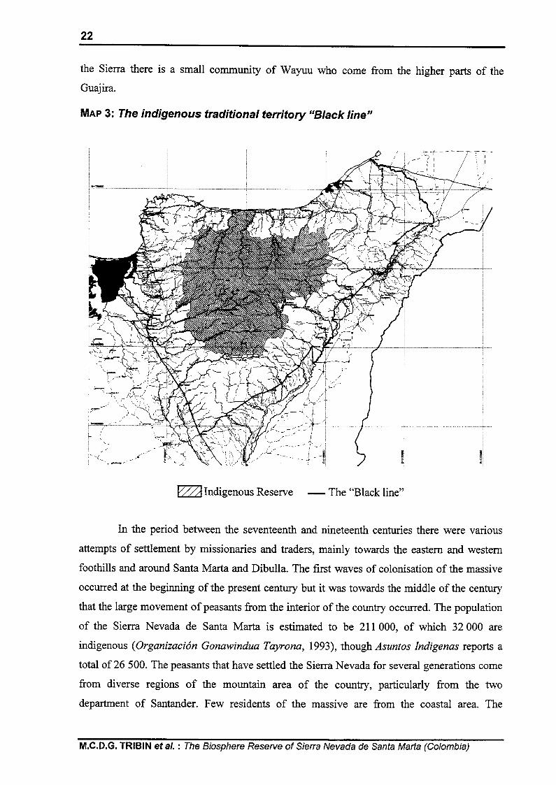
which they were exposed. The indigenous groups that currently inhabit the area (Cf: MAP 3)
are those which survived: Kogi, Wiwa, Arhuaco and Kankwamo ethnic groups, the last of
which has been strongly affected by culture change. Additionally, in the eastern foothills of
Working Paper No 30,1999, UNESCO (South-South Co-operation Programme), Paris (France)
22
the Sierra there is a small community of Wayuu who come from the higher parts of the
Guaj ira.
MAP 3: The indigenous traditional territory “Black line”
FA Indigenous Reserve - The “Black line”
In the period between the seventeenth and nineteenth centuries there were various
attempts of settlement by missionaries and traders, mainly towards the eastern and western
foothills and around Santa Marta and Dibulla. The first waves of colonisation of the massive
occurred at the beginning of the present century but it was towards the middle of the century
that the large movement of peasants from the interior of the country occurred. The population
of the Sierra Nevada de Santa Max-ta is estimated to be 211000, of which 32 000 are
indigenous (Organizacidn Gonawindua Tayrona, 1993), though Asuntos Indigenas reports a
total of 26 500. The peasants that have settled the Sierra Nevada for several generations come
from diverse regions of the mountain area of the country, particularly from the two
department of Santander. Few residents of the massive are from the coastal area. The
M.C.D.G. TRIBIN et al. : The Biosphere Reserve of Siena Nevada de Santa Mar-ta (Colombia)

23
locations of these various groups brings about the existence of different sectors, unrelated to
political and administrative boundaries in the massive, each with its own socio-economic
characteristics. In summary these include: Kogi, Wiwa and Arhuaco indigenous peoples, the
Wayuu, the Kankwamos, the coastal peasants and the peasants of the interior.
The Kogi, Wiwa and Arhuaco
The indigenous peoples of these groups are the ancestral inhabitants of the Sierra
Nevada. Of the three groups, the Arhuaco are the most numerous with some 18 000 members,
concentrated mainly in the administrative districts of Valledupar, Aracataca and Fundacion.
The second is the Kogi, with some 6 000 members, mostly living in the administrative
districts of Santa Mar-ta, Cienaga, Dibulla and Valledupar. Finally, the Wiwa, with a
population of approximately 2 000, are found mainly in the administrative districts of San
Juan de1 Cesar and Dibulla, and to a minor extent in Santa Mar-ta and Valledupar. Most of the
indigenous communities live in the area of the Kogi-Wiwa and Arhuaco Indigenous Reserves,
although a considerable number live outside these areas since these ethnic groups are
developing a policy for the recovery of their ancestral lands which helps to strengthen their
culture and to assist the conservation and regeneration of the ecosystems.
Their social and cultural characteristics are determined by their ancestral knowledge
and by a constant process of cultural readaptation as a result of the influence of the different
waves of migration and of evangelisation in the Sierra Nevada. This influence has encouraged
cultural transformations, both in the land tenure system and in their systems of production and
of social organisation. Nevertheless, while external pressures have had without doubt their
influence upon the culture, a large section of the population has maintained its ancestral
practices and traditions.
The economy is based on the management of different ecosystems of the
mountainous system and on subsistence agriculture with farming in the three hot zones, the
warm, temperate and cold zones, using different altitude zones during the course of the year.
Malanga (Xanthosona) and banana, which form the basis of their diet, are grown in the hot
and temperate zones and also beans, guandul (Caianus indicus), sweet potatoes, maize, yucca,
yam, cane and other crops; in the higher regions potatoes and vegetables are grown. A second
part of the economy is, to a greater or lesser extent, the extensive grazing of cattle and goats.
This activity is regarded as highly damaging to the natural environment in the mountainous
conditions of the Sierra since many times the area of the headwaters of the rivers is used for
grazing and stock-rearing.
Working Paper No 30,1999, UNESCO (South-South Co-operation Programme), Paris (France)

24
Political and administrative relations of the three ethnic groups with the State and
with the non-indigenous population are conducted through their indigenous organisations.
These include the Gonawindua Tayrona (OGT), which groups together the Kogis, Wiwas and
Arhuacos of the northern and western faces as far as the basin of the river Fundacion; the
Tayrona Indigenous Confederation (CIT), which represents the Arhuacos of the eastern face
and of the western face from the Fundacion to the south; and the Yugumauin Bunkuanarrwa
Tayrona, which groups together the majority of the Wiwas who live in the eastern sector.
The Wayuu
This group with a population of 4 702 people is found in the basin of the river
Rancheria where the Mayabangloma, San Francisco, Provincial, Saino and Trupiogacho
Reserves have been established. They form part of the large Wayuu family, whose territory
covers part of the Guajiran peninsula in Colombia and the adjacent sector in Venezuela.
Their principal economic activity is the herding of goats. It has been calculated that
there are approximately 1 600 animals in the zone of the Sierra occupied by this group. This
activity is combined with subsistence farming and the production of charcoal for the towns
nearby. Because of the semi-desert character of their region, the life of the Wayuu is governed
by the incessant search for water. They invest great effort in the construction of deep wells
and pools, both for their animals and for their own use.
Their political and administrative relations with the State are conducted through
Indigenous Organisations of the South of the Guajira, Oziwasug. The cultural evolution of
this ethnic group has enabled it to interact directly with the different spheres of western
society and assimilate many aspects of western culture.
The Kankwamos
This ethnic group found in the region of Atanquez, was the indigenous group most
affected by the process of acculturation as a result of pressures of colonisation and
evangelism. They are currently trying to recover their cultural identity through the Kankwama
Indigenous Organisation.
The Kankwama population of Atanquez, which is in the coffee belt, has not been
penetrated by colonists from the interior of the country. The basis of their economy is coffee
but they also produce avocados and sugar-loaf, as do other coffee-growers. On a minor scale
they engage in cattle and goat-raising in open pasture. The women contribute to the household
economy through the production of shoulder-bags and of sisal fabrics. This activity provides
an alternative source of family income in the period before the harvest.
M.C.D.G. TRIBIN et a/. : The Biosphere Reserve of Sierra Nevada de Santa Marta (Colombia)

25
2) The peasants from the interior mountainous reqion
The peasants from the interior of the country arrived in several waves of
colonisation. The first preliminary wave consisted of immigrants fleeing from the War of a
Thousand Days at the beginning of the century and from the Banana Crisis at the end of the
1920s. Later came the period of “La Violencia” in the middle of the century, when the
conditions of political violence in the interior of the country made it necessary for many
families to migrate to the Caribbean coast, where the Sierra Nevada de Santa Marta was the
favourite place for them to establish farms like those from where they came. This, as well as
the marihuana bonanza at the beginning of the 197Os, generated the largest waves of
colonisation registered for the Sierra Nevada. Actually, the Sierra Nevada has a population of
over 100 000 of peasants from the interior, their descendants who have become natives of the
Sierra and new immigrants who continue to be displaced from other parts of the country
because of violence or unemployment. These are the peasant sectors that compose the
population in the coffee belt, a band lying between 600 and 2 000 m above the sea level, but
with optimum production between 900 and 1 500 metres. This is the principal zone of
colonisation and the main area of agricultural activity. Its success and persistence stem from
the fact that it is both a legal and profitable agricultural activity. Other productive activities
include livestock raising, extensively developing on hillsides completely stripped of tree
coverage, and the extraction of high-value timber, which offers an alternative for the shortage
of agricultural employment, land or the low retribution of some crop plantations. The extent
of this activity is unknown.
The same social composition of the coffee belt is found in the north-western foothills
of the Sierra Nevada, where the economic activity is based on extensive stock-raising and the
growing of fruit and vegetables for the market. The production of these crops meets the needs
of the local market and to some extent supplies the regional market.
Two new important sources of income have arisen in recent times: the banana
plantations of the coastal region and the tourist industry. These activities generate a great deal
of direct and indirect employment but likewise have an impact on the natural environment.
3) The peasants from the coastal region
Settlers from the coastal region (mainly from the towns of Dibulla and Camarones on
the northern face) have also come to the Sierra Nevada. They have settled in the basin of the
Working Paper N” 30,1999, UNESCO (South-South Co-operation Programme), Paris (France)

26
river Garavito together with farming people from the areas of the big estates of the coastal
valleys who have settled in the sectors which, today, constitute the lower mountain zone of
the administrative district of El Copey. Some coastal peasants from the valleys of the
Ariguani and the Cesar, unemployed as a result of crisis, fast, of the banana plantations with
the United Fruit Company and, later, of cotton, migrated to the Sierra Nevada. Some got as
far as the coffee zone, and absorbed the techniques for the cultivation of the bean, but the
majority settled in the lower regions of the massive where they established extensive small-
scale animal husbandry, and the growing of food crops. In the southern region of the Guajira
the colonisation from the coast began along the trade routes established between Riohacha
and the valleys of the Rancheria and Cesar rivers. The flow of contraband along this route
stimulated the settlement of Guajiran families on the middle zones of the mountain (the lower
parts always dominated by large estates).
The marihuana bonanza of the 1970s also stimulated the movement of coastal
peasants into the Sierra Nevada; most of these were employees in the informal sector or day
labourers in the cattle ranches of the coastal plane. Some managed to acquire land and to
firmly establish themselves on the mountain, while others returned, pushed out by the wave of
violence which the bonanza generated or ruined by the loss of their crops. Subsistence
farming is the principal activity in the lower mountain areas of the administrative district of El
Copey. In the south of the Guajira, large scale cultivation of rice and extensive cattle-raising
have also been established. Both aimed at supplying the local and regional market.
Despite the efforts of the coastal peasants to establish themselves in the Sierra
Nevada, they have not managed fully to come to terms with life at high altitudes except in
cases where they have acquired farms.
4) The industrial sector
There is a flat zone bordering the Sierra Nevada which coincides with the
infrastructure of roads connecting the centres of the administrative districts and the three
regional capitals. Of the zones that depend upon the water supply from the catchment areas of
the mountain system, this is the one with the greatest commercial impact upon the regional
economy. The fertility of the soil, coupled with easy access to technology and the existence of
a road network, have made possible the development of tourist and mining industries of
international significance. Large companies predominate in this type of capitalist economy
and these have, gradually, organised themselves into a consortia as a means of promoting
M.C.D.G. TRIBIN et al. : The Biosphere Reserve of Sierra Nevada de Santa Marta (Colombia)

27
commercialisation and of competing in the external market. Each sector of commercial
activity is associated with particular zones around the Sierra Nevada, as follows.
Banana production. There are two zones, one in the administrative districts of
Cienaga, Aracataca and Fundacion, the other located on the Caribbean highway between the
Mendihuaca and Palomino rivers. The total area under cultivation is 17 500 hectares.
African palm production. This occurs mainly in the administrative districts of
Aracataca, Fundacibn, El Copey and Valledupar. The area under cultivation is around 29 695
hectares.
Rice production under irrigation. This predominates in the administrative districts
around Valledupar, or to be more exact in the Badillom local government area of the
department of Cesar, and the Fonseca local government area of Guajira. The production is
sustained by two important rivers, the Badillo and the Rancheria respectively, with numerous
irrigation channels and canals derived from them. In 1995 in Fonseca alone 3 000 ha were
sown.
Cotton and sorghum production. Twenty years ago these were the main lines in
the economies of the departments of Cesar, Guajira and part of Magdalena, but as a result of
the economic crisis of the eighties, and of changes in the rainfall regime they are declining
and are being replaced by the banana and the African palm. Presently, the growing of
sorghum and cotton continues only in the Riohacha administrative district and in the sector of
the Guajira link road.
Mining. The coal mines of the Cerrejon in the administrative district of Barrancas
(Guajira) have a close relationship with the Sierra Nevada, not only because they draw their
water supplies from the Rancheria river, but also because they stand on a sacred site for the
indigenous ethnic groups who hold that it is from there that the “God of the Thunder and the
Winds” makes his pronouncements, with the “God of the Rain” found in the snow covered
peaks. The coal is shipped out to the market from the maritime ports on the Caribbean
highway belonging to Drummond and Prodeco. These draw their water supplies from the
Toribio river.
Stock-raising. This has developed extensively in the valleys of the Ariguani rivers in
the administrative districts of El Copey, Cesar, Valledupar and San Juan de1 Cesar, in the
form of production of young animals for fattening and of dairy farming for the production and
processing of milk.
Tourism. Tourism has developed in the Caribbean coast, and economically benefits
beaches and archaeological sites, such as the Tayrona Park and Teytma (“Ciudad Perdida” or
Working Paper No 30,1999, UNESCO (South-South Co-operation Programme), Paris (France)

28
the “Lost City”, Cf: PHOTO 5). It concentrates mainly in the administrative district de Santa
Marta, where the major part of the infrastructure is located.
PHOTO 5: Teyuna or the “Lost City”
5) The administrative system
The administrative system of the Sierra Nevada is characterised by a wide range of
entities of all sorts, both jurisdictional and functional. A large number of government
institutions find it necessary to work in the Sierra Nevada and this has led to confusion in
terms of functions and areas of responsibility. Three departments, fourteen administrative
districts, two main native reserves and five smaller ones, two National Parks and about one
hundred central government organisations converge in the Sierra Nevada.
This has produced an unstable managing crisis of the massive which holds, not only
the most varied geographical characteristics of the country as a whole, but all its social and
economic diversity. Political administrative divisions, as well as a lack of institutional co-
ordination, has made it difficult to implement and execute policies to assure a proper
management of natural resources for the social and economic development needs of the
region and has worsened the environmental problems of the Sierra Nevada.
M.C.D.G. TRIBIN et al. : The Biosphere Reserve of Sierra Nevada de Santa Mat-ta (Colombia)

29
IV- THE FOUNDATION PRO-SIERRA NEVADA DE SANTA MARTA
The Foundation Pro-Sierra Nevada de Santa Marta was founded in 1986 in order to
seek alternative solutions to the growing deterioration of the Sierra and to improve the
conditions of life for its inhabitants. The Foundation has developed an innovative model for
working with the indigenous and peasant communities, and with the national and local
government authorities and other sectors. It promotes an integrated vision of the region,
transcending social and cultural divisions, territorial and political boundaries, in search of
alternative and participative solutions for the environmental problems of the Sierra. Its role is
to promote the conservation, protection and sustainable development of the cultural and
ecological heritage of the Sierra Nevada de Santa Mar-ta.
During its first year, the Foundation established a Scientific Committee made up of
national and international scientists from various disciplines, who advised the Foundation
upon the design and implementation of its programmes and projects. Similarly, Regional
Committees were set up in each department: Guajira, Cesar and Magdalena to provide a
regular mechanism for consultation and discussion with the different institutions and
communities of the region on matters of importance for them and for the Sierra Nevada. In
1987, following the first recommendations of the Scientific Committee, the Foundation Pro-
Sierra Nevada carried out an integrated diagnosis of the massive. It gathered all existing
information, especially in reference to its history from the fifteenth century up to now on
institutional, social, environmental, political and economic matters, and particularly on the
situation of the Indigenous Reserves and the National Natural Parks. Additionally, work was
done upon recording the information in a series of thematic maps which formed the origin of
a regional cartographic base.
Meanwhile, the Foundation established, in strategic zones of the Sierra, Ecological
Stations and Centres for Service to the Community. With participation of local communities,
it has developed programmes in fish-farming, agroecology, environmental health, and
decontamination, together with programmes for communal organisation and participation,
basic and applied research on the regeneration of ecosystems, the recovery of pre-Hispanic
technologies and rural housing projects, among others. This continued field work has also
made it possible for the Foundation to develop activity and research in various areas with the
participation of public and academic institutions for the achievement of common objectives
and has enabled it to maintain an uninterrupted presence in the region for a period of ten
years.
Working Paper No 30,1999, UNESCO (South-South Co-operation Programme), Paris (France)

30
graphical information. This has become a vital tool for regional planning and decision
making. In addition, the Foundation has a documentation centre which brings together
bibliography and information on the Sierra Nevada and its area of influence, as well as written
material produced by the Foundation. It has also established an archive of photographs and
videos that record various periods of the Sierra Nevada and all of the Foundation’s projects.
In 1994, the Foundation Pro-Sierra Nevada de Santa Marta also established its Unit for
Monitoring and Evaluation to keep track of its activities and projects. Among its
achievements has been the development of a methodology for the measurement of advances
towards sustainability that will be used for projects in the future.
After four years of work, there is now a Sustainable Development Plan for the Sierra
Nevada with a series of programmes and sub-programmes, as well as some 450 initiatives in
order to recover the Sierra and to promote a more equitable and stable development.
1) The development of the strateqv for the conservation of the Sierra Nevada de Santa Marta
The diagnosis
The diagnosis of the Sierra Nevada de Santa Marta developed by the Foundation was
originally conceived as an inventory of natural resources that could lead to a management
plan. However, the complexity of the social situation made it clear in 1988 that understanding
the socio-economic condition and describing the chain of cause and effect which lies behind
the current situation in the Sierra Nevada was necessary before proceeding towards any other
objective.
The description of the ecosystem was done on a cartographic basis, gathering the
existing information at a scale of 1 : 500 000. It presented secondary information about the
geological relief, politico-administrative limits, national parks, indigenous reserves, soil use,
woodlands and biomes. It also gathered new information on the current state of vegetation,
the limits of the river basins, agricultural use and the coverage of government services in the
region. The investigation concluded that the reality of the physical and biological position of
the Sierra Nevada will only be understood with an instalment of a net of stations for the
observation of its processes and phenomena.
Regarding the indigenous peoples, the study detected a tendency towards
demographic growth and a more active indigenous attitude towards the pursuit for sustainable
development in the Sierra. Their central concern was the recovery of their land together with
other related matters such as the territorial access to the sea, the well being of their reserves
M.C.D.G. TRIBIN et al. : The Biosphere Reserve of Sierra Nevada de Santa Marta (Colombia)

31
and the ownership of the sacred site of Teyuna (Cf: PHOTO 6) or “Ciudad Perdida” (the “Lost
City”).
PHOTO 6: Teyuna or the “Lost City”
External pressures that have produced significant changes all along the history of the
Sierra Nevada are obvious. The Sierra Nevada has been, and remains, a strategic region in
order to exploit resources easily manipulated, because of its isolation, and very efficient,
because of its geographical situation and the diversity of its ecological potential. The Sierra is
thus a place where the magnitude of complex external situations intensifies. Meanwhile, the
governmental policy for the Sierra Nevada is not a single integrated project, programme or
development plan but is atomised without any interdepartmental co-ordination and is, rather,
characterised by an almost total absence of direction.
In summary, present symptoms of social and ecological deterioration have their roots
in the almost total absence of any form of integrated development directed from the Sierra
Nevada itself, and the predominating influence of external factors responding to interests
which are not related to, and in many cases, opposed to those of both the inhabitants of the
Sierra Nevada and the common good of the region and the country as a whole. As a result of
this diagnosis, a series of recommendations were made to the Office of the President of the
Republic that contributed, among other things, to the creation of a Special Rehabilitation
District for the Sierra Nevada de Santa Mar-ta as a territorial unit within the National Plan for
Rehabilitation (PNR).
The first meetings of the PNR approved the establishment of direct contacts with
various communities of the Sierra and gave way for a staff of people with common interests
Working Paper N” 30,1999, UNESCO (South-South Co-operation Programme), Paris (France)

32
in the massive to come to terms with the reality of the problems and conflicts of the area. For
the fist time in the history of the region, a direct link was established between local
communities and governmental programmes. From that moment on, the priority became the
need for ample participation of all groups involved in the ecoregion, taking into account their
analysis and evaluating long term risks if concrete actions to reverse ecological deterioration
and guarantee water supply for the future development of the region were not taken. The first
meetings where held in June 199 1 in order to share results of the integrated diagnosis with the
diverse groups that interact around the Sierra Nevada. Opinions and ideas were gathered and
provided the fundamental base in order to work towards a Conservation Strategy for the
Sierra Nevada. This was proposed by the Foundation Pro-Sierra Nevada de Santa Marta and
supported by the German Co-operation Agency (GTZ). It is evident that the majority of the
population, governmental institutions and productive sectors were generally ignorant of the
situation of the region as a whole. For this reason, once the first outlines were- established,
consultations were held with groups of people drawn from the academic, governmental,
indigenous and peasant sectors, all of whom had experience and knowledge of the Sierra. Of
these, six major target groups were identified throughout the Conservation Strategy:
i) indigenous populations; ii) peasants; iii) industrial sectors which depend upon the
environmental services of the Sierra; iv) people living in the urban centres and in the zones of
influence of the Sierra from where they get their water supply; v) governmental organisations
at national, regional and local levels and vi) other organisations and political groups having an
impact upon the Sierra Nevada.
Meanwhile, members of the peasant and indigenous communities of the various
regions and basins of the massive were invited to an expert workshop where it was expected
that existent information and experience in the region could be shared in order to receive
feedback on the identification and analysis of the problems. These meetings allowed a broader
understanding of the complexity of the Sierra and the identification of the main problems that
affect it: deforestation, holding of land, reserves organisation, lack of health assistance,
absence of environmental education and public order conflicts, among others. As these main
problems were identified, a framework for proposing solutions was established letting
participants as well as universities, government institutions and representatives of the
productive sectors advance through the process. These meetings succeeded in bringing
together a variety of different, often antagonistic, points of view and interests that were
discussed. Other workshops followed this first expert workshop and the number of
participants increased.
M.C.D.G. TRIBIN et al. : The Biosphere Reserve of Sierra Nevada de Santa Marta (Colombia)

33
This gathering lead to two chief conclusions: training had to be the base for every
action of conservation and for the first time, a concern with the violation of human rights as
an obstacle to achieving a sustainable development became apparent. The indigenous peoples
raised their concern about the loss and degradation of “sacred places”. According to their
traditional knowledge, they explained the right way for the “younger brothers” (or the non-
indigenous people) to conserve and protect their territory, “the heart of the world”. They also
showed interest in learning what they called the new law of the younger brothers: the 1991
political Constitution. Upon the results of the workshop, all of the participating leaders
reported back to their communities and were supported to involve themselves in the training
courses which were to follow. The subject matter and content of these were decided by
consensus, the principal themes concerning sustainable development and the environment,
cultural identity, fundamental rights, the resolution of conflicts and leadership in participative
planning. Other activities were the district workshops, workshops on Human Rights and on
management and local government. In these workshops the participants analysed the principal
problems of the region. This process made it possible to set up an association of the district
authorities of the Sierra for co-ordination of their work under the name of Asosierra.
The draft document
The first step in the process of developing the Conservation Strategy was to produce
a document called “The Basis of a Plan for the Sustainable Development of the Sierra Nevada
de Santa Marta”, that would show the various views expressed by the different groups that
participated in the Strategy. First, it provided a general description of the region and its
history with an account of the current position of the Sierra Nevada. It then presented the
methodology for the development of the Conservation Strategy, describing the whole process
step by step. Finally, it showed the results of the diagnosis developed by each of the
participants in the process: individuals, entities and groups, each with its own programmes
and projects aimed at regulating the activity causing deterioration in the Sierra Nevada.
The document was submitted for consideration of the various social sectors,
governmental bodies, industries through a second wave of consultations, in order to receive
feedback and comments and thereafter start formulating priorities of action according to
identified central concerns and the environmental, social, political and economic conditions of
each of the regions and local government bodies that make up the massive. The formulation
of this document became a vital tool for analysis, discussion and for the contribution of ideas
from each of the participants involved in the process. These consultations took place with
Working Paper No 30,1999, UNESCO (South-South Co-operation Programme), Paris (France)

peasant communities in 32 localities. At the local government level, working sessions were
arranged with each district authority and also with each of the three departments: Cesar,
Guajira and Magdalena. The consultations included a project formulation, which sought to
make one or two principal concerns a priority for each area and to formulate its respective
solution.
The draft document was presented to traditional indigenous Kogi and Arhuaco
authorities in presence of the Governing Councils of the Gonawindua Tayrona Organisation
and the Tayrona Indigenous Confederation at a meeting in Bonga. They enhanced their
concern for actions that organise and extend their reserves and protect their sacred sites.
Similar consultations were held with leaders of indigenous groups in other regions and they
confirmed that the document registered the matters which had been discussed throughout the
expert workshops and the training courses. They made emphasis on the importance of
consultation with their spiritual leaders, or “Mamas”, in each of the indigenous areas in order
to carefully analyse each part of the document. It was estimated that this process of vital
importance could take two years.
The consultation with the district authorities was carried out with the support of
Asosierra. It included among other matters, a module on areas for priority attention in the
district and another on project formulation which contributed to the training of local
government staff. The Regional Committees of the Foundation Pro-Sierra Nevada were used
to set up consultations at the department level, Three workshops were held, one in each
department, at which point the programmes and projects on sustainable development
proposed in the draft document were debated and a series of proposals for needs identified in
Cesar, Guajira and Magdalena were jointly produced. These workshops were convened by the
governors of the departments, and State institutions, together with people from local
government and from local communities. The results of the workshops were incorporated in
the document. In certain cases, the projects formulated in the workshops have been
incorporated into the Bank of Projects for National Investment (BPIN). The Consultation also
took place at a national level where the need to achieve interinstitutional co-ordination for the
Permanent Fund for the Conservation of the Sierra Nevada was stressed. Also, the need to
establish a co-ordinating unit with an overriding authority capable of bringing together all the
players in the Sierra Nevada de Santa Mar-ta and ensuring that the proposed projects and
programmes were carried out, was enforced.
M.C.D.G. TRIBIN et al. : The Biosphere Reserve of Sierra Nevada de Santa Marta (Colombia)

35
Communication and information
The communication and information element has been enormously important during
the development of the Conservation Strategy. Its objective has been to create a favourable
climate for collective thought upon the formulation of the Sustainable Development Plan for
the Sierra Nevada. The role of communication and information is to make effective what is
known as “sensibilization”. This concerns not only the players directly involved, but also the
public and the academic community in the region, the country and the world. If one is to
achieve a change in behaviour in a society which is pursuing unsustainable patterns of
exploitation and consumption, one must have the conscious and well-informed participation
of all concerned. This depends to a large extent upon the access of the public to systems that
inform promptly, respond rapidly and educate.
In order to keep the target groups informed “Notisierra”, an eight-page tabloid
newspaper, was set up. It is published quarterly with news about the activities completed
within the framework of the project, everyday life in the Sierra and events of local, regional,
national and international levels that have bearing upon the ecosystems of the Sierra. In
support of its work, the Foundation received audio-visual equipment and made a complete
record of all its activity. These videos were used to train and inform the various target groups.
Depending on the subject matter they were also distributed to the communities or broadcasted
on the regional television channel, Telecaribe. Six videos were produced: i) the Foundation
for the Sierra Nevada and the Strategy for Conservation; ii) the training courses; iii) a voyage
to the heart of the world or the district workshops; iv) “Yuluka” (or “to find agreement”): the
Association of District Authorities of the Sierra; v) presentation of the draft document: “Basis
for the Sustainable Development Plan for the Sierra Nevada de Santa Marta” and vi) the
development of the Conservation Strategy for the Sierra Nevada de Santa Marta (in English
and Spanish).
The Conservation Strategy also included a photographic record of the workshops
and, in general, of everything that was done. This made it possible to give copies to
participants and illustrate the process for conferences and presentations to institutions and
communities. Reading materials and pamphlets were produced documenting matters which
have arisen during the development process or which have been brought up for discussion.
This activity was advanced together with each of the working sessions with the different
players in the process. Materials were distributed for the use of communities, government
bodies, productive sectors and public opinion in general. Among the materials produced is the
series of 17 documents, ECSN: Strategy for the Conservation of the Sierra Nevada de Santa
Working Paper No 30,1999, UNESCO (South-South Co-operation Programme), Paris (France)

Mar-ta. A radio programme “La Lora Serrana” (The Parrot of the Sierra), containing matters of
reflection concerning life in the Sierra and its zone of influence was broadcasted every
Saturday. A more harmonious relationship between the people of the region and the
environment was promoted through this innovative radio magazine programme which, in
turn, stimulated respect towards all cultures present.
2) The Sustainable Development Plan for the Sierra Nevada de Santa Marta
AS a result of the contributions from all sectors the Plan for the Sustainable
Development of the Sierra Nevada de Santa Marta was published in 1997 and widely
circulated. The Sustainable Development Plan was officially presented at a special meeting at
the “Casa de Nariiio” (the Presidential Palace) by the Ministry for the Environment, the
National Planning Department, the Presidential Council for the Atlantic Coast and the
Governors of the departments of Cesar, Magdalena and Guajira. Three meetings were held
thereafter to present the Plan to the departments with jurisdiction in the Sierra. Various
political, economic and social groups of the region were present at these meetings. The new
department and local governments for the period 1998-2000 have had a briefing with the
Indigenous Governing Councils, the Ministry for the Environment, the Presidential Council
for the Atlantic Coast, and CORPES C. A. to keep themselves informed and to analyse forms
of co-operation among territorial authorities with jurisdiction over the Sierra Nevada.
Another series of meetings concerning the Sustainable Development Plan as a whole
was begun with the indigenous population of the Sierra Nevada and their organisations. They
communicated their need for a long time in order to thoroughly analyse with their people and
traditional authorities the process of activities and projects, its implications on their territory
and their autonomy.
The strategy is now under way. The solutions proposed search for the widest possible
social agreement, taking into account the diversity of the ecosystems, microclimates, cultures
and interests, and the state of local and regional degradation or conservation. This means that
each particular solution will be different but that they will all be interrelated so as to obtain
the ultimate goal to prevent the extinction of water and life of the Sierra Nevada.
In order to carry out the implementation of the Sustainable Development Plan the
Congress of the Republic passed in 1996 the Law No. 344, establishing an Environmental
Regional Council and an Environmental Fund for the Sustainable Development of the Sierra
Nevada, respectively as the administrative and financial mechanisms.
M.C.D.G. TRIBIN et al. : The Biosphere Reserve of Sierra Nevada de Santa Marta (Colombia)

37
Global objective of the Sustainable Development Plan. To conserve, protect and
recover the natural base of the Sierra Nevada de Santa Mar-ta in order to guarantee its cultural
survival and its water sources for the sustainable development of the region.
Principles. To achieve the overall objective, it will be necessary to create the
conditions for a change in attitude based upon principles of respect, cultural diversity, fairness
and participation, so as to guarantee harmony, transparency and efficiency in the
implementation of the objective.
Specific objectives and/or results. The results of the participative diagnosis by the
different social groups were organised in five explanatory modules which grouped together
the problems, all of them aggravated by a lack of environmental education. In order to resolve
the situation five lines of action were considered together with a series of specific
programmes and projects aimed at the achievement of the over all objective. Environmental
Education is regarded as an additional but essential line of action, related to all the rest. The
lines of action proposed are: conservation of ecosystems and hydrological resources,
strengthening the indigenous cultural identity, stabilisation of the peasant sectors,
strengthening of fundamental rights, modernisation of administration.
3) The forum for the sustainable development of the Sierra Nevada de Santa Marta
The forum for the Sustainable Development of the Sierra Nevada de Santa Marta was
conceived as an opportunity for meeting and gathering collective thought and orientation
around matters which the stakeholders of the Sierra Nevada considered as priorities and
necessities for a joint and coherent programme, as well as an opportunity for the different
public organisations, each with its own area of competence and responsibility, to co-ordinate
their actions in those areas which exceed the competence of any one institution, so that each
one, according to its particular nature, could play its part in an integrated and co-operative
programme of work.
The general objectives set out for this meeting were: i) to analyse the Sustainable
Development Plan as a whole, and identify the priorities of action; ii) to obtain technical and
financial co-operation from agencies, donors and national and international investors for the
Sustainable Development Plan; iii) to jointly initiate the implementation phase of the
Sustainable Development Plan with all the governmental, social, political and economic
Working Paper N” 30,1999, UNESCO (South-South Co-operation Programme), Paris (France)

3%
groups of the region and iv) to establish the Regional Environmental Council for the Sierra
Nevada de Santa Mar-ta.
The Forum was composed of six Working Groups, each chaired by an organisation
of institutions with interests and concerns related to the matters in question. The Groups were
as follows: i) conservation of ecosystems and management of the hydrological resource;
ii) strengthening of the indigenous cultural identity and organisation of the Reserves;
iii) stabilisation of the peasant sector; iv) strengthening of fundamental rights;
v) administrative modernisation and vi) environmental education.
It was held as a meeting open to all social, political and economic groups of the
ecoregion, national groups, indigenous communities, organisations and authorities, peasant
communities and organisations, district, department, regional and national government
bodies, governmental institutions, non-governmental institutions, and the productive sectors.
A resource pack was prepared for each of the thematic Working Groups. It gathered inputs
from the various sectors involved in the preparation of the Plan and the recording of
discussions and recommendations from the department training workshops held in Cesar,
Guajira and Magdalena before the Forum. Each participant received a copy of this pamphlet.
Among the results of this meeting is a document that analyses the Plan as a whole
from the points of view of the different participants and specifies the agreements reached and
the matters that still require further analysis. Another result worth mentioning is the
establishment of the Regional Environmental Council (CAR), as a result of the discussions
and contributions from the different players involved. In addition, technical and financial co-
operation was obtained from agencies, donors and national and international investors for the
Sustainable Development of the Sierra Nevada through the investors’ Working Group, which
was held along side the Forum.
4) The rapid ecoloaical assesment
As a technical contribution to a better understanding of the massive, the Foundation
together with the Ministry of the Environment and the assistance of The Nature Conservancy,
carried out a rapid ecological assessment of the Sierra Nevada in order to bring up to date all
available information upon this biogeographical entity and to identify the critical areas for the
conservation of the biodiversity of the Sierra, by means of remote sensing. A
multidisciplinary and interinstitutional work plan was prepared for the development of the
assessment where five working groups took part: i) ecology and botany; ii) fauna; iii) socio-
M.C.D.G. TRIBIN et a/. : The Biosphere Reserve of Sierra Nevada de Santa Marta (Colombia)

39
economic; iv) policy and management and v) spatial information. These groups gathered the
information from where a set of thematic maps were produced, representing the geographical
distribution across the area of the different variables. The information from these maps was
overlaid using various techniques of analysis and spatial modelling to identify specific critical
areas with unique features of vegetation, plant or animal species with a restricted distribution
and important habitats for the survival of wildlife.
5) Pilot proiects arisina from the Conservation Strateav
The Foundation signed an agreement with the Dutch embassy for the execution of
ten pilot projects which were proposed by communities at the workshops for the Conservation
Strategy. These experimental projects were planned and executed by the people of the Sierra
and the groups directly involved. They were intended to test and confirm the results of the
Strategy study. The Foundation is currently carrying out the first phase in which the selection
of the pilot projects will be made. A system of consultation between the groups involved will
be set up for this purpose so that the requirements for diagnosis, planning, execution and
evaluation can be analysed and the work of each of the parties defined. In addition, a training
programme will be set up to strengthen the skills of local organisations in the areas where the
projects will take place.
V- LESSONS LEARNED AND A PERSPECTIVE OF THE FUTURE
Why a Sustainable Development Plan is necessary? Because of its participative
character, the Sustainable Development Plan is an initiative which is open to modification and
change as a result of collective thinking. It thus becomes a fundamental instrument for social
agreements that can pave the way towards a balance coexistence, which in turn guarantees the
future of the ecoregion.
The social, cultural, environmental, political and economic complexity of the Sierra
Nevada is clearly reflected in the diagnosis presented by the distinct social groups of the
region. Tendencies such as the loss of ecosystems and the drying up of water sources are a
reflection of a chain of social, political and economic problems manifesting themselves in the
deterioration and exhaustion of the massive. The natural base of the Sierra Nevada is being
systematically and progressively destroyed and up to now it has been impossible to prevent its
deterioration. It is clear that the future remains uncertain for communities and neighbours of
Working Paper No 30,1999, UNESCO (South-South Co-operation Programme), Paris (France)

40
the Sierra unless there is a change in the attitudes of the social groups that interact in the
region.
The Strategy for the Conservation of the Sierra Nevada, which has led to the
Sustainable Development Plan, is an innovative and participative process for seeking
solutions to the problems which affect the massive. For the IUCN: “Traditionally, strategic
thinking has been applied only to warfare but it can be applied as a method of action when the
concern is to resolve complex matters that involve many players. Of these matters, none are
more appropriate than ecological concerns, in particular, that of sustainable development.”
The starting point for both the diagnosis and the proposals is the analysis undertaken by social
groups involved. In this way, one is seeking to change the tendency toward external decision
making.
Each one of the five major objectives proposed and educational lines of action in the
programmes and projects has been agreed at the local level taking into account local
characteristics and the environmental, cultural, social, political and economic diversity of the
Sierra Nevada and its area of influence. In this way, a process of mutual local consent
stimulates the success of any action taken.
The Plan for the Sustainable Development of the Sierra Nevada has thus been set up
as a cyclic and participative process of action planning, seeking to improve the quality of life
for all groups while maintaining a balance between the objectives of economic, social and
environmental development.
BIBLIOGRAPHY
FUNDACI6N PRO-SIERRA NEVADA DE SANTA MARTA:
Historia y Geogra$a - Sierra Nevada de Santa Marta Bogota, 1991.
Plan de desarrollo sostenible de la Sierra Nevada de Santa Marta Santa Max-ta, 1997.
Evaluacidn ecolbgica rdpida para la determinacibn de Areas criticas en la Sierra Nevada de Santa Marta Santa Marta, 1999 [a ser publicado].
HERNANDEZ-CAMACHO, SANCHEZ: Biomas terrestres de Colombia in: The Biological Diversity of Latin America 1992.
M.C.D.G. TRIBIN et al. : The Biosphere Reserve of Sierra Nevada de Santa Marta (Colombia)

Working Papers
N” 1 (1995) : The Mata Atlantica Biosphere Reserve (Brazil): An Overview, by Antonio Carlos Diegues.
N” 2 (1995) : The Xishuangbanna Biosphere Reserve (China): A Tropical Land of Natural and Cultural Diversity, by WU Zhaolu, OU Xiaokun.
No 3 (1995) : The Mae Sa-Kog Ma Biosphere Reserve (Thailand), by B. RERKASEM, K. RERKASEM. N” 4 (1995) : La Reserve de la biosphere de Dimonika (Congo), par J. DIAMOUANGANA.
N” 5 (1995) : Le Part national de Tai’ (Core d’lvoire) : un maillon essentiel du programme de conservation de la nature, par Y. SANGARI?.
N” 6 (1995) : La Reserve de la biosphere de Mananara-Nord (Madagascar) 1988-1994 : bilan et perspectives, par N. RAONDRY, M. KLEIN, V. S. RAKOTONIRINA.
N” 7 (1997) : A Study on the Homegarden Ecosystem in the Mekong River Delta and the Hochiminh City (Viet Nam), by N. T. N. AN.
N” 8 (1995) : The Manu Biosphere Reserve (Peru), by L. YALLICO, G. SUAREZ DE FREITAS.
N” 9 (1995) : The Beni Biosphere Reserve (Bolivia), by C. MIRANDA L.. N” 10 (1995) : La Reserva de la biosfera Sierra del Rosario (Cuba), por M. H. ALVAREZ, M. GARCIA G.. N” 11 (1995) : The Omo Biosphere Reserve (Nigeria), by A. 0. ISICHEI.
No 12 (1995) : Environnement nature1 et sociodconomique de la foret classee de la Lama (Benin), par M. A. BAGLO, P. COUBEOU, B. GUEDEGBE, B. SINSIN.
N” 13 (1995) : The Calakmul Biosphere Reserve (Mexico), by E. BOEGE.
N” 14 (1996) : Conservation de la biodiversite’ aux Comores : le Part national de Moheli, par A. S. ALI, A. YOUSSOUF.
N” 15 (1996) : Resoure-Use Patterns: The Case of Coconut-Based Agrosystems in the Coastal Zones of Kerala (India) and Alagoas (Brazil), by V. NOBRE LAGES.
No 16 (1996) : The Nilgiri Biosphere Reserve: A Review of Conservation Status with Recommendations for a Holistic Approach to Management (India), by R. J. RANJIT DANIELS.
N” 17 (1996) : Kinabalu Park and the Surrounding Indigenious Communities (Malaysia), by J. NAIS. N” 18 (1997) : Puerto Galera (Philippines): A Lost Biosphere Reserve?, by M. D. FORTES.
No 19 (1997) : The Palawan Biosphere Reserve (Philippines), by R. M. SANDALO, T. BALTAZAR. N” 20 (1997) : Le Part national de Kahuzi Biega, future Reserve de la biosphere (Republique democratique du
Congo), par B. won wa MUSITI, G. M. ma OYISENZdO, G. DARKEN.
N” 2 1 (1997) : Biodiversity Conservation through Ecodevelopment Planning and Implementation Lessons from India, by S. SINGH.
N” 22 (1997) : The Tanjung Puting National Park and Biosphere Reserve (Indonesia), by H. D. SUSILO.
N” 23 (1997) : Biodiversity Conservation in Mozambique and Brazil, by Maria Teresa Rufai MENDES.
N” 24 (1998) : Social Sciences and Environment in Brazil: A State-of-the-Art Report, by P. F. VIEIRA. N” 25 (1998) : La implementacidn de reservas de la biosfera : la experiencia Iatinoamericana, por C.
DANIELE, M. ACERBI, S. CARENZO.
N” 26 (1998) : Preservation of Sacred Groves in Ghana: Esukawkaw Forest Reserve and its Anwean Sacred Grove, by B. AMOAKO-ATTA.
N” 27 (1998) : Environmentally Sound Agricultural Development in Rural Societies: A Comparative View ,from Papua New Guinea and South China, by R. OHTSUKA, T. ABE, M. UMEZAKI.
No 28 (1999) : Reunion international para la Promocidn de1 desarrollo sostenible en 10s Paises Africanos de Lengua Oficial Portuguesa (PALOP) mediante la cooperacibn international, editado por M. T. R. PITI?, E. MijLLER.
N” 29 (1999) : La Reserva de la biosfera Los Tuxtlas (Mexico), por S. GUEVARA SADA.
No 30 (1999) : The Biosphere Reserve of the Sierra Nevada de Santa Marta: A Pioneer Experience of a Shared and Co-ordinated Management of a Bioregion (Colombia), by M. C. D. G. TRIBIN, G. E. RODRiGUEZ N., M. VALDERRAMA.