STUDIES IN CAN GIO MANGROVE BIOSPHERE RESERVE, HO CHI …
75
volume 6 ISSN 0919-2646 International Society for Mangrove Ecosystems STUDIES IN CAN GIO MANGROVE BIOSPHERE RESERVE, HO CHI MINH CITY, VIET NAM March 2014 International Society for Mangrove Ecosystems (ISME) Can Gio Mangrove Protection Forest Management Board Tohoku Gakuin University mangrove ecosystems technical reports
Transcript of STUDIES IN CAN GIO MANGROVE BIOSPHERE RESERVE, HO CHI …

volume 6ISSN 0919-2646
International Society for Mangrove Ecosystems
STUDIES IN CAN GIO MANGROVE BIOSPHERE RESERVE,
HO CHI MINH CITY, VIET NAM
March 2014
International Society for Mangrove Ecosystems (ISME)
Can Gio Mangrove Protection Forest Management BoardTohoku Gakuin University
mangrove ecosystemstechnical reports
coverpage-last(4.3).ai 1 2014/05/01 9:30:34

All rights reserved. No part of this publication may be reproduced or stored in any form that can be retrieved or
Advisor: Prof. Shigeyuki Baba
Editors: Dr. Hung Tuck Chan & Assoc. Prof. Mike Cohen
Translation by Dr. Mami Kainuma
Cover photo: A planted mangrove forest in Can Gio by Dr. Tomomi Inoue
Assoc. Prof. Vien Ngoc Nam
International Society for Mangrove Ecosystems (ISME)
Human InformaticsTohoku Gakuin University
)
)

ISME Mangrove Ecosystems Technical Reports No. 6
STUDIES IN CAN GIO MANGROVEBIOSPHERE RESERVE,
HO CHI MINH CITY, VIET NAM
March 2014
Tohoku Gakuin UniversityCan Gio Mangrove Protection Forest Management BoardInternational Society for Mangrove Ecosystems (ISME)


Contents
Foreword i
Message ii
Coordinators and Authors iii
Authors iv
An Overview of Can Gio District and Mangrove Biosphere Reserve 1
Destruction, Restoration and Management of Can Gio Mangroves 9
Further Study on the Mangrove Recovery Processes in Can Gio, Viet Nam 15
&
Erosion and Accretion in Can Gio Mangroves (1953 to 2010) 31
Monitoring Riverbank Erosion in Can Gio Mangroves 37
Monitoring Natural Regeneration in a Dead Rhizophora apiculata Site in Can Gio Mangroves 43
2 Absorption Capacity of Rhizophora apiculata Plantations 47in Can Gio Mangroves
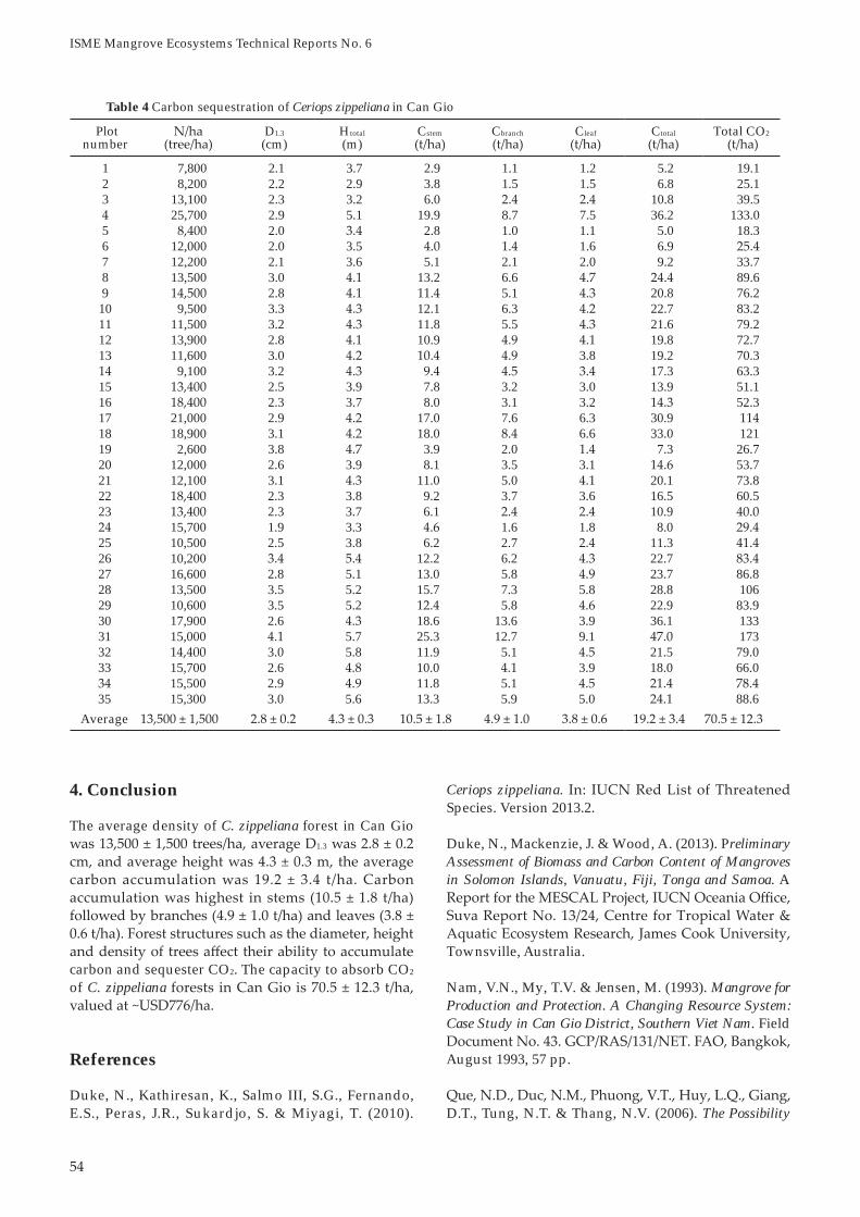
Carbon Sequestration of Ceriops zippeliana in Can Gio Mangroves 51Cao Huy Binh & Vien Ngoc Nam
Mangrove and Human Interactions: A Case Study of Can Gio Mangrove Forests and the Surroundings 57

i
Foreword
publication.
Viet Nam

ii
Message
Studies in Can Gio


1
An Overview of Can Gio District and Mangrove Biosphere Reserve
The terrain is formed by alluvial deposits from the estuaries of six rivers, namely, Nga Bay, Cai Mep, Go Gia, Thi Vai, Soai Rap and Dong Tranh (Tuan et al., 2002; IUCN, 2013). Accretion of mud flats can be observed between the estuaries of Soai Rap and Dong Tranh, and between the estuaries of Dong Tranh and Nga Bay. Elsewhere, erosion is occurring along the banks of the Go Gia estuary.
Water salinity in the mangroves is highest in March
2004). During the rainy season, water salinity is only
on soil salinity, Tu (1996) classified the soils of Can Gio into hypersaline acidic soil, saline acidic soil and saline soil. Later, Tuan et alinto four main types: saline soil, saline soil with low aluminium content, saline soil with high aluminium content, and soft mud with sandy soil deposits at the sea front.
amplitude depending on the lunar calendar and distance from the sea (Binh et alamplitudes are highest from October to November, and lowest in April and May. Five inundation classes have been identified based on frequency of inundation (Nam, 1994). They are sites inundated
A study on waves and suspended sediment at Nang
energy is dissipated inside the mangrove forest due to wave-trunk interactions and wave breaking (Phuoc & Massel, 2006). The concentration of suspended sediment depends on wave intensity and tidal current velocity. Wave action is one of the main factors causing sediment transport and coastal erosion. The
1. Can Gio District
1.1 Geography and Climate
Can Gio (10o o40’09” N; 106o o
deltaic confluence of the rivers of Saigon, Dong Nai and Vam Co, which drain into the East Sea. The town-ship of Can Thanh and six communes of Binh Khanh,
and Thanh An form the human communities of Can
The tropical climate of Can Gio is typically monsoonal
Tuan et al., 2002; Tuan & Kuenzer, 2012). The dry season is from November to May and the rainy season is from June to October. Wind directions are southwest during the rainy season with the strongest velocity in July and August, and northeast during the dry season with the strong winds in February and March. Rainfall, humidity, temperature and sunshine hours vary between the dry and rainy seasons.
in September. The rainfall in Can Gio is lower than
1.2 Topography and Hydrology
The topography of Can Gio is generally flat and low-lying with the highest elevation at Giong Chua (~10 m elevation) in compartment 14 (Tuan et al., 2002).
An Overview of Can Gio District and Mangrove Biosphere Reserve
Vien Ngoc Nam1, Le Van Sinh2, Toyohiko Miyagi3,4, Shigeyuki Baba5 & Hung Tuck Chan5
1
2
3 Department of Regional Design, Faculty of Liberal Arts, Tohoku Gakuin University, Sendai, Miyagi, Japan4
International Society for Mangrove Ecosystems (ISME), Nishihara, Okinawa, Japan

2
ISME Mangrove Ecosystems Technical Reports No. 6
extensive establishment of mangrove plantations, the entire landscape turned into one of the most beautiful and extensive sites of rehabilitated mangroves in the world (Tuan & Kuenzer, 2012). These plantations serve as the “green lung and kidney” for the people of
2. Mangrove Biosphere Reserve
2.1 Declaration and Management
Mangrove Biosphere Reserve (MBR) in Viet Nam under the Man and the Biosphere (MAB) Program of
Organization (UNESCO) (Tuan & Kuenzer, 2012). Since the declaration of Can Gio MBR, research, mon-itoring and training activities have been conducted. The focus of these activities is to promote internation-al research, enhance the environmental awareness of the local people, and to demonstrate to local and for-eign visitors how mangrove forests are rehabilitated and protected. As a result, Can Gio MBR has become an important research site and tourist destination.
The three main management objectives of Can Gio MBR are biodiversity conservation, environmentally- sound social, cultural and economic development, and mangrove-related training, research and education (Tuan et aldivided into three zones:
prohibited in this zone, which is retained for con-servation, research and monitoring purposes.
-scape, and functions as corridors for wildlife, and as cultural and ecological destinations for tourists. The transition zone (29,310 ha) surrounding the core and buffers zones is allocated for the socio-economic development.
2.2 Forest and Ecotourism
Forested and non-forested areas are the main current -
-
Can Gio MBR comprises 24 forest compartments
et al., 2003). The largest
study concluded that establishment of mangrove vegetation can encourage the deposition of sediments.
1.3 Deforestation and Reforestation
mangrove forests in Can Gio were almost completely destroyed by spraying of herbicides and other chemical agents by the U.S. air force (Nam et al., 2003;
et aldistricts of the Mekong delta, Can Gio and Camau
destroyed through deforestation.
After the war, Can Gio came under the jurisdiction
remained highly degraded (Nam et alet al
Phoenix paludosa and the fern Acrostichum aureumcultivable. Mangrove trees of Rhizophora, Sonneratiaand Bruguiera were scarce although some localised regeneration of Avicennia and Nypa palm was observed. Damage to the landscape was aggravated by the felling of trees by the local people for fuel wood and house construction. Severe erosion was observed on the bare land along rivers and canals as
etal., 1993). Coastal erosion increased due to the large tidal amplitude and the lack of a protective green belt.
Gio (Nam et al et al.,
Department. Some 20,000 ha were planted with Rhiz-ophora apiculatamanaged as economic forests for wood production.
Several factors caused the degradation of mangrove
the imbalance between demand and supply of fuel wood and poles for house construction, and the lucrative business of shrimp export encouraged local
mangroves for shrimp farming. Both factors resulted
In 1991, Can Gio was designated a coastal protection
environmental improvements to Can Gio. With the

3
An Overview of Can Gio District and Mangrove Biosphere Reserve
are Compartment 23 in the east and Compartment
The smallest is Compartment 22 in the south near Can Thanh. Compartments 4a, 6, 11, 12 and 13 are designated as the core zone with the remaining compartments forming the buffer zone (Figure 1). Binh Khanh, An Thoi Dong and Ly Nhon along Soai Rap estuary, which form the western boundary, and
form the southern boundary are the transition zone surrounding the biosphere reserve. The Can Gio
the transition zone near Can Thanh town are major
Table 1 Land-use of Can Gio Mangrove Biosphere Reserve
Land-use Area (ha)
1. Forested area 31,773 44.5 a. Forest plantations 26.6 b. Natural forests2. Non-forested area 39,587 55.5 a. Waterways 22,091 31.0 b. Utilised land 19.6 c. Wasteland 4.9
Total 71,361 100.0
Figure 1

4
ISME Mangrove Ecosystems Technical Reports No. 6
Table 3 gives a complete list of true mangrove species and mangrove associates presently found in Can Gio MBR compiled from Nam et al
are true mangroves while 24 species belonging to 22 genera are mangrove associates.
In the World Atlas of Mangroves, 30 mangrove species have been recorded for Viet Nam (Spalding et al., 2010). Of these, all species are found in Can Gio including Kandelia obovata which was introduced from north Viet Nam. In Table 3, Lumnitzera littorea,Rhizophora x lamarckii and Xylocarpus moluccensis are not listed in the world atlas.
The forest and aquatic ecosystems of Can Gio MBR are also rich in mangrove fauna comprising planktonic and benthic organisms, mammals, birds, fishes, reptiles, and amphibians. These animal species are
2.4 Constraints and Challenges
From the forestry viewpoint, it has been a constraint not to carry out silvicultural treatments such as thinning of the planted forests. A study revealed that the rotation of R. apiculata is 21 years. Most of the forests are beyond its rotation age with the oldest
forests are dying or having pest problems such as
2.3 Flora and Fauna
Before the war, mangrove vegetation in Can Gio was categorised into salt-water and brackish-water communities (Cuong, 1964). Common plant species of these two communities are listed in Table 2.
True mangrove Mangrove associate
Acanthus ebracteatus Heritiera littoralis Allophyllus cobbe Premna integrifoliaAcanthus ilicifolius Kandelia candel Annona glabra Styrax agrestisAcrostichum aureum Kandelia obovata Azima sarmentosa Thespesia populneaAegiceras floridum Lumnitzera racemosa Cerbera manghas Viscum ovalifoliumAvicennia alba Nypa fruticans Cerbera odollam Wedelia bifloraAvicennia lanata Phoenix paludosa Clerodendron inermeAvicennia marina Rhizophora apiculata Cordia cochinchinensisAvicennia officinalis Rhizophora mucronata Crinium asiaticumBruguiera cylindrica Rhizophora stylosa Dalbergia candenatensisBruguiera gymnorhiza Rhizophora x lamarckii Derris trifoliataBruguiera parviflora Scyphiphora hydrophylacea Finlaysonia obovataBruguiera sexangula Sesuvium portulacastrum Instia bijugaCeriops decandra Sonneratia alba Hibiscus tiliaceusCeriops tagal Sonneratia caseolaris Hibiscus macrophyllusCryptocoryne ciliata Sonneratia ovata Lasia spinosaDolichandrone spathacea Xylocarpus granatum Melaleuca cajuputiExcoecaria agallocha Xylocarpus moluccensis Pongamia pinnata
Table 3 True mangroves and mangrove associates presently found in Can Gio Mangrove Biosphere Reserve
Note: Under the true mangroves, Rhizophora x lamarckii is a hybrid (R. apiculata x R. stylosa). Ceriops decandra is now recognized as Ceriops zippeliana.
Table 2 List of plant species found in Can Gio before the war (Cuong, 1964)
Species in salt-water community
Species in brackish-water community
Acrostichum aureum Acanthus ebracteatusAegiceras corniculatum Amoora cucullataAvicennia alba Barringtonia acutangula Avicennia officinalis Clerodendron inerme Ceriops decandra Cryptocoryne ciliataCeriops tagal Dalbergia candenatensis Derris trifoliata Derris trifoliataExcoecaria agallocha Flagellaria indica Flagellaria indica Gardenia lucidaHeritiera littoralis Glochidion littoraleKandelia candel Hibiscus tiliaceus Lumnitzera littorea Mela stoma polyanthum Phoenix paludosa Nypa fruticansRhizophora apiculata Pandanus tectorius Sonneratia alba Pluchea indicaXylocarpus granatum Sonneratia caseolarisXylocarpus moluccensis Thespesia populnea

An Overview of Can Gio District and Mangrove Biosphere Reserve
termites and wood borers (Figure 2). Furthermore, some inland sites are no longer inundated by tide due to forest succession and increased elevation, and are therefore unsuitable for the growth of R. apiculata.
The entire coast of Viet Nam falls within the typhoon belt. The Mekong delta including Can Gio is particularly susceptible to typhoons (Diele et al., 2013). For example, Typhoon Durian (Category 4) made landfall in Decem-
forest, no human lives and property were lost.
Lightning strikes are fairly frequent in Can Gio mangroves creating circular gaps in the forest canopy (Kautz et al., 2011). Standing dead trees persist for several years before they collapse, providing light and creating space for regeneration. The percentage of
be the cause of these gaps in the mangrove canopy as no burn or scorch marks were observed on the dead trees (Ong & Gong, 2013).
Figure 2 Trunk of an old-growth tree with termite nest (left) and showing wood borer attack (right)
Figure 3
Typhoon Durian (2006)

6
ISME Mangrove Ecosystems Technical Reports No. 6
and conservation on the biodiversity and environment in Can Gio District. In: Vannucci, M. (ed.). Mangrove Management and Conservation: Present and Future.United Nations University Press, 324 pp.
into riches. In Search of Excellence: Exemplary Forest Management in Asia and the Pacific. Asia-Pacific
IUCN (2013). Building Resilience to Climate Change
Chi Minh City, Viet Nam. BCR Factsheet, August 2013, 4 pp.
Kautz, M., Berger, U., Stoyan, D., Vogt, J., Khan, N.I., Diele, K., Saint-Paul, U., Triet, T. & Nam, V.N. (2011). Desynchronizing effects of lightning strike disturbances on cyclic forest dynamics in mangrove plantations. Aquatic Botany
and function of mangrove ecosystems in the Can Gio Mangrove Biosphere Reserve, Vietnam. Ph.D. thesis, Graduate Faculty of the Louisiana State University,
Le, T.K. (2002). Economic Distribution and Institutions in the Recreation and Tourism of Mangrove Biosphere Reserve: Case study of Can Gio Mangrove Biosphere
References
to manage the mangrove for coastal environmental protec t ion . The In t e rna t i ona l Arch ives o f the Photogrammetry, Remote Sensing and Spatial Information Sciences
Cuong, V.V. (1964). Flore et Vegetation de la Mangrove de la Region Saigon-cap Saint Jacques sud Viet-nam. Ph.D. dissertation, University of Paris, France.
Diele, K., Tran Ngoc, D.M., Geist, S.J., Meyer, F.W.,
(2013). Impact of typhoon disturbance on the diversity of key ecosystem engineers in a monoculture mangrove forest plantation, Can Gio Biosphere Reserve, Vietnam. Global and Planetary Change, 110(B),
Minh City. In: Field, C. (ed.) Restoration of Mangrove Ecosystems
Figure 4 Circular gaps in the mangrove canopy of Can Gio with distant and inside views as insets

An Overview of Can Gio District and Mangrove Biosphere Reserve
impact of military use of herbicides. In: Proceedings o f In t e rnat i ona l Sympos ium on B io log i ca l and Management of Mangroves
Spalding, M., Kainuma, M. & Collins, L. (2010). WorldAtlas of Mangroves. Earthscan, London, UK, 319 pp.
Tu, L.V. (1996). Agricultural Land of Ho Chi Minh City and Trends of Utilization. Agricultural Publishing
Can Gio Mangrove Biosphere Reserve. Agricultural
Can Gio Mangrove Biosphere Reserve Evaluation 2012: Current Status, Dynamics and Ecosystem ServicesNam, 102 pp.
Valuation of the Mangrove Ecosystem in Can Gio Biosphere Reserve, Vietnam. Final
Reserve, Vi e t n a m . Final Report of MAB Young Scientist Award Program, 46 pp.
Nam, V.N. (1994). Restoration and afforestation of mangrove in Vietnam. In: Proceedings of the National Workshop, MERC and ACTMANG,
Nam, V.N., My, T.V. & Jensen, M. (1993). Mangrove for Production and Protection. A Changing Resource System: Case Study in Can Gio District, Southern Viet Nam. Field
Nam, V.N., Sinh, L.V., Miyagi, T. & Kitaya, Y. (2003). 25 years of Mangrove Rehabilitation in Can Gio District, Ho Chi Minh City, Vietnam. Annual Report of FY 2002, Core University Program between Japan Society for the Promotion of Science (JSPS) and National Centre
Ong, J.E. & Gong, W.K. (2013). Structure, Function and Management of Mangrove Ecosystems. ISME Mangrove Educational Book Series No. 2, ISME and ITTO.
wave motion and suspended sediment concentration
Vietnam. Oceanologia


9
Destruction, Restoration and Management of Can Gio Mangroves
Agent Orange contains dioxin, which can persist in the environment and enter the food chain. In 1971, while the war was still in progress, two scientists from Harvard University demonstrated that fish from the Dong Nai River, Saigon River and Can Gio coast, all contained dioxin at unacceptably high levels including human breast milk obtained from the local population (Carroll, 2010).
In some areas, trees of Rhizophora, Sonneratia and Bruguiera were killed by the herbicides but in many areas, the land had become barren with no vegetation cover (Nam et al., 1993). Years later, weed species of the palm Phoenix paludosa and the fern Acrostichum aureum infested the more elevated degraded sites
1. Introduction
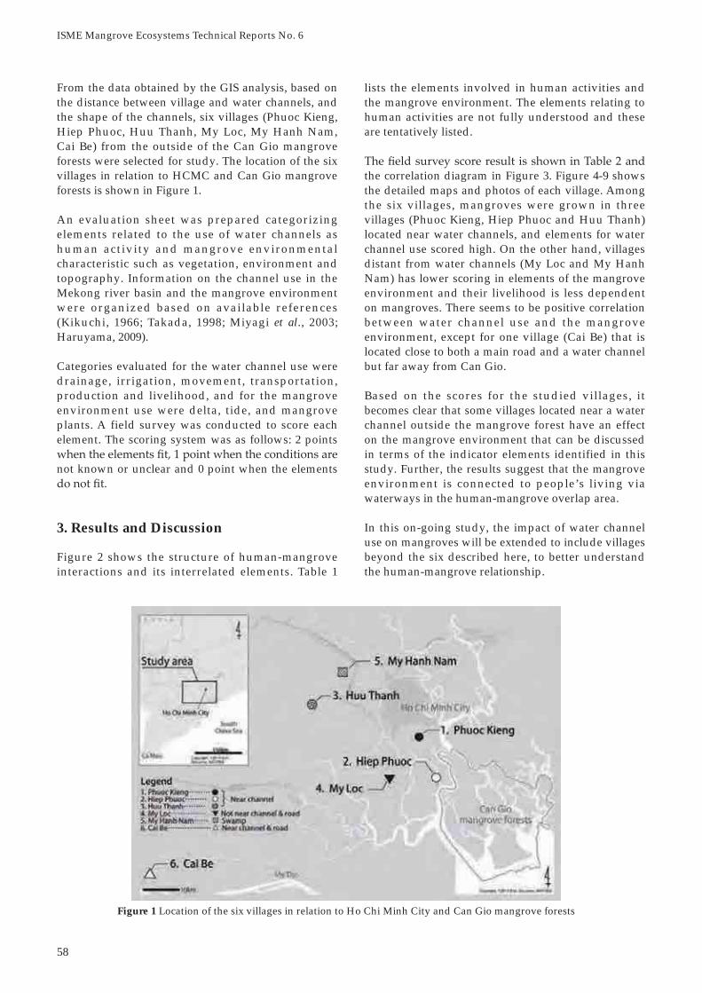
Can Gio, a suburban district of Ho Chi Minh City (HCMC), covers an area of ~72,000 ha (Figure 1). It is the poorest district of the city with a population of ~71,000. The district has a vast tract of deltaic mangroves with a network of rivers and channels. The main waterways lead to the port of HCMC.
forested vegetation of Can Gio (formerly Rung Sat) with herbicides to remove enemy cover (Ross, 1975). As a result, 57% of mangrove forests in the district were destroyed (Figure 2). Dispensed by C-123 planes and UH-1 helicopters, more than 2.5 million liters of Agent Orange (2,4-D and 2,4,5-T) were used for deforestation while 186,000 liters of Agent Blue (cacodylic acid) were targeted at food crops.
Figure 1 Location map of Can Gio
Figure 2 Can Gio mangroves before and after spraying of herbicides (Photo credit: Chicago Tribune)
Destruction, Restoration and Management of Can Gio Mangroves
Vien Ngoc Nam1 & Le Van Sinh2
1 Department of Forest Resources, Nong Lam University, Thu Duc, HCMC, Viet Nam2 Can Gio Mangrove Protection Forest Management Board, Can Gio, HCMC, Viet Nam

10
ISME Mangrove Ecosystems Technical Reports No. 6
and was designated a Mangrove Biosphere Reserve by UNESCO in 2000.
2. Economic Forest Management (from 1978–1991)
After the war, the landscape of Can Gio was barren with mangrove vegetation reduced to scattered scrubs and bushes of. Due to lacking of fuel wood and construction raw material, the mangrove forest was cut for local consumption. On 7 August 1978, an extensive reforestation program was undertaken by HCMC Forestry Department with the establishment of Duyen Hai Forestry Enterprise, a unit responsible for implementation of forest restoration. Mangrove propagules were bought from Nam Can, Dam Doi and Ngoc Hien districts of Ca Mau province (formerly Minh Hai), and transported by boat to Can Gio for planting.
The Can Gio mangrove forest was divided into 24 for-est compartments. Each compartment was managed by a Forest Brigade involving 140 forestry households. In
2.1 Management Objectives
The reforestation program in Can Gio, which started in 1978, was aimed at establishing mangrove plantations for sustained production of fuel wood, charcoal and poles. Major management objectives (Nam et al., 1993) were:
To conserve and protect the shore and riverbanks from erosion and damage by strong winds and waves in support of inland fisheries and agricultural productionTo protect and preserve available mangrove forests through maintaining and ensuring their role as a productive ecosystem, and as a breeding and feeding ground for marine and other wildlifeTo maximize the production of construction poles and roof thatches for the housing and other construction in HCMC and its suburban districtsTo provide livelihood and employment as well as to improve the living standard of the local people To preserve sufficient areas for research, recreation and training, and as seed sources for forest managementTo promote social forestry, through people’s participation in improved util ization and management of the forest by providing training
To regulate the use of waterways within the mangroves so that their navigation will not be impaired
(Figure 3). Among the mangrove species, Avicenniaspp. and Nypa fruticans showed some resilience by showing some ability to recover through natural regeneration.
Since 1978, a vast reforestation programme was undertaken by HCMC Forest Department to rehabilitate the mangroves, under the direction of HCMC People’s Committee. More than 20,000 ha of mangrove forest have been planted, mainly with Rhizophora apiculata. The objectives of the plantations were to meet the demand for fuel wood and construction materials of HCMC, as well as to re-establish conditions suitable for the development
aquaculture, research, education and ecotourism.
The reforestation effort brought vast ecological improvement to the mangrove environment and its associated biodiversity. The planted mangrove forests
pythons, wild boars, crocodiles and various birds. In 1991, Can Gio was declared an Environmental Protect ion Forest by the Council of Ministers. The district became one of the most beautiful and extensive sites of rehabilitated mangrove in the world,
Figure 3 Fruits of Phoenix paludosa (top) and fronds of Acrostichum aureum (bottom)

11
Destruction, Restoration and Management of Can Gio Mangroves
Other species planted included Ceriops tagal, Ceriops zippeliana, Intsia bijuga, Thespesia populnea, Rhizophora mucronata, Avicennia alba, Xylocarpus granatum,Kandelia obovata and Bruguiera sexangula. Photographs of some of the planted species are shown in Figure 4. These plantations provided fuel wood, poles, chip wood and other materials for construction in Can Gio and HCMC (Figure 5).
The plantation model of Eucalyptus spp. on raised beds failed because of saltwater intrusion and poor soil nutrition. Up to now, the Eucalyptus trees were cut and replaced with mangrove species that can grow on elevated sites. Sites infested with A. aureum were cut, burnt and planted with R. apiculata. In abandoned salt pans, the embankments were breached to allow flushing of tidal water and planted with C. tagal(Figure 6). In the interior and elevated area infested with P. paludosa, site treatment was carried out by
C. tagaland Lumnitzera racemosa. In open swampy wasteland covered with Paspalum vaginatum and Sesuvium portulacastrum, R. apiculata was also planted.
2.3 Silviculture Operations
After the herbicide spraying, R. mucronata disap-peared in Can Gio. To rehabilitate this species, 40 ha
2.2 Plantation Activities
Large tracts of degraded mangrove land in Can Gio were rehabilitated (Nam et al., 1993). In the south, R.apiculata was widely planted. In the north, Eucalyptusspp. were planted on raised beds with N. fruticanswithin canals and R. apiculata on bed slopes. The nipa palm was planted on riverbanks to prevent erosion and in paddy fields where the yield is low due to
R. apiculata, 715 ha of Eucalyptus spp. and 281 ha of N. fruticans were planted (Table 1).
Table 1
No. Species Area (ha)
1 Rhizophora apiculata 21,1002 Eucalyptus spp. 7153 Ceriops spp. 6384 Nypa fruticans 2815 Intsia bijuga 956 Thespesia populnea 957 Rhizophora mucronata 688 Avicennia alba 199 Xylocarpus granatum 19
10 Kandelia obovata 311 Bruguiera sexangula 1
Total 23,034
Figure 4 Propagules of Ceriops zippeliana (a), fruit head of Nypa fruticans (b), propagules of Ceriops tagal (c) and flowers of Lumnitzera racemosa (d)
a
c
b
d

12
ISME Mangrove Ecosystems Technical Reports No. 6
Department would conduct a forest inventory and mark the trees prior to Thinning 2.
Thinning 3 was carried out in plantations of 14–15 years. Yields were 20–25 stere/ha of wood with 3–10 cm dbh. The expected tree density after Thinning 3 was 2,500 trees/ha.
On 2 June 1999, the HCMC People’s Committee issued Decision No. 3172/QD-UB-CNN prohibiting forest thinning in Can Gio. Since then, the quality of the forest has deteriorated. Trees were growing slowly due to high tree density, insufficient light, and prevalence of pest problems such as termite and
3. Protected Forest Management (from 1991–2000)
On 29 May 1991, the Council of Ministers declared Can Gio mangrove forests as an Environmental Protection Forest (EPF) and thereby placing emphasis on the role of mangrove forests in coastline and riverbank stabilization, as breeding and nursery ground for marine fauna, and as habitats for wildlife. The declaration combined the protective roles of mangrove forests with organized production activities to improve living standards of the local people.
Management practices of the Can Gio EPF were as follows:
Newly accreted forests along the coast are to be managed as strict protection areasAlong the riverbanks, a green belt of mangrove
against erosion caused by waves, winds and shipsMangrove forests in the hinterland are to be managed by the Forest Department, Forest Ranger and District People’s Committee for aquaculture and forestry production.
were planted along riverbanks and in more elevated sites to serve as seed stands for future plantations. About 142 ha of R. apiculata were established as seed
-ed by boat from Ca Mau, about 300 km south of Can Gio. Since 1991, propagules were collected locally.
A rotation age of 20 years was proposed for fuel wood plantations (Chan, 1990). As Can Gio mangroves are no longer managed for economic purposes, the rotation has yet to be considered. From 1985–1999, forest thinning was carried out, yielding a total production of 337,060 stere of fuel wood and poles. Three thinning operations were enforced for the Rhizophora plantations (Nam et al., 1993).
Thinning 1 was carried out in plantations of 5–6 years by pruning the multiple stems (3–5 cm dbh) and leaving 1 or 2 main stems/tree depending on initial density. The yield was 10–14 stere/ha of wood and thinning intensity varied from 50–64%.
Thinning 2 was carried out in plantations of 9–10 years. Thinning intensity was 25–37% with a mean distance of 1.3–1.4 m. Yields were 15–22 stere/ha of wood with 6.5–8 cm dbh. To ensure proper thinning, the District Forest Ranger of HCMC Forest
Figure 5 Fuel wood (top) and construction poles (bottom) of Rhizophora apiculata
Figure 6 An abandoned salt pan planted with Ceriops tagal

13
Destruction, Restoration and Management of Can Gio Mangroves
In 1993, the State Forestry Enterprise was replaced by the EPF Management Board under the Department of Agriculture and Rural Development (DARD). In 2000, the EPF came under the jurisdiction of Can Gio District People’s Committee. Part of the mangrove forest was allocated to the Agricultural Enterprise and to households for management and protection. The number of forest owners was reduced from 24 to 12 units. To mobilize reforestation, forest owners can harvest and market products from forests which they planted. Consequently, they became the real owners, fulfilling their responsibility of forest maintenance and protection.
4. Biosphere Reserve Management (from 2001)
With the designation of Can Gio into a Mangrove Biosphere Reserve (MBR) in 2000, the management was transferred from DARD to Can Gio People’s
Forest Management Board (PFMB). Since then, growing forests flourished with richer biodiversity, and there was better environmental protection for HCMC and its suburbs.
4.1 Management of the MBR
Mangrove forests of the Can Gio MBR comprise 24 forest compartments. Each compartment (1,000–2,000 ha) is sub-divided into plots (100 ha) and subplots (1–10 ha). Currently, Can Gio PFMB has signed contracts with 141 households (10,825 ha) and 14 local units (15,153 ha) to protect a total area of 25,978 ha. A total of 14 forest compartments are directly managed by PFMB. The annual funding for the management and protection of Can Gio MBR is 25 billion Dong (USD 1.2 million), excluding inves tments in bui ld ing in f ras t ructure and technology, scientific research, and communication for the environmental protection.
4.2 Role to HCMC and Surrounding Areas
Can Gio is strategically located adjacent to HCMC and four provinces (Dong Nai, Ba Ria-Vung Tau, Tien Giang and Long An). The mangrove ecosystems of Can Gio play important roles in protecting the environment of HCMC and surrounding areas. They provide large amounts of oxygen, absorb and store CO2 (~80 t/ha/year), and contribute to the reduction of greenhouse gases. The Can Gio MBR is also the habitat for marine life aquatic species of economic value, and is the traditional fishing grounds of local residents and fishermen. The mangroves provide protection from coastal storms and erosion. This is also an ecosystem of particular interest for development of ecotourism, environmental education and extra-curricular learning for students in HCMC and adjacent areas.
References
Carroll, J.R. (2010). Agent Orange: An insidious and fatal danger. Available at: hmassydney.com/documents/Agent%20Orange.docx.
Chan, H.T. (1990). Proposed Establishment and Management of Mangrove Plantations in Duyen Hai District, South Viet Nam. Field Document No. 1, VIE/86/027/FAO/UNDP, 25 pp.
Nam, V.N., My, T.V. & Jensen, M. (1993). Mangrove for Production and Protection. A Changing Resource System: Case Study in Can Gio District, Southern Viet Nam. FieldDocument No. 43. GCP/RAS/131/NET. FAO, Bangkok, August 1993, 57 pp.
Ross, P. (1975). The mangrove of southern Vietnam:the impact of military use of herbicides. In: Proceedings of International Symposium on Biological and Management of Mangroves, Honolulu, Hawaii, 2, 695–707.


15
forming a broad tidal flat, which is now designated the Can Gio Forest Park. Figure 2 is an aerial photo of Can Gio at high tide. The topography of Can Gio can
were determined based on a tidal chart of the nearby
upper half of the tidal zone and in Can Gio, they grow
1. Introduction
was destroyed by the spraying of defoliants during
restored, and the area was designated as the Can Gio
Can Gio
successful examples of rehabilitation of damaged
Th
from the Can Gio experience can be applied in other countries worldwide. Information from our published
et al et al
with some new results are presented.
2. Overview of the Study Area
the main channel through a beach ridge in the south,
Figure 1
Figure 2
Further Study on the Mangrove Recovery Processes in Can Gio, Viet Nam
Further Study on the Mangrove Recovery Processes in Can Gio, Viet Nam
Toyohiko Miyagi1,2, Vien Ngoc Nam3, Le Van Sinh4, Mami Kainuma5, Ayako Saitoh6,Kazunori Hayashi7 & Moeko Otomo2
1
2
5

ISME Mangrove Ecosystems Technical Reports No. 6
There was a lighthouse and beacon at the mouth
and Saigon harbors played an important role in the transportation of people and goods.
aerial photographs for the first time. There was not much difference in the road network and the entire
Pictographic maps produced from aerial photographs
Viet Nam War reflected a fairly accurate status of
and the forests were extracted using the Adobe Photoshop software. Forest polygons were then generated using the auto polygon function of the ArcGIS software. The forest area during the onset of the Viet Nam War was estimated
map of Thanh An, fine
with logs transported out of the forest in boats using the tidal channels.
forests in Can Gio were largely destroyed due to
Avicennia spp. Ceriops spp. and Excoecaria agallocha
Phoenix paludosa Acrostichum aureumDerris trifoliata
After the Viet Nam War, a large-scale reforestation
3. Change in Mangrove Forest Distribution
3.1 Mangrove forest prior to defoliation
were kept pristine and no road construction was Figure 4
Figure 3

3.2 Mangrove forest after defoliation
Immediately after the aerial spraying of defoliants by
areas deforested by defoliation and the total forest
Figure 5
Thanh An is depicted in yellow.
Figure 6
Figure 7 Can Gio immediately after the defoliation spray.
a completely deforested site with dead tree stumps of Ceriops
Figure 8
Further Study on the Mangrove Recovery Processes in Can Gio, Viet Nam

ISME Mangrove Ecosystems Technical Reports No. 6
that, after the war, with the effort of the large-scale
We also used polygons to depict the forest area based areas, mainly in the central part of Can Gio, are shown
Figure 9
Figure 10 et al

of mainly Rhizophora apiculata was carried out
Cross-section data of species composition and
R. apiculataNypa fruticans,
Ceriops decandra and Avicennia officinalis used to grow. Then as sedimentation progressed towards the water channels, seedlings of A. officinalis
R. apiculata
expanding the total area. The same tendency was R. apiculata was
A. officinalis and A. alba used to grow. As the planted trees grew,
regenerated seedlings and expanding the area.
the west, and Can Thanh in the south. These areas,
natural regeneration of the existing forest.
3.3 The role of natural regeneration
Figure 12
-20
-10
0
10
20
30
40
1966 1973 1974 1989 1994 2002 2005
Are
a (1
,000
ha)
Year
Loss area between the two periodsPlanted areaEstimated naturally regenerated areaExisting mangrove area
Figure 13
Figure 11
Further Study on the Mangrove Recovery Processes in Can Gio, Viet Nam

ISME Mangrove Ecosystems Technical Reports No. 6
Figure 15
Figure 14 Figure 14
1
Loss
2
ExpansionA B
1
Loss
2
Expansion

21
4.1 Mangrove forest in the Forest Park
others, A. alba and S. alba used to be the dominant species with R. apiculata, Ceriops spp. and Phoenix paludosa occupying the more landward sites.
The Forest Park was deforested by defoliation during the Viet Nam War and after the war, an
R. apiculata was R.
mucronata and C. tagal R.apiculata dominated the forest at the center on higher
A. alba rapidly
From these results, we speculate that the root system of the planted trees slows down water flow of the
habitats suitable for the establishment of R. apiculataA. alba, A.
and C. decandra to establish through natural regeneration, leading to expansion of the forest.
To summarize, reforestation is important especially when the land is destroyed but once the plantations established, they are capable of expanding through
many countries.
4. Forest Structure Analysis
To understand the transi t ion process or the
spraying of defoliants, we established two study sites,
Figure 16et al
Further Study on the Mangrove Recovery Processes in Can Gio, Viet Nam
22
ISME Mangrove Ecosystems Technical Reports No. 6
A. alba
and R. apiculata mixed type. R. apiculata was dominant C.
decandra
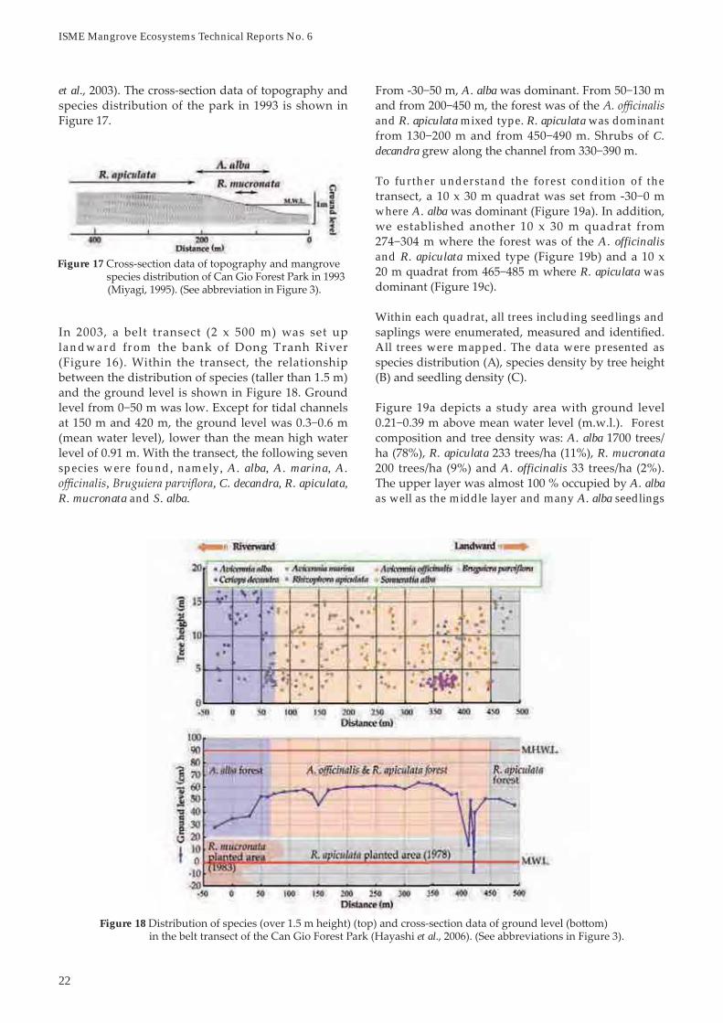
To further understand the forest condition of the
where A. alba
A. officinalisand R. apiculata
R. apiculata was
Within each quadrat, all trees including seedlings and
All trees were mapped. The data were presented as
Forest A. alba
R. apiculata R. mucronataA. officinalis
A. albaas well as the middle layer and many A. alba seedlings
et al
landward from
species were found, namely, A. alba, A. marina, A. , , C. decandra, R. apiculata,
R. mucronata and S. alba.
Figure 18et al
Figure 17

Figure 19b and R. apiculata et al
Figure 19c R. apiculata et al
Figure 19a A. alba et al.
Further Study on the Mangrove Recovery Processes in Can Gio, Viet Nam

ISME Mangrove Ecosystems Technical Reports No. 6
generally occurs when soil in bare land is oxidized. From these results, we could speculate that erosion
m in which A. alba
From the aspects of phytosociology, topography,
typical deltaic formation seen in Southeast Asia.
Can Gio were destroyed with serious soil erosion and land desiccation. In some parts, gray or
which generally occurs when soils in barren land become oxidized.
R. apiculataarea has gradually expanded through natural
establishment of A. alba.
were identified at the forest floor. The distribution of A. alba
R. mucronata did not establish,
et al
defoliation, the site was planted with R. apiculataand later with C. decandra. Forest composition and
R. apiculata C. decandra
the shrub layer, indicating that although R. apiculatawas originally planted, the site conditions were more suitable for .
planted with R. apiculataR. apiculata
and A. officinalis R. apiculata became well established with tree heights
gray clay. Further inland, the surface soil contained
Figure 20et al

25
part of the transect.
Soil core samples were collected from four locations,
indicating recent sediments accumulated within the
Phoenix paludosathe uppermost surface had a strong reddish color.
The distribution of each species was further plotted
for growth. For example, Lumnitzera racemosa and P. paludosa
R. apiculata and C. decandra grow at the
withand A. alba
4.2 Mangrove forest at the MEET Center
with mud lobster mounds were higher than highest
Figure 21et al
Figure 22 Geological and geomorphological cross-section data and forest landscape in the belt transect et al
Further Study on the Mangrove Recovery Processes in Can Gio, Viet Nam

ISME Mangrove Ecosystems Technical Reports No. 6
mostly closed but the A. alba dominant forest near R. apiculata
dominant forest.
To understand the relationship between micro-topography and forest distribution, a 5-m wide belt
A. alba.
4.3 Resurvey of the MEET Center
based the position of remaining tags. The R. apiculata
Figure 23et al
Figure 24 The R. apiculata

Figure 25 A. alba a R. apiculata Avicennia
Figure 26
Figure 27
Further Study on the Mangrove Recovery Processes in Can Gio, Viet Nam

ISME Mangrove Ecosystems Technical Reports No. 6
The results showed that A. officinalis and A. alba
R. apiculata does not grow.
5. Importance of Canopy Formation
soil erosion, we set up rain gauges and sediment traps inside a R. apiculata forest and inside a lighting gap at
segments and the tree age was categorized as
Along the transect, R. apiculata seedlings were
of A. alba and A. alba grew at lower
m. Saplings of C. decandra
Figure 28 Numbers of seedlings, saplings and mature trees within 25 m2
R. apiculata A. alba X moluccensis X. granatum, S. alba C. decandra L. racemosa
Figure 29

6. Conclusion and Recommendations
by spraying of defoliants during the Viet Nam War.
Chosen as the primary species for reforestation, R. apiculata grew well when planted in sites with proper topography. When a Rhizophora forest was established, sedimentation was promoted in the
These accreting banks facilitated the colonization of A. alba and A. officinalis, which gradually led to a
A. alba and A. officinalis
For plantations of R. apiculata, only areas with suitable
natural regeneration. When planning a reforestation or afforestation program, we need to consider the
The relationship between rainfall intensity and
2 in the exposed lightning gap. When
can be easily eroded where there is no canopy
sediment erosion following defoliation of Can Gio
Figure 30 The relationship between rainfall intensity and sediment accumulation in the sediment trap Figure 31
Can Gio from forest degradation by defoliants
Table 1
Starting Precipitation Intensitiytime
1 11.22
5
11511
11
Further Study on the Mangrove Recovery Processes in Can Gio, Viet Nam

ISME Mangrove Ecosystems Technical Reports No. 6
Geo-ecological rehabilitation process of the intensive damaged mangrove forest in Can Gio District, Viet Nam.
ecosystems in Viet Nam. A case study of Can Gio Restoration of Mangrove
Ecosystems
Mangrove of Viet Nam.
The Tohoku Gakuin University Review, History and Geography,
Mangrove Habitat Dynamics and Human Relat ion . Nihon
Natural/semi-natural mangrove geo-ecosystem establish by plantation in Can Gio district, Ho Chi Minh City, Viet Nam
Geo-ecological Study of the Processes of Mangrove Ecosystem Destruction and the Recover in Can Gio District, Viet Nam
lost. In many cases, Rhizophora is chosen due to the ease of propagule collection and planting techniques.
Rhizophora species.
Rhizophora plantation.
oxidation would become a problem and render these
efforts. There is much to be learned from the
the world. We sincerely extend our tribute to those
reforestation.
Acknowledgments
References
Bio-geomorphological Study of the Changes of Mangrove Environment by Severe External Destruction Impacts.

31
2. Study Sites
Gio MBR
3. Methods of Study
scale
1. Introduction
et al
Figure 1
Map and satellite image
Figure 2
Erosion and Accretion in Can Gio Mangroves (1953 to 2010)
Erosion and Accretion in Can Gio Mangroves (1953 to 2010)
Vien Ngoc Nam1 & Le Quoc Tri2
1

ISME Mangrove Ecosystems Technical Reports No. 6
4.3 Site 3 (Ly Nhon)
4.4 Site 4 (Long Hoa)
4. Results and Discussion
4.1 Site 1 (An Thoi Dong)
Avicennia alba
4.2 Site 2 (Ly Nhon)
Table 2
Erosion
Figure 4 seedlings
Figure 3 Avicennia alba in accretion area
Table 1
Zone 1Erosion
Con BaErosion

33
4.7 Site 7 (Can Thanh)
4.8 Site 8 (Can Thanh)
4.9 Site 9 (Thanh An)
Being
A. alba
4.5 Site 5 (Long Hoa)
4.6 Site 6 (Long Hoa)
Table 4
Erosion
Figure 6 Avicennia alba trees Figure 5
Table 3
Erosion
Erosion and Accretion in Can Gio Mangroves (1953 to 2010)

ISME Mangrove Ecosystems Technical Reports No. 6
4.10 Site 10 (Thanh An)
Table 7
Erosion
Erosion
Table 6
Figure 8 Figure 7 arrest coastal erosion
Figure 10
Erosion
Table 8
Figure 9 control
Erosion
Table 5

References
Coastline Changes A Global Review
Dong Tranh estuary, Can Gio mangrove forest, Ho Chi Minh City, Southern Vietnam
Manual on Guidelines for Rehabilitation of Coastal Forests Damaged by Natural
Monograph on Natural Landscape and Ecological Characteristics of Human in Can Gio Natural Reserve
5. Conclusion
Erosion
Table 9
Figure 11 Figure 12 control
Erosion
Table 10
Erosion and Accretion in Can Gio Mangroves (1953 to 2010)


37
the ground as markers to monitor the rate of bank erosion along the banks of studied rivers. The distance between stakes was 100 m along the riverbank and at each location, two stakes were piled (Figure 2).
m from the riverbank. The total length of the four studied rivers was 78 km with 780 numbered stakes.Using GPS to determine coordinates, the positions of the stakes along the riverbanks were recorded. Monitoring was done annually with missing stakes replaced and their positions recorded.
1. Introduction
Four major rivers and their tributaries traverse the Can Gio mangroves before draining into the East Sea. They are Soai Rap, Dong Tranh, Nga Bay and Thi Vai (Figure 1). Together they cover an area of 22,160 ha or ~20% of the Can Gio district. These large rivers together with small ones such as Long Tau are the main shipping lanes, enabling cargo tankers and ships of up to 20,000 tonnes carrying capacity to enter into the port of Ho Chi Minh City (HCMC) (Luong, 2011).
of HCMC has identified 36 areas with high risk of erosion (SCFS, 2010). They included the districts of Binh Thanh, Nha Be and Can Gio. In Can Gio district, vulnerable areas are the riverbanks of Nha Be, Nga Bay, Long Tau and Soai Rap. Passing tankers and ships create water disturbance in the form of primary and secondary waves (also known as wash). These waves would scour the riverbanks causing erosion in the form of bank collapse and toppling of mangrove trees.
In addition to riverbank erosion, coastal areas bordering the East Sea are subjected to severe coastal erosion. With climate change such as sea-level rise and extreme weather conditions such as coastal storms and typhoons, the problem of coastal erosion would be further aggravated.
Erosion in Can Gio mangroves is more extensive than accretion. The problem of riverbank and coastal erosion needs to be addressed as it leads to loss of land and human property. This study on the monitoring of riverbank erosion in Can Gio is aimed at providing information on the severity of erosion along the banks of selected rivers, which will be made available to decision makers, planners and resource managers.
2. Materials and Methods
Satellite imageries and maps from previous years of Can Gio were collected for data analysis. The rivers studied were Dua, Nga Bay, Long Tau and Tac Roi
Figure 1 Major rivers of Can Gio mangroves and rivers where riverbank erosion was monitored Estuaries of major rivers (a: Soai Rap, b: Dong Tranh, c: Nga Bay and d: Thi Vai) Study sites(1: Dua, 2: Nga Bay, 3: Long Tau and 4: Tac Roi)
Monitoring Riverbank Erosion in Can Gio Mangroves
Monitoring Riverbank Erosion in Can Gio Mangroves
Huynh Duc Hoan, Bui Nguyen The Kiet, Cao Huy Binh & Pham Van Quy
Can Gio Mangrove Protection Forest Management Board, Can Gio, HCMC, Viet Nam

38
ISME Mangrove Ecosystems Technical Reports No. 6
The following procedures described by Minh et al.(2002) and Hirose et al. (2004) were used to interpret satellite images of mangrove vegetation. Satellite images of Landsat MSS 1972 (http://glcf.umiacs.umd.edu) and Spot Image 2006 (http://imar.usf.edu) were interpreted using the ENVI 4.0 program (Fig ure 3). Usi ng t he MapI n fo prog ra m, t he coordinates of rivers and plots in the studied sites were digitized. The average rate of erosion between two periods was calculated using the following formulae:
Average rate of erosion (E) = Wr/(time interval from
Wr: average width eroded away on both sides of the river SR1: area of the river in 1972SR2: area of the river in 2006Lr: length of river
3. Results and Discussion
A total of 780 bamboo stakes were piled along the riverbanks in 17 locations (including two communes of An Hua and An Phouc) of 12 forest compartments
Along the eroding riverbanks, 10 x 10 m plots were set up in four different habitat types. They were mixed natural forests, Rhizophora plantations, Nypa forests and bare land. In each habitat type, three plots were established, and enumerations and measurements were made every three months for two years.
The data were processed using GPS to determine the coordinates of the plots and stakes, which were transferred onto digital maps via MapSource Version 5.7 program and MapInfo 7.5.
Figure 2 Positions of bamboo stakes piled along the riverbank to monitor erosion
Figure 3 Landsat MSS 1972 (left) and Spot Image 2006 (right) analysed using the ENVI 4.0 program

39
Results showed that Long Tau (1.73 ± 0.47 m/yr) and Nga Bay (1.87 ± 0.40 m/yr) experienced higher rates of erosion than Dua (1.43 ± 0.36 m/yr) and Tac Roi (1.44 ± 0.36 m/yr). However, the differences in erosion rates were not significantly different at 95% confidence level between rivers (Table 2). This implied that larger rivers used by tankers and ships had comparable erosion rates as smaller rivers used
where the erosion rate of FC7 (2.32 ± 0.27 m/yr) was
Data showed that the erosion rates of plots with forests were less severe than plots located on bare land (Table 3). Examples of erosion of riverbanks with and without vegetation are shown in Figure 5.
The data on erosion rates obtained from the bamboo stakes from December 1970 to November 2009 were compared between habitat types (plantations, natural forests and bare land), and between the rainy season of May to November and the dry season of December to April (Table 4).
Between habitat types, the rate of erosion was 1.6 m/yr for plantations and natural forests compared to 1.8 m/yr for bare land. This finding was consistent with the results obtained from the vegetation plots.
Between seasons, the erosion rate during the rainy season (1.00 ± 0.02 m/yr) was significantly higher
(Table 1). Long Tau and Nga Bay rivers had the most number of stakes as they are two major waterways used by cargo tankers and ships to reach the port of HCMC (Figure 4). Dua and Tac Roi rivers are smaller rivers used mainly by passenger speedboats commuting between Vung Tau and HCMC.
Forest Rivers TotalCompartment Dua Long Tau Nga Bay Tac Roi
3 62 4 667 44 4411 11 1112 41 4113 8 85 9318 38 3819 55 5524 63 6310a 36 364a 75 754b 24 245a 18 185b 29 296a 41 416b 39 49 88
An Hoa 35 35An Phuoc 23 23
Total 125 371 226 58 780
Table 1 Number and location of bamboo stakes along the studied riverbanks
Table 2 Erosion rates of riverbanks
Location Rate of erosion (m/yr) Dua Long Tau Nga Bay Tac Roi
FC3 1.42 ± 0.35 1.51 ± 0.26FC7 2.32 ± 0.37FC11 2.16 ± 0.51FC12 1.88 ± 0.42FC13 2.01 ± 0.40 1.72 ± 0.28FC18 1.73 ± 0.32FC19 2.06 ± 0.37FC24 1.84 ± 0.42FC10a 1.95 ± 0.38FC4a 1.44 ± 0.37FC4b 1.35 ± 0.26FC5a 1.88 ± 0.31FC5b 1.58 ± 0.57FC6a 1.58 ± 0.48FC6b 1.52 ± 0.42 1.73 ± 0.44An Hoa 1.36 ± 0.33An Phuoc 1.53 ± 0.39
Erosion 1.43 ± 0.36a 1.73 ± 0.47a 1.87 ± 0.40a 1.44 ± 0.36a
Figure 4 Cargo ships (top) and passenger speedboat
Monitoring Riverbank Erosion in Can Gio Mangroves

40
ISME Mangrove Ecosystems Technical Reports No. 6
than during the dry erosion (0.71 ± 0.02 m/yr) at the 95% confidence level. The greater rate of erosion
which loosens the soil particles making them more vulnerable to erosion by waves. A comparison was also made between both banks of the rivers (Table 5). Overall, there was no significant difference between the right bank (1.69 ± 0.38 m/yr) and the left bank (1.60 ± 0.36 m/yr).
4. Conclusion
The average erosion of the four rivers studied was 1.7 m/yr. This would imply that Can Gio mangrove forests are losing ~133,500 m2/yr of land to erosion. The presence of trees along the rivers has a positive effect in limiting riverbank erosion as forested areas tend to erode at lower rates than bare soils. There is greater erosion during the rainy season than during the dry season. The effects of waves generated by cargo tankers and ships, and passenger boats warrant further investigations.
Table 4 Level of erosion in the forest types
Habitat type Dec 07 May 08 Dec 08 May 09 Erosion - Apr 08 - Nov 08 - Apr 09 - Nov 09 (m/yr)
I. Plantations- R. apiculata 0.3 1.3 0.8 1.0 1.7 - Eucalyptus 0.3 0.7 0.4 1.0 1.2 - R. mucronata 0.1 1.5 0.9 0.8 1.7 - Acacia 0.0 1.7 0.7 1.2 1.8
II. Natural forests - Rhizophora 0.4 1.4 0.8 1.3 2.0 - Sonneratia 0.2 1.0 0.7 0.7 1.3 - Shrub 0.1 1.5 0.7 1.3 1.8 - Phoenix 0.0 0.9 0.3 1.4 1.3 - Ceriops 0.3 1.2 0.9 1.1 1.7 - Avicennia 0.2 0.7 0.8 0.7 1.2 - Excoecaria 0.4 1.0 0.7 1.3 1.7 - Nypa 0.1 1.2 0.6 1.3 1.6 - Mixed forest 0.2 1.3 0.7 1.2 1.7
III. Bare land - Rhizophora 0.3 0.5 0.7 1.4 1.5 - Avicennia 0.2 0.9 1.3 1.2 1.8 - Xylocarpus 0.0 1.2 0.6 0.7 1.3 - Nypa 0.2 1.5 0.8 1.1 1.7 - Eucalyptus 0.3 1.9 0.2 2.4 2.4 - Phoenix 0.2 0.5 0.0 1.4 1.1 - Mixed 0.4 1.2 0.7 1.3 1.8Figure 5 Erosion of riverbanks without vegetation (top)
and with vegetation
Table 5 Erosion on the right and left banks of the rivers
-
River Right bank Left bank Location Erosion(m/yr) Location Erosion(m/yr)
Dua 3 1.42 ± 0.35 4b 1.35 ± 0.276b 1.52 ± 0.44
Long Tau 4a 1.44 ± 0.37 10a 1.95 ± 0.386a 1.58 ± 0.48 5a 1.88 ± 0.3124 1.85 ± 0.42 5b 1.58 ± 0.57
11 2.16 ± 0.5112 1.89 ± 0.42
Nga Bay 7 2.32 ± 0.37 13 1.74 ± 0.3019 2.06 ± 0.37 18 1.73 ± 0.32
Tac Roi An Phuoc 1.53 ± 0.39 An Hoa 1.36 ± 0.33
Average 1.69 ± 0.38a 1.60 ± 0.36a
Table 3
B: Bare land, NP: Nypa palm, MF: Man-made forest andNF: Natural forest
Plot Habitat Dominant N/ha D1.3 Htotal Erosion type vegetation (cm) (m) (m/yr)
B1 Bareland
Grasses 1.3B2 2.6B3 1.7
NP1 Nypaforest
Nypa 1.7NP2 1.3NP3 1.3
MF1 Man-madeforest
Rhizophora 3,300 6.0 5.5 1.2MF2 2,100 7.0 7.5 1.3MF3 2,500 14.0 13.0 1.8
NF1 Naturalforest
Avicennia 1,900 0.3 1.0 2.2NF2 Ceriops 6,000 3.5 5.5 1.6NF3 Avicennia 2,500 6.2 13.0 1.8

41
Minh City, VietnamSmall Grants Foundation, 40 pp.
Minh, N.T. (2002). Application of a Combination of Remote Sensing - GIS and Geological Methods of Assessing
Chi Minh City. Undergraduate Thesis, University of Technology, Ho Chi Minh City, 83 pp.
SCFS (2010). Document No. 79/PCLB-TP of the Steering Committee for Flood and Storm on the warning of riverbanks, canals, sea, and implement measures to prevent, combat and response. 24 March 2010, Ho Chi Minh City.
References
Hirose, K., Syoji, M., Hang, H.T.M., Anh, N.H., Triet, T. & Nam, V.N. (2004). Satellite data application for mangrove management. In: Proceedings of the International Symposium on Geoinfomatics for Spatial
.
Luong, N.V. (2011). Mangrove Forest Structure and Coverage Change Analysis Using Remote Sensing and Geographical Information System Technology: A Case
Monitoring Riverbank Erosion in Can Gio Mangroves


43
2. Materials and Methods
1. Introduction
Rhizophora apiculata
Figure 1Figure 2
Monitoring Natural Regeneration in a Dead Rhizophora apiculata Site in Can Gio Mangroves
Monitoring Natural Regeneration in a Dead Rhizophora apiculataSite in Can Gio Mangroves
Cao Huy Binh, Huynh Duc Hoan, Phan Van Trung, Bui Nguyen The Kiet & Pham Van Quy

44
ISME Mangrove Ecosystems Technical Reports No. 6
3. Results and Discussion
-
Figure 3 Figure 4
Figure 5

L. racemosa A. marina
m for L. racemosa A. marina
C.tagal E. agallocha
Lumnitzera racemosa Ceriops tagal Avicennia marina
L. racemosaC. tagal
A. marinaExcoecaria agallocha
Am Lr Ct Ea3 0
2 0 0 03 0 0 04 0 0 7
0 0 22 0 220 0
7 0 0 240 0
0 0
32
Am: Avicennia marina Lr:Ct: Ceriops tagal Ea: Excoecaria agaloocha
Table 1
Figure 6
a
Figure 7 Excoecaria agallochaCeriops
tagal Avicennia marina
Monitoring Natural Regeneration in a Dead Rhizophora apiculata Site in Can Gio Mangroves

ISME Mangrove Ecosystems Technical Reports No. 6
5. Conclusion
R. apiculata
A. marina L. racemosa
A. marina
A. marina
A. marinaL. racemosa
C. tagalE. agallocha
70
Table 2 Rhizophora apiculata
2007
LrAmCt 32Ea
Lr: Lumnitzera racemosa Am: Avicennia marina Ct: Ceriops tagal Ea: Excoecaria agaloocha
Table 3
Figure 8Avicennia marina
2007L. racemosa 3C. tagal 3 7 0A. marina
2 L. racemosa 34A. marina 0 4 4
3 E. agallocha 2A. marina 0
4 L. racemosaE. agallocha 2 2 0A. marina 0L. racemosa 2 3C. tagalA. marina 0L. racemosa 34C. tagal 0A. marina 0 7
7 L. racemosa 4 7A. marinaA. marinaC. tagal 2L. racemosa 0C. tagal 0 0A. marina 0 7 27
Table 4
L A Avicennia C Ceriops E Excoecaria

47
Analysis of variance (ANOVA) between age classes and between treatments was conducted at
P < 0.05.
3. Results and Discussion
3.1 Before Thinning
An example of a R. apiculata forest in Can Gio before
1. Introduction
Rhizophora apiculata(Nam et alan important role in providing useful products (e.g. fuel wood and construction poles), and services (e.g. coastal protection and carbon sequestration). Since
absorption capacity of R. apiculata plantations in Can Gio based
managers, planners and policy makers in making
2. Materials and Methods
top)
carbon dioxide (CO ) and carbon (C) was calculated.CO , CO
Figure 2 Rhizophora apiculata
Figure 1
2 Rhizophora apiculata
Effects of Thinning on CO2 Absorption Capacity of Rhizophora apiculata Plantations in Can Gio Mangroves
Pham Van Quy1 & Vien Ngoc Nam2

ISME Mangrove Ecosystems Technical Reports No. 6
a. Between age classes absorption of age class
absorption of age class III
b. Between treatments absorption and carbon accumulation
CO
/
CO
CO
m
CO
m
3.2 Two Years After Thinning
An example of a R. apiculata forest in Can Gio two
No. Age classCO Carbon
a
a
b
4 b
Table 1 Rate of CO absorption and carbon accumulation between age classes
Figure 3 Rhizophora apiculata trees

49
R. apiculata plantations at an intensity of
absorption and carbon accumulation.
References
25 years of Mangrove Rehabilitation in Can Gio District, Ho Chi Minh City, Vietnam. Annual Report
some
Workshopon Techniques of Payment from Forest Environment Service
sustainable forest management.
4. Conclusion
No.CO Carbon
7.4b
b
9.7a
4 Control a
Table 2 Rate of CO absorption and carbon accumulation between treatments
2 Rhizophora apiculata


51
mangroves as an Environmental Protection Forest in 1991 and as a Mangrove Biosphere Reserve (MBR) in 2000, there is greater focus on the environmental services of mangrove forests.
The mangrove ecosystems of Can Gio play important roles in protecting the environment of HCMC and surrounding areas. The trees provide large amounts of oxygen, absorb and store CO2, and contribute to the reduction of greenhouse gases. The reserve is also the habitat for marine life of economic value, and is
fishermen. The mangroves provide protection from coastal storms and erosion. This is also an ecosystem of particular interest for development of ecotourism, environmental education and extra-curricular learning for students in HCMC and adjacent areas.
data and information on carbon accumulation and CO2
absorption capacity of C. zippeliana plantations in Can Gio as a basis for payment of environment services, which contribute to the socio-economic development, and environmental protection of the district.
2. Materials and Methods
2.1 Study Sites
A total of 35 (10 x 10 m) plots were established in forest compartments 6, 10, 11, 12, 13, 17 and 21 of Can Gio MBR. The location of the plots is shown in Figure 2.
2.2 Field Measurements
In each plot, all trees were enumerated, and their bole diameter at 1.3 m (D1.3) and total height (Htotal)measured (Figure 3). To develop the allometric equations, 35 trees representing the full range of diameter classes from minimum to maximum were felled. Stems, branches and leaves were sampled to obtain their fresh weight. The felled trees were then divided into 1 m lengths to determine D1 (first position of the tree), D2 (second position), until Dn (n position) to calculate their volume. Wood (1 kg) and leaves (1 kg) were dried in the laboratory at 105oC and 80oC, respectively, to obtain their carbon content.
1. Introduction
After the Second Indochina War, large tracts of degraded land in Can Gio, a suburban district of Ho Chi Minh City (HCMC), Viet Nam, have been reforested with mangroves (Nam et al., 1993). From
Rhizophora apiculata, 715 ha of Eucalyptus spp., 638 ha of Ceriops spp. and 281 ha of Nypa fruticans were planted. Other species planted included Intsia bijuga, Thespesia populnea, Rhizophora mucronata, Avicennia alba, Xylocarpus granatum,Kandelia obovata and Bruguiera sexangula.
Two species of Ceriops were planted. They were Ceriops tagal and Ceriops zippeliana . Formerly recognized as Ceriops decandra, C. zippeliana is native to Australia, Cambodia, Indonesia, Malaysia, Papua New Guinea, Philippines, Singapore, Thailand and Viet Nam (Duke et al., 2010). The species is a tree 12 m tall (Sheue et al., 2010). Bark is brownish with some
and oval with a rounded tip (Figure 1). Flowers are small and white. Propagules are long and pointed with fluted ridges along the length and a red collar when mature. They point upwards in all directions, unlike those of Ceriops tagal, which hang downwards.
Prior to 1991, these plantations provided fuel wood, poles, chip wood and other construction materials for Can Gio and HCMC. With the declaration of Can Gio
Figure 1 Ceriops zippeliana with oval leaves and propagules pointing in all directions
Carbon Sequestration of Ceriops zippeliana in Can Gio Mangroves
Carbon Sequestration of Ceriops zippeliana in Can Gio Mangroves
Cao Huy Binh1 & Vien Ngoc Nam2
1 Can Gio Mangrove Protection Forest Management Board, Can Gio, HCMC, Viet Nam2

52
ISME Mangrove Ecosystems Technical Reports No. 6
3. Results and Discussions
3.1 Correlation between Fresh Biomass and D1.3
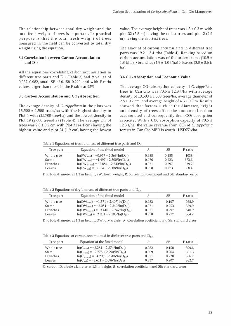
All the equations correlating fresh biomass of different tree parts and D1.3 (Table 1) had high correlation coefficients with R of 0.958–0.985, small standard errors (SE) of 0.185–0.297, and F-ratio values higher than those in the F-table at 95% confidence level.
3.2 Correlation between Dry Biomass and D1.3
All the equations correlating fresh biomass of 1.3 (Table 2) had R values of
0.958–0.983, small SE of 0.197–0.297, and with F-ratio values larger than those in the F table at 95%.
3.3 Correlation between Dry and Fresh Biomass
The following equation correlating dry and fresh biomass was used:
ln(DWtotal total)R = 0.999; SE = 0.030
2.3 Data Analysis
Carbon accumulation was calculated by multiplying
accumulation, the absorption of CO2 was calculated as CO2
t of carbon is equal to 3.67 t of CO2 (Que et al., 2006; Duke et al., 2013).
Figure 2 Biosphere Reserve
Figure 3 Measuring total height of a felled tree (left) and sampling leaves for fresh weight (right)
53
plot 32 (5.8 m) having the tallest trees and plot 2 (2.9 m) having the shortest trees.
The amount of carbon accumulated in different tree
ha).
3.6 CO2 Absorption and Economic Value
The average CO2 absorption capacity of C. zippeliana
showed that factors such as the diameter, height and density of trees affect the amount of carbon accumulated and consequently their CO2 absorption capacity. With a CO2
2 of C. zippeliana
The relationship between total dry weight and the total fresh weight of trees is important. Its practical purpose is that the total fresh weight of trees measured in the field can be converted to total dry weight using the equation.
3.4 Correlation between Carbon Accumulation and D1.3
All the equations correlating carbon accumulation in 1.3 (Table 3) had R values of
0.957–0.982, small SE of 0.158–0.220, and with F-ratio values larger than those in the F table at 95%.
3.5 Carbon Accumulation and CO2 Absorption
The average density of C. zippeliana in the plots was
1.3 of
Tree part R SE F-ratio
Whole tree ln(FWtotal) = 1.3) 0.985 0.185 1038Stems ln(FWstem) = 1.3) 0.976 0.223 673.6Branches ln(FWbranch) = 1.3) 0.971 0.297 539.2
ln(FWleaf) = 1.3) 0.958 0.273
D1.3: bole diameter at 1.3 m height, FW: fresh weight, R
Table 1 1.3
D1.3: bole diameter at 1.3 m height, DW: dry weight, R
Table 2 1.3
Tree part R SE F-ratio
Whole tree ln(DWtotal) = 1.3) 0.983 0.197 938.9Stems ln(DWstem) = 1.3) 0.971 0.253 539.9Branches ln(DWbranch) = 1.3) 0.971 0.297
ln(DWleaf) = 1.3) 0.958 0.277
Tree part R SE F-ratio
Whole tree ln(Ctotal) = 1.3) 0.982 0.158 899.6Stem ln(Cstem) = 1.3) 0.969 501.3Branches ln(Cbranch) = 1.3) 0.971 0.220 536.7
ln(Cleaf) = 1.3) 0.957 0.207 362.7
C: carbon, D1.3: bole diameter at 1.3 m height, R
Table 3 1.3
Carbon Sequestration of Ceriops zippeliana in Can Gio Mangroves
ISME Mangrove Ecosystems Technical Reports No. 6
Ceriops zippelianaSpecies. Version 2013.2.
Duke, N., Mackenzie, J. & Wood, A. (2013). PreliminaryAssessment of Biomass and Carbon Content of Mangroves in Solomon Islands, Vanuatu, Fiji, Tonga and Samoa. A
Townsville, Australia.
Nam, V.N., My, T.V. & Jensen, M. (1993). Mangrove for Production and Protection. A Changing Resource System: Case Study in Can Gio District, Southern Viet Nam. Field
August 1993, 57 pp.
D.T., Tung, N.T. & Thang, N.V. (2006). The Possibility
4. Conclusion
The average density of C. zippeliana forest in Can Gio 1.3
carbon and sequester CO2. The capacity to absorb CO2
of C. zippeliana
References
Duke, N., Kathiresan, K., Salmo III, S.G., Fernando, E.S., Peras, J.R., Sukardjo, S. & Miyagi, T. (2010).
Plot D1.3 Htotal Cstem Cbranch Cleaf Ctotal Total CO2number (cm) (m)
1 7,800 2.1 3.7 2.9 1.1 1.2 5.2 19.12 8,200 2.2 2.9 3.8 1.5 1.5 6.8 25.13 13,100 2.3 3.2 6.0 10.8 39.5
25,700 2.9 5.1 19.9 8.7 7.5 36.2 133.05 2.0 2.8 1.0 1.1 5.0 18.36 12,000 2.0 3.5 1.6 6.97 12,200 2.1 3.6 5.1 2.1 2.0 9.2 33.78 13,500 3.0 13.2 6.6 89.69 2.8 5.1 20.8 76.2
10 9,500 3.3 12.1 6.3 22.7 83.211 11,500 3.2 11.8 5.5 21.6 79.212 13,900 2.8 10.9 19.8 72.713 11,600 3.0 3.8 19.2 70.3
9,100 3.2 17.3 63.315 2.5 3.9 7.8 3.2 3.0 13.9 51.116 2.3 3.7 8.0 3.1 3.2 52.317 21,000 2.9 17.0 7.6 6.3 30.918 18,900 3.1 18.0 6.6 33.0 12119 2,600 3.8 3.9 2.0 7.3 26.720 12,000 2.6 3.9 8.1 3.5 3.1 53.721 12,100 3.1 11.0 5.0 20.1 73.822 2.3 3.8 9.2 3.7 3.6 16.5 60.523 2.3 3.7 6.1 10.9
15,700 1.9 3.3 1.6 1.8 8.025 10,500 2.5 3.8 6.2 2.7 11.326 10,200 12.2 6.2 22.727 16,600 2.8 5.1 13.0 5.8 23.7 86.828 13,500 3.5 5.2 15.7 7.3 5.8 28.8 10629 10,600 3.5 5.2 5.8 22.9 83.930 17,900 2.6 18.6 13.6 3.9 36.1 13331 15,000 5.7 25.3 12.7 9.1 17332 3.0 5.8 11.9 5.1 21.5 79.033 15,700 2.6 10.0 3.9 18.0 66.0
15,500 2.9 11.8 5.135 15,300 3.0 5.6 13.3 5.9 5.0 88.6
Average
Table 4 Carbon sequestration of Ceriops zippeliana in Can Gio

55
of CO2 Absorbed by Some Kind of Major Forest Plantation in Vietnam. Construction Criteria and Goals of Forest CDM, Research Center Ecology and Environment
Sheue, C.R., Rashid, S.M.A., Yong, J.W.H. & Yang, Y.P. (2010). Ceriops zippeliana Blume (Rhizophoraceae), a new record of a mangrove species in Singapore. Taiwania,
Carbon Sequestration of Ceriops zippeliana in Can Gio Mangroves


57
forests, which have direct and indirect impacts. This rare study captured the effects of socio-economic change on mangrove forests and their surrounding areas.
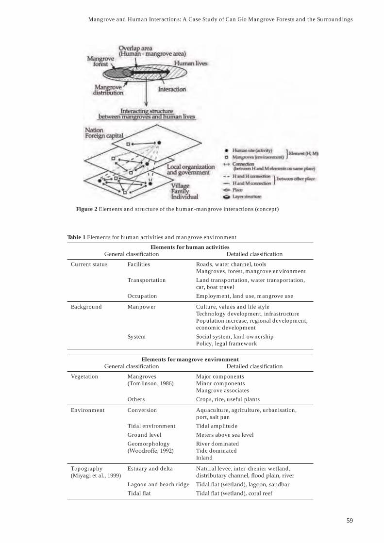
I hypothesize that mangroves and humans are mutually interacting at the zone of overlap that exists between marine, mangrove and terrestrial areas. Thus, a human-mangrove overlap area is set as one area (hereafter referred as the human-mangrove area) composed of organized elements. By identifying the interrelationship between the elements and their regional structure, I intend to understand the human-mangrove relationship in HCMC and its surrounding areas.
To understand the interaction between humans and
conducted around HCMC. Six villages outside of the mangrove forests were selected for study, and the use of water channels by villagers was surveyed and analyzed. The survey also focused on the Can Gio mangrove forests and their surrounding areas. In the study, the following two questions were addressed: 1) Do human activities, outside of mangrove forests, influence the mangrove environment? 2) What are suitable indicators to understand the human-mangrove connection? This paper reports the first outcome of the case study.
2. Materials and Methods
The relationship between the mangrove environment and the use of water channels was investigated in the human-mangrove overlap areas at the village level. Topographic maps (1:100,000) produced in 1967 by the US Military were used to locate water channels, main roads, villages and mangrove forests in the vicinity of HCMC and a GIS database was produced. For map production and analysis, the ESRI Japan
zones from the water channels and the main roads were created and villages were mapped by proximity analysis and classified into the following four types: i) near channel, ii) not near channel or road, iii) near channel and road, and iv) near road.
1. Introduction
Mangroves are plant communities distributed in the upper inter-tidal coastal zone of tropics and subtropics. Surrounding Ho Chi Minh City (HCMC) in southern Vietnam is the downstream basin of the Mekong, Saigon and Dong Nai rivers, and the low-lying ground spreads to the south of the city. Mangroves (~32,000 ha) occur in the Can Gio district, southeast of the city. The maximal tidal range of this area is approximately 4 m. Even where there is no forest, Rhizophora apiculata and Sonneratia caseolariscan be seen growing in ponds of the residential areas in the outskirts of the city. The palm (Nypa fruticans)grows gregariously along river waterways and channels used by residents.
Many mangrove areas have become secondary forests (Komiyama, 1992) that have long been used by local coastal residents. It is said that the relationship between coastal residents and mangroves is similar to that of the well-documented “Satoyama” relationship between the people and the rural environment in Japan (Miyagi et al., 2003).
In recent years, large areas of mangroves have been destroyed due to conversion for aquaculture ponds, urbanization, port construction and other development. Conversely, conservation measures and planting activities are being carried out in various places. Thus mangrove forests have been subjected to human-related pressures that vary in degree and type.
As the landscape and the role of Satoyama in Japan has changed, mangroves and their natural environment could also be altered by socio-economic development, development of infrastructures, and changes in people’s values and lifestyles. If so, in order to assess the human impact on mangroves, the study should cover not only areas where the mangrove forests exist but also extend to their surrounding areas where various human activities occur.
According to Ajiki and Miyagi (1992), the relationship between mangrove use and its destruction depends on human activities both inside and outside of the
Mangrove and Human Interactions: A Case Study of Can Gio Mangrove Forests and the Surroundings
Mangrove and Human Interactions: A Case Study of Can Gio Mangrove Forests and the Surroundings
Moeko Otomo
Division of Human Informatics, Graduate School, Tohoku Gakuin University, Sendai, Miyagi, Japan
58
ISME Mangrove Ecosystems Technical Reports No. 6
lists the elements involved in human activities and the mangrove environment. The elements relating to human activities are not fully understood and these are tentatively listed.
the correlation diagram in Figure 3. Figure 4-9 shows the detailed maps and photos of each village. Among the six villages, mangroves were grown in three villages (Phuoc Kieng, Hiep Phuoc and Huu Thanh) located near water channels, and elements for water channel use scored high. On the other hand, villages distant from water channels (My Loc and My Hanh Nam) has lower scoring in elements of the mangrove environment and their livelihood is less dependent on mangroves. There seems to be positive correlation between water channel use and the mangrove environment, except for one village (Cai Be) that is located close to both a main road and a water channel but far away from Can Gio.
Based on the scores for the studied villages, it becomes clear that some villages located near a water channel outside the mangrove forest have an effect on the mangrove environment that can be discussed in terms of the indicator elements identified in this study. Further, the results suggest that the mangrove environment is connected to people’s living via waterways in the human-mangrove overlap area.
In this on-going study, the impact of water channel use on mangroves will be extended to include villages beyond the six described here, to better understand the human-mangrove relationship.
From the data obtained by the GIS analysis, based on the distance between village and water channels, and the shape of the channels, six villages (Phuoc Kieng, Hiep Phuoc, Huu Thanh, My Loc, My Hanh Nam, Cai Be) from the outside of the Can Gio mangrove forests were selected for study. The location of the six villages in relation to HCMC and Can Gio mangrove forests is shown in Figure 1.
An evaluation sheet was prepared categorizing elements related to the use of water channels as human activity and mangrove environmental characteristic such as vegetation, environment and topography. Information on the channel use in the Mekong river basin and the mangrove environment were organized based on available references (Kikuchi, 1966; Takada, 1998; Miyagi et al., 2003; Haruyama, 2009).
Categories evaluated for the water channel use were drainage, irrigation, movement, transportation, production and livelihood, and for the mangrove environment use were delta, tide, and mangrove plants. A field survey was conducted to score each element. The scoring system was as follows: 2 points
not known or unclear and 0 point when the elements
3. Results and Discussion
Figure 2 shows the structure of human-mangrove interactions and its interrelated elements. Table 1
Figure 1 Location of the six villages in relation to Ho Chi Minh City and Can Gio mangrove forests
59
Elements for human activities
Current status Facilities Roads, water channel, toolsMangroves, forest, mangrove environment
Transportation Land transportation, water transportation,car, boat travel
Occupation Employment, land use, mangrove use
Background Manpower Culture, values and life styleTechnology development, infrastructurePopulation increase, regional development,economic development
System Social system, land ownershipPolicy, legal framework
Elements for mangrove environment
Vegetation Mangroves Major components(Tomlinson, 1986) Minor components
Mangrove associatesOthers Crops, rice, useful plants
Environment Conversion Aquaculture, agriculture, urbanisation,port, salt pan
Tidal environment Tidal amplitudeGround level Meters above sea levelGeomorphology River dominated
Tide dominatedInland
Topography Estuary and delta Natural levee, inter-chenier wetland,(Miyagi et al., 1999)
Lagoon and beach ridge
Table 1 Elements for human activities and mangrove environment
Figure 2 Elements and structure of the human-mangrove interactions (concept)
Mangrove and Human Interactions: A Case Study of Can Gio Mangrove Forests and the Surroundings

60
ISME Mangrove Ecosystems Technical Reports No. 6
No. VillageHuman activity Mangrove environment
Dr Ir Mo Tr Pr Li Score De Ti Ma Score
1 Phuoc Kieng x x x 5 62 Hiep Phuoc x x x 6 63 Huu Thanh x x 6 44 My Loc x x x x x 1 x 35 My Hanh Nam x x x x 2 x 36 Cai Be x x 6 x 3
Table 2 Scores of human activities and mangrove environment at selected villages
Villages: Phuoc Kieng, Hiep Phuoc and Huu Thanh are located near channel, My Loc is located not near channel and road, My Hanh Nam is located in a swamp, and Cai Be is located near channel and road. The types of channels for Phuoc Kieng, Hiep Phuoc and Huu Thanh were straight, reticular and river distributary, respectively Dr: Drainage, Ir: Irrigation, Mo: Movement, T: Transportation, Pr: Production, Li: Livelihood, De: Delta, Ti: Tide and Ma: Mangrove plants Scoring system: = Yes (elements fit) 1, and x = No (elements do not fit) 0
Figure 3 Relationship between the use of water channels and the mangrove environment at the six villagers

61
Figure 5 Illustrated map (A) of Hiep Phuoc village indicating where photos (B) were taken.1. A boat landing extending into the channel (a house across the channel also belongs to the same district),2. fishing boats docked near the house and 3. a gravel road near the house
A
B
1 2 3
Figure 4 Illustrated map (A) of Phuoc Kieng village indicating where photos (B) were taken. 1. Bridge leading to the village (cars cannot go beyond this point), 2. boats below the road, 3. remnants of dock and 4. a village road
A B
1 2
3 4
Mangrove and Human Interactions: A Case Study of Can Gio Mangrove Forests and the Surroundings

62
ISME Mangrove Ecosystems Technical Reports No. 6
Figure 8 Illustrated map (left) of My Hanh Nam village describing where photo (right) was taken. 1. Swamp area (according to the villagers, the place used to be a marsh but was landfilled)
1
Figure 6 Illustrated map (A) of Huu Thanh village indicating where photos (B) were taken. 1. A channel running through the village, 2. a concrete road next to houses, 3. a main road in the village and 4. a power boat next to a small boat
1
BA
2
3 4
Figure 7 Illustrated map (A) of My Loc village indicating where photos (B) were taken. 1.Vegetable field in front of a house (lettuce, onion and malabar spinach are grown), 2. chickens raised in the back yard, 3. rainwater storage vessels and 4. a gravel road leading to the village
1
BA
2
3 4

63
Miyagi, T., Ajiki, K. & Fujimoto, K. (2003). Mangrove habitat dynamics and human relation. Nihon Chirigakkai Kaigaichiikikenkyu Sousho (The Association for Japanese Geographer International Region Study Library) 1, Kokon-Shoin Publisher, Tokyo (in Japanese).
Takada, Y. (1998). Newly born rural society in the
case study of Thoi Lai village in Vietnam. The Keiai Journal of International Studies
Tomlinson, P.B. (1986). The Botany of Mangroves.Cambridge University Press. New York. 413 pp.
Woodroffe, C.D. (1992). Mangrove sediments and geomorphology. In: Tropical Mangrove Ecosystems (eds.) Robertson, A.L. & Alongi, D.M., Springer-
References
Ajiki, K. & Miyagi, T. (1992). On clearance of mangrove forest and expansion of fishpond in the Philippines. Japanese Journal of Human Geography,
Haruyama, S. (2009). The Mekong river delta: Their nature is in harmony with agriculture and ecology. Nihon Chirigakkai Kaigaichiikikenkyu Sousho (The Association for Japanese Geographer International Region Study Library) 7, Kokon-Shoin Publisher, Tokyo (in Japanese).
Kikuchi, K. (1966). Farmers of Vietnam. Kokon-Shoin Publisher, Tokyo (in Japanese).
Komiyama, A. (1992). Mangrove rin no seitaikei shufuku (Rehabilitation of mangrove ecosystems). Shinrin Kagaku
Figure 9 Illustrated map (A) of Cai Be village indicating where photos (B) were taken. 1. A rice storage building (left) and a road (right), 2. inside of the building, 3. loading rice into a truck (transported by boats and then brought to the market by trucks) and 4. boats behind the building delivering rice (a 30 cm wide board connects the boat to the building for rice transfer)
1 2
3 4
BA
Mangrove and Human Interactions: A Case Study of Can Gio Mangrove Forests and the Surroundings


- ISME -International Society for Mangrove Ecosystems
ISME Secretariatc/o Faculty of Agriculture, University of the Ryukyus, Okinawa 903-0129 Japan
Telephone: (81-98) 895-660l; Facsimile: (81-98) 895-6602