
Staff Report: Z-68-16-7 November 10, 2016 Report: Z-68-16-7 November 10, 2016 Page 6 of 7 13. The...
12
Staff Report: Z-68-16-7 November 10, 2016 Central City Village Planning Committee Meeting Date November 14, 2016 Planning Commission Hearing Date December 1, 2016 Request From: R-5 RI CMOD (0.25 acre), R-5 RI HP CMOD (1.04 acres) Request To: DTC – Van Buren (0.25 acre), DTC – Van Buren HP (1.04 acres) Proposed Use Community arts center Location Southwest corner of 9th Avenue and Woodland Avenue Owner/Applicant Stateside Presents LLC & Proper-D Invest Representative Taylor Earl – Earl, Curley & Lagarde Staff Recommendation Approval, subject to stipulations General Plan Conformity General Plan Land Use Designation Mixed Use Street Map Classification 9th Avenue Local 45-foot west half street Woodland Avenue Local 20-foot south half street STRENGTHEN OUR LOCAL ECONOMY CORE VALUE; LOCAL & SMALL BUSINESS; LAND USE PRINCIPLE: Facilitate adaptive reuse of older, underutilized properties to create mechanisms for new local and small businesses to operate, thrive and grow. The proposed community arts center is a creative and compatible adaptive reuse for the previously underutilized historic church structure. CREATE AN EVEN MORE VIBRANT DOWNTOWN CORE VALUE; ARTS, CULTURE & ENTERTAINMENT; LAND USE PRINCIPLE: Create a greater sense of place and draw people downtown by concentrating in areas in downtown with synergetic activities. The proposed use of the site will add an arts/cultural venue to the western edge of downtown along Van Buren Street. The use will complement other music venues such as the Crescent Ballroom and the planned event space at 4th Avenue and Van Buren Street. Additionally, other arts venues are in the general area; Comerica Theater at 5th Avenue and Washington Street; and the Orpheum Theater at 2nd Avenue and Adams Street.
Transcript of Staff Report: Z-68-16-7 November 10, 2016 Report: Z-68-16-7 November 10, 2016 Page 6 of 7 13. The...

Staff Report: Z-68-16-7 November 10, 2016
Central City Village Planning Committee Meeting Date
November 14, 2016
Planning Commission Hearing Date December 1, 2016
Request From: R-5 RI CMOD (0.25 acre), R-5 RI HP CMOD (1.04 acres)
Request To: DTC – Van Buren (0.25 acre), DTC – Van Buren HP (1.04 acres)
Proposed Use Community arts center Location Southwest corner of 9th Avenue and Woodland
Avenue Owner/Applicant Stateside Presents LLC & Proper-D Invest Representative Taylor Earl – Earl, Curley & Lagarde Staff Recommendation Approval, subject to stipulations
General Plan Conformity
General Plan Land Use Designation Mixed Use
Street Map Classification
9th Avenue Local 45-foot west half street
Woodland Avenue Local 20-foot south half street
STRENGTHEN OUR LOCAL ECONOMY CORE VALUE; LOCAL & SMALL BUSINESS; LAND USE PRINCIPLE: Facilitate adaptive reuse of older, underutilized properties to create mechanisms for new local and small businesses to operate, thrive and grow. The proposed community arts center is a creative and compatible adaptive reuse for the previously underutilized historic church structure. CREATE AN EVEN MORE VIBRANT DOWNTOWN CORE VALUE; ARTS, CULTURE & ENTERTAINMENT; LAND USE PRINCIPLE: Create a greater sense of place and draw people downtown by concentrating in areas in downtown with synergetic activities. The proposed use of the site will add an arts/cultural venue to the western edge of downtown along Van Buren Street. The use will complement other music venues such as the Crescent Ballroom and the planned event space at 4th Avenue and Van Buren Street. Additionally, other arts venues are in the general area; Comerica Theater at 5th Avenue and Washington Street; and the Orpheum Theater at 2nd Avenue and Adams Street.

Staff Report: Z-68-16-7 November 10, 2016 Page 2 of 7
TRANSIT ORIENTED DEVELOPMENT STRATEGIC POLICY FRAMEWORK – MEDIUM URBAN CENTER: Balanced commercial and residential, retail destination, entertainment destination, some employment. The adoption of the Medium Urban Center place type for this station area is an acknowledgement of the work done through the Urban Form Plan that in turn made recommendations for intensity and density in the downtown area. It is meant to respect the existing area. This development is appropriate within approximately 1/4 mile of the planned light rail station at 7th Avenue and Washington Street.
Area Plans
Preserve Historic Phoenix. See items 2 and 3 in the Background/Issues/Analysis section. Downtown Phoenix Plan (Downtown Urban Form Project). See items 7 and 8 in the Background/Issues/Analysis section. Transit Oriented Development Strategic Policy Framework. See items 5 and 6 in the Background/Issues/Analysis section. Governmental Mall Redevelopment Plan – the site is designated for mixed use residential/office. See item 9 in the Background/Issues/Analysis section.
Background/Issues/Analysis 1. This request is to rezone a 1.29 acre site,
located at the southwest corner of 9th Avenue and Woodland Avenue, from R-5 RI CMOD (Multifamily Residence District, Residential Infill, Capitol Mall Overlay District), and R-5 RI HP CMOD (Multifamily Residence District, Residential Infill, Historic Preservation, Capitol Mall Overlay District) to DTC – Van Buren (Downtown Code – Van Buren Character Area) and DTC – Van Buren HP (Downtown Code – Van Buren Character Area Historic Preservation). Inclusion of the site into the Downtown Code will allow for the preservation of a historic structure through its use as a community arts center. The site is located within 1,200 feet of the planned 7th Avenue and Washington Street light rail station. The site has frontage on both 9th Avenue and Woodland Avenue. The Phase 1 segment of the Capitol/I-10 West Light Rail Extension (from downtown Phoenix to the Capitol area) is anticipated to be complete in 2023.

Staff Report: Z-68-16-7 November 10, 2016 Page 3 of 7 2. There is a historic church on the site which
dates from 1918. The structure visible today was constructed in 1938. The church is a unique example of the Gothic Style in Phoenix. The site was designated with a Historic Preservation overlay (Z-87-88) as part of the greater Woodland Historic District in 1989. The Preserve Historic Phoenix plan, adopted in 2015, outlines benefits of historic preservation: Economic
• Projects create jobs • Supports and increases property
values • Attracts visitors • Supports local businesses
Environmental – adaptive and continued reuse of historic buildings minimizes the carbon footprint associated with obtaining new construction materials; lessens the building material waste sent to the landfill; and conserves embodied energy stored in the city’s existing infrastructure and buildings.
3. Goal 2 from the Preserve Historic Phoenix Plan is to protect historic resources.
Inclusion of this site into the DTC – Van Buren Character Area serves to discourage demolition of a historic resource. The property with the historic church has been listed for sale a handful of times in the recent years. At one point an application was made to demolish the building, perhaps with the intent to redevelop the site in another manner or to have the property marketed in an “unencumbered” condition. The one year wait time to stay the demolition for this historic property has expired. The current owner intends to adaptively reuse the historic church and has no plans for its demolition.
4. The General Plan Land Use Map designation for this property is Mixed Use. The
proposed use as an arts and cultural venue is consistent with this General Plan Land Use Map designation for the site.
TRANSIT ORIENTED DEVELOPMENT STRATEGIC POLICY FRAMEWORK 5. The Transit Oriented Development Strategic Policy Framework is intended to improve
the investment environment around key nodes in the Phoenix transit network and guide sustainable urban development to benefit all residents. The Transit Oriented Development Strategic Policy Framework includes a detailed background regarding the market for development near high capacity transit, the community benefits that can be realized and the sustainability integration that can occur. Further, the policy document notes that proactive planning can ensure that economic growth benefits the community and advances urban sustainability. In keeping with this idea, planning typologies, describing urban environments by related characteristics, were developed for existing and proposed light rail station areas across the system. The typologies and associated
Staff Report: Z-68-16-7 November 10, 2016 Page 4 of 7
policies are designed to shape walkable mixed use environments and focus redevelopment near high capacity transit stations.
6. The 7th Avenue/Washington/Jefferson light rail station area is identified as a Medium
Urban Center place type. Medium Urban Center is characterized by a balance of commercial and residential uses and some employment. Housing can be mid-rise, apartments, town houses, row houses or live/work. Development in this place type is of medium intensity in a range of three to six stories and the possibility of up to 10 stories with some incentives. Historic preservation is a key component of the Policy Framework. Policies are designed to minimize the pressure to demolish historic structures, and in fact, the policies support the retention of historic properties.
DOWNTOWN PHOENIX PLAN 7. The Downtown Phoenix Plan is the implementation strategy of a community-based
vision for the downtown, aimed at transforming the downtown area into an active, pedestrian-oriented and sustainable area. The plan identified an area generally from McDowell Road to Buckeye Road and 7th Street to 7th Avenue. It provided the foundation for the development of and adoption of the Downtown Code.
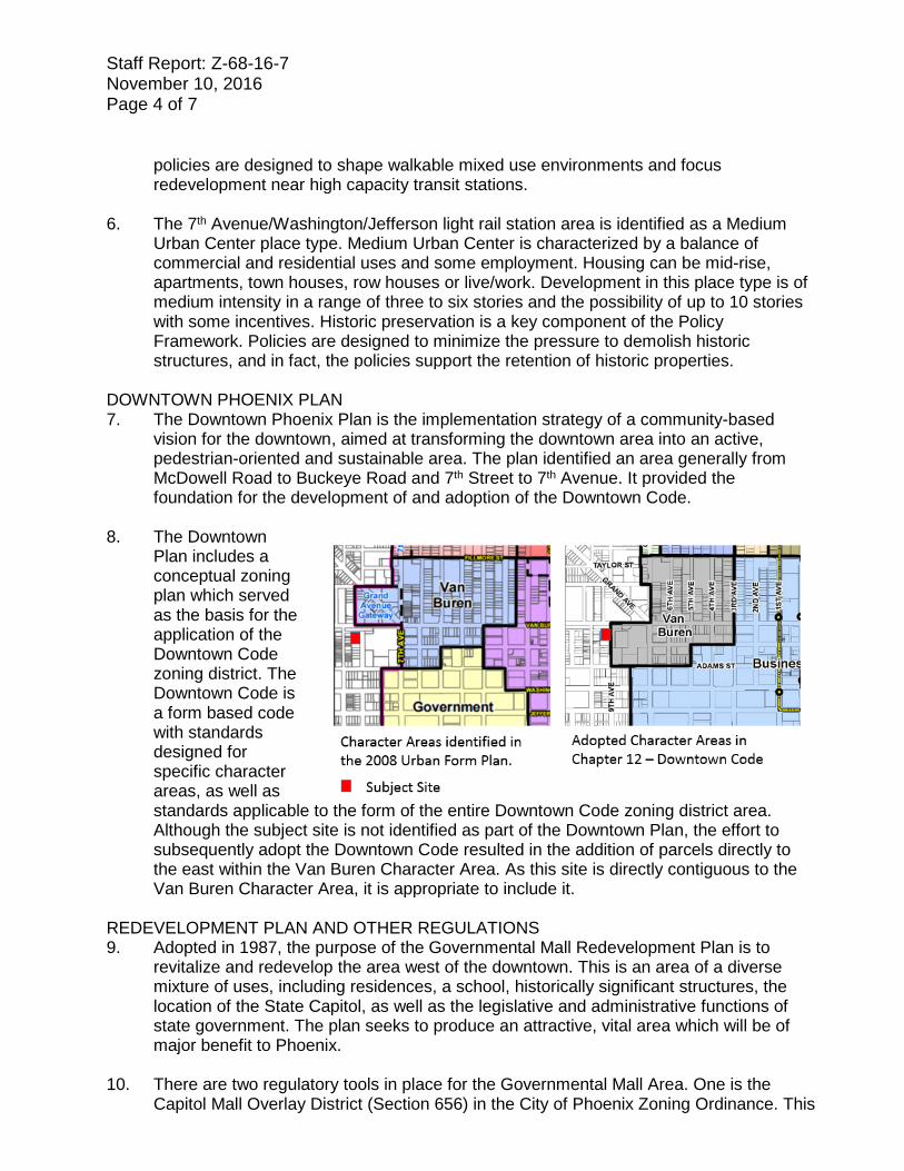
8. The Downtown
Plan includes a conceptual zoning plan which served as the basis for the application of the Downtown Code zoning district. The Downtown Code is a form based code with standards designed for specific character areas, as well as standards applicable to the form of the entire Downtown Code zoning district area. Although the subject site is not identified as part of the Downtown Plan, the effort to subsequently adopt the Downtown Code resulted in the addition of parcels directly to the east within the Van Buren Character Area. As this site is directly contiguous to the Van Buren Character Area, it is appropriate to include it.
REDEVELOPMENT PLAN AND OTHER REGULATIONS 9. Adopted in 1987, the purpose of the Governmental Mall Redevelopment Plan is to
revitalize and redevelop the area west of the downtown. This is an area of a diverse mixture of uses, including residences, a school, historically significant structures, the location of the State Capitol, as well as the legislative and administrative functions of state government. The plan seeks to produce an attractive, vital area which will be of major benefit to Phoenix.
10. There are two regulatory tools in place for the Governmental Mall Area. One is the
Capitol Mall Overlay District (Section 656) in the City of Phoenix Zoning Ordinance. This
Staff Report: Z-68-16-7 November 10, 2016 Page 5 of 7
District acknowledges the varied uses of the area including governmental offices, industrial and commercial businesses and historic residences. Many activities in this area are in close proximity to each other and the compatibility of these activities is critical to their property and orderly function. The overlay district purpose is to prevent a concentration of certain uses which could then restrict businesses and residences from functioning normally and possibly contributing to the deterioration of the business and living environment. When the Downtown Code was adopted, portions of the CMOD fell within the Code’s boundaries and the Code replaced the CMOD. Inclusion of this site within the DTC – Van Buren Character Area will replace the underlying zoning and the CMOD. A comparison of the provisions of the CMOD and the DTC – Van Buren Character Area can be found in Attachment A.
11. The second regulatory tool falls under State purview. The Legislative Governmental
Mall Commission was established in 1985 to develop and maintain a comprehensive long-range plan for the development of the Governmental Mall area. The Commission is composed of representatives from State, County and City government as well as from the general public. Legislation was approved that gave the Commission the authority to review and approve proposed development prior to the issuance of building permits. The Commission utilizes the goals, objectives and design guidelines included in the Capitol District Development Guidelines to evaluate the project and make a decision which is forwarded to the City of Phoenix.
SURROUNDING USES & ZONING 12. North
The property to the north of the subject site is the City of Phoenix Woodland Parkway which is part of the Woodland Historic District. The parkway was closed to public use years ago as it tended to be a gathering/camping spot for homeless individuals. It is zoned R-5 RI HP CMOD (Multifamily Residence District, Residential Infill, Historic Preservation District, Capitol Mall Overlay District). West There is a one story multifamily residence to the west which is zoned R-5 RI HP CMOD (Multifamily Residence District, Residential Infill, Historic Preservation District, Capitol Mall Overlay District). South A one story residence zoned R-5 RI CMOD (Multifamily Residence District, Residential Infill, Capitol Mall Overlay District) exists to the south. East The property to the east of the subject site is zoned DTC – Van Buren (Downtown Code – Van Buren Character Areas) and is developed with a five level parking structure.

Staff Report: Z-68-16-7 November 10, 2016 Page 6 of 7 13. The Governmental Mall area is
home to a number of services providing support to a large number of the city’s population of homeless individuals. The Human Services Campus is located approximately five blocks to the south of the subject site. This campus is comprised of several organizations, including: the Central Arizona Shelter Services (CASS); the Society of St. Vincent de Paul; Maricopa County Healthcare for the Homeless; Lodestar Day Resource Center; and St. Joseph the Worker. CASS provides overnight shelter for over 400 homeless men and women each night. Due to the proximity of these services, there is a high concentration of transient individuals who walk through the greater area to reach the campus.
MISCELLANEOUS 14. The Aviation Department requests that the property owner record a Notice to
Prospective Purchasers of Proximity to Airport in order to disclose the existence, and operational characteristics of Phoenix Sky Harbor International Airport to future owners or tenants of the property. Stipulation 1 addresses this request.
15. The Water Services Department has noted that the site is surrounded with existing
sewer and water mains that can potentially serve this development. For any given property, water and sewer requirements may vary over time to be less or more restrictive depending on the status of the City’s water and sewer infrastructure.
16. The Archaeology Section of the City of Phoenix has commented that there are no
known archaeological sites located in this project area. However, if any archaeological materials are encountered during construction, all ground-disturbing activities must cease within 33 feet of the discovery and the City of Phoenix Archaeology Office must be notified and allowed time to properly assess the materials. This is addressed in Stipulation 2.
17. It has been determined that this parcel is not in a Special Flood Hazard Area (SFHA),
but is located in a Shaded Zone X, on panel 2205 L of the Flood Insurance Rate Maps (FIRM) dated October 16, 2013.
18. Development and use of the site is subject to all applicable codes and ordinances.
Zoning approval does not negate other ordinance requirements. Other formal actions such as, but not limited to, zoning adjustments and abandonments, may be required.

Staff Report: Z-68-16-7 November 10, 2016 Page 7 of 7 Findings 1. The development conforms to the General Plan Land Use Map Designation of Mixed
Use. 2. The request is consistent with the Medium Urban Center Place Type assignment from
the Transit Oriented Development Strategic Policy Framework of the General Plan. 3. The proposal is consistent with and will further the goals of the Preserve Historic
Phoenix Plan. Stipulations 1. The property owner shall record documents that disclose the existence, and
operational characteristics of Phoenix Sky Harbor International Airport to future owners or tenants of the property. The form and content of such documents shall be according to the templates and instructions provided which have been reviewed and approved by the City Attorney.
2. In the event archaeological materials are encountered during construction, the
developer shall immediately cease all ground-disturbing activities within a 33-foot radius of the discovery, notify the City Archaeologist, and allow time for the Archaeology Office to properly assess the materials.
3. The development shall comply with all ADA accessibility standards, as per plans
approved by the Planning and Development Department. Writer K. Coles 11/7/2016 Team Leader Joshua Bednarek Attachments Attachment A – Comparison Table Sketch Map Aerial Site Plan dated September 21, 2016 Elevations dated September 21, 2016

ATTACHMENT A Comparison Table
Land Use Capitol Mall Overlay Van Buren Character Area Package Liquor Sales
Prohibited Use Permit
Pawnshops
Prohibited Use Permit
Blood banks and blood plasma centers, unless contained within a hospital with no direct public access except from within the hospital.
Prohibited Not Permitted (Hospital allowed)
Unscreened charitable outdoor food serving.
Prohibited Not Permitted
Day labor hiring and transportation centers.
Special Permit Not Permitted
Nonhandicapped group facilities, including, but not limited to group homes, boarding or rooming houses. No nonhandicapped group facility shall be located within 1,500 feet of another such facility as measured between the closest property lines of the two facilities; this standard shall not be varied by the procedures of Section 307.
Special Permit Permitted No use shall be located within 1,320 feet of the
same type of use as measured from the exterior
walls of the building or portion thereof in which the
use is conducted.
Recycling centers
Special Permit Not Permitted
Charitable dining halls and food serving areas in an enclosed structure or screened outdoor area. Unscreened outdoor charitable food serving shall not be permitted.
Special Permit Not Permitted
Missions, shelters and dormitories intended to provide temporary shelter.
Special Permit Permitted (Pocket Shelter accessory to
religious assembly only) The use may not be
conducted for more than 10 persons.
Drug, alcohol, other substance abuse or mental
health rehabilitation programs shall not be allowed as part of the
shelter services. Parking structures Special Permit/Use Permit,
depending on the design Permitted
(accessory use only, subject to DTC standards)
Bars and cocktail lounges. Use Permit Use Permit

* Maximum Units Allowed with P.R.D. Bonus
APPLICANT'S NAME:
DATE:REVISION DATES:
REQUESTED CHANGE:
GROSS AREA INCLUDING 1/2 STREETAND ALLEY DEDICATION IS APPROX. AERIAL PHOTO &
QUARTER SEC. NO.ZONING MAP
MULTIPLES PERMITTED CONVENTIONAL OPTION * UNITS P.R.D. OPTION
FROM:
TO:
VAN BUREN ST
MC DOWELL RD
JEFFERSON STBUCKEYE RD
LOWER BUCKEYE RD
19TH
AVE
7TH A
VECE
NTRA
L AVE
7TH
ST
16TH
ST
24TH
ST
32ND
ST
40TH
ST
I - 10
I - 17
APPLICATION NO.
Stateside Presents LLCZ-68-16
1.29 Acres
10/10/2016
QS 10-26 F-8
CENTRAL CITY VILLAGE
Z-68-16
N 10
TH AV
E
N 9T
H AVE
W WOODLAND AVE
W ADAMS ST
W GRAND AVE
W VAN BUREN ST
N 11T
H AVE
112-04-978B
112-04-03811
2-04-0
84112-04-063
112-03-036
112-03-140
112-04-030A
111-30-013
112-03-040
112-04-977
111-30-014A111-30-014A
111-30-090
112-03-028
112-0
3-023
112-04-028
112-04-069
112-03-044
112-04-040
111-30-015
112-04-064
112-04-050
112-0
3-043
112-04-005
112-0
4-092
112-03-042
112-04-042
112-0
3-046
111-30-10511
2-03-0
41
112-04-062
112-04-062
112-04-045
112-04-094
112-04-046A
112-04-026A
112-04-081
112-0
3-037
111-30-095
112-04-006
112-04-036
112-04-047
112-04-029
112-0
4-009
112-04-975
112-03-022
112-0
4-085
112-04-037
112-04-033
112-04-041
112-03-034
112-03-095A
112-04-110A
112-04-027
111-30-079A
112-04-039
112-03-026
111-30
-094
111-30-017A
112-0
3-031
112-04-979
112-04-070
112-04-008
112-04-976
112-04-978A
112-04-035
112-04-014A
112-0
3-029
112-04-001
112-04-031
111-30
-103
112-04-004
112-04-007
112-04-025112-03-030 112-04-023
112-03-032
112-04-043
111-30-082A
112-03-025
112-03-095B
112-04-067
112-04-974
112-04-044
111-28-001
112-04-012A
112-0
3-033
112-0
3-035
112-03-038
CapitolMall Overlay
DistrictArts Cultureand Small
Business Overlay
DTC-VanBurenZ-1-10
DTC-VanBurenZ-1-10
C-3
R-5RI HP
C-3 HPZ-128-04
C-3 HP C-3 HP *Z-12-12
R-5 R-5 HP
C-2 H-R *Z-113-00
R-5 RI
R-5RI
C-3 H-R *Z-315-82
DTC-VanBuren HP
Z-1-10C-3
200 0 200100Feet
DTC- Van Buren, (0.25 a.c.),DTC- Van Buren HP, (1.04 a.c. )
R:\IS_Team\Core_Functions\Zoning\sketch_maps\2016\Z-68-16.mxd
R-5 RI CMOD, R-5 RI CMODDTC- Van Buren, DTC- Van Buren HP 11, 45
13, 5411, 4511, 45
CITY COUNCIL DISTRICT: 7
I
R-5 RI CMOD, (0.25 a.c.),R-5 RI HP CMOD, (1.04 a.c.)
01/24/2017


![H M.09 B g n h j f Z l b d Z Урок 68 · Урок 68 Преподаватель F m j Z l h \ . H. =руппа: 11 ] j/12 ] j Тема урока: D h e e _ d l b \ g u _ l _ \](https://static.fdocuments.us/doc/165x107/5f44db8a84a99327592e29b8/h-m09-b-g-n-h-j-f-z-l-b-d-z-68-68-oe.jpg)


