Southwest Scotland: A landscape fashioned by geology · PDF fileSouthwest Scotland: A...
46
Southwest Scotland: A landscape fashioned by geology From south Ayrshire and the Firth of Clyde across Dumfries and Galloway to the Solway Firth and northeastwards into Lanarkshire, a variety of attractive landscapes reflects the contrasts in the underlying rocks. The area’s peaceful, rural tranquillity belies its geological roots, which reveal a 500-million-year history of volcanic eruptions, continents in collision, and immense changes in climate. Vestiges of a long-vanished ocean are preserved at Ballantrae and the rolling hills of the Southern Uplands are constructed from the piled-up sediment scraped from an ancient sea floor. Younger rocks show that the Solway shoreline was once tropical, whilst huge sand dunes of an arid desert now underlie Dumfries. Today’s landscape has been created by aeons of uplift, weathering and erosion. Most recently, over the last 2 million years, the scenery of Southwest Scotland was moulded by massive ice sheets which finally melted away about 11,500 years ago. I have a close personal interest in the geology of Southwest Scotland as it gave me my name. It comes of course from the town of Moffat, which is only a contraction of Moor Foot, which nestles near the head of a green valley, surrounded by hills and high moorland. But thank God something so prosaic finds itself in the midst of so much geological drama. What this excellent book highlights is that Southwest Scotland is the consequence of an epic collision. Aeons ago two huge continents slowly came together and the rocks of what would eventually become Scotland were buckled and corrugated in collision with the bedrock of what is now West Cumbria. At first it sounds like the geological equivalent of winning at Wembley or Twickenham, but in fact, the English got coal and iron ore, and we received, granite - and some very bonny hills and valleys. A draw, perhaps! Andrew McMillan and Phil Stone have explained and made elegantly clear a fascinating story in this beautifully illustrated book. In classic fashion, they inform, educate and entertain. Alistair Moffat (Moorfoot) Author and Broadcaster About the Authors Andrew McMillan has worked as a British Geological Survey geologist for 35 years in Scotland and northern England. His geological interests range from Palaeozoic sedimentary basins to Quaternary glaciations. He has also researched the stone-built heritage of Scotland. His paternal ancestors farmed for many centuries at Glenhead near Loch Trool. Many years of hill walking have improved his knowledge of Scotland's rich geodiversity. Phil Stone has more than 35 years of geological experience, first with the British Antarctic Survey and then with the British Geological Survey where his work has concentrated on southern Scotland and northern England whilst ranging as far afield as the Falkland Islands. He has a particular interest in the interaction between sedimentary basins and the tectonics of their growth and accretion onto neighbouring continents. ISBN 978 1 85397 520 2 Price £4.95 Scottish Natural Heritage www.snh.org.uk SOUTHWEST SCOTLAND: A LANDSCAPE FASHIONED BY GEOLOGY SOUTHWEST SCOTLAND A LANDSCAPE FASHIONED BY GEOLOGY
-
Upload
truongxuyen -
Category
Documents
-
view
225 -
download
8
Transcript of Southwest Scotland: A landscape fashioned by geology · PDF fileSouthwest Scotland: A...

Southwest Scotland: A landscape fashioned by geology
From south Ayrshire and the Firth of Clyde across Dumfries and Galloway to the Solway Firth and northeastwards into Lanarkshire, a variety of attractive landscapes reflects the contrasts in the underlying rocks.The area’s peaceful, rural tranquillity belies its geological roots, which reveal a 500-million-year history ofvolcanic eruptions, continents in collision, and immense changes in climate. Vestiges of a long-vanished oceanare preserved at Ballantrae and the rolling hills of the Southern Uplands are constructed from the piled-upsediment scraped from an ancient sea floor. Younger rocks show that the Solway shoreline was once tropical,whilst huge sand dunes of an arid desert now underlie Dumfries. Today’s landscape has been created by aeonsof uplift, weathering and erosion. Most recently, over the last 2 million years, the scenery of Southwest Scotlandwas moulded by massive ice sheets which finally melted away about 11,500 years ago.
I have a close personal interest in the geology of Southwest Scotland as it gave me my name. It comes of coursefrom the town of Moffat, which is only a contraction of Moor Foot, which nestles near the head of a green
valley, surrounded by hills and high moorland. But thank God something so prosaic finds itself in the midst of somuch geological drama. What this excellent book highlights is that Southwest Scotland is the consequence of an
epic collision. Aeons ago two huge continents slowly came together and the rocks of what would eventuallybecome Scotland were buckled and corrugated in collision with the bedrock of what is now West Cumbria. Atfirst it sounds like the geological equivalent of winning at Wembley or Twickenham, but in fact, the English got
coal and iron ore, and we received, granite - and some very bonny hills and valleys. A draw, perhaps!
Andrew McMillan and Phil Stone have explained and made elegantly clear a fascinating story in thisbeautifully illustrated book. In classic fashion, they inform, educate and entertain.
Alistair Moffat (Moorfoot) Author and Broadcaster
About the AuthorsAndrew McMillan has worked as a British Geological Survey geologist for 35 years in Scotland and northern England. Hisgeological interests range from Palaeozoic sedimentary basins to Quaternary glaciations. He has also researched the stone-builtheritage of Scotland. His paternal ancestors farmed for many centuries at Glenhead near Loch Trool. Many years of hill walking haveimproved his knowledge of Scotland's rich geodiversity.
Phil Stone has more than 35 years of geological experience, first with the BritishAntarctic Survey and then with the British Geological Survey where his work has
concentrated on southern Scotland and northernEngland whilst ranging as far afield as the FalklandIslands. He has a particular interest in the interactionbetween sedimentary basins and the tectonics of theirgrowth and accretion onto neighbouring continents.
ISBN 978 1 85397 520 2
Price £4.95Scottish Natural Heritage
www.snh.org.uk
SOU
THW
EST SCO
TLAN
D: A
LAN
DSC
AP
E FASH
ION
ED B
Y G
EOLO
GY
SOUTHWESTSCOTLAND
A LANDSCAPE FASHIONED BY GEOLOGY
64751 SNH SW Cvr_5mm:cover 14/1/09 10:00 Page 1

A LANDSCAPE FASHIONED BY GEOLOGY
SOUTHWESTSCOTLAND
64751 SNH SW Text:53406 Text paged 22/11/08 02:02 Page 1

Further copies of this book and other publications can be ordered online at www.snh.org.uk/pubsor contact:
Publications,
Scottish Natural Heritage,
Battleby, Redgorton, Perth PH1 3EW
Tel: 01738 458530 Fax: 01738 458613
E-mail: [email protected]
AcknowledgementsAuthors: Andrew McMillan (BGS) and Phil Stone (BGS)Series editor: Alan McKirdy (SNH)
Photography: Alamy/Chuck Eckert 23 top; Alamy/SW Images 28; Alamy/Vincent Lowe 17; Alan Devlin 25 left; Lorne Gill/SNH frontcover, frontispiece, 7, 8, 10, 13, 14, 14 inset, 16, 18, 19, 20, 24 top, 25 right, 29, 31, 33, 33 inset, 34, 36, 37; John Gordon 26; BGS 12, 21 top,21 bottom left, 22, 32; Patricia & Angus Macdonald/SNH 5 top, 27 top; Andrew McMillan 30; National Museums of Scotland 9 top, 15, 35;US Geological Survey 6 top.
Illustrations: BGS 21 bottom right, 27 bottom; Craig Ellery 2, 3, 4, 5 bottom, 6 bottom, 11; Clare Hewitt 9 bottom, 24 bottom; Ian McIntosh contents; Elizabeth Pickett/North Pennines AONB Partnership 23 bottom.
Front cover image:
View over Nithsdale
Back cover image:
The shore at Arbigland
©Scottish Natural Heritage 2008
ISBN 978 1 85397 520 2
A CIP record is held at the British Library TC2.5K1108
64751 SNH SW Text:53406 Text paged 22/11/08 02:02 Page 2

SOUTHWEST SCOTLANDA Landscape Fashioned by Geology
by
Andrew McMillan (BGS) and Phil Stone (BGS)
64751 SNH SW Text:53406 Text paged 22/11/08 02:02 Page 3

1. Introduction2. Southwest Scotland Through Time 3. Geological Map4. The Iapetus Ocean6. A Volcanic Collision - the Ballantrae Complex8. A Subsiding Continental Margin - the Girvan Succession
10. A Tectonic Paradox - The Southern Uplands14. Graptolites - Celebrity Fossils16. Continents Meet - Faults, Folds and Granite 18. Volcanoes, Rivers, and a Tropical Sea20. Faults and Fossils22. Coal and Swamps
24. Volcanoes in the Desert...then the Atlantic Opens26. The Ice Age28. Upland Glaciers30. The Glacial Lowlands32. Man Arrives on the Scene34. Mineral Treasures 36. The Landscape Today - Rocks, Wind and Rain38. Scottish Natural Heritage and the
British Geological Survey39. Remember the Geological Code41. Publications Order Form
Contents
The main elements of the Southwest Scotland landscape
64751 SNH SW Text:53406 Text paged 6/1/09 13:21 Page 4

1
The southwest corner of Scotland rises from the coasts of the Solway Firth and Firth of Clyde into the broad rolling hills of the
Southern Uplands. Five hundred million years of geological history are recorded in the rocks, which range from soft red
sandstone to hard intractable granite. An ancient long-lost ocean, volcanoes, arid deserts, tropical forests, glaciers, the collision
and splitting apart of huge continents; all of these phenomena have played their part in shaping the landscape, but the most
profound was the relatively recent scouring by a vast ice sheet. Humans moved in as the glaciers retreated and have continued
the modification, mining, quarrying, farming and building. The unique combination of all these influences has produced a wild
and rugged mountainous core with an extensive periphery of arable land and pasture. Most of the main communication arteries
run around that periphery, or up and over the main valleys and watersheds, but for the more intrepid the Southern Upland Way, a
long-distance footpath, runs from west to east through the heart of the hills. Art and literary associations with the landscape are
legion: the Impressionists such as The Glasgow Boys including E A Hornel, and the poets and authors including Sir Walter Scott,
Robert Louis Stevenson, John Buchan, S R Crockett, Dorothy Sayers and, of course, Rabbie Burns - ‘Ye banks and braes o’ bonnie
Doon, How can ye bloom sae fresh and fair?’ Part of the answer lies in the geology.
64751 SNH SW Text:53406 Text paged 22/11/08 02:02 Page 5

Southwest Scotland Through Time
Brown bars indicate periods of time represented by the rocks and loose sediments of Southwest Scotland.
CRETACEOUS145 to 65 million years ago
JURASSIC199 to 145 million years ago
PERMIAN299 to 251 million years ago
CARBONIFEROUS359 to 299 million years ago
The youngest rocks in Southwest Scotland formed when masses of molten magma, sourced from the volcanoes of the InnerHebrides, solidified in the earth’s crust.
In western Scotland warm shallow seas existed, but the Galloway area is likely to have been dry land and no rocks of thisperiod are preserved here.
Sea level changes meant that the fringes of Scotland were intermittently covered by shallow seas. No rocks of this periodare preserved in Southwest Scotland but just to the south around Carlisle, there are Jurassic rocks with fossils of marineanimals known as ammonites.
Scotland lay just north of the equator. Deserts developed across most of southern Scotland and the red sandstones ofLochmaben, Thornhill, Dumfries and Stranraer show all the characteristics of desert dunes. Flash floods occurred from timeto time. Fossil trackways in the sandstones preserve evidence of early reptiles.
Intermittent volcanic eruptions formed thin lava flows. Sedimentary rocks, now best seen along the Solway Coast, were laiddown in a variety of settings including rivers, lakes and the sea. Abundant shells and coral fossils, and coals developed inswampy areas, all indicate a tropical equatorial climate.
TRIASSIC251 to 199 million years ago
Deposits of red sandstone and mudstone were laid down in rivers and ponds on a relatively flat desert plain. These rocks arefound in eastern Dumfries-shire, where some of the mudstones contain early plant fossils.
SILURIAN444 to 416 million years ago
DEVONIAN416 to 359 million years ago
ORDOVICIAN488 to 444 million years ago
The Anglo-Scottish “join” was wrenched sideways allowing magma to rise up from great depth. Surface erosion took placein the arid Devonian environment and it is likely that the major valleys of Galloway began to develop at this time.
As the Iapetus Ocean closed thick layers of sand accumulated at the Scottish margin, but were folded and piled up into hugefaulted slices as the ocean disappeared.
The Iapetus Ocean began to close and volcanoes erupted at its margins. The volcanic rocks and thick layers of ocean-floorsediment were pushed onto the continental margin as huge faulted slices.
Before 5,000 years ago. Human occupation began.11,500 years ago. Vegetation started to recolonise the land with forests established by 5000 years ago.12,500 to 11,500 years ago. Small corrie glaciers existed in the Galloway and Moffat hills.15,000 to 12,500 years ago. Rapid deglaciation occurred as the climate warmed.30,000 to 15,000 years ago. The last major ice sheets covered Galloway and the Southern Uplands.Before 30,000 years ago. There were periods of very cold climate, and at times much of Britain was covered by ice-sheets.These periods were interspersed with warm (Interglacial) stages.❄
❄
❄❄
❄❄
❄
QUATERNARY2.6 million years ago to the present day
PALAEOGENE65 to 23 million years ago
CAMBRIAN542 to 488 million years ago
Scotland and England, then parts of different continents, were separated by the wide Iapetus Ocean. Scotland lay in thesouthern tropics; England was much farther south.
PRECAMBRIANBefore 542 million years ago
Precambrian rocks formed within the continental masses that split apart to create the Iapetus Ocean, but no rocks formedat this time are preserved in Southwest Scotland.
At about 2.6 million years ago, there was a dramatic cooling of the northern hemisphere, the beginning of the ‘Ice Age’.Before that, tropical conditions existed. The south of Scotland is likely to have been a well-vegetated land mass at this timeand was probably populated by a wide variety of herbivore animals including horses and hippos.
NEOGENE 23 to 2.6 million years ago
❄
❄
64751 SNH SW Text:53406 Text paged 6/1/09 13:21 Page 6

3
Geological Map of Southwest Scotland
Southern Uplands accretionary complex:
Each strip of sedimentary sandstone and mudstone is slightly different incomposition and the strips becomesequentially younger to the south-east.
64751 SNH SW Text:53406 Text paged 6/1/09 13:21 Page 7

The Southern Uplands of Scotland lie immediately to the
north of one of Britain's most fundamental geological divides.
This is the so-called 'Iapetus Suture', the trace of an ancient
ocean, Iapetus, which separated two continents and was
destroyed by their slow convergence. To the north was
Laurentia, of which Scotland formed a tiny part; to the south
was Avalonia, containing embryonic England. The Iapetus
Ocean was more than 1000 kilometres wide about 500
million years ago but then, along its margins, volcanic islands
appeared as ocean crust was destroyed. The process had
begun that, over the next 80 million years, would close the
ocean. As shown in the sketch on page 6, the destruction of
ocean crust as it sinks beneath the margin of a continent is
called subduction. The opposite effect, when the ocean crust
rides up on top of the continental margin, is called
obduction. Incidentally, the name 'Iapetus' comes from Greek
4
The lapetus Ocean
mythology. Iapetus was the father of Atlas - after whom the
present-day Atlantic Ocean is named.
Early in the Ordovician Period, about 470 million years ago,
the southern part of Scotland lay in the tropics, just to the
south of the equator. Its surroundings would have looked a
little like the western Pacific of today, with a complex pattern
of active volcanic islands fringing the continental mainland.
Away to the south stretched the Iapetus Ocean, with
Avalonia (and England) forming its southern shores away
down at a latitude of about 60o south. When the ocean
eventually closed, about 420 million years ago, very
different rocks and fossils were juxtaposed; their contrast
provided one of the first clues to the reconfiguration of this
ancient world.
South Pole
LAUR
ENTI
A
SIBERIA
BALTICA
AVALONIA
IAPE
TUS OCEAN
Equator
Scotland
GONDWANA
South Pole
30 No
Equator
30 SoIAPETUS OCEAN
RHEIC
OCEAN
South Pole
Equator
30 No
30 So
60 So
a. Late Cambrian circa 500 Million years ago
b. Late Ordovician circa 450 Million years ago
c. Early Devonian circa 400 Million years ago
64751 SNH SW Text:53406 Text paged 22/11/08 02:02 Page 8

5
The closure of the Iapetus Ocean and
subsequent plate collisions had, by 250 million
years ago, combined all of the Earth's land
masses into a single 'supercontinent', known as
Pangaea. The subsequent break-up of
Pangaea did not respect the earlier geological
boundaries and the once-continuous margin of
Laurentia is now divided by the still-spreading
Atlantic Ocean. As a result the Early
Palaeozoic rocks of southern Scotland have
more in common with those of Newfoundland
than with those of northern England, whilst the
latter relate more closely to Nova Scotia than
to Auld Scotland just to the north.
Equator
60 No
30 No
North Pole
Equator
60 No
30 No
North Pole
PANGAEA
View over Moffatdale towards the Grey Mare’s Tail, White Coomb and Loch Skene
d. Permian / Triassic circa 250 Million years ago
e. Palaeogene circa 50 Million years ago
64751 SNH SW Text:53406 Text paged 22/11/08 02:02 Page 9

A Volcanic Collision - the Ballantrae Complex
Between Girvan and Ballantrae, overlooking the Firth of
Clyde, an unusual assemblage of rocks - the Ballantrae
Complex - is testament to one phase in the destruction of the
Iapetus Ocean about 480 million years ago. The complex
was formed when volcanic islands escaped being subducted
and were instead obducted, pushed up onto the margin of
the Laurentian continent. In the process, distinctive rocks
from 10 kilometres down beneath the seafloor were stacked
up and mixed with lavas that had been erupted onto the sea
floor. Such a relic of oceanic crust is generically known as
an ophiolite complex, and the one at Ballantrae can be
most readily interpreted when compared with the much
bigger and better examples in places like Cyprus, Oman
and Newfoundland.
6
Sketch showing the processes of subduction and obduction
Lava running into the sea, Hawaii
Detail shown in
diagram on left
64751 SNH SW Text:53406 Text paged 6/1/09 13:21 Page 10

7
Pillow lavas, south of Ballantrae
Some of the rocks derived from great depth consist of minerals that are
not very stable at the Earth's surface and so have been altered to
'serpentinite', so-called because of the sinuous patterns of red, green and
brown that run through the rock and which were thought to be
reminiscent of snake skin. Serpentinite is relatively soft and so has been
readily eroded. It is only rarely exposed and at the coast tends to be
buried beneath a raised beach backed by an old sea cliff cut in glacial
deposits. Dykes and enclaves of harder, volcanic rock are left standing
as sea stacks at the coast, for example at Lendalfoot, but further inland,
around Colmonell, they have produced some spectacular crag and tail
features in response to glacial erosion.
The volcanic lavas found at Ballantrae are commonly accumulations of
pillow-shaped balls of basalt. This style is characteristic of submarine
eruptions, where the lava is rapidly cooled by contact with seawater,
and the resulting 'pillow-lavas' can be seen forming today around
oceanic volcanoes like those of Hawaii. Many of the Ballantrae pillows
were violently broken up by their rapid chilling so that thick beds made
up of angular volcanic debris are interspersed amongst the lavas. The
resulting massive volcanic sequence produces a rocky coastline and
high sea cliffs at places such as Bennane Head; inland the volcanic
rocks form the prominent hills such as Knockdolian.
The Early Ordovician age of the lavas in the Ballantrae Complex was
established by fossils found in rare interbedded sedimentary rocks.
Slightly younger, Late Ordovician pillow lavas occur just to the south of
Ballantrae and their pillow structures are spectacularly developed.
These lavas, at Downan Point, provide the finest examples of this
volcanic feature to be seen in Britain.
64751 SNH SW Text:53406 Text paged 22/11/08 02:02 Page 11

8
The obduction of the ophiolite assemblage was a
geologically brief event and soon the Ballantrae Complex
and its continental foundation began to subside. Slowly the
sea crept across the eroded remains of the ophiolite
complex, which was progressively buried beneath
sedimentary rocks deposited from the end of the Ordovician
Period into the earliest Silurian.
Deposition of sediment was initially in shallow water
encroaching onto the southern fringes of the ophiolite.
Limestone reefs built up locally, and were home to a rich
fauna of corals, shellfish, trilobites and other sea creatures;
the calcareous alga Girvanella was abundant. The
limestones inter-finger with thick beds of conglomerate, an
accumulation of pebbles and boulders that originally poured
A Subsiding Continental Margin - the Girvan Succession
Steeply dipping turbidite beds at Ardwell Bay, Ayrshire
64751 SNH SW Text:53406 Text paged 22/11/08 02:02 Page 12

9
Above: Silurian trilobite
Below: Turbidity current in action andidealized turbidite sequence showinggraded beds
across the subsiding continental margin in submarine fans
derived from the land mass to the north. As subsidence
continued, this shallow-water sedimentary assemblage edged
northwards whilst, in the south, the older limestone and
conglomerate beds sunk deeper and were buried by
sandstone and mudstone, mostly deposited from underwater
debris avalanches known as turbidity flows.
Turbidites - the deposits of turbidity flows - comprise myriad
layers of sandstone and mudstone, mostly thin but with some
beds of sandstone up to two metres thick and extending
laterally for several kilometres. Each sandstone bed was
deposited from a single, huge submarine flow of chaotically-
mixed sediment. This slumped mass accelerated down the
margin of the continent into the deeper water, but then
slowed abruptly as it spread out across the sea floor. As the
current slowed, its sediment load settled out; first the largest
and heaviest particles, then progressively smaller and lighter
grains. The result is a 'graded bed' with coarse grains of
sand at its base and sequentially finer sand and silt
appearing towards the top. Between successive turbidity
flows only mud was deposited. This alternation produces the
emphatically striped appearance of the rock succession seen
on the coast south of Girvan.
Trace fossils formed by soft-bodied animals burrowingthrough the mud
10s to 100s of kilometres
Erosive base ofturbidite flow
Coarse sand/gravel atbase of turbidite flow
64751 SNH SW Text:53406 Text paged 22/11/08 02:02 Page 13

10
A Tectonic Paradox - The Southern Uplands
Folded strata at Ardwell Bay, Wigtownshire
64751 SNH SW Text:53406 Text paged 22/11/08 02:03 Page 14

11
Whilst the late Ordovician seas were encroaching on the
subsiding margin of the Laurentian continent, another
sedimentary sequence was being deposited further south. Its
history is now revealed by the rocks of the Southern Uplands,
a geological massif that extends from the North Sea coast of
Scotland south-westward into Northern Ireland, spanning the
Dumfries and Galloway region. Across this wide expanse of
rolling hills are seen tough, resistant sandstones. They record
how, with the resumption of subduction, a deep ocean trench
was established into which turbidity flows poured. A
characteristic, banded succession of turbidite strata built up,
but with important constraints on its development imposed by
the highly active tectonic setting, similar to the environment
seen today in the earthquake-prone trenches around
Indonesia and Japan.
The Southern Uplands turbidite sandstones were deposited
on top of the thin layer of muddy sediment that covered the
ocean floor. But all the while the ocean floor was very
slowly, at a rate of several centimetres per year, creeping
towards destruction in the ocean trench subduction zone.
So, once deposited, the turbidite sandstones were also
carried on towards a similar fate. Instead of disappearing
into oblivion, however, successive huge slices of sedimentary
rock were stripped off the descending oceanic crust and
stacked up, each new slice pushed in beneath those that
had gone before. As the pile of rock slices got bigger, the
original, nearly horizontal structures were steepened and
now appear almost vertical. The major features seen today
originated as the planes of movement, or faults, separating
the sequentially incorporated slices.
Diagram showing theformation of theSouthern Uplandssandstone succession.
64751 SNH SW Text:53406 Text paged 13/1/09 11:18 Page 15

12
the northwest. But the stacking up of rock slices has
produced paradoxical stratigraphical relationships, and
fossils show that overall the rocks become younger towards
the southeast. This is the result of the sequential
incorporation of successively younger sediment slices
beneath previously incorporated slices. Since deformation of
the sandstone turbidite beds largely occurred as they were
incorporated, the folds produced - and there are lots of them
- are also older in the north than in the south.
The faults now form more readily eroded lines of weakness
that run northeast to southwest and determine the orientation
of major valleys such as Glen App and Moffatdale. The
faults separate tracts of steeply inclined turbidite beds that
also run northeast to southwest across the country.
The turbidite deposits dominate the succession so that
between any two major faults, thousands of metres of
sandstone beds may overlie only a few metres of the ocean
floor mudstone, with the succession getting younger towards
Steeply dipping and inclined turbidite sandstones at Brighouse Bay
64751 SNH SW Text:53406 Text paged 6/1/09 13:22 Page 16

View southwest along the fault line from abovethe Grey Mare's Tail car-park, Moffatdale
64751 SNH SW Text:53406 Text paged 22/11/08 02:03 Page 17

14
Graptolites – Celebrity Fossils
The northeast end of Moffatdale, Lapworth’s Cottage and Dob’s LinnInset: The view up Dob’s Linn
64751 SNH SW Text:53406 Text paged 22/11/08 02:03 Page 18

15
in his investigation, for in this stream section he was able to
establish a complete, unbroken succession of graptolitic
mudstone spanning the Late Ordovician and the Early
Silurian Periods. This provided the key to age relationships
across the whole region. Crucially, it was used by the
Victorian geologists Ben Peach and John Horne, who
applied Lapworth's scheme during their mapping of the
Southern Uplands for the Geological Survey between 1880
and 1890. The sequence of graptolite 'biozones' worked out
in those early days has stood the test of time and is still
broadly applicable today.
The importance of the Dob’s Linn site has also carried
forward into modern times with its formal adoption by the
international geological community as the global standard
used to define the beginning of the Silurian Period. This
would undoubtedly have astonished Halbert Dobson, the
17th century Covenanter who hid from Government
Dragoons in a cave above the waterfall at Dob’s Linn, and
after whom it is named.
At first sight, the seemingly vast and intractable turbidite
succession of the Southern Uplands of Scotland must have
presented a daunting geological challenge. The key that
unlocked its secrets was a group of humble fossils called
graptolites, the remains of small, free-floating colonies of
marine organisms. Through the late Ordovician and the
Silurian Periods graptolites were evolving rapidly and so
different assemblages of them can be used to date the rocks;
at best, graptolites can be used to identify divisions
representing the sedimentary accumulation of less than half a
million years.
Dob’s Linn in Moffatdale is a gash in the hillside where a
waterfall cascades down the vertical base of a massive
turbidite sandstone bed and into a stream that tumbles
through a gorge cut into the underlying oceanic mudstone.
Here, a pioneering study of graptolites was carried out
during the 1870s by Charles Lapworth, then a schoolmaster
in Galashiels but later to become Professor of Geology at the
University of Birmingham. Dob’s Linn was a pivotal location
Fossil graptolites
64751 SNH SW Text:53406 Text paged 22/11/08 02:03 Page 19

16
Sometime late in the Silurian Period, round about 425
million years ago, the last remnants of the Iapetus Ocean
were subducted and Laurentia collided with Avalonia. We
might expect this to have been a dramatic event, with intense
deformation and the rise of a mountain range, rather as the
collision of India and Asia has thrown up the Himalayas. But
as far as the rocks of Southwest Scotland were concerned,
continental collision was a bit of an anticlimax. There was no
major deformation and instead the Southern Uplands stack
of turbidite slices, at the leading edge of Laurentia, initially
rode up onto and pushed down the margin of the Avalonian
continent. In this first meeting of Scotland and England it
seems that Scotland came out on top.
The deformation that was preserved in the rocks shows that
for part of the time the two continents slid past each other
rather than towards each other. Within the Southern
Uplands, accommodating movement was concentrated into
the weaker zones, mainly along the pre-existing faults in the
near-vertical mudstone sequence at the base of the
Continents Meet - Faults, Folds and Granite
View northwest over farmland looking towards Cairnsmore of Fleet NNR
64751 SNH SW Text:53406 Text paged 22/11/08 02:03 Page 20

17
sandstone-dominated tracts, but locally the sandstones were
folded as well. In some places, wider zones of more
pervasive deformation were developed: the best example of
the latter runs southwest from Moniaive and is several
kilometres across at its widest point.
But perhaps the most important result of the continental
collision was that it upset the balance of forces deep in the
Earth's crust and as a result, about 400 million years ago,
triggered the rise of molten magma. Some of this was
injected upwards into vertical cracks where it solidified into
sheets known as dykes. The dykes commonly occur in
swarms, where many crowd together in close proximity; they
may have fed erupting volcanoes that have been completely
eroded away, or they may never have reached the Earth's
surface. Elsewhere, the magma rose in much larger masses
before cooling and solidifying deep underground to form
granite plutons. The latter have been a major influence on
the landscape of Southwest Scotland, their eroded remains
forming the high, rounded hills of Criffel and Cairnsmore of
Fleet. Farther north, the effect of the granite has been more
subtle. Some of the hills to the south of Loch Doon, such as
Mullwharchar, are indeed of granite, but the highest
mountain, Merrick (843 metres), and the equally rugged
Rhinns of Kells lie just outside the granite outcrop. There, the
intruding hot granite has baked and hardened the
surrounding sandstone to such an extent that the latter is now
the more resistant to weathering and erosion.
Merrick, highest hill in the Southern Uplands, and Loch Valley, seen from the Rig of The Jarkness
64751 SNH SW Text:53406 Text paged 22/11/08 02:03 Page 21

18
Volcanoes, Rivers and a Tropical Sea
From about 360 million years ago, at the beginning of the
Carboniferous Period, the sedimentary rocks of the south of
Scotland were deposited in rivers and shallow seas that
intermittently encroached onto the land. The south of
Scotland was then situated near the Equator and enjoyed a
tropical climate! The area around today's Solway Firth was
a subsiding centre of sediment deposition (known as the
Solway Basin). Good exposures of the sedimentary rocks
including sandstones, mudstones and limestones can be seen
around Langholm in the River Esk and Liddel Water, and
along the coast at Southerness.
Early in the Carboniferous, sediment deposition was interrupted
by a volcanic episode, during which thin lava flows of the
Birrenswark Lavas were erupted from fissures cut in the Earth's
surface just like those of modern Iceland. Today's landscape
shows these basalt flows occupying both the hill tops north of
Ecclefechan and river beds (e.g. in the River Esk below
Skipper's Bridge south of Langholm).
The volcanic rocks are overlain by thick white sandstones,
which formed as sands filling the channels of large rivers that
flowed southwards. At Whita Hill, near Langholm, these
sandstones were easily exploited during the past 150 years as
a source of good building stone for local towns and villages.
Basalt lavas under Skippers Bridge, Langholm
Birrenswark Hill which iscomposed of basalt lavaflows, near Ecclefechan
64751 SNH SW Text:53406 Text paged 22/11/08 02:03 Page 22

19
64751 SNH SW Text:53406 Text paged 22/11/08 02:03 Page 23

20
Faults and Fossils
Higher in the Carboniferous sequence, successions of
sediments were laid down alternately in shallow seas and in
rivers, in response to changes in sea level. These global
changes were controlled by the melting and freezing of
massive polar ice sheets. Along the Southerness to Arbigland
shore of the Solway and in the Liddel Water at Penton Linns,
east of Canonbie, shells and coral fossils together with the
traces of burrowing worms indicate that these sediments were
laid down in shallow tropical seas.
The present coast northeast of Southerness shows folded and
deformed strata, including thick beds of sandstone and
interbedded fossil-bearing mudstones and siltstones and
occasional algal beds. At Thirlstane, a 15 metres thick
sandstone bed now favoured by rock climbers shows
evidence of earthquake activity, the soft beds of
unconsolidated sand having once been disrupted due to the
ground shaking. These sediments were deposited near to the
line of a major fault or tear in the Earth's crust known as the
North Solway Fault. The Fault is best seen from the
viewpoint at Castlehill Point, Rockcliffe.
Folded limestones in Liddel Water
64751 SNH SW Text:53406 Text paged 22/11/08 02:04 Page 24

21
Fossil nautilus found at Closeburn
A coral from Arbigland Bay
Inland, Carboniferous sedimentary rocks are seen at
Thornhill and Sanquhar. At Closeburn and Barjarg
thick limestones were worked in quarries and shallow
mines during the late 18th century as a source of lime
for agricultural purposes. One of the local farmers who
used Closeburn lime was the poet Rabbie Burns, who
farmed for a time at Ellisland. The limestones yielded
some spectacular marine fossil shells, including large
nautiloids (the precursor of the modern octopus and
squid). Some of these fossils may be seen in the
National Museum of Scotland, Edinburgh.
Artist’s impression of aCarboniferous tropical sea withmarine creatures nowpreserved as fossils
1cm
64751 SNH SW Text:53406 Text paged 6/1/09 13:22 Page 25

22
Coal and Swamps
During the late Carboniferous, shallow seaways occupied
valleys through the Southern Uplands between the Solway
and the Midland Valley. Coal Measures sediments were laid
down in swamps and estuaries in a steamy tropical climate.
Some speculate that all of the Southern Uplands were once
covered by Coal Measures sedimentary rocks. Whether or
not this was the case, all we see in this area today are
remnants at Langholm, Thornhill, Sanqhuar and Stranraer.
Typically, cyclical sequences (or measures) of seatrock, coal,
mudstone and sandstone were deposited in subsiding
swamps and the sequences of rocks represent the changing
conditions with time. At the base of each sequence,
seatrocks are made up of the fossilised roots of the tropical
trees growing in swampy conditions. A modern
analogy is a mangrove swamp in Florida. Above
the rooty beds, coal developed from a mass of
vegetation compressed by the weight of
overlying sediments. These overlying
strata included mudstones, often packed
with freshwater mussel fossils which
indicate the development of lakes across
the swamp. At the top of the sequence,
sandstones were deposited in river
channels. Occasionally subsidence
was so rapid that the sea encroached
across the land resulting in the formation of limestones
above the river sediments. Then the cycle of rocks began
all over again.
Thus the Coal Measures contains many seams of coal and it
was these that were exploited in many parts of Britain,
including locally at Sanquhar and Cumnock where coals
were worked underground until the 1970s and latterly in
opencast pits. Coal seams are also present in the concealed
coalfield south of Canonbie where deep mining finished in
the 1920s.
Fossil mussel shells found in the Coal Measures
64751 SNH SW Text:53406 Text paged 22/11/08 02:04 Page 26

23
Reconstruction of the shallowrivers and swampy environment ofcoal formation
Present day swamp, Florida
64751 SNH SW Text:53406 Text paged 22/11/08 02:04 Page 27
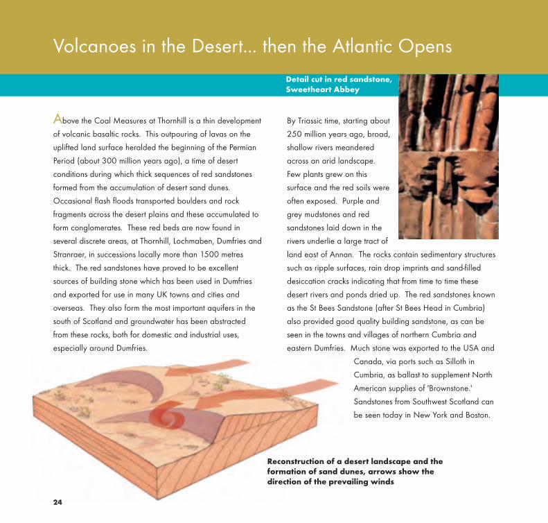
By Triassic time, starting about
250 million years ago, broad,
shallow rivers meandered
across an arid landscape.
Few plants grew on this
surface and the red soils were
often exposed. Purple and
grey mudstones and red
sandstones laid down in the
rivers underlie a large tract of
land east of Annan. The rocks contain sedimentary structures
such as ripple surfaces, rain drop imprints and sand-filled
desiccation cracks indicating that from time to time these
desert rivers and ponds dried up. The red sandstones known
as the St Bees Sandstone (after St Bees Head in Cumbria)
also provided good quality building sandstone, as can be
seen in the towns and villages of northern Cumbria and
eastern Dumfries. Much stone was exported to the USA and
Canada, via ports such as Silloth in
Cumbria, as ballast to supplement North
American supplies of 'Brownstone.'
Sandstones from Southwest Scotland can
be seen today in New York and Boston.
24
Above the Coal Measures at Thornhill is a thin development
of volcanic basaltic rocks. This outpouring of lavas on the
uplifted land surface heralded the beginning of the Permian
Period (about 300 million years ago), a time of desert
conditions during which thick sequences of red sandstones
formed from the accumulation of desert sand dunes.
Occasional flash floods transported boulders and rock
fragments across the desert plains and these accumulated to
form conglomerates. These red beds are now found in
several discrete areas, at Thornhill, Lochmaben, Dumfries and
Stranraer, in successions locally more than 1500 metres
thick. The red sandstones have proved to be excellent
sources of building stone which has been used in Dumfries
and exported for use in many UK towns and cities and
overseas. They also form the most important aquifers in the
south of Scotland and groundwater has been abstracted
from these rocks, both for domestic and industrial uses,
especially around Dumfries.
Volcanoes in the Desert... then the Atlantic Opens
Detail cut in red sandstone,Sweetheart Abbey
Reconstruction of a desert landscape and theformation of sand dunes, arrows show thedirection of the prevailing winds
64751 SNH SW Text:53406 Text paged 22/11/08 02:04 Page 28

25
Any younger sedimentary rocks that might once have covered
Southwest Scotland have long since been eroded away.
Some igneous rocks of Palaeogene age (65 million years
ago) have survived, vestiges of the massive volcanic activity
that accompanied the opening of the Atlantic Ocean. Most
impressive is Ailsa Craig, a precipitous island off Girvan
formed from a plug of granitic rock with an unusual
composition, distinctive appearance and uniform hardness that
makes it a great favourite for curling stones. Dykes of similar
age can also be found, cutting across the older rocks. The
most extensive, such as the Cleveland and Eskdalemuir dykes,
though only a few metres across, can be traced all the way
from northern England back to an ancient volcano on Mull.
Palaeogene dyke at Bennane Head
Looking towards Ailsa Craig from Ballantrae
64751 SNH SW Text:53406 Text paged 22/11/08 02:04 Page 29

26
Across the northern hemisphere rapid changes in climate
occurred at the beginning of the Quaternary, some
2.6 million years ago. Alternating phases of warm climate
were interspersed with colder periods. Some 750,000 years
ago most of Britain was subjected to a prolonged glaciation
known as the Anglian Glaciation. At this time the south of
Scotland may have been completely covered by an ice sheet
although there is little direct evidence for this. The most
recent glaciation, the Late Devensian Glaciation, took place
some 20,000 years ago, as determined by evidence from
The Ice Age
cores through the Greenland ice sheet. Again, during the
maximum stages of the glaciation much of the Southern
Uplands was probably overtopped by ice. From about
15,000 years ago, the climate warmed and the ice sheet
melted, glaciers occupied the steep-sided valleys, and large
volumes of sediment were transported downstream by
meltwater. By about 12,500 years ago, all the glaciers had
disappeared but then, for a short period of about 1000
years, small corrie glaciers reappeared in the Galloway
mountains and Moffat Hills.
South Patagonian Icefield
64751 SNH SW Text:53406 Text paged 22/11/08 02:04 Page 30

27
The cycle of climatic change has left a marked signature on
the present-day landscape. Both erosional and depositional
processes of the ice sheets and the weathering of bedrock
during warm inter-glacial interludes can be detected in
upland areas. On the low ground in the valleys, thick
accumulations of glacial debris developed in the form of till,
a compact clay full of a jumble of ice-smoothed pebbles and
boulders. Across Wigtownshire and Kirkcudbrightshire, both
till deposits and exposed bedrock were moulded into well-
formed drumlins, elongated mounds with sharp crests which
were aligned in the direction of ice flow.
Blanket forestry and the glacially scoured Devil’s Beeftub, near Moffat
Sketch of the margin of a glacier
Moraine
Erratics
64751 SNH SW Text:53406 Text paged 22/11/08 02:04 Page 31

322832
Upland Glaciers Erratic granite boulders on the Devil’sBowling Green near Craignaw inGalloway Forest Park
64751 SNH SW Text:53406 Text paged 6/1/09 13:22 Page 32

29
Evidence of the glaciers is abundant. Glaciers had the
effect of overdeepening pre-existing valleys, some of which
show a 'U'-shaped profile. In some upland areas near the
heads of valleys in the Galloway mountains and in the hills
above Moffat, moundy accumulations of gravelly debris
termed 'moraine' were formed at times when the snout of the
glacier remained stationary for short periods of time during
general retreat.
In areas underlain by granite, such as around Loch Doon,
large granite boulders that were picked up and moved short
distances by ice now perch directly on bare rock. Other
granite boulders have been transported by ice well beyond
the area of granite outcrop and abandoned as spectacular
erratic blocks, the term 'erratic' meaning not of local origin.
The power to transport material by major ice streams is
demonstrated by the present distribution of granite erratics
from Criffel and Ailsa Craig, which have travelled the length
of the Irish Sea and across northern England.
In upland areas today, the steep slopes of mountain valleys
are partly clothed in turf and heather and partly exhibit bare
craggy rock surfaces and associated screes. Scree formation
probably began at the earliest stages of deglaciation, some
15,000 years ago, and continued to occur at intervals. Piles
of gravel and boulders accumulated at the foot of gullies or
tributary streams to major valleys forming evocative fan-
shaped deposits imprinted on the valley floor landscape.
Around 5000 years ago, the landscape was covered in
trees, a mixture of deciduous and pine, but with human
settlement and the use of wood for fuel and construction, this
canopy was removed. Recent studies of alluvial fans
emanating from the steep slopes indicate that with clearance
of forests and the introduction of agriculture to upland areas
from about 3000 years ago, extensive hillslope gullying took
place. Attempts to re-create wooded glens such as at
Carrifran Glen in Moffatdale have been supported by
communities and heritage agencies.
Moraines near Loch Skene, outside Moffat
64751 SNH SW Text:53406 Text paged 22/11/08 02:05 Page 33

30
The valley floors of the major rivers (Cree, Dee, Annan,
Nith) are characterised by mounds and ridges of meltwater
gravels which accumulated as valley glaciers melted and
receded over many seasons. Many of the valley floors today
contain small 'misfit' rivers within broad corridors of flat
floodplains and higher river terraces, some of which formed
as the glaciers receded. These modern rivers would have
been dwarfed by the huge torrents of meltwater which
flooded the same valleys, as the glaciers started to melt.
Glacier ice melted seasonally so there were winter periods of
little sedimentation followed by spring and summer influxes of
sand and gravel.
From about 14,000 years ago, melting glaciers across the
northern hemisphere led to a rise in global sea level.
However, along coastal areas of the Solway, the early onset
of this was relatively slow as sea level interacted with the
general (isostatic) rise of the land as the weight of the ice
The Glacial Lowlands
was removed. The land continued to rise long after the
change in sea level and this has resulted in beaches and
marine deposits being lifted high and dry. Remnants of these
raised beaches now preserve isolated pockets of sands and
gravels up to 20 metres above present sea level. Raised
beach gravels, deposited about 7,000 years ago, are well
preserved south of Girvan. Here they lie on a prominent
wave-cut platform, with rocky sea stacks, about 5 metres
above present-day sea level.
In estuarine areas, beach barriers sometimes blocked access
to the sea as the land continued to rise. Some of the best
examples can be seen south of Dumfries where thick peat
deposits started to accumulate, protected from invasion by
the sea by shingle barriers. The Solway lowlands are home
to a variety of migratory birds, for example the raised tidal
flats of the Caerlaverock wetlands are visited each autumn
by about 25,000 barnacle geese.
Raised beach with sea stacks, south of Girvan
64751 SNH SW Text:53406 Text paged 22/11/08 02:05 Page 34

33View over Nithsdale
64751 SNH SW Text:53406 Text paged 22/11/08 02:05 Page 35

32
As the ice sheets finally retreated, early Man spread into
Southwest Scotland. Evidence for Mesolithic occupations is
tantalisingly sparse and restricted to a few sites but by
Neolithic times, about 5000 years ago, the area was well
populated. Dating from then, and the succeeding Bronze
Age, are chambered cairns, cup and ring carvings, stone
circles and individual standing stones, which have a particular
concentration in the Whithorn peninsula - The Machars. The
town of Whithorn was also a centre of early Christianity,
founded by St Ninian in 397 AD, with the local Silurian
sandstone utilized for carved religious monuments across a
wider area of Galloway from the 5th century onwards.
Local building stone was used in defensive Iron Age
earthworks but its acquisition became more organised as
larger quantities were required for medieval castles. The
impressively cliff-edged Dunskey Castle, south of Portpatrick,
is typical in being constructed largely of Southern Uplands
turbidite sandstone but with dressed corner stones and lintels
of the much softer Permian red sandstone, most probably
sourced in the Dumfries area. By that time the quarrying of
the readily worked Permian sandstone must have been well
established, since it was used extensively from 1273 onwards
in the building of Sweetheart Abbey. This Cistercian
establishment to the south of Dumfries, now a picturesque ruin,
was founded by Devorgilla, Lady of Galloway, in memory of
her husband John Balliol.
Man Arrives on the Scene
The Permian red sandstone has proved a popular building
stone, both in the UK and overseas, and its extraction
continues today at Locharbriggs Quarry, to the north of
Dumfries. The Galloway granites have also been quarried,
particularly the Criffel intrusion whose coastal location made
transport of the extracted stone a little easier. The largest
quarries were near Dalbeattie where granite setts were
traditionally the primary product. Building and dimension
stone was also won and was much used in Dalbeattie and
Castle Douglas. Large quantities of the Galloway granites
were also shipped to Liverpool for construction of the Docks.
Hard rock aggregate is currently produced from quarries at
Dalbeattie and Creetown.
Sweetheart Abbey
Splitting a granite block at Silver Grey Quarries, Creetown, around 1939
Inset right: Stone circle at Torhousemuir near Wigtown
64751 SNH SW Text:53406 Text paged 6/1/09 13:22 Page 36

35
64751 SNH SW Text:53406 Text paged 22/11/08 02:05 Page 37

36
Mineral TreasuresOld mine workings at Wanlockhead
64751 SNH SW Text:53406 Text paged 22/11/08 02:05 Page 38

In two areas of Southwest Scotland, geological processes
have conspired to concentrate metallic minerals into veins
and so allowed development of mainly 18th and 19th
century mining industries. Most important was the Leadhills-
Wanlockhead district which, between 1700 and 1958,
produced 400 000 tonnes of lead, 10,000 tonnes of zinc
and 25 tonnes of silver; in addition, the area's stream
sediments were an important source of gold. Farther west,
mining of copper, lead and zinc ores in Galloway was more
dispersed: near Carsphairn, between Newton Stewart and
Gatehouse of Fleet, and around Dalbeattie. From a site in
the last of these areas intermittent production of baryte
(barium sulphate, then used mainly in paint manufacture)
continued until 1954, but elsewhere in Galloway mining had
ceased by 1920.
Most of the mineral veins were probably formed during the
Carboniferous Period. Metal sulphides such as galena (lead),
sphalerite (zinc) and chalcopyrite (copper) were the main
ore minerals, although in the Leadhills-Wanlockhead mines a
great range of unusual secondary minerals were also
encountered. Hence we have Leadhillite and Susannite, each
of which is a mixed sulphate-carbonate of lead; the latter is
named after the Susannah Vein, the source of the former
name is more obvious as is that of Caledonite, a complex
copper-lead mineral. Other unusual secondary minerals have
been created in the spoil heaps by the weathering and
alteration of discarded ore.
The alluvial gold in the Leadhills-Wanlockhead area has
been of particular historical significance. It was discovered
at Crawford Muir in the early 16th century and by 1542 was
being used in significant quantities for royal crowns and
jewellery and in the minting of coins. Production declined as
the richest deposits were worked out but intermittent sluicing
operations continued until relatively recently, and gold can
still be panned today from many of the local streams.
Although there are reports of gold-bearing quartz veins
having been discovered, the bedrock source of the gold
remains completely unknown. Modern microchemical
investigations suggest that it might even be derived from a
number of different sources.
Mining tends to leave its mark on the landscape long after
activity has ceased, but in both of the old mining districts
there is an increasing interest in industrial archaeology and
the preservation of the surviving heritage. Wanlockhead is
now the site for Scotland's Museum of Lead Mining, and
includes an underground drift working restored for public
access. Less of the mining infrastructure survives in
Galloway, but at several sites the remains of mine buildings,
shafts and crushing floors can still be seen.
35
Caledonite crystals
64751 SNH SW Text:53406 Text paged 22/11/08 02:05 Page 39

The coastal fringe of Dumfries and Galloway enjoys a
relatively mild climate thanks to the balmy influence of the
Gulf Stream ocean current. As a result, the Port Logan
Botanical Garden at the southern end of the Rhins of
Galloway boasts a fine collection of palms and tree ferns.
The more exposed and rocky upland areas, with only a thin
covering of poor-quality, acidic soil, support more robust
trees - the spruce and pine of commercial forestry which has
expanded dramatically since the 1940s. For at least two
centuries blackface sheep were a common sight across
the rough uplands, supporting the livelihoods of many
Galloway farms. Across the lowland areas, the blanket of
glacial sediments gives rise to better soils and supports
pastureland for sheep and cattle, with the distinctive black
and white Belted Galloway cows a much-loved feature of
the landscape.
The Landscape Today - Rocks, Wind and Rain
There is a lot of rain - an average of up to about 1275
millemetres per annum with more over the mountains. Not
surprising then that the region was a pioneer in hydro-
electricity generation, with the Galloway scheme based on
Loch Ken initiated in 1929. Clatteringshaws Loch was
greatly expanded as part of this enterprise, with a large
quarry opened in the adjacent Cairnsmore of Fleet granite
to provide material for the dam. More recently, energy
generation has switched to wind power, with wind farms
appearing, sometimes controversially, in the exposed
upland areas.
Transport links across the region have always been dictated
by the landscape, itself influenced by the underlying rocks.
The principal east-west route follows the low-lying coastal
fringe along the north shore of the Solway Firth. Though
the railway is long-abandoned, its circuitous route is still
picked out by the viaducts made famous by John Buchan in
The Thirty-Nine Steps. The main north-south route rises over
the watershed between the catchments of the rivers Annan
and Clyde and recently has been radically developed with
the construction of the M74 motorway. Large roadside
cuttings now expose swathes of the Southern Uplands'
sandstone and mudstone that Charles Lapworth puzzled
over in obscure stream sections only 130 years ago.
The old railway viaduct at Gatehouse of Fleet
36
Port Logan Botanical Garden
64751 SNH SW Text:53406 Text paged 22/11/08 02:05 Page 40

64751 SNH SW Text:53406 Text paged 22/11/08 02:05 Page 41

38
Scottish Natural Heritage and the British Geological Survey
Scottish Natural Heritage is a government body.
Its aim is to help people enjoy Scotland’s
natural heritage responsibly, understand it
more fully and use it wisely so that it can be
sustained for future generations.
Scottish Natural Heritage Great Glen House, Leachkin Road Inverness IV3 8NW
The British Geological Survey maintains up-to-
date knowledge of the geology of the UK and
its continental shelf. It carries out surveys and
geological research.
The Scottish Office of BGS is sited in Edinburgh.
The office runs an advisory and information
service, a geological library and a well-stocked
geological bookshop.
British Geological Survey
Murchison House
West Mains Road
Edinburgh EH9 3LA
64751 SNH SW Text:53406 Text paged 22/11/08 02:05 Page 42

39
64751 SNH SW Text:53406 Text paged 22/11/08 02:05 Page 43

40
Also in the Landscape Fashioned by Geology series...
Ben Nevis and GlencoeKathryn Goodenough & David Stephenson
ISBN 1 85397 506 6 pbk 44pp £4.95
CairngormsJohn Gordon, Rachel Wignall, Ness Brazier,
and Patricia Bruneau
ISBN 1 85397 455 2 pbk 52pp £4.95
Edinburgh and West LothianDavid McAdam
ISBN 1 85397 327 0 pbk 44pp £4.95
Fife and TaysideMike Browne, Alan McKirdy & David McAdam
ISBN 1 85397 110 3 pbk 36pp £3.95
Glen RoyDouglas Peacock, John Gordon & Frank May
ISBN 1 85397 360 2 pbk 36pp £4.95
Loch Lomond to StirlingMike Browne & John Mendum
ISBN 1 85397 119 7 pbk 26pp £2.00
Mull and IonaDavid Stephenson
ISBN 1 85397 423 4 pbk 44pp £4.95
Northwest HighlandsJohn Mendum, Jon Merritt & Alan McKirdy
ISBN 1 85397 139 1 pbk 52pp £6.95
Orkney and ShetlandClive Auton, Terry Fletcher & David Gould
ISBN 1 85397 220 7 pbk 24pp £2.50
The Outer HebridesKathryn Goodenough & Jon Merritt
ISBN 1 978185397 507 3 pbk ??pp £4.95
Rum and the Small IslesKathryn Goodenough & Tom Bradwell
ISBN 1 85397 370 2 pbk 48pp £5.95
SkyeDavid Stephenson & Jon Merritt
ISBN 1 85397 026 3 pbk 24pp £3.95
Scotland: the creation of its natural landscapeAlan McKirdy & Roger Crofts
ISBN 1 85397 004 2 pbk 64pp £7.50
Series Editor: Alan McKirdy (SNH)Other books soon to be produced in the series
include: Argyll & the Islands, Moray & Caithness
64751 SNH SW Text:53406 Text paged 6/1/09 13:22 Page 44

Title Price Quantity
Ben Nevis and Glencoe £4.95
Cairngorms £4.95
Edinburgh and West Lothian £4.95
Fife and Tayside £3.95
Glen Roy £4.95
Loch Lomond to Stirling £2.00
Mull and Iona £4.95
Northwest Highlands £6.95
Orkney and Shetland £2.50
The Outer Hebrides £4.95
Rum and the Small Isles £5.95
Southwest Scotland £4.95
Skye £3.95
Scotland:the Creation of its Natural Landscape £7.50
41
SNH Publication Order Form
Please complete in BLOCK CAPITALS
Name
Address
Method Mastercard Visa Switch Solo Cheque
Name of card holder
Card Number
Valid from Expiry Date
Issue no. Security Code
(last 3 digits on reverse of card)
Send order and cheque made payable to Scottish Natural Heritage to:Scottish Natural Heritage, Design and Publications, Battleby, Redgorton, Perth PH1 3EW Tel: 01738 458530
[email protected] or order online at: www.snh.org.uk/pubs
Post Code
Postage and packing: free of charge in the UK, a standard chargeof £2.95 will be applied to all orders from the European Union.Elsewhere a standard charge of £5.50 will be applied for postage.
TOTAL
64751 SNH SW Text:53406 Text paged 22/11/08 02:06 Page 45