
Pattern recognition receptors, the receptors of the Innate ...
A9 Dualling Programme: Tay Crossing to Ballinluig
DMRB Stage 3 Environmental Statement
Chapter 13: Landscape
Page 1 of Chapter 13
13 Landscape
This chapter considers the potential impacts on the landscape resource resulting from the proposed scheme. The assessment has been undertaken following DMRB guidance and the Guidelines for Landscape and Visual Impact Assessment 3rd Edition (GLVIA3), taking account of the results of scoping and consultation.
The assessment confirmed baseline conditions for a study area comprising the proposed scheme and an area extending up to a distance of 5km from it. The extent of the study area was established through desk-based survey and site survey. Designated landscape receptors located within the study area include the River Tay (Dunkeld) National Scenic Area (NSA) and Strath Tay Special Landscape Area (SLA). In addition, three Landscape Character Areas (LCAs) and five Local Landscape Character Areas (LLCAs) have been identified.
Potential impacts of the proposed scheme on landscape receptors would arise from construction activities such as the removal of roadside vegetation, the loss of existing natural topography, in addition to the construction of structures and associated earthworks (for example the proposed new Guay South Overbridge and several stretches of retaining wall). Potential impacts would also arise from the operation of the additional carriageways and associated route infrastructure, in addition to the changed appearance of the landscape and the associated change in the perception of the River Tay (Dunkeld) NSA and Strath Tay SLA.
To mitigate potential impacts, embedded, standard and project specific mitigation measures have been developed through an iterative design process. Embedded mitigation measures adopted include the careful alignment of the proposed scheme to avoid or reduce potential impacts on landscape features (including those which contribute to the Special Qualities (SQs) of the NSA). This has primarily been achieved through online widening of the existing A9 as opposed to the adoption of offline routes and also the use of retaining structures / slope steepening to reduce loss of woodland and natural landform, grading out of cuttings and embankments in order to reflect the local topography as well as the careful siting of SuDS features.
A number of project specific measures have been developed to mitigate potential impacts on landscape receptors and facilitate the integration of the proposed scheme into the landscape. Where soil-nailing is required to stabilise cutting slopes, the soil nail heads and mesh would be covered and the slope surface vegetated to assist with integration into the landscape. Woodland planting is proposed in areas where the surrounding landscape is more wooded and where integration, replacement, restoration or screening is required in order to improve the fit of the proposed scheme within the surrounding landscape. Sowing of species rich grassland and wet grassland is proposed within areas that are more open in character.
The assessment of impacts on landscape receptors took into account the proposed mitigation measures and considered the proposed scheme in the winter of the year of opening (when planting has been implemented but has not established) and in the summer, 15 years after opening (when the proposed planting would be reasonably established). Impacts from the construction and operation of the proposed scheme are predicted to occur on the Strath Tay: Mid Glen LLCA and the Strath Tay: Lower Glen LLCA. These impacts would occur as a result of the widening of the carriageway in addition to the construction of earthworks and structures (particularly at the A9 Southern Tie-in Interim Roundabout, Rotmell, Dowally, Guay and Kindallachan) which would result in a change in landcover and landform in addition to the loss of woodland. The proposed scheme would also affect landscape features within the River Tay (Dunkeld) NSA, as a result of carriageway widening and construction of earthworks and structures (particularly those associated with the proposed Guay South Overbridge and associated side roads and access tracks, which would result in a change in landcover and landform in addition to the loss of woodland along the route.
In the winter of the year of opening (2026) it is predicted that significant direct impacts would occur on the Strath Tay: Mid Glen LLCA (Moderate/Substantial impact). The Strath Tay: Lower Glen LLCA (Slight/Moderate impact) would not experience significant impacts. Indirect impacts as a result of the changes in the landscape and loss of landscape features in adjoining landscape character units are predicted on the Strath Tay: Upper Glen LLCA and Strath Tummel LLCA, in addition to the Highland Summits and Plateaux LCA. These impacts are, however, not predicted to be significant.
As planting establishes and the proposed scheme becomes more integrated into the landscape, it is predicted that residual impacts would reduce. As such, in summer after 15 years for the Strath Tay: Mid Glen LLCA, residual impacts are predicted to reduce to Moderate which is significant. Residual impacts in summer after 15 years on the Strath Tay: Lower Glen LLCA are predicted to reduce to Slight and therefore would not be significant.
A9 Dualling Programme: Tay Crossing to Ballinluig
DMRB Stage 3 Environmental Statement
Chapter 13: Landscape
Page 2 of Chapter 13
13.1 Introduction
13.1.1 This chapter presents the DMRB Stage 3 assessment of the potential impacts of the proposed scheme on the landscape resource. The assessment of impacts on the landscape resource is primarily concerned with changes to:
specific landscape features and elements;
the overall pattern of the elements, which together define the landscape character and local regional distinctiveness;
areas of particular interest and/or value, such as designated landscapes, conservation sites and cultural associations; and
perceived characteristics of the landscape, such as tranquillity and remoteness.
13.1.2 The chapter is supported by the following figures:
Figure 13.1 Landscape Designations and other associated Designations;
Figure 13.2 Landscape Character Plan;
Figure 13.3 Landscape Features Plan;
Figure 13.4 Visibility Analysis;
Figure 13.5 Landscape and Ecological Mitigation;
Figure 13.6 Cross-sections; and
Figure 13.7 Typical Planting Structure.
13.1.3 The Chapter is also supported by the following appendices:
A13.1 Landscape Character Areas;
A13.2 Special Qualities of the River Tay National Scenic Area;
A13.3 Assessment of Residual Indirect Impacts on Landscape Character Areas;
A13.4 Strategic Environmental Design Principles: Landscape;
A13.5 Landscape Objectives; and
A13.6 SuDS Design Principles.
13.1.4 Further considerations that specifically inter-relate with this landscape assessment are addressed separately as follows:
Chapter 9: (People and Communities - All Travellers) - assessment of the views from the proposed scheme, as they would be experienced by vehicle travellers;
Chapter 14: (Visual) - assessment of impacts on the visual amenity and views experienced by people from publicly accessible viewpoints and nearby buildings, including residential properties: and
Chapter 15 (Cultural Heritage) - assessment of impacts on cultural heritage assets.
13.1.5 In addition, Chapter 12 (Ecology and Nature Conservation) informs this chapter, due to the influences of vegetation and wildlife in relation to the proposed mitigation measures, particularly planting.
13.2 Approach and Methods
General
13.2.1 The landscape assessment was undertaken based on the guidance provided by DMRB Interim Advice Note 135/10 (IAN 135/10) Landscape and Visual Effects Assessment (The Highways Agency et al,
A9 Dualling Programme: Tay Crossing to Ballinluig
DMRB Stage 3 Environmental Statement
Chapter 13: Landscape
Page 3 of Chapter 13
2010), updated to incorporate current best practice methodology included in Guidelines for Landscape and Visual Impact Assessment 3rd Edition (GLVIA3) (Landscape Institute and IEMA 2013).
13.2.2 The approach to the assessment has also been informed by Fitting Landscapes: Securing more Sustainable Landscapes (Transport Scotland, 2014) and Planning Advice Note (PAN) 1/2013: Environmental Impact Assessment (Scottish Government, 2013).
13.2.3 A staged approach to the assessment has been adopted comprising:
scoping and consultation, including agreement of the approach to the assessment as noted above;
baseline assessment – a description of the landscape resource within the study area following desk study and site surveys;
assessment of the value, susceptibility and sensitivity of the landscape resource;
assessment and description of potential impacts arising from the proposed scheme, and their likely impacts upon the landscape resource;
development of proposed mitigation measures (which are additional to the embedded mitigation measures which have been developed at DMRB Stage 2); and
assessment and description of residual impacts (i.e., those that would remain after mitigation) during the construction phase and the operational phase.
13.2.4 In accordance with IAN135/10 separate assessments were undertaken for the following scenarios:
in the winter of the proposed year of opening in 2026, taking account of the completed project (including embedded mitigation measures such as the route alignment and formation of earthworks) in addition to the traffic using it; which represents a maximum-impact situation (in comparison to a ‘do-nothing scenario’), before any planted mitigation can take effect; and
in the summer of the 15th year after the proposed year of opening in 2041, taking account of the completed project (including embedded mitigation) in addition to the traffic using it, which represents a reduced-impact scenario, where any planted mitigation measures can be expected to be reasonably effective.
13.2.5 In addition, qualitative commentary has been provided on the likely longer-term reductions in impacts beyond 15 years in recognition that in many areas the proposed planting is expected to take considerably longer to reach a level of maturity equivalent to that of existing areas of established woodland affected by the proposed scheme.
13.2.6 The approach and methods have also been informed by the recommendations made in the A9 Dualling Programme Strategic Environmental Assessment (SEA) Report and Appendix F (Strategic Landscape Review) of the SEA Addendum (Transport Scotland, 2013 and 2014). In regard to the landscape assessment, the SEA recommended that early consultation with Scottish Natural Heritage (SNH) and Historic Environment Scotland (HES) be undertaken and the results of this consultation considered within the DMRB Stage 3 assessment process. More detailed information on the recommendations made in the SEA is presented in Appendix B of the SEA Addendum (Strategic Environmental Assessment (SEA) Monitoring Framework).
13.2.7 It should be noted that a detailed pre-mitigation landscape impact assessment has not been undertaken, since the landscape mitigation is largely an intrinsic part of the proposed scheme design, and therefore not separable from it. Residual impacts, which take into account this mitigation, are described in relation to the winter of the year of opening and summer after 15 years’ scenarios. These are reported as such in Section 13.6, along with an indication on the degree to which mitigation planting has reduced impacts between these two scenarios.
Scoping and Consultation
13.2.8 Through the Environmental Steering Group (ESG), Scottish Natural Heritage (SNH) and Perth & Kinross Council (PKC) have been consulted on the approach to the DMRB Stage 3 assessment, in order to identify the key issues to be addressed and establish appropriate landscape mitigation
A9 Dualling Programme: Tay Crossing to Ballinluig
DMRB Stage 3 Environmental Statement
Chapter 13: Landscape
Page 4 of Chapter 13
measures. Additional detail on scoping and consultation is provided in Chapter 7 (Consultation and Scoping).
Study Area
13.2.9 A study area extending to 5km from the proposed scheme has been adopted for this assessment (please refer to Figure 13.1). This size of study area was based on professional experience and judgement. Whilst it is possible that there may be some impacts on perceptual qualities of the landscape beyond 5km, such as the sense of remoteness and tranquillity due to changes in views beyond this study area, these are likely to be not significant due to distance and intervening topography and/or vegetation.
13.2.10 Within this 5km study area, Zones of Theoretical Visibility (ZTVs) have been prepared for the existing A9 (Figure 14.1) and the proposed scheme (Figure 14.2). The ZTVs have been produced using a ‘bare-earth’ digital terrain model (DTM) and do not take into account screening or filtering of visibility by existing built features or vegetation, which were identified during subsequent site survey work and are taken account of in the assessment. Further information regarding the production of the ZTVs is provided in Chapter 14 (Section 14.2).
Baseline Assessment
13.2.11 Baseline conditions for the study area have been established through desk-based and site surveys, details of which are presented in Section 13.3 (Baseline Assessment).
13.2.12 Baseline landscape conditions are those that exist at the time of desk and site survey, but also take into account future changes that are assumed certain (e.g. an approved development alongside the existing A9 which has planning permission or is under construction) as well as considering likely future changes to the landscape (e.g. harvesting and re-stocking of commercial forestry plantations).
Desk-based Assessment
13.2.13 Baseline information was collected through a desk-based assessment (including review of the previous DMRB Stage 2 landscape assessment (A9 Dualling Programme: Tay Crossing to Ballinluig DMRB Stage 2 Scheme Assessment Report, Volumes 1-3, Part 3: Environmental Assessment (Jacobs 2016)) in addition to review of the following information sources:
1:5,000, 1:10,000, 1:25,000 and 1:50,000 Ordnance Survey mapping;
Google Earth web-based photography;
Inventory of Gardens and Designed Landscapes;
aerial photography provided by Transport Scotland (BLOM Survey, 2014);
Jacobs’ GIS environmental constraints datasets (obtained through stakeholder consultation);
A9 Dualling Programme. Strategic Environmental Assessment (SEA) Report. (Transport Scotland, 2013);
A9 Dualling Programme. Strategic Environmental Assessment (SEA). Environmental Report and Addendum. Appendix F – Strategic Landscape Review Report (Transport Scotland, 2014);
Landscape Study to Inform Planning for Wind Energy Final Report (David Tyldesley and Associates/PKC, 2010);
Landscape Supplementary Guidance (PKC, 2015);
Perth & Kinross Council Local Landscape Designations Review (PKC, 2013);
Highland Area Local Plan (PKC, 2000);
Local Development Plan (PKC, 2014);
TAYplan: Strategic Development Plan (2016 – 2036) (TAYplan, 2012);
The Special Qualities of the National Scenic Areas, SNH Commissioned Report No.374 (SNH,
A9 Dualling Programme: Tay Crossing to Ballinluig
DMRB Stage 3 Environmental Statement
Chapter 13: Landscape
Page 5 of Chapter 13
2010); and
Tayside Landscape Character Assessment: SNH Review 122 (SNH, 1999).
Site Surveys
13.2.14 The site surveys were carried out by a team of landscape architects on foot and by car. Data on landscape features and characteristics were collected, as well as photographs of landscape features likely to be physically affected and photographs to/from key viewpoints within landscapes from which views of the proposed scheme would be likely.
Impact Assessment
13.2.15 As detailed below, significance of impact has been assessed based on the sensitivity to change of the landscape value, elements and character, and the magnitude of change that would result from the construction and operation of the proposed scheme.
13.2.16 GLVIA3 is a more recently published guidance document than IAN 135/10 (which refers to the earlier 2002 GLVIA2), and was taken into account in assigning significance as it provides greater clarity with regard to:
the interrelationship between susceptibility and value in determining sensitivity to the proposed scheme; and
the interrelationship between size or scale, geographical extent of influence, duration and reversibility in determining magnitude of change.
Sensitivity to Change
13.2.17 In accordance with GLVIA3, the assessment of sensitivity combines judgements on the susceptibility of the landscape receptor to the specific type of development proposed, and the value attributed to that receptor.
Landscape Susceptibility
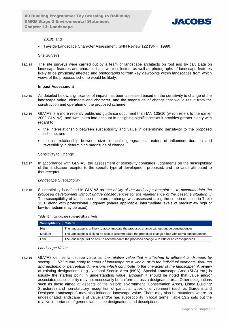
13.2.18 Susceptibility is defined in GLVIA3 as ‘the ability of the landscape receptor … to accommodate the proposed development without undue consequences for the maintenance of the baseline situation…’ The susceptibility of landscape receptors to change was assessed using the criteria detailed in Table 13.1, along with professional judgment (where applicable, intermediate levels of medium-to- high or low-to-medium may be used).
Table 13.1: Landscape susceptibility criteria
Susceptibility Criteria
High The landscape is unlikely to accommodate the proposed change without undue consequences.
Medium The landscape is likely to be able to accommodate the proposed change albeit with some consequences.
Low The landscape will be able to accommodate the proposed change with little or no consequences.
Landscape Value
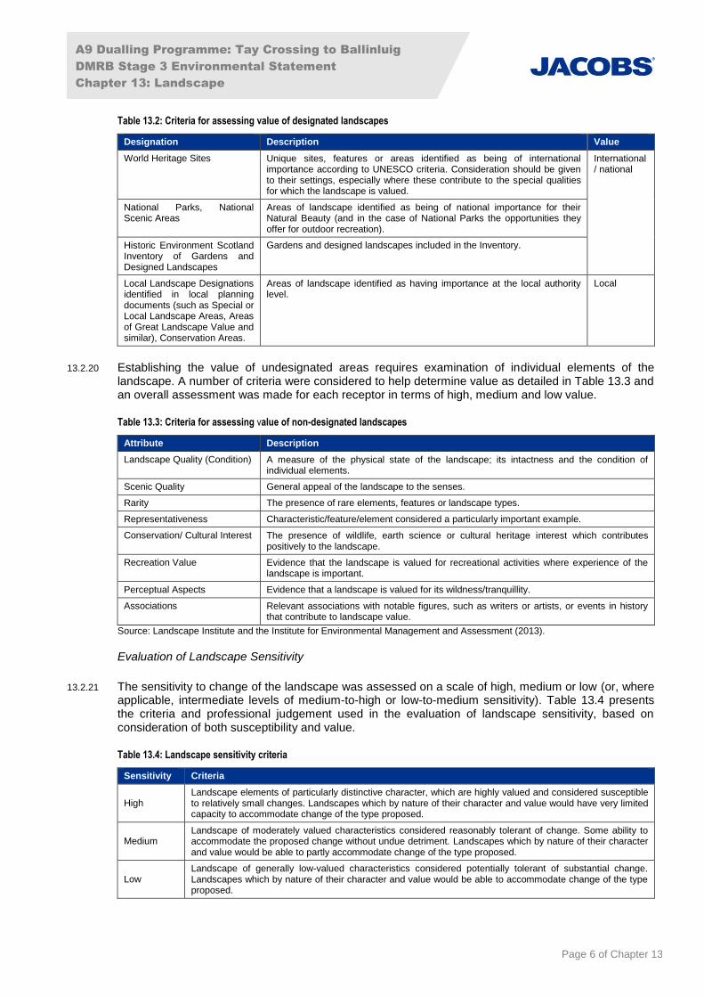
13.2.19 GLVIA3 defines landscape value as ‘the relative value that is attached to different landscapes by society…’. ‘Value can apply to areas of landscape as a whole, or to the individual elements, features and aesthetic or perceptual dimensions which contribute to the character of the landscape’. A review of existing designations (e.g. National Scenic Area (NSA), Special Landscape Area (SLA) etc.) is usually the starting point in understanding value, although it should be noted that value and/or associated susceptibility may not necessarily be uniform across a designated area. Other designations such as those aimed at aspects of the historic environment (Conservation Areas, Listed Building/ Structures) and non-statutory recognition of particular types of environment (such as Gardens and Designed Landscapes) may also influence landscape value. There may also be situations where an undesignated landscape is of value and/or has susceptibility in local terms. Table 13.2 sets out the relative importance of generic landscape designations and descriptions.
A9 Dualling Programme: Tay Crossing to Ballinluig
DMRB Stage 3 Environmental Statement
Chapter 13: Landscape
Page 6 of Chapter 13
Table 13.2: Criteria for assessing value of designated landscapes
Designation Description Value
World Heritage Sites Unique sites, features or areas identified as being of international importance according to UNESCO criteria. Consideration should be given to their settings, especially where these contribute to the special qualities for which the landscape is valued.
International/ national
National Parks, National Scenic Areas
Areas of landscape identified as being of national importance for their Natural Beauty (and in the case of National Parks the opportunities they offer for outdoor recreation).
Historic Environment Scotland Inventory of Gardens and Designed Landscapes
Gardens and designed landscapes included in the Inventory.
Local Landscape Designations identified in local planning documents (such as Special or Local Landscape Areas, Areas of Great Landscape Value and similar), Conservation Areas.
Areas of landscape identified as having importance at the local authority level.
Local
13.2.20 Establishing the value of undesignated areas requires examination of individual elements of the landscape. A number of criteria were considered to help determine value as detailed in Table 13.3 and an overall assessment was made for each receptor in terms of high, medium and low value.
Table 13.3: Criteria for assessing value of non-designated landscapes
Attribute Description
Landscape Quality (Condition) A measure of the physical state of the landscape; its intactness and the condition of individual elements.
Scenic Quality General appeal of the landscape to the senses.
Rarity The presence of rare elements, features or landscape types.
Representativeness Characteristic/feature/element considered a particularly important example.
Conservation/ Cultural Interest The presence of wildlife, earth science or cultural heritage interest which contributes positively to the landscape.
Recreation Value Evidence that the landscape is valued for recreational activities where experience of the landscape is important.
Perceptual Aspects Evidence that a landscape is valued for its wildness/tranquillity.
Associations Relevant associations with notable figures, such as writers or artists, or events in history that contribute to landscape value.
Source: Landscape Institute and the Institute for Environmental Management and Assessment (2013).
Evaluation of Landscape Sensitivity
13.2.21 The sensitivity to change of the landscape was assessed on a scale of high, medium or low (or, where applicable, intermediate levels of medium-to-high or low-to-medium sensitivity). Table 13.4 presents the criteria and professional judgement used in the evaluation of landscape sensitivity, based on consideration of both susceptibility and value.
Table 13.4: Landscape sensitivity criteria
Sensitivity Criteria
High Landscape elements of particularly distinctive character, which are highly valued and considered susceptible to relatively small changes. Landscapes which by nature of their character and value would have very limited capacity to accommodate change of the type proposed.
Medium Landscape of moderately valued characteristics considered reasonably tolerant of change. Some ability to accommodate the proposed change without undue detriment. Landscapes which by nature of their character and value would be able to partly accommodate change of the type proposed.
Low Landscape of generally low-valued characteristics considered potentially tolerant of substantial change. Landscapes which by nature of their character and value would be able to accommodate change of the type proposed.
A9 Dualling Programme: Tay Crossing to Ballinluig
DMRB Stage 3 Environmental Statement
Chapter 13: Landscape
Page 7 of Chapter 13
Magnitude
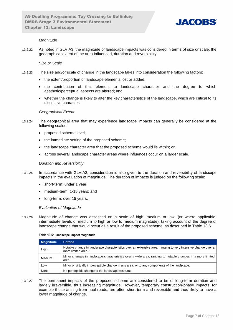
13.2.22 As noted in GLVIA3, the magnitude of landscape impacts was considered in terms of size or scale, the geographical extent of the area influenced, duration and reversibility.
Size or Scale
13.2.23 The size and/or scale of change in the landscape takes into consideration the following factors:
the extent/proportion of landscape elements lost or added;
the contribution of that element to landscape character and the degree to which aesthetic/perceptual aspects are altered; and
whether the change is likely to alter the key characteristics of the landscape, which are critical to its distinctive character.
Geographical Extent
13.2.24 The geographical area that may experience landscape impacts can generally be considered at the following scales:
proposed scheme level;
the immediate setting of the proposed scheme;
the landscape character area that the proposed scheme would lie within; or
across several landscape character areas where influences occur on a larger scale.
Duration and Reversibility
13.2.25 In accordance with GLVIA3, consideration is also given to the duration and reversibility of landscape impacts in the evaluation of magnitude. The duration of impacts is judged on the following scale:
short-term: under 1 year;
medium-term: 1-15 years; and
long-term: over 15 years.
Evaluation of Magnitude
13.2.26 Magnitude of change was assessed on a scale of high, medium or low, (or where applicable, intermediate levels of medium to high or low to medium magnitude), taking account of the degree of landscape change that would occur as a result of the proposed scheme, as described in Table 13.5.
Table 13.5: Landscape impact magnitude
Magnitude Criteria
High Notable change in landscape characteristics over an extensive area, ranging to very intensive change over a more limited area.
Medium Minor changes in landscape characteristics over a wide area, ranging to notable changes in a more limited area.
Low Minor or virtually imperceptible change in any area, or to any components of the landscape.
None No perceptible change to the landscape resource.
13.2.27 The permanent impacts of the proposed scheme are considered to be of long-term duration and largely irreversible, thus increasing magnitude. However, temporary construction-phase impacts, for example those arising from haul roads, are often short-term and reversible and thus likely to have a lower magnitude of change.
A9 Dualling Programme: Tay Crossing to Ballinluig
DMRB Stage 3 Environmental Statement
Chapter 13: Landscape
Page 8 of Chapter 13
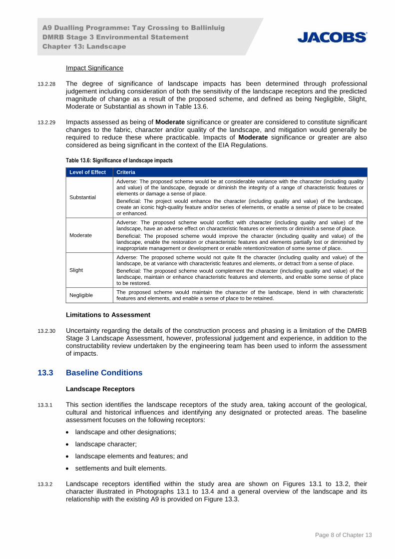
Impact Significance
13.2.28 The degree of significance of landscape impacts has been determined through professional judgement including consideration of both the sensitivity of the landscape receptors and the predicted magnitude of change as a result of the proposed scheme, and defined as being Negligible, Slight, Moderate or Substantial as shown in Table 13.6.
13.2.29 Impacts assessed as being of Moderate significance or greater are considered to constitute significant changes to the fabric, character and/or quality of the landscape, and mitigation would generally be required to reduce these where practicable. Impacts of Moderate significance or greater are also considered as being significant in the context of the EIA Regulations.
Table 13.6: Significance of landscape impacts
Level of Effect Criteria
Substantial
Adverse: The proposed scheme would be at considerable variance with the character (including quality and value) of the landscape, degrade or diminish the integrity of a range of characteristic features or elements or damage a sense of place.
Beneficial: The project would enhance the character (including quality and value) of the landscape, create an iconic high-quality feature and/or series of elements, or enable a sense of place to be created or enhanced.
Moderate
Adverse: The proposed scheme would conflict with character (including quality and value) of the landscape, have an adverse effect on characteristic features or elements or diminish a sense of place.
Beneficial: The proposed scheme would improve the character (including quality and value) of the landscape, enable the restoration or characteristic features and elements partially lost or diminished by inappropriate management or development or enable retention/creation of some sense of place.
Slight
Adverse: The proposed scheme would not quite fit the character (including quality and value) of the landscape, be at variance with characteristic features and elements, or detract from a sense of place.
Beneficial: The proposed scheme would complement the character (including quality and value) of the landscape, maintain or enhance characteristic features and elements, and enable some sense of place to be restored.
Negligible The proposed scheme would maintain the character of the landscape, blend in with characteristic features and elements, and enable a sense of place to be retained.
Limitations to Assessment
13.2.30 Uncertainty regarding the details of the construction process and phasing is a limitation of the DMRB Stage 3 Landscape Assessment, however, professional judgement and experience, in addition to the constructability review undertaken by the engineering team has been used to inform the assessment of impacts.
13.3 Baseline Conditions
Landscape Receptors
13.3.1 This section identifies the landscape receptors of the study area, taking account of the geological, cultural and historical influences and identifying any designated or protected areas. The baseline assessment focuses on the following receptors:
landscape and other designations;
landscape character;
landscape elements and features; and
settlements and built elements.
13.3.2 Landscape receptors identified within the study area are shown on Figures 13.1 to 13.2, their character illustrated in Photographs 13.1 to 13.4 and a general overview of the landscape and its relationship with the existing A9 is provided on Figure 13.3.
A9 Dualling Programme: Tay Crossing to Ballinluig
DMRB Stage 3 Environmental Statement
Chapter 13: Landscape
Page 9 of Chapter 13
Landscape and Landscape Related Designations
River Tay (Dunkeld) National Scenic Area (NSA)
13.3.3 The northern extent of the River Tay (Dunkeld) NSA partially covers the southern part of the study area and extends across the proposed scheme between ch0 and ch2800, as shown on Figure 13.1.
13.3.4 The River Tay (Dunkeld) NSA is characterised by its natural and semi-natural scenery and cultural influences, where the Highland features of rivers, straths and highlands are balanced with farmland, settlements and managed woodland across hills, and designed landscapes.
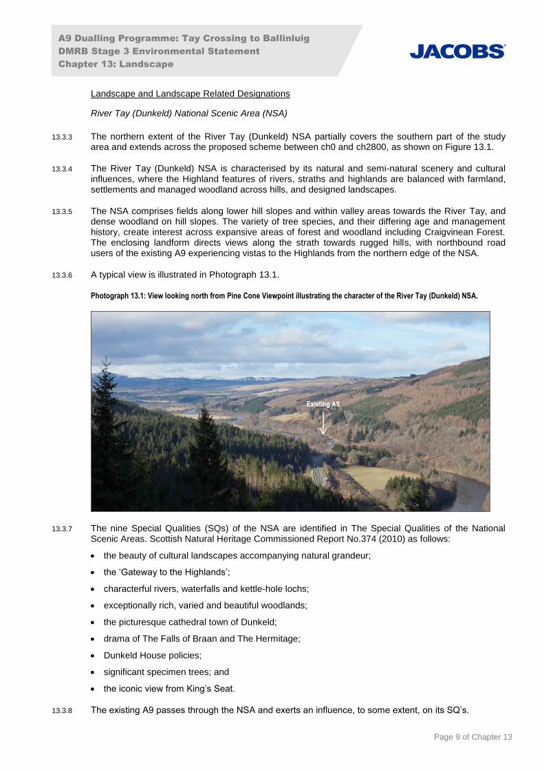
13.3.5 The NSA comprises fields along lower hill slopes and within valley areas towards the River Tay, and dense woodland on hill slopes. The variety of tree species, and their differing age and management history, create interest across expansive areas of forest and woodland including Craigvinean Forest. The enclosing landform directs views along the strath towards rugged hills, with northbound road users of the existing A9 experiencing vistas to the Highlands from the northern edge of the NSA.
13.3.6 A typical view is illustrated in Photograph 13.1.
Photograph 13.1: View looking north from Pine Cone Viewpoint illustrating the character of the River Tay (Dunkeld) NSA.
13.3.7 The nine Special Qualities (SQs) of the NSA are identified in The Special Qualities of the National Scenic Areas. Scottish Natural Heritage Commissioned Report No.374 (2010) as follows:
the beauty of cultural landscapes accompanying natural grandeur;
the ‘Gateway to the Highlands’;
characterful rivers, waterfalls and kettle-hole lochs;
exceptionally rich, varied and beautiful woodlands;
the picturesque cathedral town of Dunkeld;
drama of The Falls of Braan and The Hermitage;
Dunkeld House policies;
significant specimen trees; and
the iconic view from King’s Seat.
13.3.8 The existing A9 passes through the NSA and exerts an influence, to some extent, on its SQ’s.
Existing A9
A9 Dualling Programme: Tay Crossing to Ballinluig
DMRB Stage 3 Environmental Statement
Chapter 13: Landscape
Page 10 of Chapter 13
13.3.9 The NSA designation has been taken into account in the determination of the value, and the sensitivity to change of the Strath Tay: Mid Glen LLCA and Strath Tay: Upper Glen LLCA (assessed in Appendix 13.1).
13.3.10 An assessment of the impact on the SQs of the River Tay NSA resulting from the proposed scheme is provided in Appendix A13.2 (Special Qualities of the River Tay (Dunkeld) National Scenic Area).
Strath Tay Special Landscape Area (SLA)
13.3.11 The Strath Tay SLA is located to the west of the existing A9, extending along the valley of the River Tay and Loch Tay. The easternmost edge of the SLA lies approximately 1.2km away from the existing A9, and is enclosed by low hills adjacent to moorland plateau in the south, with higher hills to the north.
13.3.12 The Special Qualities (SQs) of the SLA are identified in Landscape Supplementary Guidance (PKC, 2015) as follows:
at the heart of Perth and Kinross, with a strong sense of place;
transition from the wooded and settled small-scale valley, to the surrounding open upland rising to the north;
the setting for historic settlements, castles and designed landscapes, as well as General Wade’s iconic bridge over the Tay and the famous Birks of Aberfeldy;
important east-west route, as well as a hub for tourism, sport and recreation; and
long-distance views to Schiehallion and Ben Lawers, contrasting with the more enclosed valley.
13.3.13 The key features of the SLA are generally contained within it by the surrounding hills, particularly to the north and south. From the eastern extent and from elevated parts of the SLA, there is limited visibility to the existing A9, with views largely dominated by the surrounding open valley and distinct peaks beyond.
13.3.14 The SLA contributes to the quality of the landscape character and in this regard has been considered in the determination of the value, and the sensitivity to change of the Strath Tay: Upper Glen LLCA (assessed in Appendix 13.1).
13.3.15 The existing A9 is not located within the SLA and has no bearing on the SQs of the designation. Where views are obtained from the SLA, the existing A9 appears as a distant minor element and thus has not been included within the assessment of indirect impacts. No visual receptors are located within the SLA.
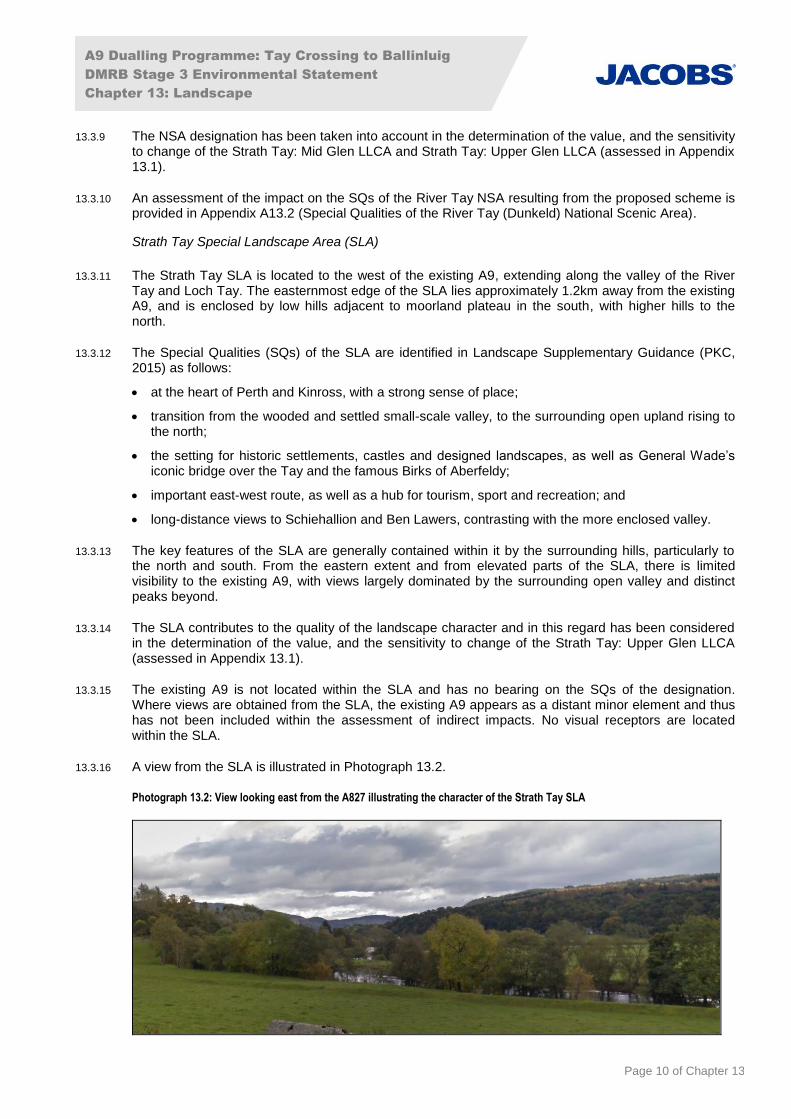
13.3.16 A view from the SLA is illustrated in Photograph 13.2.
Photograph 13.2: View looking east from the A827 illustrating the character of the Strath Tay SLA
A9 Dualling Programme: Tay Crossing to Ballinluig
DMRB Stage 3 Environmental Statement
Chapter 13: Landscape
Page 11 of Chapter 13
Landscape Character
13.3.17 Landscape character is described using Landscape Character Areas (LCAs) from the SNH Tayside Landscape Character Assessment: Scottish Natural Heritage Review 122 (1999) and Local Landscape Character Areas (LLCA’s), which were identified after review of the documents below and refined following field based assessment.
Landscape Study to Inform Planning for Wind Energy Final Report (David Tyldesley and Associates/Perth & Kinross Council, 2010);
Tayside Landscape Character Assessment: Scottish Natural Heritage Review 122 (Scottish Natural Heritage, 1999); and
A9 Dualling Programme. Strategic Environmental Assessment (SEA). Environmental Report Addendum. Appendix F – Strategic Landscape Review Report (Transport Scotland, 2014).
13.3.18 Eight Local Landscape Character Areas (LLCAs) and Landscape Character Areas (LCAs) have been identified within the study area. Two of the LLCAs, namely Strath Tay: Mid Glen LLCA and Strath Tay: Lower Glen LLCA, contain elements of the proposed scheme.
13.3.19 A summary of the key features of the baseline conditions of these character areas is provided below and an assessment of the impacts is provided in Section 13.6.
13.3.20 The proposed scheme would indirectly affect the six remaining character areas comprising:
Strath Tay: Dunkeld and Birnam (Settlement) LLCA;
Strath Tay: Upper Glen LLCA;
Strath Tummel LLCA;
Highland Foothills LCA;
Highland Glens LCA; and
Highland Summits and Plateaux LCA.
13.3.21 Detailed descriptions of the LCAs and LLCAs within the study area are provided in Appendix A13.1 (Landscape Character Areas/Local Landscape Character Areas) and their extents are shown on Figure 13.2.
13.3.22 An assessment of indirect impacts on the character areas is provided in Appendix A13.4 (Assessment of Residual Indirect Impacts on Landscape Character Areas).
Strath Tay: Mid Glen LLCA
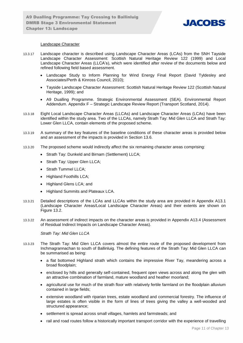
13.3.23 The Strath Tay: Mid Glen LLCA covers almost the entire route of the proposed development from Inchmagrannachan to south of Ballinluig. The defining features of the Strath Tay: Mid Glen LLCA can be summarised as being:
a flat bottomed Highland strath which contains the impressive River Tay, meandering across a broad floodplain;
enclosed by hills and generally self-contained, frequent open views across and along the glen with an attractive combination of farmland, mature woodland and heather moorland;
agricultural use for much of the strath floor with relatively fertile farmland on the floodplain alluvium contained in large fields;
extensive woodland with riparian trees, estate woodland and commercial forestry. The influence of large estates is often visible in the form of lines of trees giving the valley a well-wooded and structured appearance;
settlement is spread across small villages, hamlets and farmsteads; and
rail and road routes follow a historically important transport corridor with the experience of travelling
A9 Dualling Programme: Tay Crossing to Ballinluig
DMRB Stage 3 Environmental Statement
Chapter 13: Landscape
Page 12 of Chapter 13
through the open strath constrained by passes to the north and south a powerful narrative.
13.3.24 From the existing A9, a sequence of open and more enclosed views are experienced travelling through the LLCA. In open locations long distance views are obtained across the broad valley floodplain towards the River Tay and the distant hills wooded beyond. Remnants of former farmsteads and wall enclosures are visible and can be seen in fleeting views from the road due to the high speed of vehicles along the route. In many locations the existing A9 is enclosed by woodland and here views from the road are focussed on the road corridor.
13.3.25 An illustrative view of the character of the LLCA is provided in Photograph 13.3.
Photograph 13.3: View looking west from General Wade’s Military Road north of Warren Lodge, illustrating the character of the Strath Tay: Mid Glen LLCA
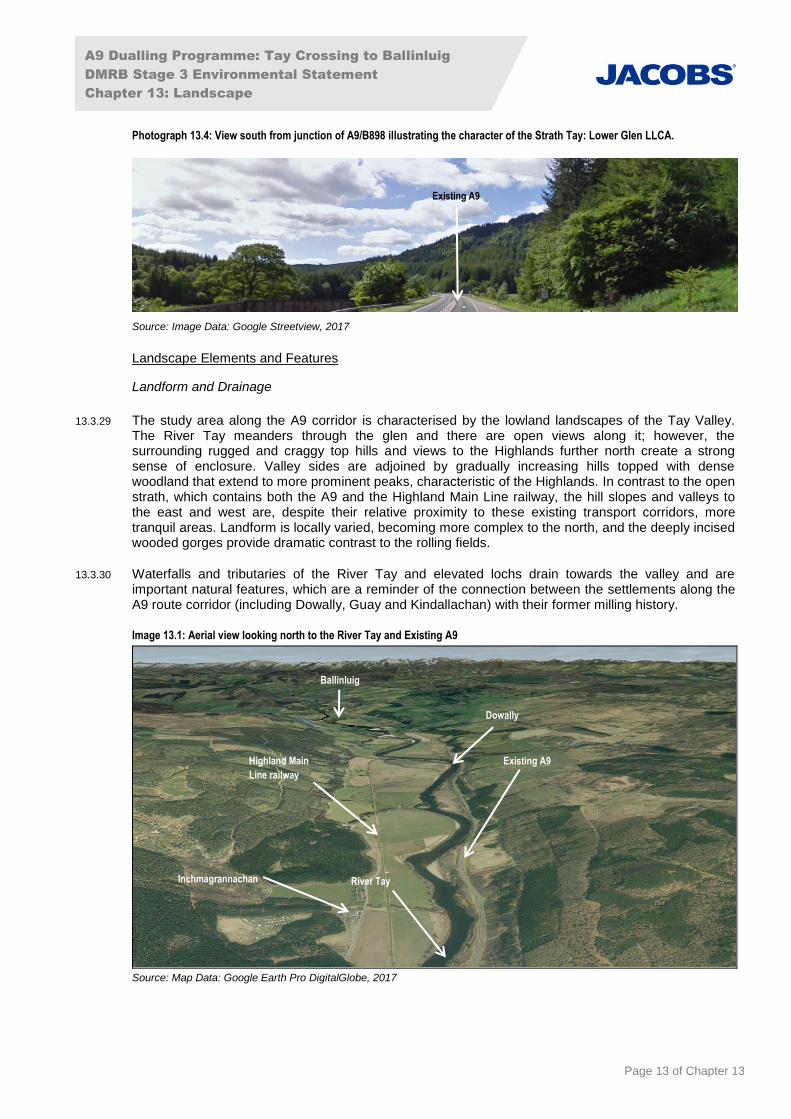
Strath Tay: Lower Glen LLCA
13.3.26 The Strath Tay: Lower Glen LLCA covers a short section of the existing A9 and the proposed scheme to the south of Inchmagrannachan. The defining features of the Strath Tay: Mid Glen LLCA can be summarised as being:
a classic lower Highland glen with a narrow valley and steeply sloping wooded hill sides;
extensive broad leaved and coniferous woodland dominates and emphasises the enclosed nature of the LLCA;
in some places the River Tay broadens out to meander through a fertile floodplain; and
well settled with a developed character due to the influence of farmland and large estates.
13.3.27 From the existing A9, views are generally limited by the enclosing steep sided hills and due to the high quality of the surrounding wooded landscape the views are frequently highly attractive. Long distance views to more distant hills are obtained along the glen and in more open locations such as the Tay Crossing. However, in many locations the existing A9 is enclosed by woodland and here views from the road are restricted and focussed on the road corridor.
13.3.28 An illustrative view of the character of the landscape is provided in Photograph 13.4.
Existing A9
A9 Dualling Programme: Tay Crossing to Ballinluig
DMRB Stage 3 Environmental Statement
Chapter 13: Landscape
Page 13 of Chapter 13
Photograph 13.4: View south from junction of A9/B898 illustrating the character of the Strath Tay: Lower Glen LLCA.
Source: Image Data: Google Streetview, 2017
Landscape Elements and Features
Landform and Drainage
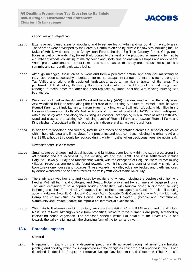
13.3.29 The study area along the A9 corridor is characterised by the lowland landscapes of the Tay Valley. The River Tay meanders through the glen and there are open views along it; however, the surrounding rugged and craggy top hills and views to the Highlands further north create a strong sense of enclosure. Valley sides are adjoined by gradually increasing hills topped with dense woodland that extend to more prominent peaks, characteristic of the Highlands. In contrast to the open strath, which contains both the A9 and the Highland Main Line railway, the hill slopes and valleys to the east and west are, despite their relative proximity to these existing transport corridors, more tranquil areas. Landform is locally varied, becoming more complex to the north, and the deeply incised wooded gorges provide dramatic contrast to the rolling fields.
13.3.30 Waterfalls and tributaries of the River Tay and elevated lochs drain towards the valley and are important natural features, which are a reminder of the connection between the settlements along the A9 route corridor (including Dowally, Guay and Kindallachan) with their former milling history.
Image 13.1: Aerial view looking north to the River Tay and Existing A9
Source: Map Data: Google Earth Pro DigitalGlobe, 2017
Highland Main
Line railway
River Tay
Existing A9
Inchmagrannachan
Dowally
Ballinluig
Existing A9
A9 Dualling Programme: Tay Crossing to Ballinluig
DMRB Stage 3 Environmental Statement
Chapter 13: Landscape
Page 14 of Chapter 13
Landcover and Vegetation
13.3.31 Extensive and varied areas of woodland and forest are found within and surrounding the study area. These areas were developed by the Forestry Commission and by private landowners including the 3rd Duke of Atholl, who created the Craigvinean Forest, the first ‘Big Tree Country’ forest. Craigvinean Forest is part of the wider Tay Forest Park located to the west of the proposed scheme and formed by a number of woods, consisting of mainly beech and Scots pine on eastern hill slopes and rocky peaks. Wide-spread woodland and forest is mirrored to the east of the study area, across hill slopes and summits and surrounding elevated lochs.
13.3.32 Although managed, these areas of woodland form a perceived natural and semi-natural setting as they have been successfully integrated into the landscape. In contrast, farmland is found along the Tay Valley and, along with designed landscapes, adds to the rich character of the area. The patchwork of fields along the valley floor was historically enclosed by treelines and hedgerows, although in recent times the latter has been replaced by timber post-and-wire fencing, blurring field boundaries.
13.3.33 Woodland included in the Ancient Woodland Inventory (AWI) is widespread across the study area. AWI woodland includes areas along the east side of the existing A9 south of Rotmell Farm, between Rotmell Farm and Kindallachan and from Haugh of Kilmorich to Ballinluig. Woodland identified in the Forestry Commission Scotland’s Native Woodland Survey of Scotland (NWSS) is also widespread within the study area and along the existing A9 corridor, overlapping in a number of areas with AWI woodland close to the existing A9, including south of Rotmell Farm and between Rotmell Farm and Kindallachan. Associated with this woodland is a diverse and attractive ground flora.
13.3.34 In addition to woodland and forestry, riverine and roadside vegetation creates a sense of enclosure within the study area and limits views from properties and road corridors including the existing A9 and the B898, although this would be reduced during winter months, when deciduous trees are not in leaf.
Settlement and Built Elements
13.3.35 Small scattered villages, individual houses and farmsteads are found within the study area along the A9 corridor and are accessed by the existing A9 and the B898. The main settlements include Dalguise, Dowally, Guay and Kindallachan which, with the exception of Dalguise, were former milling villages. Properties are generally found towards lower hill slopes and consist of mainly single- and two-storey stone houses and cottages. Those towards the valley edge are backed and partly enclosed by dense woodland and oriented towards the valley with views to the River Tay.
13.3.36 The study area was home to and visited by royalty and writers, including the Duchess of Atholl who lived at Rotmell Farm and Cottages, and Beatrix Potter who spent her summers at Dalguise House. The area continues to be a popular holiday destination, with tourism based businesses including Inchmagrannachan Farm Holiday Cottages, Kinnaird Estate cottages and Castle Peroch self-catering accommodation, Dowally Chalet and Caravan Park, Dowally Craft Centre, the May Murray Memorial Camp and Cuil-an-Duin Country House B&B. Refer to Chapter 8 (People and Communities: Community and Private Assets) for impacts on commercial businesses.
13.3.37 The main built elements within the study area are the existing A9 and B898 roads and the Highland Main Line railway. Although visible from properties, views to these elements are partly screened by intervening dense vegetation. The proposed scheme would run parallel to the River Tay in and towards the valley, aligning with the changing form of the terrain and river.
13.4 Potential Impacts
General
13.4.1 Mitigation of impacts on the landscape is predominantly achieved through alignment, earthworks, planting and seeding which are incorporated into the design as assessed and reported in this ES and described in detail in Chapter 4 (Iterative Design Development) and Chapter 5 (The Proposed
A9 Dualling Programme: Tay Crossing to Ballinluig
DMRB Stage 3 Environmental Statement
Chapter 13: Landscape
Page 15 of Chapter 13
Scheme). Key mitigation measures, such as limiting the extent of the cutting slopes, minimising loss of woodland, and the screening it provides, or the selection of the bridge structures are all embedded in the design. It is therefore not practicable to undertake an assessment of the potential landscape impacts of the construction and operation of the proposed scheme in the absence of mitigation.
13.4.2 This section therefore provides a brief summary of the types of impacts that could occur in the absence of mitigation during operation, and sets out potential temporary impacts during construction. It should be noted however that online widening of the proposed scheme would in itself reduce potential impacts to some degree. Impacts that occur during construction associated with the loss of landscape elements such as woodland, but which would be permanent are also considered in the assessment of operational landscape impacts.
Construction
13.4.3 Construction activities associated with road schemes would generally result in temporary adverse landscape impacts. The proposed scheme is likely to result in impacts on the landscape resource during construction as a result of:
removal of roadside woodland and scrub vegetation;
haulage routes and vehicles moving machinery and materials to and from the site;
machinery, potentially including heavy excavators and earth moving plant;
exposed bare earth over the extent of the proposed works;
structures, earthworks, road surfacing and ancillary works;
temporary soil storage heaps and stockpiles of construction materials;
lighting associated with night-time working and site accommodation;
temporary works associated with bridge construction operations; and
traffic management measures.
13.4.4 In general terms the most significant adverse landscape impacts during the construction period would be likely to occur when major structures and/or junctions and the associated earthworks are being erected or carried out. These features are labelled on Figure 5.1 (The Proposed Scheme) and would include the elements listed below. The A9 Southern Tie-in Interim Roundabout is envisaged as a temporary measure, although the length of time it will be in place cannot be confirmed at the time of writing, and therefore it has been included within the landscape assessment as a worst case scenario.
Large-scale earthworks along much of the route, particularly associated with large-scale cuttings into the hillside on the southbound side.
A9 Southern Tie-in Interim Roundabout and associated Pond A2 (construction of earthworks, cuttings, SuDS and Pond A2 Access Track) (ch500 to ch800).
River erosion control measures comprising a contiguous bored pile wall and rock revetment (ch1600 to ch1900).
Dunkeld to Rotmell (C502) Junction (construction of large-scale earthworks including cuttings, retaining walls and new left-in left-out junction) (ch3000 to ch3500), Basin C (construction of earthworks, SuDS and Basin C Access Track) (ch3900 to ch4050).
Guay South Overbridge, Dowally - Guay Link Road, Dowally Farm Access Track and Network Rail Access Track (construction of new left-in left-out junction and overbridge including large scale earthworks, Swales D1 and D2, Compensatory Flood Storage Areas 3, 4 and 5, Dowally Farm retaining wall and Dowally Burn culvert) (ch4150 to ch5200).
The Dowally to Kindallachan Side Road (construction of large-scale earthworks including cuttings, a retaining wall at Guay, a new bus turning facility at Dowally and parking at Guay Cottages) (ch4050 to ch5900).
Kindallachan Direct Access Road and adjacent Compensatory Flood Storage Areas 1 and 2 (construction of left-in left-out junction and flood storage with associated Pond E, Swale E and
A9 Dualling Programme: Tay Crossing to Ballinluig
DMRB Stage 3 Environmental Statement
Chapter 13: Landscape
Page 16 of Chapter 13
earthworks) (ch5350 to ch5900).
Kindallachan North Access Road and Haugh of Kilmorich Access Track (construction of large scale cuttings, access tracks and associated earthworks, Compensatory Flood Storage Area 6, Haugh of Kilmorich Retaining Wall and a left-in left-out junction) (ch6800 to ch7350).
Westhaugh of Tulliemet Access and hard-faced soil nailed slope (construction of access tracks, earthworks, Compensatory Flood Storage Area 7, Pond H and left-in left-out junction) (ch7300 to ch8200).
Operation
13.4.5 Potential operational impacts on the landscape resource in the absence of mitigation would result from the following:
Operation of the additional carriageways, junctions and side roads plus associated route infrastructure including structures, signage including Variable Message Signs and CCTV cameras, barriers, mammal fencing and other road furniture.
The change in the perception of landscape character, or on landscape settings, following physical and/or indirect impacts such as the loss of component parts of the landscape such as established woodland and perceived changes to existing views as a result of the proposed scheme.
Loss of woodland including AWI and NWSS woodland. Implications of loss of woodland in terms of ecology are provided in Chapter 12 (Ecology and Nature Conservation).
The alteration of vegetation patterns and field patterns as a result of tree loss, changes to field boundaries and stripping of groundcover vegetation and topsoil, followed by reinstatement and new planting.
The changed appearance of the landform along the road corridor as a result of large-scale earthworks and the potential requirement for reinforced slopes and/or retaining structures within the rural landscape.
The presence of new bridge structures across rivers, the widened A9 and side roads in addition to various small watercourse and minor road/access track underbridges.
The addition of a new retaining structure and rock revetment to combat erosion from the River Tay.
The presence of SuDS features.
Increased visual influence of traffic on the surrounding landscape due to widening and loss of screening elements.
13.4.6 A detailed description of the aspects/activities and associated impacts of the proposed scheme on the landscape resource is provided in Section 13.6 (Residual Impacts).
13.5 Mitigation
Introduction
13.5.1 This chapter makes reference to overarching standard measures applicable across A9 dualling projects (‘SMC’ mitigation item references), and also to project-specific measures (‘P03’ mitigation item references). Those that specifically relate to landscape are assigned an ‘LV’ reference.
13.5.2 The landscape mitigation measures that apply to all parts of the proposed scheme are described within the following paragraphs in Section 13.5. Location specific measures are illustrated on Figure 13.5 and described along with the impacts in Section 13.6 (Residual Impacts).
13.5.3 Landscape mitigation is concerned primarily with mitigation of likely significant adverse impacts.
13.5.4 Mitigation of these impacts falls into three categories:
prevention: avoidance of the loss of significant landscape elements through design of proposed scheme to achieve sensitive horizontal and vertical alignment;
A9 Dualling Programme: Tay Crossing to Ballinluig
DMRB Stage 3 Environmental Statement
Chapter 13: Landscape
Page 17 of Chapter 13
reduction: lessening of those adverse impacts that cannot be eliminated by prevention (e.g. roadside mounding and planting to integrate with surrounding landform and landscape); and
offsetting: provision of alternative or compensatory measures where appropriate and feasible (e.g. replacing woodland where appropriate).
13.5.5 The design of the landscape mitigation proposals has been developed in accordance with Fitting Landscapes: Securing more Sustainable Landscapes (Transport Scotland 2014), DMRB Volume 10 and Planning Advice Note (PAN) 1/2013: Environmental Impact Assessment (Scottish Government, 2013). In addition, programme-specific Strategic Environmental Design Principles contained in the A9 Dualling Programme SEA have been followed.
13.5.6 Fitting Landscapes requires that project specific landscape design objectives are developed to deliver the four key policy aims:
ensure high quality of design and place;
enhance and protect natural heritage;
use resources wisely; and
build in adaptability to change.
13.5.7 The project specific landscape design objectives are detailed in Appendix A13.5 (Landscape Objectives). These have been developed in consultation with statutory consultees including SNH.
A9 Dualling Programme: Strategic Environmental Design Principles
13.5.8 Developed in collaboration with SEPA, SNH, Historic Environment Scotland and the Cairngorms National Park Authority, the Strategic Environmental Design Principles have been considered through all stages of the design process.
13.5.9 Details of how the design has been developed to respond to each of the Strategic Environmental Design Principles - Landscape (SEDPLs) are presented in Appendix A13.4 of this chapter. The full range of Strategic Environmental Design Principles relating to the proposed scheme is listed in Appendix 2.1.
13.5.10 In line with SEDPLs 1 and 2 the proposed scheme and mitigation measures have been designed to respect the qualities and key characteristics of each LCA/LLCA along the route, including tying in with and reflecting existing vegetation patterns and landform and the planting of species typical of the area. In line with SEDPL 7, the landscape design as part of the proposed scheme has been developed to require low maintenance and to provide ‘flexibility’ to accommodate future changes in circumstances, for example to take opportunities for wildlife habitat enhancement or management.
13.5.11 Although the landscape and visual assessments address impacts in summer after 15 years of operation, in line with DMRB guidance and SEDPL 5, the landscape mitigation has been designed to take account of the longer term (beyond 25 years), with species selected to continue to mature and provide mitigation. The planting mixes are designed to include a range of understorey and edge species to ensure a balanced woodland structure, providing lower level screening once canopy species have matured. They include long lived and native species which are expected to naturally regenerate, hence ensuring longevity of woodland and scrub planting areas.
Consideration of the Special Qualities of River Tay (Dunkeld) NSA
13.5.12 An appraisal has been undertaken to inform the development of the mitigation proposals specifically in relation to the SQs of the River Tay (Dunkeld) NSA relevant to the proposed scheme and is included in Appendix A13.2 (Special Qualities of the River Tay (Dunkeld) NSA). The consideration of SQs of the River Tay (Dunkeld) NSA has informed the development of the Landscape Objectives set out in Appendix A13.5 (Landscape Objectives).
A9 Dualling Programme: Tay Crossing to Ballinluig
DMRB Stage 3 Environmental Statement
Chapter 13: Landscape
Page 18 of Chapter 13
Embedded Mitigation
13.5.13 The alignment of the proposed scheme has been developed through an iterative design process (initiated as part of the DMRB Stage 2 assessment), involving both engineering and environmental specialists. The process has comprised eight design iterations, each of which has been informed and reviewed by landscape specialists in order to reduce potential landscape (and visual impacts) and integrate the road with the surrounding landscape. These inputs have derived the following embedded mitigation measures:
the route alignment;
the form and extents of earthworks and the use of retaining structures along the length of the route; and
the location of SuDS.
13.5.14 These measures have been adopted in order to reduce potential impacts on sensitive landscape character receptors such as the landscape character unit through which the proposed scheme passes in addition to the River Tay (Dunkeld) NSA.
13.5.15 Further details of embedded mitigation are provided in Chapter 4 (Iterative Design Development). Further details of the alternative options considered at DMRB Stage 2 are provided in Chapter 3 (Alternatives Considered).
Standard Mitigation Commitments
13.5.16 During the construction phase, Standard Mitigation Commitments (SMCs) will be applied in order to mitigate potential impacts on landscape (and visual) receptors (Mitigation Items SMC-LV1 to SMC-LV7). These commitments have been developed for adoption across the A9 Dualling Programme and will be implemented in addition to Tay Crossing to Ballinluig project specific mitigation measures detailed below (Mitigation Items P03-LV8 to P03-LV22). Details of Mitigation Items SMC-LV1 to SMC-LV7 are provided in Table 13.8.
Table 13.8: Standard mitigation for Landscape
Construction Phase Standard Mitigation Items
Description
SMC-LV1 The construction programme will be kept to the minimum practicable time to reduce the duration of any landscape and visual impacts and areas will be cleared for construction as close as possible to works commencing and topsoiling, reseeding and planting shall be undertaken as soon as practicable after sections of work are complete.
SMC-LV2 As far as practicable, plant and material storage areas will be appropriately sited to minimise their landscape and visual impact.
SMC-LV3 Construction sites will be kept tidy (e.g. free of litter and debris).
SMC-LV4 Work during hours of darkness will be avoided as far as practicable, and where necessary, directed lighting will be used to minimise light pollution/glare. Lighting levels shall be kept to the minimum necessary for security and safety.
SMC-LV5 To protect soil quality for the purposes of landscape planting, the following measures will be implemented:
Uncontaminated topsoil for re-use shall be stored in un-compacted mounds no more than 2m in height, and stored separately from subsoil material. Topsoil stripped from areas designated as Ancient Woodland shall be stored separately to all other topsoil and sub-soil material, in un-compacted mounds no more than 2 m in height.
Stripped topsoil shall be used in areas of the same proposed vegetation type to utilise the existing natural seed bank.
Subsoil in planting areas shall be replaced after construction and ripped to a minimum of 450 mm prior to topsoiling and planting.
Proposed planting areas in existing arable and pasture land, not subject to construction activity, shall be ripped to 600 mm to alleviate compaction.
SMC-LV6 The construction shall be managed such that the loss of any existing woodland, scrub, heath, mire, grassland vegetation, marshland, swamps and isolated trees and shrubs not affected by the permanent works is minimised.

A9 Dualling Programme: Tay Crossing to Ballinluig
DMRB Stage 3 Environmental Statement
Chapter 13: Landscape
Page 19 of Chapter 13
Construction Phase Standard Mitigation Items
Description
SMC-LV7 All existing trees and shrubs not affected by the construction of the permanent works shall be fenced off with a suitable type of temporary fencing in accordance with BS5837. Fencing shall extend to the drip line of the tree canopies (unless otherwise agreed by an arboricultural advisor), and shall be erected prior to any construction activities in that area and shall remain for the entire period of construction in that area.
n/a (note) Further to the above, Mitigation items SMC-E7, SMC-E8, SMC-E9, SMC-E11 and SMC-E12 (as detailed in Table 12.10, Chapter 12 (Ecology and Nature Conservation)) will be implemented to protect breeding birds and vegetation which is identified to be retained.
13.5.17 Whilst these commitments will help to reduce impacts during the construction phase, it should be noted that construction impacts cannot be completely mitigated, due to the extensive construction works necessary.
Specific Mitigation
13.5.18 The specific mitigation measures regarding prevention, reduction and offsetting approaches were applied during the planning and design of the proposed scheme. These measures are described below and illustrated on Figure 13.5.
13.5.19 The measures have evolved from an iterative process between the environmental, landscape and design teams, with consideration given to design quality throughout the process.
13.5.20 Prevention measures include best fit of the proposed scheme with existing landform, avoiding loss or damage to landscape features such as water features or field systems and avoiding loss or damage to sites of ecological or archaeological interest, as described in Chapter 4 (Iterative Design Development). Measures designed to reduce and offset adverse impacts, are summarised below.
13.5.21 Details of where the mitigation measures have been applied within each LLCA directly impacted upon by the proposed scheme are set out in Section 13.6.
Earthworks
13.5.22 Earthworks proposals will aim to minimise the impact of cuttings and embankment slopes and to allow integration of the road with surrounding land (Mitigation Item P03-LV8) through:
use of retaining walls or engineered slopes where appropriate to avoid extensive cuttings into hill slopes or large embankments that ‘chase the slope’ and avoid the increase in the disturbance of the landscape;
where soil nailed cutting slopes are required on soft-faced slopes, slopes will be fully vegetated to reduce visual impacts. The soil nail heads will be recessed with mesh and nail heads/plates concealed from view. The design will include for sufficient topsoil depths in order to support the proposed planting and seeding, which will establish to cover the nail heads and any mesh that may be required;
where soil nailed cutting slopes are required on hard-faced slopes with acute angles which will not support vegetation, their aesthetic design will be carefully considered. The slope will be clad with patterned concrete panels which will mimic a battered retaining wall to aid integration within the surrounding landscape sensitive grading and profiling of all earthworks where possible to improve integration with the surrounding landform, modifying embankment and cutting slopes to reflect and tie smoothly into existing natural landform and to allow land to be returned to its previous use where appropriate;
softening changes in slope at junctions and overbridges by smoothing out transitions;
rounding off top and bottom of cuttings and embankments;
varying gradients along and across the length of the slopes; and
modification of earthworks around SuDS features in order to improve integration with surrounding landform.
A9 Dualling Programme: Tay Crossing to Ballinluig
DMRB Stage 3 Environmental Statement
Chapter 13: Landscape
Page 20 of Chapter 13
SuDS Features: Ponds, Basins and Swales
13.5.23 The initial design of the SuDS has been developed by drainage engineers in collaboration with landscape architects, ecologists, and hydrologists in order to take advantage of opportunities for improved amenity and biodiversity in addition to meeting the requirements for attenuation and treatment of runoff. The proposed SuDS features include ponds, basins and swales (as shown indicatively on Figure 13.5). The design will be refined further in order to integrate them into the landscape and maximise their amenity and biodiversity value at each specific location. As necessary to meet runoff treatment and water quality requirements, and where SuDS features are likely to be visible at close range, and where it is considered that they would fit well with the surrounding landscape and provide benefits to wildlife, ponds/basins have been proposed. In other locations, where ponds/basins are considered to be out of character or unlikely to offer opportunities to enhance visual amenity or biodiversity or where ponds/basins are not required for runoff treatment requirements, swales are proposed.
13.5.24 SuDS features required as part of the drainage system of the proposed scheme, provide the opportunity to create new beneficial features within the landscape and habitat for wildlife. Their design should comply with Appendix A13.7 (SuDS Design Principles) (Mitigation Item P03-LV9) and include the following:
where practicable they are sited within naturally low areas and designed to look as natural as possible;
their earthworks will be designed to integrate naturalistically with the surrounding landform. Abrupt changes in slope, sharp angles and steep side slopes will generally be avoided;
boundary fencing, where required around SuDS, will be designed to be as unobtrusive as possible;
planting of native tree and shrub species will help screen proposed fencing, outfall and inlet structures, enhance wildlife habitat and provide visual interest;
open ground in the areas around proposed SuDS features will be seeded with native grasses and wildflowers or heathland vegetation, as appropriate, to provide added wildlife habitat and visual interest; and
the margins of SuDS ponds/basins will be planted with native emergent and marginal plant species (e.g. greater bird’s-foot trefoil, yellow iris, white water-lily, purple-loosestrife and meadowsweet) to help integrate them with the surrounding landscape and enhance their visual amenity and wildlife value.
13.5.25 Further details of the approach to the design of SuDS features together with examples are provided in Appendix A13.7 (SuDS Design Principles).
Ecological/Compensatory Flood Storage Pond
13.5.26 An Ecological/Compensatory Flood Storage Pond will be created to the northwest of Kindallachan, to provide specific habitat for the Northern damselfly, following the general objective of enhancing biodiversity through landscape mitigation. Details of the approach to the design of the pond are provided in project specific Mitigation Item P03-E72 in section 12.5 of Chapter 12 (Ecology and Nature Conservation). The pond also provides compensatory flood storage for the proposed scheme.
Compensatory Flood Storage Areas
13.5.27 The Compensatory Flood Storage Areas will have the potential to be visually intrusive and alter the character of the landscape. Where practicable they will be returned to their former land cover/land use so that they blend in with the surrounding landscape. The use of retaining walls and ‘hard’ structures will be avoided and earthwork slopes slackened where practicable, to integrate with the surrounding landform (Mitigation Item P03-LV10).
Noise Barriers
13.5.28 Noise barriers have the potential to be visually intrusive when viewed from the existing A9 and surrounding properties. Where possible earth bunding will be used to provide noise attenuation in
A9 Dualling Programme: Tay Crossing to Ballinluig
DMRB Stage 3 Environmental Statement
Chapter 13: Landscape
Page 21 of Chapter 13
order to reduce potential impacts on landscape character and visual amenity. Where earth bunding is not a practical option, stone walling is considered to be the most appropriate form of noise barrier to integrate with the local landscape character. In locations where stone walling is not practicable and noise fencing is required, timber fencing or similar will be used with careful consideration given to the detailed design of the noise barriers and the use of planting considered in order to help screen the noise barriers from nearby visual receptors (Mitigation Item P03-LV11).
13.5.29 The locations of the five proposed noise barriers (at ch1500, ch2900, ch4100, ch5150 and ch5250) are shown on Figure 13.5. Under the Design and Build type contract for the proposed scheme, the detailed design of the noise mitigation measures will be undertaken by the Contractor responsible for the works.
Structures
13.5.30 The design of structures, such as bridges along the length of the proposed scheme and aspects of the landscape design, has been informed by specialist aesthetic advice and design meetings in order to reduce impacts on both landscape and visual receptors (Mitigation Item P03-LV12). While the measures to be adopted will be confirmed at the detailed design stage, mitigation will include measures such as a patterned or relief finish to sections of retaining wall and for bridges, carefully integrated abutments and/or refinement of the design process in order to achieve slender, elegant and well-proportioned structures.
Signage
13.5.31 The location, size and design of variable message, advanced direction and tourist information signs along the length of the proposed scheme and just beyond its extents, is largely dictated by road design standards. However, in some instances there may be scope to adjust the location to reduce their impact on the surrounding landscape. This will be undertaken at the detailed design stage and where practicable proposed new signs will be sited in areas of cutting and adjoining woodland to screen them from the surrounding landscape. Where practicable, the use of lattice supports to the signage will be avoided.
Woodland Planting
13.5.32 A series of Strategic Environmental Design Principles for woodland planting were developed as part of the SEA process. These comprise:
Wd1 - avoid loss of woodland functionality (connectivity) at a landscape scale;
Wd2 - avoid loss, damage, or fragmentation of ancient woodland inventory (AWI) sites;
Wd3 - restrict woodland edge clearance and include woodland edge impacts in the calculation of
compensatory habitat requirements;
Wd4 - compensation for ancient woodland losses should be of a scale, nature and location which is capable of delivering the woodland functionality being lost;
Wd5 - veteran trees and significant landscape trees should be identified and safeguarded, where possible; and
Wd6 - avoid tree planting on road side verges to limit opportunities for shelter [for fauna including deer].
13.5.33 Proposals relating to existing and new planting comprise of the following:
retention of existing trees and vegetation wherever possible and incorporation with new planting proposals (Mitigation Item P03-LV13);
planting to replace trees lost during construction, particularly in areas designated as ancient woodland (Mitigation Item P03-LV14);
enhancement of biodiversity through use of native species, providing new wildlife habitats and complementing existing adjacent habitats (Mitigation Item P03-LV15). Planting proposals have been developed in consultation with ecology specialists. Refer to Chapter 12 (Ecology and Nature
A9 Dualling Programme: Tay Crossing to Ballinluig
DMRB Stage 3 Environmental Statement
Chapter 13: Landscape
Page 22 of Chapter 13
Conservation);
planting of woodland at junctions and bridges to help assimilate these elements into the surrounding landscape (Mitigation Item P03-LV16);
planting to provide screening to reduce visual impacts of the road, structures and vehicle headlights (Mitigation Item P03-LV17); and
use of severed field corners and landlocked areas as appropriate (Mitigation Item P03-LV18).
13.5.34 Proposed planting mixes will be based on native species, proven by established presence within the local area and adapted to local conditions. The planting will be monitored for a minimum of five years after construction with annual replacement of any failed planting with stock of a suitable age so as to achieve full establishment and the required level of mitigation/impact reduction by summer 15 years after opening (Mitigation Item P03-LV19).
13.5.35 National Vegetation Classification (NVC), which is used to describe and categorise the vegetation covering land in Great Britain, will inform the selection of plant species. The following NVC woodland types have been identified as being appropriate to the proposed scheme:
W4 birch woodland with purple moor-grass;
W6 alder woodland with common nettle;
W7 alder – ash woodland with yellow pimpernel;
W8 lowland mixed broadleaved woodland with dog’s mercury;
W9 upland mixed broadleaved woodland with dog’s mercury;
W11 upland oak – birch woodland with bluebell/wild hyacinth;
W17 upland oak – birch woodland with blaeberry; and
W18 Scots pine woodland with heather.
13.5.36 Localised variations of these communities, and appropriate sub‐communities, will be required to fit with specific site conditions. Appropriate understorey and ground-cover planting will be included with the woodland.
13.5.37 Young stock is generally easier to establish and will therefore be predominant in mixes, with a smaller proportion of woodland mixes (typically 5-10%) comprising feathered trees. An increased percentage of feathered trees will be used for initial effect in specific locations, for example in close proximity to visual receptors where early screening is required and at locations where there is a need to help integrate structures into the landscape.
13.5.38 Planting will also assist integration with the local landscape character by using species mixes and planting patterns typical of the local landscape. This will also enhance the experience of travelling along the proposed scheme by creating views of a variety of woodland types. Details of the typical planting structure are shown on Figure 13.7. This takes account of aspects such as natural woodland characteristics typical in the locality, designed landscape features and other requirements such as avoiding creation of tree canopies close to the road. More specific details for each type of planting are specified below.
13.5.39 In total, it is estimated that approximately 16.56ha of woodland (of which 6.35ha is verified AWI woodland) will be lost during construction of the proposed scheme. 18.14ha of new woodland planting is proposed (of which 8.88ha will be for AWI woodland compensation).
Mixed Woodland Planting
13.5.40 Proposed Mixed Woodland planting for visual screening purposes, will comprise plants which range in size from feathered trees to whips and transplants. This will aim to create multi-layered woodland with a balanced mix of native deciduous and coniferous trees, including understorey. The balance between deciduous and evergreen species will be varied to achieve year-round screening and reflect existing woodland local to the various sections of the proposed scheme. The coniferous species within the
A9 Dualling Programme: Tay Crossing to Ballinluig
DMRB Stage 3 Environmental Statement
Chapter 13: Landscape
Page 23 of Chapter 13
mixed woodland will be predominantly Scots pine, with smaller proportions of yew and juniper, reflecting surrounding woodlands and providing a strong evergreen framework and a habitat for red squirrels.
13.5.41 A typical species mix to be used for Mixed Woodland will include Scots pine, downy birch and pedunculate oak with smaller proportions of sessile oak, alder, wych elm, holly, aspen, silver birch, grey willow, hazel, blackthorn, bird cherry and rowan.
Riparian Woodland Planting
13.5.42 Riparian Woodland is to be planted adjacent to watercourses and proposed retention ponds and in other areas along flood plains. It will comprise a mix of sizes of plants such as feathered trees, whips and transplants using wetland species such as birch, willow and alder.
13.5.43 A typical species mix to be used for Riparian Woodland would include downy birch, aspen and hazel with smaller proportions of alder, white willow, eared willow, goat willow and grey willow.
Scrub Planting
13.5.44 Proposed scrub planting will comprise native species of local provenance creating a dense medium height canopy. This mix will be used in areas where a lower height plant cover is more appropriate than the taller woodland mixes.
13.5.45 A typical species mix to be used for scrub will include hawthorn, blackthorn, juniper and wild cherry with smaller proportions of blaeberry, heather, bell heather, guelder-rose, dog-rose and elder.
Individual Standard Trees
13.5.46 Groups of individual trees and tree lines will comprise appropriately sized trees in informal or formal groupings to reflect the character of existing landscapes, mitigate for lost landscape features, maintain habitat connectivity and provide screening or to filter views of the proposed scheme. Typical species to be used will include Scots pine, silver birch, rowan, wych elm and pedunculate oak.
Grass Seeding
13.5.47 For all disturbed soft areas and road verges, different seed mixes will be used, dependent on location and use (Mitigation Item P03-LV20), as suggested below:
Visibility Splay Mix: suited for use in road verges and other areas where grass needs to be kept short for forward visibility, being low-maintenance, fast-establishing and tolerant of traffic and salt spray.
Species-rich Grassland Mix: suited for use in all other areas disturbed by construction works, consisting of a mixture of native, non-invasive grasses and wildflower species to reflect locally occurring semi-natural flora. As well as enhancing biodiversity and visual interest along the proposed scheme, this type of grassland will require minimal maintenance. Example wild flower species of local provenance, which will provide an added benefit of a nectar rich plant source, include common bird’s-foot trefoil, greater bird’s-foot trefoil, devil’s-bit scabious, wild thyme, meadow buttercup and oxeye daisy. Appropriate mixes could be neutral, calcareous, dry, wet, highland or lowland and should be developed further for the specific location and conditions at detailed design stage.
Wetland Grassland Mix: suited for use in SuDS and areas around culverts that are likely to experience wet conditions. Example species of local provenance, which would have the added benefit of providing an invertebrate food or structural plant and will be selected appropriate to local conditions at detailed design stage, may include greater bird’s-foot trefoil, common knapweed, devil’s-bit scabious, sneezewort, meadowsweet and lesser spearwort.
Proposed Planting relating to Road Users
13.5.48 Planting will be applied within the road corridor in order to enhance the experience of travelling along
A9 Dualling Programme: Tay Crossing to Ballinluig
DMRB Stage 3 Environmental Statement
Chapter 13: Landscape
Page 24 of Chapter 13
the proposed scheme by maintaining important open views and creating views to a variety of woodland types. The species composition of such planting will take account of aspects such as natural woodland characteristics typical in the locality and designed landscape features (Mitigation Item P03-LV21).
Proposed Habitat Creation for Ecological Mitigation
13.5.49 In addition to following the general objective of enhancing biodiversity through the landscape mitigation, more detailed habitat creation proposals are provided in Chapter 12 (Ecology and Nature Conservation).
Lighting
13.5.50 Refer to Chapter 14 (Visual) for details of mitigation measures necessary to reduce the landscape and visual impacts of the proposed lighting (Mitigation Item P03-LV22).
13.6 Residual Impacts
13.6.1 Residual impacts are those that remain once the described mitigation measures have been implemented.
13.6.2 The assessment of the residual direct impacts on each LLCA resulting from the construction and operation of the proposed scheme is provided below. A separate assessment of residual, indirect impacts on landscape character areas is provided in Appendix A13.4 (Assessment of Residual Indirect Impacts on Landscape Character Areas). The assessment provided in Appendix A13.4 determined that the proposed scheme would not result in any significant indirect landscape impacts on any LCAs remote from the proposed scheme.
Assessment of Impacts on Landscape Character Areas (Direct Impacts)
General
13.6.3 The following section provides an assessment of the residual impacts on the LLCAs which would experience direct, physical impacts on their defining elements and features as a result of the proposed scheme. Two LLCAs would be directly impacted, these are the Strath Tay: Mid Glen LLCA, which covers the majority of the proposed scheme (ch570 to ch8200) and the Strath Tay: Lower Glen LLCA which covers a short section to the south of the proposed scheme (ch0 to ch570).
13.6.4 A detailed description of the impacts on these LLCAs is provided below. The sensitivity to change associated with the proposed scheme for each LLCA is provided in Appendix A13.1 (Landscape Character Areas).
13.6.5 An indication of the profile of the landform and the nature of earthworks and planting are provided in the mitigation plans on Figures 13.5 and cross sections on Figures 13.6 whilst individual features are labelled on Figure 5.1 (The Proposed Scheme).
13.6.6 A combination of wirelines and photomontages prepared for the proposed scheme are provided on Figure 14.5 to Figure 14.16. The photomontages provide indicative views of the proposed scheme once mitigation planting and seeding has become established.
Strath Tay: Mid Glen LLCA
13.6.7 The proposed scheme falls mostly within the Strath Tay: Mid Glen LLCA and would result in direct physical impacts on the elements and features which define the LLCA. These impacts would result from aspects of the proposed scheme including:
The proposed online widening of the existing A9 along the southbound carriageway plus associated cuttings and embankments, resulting in physical changes to the local landform and the loss of roadside woodland (ch570 to ch8200).
A9 Dualling Programme: Tay Crossing to Ballinluig
DMRB Stage 3 Environmental Statement
Chapter 13: Landscape
Page 25 of Chapter 13
Construction of the A9 Southern Tie-in Interim Roundabout and associated Pond A2 and lighting columns at the southern end of the scheme (ch570 to ch700).
The formation of a steep visually prominent cutting to the west of Woodlands (ch600 to ch950).
The construction of Fishing Bothy 1 Access Track resulting in a loss of woodland, earthworks and a retaining wall (ch900 to ch1000).
The formation of a steep visually prominent cuttings from south of Ledpetty Lodge to north of Warren Lodge resulting in a loss of woodland (ch1200 to ch2100).
The formation of a contiguous bored pile wall and rock revetment to control river erosion (ch1600 to ch1900).
The construction of Fishing Bothy 2 Access Track resulting in a loss of woodland and associated earthworks (ch2800).
The formation of the left-in left-out Dunkeld to Rotmell (C502) Junction including steep visually prominent cuttings, retaining walls and a resultant loss of woodland (ch2900 to ch3600).
The construction of Basin C including earthworks and an access track with a resultant loss of agricultural land (ch3900 to ch4050).
Construction of the Guay South Overbridge, the Dowally - Guay Link Road and a new left-in left-out junction, the Dowally Farm Access Track and the Network Rail Access Track including large scale earthworks, Swales D1 and D2, Compensatory Flood Storage Areas 3, 4 and 5, the Dowally Farm retaining wall and Dowally Burn culvert and a resultant loss of agricultural land (ch4150 to ch5200).
Formation of the Dowally to Kindallachan Side Road including large-scale earthworks and cuttings, retaining walls at Guay and south of Kindallachan, a combined bus stop and car park facility at Dowally and parking at Guay Cottages. The construction will result in the loss of a substantial amount of AWI woodland to the north of Dowally (ch4300 to ch5000), the loss of farmland, a prominent coniferous shelter belt at Guay and the demolition of Guay Farm Cattle Shed and partial demolition of the Wing of Guay Farmhouse (ch5000 to ch5300) and the loss of some woodland and farmland between Guay and Kindallachan (ch5300 to ch5900).
Kindallachan Direct Access Road with left-in left-out junction and adjacent Compensatory Flood Storage Areas 1 and 2 with Pond E and Swale E, associated earthworks and loss of agricultural land (ch5350 to ch5900).
Formation of an Ecological/Flood Compensatory Storage Pond including earthworks and loss of agricultural land (ch6400).
Formation of Kindallachan North Access Road, including cuttings, earthworks and loss of AWI woodland (ch6800).
Construction of the new Haugh of Kilmorich Access Track with a left-in left-out junction and associated loss of roadside vegetation and agricultural land (ch7000 to ch7200).
Formation of Westhaugh of Tulliemet Access including a left-in left-out junction, Compensatory Flood Storage Area 7 and earthworks with an associated loss of farmland (ch7500 to ch7700), and a visible section of steep hard-faced soil nailed slope along the southbound carriageway (ch7300 to ch7700).
Realignment of Cuil-An-Duin Access Road including prominent cuttings, earthworks and loss of AWI woodland and the introduction of a SuDS pond resulting in the loss of agricultural land (ch7900 to ch8200).
Formation of a new Kindallachan to Ballinluig footpath including cuttings, earthworks and loss of AWI woodland (ch6700 to ch7900).
The construction of Pond H including earthworks with a resultant loss of agricultural land and a new retaining wall along the southbound carriageway at Inch Cottage (ch7960 to ch8220).
Introduction of noise barriers at Ledpetty Lodge (ch1500 to ch1550), St Colme’s (ch2900 to ch3000) a stone and mortar wall at Dowally (ch4030 to ch4250) and at two locations in Guay (ch5150 to ch5300).
A9 Dualling Programme: Tay Crossing to Ballinluig
DMRB Stage 3 Environmental Statement
Chapter 13: Landscape
Page 26 of Chapter 13
Introduction of badger and otter resistant mammal fencing along much of the route of the proposed scheme (ch550 to ch1100, ch1400 to ch2500, ch3000 to ch3650, ch4150 to ch5450 and ch5900 to ch8300).
Introduction of signage along the road corridor, junctions and side roads, resulting in an increase in visible road infrastructure.
13.6.8 The sensitivity of the Strath Tay: Mid Glen LLCA associated with the proposed scheme has been assessed to be medium/high.
13.6.9 In the winter of the year of opening, the proposed scheme would result in a Moderate/Substantial impact on the Strath Tay: Mid Glen LLCA. This level of impact would be incurred as a result of a medium magnitude of change associated with the loss of defining features of the LLCA including:
Loss of areas of pasture and arable land at various locations along the length of the proposed scheme.
Modifications to the existing landform including visually prominent cuttings near Woodlands (ch650 to ch1050), at and north of Warren Lodge (ch1700 and ch1900 to 2150), Rotmell (ch3100 to ch3300), south of Guay (ch4700 to ch4950) and a prominent steep hard-faced soil nailed slope opposite Westhaugh of Tulliemet (ch7300 to ch7700).
The felling of roadside trees.
The staged construction of a contiguous bored pile wall and rock revetment to control river erosion which will result in the loss of woodland between the route and the river Tay (ch1600 to ch1900).
The loss of areas of mature woodland, including AWI woodland, particularly at Rotmell (ch2900 to ch3300) and to the north of Dowally (ch4600 to ch5000), and a loss of scrub and woodland to the east of Haugh of Kilmorich (ch7000 to ch7300).
The opening up of views towards the proposed scheme, particularly at Rotmell and Woodlands where long distance views to new cuttings will be obtained across the valley floor.
The introduction of prominent new vertical elements of road infrastructure within the rural landscape with local and long distance views obtained to the new Guay South Overbridge (ch4700).
The introduction of five SuDS ponds/basins and an Ecological/Compensatory Flood Storage Pond within the landscape.
The introduction of lighting columns associated with the A9 Southern Tie-in Interim Roundabout at ch650 which would be visible in local views as vertical elements within the rural landscape.
The introduction of night-time lighting associated with the A9 Southern Tie-in Interim Roundabout at ch650 into a relatively dark landscape.
13.6.10 These impacts on the LLCA would be mitigated by implementation of the proposed mitigation measures which include:
Retention of existing open and enclosed views, reflecting the contrasting character of the transitory experience within the LLCA, such as the retention of the open character at Woodlands (ch880 to ch990) (Mitigation Items P03-LV17, P03-LV21).
Retention of key views across the valley floor and linear views along the glen to the mountains beyond; (Mitigation Item P03-LV21).
Retention and protection of existing structural woodland and other landscape features as far as practicable (Mitigation Item P03-LV13).
Reinstatement of woodland by replacement planting, the species composition reflecting the lost areas of woodland such as woodland at Rotmell (ch3000 to ch3800) and at Haugh of Kilmorich (ch7000 to ch7300) (Mitigation Item P03-LV14).
Planting of location-specific woodland, the species mix proposed for areas of woodland reflecting the species composition of neighbouring woodland (Mitigation Item P03-LV19).
A9 Dualling Programme: Tay Crossing to Ballinluig
DMRB Stage 3 Environmental Statement
Chapter 13: Landscape
Page 27 of Chapter 13
the enhancement of biodiversity through use of predominantly native species, providing new wildlife habitats and complementing existing adjacent habitats (Mitigation Items P03-LV15 and P03-LV19).
Sensitive design of the Guay South Overbridge (ch4700) and the surrounding proposed planting structure to help integrate into the surrounding landscape and minimise its visual impact (Mitigation Items P03-LV12 and P03-LV16).
The introduction of retaining walls to lessen the amount of woodland loss and to improve landform integration such as at Rotmell (ch3100) (Mitigation Items P03-LV8 and P03-LV12).
Minimise the visual impact of soil nailing using detailed planting specification to disguise nail heads, such as at Guay (ch4750 to 4970) and at Kindallachan (ch6670 to ch7290) (Mitigation Item P03-LV8).
Minimise the visual impact of soil nailing on slopes with acute angles which would not support vegetation, by careful consideration of their aesthetic design. On the southbound carriageway near Westhaugh of Tulliemet (ch7300 to ch7700) patterned concrete panels will be used to mimic a battered retaining wall to aid integration within the surrounding landscape (Mitigation Item P03-LV8).
A ‘naturalistic’ design approach to SuDS detention basins, ponds and swales with associated riparian woodland and wet grassland, in order to promote biodiversity and improve integration into the receiving landscape (ch700 and ch3900) (Mitigation Item P03-LV9).
Return Compensatory Flood Storage Areas 1 and 2 to their former land cover/land use so that they blend in with the surrounding landscape. The use of retaining walls and ‘hard’ structures would be kept to the minimum necessary and earthwork slopes slackened where practicable to integrate with the surrounding landform (Mitigation Items P03-LV8 and P03-LV10).
The noise barrier at Dowally will be a mortared stone wall to match the local walling style and fit with the existing landscape character (Mitigation Item P03-LV11).
Special attention will be given to minimising the landscape impacts of the lighting columns and fixings to prevent unnecessary glare or light spill. Light Emitting Diodes (LEDs) or similar providing a directional light source with minimal light spillage would be used (Mitigation Item P03-LV22).
13.6.11 On establishment of the proposed mitigation measures in summer 15 years after opening and following the integration of the proposed scheme into the receiving landscape, the magnitude of change to the LLCA is predicted to reduce to low to medium. This reduction in the magnitude of change would result in a Moderate residual impact on the Strath Tay: Mid Glen LLCA.
Strath Tay: Lower Glen LLCA
13.6.12 A southern part of the proposed scheme falls within the Strath Tay: Lower Glen LLCA and would result in direct physical impacts and indirect impacts on the elements and features which define the LLCA. These impacts would result from aspects of the proposed scheme including:
The proposed online widening of the existing A9 along the southbound carriageway plus associated embankments, resulting in physical changes to the local landform and the loss of a small quantity of roadside vegetation (ch0 to ch570).
Introduction of Pond A1 and access track at the southern end of the scheme (ch200).
Introduction of otter fencing (ch540 to ch570)
Indirect impacts from the introduction of lighting associated with the A9 Southern Tie-in Interim Roundabout (ch650) within the Strath Tay: Mid Glen LLCA.
Introduction of signage along the road corridor, resulting in an increase in visible road infrastructure.
13.6.13 The sensitivity of the Strath Tay: Lower Glen LLCA associated with the proposed scheme has been assessed to be high.
13.6.14 In the winter of the year of opening, the proposed scheme would result in a Slight/Moderate impact on
A9 Dualling Programme: Tay Crossing to Ballinluig
DMRB Stage 3 Environmental Statement
Chapter 13: Landscape
Page 28 of Chapter 13
the Strath Tay: Lower Glen LLCA. This level of impact would be incurred as a result of a low magnitude of change associated with the loss of defining features of the LLCA including:
Loss of a small area of roadside vegetation along the southbound carriageway of the proposed scheme (ch0 to ch570).
The felling of some mature roadside trees at ch550 to ch570.
Minor modifications to the existing landform including earthworks.
The introduction of Pond A1 with associated earthworks and loss of woodland.
The opening up of views towards the proposed scheme, with adjacent infrastructure including the A9 Southern Tie-in Interim Roundabout, Pond A2 and cuttings visible.
The introduction of lighting columns associated with the A9 Southern Tie-in Interim Roundabout which will be seen in local views as minor vertical elements within the rural landscape.
The introduction of night-time lighting associated with the A9 Southern Tie-in Interim Roundabout into a relatively dark landscape.
13.6.15 These impacts on the LLCA would be mitigated by implementation of the proposed mitigation measures which include:
Retention of existing open and enclosed views, reflecting the generally enclosed character of the LLCA (Mitigation Items P03-LV17 and P03-LV21).
Retention of key views across the valley floor and linear views along the glen to the mountains beyond; (Mitigation Item P03-LV21).
Retention and protection of existing structural woodland and other landscape features as far as practicable (Mitigation Item P03-LV13).
Reinstatement of woodland by replacement planting, the species composition reflecting the lost trees (ch550 to ch570) (Mitigation Item P03-LV14).
The enhancement of biodiversity through use of native species, providing new wildlife habitats and complementing existing adjacent habitats (Mitigation Items P03-LV15 and P03-LV19).
Planting of location-specific woodland, the species mix proposed for areas of woodland reflecting the species composition of neighbouring woodland (Mitigation Item P03-LV19).
Planting of grassland on earthwork slopes to aid integration into the wider landscape. (Mitigation Item P03-LV20).
A ‘naturalistic’ design approach to SuDS ponds/basins with associated riparian woodland and wet grassland, in order to promote biodiversity and improve integration into the receiving landscape (ch200) (Mitigation Item P03-LV9).
Special attention will be given to minimising the landscape and visual impacts of the lighting columns and fixings and to prevent unnecessary glare or light spill. Light Emitting Diodes (LEDs) or similar providing a directional light source with minimal light spillage would be used (Mitigation Item P03-LV22).
13.6.16 On establishment of the proposed mitigation measures in summer 15 years after opening, following the integration of the proposed scheme into the receiving landscape the magnitude of change to the LLCA is predicted to reduce but would still be low. This magnitude of change would result in a Slight residual impact on the Strath Tay: Mid Glen LLCA.
13.7 Statement of Significance
13.7.1 The alignment of the proposed scheme along the much of existing A9 and implementation of mitigation measures, including the integration of earthworks into the surrounding landscape and woodland planting, would help to limit the magnitude of change and significance of impact of the road widening.
13.7.2 In the winter year of opening, the impacts on the Strath Tay: Mid Glen LLCA would be significant
A9 Dualling Programme: Tay Crossing to Ballinluig
DMRB Stage 3 Environmental Statement
Chapter 13: Landscape
Page 29 of Chapter 13
(Moderate/Substantial impacts). In the summer 15 years after opening, following establishment of the mitigation planting, impacts on the Strath Tay: Mid Glen LLCA would reduce, but remain significant (Moderate impacts).
13.7.3 There would be no significant impacts on the Strath Tay: Lower Glen LLCA, Strath Tay: Dunkeld and Birnam LLCA (Settlement), Strath Tay: Upper Glen LLCA, Strath Tummel LLCA, Highland Summits and Plateaux LCA, Highland Glens LCA and Highland Foothills LCA.
13.8 References
Highways Agency et al. (2009). Interim Advice Note (IAN) 125/09: Supplementary Guidance for Users of DMRB Volume 11 Environmental Assessment
Landscape Institute and the Institute for Environmental Management and Assessment (2013). Guidelines for Landscape and Visual Impact Assessment, 3rd edition (GVLIA3). Routledge.
Transport Scotland (2014). Fitting Landscapes: Securing more sustainable landscapes.
Scottish Executive (2013). Planning Advice Note (PAN) 1/2013: Environmental Impact Assessment.
Transport Scotland (2013). A9 Dualling Programme. Strategic Environmental Assessment (SEA) Report. TSSEA/PASS0.
Transport Scotland (2014). A9 Dualling Programme. Strategic Environmental Assessment (SEA). Report Addendum. Appendix B – Monitoring Framework – Design Section Restraints.
Transport Scotland (2014). A9 Dualling Programme. Strategic Environmental Assessment (SEA). Report Addendum. Appendix F – Strategic Landscape Review Report.
Historic Environment Scotland (1987) Inventory of Gardens and Designed Landscapes
David Tyldesley and Associates and Perth & Kinross Council (2010). Landscape Study to Inform Planning for Wind Energy: Final Report
Perth & Kinross Council (2015) Landscape Supplementary Guidance, 2015.
Land Use Consultants and STAR Development Group (2014). Perth & Kinross Council Local Landscape Designations Review.
Perth & Kinross Council (2000). Highland Area Local Plan 2000.
Perth & Kinross Council (2014). Perth & Kinross Council Local Development Plan.
TAYplan (2012). TAYplan: Scotland’s SusTAYnable Region. Strategic Development Plan 2012 – 2032.
Scottish Natural Heritage (2010). The Special Qualities of the National Scenic Areas. SNH Commissioned Report No.374.
Land Use Consultants (1999). Tayside Landscape Character Assessment. Scottish Natural Heritage Review No 122.
Highways Agency et al. (2010) Design Manual for Roads and Bridges Interim Advice Note 135/10
Landscape and Visual Effects Assessment, Highways Agency, Scottish Executive Development
Department, The National Assembly for Wales and The Department of Regional Development
Northern Ireland.