Some events and clues ion the history of the city of Fréjus Frejus.pdfThe town was victim of...
12
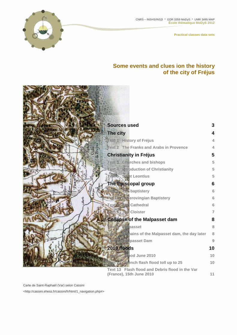
CNRS – INSHS/INS2I * GDR 3359 MoDyS * UMR 3495 MAP École thématique MoDyS 2012 Practical classes data sets Some events and clues ion the history of the city of Fréjus Sources used 3 The city 4 Text 1 History of Fréjus 4 Text 2 The Franks and Arabs in Provence 4 Christianity in Fréjus 5 Text 3 Churches and bishops 5 Text 4 Introduction of Christianity 5 Text 5 Saint Leontius 5 The Episcopal group 6 Text 6 The baptistery 6 Fig 1 A Merovingian Baptistery 6 Text 7 The Cathedral 6 Text 8 The Cloister 7 Collapse of the Malpasset dam 8 Text 9 Malpasset 8 Fig 2 Remains of the Malpasset dam, the day later 8 Text 10 Malpasset Dam 9 2010 floods 10 Text 11 Flood June 2010 10 Text 12 French flash flood toll up to 25 10 Text 13 Flash flood and Debris flood in the Var (France), 15th June 2010 11 Carte de Saint-Raphaël (Var) selon Cassini <http://cassini.ehess.fr/cassini/fr/html/1_navigation.php#>
-
Upload
dinhkhuong -
Category
Documents
-
view
213 -
download
0
Transcript of Some events and clues ion the history of the city of Fréjus Frejus.pdfThe town was victim of...
CNRS – INSHS/INS2I * GDR 3359 MoDyS * UMR 3495 MAP École thématique MoDyS 2012
Practical classes data sets
Some events and clues ion the history of the city of Fréjus
Sources used 3
The city 4
Text 1 History of Fréjus 4
Text 2 The Franks and Arabs in Provence 4
Christianity in Fréjus 5
Text 3 Churches and bishops 5
Text 4 Introduction of Christianity 5
Text 5 Saint Leontius 5
The Episcopal group 6
Text 6 The baptistery 6
Fig 1 A Merovingian Baptistery 6
Text 7 The Cathedral 6
Text 8 The Cloister 7
Collapse of the Malpasset dam 8
Text 9 Malpasset 8
Fig 2 Remains of the Malpasset dam, the day lat er 8
Text 10 Malpasset Dam 9
2010 floods 10
Text 11 Flood June 2010 10
Text 12 French flash flood toll up to 25 10
Text 13 Flash flood and Debris flood in the Var (France), 15th June 2010 11
Carte de Saint-Raphaël (Var) selon Cassini
<http://cassini.ehess.fr/cassini/fr/html/1_navigation.php#>

Fiche de données atelier cas concret / L’eau comme ressource
2 École thématique MODYS - CNRS INSHS/INSII GDR 3359 MoDyS UMR 3495 MAP Rése au ISA [JY Blaise I Dudek 09/2012 [email protected]]
Fiche de données atelier cas concret / L’eau comme ressource
3 École thématique MODYS - CNRS INSHS/INSII GDR 3359 MoDyS UMR 3495 MAP Rése au ISA [JY Blaise I Dudek 09/2012 [email protected]]
Sources used
[1] History of Fréjus http://en.wikipedia.org/wiki/Fr%C3%A9jus [03/10/2012]
[2] History of Provence http://en.wikipedia.org/wiki/History_of_Provence
[3] Introduction of Christianity http://en.wikipedia.org/wiki/Bishopric_of_Fr%C3%A9jus
[4] Saint Leontius http://en.wikipedia.org/wiki/Leontius_of_Fr%C3%A9jus
[5] The cathedral in Fréjus http://en.wikipedia.org/wiki/Fr%C3%A9jus_Cathedral
[6] Collapse of the dam in Malpasset http://en.wikipedia.org/wiki/Malpasset
[7] Remains of the dam, the day later http://frejus59.fr/malpasset-photos-inedites
[8] Fréjus http://www.beyond.fr/villages/frejus.html
[9] Malpasset dam http://www.beyond.fr/sites/malpasset.html
[10] BBC news Europe http://www.bbc.co.uk/news/10337433
[11] IMPRINTS http://imprints-fp7.eu/en/news/123-flash-flood-and-debris-flood-in-the-var-france-15th-june-2010
Fiche de données atelier cas concret / L’eau comme ressource
4 École thématique MODYS - CNRS INSHS/INSII GDR 3359 MoDyS UMR 3495 MAP Rése au ISA [JY Blaise I Dudek 09/2012 [email protected]]
The city
Text 1 History of Fréjus
In 49 B.C., Julius Caesar decided to have the Adrian Way built linking Italy with Spain. In those days the Phoenicians of Marseille had already set up a colony on the site, but it was the Roman emperor who gave the port its prosperity and the city its name of 'Forum Julii' meaning 'market of Julius;' he also named its port 'Claustra Maris' (The sea bolt). It went on to become one of the most important ports in the Mediterranean, until the Pax Romana, by denying Forum Julii its military activity, marked the beginning of its decline. The decay of Rome led to that of the cities of its empire. Between the 7th and the 9th centuries, Muslim invaders repeatedly raided the city. The sea encroached on the land while invasions by the Muslims and pirates left the monuments in ruin. By the 10th century there was very little left of the colony, mostly rubble.
[1] http://en.wikipedia.org/wiki/Fr%C3%A9jus
First record, Cited by Cicero, Strabon, Pline and Tacite. 1st-c BC: Forum Julii; 2nd-c: Forum Julium; 1035: de Frejurio; 1416: Frejus
Fréjus was founded in the first century BC. It was an important stop on the Aurelian way.
Around 30 BC, at the beginning of the Early Empire, Forum Julii became a colony for veterans of the 8th Legion. About the same time, Octavian brought here the ships he captured from Sextus Pompey at Actium, and began constructing the port. Fréjus became the second largest Roman port after Ostie, and remained a significant naval base until after the fall of Nero, around 69 AD.
Fréjus declined gradually until the 10th century, when it came under control of Bishop Riculphe, who founded the beginning of the "modern" town.
The town was victim of continuous barbarian raids.
In 1536, Charles-Quint invaded Fréjus.
Later in the 16th century, under King Henri II, Fréjus became the seat of the admiralty.
The town declined when the port began silting up, with population dropping from 6000 in the 17th century to 2000 in 1800.
[8] http://www.beyond.fr/villages/frejus.html
Text 2 The Franks and Arabs in Provence
Beginning in the 8th century, Provence became the frontier and battleground between the Frankish kings of the Merovingian Dynasty and the expanding new power in the Mediterranean world, the Arabs, called the Saracens by the French. The Frankish King, Charles Martel, defeated the Arabs at the Battle of Tours in 732 and kept them from advancing further north, but the Arabs remained a formidable power on the Mediterranean coast.
In 736 Arles and Marseille and other towns of western Provence rebelled against Charles Martel, and installed their own leader. Charles Martel invaded Provence and recaptured and punished the rebel towns. In 737 the cities of Provence rebelled again, this time calling for help from the Arabs. Once again Charles Martel sent an army to Provence, capturing Avignon and massacring a large part of the population. The rebellion broke out again in 739, and Charles Martel was forced to bring in Lombard warriors from Italy as allies to fight the Arabs and bring Provence under control […]
While Louis the Blind and Hugh had been occupied in Italy, the Muslim Saracens in Provence, had established a base on the coast, called Fraxinetum, near modern-day Saint-Tropez, from which they controlled the mountains of the Massif de Maures and the coast between modern Frejus and Hyeres.
clue 2 clue 1
clue 3
clue 4
clue 5
clue 6
clue 7
clue 8
clue 9
clue 10
clue 11
clue 12
clue 13
clue 14
clue 15
clue 16
clue 17
clue 18
Fiche de données atelier cas concret / L’eau comme ressource
5 École thématique MODYS - CNRS INSHS/INSII GDR 3359 MoDyS UMR 3495 MAP Rése au ISA [JY Blaise I Dudek 09/2012 [email protected]]
Between 900 and 910 and between 925 and 940 the Saracens raided throughout Provence. They usually avoided attacking walled towns but attacked isolated villas and monasteries. They raided from the Rhone as far east as the Italian riviera, to Albenga and St. Remo, and north to the Alpine valleys of Piemont, where they pillaged the monasteries of San Dalmazzo near Coni and Novalaise near Suse.
Louis the Blind made an attempt to expel the Saracens from Provence without success. Hugh of Italy enlisted the Byzantine fleet to blockade Fraxinetum, and was preparing an attack, when an uprising in Italy forced him to cancel his plans.
In 973, the Saracens captured Mayeul, the Abbot of the Monastery at Cluny, and held him for ransom. The ransom was paid and the abbot was released, Count William I, the Count of Arles, organized an army, with the help of allied soldiers from Piedmont, and defeated the Saracens near (La Garde-Freinet) at the Battle of Tourtour. The Saracens who were not killed at the battle were forcibly baptized and made into slaves, and the remaining Saracens in Provence fled the region. The expulsion of the Saracens in 973 became an epic event in the history and legends of Provence.
[2] http://en.wikipedia.org/wiki/History_of_Provence
Christianity in Frejus
Text 3 Churches and bishops
In the second quarter of the 3rd century the Christian Church in Rome began to send missionaries to evangelize Provence. By Catholic tradition, the first bishops in Provence were Trophimus of Arles and Paul of Narbonne. There were active churches and bishops in Arles in 254; Marseille in 314; Orange, Vaison and Apt in 314; Cavaillon, Digne, Embrun, Gap, and Fréjus at the end of the 4th century .
[2] http://en.wikipedia.org/wiki/History_of_Provence
Text 4 Introduction of Christianity
Christianity would seem to have been introduced into Fréjus in the time of Emperor Constantine. History relates that in 374 a certain Acceptus falsely declared himself guilty of some crimes in order to rid himself of the episcopal dignity, and that the Council of Valencia besought the Church to name another in his stead.
[some bishops]:
St. Leontius (419-433), brother of St. Castor and friend of John Cassian, who dedicated to him his first ten "Collationes", and of St. Honoratus, founder of the monastery of Lérins
Riculfus (973-1000), who restored the ruins made by the Saracens, and built the cathedral and the episcopal palace
[3] http://en.wikipedia.org/wiki/Bishopric_of_Fr%C3%A9jus
Text 5 Saint Leontius
Saint Leontius (French: Léonce de Fréjus) (ca. 419 – ca. 488) was a bishop of Fréjus. He was born probably at Nîmes, towards the end of the fourth century;
He died in his episcopal town in 488, according to some authorities, though others say 443 or even 448. His feast day is December 1.
The date of his Episcopal ordination is uncertain, but most likely it took place between the years 400 and 419; indeed the obscurity surrounding his life has not been entirely dissipated by the most conscientious labours of historians. It is however, indisputable that he was a man of eminent sanctity, and his episcopate was marked with important results, else he would not have been from an early date associated with the Blessed Virgin as patron of the cathedral church of Fréjus.
[4] http://en.wikipedia.org/wiki/Leontius_of_Fr%C3%A9jus
clue 20
clue 19
clue 21
clue 22
clue 23
clue 24
Fiche de données atelier cas concret / L’eau comme ressource
6 École thématique MODYS - CNRS INSHS/INSII GDR 3359 MoDyS UMR 3495 MAP Rése au ISA [JY Blaise I Dudek 09/2012 [email protected]]
The Episcopal group
Text 6 The baptistery
The oldest still-existing Christian structure in Provence is the baptistery of the cathedral in Fréjus, dating from the 5th century. […] The baptistery of Frejus Cathedral (5th century) is still in use.
[2] http://en.wikipedia.org/wiki/History_of_Provence
In the 13th century the baptistery was surrounded by a new wall, and the baptismal basin was covered over. It was rediscovered in the 1920s by Jules Formigé, the Inspector of French Historical Monuments, and the interior was restored during the 1930s to what he believed to be its original appearance.
[5] http://en.wikipedia.org/wiki/Fr%C3%A9jus_Cathedral
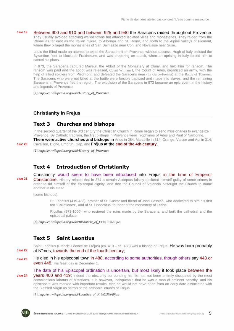
Figure 1 A Merovingian Baptistery
Cathédrale Saint-Léonce of Fréjus with its merovingian baptistery
[1] http://en.wikipedia.org/wiki/Fr%C3%A9jus
Text 7 The Cathedral
The cathedral contains two naves, one of which belonged to the bishop, and the other to the local parish, side by side under the same roof, separated by arches. An earlier church, from the same period as the baptistery, stood on the same site, some vestiges of which, including a mosaic floor, have been found under the old bell tower and nave of the present church.
It appears that the two naves of the present church were probably built at different times. The church of St. Étienne (Saint Stephen) was probably begun in the 11th century, and enlarged in the 12th century, and became the parish church of the city. It consisted of a long nave under a barrel vault ceiling, divided on the north side into four parts by lateral arcades resting on massive rectangular pillars.
clue 25
clue 26 clue 27 clue 28
clue 29
clue 30
clue 31
clue 32
Fiche de données atelier cas concret / L’eau comme ressource
7 École thématique MODYS - CNRS INSHS/INSII GDR 3359 MoDyS UMR 3495 MAP Rése au ISA [JY Blaise I Dudek 09/2012 [email protected]]
The south wall, which connected the church to the cathedral of Notre Dame, was reconstructed in the 12th century to add greater strength and support for the new arcades that were constructed. The marks of the stonemasons can still be seen on the vault of the third traverse. Many of the stones appear to have been taken from earlier buildings, either Roman or later.
The nave and choir of the cathedral of Notre Dame were built next, in the 13th century, against the south wall of the church of St. Étienne. The first part constructed was the porch and bell tower, at the western end of the nave, between the baptistery and the nave. This part of the church, like the residence of the bishop at the other end, had a strongly military appearance, as if to stress the power of the bishop in temporal as well as spiritual affairs.
[…] Once the cathedral's new nave had been built, larger arcades were built to open the wall between the two churches.
[5] http://en.wikipedia.org/wiki/Fr%C3%A9jus_Cathedral
Text 8 The Cloister
The cloister, which served as a place of meditation for the bishop and the dozen canons who served him, was built in the 13th century on the north side of the cathedral. It consists of pointed arches resting on double Corinthian columns. The decoration of the capitals of the columns features the key, the symbol of the bishops of Fréjus, and the fleur-de-lis, the symbol of Charles I of Anjou, the brother of Louis IX of France, (Saint Louis), who had become the Count of Provence in 1246.
[5] http://en.wikipedia.org/wiki/Fr%C3%A9jus_Cathedral
clue 33
clue 34
clue 35
Fiche de données atelier cas concret / L’eau comme ressource
8 École thématique MODYS - CNRS INSHS/INSII GDR 3359 MoDyS UMR 3495 MAP Rése au ISA [JY Blaise I Dudek 09/2012 [email protected]]
Collapse of the Malpasset dam
Text 9 Malpasset
Malpasset was an arch dam on the Reyran River, constructed approximately 7 km north of Fréjus on the Côte d'Azur, southern France, in the Var département. It collapsed on December 2, 1959, killing 421 people in the resulting flood. Various sources indicate death numbers of 361, 400, 423, 429 or 510.
The dam, which was a doubly curved equal angle arch type with variable radius, began construction in April 1952 and finished in 1954 to supply water and irrigation for the region. Another source reports that construction began as early as 1941.
The dam was breached at 21:13 on December 2, 1959. The entire wall collapsed with only a few blocks remaining on the right bank. Pieces of the dam are still scattered throughout the area. The breach created a massive dam break wave, or wall of water, 40 metres (130 ft) high and moving at 70 kilometres (43 mi) per hour, destroying two small villages - Malpasset and Bozon, the highway construction site, and in 20 minutes reaching Fréjus, still standing 3 metres (10 ft) high.
Geological and hydrologic studies were conducted in 1946 and the dam location was considered suitable. Due to lack of proper funding, however, the geological study of the region was not thorough. The lithology underlying the dam is a metamorphic rock called gneiss. This rock type is known to be relatively impermeable meaning that there is no significant groundwater flow within the rock unit, and it does not allow water to penetrate the ground. On the right side (looking down the river), was also rock, and a concrete wing wall was constructed to connect the wall to the ground.
Weeks before the breach, some cracking noises were observed, but they were not examined. It's hard to determine when the cracking noises started. The right side of the dam had some leaks in November 1959.
A tectonic fault was later found as the most likely cause of the disaster. The water collected under a wall, unable to escape through the rocks. The water pressure was aimed diagonally towards the dam wall, and was not found initially. According to a source, explosions during building of the highway might have caused shifting of the rock base of the dam.
Between November 19th and December 2nd, there was 50cm of rainfall, and 13cm in 24 hours before the breach. The water level in the dam was only 28cm away from the edge. Rain continued, and the dam guardian wanted to open the discharge valves, but the authorities refused, claiming the highway construction site was in danger by flooding water. 5 hours before the breach, at 18:00 hours, the water release valves were opened, but with a discharge rate of 40 m³/s, it was not enough to empty the reservoir in time.
[6] http://en.wikipedia.org/wiki/Malpasset
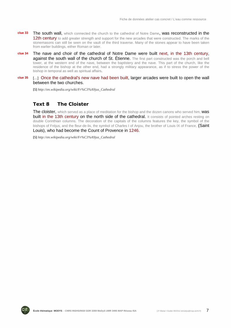
Figure 2 Remains of the Malpasset dam, the day later
[Photograph taken] l morning of December 3rd 1959 by Daniel Cabaret, an engineer working on the motorway construction site.
[7] http://frejus59.fr/malpasset-photos-inedites
clue 36
clue 37
clue 38
clue 39
clue 40
clue 41
clue 42
clue 43
clue 44
clue 45
clue 46
clue 47
Fiche de données atelier cas concret / L’eau comme ressource
9 École thématique MODYS - CNRS INSHS/INSII GDR 3359 MoDyS UMR 3495 MAP Rése au ISA [JY Blaise I Dudek 09/2012 [email protected]]
Text 10 Malpasset Dam
A bit a recent history of the region includes the disaster of the Malpasset dam (barrage de Malpasset), which broke on the night of 2 December 1959 and killed over 420 people, possibly even more than 500. On the map, the blue area above the dam was the "lake" area created by the dam. (The southern edge of the current Lac St Cassien is at the top edge of our map.) The blue area below the dam shows the area flooded when the dam broke.
"Malpasset" translates roughly to "passes badly" or "doesn't go very well". Although that turned out to be an appropriate name for the ill-fated dam, the area was really named after a local version of Robin Hood, one Gaspard de Besse who attacked all the passing stage coaches (diligences). He was said to take from the rich and give to the poor, although the rich could have been anyone with something worth stealing.
The Reyran river runs south about 15 km through the hills to Fréjus where it empties into the Mediterranean along with the Argens river. The Reyran is a mercurial river, completely dry during the hot summer months and a raging torrent in the winter and spring.
To tame the river and provide year-round agricultural water to the region, it was decided to build a dam in the valley about half way between Lac St Cassien (not yet a lake) and Fréjus. Geological studies were done in 1946, but even then there was some disagreement about the suitability of the land.
André Coyne was selected to build an arched dam (barrage-voûte) across the valley. He had already built similar dams in India, Marocco, Rhodesia and at Tignes and Bort-les-Orgues in France. An arched dam is arched in the upstream direction and isn't completely rigid, so the pressure of the water actually distorts the dam and forces the dam more tightly against the sides. This type of dam is extremely reliable, as long as the terrain at the sides and bottom is very solid.
Construction
The dam took 30 months (two and a half years) to build -- the Empire State building took just over a year. Started on April-fools day in 1952, the construction halted several times because of lack of funding and labor disputes, leaving long periods for parts of the cement to harden completely before work resumed and new cement was added. This could have resulted in a non-homogeneous structure.
Following the construction of the dam, the A8 autoroute was being built across the hills only 200 meters away. Local lore has it that the explosions ocurring to build the autoroute shifted the earth and rock at the dam. This could have loosened the critical attachment of the dam to the shoulders of the rock, precipitating the failure. The explosions could also have shifted the concrete within the dam itself, opening hollows or unseen cracks.
Extreme Weather
The dam was completed in December 1954,
and gradually filled up over the next five years.
With the autumn rains of November 1959, the water was still 7 meters below the top when small leaks were discovered along the right bank of the dam. The leaks grew rapidly, indicating a serious danger, but the population was not notified.
A tidal wave hit the Mediterranean coast on the 2nd of December, making the population nervous and expecting another tidal wave even while the rains were coming down. There was nearly 50 cm of rainfall from the 19th of November to the 2nd of December, with 13 cm in the last 24 hours.
And the dam filled for the first time, to the brim and overflowing. The guardian of the dam set out on his mobylette to warn the authorities, the phones not working because of a telephone-company strike. He wanted to open the valves to release some of the water pressure but, to prevent damage to the new bridge pylons being built for the autoroute, permission was refused.
The First Wave
Following more inspections in the afternoon, the valve was finally opened at 18h00 and the water level began dropping a few centimeters.
clue 48
clue 50
clue 49
clue 51
clue 52
clue 53
clue 54
clue 55
clue 56
clue 57
clue 58
clue 59
Fiche de données atelier cas concret / L’eau comme ressource
10 École thématique MODYS - CNRS INSHS/INSII GDR 3359 MoDyS UMR 3495 MAP Rése au ISA [JY Blaise I Dudek 09/2012 [email protected]]
It was too-little too-late. At 21h13, while the guardian of the dam was at home with his wife and 3-year-old son 2 km down-stream, the dam burst and a 40-m high wall of water came down the valley at 70 km an hour.
Below the Dam
Immediately below the dam were a couple of isolated houses, the hamlet of Malpasset, the Bozon mining hamlet and the autoroute construction site. When the dam burst, the mass of water tore through here along with much of the dam itself, carrying 600-ton blocks of cement as far as 1.7 km downstream and destroying and killing all in its path. Most of the residents here died, including all the Malpasset hamlet and the construction workers; it's thought that there may have been as many as 100 unregistered workers who perished, undiscovered or unidentified in the final count.
Fréjus
The waters roared down the valley, spreading out as they hit the plains at the mouth of the Argens and flooding across the western half of Fréjus and into the sea. The western part of the town, including the Roman amphitheater, was completely flooded, as was the southern part of town, including the rue Henri Vadon and Ave de Verdon, along with the railway station and the entire coastline. Kilometers of railway line were torn out and twisted and the land was devastated. Roads were destroyed completely and many hundreds of houses, farms and factories were wiped out. The cost of lost lives was enormous, with entire families being eliminated and others suffering the pain of lost relatives. Many were washed out to sea and some found a week later 60 km away at Port-Cros. An unknown number of others were never found.
[9] http://www.beyond.fr/sites/malpasset.html
2010 floods
Text 11 Flood June 2010
The town suffered severe damage, with several deaths, from a flood on Tuesday 15 June 2010. With a rainstorm of unprecedented size in the Var hills, the worst flood in two centuries crashed through several towns in the local river valleys […].
At least 25 people were killed through the region, with 13 still missing (as of 19 June).
[8] http://www.beyond.fr/villages/frejus.html
Text 12 French flash flood toll up to 25
17 June 2010, Last updated at 17:58 GMT
BBC News, 17 June 2010, archived from the original on 17 June 2010, http://news.bbc.co.uk/2/hi/world/europe/10337433.stm, retrieved 17 June 2010 .
The death toll from flash floods in the south-eastern French department of Var has risen to 25. Authorities
warned that more bodies could still be found as they picked through debris swept away by Tuesday's torrential
rain above the Cote D'Azur. […]
This was extraordinary freak weather - more than 30cm fell in the space of just a few hours. But residents say this has happened twice before here - and there are concerns that huge areas of land have
been developed in this region, without much thought given to how the water escapes.
Meteo France, the national weather service, warned of further storms on Thursday. They said up to 40cm (15.7in) of rain had fallen since Tuesday.
clue 60
clue 61
clue 62
clue 63
clue 64
clue 65

Fiche de données atelier cas concret / L’eau comme ressource
11 École thématique MODYS - CNRS INSHS/INSII GDR 3359 MoDyS UMR 3495 MAP Rése au ISA [JY Blaise I Dudek 09/2012 [email protected]]
The floods are the worst in the region since 1827, according to meteorologists.
One BBC website reader said her son was stuck for six hours on his school bus when it was cut off by the
conditions. Another, Paul Reeves, said: "In eight years of living here we have never seen rain like it, it was a wall
of rain for hours."
[10] http://www.bbc.co.uk/news/10337433
Text 13 Flash flood and Debris flood in the Var (France), 15th June 2010
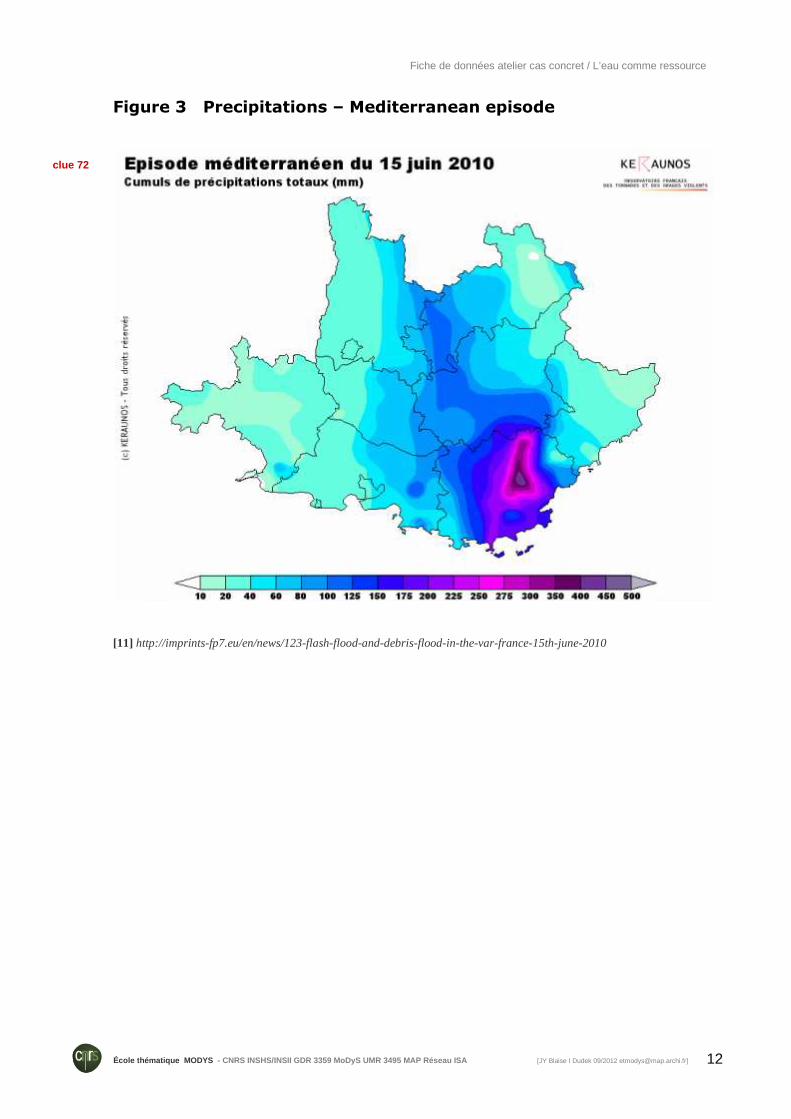
25 people have been killed by flash flood in south-eastern France on 15th June 2010. Typical torrential rainfall called “cévenol” hit the mountains above the Cote D'Azur region. This very intense and exceptional storm has particularly affected the department of the Var: around 400 mm fell on the region of Les Arcs, and more than 300 mm during 12 hours.
This intensive rainfall has caused many floods in the river network of the region. The Nartuby river (crossing Draguignan city) has generated an historical flood;
according to the local authorities, the floods are the worst in the region since 1827. The Real stream (crossing Les Arcs) has also been responsible for an important debris flow wiping out everything in its path.
About 2,000 rescue workers have been drafted into affected regions near the Mediterranean coast to help those trapped in their vehicles or houses. 1400 persons have been saved by helicopter, and 200 by boat. Rescue teams had also to moved 436 inmates from a prison in Draguignan after two floors flooded. Rail and air services in the region were interrupted, and about 300 passengers travelling on a high-speed train between Nice and Lille had been trapped by the flood waters.
Unfortunately, 25 peoples died during this storm, 11 for the only city of Draguignan. Most of the victims are old persons that have been surprised by the fast water rise. Indeed, rivers have rapidly overflowed and the level has risen of 50 cm in few minutes. In some houses, the first floor was completely flooded (until 2,5 meters). The force of the water swept empty cars and other vehicles down streets in the different communities.
clue 66
clue 67
clue 68
clue 69
clue 70
clue 71
Fiche de données atelier cas concret / L’eau comme ressource
12 École thématique MODYS - CNRS INSHS/INSII GDR 3359 MoDyS UMR 3495 MAP Rése au ISA [JY Blaise I Dudek 09/2012 [email protected]]
Figure 3 Precipitations – Mediterranean episode
[11] http://imprints-fp7.eu/en/news/123-flash-flood-and-debris-flood-in-the-var-france-15th-june-2010
clue 72