Prospecting & Closing Scri Prospecting & Closing Script Book.pdfpt Book

REPORT ON
A PROSPECTING PROGRAM ON THE AMPLE-GOLDMAX GROUP OF MINERAL CLAIMS
LILLOOET MINING DIVISION NTS 92-J-9E
Latitude: 50°41'N Longitude: 122OW
Report'by Gary Polischuk (Prospector) for Dave Javorsky, Sharon Polischuk & Gary Polischuk (Owners)
TABLE OF CONTENTS
Introduction
Summary & Conclusions
Recommendations & Cost Estimates
Property Location
Claim Description
History
Regional Geology
Property Geology
References
Author's Experience
Prospecting Dates and Expenses
% Page 1
Page 2
Page 3
Page 4
Page 5
Page 6
Page 7
Page 8
Page 9
Page 10
Page 11
Page 1
INTRODUCTION
On March 15, 1991, I initiated a prospecting program on a group of claims I staked. These claims were named the Goldmax 1-6. A prospecting assessment work report was written and filed with the Gold Commissioner in Lillooet on this ground. No further work was done on this group until February 1993.
On February 25, 1993, while driving along the Duffy Lake Road, I noticed a large quartz boulder on the opposite lane of the highway. Due to its location (about 300 metres west of the Goldmax #6 final post), and its greenish colour, I stopped, put it in my truck and brought it home with me. Upon breaking it apart, I discovered it contained visible gold, which assayed 4.34 oz. Au, .65 oz. Ag and .079 % Cu. Consequently, I staked the Goldmax Fr. and Goldmax 7, 8 & 9 mineral claims adjoining Goldmax claims numbers 5 & 6 on the west and along the east and north side of the Ample Mineral claim owned by Dave Javorsky.
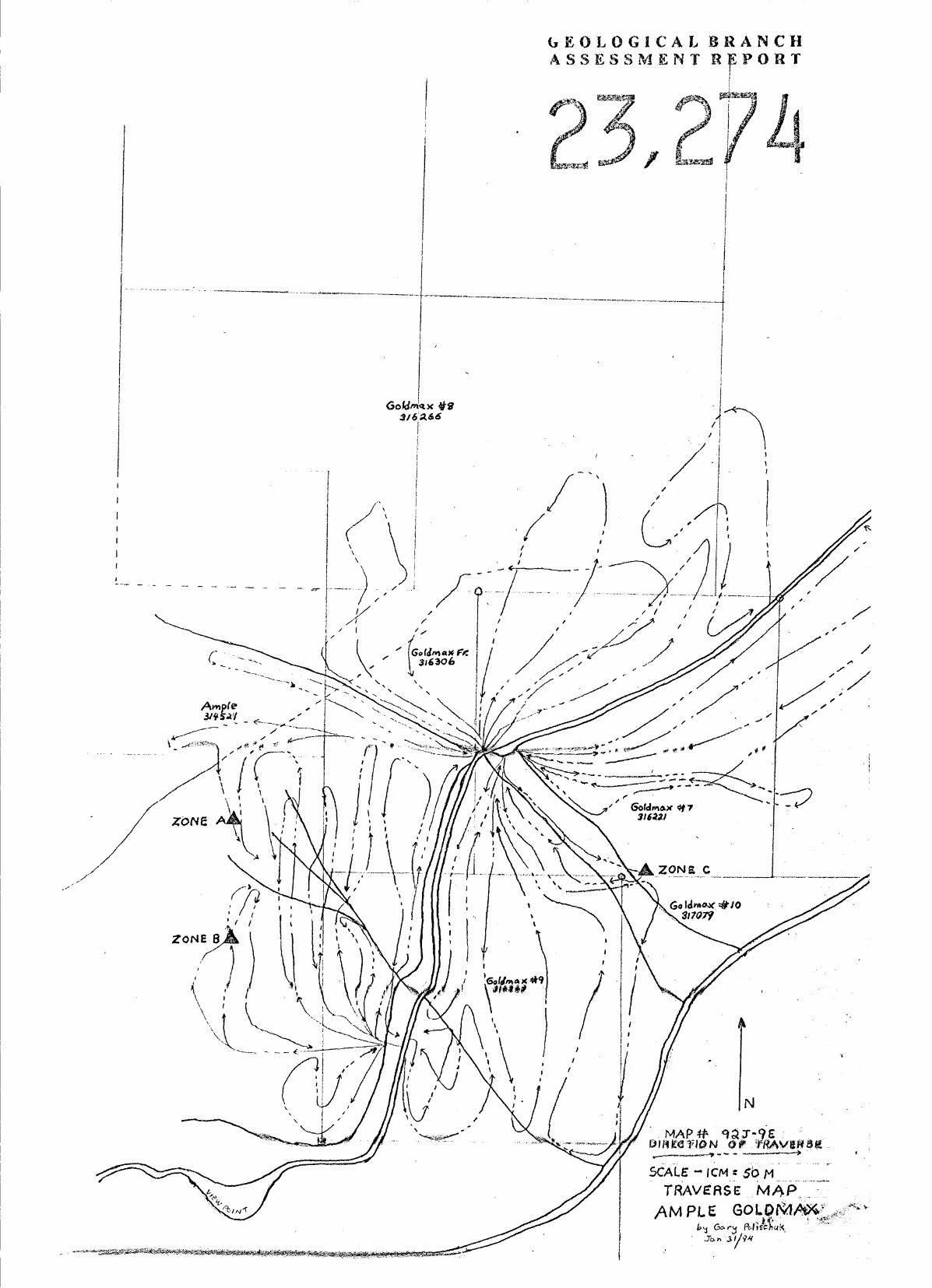
On March 4th I initiated a prospecting program on the recently staked Goldmax claims in the hope of finding the source of this high grade float. Numerous traverses were made in east-west directions, gradually climbing higher after each traverse. Due to the depth of overburden, I decided to take random soil samples along the traverses whenever oxidized soils would appear on the surface. During the traverse I made on March 14th, I crossed onto the Ample claim to see what type of geology it contained because the overburden was less there. After walking about 200 metres onto the Ample claim, I noticed the soil changing to a reddish color and decided to take a soil sample. I stuck the pick into the ground and dug up a piece of quartz. After breaking it open, I found the piece of quartz float contained several small blebs of visible gold, minor galena and chalcopyrite. More digging with the pick revealed a quartz vein 24" wide about 18" below the surface directly under the quartz float I had found. Visible gold was noted throughout this freshly uncovered section of vein. When a comparison of'this new zone of gold quartz was made with the original piece found on the highway, I realized the rocks were different. The float found on the highway was extremely fractured (easy to break), and no galena was present, whereas the quartz from the new discovery was not as easily broken and contained galena prominently visible, thus leading me to believe that there had to be other gold bearing zones.
At this time, I contacted Dave Javorsky - the Ample Mineral claim owner - and it was decided we would put all our claims into one package. Further traverses were made and more rock and soil samples were taken on both the Goldmax and Ample mineral claims. The results of these are noted under section Geology.

Page 2
SUMMARY AND CONCLUSIONS
1.1
1.2
1.3
1.4
1.5
1.6
1.7
1.8
The Ample-Goldmax claim group consists of 56 metric claim units and is located about 5 kilometres from the Village of Lillooet in the Lillooet Mining Division.
This area was extensively prospected around the turn of the century, leading to the discovery of the Golden Cache mine. Most of this area was held by individuals owning Crown grant mineral claims until the last 2 years when they were forfeited for unpaid taxes. Most of the Crown grants are restaked under Ample mineral claim and are part of the Ample-Goldmax group.
This group is accessible by the Duffy Lake Road.
The claim group is underlain by rock of the Bridge River (Fergusson) group consisting of argillites, cherts, phyllites and greenstone, minor limestone and schists.
With the discovery of gold bearing quartz on the Duffy Lake road by the author of this report, a prospecting program to find the source was initiated. Several structures have consequently been discovered through this effort. Visible gold is found in two of these new zones. The gold seems to be associated only in highly altered greenstone consisting of shears and quartz veins. Throughout each of these discoveries comparisons were made with the original piece of float, but each zone was different from it in respect to the type of mineral content or hardness. With these comparisons in mind, I am led to believe the zone from the original piece of float remains undiscovered at this time.
Gold values in the A Zone are consistently high with many assays from 1 02. to over 5 oz. Au per tonne.
No visible sign of past mining activity is evident in the area around Zone A or Zone C. Minor trenching is seen at Zone B.
Overburden is quite extensive over the area below Zone A & B, making prospecting slow and difficult. Random Geochem sampling of the B horizon has proven to be successful when soil analysis for gold, arsenic, silver, copper and lead are made.
Page 3
RECOMMENDATIONS & COST ESTIMATES
Two phases of exploration to extend known, and find other =.yet undiscovered zones, are recommended with hopes of delineating an economic ore body.
Phase 1
The first phase that is recommended is to establish a grid extending from the thrust fault downslope to Cayoosh Creek, taking in Zone A, B and C as this is the main area of recent gold discoveries. A grid 525 metres wide and 750 metres long would accomplish this. Lines should be 75 metres apart with 20 metre soil sample sections. Each sample should be analyzed for gold, silver, copper, lead and arsenic.
Description
Sample analysis Labour Pick-up rental & gas
TOTAL
$ cos t
2500.00 1000.00 500.00
Phase 2
Upon completion of Phase 1 , a road should be constructed to the area around Zone A and B in such a way as to explore any Geochem highs encountered by Phase 1. A’Cat 225 excavator would be the best machine to construct this road. A road grade of not more than 8% should be strived for due to the possibilities of a dump truck being used to haul ore and to minimize future road construction. Construction of this road would require about 10 days at 8 hours per day.
Description
Excavator rental @ $1 OOhour 8000.00 for 8 hours for 10 days
$ cos t
8000.00
Page 4
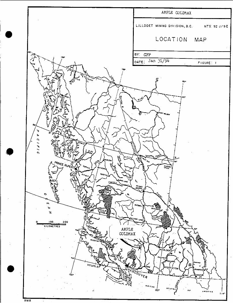
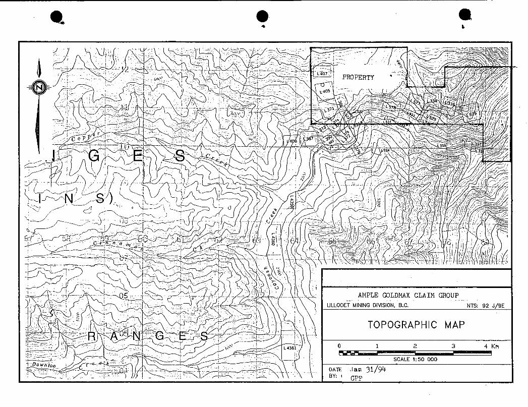
PROPERTY LOCATION
The Ample-Goldmax group of mineral claims begin 1.5 kilometres west of the most southerly portion of Seton Lake. The claims are staked on both sides of Cayoosh Creek and extend for 6 kilometres upstream. Access through the property is made via the Duffy Lake road from Lillooet. Mining roads are found in this claim group only on the Goldmax 1-6 mineral claims. The remaining property is accessible by foot paths and wagon roads.
AMPLE COLDPAX
L ILLOOET MINING DIVISION, B.C. NTS: 92 J / 9 E
L O C A T I O N MAP
WR

Page 5
CLAIM DESCRIPTION
The Ample-Goldmax group of mineral claims consists of 56 units:
Name
Goldmax #1
I Goldmax #2
Goldmax #3
Goldmax #4
Goldmax #5
Goldmax #6
Goldmax #7
' Goldmax#8
Goldmax #9
Goldmax Fr.
Goldmax #10
Ample
Noel(Arthur)
Record #
229407
229408
229409
2294 10
2294 12
229413 .
316221
3 16266
3 16267
3 16306
3 17079
3 14521
3 17008
# of Units
1
1
1
1
1
1
1
9
1
1
10
8
20
Ekpirv Date
Feb.28,1994
Feb.28,1994
Feb.28,1994
Feb.28,1994
Mar. 13,1994
Mar. 13,1994
Feb.28,1994
Mar.0 1,1994
Feb.28,1994
Mar.02,1994
Apr.20,1994
Oct.28,1994
Apr. 15,1994
a
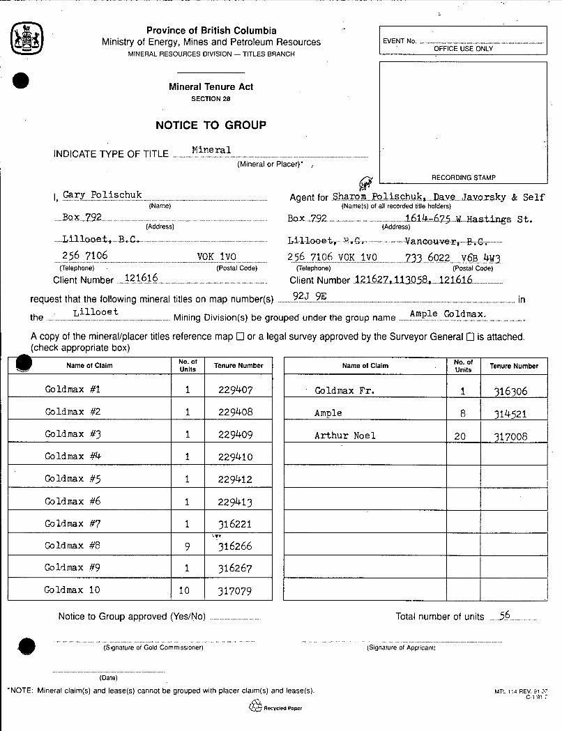
Province of British Columbia Ministry of Energy, Mines and Petroleum Resources
MINERAL RESOURCES DIVISION - TITLES BRANCH
EVENT No. ................................................................................ OFFICE USE ONLY -
Name of Claim
Mineral Tenure Act SECTION 28
No. of Units Tenure Number
NOTICE TO GROUP
Name of Claim .
M i n e r a l INDICATE TYPE OF TITLE .......................................................................................................................... (Mineral or Placer)' ,
kiEf Tenure Number
I, Gary Po l i schuk .... ...... ....
..... B.0.X .... 7.92 ..........................................................................................................
..... Lil1ao.e.t. .,.... B..C ... ................................................................................. L I J L ~ ~ ~ ,..... ~.,.c., ........ a.ncOuve.r E...c .............
................................................................................................................................... Agent for .ShaXo.m Po~.i.S.c.hu.k., Dave da.va.r.sky & S e l f (Name) (Name(s) of all recorded title holders)
BOX .... 7.92 ................................................... Lhih-67.5 .... U.... ~astings St. (Address) (Address)
1""'
......... ............... ...... 256 ......................................................................... 7106 VCK 1 V O ?2.3 ... 6022 ....... VGB ... 4w3.. (Telephone) (Postal Code)
Client Number 121616 .................... Client Number .~.~.~.62.i1,.~..13.5~., ..... 121.616 ................................................................................................
request that the following mineral titles on map number(s) ........................................................................................................... 925 9E in
the ................. Mining Division(s) be grouped under the group name ...................................................... Ample Goldmax : ........................
A copy of the mineral/placer titles reference map 0 or a legal survey approved by the Surveyor General 0 is attached. (check appropriate box)
Goldmax Fr,
Ample
1 316306
8 314521
I Goldmax #1 I 1 I 229407 I
Arthur Noel
I Caldmax #2 I 1 I 229408 I 20 317008 I Goldmax #3 I 1 1 229409 I
I Goldmax ;yrC I 1 I 229410 I I Goldmax #5 1 1 I 229412 I
I Goldmax #7 j-1 I 316221 I I Goldmax #8
i
Notice to Group approved (Yes/No) ................................ Total number of units ....... 56 ................
................................................................................................................................. ......................................................................................................................... (Signature of Gold Commissioner) (Signature of Applicant)
(Date)
'NOTE: Mineral claim(s) and lease(s) cannot be grouped with placer claim(s) and lease(s).
@ Recycled Paper
MTC 114 REV. 31 .'I c-; '9: I


Page 6
HISTORY
Cayoosh Creek has a long but intermittent history of prospecting for gold which dates back to 1866 when the Chinese discovered placer gold along its lower reaches.
The placers yielded a large amount of gold for which statistics cannot be given because the creek was worked almost altogether by Chinese who sold to their own people and from whom it was impossible to get information. It was generally conceded the total amount went into the hundreds of thousands of dollars.
Prospecting was carried out upstream to locate the source of this gold. In 1887 the first gold in hardrock was found above these placers. In 1897 the Golden Cache mine started production only to fail the following year. Some limited production was achieved in 1901. Total production for these years was 2789 metric tonnes, which contained 22.611 grams of gold. Prospecting for gold continued along Cayoosh Creek but until the Duffy Lake road was built, access to the area was difficult.
/-

Page 7
REGIONAL GEOLOGY
Mapping by Roddick and Hutchinson indicates that the Ample- Goldmax claim group is underlain by rock of the Bridge River (Fergusson) group (Geological Survey Paper 73-17 1973). The Bridge River (Fergusson) group of rocks consists mainly of chert, argillite, phyllite and greenstone; minor limestone and schist.

AMPLE GOLDFAX
ULLOOET MINING DIVISION. B.C. NTS: 92 J/9E
REGIONAL GEOLOGY M A P ~~
0 5 10 IC 2c Kn
SCALE 1:250 000
DATE: Jan 31/94 P 7 n EGURE No. 7
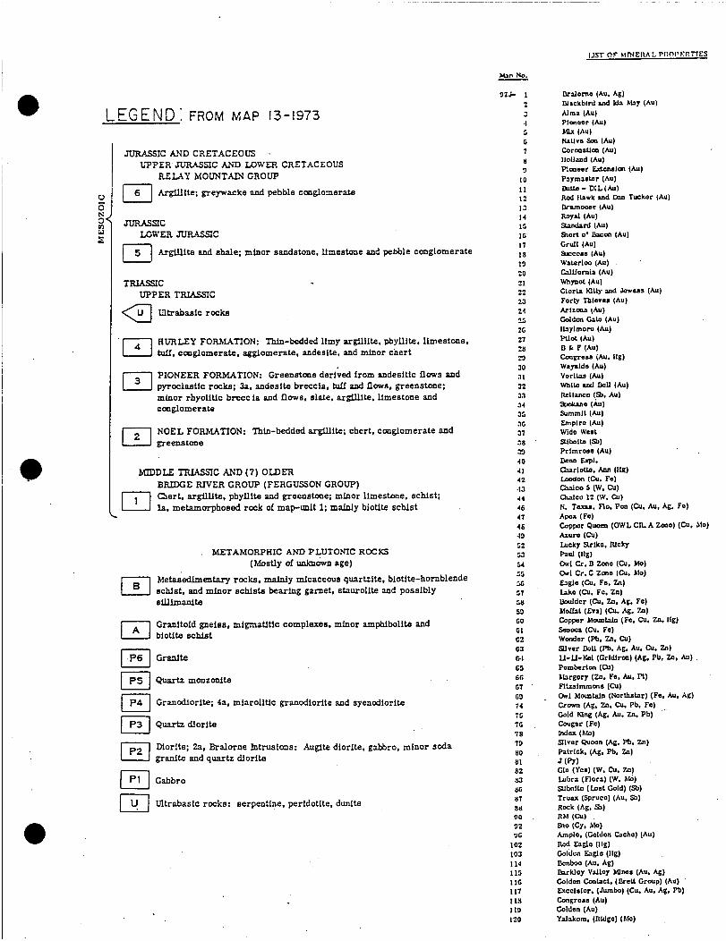
LEGEND: FROM MAP 13-1973
2
2 0 N
W E
JURASSIC AND CRETACEOUS . UPPER JURASSIC AND LOWER CRETACEOUS
REMY hfOUNTAIN GROUP
Argillite; greywacke and pebble cmglomerlta
JLTRASSC LOWER JURASSIC
151 Argillite and shale; minor sandstone. limestone and pebble conglomerate
TRIASVC UPPER TRMSSIC a ~ t r a b a s i c r o c h
BURLEY FORMATION: Thin-bedded limy arglllite. phyllite. limestone. tuff. cmglomerate. agglomerate, andesite. and minor chert
PIONEER FORMATION: Greenstone derived from andesitic flows and pyroclastic rocks; 3a, andesite breccia, tuff and flows, greenstone; minor rhyolitic breccia and flows. slate. argiUIte. Umestone and cmglomerab
NOEL FORMATION: Thin-bedded argillite; chert, conglomerate and greenstme
[.I
W D D L E TFUASSIC AND (7) OLDER BRIDCE RIVER GROUP (FERGUSSON GROUP) Caert. argillite, phyllita and greenstme; minor limestwe. schist; .m la, metamorphoeed rock of maprmlt 1; mainly biotite schist
. METAMORPHIC AND PLUTONIC ROCKS (Mostly of unknown age)
Metas'edlmentary rocks. mainly micaceous quartzite, biotite-hornblende schist. and minor schlsts bearing garnet, staurolite and possibly sillimanite
Granltoid gneiss, mipatitic complexes, minor amphibolite and biotite schist
Granfte
-monzonite
Granodiorite; 4a. miarolitic granodiorite and syencdiorite
Quartzdiorite
Diorite; 2a, Bralorne Intrusions: Augite diorite, paWro, minor soda El granite and quartz diorite
Gabbro
I.1 Ultrabasic rocks: serpentine, peridotlte. dunite
Man NO.
9 z c 1 2 3 4 5 G 7 8 9 10 1 1 1: I3 14 11 IO 17 18 19 20 21 22 23 24 *-5 26 27 18 W 30 31 J2 z7 34 J5 JG 37 38 33 40 41 4 2 4 3 44 46 41 4 s 49 52 53 54 55 56 51 511 .VI GO G I 62 G3 GI 68 66 61 69 1 4 18 16 78 73 80 81 82 xl 86 81 111) ofl 92 1JG
102 103 I14 113 I16 1 I1 11s 113 I20
-

Page 8
PROPERTY GEOLOGY
0
The Ample-Goldmax group of mineral claims are located in steep slopes of 20 to 30 degrees with numerous vertical rock bluffs. The slopes are usually heavily timbered with stands of good Douglas fir. Rock outcrops are scarce in these areas.
The claims are crossed by 2 normal faults and 1 thrust fault. The first normal fault (Marshall Creek fault) trends northwest and is located on the eastern portion of the Goldmax claims. The second normal fault trends west from the Marshall Creek fault and crosses the entire length of the Ample-Goldmax group. The thrust fault trends west from the Marshall Creek fault and is located immediately south of the second normal fault. This fault also crosses the entire length of the Ample-Goldmax group.
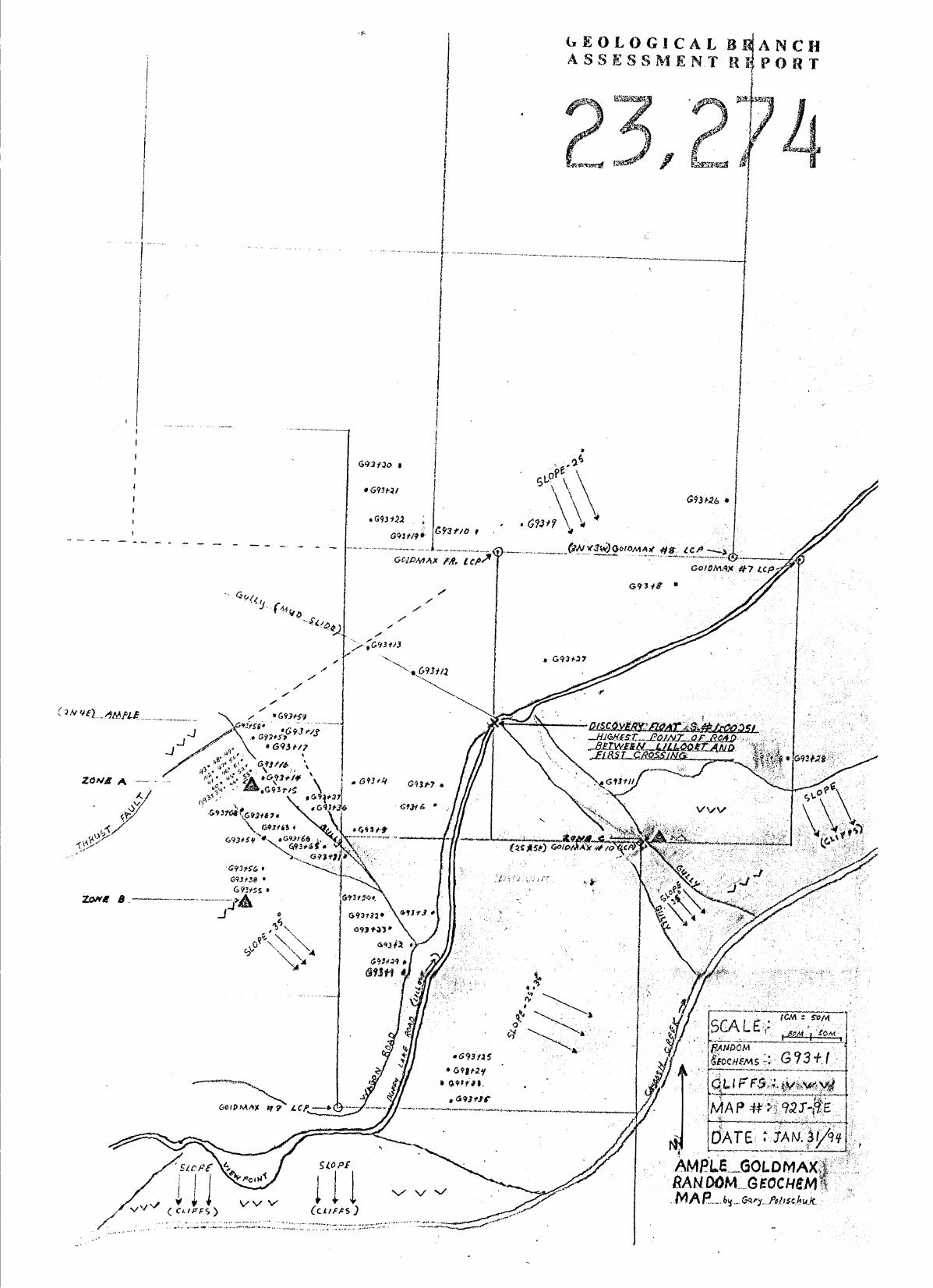
Prospecting was carried out mainly on the eastern boundarie,? of the Ample claim and western boundaries of the Goldmax claims below the thrust fault. Numerous areas of gold mineralization have been discovered and are sectioned off in this report as Zone A, Zone B and Zone C.
The discovery of Zone A has been described in the Introduction. This zone is located 325 metres above the Duffy Lake road at its highest point between Seton Lake and the road's first crossing of Cayoosh Creek. The thrust fault is located 80 metres above this zone. The rocks on the upper side of the thrust fault are massive greenstone and on the lower side consisting of argillites and greenstone flows. Numerous lenses of quartz of 1-4 metres in length and 2-8 centimetres in width are seen along the contact with mineralization being scarce. The thrust fault is easily followed because the upper portion is vertical rock bluffs, while lower portions consist of argillite blending intermittently to overburden, thus leaving the contact quite visible.
Zone A is found on the eastern edge of the Ample claim at the crest of a ridge where overburden is a thin veneer only 2-50 centimetres deep. The rock in this area is an altered reddish brown to buff colored greenstone, which is highly fractured. One quartz vein and 3 shear zones of quartz stockwork with visible gold have been noted here. The contacts of the greenstone of Zone A and the thrust fault are not known as yet due to the extensive overburden between the 2 structures. Argillites form the rock on the lower portion of Zone A. They are black in color and exhibit a wrinkled banding appearance with a vague general strike to the northwest.
The quartz vein found in Zone A is 0.6 metres in width and displays a weak banding aspect probably due to minor faulting in its immediate vicinity. Mineralization content is visible gold, galena, chalcopyrite and minor arsenopyrite.
I The 3 shear zones of Zone A are located above the quartz vein, all of which are found in an area 15 metres wide and 30 metres in length. These shears vary from a few centimetres
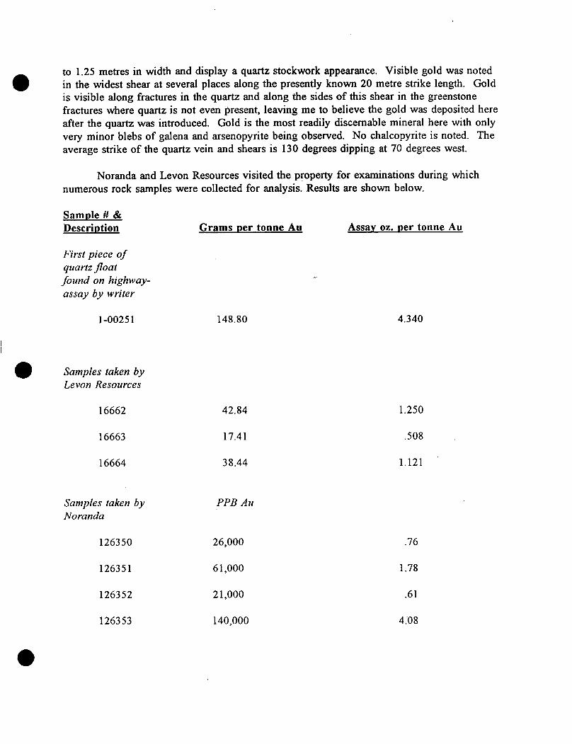
to 1.25 metres in width and display a quartz stockwork appearance. Visible gold was noted in the widest shear at several places along the presently known 20 metre strike length. Gold is visible along fractures in the quartz and along the sides of this shear in the greenstone fractures where quartz is not even present, leaving me to believe the gold was deposited here after the quartz was introduced. Gold is the most readily discernable mineral here with only very minor blebs of galena and arsenopyrite being observed. No chalcopyrite is noted. The average strike of the quartz vein and shears is 130 degrees dipping at 70 degrees west.
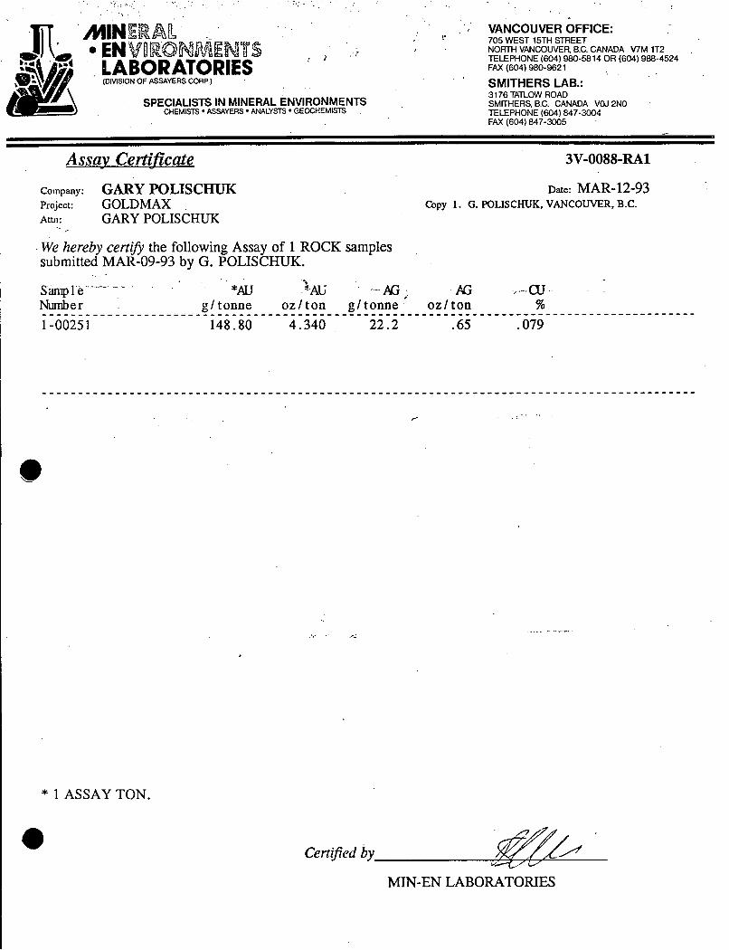
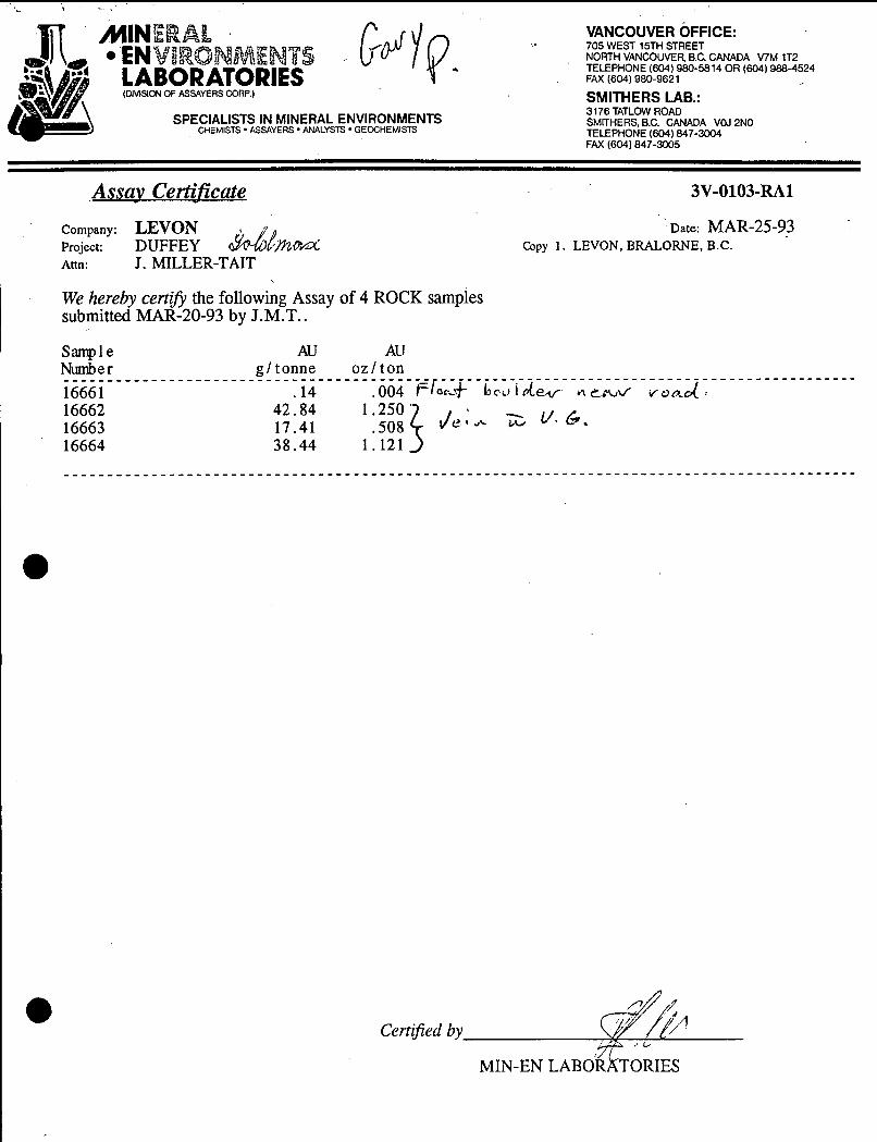
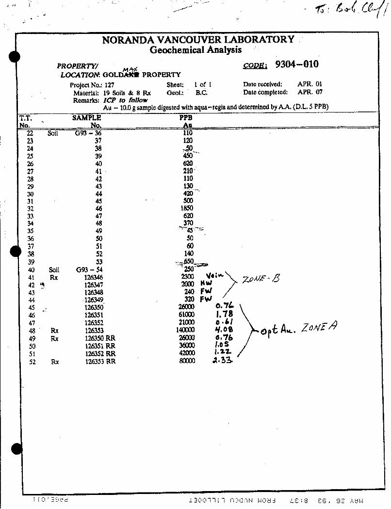
Noranda and Levon Resources visited the property for examinations during which numerous rock samples were collected for analysis. Results are shown below.
Sample W & Description Grams per tonne Au Assay oz. per tonne Au
First piece of quartz ji'oat found on highway- assay by writer
1-0025 1
0 Samples taken by Levon Resources
16662
16663
16664
Samples taken by Noranda
126350
126351
126352
1263 53
148.80
42.84
17.41
38.44
PPB Au
26,000
6 1,000
21,000
140,000
4.340
1.250
.508
1.121
.76
1.78
.61
4 .'O 8
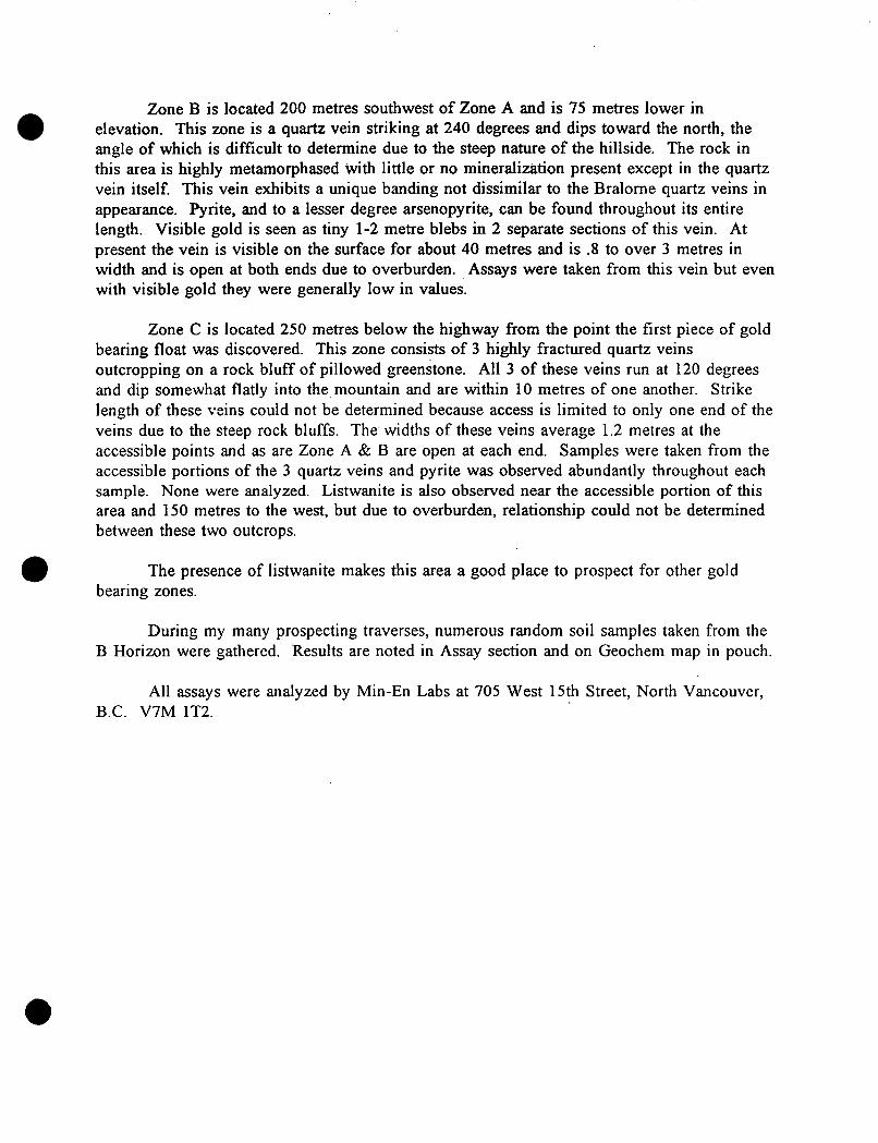
Zone B is located 200 metres southwest of Zone A and is 75 metres lower in elevation. This mne is a quartz vein striking at 240 degrees and dips toward the north, the angle of which is difficult to determine due to the steep nature of the hillside. The rock in this area is highly metamorphased with little or no mineralization present except in the quartz vein itself. This vein exhibits a unique banding not dissimilar to the Bralorne quartz veins in appearance. Pyrite, and to a lesser degree arsenopyrite, can be found throughout its entire length. Visible gold is seen as tiny 1-2 metre blebs in 2 separate sections of this vein. At present the vein is visible on the surface for about 40 metres and is .8 to over 3 metres in width and is open at both ends due to overburden. Assays were taken from this vein but even with visible gold they were generally low in values.
Zone C is located 250 metres below the highway from the point the first piece of gold bearing float was discovered. This mne consists of 3 highly fractured quartz veins outcropping on a rock bluff of pillowed greenstone. All 3 of these veins run at 120 degrees and dip somewhat flatly into the,mountain and are within 10 metres of one another. Strike length of these veins could not be determined because access is limited to only one end of the veins due to the steep rock bluffs. The' widths of these veins average 1.2 metres at the accessible points and as are Zone A & B are open at each end. Samples were taken from the accessible portions of the 3 quartz veins and pyrite was observed abundantly throughout each sample. None were analyzed. Listwanite is also observed near the accessible portion of this area and 150 metres to the west, but due to overburden, relationship could not be determined between these two outcrops.
The presence of listwanite makes this area a good place to prospect for other gold bearing zones.
0 During my many prospecting traverses, numerous random soil samples taken from the
B Horizon were gathered. Results are noted in Assay section and on Geochem map in pouch.
All assays were analyzed by Min-En Labs at 705 West 15th Street, North Vancouver, B.C. V7M 1T2.

Page 9
REFERENCES
Roddick and Hutchinson: Pemberton (East Half) map area appear 73-17 (OF. 482)
Sampson, C.J.; Miller-Tait, J. on Raven claim in Downton Creek N.T.S. 92J9E
1990 Report on geochemical sampling and trenching programs
Geology by M.E. Coleman Open File 1991 - 13 Geology of the Mission Ridge Area, Southwestern British Columbia
Miller-Tait, J. B.Sc. P. Geo.
Cluff, G. Robert District Geologist for Noranda Explorations
Sampson, C.J. P. Eng. Consulting Geologist
. Page 10
AUTHOR'S PROSPECTING EXPERIENCE
I, Gary Polischuk, have been a prospector in British Columbia for 18 years. I have worked all aspects of mining, including Diamond drilling, underground mining, line cutting for soil geochems, running EM, mag. and I.P. surveys and Placer mining.
This report is based on my work on the Ample-Goldmax group of mineral claims.
Special thanks to those below for their inva1,uable efforts in aiding me in my prospecting of the Ample-Goldmax claim group.
J. Miller-Tait B.Sc., P. Geo.
G. .Robert Cluff District Geologist for Noranda Explorations
C. J. Sampson P.Eng. Consulting Geologist
Author
Gary Polischuk

Page 11
PROSPECTING DATES AND EXPENSES
Dates for which prospecting took place on the Ample-Goldmax group of mineral claiml claims during 1993.
Month March 4
5 10 11 12 14 16 18 19 21 22 23 24 28 29 30 31
# of men 1 1 1 1 1 1 2 1 1 1 1 1 2 2 1 2 2
Apr 15 16 20 25 29 30
1 1 1
. 1 2 1
Month May 2
4 9
16 24 25 27 28 31
June 1 2 4 6 8 9
13 14 15 17 20
July 11
Sept 19
# of men 3 1 2 1 1 1 1 1 1
2 3 1 1 1 1 1 1 1 2 1
1
2
TOTAL 59 days
Assay Costs 466.52
33.01 275.00
Freight Fuel
Equipment Rental 2200.00
All financing for this prospecting program was made by me, Gary Polischuk. Assaying and other expenses by Noranda and Levon Resources are not calculated in this prospecting program, although their assay results are. 0
. . . . . . . . . - . .. 1 . . , . . . .1. . . . . . -:,! :.,; , . . ..
. VANCOUVER OFFICE: 705 WEST 15TH STREET
I NORTH VANCOUVER BC. CANADA V7M 1T2 I TELEPHONE (604) 980-5814 OR (604) 988-4524
FAX (604) 980-962 1 . . ) E
R l SMITHERS LAB.: (DIVISION OF ASSAYERS CORP) I 3 176 TATLOW ROAD
SMITHERS, B C CANADA VAI 2N0 SPECIALISTS IN MINERAL ENVIRONMENTS CHEMISTS ASSAYERS ANALYSTS GEOCHEMISTS TELEPHONE (604) 847-3004
FAX (604) 847-3005 e
I Assay Certificate 3V-0088-RA1
Company: GARY POLISCHUK Date: MAR-12-93 Project: GOLDMAX Copy 1. G. POLISCHUK, VANCOUVER, B.C.
~
Ami: GARY POLISCHUK
We hereby ten@ the following Assay of 1 ROCK samples submitted MAR-09-93 by G . POLISCHUK.
~
\
Sample ---- I *Au 1 . h - _ - AG I% 3 - a J Number g/tonne oz/ton g/tonne oz/ton % . . . . . . . . . . . . . . . . . . . . . . . . . . . . . . . . . . . . . . . . . . . . . . . . . . . . . . . . . . . . . . . . . . . . . . . . . . . . . . . . . . . . . . . . . . 1 -0025 1 148.80 4.340 22.2 .65 .079
. . ., . I . . . . /
. , . . - .. .
Cenijied by
MTN-EN LABORATORIES

COMP: GARY POLISCHUK MIN-EN, LABS - I C P REPORT PROJ: COLDMAX ATTN: GARY POLISCHUK (604 1980- 581 4 OR (604 1988-4524
705 UEST 15TH ST., NORTH VANCOUVER, B.C. VM,,JT2 ' .
SAMPLE NUMBER C93 - 3 C93 - 2 C93- 1
G93+5 C93+4
C93+6 C93+7
F I L E NO: 3V-0088-SJl DATE: 93/03/12
* S O I L * '(ACT:F31)
AG AS B BA BE 8 1 CD . CO CU FE K L I MN MO N I P PB SB SR TH T I V ZN GA SN U CR AU-FIRE PPM PPM PPM PPM PPM PPM c! PPM PPM PPM % % PPM Mg PPM PPM Ni PPM PPM PPM PPM PPM PPM PPM PPM PPM PPM PPM PPM PPM PPB
.3 2.04 17 4 148 .2 5 1.07 .1 25 120 4.61 . I5 21 1.74 790 2 .02 60 490 7 4 24 9 770 101.7 77 6 3 8 102 22
.2 2.50 85 5 170 .I 4 .50 .1 30 155 5.69 -17 24 2.00 958 4 .01 82 470 6 i 5 24 10 864 110.2 94 7 4 12 167
.3 2.05 88 6 228 .I 5 .40 .1 25 127 5.50 .16 27 1.04 910 5 .02 46 450 14 7 26 8 576 66.2 146 5 3 6 64
.1 2.56 22 7 281 .2 6 .81 .1 29 153 5.57 .21 24 1.78 1071 3 .02 82 1090 33 11 1040 135.2 110 8 4 10 134 26
.9 1.89 25 7 473 .2 8 1.88 .1 27 111 4.25 .22 19 1.08 1715 4 .02 49 1370 14 , 5 68 8 1233 76.8 159 6 4 8 78 22
.7 2.31 22 10 526 - 2 7 1.81 .1 33 156 5.07 -20 20 1.30 1849 5 .02 66 2020 17 5 63 11 1191 105.3 233 6 5 9 115 32
.6 2.62 41 8 332 .1 7 .69 .1 33 144 5.24 .29 22 1.45 1702 3 .02 83 020 1: 1 2 32 10 1372 99.2 138 6 3 10 144 33
. : I
't
I
MIN EN LABORATQRIES (DIVISION OF ASSAYERS CORP )
SPECIALISTS IN MINERAL CHEMISTS * ASSAYERS ANALYS
ENVIRONMENTS iTS GEOCHEMISTS
VANCOUVER OFFICE: 705 WEST 15TH STREET NORTH VANCOUVER, BC. CANADA VIM 1T2 TELEPHONE (604) 980-5814 OR (604) 988-4524 FAX (604) 980-9621
SMITHERS LAB.: ~~ ~
3 176 TATLOW ROAD SMITHERS, B.C. CANADA VOJ 2N0 TELEPHONE (604) 847-3004 FAX (604) 847-3005
Assav Ce&Ificate 3V-0103-RA1
&L!?rnd Company: LEVON Project: DUFFEY Attn: J . MILLER-TAIT
' Date: MAR-25-93 Copy 1. LEVON, BRALORNE, B.C.
Certzjied by

VANCOUVER OFFICE: AlN::‘”-:. ’: . EN .~ $ 7 ~ 64 - v - * c VL - cr . t .-
LABOR ATOklES’ (DMSION OF ASSAYERS CORP )
SPECIALISTS IN MINERAL ENVIRONMENTS CHEMISTS ASSAYERS ANALYSTS GEOCHEMISTS
FAX (604) 847-3005
Metallic Assav Cert@cate 3V-0103-RMl
705 WEST 15TH STREET NORTH VANCOUVER. B.C. CANADA V7M 1T2 TELEPHONE (604) 980-5814 OR (604) 988-4524 FAX (6W) 980-962 1
SMITHERS LAB.: 3 176 TATLOW ROAD SMKHERS B.C. CANADA VCN 2N0 TELEPHONE (6041 847-3004
Company: LEVON Project: DUFFEY Am: J. MILLER-TA~
Date: MAR-25-93 Copy 1. LEVON, BRALORNE, B.C.
We hereby cem? the following Metallic Assay of 3 METALLIC samples submitted MAR-20-93 by J.M.T..
Sarpie * Total * +12OM * Assay Value Au * Total W i g h t Au * Mtallic Au * Net Au . . . . . . . . . . . . . . . . . . . . . . . . . . . . . . . . . . . . . . . . . . . . . . . . . . . . . . . . . . . . . . . . . . . . . . . . . . . . . . . . . . . . . . . . . . . . . . . . . . . . . . . . . . . . . . . . . . . . . . . . . . . . . . .
* Wt * Wt * +120$4/t) -I20(4lt) * +120(q) -120(9) * (ozlton) lt) * (ozlton) (glt)
16662 * 219.29 * 21.29 * 194.20 31.40 * 5.300 9.425 * 0.553 18.98 * 1.538 52.12 16663 * 283.38 * 36.38 * 69.60 10.27 * 2.532 2.537 * 0.261 8.94 * 0.522 17.89 16664 * 229.11 * 42.77 * 126.49 19.07 * 5.410 3.566 * 0.681 23.55 * 1.139 39.01
!A%::*******************igi*******&i******** ********* ************ ******** ......................................... *****
Certified by 1 MIN-EN LABORATORIES

COMP: LEVON PROJ: DUFFEY ATTN: J. M I L L E R - T A I T
NUMBER
693+09 G 9 3 + 1 0 G93+11
G93+13 G93+14 G93+ 1 5 G93+16
MIN-EN LABS - ICP REPORT 705 WEST 15TH ST., NORTH VANCWVER, B.C. V7M 1 T 2
( 6 0 4 ) 9 8 0 - 5 8 1 4 OR ( 6 0 4 ) 9 8 8 - 4 5 2 4
F I L E N.0: 3 V - 0 1 0 3 - S J 1 DATE: 93/03/25
* SOILS * (ACT:F31)
NORANDA VANCOUVER LABORATORY
I
Geochemical Analysis COD& 9304-010
M 6 N PZ?OPRRTY/ LUCATTON: GOLD- PROPERTY
Project No.: 127 Sheet: 1 of 1 Datermived: APR. 01 Material: 19 Soils & 8 Rx <)cot.: B.C. Datecompleted: APR. M Remarks: ICP to faUow
'.T. SAMPLE PPB
22 Soil C393-36 110
Au - 10.0 g sample digested with aqua-regia and determined by AA. (D.L, 5 PPB) I.%.. ..-
_- A -- - -.___I.,.-- Aa __.. IO.
46 47 43 49 so 51 52
23 24 25 26 27 28 29 -70 31 32 33 34 35 36 37 38 39 40 sail 41 Rx 42 7 43 44 45 :
37 38 39 40 41 42 43 44 45 46 47 48 49 50 51 52 33
G93-S4 126346 126347 126348 126349- 126350 126351 126352 126353 126350 RR 126351 RR 126352 RR 126353 RR
500 1850 620 3m

NORANDA VANCOUVER LABORATORY
i ?
Q
f \ c
M
2 0 XJ
x u
rn
rn r -I D
CD N

AINERAL EN^^^,^^^ LABORATORIES (DMSION OF ASSAYERS CORP )
SPECIALISTS IN MINERAL ENVIRONMENTS CHEMISTS ASSAYERS * ANALYSTS GEOCHEMISTS
VANCOUVER OFFICE: 705 WEST 15TH STREET NORTH VANCOUVER B.C. CANADA V7M 1T2 TELEPHONE (604) 980-5814 OR (€04) 988-4524 FAX (604) 980-962 1
SMITHERS LAB.: 3 176 TATLOW ROAD SMITHERS, B.C. CANADA VOJ 2N0 TELEPHONE (604) 847-3004 FAX (604) 847-3005
Assay Certificate 3V-0174-RAl
company: GARY POLISCHUK Project: Am: GARY POLISCHUK
Date: MAY-13-93 Copy 1. GARY POLISCHUK, LILLOJX. B.C.
We hereby c e m ! the following Assay of 8 ROCK samples submitted MAY-10-93 by SAMPSON.
Certified by
MIN-EN LABORATORIES

COMP: GARY POLISCHUK PROJ: GOLDMAX ATTN: GARY POLISCHUK
SAMPLE NUMBER
G93+20 G93+21 G93+22 G93+23 G93+24
G93+25 G93+29 G93+30 G93+31 G93+32
MIN-EN LABS - ICP REPORT ,
705 UEST 15TH ST., NORTH VANCOUVER, B.C. V7M IT2 (604 )980- 581 4 OR (604 1988-4524
AG AS cu PE AU-FIRE PPM PPM PPM PPM PPB
.6 155 310 13 103
.7 124 288 9 93
.6 25 67 22 23
.9 7 131 7 17
.7 33 77 11 13
1 .o 35 91 10 27 .9 90 139 12 108 .7 70 114 16 66 .8 116 130 13 237 .6 104 101 15 80
FILE NO: 3V-0136-SJ1 DATE: 93/04/20
SOILS * (ACT:F31)
SAMPLE NUMBER
G93-64 693-65 G93- 66 G93-67 693-68
G93-69
.
AI; AS cu FE PB ZN AU-FIRE PPM PPM PPM % PPI4 PPM PPB
.1 38 65 4.39 13 113 13
.2 175 174 5.34 11 90 970
.l 82 100 4.33 7 117 353 -1 222 131 1.56 11 92 492 .4 111 114 5.06 6 98 181
.4 I95 137 5.15 7 109 157
- -