Report on Prospecting at Claim 1227076&1222223
16
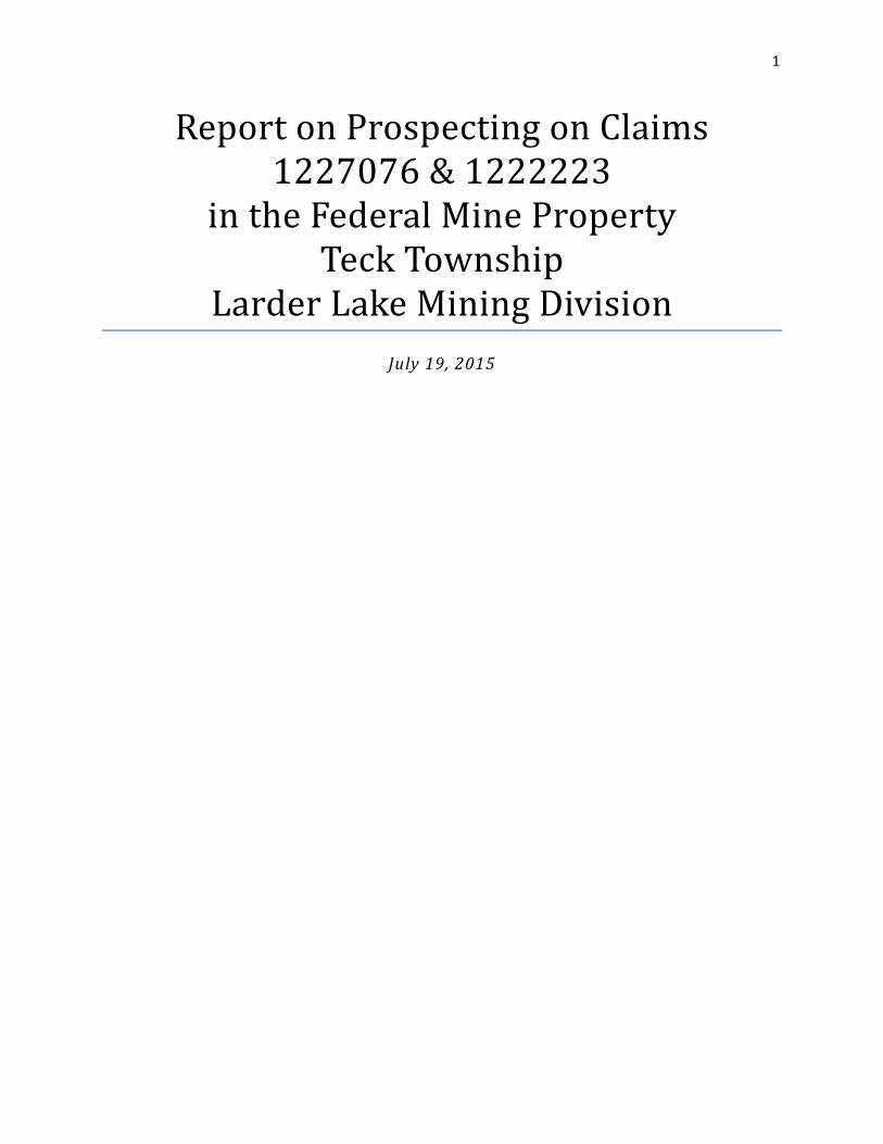
1 Report on Prospecting on Claims 1227076 & 1222223 in the Federal Mine Property Teck Township Larder Lake Mining Division July 19, 2015
Transcript of Report on Prospecting at Claim 1227076&1222223
1
ReportonProspectingonClaims1227076&1222223
intheFederalMinePropertyTeckTownship
LarderLakeMiningDivisionJuly19, 2015
2
TableofContentsIntroduction .................................................................................................................................................. 3
Summary ....................................................................................................................................................... 3
Property Descriptions and Access ................................................................................................................. 3
History ........................................................................................................................................................... 5
Property Geology .......................................................................................................................................... 6
General Description of Sampled Rock Units ............................................................................................. 8
Meta‐Sediment: Greywacke .................................................................................................................. 8
Mafic Syenite ......................................................................................................................................... 8
Syenite Porphyry ................................................................................................................................... 8
Description of Recent Work ........................................................................................................................ 10
Conclusions and Recommendations ........................................................................................................... 11
Data ............................................................................................................................................................. 12
FIGURE 1: LOCATION OF TECK TOWNSHIP RELATIVE TO THE PROVINCE OF ONTARIO AND CANADIAN MALARTIC CLAIMS (SHADED GREY);
WHERE THE CLAIMS 1227076 & 1222223 ARE LOCATED (SHADED PALE ORANGE). ............................................................... 4
FIGURE 2: A 1:15,000 SCALE MAP SHOWING MNDM LISTED MINING CLAIMS FOR TECK TOWNSHIP IN THE AREA OF THE MUNICIPALITY OF
KIRKLAND LAKE. THE CLAIMS 1227076 & 1222223 ARE HIGHLIGHTED. ............................................................................. 5
FIGURE 3: LOCAL GEOLOGY IN THE CLAIM AREA NORTH OF KIRKLAND LAKE. THE MAP SHOWS THE BANDS OF TEMISKAMING META‐
SEDIMENTS INTRUDED WITH FELSIC‐INTERMEDIATE INTRUSIVES AND KEEWATIN VOLCANICS IN CONTACT TO THE NORTH OF THE
TEMISKAMING SEDIMENTS. .......................................................................................................................................... 9
FIGURE 4: MAP SHOWING THE GPS TRACKS AND WAYPOINTS FOR THE WORKER'S TRAVERSES ON JULY 12‐13, 2016 FOR CLAIMS
1227076 & 1222223. ........................................................................................................................................... 15
FIGURE 5: A 1:4,000 SCALE SATELLITE MAP SHOWING ACCESS AND TRAVERSE TRACKS FOR CLAIMS 1227076 & 1222223. ................ 16

3
Introduction
This report is written for submission to the Ministry of Northern Development and Mines to fulfill the
assessment work requirements for part of the historic Federal Mine property. This report summarizes
the activities completed in the period of July 11 to July 13, 2016 on the un‐patented mining claims
1227076 & 1222223. This report was prepared by Canadian Malartic Corporation (CMC) geologist
Christopher A. L. Clarke, P.Geo under supervision from Mark Masson, P.Geo.
Summary
The claims 1227076 & 1222223 in Teck Township are associated with the historic Federal Mine property,
whose shaft is located on claim 1222223. The claims are held by Canadian Malartic Corporation and are
contiguous with other claims on the Federal Mine property which Canadian Malartic also holds. Both
claims 1227076 & 1222223 were staked on August 10, 1998. Workers for Canadian Malartic conducted a
prospecting and sampling program to fulfill the work requirements of the claim. Historically, the Federal
Mine property has been the focus of extensive exploration both above and below ground.
PropertyDescriptionsandAccess
Claims 1227076 & 1222223 are situated along the north‐eastern edge of the Town of Kirkland
Lake in Teck Township, District of Temiskaming, Larder Lake Mining Division, Ontario, Canada (Figure 1).
Claims 1227076 & 1222223 can be accessed along the east side of Goodfish road, 1.5‐2km from the
intersection of Duncan Ave and Goodfish Rd and ranges 80‐300m from the road or from the south via
Federal Street. There are several ATV trails/old dirt roads leading to the claims. The property is
immediately north of a residential neighborhood (Wishman Avenue) and abandoned residential lots.
The claims can also be accessed from the couth via Wilson Avenue which leads to Finntown. To the
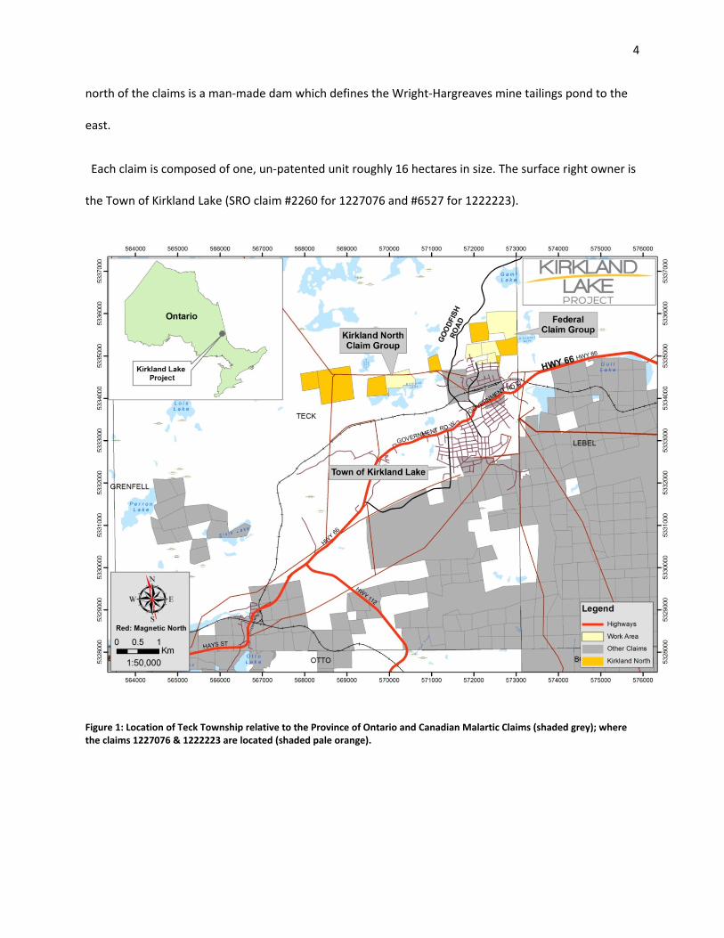
4
north of the claims is a man‐made dam which defines the Wright‐Hargreaves mine tailings pond to the
east.
Each claim is composed of one, un‐patented unit roughly 16 hectares in size. The surface right owner is
the Town of Kirkland Lake (SRO claim #2260 for 1227076 and #6527 for 1222223).
Figure 1: Location of Teck Township relative to the Province of Ontario and Canadian Malartic Claims (shaded grey); where the claims 1227076 & 1222223 are located (shaded pale orange).
5
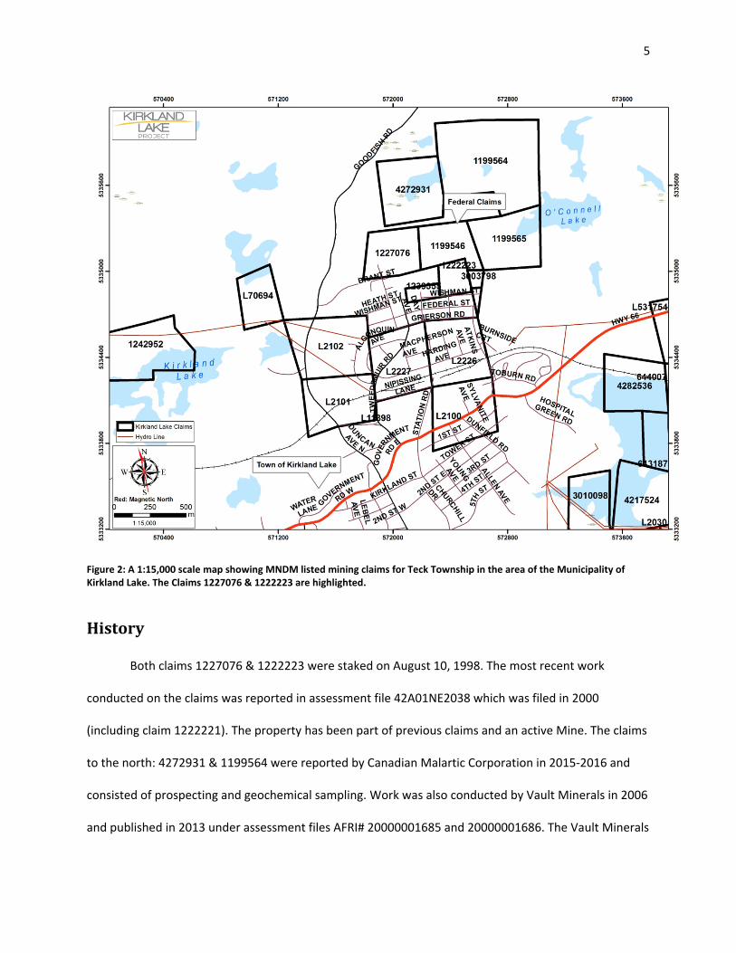
Figure 2: A 1:15,000 scale map showing MNDM listed mining claims for Teck Township in the area of the Municipality of Kirkland Lake. The Claims 1227076 & 1222223 are highlighted.
History
Both claims 1227076 & 1222223 were staked on August 10, 1998. The most recent work
conducted on the claims was reported in assessment file 42A01NE2038 which was filed in 2000
(including claim 1222221). The property has been part of previous claims and an active Mine. The claims
to the north: 4272931 & 1199564 were reported by Canadian Malartic Corporation in 2015‐2016 and
consisted of prospecting and geochemical sampling. Work was also conducted by Vault Minerals in 2006
and published in 2013 under assessment files AFRI# 20000001685 and 20000001686. The Vault Minerals

6
work was designed to assess the Kirkland Basin and Federal Kirkland historic properties. Vault Minerals
was 100% acquired by Queenston Mining Inc. which in turn was 100% acquired by Osisko Mining Ltd and
was then acquired by a 50‐50% agreement between Agnico Eagle and Yamana Gold who formed the
Osisko properties into the Canadian Malartic Corporation. Vault Minerals conducted a mapping and
sampling program on their claims on the Federal Mine property.
Historically, The Federal Mine property has had extensive and near continuous work conducted
on it, most notably a 745 ft shaft which is currently capped in the northeast corner of claim #1222223.
The underground workings consist of four levels situated at 200, 400, 500 and 700 feet below surface
with pervasive drifting. Another notable period in the Federal Mine property was in 1986 and 1987,
when a drill program was initiated by Goldhunter Explorations Inc. The drill program consisted of 27
diamond drill holes primarily targeting the mine workings on claim #1222223 and 1227076.
The historic drilling and stripping programs listed by Goldhunter Explorations Inc. or other
assessment files appears to have been concentrated in claim 1222223. Only limited prospecting and
mapping appears to have been reported on the claim area.
PropertyGeology
The claims 1227076 & 1222223 are situated within the prolific Kirkland Lake gold camp which is
part of the Abitibi Greenstone belt in the Superior Province. The Abitibi Greenstone belt is Archean in
age and is composed of greenschist facies volcanic and sedimentary rocks with localized syn‐post
tectonic intrusions of granitic to dioritic dykes to batholiths. The Abitibi Greenstone belt forms an east
plunging synclinorium between the Abitibi batholith, northeast of Timmins and the Round Lake
batholith, south of Kirkland Lake. Mesozoic aged kimberlitic dykes are also present in the Kirkland Lake
Camp but are rare in occurrence. The Kirkland Lake Camp hosts Keewatin (2750‐2700 Ma) and
7
Temiskaming (2690‐2670 Ma) aged assemblages associated with the Abitibi Greenstone belt. The
Keewatin assemblages within the Kirkland Lake Camp are composed of the greenschist facies volcanco‐
sedimentary lithologies of the: Pacaud, Deloro, Stoughton‐Roquemaure, Kidd‐Munro, Tisdale, Kinojevis,
and Blake River groups. The Temiskaming assemblage within the Kirkland Lake camp is the Temiskaming
group, noted for its non‐marine, variably metamorphosed, pyroclastic and clastic‐sedimentary
(conglomerate) lithological units. Temiskaming group meta‐sedimentary rocks form along the north
facing side of the Larder Lake‐Cadillac Deformation Zone (LLCDZ), a major east‐west structural control
associated with chemical alteration and sulphide mineralization. The LLCDZ length coincides with a
folded and deformed sinuous belt of sedimentary rocks of Temiskaming age.
The claim 1227076 hosts Temiskaming meta‐sediments (conglomerate) and a Kinojevis mafic
intrusive suite (gabbro, Error! Reference source not found.). The Temiskaming sediments are present in
the northwest while the mafic intrusives are in the north of the claim1227076. Claim 1222223 largely
hosts intrusive volcanic units which are generally described as augite syenites, porphyries, trachytes and
lamprophyres. The inferred contact from Ontario Geological Survey maps is striking northeast, through
the centre of the claim. Both map units host various degrees of structural deformation from brittle
(faults) to ductile (foliation/shearing); notably the north‐south Sylvanite fault passes through the centre
of the claim 1227076.
To the North of the claims are a series of Keewatin aged basic volcanics (greenstone) of the
Kinojevis Group. To the south are a series of Temiskaming meta‐sedimentary units and felsic‐
intermediate intrusives (syenite‐diorite).

8
GeneralDescriptionofSampledRockUnits
Meta‐Sediment:GreywackeGrain Size: Fine grained (fine sand sized grains)
Texture: massive with conchoidal breaks
Alteration: Generally fresh with weak to moderate carbonate (ankerite?) alteration
Mineralization: <1‐1mm anhedral pyrite disseminated within matrix
Magnetism: non‐magnetic
Veining: There are <1% abundant, <1‐3mm thick, milky quartz‐carbonate stringers
MaficSyeniteGrain Size: Fine‐medium grained (euhedral grains) with 2‐3mm augite grains
Texture: massive
Alteration: Generally fresh with weak to moderate carbonate (calcite/ankerite) alteration
Mineralization: non‐visible
Magnetism: weak to moderate
Veining: There are <1% abundant, <1‐3mm thick, milky quartz‐carbonate stringers
SyenitePorphyryGrain size: Coarse grained: 3‐6mm euhedral plagioclase grains
Texture: massive
Alteration: bleached white‐pink weathering colour, weak patches of red hematite alteration along joints
Mineralization: non‐visible
Magnetism: non‐magnetic
Veining: isolated, sub‐planar stringers of <2mm thick quartz‐carbonate which are <<1% abundant.

9
Figure 3: Local Geology in the Claim area north of Kirkland Lake. The map shows the bands of Temiskaming meta‐sediments intruded with felsic‐intermediate intrusives and Keewatin volcanics in contact to the north of the Temiskaming sediments.
10
DescriptionofRecentWork
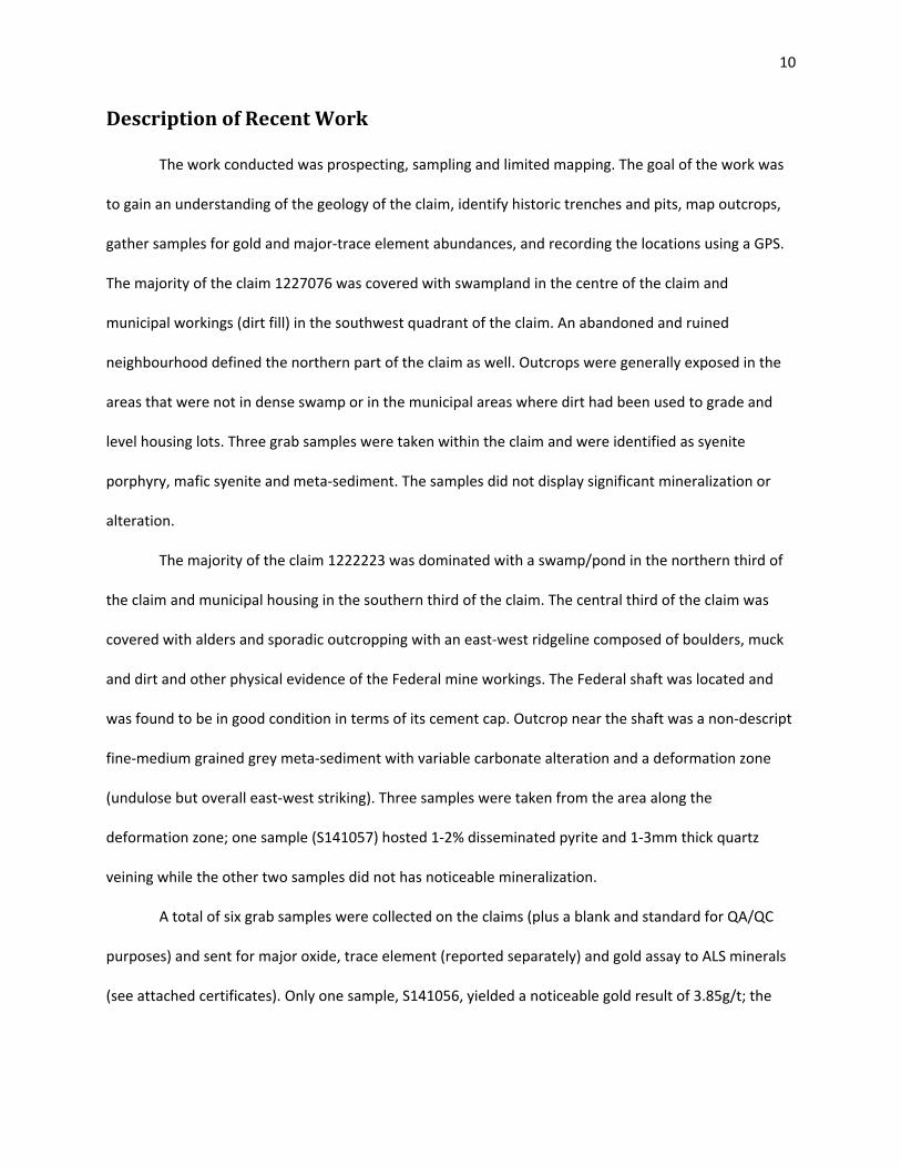
The work conducted was prospecting, sampling and limited mapping. The goal of the work was
to gain an understanding of the geology of the claim, identify historic trenches and pits, map outcrops,
gather samples for gold and major‐trace element abundances, and recording the locations using a GPS.
The majority of the claim 1227076 was covered with swampland in the centre of the claim and
municipal workings (dirt fill) in the southwest quadrant of the claim. An abandoned and ruined
neighbourhood defined the northern part of the claim as well. Outcrops were generally exposed in the
areas that were not in dense swamp or in the municipal areas where dirt had been used to grade and
level housing lots. Three grab samples were taken within the claim and were identified as syenite
porphyry, mafic syenite and meta‐sediment. The samples did not display significant mineralization or
alteration.
The majority of the claim 1222223 was dominated with a swamp/pond in the northern third of
the claim and municipal housing in the southern third of the claim. The central third of the claim was
covered with alders and sporadic outcropping with an east‐west ridgeline composed of boulders, muck
and dirt and other physical evidence of the Federal mine workings. The Federal shaft was located and
was found to be in good condition in terms of its cement cap. Outcrop near the shaft was a non‐descript
fine‐medium grained grey meta‐sediment with variable carbonate alteration and a deformation zone
(undulose but overall east‐west striking). Three samples were taken from the area along the
deformation zone; one sample (S141057) hosted 1‐2% disseminated pyrite and 1‐3mm thick quartz
veining while the other two samples did not has noticeable mineralization.
A total of six grab samples were collected on the claims (plus a blank and standard for QA/QC
purposes) and sent for major oxide, trace element (reported separately) and gold assay to ALS minerals
(see attached certificates). Only one sample, S141056, yielded a noticeable gold result of 3.85g/t; the

11
sample was taken directly from the deformation zone which hosted 1‐3% pyrite with rusty weathered
carbonate(ankerite? –test with potassium ferro‐cyanide) alteration.
ConclusionsandRecommendations
A grid should be established in a low impact manner to reduce disturbance of the environment
and residents. Following the establishment of a grid an IP survey and limited stripping should be
conducted pending the geochemical results of the grab sample analysis. The outcrop around the Federal
shaft should be re‐stripped and washed so a highly detailed outcrop map can be produced.
Respectfully Submitted,
Christopher A. L. Clarke

12
DataThe work was carried out as follows:
Field:
Prospecting July 12, 2016 to July 14, 2016
Office:
Report July 14, 2016
Persons who carried out the work:
Prospecting:
Christopher A.L. Clarke Larder Lake, On
Christal Hanuszczak Kirkland Lake, On
Report:
Christopher A.L. Clarke
Sample List (UTM zone 17 NAD 83)
Waypoint Northing Easting Rock Type
S141056 5334970 572456 Metasediment
S141057 5334960 572444 Metasediment
S141058 5334959 572435 Metasediment
S141059 5335085 571961 Syenite Porphyry
S141060 5335134 571983 Mafic Syenite
S141061 5335111 572024 Syenite Porphyry
13
July 12, 2016 – 1 Day Prospecting
Workers: Christopher Clarke; Christal Hanuszczak
Weather: Heat warning, sunny and humid (36%)
We drove our truck to ‘Finn Town’ which is the northern (unmapped) extent of Foss Rd. and parked our
vehicle just south of the town by an ATV trail. The objective for the day was locating the historic Federal
shaft. Using the AMIS co‐ordinates for the shaft we proceeded down an ATV trail looking for the shaft
which appeared to be situated near the trail. Walking down the trail we did not encounter the shaft
leading us to leave the trail and head south towards the AMIS co‐ordinates. Heading south from the trail
we encountered dense alder patches and a moderate incline composed of rubble/muck. At the summit
of the incline was the shaft along with an east‐west trending outcrops. The shaft was capped and in
good condition and defined the eastern boundary of the outcrop. The outcrop extended to the west for
approximately 40m and appeared to be a single lithology with a ductile deformation structure through
it. The outcrop appeared to be a meta‐sediment which was fine‐medium grained, grey coloured on fresh
surfaces, rust brown on weathered surfaces, and with carbonate alteration. The carbonate alteration
increased near a ductile deformation zone trending east‐west along the southern edge of the outcrop.
The deformation zone was a dark brown colour with 1‐4mm thick carbonate veining, there were no
visible sulphides but there was a channel sample running perpendicular through the deformation near
the shaft. Three samples were taken: S141056‐S141058 at intervals along the outcrop and generally
taken near the deformation zone. After the samples were taken and recorded we proceeded to locate
the historic road to the shaft, however, the road was completely overgrown with alders and we had
difficulty following it back to Foss Road. After returning to the road we returned to the truck and
completed the day.
Prospecting Diary for Christopher Clarke, B.Sc, M.Sc, P.Geo
July 13, 2016 – 2 Day Prospecting
Workers: Christopher Clarke; Christal Hanuszczak
Weather: Heat warning, sunny/overcast and humid (36%)
We drove our truck to the northern end of Wilson Ave. and parked our truck there. We then proceeded
to locate any outcrops within the southern portion of the claim. During this traverse it became clear that
the southwest quadrant of the claim has largely been built up with dirt for municipal housing. There
were several ruined foundations in this area which was also graded and flat though overgrown with
grass and alders. Along the edges of this flat area, the ground level dropped precipitously by several
metres into a marsh/swamp. Descending into the swampland we located several outcrops which formed
a roughly ENE trend in the centre of the claim. The outcrop was generally covered with moss and spruce
trees instead of alders. The outcrop lithologies alternated between medium grained plagioclase syenite
porphyry and ‘Kirkland Lake’ mafic syenite (augite phenocrysts 1‐3mm in size). The mafic syenite was
magnetic while the porphyry was non‐magnetic. We took three samples in three outcrops within this

14
area: two of porphyry and one of mafic syenite (Samples S141059‐S141061). There was no visible
mineralization within the samples.
At this point we returned to the truck and drove to Goodfish Road with the objective of accessing the
northern portion of the claim since deep swamp and creeks blocked our access from the south. We left
Goodfish Road and entered an abandoned neighbourhood we located last year during our work on claim
4272931. The abandoned neighbourhood occupies the northern portion of the claim. We located one
outcrop in the west‐central edge of the claim along the boundary between the swamp and abandoned
neighbourhood. The outcrop was composed of a cryptic lithology which had a fine grained matrix and
ovoid alteration ‘rings’ and euhedral grains which led us to suspect it was either an altered trachyte or
some form of meta‐sediment. We could not break off an adequate fresh piece to determine the
lithology definitively. At this point the heat and humidity began to affect us and we returned to the truck
and ended the day.
Prospecting Diary for Christopher Clarke, B.Sc, M.Sc, P.Geo

15
Figure 4: Map showing the GPS tracks and waypoints for the worker's traverses on July 12‐13, 2016 for claims 1227076 & 1222223.

16
Figure 5: A 1:4,000 scale satellite map showing access and traverse tracks for claims 1227076 & 1222223.