PROSPECTING REPORT ON SOIL, SILT AND WATER SAMPLING …
21
PROSPECTING REPORT ON SOIL, S I L T AND WATER SAMPLING CCI'XDUCTED ON "IBLE" MINERiL CLAIM RECORD NO. 968 (8) KAMLOOPS MINING DIVISION N.T.S. 921/6E 121O-03' WEST AND 50°-18' NORTH OWNER : ROBERT McLEAN, F.M.C. #159278 OPERATOR: FLEXIBLE RESOURCES SYNDICATE CONSULTANT : G . S . ELDRIDGE , P . ENG . AUTHOR: ROBEET McLEAN DATE : 31 JULY, 1978
Transcript of PROSPECTING REPORT ON SOIL, SILT AND WATER SAMPLING …

PROSPECTING REPORT
ON
S O I L , S I L T AND WATER SAMPLING
CCI'XDUCTED ON
"IBLE" M I N E R i L CLAIM RECORD NO. 9 6 8 ( 8 )
KAMLOOPS MINING D I V I S I O N
N . T . S . 9 2 1 / 6 E
121O-03' WEST AND 50°-18 ' NORTH
OWNER : ROBERT McLEAN, F .M.C. # 1 5 9 2 7 8
OPERATOR: FLEXIBLE RESOURCES SYNDICATE
CONSULTANT : G . S . ELDRIDGE , P . ENG . AUTHOR: ROBEET McLEAN
DATE : 3 1 J U L Y , 1 9 7 8

CONTENTS
Page N o .
1.
2 .
3 .
4 .
5.
6 .
7 .
8 .
9 .
1 0 .
11.
1 2 .
a) Index Map S c a l e ; 1:50 ,000
i-: - . L o c a t i o n Map S c a l e ; 1:125,000
1r:trod.uction and Genera l Remarks
C:mr.ershiF of t h e P r o p e r t y
L s c a t i o n and Access
P c r s o s e o f P r o s p e c t i n g T r i p
P r o s p e c t i n g blethods and Work Per formed
a.) Wcrk Per formance
b) G r i d S t a k i n g
c) S i l t Sampling
d ) Water Sampling
e) S o i l Sampling
f ) Record Data of Samples and O b s e r v a t i o n s
SuImary of R e s u l t s
C o n c l u s i o n s
C o n s u l t a n t s Review
A u t h o r ' s Q u a l i f i c a t i o n s
At t achmen t s :
a ) P r o p e r t y C l a i m Map S c a l e 1 : 5 0 , 0 0 0
b) Map of Sampled A r e a S c a l e 1 :2 ,500
c ) Map of F a u l t Zone S c a l e 1 : 1 0 0 , 0 0 0
d! Asszyer ' s R e p o r t s _ _
f i ...
6
6
7
7
8
9 & 1 0
11
11
1 2
1 3
1 4
15 1 6
1 7
1 8 & 1 9

THE "IBLE" MINERAL CLAIM
I N T R O D U C T I O N AND GENERAL REMARKS
A s a r e s u l t of Geophys ica l and Geochemical work per formed on t h e
"FLEX" m i n e r a l c l a i m d u r i n g J u l y , 1977, t h e a d j o i n i n g "IBLE"
m i n e r a l c l a i m w a s s t a k e d t o cover p o s s i b l e e x t e n s i o n of t h e
m i n e r a l i z - d zones i n d i c a t e d on t h e s u r v e y s . The c l a i m e x t e n d s
from t h e e a s t e r n s l o p e s o f t h e Skuhun Creek V a l l e y a t a b o u t
e levat icp 1 2 0 0 m across t h e V a l l e y a t 850 t o 910 m e l e v a t i o n
and up t h e w e s t s l o p e s t o a b o u t e l e v a t i o n 1 3 0 0 m where it a d j o i n s
t h e e a s t e r n boundary of t h e "FLEX" claim.
/
The Skuhur: Creek Road t r a v e r s e s t h e c l a i m i n t h e n o r t h - e a s t e r l y
d i r e c t i o n a 2 p r o x i m a t e l y a t c l a i m c e n t r e a n d e l e v a t i o n 885 m.
The c l a i m c o v e r s a cross f r a c t u r e d f a u l t zone r u n n i n g e a s t t o
w e s t and i n t e r s e c t i n g w i t h t h e main Lornex n o r t h t o s o u t h f a u l t .
N o a s s e s s m e n t work a p p e a r s t o have been recorGed p r e v i o u s l y on
t h e c l a i m . Dur ing s t a k i n g o f " I B L E " c l a i m , s o i l , and r o c k o u t c r o p
samples w e r e t a k e n a l o n g t h e e a s t e r n boundary l i n e . The r o c k
a p p e a r s t o b e q u a r t z d i o r i t e and i s s t r o n g l y m a g n e t i c . The s o i l sample w a s t a k e n ir, v i c i n i t y of p o s t 2 N a n d on s u b s e q u e n t exam-
i n a t i o n c o n s i s t e d of a m i x t u r e of s m a l l rose and w h i t e c o l o u r e d
q u a r t z p e b b l e s embedded w i t h m a g n e t i t e and a l so t e s t e d s t r o n g l y
magnetic: throughout t h e sample . T r a c e s of B o r n i t e and M a g n e t i t e
w e r e d i s c e r n e d i n t h e p e b b l e s . A few f l a k e s t h a t l ooked l i k e
m i n e r a l i z a t i o n w e r e d e t e c t e d i n t h e sample b u t n o t enough t o p e r m i t a p o s i t i v e i d e n t i f i c a t i o n .
--c - - - --
The e a s t e r n s l o p e s of t h e p r o p e r t y have a s t e a d y w a t e r r un -o f f
l e a d i n g i n t o a swamp area w i t h several c o n n e c t i n g beaver-damned
ponds which e f f l u e n c e i n t o t h e Skuhun Creek . Approximate ly h a l f the na-j.=r pond zrea i s an Ii T- -sku - p 71 E n i t 815 t h e o t h e r h a l f e x t e n d s
t o t h e n o r t h . A f l a t area e x t e n d s west f r o m t h e pond towards t h e
Skuhun C r e e k Road f o r a d i s t a n c e of a b o u t 1 2 0 m , before c l a i m
a s c e n d s t h e s o u t h - e a s t e r l y s l o p e s of Skwilkwakwil Mountain. 9 5
P.3
OWNERSHIP OF THE PROPERTY
The r eco rded and r e g i s t e r e d owner of t h e p r o p e r t y h e l d by
l o c a t i o n i s Rober t McLean FMC #159278 d a t e d a t Vancouver,
9 J a n u a r y , 1978.
The " I B L E " c l a i m c o n s i s t s of t e n ( 1 0 ) m e t r i c u n i t s s t a k e d on
t h e modificci g r i d system and r u n s t w o ( 2 ) u n i t s n o r t h and f i v e
(5 ) u n i t s Z C I S ~ of l e g a l c o r n e r p o s t #35257.
The r e c o r d >umber of t h e " I B L E " m i n e r a l c l a i m i s #968 (8) i n
Kamloops XiXing D i v i s i o n and e x p i r y d a t e i s 3 August , 1 9 7 9 * *
* * Assunisg t h i s r e p o r t i s accep ted f o r f i l i n g .
LOCATION APjD ACCESS
The "IBLE" c l a i m i s l o c a t e d abou t mid-way up t h e Skuhun C r e e k
Va l l ey and on bo th s i d e s of t h e Skuhun Creek i n t h e sou the rn h a l f of t h e Highland Val ley area of B r i t i s h Columbia, and
a b o u t 10 .5 K i l o m e t e r s s o u t h of t h e e a s t e r n end of t h e
Pimainus Lakes.
C l a i m i s c e n t r e d abou t 121"-03 ' west and 5G0-i8' n o r t h .
A c c e s s i s by main highway from Spences-Bridge abou t 22.5 K i l o -
m e t e r s e a s t towards town o f Merr i t t t h e n n o r t h e a s t e r l y by
g r a v e l road f o r a b o u t 1 2 K i l o m e t e r s .
The c l a i m s t r a d d l e s t h e g r a v e l road a t a b o u t mid-point of c l a i m
=.r,c? i s accessible bv - - p~ssezger automto5ile t o t h i s p o i n t .
P . 4 __ -

PURPOSE OF PROSPECTING TRIP
I t has been noted t h a t o t h e r copper mine ra l d e p o s i t s of
commercial va lue w e r e found i n t h e l o w l y i n q area of v a l l e y s .
S p e c i f i c a l l y t h e Va l l ey Copper d e p o s i t t o t h e n o r t h and t h e
Maggie Mine t o t h e north-west . I t i s cons ide red t h a t f u r t h e r
i n v e s t i g a t i o n of t h e "IBLE" low l y i n g p a r t of t h e Skuhun Va l l ey
t o t h e e a s t of t h e Lornex f a u l t zone and i n area of t h e beaver
ponds merizs p r o s p e c t i n g t o determine i f t h i s a r e a h o l d s min-
e r a l potnr.:ial w i t h mineable p o s s i b i l i t i e s .
The ares :: l a r g e l y covered i n overburden which i s b e l i e v e d
t o be a t c c s s i d e r a b i e dep th , t h e r e f o r e a program of s o i l , s i l t and water sampling around t h e pond areas w i l l b e bene-
f i c i a l i n de te rmining t h e minera l p o t e n t i a l o f t h e a r e a . The
o b j e c t i v e be ing t o f i n d o u t i f f u r t h e r Geochemical and Geo-
p h y s i c a l survey work i s warran ted i n t h a t area i n p re fe rence
t o a planned program i n a r e a a d j o i n i n g t h e "FLEX" c l a i m .
P .5 -.


- P R O S P E C T I N G METHODS AND WORK PERFORMED
a ) Work Performance cc
The f i e l d work w a s c a r r i e d o u t d u r i n g p e r i o d 1 4 J u l y t o 1 6 JE ly by p r o s p e c t o r R. McLean, t h e r eco rded owner o f
t h e n r o p e r t y and a s s i s t e d throughout by p r o s p e c t o r
W i l l i a m Bain F.M.C. #167565.
The o F e r a t i o n s w e r e t imed t o permit s i l t sampling when
pon5.s xere a t a summer l o w l eve l and m o r e r e a d i l y
accessible f o r sampling. The pond area i s surrounded
by t h i z k underbrush and modera te ly t imbered w i t h p i n e ,
c o t t o r - m o d and c o n i f e r o u s trees. A c c e s s th rough bog
areas and b r u s h made go ing r a t h e r d i f f i c u l t b u t s i g h t i n g s
from t a l l t rees enabled g r i d c o - o r d i n a t e s t o be a c c u r a t e l y
l o c a t e d .
b - Grid S t a k i n q
B a s e l i n e s w e r e s t a k e d o u t a t 30 m i n t e r v a l s on t h e w e s t and e a s t s i d e s of t h e ponds on a c o - o r d i n a t e b a s i s t h a t
t i e s - i n t o su rveys conducted on "FLEX" mine ra l c l a i m i n
1977'. The base l i n e s w e r e e s t a b l i s h e d a t n i n e t y deg rees t o " I B L E " boundary l i n e 2 N and a t d i s t a n c e s o f 220 m w e s t o f
pos t 2N1W t o cover pond area and a t 1 4 0 m east o f p o s t 2 N 1 W
t o cover the h i g h e r e l e v a t i o n s .
The eas t boundary o f " I B L E " c l a i m w a s a l so s t a k e d o u t p a r t -
way. The s t a t i o n s w e r e marked w i t h o range p a i n t e d wooden
s t a k e s a t each i n t e r v a l and i d e n t i f i c a t i o n co -o rd ina te s
marked t h e r e o n . The d i s t a n c e s t o edge of ponds w e r e t h e n
compassed and chained-off a t r i g h t a n g l e s t o b a s e l i n e s
and measurements r eco rded t o e n a b l e a r easonab ly a c c u r a t e F & ? 7 7 - . 7 i2i2.1Ay '?n of the pond zrea. Access noints t o pond area w e r e
f l a g g e d w i t h p ink t a p e a t r o a d s i d e where l i n e L17S and L23S
cross o v e r , t o e n a b l e easier l o c a t i o n i n t h e f u t u r e .

c) - S i l t Sampling
A s p e c i a l l y c o n s t r u c t e d 50 mm d i a m e t e r aluminum t u b e d e v i c e
a b o u t 1 . 2 5 m i n l e n g t h w i t h a serrated end f o r easier i n -
s e r t i o n and a n i n t e r n a l s i l t t r a p t o e n s u r e r e t e n t i o n o f
major p o r t i o n , w a s used t o o b t a i n t h e samples f rom t h e
bo t tom of ponds. Three s i l t samples a b o u t 1 m a p a r t w e r e t a k e n a t e a c h loca t ion on t h e pond and t h e s i l t s combined
i n a Gold pan . F l u s h i n g w a t e r t a k e n f r o m t h e pond w a s t h e n
poured t h r o u g h t h e t u b e t c r e n s u r e as much o f , and as r e p r e - s e n t a t i v e a sample a s p o s s i b l e , w a s o b t a i n e d .
A l l s i l t samples w e r e t a k e n a t d e p t h s r a n g i n g from 450 mm t o
6 0 6 TT. below bottom o f ponds.
A f t e r s e t t l i n g of samples t h e e x c e s s w a t e r w a s c a r e f u l l y s loughed-o f f f r o m t h e p a n and t h e r e s i d u e s i l t scooped i n t o
brown w e t - s t r e n g t h p a p e r bags. G r i d c o - o r d i n a t e s w e r e marked on bags f o r f u t u r e i d e n t i f i c a t i o n when a s s a y i n g . E i g h t ( 8 ) s i l t samples w e r e t a k e n u s i n g t h i s method.
d ) Water Sampling
Seven ( 7 ) w a t e r samples w e r e collected a t s t r a t e g i c l o c a t i o n s
i n s t e r i l i z e d p l a s t i c b o t t l e s w i t h t i g h t f i t t i n g covers.
Three l o c a t i o n s w e r e t a k e n from t h e c r e e k , o n e f r o m a swamp
area a n d t h r e e a t d i f f e r e n t l o c a t i o n s f r o m t n e run-of f water
coming from t h e e a s t e r n s l o p e s .
A l l s e v e n ( 7 ) w a t e r s amples have been r e t a i n e d f o r f u t u r e
a n a l y s i s . A
Two samples tested s l i g h t l y a l k a l i n e , t h e o t h e r f i v e n e u t r a l
by litmus t es t .
P . 7

e) So i l Sampling
S o i l samples w e r e t a k e n a t a l l s t a t i o n s on b a s e l i n e s , a t
p o i n t s a d j a c e n t t o s i l t samples ,and u p h i l l from pond area i n c l u d i n g some a t e a s t e r n boundary of "IBLE" c l a i m n e a r
p o s t 2 N .
T h i r t y - f o u r ( 3 4 ) soil samples w e r e t a k e n u s i n g a mattock-type
p i c k aad s m a l l t r o w e l .
All ssi ls w e r e t a k e n from t h e "B" o r s u b - s u r f a c e l a y e r a t
d e p t h s r ang ing froin 1 0 0 t o 2 0 0 mm.
All soils w e r e t e s t e d w i t h a p e n c i l magnet , c o l o u r noted and
v i s u a l l y c l a s s i f i e d by s i z e of p a r t i c l e s a s sand, s i l t o r c l a y s .
Samples w e r e t h e n p l a c e d i n w e t - s t r e n g t h bags and c o - o r d i n a t e s
marked f o r f u t u r e i d e n t i f i c a t i o n and a n a l y s i s .
On r e t u r n t o Vancouver, a l l silt and s o i l samples w e r e sub-
m i t t e d t o ACME A n a l y t i c a l L a b o r i t o r i e s i n Burnaby f o r Cu a s s a y s aisd approximate ly h a l f f o r A g a s s a y s .
On n o t i n g t h e good s i l v e r v a l u e s i n samples and c o n s i d e r i n g
t h e a l k a l i n i t y of t h e w a t e r samples , t h e samples w e r e re- run f ~ r z i r ~ ~ cor i ten t with i n t e r e s t i n g results.
P.8

RECORD DATA OF SAMPLES AND OBSERVATIONS
SAMPLE NO. TYPE
1. S O I L
2. S O I L
3. S O I L
4. S O I L
5. S O I L
6. S O I L
7. S O I L
8 . S O I L
9. S O I L
1 0 . S O I L
11. S O I L
1 2 . S O I L
13. S O I L
1 4 S O I L
1 5 . S O I L
1 6 . S O I L
17 . S O I L
18. S O I L
1 9 . S O I L
20. S O I L
21. S O I L
22. S O I L
23. S O I L
24. S O I L
25. S O I L
26. S O I L
CO-ORDINATES COLOUR TEXTURE DEPTH mm
2 N
1 7 S
1 8 S
1 9 s
2 0 s
1’6 S
1 5 S
1 4 S
2 N
2 N
2 N
1 7 S
1 8 S
1 9 s
2 0 s
2 1 s
2 2 s
2 3 S
2 4 S
25 S
23 S
22 s
2 1 s
2 0 s
1 9 s
1 8 S
AT POST
2 0 0 E
2 0 0 E
200 E
2 0 0 E
2 0 0 E
200 E
200 E
1 9 6 E
1 9 0 E
1 8 4 E
1 7 6 E
176E
1 7 6 E
1 7 6 E
1 7 6 E
1 7 6 E
1 7 6 E
1 7 6 E
1 7 6 E
1 5 2 E
1 5 2 E
1 5 2 E
1 5 2 E
1 5 2 E
1 5 2 E
GREY BROWN
GREY BROWN
GREY BROWN
OLIVE BROWN
OLIVE BROWN
OLIVE BROWN
OLIVE BROWN
OLIVE BROWN
OLIVE BROWN
LIGHT BROWN
LIGHT BROWN
L I G H T BROWN
LIGHT BROWN
BROWN
BROWN
OLIVE BROWN
OLIVE BROWN
GREY BROWN
BROWN
GREY BROWN
OLIVE BROWN
OLIVE BROWN
OLIVE BROWN
OLIVE BROWN
OLIVE BROWN
BROWN
SAND
SAND
SAND
SAND
SAND
SAND
SAND
S I L T
S ILT
SAND
SAND
S I L T
SAND
SAND
SAbJD
S I L T
SAND
SAND
SAND
SAND
S I L T
S I L T
S I L T
S I L T
S I L T
SAND
200
1 5 0
2 0 0
1 7 5
200
2 0 0
1 7 5
2 0 0
1 7 5
2 0 0
1 5 0
1 7 5
2 0 0
200
200
1 7 5
1 5 0
1 2 5
1 5 0
1 5 0
2 0 0
400
1 7 5
2 0 0
2 0 0
1 7 5
OBSERVATIONS C u ppm A g pp m Zn ppm
STRONGLY MAGNETIC, METALLIC FLAKES 25 5 2
MAGNETIC 2 8 58
STRONGLY MAGNETIC, METALLIC FLAKES 29 3 6
MAGNETIC, METTALLIC FLAKES 25 4 5
MAGNETIC 5 2 6 0
MAGNETIC 50 9 2
MAGNETIC 42 6 0
MAGNETIC 44 1 4 5
MAGNETIC 3 6 62
MAGNETIC, METALLIC FLAKES 1 8 58
MAGNETIC 1 8 64
STRONGLY MAGNETIC, METALLIC FLAKES 1 8 62
STRONGLY MAGNETIC, METALLIC FLAKES 1 8 48
STRONGLY MAGNETIC 2 6 26
STRONGLY MAGNETIC 20 48
2 6 66 STRONGLY MAGNETIC, METALLIC FLAKES
STRONGLY MAGNETIC, METALLIC FLAKES
STRONGLY MAGNETIC, METALLIC FLAKES
STRONGLY MAGNETIC, METALLIC FLAKES
STRONGLY MAGNETIC, METALLIC FLAKES
MAGNETIC, METALLIC FLAKES
BOG SAMPLE, MAGNTIC, METALLIC FLAKES
MAGNETIC
MAGNETIC
STRONGLY MAGNETIC, V I S I B L E MICA
MAGNETIC, METALLIC FLAKES
1 8
11
1 4
45
3 8
50
1 4 .1 4 2
74 .2 2 2
82 .1 2 5
7 6 .1 2 2
3 1 .1 1 8
82 .1 2 2
1 1 8 .1 5 2

1
OBSERVATIONS Cu ppm Ag ppm Zn ppm SAMPLE NO. TYPE C O-ORD I NATE S COLOUR TEXTURE DEPTH mm
MAGNETIC 34 .2 1 2 6
94 .3 3 0
27. SOIL 1 7 S 1 5 2 E OLIVE BROWN SILT 1 5 0
28. SOIL 2 5 S 1 5 2 E OLIVE BROWN SILT 200 MAGNETIC, METALLIC FLAKES
29. SOIL 24 S 1 5 2 E OLIVE BROWN SILT 2 0 0 MAGNETIC, METALLIC FLAKES
30. SILT 23 S 1 5 6 E OLIVE GREEN SILT 5 5 0 NON-MAGNE TIC
31. SOIL 22 S 1 5 3 E OLIVE GREEN SILT 1 7 5 MAGNETIC, METALLIC FLAKES
32. SOIL
33. SOIL
34. SOIL
35. SOIL
36. SOIL
37. SILT
38. SILT
39. SILT
40.
41.
42.
43.
44.
45.
46.
47.
48.
49.
SILT
SILT
SILT
WATER
WATER
WATER
WATER
WATER
WATER
WATER
2 1 S 1 5 4 E
2 0 S 1 5 5 E
1 9 S 1 5 6 E
1 8 S 1 5 7 E
1 7 S 1 5 8 E
2 2 S 1 5 3 E
2 1 S 1 5 4 E
2 0 S 1 5 5 E
1 9 S 1 5 6 E
1 8 S 1 5 7 E
1 7 S 1 5 8 E
2 2 S 1 5 3 E
2 1 S 1 5 5 E
1 9 S 1 5 6 E
1 7 S 1 5 8 E
1 7 S 1 5 6 E
1 7 S 1 5 4 E
25 S 1 4 6 E
OLIVE BROWN
OLIVE BROWN
OLIVE BROWN
OLIVE BROWN
OLIVE BROWN
OLIVE BROWN
OLIVE GREEN
OLIVE GREEN
BLACK
BLACK
BLACK
CLEAR
CLEAR
CLEAR
GREENISH
CLEAR
CLEAR
CLEAR
SILT
SILT
SILT
SAND
SAND
SILT
SILT
SILT
CLAY
CLAY
CLAY
FLOWING
FLOWING
FLOWING
STATIC FAST FLOWING FAST FLOWING FAST FLOWING
1 5 0
2 0 0
2 0 0
1 7 5
200
500
600
6 0 0
5 5 0
600
5 7 5
1 5 0
1 5 0
3 0 0
4 0 0
250
250
250
MAGNETIC, METALLIC FLAKES
MAGNETIC, METALLIC FLAKES
STRONGLY MAGNETIC, METALLIC FLAKES
STRONGLY MAGNETIC, METALLIC FLAKES
S TRON GLY MAGNET I C
MAGNETIC, METALLIC FLAKES
NON-MAGNETIC, METALLIC FLAKES
NON-MAGNETIC, METALLIC FLAKES
1 0 6 .4 26
6 2 .2 2 0
3 6 .1 1 6
3 4
54
5 2
5 2
46
3 7
58
42
.1
.1
.1
.1
.3
.1
.1
.1
1 8
2 2
2 0
24
2 2
1 8
2 2
2 0
1 3 4 .4 2 4
1 2 8 .3 2 5
7 6 .2 2 8
SPONGY, NON-MAGNETIC, METALLIC FLAKES
SPONGY, NON-MAGNETIC
SPONGY, NON-MAGNETIC
RUN-OFF FROM SMALL POND, NEUTRAL PH
RUN-OFF FROM LARGE POND, SLIGHTLY ALKALINE
RUN-OFF FROM EAST SLOPES, SLIGHTLY ALKALINE
SWAMP, NEUTRAL PH
SKUHUN CREEK EAST FORK, NEUTRAL PH
SKUHUN CREEK WEST FORK, NEUTRAL PH
SKUHUN CREEK COMBINED FLOW, NEUTRAL PH
P.10
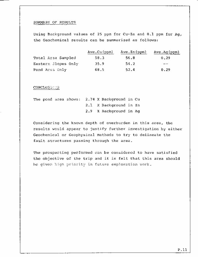
SUMMARY O F RESULTS
Using Background v a l u e s of 2 5 ppm f o r Cu-Zn and 0 . 1 ppm f o r Ag, t h e Geochemical r e s u l t s c a n be summarized as fo l lows :
Ave . Cu (ppm) Ave . Zn ( ppm) A v e .Ag (ppm) Total A r f a Sampled 58.3 56.8 0.29 Easterr, S lopes Only 35.9 54.2 -- Pond Are3 Only 68.5 52 .4 0.29
CONCLUSiCN3
The pond area shows: 2 . 7 4 X Background i n Cu
2 . 1 X Background i n Zn
2 . 9 X Background i n A g
Cons ide r ing t h e known d e p t h of overburden i n t h i s area, t h e
r e s u l t s would appear t o j u s t i f y f u r t h e r i n v e s t i g a t i o n by e i t h e r
Geochemical o r Geophysical methods t o t r y t o d e l i n e a t e t h e
f a u l t s t r u c t u r e s p a s s i n g through t h e area.
The p r o s p e c t i n g performed can b e c o n s i d e r e d t o have s a t i s f i e d
t h e o b j e c t i v e o f t h e t r i p and it is f e l t t h a t t h i s area should
h e given ir! f u t u r e e x p l o r a t i o n work.
P . l l

CONSULTANT’S REVIEW
305 - 543 G r a n v i l l e S t .
Vancouver, B . C . 31 J u l y , 1978
I t w a s n o t i c e d on t h e g e o l o g i c a l maps of t h e d i s t r i c t , t h a t t h e
major nor th-south f r a c t u r e running s o u t h f r o m t h e Rio-Algom
p r o p e r t y had a dec ided c r o s s f r a c t u r e movement t o t h e w e s t on t h e
IBLE c la im. The re fo re , it w a s dec ided t o do a d e t a i l e d geo-
chemical survey on t h i s area. The area i s covered wi th overburden w i t h no rock exposures .
The e a s t s y r s l o p e s have a s t e a d y w a t e r run-off i n t o a swarrip area w i t h several connect ing ponds which e f f l u e n c e i n t o Skuhun Creek
which r u n s a long t h e c r o s s f r a c t u r e . Half t h e cajor pcnd is on IBLE u n i t #15, t h e o t h e r h a l f ex tends
t o t h e rmr th . A f l a t - area e x t e n d s w e s t from t h e ponds towards t h e Skuhun Creek Road f o r a d i s t a n c e of 120 meters b e f o r e t h e
c l a i m ascends t h e s o u t h - e a s t e r l y s l o p e s of Skwilkwakwil Mountain.
The o n l y rock exposures occur a t t h e east boundary l i n e of c l a im
where samples #1 t o 8 w e r e t a k e n and show m o r e Zinc than Copper.
Th i s i s a l s o t r u e t o t h e e a s t f o r samples up t o # 2 0 .
From # 2 1 t o #30 t h e Copper r e s u l t s a r e w e l l above background
e s p e c i a l l y # 2 5 , 2 6 , 25 & 2 9 .
The S i l v e r on # 2 7 , 2 8 , 29 20, 40, 4 1 & 4 2 are e q u a l l y as good. The Copper on # 4 0 , 41 & 4 2 are good and i n l i n e w i t h t h e S i l v e r
r e s u l t s .
The r e s u l t s of t h e chemical tes ts on Copper, S i l v e r and Zinc were qc,it-.e pood co2s ;de r ing t h e dep th of overburden and I would
recommenc! an E.M. survey be done t o l o c a t e t h e i n t e r s e c t i o n of t h e c r o s s f r a c t u r e w i t h t h e m a i n r e g i o n a l no r th - sou th f r a c t u r e
and t h e n d r i l l t h r e e ( 3 ) h o l e s t o g e t below t h e overburden and
de termine t h e n a t u r e of t h e g e o l o g i c a l and mine ra l occurance.
Gard iner S . E l d r i d g g l P . Eng.
P . 1 2

SUMMARY OF COSTS
Prospec t ing T r i p - IBLE Mineral C l a i m 968(8) Kamloops Mining Div is ion 14 J u l y t o 3 1 J u l y , 1978
Wages : R. McLean - Prospec to r & Superv i so r 2 3 Days @ $ 125.00 $ 312.50
W. Bain - Prospector & C r e w Member 231 Days @ $ 100.00 $ 250.00
Equipment : Van Rental - 2 5 Days @ $ 40.00 $ 100.00
Survey Equipment & Supp l i e s $ 30.00
Tool Renta l s - 23 Days @ $ 10.00 $ 25.00
S o i l & Silt Sample Analys is (1 .2 Line/ki lometers)
42 Cu a s says @ $ 1.45 $ 60.90
23 Ag a s s a y s @ $ 0.50 $ 11.50
42 Zn a s says C! $ 1 . 2 0 $ 50.40
P rospec t ing Report & D r a f t i n g - R. McLean
C o n s u l t a n t ' s Review - G.S . E ld r idge , P.Eng.
TOTAL COST
Cost Pe r Sample (42)
$
$
562.50
155.00
122.80
400.00
150.00
$ 33.10
P.13

AUTHOR'S QUALIFICATIONS _c
I , Robert McLean, o f t h e M u n i c i p a l i t y of W e s t Vancouver i n t h e P rov ince of B r i t i s h Columbia, do hereby c e r t i f y :
That I a m t h e v a l i d h o l d e r of a F r e e Miner ' s
C e r t i f i c a t e and have been engaged i n p r o s p e c t i n g
f o r m i n e r a l s f o r a p e r i o d of approximate ly t e n (10) v e a r - s .
I f u r t h e r c e r t i f y :
That I have a c t i v e l y performed t h e f o l l o w i n g d u t i e s i n t h e
mining i n d u s t r y ,
1. ? r e s i d e n t - N e w J e r i c h o Development Corpora t ion Ltd .
s i n c e 1 9 6 9 t o d a t e .
2. P r e s i d e n t - Gaza Mines Ltd . s i n c e 1968 t o d a t e .
(Both companies owning copper p r o p e r t i e s under dev-
eloprnei-it by Highmont-Teck i n t e r e s t s i n t h e Highland
Va l l ey area of B . C .
3 . Engaged i n P r o c e s s and d e s i g n of m i n e r a 1 , o i l and f o r e s t
r e s o u r c e p l a n t s f o r major e n g i n e e r i n g c o n s u l t a n t s i n
c i t y of Vancouver s i n c e 1 9 6 6 . 4 . I a m t h e r eco rded owner of t h e FLEX and IBLE m i n e r a l
c la ims and have a s s i s t e d Geo t ron ic s Surveys L t d . i n
performance of Geochemical and Geophys ica l work con-
duc ted on t h e FLEX c l a i m d u r i n g sumer of 1 9 7 7 .
Robert McLean
Author of Repor t .
P.14

.


Figure 45. Simplified geology of the Guichon Creek batholith
364
YAP O F FAULT ZONE IBLE MINERAL CLAIM 968(8)
NTS 921/6E SCALE : 1 i 100,000
0 4600 8000 I2000 16000p. I
.~ ~

ACME ANALMICAL LABORATORIES LTD.
(- Vancower, 6. C. V5C 1x8 ANALYSES CE RTI FI CAVE
P.1
Tel 299 52122
All repan; are !he icnfiden:ial pcoperty Of Clients
A l l resu l t s are i n parts per million. July 1 % I??R I
I --suWtcr; -?97p-- DATE SAMP! ES RECEIVED _ _ DATE HCFORTS MAJLED---.---.--. ___
P.18

I ACME ANALYTICAL LABORATORIES LTD. TO Assaying & Traceknalysis
Flexible Resources Syndi caQ455 Laurel St., Biirnaby, B.C. V5B 384
305 - 543 Granville St. Vancouver, B. C.
r" ANALYSES CERTl FlCATE
V6C 1x8
let: 299.5242
-_ File No. 8495 Soi 1 s Type of Samples _.___-_
Disposition --
29 30
31 I 31
32 t -32- 33 33
35 1 !
37 37
39 39
-
I 34 34
35 36 36
-
' __ ~
30 30
+ 40 40
All reports are the confidential property of clients DATE SAMPLES RECEIVED '' y l8 9 78 DATE REPORTS MAILED- July ,20, 1978 All results are i n parts per million.
/C ;*(>'/(./ . ->J,i,.< ,/ ' ANALYST P.19


![GOM2: Prospecting, Drilling and Sampling Coarse-Grained ...1].pdfGOM2: Prospecting, Drilling and Sampling Coarse-Grained Hydrate Reservoirs in the Deepwater Gulf of Mexico Peter B.](https://static.fdocuments.us/doc/165x107/5ebf49db558d174493402009/gom2-prospecting-drilling-and-sampling-coarse-grained-1pdf-gom2-prospecting.jpg)