Report from the Workshop on the Development of the Weddell ...
16
Report Series Report from the Workshop on the Development of the Weddell Sea - Dronning Maud Land Regional Working Group SOOS Report Series, #9 2019
Transcript of Report from the Workshop on the Development of the Weddell ...

Report Series
Report from the Workshop on the Development of the
Weddell Sea - Dronning Maud Land Regional Working Group
SOOS Report Series, #92019

SOOS Report Series, No. 9
Authors
Laura de Steur (Norwegian Polar Institute, Norway)
Julian Gutt (Alfred Wegener Institute for Polar and Marine Research, Germany)
Sebastien Moreau (Norwegian Polar Institute, Norway)
Report from the Workshop on the Development of the Weddell Sea - Dronning Maud Land Regional Working Group
Citation
de Steur, L., Gutt, J., and Moreau, S. (2019). Report from the Workshop on the Development of the Weddell Sea - Dronning Maud Land Regional Working Group. SOOS Report Series, #9. Zenodo.

SOOS Report Series, No. 9
Objectives of the Workshop:The objectives of the Workshop were to:
• identify the community of researchers in the Weddell Sea - Dronning Maud Land
• gain consensus on the key drivers of biological and physical systems in the region
• develop a picture of the status of multidisciplinary observations in the region
• discuss key observational gaps, regional priorities, and challenges.
Participants:
The workshop was co-organised by Laura de Steur (NPI, Norway), Julian Gutt (AWI, Germany), and Sebastien Moreau (NPI, Norway).
The participants who could attend in person were: Mauricio Mata (FURG, Brazil), Mario Hoppema (AWI, Germany), Thomas Brey (AWI, Germany), Markus Janout (AWI, Germany), Sabu Prabhakaran (NCAOR, India), Agneta Fransson (NPI, Norway), Tore Hatterman (NPI, Norway), Hanna Kauko (NPI, Norway), Odd-Aksel Bergstad (IMR, Norway), Elin Darelius (UiB, Norway), Piotr Kuklinski (IOPAN, Poland), Mia Wege (UP, South Africa), Marcello Vichi (UCT, South Africa), Isabelle Ansorge (UCT, South Africa), Louise Biddle (UG, Sweden).
Several others joined the workshop on skype: Pip Bricher (SOOS Data officer, Australia), Scarlett Trimborn (AWI, Germany), Stefanie Schumacher (AWI, Germany) and Andrew Meijers (BAS, UK).
Other researchers have confirmed their interest in being part of our working group, even though they could not join the workshop for technical reasons: Sarah Fawcett (UCT, South Africa), Mike Meredith (BAS, UK), J.-B. Sallee (LOCEAN, France), Melissa Chierici (IMR, Norway), Sebastien Descamps (NPI, Norway), Francois Fripiat (MPI, Germany), Torsten Kanzow (AWI, Germany).
All the participants should be listed as members for our working group.
SOOS Report Series, No. 9
Scientific Presentations:There were five science presentations given on Wednesday morning to review the status of present-day knowledge of the physical, biogeochemical, cryosphere, and biological systems. Below we list the speakers and titles and abstracts from their 20-minutes long presentations:
1. Markus Janout (AWI) “Oceanography of the Weddell Sea-Dronning Maud Land region”
The Weddell Sea-Dronning Maud Land (WS-DML) region includes some of the largest Antarctic ice shelves and is a formation region of Antarctic Bottom Water, hence a region relevant for sea level and the global overturning circulation. The circulation is characterized by the cyclonic Weddell Gyre and an oceanic slope front that separates the warm Weddell Deep Water from the colder shelf regions. The formation of near-freezing water masses in polynyas and below the ice shelves concentrates cold and dense waters on the shelf, and presently protects the ice shelves from rapid melt due to warm ocean waters as observed in other Antarctic regions. Long-term monitoring programs show a continuous warming in the deep Weddell Sea in concert with the global ocean. This presentation discussed some relevant ocean processes in the WS-DML region and underlined the need for continuous efforts to understand the region’s future contribution to sea level rise and global ocean circulation.
2. Mario Hoppema (AWI) “Carbon and nutrient dynamics of the Weddell Gyre: review and future challenges”
An overview was given of factors and processes playing a role in the distribution
of carbon dioxide and nutrients in the Weddell Gyre. Sea-ice cover and its disappearance in austral spring have a large abating effect on the partial pressure in CO2 in the oceanic surface layer, leading to rapid undersaturation. Upwelling of CO2-rich subsurface water determines the background level of the CO2 concentration in the surface layer of the entire Weddell Gyre. A three decades long time series of repeat sections has identified a significant increase of Total CO2 (TCO2 or DIC) in the bottom water and in the surface water. Accompanying this is a decrease of dissolved oxygen in the Weddell Sea Bottom Water, indicating that part of the TCO2 increase is caused by the non-steady state circulation or changed mixing sequences in the gyre. A significant correlation of the TCO2 increase with that of anthropogenic tracers (CFCs) suggests that the remaining TCO2 increase is of anthropogenic nature. The Weddell Polynya in the 1970s is thought to have been significant for the uptake and sequestration of anthropogenic CO2 in those years, possibly even more than the usual uptake through bottom water formation. The distribution of the time rate of change of TCO2 in waters over the slope of the Antarctic Peninsula suggests that surface shelf water, an important component of it, may well be equilibrated with the (anthropogenically enriched) CO2 in the atmosphere, despite sea-ice cover during a significant part of the year. In the gyre interior, CO2 is enriched in the subsurface layer, known as the Central Intermediate Water, a specific variant of Circumpolar Deep Water. This water is exported along isopycnal surfaces into the abyssal layers of the Antarctic
SOOS Report Series, No. 9
Circumpolar Current, thus enabling long-time sequestering of CO2 and nutrients. Weddell local changes in this process may have implications for the bottom waters of the world’s oceans. An increase of nutrients predominantly in the surface layer of the Weddell Sea between 1996 and 2011 was attributed to enhanced upwelling, the latter in turn possibly related to changes in the Southern Annular Mode. In the Antarctic Intermediate Water north of the Weddell Gyre, TCO2 and nitrate showed a significant increase between 1990 and 2014, indicating that the circulation is subject to changes, but also that significant amounts of anthropogenic CO2 are taken up here. In the Subantarctic Mode Water, the storage of anthropogenic CO2 peaked in about 2005 and thus shows decadal variations.
3. Tore Hatterman (NPI) “Cryosphere-ocean interactions”
The Weddell Gyre interacts with all components of the cryosphere in the WS-DML region, i.e., sea ice, icebergs, and ice shelves. Sea-ice formation and melt redistributes freshwater in the upper ocean. Wind driven southward Ekman transport accumulates sea ice melt water along the narrow shelf, producing the relatively fresh Eastern Shelf Water and depressing the Warm Deep Water below the shelf break. On the broad southern continental shelf, brine release from sea ice formation drives the circulation beneath the Filchner-Ronne Ice Shelf and contributes to the formation of dense deep and bottom waters. Off-shore heat circulating at mid-depth within the boundary current along the continental slope carries the largest potential for driving ice shelf basal mass loss around Antarctica. In the WS-DML region, the
cross-frontal heat transport is currently limited, but model projections suggest future increase inflow of warm water beneath WS-DML ice shelves. On-going freshening of surface water masses and observed year-to-year variability warm water intrusions onto the continental shelf further emphasize the importance of panregional monitoring of the continental shelf region and coastal seascape in this sector of Antarctica.
4. Odd Aksel Bergstad (IMR) “Zooplankton and krill in the Weddell Sea-Dronning Maud Land”
Despite the significance of krill and a range of zooplankton taxa in the WS-DML food-webs, many questions remain open regarding diversity, spatial and temporal abundance patterns, and significance of different food-web structures. For krill, key topics for future work is the identity and distribution of possible sub-populations and how they are maintained by local production and advection from neighboring waters. The occurrence and distribution of ichthyoplankton, including progeny of Antarctic toothfish, is poorly understood and new information is needed to test population hypotheses. The WSDML region is currently an insignificant fishing area for krill, and otherwise little used for fishing. However, the international efforts to establish an MPA (by CCAMLR) in this subarea of the Antarctica require a more complete understanding of the ecological roles of krill and zooplankton, and the talk briefly discussed plans for pertinent Norwegian studies in DML in 2019.
5. Mia Wege (University of Pretoria) “Upper trophic levels”
The higher-order trophic level talk focused on marine mammals, seabirds
SOOS Report Series, No. 9
and penguins. I looked at the number of species within each of the taxonomic groups that breed (n = 11) and forage (n = ±59) within the WS-DML region. The importance of Antarctic krill (Euphausia superba) as prey to the higher-order predators within WS-DML and the potential threats to krill populations (e.g. fisheries and climate change) were discussed. Other known and potential threats to these predators were also listed and I then highlighted the data gaps in our knowledge to fully understand the potential far-reaching effects of these threats. The
main data gaps that were highlighted include: the basic biology of many species, accurate population estimates, and long-term population estimates to understand population dynamics and the influence of the environment on key life-history events on these species in the WS-DML. The WS-DML currently has no long-term study on any of the higher-order predator populations, unlike some of the other SOOS network areas. This is major cause for concern and should be a focus for future research.
Identification of Countries and Potential Representatives:First of all, we presented the Terms of References to all participants.
We then identified all the countries that have a scientific interest in the region.
We also discussed potential representatives for each country. These representatives have or will be contacted to confirm their interest. They will act as point of contact to gather information on existing scientific data and the upcoming projects and cruises (including the name of the project, a web link, dates and the principal investigator).
Argentina: Irene Schloss (IAA) and/or Viviana Alder (CONICET)
Belgium: Francois Fripiat (MPI)
Brazil: Mauricio Mata (FURG)
Finland: Jari Haapala (FMI)
France: Jean-Baptiste Sallée (LOCEAN)
Germany: Julian Gutt and Markus Janout (AWI)
India: Sabu Prabhakaran (NCAOR)
Norway: Sebastien Moreau and Tore Hatterman (NPI)
Poland: Piotr Kuklinski (IOPAN)
South Africa: Sarah Fawcett and Marcello Vichi (UCT)
UK: Andrew Meijers and Mike Meredith (BAS)
Sweden: Louise Biddle and Sebastian Swart (UG)
USA: Maria Vernet (UCSD) and Dan Costa (UCSC)
We would also like to reach out to other countries such as China, Russia, South Korea, Japan, Chile, the Netherlands and Spain. We will look for points of contact in those countries in the coming weeks.

SOOS Report Series, No. 9
Identification of Present and Near-Future Expeditions and Research Activities:We discussed all known research activities, repeat sections, newly planned programs and expeditions and monitoring. Activities were drawn on the WS-DML map and are listed below per country.

SOOS Report Series, No. 9
Argentina
• Early work in the late 1980s: lower trophic biology
• Transects between Argentinian bases Orcadas (South Orkney Islands) and Belgrano (Southern Weddell Sea, between the Brunt and Filchner Ronne ice shelves) in the frame of the Argentinian-French ARGAU program on board “Almirante Irizar” from 2002 to 2005, hydrography and biology
• Since 2013: work in the western and northern Weddell Sea, lower trophic biology and penguin population (trends, sizes, breeding) of Emperor and Adelie penguins
Brazil:
• Occupation of the western part of the ‘Farhbach line’ also every 2-3 years (not coordinated with AWI and depending on sea ice conditions) and coverage east-southeast of the northern tip of the peninsula
• In next 4 years, 3 fully comprehensive cruises are planned in the western Weddell Sea and around the tip of the peninsula. Strong group on physical oceanography, biogeochemistry and biology (one cruise is happening right now), glider work is also planned for the next three summers; summer-based cruises
France:
• Transects between Argentinian bases Orcadas (South Orkney Islands) and Belgrano (Southern Weddell Sea, between the Brunt and Filchner Ronne ice shelves) in the frame of the
Argentinian-French ARGAU program on board “Almirante Irizar” from 2002 to 2005, hydrography and biology
• So-Chic (Sallée, Sorbonne Univ. with EU partners)) Southern Ocean Carbon and Heat Impact on Climate. Weddell Sea. Leverage observations (under-ice Argo, bgc Argo), air-sea fluxes and mixed-layer experiments in seasonal ice zone (year-round gliders with Swart/Heywood), a dedicated winter Maud Rise Polynya experiment, numerical modeling (global and regional)
Germany:
• AWI occupies the so-called ‘Fahrbach line’ crossing the central Weddell Sea (Go-Ship line SR04) every 2-3 years, incl. 2019 (sometimes only parts of it). Moorings, hydrography, biogeochemistry, and biology. Opportunistic marine mammal and bird work
• Go-Ship section A12 (Prime Meridian): occupied by AWI every 2-3 years, including moorings
• Larsen-C/eastern peninsula expedition (2019)
• Moorings near continental slope/Filchner-Ronne ice shelf/southern Weddell Sea (2021, planned)
India
• Focus on the eastern DML (beyond 20°E) to Prydz Bay and north toward the sub-tropical front where their proposed mooring site and do XCTD/Underway-CTD transects.
• The westernmost Indian Antarctic station Maitri is at 11°44°E in the WS-DML region. From there, work is done

SOOS Report Series, No. 9
on the Nivl Ice Shelf studying ice shelf dynamics and melting (APRES measurements) and there is an Indian-Norwegian collaboration.
Norway:
• Continental Shelf/slope moorings NE of Filchner-Ronne ice shelf (UiB)
• Filchner-Ronne under-ice shelf moorings (NORCE-AWI-BAS)
• Fimbul under-ice shelf moorings (2009-present) (NPI)
• DML moorings on continental slope near Fimbul and Nivlisen (2019-2021) (NPI-UiB)
• ECOgaps cruise to DML between 0-12°E in 2019: hydrography and intensive biological sampling on all levels. Every 3rd of 4th year(?) (NPI-IMR)
• ECOgaps cruise to DML between 0-12°E in 2019: hydrography and intensive biological sampling on all levels. Every 3rd of 4th year(?) (NPI-IMR)
• Cruises on Fridtjof Nansen to sea mounts in the northern part of the area (IMR)
Russia
• The Novolazarevskaya Station in DML is at 11.75°E (just east of Maitri) which has an airstrip serving research and commercial flights. We have not been able to identify work from Russia in the region yet during the workshop.
South Africa:
• Go-Ship section A12: annually between December to February underway sampling with some CTDs; winter surveys from 2015-2017; in 2018 July, October, November; in the future hopefully also continued in winter every 2-3 years
• Go-Ship section IO6S at 30°E: summer and in future winter surveys alternating between A12
• Here also: opportunistic marine mammal and bird work on the repeat sections
• Starting up and plan for years to come to have gliders in ‘mooring mode’ at several locations along the Cape of Good Hope line at ~44°S, 46°S and on the Meridian at~ 49°S, 60°S (with Sweden, see below) and near Maud Rise (65°S) incl. sea ice work with ice-tethered buoys.
• Cruise from DML to South Georgia, back to Cape Town. That cruise goes every year from Dec to Feb.
• Cruise to Gough at 10°W, then down to 50°S to deploy weather buoys, also drifters and floats
Sweden
• Seb Swarts group (represented by Louise Biddle) ROAM-MIZ project (with US, S. Africa, UK and NO) will provide year-round observations of the MIZ, air-sea and ML processes through 5 gliders and 1 sail buoy.
• EMAPEX float + ice mass balance near Maud Rise
UK:
• Go-Ship repeat hydrographic section A23 (BAS)
• Orchestra (BAS, 2016-2021) Ocean Regulation of Climate by Heat and Carbon Sequestration and Transports. Weddell Sea: hydrographic sections, process studies, array with 6 moorings at Orkney Passage, gliders and drifters, aircraft and seal tagging.

SOOS Report Series, No. 9
• Ice Shelf Observations on Filchner-Ronne Ice Shelf (FISS) (BAS with AWI and NORCE): under-ice shelf moorings, APRES and autosub, long-term monitoring (> 3 years)
• PICCOLO (UEA, 2019-21) Processes Influencing Carbon Cycling: Observations of the Lower limb of the Antarctic Overturning: Western Weddell Sea/Larsen Ice Shelf, hydrography, watermass transformation, gliders, AUV. 2019: floats deployed over Maud Rise (3 physics and 2 bio-Argo)
• Benthic biology (BAS) (2017-18 and 2019).
• Pelagic biology (BAS) 2016) South Orkney Islands
In addition, during the workshop, Mia Wege (University of Pretoria) suggested that it would be good if a list is compiled of countries/persons working with marine mammals, sea birds, penguins (and which species) – it is not so easy to pinpoint on a map because it’s done in different areas based on distribution. Can this WG assist in this? Can this be a near-future goal?
Discussion of sub-areas and possible extension of our area eastward to 35°E:In preparation for the discussion on the EOV and heat maps on Thursday we discussed what the best way would be to divide the WS-DML region in to subareas. We started out with looking at maps of the subareas in the Indian sector and standard Go-Ship transects.
This first amounted to a discussion on whether or not it is a sensible choice to have the eastern boundary at 20°E while 35°E would make more sense (in relation to eastward extension of the Weddell gyre, the presence of the Gunnerus Ridge and to match the 35°E boundary of the CCAMLR region) or to have the area between 20°E and 35°E as an overlap with the Indian sector WG. This will be taken up with the SOOS SSC after the workshop.
We then continued to define the subareas. We all agreed that the ice-shelf covered regions including shelf, coastal zones and continental slope would be zonally divided in 3 subareas (Larsen, Filchner Ronne
and all east of Brunt ice shelf). The central Weddell Sea is defined as one subarea as well as the central ocean around Maud Rise up to 62°S. North of 62°N the areas were divided in such way to encompass the Subantarctic Front (SAF) and the Polar Front (PF). Finally, since concentration of data is high along the Prime Meridian we decided to choose a set of subareas encompassing the Meridian and have separate subareas east and west of that since those are likely more data poor.
The list of subareas defined at the workshop is as follows:
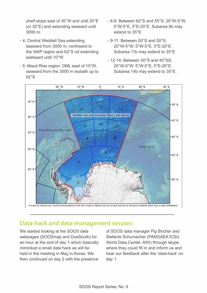
• 1: Eastern WAP with Larsen ice shelf between 63°S and 70°S seaward until the 3000 m isobath.
• 2: Filchner-Ronne ice shelf south of 70°S with continental shelf and slope extending eastward until 35°W and seaward until 3000 m.
• 3: DML ice shelves, coast and continental
SOOS Report Series, No. 9
shelf-slope east of 30°W and until 20°E (or 35°E) and extending seaward until 3000 m.
• 4: Central Weddell Sea extending seaward from 3000 m, northward to the WAP region and 62°S nd extending eastward until 10°W.
• 5: Maud Rise region: DML east of 10°W, seaward from the 3000 m isobath up to 62°S
• 6-8: Between 62°S and 55°S; 20°W-5°W, 5°W-5°E, 5°E-20°E. Subarea 8b may extend to 35°E
• 9-11: Between 55°S and 50°S; 20°W-5°W, 5°W-5°E, 5°E-20°E. Subarea 11b may extend to 35°E
• 12-14: Between 50°S and 40°SS; 20°W-5°W, 5°W-5°E, 5°E-20°E. Subarea 14b may extend to 35°E.
Data-hack and data-management session:We started looking at the SOOS data webpages (SOOSmap and DueSouth) for an hour at the end of day 1 which basically mimicked a small data hack as will be held in the meeting in May in Korea. We then continued on day 2 with the presence
of SOOS data manager Pip Bricher and Stefanie Schumacher (PANGAEA ICSU World Data Center, AWI) through skype where they could fill in and inform us and hear our feedback after the ‘data-hack’ on day 1.
SOOS Report Series, No. 9
We familiarized ourselves mostly with data and platforms on SOOSmap and found some things inconsistent and also data missing. These questions were collected and presented to Pip on day 2. The most important items we found were:
• Data from PANGAEA was missing - Pip explained that this is indeed the case because of incompatibility between the platforms. This is worked on.
• Not all MEOP data appeared to be there. Also to be fixed.
• It looked incorrect that under Parameters it was listed ‘Water conductivity/Biogeochemical”. It was suggested to change that to Biogeochemistry only since there is already a Parameter for seawater salinity.
• All biology is missing under Parameters.
• Products: if one selects a product like water temperature and wants to make slice from that on a depth level, nothing happens. Pip will look into this.
• Can the regional WG regions (currently listed under Base layers) be used to just extract data from that region in the future? Or even for the subareas. This would then save time on developing the list of EOV’s per subarea and heat maps (which likely become outdated very fast in this WG’s opinion).
We also looked at DueSouth and found that several upcoming planned expeditions, e.g. Polarstern cruises (AWI) and Kronprins Haakon (NPI/IMR) cruises in 2019 were not there. We will follow up soon and add these expeditions to the DueSouth webpage. The chairs will send out a reminder to the WG participants.
Discussion of EOVs maps:As part of the workshop, we started to complete the heat maps, taking Brazil as an example. We ended with a series of request to the Steering Committee regarding the EOVs given in the heat maps. Our understanding is that these EOVs come from Constable et al. [2016], however, we found that the quality of contribution would depend on some more information on the aim of this survey and important variables were lacking which we summarize below:
1. First of all, the role of gliders should be considered here, as for example, a way to obtain physical as well as biogeochemical (DO, pCO2, pH, light, etc.) data.
2. Currents should be differentiated between ship’s ADCP and LADCP.
3. Are XBT considered in standard UW measurements?
4. pCO2 and pH should not only come from the Ship but also from the underway, floats and gliders. In addition, important carbon variables include Total CO2 (DIC) and Total Alkalinity (TA), which are often measured from the CTD, and more recently from floats.
5. Most recently, Nutrients (NO3-, nitrates) have been obtained by BGC-Argo floats.
6. Chlorophyll may come from observations on ship, seals, floats, underway and gliders.
7. Other important variables for birds and marine mammals include diving and accelerometry.
SOOS Report Series, No. 9
8. Observations of sea ice algae, nutrients, carbon, DMS, and iron (Fe) are essential to this ecosystem and are not listed here.
9. Observations of the natural isotopes for oxygen, nutrients as well as animal tissues provide essential information on this ecosystem and its biogeochemical cycle, and are not listed here.
10. Observations of bio-optics such as backscattering and beam attenuation are quite standard from CTD, underway, gliders and floats and provide very important information on the status of this ecosystem, and are not listed here.
11. Standard atmospheric measurements are routinely taken from ships (WMO, aerosols, radiosondes, etc.), which are important to consider regarding the oceanography of the region, and are not listed here.
We also filled the “Drivers” excel sheet taking our Zone 4 as an example and considering all the countries present in the room. Our main impression is that the Drivers from column B to S correspond to Drivers of interest that can be discussed. However, Drivers from column T to AD
seem to correspond to variables. This problem should be discussed.
In addition, to make a basic and robust comparability of the information provided by different countries and for different regions possible, several of the variables, drivers and “quantities” should be defined, e.g. what is “opportunistically” and what is “well supported”? Is sampling-derived information well supported if only one (maybe important) benthic or planktonic species had been studied? Or is sampling of only one species (e.g. krill) opportunistic? Is a handful of measurement in 2 years really the same as 1000 in 2 years, e.g. in case of CTDs?
Following the workshop, we will ask each national representative to fill these heat maps, based on their best knowledge. If need be, they will ask colleagues to help filling these heat maps. The heat maps need to be returned to the WG leaders. However, considering the discussion on the eastern boundary of our WG, we, the WG leaders, decided after the workshop that we will wait till after the SSC meeting in South Korea, May 2019, before we ask each Nation representative to fill these maps.
Key scientific questions, objectives, wish lists and long-term solutions:We first identified that various ideas for future projects and research approaches in the Southern Ocean have recently been published:
• The 80 SCAR Horizon Scan question [Kennicutt et al., 2014] : https://www.scar.org/aboutus/horizon-scan/overview/
• The COMNAP Antarctic roadmap challenges [Kennicutt et al., 2016] : https://www.comnap.aq/Projects/SiteAssets/SitePages/ARC/Antarctic_Roadmap_Challenges_Book_2016.pdf
• Cross-disciplinarity in Antarctic ecosystem research by the SCAR/AnT-ERA community [Gutt et al.,2018] :
SOOS Report Series, No. 9
http://dx.doi.org/10.1016/j.margen.2017.09 .006]
• Present knowledge and 25 challenges for Weddell gyre research by M. Vernet et al. (submitted)
We further discussed additional plans and requirements for our region of interest with specific SOOS relevance:
• Strategic sampling for biodiversity assessments of benthic communities to support ecological and evolutionary studies.
• Coordinated sampling strategies, sampling activities and measurements resulting from the requirements of the planned MPA research and monitoring plan, e.g. in terms of biodiversity patterns, ecological key-species, climate-relevant ecological processes, abundance, reproduction and survival/mortality of top-predators.
• Sampling of trace metal and nutrient isotopes in open water and shelf ice, in front of ice shelves and ice shelf water types to study the link between biogeochemistry and cryosphere.
• Year-round measurement of sea-ice seasonal dynamics along the coastal and marginal ice zone
• Countinuation of sea-bird observations and integration with the other SOOS data sets (AS@S http://seabirds.saeon.ac.za/ )
• Year-round observations of a variety of physical-chemical and biological variables with a pronounced seasonality. and with a specific focus on upwelling, increasing nutrients, sea-ice dynamics, and biogeochemistry.
• Measure the Central Intermediate Water (Modified Warm Deep Water) in the central Weddell Sea, being enriched in nutrients and CO2 through remineralization, since it plays a significant role for CO2 sequestration in the abyssal global ocean.
• Monitor the Warm Deep Water along the shelf break to provide a spatially synoptic overview of ice shelf-ocean interactions and ice shelf-melting.
• Measure the regional biological production; what maintains populations of fish and krill in the under-sampled subareas 1 – 8?
• Collect data on the dense shelf water formation in subareas 1 and 2, which drives the circulation under ice shelves, contributes to deep-water formation and protects ice shelves from warm water.
• Monitor the impact of fishing on seabirds around Bouvet, similar to studies around Gough Island and Tristan da Cunha.
• Collect data to unravel the role of moving fronts for processes around sub-Antarctic islands, seamounts and ridges.
• High resolution measurements for a better understanding of the shift and intensification of westerly winds also related to SAM, and assess its role for physical and biological CO2 sequestration. This must include a better predictability of air-sea fluxes and could be realized by intensified use of autonomous devices including BIO ARGO floats and gliders. Solutions for under-ice (winter) measurements and interactions/communication between such devices are to be developed.
SOOS Report Series, No. 9
Next Workshop:We will organize our next workshop in late April –early May 2020, before the EGU in Viena, Austria. The workshop will likely take place in Northern Germany. We plan 2.5 days of workshop with about 30 oral presentations on the observation of the Southern Ocean in the Weddell Sea-Dronning Maud Land region. We aim for 45 to 50 participants. At the workshop, we will discuss the possibility of leading a special issue in a scientific journal. We will also discuss the future actions of the working group. We would also like to extend our reach to early career scientist and have 2 or 3 more APECS participants, Mia Wege being our official APECS representative.
Action List:We came up with list of actions from the Workshop:
• We will contact the SOOS Steering Committee for the extension of the eastern boundary and its potential overlap with the western boundary of the Indian sector group.
• We will plan our next workshop in the coming months.
• We will need to update the webpage of our working group on the SOOS website:
• We need to upload the workshop report and the TORs, incl. the map of the region.
• We will upload the list of projects and expeditions to be provided by
each country and scientists being involved or interested in our WG.
• We will motivate CONMAP via Uwe Nixdorf to take care that basic information on expeditions in the Weddell Sea-DML is to be uploaded on DueSouth (https://data.aad.gov.au/duesouth/search/expedition) or provided by the research vessel operators
• We will motivate each national representative to fill the EOVs heat maps (after further clarification during the SOOS SSC meeting in South Korea in May 2019), a list of National projects (Name of the project + link + date + PI name), and a list of National expeditions
References:Constable, A. J., et al. (2016), Developing priority variables (“ecosystem Essential Ocean Variables” — eEOVs) for observing dynamics and change in Southern Ocean ecosystems, J. Mar. Syst., 161, 26-41, doi:https://doi.org/10.1016/j.jmarsys.2016.05.003.
Gutt, J., et al. (2018), Cross-disciplinarity in the advance of Antarctic ecosystem research, Marine Genomics, 37, 1-17, doi:https://doi.org/10.1016/j.margen.2017.09.006.
Kennicutt, M. C., et al. (2014), A roadmap for Antarctic and Southern Ocean science for the next two decades and beyond, Antarct. Sci., 27(1), 3-18, doi:10.1017/0954102014000674.
Kennicutt, M. C., et al. (2016), Delivering 21st century Antarctic and Southern Ocean science, Antarct. Sci., 28(6), 407-423, doi:10.1017/S0954102016000481.

SOOS is an initiative of the Scientific Committee on Oceanic Research and the Scientific Committee on Antarctic Research
SOOS International Project Office hosted by