Recognition of the Susceptibility of Hydrogeomorphic ...
6
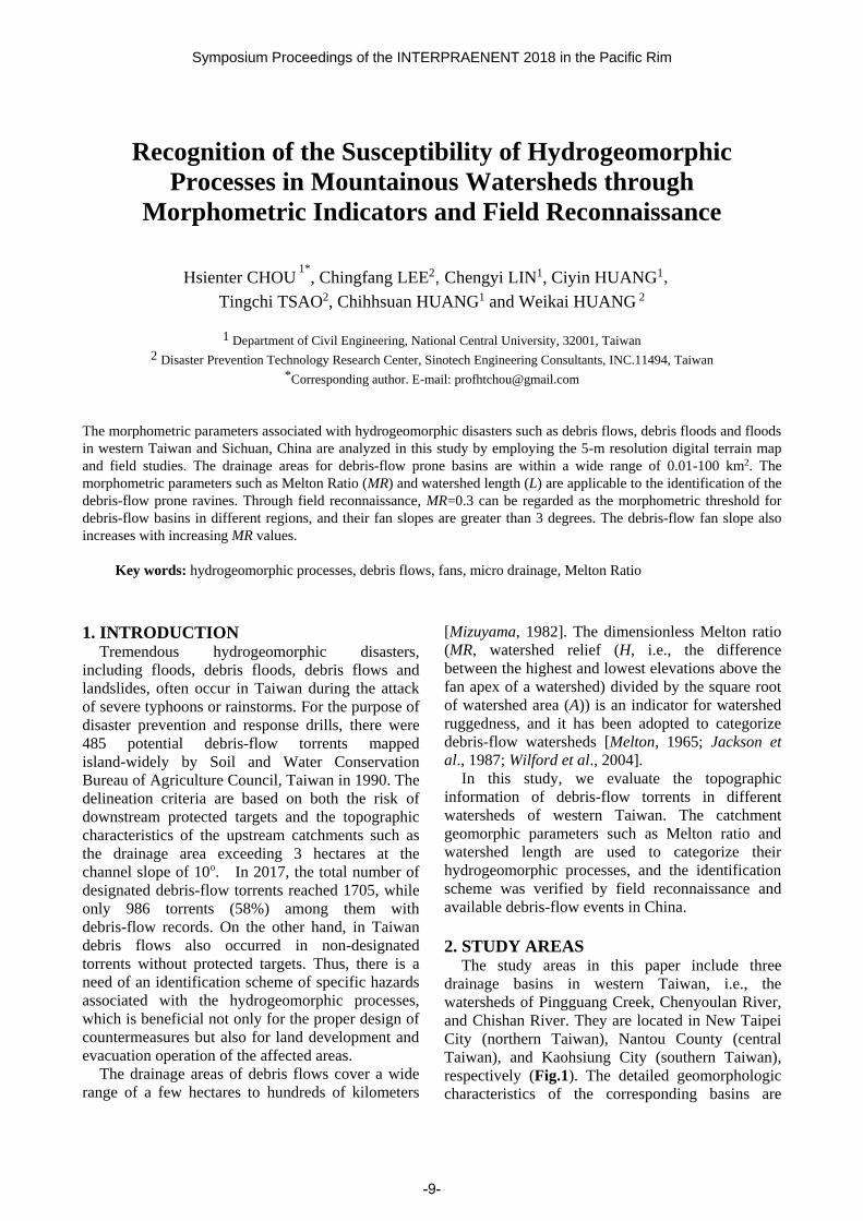
Symposium Proceedings of the INTERPRAENENT 2018 in the Pacific Rim Recognition of the Susceptibility of Hydrogeomorphic Processes in Mountainous Watersheds through Morphometric Indicators and Field Reconnaissance Hsienter CHOU 1* , Chingfang LEE 2 , Chengyi LIN 1 , Ciyin HUANG 1 , Tingchi TSAO 2 , Chihhsuan HUANG 1 and Weikai HUANG 2 1 Department of Civil Engineering, National Central University, 32001, Taiwan 2 Disaster Prevention Technology Research Center, Sinotech Engineering Consultants, INC.11494, Taiwan * Corresponding author. E-mail: [email protected] The morphometric parameters associated with hydrogeomorphic disasters such as debris flows, debris floods and floods in western Taiwan and Sichuan, China are analyzed in this study by employing the 5-m resolution digital terrain map and field studies. The drainage areas for debris-flow prone basins are within a wide range of 0.01-100 km 2 . The morphometric parameters such as Melton Ratio (MR) and watershed length (L) are applicable to the identification of the debris-flow prone ravines. Through field reconnaissance, MR=0.3 can be regarded as the morphometric threshold for debris-flow basins in different regions, and their fan slopes are greater than 3 degrees. The debris-flow fan slope also increases with increasing MR values. Key words: hydrogeomorphic processes, debris flows, fans, micro drainage, Melton Ratio 1. INTRODUCTION Tremendous hydrogeomorphic disasters, including floods, debris floods, debris flows and landslides, often occur in Taiwan during the attack of severe typhoons or rainstorms. For the purpose of disaster prevention and response drills, there were 485 potential debris-flow torrents mapped island-widely by Soil and Water Conservation Bureau of Agriculture Council, Taiwan in 1990. The delineation criteria are based on both the risk of downstream protected targets and the topographic characteristics of the upstream catchments such as the drainage area exceeding 3 hectares at the channel slope of 10 o . In 2017, the total number of designated debris-flow torrents reached 1705, while only 986 torrents (58%) among them with debris-flow records. On the other hand, in Taiwan debris flows also occurred in non-designated torrents without protected targets. Thus, there is a need of an identification scheme of specific hazards associated with the hydrogeomorphic processes, which is beneficial not only for the proper design of countermeasures but also for land development and evacuation operation of the affected areas. The drainage areas of debris flows cover a wide range of a few hectares to hundreds of kilometers [Mizuyama, 1982]. The dimensionless Melton ratio (MR, watershed relief (H, i.e., the difference between the highest and lowest elevations above the fan apex of a watershed) divided by the square root of watershed area (A)) is an indicator for watershed ruggedness, and it has been adopted to categorize debris-flow watersheds [Melton, 1965; Jackson et al., 1987; Wilford et al., 2004]. In this study, we evaluate the topographic information of debris-flow torrents in different watersheds of western Taiwan. The catchment geomorphic parameters such as Melton ratio and watershed length are used to categorize their hydrogeomorphic processes, and the identification scheme was verified by field reconnaissance and available debris-flow events in China. 2. STUDY AREAS The study areas in this paper include three drainage basins in western Taiwan, i.e., the watersheds of Pingguang Creek, Chenyoulan River, and Chishan River. They are located in New Taipei City (northern Taiwan), Nantou County (central Taiwan), and Kaohsiung City (southern Taiwan), respectively (Fig.1). The detailed geomorphologic characteristics of the corresponding basins are -9-
Transcript of Recognition of the Susceptibility of Hydrogeomorphic ...
Symposium Proceedings of the INTERPRAENENT 2018 in the Pacific Rim
Recognition of the Susceptibility of Hydrogeomorphic
Processes in Mountainous Watersheds through
Morphometric Indicators and Field Reconnaissance
Hsienter CHOU 1*
, Chingfang LEE2, Chengyi LIN1, Ciyin HUANG1,
Tingchi TSAO2, Chihhsuan HUANG1 and Weikai HUANG 2
1 Department of Civil Engineering, National Central University, 32001, Taiwan
2 Disaster Prevention Technology Research Center, Sinotech Engineering Consultants, INC.11494, Taiwan
*Corresponding author. E-mail: [email protected]
The morphometric parameters associated with hydrogeomorphic disasters such as debris flows, debris floods and floods
in western Taiwan and Sichuan, China are analyzed in this study by employing the 5-m resolution digital terrain map
and field studies. The drainage areas for debris-flow prone basins are within a wide range of 0.01-100 km2. The
morphometric parameters such as Melton Ratio (MR) and watershed length (L) are applicable to the identification of the
debris-flow prone ravines. Through field reconnaissance, MR=0.3 can be regarded as the morphometric threshold for
debris-flow basins in different regions, and their fan slopes are greater than 3 degrees. The debris-flow fan slope also
increases with increasing MR values.
Key words: hydrogeomorphic processes, debris flows, fans, micro drainage, Melton Ratio
1. INTRODUCTION Tremendous hydrogeomorphic disasters,
including floods, debris floods, debris flows and
landslides, often occur in Taiwan during the attack
of severe typhoons or rainstorms. For the purpose of
disaster prevention and response drills, there were
485 potential debris-flow torrents mapped
island-widely by Soil and Water Conservation
Bureau of Agriculture Council, Taiwan in 1990. The
delineation criteria are based on both the risk of
downstream protected targets and the topographic
characteristics of the upstream catchments such as
the drainage area exceeding 3 hectares at the
channel slope of 10o. In 2017, the total number of
designated debris-flow torrents reached 1705, while
only 986 torrents (58%) among them with
debris-flow records. On the other hand, in Taiwan
debris flows also occurred in non-designated
torrents without protected targets. Thus, there is a
need of an identification scheme of specific hazards
associated with the hydrogeomorphic processes,
which is beneficial not only for the proper design of
countermeasures but also for land development and
evacuation operation of the affected areas.
The drainage areas of debris flows cover a wide
range of a few hectares to hundreds of kilometers
[Mizuyama, 1982]. The dimensionless Melton ratio
(MR, watershed relief (H, i.e., the difference
between the highest and lowest elevations above the
fan apex of a watershed) divided by the square root
of watershed area (A)) is an indicator for watershed
ruggedness, and it has been adopted to categorize
debris-flow watersheds [Melton, 1965; Jackson et
al., 1987; Wilford et al., 2004].
In this study, we evaluate the topographic
information of debris-flow torrents in different
watersheds of western Taiwan. The catchment
geomorphic parameters such as Melton ratio and
watershed length are used to categorize their
hydrogeomorphic processes, and the identification
scheme was verified by field reconnaissance and
available debris-flow events in China.
2. STUDY AREAS The study areas in this paper include three
drainage basins in western Taiwan, i.e., the
watersheds of Pingguang Creek, Chenyoulan River,
and Chishan River. They are located in New Taipei
City (northern Taiwan), Nantou County (central
Taiwan), and Kaohsiung City (southern Taiwan),
respectively (Fig.1). The detailed geomorphologic
characteristics of the corresponding basins are
-9-

shown in Table 1.
Typhoon and rainstorm events are the primary
triggering factors to induce regional landslides,
floods and debris flows. The annual mean
precipitations in Pingguang Creek, Chenyoulan
River, and Chishan River are 2,210 mm, 3,504 mm,
and 2,645 mm, respectively. According to the
historical record, Typhoon Morakot was the most
critical event triggering the sediment-related
disasters in both Chenyoulan River, and Chishan
River watersheds in 2009. Furthermore, a severe
Typhoon Soudelor brought heavy rainfall in
northern Taiwan on 8th, August in 2015. The
short-term rainfall intensity exceeded 80 mm/hr, and
the accumulated precipitation had reached 769 mm
in 24 hours and many landslides, debris flows, and
debris floods occurred in Pingguang Creek basin
(Fig.2). Table 1 The geomorphologic characteristics of the study areas
Watershed Pingguang
Creek (PG)
Chenyoulan
River (CYL)
Chishan
River (CS)
Length
Area
Mean slope
Max. EL.
Min. EL.
7.5 km
19.4 km2
9.85o
970 m
45 m
42.2 km
447.3 km2
6.75 o
3,926 m
301 m
118 km
736.2 km2
8.37o
3,500 m
43 m
Fig. 1 Study areas in western Taiwan
Fig. 2 Debris flow deposition in downstream reach in
Ping-Guang Creek watershed (2015/08/13)
3. MATERIAL AND METHODOLOGY
3.1 High-resolution DEMs and micro-drainage
classification
For the extraction of the geomorphologic
feature, digital elevation models (DEMs) with two
different resolutions are adopted in the study; one is
5m x 5m, and the other is 1m x 1m. The dataset was
provided by Soil and Water Conservation Bureau,
Taiwan. We utilized 5-m DEMs (2004 version) to
divide micro-drainage basins and to construct
streamlines through Geographic Information
Systems (GIS) software. The airborne LiDAR
(2009) can remove the surface vegetation and
provides the 1-m high-resolution DEM, which is
useful to enhance particular landscape features.
After pre-processing, this data were transformed
into visualization shading relief and applied to map
old landslides, debris-flow and fluvial fans by their
geomorphic features.
3.2 Micro-topography interpretation
The occurrence of landslides at the upper stream
reaches usually contributes loose colluvium and
material to trigger the subsequent debris flows. The
topographic lineaments, scarps, landslide mass and
debris-flow fans in three watersheds were
characterized by visualization enhancement
approach [Lee et al., 2017; Lo et al., 2017]. A
powerful visualization technique, being referred to
as sky-view factor (SVF) relief, is utilized in this
study instead of traditional analytical hill shading
from multiple directions. In brief, SVF can be
regarded as a geophysical parameter that
demonstrates the space of the sky visible from the
given point on the ground surface [Zakšek et al.,
2011]. SVF represents the largest range that can be
encompassed over the observer or a certain point
(the projected area of the hemisphere over the
observer in a unit of space; [Lo et al., 2017]:
Ω = ∫ ∫ 𝑐𝑜𝑠𝜑𝑑𝜑𝑑𝜆 = 2𝜋𝜋/2
0
2𝜋
0 (1)
where, Ω, φ and λ denote the solid angle, latitude and
longitude within the hemisphere, respectively. One
can normalize the solid angle in Eq. (1) by using 2π,
which gives the SVF:
SVF = 1 − (∑ 𝑠𝑖𝑛𝑟𝑖𝑛𝑖=1 )/𝑛 (2)
where γ𝑖 and n represents the elevation angle from the
horizontal surface and the selected number of azimuth
directions, respectively. SVF=1 means that the entire
hemisphere of sky is visible (such as on a plain or from
a peak); SVF=0 means that virtually no sky can be
seen from the observation point (canyon). Table 2
-10-

lists the morphological features for manual mapping
criteria in SVF relief maps. It is noted that some
landscapes of landslides and debris-flow fans are
affected by man-made countermeasures or training
works. Once the micro-topography interpretation
was performed, one can analyze the geometric
parameters such as slope gradient (along with the
centerline from the apex to the end of the broader
fan) and area of debris-flow fans. Furthermore, the
relationship between fan slope gradient and the
drainage basin will be examined in the following
section.
3.3 Melton’s number(MR) assessment
The watershed boundaries, watershed lengths
and stream orders were established by using DEM
and GIS. The DEM has a cell size of 5 x 5 m and
the lowest point of the feeding channel in a
watershed was the apex of the fan. The Melton ratio
(MR) and watershed length (L) is a suitable scheme
for the differentiation of the hydrogeomorphic
processes in mountainous watersheds [Melton,
1965; Wilford et al., 2004; Chou et al., 2017]. The
watersheds in Pingguang Creek, Chenyulang River,
and Chi-Shan River were derived based on DEM
and GIS. The dominant hydrogeomorphic processes,
including debris flows, debris floods, and floods, for
each sub-basin are determined by their geomorphic
parameters, MR and L, and verified by the
depositional patterns in the fan areas through field
reconnaissance.
4. RESULTS AND DISCUSSIONS
4.1 The geomorphologic characteristics of debris-
flow fans
The formation process of an alluvial fan is
dominated by the ratio between the power of the
water discharge and the sediment supply from the
upslope catchment [Harvey et al., 1999]. As shown
in Table 3, this study identified and mapped 97
debris-flow fans over the watersheds of Ping-Guang
Creek, Chenyoulan River, and Chishan River (Fig.
3). The area of debris-flow fans ranges from 0.05 to
25.47 ha depending on the scale of stream discharge
Table 2 Micro-topography interpretation for recent landslides
and debris-flow fans (summarized by Lee et al., 2016)
Feature SVF relief map Description
Landslide
scarp
Most of the cliffs formed
by slope slumps are
scarps of slope top
failure. The flanks are
the result of the steep
slumps and can be used
to gauge the strain rate of
the slope failure process
Landslide
body
The original sliding body
presents a
dustpan-shaped
depression with the
upper section displaying
subsidence, the middle
section showing a gentle
slope, and the lower
section exhibiting
hummocky relief
Debris-
flow fan
It usually is formed at the
gentle slope and broad
downstream reach
(deposition section:
3-6o). The shape of the
fan is dominated by
magnitude of debris
flow, material, and
geometrical condition of
the channel. It could be
symmetrical fan-shaped
or lobe-shaped
deposition.
Table 3 The debris-flow/alluvial fans mapped in the study areas
Watershed Pingguang
Creek (PG)
Chenyoulan
River (CYL)
Chishan
River (CS)
Num. of fans 7 37 53
Area [ha.] 0.50- 2.76 0.05-25.47 0.57-21.58
Slope [deg.] 5.5-13.7 1.8-20.7 2.9-27.6
Fig. 3 Recent debris-flow fans mapped in (a) Chenyoulan
River watershed and (b) Chishan River watershed.
-11-
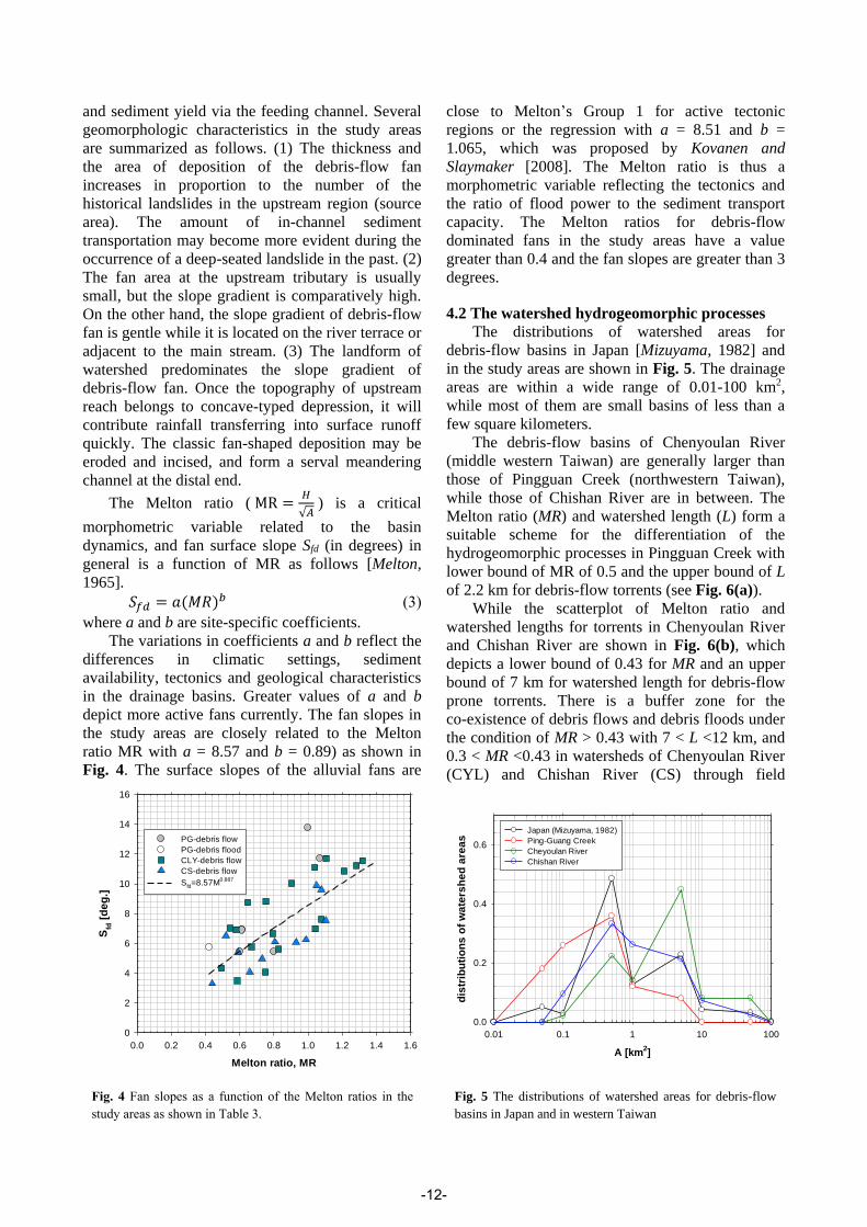
and sediment yield via the feeding channel. Several
geomorphologic characteristics in the study areas
are summarized as follows. (1) The thickness and
the area of deposition of the debris-flow fan
increases in proportion to the number of the
historical landslides in the upstream region (source
area). The amount of in-channel sediment
transportation may become more evident during the
occurrence of a deep-seated landslide in the past. (2)
The fan area at the upstream tributary is usually
small, but the slope gradient is comparatively high.
On the other hand, the slope gradient of debris-flow
fan is gentle while it is located on the river terrace or
adjacent to the main stream. (3) The landform of
watershed predominates the slope gradient of
debris-flow fan. Once the topography of upstream
reach belongs to concave-typed depression, it will
contribute rainfall transferring into surface runoff
quickly. The classic fan-shaped deposition may be
eroded and incised, and form a serval meandering
channel at the distal end.
The Melton ratio ( MR =𝐻
√𝐴) is a critical
morphometric variable related to the basin
dynamics, and fan surface slope Sfd (in degrees) in
general is a function of MR as follows [Melton,
1965].
𝑆𝑓𝑑 = 𝑎(𝑀𝑅)𝑏 (3)
where a and b are site-specific coefficients.
The variations in coefficients a and b reflect the
differences in climatic settings, sediment
availability, tectonics and geological characteristics
in the drainage basins. Greater values of a and b
depict more active fans currently. The fan slopes in
the study areas are closely related to the Melton
ratio MR with a = 8.57 and b = 0.89) as shown in
Fig. 4. The surface slopes of the alluvial fans are
close to Melton’s Group 1 for active tectonic
regions or the regression with a = 8.51 and b =
1.065, which was proposed by Kovanen and
Slaymaker [2008]. The Melton ratio is thus a
morphometric variable reflecting the tectonics and
the ratio of flood power to the sediment transport
capacity. The Melton ratios for debris-flow
dominated fans in the study areas have a value
greater than 0.4 and the fan slopes are greater than 3
degrees.
4.2 The watershed hydrogeomorphic processes
The distributions of watershed areas for
debris-flow basins in Japan [Mizuyama, 1982] and
in the study areas are shown in Fig. 5. The drainage
areas are within a wide range of 0.01-100 km2,
while most of them are small basins of less than a
few square kilometers.
The debris-flow basins of Chenyoulan River
(middle western Taiwan) are generally larger than
those of Pingguan Creek (northwestern Taiwan),
while those of Chishan River are in between. The
Melton ratio (MR) and watershed length (L) form a
suitable scheme for the differentiation of the
hydrogeomorphic processes in Pingguan Creek with
lower bound of MR of 0.5 and the upper bound of L
of 2.2 km for debris-flow torrents (see Fig. 6(a)).
While the scatterplot of Melton ratio and
watershed lengths for torrents in Chenyoulan River
and Chishan River are shown in Fig. 6(b), which
depicts a lower bound of 0.43 for MR and an upper
bound of 7 km for watershed length for debris-flow
prone torrents. There is a buffer zone for the
co-existence of debris flows and debris floods under
the condition of MR > 0.43 with 7 < L <12 km, and
0.3 < MR <0.43 in watersheds of Chenyoulan River
(CYL) and Chishan River (CS) through field
Melton ratio, MR
0.0 0.2 0.4 0.6 0.8 1.0 1.2 1.4 1.6
Sfd
[d
eg
.]
0
2
4
6
8
10
12
14
16
PG-debris flow
PG-debris flood
CLY-debris flow
CS-debris flow
Sfd=8.57M
0.887
Fig. 4 Fan slopes as a function of the Melton ratios in the
study areas as shown in Table 3.
A [km2]
0.01 0.1 1 10 100
dis
trib
uti
on
s o
f w
ate
rsh
ed
are
as
0.0
0.2
0.4
0.6
Japan (Mizuyama, 1982)
Ping-Guang Creek
Cheyoulan River
Chishan River
Fig. 5 The distributions of watershed areas for debris-flow
basins in Japan and in western Taiwan
-12-

investigations. In accordance with analysis result
and overlay by potential debris flow torrents, one
may identify the sediment-related hazards occurred
in three study areas (Table 4). For small Pingguang
Creek watershed, fifty debris flows and three debris
floods are clarified by integrating geomorphic factor
and field investigation. To verify the applicability of aforementioned
morphometric parameters for hydrogeomorphic hazards in different regions, a data set of 147 debris-flow torrents in 5 counties (Ching-ping, Bai-chuan, Yin-shou, Long-tse and Der-chan) of
Sichuan province, China was adopted for comparison (Dr. Bin Yu, personal communication). The results are shown in Fig. 7, which indicates a lower MR limit of 0.3 and a higher watershed length limit of 14 km for debris-flow prone torrents; so the scatting of debris-flow torrents in China covers both regimes of debris flow (DF) and debris flood (DFL) delineated in the study areas (Fig. 6b). As shown in Fig. 7, the maximum watershed length for debris-flow basins in Sichuan is about 13.7 km in Yin-shou region, and the corresponding drainage area is 48.7 km2, which is within the range of 0.01-100 km2 as shown in Fig. 5. Thus MR>0.3 and L<14 km should be the morphometric parameters for debris-flow basins in Sichuan, China.
The differences in their threshold values of MR
and L for debris-flow prone watersheds among
western Taiwan and China are mainly due to the
differences of lithology, sediment supply, geological
settings and climate. The zonation between debris
flow and debris flood deserves further investigation.
Above all, MR = 0.3 seems to be the lower bound
for debris-flow basin as proposed by Jackson et al.
[1987], and itself also serves as the upper bound for
flood-related disasters.
5. CONCLUSION
The morphometric parameters, i.e., Melton Ratio
and drainage length, are applicable to an
identification scheme of hydrogeomorphic processes
such as debris flows, debris floods and floods.
Regarding the debris-flow torrents in the study
areas, the lower bound of MR is about 0.3-0.5, while
the upper bound of L is about 2.2 -14 km in different
regions in western Taiwan and China due to their
Table 4 Classification of sediment-related hazards in the
study areas
Watershed Pinggung
Creek (PG)
Chenyoulan
River (CYL)
Chishan
River (CS)
Debris flows 50 47 50
Debris floods 3 3 4
Floods 0 0 1
(a) Pinggung Creek (PG) in Northwestern Taiwan
Melton ratio, MR
0.0 0.2 0.4 0.6 0.8 1.0 1.2 1.4 1.6
L [
km
]
0
2
4
6
8
10
12
14
16
CS-flood
CS-debris flood
CS-debris flow
CYL-debris flood
CYL-debris flow
flo
od
debris flood / debris flow
debris flow
(b) Chenyoulan River (CYL)and Chishan River(CS) Fig. 6 The relationship between watershed length (L) and
Melton ratio (MR) for hydrogeomorphic hazards in
western Taiwan
Melton ratio, MR
0.0 0.2 0.4 0.6 0.8 1.0 1.2 1.4 1.6
L [
km
]
0
2
4
6
8
10
12
14
Ching-ping
Bai-chuan
Yin-shou
Long-tse
Der-chan
flo
od
debris flood / debris flow
debris flow
Fig. 7 The relationship between watershed length (L) and
Melton ratio (MR) for hydrogeomorphic disasters in
Sichuan, China.
-13-

different lithology, sediment availability, geological
and climate settings. MR=0.3 seems to be the lower
bound for debris-flow basins as proposed by
Jackson et al. [1987], and itself also serves as the
upper bound for flood-related disasters. A buffer
zone for the co-existence of debris flows and debris
floods under the condition of 0.3 < MR <0.43, or
MR > 0.43 with 7 < L <12 km deserves further
research. The fan slope for debris-flow fans in this
study areas generally exceed 3 degrees, and the fan
slopes versus Melton Ratio are close to Melton’s
type Group 1 for active tectonic regions.
ACKNOWLEDGMENT
This study was financially supported by the
Ministry of Science and Technology of the Republic
of China, Taiwan under Contract No.
MOST-106-2625-M-008-007.
REFERENCES
Chou, H.T., Lee, C.F. and Lo, C.M. (2017): The evolution of a
coastal alluvial fan caused by rainfall-induced landslides in
eastern Taiwan. Landslides, Vol.14(1), pp.109-122.
Harvey, A.M. Silva, P.G. Mather A.E. Goy. J.L. Stokes, M. and
Zazo, C. (1999): The impact of Quaternary sea-level and
climatic change on coastal alluvial fans in the Cabo de Gata
ranges, southeast Spain. Geomorphology, Vol. 28, pp.1-22.
Jackson, L.E. Kostaschuk, R.A. and MacDonald G.M. (1987):
Identification of debris-flow hazard on alluvial fans in the
Canadian Rocky Mountains. Rev. Eng. Geol., Vol. 7,
pp.115–124.
Kovanen, D.J. and Slaymaker, O. (2008): The morphometric
and stratigraphic framework for estimates of debris flow
incidence in the North Cascades foothills Washington State
USA. Geomorphology, Vol.99, pp.224-245.
Lee, C.F., Lo, C.M., Chou, H.T. and Chi, S.Y. (2016):
Landscape evolution analysis of large scale landslides at
Don-Ao Peak, Taiwan. Environ. Earth Sci., Vol.75:29.
Lee, C.F., Huang, W.K. Huang, C.M. and Chi, C.C. (2017):
Deep-seated landslide mapping and geomorphic
characteristic using high resolution DTM in northern
Taiwan. In: Mikos M., Tiwari B., Yin Y., Sassa K. (eds)
Advancing Culture of Living with Landslides. 4th World
landslide Forum, Ljubljana, Slovenia, Vol. 2, pp.767-777.
Lo, C.M., Lee, C.F. and Keck, J. (2017): Application of sky
view factor technique to the interpretation and reactivation
assessment of landslide activity. Environ. Earth Sci., Vol.
76:375.
Melton M.A. (1965): The geomorphic and paleoclimatic
significance of alluvial deposits in southern Arizona. The
Journal of Geology, Vol. 73(1), pp.1-38.
Mizuyama, T. (1982): Analysis of sediment yield and transport
data for erosion control works. Recent Development in the
Explanation and Prediction of Erosion and Sediment Yield
(Proceedings of the Exeter Symposium). IAHS Publ. No.
137.
Wilford, D.J. Sakals, M.E. Innes, J.L. Sidle, R.C. and Bergerud,
W.A. (2004): Recognition of debris flow, debris flood and
flood hazard through watershed morphometrics. Landslides,
Vol. 1, pp.61-66.
Zakšek, K. Oštir, K. and Kokalj, Ž. (2011): Sky-view factor as a
relief visualization technique. Remote Sens., Vol. 3, pp.
398-415.
-14-