QUICKSILVER DEPOSITS OF THE OPALITE … STATES DEPARTMENT OF THE INTERIOR Harold L. Ickes, Secretary...
40
UNITED STATES DEPARTMENT OF THE INTERIOR Harold L. Ickes, Secretary GEOLOGICAL SURVEY W. C. Mendenhall, Director Bulletin 931-N QUICKSILVER DEPOSITS OF THE OPALITE DISTRICT, MALHEUR COUNTY OREGON, AND HUMBOLDT COUNTY, NEVADA BY ROBERT G. YATES Strategic Minerals Investigations, 1941 (Pages 319-348) UNITED STATES GOVERNMENT PRINTING OFFICE WASHINGTON : 1942 For sale by the Superintendent of Documents, Washington, D. C. Price 60 cents
Transcript of QUICKSILVER DEPOSITS OF THE OPALITE … STATES DEPARTMENT OF THE INTERIOR Harold L. Ickes, Secretary...

UNITED STATES DEPARTMENT OF THE INTERIOR Harold L. Ickes, Secretary
GEOLOGICAL SURVEY W. C. Mendenhall, Director
Bulletin 931-N
QUICKSILVER DEPOSITS OF THE
OPALITE DISTRICT, MALHEUR COUNTY
OREGON, AND HUMBOLDT COUNTY, NEVADA
BY
ROBERT G. YATES
Strategic Minerals Investigations, 1941
(Pages 319-348)
UNITED STATES
GOVERNMENT PRINTING OFFICE
WASHINGTON : 1942
For sale by the Superintendent of Documents, Washington, D. C. Price 60 cents


CONTENTS
Page
Abstract................................................. 319Introduction............................................. 319
History and production.........o..................... 321Field work and acknowledgments....................... 323
Geology.................................................. 323Miocene lavas........................................ 324Late Miocene lake sediments.......................... 325Quaternary deposits.................................. 326Structure............................................ 327
Ore deposits............................................. 329Mineralogy,.......................................... 329
Cinnabar......................................... 330Native mercury................................... 331Terlinguaite..................................... 331Eglestonite...................................... 331Realgar.......................................... 331Pyrite........................................... 331
Rock alteration...................................... 331Ore bodies........................................... 334Origin................................................ 336
Suggestions for prospecting.............................. 339Reserves...............;................................. 341Mines.................................................... 343
Opalite mine......................................... 343Bretz mine........................................... 344Cordero mine......................................... 346
ILLUSTRATIONS
Plate 52. Geologic map of the Opalite district, MalheurCounty, Oreg., and Humboldt County, Nev. In pocket
53. Geologic map of the Opalite mine area......... 34254. Geologic sections of the Opalite mine......... 34255. Plan of workings of the Opalite mine.......... 34256. Geologic map of the Bretz mine................ 34657. Geologic sections of the Bretz mine........... 34658. Geologic map of the Cordero mine area......... 346
Figure 34. Index map of parts of Oregon and Nevada show ing the location of the Opalite district.... 320
35. Geologic map of the underground workings ofthe 1940 Bretz pit.......................... 345
36. Sketch map and section of the undergroundworkings of the Cordero mine................ 347
III


QUICKSILVER DEPOSITS OF THE OPALITE DISTRICT,
MA.LHEUR COUNTY, OREGON, AND
HUMBOLDT COUNTY, NEVADA
By Robert G. Yates
ABSTRACT
The Opalite district, in Malheur County, Oreg., and Humboldt County, Nev., produced 22,174 flasks of quicksilver between Jan uary 1927 and January 1941. Nearly all of this was taken from the Opalite and Bretz mines, in Oregonj but the Cordero mine, in Nevada, should contribute materially to production in the near future.
The rocks in the district are flat-lying Miocene lavas, ranging from basalt to rhyollte in composition, and overlain by late Miocene tuffaceous lake beds. All these rocks are cut by steep normal faults, which locally have acted as channelways for rising hydrothermal solutions. The tuffs and lake beds were siliclfled in places by these solutions into lenticular masses of chalcedony, producing a rock locally called "opalite." The ore mineral, cinnabar, occurs partly in these chalcedony zones and partly in unsilicified rocks immediately adjacent to them. All the ore bodies mined were within 100 feet of the surface. Siliceous ore mined in the past has yielded an average of 6 pounds of quicksilver to the ton; nonsiliceous ore has yielded about 19 pounds to the ton.
Reserves in the district are estimated to be more than 3,000 flasks of quicksilver, but minable ore containing several'times as much as this might be found by further exploration. New de posits may be discovered by prospecting tuffs and lake beds near faults along which quicksilver-bearing solutions may have risen.
INTRODUCTION
The Opalite quicksilver district includes two deposits with
a considerable past production, one deposit with a small produc
tion, and one unproved prospect. These deposits are located
along the circumference of a semicircular area that extends from
a short distance west of McDermitt, Nev., for about 20 miles
along the Oregon-Nevada State boundary. (See fig. 34.) The
319

320 STRATEGIC MINERALS INVESTIGATIONS, 1941
area thus includes parts of Humboldt County, Nev., and Malheur
County, Oreg.; almost the entire production has been derived
from the portion in Oregon. The approximate center of this
semicircular area is about 15 miles west of McDermitt, Nev., the
nearest town.
McDermitt i /"NEV CDA
Figure 3^. Index map.of parts of Oregon and Nevada showing the location of the Opalite district.
McDermitt Is on the Oregon-Nevada State boundary and can be
easily reached from Winnemucca, Nev., 74 miles to the south,
over Nevada State Highway No. 8. The nearest railway is at Win
nemucca. All of the deposits are accessible over gravel or dirt
roads except for short periods during the winter.

QUICKSILVER IN THE OPALITE DISTRICT, OREGON AND NEVADA 321
The district is in the southern part of the White Horse
Mountains where altitudes range from 4,400 feet (in the McDer-
mitt Valley) to more than 7,500 feet. All drainage is into Mc-
Dermitt Creek, which with a few of its larger tributaries is the
only permanent stream. The vegetation consists mainly of abun
dant sagebrush; aspens grow along the permanent streams. Where
the narrow valley floors are arable, hay is raised as winter
feed for stock, which is pastured in the higher parts of the
mountains during the summer.
The only detailed description of the district that has ap
peared is by Schuette. As is evident from the following dis
cussion, the writer is not in agreement with Schuette's geologic
interpretation.
History and production
Mining is still active in the district, which has produced
over 22,000 flasks of quicksilver since 1926. Cinnabar was
first discovered in July 1917 by William Bretz near the location
of what was tp be known later as the Bretz mine. As assessment
work over a period of years failed to reveal any high-grade ore
in the discovery workings, Bretz continued to prospect the sur
rounding country, and in 1924 he discovered the Opallte ore body.
He soon sold the ground containing this ore body to F. W. Brad
ley, who, in April 1925, formed the Mercury Mining Syndicate and
began development of the Opalite mine. Late in 1926 a reduction
plant was completed at the property. In 1931 Bretz discovered
some very high grade ore just south of his original workings and
leased this ground to the Bradley Mining Co., the successor of
the Mercury Mining Syndicate. This property, now known.as the
Bretz mine, was worked Intermittently during the years 1931-36,
and the ore was treated at the Opalite furnace. In 1936
I/ Schuette, C. N., Lahontan quicksilver: Brig, and Min. Jour., vol. 13U, PP. 329-332, 1933; Quicksilver in Oregoni State of Oregon, Dept. Geology and Min. Industries, Bull. U, pp. lUj-153, 1938.

322 STRATEGIC HINERALS INVESTIGATIONS, 1941
Bradley's option to purchase the Bretz mine expired and the
property reverted to the discoverer. Since then no ore has been
removed from these early Bretz workings. During the summer of
1940, however, the Bradley Mining Co. was extracting ore from an
open pit referred to in this report as the 1940 Bretz workings
about half a mile west of the original Bretz mine.
The Cordero mine (also called the McDermitt mine) was dis
covered in 1924 by Tomas Alcorta of McDermitt. For several
years Alcorta and his partner, Eusebio Agnarez, explored the
ground by digging surface pits and trenches. During 1935 the
Bradley Mining Co. leased the property and sank an inclined
shaft into the main ore body. It is reported that 50 tons of
sorted ore treated at the Opalite plant yielded 48 pounds of
quicksilver to the ton. Since the spring of 1940, the Cordero
Mining Co. of Nevada, associated with the Horse Heaven Mining
Co. of Portland, Oreg., has been exploring the property prepara
tory to actual mining.
The fourth place at which cinnabar occurs is near Disaster
Peak, at a prospect owned by Stive Crutcharray and P. Apesteguy,
In the western part of the area mapped (fig. 34) Up to Septem
ber 1940, assessment work had not revealed any promising ore
body, though 2 tons of ore is estimated to have been mined from
the property.
The following table shows the production of quicksilver from
the district:
Quicksilver production from the Opalite district, 1927-40, inclusive I/
Mine
Gorderoi.i ........ ....
Years
1927-19401931-1940
1935
Ore (tons )
154,53139,885
(?) 50
Tenor ( pounds per ton)
5.9618.84
(?) 48« >
Quicksilver (flasks of 76 pounds )
12,12410,019
31
22,174
I/ Jrom the records of Mr. Worthen Bradley, president of the Bradley Mining Co., San Francisco, Calif. No production prior to 1927.

QUICKSILVER IN THE OPALITE DISTRICT, OREGON AND NEVADA 323
Field work and acknowledgments
The writer, assisted by James Pollock, was engaged in field
work from July 5, 1940 to September 8, 1940. The district was
revisited briefly in October of that year and again in March
1941. The regional geology was mapped on aerial photographs,
and the geologic map, plate 52, was compiled from these photo
graphs, controlled by a plane-table triangulation net. Maps of
the principal mineralized areas were made by plane-table tele
scopic-alidade surveys.
The field work was under the guidance of Clyde P. Ross, and
thanks are due to him not only for advice in the field but also
for help in preparing the manuscript. E. B. Eckel's and H. G.
Perguson's criticisms of the manuscript are also greatly apprec
iated, as are those of F. C. Calkins.
Messrs. ^Worthen Bradley, of the Bradley Mining Co., and
0. L. Cash, superintendent of the Bretz and Opallte mines,- cor
dially cooperated with the writer, giving him free access to the
company's maps, assays, and production figures, as well as pro
viding living accommodations at the mine. Messrs. S. H. Willis-
ton and Albert 0. Bartell also extended similar favors at the
Cordero mine. To all these men the writer offers hearty thanks.
' GEOLOGY
The steeply scarped, plateaulike character of the Southern
White Horse Mountains is'the result of block faulting in a thick
sequence of nearly horizontally bedded Miocene lavas (see pi.
52), and the basinlike drainage area of McDermitt Creek, which
includes most of the Opalite district, roughly coincides with a
down-faulted block of lavas. No rocks older than Tertiary are
exposed in the area mapped, but immediately to the southwest the
lavas rest upon the eroded surface of a granitic complex. The
lavas, which range from rhyolite to basalt in composition, are450835 O - 42 - 2

324 STRATEGIC MINERALS INVESTIGATIONS, 1941
locally interbedded with tuffs. The lavas are overlain by thin-
bedded upper Miocene lake sediments, which contain the Opalite
and Bretz ore bodies. These sediments probably accumulated in a
depression that was being deepened from time to time by faulting,
and were faulted down to their present position during the Plio
cene.
Mineralization probably began during or shortly after the
Pliocene faulting. Hydrothermal silica-bearing solutions local
ly ascended along the faults, and as they approached the surface
they silicified lenticular masses of the more permeable rocks.
During and after the late stages of this sllicification, rising
quicksilver-bearing solutions deposited cinnabar both in previ
ously silicified rocks and in unsilicified rocks.
After the lake beds had been faulted down to their present
position, and after the cinnabar had been deposited, streams
that headed in the adjacent upfaulted block eroded the upper
beds and covered the surface thus produced with a mantle of al
luvium. After the streams had established meandering courses
across the nearly level graded surface, their former power of
downcutting was rejuvenated to such an extent that they now flow
through narrow winding canyons, whose sinuous courses were In
herited from this earlier graded condition. The dying stages of
mineralization, in the form of hot spring activity, were contem
poraneous with the accumulation of the alluvial mantle.
Miocene lavas
The dominant rocks of the area consist of over 3,000 feet
Of lava flOWS, Which range in composition from basalt to rhyo-
Iite 0 Intrusive rocks appear to be scarce, but some of the
rocks mapped as extrusive may be intrusive for example, tn©
rhyolites near the Disaster Peak prospect. The rocks in the
western part of the are.a are in general more basic than those in
the eastern part. The silicic lavas range from obsidian to por-

QUICKSILVER IN THE OPALITE DISTRICT, OREGON AND NEVADA 325
phyritic rhyolite and in general exhibit well-developed flow
banding. They are locally associated with tuffs. The basaltic
and andesitic lavas are darker than the rhyolite and are gener
ally in thinner flows. They are characterized by vesicularity,
columnar structures, flow brecciation, and porphyritic texture.
The flows are either horizontal or nearly so, except where they
have been locally tilted by faulting. Individual flows are from
a few feet to more than 100 feet thick.
Late Miocene lake sediments
Late Miocene lake sediments are distributed over a consider
able part of the McDermitt Creek Basin (see pi. 52), and they
probably once extended over a much larger area from which they
have been removed by erosion. In places they are more than 200
feet thick. They consist mainly of well-bedded tuffs, shales
(including clayey, carbonaceous, tuffaceous, and diatomaceous
varieties), and sandstones, but include small lenses of conglom
erate. They are mostly light-colored, varying from white to
light brown, except that the carbonaceous shales are dark choco
late brown. The constituent fragments are dominantly of volcan
ic origin. Some beds contain carbonaceous plant fragments and
fossil wood; and fossil leaves, fish, and fresh-water gastropods
were collected at several places'. On the basis of the fossils
these beds have been correlated with the Miocene Trout Creek
beds of Malheur County, Oreg. 2/
These beds were believed by Schuette to have been depos
ited in Pleistocene Lake Lahontan, but this belief is contro
verted by several facts: The beds are not within the boundaries3/
of Lake Lahontan as originally mapped by Russell, although the
headwaters of McDermitt Creek were traversed by the Russell
party; and the highest Lahontan beach visible near Winnemucca
2/ Schuette, C. N., op. cit.2/ Russell, I. C., Geological history of lake lahontan, a Quaternary lake
of northwestern Nevada: U. S. Geol. Survey Hon. 11, 1885.

326 STRATEGIC MINERALS INVESTIGATIONS, 1941 .
4/is 1,200 feet lower than the lake beds at the Bretz mine. Dia
toms collected from lake beds at the Bretz mine were determined5/
by K. E. Lohman as contemporaneous with the Trout Creek diatom
flora, which has been assigned to the upper Miocene on fossil
plant evidence; and the diatoms studied by Lohman were deposited
in a lake of pure fresh water whereas the waters of Lake Lahon-
tan were saline. Determinations of the age of fossil leaves by6/ 7>
R. W. Brown and of fresh water gastropods by F. S. MacNeil '
also indicate Miocene age.
The scarcity of conglomerate in the lake beds is evidence
that they did not accumulate at the base of the abrupt slopes
which now bound the basin but have been faulted down into their
present position. If the lake had been coextensive, or nearly
so, with the present McDermitt Creek Basin, the lake beds at the
mouths of canyons now entering the basin would contain much fan
gravel. This is so far from being true that the distribution of
gravel in the lake beds is wholly unrelated to the situation of
the present canyon mouths. The fact that there are local uncon
formities between individual beds in areas of known faulting
suggests, moreover, that faulting was in progress during deposi
tion of the lake sediments.
Quaternary deposits
Two kinds of Quaternary deposits were mapped. The younger
consists of the gravel, sand, and silt that are accumulating on
fans and in valleys at the present time. The older, mapped on
plate 52 as the precanyon gravels, consists of rubble cappings
on the eroded surfaces of the lake beds in the interstream areas.
This capping, which now varies from a thin scattering of angular
rock fragments to local accumulations of loose porous material
U/ Ferguson, H. G., personal communication. 5/ Lohman, K. E., letter of May 29, 19^1. ty Brown, R. ff., personal communication. 2l MacNeil, F. S., personal communication.

QUICKSILVER IN THE OPALITE DISTRICT, OREGON AND NEVADA 327
more than 40 feet thick, has aided in the preservation of the
soft lake sediments. It is younger than the cinnabar minerali
zation, for it contains cinnabar-bearing boulders and is not im
pregnated with cinnabar where it overlies the Bretz ore bodies.
Its topographic relations, on the other hand, clearly show that
it is older than the canyon cycle of. drainage history. Calcar
eous sinter is interbedded with the older gravels, showing that
hot-spring activity continued after the cinnabar mineralization
was complete.
Structure
The structure of the Opalite district is simple. Flat-lying
lavas have been displaced, with little tilting, along steep nor
mal faults, of which the steep scarps that outline the flat-
topped Southern White Horse Mountains are a direct expression.
Direct evidence of this faulting is given by the presence of
fault breccia, drag warps, and silicified rocks along the scarp
bases; similar features at various distances outward from the
scarps indicate that the displacements were distributed on step
faults. The throw on any single break cannot be measured, but
the aggregate displacement, which accounts directly for much of
the relief in the area, was more than 2,000 feet.
The McDermitt Creek Basin is a result of such distributed
faulting, and all the quicksilver deposits of the district are
related to faults within or along the borders of this graben-
like area. The faults within the basin are arranged in no par
ticular pattern and are of small displacement probably none
has a throw greater than 100 feet. In many places the lake
beds that overlie the faulted lavas have adjusted themselves to
the faulting by merely bending along the breaks in the lavas;
but in some places the displacement in the underlying lavas has
been great enough to fault the lake beds also, as may be seen,

328 STRATEGIC MINERALS INVESTIGATIONS, 1941
for example, where the fault east of the Opalite mine crosses
Cherokee Creek.
In general the lake beds have been eroded away from the
boundary faults. At the Bretz mine, where the lake beds are
still in place near the bounding faults, the presence of minor
folds and angular unconformities between beds indicates that
faulting began shortly after the extrusion of the lavas and con
tinued during the deposition of the lake beds. But this fault
ing must have been on a small scale, for otherwise the sediments
would be more varied in texture than they are. The scarcity of
conglomerates or other coarse deposits in the lake beds indi
cates, moreover, that the beds could not have accumulated at the
bases of the 2,000- to 3,000-foot scarps which now partially en
close the basin. The major movement, therefore, must have oc
curred after the deposition of the lake beds.
The faults indicated on plate 52 include not only those that
are exposed but also ttiose that are inferred from physiographic
evidence. The fault shown as extending north from the Cordero
mine is mapped by inference, because of the very straight scarp
just south. This fault may be younger than the precanyon grav
els, and if so it would explain the incision of the streams that
cross McDermitt Creek Basin.
Photographs used in the areal mapping were of great use in
tracing faults, for such indications of faulting as minor dif
ferences in soil color, abrupt terminations of lava flows, and
inconsistencies in stream patterns were often much more apparent
on the photographs than on the ground.
In all Of the mineralized areas there are minor structures
related to the major faulting. At the Opalite mine (see pis. 53
ana 54) a tabula*- feody Of chalcedony has been broken in several
places by small faults, 'it is believed that the lavas tieflGatH
the lake beds are traversed by a fault, the movement along which
has merely warped the soft lake beds but has caused the rigid
QUICKSILVER IN THE OPALITE DISTRICT, OREGON AND NEVADA 329
and brittle chalcedony to adjust itself by fracture. Thes
breaks, many of which are open, downward-pinching fractures, ap
pear to have followed zones of earlier fracturing in the chal
cedony. At the Opallte deposit also the lake beds have been
faulted, notably along the borders of the chalcedony mass.
The lake beds that enclose the Bretz ore bodies are locally
inclined to the south at angles as high as 45°, a result of drag
along a fault which lies just north of the ore bodies. An anti
clinal roll in these tilted beds has controlled the concentra
tion of cinnabar at the 1940 Bretz pit (fig. 35).
At the Cordero mine also the tuffs that enclose the ore body
are inclined, probably also by drag on a fault that is inferred
to lie beneath the alluvium to the north.
ORE DEPOSITS
The known deposits of quicksilver ore (see pi. 52) in the
Opalite district are at three separate localities. A minor
showing of cinnabar occurs at a fourth locality, the Disaster
Peak prospect in the western part of the area mapped. All of
these occurrences except the Bretz deposit are in silicified
rock, and all are believed to be genetically associated with the
hydrothermal processes that have produced chalcedony zones in
permeable lake beds and tuffs. The principal ore mineral, cin
nabar, is mixed with the silica in the chalcedonic ore bodies
and forms disseminated crystals in the unsilicified rocks. The
deposits, being shallow and roughly tabular, are most easily
mined by surface methods.
Mineralogy
Although the principal ore mineral in the Opallte district
is cinnabar (mercury sulfide), native mercury (quicksilver) and
the relatively rare oxychlorides of mercury are also present.
330 STRATEGIC MINERALS INVESTIGATIONS, 1941
The gangue minerals in the siliceous ores are chalcedony, quartz,
and opal. The chalcedony, which is the most abundant, is hard
and dense and ranges from white to dark gray. Opal is mixed
with the chalcedony in minor quantity and also forms white or
gray layers in the lake beds and tuffs. 'Small veinlets of comb
quartz, up to half an inch wide, commonly fill fractures in the
chalcedony. Calcium carbonate occurs as fine needles of aragon-
ite lining vugs in the chalcedony, and more massive aragonite
is mixed with silica. The shales at the Bretz mine contain
large clear plates of gypsum. Montmorillonite occurs at the
Bretz mine, and halloysite or some other mineral of that group
occurs at the Opalite mine. These two clay minerals were deter
mined by Mr. Clarence S. Ross, of the Geological Survey.
Cinnabar, The cinnabar of the district occurs in three
forms: Disseminated as small crystals in the lake sediments at
Bretz, intimately mixed with silica in chalcedony, and coating
slip and joint faces as a pulverulent "paint" which may be of
supergene origin. As the cinnabar in the chalcedony blackens .
rapidly when exposed to sunlight, it is not easily recognized
except in freshly broken rock.
The cinnabar in the chalcedony is closely related to frac
tures and to irregularly distributed zones and swarms of micro
scopic inclusions, of which some appear to be clay minerals and
others appear to be liquid. These inclusions are abundant In
the cinnabar-bearing chalcedony but rare or absent in the barren
rock. The presence of liquid, either included in the chalcedony
or absorbed by the clay, may account for the fact that drilling
in the ore is almost dustless, whereas drilling in the barren
rock is very dusty, The cinnabar that has been introduced by
replacement forms embayments leading from the small fractures
and small globular clusters, which are not connected with the
fractures but apparently associated with swarms -of inclusions.
QUICKSILVER IN THE OPALITE DISTRICT, OREGON AND NEVADA 331
Native mercury. Native mercury was observed only in the
open pit at the Opalite mine, where it is associated with ter-
linguaite and cinnabar, but it has been reported at the Cordero
minei It is common in some of the Opalite ore as globules that
fill cracks and small vugs in the chalcedony. The richness of
some of the Opalite ore was due to appreciable amounts of native
mercury and accompanying terlinguaite.
Terlinguaite. Terlinguaite (HggCIO), an oxychloride of mer
cury, occurs with native mercury at the Opalite mine. It is a
canary-yellow powder which rapidly-turns green and then black
when exposed to air and sunlight. It was formed later than the
cinnabar and is found in vugs and along open cracks.
Eglestonite, Eglestonite (Hg4Cl20) is said to occur in
association with native mercury and cinnabar at the Cordero mine.
Realgar. Realgar (AsS) was observed in a small cut just
east of the 1940 Bretz workings, where well-formed crystals up
to a centimeter in length are distributed along the bedding
planes of carbonaceous shale.
Pyrite, Pyrite (PeSg) was noted at the Disaster Peak pros
pect and in small quantities at the Opalite mine, but it is no
where common. Iron sulfates present in the lower levels of the
Opalite mine were probably derived from pyrite.
Rock alteration
The dominant effect of hydrothermal alteration on the rocks
of the district was silicification, which was accompanied by
§/kaolinization. All the ore deposits are either in or in contact
with silicifled rocks, and it is believed that the quicksilver
was deposited at a late stage of the hydrothermal activity that
produced the silicification. Both the lavas and lake beds were
silicified, but only the lake beds were kaolinized. The lavas
S/ Kaolinization is used here in the sense of alteration to clay miner als rather than to the mineral kaolinite.450835 O - 42 - 3

332 STRATEGIC MINERALS INVESTIGATIONS, 1941
were less susceptible to replacement by silica than the more
open-textured lake beds and consequently were altered only along
faults and breccia zones, whereas alteration in the sediments
was more widespread and was not confined to zones of fracture.
Many flat tabular masses of the lake sediments were completely
converted by siliceous hydrothermal solutions to hard dense
chalcedony (see pis. 53, 54, and 55). This conversion is exem-
plifled in the tuffs at the Cordero mine, in the coarsely clas
tic conglomeratic tuff above the Bretz workings, and in tuffs at
the Disaster Peak prospect. Where erosion has removed the over
lying lake sediments the chalcedony--or "opalite," as the rock
is commonly termed crops out in low rounded knobs.
The silicified masses are elongate and domelike or lenticu
lar in form, and are roughly parallel to the strata that enclose
them. They range in length from' less than 100 feet to more than
1,000 feet. The silicified mass that contained the ore body at
the Opalite mine is 1,200 feet long, 000 feet wide, and a little
over 100 feet in maximum thickness.
Th.e chalcedony or opalite ranges in color from grayish white
to dark gray. Mottled, banded, and brecciated rock shows con
trasts of color and may be due to the varying quantities of in
cluded clay minerals. The chalcedony at the Opalite mine shows
light and dark bands, crenulated in places but mostly wavy. The
banding in the chalcedony resembles the bedding in the lake
sediments in general attitude and in spacing.
In places the chalcedony is brecciated, and angular frag
ments of it are tightly cemented by quartz. It is in the zones
of intense brecciation that the ore bodies occur, the cinnabar
.being mixed with, the quartz cement. The breccia may be coarse
oi* fine, bvit the coarse and fine portions are not SO distributed
as to suggest an origin by fault movement, the brecciation being
apparently due to the shrinkage of opal in the .process of dehy-

QUICKSILVER IN THE OPALITE DISTRICT, OREGON AND NEVADA 333
dration and conversion to chalcedony. In places, however, the
breccia has been fractured by post-ore movements.
In places where brecciation was not followed by cementation
or where later leaching of silica took place, the rock is porous
and vuggy, containing some openings more than a foot across.
Locally there are discontinuous porous bodies of limonite-
stained rubble of broken blocks and fragments. Some vugs and
cracks are lined with aragonite needles, and some openings in
the chalcedony at the Opalite deposit are filled with granular
to dense calcium carbonate.
The chalcedony commonly grades into unsilicified lake beds,
through a zone several feet in width. At the base of the chal
cedony the contact is sharp in places, but more commonly there
is an alternation of silicified and unsilicified beds, the
silicified beds increasing in number upwards. At the top of the
chalcedony, silicification has progressed outwards along certain
beds more readily than along others, so that in places,.notably
in the lower workings of the Opalite mine, the silicified and
unsilicified beds interfinger. In general silicification has
progressed along the bedding, but locally thin silicified sheets
cut across the bedding. Some contact zones consist in part of
small irregular nodules of chalcedony in an unaltered matrix of
tuffs or shaleso Nodules of chalcedony and quartz, or both,
ranging from a few inches to a few feet in diameter, are dis
tributed at random in the unsilicified lake beds surrounding the
silicified masses at both the Opalite and Cordero mines.
Clay, presumably formed by thorough kaolinization of the
lake beds, which, of course, originally consisted partly of
claylike material, is abundant beneath the masses of chalcedony,
and some of it, especially near zones of disturbance produced
by faulting, is in sheets that crosscut the bedding of the aedi-
ments. The clay is massive or bedded and ranges in color from

334 STRATEGIC MINERALS INVESTIGATIONS, 1941
white to rusty brown. It is almost free from grit and when wet
is very plastic.
Some calcium-carbonate rock has been formed by hydrothermal
processes. At the west end of the chalcedony mass at the Opal-
ite mine calcium carbonate appears both to have filled in and to
have partially replaced what was once a porous part of the chal
cedony mass, and a dikelike body of fine-grained porous calcium
carbonate north of the west end of the chalcedony mass appears
to have filled a fault fissure in the lake beds and to have par
tially replaced its walls. The relationships of the calcium-
carbonate rock mapped at the Bretz mine are not clear. Some of
the rock is a surficial calcium-carbonate sinter that formed
after the silicification of the conglomeratic tuff to the north
and apparently during the accumulation of the fan gravel exposed
in the south wall of the pit (see pi. 56), for this gravel con
tains both tongues and nodules of calcium carbonate. The cal
cium carbonate probably fills th.e pore of, and to some extent
replaces broken and crushed lake beds. This rock, which is a
mixture of calcium carbonate and silica, probably becomes more
Siliceous downward ; for the rock in the now-caved tunnels below
the pit is said to have been harder than that near the surface.
Ore bodies
AIX 0? the ore wies APS associated wltlij ana" geneticallyrelated to, masses of silicified rock. The Opalite ore body is
all within the Chalcedony except for a minor quantity of "paint"
cinnabar in the faulted sediments.below the chalcedony. At the
Cordero mine there is ore in both the chalcedony and the adjoin
ing UnSillClfled tuffs. The ore bodies that have been mined at
the Bretz pits were in ujasiiioirieci xako toecia txit wer-e in con
tact with siliclfied rock.
There are two distinct types of ore, that in the chalcedony
zones, where the cinnabar is intimately mixed with silica, and
QUICKSILVER IN THE OPALITE DISTRICT, OREGON AND NEVADA 335
that In the unsilicified beds, where crystalline cinnabar fills
openings along joints and bedding planes In the shales and is
deposited between the grains in coarser rocks. The siliceous
ore, locally known as the opalite type, is a hard brittle rock,
composed of chalcedony and quartz, which is traversed by net
works of small fractures filled with a mixture of silica and
cinnabar. Microscopic examination reveals that the cinnabar is
not confined tp these fractures but extends from them, replacing
the rock in irregular tongues that apparently follow swarms of
small inclusions. In weathered outcrops of the opalite type of
ore the cinnabar is black, but when the ore is freshly broken it
is red, the intensity of the red depending upon the amount of
admixed silica. At the Opalite mine native mercury and terlin-
guaite, associated with cinnabar, fill small vugs and fractures.
The gangue of the second type of ore as represented at the
Bretz mine consists of shale and sandstone. Small crystals of
cinnabar occur along partings In the shale and between grains in
the sandstone. The cinnabar in the tuffs at the Cordero mine is
much finer in grain size and not as apparent as that at the
Bretz mine.
Both the siliceous and the nonsiliceous ore bodies are ir
regular in shape. The general dimensions of the Opalite ore
body are indicated by the pit shown on plate 53. This ore body
Is roughly conformable to the shape of the chalcedony mass.
Development work at the base of the chalcedony proved that the
deposit extended less than 100 feet from the surface. The ore
decreased in grade downward, and only traces of cinnabar were
found at the base of the chalcedony. The Bretz ore bodies were
equally shallow, as shown by shafts sunk below the mine workings
in the ore. Cinnabar is widely disseminated in the lake beds
surrounding the pits, but not abundantly enough to constitute
ore. The ore body at the Cordero mine is more elongate and more
steeply tilted than the one at the Opalite mine. Development
336 STRATEGIC MINERALS INVESTIGATIONS, 1941
work up to March 1941 had proved that it extended at least 80
feet below the surface.
The average grade of the ore sent to the furnace from the
Opalite and Bretz mines is given in the table on page 322, and
the grade of the Cordero ore is discussed under reserves and in
the description of the mine. The figures for the Cordero mine
in the table on page 322 refer to carefully sorted ore and thus
are not representative of the whole mass of the deposits.
The history of the ore deposits may be summarized as follows:
1. Formation of steep normal faults 0
2. Period of hydrothermal activity, with solutions rising
along open parts of the fault fissures and spreading
out into the more porous rocks near the surface.
(a) Advent of silica-rich solutions which converted
the porous lake beds and tuffs into opal,
(to) Dehydration and crystallization of the opal in
to chalcedony and quartz, resulting in brec-
ciation. (This may have been followed by the
entry of siliceous solutions that replaced
undehydrated opal with chalcedony and extend
ed the silicified zone farther into the sedi
ments .)
(c) Introduction of mercuric sulfide solutions,
which deposited cinnabar in openings in both
the silicified and unsilicifled rocks.
(d) Final stages of thermal activity with the de
position of calcium carbonate in vugs and
fracture openings, and as surficial calcar
eous sinter.
This sequence of events is best illustrated at the Opalite
mine. At the Bretz deposit, on the other hand, ore bodies

QUICKSILVER IN THE OPALITE DISTRICT, OREGON AND NEVADA 337
apparently did not form in the silicified rocks but did form in
the adjoining unsilicified rocks. This anomaly may be explained
by supposing that the channelway for the ore-forming solutions
was opened by movement that occurred along the fault at some
time between the earlier silicification and the quicksilver min
eralization.
The chalcedony zones are believed to have been formed by re
placement of lake sediments and tuffs through the action of hot
siliceous solutions that rose through the volcanic rocks along
fault fissures. It seems possible that some, if not most, of
the silica in solution may have been derived from leaching of
the wall rocks through which the solutions passed. The tuffs
and lake sediments, because of their great porosity and fineness
of grain, would be more readily leached and, for the same rea
son, more readily replaced than the most vesicular and frac
tured lavas. If the silica was derived from this source it was
carried upward for only a short distance before it was redepos-
ited.
The hypothesis of local silica transfer is supported by the
presence of clays, presumably hydrothermal in origin, immediate
ly below the chalcedony mass at the Opalite deposit. Hydrother
mal conversion of the lake sediments into clays would have
necessitated a removal of silica, which would have been avail
able for the silicification of higher beds. It is remarkable
that the chalcedony masses were formed within the lake beds and
not on the immediate contact between the lake beds and the un
derlying lavas, for the contact would seem to have been a likely
place for silica to be deposited, since this is the horizon at
which the rising hydrothermal solutions first encountered a sud
den change in the character of the rock as they approached the
surface.
The fact that silicification has a short vertical range sug
gests that the ascending solutions had encountered some decisive

338 ' STRATEGIC MINERALS INVESTIGATIONS, 1941
change of environment at their place of deposition. This change
could not have been entirely a change in character of wall rocks,
for the beds below the chalcedony, except where kaolinized, are
very similar to the beds that were silicified. As the bottoms
of the chalcedony masses are conformable in general to the un
derlying beds, it seems reasonable to assume that the agency
that localized the silicification was also controlled by the
generally low angle of the bedding. The most available agency
for such control would be a sheet of ground water from close to
the surface that was moving down the dip of the beds toward top
ographic lows. Such water would have cooled and diluted the
thermal solutions, and possibly would have changed their chemi
cal nature.
The silica probably was introduced originally as opal, which
later was dehydrated and crystallized as chalcedony. Dehydra
tion of opal with consequent shrinkage cracking would explain
brecciation in the chalcedony that cannot be ascribed to struc
tural movements. It is possible that, after the dehydration and
consequent crystallization of some of the opal, the remaining
opal as well as more of the lake beds were replaced by chalced
ony, thus causing an increase in the size of the silicified zone.
This concept, however, would imply that the shrinkage cracks
were held open during this wholesale replacement of the opal by
chalcedony; but such a condition hardly seems probable, for the
cracks were not filled until the time of cinnabar mineralization,
when only a small amount of silica was added.
It seems certain that the cinnabar mineralization took place
during the last stages of silicification. It is not certain,
however, whether silicification went on continuously up to and
through the period of cinnabar mineralization, or whether the
mftjoF silicification was separated from the cinnabar mineraliza
tion by a pause in thermal activity. The fact that silicifica-
QUICKSILVER IN THE OPALITE DISTRICT, OREGON AND NEVADA 339
tion accompanied cinnabar mineralization favors the concept of
a continuous, but dwindling, silicification.
The distribution of cinnabar within the chalcedony was con
trolled by fractures, which probably were kept open by repeated
movements. Where fracture zones were absent or where the chan-
nelways to them had been closed the cinnabar was deposited else
where, as for example at the Bretz deposit, where the ore bodies»
are in the soft lake beds. The closing and shifting of channel-
ways could likewise account for the fact that not all of the
chalcedony masses are ore bearing.
Calcium carbonate, deposited as a surficial sinter at the
Bretz mine and as filling'in fractured chalcedony at the Opalite
mine, represents a final stage of hydrothermal activity.
The above concepts of origin are not in agreement with thoseg/ expressed by Schuette. Schuette describes the cinnabar of the
Opalite deposit as occurring in a surficial deposit of siliceous
hot-spring sinter which accumulated as a mound upon the shores
of Lake Lahontan. Beds overlying the mound are described as
having accumulated during a high-water s-tage of the lake. Aside
from the fact that the lake beds are late Miocene, and also much
higher than the highest known level of the Pleistocene Lake
Lahontan, the gradational contacts of the silicified body, the
interfingering of silicified and unsilicified beds, and the
character of the chalcedony fall to support this hypothesis of
surficial origin.
SUGGESTIONS FOR PROSPECTING
In prospecting the Opalite district for new ore deposits,
zones of silicification should be looked for carefully. Areas
adjacent to the faults shown on plate 52 are favorable prospect
ing ground for silicified and altered rocks. A more comprehen-
Schuette, C. N., op. cit.

340 STRATEGIC MINERALS INVESTIGATIONS, 1941
sive search than was possible during the field work for this re
port will doubtless reveal areas of silicification other than
those shown on plate 52. These chalcedony zones may project
through the alluvial mantle and crop out as low knobs, or they
may be exposed only in stream cuts with lake beds or alluvium
overlying them.
Each body of chalcedony that Is prospected should be care
fully examined for zones of brecciation, which in turn should be
carefully examined for cinnabar. As the cinnabar does.not have
the characteristic bright-red color on weathered rock surfaces,
the chalcedony should be chipped to reveal unweathered surfaces.
Ore bodies of the Bretz type may be discovered in unsilici-
fied tuffs and lake beds that are in contact with or adjacent to
barren silicified zones, where quicksilver solutions presumably
came up the same channelways that the silicifylng solutions fol
lowed but were diverted into unsilicifled rocks as they ap
proached the surface. Ore bodies of this type can most effec
tively be looked for by panning the sediments around the sllici-
fied zones. Panning of the sediments at outcrops where the beds
are contorted and have steep dips might lead to the discovery of
new deposits, as steeply dipping beds may indicate the presence
of faults in the lavas beneath. Cinnabar in the chalcedony is
not amenable to panning because of the admixed silica, but even
small quantities of the crystalline cinnabar that is character
istic of the Bretz type of deposit can be detected by this
method.
Favorable geologic conditions exist "between the oxa. Bretz
pits and the 1940 pit (see pi. 56) and near the three small out
crops of silicifled rock a quarter of a mile southeast of the
old Bretz pits. Another place that seems to deserve fu.rth.er ex
ploration is the area of silicified roelcs l| milea south o£ the
Opalite mine. All the tuffs and sediments adjacent to the

QUICKSILVER IN THE OPALITE DISTRICT, OREGON AND NEVADA 341
silicified rocks at the Disaster Peak prospect are also possible
host rocks for cinnabar.
The Cordero Mining Co. has delimited the silicified zone at
the Cordero mine by means of the resistivity method of geophysi
cal surveying. This method of exploration may prove to be use
ful in discovering and tracing faults that are buried by alluvi
um and in discovering and delimiting silicified zones in other
parts of the district.
Past mining operations indicate that none of the ore bodies
probably extends much more than 100 feet below the outcrop, al
though the Cordero deposit, because of its dip of over 40°, may
prove to .be an exception to this rule. Below this depth it is
likely that the ore bodies, if still present, may narrow down to
veins along crushed zones in faults.
These shallow deposits probably can be mined most economi
cally by means of open pits. If assays are to be used as a
guide In mining, numerous samples should be taken, because the
grade of the ore varies greatly within very short distances.
Exploratory drilling in the hard, dense chalcedony would be ex
pensive, and closely spaced holes would be necessary in order to
determine the grade of an ore body. Where the"alluvial cover is
thin, scraping with a bulldozer would be an efficient manner of
prospecting the surface.
RESERVES
The ore bodies of the Opalite and Bretz mines had been al
most exhausted by April 1941. The known reserves of the dis
trict, therefore, are confined to the recently explored ore body
of the Cordero mine.
The management of the Bradley Mining Co. believed in March
1941 that the ore remaining in the chalcedony at the Opalite
mine was not in excess of 5,000 tons with an average tenor of 2
pounds of quicksilver to the ton. It is possible, however, that

342 STRATEGIC MINERALS INVESTIGATIONS, 1941
the life of the mine may be extended by the mining of ore in
cinnabar-bearing lake beds that are exposed in the lower winze
(see pis. 53 and 55), though the grade and extent of that ore is
problematical.
No body of commercial extent or grade is now known in the
vicinity of either the old or the new Bretz workings. There are
several showings of cinnabar that have been prospected since the
field work for this report was done.
In the Cordero mine about 15,000 tons of ore has been
blocked out that will average 15 pounds of quicksilver to the
ton, or about 3,000 flasks. This ore body has been carefully
explored and its tenor has been estimated by means of numerous
assays. Surface and underground exploration indicates that the
property has potential reserves of from 50,000 to 100,000 tons
of ore, averaging about 5 pounds of quicksilver to the ton.
These figures, however, are based upon broad generalization, and
further explorations may reveal ore that will justify a higher
estimate. It seems certain, at any rate, that the property can
produce at least 3,000 flasks of quicksilver and perhaps several
times that amount at 1941 prices.
At the Disaster Peak prospect development work has not yet
revealed any ore body. Very little cinnabar can be seen in the
outcrops of the silicified rocks, whereas in all other known de
posits of this type in Nevada and Oregon cinnabar was relatively
abundant in the outcrops and decreased in grade downward. It is
therefore doubtful whether the chalcedony contains a deposit of
any considerable size. However, the unsilicified rocks beneath
and adjacent to the chalcedony mass are probably worthy of fur
ther prospecting in the hope that deposits similar to the Bretz
may "be discovered..

GEOLOGICAL SURVEY / BULLETIN 931 PLATE S3
«V *^x-X*g^a^jSilica and calcium-carbonatefillings and replacements
in lake beds
Silicified lake bedsandtuffs
Lake beds
Strike and dip of bedse
Horizontal beds
Strike of joint plane
Strike and dip of joint plane
^Margin of surface excavations
-*<
Tunnel portalB
Shaft
Geology and topography by Robert G Yates and James Pollock
(Faces p. 342) 450835 O - 42 GEOLOGIC MAP OF THE OPALITE MINE AREA
100 O'L-La.1 I I
500 Feet

GEOLOGICAL SURVEY BULLETIN 931 PLATE 54 A'
i?1?^^^r4':'-x'A-^k-;\'Xv<^
Section along line A-A'
Section along line B-B'
(Limit of pitLimit of pit
Section along line C-C'
Ore shoot projected from glory hole to north
Limit of pit Limit of pit
Section along line D-D'
-5400
-5350'
-5300'
-5250'
5200'
S.
Lake beds
N.Profile Lakebeds N r545o' of pit.
5400
5350'
5310'Diagrammatic section across open pit
. , 9 '9° SOOFeet
EXPLANATION
Silica and calcium-carbonate Silicified lake fi'llings and replacements beds and tuffs
in lake beds
Lake beds Cinnabar mineralization
(Faces p. 342) 4S083S O - 42 GEOLOGIC SECTIONS OF THE OPALITE MINE

GEOLOGICAL SURVEY BULLETIN 931 PLATE 65
>v-/> \ ft?/ _-\: : ' \ \\ \Po No. I
Elev. 53IO
\ Highly fractured
:rongly fractured, porous
Rolling contact
y
x\ >\ \
V/C 4- / N'// Fractures x''' x
^rri^Cl'"v\ - -' ^^ I N - vI \\ Vuggy x\
v j N v \ \ x\ ^
\x \ -0,\ * .«>)\ » ft
-Sy <?//
^ ---I
conxacT / ^ x x XW Minor rolls
/' A-'
f/.7/ ^
Z./-Oa/ *
i/r(\ , /.-'^!
\ v'^x'
47
EXPLANATION
Fault or fracture,showing dip
\ \\ \bed~s"ng /o' - x\ i \ t?/ \.11 /-%* ».\v\ \x\ ^\\v\ Ai-A
\ * \i _ _- - >
'' '~/*t*\ < '''1Vinze\ »V0> aS'deep: y*» Mdown to o > contact «- J
Partly.s~> -^Silicified
^' ^^-^ --^beds
Silicified lake beds
Lake beds
Vertical fault or fracture 130°
Attitude of lake beds and contacts
Horizontal bedding
<3 B Shafts
Raise
Winze
Grizzly
IOO 200 Feet
(Faces p. 342) 450835 O - 42PLAN OF WORKINGS OF THE OPALITE MINE
Modified from map of Bradley Mining Co.
QUICK|ILVER IN THE OPALITE DISTRICT, OREGON AND NEVADA 343
MINES
Opalite mine
The Opalite mine is about 20 miles west of McDermitt, in
sec. 33, T. 40 S., R. 40 E., in Malheur County, Oreg. It is
owned and operated by the Bradley Mining Co. of San Francisco,
Calif. A rotary furnace capable of treating over 100 tons a day
of ore from' the Opalite mine is in operation on the property.
Ore from the Bretz mine has also been treated in this furnace,
but because of the wet character of this ore less than 50 tons
of it can be burned in a day.
Since 1927 the Opaline mine has produced over 12,000 flasks
of quicksilver,, The mine has been developed by means of a glory
hole, with the main haulageway about 100 feet below the outcrop
of the ore body. If it had been known beforehand that the de
posit did not persist at depth it could have been mined more
economically from the surface.
The lower workings (tunnels 1 and 2) follow, in general, the
contact between the unsilicified beds and the overlying chalced
ony. There are traces of cinnabar in the chalcedony of these
lower workings (see pi. 55), and a little low-grade ore has been
stoped from the soft lake beds on the southeast side of the west
winze, which was sunk on a northwest-striking fault. The pul
verulent cinnabar here present may be of secondary origin; if so,
it will probably not prove to be extensive.
The main ore body was in thi> northern part of the east pit,
and in general the present boi-ders of the pit coincide with the
limits of this ore body,, The chalcedony is much brecciated and
the best ore occurs where the brecciation .is most intense. Ore
from the Opalite mine has averaged a little less than 6 pounds
of quicksilver to the ton. Some high-grade ore, which contained
native mercury and the oxychloride in addition to cinnabar,
yielded as much as 40 pounds of quicksilver to the ton, but the

344 STRATEGIC MINERALS INVESTIGATIONS, 1941 Q
rest of the ore produced in the past cannot have averaged more
than 4 pounds to the ton.
Most of the ore has been removed from the east pit, but the
former presence of two ore shoots to the west is indicated by
the two glory .holes represented in plate 53. These two ore
shoots did not extend to the lower level, and the chalcedony
east of the surface -workings contains only traces of cinnabar.
Bretz mine
The Bretz mine is about 13 miles by a graveled road from
McDermitt and lies in sec. 3, T. 41 S., R. 41 E., in Malheur
County, Oreg. It is leased and operated by the Bradley Mining
Co. of San Francisco. Cinnabar was first discovered in the dis
trict in the ailicified conglomeratic tuff just north of the
Bretz pits (see pi. 56), but no ore has been mined from these
rocks. All the ore that has been mined at Bretz was from the
soft lake beds south of the silicified rocks.
The ore occurs in two separate zones, the location of which
is marked by the east and west pits (pi. 56). The northern lim
it of the ore was an east-trending fault. This fault, adjacent
to which the lake beds showed steep drag folds, was probably the
channelway for the ore-forming solutions and the solutions that
silicified the rocks to the north. Some porous sinter, consist
ing of calcium carbonate and silica, was deposited"on the sur
face between the two ore bodies after the ore zone had been par
tially eroded. This sinter is said to have extended downward
along the faulted zone and to have increased in hardness with
depth. A tunnel (now caved) about 75 feet below the rim of the
pits is reported to have crosscut siliceous calcium-carbonate
rock that contained cinnabar.
The ore bodies in both the east and west pits are almost
completely mined out, only a little ore remaining in the walls,

QUICKSILVER IN THE OPALITE DISTRICT, OREGON AND NEVADA 345
but traces of cinnabar are found In the lake beds for several
hundred feet to the south and west of the pits.
During the fall and summer of 1940 the only ore that was
being burned at the Opalite furnace was from a small opening,
half a mile west of the old Bretz pits (see pis. 56, 57, and
fig, 35), referred to as the 1940 Bretz pit. The ore here is
. probably related to the same east-trending fault as the similar
ore at the old Bretz pits. The ore body extends along the crest
of a southwest-plunging anticline. Several small pockets of ore
containing as much as 30 percent of cinnabar were mined from
EXPLANATION
Shale Conglomeratic Chalcedony Ore zonesandstone lens (Dots indicate relative
abundance of cinnabar)
55° ® e*~ ° -*TStrike and dip Horizontal Fault Vertical Axis of plung-
of bedding bedding showing dip fault ing anticline
50 0 50 Feet
Figure 35. Geologic map of the underground workings of the 19*K) Bretz pit.
this pit. The rocks here are thin-bedded, brown-black carbona
ceous shales overlying a buff conglomeratic sandstone. Most of
the ore was in the shale, but some of the high-grade pockets
filled the pores in lenses of tuffaceous shale. By the end of
1940 this ore body had been exhausted, after yielding about
5,000 tons of ore averaging 12.8 pounds of quicksilver per ton.
The ore from the soft lake beds was too wet either to mine or to
burn during the winter months.
A tunnel (shown on pi. 56) In rhyolitic lavas and tuffs
about 500 feet north-northeast of the,1940 pit explores a fault

346 STRATEGIC MINERALS INVESTIGATIONS, 1941
along which, cinnabar occurs in fractures in-opalized rocks«
Near the portal of this tunnel cinnabar is present in chalcedo-
nized tuffs.
The area about the 1940 Bretz pit has been explored by the
Bradley Mining Co. by means of pits 100 feet apart and ranging
in depth .from 4 to 20 feet. West of the spur on which the 1940
pit is located none of the pits revealed any ore, but on the
east side of the spur, directly in line with the old Bretz pits,
there are good showings of cinnabar and exploration was being
carried on here during the winter of 1940-41.
Cordero mine
The Cordero mine is in Humboldt County, Nev., about 11 miles
by road southwest of McDermltt. The deposit was discovered in
1931, but only 40 tons of hand-sorted ore, burned at Opalite in
1935, has been treated. In the spring of 1940 the mine was tak
en over by the Cordero Mining Co., which has since conducted ex
tensive explorations. This company installed a 50-ton Herre-
shoff furnace in the spring of 1941 and had on the property a
gasoline power shovel which will be used in open-pit mining,,
Cinnabar is here distributed sporadically over a northeast-
trending area about 300 feet wide and 3,500 feet long (pi. 58).
The only natural rock exposures in this area are small knobs of
chalcedony. All these outcrops are surrounded by an alluvial
mantle, locally 15 feet or more in thickness, of volcanic detri
tus that was derived from the immediate slopes and canyons to
the southeast. Trenching through the alluvial mantle has indi
cated that there are two principal zones of mineralization, one
at the southwestern end of the property and the other at the
northeastern end. The southwestern area has more and better ore
than the northeastern area and for this reason will he mined
first.

GEOLOGICAL SURVEY BULLETIN 931 PLATE 56
EXPt ANATION
Alluvium.valley fill, and slope wash
Fault.showingdi (U, upthrow, down-throw)
Linging
Margin of surface excavations
' ' diluvium '.'. .''.:-.'.':'. .'
»;/
500
GEOLOGIC MAP OF THE BRETZ MINE o 500 Feet
Contour interval 20 feet
(Faces p. 346) 450835 O - 42

GEOLOGICAL SURVEY BULLETIN 931 PLATE 57 A'
f^'^v' "« > « ^^ * 2^ » ^
,Silicified ledge 1 along fault zone
Restored surface upon which precanyon alluvium rested
^^m^:^
Section along line C-C r 100 SOoFeet
EXPLANATION
Alluvium,valley fill, Precanyon alluvium Siliceous calcareous Silicified rocks and slope wash sinter
Lake beds Rhyolite flows and tuffs
Cinnabar mineralization
(Faces p. 346) 4S08S5 O - 42 GEOLOGIC SECTIONS OF THE BRETZ MINE

GEOLOGICAL SURVEY
EXPLANATION
Silicified -tuff outcrop
BULLETIN 931 PLATE 58
AlluviumApproximate boundary o-P explored mineral'ized areas
Underground workings
Contour interval 2.0 feet
Altered tuff-£)
uff and obsidian; with cinnabar in o bsi d i a n fractu res
-buff;little chalcedony near surface
Chalcedony "in altered tu-f-P
Opalized tuf-P9 alluvium over altered felsite ;\
Trenches in. s'llicified felsite
GEOLOGIC MAP;OF THE CORDERO MINE AREAGeology and topography by Robert G. Yates and James Pollock
(Faces p. 346) 450835 O - 42
QUICKSILVER IN THE OPALITE DISTRICT, OREGON AND NEVADA 347
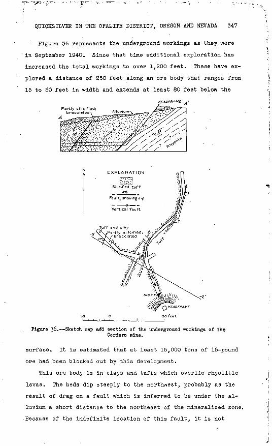
Figure 36 represents the underground workings as they were
in September 1940. Since that time additional exploration has
increased the total workings to over 1,200 feet. These have ex
plored a distance of 250 feet along an ore body that ranges from
15 to 50 feet in width and extends at least 80 feet below the
Partly sil
EXPLANATION
Silicified tuff
Fault, showing dip
Vertical fault
oHEAOFKAME
100 Feet
Figure 36. Sketch map arfd section of the underground workings of theCordero mine.
surface. It is estimated that at least 15,000 tons of 15-pound
ore had been blocked out by this development.
This ore body is in clays and tuffs which overlie rhyolitic
lavas. The beds dip steeply to the northwest, probably as the
result of drag on a fault which is inferred to be under the al
luvium a short distance to the northeast of the mineralized zone.
Because of the indefinite location of this fault, it is not
348 STRATEGIC MINERALS INVESTIGATIONS, 1941
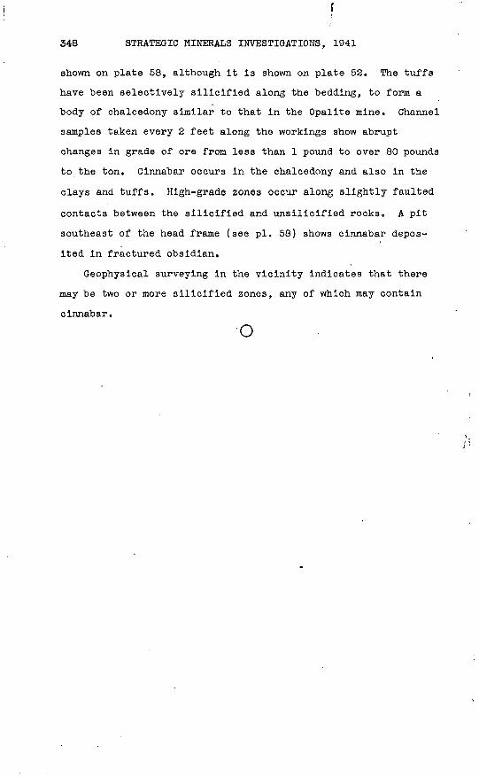
shown on plate 58, although it is shown on plate 52. The tuffs
have been selectively silicified along the bedding, to form a
body of chalcedony similar to that in the Opalite mine. Channel
samples taken every 2 feet along the workings show abrupt
changes in grade of ore from less than 1 pound to over 80 pounds
to the ton. Cinnabar occurs in the chalcedony and also in the
clays and tuffs. High-grade zones occur along slightly faulted
contacts between the silicified and unsilicified rocks A pit
southeast of the head frame (see pi. 58) shows cinnabar depos
ited in fractured obsidian.
Geophysical surveying in the vicinity Indicates that there
may be two or more silicified zones, any of which may contain
cinnabar.
o