QUADRANGLES. - USGS
14
U. S. Geological Swvey 1815 University Avenue Madison, Wisconsin 53706 QUADRANGLES. By Ulysses S. Grant and Ernest F. Burchard. INTRODUCTION. LOCATION AND AREA OF THE QUADRANGLES. The Lancaster and Mineral Point quadrangles are located between longitude 90° and 91° west and latitude 42° 30' and 43° north, and cover one-half of a square degree. Each quadrangle has an aver- age width of about 25^ miles and a length of nearly 35 miles, and together they have an area of approx- imately 1756 square miles. The quadrangles are in the southwest corner of Wisconsin and in north- eastern Iowa, and part of the southern border of each extends less than half a mile into Illinois. They comprise parts of Lafayette, Iowa, and Grant counties, Wis.; ^arts of Dubuque and Clayton counties, Iowa; and a small part of Jo Daviess County, 111. GENERAL FEATURES. The district was settled early in the history of the Mississippi Valley and is part of a rich agricul- tural region. Its chief farm products are hay, corn, oats, cattle, butter, and cheese. There are manu- facturing establishments at a number of places, and at the town of Mineral Point large quantities of sulphuric acid and zinc oxide are produced. The district is in the heart of the upper Missis- sippi Valley lead and zinc region and has long been known as a producer of lead and zinc ores. For a series of years its production of these ores decreased, but within the last four or five years its production of zinc ore has increased markedly. This increase is due to the mining of bodies of zinc sulphide which are found beneath the level of ground water, below which little of the early mining extended. The prospects are that this mining industry will be more extensively developed and that the district, which for nearly a century has been a producer of lead, and in later years a producer of zinc also, will continue for some time to be an important source of the ores of both metals, especially zinc, Dubuque, Iowa, a city of about 40,000 inhabit- ants, situated on Mississippi River at the extreme southern edge of the Lancaster quadrangle, is the largest and most important city in 'the area. Other important towns, all in Wisconsin, are Dodgeville, Darlington, Fennimore, Lancaster, Mineral Point, Platteville, and Shullsburg. The district is reached by five railroads the Illinois Central, the Chicago Great Western, the Chicago, Milwaukee and St. Paul, the Chicago, Burlington and Quincy, and the Chicago and Northwestern. OUTLINE OF THE GEOGRAPHY AND GEOLOGY OF THE REGION. The parts of southwestern Wisconsin and north- eastern Iowa that are included between the latitude of the Illinois boundary on the south and Wiscon- sin River on the north, and that extend from the confluence of Mississippi and Wisconsin rivers eastward nearly to the longitude of Madison, com- prise an elevated district from which streams flow out in all directions, although most of them run southward. Nearly all of this part of the Missis- sippi Valley is included in the "Driftless Area" a district comprising about 10,000 square miles, mostly in southwestern Wisconsin, but embracing also adjacent portions of Minnesota, Iowa, and Illinois. This area was not covered by the great continental ice sheet but was entirely surrounded by it, and the surface features here therefore pre* sent a marked contrast to those of the surrounding drift-covered districts. Outside of this area that is, in the region of the drift the bed rock is covered to a varying thickness by glacial drift, composed in some places of a stratified and in others of an unstratified mixture of clay, rock flour, sand, gravel, and bowlders. The bed rock beneath this drift is commonly scratched, smoothed, or pol- ished, and there is a shaijp line of demarcation between the rock and the overlying unconsolidated material. The surface of the ground is here rough and hilly, there undulatory, elsewhere smooth; there is a lack of system in the arrangement of the topographic features, and the streams wander about, in places in an apparently aimless way. More- over, none but the larger streams have well-defined valleys, and swamps and lakes are common. The surface is topographically young, at least in its minor features. Scale of Miles FIG. 1. Diagram showing relation of Lancaster-Mineral Point area to Driftless Region. Within the Driftless Area, on the other hand, the bed rock is overlain by unconsolidated material that is derived directly from this rock by decay. The underlying rock is not scratched or smoothed and is not sharply separated from the unconsoli- dated material above. The topographic features are systemized, and even the smaller streams have well-defined valleys and -locally straight courses. There are no swamps and no lakes, except along river bottoms. The surface is topographically mature. The Mineral Point quadrangle lies wholly within the Driftless Area, and there is but a thin fringe of drift in the southwest corner of the Lancaster quadrangle, along its boundary, and only a few scattered and fragmentary out- liers of drift between this fringe and Mississippi River. The geologic structure of this district is simple. The area is underlain by early Paleozoic sedimen- tary rocks sandstone, limestone, and shale rang- ing in age from Cambrian to Silurian. The strata dip very gently south-southwest, descending a little more steeply than, do the main southward-flowing streams, so that, in general, the younger rocks are found in the southern part of the area and the older rocks in the northern part. Locally the rocks have been thrown into slight folds, whose axes generally trend east and west, and whose southern limbs are long and gentle, while their northern limbs are shorter and steeper. The material to form these rocks was derived from the older highlands, com- posed of pre-Cambrian rocks, which lie farther north and northeast, in central and northern Wis- consin. In early Paleozoic time this highland district was a land area, while the sea lay over southwestern Wisconsin. During this time, how- ever, there were some changes in the relation of sea and land, the shore at one period lying farther south and at another farther north. Still, the rocks deposited in this region may be considered broadly as the product of one period of sedimentation, which began in the Cambrian and extended at least into the Silurian period. There is no certain evidence that the district has been below sea level since the deposition of the Niagara (Silurian) lime- stone, and erosion has been marked only in com- paratively recent geologic times Tertiary and later. If the district was above sea level in later Paleozoic and Mesozoic times it was probably a low-lying area, in which erosion was relatively inactive. EARLIER PUBLICATIONS ON THE DISTRICT. As the Mineral Point and Lancaster quadrangles constitute an important part of the upper Missis- sippi Valley lead and zinc district, their general features, geology, and ore deposits have been : described rather fully. The most complete account yet published is by T. C. Chamberlin (Geol. Wis- consin, vol. 4, 1882, pp. 365-571). Some other reports on this district are as follows: Whitney, J. D., Report on the lead region of "Wisconsin: Greol. Survey Wisconsin, vol. 1, 1862, pp. 73-420. Whitney, J. D., Geology of lead region: Geol. Survey Illinois, vol. 1, 1866, pp. 153-207. Republished in Economical Geology of Illinois, vol. 1, 1882, pp. 118-162. Shaw, James, Geology of northwestern Illinois: Geol. Survey Illinois, vol. 5, 1873, pp. 1-24. Republished in Eco- nomical Geology of Illinois, vol 3, 1882, pp. 1-20. Shaw, James, Geology of Jo Daviess County: Geol. Sur- vey Illinois, Vol. 5, 1873, pp. 25-56. Republished in Econom- ical Geology of Illinois, vol. 3, 1882, pp. 20-54. Strong, Moses, Geology and topography of the lead region: Geol. Wisconsin, vol. 2, 1877, pp. 643-752. Strong, Moses, Lead and zinc ores: Geol. Wisconsin, vol. 1, 1883, pp. 637-655. Chamberlin, T. C., and Salisbury, R. D., Preliminary paper on the Driftless Area of the upper Mississippi Valley : Sixth Ann. Rept. U. S. Geol. Survey, 1885, pp. 199-322. Jenney, W. P., Lead and zinc deposits of the Mississippi Valley: Trans. Am. Inst. Min. Eng., vol. 22, 1894, pp. 171-225, 642-646; especially pp. 208-212. Hershey, O. H., Physiographic development of the Missis- sippi Valley: Am. Geologist, vol. 20, 1897, pp. 246-268. Leonard, A. G., Lead and zinc deposits of Iowa: Iowa Geol. Survey, vol. 6, 1897, pp. 9-66. Calvin, Samuel, and Bain, H. F., Geology of Dubuque County: Iowa Geol. Survey, vol. 10, 1900, pp. 379-622; espe- cially pp. 480-597. Bain, H. F,, Preliminary report on the lead and zinc depos- its of the Ozark region, with an introduction by C. R. Van Hise and chapters on the physiography and geology by G. I. Adams: Twenty-second Ann. Rept. U. S. Geol. Survey, pt. 2, 1902, pp. 23-227; especially the introduction, pp. 33-49. Grant, U. S., Preliminary report on the lead and zinc deposits of southwestern Wisconsin: Bull. Wisconsin Geol. and Nat. Hist. Survey No. 9, 1903, 103pp. Bain, H. F., Zinc and lead deposits of northwestern Illinois: Bull. U. S. Geol. Survey No. 246, 1905, 56 pp. Grant, U. S., Report on the lead and zinc deposits of Wis- consin, with an atlas of detailed maps: Bull. Wisconsin Geol. and Nat. Hist. Survey No. 14, 1906, 100 pp., 18 atlas sheets. Grant, U. S., Structural relations of the Wisconsin lead and zinc deposits: Economic Geology, vol. 1, 1906, pp. 233- 242. Bain, H. F., Zinc and lead deposits of the upper Mississippi Valley: Bull. U. S. Geol Survey No. 294, 1906, 155 pp. Bulletin No. 14 of the Wisconsin Survey, cited above, contains a nearly complete bibliography of the lead and zinc deposits of the Wisconsin district. ACKNOWLEDGMENTS. - . The senior author is, in the main, responsible for the matter in this folio that relates to the Min- eral Point quadrangle and to the ore deposits. The junior author is responsible for those parts that deal especially with the Lancaster quadrangle. In the study of the area the authors were associated with Mr. H. Foster Bain. Mr. E. O. Ulrich has identified the fossils and has aided in solving questions of structure and correlation. In this investigation there was informal cooperation with the Wis- consin Geological and Natural History Survey, which mapped in detail certain important ore- bearing areas. Some of the results of this detailed work are incorporated in this folio. No attempt is made to give references to sources of information on definite points. The authors are indebted to several persons and publications, but especially to Prof. T. C. Chamberlin, whose thorough work on the general geology and ore deposits of the district is well known, and whose main conclusions the present investigation has abundantly confirmed. < TOPOGRAPHY OF THE QUADRANGLES. RELIEF. - The surface of the eastern half of the area is notably flat. Viewed from almost any stream divide it appears to be a broad, upland plain (here called the Lancaster peneplain) of monotonously even sky line. On closer examination, however, the plain is seen to be trenched by numerous wide, open valleys. Toward the west the extremes of relief become greater and the declivities steeper. In the western part of the area the plain is repre- sented by ridges and by flat interstream areas of limited extent. The broad, flat-bottomed gorge of Mississippi River, which is cut through the south- west portion of the area, constitutes, with its pre- cipitous rock walls, the dominating topographic feature of the region. A few mounds rise above the plain on both sides of Mississippi River, while southwest of the river, in Iowa, a solid front of hills and ragged promontories the Niagara escarp- ment marks the outer boundary of a stilLJiigher table-land. THE MOUNDS. The most marked elevations in the quadrangles are ten hills, which stand singly or in groups in widely separated portions of the area. Three of these hills, which lie in an east-west line about 4 miles northeast of Platteville, are known as the Platte Mounds. The central one of these is the smallest and is conical in form. The others are flat-topped and rise about 300 feet above the sur- rounding plain. These mounds, as well as all the others mentioned below, are capped by layers of Niagara limestone, which are rendered especially resistant to erosion by the large amounts of chert which they contain. The upper slopes of the Platte Mounds are steep and in places are almost bare of vegetation, while their lower slopes, com- posed of the soft Maquoketa shale, are gentle and grade off insensibly into the level of the upland plain. The westernmost of the Platte Mounds rises 1430 feet above sea level, and the eastern- most almost 1400 feet, but the central mound is 100 feet lower. The western mound is the high- est point in the two quadrangles; and the lowest point, where Mississippi River leaves the Lancaster quadrangle at its southern border, is below 600 feet. Thus the range of elevation in the quad- gles is about 830 feet. Sinsinawa Mound, about 5 miles west of Hazel Green, is a prominent, isolated, conical hill, 1160 feet above sea level at its summit. It stands nearly 300 feet above the immediately surrounding surface and its preservation is due to the same lithologic causes that have produced the Platte Mounds. ( Sherrill Mound and an unnamed mound of similar extent, together with two smaller inter- mediate knobs, lie in a northwest-southeast line in Jefferson Township, 10 to 12 miles northwest of Dubuque. These mounds are outliers that have been but recently detached from the Niagara escarp- ment or from the ends of the digitate ridges that project like rocky headlands from the high table- land to the southwest. The tops and the steep upper slopes of most of these mounds and the escarpment are heavily wooded, while the gentler slopes below are cleared and cultivated. Two other mounds, not so prominent, lie south of Shullsburg, and still farther south, in Illinois and Iowa (outside the quadrangles), there are many others. About 8 miles east-northeast of the north- east corner of the Mineral Point quadrangle is Blue
Transcript of QUADRANGLES. - USGS

U. S. Geological Swvey1815 University Avenue
Madison, Wisconsin 53706
QUADRANGLES.
By Ulysses S. Grant and Ernest F. Burchard.
INTRODUCTION.
LOCATION AND AREA OF THE QUADRANGLES.
The Lancaster and Mineral Point quadrangles are located between longitude 90° and 91° west and latitude 42° 30' and 43° north, and cover one-half of a square degree. Each quadrangle has an aver age width of about 25^ miles and a length of nearly 35 miles, and together they have an area of approx imately 1756 square miles. The quadrangles are in the southwest corner of Wisconsin and in north eastern Iowa, and part of the southern border of each extends less than half a mile into Illinois. They comprise parts of Lafayette, Iowa, and Grant counties, Wis.; ^arts of Dubuque and Clayton counties, Iowa; and a small part of Jo Daviess County, 111.
GENERAL FEATURES.
The district was settled early in the history of the Mississippi Valley and is part of a rich agricul tural region. Its chief farm products are hay, corn, oats, cattle, butter, and cheese. There are manu facturing establishments at a number of places, and at the town of Mineral Point large quantities of sulphuric acid and zinc oxide are produced.
The district is in the heart of the upper Missis sippi Valley lead and zinc region and has long been known as a producer of lead and zinc ores. For a series of years its production of these ores decreased, but within the last four or five years its production of zinc ore has increased markedly. This increase is due to the mining of bodies of zinc sulphide which are found beneath the level of ground water, below which little of the early mining extended. The prospects are that this mining industry will be more extensively developed and that the district, which for nearly a century has been a producer of lead, and in later years a producer of zinc also, will continue for some time to be an important source of the ores of both metals, especially zinc,
Dubuque, Iowa, a city of about 40,000 inhabit ants, situated on Mississippi River at the extreme southern edge of the Lancaster quadrangle, is the largest and most important city in 'the area. Other important towns, all in Wisconsin, are Dodgeville, Darlington, Fennimore, Lancaster, Mineral Point, Platteville, and Shullsburg. The district is reached by five railroads the Illinois Central, the Chicago Great Western, the Chicago, Milwaukee and St. Paul, the Chicago, Burlington and Quincy, and the Chicago and Northwestern.
OUTLINE OF THE GEOGRAPHY AND GEOLOGY OF
THE REGION.
The parts of southwestern Wisconsin and north eastern Iowa that are included between the latitude of the Illinois boundary on the south and Wiscon sin River on the north, and that extend from the confluence of Mississippi and Wisconsin rivers eastward nearly to the longitude of Madison, com prise an elevated district from which streams flow out in all directions, although most of them run southward. Nearly all of this part of the Missis sippi Valley is included in the "Driftless Area" a district comprising about 10,000 square miles, mostly in southwestern Wisconsin, but embracing also adjacent portions of Minnesota, Iowa, and Illinois. This area was not covered by the great continental ice sheet but was entirely surrounded by it, and the surface features here therefore pre* sent a marked contrast to those of the surrounding drift-covered districts. Outside of this area that is, in the region of the drift the bed rock is covered to a varying thickness by glacial drift, composed in some places of a stratified and in others of an unstratified mixture of clay, rock flour, sand, gravel, and bowlders. The bed rock beneath this drift is commonly scratched, smoothed, or pol
ished, and there is a shaijp line of demarcation between the rock and the overlying unconsolidated material. The surface of the ground is here rough and hilly, there undulatory, elsewhere smooth; there is a lack of system in the arrangement of the topographic features, and the streams wander about, in places in an apparently aimless way. More over, none but the larger streams have well-defined valleys, and swamps and lakes are common. The surface is topographically young, at least in its minor features.
Scale of Miles
FIG. 1. Diagram showing relation of Lancaster-Mineral Point area to Driftless Region.
Within the Driftless Area, on the other hand, the bed rock is overlain by unconsolidated material that is derived directly from this rock by decay. The underlying rock is not scratched or smoothed and is not sharply separated from the unconsoli dated material above. The topographic features are systemized, and even the smaller streams have well-defined valleys and -locally straight courses. There are no swamps and no lakes, except along river bottoms. The surface is topographically mature. The Mineral Point quadrangle lies wholly within the Driftless Area, and there is but a thin fringe of drift in the southwest corner of the Lancaster quadrangle, along its boundary, and only a few scattered and fragmentary out liers of drift between this fringe and Mississippi River.
The geologic structure of this district is simple. The area is underlain by early Paleozoic sedimen tary rocks sandstone, limestone, and shale rang ing in age from Cambrian to Silurian. The strata dip very gently south-southwest, descending a little more steeply than, do the main southward-flowing streams, so that, in general, the younger rocks are found in the southern part of the area and the older rocks in the northern part. Locally the rocks have been thrown into slight folds, whose axes generally trend east and west, and whose southern limbs are long and gentle, while their northern limbs are shorter and steeper. The material to form these rocks was derived from the older highlands, com posed of pre-Cambrian rocks, which lie farther north and northeast, in central and northern Wis consin. In early Paleozoic time this highland district was a land area, while the sea lay over southwestern Wisconsin. During this time, how ever, there were some changes in the relation of sea and land, the shore at one period lying farther south and at another farther north. Still, the rocks
deposited in this region may be considered broadly as the product of one period of sedimentation, which began in the Cambrian and extended at least into the Silurian period. There is no certain evidence that the district has been below sea level since the deposition of the Niagara (Silurian) lime stone, and erosion has been marked only in com paratively recent geologic times Tertiary and later. If the district was above sea level in later Paleozoic and Mesozoic times it was probably a low-lying area, in which erosion was relatively inactive.
EARLIER PUBLICATIONS ON THE DISTRICT.
As the Mineral Point and Lancaster quadrangles constitute an important part of the upper Missis sippi Valley lead and zinc district, their general features, geology, and ore deposits have been : described rather fully. The most complete account yet published is by T. C. Chamberlin (Geol. Wis consin, vol. 4, 1882, pp. 365-571). Some other reports on this district are as follows:
Whitney, J. D., Report on the lead region of "Wisconsin: Greol. Survey Wisconsin, vol. 1, 1862, pp. 73-420.
Whitney, J. D., Geology of lead region: Geol. Survey Illinois, vol. 1, 1866, pp. 153-207. Republished in Economical Geology of Illinois, vol. 1, 1882, pp. 118-162.
Shaw, James, Geology of northwestern Illinois: Geol. Survey Illinois, vol. 5, 1873, pp. 1-24. Republished in Eco nomical Geology of Illinois, vol 3, 1882, pp. 1-20.
Shaw, James, Geology of Jo Daviess County: Geol. Sur vey Illinois, Vol. 5, 1873, pp. 25-56. Republished in Econom ical Geology of Illinois, vol. 3, 1882, pp. 20-54.
Strong, Moses, Geology and topography of the lead region: Geol. Wisconsin, vol. 2, 1877, pp. 643-752.
Strong, Moses, Lead and zinc ores: Geol. Wisconsin, vol. 1, 1883, pp. 637-655.
Chamberlin, T. C., and Salisbury, R. D., Preliminary paper on the Driftless Area of the upper Mississippi Valley : Sixth Ann. Rept. U. S. Geol. Survey, 1885, pp. 199-322.
Jenney, W. P., Lead and zinc deposits of the Mississippi Valley: Trans. Am. Inst. Min. Eng., vol. 22, 1894, pp. 171-225, 642-646; especially pp. 208-212.
Hershey, O. H., Physiographic development of the Missis sippi Valley: Am. Geologist, vol. 20, 1897, pp. 246-268.
Leonard, A. G., Lead and zinc deposits of Iowa: Iowa Geol. Survey, vol. 6, 1897, pp. 9-66.
Calvin, Samuel, and Bain, H. F., Geology of Dubuque County: Iowa Geol. Survey, vol. 10, 1900, pp. 379-622; espe cially pp. 480-597.
Bain, H. F,, Preliminary report on the lead and zinc depos its of the Ozark region, with an introduction by C. R. Van Hise and chapters on the physiography and geology by G. I. Adams: Twenty-second Ann. Rept. U. S. Geol. Survey, pt. 2, 1902, pp. 23-227; especially the introduction, pp. 33-49.
Grant, U. S., Preliminary report on the lead and zinc deposits of southwestern Wisconsin: Bull. Wisconsin Geol. and Nat. Hist. Survey No. 9, 1903, 103pp.
Bain, H. F., Zinc and lead deposits of northwestern Illinois: Bull. U. S. Geol. Survey No. 246, 1905, 56 pp.
Grant, U. S., Report on the lead and zinc deposits of Wis consin, with an atlas of detailed maps: Bull. Wisconsin Geol. and Nat. Hist. Survey No. 14, 1906, 100 pp., 18 atlas sheets.
Grant, U. S., Structural relations of the Wisconsin lead and zinc deposits: Economic Geology, vol. 1, 1906, pp. 233- 242.
Bain, H. F., Zinc and lead deposits of the upper Mississippi Valley: Bull. U. S. Geol Survey No. 294, 1906, 155 pp.
Bulletin No. 14 of the Wisconsin Survey, cited above, contains a nearly complete bibliography of the lead and zinc deposits of the Wisconsin district.
ACKNOWLEDGMENTS.- .
The senior author is, in the main, responsible for the matter in this folio that relates to the Min eral Point quadrangle and to the ore deposits. The junior author is responsible for those parts that deal especially with the Lancaster quadrangle. In the study of the area the authors were associated with Mr. H. Foster Bain. Mr. E. O. Ulrich has identified the fossils and has aided in solving questions of structure and correlation. In this investigation there was informal cooperation with the Wis consin Geological and Natural History Survey, which mapped in detail certain important ore- bearing areas. Some of the results of this detailed work are incorporated in this folio. No attempt is made to give references to sources of information on definite points. The authors are indebted to several persons and publications, but especially to Prof. T. C. Chamberlin, whose thorough work on
the general geology and ore deposits of the district is well known, and whose main conclusions the present investigation has abundantly confirmed. <
TOPOGRAPHY OF THE QUADRANGLES.
RELIEF.
- The surface of the eastern half of the area is notably flat. Viewed from almost any stream divide it appears to be a broad, upland plain (here called the Lancaster peneplain) of monotonously even sky line. On closer examination, however, the plain is seen to be trenched by numerous wide, open valleys. Toward the west the extremes of relief become greater and the declivities steeper. In the western part of the area the plain is repre sented by ridges and by flat interstream areas of limited extent. The broad, flat-bottomed gorge of Mississippi River, which is cut through the south west portion of the area, constitutes, with its pre cipitous rock walls, the dominating topographic feature of the region. A few mounds rise above the plain on both sides of Mississippi River, while southwest of the river, in Iowa, a solid front of hills and ragged promontories the Niagara escarp ment marks the outer boundary of a stilLJiigher table-land.
THE MOUNDS.
The most marked elevations in the quadrangles are ten hills, which stand singly or in groups in widely separated portions of the area. Three of these hills, which lie in an east-west line about 4 miles northeast of Platteville, are known as the Platte Mounds. The central one of these is the smallest and is conical in form. The others are flat-topped and rise about 300 feet above the sur rounding plain. These mounds, as well as all the others mentioned below, are capped by layers of Niagara limestone, which are rendered especially resistant to erosion by the large amounts of chert which they contain. The upper slopes of the Platte Mounds are steep and in places are almost bare of vegetation, while their lower slopes, com posed of the soft Maquoketa shale, are gentle and grade off insensibly into the level of the upland plain. The westernmost of the Platte Mounds rises 1430 feet above sea level, and the eastern most almost 1400 feet, but the central mound is 100 feet lower. The western mound is the high est point in the two quadrangles; and the lowest point, where Mississippi River leaves the Lancaster quadrangle at its southern border, is below 600 feet. Thus the range of elevation in the quad- gles is about 830 feet.
Sinsinawa Mound, about 5 miles west of Hazel Green, is a prominent, isolated, conical hill, 1160 feet above sea level at its summit. It stands nearly 300 feet above the immediately surrounding surface and its preservation is due to the same lithologic causes that have produced the Platte Mounds. ( Sherrill Mound and an unnamed mound of similar extent, together with two smaller inter mediate knobs, lie in a northwest-southeast line in Jefferson Township, 10 to 12 miles northwest of Dubuque. These mounds are outliers that have been but recently detached from the Niagara escarp ment or from the ends of the digitate ridges that project like rocky headlands from the high table land to the southwest. The tops and the steep upper slopes of most of these mounds and the escarpment are heavily wooded, while the gentler slopes below are cleared and cultivated.
Two other mounds, not so prominent, lie south of Shullsburg, and still farther south, in Illinois and Iowa (outside the quadrangles), there are many others. About 8 miles east-northeast of the north east corner of the Mineral Point quadrangle is Blue
Mound, the top of which the highest point in this part of Wisconsin stands approximately 1700 feet above sea level.
All these mounds are, possibly, remnants of a structural plain that was developed on the Niagara limestone, and clearly illustrate the extent to which the limestone has been removed from the surface by erosion.
NIAGARA ESCARPMENT.
The Niagara escarpment, a northeastward-facing scarp of wide extent, is present only in that por tion of the area that lies southwest of the Missis sippi. Its outline is very irregular, for it has been deeply serrated by the erosive action of the Mis sissippi and the Little Maquoketa and its branches. It consists of steep slopes, most of them timbered, and occasional small dolomite cliffs and buttresses, or detached blocks, the whole aggregating from 60 to 150 feet in height.
The upper plateau or table-land, west of the Niagara escarpment, occupies a relatively small proportion of the area under discussion. Its extent practically coincides with the continuous area of Niagara limestone and may be readily, ascertained by reference to the geologic map of the Lancaster quadrangle. The elevation of this portion of the plateau is approximately 1200 feet, but beyond this quadrangle it slopes perceptibly to the south- southwest. Toward the northeast the former plain apparently rose much higher, as is shown by the progressive increase in elevation, for instance, from Sherrill Mound through Platte Mounds to Blue Mound. This plain does not so completely bevel across underlying formations as does the one next lower. There is a greater difference between their respective elevations at the extreme northeast cor ner of this area than at the southwest corner, or, in other words, the plains are not parallel to each other. The facts observed within these two quadrangles are not sufficient to determine whether this upper plain that is, the one lying above the Niagara escarpment is a peneplain or a structural plain, and its general history outside of these two quad rangles has not yet been completely worked out, though its age is probably Cretaceous.
LANCASTER PENEPLAIN.
From Military Ridge, the divide on which the Chicago and Northwestern Railway runs between Dodgeville and Montfort, and also from points along that railway between Montfort and Cuba, or from the town of Lancaster, a comprehensive view can be had of the broad upland that is here called the Lancaster peneplain. The even horizon is broken only by the mounds and the Niagara escarpment, already mentioned, or by other similar elevations in adjoining portions of Illinois and Iowa. The highest portions of this plain in the area here described are near Dodgeville, in the northeastern portion of the Mineral Point quad rangle, where the general upland surface is over 1200 feet above sea level. From this area it slopes gently southward and, to a much less extent, west ward. South of Gratiot the general elevation is somewhat more than 1000 feet above sea level; near Fennimore it is above 1200 feet; in the north west corner of the area, near Patch Grove, it is over 1100 feet; at Lancaster, from which the name of the plain is derived, and where it is typically developed, it stands at an altitude of about 1100 feet; south of Hazel Green it is at about 950 feet; while the lowest surface of the plain, near Asbury, Iowa, is somewhat less than 900 feet.
The surface of the plain lies mainly in the thick dolomitic formation known as the Galena, but toward the southern border of the quadrangles it lies in the lower portion of the soft Maquoketa shale. In other words, the plain, sloping more gently to the south than do the underlying forma tions, cuts across the edges of these formations. In the region farther south, outside the quadran gles, near Galena, 111., the plain lies well up in the Maquoketa shale. In the area north of the quad rangles, beyond Wisconsin River, the same plain lies in the Prairie du Chien formation, and still farther north it passes into the Cambrian sandstone. This upland plain, then, is not parallel with any particular geologic horizon, but cuts across differ ent formations; it is of the nature of a peneplain a plainlike surface produced by subaerial erosion. It dates probably from Tertiary time.
VALLEYS.
The Lancaster peneplain has been cleft by Mis sissippi River and extensively dissected by tributary streams which have, near their headwaters, rather wide, open valleys and in their lower portions canyonlike phases and well-developed but narrow flood plains. In fact, this dissection has gone so far that the original plain surface now commonly remains only along the stream divides. The main valley bottoms in the east half of the area lie 200 to 300 feet below the general level of the pene plain, but the Mississippi water level lies 300 to 600 feet below it, and consequently the streams joining the master stream within / the area have excavated the lower reaches of their valleys to a corresponding depth. On the smaller streams the valley sides have rather gentle slopes, except where the streams are now, or recently have been, actively encroaching on the sides of the valleys; and well- developed flood plains are common, even along intermittent streams.
The district, aside from the Mississippi River trough and the territory immediately adjacent, where the erosion forms are relatively youthful, may be called topographically mature, or may even be regarded as passing from maturity toward old age. It has been calculated that the cubic contents of the valleys equal approximately the cubic contents of the ridges between the valleys. If the valleys lie approximately 300 feet below the general upland level, this will mean that material equal in bulk to a layer 150 feet thick over the whole district has been removed by stream erosion since the peneplain was formed.
The Mississippi flows in a steep-walled gorge bordered by rock faces 60 to 90 feet high, above which abrupt slopes rise to a height of 150 to 200 feet above the river. From the border of this inner gorge rise gentler slopes that ascend 100 to 150 feet higher, to the general level of the Lan caster peneplain. These gentler slopes constitute the sides of what has been termed the "Basin" valley. The width of the inner valley or gorge, averaging IJr miles, is slightly greater at Cassville, where it enters the area, than where it leaves it at Dubuque. Below Dubuque this valley maintains an even width of 1^ miles for about 12 miles beyond the border of the area. Above Cassville it widens, except for a slight local constriction below the mouth of Wisconsin River, until it reaches a width of 3f miles at New Albin, Iowa, more than 60 miles distant. This somewhat anomalous widening of a river valley upstream
Chien the rock bottom was. found 112 feet below low-water mark. Observations at La Crosse and Lake Pepin also indicate corresponding depths. Near the inner edge of Peru Bottoms a well pen etrates 143 feet of sand containing a small pocket of gravel, reaching limestone at a depth of 80 feet below low-water mark.
The rock faces displayed along the walls of the gorge are the truncated ends of what were once graceful promontories that extended out to the main stream between its numerous tributaries and short-stream gullies. Normally the base of these bluffs is hidden by heavy talus, but the railroads on both sides of the gorge have cleared the lower part of this away at some places to such an extent as to afford continuous exposures of the strata from the bottom to the top of the bluffs.
The canyons of the streams in the southern portion of the area, near the Mississippi, are par ticularly striking, especially those of the Little Maquoketa and its tributaries, whose canyons are excavated practically their whole depth in the Galena limestone. Prominent crags and isolated towers and "chimneys" of this cliff-forming rock are conspicuous features of North Fork of Little Maquoketa River and of the small branch just west of Durango, although similar cliffs and crags are not rare along the bluffs of the Mississippi and other streams in the area.
Besides a terrace which is peculiar to the north ern portion of the district, and which is discussed below under the heading "Prairie du Chien for mation," there is in places along the Mississippi and in the adjacent valleys of its tributary streams a well-defined terrace composed of silt, sand, and gravel. On the Mississippi the Peru Bottoms, west of the Chicago, Milwaukee, and St. Paul Railway, comprise an extensive remnant of this terrace that lies more than 60 feet above the river. Another remnant, below the mouth of Sinnipee Creek, lies 40 feet above the river, and portions of the cities of Dubuque and Cassville are built on similar remnants of this terrace. This terrace has been observed above Burton, in the valley of Grant River. A remnant extends back three-fourths of a mile from the mouth of the hollow below Potosi. The small stream that occupies this hollow has cut its bed down through the unconsolidated deposit without much lateral corrasion, and the terrace is consequently a noticeable feature. Remnants of the terrace have been observed in the valleys of the Platte and Little Platte at distances exceeding 5 miles from the Mississippi. Beyond the southern
0£NE
.......
S^fa'^^
Horizontal ScaleO__ __y2 Irmile.
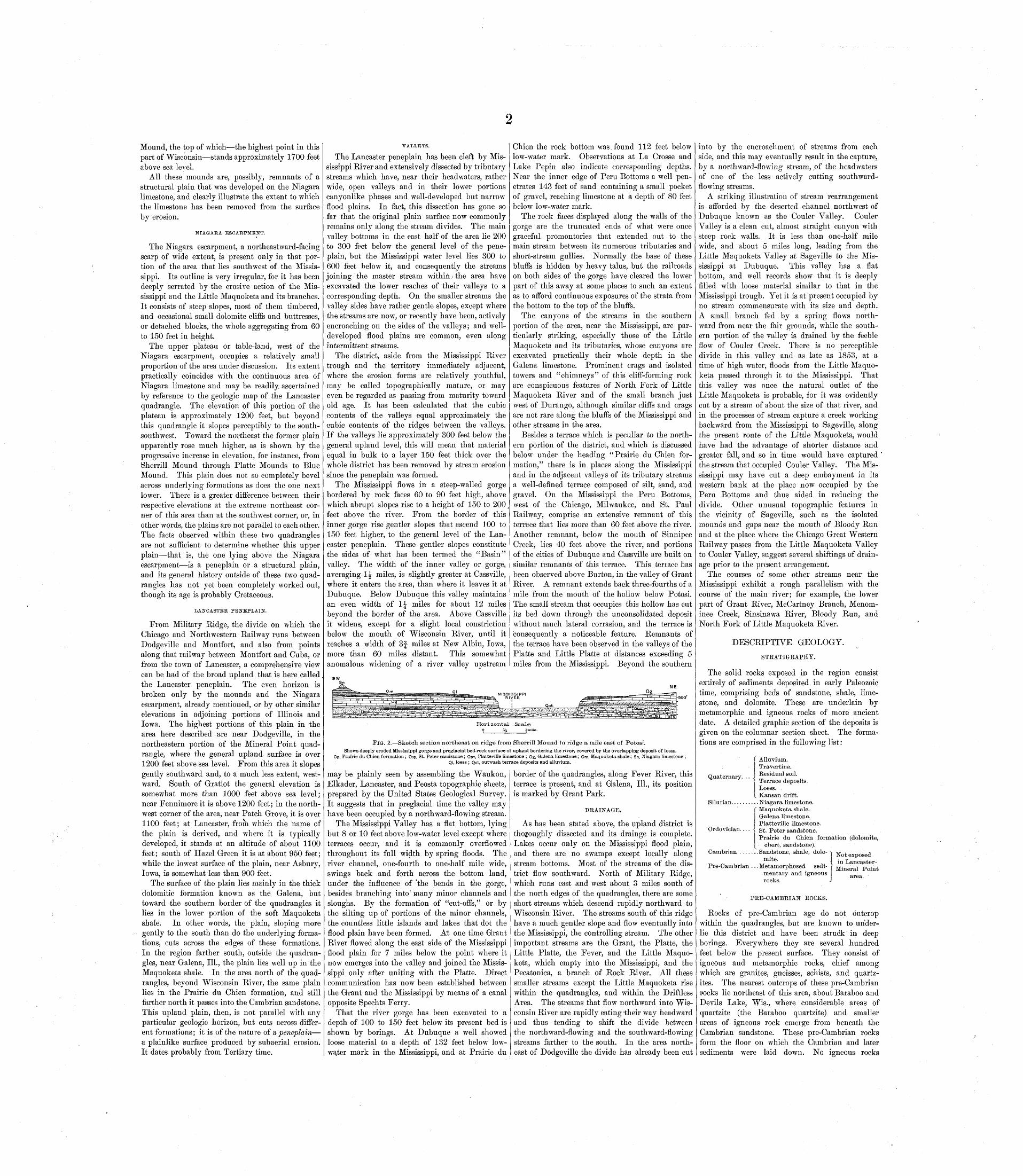
FIG. 2. Sketch section northeast on ridge from Sherrill Mound to ridge a mile east of Potosi.Shows deeply eroded Mississippi gorge and preglacial bed-rock surface of upland bordering the river, covered by the overlapping deposit of loess.
Op, Prairie du Chien formation ; Osp, St. Peter sandstone; Opv, Platteville limestone ; Og, Galena limestone; Om, Maquoketa shale; Sn, Niagara limestone ;Ql, loess ; Qot, outwash terrace deposits and alluvium.
may be plainly seen by assembling the Waukon, Elkader, Lancaster, and Peosta topographic sheets, prepared by the United States Geological Survey. It suggests that in preglacial time the valley may have been occupied by a northward-flowing stream.
The Mississippi Valley has a flat bottom, lying but 8 or 10 feet above low-water level except where terraces occur, and it is commonly overflowed throughout its full width by spring floods. The river channel, one-fourth to one-half mile wide, swings back and forth across the bottom land, under the influence of "the bends in the gorge, besides branching into' many minor channels and sloughs. By the formation of "cut-offs," or by the silting up of portions of the minor channels, the countless little islands and lakes that dot the flood plain have been formed. At one time Grant River flowed along the east side of the Mississippi flood plain for 7 miles below the point where it now emerges into the valley and joined the Missis sippi only after uniting with the Platte. Direct communication has now been established between the Grant and the Mississippi by means of a canal opposite Spechts Ferry.
That the river gorge has been excavated to a depth of 100 to 150 feet below its present bed is shown by borings. At Dubuque a well showed loose material to a depth of 132 feet below low- wa.ter mark in the Mississippi, and at Prairie du
border of the quadrangles, along Fever River, this terrace is present, and at Galena, 111., its position is marked by Grant Park.
DRAINAGE.
As has been stated above, the upland district is thoroughly dissected and its drainge is complete. Lakes occur only on the Mississippi flood plain, and there are no swamps except locally along stream bottoms. Most of the streams of the dis trict flow southward. North of Military Ridge, which runs east and west about 3 miles south of the north edges of the quadrangles, there are some short streams which descend rapidly northward to Wisconsin River. The streams south of this ridge have a much gentler slope and flow eventually into the Mississippi, the controlling stream. The other important streams are the Grant, the Platte, the Little Platte, the Fever, and the Little Maquo keta, which empty into the Mississippi, and the Pecatonica, a branch of Rock River. All these smaller streams except the Little Maquoketa rise within the quadrangles, and within the Driftless Area. The streams that flow northward into Wis consin River are rapidly eating vtheir way head ward and thus tending to shift the divide between the northward-flowing and the southward-flowing streams farther to the south. In the area north east of Dodgeville the divide has already been cut
into by the encroachment of streams from each side, and this may eventually result in the capture, by a northward-flowing stream, .of the headwaters of one of the less actively cutting southward- flowing streams.
A striking illustration of stream rearrangement is afforded by the deserted channel northwest of Dubuque known as the Couler Valley. Couler Valley is a clean cut, almost straight canyon with steep rock walls. It is less than one-half mile wide, and about 5 miles long, leading from the Little Maquoketa Valley at Sageville to the Mis sissippi at Dubuque. This valley has a flat bottom, and well records show that it is deeply filled with loose material similar to that in the Mississippi trough. Yet it is at present occupied by no stream commensurate with its size and depth. A small branch fed by a spring flows north ward from near the fair grounds, while the south ern portion of the valley is drained by the feeble flow of Couler Creek. There is no perceptible divide in this valley and as late as 1853, at a time of high water, floods from the Little Maquo keta passed through it to the Mississippi. That this valley was once the natural outlet of the Little Maquoketa is probable, for it was evidently cut by a stream of about the size of that river, and in the processes of stream capture a creek working backward from the Mississippi to Sageville, along the present route of the Little Maquoketa, would have had the advantage of shorter distance and greater fall, and so in time would have captured the stream that occupied Couler Valley. The Mis sissippi may have cut a deep embayment in its western bank at the place now occupied by the Peru Bottoms and thus aided in reducing the divide. Other unusual topographic features in the vicinity of Sageville, such as the isolated mounds and gaps near the mouth of Bloody Run and at the place where the Chicago Great Western Railway passes from the Little Maquoketa Valley to Couler Valley, suggest several shiftings of drain age prior to the present arrangement.
The courses of some other streams near the Mississippi exhibit a rough parallelism with the course of the main river; for example, the lower part of Grant River, McCartney Branch, Menom- inee Creek, Sinsinawa River, Bloody Run, and North Fork of Little Maquoketa River.
DESCRIPTIVE GEOLOGY.
STRATIGRAPHY.
The solid rocks exposed in the region consist extirely of sediments deposited in early Paleozoic time, comprising beds of sandstone, shale, lime stone, and dolomite. These are underlain by metamorphic and igneous rocks of more ancient date. A detailed graphic section of the deposits is given on the columnar section sheet. The forma tions are comprised in the following list:
Quaternary. .. J
f Alluvium. Travertine. Residual soil. Terrace deposits. Loess.Kansan drift.
Silurian.......... Niagara limestone.Maquoketa shale. Galena limestone. Platteville limestone. St. Peter sandstone.Prairie du Chien formation (dolomite,
chert, sandstone).
Ordovician.
INot exposed in Lancaster-
Mineral Point
Cambrian ...... .Sandstone, shale, dolo mite.
Pre-Cauibrian .. .Metamorphosed sedi mentary and igneous rocks.
PRE-CAMBEIAlSr EOCKS.
Rocks of pre-Cambrian age do not outcrop within the quadrangles, but are known to under lie this district and have been struck in deep borings. Everywhere they are several hundred feet below the present surface. They consist of igneous and metamorphic rocks, chief among which are granites, gneisses, schists, and quartz- ites. The nearest outcrops of these pre-Cambrian rocks lie northeast of this area, about Baraboo and Devils Lake, Wis., where considerable areas of quartzite (the Baraboo quartzite) and smaller areas of igneous rock emerge from beneath the Cambrian sandstone. These pre-Cambrian rocks form the floor on which the Cambrian and later sediments were laid down. No igneous rocks
whatsoever of as late date as the Cambrian sand stone are known in this area.
CAMBRIAN SYSTEM.
The Cambrian system is represented by a thick formation, consisting of sandstone, as a rule poorly consolidated, with minor amounts of shale and dolo mite. In the Wisconsin reports the name " Pots dam" sandstone has been applied to this formation, although it is not the exact equivalent of the Pots dam sandstone of New York. It reaches a max imum thickness of about 1000 feet. A generalized section of the Cambrian rocks shows that more than their lower half is sandstone, above which lies 85 feet of shale, and above this 150 feet of sandstone, at some places calcareous, overlain by 35 feet of shale and limestone that is known in the vicinity of Madison as the "Mendota" limestone. The upper part of the Cambrian ,is sandstone, about 30 feet thick. This is exposed in the vicinity of Madison and elsewhere, and has been named in the Wisconsin reports the "Madison" sandstone.
The Cambrian rocks outcrop nowhere in either the Mineral Point or the Lancaster quadrangle, erosion having not yet cut down to them, but they do appear in the stream valleys just beyond the northern edge of the quadrangles.
ORDOVICIAN SYSTEM.
The chief strata exposed in the quadrangles belong to the Ordovician system, and especially to the Galena dolomite. The Ordovician rocks directly underlie both quadrangles, except on the mounds. The divisions of the Ordovician here represented are as follows, in ascending order: (1) a thick dolomite, chert, and shale formation the Prairie du Chien; (2) a sandstone formation the St. Peter; (3) a limestone, dolomite, and shale for mation the Platteville; (4) a thick dolomite for mation the Galena; (5) a shale formation the Maquoketa.
PRAIRIE DU CHIEN FORMATION.
Thickness and subdivisions. Above the Cam brian sandstone and below the next sandstone (St. Peter) there is a formation ranging in thickness from 150 to 250 feet, composed largely of dolo mite. To this the name Prairie du Chien forma tion is applied, as it is well exposed in the vicinity of the town of that name, at the junction of Wis consin and Mississippi rivers. This same forma tion is commonly known in the upper Mississippi Valley as the "Lower Magnesian" limestone. Locally it is separable into three divisions, as follows: (1) At the base a thick dolomite, the main body of the formation, which has been called "Oneota"; (2) a thinner division called the "New Richmond" sandstone; (3) at the top, a thin divi sion to which the name "Shakopee" limestone has been applied. The separation of the Prairie du Chien formation into these three divisions can not everywhere be readily maHe, first, because of the thinness or local absence of the second division (sandstone), and, second, because the upper part of this formation was in places removed by erosion before the St. Peter sandstone was deposited.
Lithologic character. The dolomite is gray to white in color and varies from a very compact, fine-grained rock to one that is porous and coarse grained, but on the average it is less porous and less coarse grained than the other thick dolomite of the district the Galena limestone. It also com monly weathers less roughly than does the Galena, though at some localities the Prairie du Chien is a markedly rough-weathering rock, but at these places this feature is due largely to its semi- brecciated, brecciated, or possibly conglomeratic character. Beds of clay shale, 3 to 10 inches thick, are locally developed in the finer grained portions of the dolomite.
Many small masses of chert, more commonly termed flint, some of them a foot or more in diam eter, also occur in the upper third of this formation, but the chert is, as a rule, aggregated in certain layers rather than scattered indiscriminately through the dolomite. In general the coarser parts of the for mation carry the most chert; most of the finer com pact portions are entirely free from it. Here and there in the dolomite, or in the chert masses, there are small cavities, which are lined with small crys tals of quartz; in fact there are more quartz crys-
Lancaster-Mineral Point.
tals in this formation than in the others of the district, which are noticeably deficient in silica in crystallized form.
Near or at the very top of the formation there is at many places a marked development of oolite, a rock consisting of small rounded bodies, about the size of a pin's head, embedded in a siliceous cement. These bodies have a concentric* structure and are mainly siliceous, though some of them may be calca reous. This oolite may be seen in fragments in many places along the wagon roads of the district, as, for instance, in the eastern part of sec. 14, T. 5 N., R. 2 W., 2 miles west of Annaton; also just west of the bridge across Pecatonica River, in NE. J sec. 36, T. 4 N., R. 2 E., 5 miles south of Min eral Point; also along the road near the south side of sec. 3, of the same township, about 3 miles west- southwest of Mineral Point. At the latter place some large masses of cellular chert are associated with the oolite.
In the extensive exposure of the formation along Mineral Point Branch in sees. 2, 3, and 10, T. 4 N., R. 2 E., about 30 feet of rock is seen in one cliff. The upper 10 feet consists of rough-weathering, hard, more or less broken beds of dolomite; while the lower part is more regular, less rough-weather ing, and in heavy beds. Some chert occurs in both parts of the cliff.
The exposures of the Prairie du Chien in these quadrangles are mainly of dolomite, sandstone exposures of this age being rather uncommon, especially in the southern part of the area. Sand stone occurs, however, at several places in the north ern part of the quadrangles. Near the northeast corner of sec. 24, T. 5 Nv R. 2 E., on the east bank of the creek, 2^ miles north of Mineral Point, the following section is exposed:
Section near top of Prairie du Chien formation north of Mineral Point.
Ft. In.12. Sandstone, crumbling, not clearly in place. 5 011. Fine-grained dolomite....... .............. 0 610. Sandstone.................................. 4 0
9. Fine-grained dolomite in undulating beds1 to 3 inches thick........................ 1 8
8. Sandstone.................................. 0 17. Fine-grained dolomite ..................... 0 16. Sandstone, commonly pure, but in places
with blue clay cement. .................. 2 05. Soft, calcareous shale or shaly limestone... 0 24. Sandstone. ................................ 0 33. Soft, calcareous shale or shaly limestone... 0 62. Sandstone.................................. 2 01. Coarse dolomite............................ 0 6
16 9
Along the road that runs through sec. 14 and into sec. 10, T. 6 N., R. 2 E., just north of the Min eral Point quadrangle, there are imperfect expo sures showing both dolomite and sandstone in the upper part of the Prairie du Chien formation. Another road section in which the exposures are not continuous, but which shows the presence of sandstone in the formation, occurs in the E. ^ sec. 14, T. 5 N., R. 2 W., on the Annaton-Stitzer wagon road. The rocks dip perceptibly eastward here, so that on the hill slope the apparent thick ness of the beds is greater than the actual thick ness. At the base of the hill are about 30 feet of massive, rough-weathering dolomite, overlain by 5 feet of interbedded, crystalline dolomite and sharp-grained, reddish sandstone, and for some 30 feet above this horizon there are scattered outcrops and debris of reddish .sandstone and oolitic chert, with an exposure, at the top, of bluish-green sandy clay, succeeded above by St. Peter sandstone.
Near Dodgeville a drill record is reported as follows: .
Section near Dodgemlle.
Feet. 5. Limestone (Galena) ............................. 704. Limestone (Platteville).......................... 583. Sandstone (St. Peter) ........................... 522. Solid limestone, no openings (Prairie du Chien) 191 1. Sandstone, probably Cambrian................. 8
379
A few other indefinite drill records have been reported, but in these no sandstone has been noted in the Prairie du Chien formation.
Far better exposures of the Prairie du Chien formation are found a few miles north of these quadrangles, toward Wisconsin River and farther west, near the Mississippi. The nature of the upper portion of the formation in the eastern part of the Elkader quadrangle is shown in the following section:
Section of upper part of Prairie du CMen formation north of Bagley, Wis.
Ft. In.Sandstone (St. Peter)............................ 30 0D6bris, concealing contact. ......................* 30 0PRAIRIE DU CHIEN:
Limestone, hard, porous..................... 1 0Sandstone, white, very soft................... 2 0Dolomite, hard, fine grained, thin bedded,
grading into sandy beds.................... 30 0Siliceous dolomite, hard and quartzitic....... 0 4Sandstone, thin-bedded, yellow............... 8 0Shale, blue, with 1-inch band of white, silice
ous oolite................................... 1 2Dolomite, very massive, hard, with large con
cretions ..................................... 20 0Shale, blue, with some sand................. 1 0Limestone, white, fine grained, thin bedded.. 2 0 Chert in irregular, wavy beds................. 2 0Shale, sandy.................................. 1 0Limestone or dolomite, irregularly bedded,
with small concretions. At base is a thin layer of calcareous sandstone............... 20 0
Shale, blue, with sandstone interbedded, and at bottom a fine-grained, white, conglomer atic limestone............................... 2 0
Sandstone, pure white, coarse grained, friable 6 0 Siliceous dolomite, very irregularly bedded,
weathering rough, and containing a large proportion of chert......................... 20 0
Total exposure of Prairie du Chien. Base not exposed.
116 6
The sandstone beds in the above section appear to have little horizontal extent, but rather seem to be sandstone lenses in the formation. In the Lan caster quadrangle evidence of the occurrence of such sandstone beds in the Prairie du Chien was seen about 2 miles southwest of Fennimore, along the north-south road in sec. 36, T. 6 N., R. 3 W., about 100 paces south of the schoolhouse.
In these quadrangles the upper 50 to 60 feet of the formation may contain considerable sandstone, interbedded with dolomite and chert. At some places, especially in the northwest portion of the area, the sandstone layers are few and very thin, and occasionally may be entirely absent. When present, the sandstone of the Prairie du Chien for mation can usually be distinguished from the St. Peter sandstone by one or more of the following criteria: (1) the St. Peter is usually a thick-bedded, massive formation, while the lower sandstone is generally a thinner bedded, rougher weathering formation in which cross-bedding is common; (2) the St. Peter has little foreign matter, i. e., it is a pure, waterworn quartz sand, while the lower sand stone is commonly highly charged with iron oxide, at some localities has a clay or calcareous cement, and in many places is interbedded with dolomite; (3) at the junction of the St. Peter with the under lying rocks there is at many localities a layer of siliceous oolite, and at some places large masses of cellular flint, which are not known to occur in the St. Peter itself.
Distribution and physiographic expression. Ex posures of the Prairie du Chien formation in the Mineral Point quadrangle are, with one exception, confined to some of the valleys in its northern half, and commonly these exposures rise only a few feet above the water. The deeper valleys of the Lan caster quadrangle north of the Mississippi nearly all cut well into the formation, which at a few places extends completely across low divides. The formation is seen north of Lancaster in bluffs 30 to 40 feet high, but it tends to break up into small, flinty fragments, which completely cover the slopes and quickly give rise to soil. The presence of this formation can at some places be detected, even if outcrops are not at hand, by its effect on the form of valley bottoms. Most of the valleys in the St. Peter sandstone have wide, flat bottoms. Where the valley bottoms pass from this easily eroded sandstone into the harder dolomite of the Prairie du Chien they become much constricted and a ter race marks the location of the dolomite. This fea ture is made more prominent by the tendency of the immediately overlying sandstone to form a low escarpment. Such terraces occur at several places on Pecatonica River and its branches, south and. west of Mineral Point, and one very noticeable terrace is in the southern part of sec. 2, T. 4 N., R. 2 E., 2 miles west-southwest of that town. Terraces of similar origin are also perceptible along the larger streams in the Lancaster quadrangle, even where the valley has been cut but a few feet below the top of the Prairie du Chien without pro ducing any constriction in width of the valley, as, for example, along Platte River just above the mouth of the Little Platte. Other localities farther north are on Bull Branch, near its junction with Bacon Branch, and along Roger Branch, on the
Lancaster-Mount Ida wagon road. From the small knob crossed by this road in sec. 17, T. 5 N., R. 3 W., may be viewed a broad plain developed on the Prairie du Chien formation, into which valleys have been grooved. Above the plain rise occasional knobs of sandstone, and the St. Peter escarpment encircles it 2 or 3 miles to the west and north.
Fossils and correlation. The fossils contained in the Prairie du Chien formation in this region are somewhat rare. The only one at all common is a large globular mass, some specimens a foot or more in diameter, of concentric structure, roughly resem bling a cabbage head, and known as Cryptozoon. The exact horizon of this fossil has not been fully determined, but it apparently occurs in the upper 50 feet of the formation. So far as known it has not been found in the lower main dolomite division. The other fossils consist almost entirely of gastero- pods and cephalopods. These also occur only or chiefly in the cherty upper one-third of the forma tion. Among the collections made in these and in adjacent quadrangles the following described species have been identified:
Helicotoma pecatonica Sardeson. Raphistoma multivolvatum Calvin. Raphistoma minnesotensis (Owen) Sardeson. Straparollus claytonensis Calvin. Murchisonia argylensis Sardeson. Murchisonia putilla Sardeson. Subulites exactus Sardeson. Cyrtoceras luthei Calvin.
These indicate that in general the Prairie du Chien is the equivalent of the "Calciferous," or Beekmantown limestone, as it is now known, of New York and Canada, and that it also corresponds to that part of the "Magnesian" series of Missouri immediately underlying the "First Saccharoidal" or St. Peter sandstone of that State. It is highly probable that it may all be included in the horizon of the Jefferson City limestone of Missouri.
Stratigraphic relations. Wherever the base of the formation is exposed in the surrounding region the passage from the underlying Cambrian sand stone to the Prairie du Chien dolomite appears to be gradual. There is no sharp lithologic break, but rather an interbedding of sandstone and dolo mite, the dolomite predominating above and the sandstone below the line of division. The follow ing sections illustrate the character of the passage from the uppermost Cambrian to the Prairie du Chien formation of the Ordovician:
Section showing contact of Prairie du Chien formation (Ordovician) and Cambrian sandstone, near Soscobel, Wis.
Feet.ORDOVICIAN:
Limestone, rather thin bedded, fine grained, andcompact........................................ 10
Sandstone, soft, fine grained, yellow, and friable. .10 Unexposed ....................................... 5Limestone, hard, compact, almost like "glass
rock "; blue on fresh surface.................... 4Dolomite, hard, flinty, rough weathering, and
irregularly bedded; grades into thin-beddedlimestone........................................ 15
Debris............................................ 5Sandstone, limy, hard, crystalline, and buff
colored.......................................... 1
CAMBRIAN: Sandstone, soft, yellow to white, with blue shaly
streaks............................. ............ 6Unexposed ....................................... 4Limestone, heavy bedded, hard, subcrystalline,
with blue shale layer near top.................. 3Sandstone, iron stained, without bedding planes,
resembling St. Peter sandstone... ............. 27
"Section showing Ordovician-Cambrian contact, near Boscobel, Wis.
Feet.ORDOVICIAN:
Slope covered with fragments of St. Peter sand stone.
Limestone in subcrystalline beds 2 to 4 inches thick............................................ 20
Unexposed ....................................... 4Dolomite, heavy compact buff beds, effervescing,
but not very vigorously, in acid................. 10Limestone, yellow, very irregularly bedded, flinty,
with some sandstone partings, and blue shale... 80 Limestone, very hard, crystalline................. 1Sandstone, composed of rounded quartz grains
embedded in yellow calcareous cement. Has oolitic appearance.............................. 3
Sandstone, calcareous ...... ............. ...... 2Sandstone, containing little concretions or pockets
of pure white material that looks like carbonate of lime, but does not effervesce with acid....... 1
CAMBRIAN :Sandstone, white to yellow, with blue shale part
ings, showing ripple marks and cross-bedding.. 12
The Prairie du Chien formation is overlain unconformably by the St. Peter sandstone. The upper surface of the Prairie du Chien appears to have suffered considerable erosion before the depo-
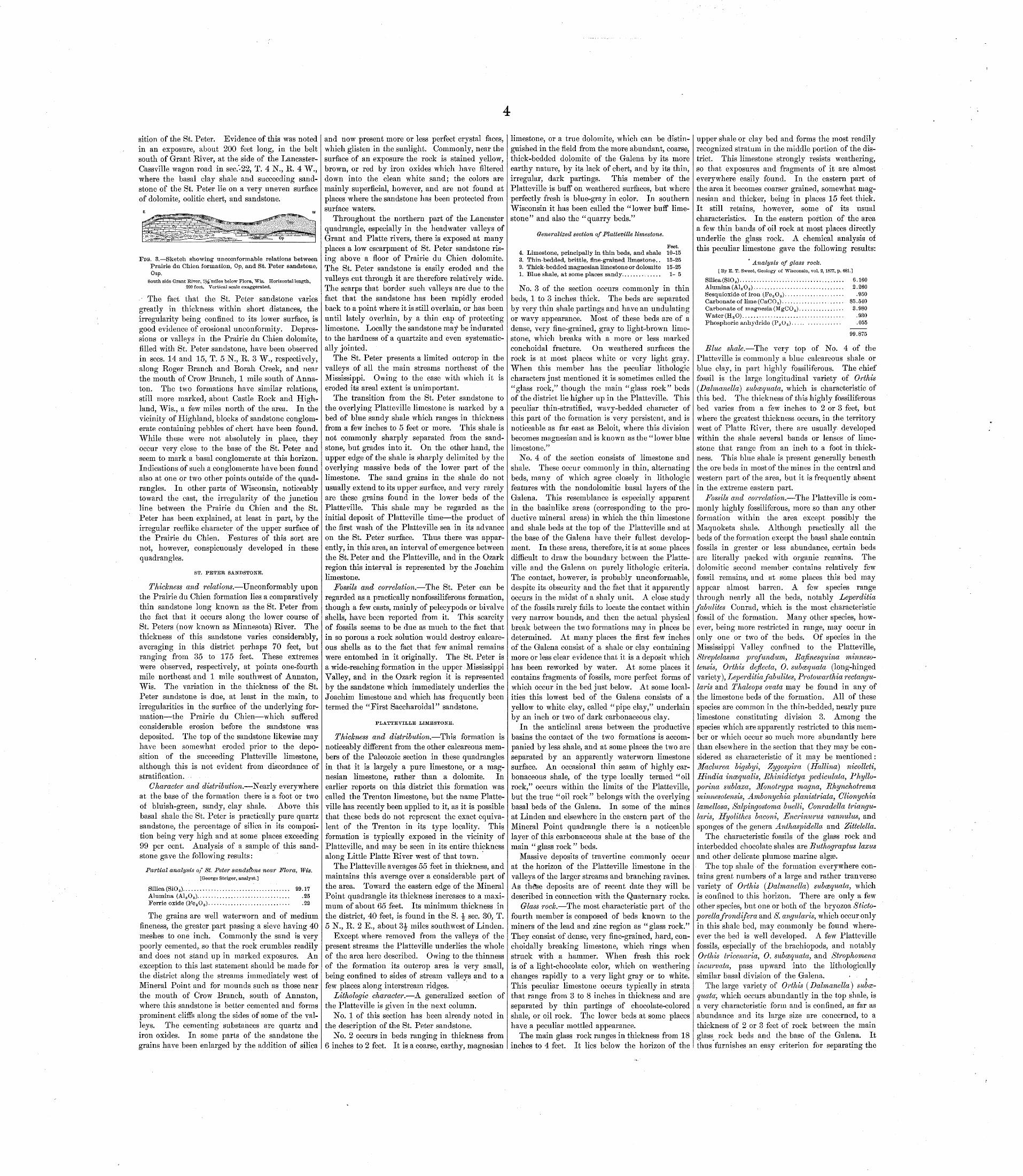
sition of the St. Peter. Evidence of this was noted in an exposure, about 200 feet long, in the belt south of Grant River, at the side of the Lancaster- Cassville wagon road in sec.'-22, T. 4 N., R. 4 W., where the basal clay shale and succeeding sand stone of the St. Peter lie on a very uneven surface of dolomite, oolitic chert, and sandstone.
FIG. 3. Sketch showing uncoinforinable relations between Prairie du Chien formation, Op, and St. Peter sandstone, Osp.
South side Grant River, IJ^'miles below Flora, Wis. Horizontal length, 200 feet. Vertical scale exaggerated.
The fact that the St. Peter sandstone varies greatly in thickness within short distances, the irregularity being confined to its lower surface, is good evidence of erosional unconformity. Depres sions or valleys in the Prairie du Chien dolomite, filled with St. Peter sandstone, have been observed in sees. 14 and 15, T. 5 N., R. 3 W., respectively, along Roger Branch and Borah Creek, and near the mouth of Crow Branch, 1 mile south of Anna- ton. The two formations have similar relations, still more marked, about Castle Rock and High land, Wis., a few miles north of the area. In the vicinity of Highland, blocks of sandstone conglom erate containing pebbles of chert have been found. While these were not absolutely in place, they occur very close to the base of the St. Peter and seem to mark a basal conglomerate at this horizon. Indications of such a conglomerate have been found also at one or two other points outside of the quad rangles. In other parts of Wisconsin, noticeably toward the east, the irregularity of the junction line between the Prairie du Chien and the St. Peter has been explained, at least in part, by the irregular reeflike character of the upper surface of the Prairie du Chien. Features of this sort are not, however, conspicuously developed in these quadrangles.
ST. PETER SANDSTONE.
Thickness and relations. Unconformably upon the Prairie du Chien formation lies a comparatively thin sandstone long known as the St. Peter from the fact that it occurs along the lower course of St. Peters (now known as Minnesota) River. The thickness of this sandstone varies considerably, averaging in this district perhaps 70 feet, but ranging from 35 to 175 feet. These extremes were observed, respectively, at points one-fourth mile northeast and 1 mile southwest of Annaton, Wis. The variation in the thickness of the St. Peter sandstone is due, at least in the main, to irregularities in the surface of the underlying for mation the Prairie du Chien which suffered considerable erosion before the sandstone was deposited. The top of the sandstone likewise may have been somewhat eroded prior to the depo sition of the succeeding Platteville limestone, although this is not evident from discordance of stratification.
Character and distribution. Nearly everywhere at the base of the formation there is a foot or two of bluish-green, sandy, clay shale. Above this basal shale the St. Peter is practically pure quartz sandstone, the percentage of silica in its composi tion being very high and at some places exceeding 99 per cent. Analysis of a sample of this sand stone gave the following results:
Partial analysis of St. Peter sandstone near Flora, Wis.[George Steiger, analyst.]
Silica (SiO 2)..........Alumina (A1.8 O 8 ).....Ferric oxide (Fe s O 3 ).
.25
.22
The grains are well waterworn and of medium fineness, the greater part passing a sieve having 40 meshes to one inch. Commonly the sand is very poorly cemented, so that the rock crumbles readily and does not stand up in marked exposures. An exception to this last statement should be made for the district along the streams immediately west of Mineral Point and for mounds such as those near the mouth of Crow Branch, south of Annaton, where this sandstone is better cemented and forms prominent cliffs along the sides of some of the val leys. The cementing substances are quartz and iron oxides. In some parts of the sandstone the grains have been enlarged by the addition of silica
and now present more or less perfect crystal faces, which glisten in the sunlight. Commonly, near the surface of an exposure the rock is stained yellow, brown, or red by iron oxides which have filtered down into the clean white sand; the colors are mainly superficial, however, and are not found at places where the sandstone has been protected from surface waters.
Throughout the northern part of the Lancaster quadrangle, especially in the headwater valleys of Grant and Platte rivers, there is exposed at many places a low escarpment of St. Peter sandstone ris ing above a floor of Prairie du Chien dolomite. The St. Peter sandstone is easily eroded and the valleys cut through it are therefore relatively wide. The scarps that border such valleys are due to the fact that the sandstone has been rapidly eroded back to a point where it is still overlain, or has been until lately overlain, by a thin cap of protecting limestone. Locally the sandstone ma^ be indurated to the hardness of a quartzite and even systematic ally jointed.
The St. Peter presents a limited outcrop in the valleys of all the main streams northeast of the Mississippi. Owing to the ease with which it is eroded its areal extent is unimportant.
The transition from the St. Peter sandstone to the overlying Platteville limestone is marked by a bed of blue sandy shale which ranges in thickness from a few inches to 5 feet or more. This shale is not commonly sharply separated from the sand stone, but grades into it. On the other hand, the upper edge of the shale is sharply delimited by the overlying massive beds of the lower part of the limestone. The sand grains in the shale do not usually extend to its upper surface, and very rarely are these grains found in the lower beds of the Platteville. This shale may be regarded as the initial deposit of Platteville time the product of the first wash of the Platteville sea in its advance on the St. Peter surface. Thus there was appar ently, in this area, an interval of emergence between the St. Peter and the Platteville, and in the Ozark region this interval is represented by the Joachim limestone.
Fossils and correlation. The St. Peter can be regarded as a practically nonfossiliferous formation, though a few casts, mainly of pelecypods or bivalve shells, have been reported from it. This scarcity of fossils seems to be due as much to the fact that in so porous a rock solution would destroy calcare ous shells as to the fact that few animal remains were entombed in it originally. The St. Peter is a wide-reaching formation in the upper Mississippi Valley, and in the Ozark region it is represented by the sandstone which immediately underlies the Joachim limestone and which has frequently been termed the "First Saccharoidal" sandstone.
PLATTEVILLE LIMESTONE.
Thickness and distribution. This formation is noticeably different from the other calcareous mem bers of the Paleozoic section in these quadrangles in that it is largely a pure limestone, or a mag- nesian limestone, rather than a dolomite. In earlier reports on this district this formation was called the Trenton limestone, but the name Platte ville has recently been applied to it, as it is possible that these beds do not represent the exact equiva lent of the Trenton in its type locality. This formation is typically exposed in the vicinity of Platteville, and may be seen in its entire thickness along Little Platte River west of that town.
The Platteville averages 55 feet in thickness, and maintains this average over a considerable part of the area. Toward the eastern edge of the Mineral Point quadrangle its thickness increases to a maxi mum of about 65 feet. Its minimum thickness in the district, 40 feet, is found in the S. -J sec. 30, T.5 N., R. 2 E., about 3|- miles southwest of Linden.
Except where removed from the valleys of the present streams the Platteville underlies the whole of the area here described. Owing to the thinness of the formation its outcrop area is very small, being confined to sides of stream valleys and to a few places along interstream ridges.
Lithologic character. A generalized section of the Platteville is given in the next column.
No. 1 of this section has been already noted in the description of the St. Peter sandstone.
No. 2 occurs in beds ranging in thickness from6 inches to 2 feet. It is a coarse, earthy, magnesian
limestone, or a true dolomite, which can be distin guished in the field from the more abundant, coarse, thick-bedded dolomite of the Galena by its more earthy nature, by its lack of chert, and by its thin, irregular, dark partings. This member of the Platteville is buff on weathered surfaces, but where perfectly fresh is blue-gray in color. In southern Wisconsin it has been called the "lower buff lime stone" and also the "quarry beds."
Generalized section of Platteville limestone.
Feet.4. Limestone, principally in thin beds, and shale 10-153. Thin-bedded, brittle, fine-grained limestone.. 15-252. Thick-bedded magnesian limestone or dolomite 15-251. Blue shale, at some places sandy.............. 1-5
No. 3 of the section occurs commonly in thin beds, 1 to 3 inches thick. The beds are separated by very thin shale partings and have an undulating or wavy appearance. Most of these beds are of a dense, very fine-grained, gray to light-brown lime stone, which breaks with a more or less marked conchoidal fracture. On weathered surfaces the rock is at most places white or very light gray. When this member has the peculiar lithologic characters just mentioned it is sometimes called the "glass rock," though the main "glass rock" beds of the district lie higher up in the Platteville. This peculiar thin-stratified, wavy-bedded character of this part of the formation is very persistent, and is noticeable as far east as Beloit, where this division becomes magnesian and is known as the "lower blue limestone."
No. 4 of the section consists of limestone and shale. These occur commonly in thin, alternating beds, many of which agree closely in lithologic features with the nondolomitic basal layers of the Galena. This resemblance is especially apparent in the basinlike areas (corresponding to the pro ductive mineral areas) in which the thin limestone and shale beds at the top of the Platteville and at the base of the Galena have their fullest develop ment. In these areas, therefore, it is at some places difficult to draw the boundary between the Platte ville and the Galena on purely lithologic criteria. The contact, however, is probably unconformable, despite its obscurity and the fact that it apparently occurs in the midst of a shaly unit. A close study of the fossils rarely fails to locate the contact within very narrow bounds, and then the actual physical break between the two formations may in places be determined. At many places the first few inches of the Galena consist of a shale or clay containing more or less clear evidence that it is a deposit which has been reworked by water. At some places it contains fragments of fossils, more perfect forms of which occur in the bed just below. At some local ities this lowest bed of the Galena consists of a yellow to white clay, called "pipe clay," underlain by an inch or two of dark carbonaceous clay.
In the anticlinal areas between the productive basins the contact of the two formations is accom panied by less shale, and at some places the two are separated by an apparently waterworn limestone surface. An occasional thin seam of highly car bonaceous shale, of the type locally termed "oil rock," occurs within the limits of the Platteville, but the true "oil rock" belongs with the overlying basal beds of the Galena, In some of the mines at Linden and elsewhere in the eastern part of the Mineral Point quadrangle there is a noticeable layer of this carbonaceous shale at the base of the main " glass rock " beds.
Massive deposits of travertine commonly occur at the horizon of the Platteville limestone in the valleys of the larger streams and branching ravines. As th£se deposits are of recent date they will be described in connection with the Quaternary rocks.
Glass rock. The most characteristic part of the fourth member is composed of beds known to the miners of the lead and zinc region as " glass rock." They consist of dense, very fine-grained, hard, con- choidally breaking limestone, which rings when struck with a hammer. When fresh this rock is of a light-chocolate color, which on weathering changes rapidly to a very light gray or to white. This peculiar limestone occurs typically in strata that range from 3 to 8 inches in thickness and are separated by thin partings of chocolate-colored shale, or oil rock. The lower beds at some places have a peculiar mottled appearance.
The main glass rock ranges in thickness from 18 inches to 4 feet. It lies below the horizon of the
upper shale or clay bed and forms the most readily recognized stratum in the middle portion of the dis trict. This limestone strongly resists weathering, so that exposures and fragments of it are almost everywhere easily found. In the eastern part of the area it becomes coarser grained, somewhat mag nesian and thicker, being in places 15 feet thick. It still retains, however, some of its usual characteristics. In the eastern portion of the area a few thin bands of oil rock at most places directly underlie the glass rock. A chemical analysis of this peculiar limestone gave the following results:
Analysis of glass rock.[ By E. T. Sweet, Geology of Wisconsin, vol. 2,1877, p. i 1.]
Silica (SiO 3)..................................... 6.160Alumina (A1 2 O 3)................................ 2.260Sesquioxide of iron (J^e-jOg)..................... .950Carbonate of lime(CaCO 3)..................... 85.540Carbonate of magnesia (MgCO 3)................ 3.980Water (H S O).................................... .930Phosphoric anhydride (P S O 5)..... ............ .055
99.875
Slue shale. The very top of No. 4 of the Platteville is commonly a blue calcareous shale or blue clay, in part highly fossiliferous. The chief fossil is the large longitudinal variety of Orthis (Dalmanella} subcequata, which is characteristic of this bed. The thickness of this highly fossiliferous bed varies from a few inches to 2 or 3 feet, but where the greatest thickness occurs, in the territory west of Platte River, there are usually developed within the shale several bands or lenses of lime stone that range from an inch to a foot in thick ness. This blue shale is present generally beneath the ore beds in most of the mines in the central and western part of the area, but it is frequently absent in the extreme eastern part.
Fossils and correlation. The Platteville is com monly highly fossiliferous, more so than any other formation within the area except possibly the Maquoketa shale. Although practically all the beds of the formation except the basal shale contain fossils in greater or less abundance, certain beds are literally packed with organic remains. The dolomitic second member contains relatively few fossil remains, and at some places this bed may appear almost barren. A few species range through nearly all the beds, notably Leperditia fabulites Conrad, which is the most characteristic fossil of the formation. Many other species, how ever, being more restricted in range, may occur in only one or two of the beds. Of species in the Mississippi Valley confined to the Platteville, Streptelasma profundum, Rajinesquina minneso- tensis, Orthis deflecta, 0. subcequata (long-hinged variety), Leperditia fabulites, Protowarthia rectangu- laris and Thaleops ovata may be found in any of the limestone beds of the formation. All of these species are common in the thin-bedded, nearly pure limestone constituting division 3. Among the species which are apparently restricted to this mem ber or which occur so much more abundantly here than elsewhere in the section that they may be con sidered as characteristic of it may be mentioned: Maclurea bigsbyi, Zygospira (Hallina} nicolleti, Hindia incequalis, Rhinidictya pediculata, Phyllo- porina sublaxa, Monotrypa magna, Rhynchotrema minnesotensis, Ambonychia planistriata, Clionychia lamellosa, Salpingostoma buelli, Conradella triangu- laris, Hyolithes baconi, Encrinurus vannulus, and sponges of the genera Anthaspidella and Zittelella.
The characteristic fossils of the glass rock and interbedded chocolate shales are Buthograptus laxus and other delicate plumose marine algse.
The top shale of the formation everywhere con tains great numbers of a large and rather tran verse variety of Orthis (Dalmanella} subcequata, which is confined to this horizon. There are only a few other species, but one or both of the bryozoa Sticto- porellafrondifera and S. angularis, which occur only in this shale bed, may commonly be found where- ever the bed is well developed. A few Platteville fossils, especially of the brachiopods, and notably Orthis tricenaria, 0. subcequata, and Strophomena incurvata, pass upward into the lithologically similar basal division of the Galena.
The large variety of Orthis (Dalmanella} subce quata, which occurs abundantly in the top shale, is a very characteristic form and is confined, as far as abundance and its large size are concerned, to a thickness of 2 or 3 feet of rock between the main glass rock beds and the base of the Galena. It thus furnishes an easy criterion for separating the

Galena from the Platteville a criterion which is of use in geologic mapping as well as in deter mining a horizon that is important in mining operations.
The Platteville is regarded as the equivalent of the Stones River group of Tennessee and Kentucky, a group that lies lower than the Black River and Lowville (Birdseye) limestones of New York.
Detailed sections. The upper part of the Platte ville limestone is exposed at several places, at some of which continuous sections from this formation up into the lower part of the Galena are observable. The eight sections given below are particularly well exposed, and each exhibits a greater thickness of rock than is commonly observed in one exposure. The section first given is from an old quarry on the west bank of Little Platte River, about 1^ miles west-northwest of Platteville; the exact location is in NE. J sec. 8, T. 3 N., R. 1 W.
Section near Plattemlle, Wis.
Ft. In.GALENA :
13. Subcrystalline, magnesian limestone at base, but in 2 or 3 feet grading into coarse, thick-bedded dolomite........ 20 0
12. Blue to gray calcareous shale or shalylimestone............................. 0 8
11. Thin-bedded, Subcrystalline limestone. A few specimens of Orthis tricenaria Conrad and 0. subcequata Conrad.... 5 0
10. Thin, wavy-bedded limestone, resem bling glass rock, becoming subcrystal- line above. Some beds are very fossil- iferous. Orthis tricenaria Conrad, 0. subcequata, 0. pectinella Hall, and 0. testudinaria Dalman............... 6 0
9. Dark-brown or chocolate-colored shaleor oil rock............................. 0 2
8. Thin, wavy-bedded limestone, resem bling glass rock; commonly very fossil- iferous; a few thin partings of oil rock. Orthis tricenaria Conrad, 0. sub cequata Conrad, Strophomena incur- vata Shepard, Raflnesquina alternata Conrad, Ctenodonta astartiformis Sal- ter, Cerauruspleurexanthemus Green, Asaphus (Isotelus) gig as Dek.a,j,Rhini- dictya mutabilis minor TJlrich........ 8 0
PLATTEVILLE :7. Blue shale............................... 0 86. Thin, undulating, hard limestone, at
some places resembling glass rock, in- terbedded with blue shale. The lime stone is very fossiliferous. This is the chief horizon for Orthis subcequata Con rad (var. minneapolis Winchell), which is here very abundant and of large size. Stictoporella frondifera Ulrich occurs at the top of this division............. 2 0
5 Gray to yellow-brown to almost blackclay................................... 0 7
4. Dark-gray shale and hard gray lime stone interbedded..................... 1 2
3. Main glass rock beds. Some oil rock bands occur in the lower part, and in these are Isotelus gigas and fernlike forms, probably of the fossil alga Buthograptus laxus Hall.............. 2 6
2. Thin shaly layers of glass rock with oil- rock partings; weathers to clay....... 0 3
I. Blue, gray-weathering limestone with dark partings. The upper part is separated by blue shale into 2 beds, each 21 inches thick. The upper part of these beds has in places the appear ance, of thin wavy-bedded glass rock. Orthis aeflecta Conrad, Raflnesquina minnesotensis Winchell, Thaleops ovata Conrad, Leperditia fabulites Conrad, Monotrypa magna Ulrich.... 7 0
Total exposure................... 54 0Galena limestone, exposed...... 39 10Platteville limestone, exposed... 14 2
In the above section No. 1 belongs to. the thin- bedded member (No. 3 of generalized section) of the Platteville, Nos. 2 to 7 belong to the upper member of the Platteville, while Nos. 11 to 13 clearly belong to the Galena, Nos. 8 to 10 are regarded as the equivalents of the main oil-rock horizon that marks the base of the Galena. The division between the Galena and Platteville will then be drawn between Nos. 7 and 8.
Section at City Quarry, Mineral Point, Wis.
Ft. In.GALENA :
II. Residual soil............................. 5 610. Decayed dolomite, called by the miners
the " brown rock"..................... 4 09. Oil rock, with some cubes of galena and
some decayed limestone................ 1 68. Compact, brownish magnesian limestone 1 0 7. Unexposed............................... 17 6
PLATTEVILLE:6. Thin, wavy-bedded limestone, much like
glass rock............................... 4 05. Compact, magnesian limestone; brown
on weathered surface, but blue on fresh surfaces; in beds 3 inches to 1 foot in thickness............................... 10 6
4. Thin, wavy bedued, hard, glass rocklikelimestone .............................. 15 6
3. Coarse, thick-bedded dolomite........... 20 62. Traces of shale........................... 0 6
Lancaster-Mineral Point.
ST. PETER: 1. Sandstone.
Total............................. 83 6Galena limestone, exposed........ 6 6Platteville limestone, exposed.... 51 0St. Peter sandstone, exposed ..... 3 0
In this section No. 1 represents the St. Peter sandstone. The shale (No. 1 of the generalized section of the Platteville) just above this is here very thin and not well exposed. No 3 represents division 2 of the generalized section of the Platte ville, while Nos. 4 and 5 represent the next higher member; and No. 6 and probably a part of No. 7 represent the upper member of the Platteville. Nos. 8, 9, 10, and part of No. 7 belong to the Galena.
Section at Mineral Point, near Mineral Point Zinc Works.Feet.
6. Debris of limestone, containing Streptelasma corniculum Hall and a few Orthis sub cequata Conrad........................ ..... 3
PLATTEVILLE :5. Compact, fine-grained limestone............... 24. Thin, wavy-bedded limestone resembling glass
rock; Orthis tricenaria Conrad, 0. deflecta Conrad, Raflnesquina alternata Conrad, R. minnesotensis Winchell, Zygospira (Hal- Una} nicolleti Winchell and Schuchert, Stro- phomena trentonensis Winchell and Schu chert, Rhynchotrema minnesotensis Sarde- son, Leperditia fabulites Conrad, Isotelus gigas Dekay, Monotrypa magna Ulrich, Zittelella typicalis Ulrich and Everett, and Anthaspidella sp ........................... 25
3. Coarser, thick-bedded dolomite................ 14ST. PETER:
2. Unexposed..................................... 6I. Sandstone...................................... 10
Total.................................. 60Platteville limestone, exposed......... 41St. Peter sandstone, exposed .......... 10
In this section No. 1 represents the St. Peter; No. 3 (and part of No. 2) is the second member of the Platteville, No. 4 is the third member of the Platteville, and No. 5 is part of the uppermost mem ber of the Platteville.
Section in quarry at Darlington, Wis.Ft. In.
GALENA :II. Coarse-grained, thick-bedded dolomite,
with Receptaculites oweni Hall....... 4 010. Coarse-grained, thick-bedded dolomite. 3 0
9. Coarse-grained, thick-bedded dolomitewith chert........ .................... 5 0
8. Coarse-grained, thick-bedded dolomite.. 2 0 7. No exposure ...... ..................... 6 06. Coarse-grained, thick-bedded dolomite,
with 3 shaly bands, one-half inch to 4 inches thick. Near base are a few Orthis tricenaria Conrad, 0. plicatella Hall, 0. subcequata Conrad........... 27 6
5. Thin-bedded dolomite................... 4 64. Thin-bedded limestone with oil-rock
partings, which range from one-fourth inch to 2 inches in thickness. Orthis tricenaria Conrad, 0. subcequata Con rad................................... 4 0
PLATTEVILLE :3. Fine-grained, compact, magnesian lime
stone, with some chert, and containing Buthograptus laxus and a few oil-rock partings; represents the glass rock. The upper surface is smooth, appar ently waterworn. 0. subcequata Con rad (var. minneapolis Winchell) on top surface; Streptelasma profundum Owen, in body of bed................ 15 6
2. Blue magnesian limestone with darkwavy partings ........................ 19 6
I. Very blue magnesian limestone with prominent clay partings. Clathrospira subeonica Hall, Streptelasma profun dum Owen............................ 10. 0
' Total............................ 101 0Galena limestone, exposed....... 56 0Platteville limestone, exposed... 45 0
In the above section No. 2, and probably No. 1, belong to No. 3 of the generalized Platteville sec tion, while No. 3 belongs to the upper member of that section. Nos. 4 to 11 belong to the Galena.
In the western half of the area the thickening of the shale in division 4 of the Platteville becomes noticeable, as is shown in the following sections; and certain changes in lithology toward the north are illustrated in the last section given.
The section next following is exposed in a ravine entering the main Potosi hollow just above Potosi station, in SW. ^ sec. 4, T. 2 N., R. 3 W.
Section of Platteville limestone near Potosi station, Wis.
Ft. In.GALENA:
14. Limestone, heavy, with shaly clay atbase. Orthis testudinaria and smallvariety of Orthis subcequata.
13. Limestone, hard, fine grained, in thin,wavy beds with chocolate-colored shalepartings................................ 12 0
12. Limestone, crystalline, fossiliferous...... 0 7II. Shale, brown, carbonaceous (oil rock).... 0 4 10. Limestone, crystalline, fossiliferous...... 0 7
Ft. In.PLATTEVILLE:
9. Shale, drab and brown......... ......... 1 4Limestone, drab ......................... 0 1Shale, bluish................... ......... 0 4Limestone, ferruginous .................. 1 0Shale, olive and brownish; somewhat
fissile................................... 1 1Limestone................................ 0 3Shaly clay............................... 0 2Limestone, drab ......................... 0 4Shale, bluish....... ..................... 1 8Calcareous "mud rock;" fossiliferous in
places.................................. 0 5Shale, brown and carbonaceous at base.. 0 6 Limestone, hard, fossiliferous, bluish
where unweathered, parted by thin band of brown carbonaceous shale..... 1 0
8. Limestone, fine grained, compact; beds 2to 3£ inches thick...................... 2 6
7. Limestone, even grained, buff colored where weathered; beds 4 to 6 inches thick; grades into overlying thinner beds.................................... 3 0
6. Limestone, brownish, somewhat iron stained, in thin, hard, rather crystal line beds. More massive where un- weathered. Contains Leperditia fabu lites, Bathyurus schucherti, and Ptery- gometopus intermedius. ............... 12 0
5. Limestone, fine grained, compact, bluish white where fresh, in thin, wavy beds (2 to 4 inches), with thin leaves of brown shale in partings. Rather fossiliferous. Contains Leperditia fabulites, Leper- ditella germana, Clathrospira sub eonica, Protowarthia rectangularis ... 18 0
4. Debris ................................... 3 03. Magnesian limestone, buff, heavy bedded
(only top exposed). 2. Debris ................................... 8 01. Shale, below which is St. Peter sandstone 1 6
Total...........................Total thickness of Platteville...
No. 1 belongs to general division 1 of the Platteville; Nos 2 and 3, and probably No. 4, belong to division 2; Nos. 5 and 6 represent an unusual development of division 3; Nos. 7, 8, and 9 belong to the topmost division.
Section of Platteville limestone at Spechts Ferry, Iowa.
Ft. In.GALENA:
15. Limestone, thin bedded and compact, grading upward into cherty magnesian beds.
14. Limestone, in alternating thin beds and shaly beds, weathering to clay........
13. Limestone, hard, compact, crystalline beds, weathering thin and light colored
12. Calcareous shaly material inclosing 6- inch limestone bed; Orthis testudi naria and Plectambonites. ............
11. Limestone, fossiliferous, fine grained, compact, rather thin and wavy bed ded, with chocolate-colored shale part ings; less wavy bedded and more crys talline than No. 10; heavier bed un derlain by a few inches of shale at base; Plectambonites .................
10. Limestone, fine grained, compact, thin and wavy bedded, with chocolate- colored shale partings. Plectambonites, Raflnesquina alternata, Strophomena fllitexta, Ctenodonta astartiformis, Bathyurus spiniger. ..................
PLATTEVILLE :9. Shale, bluish green......................
Limestone, argillaceous....... .........Shale, bluish, with two thin limestone
bands. Orthis subcequata, 0. trice naria, and bryozoans .................
Limestone lenses........................Shale....................................Limestone, argillaceous, with shale part
ings, 2^ inches ........................Shale, bluish green......................Limestone...............................Shale, green and brown. ...............Limestone...............................Shale, dark and carbonaceous ..........
8. Limestone, massive beds, 10 to 43 inches, thinner on weathered edges; bluish where fresh, buff where weathered....
7. Limestone, bluish, rather massive, weathering to 4 to 8 inches in lower part. Leperditia fabulites. ............
6. Limestone, chocolate brown to bluish, compact and fine grained, containing fine calcite streaks (exposed)..........
5. D<3bris .................................4. Limestone brownish magnesian beds
only top exposed. 3. D<5bris ..................................2. Magnesian limestone, in beds of 12 to 15
inches.................................1. Debris, probably overlying shale horizon
ST. PETER:Sandstone, top only exposed in ditch.
3 6
4 0
1 6
10
10
00
034
10
17 0
5 0
8 92 0
5 0
7 62 6
Total............................ 85 9Total thickness of Platteville.... 56 9
No. 1 of the above section represents division 1 of the Platteville; Nos. 2, 3, and 4 represent division 2; Nos. 6, 7, and 8 probably belong to division 3, and No. 9 to division 4.
The following section is derived from the most complete exposure of the whole thickness of the Platteville that has been obtained. It was meas ured in a steep gully on the east side of Grant River just above Burton, Wis.
Section of Platteville limestone near Burton, Wis.
Ft. In.GALENA:
10. Limestone, hard, fine grained, thin, and wavy bedded, with chocolate-colored shale partings; fossiliferous.... ...... 10+ 0
PLATTEVILLE :9. Shale, bluish, with limestone partings
and lenses; very fissile toward top; fos siliferous at bottom................... 3 0
Limestone, light blue................... 0 2Shale, blue.............................. 0 6Limestone, blue......................... 0 3Clay shale, bluish, with hard, thin part
ings............................ ...... 1 3Limestone, bluish....................... 0 3Clay shale, bluish....................... 0 7Calcareous beds, bluish, not very hard:
thin and shaly at top, with fossils and worm trails ........................... 1 0
8. Limestone, in wavy beds, 2 to 4 inchesthick.................................. 4 0
7. Magnesian limestone, in medium heavybeds................................... 5 0
6. Limestone, in very thin, wavy beds..... 15 05. Limestone, in thin, hard beds........... 3 04. Magnesian limestone, in heavy beds, 8
to 14 inches thick, weathering thinner in places and becoming thinner at top 23 0
3. Magnesian limestone, thin bedded...... 1 02. Concealed by bowlders, with traces of
shale at bottom....................... 2 3ST. PETER:
1. Sandstone, brown, massive, cross-bedded 10 0
Total............................ 80Total thickness of Platteville.... 60
No. 2 represents general division 1 of the Platte ville; Nos. 3 and 4 belong to division 2; Nos. 5, 6, and 7 to division 3, and Nos. 8 and 9 to the top division.
The following section is derived from exposures along the Boscobel-Fennimore wagon road at the place where it descends into the valley of Crooked Creek, about 3 miles north of the border of the Lancaster quadrangle.
Section of Platteville limestone in road about 5 miles north of Fennimore, Wis.
Feet.GALENA:
9. Limestone, cherty.8. Limestone, fine grained, containing the hemi
spheric bryozoari of genus Prasopora....... 157. Limestone, somewhat crystalline; upper part
full of Orthis (Dalmanella) testudinaria and ramose bryozoans............................ 20
PLATTEVILLE:6. Shale and limestone bands, full of Orthis sub
cequata ; Stictoporella bed prominent....... 25. Limestone, magnesian, in medium beds; Colum-
naria halli at base........................... 124. Limestone, thin bedded; Protowarthia rectan
gularis ...................................... 253. Limestone, magnesian......................... 102. Shale, thin, sandy.............................. 1+
ST. PETER: 1. Sandstone, massive.
Total thickness of Platteville.......... 50
At many of the mines in the district the upper member of the Platteville and the lower part of the Galena differ considerably from the sections given above. In general it may be said that the oil rock and the blue shale immediately underlying it are much better developed in the basinlike or pro ductive mineral areas than elsewhere, and it appears that these shales may be entirely absent at some other places.
Stratigraphic relations. -The lithologic features of the Platteville-St. Peter contact and of the Galena-Platteville contact have been shown in foregoing sections. No discordance of bedding has been observed at the base of the Platteville and the contact follows a plane, more or less undu lating according to the degree of folding. There is, however, a sharp southward-dipping fold in the southern part of sec. 34, Tt 3 N., R. 2 W., or else erosion has there produced an uneven surface of the St. Peter. The field relations of the rocks point to the latter possibility. Other facts regard ing the Platteville-St. Peter contact have been given in the description of the latter formation. The delimitation of the upper part of the Platte ville has been discussed in the description of the upper member (No. 4) of the generalized Platte ville section.
Physiographic expression. Under favorable con ditions a terrace may be developed on the top of the glass rock beds in the Platteville, and one such terrace is well displayed in the valley just below Beetown.
GALENA LIMESTONE.
Thickness and distribution. This formation was named from the lead ore (galena) which it con tains and from its typical exposures at Galena, 111. It is the most important and the most exten-
6
sively developed formation within the boundaries of these quadrangles. It forms the country rock of the district, immediately underlying the surface over the whole area except on the mounds and along some of the higher ground about the mounds and southwest of the Mississippi, where the Galena is covered by later strata, and in some of the stream valleys. Many of the streams have cut through the Galena into the Platteville limestone, and at some places even through the St. Peter to the top of the Prairie du Chien. The Galena is not only the thickest formation that is fully exposed in this area, but it also comprises by far the most important ore-bearing rocks in the district. In fact, nearly the whole of the lead ore that has been produced in this region and the main part of the zinc ore has come from the Galena limestone, especially from the lower part of it.
The thickness of the formation within this area averages about 235 feet. At some places, especially in the northern part of the area, it seems to be thinner, but on account of the lack of continuous exposures and the dip of the rock, exact measure ments are not there obtainable. At some places this formation would seem not to exceed 200 feet in thickness. In the vicinity of Hazel Green some drill holes extending to the bottom of the formation indicate a thickness of nearly 250 feet.
Lithologic character. Lithologically the Galena is a dolomite a granular, crystalline, coarse grained, porous rock, which weathers into exceed ingly rough, pitted, and irregular forms. As a result of this weathering it breaks down at some places into a coarse, yellow, dolomitic sand. The formation exhibits the same lithologic character everywhere except in its extreme upper and lower parts. As a whole it is massive in appear ance; the average thickness of the beds is from 1 to 4 feet. Near the bottom and near the top, however, thinner beds occur. Chert nodules are common in the middle part. At many places very thin seams or partings of clayey material, a little darker in color than the main mass of the dolomite, separate the formation into irregular layers. When unweathered, the dolomite is commonly light bluish gray in color; but in some places, especially in its upper part, it loses the bluish tinge and becomes gray, while in the lower part this bluish shade is at some places intensified. On weathering the dolomite changes to a light yellowish gray, or buff, and in its more weathered parts has a some what brownish to reddish color, the exact shade depending on the proportion and the character of the iron oxide present in the residual material. Nearly all the dolomite beds are intersected by joints, which trend and dip at different angles. Many of the joint faces are coated with stalagmite.
The accompanying analyses of selected fresh sam ples of this rock from several Wisconsin localities will give a general idea of its composition. As these samples include no chert nodules and practically none of the clayey partings nor of the nondolomitic basal material, the average Galena rock would contain a larger proportion of alumina, silica, and lime than is here shown.
Analysis of Galena dolomite from Wisconsin.[By W. W. Daniels, Bull. Wisconsin Geol. and Nat.
Hist. Survey No. 9,1903, p. 15.]
Calcium carbonate (CaCO s)...................... 54.33Magnesium carbonate (MgCO 3).................. 41.56Ferric oxide (FegOs)........... ................. .90Alumina (Ala O 3)................................. .99Silica (SiO 8) ..................................... 2.10
99.88
An analysis of Galena dolomite from eastern Iowa is as follows:
Analysis of lime-burning Galena dolomite from Eagle Point quarry, Dubuque, Iowa.
[By J. B. Weems, Ann. Rept. Iowa Geol. Survey for 1899, vol. 10,1900, p. 567.]
Water (H 2 O).................................... .02Insoluble....................................... 2.15Calcium oxide (CaO)................ ........... 30.72Magnesium oxide (MgO)........................ 19.90Carbon dioxide (CO 2)........................... 45.91Ferric oxide (Fe 2 O 3).................... ....... .82Phosphorus pentoxide (P S O 6)................... .60Organic................................ ........ .13
100.25 Dolomite .......................... 94.14Limestone. ........................ 2.47
Divisions. The Galena can be separated into five divisions, shown in the generalized section given in the next column.
No. 1 of this section varies considerably in thickness and composition. In the vicinity of the
mines this member of the Galena is everywhere present and is more markedly developed than at other places. As a rule this member is thicker in the western part of the district and thinner in the eastern part. A characteristic part of it is the oil rock, described beyond.
Generalized section of Galena formation.' Feet.
5. Dolomite, earthy, thin bedded........... 304. Dolomite, coarse grained, thick bedded,
with little chert......................... 603. Dolomite, coarse grained, thick bedded,
with much chert........................ 902. Dolomite, thick to thin bedded, coarse to
fine grained; the lower 15 feet locally alimestone ............................... 50
I. Thin, fine-grained limestone and bluish shale interbedded with one or more seams of chocolate-colored carbonaceous shale known as oil rock................. 2 to 10
Mean total............................... 235
No 2 of the section consists of thin-bedded to thick-bedded dolomite and limestone. The thin- bedded portions (limestone) are at the base, but locally, especially in the eastern part of the district, they are lacking. In the region west of Mineral Point thin beds of highly fossiliferous limestone lie at the base in some places, instead of dolomite beds. Two localities within the eastern half of the area where this member of the Galena is not dolomitic are: (1) Along the road that extends northward from Etna in the E. \ sec. 11, T. 1 N., K. 1 E.; (2) at an old quarry immediately east of Ben ton, where also the upper part of this member is only partially dolomitic. This variation in lithology of the basal part of this member may be due to the more extensive dolomitization of these lower beds at certain localities and also to the fact that in certain districts (especially in the anticlinal areas) the thinner limestone beds were not deposited. This member (No. 2) of the Galena marks the horizon at which most of the lead and zinc deposits of these quadrangles are found.
No. 3 of the section is a coarse-grained, porous, thick-bedded dolomite, which carries nodules and layers of chert. These masses of chert range in diameter from a few inches to a foot, and many of them are lens-shaped. They are commonly dis tributed in layers; in fact at some places the chert is so abundant that layers 1 inch to 3 inches thick can be traced for some distance through the dolomite.
No. 4 of the section is practically like No. 3 but contains no chert. These two members of the sec tion can be best separated in areas along the Missis sippi gorge and in adjacent valleys, where nearly the full thickness of the formation is exposed.
No. 5 of the section consists of thinner bedded, earthy dolomite. The beds range in thickness from 2 inches to 1 foot, the thinner beds being near the top. This member is not well exposed at many places in the Mineral Point quadrangle, but may be seen in a quarry near the southeast corner of sec. 23, T. 1 N., R. 2. E., \\ miles southeast of Shulls- burg. Several quarries in the southern portion of the Lancaster quadrangle are working these beds, affording exposures to the base of the Maquoketa shale; for instance, at Fair Play, Wis., in the western part of Dubuque, Iowa, in the valley of the Little Maquoketa above Twin Springs, and in the valley of Middle Fork south of Eickardsville.
Practically the whole thickness of the Galena is exposed at Dubuque, where the following sections have been measured:
Section of Galena formation at Dubuque (Eagle Point), Iowa.Ft. In.
18. Loess-covered slope above the outcroppingledges of Galena dolomite................. .15 0
17. Ledges of well-dolomitized Galena, vary ing from 2 to 3 feet in thickness.......... 10 0
16. Two or three rather heavy ledges contain ing large numbers of Receptaculites oweni Hall. This fossil is found sparingly in other members of the section, but at this horizon, the upper Receptaculites zone, it is very abundant......................... 10 0
15. Heavy-bedded, typical Gralena; hard, crys talline, and relatively free from chert; in ledges 3 to 6 feet in thickness............ 70 0
14. Bed containing pockets of calcite, the cal- cite in some places forming large crystals. 3
13. Bed containing large quantities of chert.. 4 012. Ledges showing the character of the typi
cal Galena; hard, compact, crystalline, completely dolomitized, with a small amount of chert.......................... 18 0
II. Thick, massive beds with a large amountof chert.................................. 12 0
10. Thick beds of crystalline dolomite, the or dinary kind.............................. 6 0
9. Ledge of varying texture, containing small pockets of calcite and some chert; a single specimen of Receptaculites was found in this ledge....................... 4 0
Ft. In.8. Heavy ledge nearly on level with the top
of lime kiln .............................. 3 07. Dolomite, varying in aspect according to
degree of weathering; at Eagle Point showing bedding planes 10 to 18 inches apart, a few nodules of flint, and numer ous specimens of Receptaculites oweni, marking the lower Receptaculites zone.. 15 0
6. Massive, crystalline dolomite; beddingplanes almost completely obliterated..... 20 0
5. Incompletely dolomitized beds with shalypartings at intervals of 6, 8, or 10 inches.. 10 0
4. Limestone, earthy, incompletely dolo mitized .................................. 2 0
3. Oil rock, carbonaceous shale, weatheringto brown, earthy matter. ............... 0 3
2. Thin-bedded, brittle, nonmagnesian lime stone in 2-inch or 3-inch layers with irreg ular clayey partings..................... 3 0
1. Shales, green, argillaceous, many fossils, among them the characteristic lower Galena species Dinorthis pectinella; exposed.................................. 3 0
Above the beds represented in this section lies a considerable thickness of limestone, as shown in the following section:
Section of Galena formation at Dubuque (Hill street), Iowa.Feet.
2. Thin-bedded Galena limestone, earthy, noncrys- talline; the layers ranging from 10 to 12 inches near the base to less than 3 inches in thickness near the top ; upper part of this member very shaly; carries as fossils Lingula iowensis, Lio- spira lenticularis, and Conularia trentonensis. 30
1. Well-dolomitized Galena in layers ranging from 1 to 2i feet in thickness; with softer beds near the middle, which at some places disintegrate so as to form caverns; only the basal part of this member is represented above the Receptaculites beds at Eagle Point.............. .............. 30
These beds, forming No. 2 of this last section, are fairly representative of the uppermost portion of the formation. They are thin bedded, earthy, soft and noncrystalline. Dolomitization is imper fect. The layers range from 3 to 10 or 12 inches in thickness, the thicker beds being near the base and the layers becoming progressively thinner toward the top. Shaly partings between the strata are more common in this division than elsewhere in the formation; indeed, the thickness of the bands of shale in the upper part becomes equal to the thick ness of the alternating layers of limestone. In the very upper part, as a matter of fact, the limestone is at some places reduced to mere rows of discon nected nodules embedded in clay. This member of the Galena is overlain directly by the Maquo keta shale. Its thickness is somewhat variable, but averages about 30 feet. The division is not definitely separated by any well-marked line from the member below. It contains beds of fairly good quarry stone toward the base; the calcareous bands and nodules of the upper part are practically worthless.
Oil rock. The material here called oil rock is a finely laminated brown to black shale. It is com monly of a dark-chocolate color. When burned it gives off an odor of petroleum, and it is from this that it is named. The shale contains fragments of slightly harder rock in a matrix of softer material. These fragments show fracture and are bent and broken, while the soft material has evidently been squeezed in between the fragments. Particularly striking examples of this structure were seen at the Hoskin mine, near Hazel Green. In the blue clay bed beneath the main oil rock there are numerous small, black, rounded, pebblelike bodies, which are made up of phosphate of lime. Since they include pieces of fossils it is supposed that they either represent fossils themselves or are concre tionary masses derived from them.
The typical oil rock is one of the most interesting materials found in the region, and its significance in relation to the ore deposits warrants the follow ing rather full description. Chemically it consists of impure limestone impregnated with organic matter. Partial analysis of this material showed contents of "carbonaceous" matter of 40.60 per cent, 18.31 per cent, and 15.76 per cent. Recent tests of material from the Dugdale prospect west of Platteville show a content of 20.85 per cent of volatile matter and 7.95 per cent of true carbon aceous material, in thoroughly air-dried shale. Leaching the shale with ether gave a thick, heavy oil, which is doubtless the most impor tant element in the volatile matter and which contains an appreciable amount of sulphur.
This oil rock closely resembles the torbanite of Scotland, central France, and New South Wales. These foreign deposits are an important source of certain illuminating gases, particularly desirable
for train service and other uses requiring compres sion, and of oil for enriching ordinary gas. In the Wisconsin districts some experiments looking toward the use of the oil rock as a source of gas have been undertaken but not yet concluded.
The significance of the oil rock in relation to the ore deposits of these quadrangles lies in its capacity to furnish a large amount of material that is espe cially well suited to precipitate metallic salts as sul phides. It is very porous and light, having a specific gravity of only 1.98 and yielding gas bub bles when placed in water. One volume of the rock gave 57.46 volumes of gas when heated to a red heat in a vacuum for two hours. A gas analy sis of this material gave the following results:
Analysis of gases derived from carbonaceous shale (oil rock) of the Galena formation.
[By Rollin Chamberlin.]
Hydrocarbon vapors............................. 11.11Heavy hydrocarbons............................. 4.00CH 4 ............................................. 35.98H.S......................................... ..... 6.79CO a ..................... ........................ 18.12CO............................ .................. 8.40O..................................... .......... 0.26H 8 .............................. ............... 13.18N a ............................................... 2.21
100.05
Under the term hydrocarbon vapors are grouped various hydrocarbons which are liquid at ordinary temperature and soluble in alcohol; benzine may be taken as a type. They contain more than 6 atoms of carbon per molecule. The heavy hydro carbons are gases such as ethylene, acetylene, and their analogues.
A microscopic examination of thin slides of the oil rock shows that it is made up largely of minute, flattened, generally oval and discoid, translucent bodies of a brilliant lemon-yellow color, which are highly refractive, the refringence being 1.619. These yellow bodies vary from 8 to 62 microns in horizontal diameter and from 5 to 20 microns in vertical diameter. Many of them are lenticular and irregularly rounded at the edges, but most of them are nearly oval and, in vertical section, seen to be horizontally matted with other sediments and with crystals of later formation, precisely like forest leaves beneath the winter snow.
The larger of the yellow bodies include a number of horizontally oval forms that are characterized by a narrow and usually obscure marginal ring, and by a small, roundish, or slightly irregular, denser and often darker colored mass near the center. These forms, which average about 8 microns in length and 5 microns in width, are suspended in the trans lucent yellow bodies. In contour they resemble collapsed and flattened unicellular plants, the outer ring representing the cell boundary, the inner, denser portion, the residual contents of the cell, whose original envelope is preserved as the bright, lemon-colored, environing mass. The smallest yellow bodies appear to have contained a single oval, the larger ones, several. The yellow bodies are, therefore, regarded as the fossil remains of microscopic unicellular algse, apparently compar able to the living Protococcales.
The oil rock owes its volatile hydrocarbons to these fossil algse, which locally comprise over 90 per cent of the mass of the rock. It is thought that these algae were originally floating forms which accumulated in large numbers on the bot toms of shallow basins in early Galena time. These deposits were originally thicker than now, their thinning being due to actual compression and to the loss of some of the volatile hydrocarbons. As these gases passed upward into the other beds of the Galena limestone they probably played an important part in the precipitation of the lead and zinc deposits of this district.
Fossils and correlation. Some beds of the Galena contain abundant organic remains, but the main body of the dolomite carries few recognizable fossils. Locally, however, where the basal limestone and shale were deposited, as shown in the first two sections of the Platteville limestone given in the description of that formation, they are highly fossiliferous, and contain a number of brachio- pods and pelecypods, viz, Orthis tricenaria, 0. pectinella, 0. testudinaria, Plectamboniles sericea, Leptcena charlottes, certain varieties of Rafinesquina alternata, and Strophomena incurvata. In such places certain fossils, viz, Orthis tricenaria, Cteno- donta astartiformis, and Vanuxemia niota are more or less common, and, except the first, which occurs
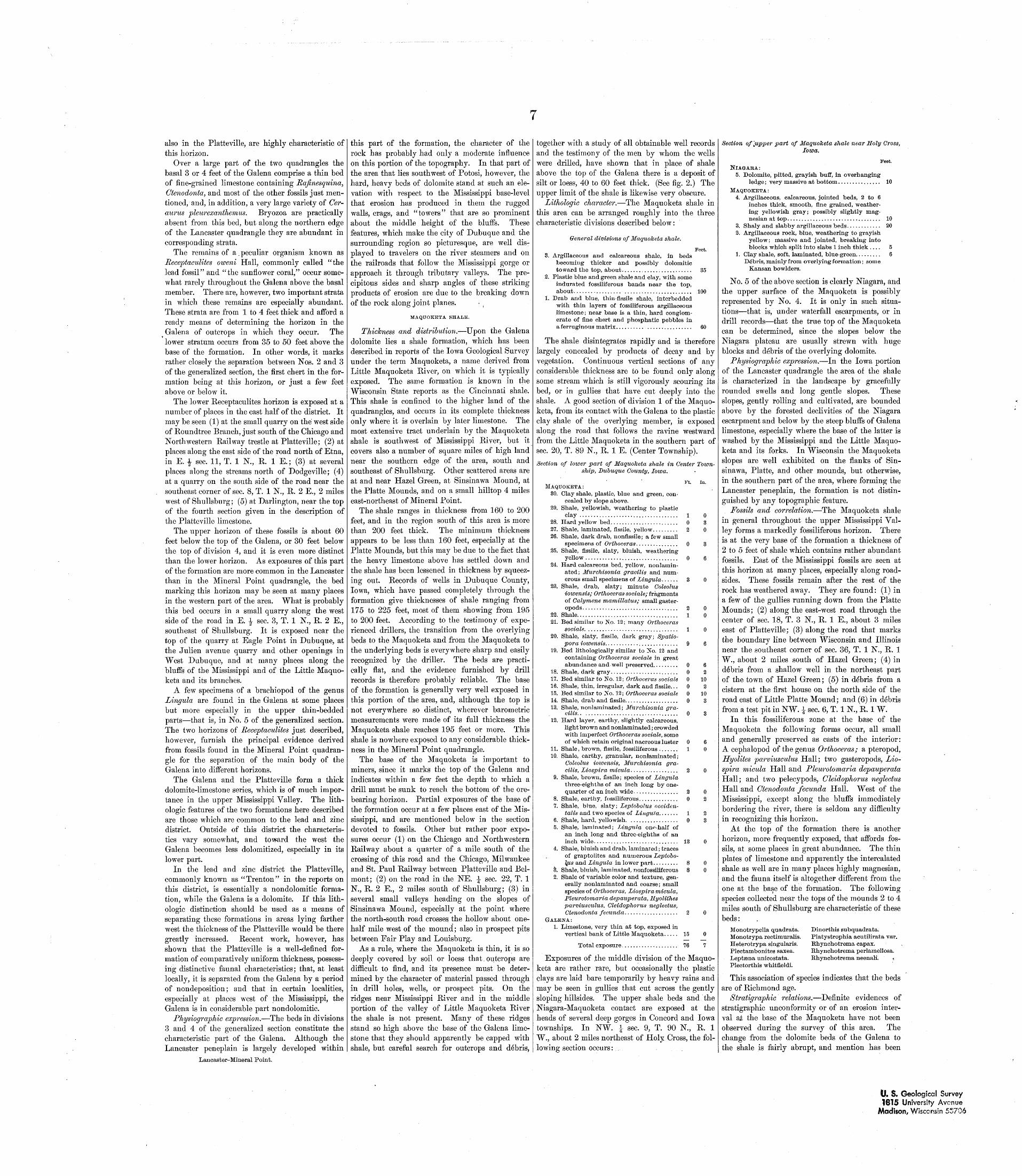
7
also in the Platteville, are highly characteristic of this horizon.
Over a large part of the two quadrangles the basal 3 or 4 feet of the Galena comprise a thin bed of fine-grained limestone containing Rafinesquina, Ctenodonta, and most of the other fossils just men tioned, and, in addition, a very large variety of Cer- aurus pleurexanthemus. Bryozoa are practically absent from this bed, but along the northern edge of the Lancaster quadrangle they are abundant in corresponding strata.
The remains of a. peculiar organism known as Receptaculites oweni Hall, commonly called "the lead fossil" and "the sunflower coral," occur some what rarely throughout the Galena above the basal member. There are, however, two important strata in which these remains are especially abundant. These strata are from 1 to 4 feet thick and afford a ready means of determining the horizon in the Galena of outcrops in which they occur. The lower stratum occurs from 35 to 50 feet above the base of the formation. In other words, it marks rather closely the separation between Nos. 2 and 3 of the generalized section, the first chert in the for mation being at this horizon, or just a few feet above or below it.
The lower Receptaculites horizon is exposed at a number of places in the east half of the district. It may be seen (1) at the small quarry on the west side of Roundtree Branch, just south of the Chicago and Northwestern Railway trestle at Platteville; (2) at places along the east side of the road north of Etna, in E. \ sec. 11, T. 1 N., R. 1 E.; (3) at several places along the streams north of Dodgeville; (4) at a quarry on the south side of the road near the southeast corner of sec. 8, T. 1 N., R. 2 E., 2 miles west of Shullsburg; (5) at Darlington, near the top of the fourth section given in the description of the Platteville limestone.
The upper horizon of these fossils is about 60 feet below the top of the Galena, or 30 feet below the top of division 4, and it is even more distinct than the lower horizon. As exposures of this part of the formation are more common in the Lancaster than in the Mineral Point quadrangle, the bed marking this horizon may be seen at many places in the western part of the area. What is probably this bed occurs in a small quarry along the west side of the road in E. -J- sec. 3, T. 1 N., R. 2 E., southeast of Shullsburg. It is exposed near the top of the quarry at Eagle Point in Dubuque, at the Julien avenue quarry and other openings in West Dubuque, and at many places along the bluffs of the Mississippi and of the Little Maquo- keta and its branches.
A few specimens of a brachiopod of the genus Lingula are found in the Galena at some places but more especially in the upper thin-bedded parts that is, in No. 5 of the generalized section. The two horizons of Receptaculites just described, however, furnish the principal evidence derived from fossils found in the Mineral Point quadran gle for the separation of the main body of the Galena into different horizons.
The Galena and the Platteville form a thick dolomite-limestone series, which is of much impor tance in the upper Mississippi Valley. The lith- ologic features of the two formations here described are those which are common to the lead and zinc district. Outside of this district the characteris tics vary somewhat, and toward the west the Galena becomes less dolomitized, especially in its lower part.
In the lead and zinc district the Platteville, commonly known as "Trenton" in the reports on this district, is essentially a nondolomitic forma tion, while the Galena is a dolomite. If this lith- ologic distinction should be used as a means of separating these formations in areas lying farther west the thickness of the Platteville would be there greatly increased. Recent work, however, has shown that the Platteville is a well-defined for mation of comparatively uniform thickness, possess ing distinctive faunal characteristics; that, at least locally, it is separated from the Galena by a period of nondeposition; and that in certain localities, especially at places west of the Mississippi, the Galena is in considerable part nondolomitic.
Physiographic expression. The beds in divisions3 and 4 of the generalized section constitute thecharacteristic part of the Galena. Although theLancaster peneplain is largely developed within
Lancaster-Mineral Point.
this part of the formation, the character of the rock has probably had only a moderate influence on this portion of the topography. In that part of the area that lies southwest of Potosi, however, the hard, heavy beds of dolomite stand at such an ele vation with respect to the Mississippi base-level that erosion has produced in them the rugged walls, crags, and "towers" that are so prominent about the middle height of the bluffs. These features, which make the city of Dubuque and the surrounding region so picturesque, are well dis played to travelers on the river steamers and on the railroads that follow the Mississippi gorge or approach it through tributary valleys. The pre cipitous sides and sharp angles of these striking products of erosion are due to the breaking down of the rock along joint planes.
MAQUOKBTA SHALE.
Thickness and distribution. Upon the Galena dolomite lies a shale formation, which has been described in reports of the Iowa Geological Survey under the term Maquoketa, a name derived from Little Maquoketa River, on which it is typically exposed. The same formation is known in the Wisconsin State reports as the Cincinnati shale. This shale is confined to the higher land of the quadrangles, and occurs in its complete thickness only where it is overlain by later limestone. The most extensive tract underlain by the Maquoketa shale is southwest of Mississippi River, but it covers also a number of square miles of high land near the southern edge of the area, south and southeast of Shullsburg. Other scattered areas are at and near Hazel Green, at Sinsinawa Mound, at the Platte Mounds, and on a small hilltop 4 miles east-northeast of Mineral Point.
The shale ranges in thickness from 160 to 200 feet, and in the region south of this area is more than 200 feet thick. The minimum thickness appears to be less than 160 feet, especially at the Platte Mounds, but this may be due to the fact that the heavy limestone above has settled down and the shale has been lessened in thickness by squeez ing out. Records of wells in Dubuque County, Iowa, which have passed completely through the formation give thicknesses of shale ranging from 175 to 225 feet, most of them showing from 195 to 200 feet. According to the testimony of expe rienced drillers, the transition from the overlying beds to the Maquoketa and from the Maquoketa to the underlying beds is everywhere sharp and easily recognized by the driller. The beds are practi cally flat, and the evidence furnished by drill records is therefore probably reliable. The base of the formation is generally very well exposed in this portion of the area, and, although the top is not everywhere so distinct, wherever barometric measurements were made of its full thickness the Maquoketa shale reaches 195 feet or more. This shale is nowhere exposed to any considerable thick ness in the Mineral Point quadrangle.
The base of the Maquoketa is important to miners, since it marks the top of the Galena and indicates within a few feet the depth to which a drill must be sunk to reach the bottom of the ore- bearing horizon. Partial exposures of the base of the formation occur at a few places east of the Mis sissippi, and are mentioned below in the section devoted to fossils. Other but rather poor expo sures occur (1) on the Chicago and Northwestern Railway about a quarter of a mile south of the crossing of this road and the Chicago, Milwaukee and St. Paul Railway between Platteville and Bel- mont; (2) on the road in the NE. £ gec. 22, T. 1 N., R. 2 E., 2 miles south of Shullsburg; (3) in several small valleys heading on the slopes of Sinsinawa Mound, especially at the point where the north-south road crosses the hollow about one- half mile west of the mound; also in prospect pits between Fair Play and Louisburg.
As a rule, where the Maquoketa is thin, it is so deeply covered by soil or loess that, outcrops are difficult to find, and its presence must be deter mined by the character of material passed through in drill holes, wells, or prospect pits. On the ridges near Mississippi River and in the middle portion of the valley of Little Maquoketa River the shale is not present. Many of these ridges stand so high above the base of the Galena lime stone that they should apparently be capped with shale, but careful search for outcrops and debris,
together with a study of all obtainable well records and the testimony of the men by whom the wells were drilled, have shown that in place of shale above the top of the Galena there is a deposit of silt or loess, 40 to 60 feet thick. (See fig. 2.) The upper limit of the shale is likewise very obscure.
Lithologic character. The Maquoketa shale in this area can be arranged roughly into the three characteristic divisions described below:
General divisions of Maquoketa shale.
Feet.3. Argillaceous and calcareous shale, in beds
becoming thicker and possibly dolomitic toward the top, about......................... 35
2. Plastic blue and green shale and clay, with some indurated fossiliferous bands near the top, about................. ........................ 100
1. Drab and blue, thin fissile shale, interbedded with thin layers of fossiliferous argillaceous limestone; near base is a thin, hard conglom erate of fine chert and phosphatic pebbles in a ferruginous matrix.......................... 60
The shale disintegrates rapidly and is therefore largely concealed by products of decay and by vegetation. Continuous vertical sections of any considerable thickness are to be found only along some stream which is still vigorously scouring its bed, or in gullies that have cut deeply into the shale. A good section of division 1 of the Maquo keta, from its contact with the Galena to the plastic clay shale of the overlying member, is exposed along the road that follows the ravine westward from the Little Maquoketa in the southern part of sec. 20, T. 89 N., R. 1 E. (Center Township).
Section of lower part of Maquoketa shale in Center Town ship, Dubuque County, Iowa.
MAQUOKBTA:30. Clay shale, plastic, blue and green, con
cealed by slope above.29. Shale, yellowish, weathering to plastic
clay ...................................28. Hard yellow bed........................27. Shale, laminated, fissile, yellow.........26. Shale, dark drab, nonfissile; a few small
specimens of Orthoceras. ..............25. Shale, fissile, slaty, bluish, weathering
yellow .................................24. Hard calcareous bed, yellow, nonlamin-
ated; Murchisonia gracilis and num erous small specimens of Lingula. .....
23. Shale, drab, slaty; minute Coleolus iowensis; Orthoceras sociale; fragments of Calymene mamillatus; small gaster- opods..................................
22. Shale....................................21. Bed similar to No. 12; many Orthoceras
sociale. ................................20. Shale, slaty, fissile, dark gray; Spatio-
pora iowensis. .........................19. Bed lithologically similar to No. 12 and
containing Orthoceras sociale in great abundance and well preserved.........
18. Shale, dark gray........................17. Bed similar to No. 12; Orthoceras sociale16. Shale; thin, irregular, dark and fissile...15. Bed similar to No. 12; Orthoceras sociale14. Shale, drab and fissile...................13. Shale, nonlaminated; Murchisonia gra
cilis. . .................................12. Hard layer, earthy, slightly calcareous,
light brown and nonlaminated; crowded with imperfect Orthoceras sociale, some of which retain original nacreous luster
11. Shale, brown, fissile, fossiliferous .......10. Shale, earthy, granular, nonlaminated;
Coleolus iowensis, Murchisonia gra cilis, Liospira micula. ................
9. Shale, brown, fissile; species of Lingula three-eighths of an inch long by one- quarter of an inch wide................
8. Shale, earthy, fossiliferous..............7. Shale, blue, slaty; LeptrJbolus occiden-
talis and two species of LiugU/a. ......6. Shale, hard, yellowish. .................5. Shale, laminated; Lingula on^-half of
an inch long and three-eighths of an inch wide..............................
4. Shale, bluish and drab, laminated; traces of graptolites and numerous Leptobo- l$is and Lingula in lower part.........
3. Shale, bluish, laminated, nonfossiliferous 2. Shale of variable color and texture, gen
erally nonlaminated and coarse; small species of Orthoceras, Liospira micula, Pleurotomaria depauperata, Hyolithes parviusculus, Cleidophorus neglectus, Ctenodonta fecunda. ..................
GrALBNA:
1. Limestone, very thin at top, exposed in vertical bank of Little Maquoketa.....
Ft. In.
62
102
103
0 61 0
2 0
13
15
Total exposure.................... 76 7
Exposures of .the middle division of the Maquo keta are rather rare, but occasionally the plastic clays are laid bare temporarily by heavy rains and may be seen in gullies that cut across the gently sloping hillsides. The upper shale beds and the Niagara-Maquoketa contact are exposed at the heads of several deep gorges in Concord and Iowa townships. In NW. \ sec. 9, T. 90 N., R. 1 W., about 2 miles northeast of Holy, Cross, the fol lowing section occurs:....
Section of [upper part of Maquoketa shale near Holy Cross,Iowa.
Feet.NIAGARA:
5. Dolomite, pitted, grayish buff, in overhanging ledge; very massive at bottom............... 10
MAQUOKETA:4. Argillaceous, calcareous, jointed beds, 2 to 6
inches thick, smooth, fine grained, weather ing yellowish gray; possibly slightly mag- nesian at top................................. 10
3. Shaly and slabby argillaceous beds............ 202. Argillaceous rock, blue, weathering to grayish
yellow; massive and jointed, breaking into blocks which split into slabs 1 inch thick .... 5
1. Clay shale, soft, laminated, blue-green......... 6De'bris, mainly from overlying formation; some
Kansan bowlders.
No. 5 of the above section is clearly Niagara, and the upper surface of the Maquoketa is possibly represented by No. 4. It is only in such situa tions that is, under waterfall escarpments, or in drill records that the true top of the Maquoketa can be determined, since the slopes below the Niagara plateau are usually strewn with huge blocks and debris of the overlying dolomite.
Physiographic expression. In the Iowa portion of the Lancaster quadrangle the area of the shale is characterized in the landscape by gracefully rounded swells and long gentle slopes. These slopes, gently rolling and cultivated, are bounded above by the forested declivities of the Niagara escarpment and below by the steep bluffs of Galena limestone, especially where the base of the latter is washed by the Mississippi and the Little Maquo keta and its forks. In Wisconsin the Maquoketa slopes are well exhibited on the flanks of Sin sinawa, Platte, and other mounds, but otherwise, in the southern part of the area, where forming the Lancaster peneplain, the formation is not distin guished by any topographic feature.
Fossils and correlation. The Maquoketa shale in general throughout the upper Mississippi Val ley forms a markedly fossiliferous horizon. There is at the very base of the formation a thickness of 2 to 5 feet of shale which contains rather abundant fossils. East of the Mississippi fossils are seen at this horizon at many places, especially along road sides. These fossils remain after the rest of the rock has weathered away. They are found: (1) in a few of the gullies running down from the Platte Mounds; (2) along the east-west road through the center of sec. 18, T. 3 N., R. 1 E., about 3 miles east of Platteville; (3) along the road that marks the boundary line between Wisconsin and Illinois near the southeast corner of sec. 36, T. 1 N., R. 1 W., about 2 miles south of Hazel Green; (4) in debris from a shallow well in the northeast part of the town of Hazel Green; (5) in debris from a cistern at the first house on the north side of the road east of Little Platte Mound; and (6) in debris from a test pit in NW. J- sec. 6, T. 1 N., R. 1 W.
In this fossiliferous zone at the base of the Maquoketa the following forms occur, all small and generally preserved as casts of the interior: A cephalopod of the genus Orthoceras; a pteropod, Hyolites parviusculus Hall; two gasteropods, Lio spira micula Hall and Pleurotomaria depauperata Hall; and two pelecypods, Cleidophorus neglectus Hall and Ctenodonta fecunda Hall. West of the Mississippi, except along the bluffs immediately bordering the river, there is seldom any difficulty in recognizing this horizon.
At the top of the formation there is another horizon, more frequently exposed, that affords fos sils, at some places in great abundance. The thin plates of limestone and apparently the intercalated shale as well are in many places highly magnesian, and the fauna itself is altogether different from the one at the base of the formation. The following species collected near the tops of the mounds 2 to 4 miles south of Shullsburg are characteristic of these beds:
Monotrypella quadrata. Monotrypa rectimuralis. Heterotrypa singularis. Plectambonites saxea. Leptsena unicostata. Plectorthis whitfieldi.
Dinorthis subquadrata. Platystrophia acutilirata var. Rhynchotrema capax. Rhynchotrema perlamellosa. Rhynchotrema neenaH.
This association of species indicates that the beds are of Richmond age.
Stratigraphic relations. Definite evidences of stratigraphic unconformity or of an erosion inter val ajb the base of the Maquoketa have not been observed during the survey of this area. The change from the dolomite beds of the Galena to the shale is fairly abrupt, and mention has been
U. S. Geological Survey1815 University Avenue
Madison, Wisconsin 5*706
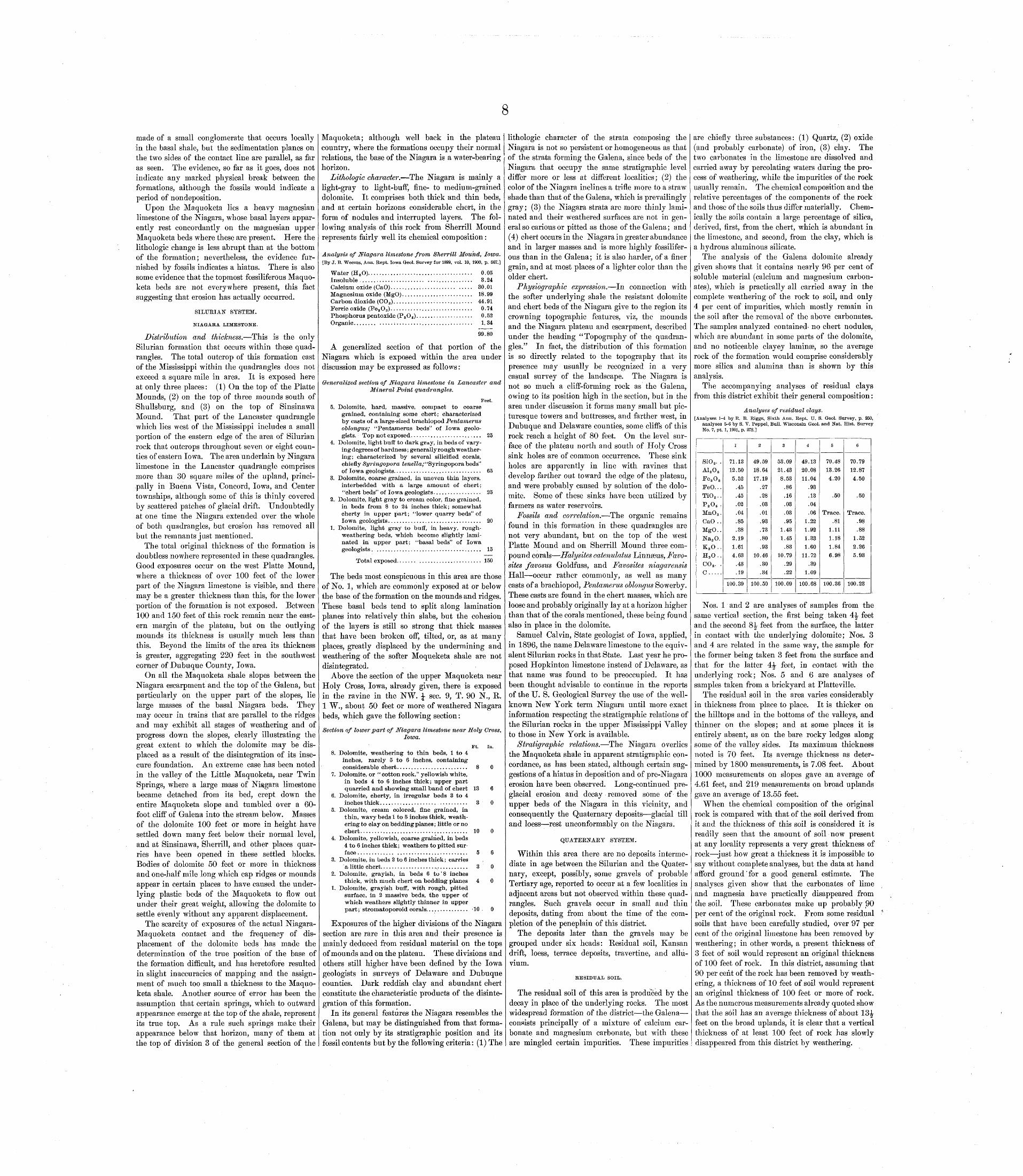
8
made of a small conglomerate that occurs locally in the basal shale, but the sedimentation planes on the two sides of the contact line are parallel, as far as seen. The evidence, so far as it goes, does not indicate any marked physical break between the formations, although the fossils would indicate a period of nondeposition.
Upon the Maquoketa lies a heavy magnesian limestone of the Niagara, whose basal layers appar ently rest concordantly on the magnesian upper Maquoketa beds where these are present. Here the lithologic change is less abrupt than at the bottom of the formation; nevertheless, the evidence fur nished by fossils indicates a hiatus. There is also some evidence that the topmost fossiliferous Maquo keta beds are not everywhere present, this fact suggesting that erosion has actually occurred.
SILURIAN SYSTEM.
NIAGARA LIMESTONE.
Distribution and thickness. This is the only Silurian formation that occurs within these quad rangles. The total outcrop of this formation east of the Mississippi within the quadrangles does not exceed a square mile in area. It is exposed here at only three places: (1) On the top of the Platte Mounds, (2) on the top of three mounds south of Shullsburg, and (3) on the top of Sinsinawa Mound. That part of the Lancaster quadrangle which lies west of the Mississippi includes a small portion of the eastern edge of the area of Silurian rock that outcrops throughout seven or eight coun ties of eastern Iowa. The area underlain by Niagara limestone in the Lancaster quadrangle comprises more than 30 square miles of the upland, princi pally in Buena Vista, Concord, Iowa, and Center townships, although some of this is thinly covered by scattered patches of glacial drift. Undoubtedly at one time the Niagara extended over the whole of both quadrangles, but erosion has removed all but the remnants just mentioned.
The total original thickness of the formation is doubtless nowhere represented in these quadrangles. Good exposures occur on the west Platte Mound, where a thickness of over 100 feet of the lower part of the Niagara limestone is visible, and there may be a greater thickness than this, for the lower portion of the formation is not exposed. Between 100 and 150 feet of this rock remain near the east ern margin of the plateau, but on the outlying mounds its thickness is usually much less than this. Beyond the limits of the area its thickness is greater, aggregating 220 feet in the southwest corner of Dubuque County, Iowa.
On all the Maquoketa shale slopes between the Niagara escarpment and the top of the Galena, but particularly on the upper part of the slopes, lie large masses of the basal Niagara beds. They may occur in trains that are parallel to the ridges and may exhibit all stages of weathering and of progress down the slopes, clearly illustrating the great extent to which the dolomite may be dis placed as a result of the disintegration of its inse cure foundation. An extreme case has been noted in the valley of the Little Maquoketa, near Twin Springs, where a large mass of Niagara limestone became detached from its bed, crept down the entire Maquoketa slope and tumbled over a 60- foot cliff of Galena into the stream below. Masses of the dolomite 100 feet or more in height have settled down many feet below their normal level, and at Sinsinawa, Sherrill, and other places quar ries have been opened in these settled blocks. Bodies of dolomite 50 feet or more in thickness and one-half mile long which cap ridges or mounds appear in certain places to have caused the under lying plastic beds of the Maquoketa to flow out under their great weight, allowing the dolomite to settle evenly without any apparent displacement.
The scarcity of exposures of the actual Niagara- Maquoketa contact and the frequency of dis placement of the dolomite beds has made the determination of the true position of the base of the formation difficult, and has heretofore resulted in slight inaccuracies of mapping and the assign ment of much too small a thickness to the Maquo keta shale. Another source of error has been the assumption that certain springs, which to outward appearance emerge at the top of the shale, represent its true top. As a rule such springs make their appearance below that horizon, many of them at the top of division 3 of the general section of the
Maquoketa; although well back in the plateau country, where the formations occupy their normal relations, the base of the Niagara is a water-bearing horizon.
Lithologic character. The Niagara is mainly a light-gray to light-buff, fine- to medium-grained dolomite. It comprises both thick and thin beds, and at certain horizons considerable chert, in the form of nodules and interrupted layers. The fol lowing analysis of this rock from Sherrill Mound represents fairly well its chemical composition:
Analysis of Niagara limestone from /Sherrill Mound, Iowa.[By J. B. Weems, Ann. Rept. Iowa Geol. Survey for 1899, vol. 10, 1900, p. 567.]
Water (H 8 O)..................................... 0.05Insoluble ...................... ................ 3.24Calcium oxide (CaO)....................... ..... 30.01Magnesium oxide (MgO)......................... 18.99Carbon dioxide (GO S)............................ 44.91Ferric oxide (Pe8 O 3)............................. 0.74Phosphorus pentoxide (P S O 5).................... 0.52Organic........ ................................. 1.34
99.80
A generalized section of that portion of the Niagara which is exposed within the area under discussion may be expressed as follows:
Generalized section of Niagara limestone in Lancaster and Mineral Point quadrangles.
Feet.5. Dolomite, hard, massive, compact to coarse
grained, containing some chert; characterized by casts of a large-sized brachiopod Pentamerus oblongus; "Pentamerus beds" of Iowa geolo gists. Top not exposed......................... 25
4. Dolomite, light buff to dark gray, in beds of vary- ingdegreesof hardness; generally rough weather ing; characterized by several silicifled corals, chiefly Syringopora £eweZZa;"Syringoporabeds" of Iowa geologists............................... 65
3. Dolomite, coarse grained, in uneven thin layers, interbedded with a large amount of chert; "chert beds" of Iowa geologists................. 25
2. Dolomite, light gray to cream color, fine grained, in beds from 8 to 24 inches thick; somewhat cherty in upper part; "lower quarry beds" of Iowa geologists................................. 20
1. Dolomite, light gray to bulf, in heavy, rough- weathering beds, which become slightly lami nated in upper part; "basal beds" of Iowa geologists...................................... 15
Total exposed....... ...................... 150
The beds most conspicuous in this area are those of No. 1, which are commonly exposed at or below the base of the formation on the mounds and ridges. These basal beds tend to split along lamination planes into relatively thin slabs, but the cohesion of the layers is still so strong that thick masses that have been broken off, tilted, or, as at many places, greatly displaced by the undermining and weathering of the softer Moqueketa shale are not disintegrated.
Above the section of the upper Maquoketa near Holy Cross, Iowa, already given, there is exposed in the ravine in the NW. J sec. 9, T. 90 N., R. 1 W., about 50 feet or more of weathered Niagara beds, which gave the following section:
Section of lower part of Niagara limestone near Holy Cross,Iowa.
Ft. In.8. Dolomite, weathering to thin beds, 1 to 4
inches, rarely 5 to 6 inches, containing considerable chert......................... 8 0
7. Dolomite, or "cottonrock," yellowish white, in beds 4 to 6 inches thick; upper part quarried and showing small band of chert 13 6
6. Dolomite, cherty, in irregular beds 3 to 4inches thick............................... 3 0
5. Dolomite, cream colored, fine grained, in thin, wavy beds 1 to 5 inches thick, weath ering to clay on bedding planes; little or no chert...................................... 10 0
4. Dolomite, yellowish, coarse grained, in beds 4 to 6 inches thick; weathers to pitted sur face ............. ......................... 5 6
3. Dolomite, in beds 2 to 6 inches thick; carriesa little chert....................>........... 3 0
2. Dolomite, grayish, in beds 6 to'8 inchesthick, with much chert on bedding planes 4 0
1. Dolomite, grayish buff, with rough, pitted surface, in 2 massive beds, the upper of which weathers slightly thinner in upper part; stromatoporoid corals............... '10 0
Exposures of the higher divisions of the Niagara section are rare in this area and their presence is mainly deduced from residual material on the tops of mounds and on the plateau. These divisions and others still higher have been defined by the Iowa geologists in surveys of Delaware and Dubuque counties. Dark reddish clay and abundant chert constitute the characteristic products of the disinte gration of this formation.
In its general features the Niagara resembles the Galena, but may be distinguished from that forma tion not only by its stratigraphic position and its fossil contents but by the following criteria: (1) The
lithologic character of the strata composing the Niagara is not so persistent or homogeneous as that of the strata forming the Galena, since beds of the Niagara that occupy the same stratigraphic level differ more or less at different localities; (2) the color of the Niagara inclines a trifle more to a straw shade than that of the Galena, which is prevailingly gray; (3) the Niagara strata are more thinly lami nated and their weathered surfaces are not in gen eral so carious or pitted as those of the Galena; and (4) chert occurs in the Niagara in greater abundance and in larger masses and is more highly fossilifer ous than in the Galena; it is also harder, of a finer grain, and at most places of a lighter color than the older chert.
Physiographic expression. In connection with the softer underlying shale the resistant dolomite and chert beds of the Niagara give to the region its crowning topographic features, viz, the mounds and the Niagara plateau and escarpment, described under the heading "Topography of the quadran gles." In fact, the distribution of this formation is so directly related to the topography that its presence may usually be recognized in a very casual survey of the landscape. The Niagara is not so much a cliff-forming rock as the Galena, owing to its position high in the section, but in the area under discussion it forms many small but pic turesque towers and buttresses, and farther west, in Dubuque and Delaware counties, some cliffs of this rock reach a height of 80 feet. On the level sur face of the plateau north and south of Holy Cross sink holes are of common occurrence. These sink holes are apparently in line with ravines that develop farther out toward the edge of the plateau, and were probably caused by solution of the dolo mite. Some of these sinks have been utilized by farmers as water reservoirs.
Fossils and correlation. The organic remains found in this formation in these quadrangles are not very abundant, but on the top of the west Platte Mound and on Sherrill Mound three com pound corals Halysites catenulatus Linnasus, Favo- sites favosus Goldfuss, and Favosites niagarensis Hall occur rather commonly, as well as many casts of a brachiopod, Pentamerus oblongus Sowerby. These casts are found in the chert masses, which are loose and probably originally lay at a horizon higher than that of the corals mentioned, these being found also in place in the dolomite.
Samuel Calvin, State geologist of Iowa, applied, in 1896, the name Delaware limestone to the equiv alent Silurian rocks in that State. Last year he pro posed Hopkinton limestone instead of Delaware, as that name was found to be preoccupied. It has been thought advisable to continue in the reports of the U. S. Geological Survey the use of the well- known New York term Niagara until more exact information respecting the stratigraphic relations of the Silurian rocks in the upper Mississippi Valley to those in New York is available.
Stratigraphic relations. The Niagara overlies the Maquoketa shale in apparent stratigraphic con cordance, as has been stated, although certain sug gestions of a hiatus in deposition and of pre-Niagara erosion have been observed. Long-continued pre- glacial erosion and decay removed some of the upper beds of the Niagara in this vicinity, and consequently the Quaternary deposits glacial till and loess rest unconformably on the Niagara.
QUATERNARY SYSTEM.
Within this area there are no deposits interme diate in age between the Silurian and the Quater nary, except, possibly, some gravels of probable Tertiary age, reported to occur at a few localities in adjacent areas but not observed within these quad rangles. Such gravels occur in small and thin deposits, dating from about the time of the com pletion of the peneplain of this district.
The deposits later than the gravels may be grouped under six heads: Residual soil, Kansan drift, loess, terrace deposits, travertine, and allu vium.
RESIDUAL SOIL.
The residual soil of this area is produced by the decay in place of the underlying rocks. The most widespread formation of the district the Galena consists principally of a mixture of calcium car bonate and magnesium carbonate, but with these are mingled certain impurities. These impurities
are chiefly three substances: (1) Quartz, (2) oxide (and probably carbonate) of iron, (3) clay. The two carbonates in the limestone are dissolved and carried away by percolating waters during the pro cess of weathering, while the impurities of the rock usually remain. The chemical composition and the relative percentages of the components of the rock and those of the soils thus differ materially. Chem ically the soils contain a large percentage of silica, derived, first, from the chert, which is abundant in the limestone, and second, from the clay, which is a hydrous aluminous silicate.
The analysis of the Galena dolomite already given shows that it contains nearly 96 per cent of soluble material (calcium and magnesium carbon ates), which is practically all carried away in the complete weathering of the rock to soil, and only 4 per cent of impurities, which mostly remain in the soil after the removal of the above carbonates. The samples analyzed contained- no chert nodules, which are abundant in some parts of the dolomite, and no noticeable clayey laminaB, so the average rock of the formation would comprise considerably more silica and alumina than is shown by this analysis.
The accompanying analyses of residual clays from this district exhibit their general composition:
Analyses of residual clays.[Analyses 1-4 by R. B. Riggs, Sixth Ann. Rept. U. S. Geol. Survey, p. 250,
analyses 5-6 by S. V. Peppel, Bull. Wisconsin Geol. and Nat. Hist. Survey No. 7, pt. 1, 1901, p. 273.]
SiO 2 . .A1 2 0 3Fe 2 O 8FeO. . .Ti0 2 ..P 2 0 5 .MnO 8 .CaO ..MgO..Na2 O.K 2 0..H 2 O..C0 2 . .c.....
1
71.1312.505.52
.45
.45
.02
.04
.85
.382.191.614.63
.43
.19
100.39
2
49.5918.6417.19
.27
.28
.03
.01
.93
.73
.80
.9310.46
.30
.34
100.50
3
53.0921.438.53
.86
.16
.03
.03
.951.431.45
.8310.79
.29
.22
100.09
4
49.1320.0811.04
.93
.13
.04
.061.221.921.331.60
11.72.39
1.09
100.68
5
70.4813.264.20
.50
Trace..81
1.111.181.846.98
100.36
6
70.7912.874.50
.50
Trace..98.88
1.522.265.93
100.23
Nos. 1 and 2 are analyses of samples from the same vertical section, the first being taken 4^ feet and the second 8^ feet from the surface, the latter in contact with the underlying dolomite; Nos. 3 and 4 are related in the same way, the sample for the former being taken 3 feet from the surface and that for the latter 4^ feet, in contact with the underlying rock; Nos. 5 and 6 are analyses of samples taken from a brickyard at Platte ville.
The residual soil in the area varies considerably in thickness from place to place. It is thicker on the hilltops and in the bottoms of the valleys, and thinner on the slopes; and at some places it is entirely absent, as on the bare rocky ledges along some of the valley sides. Its maximum thickness noted is 70 feet. Its average thickness as deter mined by 1800 measurements, is 7.08 feet. About 1000 measurements on slopes gave an average of 4.61 feet, and 219 measurements on broad uplands gave an average of 13.55 feet.
When the chemical composition of the original rock is compared with that of the soil derived from it and the thickness of this soil is considered it is readily seen that the amount of soil now present at any locality represents a very great thickness of rock just how great a thickness it is impossible to say without complete analyses, but the data at hand afford ground'for a good general estimate. The analyses given show that the carbonates of lime and magnesia have practically disappeared from the soil. These carbonates make up probably 90 per cent of the original rock. From some residual soils that have been carefully studied, over 97 per cent of the original limestone has been removed by weathering; in other words, a present thickness of 3 feet of soil would represent an original thickness of 100 feet of rock. In this district, assuming that 90 per cent of the rock has been removed by weath ering, a thickness of 10 feet of soil would represent an original thickness of 100 feet or more of rock. As the numerous measurements already quoted show that the soil has an average thickness of about 13^ feet on the broad uplands, it is clear that a vertical thickness of at least 100 feet of rock has slowly disappeared from this district by weathering.
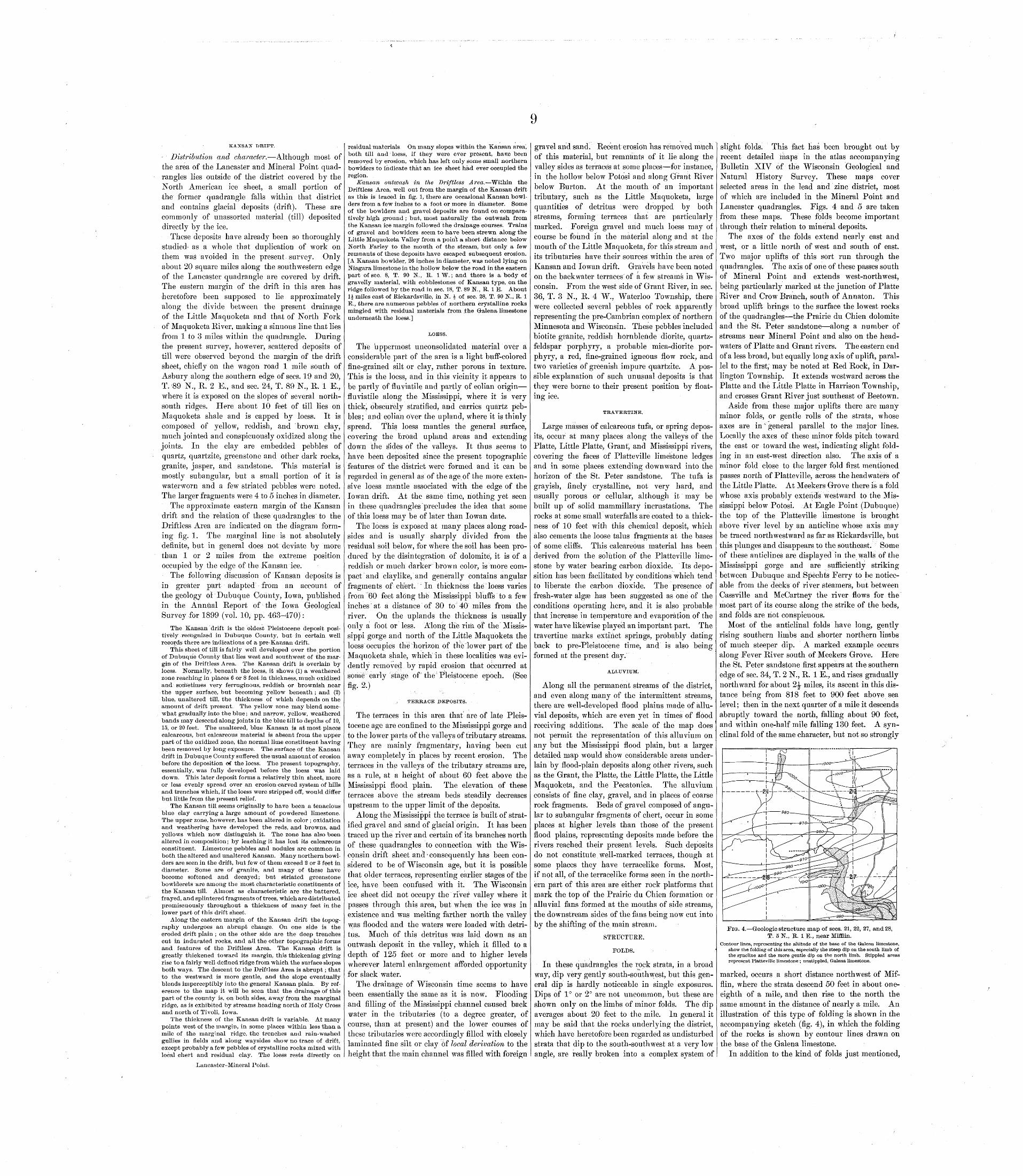
9
KASTSAN DRIFT.
- Distribution and character. Although most of the area of the Lancaster and Mineral Point quad rangles lies outside of the district covered by the North American ice sheet, a small portion of the former quadrangle falls within that district and contains glacial deposits (drift). These are commonly of unassorted material (till) deposited directly by the ice.
These deposits have already been so thoroughly studied* as a whole that duplication of work on them was avoided in the present survey. Only about 20 square miles along the southwestern edge of the Lancaster quadrangle are covered by drift. The eastern margin of the drift in this area has heretofore been supposed to lie approximately along the divide between the present drainage of the Little Maquoketa and that of North Fork of Maquoketa River, making a sinuous line that lies from 1 to 3 miles within the quadrangle. During the present survey, however, scattered deposits of till were observed beyond the margin of the drift sheet, chiefly on the wagon road 1 mile south of Asbury along the southern edge of sees. 19 and 20, T. '89 N., R. 2 E., and sec. 24, T. 89 N., R. 1 E., where it is exposed on the slopes of several north- south ridges. Here about 10 feet of till lies on Maquoketa shale and is capped by loess. It is composed of yellow, reddish, and 'brown clay, much jointed and conspicuously oxidized along the joints. In the clay are embedded pebbles of quartz, quartzite, greenstone and other dark rocks, granite, jasper, and sandstone. This material is mostly subangular, but a small portion of it is water worn and a few striated pebbles were noted. The larger fragments were 4 to 5 inches in diameter.
The approximate eastern margin of the Kansan drift and the relation of these quadrangles to the Driftless Area are indicated on the diagram form ing fig. 1. The marginal line is not absolutely definite, but in general does not deviate by more than 1 or 2 miles from the extreme position occupied by the edge of the Kansan ice.
The following discussion of Kansan deposits is in greater part adapted from an account of the geology oi Dubuque County, Iowa, published in the Annual Report of the Iowa Geological Survey for 1899 (vol. 10, pp. 463-470):
The Kansan drift is the oldest Pleistocene deposit posi tively recognized in Dubuque County, but in certain well records there are indications of a pre-Kansan drift.
This sheet of till is fairly well developed over the portion of Dubuque County that lies west and southwest of the mar gin of the Driftless Area. The Kansan drift is overlain by loess. Normally, beneath the loess, it shows (1) a weathered zone reaching in places 6 or 8 feet in thickness, much oxidized and sometimes very ferruginous, reddish or brownish near the upper surface, but becoming yellow beneath ; and (2) blue, unaltered till, the thickness of which depends on the amount of drift present. The yellow zone may blend some what gradually into the blue; and narrow, yellow, weathered bands may descend along joints in the blue till to depths of 10, 15, or 20 feet. The unaltered, blue Kansan is at most places calcareous, but calcareous material is absent from the upper- part of the oxidized zone, the normal litne constituent having been removed by long exposure. The surface of the Kansan drift in Dubuque County suffered the usual amount of erosion before the deposition o the loess. The present topography, essentially, was fully developed before the loess was laid down. This later deposit forms a relatively thin sheet, more or less evenly spread over an erosion-carved system of hills and trenches which, if the loess were stripped off, would differ but little from the present relief.
The Kansan till seems originally to have been a tenacious blue clay carrying a large amount of powdered limestone. The upper zone, however, has been altered in color ; oxidation and weathering have developed the reds, and browns, and yellows which now distinguish it. The zone has also been altered in composition; by leaching it has lost its calcareous constituent. Limestone pebbles and nodules are common in both the altered and unaltered Kansan. Many northern bowl ders are seen in the drift, but few of them exceed 2 or 3 feet in diameter. Some are of granite, and many of these have become softened and decayed; but striated greenstone bowlderets are among the most characteristic constituents of the Kansan till. Almost as characteristic are the battered, frayed, and splintered fragments of trees, which are distributed promiscuously throughout a thickness of many feet in the lower part of this drift sheet.
Along the eastern margin of the Kansan drift the topog raphy undergoes an abrupt change. On one side is the eroded drift plain ; on the other side are the deep trenches cut in indurated rocks, and all the other topographic forms and features of the Driftless Area. The Kansan drift is greatly thickened toward its margin, this thickening giving rise to a fairly well-defined ridge from which the surface slopes both ways. The descent to the Driftless Area is abrupt; that to the westward is more gentle, and the slope eventually blends imperceptibly into the general Kansan plain. By ref erence to the map it will be seen that the drainage of this part of the county is, on both sides, away from the marginal ridge, as is exhibited by streams heading north of Holy Cross and north of Tivoli, Iowa.
The thickness of the Kansan drift is variable. At many points west of the margin, in some places within less than a mile of the marginal ridge, the trenches and rain-washed gullies in fields and along waysides show no trace of drift, except probably a few pebbles of crystalline rocks mixed with local chert and residual clay. The loess rests directly on
Lancaster-Mineral Point.
residual materials. On many slopes within the Kansan area", both till and loess, if they were ever present, have been removed by erosion, which has left only some small northern bowlders to indicate that an ice sheet had ever occupied the region.
Kansan outwash in the Driftless Area, Within the Driftless Area, well out from the margin of the Kansan drift as this is traced in fig. 1, there are occasional Kansan bowl ders from a few inches to a foot or more in diameter. Some of the bowlders and gravel deposits are found on compara tively high ground ; but, most naturally the outwash from the Kansan ice margin followed the drainage courses. Trains of gravel and bowlders seem to have been strewn along the Little Maquoketa Valley from a point a short distance below North Parley to the mouth of the stream, but only a few remnants of these deposits have escaped subsequent erosion. [A Kansan bowlder, 26 inches in diameter, was noted lying on Niagara limestone in the hollow below the road in the eastern part of sec. 8, T. 90 N., R. 1 W.; and there is a body of gravelly material, with cobblestones of Kansan type, on the ridge followed by the road in sec. 18, T. 89 N., R. 1 E. About li miles east of Rickardsville, in N. * of sec. 28, T. 90 N., R. 1 E., there are numerous pebbles of northern crystalline rocks mingled with residual materials from ,the Galena limestone underneath the loess.]
LOESS.
The u ppermost unconsolidated material over a considerable part of the area is a light buff-colored fine-grained silt or clay, rather porous in texture. This is the loess, and in this vicinity it appears to be partly of fluviatile and partly of eolian origin fluviatile along the Mississippi, where it is very thick, obscurely stratified, and carries quartz peb bles; and eolian over the upland, where it is thinly spread. This loess mantles the general surface, covering the broad upland areas and extending down the sides of the valleys. It thus seems to have been deposited since the present topographic features of the district were formed and it can be regarded in general as of the age of the more exten sive loess mantle associated with the edge of the lowan drift. At the same time, nothing yet seen in these quadrangles precludes the idea that some of this loess may be of later than lowan date.
The loess is exposed at many places along road sides and is usually sharply divided from the residual soil below, for where the soil has been pro duced by the disintegration of dolomite, it is of a reddish or much darker brown color, is more com pact and claylike, and generally contains angular fragments of chert. ; In thickness the loess varies from 60 feet along the Mississippi bluffs to a few inches at a distance of 30 to 40 miles from the river. On the uplands the thickness is usually orilv a foot or less. Along the rim of the Missis-*/ O
sippi gorge and north of the Little Maquoketa the loess occupies the horizon of the lower part of the Maquoketa shale, which in these localities was evi dently removed by rapid erosion that occurred at some early stage of the Pleistocene epoch. (See fig. 2.)
...' TERRACE DEPOSITS.
The terraces in this area that are of late Pleis tocene age are confined to the Mississippi gorge and to the lower parts of the valleys of tributary streams. They are mainly fragmentary, having been cut away completely in places by recent erosion. The terraces in the valleys of the tributary streams are, as a rule, at a height of about 60 feet above the Mississippi flood plain. The elevation of these terraces above the stream beds steadily decreases upstream to the upper limit of the deposits.
Along the Mississippi the terrace is built of strat ified gravel and sand of glacial origin. It has been traced up the river and certain of its branches north of these quadrangles to connection with the Wis consin drift sheet ancl * consequently has been con sidered to be of Wisconsin age, but it is possible that older terraces, representing earlier stages of the ice, have been confused with it. The Wisconsin ice sheet did not occupy the river valley where it passes through this area, but when the ice was in existence and was melting farther north the valley w; as flooded and the waters were loaded with detri tus. Much of this detritus was laid down as an outwash deposit in the valley, which it filled to a depth of 125 feet or more and to higher levels wherever lateral enlargement afforded opportunity for slack water.
The drainage of Wisconsin time seems to have been essentially the same as it is now. Flooding and filling of the Mississippi channel caused back water in the tributaries (to a degree greater, of course, than at present) and the lower courses of these tributaries were accordingly filled with closely laminated fine silt or clay of local derivation to the height that the main channel was filled with foreign
gravel and sand. Recent erosion has removed much of this material, but remnants of it lie along the valley sides as terraces at some places for instance, in the hollow below Potosi and along Grant River below Burton. At the mouth of an important tributary, such as the Little Maquoketa, large quantities of detritus were dropped by both streams, forming terraces that are particularly marked. Foreign gravel and much loess may of course be found in the material along and at the mouth of the Little Maquoketa, for this stream and its tributaries have their sources within the area of Kansan and lowan drift. Gravels have been noted on the backwater terraces of a few streams in Wis consin. From the west side of Grant River, in sec. 36, T. 3 N., R. 4 W., Waterloo Township, there were collected several pebbles of rock apparently representing the pre-Cambrian complex of northern Minnesota and Wisconsin. These pebbles included biotite granite, reddish hornblende diorite, quartz- feldspar porphyry, a probable mica-diorite por phyry, a red, fine-grained igneous flow rock, and two varieties of greenish impure quartzite. A pos sible explanation of such unusual deposits is that they were borne to their present position by float ing ice.
TRAVERTINE.
Large masses of calcareous tufa, or spring depos its, occur at many places along the valleys of the Platte, Little Platte, Grant, and Mississippi rivers, covering the faces of Platteville limestone ledges and in some places extending downward into the horizon of the St. Peter sandstone. The tufa is grayish, finely crystalline, not very hard, and usually porous or cellular, although it may be built up of solid marnmillary incrustations. The rocks at some small waterfalls are coated to a thick ness of 10 feet with this chemical deposit, which also cements the loose talus fragments at the bases of some cliffs. This calcareous material has been derived from the solution of the Platteville lime stone by water bearing carbon dioxide. Its depo sition has been facilitated by conditions which tend to liberate the carbon dioxide. The presence of fresh-water alga3 has been suggested as one of the conditions operating here, and it is also probable that increase in temperature and evaporation of the water have likewise played an important part. The travertine marks extinct springs, probably dating back to pre-Pleistocene time, and is also being formed at the present day.
ALLUVIUM.
Along all the permanent streams of the district, and even along many of the intermittent streams, there are well-developed flood plains made of allu vial deposits, which are even yet in times of flood receiving additions. The scale of the map does not permit the representation of this alluvium on any but the Mississippi flood plain, but a larger detailed map would show considerable areas under lain by flood-plain deposits along other rivers, such as the Grant, the Platte, the Little Platte, the Little Maquoketa, and the Pecatonica. The alluvium consists of fine clay, gravel, and in places of coarse rock fragments. Beds of gravel composed of angu lar to subangular fragments of chert, occur in some places at higher levels than those of the present flood plains, representing deposits made before the rivers reached their present levels. Such deposits do not constitute well-marked terraces, though at some places they have terracelike forms. Most, if not all, of the terracelike forms seen in the north ern part of this area are either rock platforms that mark the top of the Prairie du Chien formation or alluvial fans formed at the mouths of side streams, the downstream sides of the fans being now cut into by the shifting of the main stream.
STRUCTURE.
FOLDS.
In these quadrangles the rock strata, in a broad way, dip very gently south-southwest, but this gen eral dip is hardly noticeable in single exposures. Dips of 1° or 2° are not uncommon, but these are shown only on the limbs of minor folds. The dip averages about 20 feet to the mile. In general it may be said that the rocks underlying the district, which have heretofore been regarded as undisturbed strata that dip to the south-southwest at a very low angle, are really broken into a complex system of
slight folds. This fact has been brought out by recent detailed maps in the atlas accompanying Bulletin XIV of the Wisconsin Geological and Natural History Survey. These maps cover selected areas in the lead and zinc district, most of which are included in the Mineral Point and Lancaster quadrangles. Figs. 4 and 5 are taken from these maps. These folds become important through their relation to mineral deposits.
The axes of the folds extend nearly east and west, or a little north of west and south of east. Two major uplifts of this sort run through the quadrangles. The axis of one of these passes south of Mineral Point and extends west-northwest, being particularly marked at the junction of Platte River and Crow Branch, south of Annaton. This broad uplift brings to the surface the lowest rocks of the quadrangles the Prairie du Chien dolomite and the St. Peter sandstone along a number of streams near Mineral Point and also on the head waters of Platte and Grant rivers. The eastern end of a less broad, but equally long axis of uplift, paral lel to the first, may be noted at Red Rock, in Dar lington Township. It extends westward across the Platte and the Little Platte in Harrison Township, and crosses Grant River just southeast of Beetown.
Aside from these major uplifts there are many minor folds, or gentle rolls of the strata, whose axes are in'general parallel to the major lines. Locally the axes of these minor folds pitch toward the east or toward the west, indicating slight fold ing in an east-west direction also. The axis of a minor fold close to the larger fold first mentioned passes north of Platteville, across the headwaters of the Little Platte. At Meekers Grove there is a fold whose axis probably extends westward to the Mis sissippi below Potosi. At Eagle Point (Dubuque) the top of the Platteville limestone is brought above river level by an anticline whose axis may be traced northwestward as far as Rickardsville, but this plunges and disappears to the southeast. Some of these anticlines are displayed in the walls of the Mississippi gorge and are sufficiently striking between Dubuque and Spechts Ferry to be notice able from the decks of river steamers, but between Cassville and McCartney the river flows for the most part of its Course along the strike of the beds, and folds are not conspicuous.
Most of the anticlinal folds have long, gently rising southern limbs and shorter northern limbs of much steeper dip. A marked example occurs along Fever River south of Meekers Grove. Here the St. Peter sandstone first appears at the southern edge of sec. 34, T. 2 N., R. 1 E., and rises gradually northward for about 2£ miles, its ascent in this dis tance being from 818 feet to 900 feet above sea level; then in the next quarter of a mile it descends abruptly toward the north, falling about 90 feet, and within one-half mile falling 130 feet. A syn clinal fold of the same character, but not so strongly
FIG-. 4. Geologic structure map of sees. 21, 22, 27, and 28, T. 5 N., R. 1 E., near Mifflin.
Contour lines, representing the altitude of the base of the Galena limestone, show the folding of this area, especially the steep dip on the south limb of the syncline and the more gentle dip on the north limb. Stippled areas represent Platteville limestone ; unstippled, Galena limestone.
marked, occurs a short distance northwest of Mif flin, where the strata descend 50 feet in about one- eighth of a mile, and then rise to the north the same amount in the distance of nearly a mile. An illustration of this type of folding is shown in the accompanying sketch (fig. 4), in which the folding of the rocks is shown by contour lines drawn on the base of the Galena limestone.
In addition to the kind of folds just mentioned,
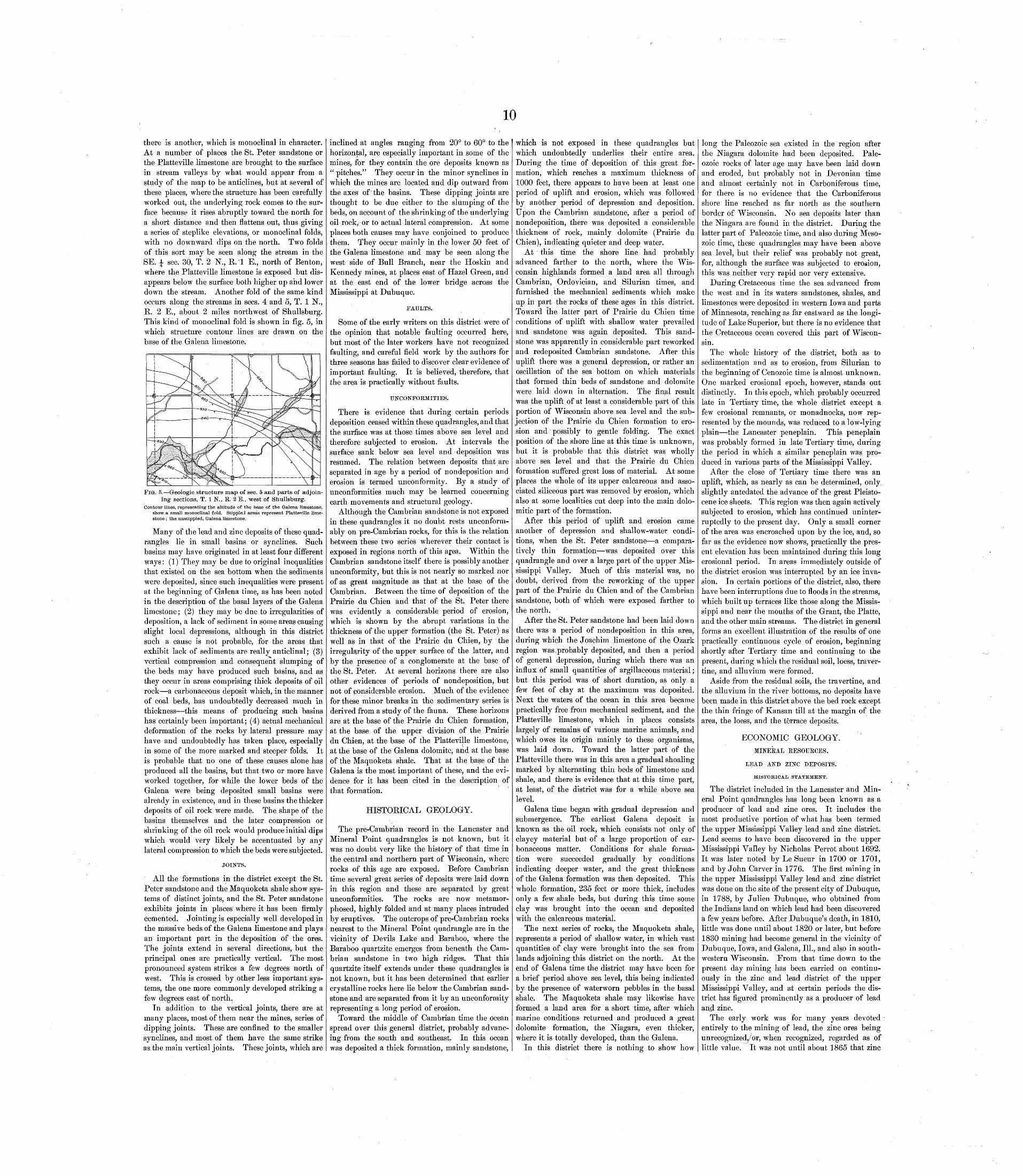
10
there is another, which is monoclinal in character. At a number of places the St. Peter sandstone or the Platteville limestone are brought to the surface in stream valleys by what would appear from a study of the map to be anticlines, but at several of these places, where the structure has been carefully worked out, the underlying rock comes to the sur face because it rises abruptly toward the north for a short distance and then flattens out, thus giving a series of steplike elevations, or monoclinal folds, with no downward dips on the north. Two folds of this sort may be seen along the stream in the SE. J sec. 30, T. 2 N., K. 1 E., north of Benton, where the Platteville limestone is exposed but dis appears below the surface both higher up and lower down the stream. Another fold of the same kind occurs along the streams in sees. 4 and 5, T. 1 N., R. .2 E., about 2 miles northwest of Shullsburg. This kind of monoclinal fold is shown in fig. 5, in which structure contour lines are drawn on the base of the Galena limestone.
FIG. 5. Geologic structure map of sec. 5 and parts of adjoin ing sections, T. 1 N., R. 2 E., west of Shullsburg.
Contour lines, representing the altitude of the base of the Galena limestone, show a small monoclinal fold. Stippled areas represent Platteville lime stone ; the unstippled, Galena limestone.
Many of the lead and zinc deposits of these quad rangles lie in small basins or synclines. Such basins may have originated in at least four different ways: (1) They may be due to original inequalities that existed on the sea bottom when the sediments were deposited, since such inequalities were present at the beginning of Galena time, as has been noted in the description of the basal layers of the Galena limestone; (2) they may be due to irregularities of deposition, a lack of sediment in some areas causing slight local depressions, although in this district such a cause is not probable, for the areas that exhibit lack of sediments are really anticlinal; (3) vertical compression and consequent slumping of the beds may have produced such basins, and as they occur in areas comprising thick deposits of oil rock a carbonaceous deposit which, in the manner of coal beds, has undoubtedly decreased much in thickness this means of producing such basins has certainly been important; (4) actual mechanical deformation of the rocks by lateral pressure may have and undoubtedly has taken place, especially in some of the more marked and steeper folds. It is probable that no one of these causes alone has produced all the basins, but that two or more have worked together, for while the lower beds of the Galena were being deposited small basins were already in existence, and in these basins the thicker deposits of oil rock were made. The shape of the basins themselves and the later compression or shrinking of the oil rock would produce initial dips which would very likely be accentuated by any lateral compression to which the beds were subjected.
JOINTS.
All the formations in the district except the St. Peter sandstone and the Maquoketa shale show sys tems of distinct joints, and the St. Peter sandstone exhibits joints in places where it has been firmly cemented. Jointing is especially well developed in the massive beds of the Galena limestone and plays an important part in the deposition of the ores. The joints extend in several directions, but the principal ones are practically vertical. The most pronounced system strikes a few degrees north of west. This is crossed by other less important sys tems, the one more commonly developed striking a few degrees east of north.
In addition to the vertical joints, there are at many places, most of them near the mines, series of dipping joints. These are confined to the smaller synclines, and most of them have the same strike as the main vertical joints. These joints, which are
inclined at angles ranging from 20° to 60° to the horizontal, are especially important in some of the mines, for they contain the ore deposits known as " pitches/' They occur in the minor synclines in which the mines are located and dip outward from the axes of the basins. These dipping joints are thought to be due either to the slumping of the beds, on account of the shrinking of the underlying oil rock, or to actual lateral compression. At some places both causes may have conjoined to produce them. They occur mainly in the lower 50 feet of the Galena limestone and may be seen along the west side of Bull Branch, near the Hoskin and Kennedy mines, at places east of Hazel Green, and at the east end of the lower bridge across the Mississippi at Dubuque.
FAULTS.
Some of the early writers on this district were of the opinion that notable faulting occurred here, but most of the later workers have not recognized faulting, and careful field work by the authors for three seasons has failed to discover clear evidence of important faulting. It is believed, therefore, that the area is practically without faults.
UNCONFORMITIES.
There is evidence that during certain periods deposition ceased within these quadrangles, and that the surface was at those times above sea level and therefore subjected to erosion. At intervals the surface sank below sea level and deposition was resumed. The relation between deposits that are separated in age by a period of nondeposition and erosion is termed unconformity. By a study of unconformities much may be learned concerning earth movements and structural geology.
Although the Cambrian sandstone is not exposed in these quadrangles it no doubt rests unconform- ably on pre-Cambrian rocks, for this is the relation between these two series wherever their contact is exposed in regions north of this area. Within the Cambrian sandstone itself there is possibly another unconformity, but this is not nearly so marked nor of as great magnitude as that at the base of the Cambrian. Between the time of deposition of the Prairie du Chien and that of the St. Peter there was evidently a considerable period of erosion, which is shown by the abrupt variations in the thickness of the upper formation (the St. Peter) as well as in that of the Prairie du Chien, by the irregularity of the upper surface of the latter, and by the presence of a conglomerate at the base of the St. Peter. At several horizons there are also oth^r evidences of periods of nondeposition, but not of considerable erosion. Much of the evidence for these minor breaks in the sedimentary series is derived from a study of the fauna. These horizons are at the base of the Prairie du Chien formation, at the base of the upper division of the Prairie du Chien, at the base of the Platteville limestone, at the base of the Galena dolomite, and at the base of the Maquoketa shale. That at the base of the Galena is the most important of these, and the evi dence for it has been cited in the description of that formation.
HISTORICAL GEOLOGY.
The pre-Cambrian record in the Lancaster and Mineral Point quadrangles is not known, but it was no doubt very like the history of that time in the central and northern part of Wisconsin, where rocks of this age are exposed. Before Cambrian time several great series of deposits were laid down in this region and these are separated by great unconformities. The rocks are now metamor phosed, highly folded and at many places intruded by eruptives. The outcrops of pre-Cambrian rocks nearest to the Mineral Point quadrangle are in the vicinity of Devils Lake and Baraboo, where the Baraboo quartzite emerges from beneath the Cam brian sandstone in two high ridges. That this quartzite itself extends under these quadrangles is not known, but it has been determined that earlier crystalline rocks here lie below the Cambrian sand stone and are separated from it by an unconformity representing a long period of erosion.
Toward the middle of Cambrian time the ocean spread over this general district, probably advanc ing from the south and southeast. In this ocean was deposited a thick formation, mainly sandstone,
which is not exposed in these quadrangles but which undoubtedly underlies their entire area. During the time of deposition of this great for mation, which reaches a maximum thickness of 1000 feet, there appears to have been at least one period of uplift and erosion, which was followed by another period of depression and deposition. Upon the Cambrian sandstone, after a period of nondeposition, there was deposited a considerable thickness of rock, mainly dolomite (Prairie du Chien), indicating quieter and deep water.
At this time the shore line had probably advanced farther to the north, where the Wis consin highlands formed a land area all through Cambrian, Ordovician, and Silurian times, and furnished the mechanical sediments which make up in part the rocks of these ages in this district. Toward the latter part of Prairie du Chien time conditions of uplift with shallow water prevailed and sandstone was again deposited. This sand stone was apparently in considerable part reworked and redeposited Cambrian sandstone. After this uplift there was a general depression, or rather an oscillation of the sea bottom on which materials that formed thin beds of sandstone and dolomite were laid down in alternation. The final result was the uplift of at least a considerable part of this portion of Wisconsin above sea level and the sub jection of the Prairie du Chien formation to ero sion and possibly to gentle folding. The exact position of the shore line at this time is unknown, but it is probable that this district was wholly above sea level and that the Prairie du Chien formation suffered great loss of material. At some places the whole of its upper calcareous and asso ciated siliceous part was removed by erosion, which also at some localities cut deep into the main dolo- mitic part of the formation.
After this period of uplift and erosion came another of depression and shallow-water condi tions, when the St. Peter sandstone a compara tively thin formation was deposited over this quadrangle and over a large part of the upper Mis sissippi Valley. Much of this material was, no doubt, derived from the reworking of the upper part of the Prairie du Chien and of the Cambrian sandstone, both of which were exposed farther to the north.
After the St. Peter sandstone had been laid down there was a period of nondeposition in this area, during which the Joachim limestone of the Ozark region was,probably deposited, and then a period of general depression, during which there was an influx of small quantities of argillaceous material; but this period was of short duration, as only a few feet of clay at the maximum was deposited. Next the waters of the ocean in this area became practically free from mechanical sediment, and the Platteville limestone, which in places consists largely of remains of various marine animals, and which owes its origin mainly to these organisms, was laid down. Toward the latter part of the Platteville there was in this area a gradual shoaling marked by alternating thin beds of limestone and shale, and there is evidence that at this time part, at least, of the district was for a while above sea level.
Galena time began with gradual depression and submergence. The earliest Galena deposit is known as the oil rock, which consists not only of clayey material but of a large proportion of car bonaceous matter. Conditions for shale forma tion were succeeded gradually by conditions indicating deeper water, and the great thickness of the Galena formation was then deposited. This whole formation, 235 feet or more thick, includes only a few shale beds, but during this time some clay was brought into the ocean and deposited with the calcareous material.
The next series of rocks, the Maquoketa shale, represents a period of shallow water, in which vast quantities of clay were brought into the sea from lands adjoining this district on the north. At the end of Galena time the district may have been for a brief period above sea level, this being indicated by the presence of waterworn pebbles in the basal shale. The Maquoketa shale may likewise have formed a land area for a short time, after which marine conditions returned and produced a great dolomite formation, the Niagara, even thicker, where it is totally developed, than the Galena.
In this district there is nothing to show how
long the Paleozoic sea existed in the region after the Niagara dolomite had been deposited. Pale ozoic rocks of later age may have been laid down and eroded, but probably not in Devonian time and almost certainly not in Carboniferous time, for there is no evidence that the Carboniferous shore line reached as far north as the southern border of Wisconsin. No sea deposits later than the Niagara are found in the district. During the latter part of Paleozoic time, and also during Meso- zoic time, these quadrangles may have been above sea level, but their relief was probably not great, for, although the surface was subjected to erosion, this was neither very rapid nor very extensive.
During Cretaceous time the sea advanced from the west and in its waters sandstones, shales, and limestones were deposited in western Iowa and parts of Minnesota, reaching as far eastward as the longi tude of Lake Superior, but there is no evidence that the Cretaceous ocean covered this part of Wiscon sin.
The whole history of the district, both as to sedimentation and as to erosion, from Silurian to the beginning of Cenozoic time is almost unknown. One marked erosional epoch, however, stands out distinctly. In this epoch, which probably occurred late in Tertiary time, the whole district except a few erosional remnants, or monadnocks, now rep resented by the mounds, was reduced to a low-lying plain the Lancaster peneplain. This peneplain was probably formed in late Tertiary time, during the period in which a similar peneplain was pro duced in various parts of the Mississippi Valley.
After the close of Tertiary time there was an uplift, which, as nearly as can be determined, only, slightly antedated the advance of the great Pleisto cene ice sheets. This region was then again actively subjected to erosion, which has continued uninter ruptedly to the present day. Only a small corner of the area was encroached upon by the ice, and, so far as the evidence now shows, practically the pres ent elevation has been maintained during this long erosional period. In areas immediately outside of the district erosion was interrupted by an ice inva sion. In certain portions of the district, also, there have been interruptions due to floods in the streams, which built up terraces like those along the Missis sippi and near the mouths of the Grant, the Platte, and the other main streams. The district in general forms an excellent illustration of the results of one practically continuous cycle of erosion, beginning shortly after Tertiary time and continuing to the present, during which the residual soil, loess, traver tine, and alluvium were formed.
Aside from the residual soils, the travertine, and the alluvium in the river bottoms, no deposits have been made in this district above the bed rock except the thin fringe of Kansan till at the margin of the area, the loess, and the terrace deposits.
ECONOMIC GEOLOGY.MINERAL RESOURCES.
LEAD AND ZINC DEPOSITS.
HISTORICAL STATEMENT.
The district included in the Lancaster and Min eral Point quadrangles has long been known as a producer of lead and zinc ores. It includes the most productive portion of what has been termed the upper Mississippi Valley lead and zinc district. Lead seems to have been discovered in the upper Mississippi Valley by Nicholas Perrot about 1692. It was later noted by Le Sueur in 1700 or 1701, and by John Carver in 1776. The first mining in the upper Mississippi Valley lead and zinc district was done on the site of the present city of Dubuque, in 1788, by Julien Dubuque, who obtained from the Indians land on which lead had been discovered a few years before. After Dubuque's death, in 1810, little was done until about 1820 or later, but before 1830 mining had become general in the vicinity of Dubuque, Iowa, and Galena, 111., and also in south western Wisconsin. From that time down to the present day mining has been carried on continu ously in the zinc and lead district of the upper Mississippi Valley, and at certain periods the dis trict has figured prominently as a producer of lead an^ zinc.
The early work was for many years devoted entirely to the mining of lead, the zinc ores being unrecognizedy or, when recognized, regarded as of little value. It was not until about 1865 that zinc
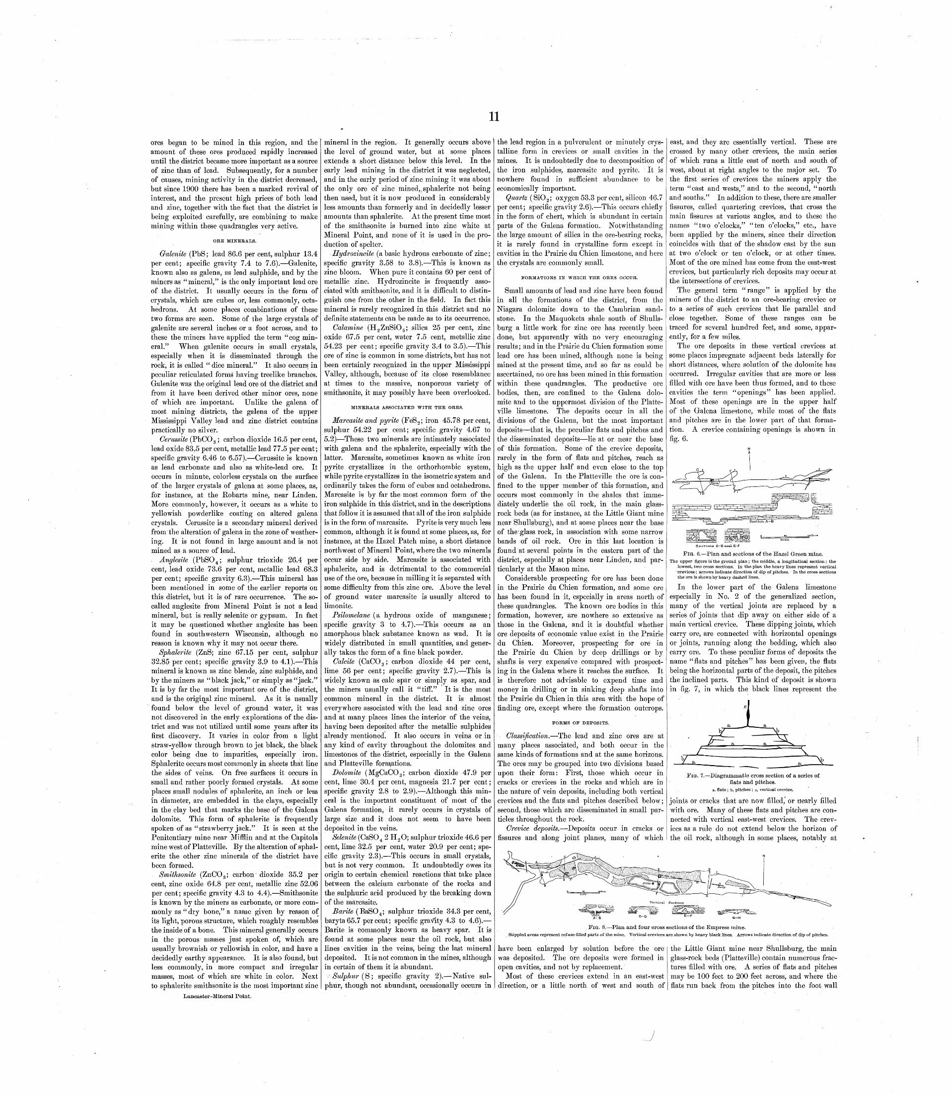
11ores began to be mined in this region, and the amount of these ores produced rapidly increased until the district became more important as a source of zinc than of lead. Subsequently, for a number of causes, mining activity in the district decreased, but since 1900 there has been a marked revival of interest, and the present high prices of both lead and zinc, together with the fact that the district is being exploited carefully, are combining to make mining within these quadrangles very active.
ORE MINERALS.
Galenite (PbS; lead 86.6 per cent, sulphur 13.4 per cent; specific gravity 7.4 to 7.6). Galenite, known also as galena, as lead sulphide, and by the miners as "mineral," is the only important lead ore of the district. It usually occurs in the form of crystals, which are cubes or, less commonly, octa hedrons. At some places combinations of these two forms are seen. Some of the large crystals of galenite are several inches or a foot across, and to these the miners have applied the term "cog min eral." When galenite occurs in small crystals, especially when it is disseminated through the rock, it is called " dice mineral." It also occurs in peculiar reticulated forms having treelike branches. Galenite was the original lead ore of the district and from it have been derived other minor ores, none of which are important. Unlike the galena of most mining districts, the galena of the upper Mississippi Valley lead and zinc district contains practically no silver.
Cerussite (PbCO 3 ; carbon dioxide 16.5 percent, lead oxide 83.5 per cent, metallic lead 77.5 per cent; specific gravity 6.46 to 6.57). Cerussite is known as lead carbonate and also as white-lead ore. It occurs in minute, colorless crystals on the surface of the larger crystals of galena at some places, as, for instance, at the Robarts mine, near Linden. More commonly, however, it occurs as a white to yellowish powderlike coating on altered galena crystals. Cerussite is a secondary mineral derived from the alteration of galena in the zone of weather ing. It is not found in large amount and is not mined as a source of lead.. Anglesite (PbSO 4 ; sulphur trioxide 26.4 per cent, lead oxide 73.6 per cent, metallic lead 68.3 per cent; specific gravity 6.3). This mineral has been mentioned in some of the earlier reports on this district, but it is of rare occurrence. The so- called anglesite from Mineral Point is not a lead mineral, but is really selenite or gypsum. In fact it may be questioned whether anglesite has been found in southwestern Wisconsin, although no reason is known why it may not occur there.
Sphalerite (ZnS; zinc 67.15 per cent, sulphur 32.85 per cent; specific gravity 3.9 to 4.1). This mineral is known as zinc blende, zinc sulphide, and by the miners as "black jack," or simply as "jack." It is by far the most important ore of the district, and is the original zinc mineral. As it is usually found below the level of ground water, it was not discovered in the early explorations of the dis trict and was not utilized until some years after its first discovery. It varies in color from a light straw-yellow through brown to jet black, the black color being due to impurities, especially iron. Sphalerite occurs most commonly in sheets that line the sides of veins. On free surfaces it occurs in small and rather poorly formed crystals. At some places small nodules of sphalerite, an inch or less in diameter, are embedded in the clays, especially in the clay bed that marks the base of the Galena dolomite. This form of sphalerite is frequently spoken of as "strawberry jack." It is seen at the Penitentiary mine near Mifflin and at the Capitola mine west of Platteville. By the alteration of sphal erite the other zinc minerals of the district have been formed.
Smithsonite (ZnCO 3 ; carbon' dioxide 35.2 per cent, zinc oxide 64.8 per cent, metallic zinc 52.06 per cent; specific gravity 4.3 to 4.4). Smithsonite is known by the miners as carbonate, or more com monly as "dry bone," a name given by reason of its light, porous structure, which roughly resembles the inside of a bone. This mineral generally occurs in the porous masses just spoken of, which are usually brownish or yellowish in color, and have a decidedly earthy appearance. It is also found, but less commonly, in more compact and irregular masses, most of which are white in color. Next to sphalerite smithsonite is the most important zinc
Lancaster-Mineral Point.
mineral in the region. It generally occurs above the level of ground water, but at some places extends a short distance below this level. In the early lead mining in the district it was neglected, and in the early period of zinc mining it was about the only ore of zinc mined,, sphalerite not being then used, but it is now produced in considerably less amounts than formerly and in decidedly lesser amounts than sphalerite. At the present time most of the smithsonite is burned into zinc white at Mineral Point, and none of it is used in the pro duction of spelter.
Hydrozincite (a basic hydrous carbonate of zinc; specific gravity 3.58 to 3.8). This is known as zinc bloom. When pure it contains 60 per cent of metallic zinc. Hydrozincite is frequently asso ciated with smithsonite, and it is difficult to distin guish one from the other in the field. In fact this mineral is rarely recognized in this district and no definite statements can be made as to its occurrence.
Calamine (H 2 ZnSiO 5 ; silica 25 per cent, zinc oxide 67.5 per cent, water 7.5 cent, metallic zinc 54.23 per cent; specific gravity 3.4 to 3.5). This ore of zinc is common in some districts, but has not been certainly recognized in the upper Mississippi Valley, although, because of its close resemblance at times to the massive, nonporous variety of smithsonite, it may possibly have been overlooked.
MINERALS ASSOCIATED WITH THE ORES.
Marcasite and pyrite (FeS 2 ; iron 45.78 percent, sulphur 54.22 per cent; specific gravity 4.67 to 5.2) These two minerals are intimately associated with galena and the sphalerite, especially with the latter. Marcasite, sometimes known as white iron pyrite crystallizes in the orthorhombic system, while pyrite crystallizes in the isometric system and ordinarily takes the form of cubes and octahedrons. Marcasite is by far the most common form of the iron sulphide in this district, and in the descriptions that follow it is assumed that all of the iron sulphide is in the form of marcasite. Pyrite is very much less common, although it is found at some places, as, for instance, at the Hazel Patch mine, a short distance northwest of Mineral Point, where the two minerals occur side by side. Marcasite is associated with sphalerite, and is detrimental to the commercial use of the ore, because in milling it is separated with some difficulty from this zinc ore. Above the level of ground water marcasite is usually altered to limonite.
Psilomelane (a hydrous oxide of manganese; specific gravity 3 to 4.7). This occurs as an amorphous black substance known as wad. It is widely distributed in small quantities, and gener ally takes the form of a fine black powder.
Calcite (CaCO 3 ; carbon dioxide 44 per cent, lime 56 per cent; specific gravity 2.7). This is widely known as calc spar or simply as spar, and the miners usually call it "tiff." It is the most common mineral in the district. It is almost everywhere associated with the lead and zinc ores and at many places lines the interior of the veins, having been deposited after the metallic sulphides already mentioned. It also occurs in veins or in any kind of cavity throughout the dolomites and limestones of the district, especially in the Galena and Platteville formations.
Dolomite (MgCaCO 3 ; carbon dioxide 47.9 per cent, lime 30.4 per cent, magnesia 21.7 per cent; specific gravity 2.8 to 2.9). Although this min eral is the important constituent of most of the Galena formation, it rarely occurs in crystals of large size and it does not seem to have been deposited in the veins.
Selenite (CaSO 4 2 H 2 O; sulphur trioxide 46.6 per cent, lime 32.5 per cent, water 20.9 percent; spe cific gravity 2.3). This occurs in small crystals, but is not very common. It undoubtedly owes its Origin to certain chemical reactions that take place between the calcium carbonate of the rocks and the sulphuric acid produced by the breaking down of the marcasite.
Barite (BaSO 4 ; sulphur trioxide 34.3 per cent, baryta65.7 percent; specific gravity 4.3 to 4.6). Barite is commonly known as heavy spar. It is found at some places near the oil rock, but also lines cavities in the veins, being the last mineral deposited. It is not common in the mines, although in certain of them it is abundant.
Sulphur (S; specific gravity 2). Native sul phur, though not abundant, occasionally occurs in
the lead region in a pulverulent or minutely crys talline form in crevices or small cavities in the mines. It is undoubtedly due to decomposition of the iron sulphides, marcasite and pyrite. It is nowhere found in sufficient abundance to be economically important.
Quartz (SiO 2 ; oxygen 53.3 per cent, silicon 46.7 percent; specific gravity 2.6). This occurs chiefly in the form of chert, which is abundant in certain parts of the Galena formation. Notwithstanding the large amount of silica in the ore-bearing rocks, it is rarely found in crystalline form except in cavities in the Prairie du Chien limestone, and here the crystals are commonly small.
FORMATIONS IN WHICH THE ORES OCCUR.
Small amounts of lead and zinc have been found in all the formations of the district, from the Niagara dolomite down to the Cambrian sand stone. In the Maquoketa shale south of Shulls- burg a little work for zinc ore has recently been done, but apparently with no very encouraging results; and in the Prairie du Chien formation some lead ore has been mined, although none is being mined at the present time, and so far as could be ascertained, no ore has been mined in this formation within these quadrangles. The productive ore bodies, then, are confined to the Galena dolo mite and to the uppermost division of the Platte ville limestone. The deposits occur in all the divisions of the Galena, but the most important deposits that is, the peculiar flats and pitches and the disseminated deposits lie at or near the base of this formation. Some of the crevice deposits, rarely in the form of flats and pitches, reach as high as the upper half and even close to the top of the Galena. In the Platteville the ore is con fined to the upper member of this formation, and occurs most commonly in the shales that imme diately underlie the oil rock, in the main glass- rock beds (as for instance, at the Little Giant mine near Shullsburg), and at some places near the base of the'glass rock, in association with some narrow bands of oil rock. Ore in this last location is found at several points in the eastern part of the district, especially at places near Linden, and par ticularly at the Mason mine.
Considerable prospecting for ore has been done in the Prairie du Chien formation, and some ore has been found in it, especially in areas north of these quadrangles. The known ore bodies in this formation, however, are nowhere so extensive as those in the Galena, and it is doubtful whether ore deposits of economic value exist in the Prairie du Chien. Moreover, prospecting for ore in the Prairie du Chien by deep drillings or by shafts is very expensive compared with prospect ing in the Galena where it reaches the surface. It is therefore not advisable to expend time and money in drilling or in sinking deep shafts into the Prairie du Chien in this area with the hope of finding ore, except where the formation outcrops.
FORMS OF DEPOSITS.
Classification. The lead and zinc ores are at many places associated, and both occur in the same kinds of formations and at the same horizons. The ores may be grouped into two divisions based upon their form: First, those which occur in cracks or crevices in the rocks and which are in the nature of vein deposits, including both vertical crevices and the flats and pitches described below; second, those which are disseminated in small par ticles throughout the rock.
Crevice deposits. Deposits occur in cracks or fissures and along joint planes, many of which
east, and they are essentially vertical. These are crossed by many other crevices, the main series of which runs a little east of north and south of west, about at right angles to the major set. To the first series of crevices the miners apply the term "east and wests," and to the second, "north and souths." In addition to these, there are smaller fissures, called quartering crevices, that cross the main fissures at various angles, and to these the names "two o'clocks," "ten o'clocks," etc., have been applied by the miners, since their direction coincides with that of the shadow cast by the sun at two o'clock or ten o'clock, or at other times. Most of the ore mined has come from the east-west crevices, but particularly rich deposits may occur at the intersections of crevices.
The general term "range" is applied by the miners of the district to an ore-bearing crevice or to a series of such crevices that lie parallel and close together. Some of these ranges can be traced for several hundred feet, and some, appar ently, for a few miles.
The ore deposits in these vertical crevices at some places impregnate adjacent beds laterally for short distances, where solution of the dolomite has occurred. Irregular cavities that are more or less filled with ore have been thus formed, and to these cavities the term "openings" has been applied. Most of these openings are in the upper half of the Galena limestone, while most of the flats and pitches are in the lower part of that forma tion. A crevice containing openings is shown in fig. 6.
Sections C-D and-E-F
FIG. 6. Plan and sections of the Hazel Green mine.The upper figure is the ground plan; the middle, a longitudinal section ; the
lowest, two cross sections. In the plan the heavy lines represent vertical 'crevices; arrows indicate direction of dip of pitches. In the cross sections the ore is shown by heavy dashed lines.
In the lower part of the Galena limestone especially in No. 2 of the generalized section, many of the vertical joints are replaced by a series of joints that dip away on either side of a main vertical crevice. These dipping joints, which carry ore, are connected with horizontal openings or joints, running along the bedding, which also carry ore. To these peculiar forms of deposits the name "flats and pitches" has been given, the flats being the horizontal parts of the deposit, the pitches the inclined parts. This kind of deposit is shown in fig. 7, in which the black lines represent the
FIG. 7. Diagrammatic cross section of a series of flats and pitches.
a, flats ; b, pitches ; o, vertical crevice.
joints or cracks that are now filled, or nearly filled with ore. Many of these flats and pitches are con nected with vertical east-west crevices. The crev ices as a rule do not extend below the horizon of the oil rock, although in some places, notably at
FIG. 8. Plan and four cross sections of the Empress mine.
Stippled areas represent refuse-filled parts of the mine. Vertical crevices are shown by heavy black lines. Arrows indicate direction of dip of pitches.
have been enlarged by solution before the ore was deposited. The ore deposits were formed in open cavities, and not by replacement.
Most of these crevices extend in an east-west direction, or a little north of west and south of
the Little Giant mine near Shullsburg, the main glass-rock beds (Platteville) contain numerous frac tures filled with ore. A series of flats and pitches may be 100 feet to 200 feet across, and where the flats run back from the pitches into the foot wall
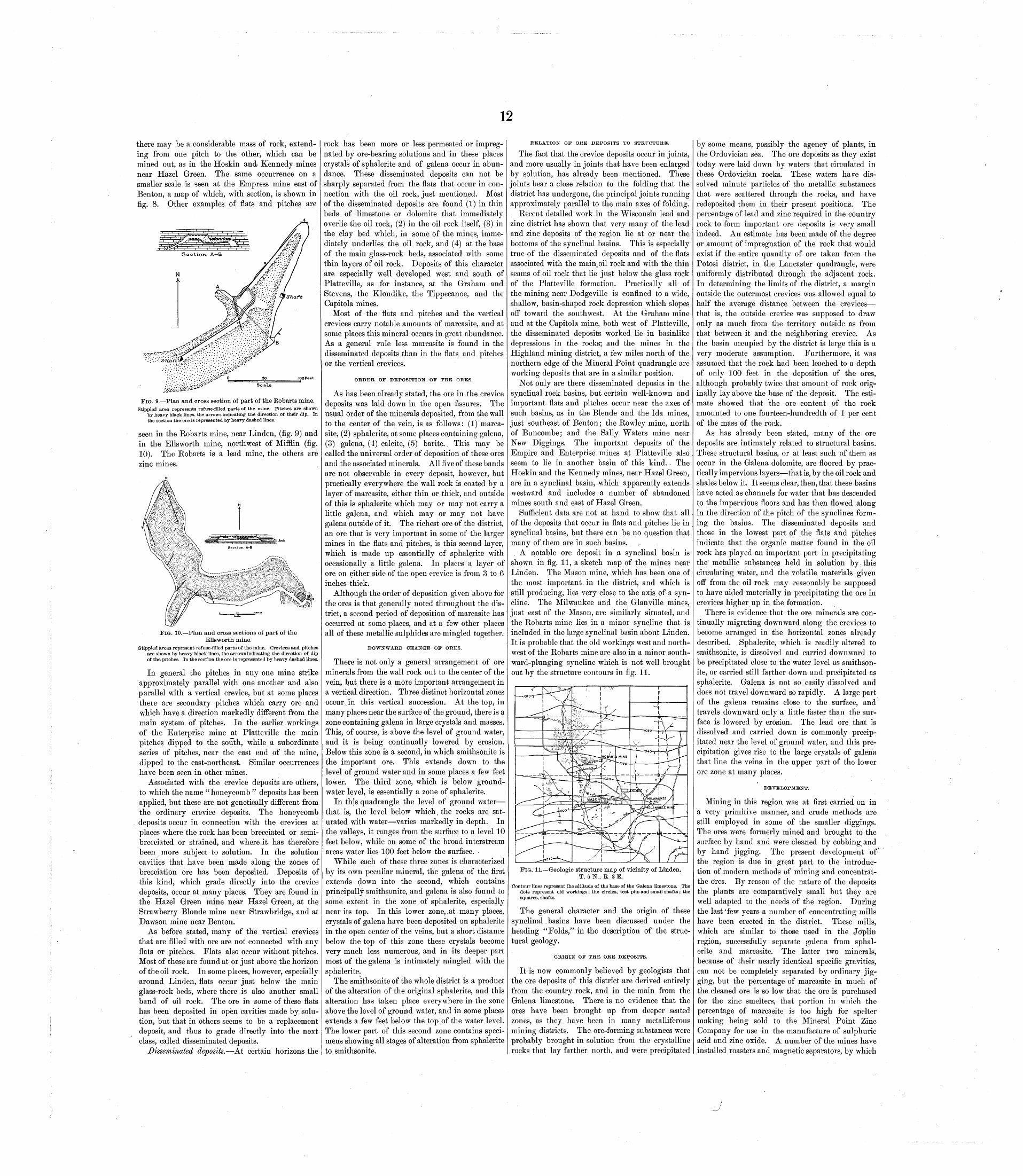
12
there may be a considerable mass of rock, extend ing from one pitch to the other, which can be mined out, as in the Hoskin and Kennedy mines near Hazel Green. The same occurrence on a smaller scale is seen at the Empress mine east of Benton, a map of which, with section, is shown in fig. 8. Other examples of flats and pitches are
Scale
-. 9. Plan and cross section of part of the Robarts mine.Stippled area represents refuse-filled parts of the mine. Pitches are shown
by heavy black lines, the arrows indicating the direction of their dip. In the section the ore is represented by heavy dashed lines.
seen in the Robarts mine, near Linden, (fig. 9) and in the Ellsworth mine, northwest of Mifilin (fig. 10). The Robarts is a lead mine, the others are zinc mines.
10. Plan and cross sections of part of the Ellsworth mine.
Stippled areas represent refuse- filled parts of the mine. Crevices and pitches are shown by heavy black lines, the arrows indicating the direction of dip of the pitches. In the section the ore is represented by heavy dashed lines.
In general the pitches in any one mine strike approximately parallel with one another and also parallel with a vertical crevice, but at some places there are secondary pitches which carry ore and which have a direction markedly different from the main system of pitches. In the earlier workings of the Enterprise mine at Platteville the main pitches dipped to the south, while a subordinate series of pitches, near the east end of the mine, dipped to the east-northeast. Similar occurrences have been seen in other mines.
Associated with the crevice deposits are others, to which the name " honeycomb " deposits has been applied, but these are not genetically different from the ordinary crevice deposits. The honeycomb deposits occur in connection with the crevices at places where the rock has been brecciated or semi- brecciated or strained, and where it has therefore been more subject to solution. In the solution cavities that have been made along the zones of brecciation ore has been deposited. Deposits of this kind, which grade directly into the crevice deposits, occur at many places. They are found in the Hazel Green mine near Hazel Green, at the Strawberry Blonde mine near Strawbridge, and at Dawson mine near Benton.
As before stated, many of the vertical crevices that are filled with ore are not connected with any flats or pitches. Flats also occur without pitches. Most of these are found at or just above the horizon of the oil rock. In some places, however, especially around Linden, flats occur just below the main glass-rock beds, where there is also another small band of oil rock. The ore in some of these flats has been deposited in open cavities made by solu tion, but that in others seems to be a replacement deposit, and thus to grade directly into the next class, called disseminated deposits.
Disseminated deposits. At certain horizons the
rock has been more or less permeated or impreg nated by ore-bearing solutions and in these places crystals of sphalerite and of galena occur in abun dance. These disseminated deposits can not be sharply separated from the flats that occur in con nection with the oil rock, just mentioned. Most of the disseminated deposits are found (1) in thin beds of limestone or dolomite that immediately overlie the oil rock, (2) in the oil rock itself, (3) in the clay bed which, in some of the mines, imme diately underlies the oil rock, and (4) at the base of the main glass-rock beds, associated with some thin layers of oil rock. Deposits of this character are especially well developed west and south of Platteville, as for instance, at the Graham and Stevens, the Klondike, the Tippecanoe, and the Capitola mines.
Most of the flats and pitches and the vertical crevices carry notable amounts of marcasite, and at some places this mineral occurs in great abundance. As a general rule less marcasite is found in the disseminated deposits than in the flats and pitches or the vertical crevices.
ORDER OF DEPOSITION OP THE ORES.
As has been already stated, the ore in the crevice deposits was laid down in the open fissures. The usual order of the minerals deposited, from the wall to the center of the vein, is as follows: (1) marca site, (2) sphalerite, at some places containing galena, (3) galena, (4) calcite, (5) barite.. This may be called the universal order of deposition of these ores and the associated minerals. All five of these bands are not observable in every deposit, however, but practically everywhere the wall rock is coated by a layer of marcasite, either thin or thick, and outside of this is sphalerite which may or may not carry a little galena, and which may or may not have galena outside of it. The richest ore of the district, an ore that is very important in some of the larger mines in the flats and pitches, is this second layer, which is made up essentially of sphalerite with occasionally a little galena. In places a layer of ore on either side of the open crevice is from 3 to 6 inches thick.
Although the order of deposition given above for the ores is that generally noted throughout the dis trict, a second period of deposition of marcasite has occurred at some places, and at a few other places all of these metallic sulphides are mingled together.
DOWNWARD CHANGE OF ORES.
There is not only a general arrangement of ore minerals from the wall rock out to the center of the vein, but there is a more important arrangement in a vertical direction. Three distinct horizontal zones occur in this vertical succession. At the top, in many places near the surface of the ground, there is a zone containing galena in large crystals and masses. This, of course, is above the level of ground water, and it is being continually lowered by erosion. Below this zone is a second, in which smithsonite is the important ore. This extends down to the level of ground water and in some places a few feet lower. The third zone, which is below ground- water level, is essentially a zone of sphalerite.
In this quadrangle the level of ground water that is, the level below which, the rocks are sat urated with water varies markedly in depth. In the valleys, it ranges from the surface to a level 10 feet below, while on some of the broad interstream areas water lies 100 feet below the surface.
While each of these three zones is characterized by its own peculiar mineral, the galena of the first extends down into the second, which contains principally smithsonite, and galena is also found to some extent in the zone of sphalerite, especially near its top. In this lower zone, at many places, crystals of galena have been deposited on sphalerite in the open center of the veins, but a short distance below the top of this zone these crystals become very much less numerous, and in its deeper part most of the galena is intimately mingled with the sphalerite.
The smithsonite of the whole district is a product of the alteration of the original sphalerite, and this alteration has taken place everywhere in the zone above the level of ground water, and in some places extends a few feet below the top of the water level. The lower part of this second zone contains speci mens showing all stages of alteration from sphalerite to smithsonite.
RELATION OF ORE DEPOSITS TO STRUCTURE.
The fact that the crevice deposits occur in joints, and more usually in joints that have been enlarged by solution, has already been mentioned. These joints bear a close relation to the folding that the district has undergone, the principal joints running approximately parallel to the main axes of folding.
Recent detailed work in the Wisconsin lead and zinc district has shown that very many of the lead and zinc deposits of the region lie at or near the bottoms of the synclinal basins. This is especially true of the disseminated deposits and of the flats associated with the main oil rock and with the thin seams of oil rock that lie just below the glass rock of the Platteville formation. Practically all of the mining near Dodgeville is confined to a wide, shallow, basin-shaped rock depression which slopes off toward the southwest. At the Graham mine and at the Capitola mine, both west of Platteville, the disseminated deposits worked lie in basinlike depressions in the rocks; and the mines in the Highland mining district, a few miles north of the northern edge of the Mineral Point quadrangle are working deposits that are in a similar position.
Not only are there disseminated deposits in the synclinal rock basins, but certain well-known and important flats and pitches occur near the axes of such basins, as in the Blende and the Ida mines, just southeast of Benton; the Rowley mine, north of Buncombe; and the Sally Waters mine near New Diggings. The important deposits of the Empire and Enterprise mines at Platteville also seem to lie in another basin of this kind. The Hoskin and the Kennedy mines, near Hazel Green, are in a synclinal basin, which apparently extends westward and includes a number of abandoned mines south and east of Hazel Green.
Sufficient data are not at hand to show that all of the deposits that occur in flats and pitches lie in synclinal basins, but there can be no question that many of them are in such basins.
A notable ore deposit in a synclinal basin is shown in fig. 11, a sketch map of the mines near Linden. The Mason mine, which has been one of the most important,in the district, and which is still producing, lies very close to the axis of a syn- cline. The Milwaukee and the Glanville mines, just east of the Mason, are similarly situated, and the Robarts mine lies in a minor syncline that is included in the large synclinal basin about Linden. It is probable that the old workings west and north west of the Robarts mine are also in a minor south ward-plunging syncline which is not well brought out by the structure contours in fig. 11.
-. 11. Geologic structure map of vicinity of Linden, T. 5N., R 2E.
Contour lines represent the altitude of the base of the Galena limestone. The dots represent old workings; the circles, test pits and small shafts ; the squares, shafts.
The general character and the origin of these synclinal basins have been discussed under the heading "Folds," in the description of the struc tural geology.
ORIGIN OF THE ORE DEPOSITS.
It is now commonly believed by geologists that the ore deposits of this district are derived entirely from the country rock, and in the main from the Galena limestone. There is no evidence that the ores have been brought up from deeper seated zones, as they have been in many metalliferous mining districts. The ore-forming substances were probably brought in solution from the crystalline rocks that lay farther north, and were precipitated
by some means, possibly the agency of plants, in the Ordovician sea. The ore deposits as they exist today were laid down by waters that circulated in these Ordovician rocks. These waters have dis solved minute particles of the metallic substances that were scattered through the rocks, and have redeposited them in their present positions. The percentage of lead and zinc required in the country rock to form important ore deposits is very small indeed. An estimate has been made of the degree or amount of impregnation of the rock that would exist if the entire quantity of ore taken from the Potosi district, in the Lancaster quadrangle, were uniformly distributed through the adjacent rock. In determining the limits of the district, a margin outside the outermost crevices was allowed equal to half the average distance between the crevices that is, the outside crevice was supposed to draw only as much from the territory outside as from that between it and the neighboring crevice. As the basin occupied by the district is large this is a very moderate assumption. Furthermore, it was assumed that the rock had been leached to a depth of only 100 feet in the deposition of the ores, although probably twice that amount of rock orig inally lay above the base of the deposit. The esti mate showed that the ore content pf the rock amounted to one fourteen-hundredth of 1 per cent of the mass of the rock.
As has already been stated, many of the ore deposits are intimately related to structural basins. These structural basins, or at least such of them as occur in the Galena dolomite, are floored by prac tically impervious layers that is, by the oil rock and shales below it. It seems clear, then, that these basins have acted as channels for water that has descended to the impervious floors and has then flowed along in the direction of the pitch of the synclines form ing the basins. The disseminated deposits and those in the lowest part of the flats and pitches indicate that the organic matter found in the oil rock has played an important part in precipitating the metallic substances held in solution by this circulating water, and the volatile materials given off from the oil rock may reasonably be supposed to have aided materially in precipitating the ore in crevices higher up in the formation.
There is evidence that the ore minerals are con tinually migrating downward along the crevices to become arranged in the horizontal zones already described. , Sphalerite, which is readily altered to smithsonite, is dissolved and carried downward to be precipitated close to the water level as smithson ite, or carried still farther down and precipitated as sphalerite. Galena is not so easily dissolved and does not travel downward so rapidly. A large part of the galena remains close to the surface, and travels downward only a little faster than the sur face is lowered by erosion. The lead ore that is dissolved and carried down is commonly precip itated near the level of ground water, and this pre cipitation gives rise to the large crystals of galena that line the veins in the upper part of the lower ore zone at many places.
DEVELOPMENT.
Mining in this region was at first carried on in a very primitive manner, and crude methods are still employed in some of the smaller diggings., The ores were formerly mined and brought to the surface by hand and were cleaned by cobbing^ and by hand jigging. The present development of* the region is due in great part to the introduc tion of modern methods of mining and concentrat- the ores. By reason of the nature of the deposits the plants are comparatively small but they are well adapted to the needs of the region. During the last'few years a number of concentrating mills have been erected in the district. These mills, which are similar to those used in the Jopliii region, successfully separate galena from sphal erite and marcasite. The latter two minerals, because of their nearly identical specific gravities, can not be completely separated by ordinary jig ging, but the percentage of marcasite in much of the cleaned ore is so low that the ore is purchased for the zinc smelters, that portion in which the percentage of marcasite is too high for spelter making being sold to the Mineral Point Zinc Company for use in the manufacture of sulphuric acid and zinc oxide. A number of the mines have installed roasters and magnetic separators, by which
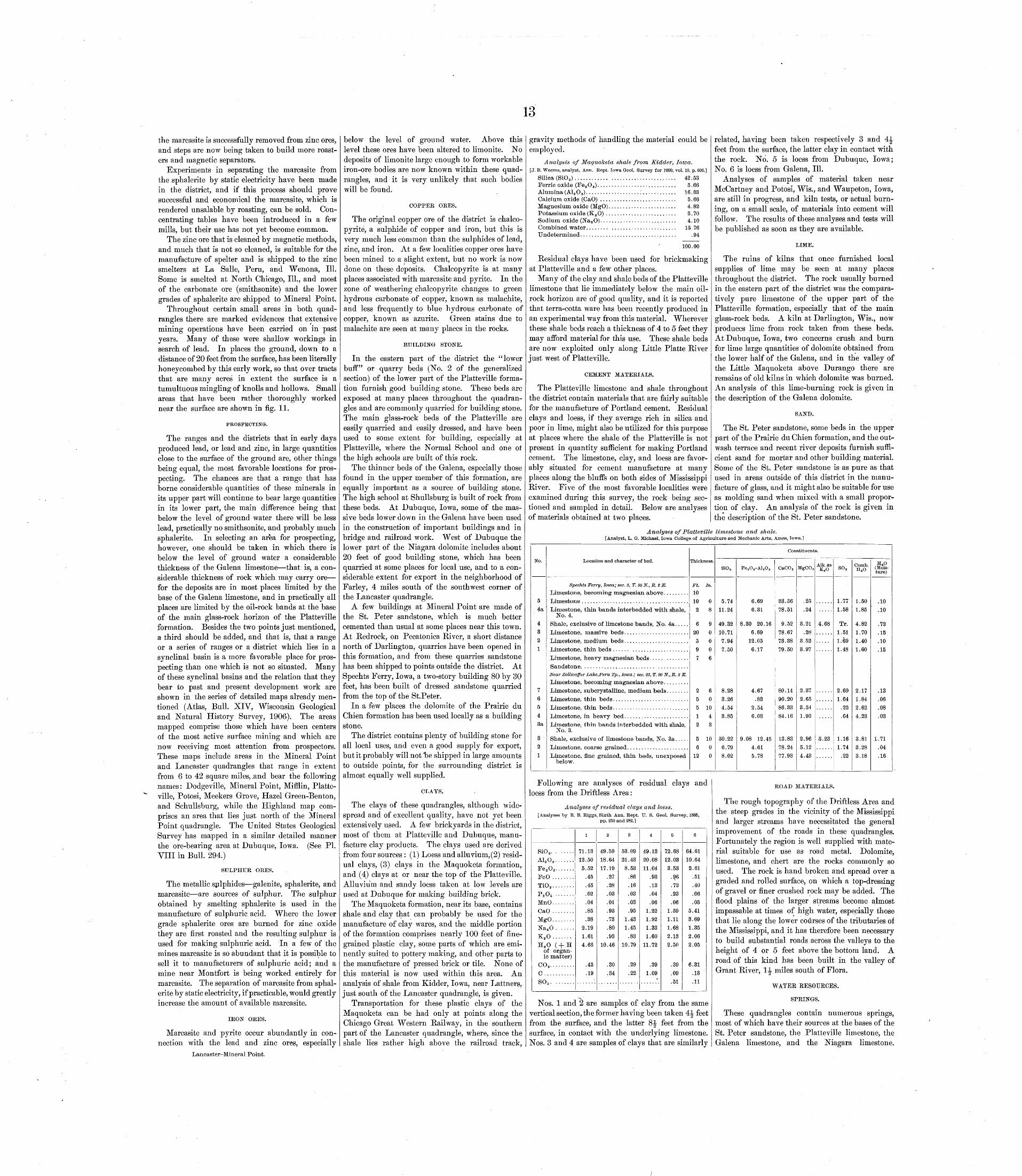
13
the marcasite is successfully removed from zinc ores, and steps are now being taken to build more roast ers and magnetic separators.
Experiments in separating the marcasite from the sphalerite by static electricity have been made in the district, and if this process should prove successful and economical the marcasite, which is rendered unsalable by roasting, can be sold. Con centrating tables have been introduced in a few mills, but their use has not yet become common.
The zinc ore that is cleaned by magnetic methods, and much that is not so cleaned, is suitable for the manufacture of spelter and is shipped to the zinc smelters at La Salle, Peru, and Wenona, 111. Some is smelted at North Chicago, 111., and most of the carbonate ore (smithsonite) and the lower grades of sphalerite are shipped to Mineral Point.
Throughout certain small areas in both quad rangles there are marked evidences that extensive mining operations have been carried on in past years. Many of these were shallow workings in search of lead. In places the ground, down to a distance of 20 feet from the surface, has been literally honeycombed by this early work, so that over tracts that are many acres in extent the surface is a tumultuous mingling of knolls and hollows. Small areas that have been rather thoroughly worked near the surface are shown in fig. 11.
PROSPECTING.
The ranges and the districts that in early days produced lead, or lead and zinc, in large quantities close to the surface of the ground are, other things being equal, the most favorable locations for pros pecting. The chances are that a range that has borne considerable quantities of these minerals in its upper part will continue to bear large quantities in its lower part, the main difference being that below the level of ground water there will be less lead, practically no smithsonite, and probably much sphalerite. In selecting an area for prospecting, however, one should be taken in which there is below the level of ground water a considerable thickness of the Galena limestone that is, a con siderable thickness of rock which may carry ore for the deposits are in most places limited by the base of the Galena limestone, and in practically all places are limited by the oil-rock bands at the base of the main glass-rock horizon of the Platteville formation. Besides the two points just mentioned, a third should be added, and that is, that a range or a series of ranges or a district which lies in a synclinal basin is a more favorable place for pros pecting than one which is not so situated. Many of these synclinal basins and the relation that they bear to past and present development work are shown in the series of detailed maps already men tioned (Atlas, Bull. XIV, Wisconsin Geological and Natural History Survey, 1906). The areas mapped comprise those which have been centers of the most active surface mining and which are now receiving most attention from prospectors. These maps include areas in the Mineral Point and Lancaster quadrangles that range in extent from 6 to 42 square miles, .and bear the following names: Dodgeville, Mineral Point, Mifflin, Platte ville, Potosi, Meekers Grove, Hazel Green-Benton, and Schullsburg, while the Highland map com prises an area that lies just north of the Mineral Point quadrangle. The United States Geological Survey has mapped in a similar detailed manner the ore-bearing area at Dubuque, Iowa. (See PL VIII in Bull. 294.)
SULPHUR ORES.
The metallic sulphides galenite, sphalerite, and marcasite are sources of sulphur. The sulphur obtained by smelting sphalerite is used in the manufacture of sulphuric acid. Where the lower grade sphalerite ores are burned for zinc oxide they are first roasted and the resulting sulphur is used for making sulphuric acid. In a few of the mines marcasite is so abundant that it is possible to sell it to manufacturers of sulphuric acid; and a mine near Montfort is being worked entirely for marcasite. The separation of marcasite from sphal erite by static electricity, if practicable, would greatly increase the amount of available marcasite.
IRON ORES.
Marcasite and pyrite occur abundantly in con nection with the lead and zinc ores, especially
Lancaster-Mineral Point.
below the level of ground water. Above this level these ores have been altered to limonite. No deposits of limonite large enough to form workable iron-ore bodies are now known within these quad rangles, and it is very unlikely that such bodies will be found.
COPPER ORES.
The original copper ore of the district is chalco- pyrite, a sulphide of copper and iron, but this is very much less common than the sulphides of lead, zinc, and iron. At a few localities copper ores have been mined to a slight extent, but no work is now done on these deposits. Chalcopyrite is at many places associated with marcasite and pyrite. In the zone of weathering chalcopyrite changes to green hydrous carbonate of copper, known as malachite, and less frequently to blue hydrous carbonate of copper, known as azurite. Green stains due to malachite are seen at many places in the rocks.
BUILDING STONE.
In the eastern part of the district the "lower buff" or quarry beds (No. 2 of the generalized section) of the lower part of the Platteville forma tion furnish good building stone. These beds are exposed at many places throughout the quadran gles and are commonly quarried for building stone. The main glass-rock beds of the Platteville are easily quarried and easily dressed, and have been used to some extent for building, especially at Platteville, where the Normal School and one ot the high schools are built of this rock.
The thinner beds of the Galena, especially those found in the upper member of this formation, are equally important as a source of building stone. The high school at Shullsburg is built of rock from these beds. At Dubuque, Iowa, some of the mas sive beds lower down in the Galena have been used in the construction of important buildings and in bridge and railroad work. West of Dubuque the lower part of the Niagara dolomite includes about 20 feet of good building stone, which has been quarried at some places for local use, and to a con siderable extent for export in the neighborhood of Farley, 4 miles south of the southwest corner of the Lancaster quadrangle.
A few buildings at Mineral Point are made of the St. Peter sandstone, which is much better cemented than usual at some places near this town. At Bedrock, on Pecatonica River, a short distance north of Darlington, quarries have been opened in this formation, and from these quarries sandstone has been shipped to points outside the district. At Spechts Ferry, Iowa, a two-story building 80 by 30 feet, has been built of dressed sandstone quarried from the top of the St.Peter.
In a few places the dolomite of the Prairie du Chien formation has been used locally as a building stone.
The district contains plenty of building stone for all local uses, and even a good supply for export, but it probably will not 'be shipped in large amounts to outside points, for the surrounding district is almost equally well supplied.
CLAYS.
The clays of these quadrangles, although wide spread and of excellent quality, have not yet been extensively used. A few brickyards in the district, most of them at Platteville and Dubuque, manu facture clay products. The clays used are derived from four sources : (1) Loess and alluvium, (2) resid ual clays, (3) clays in the Maquoketa formation, and (4) clays at or near the top of the Platteville. Alluvium and sandy loess taken at low levels are used at Dubuque for making building brick.
The Maquoketa formation, near its base, contains shale and clay that can probably be used for the manufacture of clay wares, and the middle portion of the formation comprises nearly 100 feet of fine grained plastic clay, some parts of which are emi nently suited to pottery making, and other parts to the manufacture of pressed brick or tile. None of this material is now used within this area. An analysis of shale from Kidder, Iowa, near Lattners, just south of the Lancaster quadrangle, is given.
Transportation for these plastic clays of the Maquoketa can be had only at points along the Chicago Great Western Railway, in the southern part of the Lancaster quadrangle, where, since the shale lies rather high above the railroad track,
gravity methods of handling the material could be employed.
Analysis of Maquoketa shale from Kidder, Iowa.[J. B. Weems, analyst, Ann. Kept. Iowa Geol. Survey for 1899, vol. 10, p. 606.]
Silica (SiO,)............ ....................... 43.53Ferric oxide (Fes O s)............................. 5.66Alumina (A12 O 3)................................ 16.83Calcium oxide (CaO) ....Magnesium oxide (MgO). Potassium oxide (K 3 O) Sodium oxide (Na 2 O)... Combined water........Undetermined...........
................... 5.66
................... 4.82
................... 3.70
................... 4.10
................... 1576
.................... .94
100.00
Residual clays have been used for brickmaking at Platteville and a few other places.
Many of the clay and shale beds of the Platteville limestone that lie immediately below the main oil- rock horizon are of good quality, and it is reported that terra-cotta ware has been recently produced in an experimental way from this material. Wherever these shale beds reach a thickness of 4 to 5 feet they may afford material for this use. These shale beds are now exploited only along Little Platte River just west of Platteville.
CEMENT MATERIALS.
The Platteville limestone and shale throughout the district contain materials that are fairly suitable for the manufacture of Portland cement. Residual clays and loess, if they average rich in silica and poor in lime, might also be utilized for this purpose at places where the shale of the Platteville is not present in quantity sufficient for making Portland cement. The limestone, clay, and loess are favor ably situated for cement manufacture at many places along the bluffs on both sides of Mississippi River. Five of the most favorable localities were examined during this survey, the rock being sec tioned and sampled in detail. Below are analyses of materials obtained at two places.
related, having been taken respectively 3 and 4^ feet from the surface, the latter clay in contact with the rock. No. 5 is loess from Dubuque, Iowa; No. 6 is loess from Galena, 111.
Analyses of samples of material taken near McCartney and Potosi, Wis., and Waupeton, Iowa, are still in progress, and kiln tests, or actual burn ing, on a small scale, of materials into cement will follow. The results of these analyses and tests will be published as soon as they are available.
LIME.
The ruins of kilns that once furnished local supplies of lime may be seen at many places throughout the district. The rock usually burned in the eastern part of the district was the compara tively pure limestone of the upper part of the Platteville formation, especially that of the main glass-rock beds. A kiln at Darlington, Wis., now produces lime from rock taken from these beds. At Dubuque, Iowa, two concerns crush and burn for lime large quantities of dolomite obtained from the lower half of the Galena, and in the valley of the Little Maquoketa above Durango there are remains of old kilns in which dolomite was burned. An analysis of this lime-burning rock is given in the description of the Galena dolomite.
SAND.
The St. Peter sandstone, some beds in the upper part of the Prairie du Chien formation, and the out- wash terrace and recent river deposits furnish suffi cient sand for mortar and other building material. Some of the St. Peter sandstone is as pure as that used in areas outside of this district in the manu facture of glass, and it might also be suitable for use as molding sand when mixed with a small propor tion of clay. An analysis of the rock is given in the description of the St. Peter sandstone.
Analyses of Platteville limestone and shale.[Analyst, L. G. Michael, Iowa College of Agriculture and Mechanic Arts, Ames, Iowa. ]
No.
5
4a
4 32 1
7 6 5 4 3a
32
1
Location and character of bed.
Spechts Ferry, Iowa; sec. 3, T. 90 N., B. 2 E.
Limestone, thin bands interbedded with shale, No. 4.
Shale, exclusive of limestone bands, No. 4a. . . . .
Limestone, thin beds ...... ....................
Near Zollicoffer Lake,Peru Tp., Iowa ; sec. S3, T. 90 N., R. % E.
Limestone, in heavy bed .......................Limestone, thin bands interbedded with shale,
No. 3.Shale, exclusive of limestone bands, No. 3a. . . . .
Limestone, fine grained, thin beds, unexposed below.
Thickness.
Ft. In.
1010 0
2 8
6 9 20 0
5 0 9 07 6
2 6 5 0 5 10 1 4 2 3
5 10 6 0
12 0
Constituents.
SiO 2
5.74 11.24
49.32 10.71 7.947.50
8.28 3.26 4.54 3.85
50.22 6.798.02
Fe2O 3-Al 2O 3
6.69 6.31
8.30 20.16 6.69
12.05 6.17
4.67 .83
2.54 6.03
9.08 12.45 4.615.78
CaCO 3
83.56
78.51
9.5278.67 73.38 79.50
80.14 90.20 86.33 84.16
13.8378.24 77.93
MgC0 3
.25
.24
3.21 .28
3.52 3.97
2.37 2.65 3.54 1.93
2.96 5.12 4.43
Alk. as K 20
4.68
5.23
S0 3
1.77 1.58
Tr.1.51 1.69 1.48
2.60 1.64
.22
.64
1.16 1.74
.22
Comb. H2O
1.50
1.85
4.82 1.70 1.40 1.60
2.17 1.84 2.62 4.23
3.81 3.28 3.18
H20(Mois ture)
.10
.10
.72
.15
.10
.15
.13
.06
.08
.03
1.71 .04 .16
Following are analyses of residual clays and loess from the Driftless Area:
Analyses of residual clays and loess.[Analyses by R. B. Riggs, Sixth Ann. Rept. U. S. Geol. Survey, 1885,
pp. 250 and 382.]
SiO s . . .....Al O
Fe g O 8 .......FeO ........TiO 8 ........
P oMnO........CaO ........MgO........Na2 O . ..... K 8 0.......
H S 0 (+H of organ ic matter)
co s .........C... ........cfr^
1
71.13 12.505.52
.45
.45
.02
.04
.85
.382.19 1.614.63
.48
.19
2
49.59 18.6417.19
27.28.03.01.93.73.80 .93
10.46
.30
.34
3
53.09 21.438.53
.86
.16
.03
.03
.951.431.45
.8310.79
.29
.22
4
49.13 20.0811.04
.93
.13
.04
.061.221.921.33 1.60
11.72
.391.09
5
72.68 12.033.53
.96
.72
.33
.061.591.111.68 2.132.50
.39
.09
.51
6
64.61 10.642.61
.51
.40
.06
.055.413.691.35 2.062.05
6.31.13.11
Nos. 1 and 2 are samples of clay from the same vertical section, the former having been taken 4| feet from the surface, and the latter 8|- feet from the surface, in contact with the underlying limestone. Nos. 3 and 4 are samples of clays that are similarly
ROAD MATERIALS.
The rough topography of the Driftless Area and the steep grades in the vicinity of the Mississippi and larger streams have necessitated the general improvement of the roads in these quadrangles. Fortunately the region is well supplied with mate rial suitable for use as road metal. Dolomite, limestone, and chert are the rocks commonly so used. The rock is hand broken and spread over a graded and rolled surface, on which a top-dressing of gravel or finer crushed rock may be added* The flood plains of the larger streams become almost impassable at times of high water, especially those that lie along the lower courses of the tributaries of the Mississippi, and it has therefore been necessary to build substantial roads across the valleys to the height of 4 or 5 feet above the bottom land. A road of this kind has been built in the valley of Grant River, 1^ miles south of Flora.
WATER RESOURCES.
SPRINGS.
These quadrangles contain numerous springs, most of which have their sources at the bases of the St. Peter sandstone, the Platteville limestone, the Galena limestone, and the Niagara limestone.
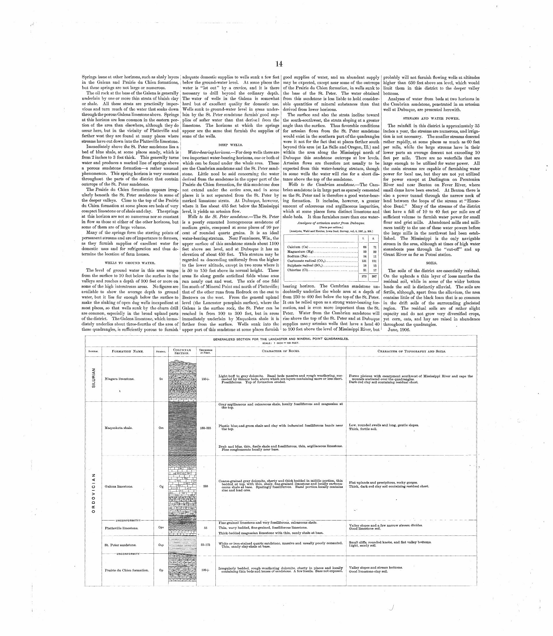
Springs issue at other horizons, such as shaly layers in the Galena and Prairie du Chien formations, but these springs are not large or numerous.
The oil rock at the base of the Galena is generally underlain by one or more thin strata of bluish clay or shale. All these strata are practically imper vious and turn much of the water that soaks down through the porous Galena limestone above. Springs at this horizon are less common in the eastern por tion of the area than elsewhere, although they do occur here, but in the vicinity of Platteville and farther west they are found at many places where streams have cut down into the Platteville limestone.
Immediately above the St. Peter sandstone lies a bed of blue shale, at some places sandy, which is from 2 inches to 3 feet thick. This generally turns water and produces a marked line of springs above a porous sandstone formation a rather unusual phenomenon. This spring horizon is very constant throughout the parts of the district that contain outcrops of the St. Peter sandstone.
The Prairie du Chien formation appears irreg ularly beneath the St. Peter sandstone in some of the deeper valleys. Close to the top of the Prairie du Chien formation at some places are beds of very compact limestone or of shale and clay. The springs at this horizon are not so numerous nor so constant in flow as those at either of the other horizons, but some of them are of large volume.
Many of the springs form the starting points of permanent streams and are of importance to farmers, as they furnish supplies of excellent water for domestic uses and for refrigeration and thus de termine the location of farm houses.
WELLS TO GROUND WATER.
The level of ground water in this area ranges from the surface to 10 feet below the surface in the valleys and reaches a depth of 100 feet or more on some of the high interstream areas. No figures are available to show the average depth to ground water, but it lies far enough below the surface to make the sinking of open dug wells inexpedient at most places, so that wells sunk by the churn drill are common, especially in the broad upland parts of the district. The Galena limestone, which imme diately underlies about three-fourths of the area of these quadrangles, is sufficiently porous to furnish
adequate domestic supplies to wells sunk a few feet below the ground-water level. At some places the water is "let out" by a crevice, and it is there necessary to drill beyond the ordinary depth. The water of wells in the Galena is somewhat hard but of excellent quality for domestic use. Wells sunk to ground-water level in areas under lain by the St. Peter sandstone furnish'good sup plies of softer water than that derived from the limestone. The horizons at which the springs appear are the same that furnish the supplies of some of the wells.
DEEP WELLS.
Water-bearing horizons. For deep wells there are two important water-bearing horizons, one or both of which can be found under the whole area. These are the Cambrian sandstone and the St. Peter sand stone. Little need be said concerning the water derived from the sandstone in the upper part of the Prairie du Chien formation, for this sandstone does not extend under the entire area, and in some places it is not separated from the St. Peter by marked limestone strata. At Dubuque, however, where it lies about 435 feet below the Mississippi level, it yields an artesian flow.
Wells to the St. Peter sandstone. The St. Peter is a poorly cemented homogeneous sandstone of medium grain, composed at some places of 99 per cent of rounded quartz grains. It is an ideal water-bearing stratum. Near Fennimore, Wis., the upper surface of this sandstone stands about 1100 feet above sea level, and at Dubuque it has an elevation of about 450 feet. This stratum may be regarded as descending uniformly from the higher to the lower altitude, except in two areas where it is 50 to 150 feet above its normal height. These areas lie along gentle anticlinal folds whose axes run nearly east and west. The axis of one fold lies south of Mineral Point and north of Platteville; that of the other runs from Kedrock on the east to Beetown on the west. From the general upland level (the Lancaster peneplain surface), where the Galena is the surface rock, the St. Peter can be reached in from 100 to 300 feet, but in areas immediately underlain by Maquoketa shale it is farther from the surface. Wells sunk into the upper part of this sandstone at some places furnish
good supplies of water, and an abundant supply may be expected, except near some of the outcrops of the Prairie du Chien formation, in wells sunk to the base of the St. Peter. The water obtained from this sandstone is less liable to hold consider able quantities of mineral substances than that derived from lower horizons.
The surface and also the strata incline toward the south-southwest, the strata sloping at a greater angle than the surface. Thus favorable conditions for artesian flows from the St. Peter sandstone would exist in the southern part of the quadrangles were it not for the fact that at places farther south beyond this area (at La Salle and Oregon, 111.) and within the area along the Mississippi north of Dubuque this sandstone outcrops at low levels. Artesian flows are therefore not usually to be expected from this water-bearing stratum, though in some wells the water will rise for a short dis tance above the top of the sandstone.
Wells to the Cambrian sandstone. The Cam brian sandstone is in large part as sparsely cemented as the St. Peter and is therefore a good water-bear ing formation. It includes, however, a greater amount of calcareous and argillaceous impurities, which at some places form distinct limestone and shale beds. It thus furnishes more than one water-
Analyses of artesian water from Dubuque.[Parts per million.]
[Analysts, Wahl and Henius, Iowa Geol. Survey, vol. 6,1897, p. 309.]
Magnesium (Mg) .............................
Sodium (Na) .................................
Carbonate radical (CO 3) .....................
Sulphate radical (SO 4) .......................Chlorine (Cl). ........................ ......
l.
66
22
14
1891
272
2.
71
22
111 «i
15
17
287
bearing horizon. The Cambrian sandstone un doubtedly underlies the whole area at a depth of from 230 to 400 feet below the top of the St. Peter. It can be relied upon as a strong water-bearing for mation, and is even more important than the St. Peter. Water from the Cambrian sandstone will rise above the top of the St. Peter and at Dubuque supplies many artesian wells that have a head 40 to 100 feet above the level of Mississippi Eiver, but
probably will not furnish flowing wells at altitudes higher than 650 feet above sea level, which would limit them in this district to the deeper valley bottoms.
Analyses of water from beds at two horizons in the Cambrian sandstone, penetrated in an artesian well at Dubuque, are presented herewith.
STREAMS AND WATER POWER.
The rainfall in this district is approximately 35 inches a year, the streams are numerous, and irriga tion is not necessary. The smaller streams descend rather rapidly, at some places as much as 60 feet per mile, while the large streams have in their lower parts an average descent not exceeding 10 feet per mile. There are no waterfalls that are large enough to be utilized for water power. All the main streams are capable of furnishing water power for local use, but they are not yet utilized for power except at Darlington on Pecatonica Eiver and near Benton on Fever River, where small dams have been erected. At Benton there is also a power tunnel through the narrow neck of land between the loops of the stream at "Horse shoe Bend." Many of the streams of the district that have a fall of 10 to 40 feet per mile are of sufficient volume to furnish water power for small flour and grist mills. Abandoned mills and mill- races testify to the use of these water powers before the large mills in the northwest had been estab lished. The Mississippi is the only navigable stream in the area, although at times of high water steamboats pass through the "cut-off" and up Grant Eiver as far as Potosi station.
SOILS.
The soils of the district are essentially residual. On the uplands a thin layer of loess mantles the residual soil, while in some of the wider bottom lands the soil is distinctly alluvial. The soils are fertile, although, apart from the alluvium, the area contains little of the black loam that is so common in the drift soils of the surrounding glaciated region. The residual soils are of rather slight capacity and do not grow very diversified crops, yet corn, oats, and hay are raised in abundance throughout the quadrangles.
June, 1906.
GENERALIZED SECTION FOR THE LANCASTER AND MINERAL POINT QUADRANGLES.
SCALE: 1 INCH = 100 FEET.
SYSTEM.
Z < DC D _JCO
FORMATION NAME.
Niagara limestone.
Maquoketa shale.
o>o a DC o
Galena limestone.
UNCONFORMITY?
Platteville limestone.
St. Peter sandstone.
UNCONFORMITY
Prairie du Chien formation.
SYMBOL. COLUMNAR SECTION.
Sn
Om
Opv
THICKNESS IN FEET.
150+
160-225
235
55
CHARACTER OF ROCKS.
Light-buff to gray dolomite. Basal beds massive and rough weathering, suc ceeded by thinner beds, above which are layers containing more or less chert. Fossiliferous. Top of formation eroded.
Gray argillaceous and calcareous shale, locally fossiliferous and magnesian at the top.
Plastic blue and green shale and clay with indurated fossiliferous bands near the top.
Drab and blue, thin, fissile shale and fossiliferous, thin, argillaceous limestone. Fine conglomerate locally near base.
Coarse-grained gray dolomite, cherty and thick bedded in middle portion, thin bedded at top, with thin, shaly, fine-grained limestone and locally carbona ceous shale at base. Sparingly fossiliferous. Basal portion locally contains zinc and lead ores.
Fine-grained limestone and very fossiliferous, calcareous shale. Thin, wavy-bedded, fine-grained, fossiliferous limestone.
Thick-bedded magnesian limestone with thin, sandy shale at base.
CHARACTER OF TOPOGRAPHY AND SOILS.
Forms plateau with escarpment southwest of Mississippi River and caps themounds scattered over the quadrangles.
Dark-red clay soil containing residual chert.
Low, rounded swells and long, gentle slopes. Thick, fertile soil.
Flat uplands and precipitous, rocky gorges. Thick, dark-red clay soil containing residual chert.
Valley slopes and a few narrow stream divides. Good limestone soil.
White or iron-stained quartz sandstone, massive and usually poorly cemented. Thin, sandy clay-shale at base.
Irregularly bedded, rough-weathering dolomite, cherty in places and locally containing thin beds and lenses of sandstone. A few fossils. Base not exposed.
Small cliffs, rounded knobs, and flat valley bottoms. Light, sandy soil.
Valley slopes and stream bottoms. Good limestone-clay soil.