The Alaska Mineral Resource Assessment Program:...
24
The Alaska Mineral Resource Assessment Program: Background Information to Accompany Geologic and Mineral-Resource Maps of the Cordova and Middleton Island Quadrangles, Southern Alaska By G.R. WINKLER, GEORGE PLAFKER, R.J. GOLDFARB, and J.E. CASE U.S. GEOLOGICAL SURVEY CIRCULAR 1 076
Transcript of The Alaska Mineral Resource Assessment Program:...
The Alaska Mineral Resource Assessment Program: Background Information to Accompany Geologic and Mineral-Resource Maps of the Cordova and Middleton Island Quadrangles, Southern Alaska
By G.R. WINKLER, GEORGE PLAFKER, R.J. GOLDFARB, and J.E. CASE
U.S. GEOLOGICAL SURVEY CIRCULAR 1 076

U.S. DEPARTMENT OF THE INTERIOR
MANUEL LUJAN, JR., Secretary
U.S. GEOLOGICAL SURVEY
Dallas L. Peck, Director
Any use of trade, product, or firm names in this publication is for descriptive purposes only and does not imply endorsement by the U.S. Government
UNITED STATES GOVERNMENT PRINTING OFFICE: 1992
For sale by the Books and Open-File Reports Section U.S. Geological Survey Federal Center Box 25425 Denver, CO 80225
Library of Congress Cataloging-in-Publication Data
The Alaska Mineral Resource Assessment Program : background information to accompany geologic and mineral-resource maps of the Cordova and Middleton Island quadrangles, southern Alaska / by G.R. Winkler ... [et al.].
p. cm.4U.S. Geological Survey circular; 1076) Includes bibliographical references. 1. Geology-Alaska-Prince William Sound Region. 2. Mines and mineral
resources-Alaska-Prince William Sound Region. 3. Alaska Mineral Resource Assessment Program. I. Winkler, Gary R. 11. Series. QE84.P7A53 1992 91 -38969 557.98'34~20 CIP

CONTENTS
Abstract 1 Introduction 1
Purpose and scope 1 Geography and access 1 Acknowledgments 4
Summary of mineral and energy production and exploration 4 Copper 4 Gold S Manganese 7 Uranium 8 Coal 8 Petroleum 8
Geologic investigations 9 Geologic and -tectonic summary 11 Geochemical investigations 13 Geophysical investigations 14 References cited 15
FIGURES
1. Location map of the Cordova and Middleton Island quadrangles 3 2. Generalized geologic map of the Cordova and Middleton Island quadrangles 6 3. Geologic terrane map of the northern Gulf of Alaska region, showing selected
faults and boundaries of I0x3" quadrangles 10
TABLE
1. List of geologic, geochemical, geophysical, and mineral-resource maps of the Cordova and Middleton Island quadrangles 2
Contents Ill


The Alaska Mineral Resource Assessment Program: Background Information to Accompany Geologic and Mineral-Resource Maps of the Cordova and Middleton lsland Quadrangles, Southern Alaska
B y G.R. Winkler, George Plafker, R.J. Goldfarb, and J.E. Case
Abstract INTRODUCTION
This report summarizes recent results of integrated geological, geochemical, and geophysical field and laboratory studies conducted by the U.S. Geological Survey in the Cordova and Middleton lsland 1 "x3O quadrangles of coastal southern Alaska. Published open-file reports and maps accom- panied by descriptive and interpretative texts, tables, diagrams, and pertinent references provide background information for a mineral-resource assessment of the two quadrangles.
Mines in the Cordova and Middleton lsland quadrangles produced copper and byproduct gold and silver in the first three decades of the 20th century. The quadrangles may contain potentially significant undiscovered resources of pre- cious and base metals (gold, silver, copper, zinc, and lead) in veins and massive sulfide deposits hosted by Cretaceous and Paleogene sedimentary and volcanic rocks. Resources of manganese also may be present in the Paleogene rocks; uranium resources may be present in Eocene granitic rocks; and placer gold may be present in beach sands near the mouth of the Copper River, in alluvial sands within the canyons of the Copper River, and in smaller alluvial deposits underlain by rocks of the Valdez Group. Significant coal resources are present in the Bering River area, but difficult access and structural complexities have discouraged development. Investi- gation of numerous oil and gas seeps near Katalla in the eastern part of the area led to the discovery of a small, shallow field from which oil was produced between 1902 and 1933. The field has been inactive since, and subsequent exploration and drilling onshore near Katalla in the 1960's and offshore near Middleton lsland on the outer continental shelf in the 1970's and 1980's was not successful.
Manuscript approved for publication September 6, 199 1.
Purpose and Scope
This ~ ~ p O R integrates and summarizes results of recent U.S. Geological Survey field and laboratory studies of the geologic setting of mineral and energy deposits in the Cordova and Middleton Island 1°x3" quadrangles in coastal southern Alaska. Geologic, geochemical, and geophysical investigations were conducted as part of the Alaska Mineral Resource Assessment Program (AMRAP) and the Mineral Resources of Public Lands (MRPL) investigations of the Chugach National Forest, which includes more than 90 percent of the land area of the two quadrangles. These multidisciplinary investigations were completed in 1988: however, they incorporate much fundamental geologic information that was obtained during the 1950 '~~ 1960's, and 1970's during studies of the Gulf of Alaska Tertiary province and the epicentral region of the 1964 Alaska earthquake. A list of maps and reports that refer specifically to the two quadrangles is in table 1. Other sources of information on the geology and mineral deposits of the quadrangles are cited in the text and listed in the accompanying references.
Geography and Access
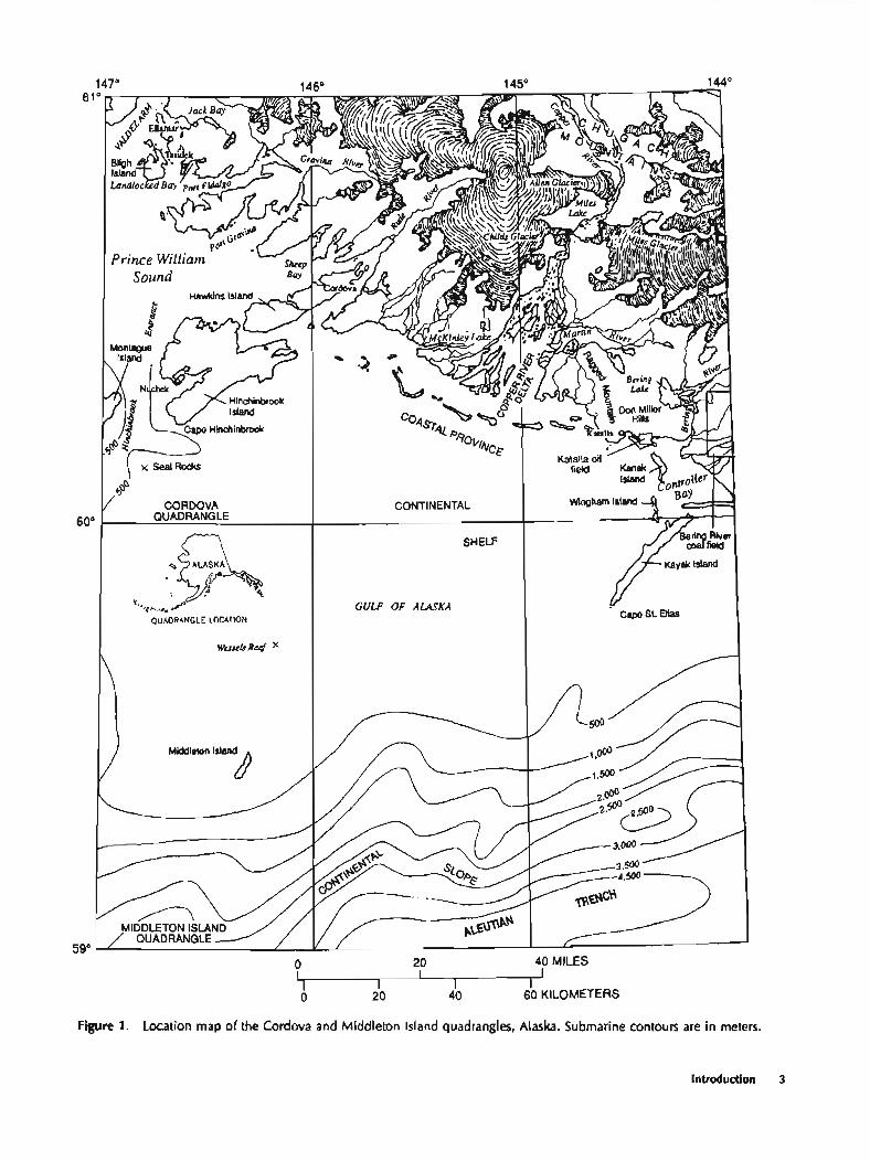
The Cordova and Middleton Island quadrangles include about 35,000 km2 (square kilometers) of southern Alaska along the continental margin (fig. 1). The quad- rangles are bounded by the 59" and 61" parallels and by the 144" and 147" meridians. The quadrangles include, from north to south, the rugged, glacier-clad, fiord-indented Chugach Mountains, part of the Pacific Border Ranges
Introduction 1

Table 1. list of geologic, geochemical, geophysical, and mineral-resource maps of the Cordova and Middleton Island quadrangles, Alaska
Authors Subject
U.S. Geological Survey (1979, 1988) . . . . . . . Aeromagnetic surveys.
Winkles and Plafker (1981, 1991) . . . . . . . . . Geolag.
Sutley and others (1986) . . . . . . . . . . . . . . . . Geochemical survey: analytical results and sample-locality maps.
Goldfarb and others (1989) . . . . , , . . . . . . . . Geochemical survey: maps and tabulations of areas with geochemical anomalies, particularly for gold and base metals.
Case and others (written comrnun., 1992) . . . Aeromagnetic map and interpretation.
Goldfarb and others (in p rw) . . . . . . . . . . . Mineral-resource assessment: tabulations of deposits and occurrences and maps of areas with potential for undiscovered resources of precious, base, and ferrous metals, uranium; coal; and petroleum.
physiographic province (Wahrhaftig. 1965); the more subdued ridges, plains, and islands of the ,Gulf of Alaska coastal province; the continental shelf with emergent areas at Seal Rocks, Wessels Reef, and Middleton Island; and, along the southern part of the Middleton Island quadrangle, the continental slope, which descends into the northeastern end of the Aleutian Trench, where water depths exceed 4,500 m.
The Copper River (fig. I), Alaska's third largest drainage, flows southward from the Copper River Basin across the Chugach Mountains through a series of deep canyons to emerge in the eastern part of the Cordova quadrangle, where its sediment load has been deposited as a large delta fringed by offshore sandbars. Several other major rivers, such as the Bering and Martin Rivers, originate in piedmont glaciers near the coast. AU of these rivers have large seasonal flows and carry enormous loads of sediment, which have been deposited as broad alluvial plains to form coastal forelands. Other large rivers originate in valley glaciers in the coastal mountains. The Rude and Gravina Rivers, among others, have partly filled deepwater fiords and created steep delta fronts where they meet tidewater in arms of Prince William Sound.
Topographic relief in the quadrangles exceeds 2,350 m (meters). Most ridges on the mainland are very steep sided, having been quarried by and submerged beneath glaciers until recently. During the seismic shaking of the 1964 Alaska Good Friday earthquake, many such overstwpned slopes failed and slid into tidewater, valley bottoms, or onto glaciers. Moving ice, water, and wind also are dynamic erosive prodksses throughout the quadrangles.
The coastline from Montague Island to Controller Bay (fig. 1) faces the tempestuous open waters of the Gulf of Alaska. Lighthouses at Cape Hinchinbrook and Cape St. Elias, which were manned stations until recently, are the
only facilities along this stretch of exposed coastline. The prominent pinnacles that make up Cape St. Elias were the first Alaskan landfall for the Russian-contracted Danish explorer Vitus Bering in 1741. Soon thereafter the abun- dance of fur-bearing marine mammals attracted Russian hunters and traders to the rich waters of Alaska. As animals were depleted first in the Aleutian Islands and then around Kodiak Island, the Russians migrated to hince William Sound. The Russian S.K. Zaikof entered Prince William Sound in a trading vessel in 1783, and Fort Konstantine was established at Nuchek on the west end of Hinchinbrook Island to guard one entrance to the fur-harvesting grounds. Nuchek was a Russian trading post from 1793 to 1848 and continued as a native settlement until the winter of 1929-30 (de Laguna, 1956). The early Russian name for Prince William Sound, Chugatskay Zaliv (Chugach Gulf), has been retained only in the name of the surrounding mountains, and few other Russian names have survived from this era. Waves of competitive exploration by English (Cook, Meares, Dixon, Portlock, Whidbey, and Vancouver) and Spanish (Arteaga, Martinez, and Fidalgo) mariners resulted in replacement with the names used on modem maps. Eastern Prince William Sound is somewhat protected from the full brunt of storms born in the Gulf of Alaska by the elevated ridges of Montague, Hinchinbrook, and Hawkins Islands (fig. l), which nearly enclose the sound on the south. Hinchinbrook Entrance between Montague and Hinchin- brook Islands provides the eastern access for deep-draft vessels to the sound; it is the route used by oil tankers to and from the marine facility at the southern end of the trans- Alaska pipdine near the head of Port Valdez.
Only two communities are in the quadrangles: Cor- dova (and several nearby fish canneries) (fig. I), with 2,053 permanent residents in 1990, and the native village of Tatitlek (population 108). Both can be reached only by sea
2 AMRAP: Codova and Middleton Island Quadrangles, Alaska
40 MILES
0, 0 20 40 60 KILOMETERS
Figure 1. Location map of the Cordova and Middletan Island quadrangles, Alaska. Submarine contours are in meters.
Introduction 3

or air transportation. Cordova has the only year-round harbor facilities in the map area. It is a port-ofcall for ferries on the Alaska Marine Highway system and is the base for a U.S. Coast Guard cutter and a large fleet of fishing vessels. Cordova is sewed by an dl-weather airport with daily jet service. Between 191 1 and 1938, the city was the terminus of the Copper River and Northwestern Railroad, which extended inland up the Copper River canyons 316 km to the bonanza copper mines at Kennicott in the southern Wrangell Mountains. More than 1.2 billion pounds of copper and 9 million troy ounces of silver from the Kennicott mines (Douglas, in MacKevett and others, 1977) were carried by the railroad to the Cordova shipping docks during 27 years of production. Most of the rails were salvaged for scrap metal during World War It, and the roadbed was graded and maintained for passenger vehicles as far as Allen Glacier. However, during the 1964 Alaska earthquake, one end of the northern span of the steel "Million-dollar Bridge" at the outlet of Miles Lake was jarred from its foundations and fell into the Copper River. The span has not been reset, and today it is possible to drive only to the south shore of the lake about 68 km northeast of Cordova. Other road access in the quadrangles is limited to a few kilometers of graded side roads around Cordova and from the airport to a campground and a view point near Sheridan Glacier.
The only other facilities in the quadrangles are U.S. Government communications facilities on Hinchinbrook and Middleton Islands, several private fishing and hunting cottages, and U.S. Forest Service public-use cabins on outlying islands in Prince William Sound and on the mainland east of Ragged Mountain. These facilities are accessible by boat or small plane only.
Acknowledgments
Many U.S. Geological Survey colleagues participated in the earth-science investigations of the Cordova and Middleton Island quadrangles that are summarized in this circular. We gratefully acknowledge their important scien- tific contributions, many of which are cited in the accom- panying list of references. We are indebted particularly to D.F. Barnes, J.A. Dumoulin, Andrew Griscom, T.L. Hudson, J.S. Lull, M.L. Miller, R.L. Morin, S.W. Nelson, W.J. Nokleberg, R.M. O'Leary, W.J. Pickthorn, S,M. Roeske, S.C, Smith, S.J. Sutley, R.B. Tripp, and R.G. Tysdal, who participated in geologic, geochemical, and geophysical studies in the quadrangles. The detailed geo- logic mapping and stratigraphic studies of D.J. Miller in the Katalla area provided an inspiration and a framework for our later studies. Miller's contributions are recognized by a range of hills on the north side of Controller Bay that is named in his honor. In addition, the Research Vessels Don J. Miller and Don J. Miller II, under the command of
Captains R.J. Stacey and A.C. Frothingham and Chief Engineer Ed Magalhaes, provided reliable and cheerful havens during many of our studies in Prince William Sound.
Hollis and Shirley Henrichs (deceased), long-time residents of Cordova, always provided warm hospitality and insightful views of the region's history and continuing development. U.S. Forest Service personnel of the Cordova Ranger District and U.S. Federal Aviation Administration personnel of the Cordova flight station provided frequent advice, logistical support, and use of remote facilities on Hinchinbrook and Middleton Islands. The pilots of Cordova Airlines. Chitina Air Service, and Parkair in Cordova provided competent and timely fixed-wing air support, many times under demanding conditions.
SUMMARY OF MINERAL AND ENERGY PRODUCTION AND EXPLORATION
Identified mineral and energy resources in the Cor- dova and Middleton Island quadrangles include deposits of copper (with or without zinc or silver), gold, manganese, coal, and petroleum. Approximately 22 million pounds of copper, 199,000 oz of silver, and 51,450 oz of gold were produced between 1900 and 1930 from mines in the Ellamar district in the northwest part of the Cordova quadrangle: recorded production from the Ellarnar mine alone exceeded 15.7 million pounds of copper, 51,300 oz of gold, and 191,600 oz of silver (Jansons and others, 1984). Zinc, minor lead, and anomalous cobalt values also were noted in the ore (Capps and Johnson, 1915), but no production was recorded. Sixteen ounces of gold reportedly were produced sometime before 1912 from the McKinley Lake district (Jansons and others, 1984). Eighteen thousand to 20.000 tons of coal were shipped from the Bering River field between 19 10 and 1920 (Janson. 1979). Approximately 154,000 barrels of oil were produced between 1902 and 1933 from a small abandoned field at Katalla (Miller, 1975; see fig. 1 for locations). No other mineral or energy commodities are known to have been produced from the quadrangles.
Copper
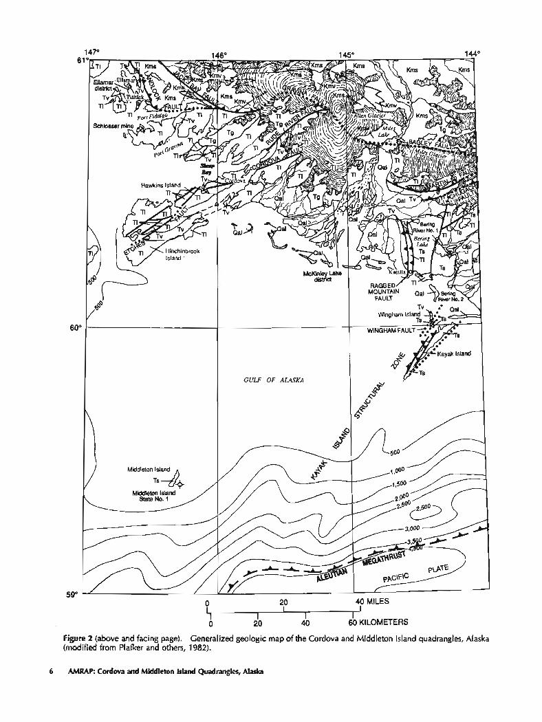
Large abandoned surface facilities near Ellamar. Landlocked Bay, and Port Fidalgo (fig. 1) attest to the importance of former copper mining in the Ellamar district. Numerous workings were developed along stratabound, massive ironcopper-zinc sulfide deposits hosted by rocks of the lower Tertiary Orca Group (Capps and Johnson, 1915; Wiltse, 1973; Winkler and others, 1977). The most productive deposits, such as those at the Ellarnar mine and the Schlosser mine south of Port Fidalgo ((fig. 2), were
4 AMRAP: Cordova and Middleton Island Quadrangles, Alaska

hosted by fine-grained sedimentary rocks. Pyrite, pyrrhotite, chalcopyrite, and sphalerite formed tabular masses, lenses, and stringers in nested layers that were conformable to bedding; arsenopyrite and tetrahedrite were present in minor or trace amounts. The Ellamar deposit was overlain by a pyritic cap 8-10 m thick. In a few locations, mafic volcanic rocks were intercalated with the mineralized shale and siltstone. Deposits that were hosted by volcanic rocks, such as deposits in Boulder and Landlocked Bays southeast of Ellamar, generally were much smaller than those hosted by sedimentary rocks, but some were higher grade. These deposits contained nested pyrite-chalcopyrite-pynhotite- sphalerite layers within pillow breccia or aquagene tuff and lenses of sulfide minerals enclosed between flows and tuff or sediment. Cubanite and galena were found locally as late-stage sulfide mineral phases in volcanic rock-hosted deposits. Some deposits are underlain by heavily oxidized or silicified boxwork zones (S.W. Nelson, U.S. Geolog- ical Survey, written commun., 1990). Apparently. most deposits were syngenetic and formed in areas fringing local centers of mafic submarine volcanism. However, in many places, the sulfide minerals were remobilized along cross- cutting faults, probably during regional deformation and metamorphism.
Copper production ceased about 1930, but significant resources remain in and adjacent to mined properties in the Ellarnar district, and a caretaker still lives at the Ellarnar mine townsite. Jansons and others (1984) inferred approxi- mately 2 million tons of reserves with grades between 0.3 and 7.9 percent copper in deposits hosted by volcanic rocks in the Ellamar district, and approximately 750,000 tons with grades between 0.6 and 3.2 percent in deposits hosted by sedimentary rocks. However, active exploration and eval- uation programs for massive sulfide deposits by several companies in the late 1970's failed to locate economically viable deposits, and there has been little subsequent interest.
Metavolcanic and rnetasedimentary rocks of the Cretaceous Valdez Group (fig. 2) are hosts to stratabound iron-copper-zinc sulfide mineral deposits in adjacent parts of the Valdez quadrangle to the north, such as at Solomon and Sulphide Gulches (Johnson, 1919; Mofit and Fellows. 1950; Winkler, Miller, and others, 1981; Nelson and Koski, 1987). The Midas mine in Solomon Gulch produced approxi- mately 3.4 million pounds of copper between 1912 and 1930 from a tabular layer of nearly massive pyrite, chalco- pyrite, and sphalerite 6 1 0 m thick. This layer was not mined out completely but is exposed in underground workings with a minimum strike length of about 225 m and a downdip extension of at least 120 m (S.W. Nelson, written commun.. 1990 ). Disseminated sulfide minerals are present in rocks of the Valdez Group in many places in the Cordova quadrangle, particularly in and near diabase dikes asso- ciated with pillowed greenstone. Oxidation of the sulfide minerals, especially pyrite, causes these rocks to weather
rusty brown. Despite extensive exploration during the more than two decades that copper mines in the area were pruducing, no &posits comparable to those at the Midas mine were discovered.
Geologic environments favorable for formation of volcanogenic massive sulfide deposits are widespread in the Cordova quadrangle, and the likelihood is high that undis- covered resources of copper (and associated zinc, lead, silver, and gold) exist in rocks of the Orca and Valdez Groups (Nelson and others, 1984; Bliss, 1989; Goldfarb and others, in press). Using grade-tonnage models for Cyprus (volcanic rock-hosted) and Besshi (sedimentary rock- hosted) massive-sulfide deposit types, Bliss (1989) prepared a probabilistic quantitative assessment of contained metal values for favorable tracts in the Chugach National Forest. The tracts include approximately one-third of the onshore area of the Cordova quadrangle.
Cold
In the McKinley Lake district, 32 krn southeast of Cordova, sedimentary rocks of the Orca Group host quartz veins that bear minor gold, pyrite, and arsenopyrite (Chapin, 19 13). Prospecting and development occurred mainly before 1920, but sporadic work continued until World War I1 (Haney and Jansons, 1987). The principal mineralized veins form networks approximately parallel to bedding in the enclosing rocks, and they generally are at contacts between sandstone and shale where the sandstone has been bmciated extensively. Discordant quartz veins also have minor gold values, even where free gold is not visible. Eocene intrusive rocks near the prospects are virtually unmineralized (Haney and Jansons. 1987). Several adits totaling at least 775 m in length were excavated, but reported gold production was virtually nil; lode claims active in the area in 1983 revealed no zones with economic grades (Haney and Jansons. 1987).
In sedimentary rocks of the Orca Group north of Port Fidalgo (fig. l), stockworks of gold-bearing quartz veins were worked at Graveyard Point on the north side of Port Fidalgo and at two places on Bligh Island in the early 1900's (Capps and Johnson, 1915). No production was reported. The U.S. Bureau of Mines (1973) reported a lode-gold prospect in mafic volcanic rocks of the Orca Group at the north end of Wingharn Island. No other lode-gold occurrences are known in rocks of the Orca Group in the Cordova and Middleton Island quadrangles. However, quartz veins are scattered through much of the Orca Group, particularly near granitic stocks that may have provided heat or fluids during the formation of quartz veins. Goldfarb and others (1989) reported anomalous gold and silver values and microscopically visible gold grains from heavy-mineral concentrate samples collected in areas underlain by the Orca Group near the headwaters of the Rude River.
Summary of Mineral and Energy Production and Exploration 5
I 1 I I I I
0 20 40 60 KILOMETERS
Figure 2 (above and facing page). Generalized geologic map of the Cordava and Middleton Island quadrangles, Alaska (modified from Plafker and others, 1982).
6 AMRAP: Cordova and Middleton Island Quadrangles, Alaska

EXPLANATION
Qal Quaternary alluvinl deposits
Ts Upper and middle Tertiary sedimentary and volcanic rucks- As mapped, includes Pleistocene deposits on Middleton Island
Tg Tertiary granitic rocks
TI Lower lkrtiary sedimentary meks
TV Lower Tertiary volcanic rocks
Kms Cretaceous metaPedimentnry mckcVddez Group (part)
Kmv Cretacmus metavolcanic m k e V a l d e z Group (pan)
Conlac-Dashed where concealed
Steep fault-Dotted where concealed
L L L Thrust fault-Dashed or dotted where wmealed
a Drill hole
Quartz veins bearing anomalous amounts of gold, lead, zinc, silver, antimony, and arsenic are localized in slate, argillite, and graywacke of the Valdez Group in the Port Valdez area, 20 km north of the map area. In the heavily glaciated northern part of the Cordova quadrangle west of Copper River, quartz veins and stringers are widely dispersed within metasedimentary rocks of the Valdez Group, but they have not been explored extensively. Quartz stringers and veins, generally less than 1 m thick, have been prospected in the Jack Bay area near the northwest edge of the Cordova quadrangle (Johnson, 1919). No records of metal production exist for this area, and assays of recently collected samples showed no significant gold values (Jan- sons and others, 1984).
Fluid-inclusion and stable-isotope data from precious metal-bearing quartz veins throughout the Valdez Group indicate that they formed from low-salinity fluids at tem- peratures and pressures exceeding 210 O C and 1 kilobar, respectively (Goldfarb and others, 1986). The isotopic data indicate ore-fluid genesis by devolatilization reactions during regional metamorphism, which affected much of the northern part of the Cordova quadrangle. Thus, favorable geologic conditions are widespread, and the likelihood is high that undiscovered resources of gold (and byproduct silver) exist, particularly in small, high-grade lodes in rocks of the Valdez Group (Nelson and others, 1984; Bliss, 1989; Goldfarb and others, in press). Based on production data from known deposits in the Chugach National Forest, Bliss (1989) developed a grade-tonnage model for precious metal-bearing metamorphic quartz veins and prepared a probabilistic quantitative assessment of contained gold and silver values for favorable tracts. The tracts include approxi- mately one-fifth of the onshore area of the Cordova quadrangle.
No gold is known to have been recovered from placer sources in the northern Cordova quadrangle, even though the area is underlain by rocks of the Valdez Group con- taining abundant metamorphic quartz veins. Much of this region has steep topography and active alpine glaciers. Although anomalous gold was detected in many panned concentrates from this area (Goldfarb and others, 1989), most samples were derived from fluvioglacial material. Inasmuch as glaciation generally either destroys pre- existing placers or dilures them below economic grade, the potential for resources of gold in placers is thought to be low (Goldfarb and others, in press).
Concentrations of heavy minerals, including gold, were found in sands sampled from offshore beach bars of the Copper River Delta (Reimnitz and Plafker, 1976). Although gold concentrations were only 0.25 ppm (parts per million) in the highest grade samples, the large volume of easily accessible sand in the Copper River barrier beaches may warrant additional evaluation of gold values.
Jansons and others (1984) noted trace amounts of gold (0.004-0.005 ounces per cubic yard) in alluvial sand at numerous sites along the Copper River. Aeromagnetic highs along the Copper River have been attributed to mas of probable black-sand accumulations that also are likely to contain placer gold (Case and others, written commun., 1992). The large volume of accessible material constitutes a potential resource that should be evaluated further.
Beach sand collected by Eyles (1990) between Icy Bay and Cape Yakataga, 150 km east of the Cordova and Middleton Island quadrangles, contained as much as 37 ppm Au. Eyles suggested that the placer gold was derived from the lower part of the Yakataga Formation. However, beach-sand samples collected in the Cordova and Middleton Island quadrangles from areas underlain by the lower part of the Yakataga Formation contained only background values of 1&20 ppb (parts per billion) or less Au (Reirnnitz and Plafker, 1976; Goldfarb and others, 1984, Sutley and others, 1986).
Manganese
Goodfellow and others (1984) described a newly discovered deposit of nodular manganese that occurs in iron-stained mudstone intercalated with volcanic rocks of the Orca Group on Hinchinbrook Island. Rocks of the Orca Group host another small deposit in the Seward quadrangle in western Prince William Sound (Kurtak, 1982). These are the only occurrences that are known in the region, although potentially favorable intercalated pelitic and volcanic host rocks are widespread in both the Valdez and Orca Groups in the Cordova quadrangle. Sediment and heavy-mineral- concentrate samples throughout the Gravina River watershed are strongly anomalous in manganese (Goldfarb and others, 1989); the area is mainly underlain by
Summary of Mineral and Energy Production and Exploration 7

mctasedimentary rocks of the Valdez Group, but the source of the extensive anomalies is presently unknown. At the occurrence on Hinchinbrook Island, grab samples from an area of rubbly outcrop about 10 by 30 m in extent averaged about 30 percent Mn. Although no volcanogenic sulfide deposits are known to crop out in the vicinity of this deposit, Goodfellow and others (1984) believed that the mineralogy of the occurrence indicated submarine volcanogenic hot springs as a likely source. By assuming that the occurrences are analogous to small-volume, low-tonnage volcanogenic manganese deposits of the Olympic Peninsula in Washington, Bliss (1989) prepared a quantitative assess- ment of potential undiscovered resources of manganese in the Chugach National Forest, including areas of low" potential on Hinchinbrook and Hawkins Islands and east of Cordova.
Uranium
A National Uranium Resource Evaluation (NLJRE) reconnaissance airborne gamma-ray survey of the Cordova quadrangle indicated that a uranium anomaly existed just north of Sheep Bay (U.S. Department of Energy, 1978) where a large granodioritic pluton intrudes sedimentary and volcanic rocks of the Orca Group. Dickinson and Morrone (1982) evaluated several anomalies in the NURE data for the quadrangle, and they found that they resulted from radiometric contrasts between mafic volcanic, sedimentary, and plutonic rocks, and icefields. NURE sediment samples from streams draining the Sheep Bay pluton contained 6- 35 ppm U, and some had uranium-thorium ratios greater than 1 (D'Andrea, 1981). U.S, Geological Survey heavy- mineral-concentrate samples collected from around the pluton contained monazite and thorite and were strongly anomalous in bismuth, lanthanum, niobium, tin, tungsten, yttrium, and thorium, anomalies that indicate a high degree of differentiation of the pluton (Goldfarb and others, 1989). Scintillometer readings as high as 375 counts per second were taken over some outcrops of the pluton, and samples of the more radioactive outcrops assayed as high as 8 ppm U. The anomalous uranium content of the Sheep Bay pluton indicates a low potential for resources of uranium (Goldfarb and others, in press).
The Bering River coal field (fig. 1) was discovered in 1896, and practically the entire 180-km2 field northeast of Bering Lake was covered by coal claims by 1905 (Bames, 1951). The first extensive study of the area was by Martin (1908). who prepared a geologic map and measured and sampled many of the coal beds. The numerous coal beds, which are contained entirely in the Kulthieth Formation,
8 AMRAP: Cordova and Middleton Island Quadrangles, Alaska
range from low-volatile bituminous to anthracite in rank and include some cod of coking quality (Martin, 1908; Bames, 1951, 1967). Evaluations prior to 1920 focused on potential use as fuel in steamships, and there may have been minor shipments during this time (Janson. 1979). These early investigations were hindered by outcrops that were isolated by heavy soil and vegetation; nonetheless, the studies were adequate to indicate that the coal beds change markedly in thickness within short distances and have measured thick- nesses ranging from several centimeters to 19 m. The coal is strongly crushed and sheared, and the thicker beds have podlike shapes due to extreme structural deformation. Hypothetical resources of 3.6 billion tons have been estimated for the field (Sanders, 1975), which includes the Carbon Mountain area just east of the Cordova quadrangle. An extensive drilling program conducted by an industry- native corporation partnership in the early 1980's tested the economic potential of the coal in the Carbon Mountain area (Nelson and others, 1984). No production has ensued. The major obstacles to development in the Bering Lake area include complex structure of the coal-bearing strata, the presence of gas and abundant water underground, the lack of a deep-water port, and the difficulties in developing coal mines and shipping facilities in a remote and environ- mentally sensitive area.
Petroleum
Oil and gas seeps were discovered east of Katalla about 1896, and active onshore exploration for petroleum began soon thereafter in Tertiary rocks of the northern Gulf of Alaska region (Martin, 1908, 1921; Plafker, 1967, 1971, 1987; Plafker and others, 1975). A small field was developed near the seeps. From 1902 through 1933, the Katalla field (fig. 1) produced about 153.992 barrels of paraff~n-base crude oil from 18 shallow wells that tapped fracture porosity in the Poul Creek Formation (Miller, 1975). Numerous oil seeps have been noted in the Don Miller Hills, east of the Bering River, and west of Ragged Mountain (fig. 1); several gas seeps have been located along the south edge of Bering Lake (Miller, 1961, 1975: Tysdal and others, 1976a). In addition & the petroleum seepages on the mainland, one seep of live light, low-sulfur, pmn- base oil occurs in the Tokun Formation at the south end of Wingham Island (Plafker, 1987), Probably much or all of the petroleum was generated in deeply buried Eocene strata (Plafker and Claypool, 1979; Plafker, 1987). Twenty-five wells and core holes were drilled and abandoned onshore between 1954 and 1963, including two in the Katalla area. The Richfield Oil Corporation Bering River No. 1 well at Bering Lake (fig. 2) penetrated 1,882 m of the Tokun Formation and Kulthieth(?) Formation; the Bering River No. 2 well at Bering River was drilled to 1,835 m in the Poul Creek Formation and Tokun(?) Formation (Rau and

others, 1983). One offshore well was drilled and abandoned in 1969 on state lands near Middleton Island. The Tenneco Middleton Island State No. 1 well, which penetrated 3,658 m of strata correlative with the Yakataga, Poul Creek, and Tokun Formations, bottomed in strata of Eocene age (Rau and others. 1983; A.D. Warren, ARC0 Alaska, Inc., written commun., 1990). During 1975-78, 1 stratigraphic test and 10 wildcat wells that penetrated correlative rocks in tracts in Outer Continental Shelf Lease Sale No. 39 east of the Cordova and Middleton Island quadrangles were drilled and abandoned. The onshore and offshore wells did not discover economically recoverable petroleum due to a general lack of permeable reservoir rocks and, in the area of the Katalla wells, to structural complexity at depth. The Tertiary sequence on the Middleton Island shelf (west of the Chugach-Ragged Mountain-Wingham fault system, fig. 2) also apparently lacks suitable source rocks. To the east of this fault system, potential source and sandstone reservoir beds are found in thermally mature Eocene strata, which generally occur at depths exceeding 4,500 m (Plafker, 1987). The major exploration problem is to find, in this structurally complex part of the Tertiary basin, suitable traps that have the Eocene section at economically producible depths.
GEOLOGIC INVESTIGATIONS
Field studies by U.S. Geological Survey personnel have been carried out intermittently in the Cordova and Middleton Island quadrangles from 1898 to the present time. The earliest geologic reconnaissance in eastern Prince William Sound was carried out by Schrader (1900), who distinguished two major rock units of regional extent, the Valdez and Orca Groups, and visited the copper prospects at Landlocked Bay and Ellarnar (fig. 1). The first decade of geologic investigations throughout the sound was sum- marized by Grant and Higgins (1910). During the same period, the geology and mineral resources of the Controller Bay region were investigated by Martin (1908), who was the first to evaluate petroleum and coal occumnces in coastal southern Alaska. As copper mining was underway in northeastern Prince William Sound, detailed studies of the geologic settings for the deposits were conducted by Capps and Johnson (1913) in the Ellamar district and by Johnson (1919) in the Jack Bay area, a detailed geologic map of the Ellarnar area was published (Capps and Johnson, 1915), and annual updates on mining in Prince William Sound were prepared by Johnson from 1913 to 1917. Additional investigations by Johnson and F.H. Mofit from 1923 to 1925 and by Mofit and R.E. Fellows in 1943 were summarized in Moffit and Fellows (1950) and Moffit (1954), which added substantial new information about the mines and prospects and the areal geology, respectively, throughout Prince William Sound. Continuing stratigraphic
studies in the coastal Tertiary sequences were conducted during these years (Taliaferro, 1932), but there was a general lull in geologic investigations in the region as the focus of Alaskan investigations shifted elsewhere.
U.S. Geological Survey investigations were renewed in the Cordova and Middleton Island quadrangles in the late 1950's with the beginning of a regional study of the Gulf of Alaska Tertiary province. Detailed studies in the southern Katalla area (Miller, 1961, 1975; Kachadoorian, 1960), and on Kayak and Wingham Islands (Plafker, 1974) provided part of the foundation for subsequent regional syntheses (Plafker, 1967, 1971, 1987).
In response to the 1964 Alaska earthquake, earth- science studies in southern Alaska, particularly in the epicentral region of Prince William Sound, were accelerated greatly. Evaluations of the aftereffects of such an extreme tectonic event included numerous detailed studies in the Cordova and Middleton Island quadrangles, most notably in the Sheridan Glacier area (Plafker, 1968), as well as regional syntheses (for example, Case and others, 1966; Plafker, 1969). The potential earthquake hazards posed by activity on major faults in the region soon became a focus and led to detailed studies of the Hinchinbrook Island (Winkler, 1973) and Ragged Mountain areas in the quad- rangles (Tysdal and others, 1976a. 1976b). as well as regional studies of major fault systems (for example. Plafker and others, 1977, 1986). Paleoseismologic studies were carried out in coastal areas, most notably at Middleton Island and the Copper River Delta, to determine the recurrence times for previous great earthquakes comparable to the 1964 earthquake (Plafker, 1969; Plafker and Rubin. 1978; Plafker and others, 1991).
In the early 1970% the U.S, Geological Survey initiated studies of submarine geology and hazards related to petroleum exploration on the outer continental shelf in the eastern Gulf of Alaska. These studies, which supported Federal preparations for leasing tracts in the offshore region, yielded abundant new data in areas for which little information had been published previously. During marine geophysical and dredging cruises (Plafker and others, 1975; Bayer and others, 1978; Plaiker and others, 1979,1980), the stratigraphic sequences and structure of the submerged continental margin were confirmed to differ dramatically west and east of Kayak Island. Two features are most significant for inferences of petroleum potential: (1) the presence of thousands of meters of Neogene strata deformed by growth anticlines above the prospective sequences, and (2) structural segmentation of an accreting continental fragment (the Yakutat terrane) by oblique underthrusting at the continental margin (Plafker and others. 1978; Bruns, 1979, 1985; Bruns and Plafker, 1982; Plafker, 1987).
During the middle and late 1970's, the U.S. Geological Survey conducted interdisciplinary mineral- resource assessments of adjacent 1°x3' quadrangles-the Seward and Blying Sound quadrangles on the west (Tysdal,
Geologic Investigations 9

EXPLANATION
Cenuzoic valcank m k s S t a r shows andesitic volcanoes
Terranea
Prince William
Chugach
Alexander
Ghost Rocks
Fault-Dashed where approximately located, dolted where conceded, queried whcrc inferred - Thrust--Sawteeth on upper plate
& Strike s l i p A m w s indicate relative horizontal motion Oblique t h ~ s t S a w t e e r h on upper plate. arrows indicate
relshve horizontal motion BRFS Border Ranges fault system CFS Contact fault system AM Aleutian megathrust
CSFS Chugach-StElias fault system
RMF Rugged Mountain fault
WF Wingham fault
KIZ Kayak Island zone
Undifferentiated PZ Pamplona zone
Figure 3. Geologic terranes of the northern Gulf of Alaska region, showing selected faults and boundaries of l0x3" quadrangles (modified from Plaker, 1987). Names of quadrangles are: A, Anchorage; BC, Bering Glacier; BS, Blying Sound; C, Cordova; 16, Icy Bay; M, McCarthy; MI, Middleton Island; S, Seward; V, Valdez.
1978; Tysdal and Case, 1979, 1982), and the Valdez In the early 1980's, a regional study of the potential quadrangle (Winkler, Miller, and others, 198 1; Winkler, for undiscovered mineral resources in the Chugach National Silberman, and others, 1981) on the north (fig. 3). These Forest was completed (Nelson and others, 1984). Parts of an investigations provided detailed information on the geology existing preliminary geologic map of the Cordova and and mineral resources of the Chugach and Prince William Middleton Island quadrangles (Winkler and Plafker, 1981) terranes, which extend directly into the Cordova and Mid- were revised significantly during the regional study and dleton Island quadrangles. were incorporated in a new map of the entire national forest
10 AMRAP: Cordova and Middleton Island Quadrangles, Alaska
(Nelson and others, 1985). A geochemical survey of the forest was completed (Goldfarb and others, 1984), and maps were produced that showed distribution of suites of anom- alous elements (Goldfarb and Smith, 1987) and selected metallic minerals (Tripp and others, 1985; Goldfarb and Tripp, 1985; Goldfatb and others, 1985). Additional gravity data were collected in many places in the forest, and a summary gravity contour map and interpretatiorl of the data were prepared (Barnes and Morin, 1990). During this field work, a small manganese deposit was discovered on Hinchinbrook Island (Goodfellow and others, 1984). Sub- sequently, a quantitative assessment of potential endow- ment of precious, base, and ferrous metals for selected mineral-deposit types throughout the forest was prepared (Bliss. 1989).
For the recent Alaska Mineral Resource Assessment Program (AMRAP) investigations, a revised geologic map of the Cordova and Middleton Island quadrangles was prepared (Winkler and Plafker, in press); a geochemical survey was completed (Sutley and others, 1986), and areas geochemically favorable for metallic mineral resources were delineated (Goldfarb and others, 1989); an interpre- tation of aeromagnetic data for the quadrangles was completed (Case and others, written cornrnun., 1992) ; and summary maps were prepared that define areas, based on geological, geochemical, and geophysical characteristics and mineral-deposit models, that are favorable for the occurrence of specific types of mineral resources (Goldfarb and others, in press).
In the mid-1980's, multidisciplinary geophysical investigations of the deep crustal structure of southern Alaska were conducted along the southern part of the Trans-Alaska Crustal Transect (TACT). Detailed surface geologic studies were carried out in support of the geophys- ical studies, including mapping of six 15-minute quad- rangles in the Cordova 1°x3' quadrangle (George Plafker, and J.S. Lull, U.S. Geological Survey, written commun.. 1990) and a variety of detailed structural, geochemical, and isotopic studies near the transect. Geological and structural interpretations of terranes that extend into the quadrangles have been reported by Plafker and others (1989) and Nokleberg and others (1989). Within and near the Cordova and Middleton Island quadrangles, recent TACT reports include: (1) paleomagnetic studies of volcanic sequences at Galena Bay just north of the Cordova quadrangle (Plumley and Plafker, 1985) and near Wingham Island (P.W. Plum- ley, written comrnun., 1990), and (2) a study of the Contact fault system that separates the Chugach and Prince William terranes (Plafker and others, 1986). Additional reports are being prepared on anatectic granites in the Cordova quadrangle west of the Copper River (Fred Barker, U.S. Geological Survey, written commun., 1990) and on geo- chemical and isotopic evidence for the provenance of the Orca and Valdez Groups (G.L. Fanner, University of Colorado, written commun., 1990).
GEOLOGIC AND TECTONIC SUMMARY
The Cordova-Middleton Island region (Winkler and Plafker, in press) consists of three distinctive fault-bounded terranes (figs. 2, 31, the Chugach, Prince William, and Yakutat t e m e s (Junes and others, 1987). From north to south, these terranes become progressively younger and less severely deformed and metamorphosed (Plafker, 1969, 1971, 1987).
The oldest (Chugach) terrane, in the northern part of the Cordova quadrangle, is underlain by the Upper Cretaceous Valdez Group and is considered to be part of the Chugach terrane as defined by Berg and others (1972). The Valdez Group (units Kms and Kmv, fig. 2) consists chiefly of fault-bounded wedges of volcanogenic flysch and sub- ordinate tholeiitic basalt; one occurrence of ultramafic rocks is known near the head of Port Fidalgo (Nelson and others. 1985). The Valdez Group is regionally metamorphosed to lower greenschist facies. The rocks are foliated, tightly folded, and commonly overturned toward the south, and are imbricated along numerous steeply dipping faults.
The metamorphic grade of the Valdez Group increases to the east, where the rocks grade into a belt of schist, gneiss, and migrnatite that extends eastward across the adjacent Bering Glacier quadrangle to the Canadian border. Typical granoblastic textures and the superimpo- sition of progressive metamorphism across regional struc- tural trends indicate that much of the arnphibolite-facies metamorphism of the Valdez Group occurred after it was deformed against and accreted to the continental margin (Hudson and Plafker, 1982). These high-grade metamorphic rocks represent deeply buried parts of the accretionary prism, and their development is believed to be spatially and genetically related to emplacement of early Eocene ana- tectic granitic plutons (Hudson and others, 1979).
No valid paleomagnetic data exist for the Chugach terrane. Although variable amounts of northward translation have been proposed for the Chugach terrane (Grommk and Hillhouse, 1981; Stone and Packer, 1979; Stone and others, 1982), all previous determinations of paleolatitudes may be challenged on the basis of unresolved structural problems. Three characteristics of the Chugach terrane make long- distance translation improbable; instead, they indicate a probable linkage with the adjacent continental margin of southern and southeastern Alaska and British Columbia. First, the volume and provenance of flysch that makes up the bulk of the Chugach terrane suggest derivation from an active westward-facing Andean-type magmatic arc that Plafker and others (1989) have informally named the Kluane arc. Second, the lateral extent of the flysch in the region aligns approximately with this discontinuously exposed landward belt of coeval inferred magmatic arc rocks that extends from the central Alaska Range southeastward through the Coast crystalline complex into British Columbia (Monger and others, 1982). Third,
Geologic and Tectonic Summary 11

scdimentologic and isotopic data indicate that a major part of the Chugach flysch came from the region of southeastern Alaska and British Columbia and was transported north- westward along the continental margin (Hollister, 1979; Zuffa and others, 1980; Dumoulin, 1987). Although alter- native sediment sources for the Chugach flysch are possible, they require improbably large and rapid strikeslip move- ment of the terrane from these sources; this movement would have imposed tectonic effects and histories on the southern Alaska margin that have not been observed.
A major change in plate motions in the Eocene resulted in northwestward movement of the Pacific oceanic crust relative to the Alaska continental margin. Also about this time, counterclockwise oroclinal bending of western Alaska occurred along a main axis in the eastern part of Prince William Sound (Carey, 1958; Plafker, 1969). As a result of these relative plate movements, ensimatic deep-sea fan deposits and intercalated tholeiitic basalt of late Paleo- cene and Eocene age, which make up the Orca Group of the Prince William terrane, were accreted, principally along the western limb of the oroclinal bend where they form a belt that is more than 110 km wide from southeast of Hinchin- brook Island to northwest of Valdez Arm. The combination of northwest-southeast compression during accretion and east-west compression due to virtually simultaneous oro- clinal bending resulted in the complex deformation of the Orca Group, particularly in the eastern part of the Cordova quadrangle. An analysis of the variable &formational styles in the Orca Group is presented by Winkler and Plafker (in press).
In the Cordova and Middleton Island quadrangles, Orca sedimentary rocks apparently do not retain mag- netization of syndepositional origin, which has made the determination of original paleolatitudes difficult (Hillhouse and Grommk, 1985). However, preliminary paleolatitudes from 13°-180f120-200 N have been determined from pillow-basalt sequences at Galena Bay and near Wingham and Whale Islands (Plumley and Plafker, 1985; P.W. Plumley, written commun., 1990); these determinations indicate possible large northward movement of at least these parts of the Orca Group relative to cratonic North America.
The Contact fault system (fig. 3) separates the Chu- gach terrane from the Prince William terrane (Plafker and others, 1977: Plafker and others. 1986). The system is a major early Tertiary terrane boundary that extends from near Mount Saint Elias, 170 krn east of the Cordova and Middleton Island quadrangles, to Kodiak Island. In the Cordova quadrangle (fig. 2), the Contact fault system consists of northward-dipping reverse faults-the Bagley, Gravina, and Landlock segments. Each of these fault segments has distinctive characteristics that may reflect some post-Orca oroclinal bending of an initially more linear structure (Winkler and Plafker. in press). The various
segments were discussed in more detail by Plafker and Lanphere (1974), Winkler and Plafier (1975), Winkler and others (1981). and Plafker and others (1986). Accretion of the Orca Group south of the Contact fault system was accompanied by intense folding and faulting in both Valdez and Orca rocks, resulting in parallel structures in both groups adjacent to parts of the fault system, Along the TACT corridor, the Contact fault marks an abrupt change in deep crustal structure (Fuis and Plafker, 1991).
Successive accretionary wedges within the Orca Group may be bounded by major northeast-trending splays from the Contact fault system, including the Martin, Rude River, Cordova, and Etches faults (fig. 2). Tysdal and Case (1979) and Helwig and Emmet (1981) described com- parable fault-bounded belts within the Orca Group in western Prince William Sound.
Anatectic granitic plutons of early Eocene age were emplaced within both the Orca and Valdez rocks shortly after the major phase of early Tertiary accretion, defor- mation, and metamorphism (Hudson and others, 1979). Tectonic and isotopic models attribute the heat for melting the accretionary prism to subduction of a magmatically active Kula oceanic plate beneath the continental margin. Plausible alternative explanations for specific sources of heat include oceanic islands or seamounts (Winkler, 1976), a triple junction (Marshak and Karig (1977), a leaky transform (Tysdal and others, 1977). thermal surge with change in subduction regime (Hudson and others, 1979), opening of a mantle window during ridge subduction (Plafker and others, 1989), or subduction of a very young, still-hot oceanic slab (Sisson and others, 1989). Inasmuch as at least thret types of basalt occur in the accretionary prism (Lull and Plafker, 1990; S.W. Nelson, U.S. Geological Survey, written commun., 1990), a combination of magmat- ically active settings may be responsible.
The Orca Group is bounded on the south and east by the Chugach, Raggsd Mountain, and Wingham faults (figs. 2, 3), which delineate the west margin of the Yakutat terrane. The faults juxtapose an upper plate of older, more competent, prehnite-pumpellyite facies metamorphic rocks of the Orca Group and a lower plate of unrnetarnorphosed bedded Tertiary rocks of the Yakutat terrane (fig. 3).
The Yakutat terrane is allochthonous with respect to the Orca Gmup (Plafker and others, 1975: Lahr and Plaflcer, 1980; Bruns and Plafker, 1982; Plaflrer, 1987). West of the Chugach-Ragged Mountain-Wingham fault system, the base- ment is composed largely, if not entirely, of the Orca Group and associated plutonic rocks (Plafker and others, 1982). whereas to the east, the basement is probably oceanic crust (Bayer and others, 1978). To the west, pre-Miocene bedded rocks above the Orca are exposed only on Wessels Reef and were penetrated in the Middleton Island State No. 1 well near Middleton Island. The Paleogene rocks have not been studied thoroughly, but they differ lithologically and paleontologically from coeval sequences east of the
12 AMRAP: Cordova and Middleton Island Quadrangles, Alaska

fault system (Rau and others, 1983; Plafker, 1987; A.D. Warren, ARC0 Alaska, Inc., written commun., 1990). To the east, the pre-Miocene sequences are well known (Miller, 1961, 1971, 1975; Plafker, 1971, 1974, 1987), and they were deposited at or near a continental margin. The Still- water, Kulthieth, and lower part of the Tokun Formations. of (overall) middle to late Eocene age, are a regressive sequence consisting of thick, interfingering, coal-bearing lagoon, barrier-beach, and delta complexes. Their sandstone beds predominantly are arkosic (Winkler and others, 1976) and reflect derivation from a predominantly granitic and metamorphic source terrane. During Oligocene and pre- sumably early Miocene time, predominantly shaly sedi- ment, in part rich in organic material and intercalated with water-laid alkalic basaltic tuff, breccia, and pillow lava, accumulated to form the Poul Creek Formation and perhaps the lower part of the sandy and conglomeratic Redwood Formation. Transgression is indicated by neritic and bathyal fauna in these units (Rau and others, 1983).
The Cenozoic sequence of post-Orca age in the Katalla area and on Kayak, Wingham, and Middleton Islands does not include major unconfomities. It appears to have been deformed essentially as a unit, beginning in post-middle Miocene time. The structural style and timing of this deformation were discussed in detail by Plafker (1987) and Winkler and Plaflcer (in press).
The present sedimentary and tectonic regime results from northwestward movement of the Pacific plate and Yakutat terrane relative to the Alaskan continental margin since the Miocene and the resulting accretion of the Yakutat terrane to southern Alaska, a process that continues to the present (Plaflcer, 1987). Large topographic relief, intense seismicity, recent faulting, and regional warping that characterize this part of the Gulf of Alaska region (Plafker, 1969) result from the Pacific plate colliding with and underthrusting the North American plate. From about the middle Miocene to the present, an enormous thickness of clastic sedimentary rocks comprising the Yakataga For- mation and part of the Redwood Formation and including much glacially derived material from the Chugach and Saint Elias Mountains (north and east of the Cordova and Mid- dleton Island quadrangles) was deposited in a pre- dominantly shelf environment (Miller. 1953; Plafker and Addicott, 1976). Structures in the Neogene sequence tend to parallel trends of older structures; locally divergent trends in the Katalla area may reflect local deformation of the younger rocks against the more competent backstop of the Orca Group during relative westward underthrusting along the Chugach-Ragged Mountain-Wingharn fault system (Tysdal and others, 1976b).
GEOCHEMICAL INVESTIGATIONS
A reconnaissance geochemical survey of the Cordova and Middleton Island quadrangles was conducted by the
U.S. Geological Survey from 1979 through 1984. A total of 844 sediment samples and 749 nonmagnetic heavy-mineral- concentrate samples was collected from streams and moraines; they were analyzed by semiquantitative emission spectrography, and selected elements in the sediments were determined by atomic-absorption spectrophotometry. The data were tabulated by Sutley and others (1986) and were evaluated by Goldfarb and others (1989), who included an extensive R-mode factor analysis of geochemical associ- ations for stream-sediment and concentrate samples and described geochemical anomalies in detail. Goldfarb and others (1989) also evaluated data from 499 stream-sediment samples collected in the quadrangles during the NURE program of the U.S. Department of Energy (D'Andrea and others, 1981).
Concentrate samples with gold values of 20 pprn or more were collected from much of the northern quarter of the Cordova quadrangle from streams that drain areas where the Valdez Group crops out. Silver values of 1 ppm or more are associated with virtually all the anomalous gold values; the gold and silver values identify drainage basins likely to contain precious-metal-bearing quartz veins. Arsenopyrite, and to a lesser extent galena, sphalerite, and chalcopyrite, are found with pyrite in many of the precious-metal-bearing quartz veins in the Valdez Group (Goldfarb and Tripp, 1985; Goldfarb and others, 1985). Despite the presence of gold values in many concentrates, placer-gold resources are not likely to be present in the northern Cordova quadrangle. Most unconsolidated material in the area is fluvioglacial; thus, any placers that may have existed prior to glaciation are likely to have been either destroyed or diluted below economic grade (Goldfarb and others, in press).
Concentrate samples with anomalous gold values also were collected in scattered places from streams that drain the Orca Group (Goldfarb and others, 1989). Bedrock upstream from sample sites generally included quartz stringers and veins in Orca sedimentary rocks. Nearby stocks or sills were i n f e d to have provided heat and fluids during formation of the veins.
Reimnitz and Plafker (1976) noted concentrations of heavy minerals with gold values as high as 0.25 ppm in sands sampled from offshore beach bars of the Copper River Delta. Beach-sand samples collected elsewhew in the Cordova and Middleton Island quadrangles, however, contained only background values of 1CL20 ppb or less Au (Reimnitz and Plafker, 1976; Goldfarb and others, 1984; Sutley and others, 1986). Jansons and others (1984) noted trace amounts of gold (0.0044.005 ounce per cubic yard) in alluvial sand at numerous sites along the Copper River. Although the sources for the gold placers in the Copper River barrier beaches and alluvial deposits are unknown, the large volume of easily accessible sand may warrant additional evaluation.
Concentrate samples with anomalous tungsten (100 ppm or more) are widespread in the Cordova quadrangle
Geochemical Investigations 13
and correlate with the presence of microscopically visible scheelite (Goldfarb and others, 1989). The spatial distribution of scheelite, and to a lesser extent anomalous tungsten, roughly correlates with the distribution of rocks of the Valdez Group or with areas where the Orca Group has been metamorphosed thermally by intrusion of Eocene granodioritic rocks. The source of the scheelite has not been demonstrated conclusively but likely is the ubiquitous metamorphic quartz veins (Goldfarb and others, 1989).
Concentrate samples enriched in iron, cobalt, copper, and nickel, and less consistently in silver, arsenic, and lead. delineate a widespread belt in the higher elevations of the Cordova quadrangle west of the Copper River, the central sulfide belt of Goldfarb and others (1989). Pyrite and chalcopyrite are abundant in most concentrate samples, and galena and sphalerite are present in many (Goldfarb and Tripp, 1985; Goldfarb and others, 1985). This area of base-metal-sulfide geochemical associations is underlain by rocks of both the Valdez and Orca Groups, and is likely to include occurrences of massive or disseminated sulfide deposits and base-metal-bearing quartz veins. Areas near Ellamar, south of Port Fidalgo, central Hawkins Island, and between Cordova and the Copper River contain anomalous zinc in stream-sediment samples. Goldfarb and others (1989) interpreted the presence of clusters of elevated zinc values in these areas underlain by the Orca Group to indicate the most favorable ground for volcanogenic massive-sulfide occurrences.
Concentrate samples that contain anomalous barium (3,000 to more than 10,000 ppm) define a distinct belt from Hinchinbrook Island to the mainland east of Cordova (Goldfarb and others, 1989). The belt of elevated barium concentrations generally coincides with outcrops of sedi- mentary rocks in the Orca Group and most likely reflects abundant detrital barite, which is microscopically visible in many samples (Goldfarb and others, 1985).
Highly anomalous values for manganese in stream sediments and concentrates from the Gravina River area, which is underlain by metasedimentary rocks of the Valdez Group, may indicate an additional region of rocks that are enriched in base metals or manganese.
In the southeastern part of the Cordova quadrangle and adjacent parts of the Middleton Island quadrangle, barium and zinc values in stream-sediment concentrates are consistently highly anomalous. This area includes virtually all of Kayak Island and may contain bedded or disseminated accumulations of these metals in the younger Tertiary sedimentary rocks of the Yakutat terrane from which the sediments were derived.
GEOPHYSICAL INVESTIGATIONS
Following the Alaska earthquake of March 27,1964, the U.S. Geological Survey intensively investigated the effects of the earthquake in the Prince William Sound
region, including studies to establish the geologic and tectonic setting of the earthquake. A regional gravity survey was completed that included approximately 120 stations in the Cordova quadrangle (Case and others, 1966). A pro- nounced gravity high with an amplitude of about 25 mGal (rnilligals) near Ellamar was found to correspond to areas of dense mafic volcanic rocks within the Orca Group. A broad gravity low with an amplitude of more than 10 mGal centered on Port Gravina was related to the relatively low density granitic rocks of the Sheep Bay pluton, which were presumed to be. more extensive at depth. Additional gravity data were acquired intermittently over the following decades, most recently during mineral-resource studies of the Chugach National Forest. Barnes and Morin (1990) incorporated all the gravity data into an anomaly map of the national forest. The map includes most of the Cordova and Middleton Island quadrangles but does not extend onto the outer continental shelf. Gravity values become increasingly negative northwest across the quadrangles, consistent with increase in crustal thickness (Barnes and Morin, 1990). In the northeast part of the Cordova quadrangle, a gravity high with an amplitude in excess of 50 mGal occurs in areas of mafic metavolcanic rocks in the Valdez Group and extends eastward with diminishing amplitude at least as far as the Copper River. Its source is probably within the upper crust. The work of Barnes and Morin (1990) reconfirmed the gravity low in the Port Gravina area and indicates that it is one of a series of disconnected lows with amplitudes as much as 25 mGal that extend eastward across the entire Cordova quadrangle along the lineament defined by drainages of the Rude River, Childs Glacier, and Miles Glacier. Scattered outcrops of Eocene granitic plutons along this entire trend (Winkler and Plafker, in press) support the inference that intrusive rocks are widespread at depth. The plutonic rocks are slightly less dense than surrounding metasedimentary rocks of the Orca and Valdez Groups and may be responsible for these negative gravity-anomaly features.
Marine and airborne magnetic surveys were con- ducted in the Cordova and Middleton Island quadrangles and southward into the Gulf of Alaska in the early and middle 1970's (Naugler and Wageman, 1973; Taylor and O'Neill, 1974; U.S. Geological Survey, 1979; Schwab and Bruns, 1979). In the late 1980's, additional detailed aero- magnetic data were acquired over the offshore continental margin and deep ocean floor (U.S. Geological Survey, 1988). Using the new data, Griscom and Sauer (1990) modeled the depth and geometry of the so-called "Slope" magnetic anomaly. This anomaly extends 500 km from near Cross Sound westward along the continental slope to near Kayak Island (Schwab and others, 1980) and apparently is caused by the truncated edge of a tabular, undulating slab of highly magnetic Paleogene oceanic crust that composes the basement of the Yakutat terrane (Plafker, 1987). From the Kayak Island structural zone (the landward extension of the
14 AMRAP: Cordova and Middleton Island Quadrangles, Alaska

Aleutian subduction zone, fig. 3), the slope anomaly extends westward beneath the continental margin, and its magnetic signature can be detected beneath the overriding plate for at least another 200 krn to the west (Griscom and Sauer, 1990).
In the Cordova and Middleton Island quadrangles, Case and others (written commun., 1992) have combined the new data on the continental shelf with earlier data from over the islands and mainland for a detailed interpretation of magnetic anomalies of shallow source. Many high- amplitude positive magnetic anomalies that correspond closely with mapped outcrops of volcanic rocks of the Paleocene and Eocene Orca Group extend onto the shelf where they form aligned discontinuous belts. In addition, high-amplitude positive anomalies on the mainland in the northern Cordova quadrangle are associated with mafic volcanic and ultramafic rocks in the Cretaceous Valdez Group. However, in detail the magnetic expression of the volcanic and metavolcanic sequences is quite variable and depends not only on original magnetite content and thickness of units, but also on subsequent alteration and metamorphism. The character of the pronounced positive anomalies constrains interpreted location and dip of both sequences of volcanic rocks in the subsurface, even through considerable thickness of water, glaciers, or unconsolidated deposits. However, the variability of magnetic expression influences the reliability of depth estimates based on horizontal extents of steepest gradients. Moreover, the bottoms of volcanic sequences are not defined by the magnetic data. Some magnetic highs in the canyon of the Copper River and the Copper River delta may be produced by concentrations of magnetite in alluvial or glacial deposits rather than by concealed volcanic rocks. These areas of probable black-sand accumulations also are likely to contain placer gold (Case and others, written cornrnun., 1992 ). The large volume of accessible material constitutes a potential resource that should be evaluated further.
In the mid-1980's, geophysical investigations of the deep crustal structure of southern Aiaska were conducted onshore along the southern part of the Trans-Alaska Crustal Transect. The deep crustal structure of offshore parts of the region was investigated in 1988 by a shipborne survey using a large airgun array (Brocher and others, 1991). Onshore studies of seismic reflection (Fisher and others, 1989) and refraction (Fuis and others, 1991; Wolf and others, 1991) yielded abundant data on the deep crust and compare well with offshore seismic reflection and refraction data in and near Prince William Sound (Fisher and others, 1987; Brocher and others, 1991). Depth to the Moho discontinuity is about 13 km below sea level in the Pacific plate south of Middleton Island (Brocher and others, 1991) and increases in depth northward to about 2540 h under the Prince William and Chugach terranes (Fuis and Plafker, 1991; Fuis and others, 1991). The crustal velocity structures of the Chugach and Prince William terranes are distinct to at least
10-krn depth (Wolf and others, 1991). which indicates that the contact fault is a fundamental crustal boundary. P-wave velocities are about 5.9-7.4 km/s (kilometers per second) in the lower crust of these terranes and about 7.8 km/s in the upper mantle. Subparallel, north-dipping, strong seismic reflectors between about 8 and 24 km depth in the Chugach Mountains north of the Cordova quadrangle have been interpreted (Fuis and Plafker, 1991) as underplated oceanic crust and possibly upper mantle. U l t r d f c rocks that are exposed in one small area north of Port Fidalgo (Nelson and others, 1985) may be a fragment of these rocks at the surface. Fuis and Plafker (1991) inferred that undulating reflectors at depths between about 6 and 10 km in the upper crust are tonalitic plutons, which fed swarms of dikes that are exposed at the surface directly above. Studies of earthquake seismicity (Page and others, 1989) have led to inferences that the subducted oceanic crust is buckled around a north-trending axis beneath northeastern Prince William Sound, which is approximately the axis of the southern Alaska orocline.
REFERENCES CITED
Barnes, D.F., and Morin, R.L., 1990, Gravity contour map and interpretation of gravity data for the Chugach National Forest, Alaska: U.S. Geological Survey Miscellaneous Field Studies Map -1645-F, 5 p., 1 sheet, scale 1:250,000.
Barnes, F.F., 195 1. A review of the geology and coal resources of the Bering River coal field, Alaska: U.S. Geological Survey Circular 146, 11 p.
1967. Coal resources of Alaska: U.S. Geological Survey Bulletin 12424, p. B1-B36.
Bayer, K.C., Mattick. R.E., Plafker, Gwrge, and Bruns, T.R,, 1978, Refraction studies between Icy Bay and Kayak Island, eastern Gulf of Alaska: U.S. Geological Survey Journal of Research, v. 6, no. 5, p. 625436.
Berg, H.C., Jones, D.L., and Richter, D.H., 1972, Gravina- Nutzotin belt-tectonic significance of an upper Mesozoic sedimentary and volcanic sequence in southern and south- eastern Alaska. in Geological Survey research 1972; U.S. Geological Survey Professional Paper 8WD, p. DI- D24.
Bliss, J.D., 1989. Quantitative mineral resource assessment of undiscovered mineral deposits for selected mineral deposit types in the Chugach National Forest, Alaska: U.S. Geological Survey Open-File Report 89-345, 25 p.
Brocher. T.M., Fisher, M.A.. Stephens, C.D,, Moses, M.J., and Geist, E,L., 1991, Structure and tectonics of the northern Gulf of Alaska [abs.]: Geological Society of America Abstracts with Programs, v. 23, no. 2, p. 8.
Bruns, T.R., 1979, Late Cenozoic structure of the continental margin, northern Gulf of Alaska, in Sisson. A., ed., The relationship of plate tectonics to Alaskan geology and resources: Anchorage, Alaska Geological Society, Sixth Symposium Proceedings, p. 11-130.
1985, Tectonics of the Yakutat block, an allochthonous terrane in the northern Gulf of Alaska: U.S. Geological Survey Open-File Report 85-13, 1 12 p.
References Cited 15

Bruns, T.R., and Plafker, George, 1982, Gcology, structure, and petroleum potential of the southeastern Alaska and northern Gulf of Alaska continental margins, in Bnms, T.R., ed., Hydrocarbon resource potential for proposed OCS lease sale 8S-Southeastern Alaska, northern Gulf of Alaska, Cook Inlet, and Shelikof Strait, Alaska: U.S. Geological Survey Open-File Report 82-928. p. 11-52.
Capps, S.R., and Johnson, B.L., 1913, M i a 1 deposits of the Ellamar disfrict, in Mineral resources of Alaska, 1912: U.S. Geological Survey Bulletin 542, p. 86124.
1915. The Ellamar district, Alaska: U.S. Gwlogical Survey Bulletin 605, 125 p.
Carey, S.W., 1958. The tectonic approach to continental drift, in Carey, S.W., convenor, Continental drift symposium, present status of the continental drift hypothesis (March 1956): Hobart, Australia. University of Tasmania, Geology Department, p. 177-355.
Case, J.E., Barnes, AF., Plafker. Ger0ge.a nd Robbii. S.L., 1966, Gravity survey and regional geology of the Prince William Sound epicentral region, in The Alaska earthquake. March 27, 1964-Regional effects: U.S. Geological Survey Professional Paper 5 4 3 4 , p, Cl-Cl2.
Chapin, Theodore, 1913, The McKinley Lake district, in Mineral resources of Alaska, 1912: U.S. Geological Survey Bulletin 54242, p. 78-80,
D'Andrea, R.F., Jr., and others, 1981, Uranium hydrogeochemical and stream sediment reconnaissance of the Cordova NTMS quadrangle. Alaska: U.S. Department of Energy Open-File Report GJBX-185(81), 67 p. Available from Books and Open-File Services Section, U.S. Geological Survey, Federal Center, Box 25046, Denver, CO 80225.
de Laguna, Frederica. 1956, Chugach prehistory-The archae- ology of Prince William Sound, Alash: Seattle, University of Washington Press. 289 p.
Dickinson, K.A., and Morrone, J.F., 1982, Distribution of uranium and thorium in the lower Tertiary Orca Group and related rocks in part of the Cordova quadrangle, southern Alaska: U.S. Geological Survey Open-File Report 82-1032, 10 p.
Dumoulin, J.A., 1987, Sandstone composition of the Valdez and Orca Groups, Prince Wiliam Sound. Alaska: U.S. Geological Survey Bulletin 1774, 37 p.
Eyles, Nicholas, 1990, Glacially derived, shallow-marine gold placers of the Cape Yakataga district, Gulf of Alaska: Sedimentary Geology, v. 68, p. 171-185.
Fisher, M.A., Brocher, T.M., Nokleberg, W.J., Plafker. George, and Smith, G.L., 1989, Seismic reflection images of the crust of the northern part of the Chugach terrane, Alaska-Results of a survey for the Trans-Alash Crustal Transect: Journal of Geophysical Research, v. 94, no. 134. p, 424-4440.
Fisher, M.A., von Huene, Roland, and Smith, G.L., 1987, Reflections from midcrustal rocks within the Mesozoic subduction complex near the eastern Aleutian trench: Journal of Geophysical Research, v. 92, no. B4, p. 7907- 7915.
Fuis, G,S.. Ambos. E.L., Mmney. W.D., Christensen, N.I., and Geist, Eric, 1991, Crustal smcture of acmtcd terranes in sourhem Alaska, Chugach Mountains, and Copper River basin from seismic refraction results: Journal of Geophysi- cal Research, v. 96, no. B3, p. 41874227.
Fuis, G.S.. and Plafker, George, 1991, Evolution of deep structure along the Trans-Alaska Crustal Transect. Chugach Moun- tains and Copper River Basin, southern Alaska: Journal of Geophysical Research, v. 96, no. B3, p. 4229-4253.
Goldfarb. RJ., Case, JE,, Plaker, George, and Wider , G.R., in press. Map showing areas of potential for mineral resources in the Cordova and northern Middleton Island 1°x20 quadrangles, southern Alaska: U.S. Gwlogical Survey Miscellaneous Field Studies Map MF-2190, 1 sheet, scale 1 :250,000.
Goldfarb, R.J.. Leach. D.L., Miller. M.L., and Pickthorn. W,J., 1986, Geology, metamorphic setting, and genetic con- straints of epigenetic lode-gold mineralization within the Cretaceous Valdez Group, south-central Alaska, in Keppie, J.D., Boyle. R.W.. and Haynes, S.J., eds., Turbidite-hosted gold deposits: Geological Association of Canada Special Paper 32, p. 87-105.
Goldfarb, RJ., Nelson, S.W., Dumoulin, J.A., and Miller, M.L.. 1984. Data report and statistical summary for samples of moraine and stream-sediment, nonmagnetic heavy-mineral- concentrate, and rock samples from the Chugach National Forest, Alaska. U.S. Gwlogical Survey Open-File Report 84355,466 p.
Goldfarb, R.J., O'bary, R.M., Sutley, S.J., and Tripp, R.B., 1989, Geochemical survey of the Cordova and Middleton Island l0x3O quadrangles, south-central Alaska: U.S. Geological Survey Bulletin 1865,32 p., 3 sheets, scales 1:250,000 and 1:125,000.
Goldfarb, RJ., and Smith, S.C., 1987, Geochemical map showing distribution of anomalous element suites in nonmagnetic heavy-mineral concentrates from the Chugach National Forest, Alaska: U.S. Geological Survey Miscellaneous Field Studies Map MF-1645-F, 1 sheet, scale 1:250,0.
Goldfarb, RJ,, and Trjpp, R.B., 1985, Geochemical map showing disuibution of chalcopyrite within the Chugach National Forest, Alaska: U.S. Geological Survey Miscellaneous Field Studies Map -1645-E, 1 sheet, scale 1:250.000.
Goldfarb. RJ., Tripp. R.B.. and Smaglik, S.M,. 1985, Geo- chemical map showing distribution of barite, galena, and sphalerite within the Chugach National Forest, Alaska: U.S. Geological S w e y Miscellaneous Field Studies Map MF-16454, 1 sheet, scale 1:250,000.
Goodfellow, Robert, Nelson, S.W., Bouse, R,M., and Koski, R.A., 1984. The geologic setting and composition of a newly discovered manganese deposit on Hinchinbmk Island, Alaska: U.S, Geological Survey Open-File Report 84-671, 9 P.
Grant, U.S., and Higgins, D.F., 1910, Reconnaissance of the geology and mineral resources of Prince William Sound, Alaska: U.S. Gwlogical Survey Bulletin 443, 89 p.
Griscom, Andrew, and Sauer, P.E., 1990, Interpretation of mag- netic maps of the northern Gulf of Alaska, with emphasis on the source of the Slope anomaly: U.S. Geological Survey Open-File Report 9&348, 18 p.
Gromrn6, S., and Hillhouse, J.W., 1981, Palmmagnetic evidence for northward movement of the Chugach m e , southern and southeastern Alaska, in Albert, Nairn, and Hudson, Travis, eds., The United States Geological Survey in Alaska-Accomplishments during 1979: U,S. Geological Survey Circular 823-B, p. B161-164.
16 AMRAP: Cordova and Middleton Island Quadrangles, Alaska
Haney, J.M., and Jansons, Uldis, 1987, Geology of the McKinley Lake gold area. Chugach National Forest, southcentral Alaska: U.S. Bureau of Mines Open-File Report OFR 3247.40 p., 1 sheet, scale 1:15,840.
Helwig, James, and Emmet, Peter, 1981, Structure of the early Tertiary Orca Group in Prince William Sound and some implications for the plate tectonic history of southern Alaska.. Alaska Geological %ety Journal, v. 1, no. 1, p. 12-35.
Hillhouse, J.W., and Crommd, S.. 1985, Paleomagnetism of sedimentary rocks in the Rince William and Yakutat terranes, in Bartsch-Winkler, Susan, ed., The United States Geological Survey in Alaska-Accomplishments during 1984: U.S. Geological Survey Circular 967, p. 60-62.
Hollister, L.S., 1979. Metamorphism and crustal displace- ments-New insights: Episodes, v. 1979, no. 3, p. 3-8.
Hudson, Travis, and Plafker, George, 1982, Paleogene meta- morphism of an accretionary flysch terrane, eastern Gulf of Alaska: Geological Society of America Bulletin, v. 93, no. 12, p. 128G1290.
Hudson, Travis, Plafker, George, and Peterman, Z.E., 1979. Palwgene anatexis along the Gulf of Alaska margin: Geology, v. 7, no. 12, p. 573-577.
Janson, L.E.. 1979, The copper spike: Anchorage. Alaska Northwest Publishing Co., 175 p.
Jansons. Uldis, Hoeluema, R.B., Kurtak, J.M,, and Fechner. S.A., 1984, Mineral occurrences in the Chugach National Forest, southcentral Alaska: U.S. Bureau of Mines Open-File Report MLA 5-84, 218 p., 2 maps, scale 1:250.000.
Johnson. B.L., 1919, Mineral resources of Jack Bay district and vicinity, Prince William Sound: U.S. Geological Survey Bulletin 692, p. 153-173,
Jones, D.L., Silberling. NJ., Coney, P.J., and Plafker, George, 1987, Lithotectonic terrane map of Alaska (west of the 41st meridian): U.S. Geological Survey Miscellaneous Field Studies Map MFl874-A, 1 sheet, scale 1:2,500,000.
Kachadoorian, Reuben, 1960, Engineering geology of the Katalla area, Alaska: U.S. Geological Survey Miscellaneous Geologic Investigations Map 1-308, 1 sheet. scale 1 :63.360.
Kurtak, J.M., 1982, A manganese occurrence on Chenega Island, Prince William Sound, Alaska: U.S. Bureau of Mines Open-File Report MLA 124-82. 9 p.
Lahr, J.C., and Plaf'ker. George, 1980, Holocene Pacific-North American plate interaction in southern Alaska-Implica- tions for the Yakataga seismic gap: Geology, v. 8, no. 10, p. 483486.
Lull, J.S., and Plafker, George, 1990, Geochemisay and paleo- tectonic implications of metabasaltic rocks in the Valdez Group, southern Alaska, in Dover, J.H., and Galloway, J.P., eds.. Geologic studies in Alaska by the U.S. Geological Survey. 1989: U.S. Geological Survey Bulletin 1946, p. 29-38.
MacKevett, E.M., Jt.. Albert, N.R.D., Barnes, D.F., Case, J.E.. Robinson, Keith. and Singer, D.A., 1977. The Alaskan mineral resource assessment program-Background infor- mation to accompany folio of geologic and mineral resource maps of the McCarthy quadrangle, Alaska: U.S. Geological Survey Circular 739.23 p.
Marshak, R.S., and Karig, D.E., 1977, Triple junctions as a cause for anomalously near-trench igneous activity between the trench and volcanic arc: Geology, v. 5, no. 4, p. 233-236.
Martin, G.C., 1908, Geology and mineral resources of the Controller Bay region, Alaska: U.S. Geological Survey Bulletin 335, 141 p.
1921, h l i r n i n q report on petroleum in Alaska: U.S. Geological Survey Bulletin 719, 83 p.
Miller, D.J., 1953, Late Cenozoic marine glacial sediments and marine terraces of Middleton Island, Alaska: Journal of Geology, v. 61, no. 1, p. 17-40.
1961. Geology of the Katalla district, Gulf of Alaska Tertiary province, Alaska: U.S. Geological Survey Open- File Report 61-99, 2 sheets. scale 1:96,000.
1971, Geologic map of the Yakataga district, Gulf of Alaska Tertiary province. Alaska: U.S. Geological Survey Miscellaneous Geologic Investigations Map 1-610, 1 sheet, scale 1 :40.000.
1975, Geologic map and sections of the central part of the Katalla dishict, Alaska: U.S. Geological Survey Miscel- laneous Field Studies Map ME-722, 2 sheets, scale 1 :40,ooO.
Moffit, F.H,, 1954, Geology of the Prince William Sound region, Alaska, in Mineral resources of Alaska, 1951-1953: U.S. Geological Survey Bulletin 989-E, p. 225-310.
Moffit, F.H., and Fellows, R.E., 1950, Copper deposits of the Prince William Sound district, Alaska: U.S. Geological Survey Bulletin 96343, p. 47-79.
Monger, J.W.H., Price, R.A., and Templeman-Kluit, D.J., 1982, Tectonic accretion and the origin of the two major meta- morphic and plutonic welts in the Canadian Cordillera: Geology, v. 10, no, 2, p, 7&75.
Naugler, F.P., and Wageman, J.M., 1973, Gulf of Alaska- Magnetic anomalies, fracture zones, and plate interactions: Geological Society of America Bulletin, v. 84, no. 5, p. 157S1584.
Nelson, S.W., Dumoulin, J.A., and Miller, M.L., 1985, Geologic map of the Chugach National Forest, south-central Alaska: U.S. Geological Survey Miscellaneous Field Studies Map MF-1645-13, 16 p., 1 sheet, scale 1:250,000.
Nelson, S.W., and Koski, R.A., 1987, The Midas mine-A stratifom Fe-Cu-Zn-Pb sulfide deposit in late Cretaceous turbidite near Valdez, Alaska [abs.]: Geological Society of America Abstracts with Programs, v. 19, no. 6, p. 436.
Nelson, S.W., Miller, M.L., Barnes, D.F., Dumoulin, J.A., Goldfarb, R.J., Koski, R.A., Mull, G.C., Pickthorn, W.J., Jansons. Uldis. Hoekzema, R.B., Kurtak. J.M.. and Fechner, S.A., 1984, Mineral resource potential of the Chugach National Forest. Alaska: U.S. Geological Survey Miscel- laneous Field Studies Map MF1645-A, 24 p., 1 sheet, scale 1 :250,000.
Nokleberg, WJ., Plafker. George, Lull, J.S.. Wallace, W.K., and Winkler, G.R., 1989, Structural analysis of the southern Peninsular, southern Wrangellia, and northern Chugach terranes along the Trans-Alaska Crustal Transect, northern Chugach Mountains, Alaska: Journal of Geophysical Research, v. 94, no. B4, p. 42974320.
References Cited 17

Page, R.A., Stephens, C.D., andLahr, J.C., 1989, Seismicity of the Wrangell and Aleutian Wadati-Benioff zones and the North American plate along the Trans-Alaska Crustal Transect, Chugach Mountains and Copper River basin, southern Alaska: Journal of Geophysical Research, v. 94, no. B11, p. 16,059-16.082,
Plafker. George, 1967, Geologic map of the Gulf of Alaska Tertiary province: U.S. Geological Survey Miscellaneous Geologic Investigations Map 1484. 1 sheet, scale 1 :500,ooo.
1968, Source areas of the Shattered Peak and Pyramid Peak land~lides at Sherman Glacier, in The great Alaskan earthquake of 1964-Hydrology: National Academy of Sciences Publication 1603, p. 374-382. - 1969, Tectonics of the March 27, 1964, Alaska
earthquake, in The Alaska earthquake, March 27, 1964- Regional effects: U.S. Geological Survey Professional Paper 543-1, p. 11-174.
1971, Possible future petroleum resources of Pacific- margin Tertiary basin. Alaska, in Future petroleum provinces of North America: American Association of Petroleum Geologists Memoir 15, p. 120,135.
1974, Preliminary geologic map of Kayak and Wingham Islands, Alaska: U.S. Geological Survey Open-File Report 74-82, 1 sheet, scale 1:31,680.
1987, Regional geology and petroleum potential of the northern Gulf of Alaska continental margin, in Scholl, D.W.. Grantz, Arthur, and Vedder, J.W., eds., Geology and resource potential of the continental margin of western North America and adjacent ocean basins: American Association of Petroleum Geologists. Circum-Pacific Earth Science Series, v. 6. p. 229-268.
Plafker, George, and Addicott, W.O., 1976, Glaciomarine deposits of Miocene through Holocene age along the Gulf of Alaska margin, Alaska: U.S. Geological Survey Open-File Report 76-84,36 p.
Plafker. George, Bruns. T.R., Carlson, P.R,, Molnia, B.F., Scott, E.W., Kahler, Rodger, and Wilson, Charles, 1978, Petroleum potential, geologic hazards, and technology for exploration in the outer continental shelf of the Gulf of Alaska Tertiary province: U.S. Gwlogical Survey Open- File Report 78490. 50 p.
Plafker, George, Bmns. T.R., and Page. RA., 1975. Interim report on petroleum resource potential and geologic hazards in the outer continental shelf of the Gulf of Alaska Tertiary province: U.S. Geological Survey Open-Rle Report 75-592,74 p.
Plafker, George, Bruns, T.R., Winkler. GR., and Tysdal, R.G., 1982, Cross section of the eastern Aleutian arc from Mount Spurt to the Aleutian trench near Middleton Island, Alaska: Geological Society of America Map and Chart Series MC-28P, 1 sheet, scale 1 : 1,000,000,
Plafker, George, Carlson. P.R., Coonrad, W.E., Hunt, S.J., and Quinterno, Paula, 1979, Geologic implications of 1978 outcrop sample data from the continental slope in the eastern Gulf of Alaska: U.S. Geological Survey Circular 8 W B , p. B143-B146.
Plafker, George, and Claypool, George, 1979, Petroleum source rock potential of rocks dredged from the continental slope in the eastern Gulf of Alaska: U.S. Geological Survey Open- File Report 79-295, 24 p.
Plafker, George, Jones, D.L., and Pessagno, E.A., Jr., 1977, A Cretaceous accretionary flysch and melange terrane along the Gulf of Alaska margin, in Blean, K.M., ed.. The United States Geological Survey in Alaska-Accomplishments during 1976: U.S. Geological Survey Circular 751-B, p. B41-B43.
Plafker, George, Ldoie, K.R., and Rubin, Meyer, 1991, New data on the recurrence interval and seismic cycle fox great 1964-type earthquakes in the Copper River Delta, Alaska [abs.]: Seismological Research Letters, v. 62, no. 1, p. 38.
Plafker, George, and Lanphere, M.A., 1974, Age of the Bagley fault, in Carter, Claire, ed,, United States Geological Survey Alaska program, 1974: U.S. Geological Survey Circular 700, p* 52.
Plafker, George, Nokleberg, W.J., and Lull, IS,, 1989, Bedrock geology and tectonic evolution of the Wrangellia, Peninsular, and Chugach terranes along the Trans-Alaska Crustal Transect in the northern Chugach Mountains and southern Copper River basin, Alaska: Journal of Geophys- ical Research, v. 94, no. B4, p. 4255-4295.
Plafker, George, Nokleberg, W.J., Lull, J.S., Roeske, S.M., and Winkler, G,R., 1986, Nature and timing of deformation along the Contact fault system in the Cordova, Bering Glacier, and Valdez quadrangles, in Bartsch-Winkler, Susan, and Reed, K.M., eds., Geologic srudies in Alaska by the U.S. Geological Survey during 1985: U,S, Geological Survey Circular 978, p. 7L77.
Plafker, George, and Rubin. Meyer, 1978, Uplift history and earthquake recurrence as deduced from marine terraces on Middleton Island, Alaska, in Proceedings of Conference VI, Methodology for identifying seismic gaps and soon-to- break gaps: U.S, Geological Survey Open-File Report 78-943, p. 687-721.
Plafker, George, Winkler, G.R., Coonrad, W.L., and Claypool, George, 1980, Preliminary geology of the continental slope adjacent KO OCS lease sale 55, eastern Gulf of Alaska- Petroleum resource implications: U.S. Geological Survey Open-File Report 8&1089, 72 p.
Plumley, P.W., and Plafker, George, 1985, Additional estimate of paleolatitude for the Paleocene/Eocene(?) Prince William terrane-Orca volcanics labs.]: Geological Society of America Abstracts with Programs, v. 17, no. 6, p. 401.
Rau, W.W., Plafker, George, and Winkler, G.R,, 1983, Forarninif- era1 biostratigraphy and correlations in the Gulf of Alaska Tertiary province: U.S. Geological Survey Oil and Gas Investigations Chart OC-120, 11 p., 3 sheets,
Reimnitz, Erk, and Plafker, George, 1976, Marine gold placers along the Gulf of Alaska margin: U.S. Geological Survey Bulletin 1415, 16 p.
Sanders, R.B., 1975, Geology and coal resource of the Bering River coal field, in Rao, P.D., and Wolff, R.D., eds., Focus on Alaska's coal, '75: Fairbanks, University of Alaska Minerals hdushy Research Laboratory Report 37. p. 21-32, 54-58.
18 AMRAP: Cordova and Middleton Island Quadrangles, Alaska
Schrader, F.C., 1900, A reconnaissance of a part of Prince William Sound and the Copper River district, Alaska, in 1898: U.S. Geological Survey 20th Annual Report, pt. 7, p. 342-423.
Schwab, W.C., and Bruns, T.R., 1979, Preliminary residual magnetic map of the northern Gulf of Alaska: U.S, Geo- logical Survey Miscellaneous Field Studies Map ME-1054, 1 sheet. scale 1:500,000.
Schwab, W.C., Bruns, T.R., and von Huene, Roland, 1980, Maps showing structural interpretation of magnetic lineaments in the northern Gulf of Alaska: U.S. Geological Survey Miscellaneous Field Studies Map MF-1245, 2 sheets, scale 1 :500,ooo.
Sisson, V.B., Hollister, L.S., and Onstott, T.C., 1989, Petrologic and age constraints on the origin of a low-pressurehigh- temperature metamorphic complex, southern Alaska: Jour- nal of Geophysical Research, v. 94, no, B4, p. 43924410.
Stone, D.B., and Packer, D.R., 1979, Paleomagnetic data from the Alaska Peninsula: Geological Society of America Bulletin, v. 90. p. 545-560.
Stone, D.B., Panuska, B.C., and Packer, D.R., 1982, Paleolatitudes versus time for southern Alaska: Journal of Geophysical Research. v. 87, p. 3697-3707.
Sutley, S.J., O'Leary, R.M., and Goldfarb, R.J., 1986, Analytical results and sample locality map of moraine-sediment, sirearn-sediment, and heavy-mineral-concentrate samples from the Cordova and Middleton Island 1°x3" quadrangles, Alaska: U.S. Geological Survey Open-File Report 86-38 1, 115 p.
Taliaferro, N.L., 1932, Geology of the Yakataga, Katalla, and Nichawak districts, Alaska: Geological Society of America Bulletin. v, 43. p. 749-782.
Taylor, P.T., and O'Neill, N.J., 1974, Results of an aeromagnetic survey in the Gulf of Alaska: Journal of Geophysical Research, v. 79, no. 5, p. 719-723.
Tripp, R.B., Goldfarb, R.J., and Pickthorn, W.J., 1985. Geo- chemical map showing dishbution of gold within the Chugach National Forest, Alaska: U.S. Geological Survey Miscellaneous Field Studies Map MF-16454, 1 sheet, scale 1 :250,000.
Tysdal, R.G., 1978, Mines, prospects. and occurrences map of the Seward and Blying Sound quadrangles, Alaska: U.S. Geological Survey Miscellaneous Field Studies Map MF-SSCA, 1 sheet. scale 1:250,000.
Tysdal, R.G., and Case, J.E., 1979, Geologic map of the Seward and Blying Sound quadrangles. Alaska: U.S. Geological Survey Miscellanwus Investigations Series Map 1-1 150, 12 p., 1 sheet, scale 1:250.000. - 1982. Metallifemus mineral resource potential of the Seward and Blying Sound quadrangles, southern Alaska: U.S. Geological Survey Miscellaneous Field Studies Map MF-880-H, 1 sheet, scale 1 :250.000.
Tysdal, R.G., Case, J.E., Winkler, G.R., and Clark, S.H.B., 1977, Sheeted dikes, gabbro, and pillow basalt in flysch of coastal southern Alaska: Geology, v. 5, no. 6, p. 377-383.
Tysdal, R.G., Hudson, Travis, and Plafker, George, 1976a, Geologic map of the Cordova 5 2 quadrangle and northern part of the Cordova A-2 quadrangle, south-centraJ Alash: U.S. Geological Survey Miscellaneous Field Studies Map MF-783, 1 sheet, scale 1:63,360.
1976b, Surface features and recent movement along the Ragged Mountain fault, south-central Alaska: U.S. Geo- logical Survey Miscellaneous Field Studies Map MF-782, 1 sheet, scale 1:63,360.
U.S. Bureau of Mines, 1973, Alaska 1:250,000-scale quadrangle map overlays showing mineral deposit locations, principal minerals, and number and type of claims: U.S. Bureau of Mines Open-File Report 20-73, 106 overlays, scale 1 :250,000.
U.S. Department of Energy, 1978, NURE aerial gamma-ray and magnetic reconnaissance survey, ChugacbYakutat area, Alaska-Bering Glacier, Icy Bay. Valdez, Cordova, Mt. Saint Elias, and Yakutat NTMS quadrangles, v. 1- Narrative report: U.S. Department of Energy Open-File Report GJBX-127(78). Available from Books and Open- File Services Section, U.S. Gwlogical Survey. Federal Center, Box 25046, Denver, CO 80225.
U,S. Geological Survey, 1979, Aeromagnetic map of part of the Cordova and Middleton Island lQx3" quadrangles, Alaska: U.S. Geological Survey Open-Fie Report 79-223, 1 sheet, scale 1 :250,000.
1988, Aeromagnetic map of part of the Middleton Island quadrangle and vicinity, Alaska: U.S, Geological Survey Open-File Report 88-505, 1 sheet, scale 1:250,000.
Wahrhaftig, Clyde, 1965, Physiographic divisions of Alaska: U,S, Geological Survey Professional Paper 482, 52 p.
Wiltse, M.A., 1973, Fe-Cu massive sulfide deposits in ancient outer-arc ridge-irench slope environments [abs.]: Geo- logical Society of America Abstracts with Programs, v. 5, no. 1, p. 122-123.
Winkler, G.R., 1973, Geologic map of the Cordova A-7 and A-8, B d , B-7, and B-8 quadrangles (Hinchinbrook Island), Alaska: U.S. Geological Survey Miscellanwus Field Studies Map MF-531, 1 sheet, scale 153,360.
1976, Deep-sea fan deposition of the lower Tertiary Orca Group, eastern Prince William Sound, Alaska, in Miller, T.P., ed.. Recent and ancient sedimentary environments in Alaska: Alaska Geological Society, 1975 Symposium Proceedings, p. Rl-R20.
Winkler, G.R., MacKevett, E.M., Jr., and Nelson, S.W,, 1977, Stratabound iron-copper-zinc sulfide deposits, Prince William Sound region, southern Alaska, in Blean, K.M., ed., The United States Geological Survey in Alaska- Accomplishments during 1976: U.S. Geological S w e y Circulat 751-B. p. B44-B45.
Winkler, G.R.. McLean, Hugh, and Plafker, George, 1976, Textural and mineralogical study of sandstones from the onshore Gulf of Alaska Tertiary Province, southern Alaska: U.S. Gwlogical Survey Open-File Report 76-198, 51 p.
Winkler, G.R., Miller. R.J., MacKevett, E.M.. Jr.. and Wolloway, C.D.. 1981. Map and summary table describing mineral deposits in the Valdez quadrangle, southern Alaska: U.S. Geological Survey Open-File Report 80-892-B, 2 sheets, scale 1 :250.000.
Winkler, G.R., and Plafker, George, 1975, The Landlock fault- Part of a major early Tertiary plate boundary in southern Alaska, in Yount, M.E.. ed.. United States Geological Survey Alaska program, 1975: U.S. Geological Survey Circular 722, p. 49.
References Cited 19
1981, Geologic map and cross sections of the Cordova and Middleton Island quadrangles, southern Alaska: U.S. Geological Survey Open-File Report 81-1 164. 25 p,, 1 sheet, scale 1:250.000.
in press, Geologic map of the Cordova and Middleton Island quadrangles, southern Alaska: U.S. Geological Survey Miscellaneous Geologic Investigations Series Map 1-1984, 1 sheet. scale 1:250,000.
Winkler, G.R., Silberman, M L., Grantz, Arthur, Miller, R.J., and MacKevett, E.M., Jr., 1981, Geologic map and summary geochronology of the Valdez quadrangle, southern Alaska:
20 AMRAP: Cordwa and Middleton Island Quadrangle, Alaska
U.S. Geological Survey Open-File Report 8-92-A, 2 sheets, scale 1:250,000.
Wolf, L.W., Stone, D.B., and Davies, J.N., 1991, Crustal structure of the active margin, southcentral Alaska-An inter- pretation of seismic refraction data from the Trans- Alaska Crustal Transect: Journal of Geophysical Research, v. 96, no. B10, p. 16,455-16,469.
Zuffa, G.G., Nilsen, T.H., and Winkler, G.R., 1980, Rock- fragment petrography of Upper Cretaceous Chugach ter- rane, southern Alaska: U.S. Geological Survey Open-File Report 8&713,28 p.
* U.S. GOVERNMENT PRINTING OFFICE: 1992-873-049/46035