PUBLICLY AVAILABLE VERSION
18
Reconnaissance Survey of Archaeological Resources Within the Proposed International Technology, Inc. Oevelo�ment Area in the Clinch River Industrial Park Roane County, Tennessee Prepared by William B. Turner Submitted by Walter E. Klippel, Principal Investigator Midsou�h An�hropological Research Center University oi Tennessee Knoxville, TN 37996-0720 (615) 97l-J408 Augus� :�aa PUBLICLY AVAILABLE VERSION
Transcript of PUBLICLY AVAILABLE VERSION
Reconnaissance Survey of Archaeological Resources Within the Proposed
International Technology, Inc. Oevelo�ment Area in the Clinch River Industrial Park
Roane County, Tennessee
Prepared by
William B. Turner
Submitted by
Walter E. Klippel, Principal Investigator Midsou�h An�hropological Research Center
University oi Tennessee Knoxville, TN 37996-0720
(615) 97l-J408
Augus� :�aa
PUBLICLY AVAILABLE VERSION

1
ACK�,m�LEDGEMEilT�
I wish to thank the following people for their assistance in completion of this project. Mike Morris did an excellent job in directing the fieldwork during my absence. Jody Carter and Dave Hunt worked as field assistants and did equally well. Dr. Gerald Schroedl provided useful background information and unselfishly shared hard-to-find reference material. Mr. Darrell Elliott of IT Corporation provided maps and helpful information. Terri Faulkner drafted Figure 3, and Laurie Baradat typed the manuscript.
2
a1Ai'IAG�MEiH S1J:·4t':AF. '{
Bet:\veen 22 and 26 Jul J : 988 a cu ltura 1 rescurc2s recJnr.a i ssance suruey of the i)rcooseo internation�, ...-ecnnology Corooration develooner:: :rac .. in :he Cline:, i<iver In<1ustr1al Park .-Jas conaucted by personnel from the Micsouth Anthrooological Research Center, University of Tennessee, Krcx\ille, Research Corporation. The survey was performed to meet the s::atutory requirements of the National Environmental Policy Act of 1969 (P.l. 91-190) and the Archaeological and Historical Protection Act of 1974 (P.l. 93-�91) as stipulated by 36 CFR VI I I 800. Impetus for the survey was the proposed development of the tract subsequent to transfer of tv,o parcels of land (numbers 6 and 6.01) from the City of Oak Ridge to International Technology Corporation (IT), and the transfer of one parcel (number 8) from the Tennessee Valley Authority to the City of Oak Ridge for later transfer to IT. Development of the tract was to include construction of facilities to demonstrate mobile decontamination technology (see Appendix A for details of the properties' transfer and development).
Preceded by a walkover of the tract, the two investigative techniques employed, surface collection and shovel testing, produced no evidence of anything other than contemporary historic occupational debris. Results of the shovel testing phase did reveal that surface erosion had been pronounced prior to reforestation of the tract. No previously recoraed sites or National Register properties are presenL within the survey boundaries.
It is rec�mmended that Internntionnl Technology, Inc. be permitted to proceed with planned development as scheduled. However, because hard-torecognize significant archaeological resources have been reported in the vicinity, monitoring of vegetation clearance is also recommended.
Exempted from Disclosure by Statute - Withheld Under 10 CFR 2.390(a)(3)
Exempted from Disclosure by
Statute[ ]
3
INTRODUCTION
On 28 May 1988 Mr. Darrel J. Elliot, Special Projects Director for the International Technology Corporation's Regional Office in Knoxville, Tennessee, contacted the Midsouth Anthropological Research Center about conducting a reconnaissance-level archaeological survey of a proposed development area along Bear Creek Road in the Clinch River Industrial Park in Oak Ridge, Tennessee. The survey tract consists of 50.9 ac of primarily wooded terrain located between Bear Creek Road and Grassy Creek in Roane County (Figure 1). The development area is currently divided into four separate parcels. Parcels 6 and 6.01 (22.8 ac combined) are proposed for transfer from the City of Oak Ridge; parcel 8 (17.92 ac), which is now Tennessee Valley Authority property, is slated for transfer to the City of Oak Ridge; and parcel 7 (10.14 ac) is currently owned by International Technology Corporation (IT). Details of property transference procedures as well as specific development plans are outlined in Appendix A (provided by IT).
Field work was conducted between 21 and 26 July 1988 by personnel from the Midsouth Anthropological Research Center. University of Tennessee Research Corporation. Prior to the survey an authorized preliminary visit to the tract was conducted on 12 May 1988 by the author to collect data necessary for realistic proposal and budgetary preparation. The purpose of the survey was to locate extant archaeological remains to be impacted by IT 1 s development of the tract, which will include the construction and management of a facility for testing of transportable treatment technologies for hazardous waste. In addition to the field reconnaissance, a literature search and check of the site files maintained by the State Division of Archaeology and the Mcclung Museum at the University of Tennessee, Knoxville were executed.
Environmental Setting
The project area is composed of gently sloping terrain contained between the prominences of Pine Ridge to the north and Chestnut Ridge to the south (Figure 1). Grassy Creek and its intermittent tributaries bound the tract on the south, east, and west; Bear Creek Road provides the artificial boundary on the north.
The survey area is located within the Ridge and Valley biogeographic province (Fenneman 1938), which is generally referred to as the Great Valley in East Tennessee (Amick and Rollins 1937). The Ridge and Valley is flanked on the west by the Appalachian Plateau and on the east by the Blue Ridge biogeographic provinces, respectively. The Ridge and Valley is itself contained within the Carolinian biotic province, which occupies the approximate center of the deciduous forest area of the Eastern United States (Dice 1943).
Tectonic folding of Paleozoic rocks (i.e., shales, dolomites, limestones, sandstones, and siltstones of Cambrian, Ordovician, and Silurian geologic age) and subsequent alteration processes--including peneplaining, upwarpin�, reduction of weaker rocks to lower stratigraphic levels, and additional uplift and dissection--have combined to produce a washboard topography ot alternating lowiand and even-topped longitudinal ridges (Fenneman 1938). Differential
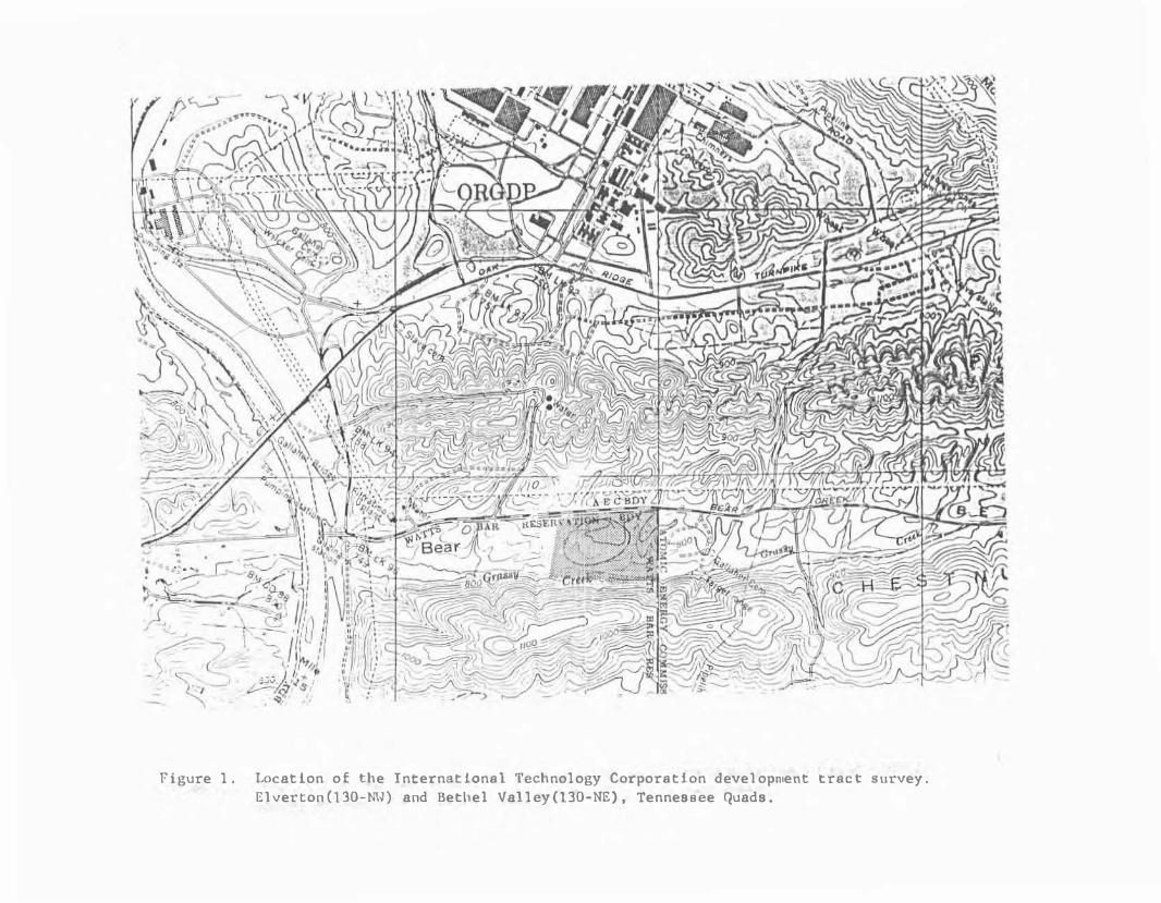
Figure l. Location of the International Technology Corporation development tract survey. Elverton(130-NW) and Bethel Valley(130-NE), Tennessee Quads.

�eathtr= ng o& �he ex;osed ii:�0g�1ph1 1as ccn;�·bu:e� Jreatly tc the 1idge and Val·ey's contemporary form ana has produced che seci�ents �hat occupy :he province toda}.
The Carolinian Biotic Province (Dice 194:) 1s cnaracterizea by a temperate deciduous forest, and present floral ana taunal species are typical of those represented in an oak-chestnut forest (Braun 1974). An exhaustive treatment of faunal and floral species present in the study area has been presented by Fielder (1974; 1975).
Lithic raw material of the varieties used by local prehistoric populations for the manufacture of stone tools is readily available in the i111T1eoiate vicinity of the survey tract. In addition to stream gravel sources, outcrops of Knox chert-bearing Ordovician Chepultepec and Copper Riage dolomite are present along slopes of Chestnut Ridge (Stoops 1988; Safford 1869; Hardeman 1966; Floyd 1974). Chickamauga chert-bearing formations also outcrop in the area. To illustrate this, two previously recorded archaeological sites, 40RE157 and 40RE159,
, were established to exploit sources of Knox and Chickamauga chert, respectively (Jolley 1982).
Four soil types dominate the sediments within the survey tract (Swann et al. 1942). Specific information for each of them is listed in Table 1. Lehew stony fine sandy loam covers the majority of the tract and is the second most extensive soil type listed for Roane County (ibid). It occurs in large and unbroken belts on sandstone and shale ridges. Only about 20% of this sediment type has been cleareo. It is poorly suited to crops or pasture because of strong relief, storiness, shallowness, and strongly acid reaction. Evidence of pronounced erosion is abundant in the surveyed area.
The remaining three sediments are restricted in their extent within the tract. Leadvale very fine sandy loam occupies the edges of NE to SW trending drainages; Atkins very fine sandy loam is present only along drainages oriented N-S; and Apison very fine sandy loam, eroded slope phase, is restricted to a narrow band paralleling Grassy Creek. All of the soils shew strong relationships to sediment sources upslope on Pine Ridge from which the drainages emanate.
Archaeological Background
Large-scale archaeological surveys conduc:ed rli:hin the major river valleys in the vicinity of the study area have a long history (i.e., Thomas 18�4 througn Cannon 1987). Results of these surveys have demonstrated that this portion of the -ennessee Valley was utilized throughout the known span of prehistoric occupation (Paleoindian througn early Historic) in the Southeas�ern United States (Nash 1941; �eob 1938; McNutt and Fischer 1960; McNutt and Graham 1961).
Numerous investigations have also been conducted within the boundaries of the Oa� Ridge Reservation. Fielder conducted three separate surveys that exam1ned prehistoric occupation of the entire reservation (1974), the p1·oposed site uf J nuclear facility for thP Exxon Corporation {1975), and later (Fielcer et al. 19;7) an historic-sites 5tudy encompassing most of the
Exempted from Disclosure by Statute - Withheld Under 10 CFR 2.390(a)(3)
Exempted from Disclosure by Statute[]
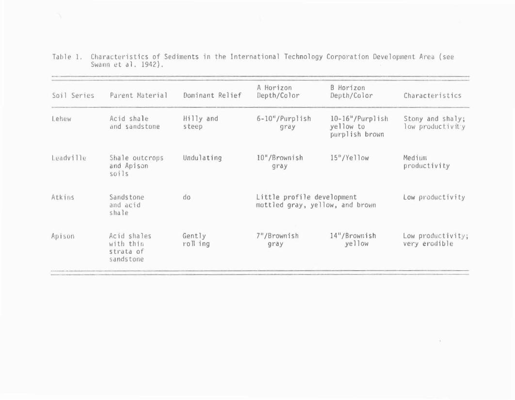
Table l. Char cl�ristics of Sediments in the International Technology Corporation Dev lopment Ar tl (see S\.,.a n, � L a 1 . 194 2) .
Soil Series
L eh�w
lt!advillt
A ki11s
Ap1�on
Parent Material
Acid shale ,rnd sandstone
Sil le outcrops and Apison soils
Sandstone ,nd a id Slid le
Acid shales with thin slrdla of sand�tone
Dominant Relief
Hilly and steep
Undulating
do
Gently roll ing
A Horizon Depth/Color
6-10 11/Purplishgray
10 11 /Brownish gray
B Horizon OeµLh/Color
10-16 11 /Purplishyellow topurplish brm'ln
15 11 /Yellow
Little profile development mottled gray, yellow, and brown
7 11 /Brownish gray
14"/Brownish yell ow
Charact ristics
Stony and shaly; low pro J11c Ii vit. y
Medium productivity
L0\'1' productivity
Low productivity; vei-y erodiul
7
reservation. Other studies :oncuctea inc·uc2 :�e :�s:·�� of ·he -�nnesse� S1nfuels .'.\ssocates sn:e fGAI :981� a.no concen"":rat?c .:ifort b} two add.,tional researchers on sites within the Clinch R1ver Breeder Qeac:or Project area '"' h d" ·a-... 1Q73 10-, 10-1-b J 11 ·ae"' )" h 1 · • d 1 wC roe I --IL, � , __ , .. a, __ , .... ; 0 ey -� ... ,. - � OSe 1s .. e , Severa have direcr. impor:ance to the present project.
Three of the previous surveys included all or �ar .. of the area under study. However, \lith one exception (Fielder 1975) the intensity of coverage was too coarse to locate all but the most obvious resources (Fielder 1974; Jolley 1982). A corridor approximately 40m wide ana south of Bear Creek Road, which includes the northwestern boundary of the present survey tract had been previously examined (see Fielder 1975, Figure 3). Consequently, this area was excluded from the present reconnaissance.
Each of the previous surveys located archaeological sites, none of which fell within the International Technology Corporation corridor. Fielder's 1975 survey located the only two sites in close proximity to the present tract. 40RE140 is 40RE139
at 40RE139 should provide important insight into the kinds of prehistoric evidence present within the survey area.
FIELD PROCEDURES
Two approaches were used during the reconnaissance. Initiaily, the perimeter of the tract was peaestrian surveyed. At this time all exposures such as road banks. erosion gulleys, game trails, creek banks, animal burrows, tree falls, and the cleared perimeter along the eastern boundary adjacent to a high hurricane fence separating the firing range from the survey area were examined. With the exception of some areas along the cleared eastern margin, visibility was extremely limited. At two locations concentrations of stream gravels in Grassy Creek were checked for cultural �aterial dislodged by stream flow.
Following surface survey the entire tract was shovel tested. Test units were .5m2
, were systematically located at 50m intervals, and were excavated through the A horizon until the B horizon was exoosed. All fill was screened though .635cm mesh and the exposed 8 horizon surface inspected for cultural d isturbances. Figure 3 shows the shovel-test grid as established and its relation to the four parcels (6 ) 6.01, 7 and 8) cowposing the :ract.
There is an existing hurricane fence oemarcJt1ng the east and west perimeters of parcel 7 and separating it frcm the o:her oarce:s. Consequently, shovel testing was initiated in parcels 6 ana 6.Cl, proceeded next in parcel 8, and was comoleted last within the conf1res of parcel 7. The northern half of parcel 7 had been significantly al:ered prior �a the present survey by lana clearing and the construction of an eyisting bu1lding now occupiea by IT. Ground disturbances in this area Here exdrnineo, but onlJ the forested and southernmost portion or the tract was shovel tesred.
Exempted from Disclosure by Statute - Withheld Under 10 CFR 2.390(a)(3)
Exempted from Disclosure by Statute
Exempted from Disclosure by Statute
Exempted from Disclosure by Statute
Exempted from Disclosure by Statute
Exempted from Disclosure by Statute
[ ][ ]
[
][[ ]
]
Figure 2. Locations of previously recorded prehistoric sites in areas adjacent to the survey tract (after Jolley 1982).

/Iv
+ +
+
l parce\ 6) l parce\ 6.0\)
-\-+
+ +
+
-··· ___ __....··� . . .
Grassy
+ +
--- .··--------
-,-E.,y.\SI inQeui\din9
+
+
l parce\ 7)
+ +
+ +
+
-------
--
+
+ +
.+ +
l parce\ S)
+ +
+ +
+
+

iO
RESULTS
Surface Collection
No arc1facts were found during the surface reconnaissance. Surface exposures sufficient for artifact detection were rare.
.
Shovel Testing
No artifacts or cultural features were discoverea during the shoveltesting phase of the survey. Ap horizon depths differed greatly across the tract even within the same soil units and ranged from as deep as 30cm at the base of slopes to as shallow as 5cm on proveniences. This evidence indicates that erosion was pronounced subsequent to original land clearing, during the later historic land-use practices, or both. Heavy concentrations of gravel, which also suggest extensive translocation of surface sediments, were encountered.
Exempted from Disclosure by Statute - Withheld Under 10 CFR 2.390(a)(3)
Exempted from Disclosure by Statute
Exempted from Disclosure by Statute
Exempted from Disclosure by Statute
[ ][ ]
][
REC{Wl•IE�lCAT IC'NS
No cultural evidence other �han contemoorary nis�o��c aebris was locatea during the reconnaissance survey of Inter'lationa- ,ec!"lna·c9y s cevelopw.ent tract in the Clinch River [noustr1al Park. Previous surveys sections of the immediate surrounding area have oemonstrated that archaeological resources are present but, because of their smail size and low artifact density, are difficult to detect. For examole, �alley (1982), in a survey covering located just south of the current project area, reported that were often no larger than 500M� (40RE161), with some considerably smaller. 40RE155 (250M2), 40RE156 (40QM2), and 40RE163 (a minute 50M2), provide useful illustrations of this.
Perhaps more salient than site size is the extremely low artifact densities manifested by reported . Fielder (1975) located a complex of small artifact-bearing loci
from the present survey area. These small scatters, reported collectively as 40RE139, were detectable
consisted of only a fe\•1 chert flakes. Their detection in a shovel test would be highly unlikely both because of the localized nature of the scatters and extremely low artifact densities (see for example Turner 1986).
during the current survey; and in the absence of a comprehensive research design intc which data collec�ed from such sites could be fit, their scientific merit is negligible. However, small sites of consioerable significance are known to be present within the Oak Ridge Reservation (GAi Consultants 1981), and their detection may be possible only after vegetation clearing of the tract is completed prior to proposed devel opment. Therefore, although it is recommended that International Technology Corporation be permitted to proceed with planned al teration of the survey tract, IT is reminded of its obligation to report any significant archaeological resources that become apparent as a result of such alteration. Monitoring of tract clearance is recommended.
Exempted from Disclosure by Statute - Withheld Under 10 CFR 2.390(a)(3)
Exempted from Disclosure by Statute
Exempted from Disclosure by Statute
Exempted from Disclosure by Statute
Exempted from Disclosure by Statute
Exempted from Disclosure by Statute
Similar small, low-density manifestations may well have gone undetected o
s
Exempted from Disclosure by Statute
Exempted from Disclosure by Statute
Exempted from Disclosure by Statute
[ ]
[ ][ ]
[ ][
][ ]
[ ]
[ ]

Amick, H.C. and L.H. Rollins
" ...
1937 Tt1e Gi:ographL of Tennes3ee. Ginn and Col, Ne\� York.
E. l.Braun 197C Oec'duous Forests of Eastern North �mer·ca. Reor·nted. Free Press
ew forK. Or g1na1ly pub11sned J50 Coilier �ac�i11an, London.
Cannon, 1986
K.P. hn Assessmert of he rchaeoloqical Resources of the �a ts Bar Reservoir, East Tennessee. Submitted to he Tennessee alley Authority, Norris.
Dice, L.R. 1943 The Biotic Provinces of North America. University of Michigan Press,
Ann Arbor.
Fenneman, .M. 1938 Physiograohy o- Eastern Uni ed States. McGraw-Hill, ew York.
G.F., Jr. Fielder, 1974 Archaeological Survey with Emphasis on Prehistoric Sites of the Oak
Ridge Reservation, Oak Ridge, Tennessee. Oak Ridge National Laboratory, Oak Ridge, Tennessee.
1975 Cultural Resource Survey of the Exxon Nuclear Facility Oak Ridge Tennessee: n In erim Reoort. Ms. on file Oeoartment of
Fielder, 1977
An hropology Llniversity oi Tennessee, Knoxv·1 e.
F.F., Jr., Steven R. Ahler, and Ben·amin Bar ingtonHistoric Sites Reconnaissance of the Oak Ride Reservation, OakRiaae, Tennessee. Oak Ridge, ationa laboratory, Oa idge,Tennessee.
Floyd, R. A. 1974 The Geologic History of Tennessee. State cf Tennessee Geological
Survey Bu1let1n 7 lashv1lle.
GAI Consultan s 1921 Cul ural Resource Survey and Evalua ion of he ennessee Synfuels
Associates S1te Oa Ria e Reservation, Roane Tennessee. Environmenta Research and ecnnology, Inc.
Hardeman, W.D. 1966 Geologic Map of Tennessee: East-Central Sheet. State of Tennessee,
Depar ment of Conservation, D�vision of Geology, �asrville.
Jolley, R.L. 1982 rcnaeo oa1cal
0ro"ec-: las vil ie
a ions in the Cline Bu, ding Corserva
or

1c!!utt, C .. and F.!L Fiscl'er
I •- .,
1960 Archaeoloaical Investi ations in the Upper Melton , i1l naerson Countl, ennessee 1960.
Park Service 1allahassee.
Mc, utt, C.H. ano J. B. Graham 96: Arc aeoloo·cal nvestioa ions in he Lower �el on ,ill Reservoir.
�noerson,WKnox, Louacn: ano �oane Counties. Tennessee. 196 . Report subm1t�ea to the a�1onal Park Service, Tal anassee.
Nash, C.H. 1941 Field notes from Wa ts Bar Reservoir survey. Unpublished notes on
file at McClung Museum, University of Tennessee, Knoxville.
Sa ford , J . M • 1869 Geolo9y of Tennessee. S.C. ercer, Nashville.
Schroedl, G.F. 1972 Archaeological Reconnaissance and Test Excavations in the
River Liquid Metal Fast Breeder Reactor Plant Site Area. submitted to the Tennessee Valley Authority, Norris.
Clinch Report
1973 Test Excavations at 40RE124 in the Clinch R"ver Liouid Metal Fast Breeder Reactor Plant Area. Report submitted to the Tennessee Valley Authority, Norris.
1974a Test Excavations at 40RE129 in the Clinch River Liquid Metal Fast Breeder Reactor Plant Area. Report submitted to the Tennessee Valley Authority, Norris.
1974b Historic Sites Reconnaissance in the Clinch River liquid Metal Fast Breeaer Reactor Plant Area. Report submitted to the Tennessee alley Authority, Norris.
Stoops, R. 1988 Reconnaissance Survey of Archaeological Resources Within the East and
West Borrow Areas on Chestnut Ridge, in the Oak Ridge Reservation. Repor submitted to Martin Marietta, Oa Ridge, Tennessee.
Swann, M.E., ,. Roberts E.H. Hubbard and H.C. Porter 942 Soil Survey of Roane County, Tennessee. Uni ed States Department of
Agriculture Series 1936 No. 15.
Thomas, C. 894 Reoor: on the �ound Exo ora ions of the
nnua Repor� or -he Bureau or mer1can
ur er W.B.986 Sur ace Artifact Assemblage Variability: A Consideration of the
latural Factors Inf uencing Recovery. �taster's thesis, University of Tennessee, Knoxville.

14
Webb, W . S . 1938 An Archaeological Survey of the Norris Basin in Eastern Tennessee.
Bureau of American Ethnology, Bull etin 1 18 . Washi ngton, D . C.
15
APPENDIX A
INFORMATION FOR
LAND PURCHASE AND/OR CONSTRUCTION WITHIN
CLINCH R I VER INDUSTRIAL PARK
Provided by
I NTERNATIONAL TECHNOLOGY CORPORATION 3 12 Di rectors Drive
Knoxville , Tennessee 37923
16
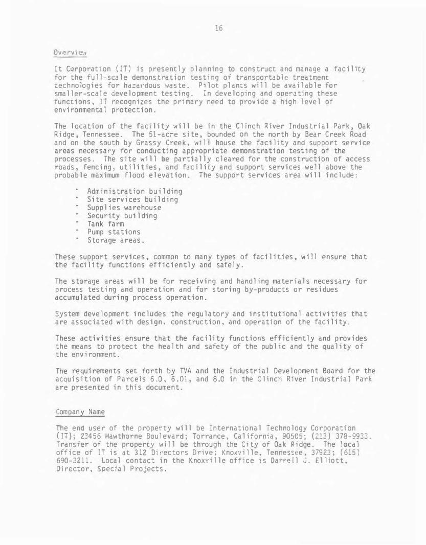
Overvi2•.v
It Corporation ( IT ) is presently planning to construct ano manage a facility for the full-scale demonstration testing or transportable treatment i:echnologies for ha_:ardous ·taste. Pilot plan1:s will be available for smaller-sca1e aevelooment testi�g. :n aeveloping �nd ooe�Jt:ng these functions, IT recognizes the primary need to proviae a high level of environmental protection.
The loca�ion of the facility Nill be in the Clinch River Industrial Park , Oak Ridge, Tennessee. The 51-acre site, boundec on the north by Bear Creek Road and on the south by Grassy Creek, \vill house 1:he facility and support service areas necessary for conducting appropriate demonstration testing of the processes. The site will be partially cleared for the construction of access roaas, fencing : utilities , and facility and suopor1: services well above the probable maximum flood elevai:ion. The support services area will include :
Administration building Site services building Supplies warehouse Security building Tank farm Pump stations Storage areas.
These support services , common to many types of facilities, will ensure that the facility functions efficiently and safely.
The storage areas will be for receiving and handling materials necessary for process testing and operation and for storing by-products or residues accumulated during process operation.
System development includes the regulatory and institutional activities that are associated with design , construction, and operation of the facility .
These activities ensure that the facility functions efficiently and provides the means to protect the health and safety of the public and the quality of the environment.
The requirements set forth by TVA and the Industrial Development Board for the acauisition of Parcels 6.0, 6.01, and 8.0 in the Clinch River Industrial Park are presented in this document.
Company Name
The ena user of the property will be International -echnology Corporation ( IT); 22456 Hawthorne Boulevard; Torrance, California, 90505 ; (213) 378-9933. Transfer of the property will be through the City of Oak Ridge. The local office of IT is at 312 Di rectors Drive ; Knoxville, Tennessee, 37923; (615 ) 690-3211. Local contact in the Knoxville of:;ce 1 s Oarr� ll J. Elliott,O irec�or, :pec;al Projects .
7
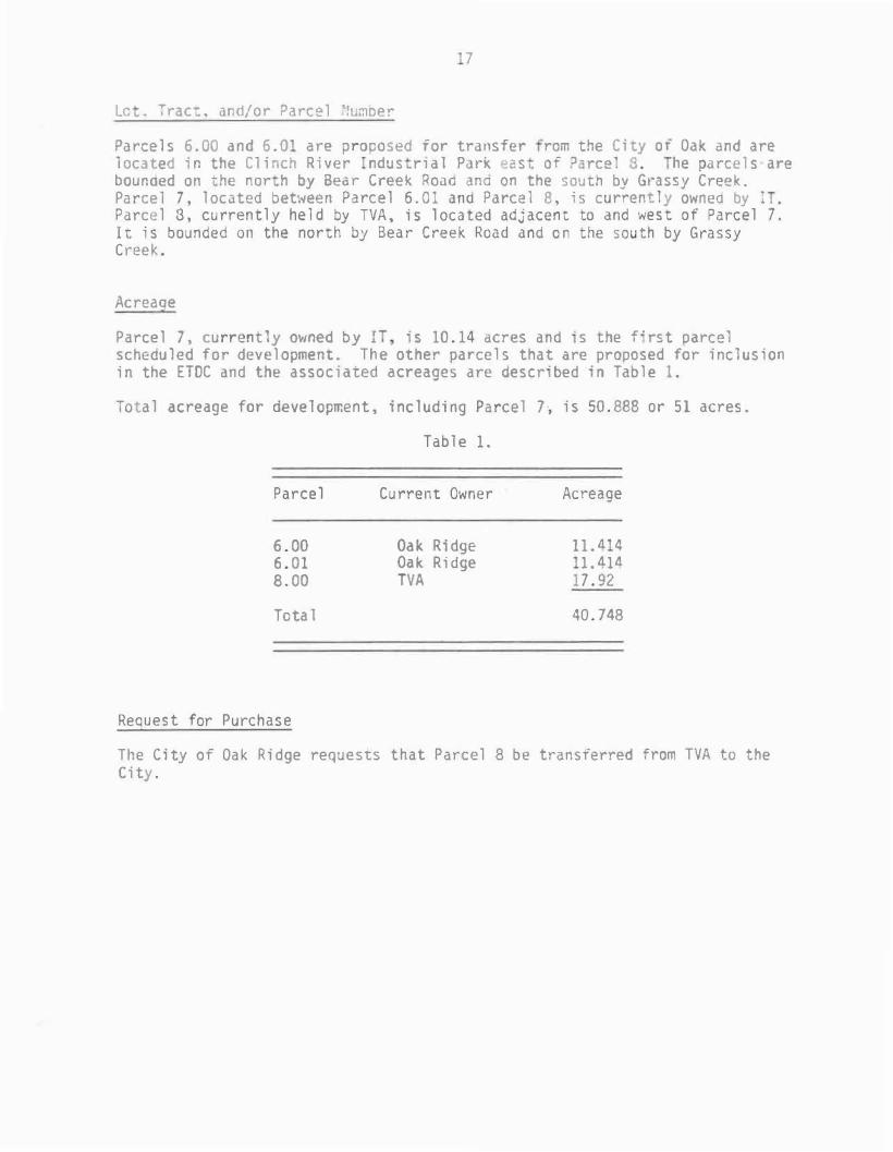
Le • Trac: . and/o r Parc e l !umce r
Pa rce l s 6 . 00 a n d 6 . 0 a re proposed for tra nsfer ram the C i ty o f Oak a nd a re l oca ted i n the C l i nch R i v er ndu s r i a l Pa rk ea s o f ) - ree l S . he pa rce l s a re bou noed o n · he n o r h by Bea r Cree k Roao ana on the s ou th by Gra s sy Cree k . Pa rce l 7 , l oc ated betwee n P arc e l 6 . 0 1 and Parce l 8 , i s cu rrent l y ownea by I P a rce l 8 , cu rren t l y he l d by TVA , i s l oca ted adj acen t to and we s t of P a rce l 7 .I t i s b o u nded on the north by Bea r C ree k Road a nd o n the s ou th by G ra s sy C ree k .
Ac reaQe
P a rce l 7 , cu rren t ly owned by I i s 10 . 14 acres and · s the f " rs t parce l sc heau l ed for deve l opment . T he other pa rce l s that are propo s ed for i nc l us i on i n the ETDC and the a s s o c i ated acreage s a re des c r · bed · n Tab l e 1 .
Tota l acreage for deve l opment , i nc l ud i ng Pa rce l 7 , i s 50 . 888 or 5 1 acres .
Tab l e 1 .
P a r c e l Cu rre nt Own e r Ac reage
6 . 00 Oa k R i dge 1 1 . ll 4 6 . 0 1 Oa k R i dge 1 . 414
8 . 00 TVA 1 7 . 92
Tota 1 40 . 748
Req ue s t for P u rc h a s e
T h e C i ty of Oa k R i dge requests t h at P a r c e l 8 b e tran s ferred from TVA to the C i ty .


![[X] Public Distribution: Publicly available · EPC342-08 Version 6.0 8 December 2016 [X] Public – [ ] Internal Use – [ ] Confidential – [ ] Strictest Confidence Distribution:](https://static.fdocuments.us/doc/165x107/5c66807b09d3f2d0218c611b/x-public-distribution-publicly-epc342-08-version-60-8-december-2016-x.jpg)