Sophos SafeGuard Disk Encryption, Sophos SafeGuard Easy Demo guide

Admiralty Inlet Pilot Tidal Project – FERC No. 12690
Appendix E Project Safeguard Plans


ADMIRALTY INLET PILOT TIDAL PROJECT FERC PROJECT NO. 12690
PROJECT SAFEGUARD PLANS (submitted with the Final Application for a New Pilot Project License)
Submitted by: Public Utility District No. 1 of Snohomish County
February 29, 2012

Admiralty Inlet Pilot Tidal Project – FERC No. 12690
FINAL APPLICATION FOR A NEW PILOT PROJECT LICENSE APPENDIX E PAGE i Project Safeguard Plans – February 29, 2012
TABLE OF CONTENTS
1.0 INTRODUCTION.............................................................................................................. 1
2.0 PROJECT AND PUBLIC SAFETY PLAN .................................................................... 1 2.1 Project Monitoring ........................................................................................................... 2
2.2 Environmental Monitoring ............................................................................................... 2
2.3 Emergency Response ....................................................................................................... 3
2.4 Emergency Communication and Reporting ..................................................................... 3
3.0 NAVIGATIONAL SAFETY PLAN ................................................................................. 3 3.1 Overview .......................................................................................................................... 3
3.2 Navigation and Collision Avoidance ............................................................................... 5
3.3 Communications, Radar, and Positioning Systems .......................................................... 6
3.4 Existing Safeguards .......................................................................................................... 6
3.5 Recommendations for Additional Preventive Measures .................................................. 6
3.6 Summary .......................................................................................................................... 8
4.0 EMERGENCY SHUTDOWN PLAN .............................................................................. 8
5.0 PROJECT REMOVAL AND SITE RESTORATION PLAN ....................................... 9 5.1 Turbine and Foundation ................................................................................................... 9
5.2 Cable Abandonment or Removal ................................................................................... 10
5.3 Shore-Based Facilities .................................................................................................... 10
5.4 Implementation Schedule ............................................................................................... 10
6.0 REFERENCES ................................................................................................................. 10
Attachment 1 – 33 C.F.R. Chapter 1
Attachment 2 – Vessels Passing Within a 200m Radius of Proposed Turbine Site (92 Total in 2010)
LIST OF FIGURES
Figure 1. Shipping and ferry lanes in Northern Admiralty Inlet (PSWQA 1992). ......................... 4
Figure 2. Clearance over installed turbines and turbine foundations.............................................. 5
Figure 3. Proposed Regulated Navigation Area Options. ............................................................... 7


PROJECT SAFEGUARD PLANS for the Admiralty Inlet Pilot Tidal Project
FINAL APPLICATION FOR A NEW PILOT PROJECT LICENSE APPENDIX E PAGE 1 Project Safeguard Plans – February 29, 2012
The Project Safeguard Plans describe the procedures Public Utility District No. 1 of Snohomish County (the District) will undertake to safeguard the public and environmental resources for the Admiralty Inlet Pilot Tidal Project (FERC No. 12690) (the Project). The plans within this document address (1) Project and public safety, (2) navigational safety, (3) emergency shutdown of one or both turbines, and (4) removal of the Project and restoration of the site, if required. These plans were developed in consultation with the Marine Aquatic Resource Committee (MARC) and Project stakeholders. Comments received from the consulted parties, as well as the District’s written response, are included with the District’s June 24, 2011, response to the Commission’s request for additional information.1
1.0 INTRODUCTION
The District is engaged in licensing and permitting the Admiralty Inlet Pilot Tidal Project in Puget Sound, Washington. The Project involves installation of two OpenHydro tidal in-stream energy conversion turbines in Admiralty Inlet, as well as placement of two transmission cables to shore. The turbines will be installed in the northeastern portion of Admiralty Inlet, approximately 1 km west-southwest of Admiralty Head near latitude 48°09’03.24” N longitude 122°41’15.72” W latitude, in water depth of approximately 58 meters. Power generated by the project will be transmitted via two subsea cables to a new control building proposed on a private parcel approximately 2,000 feet west of the ferry terminal. Grid compliant power from the control building would exit the property and connect to the local Puget Sound Energy infrastructure.
2.0 PROJECT AND PUBLIC SAFETY PLAN
The Project presents little to no known hazard to public safety, due primarily to its location, the design of the turbines, and the activities typically occurring in the area. The Project is located outside major shipping lanes, in waters not used for commercial fishing. Project turbines will be located in waters approximately 58 meters deep, deeper waters than are typically used by recreational users, and presenting minimal hazard to tug or barge vessels. Recreational diving in the area is typically conducted in shallow waters closer to shore and away from such strong currents. The Project’s subsea transmission trunk cable will be routed to shore facilities near existing grid infrastructure, with remote or local control capabilities in place 24 hours a day. Project turbines are equipped with an electrical brake that can cease power generation and slow turbine rotation within seconds. In the event of loss of transmission and control capabilities, the brake engages automatically.
The District has consulted with public and private parties interested in public safety, including the U.S. Coast Guard, the Puget Sound Pilot’s Association, the U.S. Army Corps of Engineers Navigation Division, the Washington Department of Ecology, American Waterways Operators, and the U.S. Navy. No substantive public safety concerns related to the Project have been identified. Nevertheless, the District will engage in detailed Project monitoring so as to be able to detect, respond to, and report conditions potentially hazardous to public safety.
1 Most of the comments were received informally at meetings attended by various agencies, tribes, and other
stakeholders, thus very few written comments are able to be included in the record.

Admiralty Inlet Pilot Tidal Project – FERC No. 12690
FINAL APPLICATION FOR A NEW PILOT PROJECT LICENSE APPENDIX E PAGE 2 Project Safeguard Plans – February 29, 2012
2.1 Project Monitoring
Real-time monitoring information of turbine operations will be transmitted to the Project controls building by the fiber optics or copper wire bundles in the trunk cable. Electronic turbine health and data management capability is integrated into Project controls to ensure the long term viability and structural integrity of the turbines. An integrated sensor approach to turbine management will quickly identify and respond to unusual turbine behavior.
• Electrical – Real-time operational status of each turbine will be monitored by measuring and recording electrical parameters. Automatic alarm thresholds will be set locally with processor control or remotely by maintenance personnel.
• Mechanical – A three axis orthogonal accelerometer will be mounted on the turbine to measure real-time vibration levels in x, y, and z axis. Alarm levels and automatic controls will be set to shut down the turbine at preset acceleration levels to prevent potential turbine damage or internal mechanical or electrical imbalances caused by excessive vibration. An integrated tilt sensor will be mounted to the gravity mount frame to assist in establishing levels and will monitor the turbine for long term settling.
• ROV – A remotely operated vehicle will be used to inspect the turbines and the area in the vicinity of the turbines following installation and on an as needed basis as required by the license. During the first year of deployment, ROV observations are expected every 2-3 months. Following this initial period, the District will deploy an ROV at least twice annually.
Manual control in the Project controls building and remote web-based monitoring and control will be provided for turbine and grid connection functions. Turbine control functions will include grid connection and disconnection and turbine braking if necessary. A computer will manage and display sensor information as it arrives. The program that manages the sensor data collection will also keep historical records, track sensor level thresholds, and perform calculations. The computer will have internet access for remote data displays and commands.
Each control component will be subject to evaluation and testing on an annual or more frequent basis.
2.2 Environmental Monitoring
Methods and equipment to be deployed by the District to monitor the environmental conditions of the Project, including monitoring for injury or mortality to any federally listed threatened or endangered species under the Endangered Species Act (ESA) or marine mammal afforded protection under the Marine Mammal Protection Act (MMPA), are described in detailed in various monitoring plans included with the license application. These monitoring plans (collectively, the “Monitoring Plans”) include the Benthic Habitat Monitoring Plan, the Acoustic Monitoring Plan, the Derelict Gear Monitoring Plan, the Near-Turbine Monitoring Plan, the Marine Mammal Monitoring Plan, the Water Quality Plan, and any other monitoring plan filed with the license application or later required by the Commission.
Admiralty Inlet Pilot Tidal Project – FERC No. 12690
FINAL APPLICATION FOR A NEW PILOT PROJECT LICENSE APPENDIX E PAGE 3 Project Safeguard Plans – February 29, 2012
2.3 Emergency Response
Each of the Monitoring Plans has its own requirements for when a hazardous condition is detected and how to respond to that condition. When a hazardous condition occurs that is covered by a Monitoring Plan, the District will implement the response required by that plan.
For hazardous conditions not described in a Monitoring Plan or detected by the monitoring described in this Safeguard Plan, including electronic detections (e.g., by operational parameters moving outside expected ranges), through environmental monitoring equipment (e.g., video cameras), visually, or be reported by other entities, The District will evaluate the condition and current operational parameters, and will modify or cease turbine operation until the hazard can be circumvented or resolved. Following any detection of a hazardous condition, the District will engage in emergency communications and reporting, as detailed below.
2.4 Emergency Communication and Reporting
Each Monitoring Plan contains communication and reporting protocols which are tailored to the type of hazardous condition detected and the species impacted. When a hazardous condition is detected, the District will implement those protocols, including notifying the members of the Marine Aquatic Resource Committee (comprised primarily of concerned agencies and tribes) (the MARC) and the Director, Office of Energy Projects (the Office Director)2 within the timelines prescribed in the relevant Monitoring Plan and preparing the required written reports of the condition. The Monitoring Plans also have consultation requirements and procedures intended to aid the District in developing (and ultimately filing with the Commission and implementing) measures to remove the hazardous condition and prevent its future recurrence.
3.0 NAVIGATIONAL SAFETY PLAN
3.1 Overview
The Admiralty Inlet passage is used by essentially all maritime traffic transiting to and from the ports of Seattle, Tacoma, Olympia, and Everett, as well as U.S. Navy facilities including Naval Station Everett, Puget Sound Naval Shipyard, and the Bangor Submarine Base. Additionally, the Port Townsend-Keystone ferry runs between Port Townsend and Keystone Harbor in Admiralty Bay on Whidbey Island. The location of the tidal energy project is near, but well outside of, a regulated and International Maritime Organization established Traffic Separation Scheme (TSS) under U.S. Coast Guard (USCG) Vessel Traffic Service (VTS) control.
2 The Office Director is the Commission’s authorized representative.

Admiralty Inlet Pilot Tidal Project – FERC No. 12690
FINAL APPLICATION FOR A NEW PILOT PROJECT LICENSE APPENDIX E PAGE 4 Project Safeguard Plans – February 29, 2012
Figure 1. Shipping and ferry lanes in Northern Admiralty Inlet (PSWQA 1992).
Northern Admiralty Inlet has been closed to commercial fishing since 1987 (personal communication, B. Polagye, University of Washington with J. Jordan, WDFW, 2007), though it is within the accustomed fishing areas of several tribes. Recreational anglers use hook and line from piers, the beach at Fort Casey, private vessels, and charter boats (Palsson et al. 1998). Sportfishing for salmon, sturgeon and other marine fish is a popular activity throughout Puget Sound. Fort Casey State Park is located next to the project and includes an underwater marine component. Marine activities in the park include boating, fishing, and diving. Diving within Northern Admiralty Inlet is primarily near shore (Polagye et al. 2007) and is not expected to conflict with the turbine deployment location. The wreck of the SS GOVERNOR is occasionally visited by advanced divers; however the wreckage is located well outside of the Project area (3-4 miles to the northwest).
The District has engaged in consultation in regard navigational safety with public and private interested parties, including the US Coast Guard, the Puget Sound Pilot’s Association, the U.S. Army Corps of Engineers Navigation Division, the Washington Department of Ecology, the Washington Department of Transportation, regional Marine Resource Committees, the American Waterways Operators (AWO), and the U.S. Navy. The District has conducted a rigorous navigational safety risk assessment for the project and believes that risks to navigational safety are both modest and readily manageable. The complete risk assessment document is appended to the end of this Safeguard Plan.
The Navigation Safety Plan presented here is intended to be consistent with the US Coast Guard’s Navigation and Vessel Circular No. 02-07, which provides guidance on Coast Guard policy in regards offshore renewable energy installations. The Circular states in part that navigation risk assessments for such installations should describe the installation’s effects on 1) visual navigation and collision avoidance, and 2) communications, radar, and positioning

Admiralty Inlet Pilot Tidal Project – FERC No. 12690
FINAL APPLICATION FOR A NEW PILOT PROJECT LICENSE APPENDIX E PAGE 5 Project Safeguard Plans – February 29, 2012
systems. In addition, the Circular states that a project proponent should describe plans for marine navigational marking of the project and surrounding area. Each of these is discussed below.
The purpose of the Navigation Safety Plan is to protect the public and Project facilities from such events as collisions between commercial and recreational vessels and in-water Project facilities; entanglement of fishing gear, anchors, dredging equipment, or other underwater devices that may damage or become entangled with Project transmission, anchoring, and mooring lines; and electrocution. In the event they occur, any such event will be treated as a public safety hazard to be addressed through the District’s Public Safety Plan.
3.2 Navigation and Collision Avoidance
Turbine and cable installation, maintenance, and removal will require barge, tug, and personnel vessels to operate in the Project area for periods of up to six days. All such vessels will comply with the International Rules for Preventing Collisions at Sea (COLREGS) in markings and operation. All such vessel operations shall be coordinated with the Puget Sound VTS.
The turbines will be deployed outside of the TSS and ferry routes and will be deployed at sufficient depths to allow for acceptable navigational clearances even for deep draft vessels. Navigational clearances for the installation of a 10-meter diameter OpenHydro turbine are presented in Figure 2 for the 58-meter water depth at Lowest Astronomical Tide measured at the deployment site. The maximum draft for vessels traveling outside the Admiralty Inlet shipping lane is 6 meters (Polagye et al. 2007; personal communication, Richard McCurdy, Puget Sound Pilots, 2007). The maximum device height off the seabed is 15 meters. This will ensure a minimum clearance of 37 meters for passing ships or tug cables (Figure 2). The AWO has noted however that even this clearance level may be of concern relative to the catenary of tug and barge cables under rare, but potential, head-on meeting circumstances. As a result, this was the primary focus of the navigational risk assessment as well as the existing and recommended safeguards and recommended preventive measures described below.
Figure 2. Clearance over installed turbines and turbine foundations.
Admiralty Inlet Pilot Tidal Project – FERC No. 12690
FINAL APPLICATION FOR A NEW PILOT PROJECT LICENSE APPENDIX E PAGE 6 Project Safeguard Plans – February 29, 2012
3.3 Communications, Radar, and Positioning Systems
The Project will be deployed at depth and is not expected to affect any communications, radar, or positioning systems. No concerns regarding these systems have been raised by marine users, the U.S. Navy, or the U.S. Coast Guard.
3.4 Existing Safeguards
VTS
The presence of the U.S. Coast Guard’s Vessel Traffic Service (VTS) in Puget Sound, having the specific duties of monitoring vessel traffic and issuing advisories where appropriate, is a very powerful safeguard against any marine transit accident. VTS effectively monitors, tracks and communicates with all commercial vessel traffic in the Sound, facilitating the secure and efficient flow of maritime commerce and ensuring that potential incidents are not permitted to develop into hazardous situations. Recognition of a tow vessel’s need for early warning of opposing traffic and an understanding of the unique hazards specific to the Admiralty Inlet operating area are critical watchstander skills needed to help prevent the hazardous situations described in the risk assessment from developing.
Reduction of Towline Scope
In the event of a necessary or unexpected reduction in speed, towing vessels have the option of taking up on the span of tow cable in the water, even to the point of bringing the towed barge or vessel alongside temporarily if required. Even in the event vessel power is lost, emergency power is normally available at the tow winch, permitting the towline to be brought in.
Anchor
As a last resort, if the vessel is adrift and no assistance is immediately available, the vessel master may make both anchors ready for letting go and prepare to anchor at closest anchorage or moor at nearest harbor of safe refuge upon direction of the Captain of the Port.
3.5 Recommendations for Additional Preventive Measures
Regulated Navigation Area (RNA)
In order to preclude the potential for development of a hazardous navigation situation, a request for establishment of a regulated navigation area (RNA) has been submitted in writing to the Captain of the Port, Sector Puget Sound as provided under Subpart A of 33 CFR 165, paragraph 5(b). Figure 3 shows the proposed RNA as submitted for comment. The initial RNA version showed a 500 x 1000 meter restricted area (hatched yellow rectangle in figure), oriented along the axis of the tidal flow. In order to respond to vessel operator and USCG concerns that the proposed RNA is too large and restrictive, a smaller zone (designated by the blue polygon in Figure 3) is suggested, oriented along the tidal current primary axis. In accordance with Subpart B of 33 CFR 165, paragraphs 11-12, the regulated navigation area could be designed so as to only prohibit vessel operators from towing, anchoring, bottom fishing, dredging, spudding, laying cable, and conducting salvage operations or other deep-water activities within the RNA

Admiralty Inlet Pilot Tidal Project – FERC No. 12690
FINAL APPLICATION FOR A NEW PILOT PROJECT LICENSE APPENDIX E PAGE 7 Project Safeguard Plans – February 29, 2012
that would disturb the seabed or interfere with the tidal energy test site. Ferry operations would not be affected, since the ferries do not conduct operations involving the subsurface waters.
Designation of a RNA would provide parameters for VTS to recommend diversionary routes to vessels in potential meeting situations, and would provide clear guidance to vessel operators relative to the turbine site location. Given the presence of exceptionally high tidal currents and turbulence in this area, it does not appear to be too restrictive of normal use of the waterway.
Figure 3. Proposed Regulated Navigation Area Options.
VTS Monitoring of Tugs in Test Area
VTS authority exists to control vessel traffic during conditions of vessel congestion or other hazardous circumstances. No additional monitoring requirements should be necessary.
Tug and tow avoidance of peak tidal flow zone
The project is sited directly in the peak tidal flow where turbulence is at a maximum and vessel steerage control at a minimum. It seems reasonable to suggest that shiphandling – particularly when transiting with the current – would be significantly easier and safer along a track that avoids the peak flow axis for Admiralty Inlet. A trackline farther offshore from Admiralty Head would be advantageous to reducing turbulence, particularly during the tidal ebb. One of the comments made by a towing industry representative in an early meeting to discuss AWO’s concerns mentioned the turbulence in the area and its impact on vessel control.

Admiralty Inlet Pilot Tidal Project – FERC No. 12690
FINAL APPLICATION FOR A NEW PILOT PROJECT LICENSE APPENDIX E PAGE 8 Project Safeguard Plans – February 29, 2012
Tug and tow avoidance of opposing TSS lane
Regulations prohibit vessels from transiting the wrong direction in a TSS, as it is in violation of the Navigation Rules. A southbound tug and tow in a meeting situation with a northbound tug and tow, if required to alter course, should avoid entering the northbound TSS lane unless as a last resort to avoid an imminent collision or close aboard situation. If possible, the northbound vessel should alter course to the west toward or into the northbound TSS lane so as to give the southbound vessel seaway to the east of that lane.
3.6 Summary
Vessel tracking statistics from over one year of Automatic Information System (AIS) monitoring provided as Attachment 1 in the risk assessment document indicate that the frequency of head-on meetings between two towing vessels in the area west of Admiralty Head (i.e., within area 2 miles long by 0.75 mile wide) near the proposed tidal energy test site is less than one occurrence per month. Given the presence in Puget Sound of USCG’s VTS, a unit with an exceptional record of safety, it is difficult to envision a scenario in which advance coordination between VTS and towing vessels moving through the test site could not easily accomplish a safe passage with sea room to spare. The risk assessment also indicates that traffic in the northbound TSS lane east of the site is easily sparse enough that in most cases a small diversion of the northbound tow vessel nearer to or even across the boundary into the lane would not be likely to cause any restriction of faster-moving commercial traffic in the system. Overtaking situations between tugs operating with tows are slow enough to develop that VTS monitoring and coordination should easily preclude the necessity for close passage of two vessels in the vicinity of the tidal energy pilot project site.
Based on the observed one head-on encounter each month in the area of concern, we believe that the risk of the project to tugs and tows is easily manageable, and that required monitoring will not cause an undue burden on VTS watchstanders.
4.0 EMERGENCY SHUTDOWN PLAN
Through its Project controls and environmental and Project monitoring efforts, as described in more detail in the Monitoring Plans, the District will monitor for unusual or unsafe Project conditions or operating parameters, including Project-related conditions likely associated with unauthorized injury or mortality to ESA-listed species or species protected under the MMPA, as well as incidents or conditions representing hazards to public safety. In certain circumstances identified in each of the Monitoring Plans, or if ordered by the Office Director, Project shutdown may be required. The following provisions describe the procedures to be taken when shutdown is required.
Emergency shutdown procedures will consist of the following:
• The electrical brake will be engaged on the unit(s). The electrical brake is capable of effectively ceasing turbine rotation within approximately one second, and generation ceases in this time as well.

Admiralty Inlet Pilot Tidal Project – FERC No. 12690
FINAL APPLICATION FOR A NEW PILOT PROJECT LICENSE APPENDIX E PAGE 9 Project Safeguard Plans – February 29, 2012
• The subsea systems will be electrically isolated from the grid.
• The District will implement these measures remotely from either the control center or the shore station. The District will describe these measures in the above referenced written report to be filed with FERC, agencies and Tribes.
Each of the Monitoring Plans contains notice and consultation provisions following an event that requires one or both turbines to be shut down. The District will provide the notice and engage in the consultation required in each of these plans.
5.0 PROJECT REMOVAL AND SITE RESTORATION PLAN
One or both turbines may be removed in order to perform maintenance or repairs, and reinstalled once maintenance and repairs are complete. Further, as required by FERC’s pilot project guidance, the Project will be removed, and all restoration activities completed, prior to the end of the license term unless a new license is obtained. The District will determine whether to pursue a new license based on the monitoring and operational results of the pilot Project.
In addition, one or more Monitoring Plans may require Project removal following assessment of situations that prompt emergency shutdown.
5.1 Turbine and Foundation
Project turbines and foundations will be removed by reversing the installation process. The OpenHydro Installer barge will be transported to Project area waters, anchored, and the turbines winched to the surface for transport to shore. Because the turbines are not fixed or anchored to the seafloor, the process is straightforward and requires little to no site disturbance. As with the installation process, turbine removal is completed within one tidal cycle.
The following vessels are required, under typical circumstances, to recover the OpenHydro turbines:
• OpenHydro Installer barge;
• Tug(s) with 20 metric tons or greater rated bollard pull; and
• Personnel transfer/safety boat.
Additional vessels or equipment may be required, depending on the time of year removal is conducted, the condition of the turbines at the time of removal, and the availability of the vessels listed above.
The turbine system is designed such that each turbine can be raised without disturbing the other turbine. Slack service cabling provides for removal of either turbine to the surface. Lifting cables from the barge will be attached to the subsea base in-situ using a specialized turbine recovery tool which has been designed and built by OpenHydro. The turbines will be electrically disconnected and disabled on-site. Once secured to the barge, the turbine and foundation be towed to a suitable dockside location where the turbine would be removed from the subsea base

Admiralty Inlet Pilot Tidal Project – FERC No. 12690
FINAL APPLICATION FOR A NEW PILOT PROJECT LICENSE APPENDIX E PAGE 10 Project Safeguard Plans – February 29, 2012
for maintenance. A dockside location has not yet been selected for unloading the turbines for refurbishment, though a number of suitable facilities occur in Puget Sound. It is anticipated that the majority of the maintenance and repair work would be carried out at an operations base situated locally to the site and using locally employed labor.
5.2 Cable Abandonment or Removal
Transmission cables will be assessed by ROV during operation and at the completion of the Project. Prior to removal of the Project the District will consult with state and federal resource agencies and other interested parties to determine whether the subsea cables should be left in place and abandoned to avoid further sea floor disturbance from removal or whether they should be removed. The District’s consultations will include the development of an appropriate abandonment or removal plan and, upon acceptance by the agencies and other parties involved, the District will implement that plan.
5.3 Shore-Based Facilities
In the event of Project removal, the District will remove all equipment according to the terms of the agreement(s) between the District and the owner of the private property on which the terrestrial equipment will be constructed. The District will remove all terrestrial transmission line and other equipment according to the terms of the agreement(s) between the District and Puget Sound Energy.
5.4 Implementation Schedule
The removal and restoration activities described in this section 5 will begin no later than two (2) months prior to expiration of the pilot license, unless a new license has been obtained from the Commission. In order to meet this timeframe, the District must begin its contracting process several months prior, depending on the projected availability of the vessels, equipment, and personnel necessary to remove the turbines and perform the necessary site restoration activities. Because several removal and restoration activities will be determined based on the condition of the site and equipment at the time of removal (e.g., the subsea cable), a detailed scope of work cannot be completed at the time the pilot license application is filed. The District will, however, consult with the MARC when developing the scope of work to be used for the removal and restoration activities prior to initiating the contracting process.
6.0 REFERENCES
Palsson, W. A., W., T. Northup, and M. Barker. 1998. Puget Sound groundfish management plan (revised).
Polagye, Brian, Mirko Previsic, and Roger Bedard. 2007. Tidal In-Stream Conversion (TISEC): Survey Characterization of SnoPUD Project Sites in Puget Sound. EPRI North American Tidal Flow Power Feasibility Demonstration Project. EPRI-TP-003-WA. May 30, 2007.
Puget Sound Water Quality Authority (PSWQA). 1992. Update of the Puget Sound environmental atlas. Seattle, WA.

ATTACHMENT 1 – 33 C.F.R. CHAPTER 1
FINAL APPLICATION FOR A NEW PILOT PROJECT LICENSE APPENDIX E ATTACHMENT 1 PAGE 1 Project Safeguard Plans – February 29, 2012
Title 33: Navigation and Navigable Waters PART 165 – REGULATED NAVIGATION AREAS AND LIMITED ACCESS AREAS Subpart A -- General
§165.5 Establishment procedures.
(a) A safety zone, security zone, or regulated navigation area may be established on the initiative of any authorized Coast Guard official.
(b) Any person may request that a safety zone, security zone, or regulated navigation area be established. Except as provided in paragraph (c) of this section, each request must be submitted in writing to either the Captain of the Port or District Commander having jurisdiction over the location as described in Part 3 of this chapter, and include the following:
(1) The name of the person submitting the request;
(2) The location and boundaries of the safety zone, security zone, or regulated navigation area;
(3) The date, time, and duration that the safety zone, security zone, or regulated navigation area should be established;
(4) A description of the activities planned for the safety zone, security zone, or regulated navigation area;
(5) The nature of the restrictions or conditions desired; and
(6) The reason why the safety zone, security zone, or regulated navigation area is necessary.
(c) Safety Zones and Security Zones. If, for good cause, the request for a safety zone or security zone is made less than 5 working days before the zone is to be established, the request may be made orally, but it must be followed by a written request within 24 hours.
(Requests for safety zones, security zones, and regulated navigation areas are approved by the Office of Management and Budget under control number 1625–0020)
[CGD 79–034, 47 FR 29660, July 8, 1982, as amended by CGD 79–026, 48 FR 35408, Aug. 4, 1983; USCG–2006–25150, 71 FR 39211, July 12, 2006]
Subpart B—Regulated Navigation Areas
§165.10 Regulated navigation areas.
A regulated navigation area is a water area within a defined boundary for which regulations for vessels navigating within the area have been established under this part.
Admiralty Inlet Pilot Tidal Project – FERC No. 12690
FINAL APPLICATION FOR A NEW PILOT PROJECT LICENSE APPENDIX E ATTACHMENT 1 PAGE 2 Project Safeguard Plans – February 29, 2012
§165.11 Vessel operating requirements (regulations).
Each District Commander may control vessel traffic in an area which is determined to have hazardous conditions, by issuing regulations:
(a) Specifying times of vessel entry, movement, or departure to, from, within, or throughports, harbors, or other waters;
(b) Establishing vessel size, speed, draft limitations, and operating conditions; and
(c) Restricting vessel operation, in a hazardous area or under hazardous conditions, to vessels which have particular operating characteristics or capabilities which are considered necessary for safe operation under the circumstances.
§165.13 General regulations.
(a) The master of a vessel in a regulated navigation area shall operate the vessel in accordance with the regulations contained in Subpart F.
(b) No person may cause or authorize the operation of a vessel in a regulated navigation area contrary to the regulations in this part.

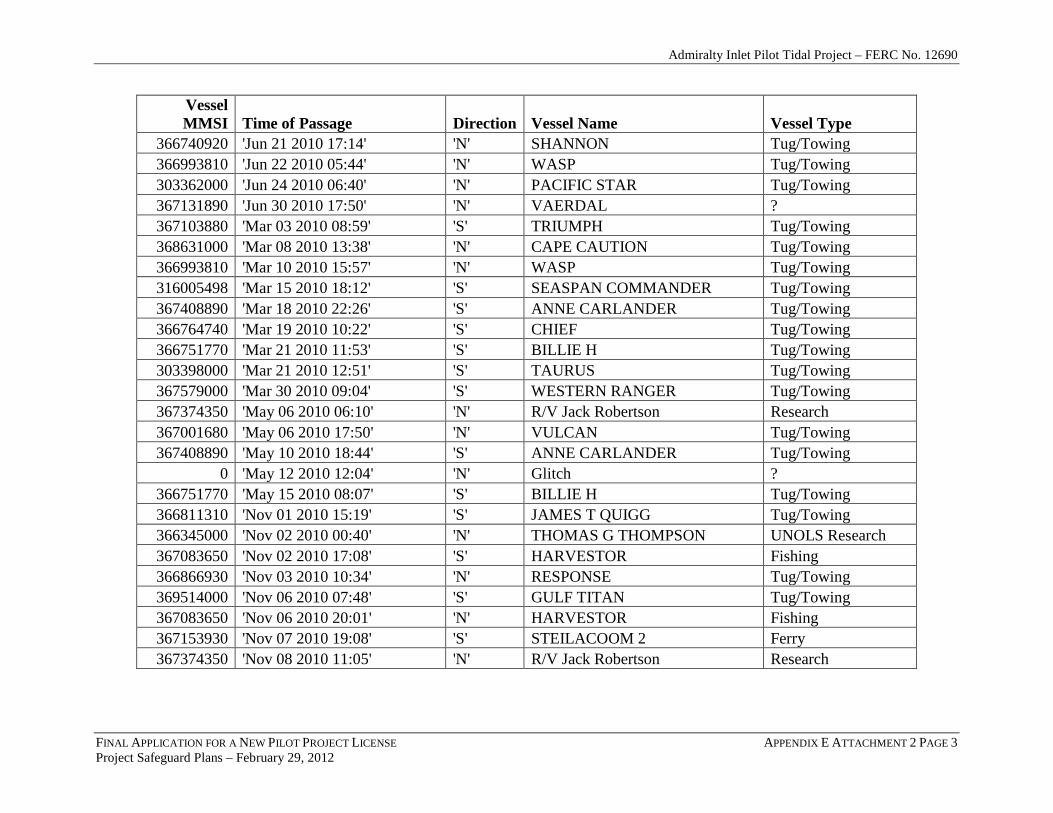
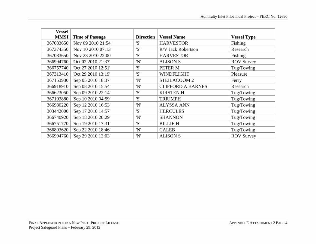
ATTACHMENT 2 – VESSELS PASSING WITHIN A 200M RADIUS OF PROPOSED TURBINE SITE (92 TOTAL IN 2010)
FINAL APPLICATION FOR A NEW PILOT PROJECT LICENSE APPENDIX E ATTACHMENT 2 PAGE 1 Project Safeguard Plans – February 29, 2012
Vessel MMSI Time of Passage Direction Vessel Name Vessel Type
367408890 'Apr 03 2010 12:36' 'S' ANNE CARLANDER Tug/Towing 303398000 'Apr 04 2010 11:45' 'S' TAURUS Tug/Towing 367153930 'Aug 06 2010 07:41' 'S' STEILACOOM 2 Ferry 366980220 'Aug 11 2010 11:10' 'S' ALYSSA ANN Tug/Towing 367408890 'Aug 12 2010 11:19' 'S' ANNE CARLANDER Tug/Towing 367010430 'Aug 15 2010 12:29' 'S' JENNIFER H Tug/Towing 367374350 'Aug 17 2010 19:14' 'S' R/V Jack Robertson Research 367444560 'Aug 20 2010 09:55' 'S' RELISH ? 6m x 20m 366751770 'Aug 21 2010 19:04' 'S' BILLIE H Tug/Towing 367317770 'Aug 22 2010 14:26' 'N' ELLIS BRUSCO Tug/Towing 366893620 'Aug 22 2010 19:46' 'N' CALEB Tug/Towing 366695810 'Aug 25 2010 07:53' 'S' WESTRAC II Tug/Towing 366866930 'Aug 31 2010 20:33' 'N' RESPONSE Tug/Towing 367083650 'Dec 04 2010 17:26' 'S' HARVESTOR Fishing 367408890 'Dec 07 2010 21:05' 'S' ANNE CARLANDER Tug/Towing 366866930 'Dec 11 2010 19:52' 'S' RESPONSE Tug/Towing 366751770 'Dec 19 2010 18:15' 'S' BILLIE H Tug/Towing 303442000 'Dec 21 2010 12:02' 'S' HERCULES Tug/Towing 367408890 'Dec 21 2010 21:03' 'S' ANNE CARLANDER Tug/Towing 367153930 'Feb 02 2010 13:36' 'N' STEILACOOM 2 Ferry 366887970 'Feb 03 2010 12:09' 'S' PROTECTOR Tug/Towing 366980170 'Feb 04 2010 00:50' 'S' PACIFIC Tug/Towing 367374350 'Feb 10 2010 17:46' 'N' R/V Jack Robertson Research 338033478 'Feb 16 2010 12:26' 'N' BERING Fishing

Admiralty Inlet Pilot Tidal Project – FERC No. 12690
FINAL APPLICATION FOR A NEW PILOT PROJECT LICENSE APPENDIX E ATTACHMENT 2 PAGE 2 Project Safeguard Plans – February 29, 2012
Vessel MMSI Time of Passage Direction Vessel Name Vessel Type
316006374 'Feb 16 2010 21:29' 'N' WEE HAUL Tug/Towing 367083650 'Feb 18 2010 21:26' 'S' HARVESTOR Fishing 366972050 'Feb 24 2010 06:12' 'N' SWINOMISH Tug/Towing 367408890 'Feb 25 2010 04:50' 'S' ANNE CARLANDER Tug/Towing 367103880 'Jan 05 2010 11:26' 'S' TRIUMPH Tug/Towing 366751770 'Jan 26 2010 16:03' 'S' BILLIE H Tug/Towing 367408890 'Jan 28 2010 19:42' 'S' ANNE CARLANDER Tug/Towing 366751770 'Jul 01 2010 20:41' 'N' BILLIE H Tug/Towing 303362000 'Jul 07 2010 19:01' 'S' PACIFIC STAR Tug/Towing 367408890 'Jul 09 2010 20:20' 'S' ANNE CARLANDER Tug/Towing 366751770 'Jul 10 2010 07:07' 'S' BILLIE H Tug/Towing 303442000 'Jul 12 2010 10:57' 'N' HERCULES Tug/Towing 319193000 'Jul 12 2010 18:16' 'N' VANGO Pleasure 367145330 'Jul 14 2010 12:35' 'S' FALCON Tug/Towing 366918910 'Jul 21 2010 11:10' 'N' CLIFFORD A BARNES Research 367001680 'Jul 24 2010 04:07' 'S' VULCAN Tug/Towing 303297000 'Jul 26 2010 09:09' 'S' UNKNOWN ? 367367880 'Jul 28 2010 10:23' 'N' ONLINE Pleasure 366993250 'Jul 30 2010 11:49' 'S' REDWOOD CITY Tug/Towing 366980170 'Jul 31 2010 11:00' 'S' PACIFIC Tug/Towing 367070410 'Jun 10 2010 18:06' 'N' LUTHER Tug/Towing 303362000 'Jun 10 2010 21:26' 'S' PACIFIC STAR Tug/Towing 367145330 'Jun 12 2010 02:08' 'N' FALCON Tug/Towing 367114810 'Jun 19 2010 06:20' 'N' VICTORIOUS Pleasure 366893620 'Jun 21 2010 02:53' 'N' CALEB Tug/Towing 366993250 'Jun 21 2010 12:01' 'N' REDWOOD CITY Tug/Towing
Admiralty Inlet Pilot Tidal Project – FERC No. 12690
FINAL APPLICATION FOR A NEW PILOT PROJECT LICENSE APPENDIX E ATTACHMENT 2 PAGE 3 Project Safeguard Plans – February 29, 2012
Vessel MMSI Time of Passage Direction Vessel Name Vessel Type
366740920 'Jun 21 2010 17:14' 'N' SHANNON Tug/Towing 366993810 'Jun 22 2010 05:44' 'N' WASP Tug/Towing 303362000 'Jun 24 2010 06:40' 'N' PACIFIC STAR Tug/Towing 367131890 'Jun 30 2010 17:50' 'N' VAERDAL ? 367103880 'Mar 03 2010 08:59' 'S' TRIUMPH Tug/Towing 368631000 'Mar 08 2010 13:38' 'N' CAPE CAUTION Tug/Towing 366993810 'Mar 10 2010 15:57' 'N' WASP Tug/Towing 316005498 'Mar 15 2010 18:12' 'S' SEASPAN COMMANDER Tug/Towing 367408890 'Mar 18 2010 22:26' 'S' ANNE CARLANDER Tug/Towing 366764740 'Mar 19 2010 10:22' 'S' CHIEF Tug/Towing 366751770 'Mar 21 2010 11:53' 'S' BILLIE H Tug/Towing 303398000 'Mar 21 2010 12:51' 'S' TAURUS Tug/Towing 367579000 'Mar 30 2010 09:04' 'S' WESTERN RANGER Tug/Towing 367374350 'May 06 2010 06:10' 'N' R/V Jack Robertson Research 367001680 'May 06 2010 17:50' 'N' VULCAN Tug/Towing 367408890 'May 10 2010 18:44' 'S' ANNE CARLANDER Tug/Towing
0 'May 12 2010 12:04' 'N' Glitch ? 366751770 'May 15 2010 08:07' 'S' BILLIE H Tug/Towing 366811310 'Nov 01 2010 15:19' 'S' JAMES T QUIGG Tug/Towing 366345000 'Nov 02 2010 00:40' 'N' THOMAS G THOMPSON UNOLS Research 367083650 'Nov 02 2010 17:08' 'S' HARVESTOR Fishing 366866930 'Nov 03 2010 10:34' 'N' RESPONSE Tug/Towing 369514000 'Nov 06 2010 07:48' 'S' GULF TITAN Tug/Towing 367083650 'Nov 06 2010 20:01' 'N' HARVESTOR Fishing 367153930 'Nov 07 2010 19:08' 'S' STEILACOOM 2 Ferry 367374350 'Nov 08 2010 11:05' 'N' R/V Jack Robertson Research
Admiralty Inlet Pilot Tidal Project – FERC No. 12690
FINAL APPLICATION FOR A NEW PILOT PROJECT LICENSE APPENDIX E ATTACHMENT 2 PAGE 4 Project Safeguard Plans – February 29, 2012
Vessel MMSI Time of Passage Direction Vessel Name Vessel Type
367083650 'Nov 09 2010 21:54' 'S' HARVESTOR Fishing 367374350 'Nov 10 2010 07:13' 'S' R/V Jack Robertson Research 367083650 'Nov 23 2010 22:00' 'S' HARVESTOR Fishing 366994760 'Oct 02 2010 21:37' 'N' ALISON S ROV Survey 366757740 'Oct 27 2010 12:51' 'S' PETER M Tug/Towing 367313410 'Oct 29 2010 13:19' 'S' WINDFLIGHT Pleasure 367153930 'Sep 05 2010 18:37' 'N' STEILACOOM 2 Ferry 366918910 'Sep 08 2010 15:54' 'N' CLIFFORD A BARNES Research 366623050 'Sep 09 2010 22:14' 'S' KIRSTEN H Tug/Towing 367103880 'Sep 10 2010 04:59' 'S' TRIUMPH Tug/Towing 366980220 'Sep 12 2010 16:53' 'N' ALYSSA ANN Tug/Towing 303442000 'Sep 17 2010 14:57' 'S' HERCULES Tug/Towing 366740920 'Sep 18 2010 20:29' 'N' SHANNON Tug/Towing 366751770 'Sep 19 2010 17:31' 'S' BILLIE H Tug/Towing 366893620 'Sep 22 2010 18:46' 'N' CALEB Tug/Towing 366994760 'Sep 29 2010 13:03' 'N' ALISON S ROV Survey