Prepared by Lockwood, Andr ews and Newnam, Inc . for the ... · and Estuari es is limited to a...
43
,. TEXAS WATER DEVELOPMENT BOARD REPORT 43 ANEW CONC EPT-- WATER FOR PRESERVAT ION OF BAYS AND ESTUARIES Pr epar ed by Lockwood, Andr ews and Newnam, In c. f or t he Tex as Wa ter Develo pment Board A pr il 1967
Transcript of Prepared by Lockwood, Andr ews and Newnam, Inc . for the ... · and Estuari es is limited to a...

,.
TEXAS WATER DEVELOPMENT BOARD
REPORT 43
A NEW CONCEPT--
WATER FOR PRESERVATION
OF BAYS AND ESTUARIES
Pre pared b yLockwood, Andr ews and Newnam, Inc .
f or t heTexas Wa t e r Development Board
Apr il 1967

-,
..
FOREWORD
During the pr ep arati on of the prel imi nary Texa s Water P la n, t he Wa te r
De velopment Board had a number of s t ud i es prepared by The Uni versit y of Texas ,
Texas A & M University, a nd Texas Te chnologi cal College. Oth er investi ga tions
wer e prep ared by the staff, or under contract wi t h va r ious co ns u l tan t s . A
number of thes e r eports ha ve been published heret of ore by the Boa rd .
Wa t e r r e quirements and the means for preservation of the ba ys and estuaries
r ece i ved detai led a t t en t i on during the preparati on of the preliminary Plan.
This a t t en t ion r esu lt ed from: (1) the important role the ba ys a nd es t ua r i e s
p l ay in the total ec on omic l i f e of Texas; a nd ( 2) the s t a t ua tory r e f erence to
cons i dera t i on of the ba ys and estuaries in comprehensive p l a nn i ng.
Ar t ic le 8280 - 9, V.A .C. S., Sec ti on 3b, states in par t : "Consider a t i on shall
also be gi ve n in the plan to the effect of upstream development upon the bays ,
estuaries , and ar ms of the Gulf of Mex i co a nd to t he effect upo n na viga t i on."
Publicati on of this report is a cont i nua t ion o f the Board 's po l icy of
providing the widest poss i b l e distribution o f inf or mat i on conce r ni ng t he prelim-
inary Plan.
Texa s Wa ter Deve lopme nt Boar d
g~~~

TABLE OF CONTENTS
Page
INTRODUCTION . . .. . .... . ... . . . . .. • .. . .. . . . .. .. . . . . .. .. .. .
DEFINITIONS .
Estuary . . . . . . . . . . . . . . . . . . . . . . . . . .. 2
Water . . . . . . . . . .. . . . . . • . . . . • • . . . . . . . . . . . . . .. . . . . . . . 2
Fishery .. . .. . .. . . . . . ... •. . . . ... . . . . .. .. .. . .... .. . . . 2
Pollution .. ... .. . .. .. ... . . . . ... •........ . .... ... .. .. 2
VALUE OF ESTUARI ES . . . . . . • . . . . . . . . . . . . . . . . . . . . . . . . . . . . . . . 3
THE VARIABLE ENVIRONMENT. . . . . . . . . . . . . . . . . . . . . . . . . . . . . . . . 4
Area af Greatest Variability . . . . . . . . . . . . . . . . . . . . . . . . . . . . . . . 4
Salinity Variations ... .. . •. . . . . . . . . .. . . .. .. . .. . ... .... . 5
Floods and Tides 6
Rainfall.Runoff·Evaporation Relations • . . . . . . . . . . . . . . . . . . . . . .. 7
Table 1 . . .... . . . . • . . . . . . . . . . . . .. . .. . . . •. . ... . .. .. . . 7
Siltat ion and Clarity. . . . . . . . . . . . . . . . . . . . . . . . . . . . . . . . . . . . 8
Exist ing Inlets 10
Pollution and Flushing . . . . . . . . . . . . . . . . . . . . . . . . . . . . . . . . . . 12
OPERATION STUDIES . . . . . . . . . . . . . . . • . . . . . . . . . . . . . • . . . . . . . . . 15
Water Balance and Sal inity . . . . . . . . . . . . . . . . . . . . . . . . . . . . . . . . 15
Table 2 - Average Annual Salinities . . . . . . . . . . . . . . . . . . . . . . . . . 18
Sal inity and Euryhaline Fish 19
Sal inity Control . . . . . . . . . . . . . . . . . . . . . . . . . . . . . . . . . . . . . . . 20

•
TABLE OF CONTENTS (Continued) Poge
ESTUARY WATER NEEOS . . . . . . . . . . . . . . . . . . . . . . . . . . . . . . . . . . . . 20
Go lveston Boy . . . . . . . . . . . . . . . . . . . . . . . . . . . . . . . . . . . . . . . 21
Matagorda Bay 23
San Antanio Bay 26
Aransas Bay . . . . . . . . . . . . . . . . . . . . . . . . . . . . . . . . . . . . . . . . 28
Corpus Christ i Bay . . . . . . . . . . . . . . . . . . . . . . . . . . . . . . . . . . . . 30
Baffi n Bay and Upper Laguna Madre . . . . . . . . . . . . . . . . . . . . . . . . . 32
Summary af Water Needs 33
Summary of Passib le Inlets and Structural Modifications. . . . . . . . . . . . 33
BASIC DATA NEEDS 35
Comm unications and Liaisan 35
Analysis of Tidal Differentials. . . . . . . . . . . . . . . . . . . . . . . . . . . . 35
Salinity Dist ributian and Gradients 35
Typical Currents and Circulatian . . . . . . . . . . . . . . . . . . . . . . . . . . . 35
Rainfall .Runoff.Evaporation Relations .. . . . . . . . . . . . . . . . . . . . . . 35
Efficienc y of Mixing . . . . . . . . . . . . . . . . . . . . . . . . . . . . . . . . . . . 36
Hydraulic Models - Inlets . . . . . . . . . . . . . . . . . . . . . . . . . . . . . . . 36
Class ification Maps . . . . . . . . . . . . . . . . . . . . . . 36
PLANNING FOR ESTUARY PRESERVATION AND ENH ANCEMENT 37
SELECTED REFERENCES . . . . . . . . . . . . . . . . . . . . . . . . . . . . . . . . . . . 38
FIG. 1 - BASIC CONCEPT OF ESTUARY WATE R NE EDS

I
f
..
1
A NEW CONCEPT -
WATER FOR PRESERVATION
OF BAYS AND ESTU ARI ES
INTRODUCTI ON
In evolving 0 Texos Woter Pion , ond whil e ex plori ng the impa ct af ever- increosi ng
re turn fl ows on the bay systems, th e Texas Water Dev e lopment Board correctly recogn ited
the implica t ions of poss ib le serio us da moge ta the estuar ies and fishery by ma jor but
ine vita ble modif icat ions in the river flows .
This is an explorat ian , from the coastal eng ineering and tidal hydraul ics standpoint,
to evolve some new concep ts that would pe rmit both reasonable maximum river develop
ment and preservation - plus enhanc ement - of the Texas Coastal bays and estuaries .
It is found that th is is a rnixe d-wnter problem a nd cannot be reasonably solved as 0
s imple fresh water demand . The bas ic concept evolved is that inc reos ed and improved
distrib ut ion of gulf wa te r inflow int o the es tuari es .may be a good subs ti tute for apparent
la rge fresh wa ter needs . Hydra ul ic structures for controlled fre s h wate r rel ease s into
some de s ig na ted prime spawning and nursery areas may then be expecte d to provide maxi
mum benefits to the fishery with minimum fresh water . See F ig . 1, Ba s ic Concept of
Es tua ry Water Needs , following last page.
Reduc t ion in, and re s ponsible control of, excess ive poll ution and spo iling is con
si dered to be a prime requi s ite in maintenanc e and preservot ion of the recr ea ti on and
fishe ry aspects of th ese bay s and estuari es . Brought to specific a ttent ion is the del icate
bola nce of the life of the commercial oy s te r in San Anton io a nd Matago rdo Bays .
DE FI NITION S
Some of the terms used in thi s conce pt for preservotion and enhancement of the bays
and es tua ries need ta be cl early defined .

2
ESTUARY
A true estuary is defined as a passage where the tide meets the river current, and
especially on arm of the sea at the lower end of a river. Along the Texas Coast, the
estuaries of interest consist of large bodies of brackish water (except hypersaline Laguna
Madre) separated from the Gulf of Mexico by a chain of barrier islands. They are sepa
rated, or combined, herein as - Galveston Boy, Matagorda Boy, Son Antonio Boy, Aransas
Boy, Corpus Christi Boy, Upper Laguna Madre with Boffin Boy, and Lower Laguna Madre.
WATER
Water for estuaries has a rather brood meaning. It consists of a mixture of gulf
water ond fresh woter. Sources of fresh water are: runaff from land, creeks, and rivers;
rainfall directly on the bay surface less the evaporation lass from this surface; and efflu
ents ar return flow fram the various domestic, industrial, and agricultural uses around the
bay. Gulf water flows in and out of the bays and estuaries thru the limited inlets across
the barrier islands. Knawledge af the intricate mixing of these waters of different density
(measured by salinity in parts per thausand) is of the utmost importance in any study of
these bays. Fresh water needs cannat be praperly determined without consideration of the
needs for gulf water, as determined by special operation studies peculiar to bays and
estuaries.
FISHERY
Here fishery means a place for catching fish or taking other sea products and
includes the habitat where fish can spawn and be carried thru the nursery period . All the
fish of interest are known as euryhaline - that is, they have a talerance for a rather wide
range of salinity.
POLLUTION
For the present purposes, pollution is defined more from the standpoint of the
fishery than from the viewpoint of the usual water uses by man. From this standpoint
pollution contrals may be braadly defined by five majar categories: (1) salinity cantrol;
(2) silt and clarity contral; (3) provision of a minimum amount of dissolved oxygen;

3
(4) bac te ria control; and (5) control of nutrients where some ore neces s ory, but too much
or too litt le ore undesired by the fishery . The concept discussed herein cove rs only the
fi rs t two ca te gorie s - with the understanding that municipal, industrial, an d agricultural
re tu rn fla ws wi ll either be treated so as to be sa tisfactory for the fishe ry, or be prevented
from entering the boys and estuaries .
VALUE OF ESTUARIES
T he only known attempt to moke 0 complete evaluotion of the Texo s Coastal Bays
and Es tuari es is limited to a report by the Bureau of Business Research, University of
Texos, en ti t led "Marine Resources of the Corpus Christi Area ."1 The e st imated annual
volue of Corpus Christi and Aransas Bays for 1958 was $370 per bay surface a cr e . Th is
is the sum of all averages of all tangible and imputed surface acre va lues associated with
all prese nt act ivit ie s related to the bays. These oct ivities included: recreati on and sport
f ishing ot $151; commerc ial fish ing at $15; minerals at $130; cooling water at $10; t rans
portat ion ot $63; a nd effluent disposal at $1.00 value per bay surface acre per ye a r.
F or want of complete coverage of the bays , and as an exercise , if th is va lue is
appl ied to 1.3 million acres of coastal bays, the total annual va lue wou ld be $483 mi lli on.
Now applyi ng one of the basic formulas of mathemat ics of finance, when computed as an
annu it y of $483 million per year at 5.0 percent for 50 years, the pre sent wor th is $8.8
billion ($6,780 per acre) .
This motter of woter for preservation ond enhancement of th e es tuari e s app lies to
the activit ies of recreati on, including sport fishing, and co mmerci a l fish ing - valued at
$166 .25 pe r ac re per yeor in the Corpus Christi area . If this va lue(45% of tota l) is cpplied
like th e tot o l, the annual value of the bays would be computed at $216 million with a
present worth of $4.0 bill ion ($3,200 per acre) for recreation and fis he ry.
Th e co mmerc io l fishing is volued at less than 10 per cent of the combine d recren
t ion and fi sh e ry; that is , $14.64 per acre per year. Then computed as above, annual value
of commercial fi shing is $19 million with 0 present worth of $347 mill ion ($2 67 per ocre ).

4
In any event, a camplete inve nta ry and evaluation is need ed and is c e rta in to sh ow
that the preservat ion and enhancement of the bays and estuaries for recreation and fishery
are of treme ndo us val ue to the Sta te . F urther, it is believed that it will be found that the
State can hard ly offo rd not to preserve th is voluable .heritoge.
THE VARIABLE ENVIRONMENT
T he environment of these es tuaries, with respect to the fishe ry , is highly variable
and sub ject to many extremes . Boffin Bay and Up per Laguna Madre is too sa lt y whil e
Galveston Bay usually has too much fresh water, and Sa bine Lak e is over whelmed by
fresh water . In places, they have been ch oked from needed gulf wate r. At othe r places,
they are be ing choked with pollution and silt . It is a harsh c limate, with sal inities rang
ing from 1 to 80 ppt (ports per thousand) inc luding wide ra nges in month ly and annual
va lues . Also involved are variable density or st rat if ie d flo ws and s ali nity grad ients.
All of this - plus the impact of changing fresh water fl ow, a dde d po ll ution loads , thre at
of further choking of Gulf water inflow by hurricane pro tec t io n works, and rapidly in cr ec
sing pressure for recreation - really makes for some highly disturbed estuaries .
AREA OF GREATEST VARIABILITY
There is a sign ificant cl imat ic mop in " Hyd ro logy" 2 which is a map of the United
States showing percentage of years tha t annual rainfall has been less than demands for
evaporat ion and transp ira t ion fro m the land surface. The frequency study was based on
measured difference between ra infa l l and runoff. The c ritical areas and area of greatest
va riabil ity with respect to dro ughts lie between the lines of 80 per cent and 20 per cent
frequency, located between Corpus Christi Boy and Sabine Lake. This means, on the
average expectancy , a t t he 20 pe r cent line there will be 8 yea rs of excess rainfall [ol
lowed by a 2 year " dro ught; " and at the 80 per cent line there will be 2 years of excess
rainfall followed by an 8 year " drought."
Galveston Bay is in the humid region between the 30 ·40 per cent lines . Matagord a
Bay is in the moist subhumid region between th e 60·70 per cent lines . San Anto ni o Bay

<
•
5
is in the moist subhumid region between the 70:80 per cent lines. Aransas Boy and
Corpus Christi Boy are in Ihe dry subh umid region near the 80 per cent line . Bollin Boy
and the Upper and Lower Laguna Madre are in the serni-crid region between the 80.90 per
cent lines .
SALINITY VARIATIONS
Average salin ity 01 the oceans is approximately 35 ppt (ports per thousand), but
varies generally between 33 ppl and 37 ppt . See pages 50, 66 and 123 01 " The Oceons."3
Gordon Gunter4 reported in 1941 and 1942 (h igh overage roinloll period) the solinily range
was 26.7 ppt to 36.7 ppt in Ihe Gull 01 Mexico Irom 2 to 5 miles ollshore Irom Aransas
Pass. Other very limited reports range Irom 25.3 to 37.7; hence, lor operation studies,
salin ity 01 the Gull water inllow is needed.
Whitten, Rosene, and Hedgepeth 5 report on annual mean surloce salinity in Gclves-
Ion Boy at Galveston 01 23.7 ppt in Ihe period 1922-1944. From 1961 to 1964 (generally
low overage conditions) salinities ranged Irom 4 to 33.5 ppt throughoul the boy system .
Weiser and Armstrong6 reported the salinity 01 Matagorda Boy varies Irom nearly
zero near the mouths 01 streams 10 25 to 32 ppt near Pass Cavallo . The data was secured
in 1959 , with roinloll at near normal.
For Aransas Boy, incl udi ng Copano Boy, Collier and Hedgepeth7 reported on overage
salinity 01 20 to 23 ppt, rang ing Irom 1 10 36.8 ppt . This overage appears to represent
somewhat above overage climatic conditions (above overage roinloll.runoll.evoporation
relations) .
The maximum salinities in Corpus Christi Boy are due to both the hypersaline
wole rs 01 the Upper Laguna Madre and reduced ri ve r flow . Sal in it ies up 10 58 ppt in the
underflow Irom the Laguna to the Boy were measured by D. W. Hood. 8 Recently, sal in
ities in Nueces Boy ranged up to 55 ppt.
Salinity 01 Bollin Boy and Upper Laguna Madre usually ra nge s greater Ihan 45 ppt
and gaes up to 80 ppt accarding to Simmans9 and Breuer. 10
The average annual salinities increase generally Irom east 10 west. In each bay
there is a wide annual variation from the wettest to driest year. For each range of annual

<
•
6
climatic condition (rai nfall , runoff, and evaporation relati ons) there are variable salinity
grad ient s from Gulf in le ts to fo r reaches of the estuary . These horizontal salinity grad
ients va ry fro m month to month and often superposed are vert ical salinity gradients caus
ing density or stratif ied flows in the bays and c hanne ls. Hence, any fish in these estu
aries must be euryhal ine (tolerance for wide range of salinity) and their natural abi lity to
adjus t to wide ranges of sal in ity is often greatly underrated.
FLOODS AND TIDES
Infrequently, these estuaries are subjected to rather extreme floods from rain fa l l
runoff and from hurricane tides . Insofar as the fishery are concerned, these inf requen t
floods and tides do much harm and provide little, if a ny, benefit . Even the local 10 to 13
feet hurr icane tides of " Carl a, " September, 1961, provided amazingly little flushing ac t ion
in Trin ity Bay (Ga lve s ton Bay System). This is shown by the minor effects on mont h ly
mean salinity measured Februa ry , 1961 to April , 1962 and repo rted in " Re s u lt s of the
Trin ity Bay Study . ,,11 The uppe r portion increased from 2 to 3 ppt , while the remainder
of the bay decreased from about 5 to 2 ppt.
The basic Gulf wate r inflow-outflow and mixing depends mostly on the "normal"
day-in, day-out Gulf tides, which are rather small and decrease somewhat going from east
to we s t along the coast. This Gulf water inflow is as necessary as fresh water runo ff .
It must also be protected fo r the preservation of th e estuaries .
RAINFALL-RUNOFF-EVAPORATION RELATIONS
The first app roximation (th is is admittedly not well validated, and which mayor
may not be considerably in erro r with respect to evaporation from the bay water surface)
of the wide variabi lity of present or natural rainfall-runoff-evaporatian relations wit hin
these bays and estuari es a re listed in Table I, following page .

• •
TABLE 1
ANNUAL RAINFALL - RUNOFF - EVAPORATION RELATIONS (a r OR ae)
(MILLION ACRE FEET PER YEAR)
LLJ~ ~ D::~.. .. 0>- > > ~ << .- ~
coD:: >-D:: >-~ ~
<..g < ° < .-06 V') I- <
co"g coD:: V') 06Z00 0 0>-Z D:: (; < (; <..g -< D:: >- f50 0- 0- 00 z Zco :l: «
ANNUAL l:)0 D:: ° D:: (; 0 o V') UI- <u OU l-V') co-lV') 0- < 1-< V')
LLJ 1-:; l:):; l:)0 Z V') ZV') ::l ~D::CLIMATIC > < 0 < ° <u < Z <z a.. u.LLJ
-l>- ~-= 1--= 1--= z>- <>- z< D:: >- u.a..CONDITIONS « . J < .- < .- « D::< <D:: 0< <a..
l:)CO LLJ ~ ~~ ~~ V') co <co V') < uco CO::l
Wettest (1941) +19.7 +0.86 +2.74 +8 .89 +3.30 +1.00 +4.30 +1.37 +0.38
High Average (1940.46) +14.9 +0.48 +1.65 +4.42 +2.03 +0.35 +2.38 +0.64 -{J. 15
Average Annual + 9.7 +0.27 +0.77 +2.75 +1.15 +0.01 +1.16 +0.33 -0. 35
Low Average (1950.56) + 3.2 +0.06 -0.09 +0.69 +0.23 - 0.27 -0.04 - 0.14 -0.55
Driest (1956) + 1.2 -0.08 -0.86 -0.29 -0.18 -0.50 -0.68 -0.50 - 0.85
NOTES : The figures are sum of rainfall on bay surface plus runoffinto the bay mi nus gross evaporation from bay surface
+ means rainfall plus runoff exceeds evaporation
- means evaporation exceeds rainfall plus runoff .....

•
8
In Galveston Bay, rainfall and runoff always exceeds evaporation, even in the dri e st
year when there is still or, e xcess of 1.2 mi ll ion acre feet per year .
P rior to 1925, the Colorado River flawed directly into the east arm of Matagorda
Ba y. Some t ime between 1925 and 1930 nature and man combined to div e rt mast of th is
ro ver fl a w di rect into the Gu lf. Same flaw present ly escapes in to the ba y throu gh th e
Intr a co a s ta l Waterway and sam e by flood overflow. The amount an d di stribu tion o f thi s
fre sh water flaw into the bay is nat known. Hence , the rainfall.runaff-evaparatian rel a
tions are listed bath without and with the Colorado River flaw. The true conditions li e
somewhere between these limits .
The first prerequisite for Matagorda Bay is to make accurate accounting of present
run off and evaporation . Even with all the Colorado River flow, it appears that this boy is
natu rally due to become mare salty than the nearshore Gulf waters durin g the driest ye ar,
becau se the re is a deficiency of 0.29 million acre feet per year to pre ven t ev apora tion fro m
exceed ing rai nfal l plus runoff during driest years.
San Antonia Bay now has an ample supply of fresh water except for the driest year,
when the re is an ind ic a t ed deficiency of 0.18 million acre feet per year .
It will be noted that Aransas Bay is nea r " ba la nce" around average annual cl imatic
condition with defic iency below average and e xcess above average.
Corpus Christi Bay has an ind icated deficiency of 0 .14 and 0.5 million acre feet per
yea r for the low average and driest climat ic condition. In this analysis, natural runoff
before con st ructio n of Lake Carpus Christi was used . But the major troubl e with this ba y
is the ex t reme ly h igh sal in ity infl ow from the Uppe r Laguna Madre . Under thi s condi t ion,
it ce rtai nl y ca n ill afford any reduction in the original natural fresh water s upp ly.
Baff in Ba y and Upper Laguna Madre are always deficient, with the exception of the
weltest year.
SILTAT ION AND CLARITY
The main sources of s iltat ion are riv e r floods , share eras ion , sand transport at
inlets and hydraulic dredging . Any reduct ion in river silt loads, due to river development,
wil l be goad for the bay fishery. Convenient dump ing of hydraulic spoil in the bays wi th

•
9
subsequent " reci rculation" bock into channels by waves and currents and out aga in by
maintenance dredging has for many years been ca using se rious damage by "m udding up"
the clarity of the boys. Indisc riminate spoil disposal has caused loss of valuable habi
tat, and there are innumerable cases of seriously blocking or chang ing boy water circuln
tion and water interchange. It looks as though this trend is increasing, instead of being
placed under more responsible control. Most channels cut in the boys benefit the fishery
by improved circulation of both water and recreation boots. But the only control over
placement of dredge spoils is in the interes t of commercial nav igat ion - not in the inter.
est of preservation and enhancement of the boy fishery.
Wove -suspended and eurrent-trcnspcrted silt from shell dredging and shell wash ing
operations (along with floods and high salinities) have killed live oyster reefs - leaving
them without legal protection. The dredging operations for commerce are necessary, vital,
and valuable - but surely the indiscriminate abuse of the fishery can be .!!duced. Sh;1I
dredging may not be comp-atible with the overoll econ~my, unless it can be and is actually
done without serious damage to the ecology of the boy fishery. Correction of these abuses
would help these estuaries withstand the impact of inevi table changes in fresh water
runoff and increased, but polluted, retu rn flow.
A sign ificant advance in the science of tidal hydraul ics was recently mode (May
1965) with publication of Report No.3 of the Committee on Tidal Hydraulics, C. of E.,
U.S. Army, entitled : " Eva luation of Present State of Knowledge of Factors Affecting
Tidal Hydraulics and Related Phenomena," Chapter VII, by Johnson and Marcroft, is
entitled "Dredging and Disposal Practices in Estuaries," Therein, the basic considera
tion is to locate spoil areas so that dredged material does not find its way bock into the
navigation channel to contribute to excessive volumes of maintenance dredging. Of
particular interest is the statement that the dredged material mus t be transported to a
place where it will do no harm - neither to channe l nor to va luable beds of the fishe ry.
The proper dredg ing and disposal practices to do this are described in detail. The some
basic principles and pract ices should also be applied to any permitted shell dredging
operations, including washing and spoil disposal.

0 '
10
Much of the spoil consists of silt ond cloy thot is flocculoted by the saline estuary
waters. For study af the silting problems and design of proper desilting basins, the
"apparent gradation," or selli ing rate, or equivalent sedimentation diameter of the silt
and clay particles should be determined by hydrometer analyses without use of defloc
culating agent and with use of saline bay water for di lution instead of the usual fresh
woter .
It is suggested that hydraul ic spoil ing fram channel and shell dredging could be
designed to imprave - , instead of spail - the bays and estuaries . For instance, selectian
af sand and shell spoil could be used ta improve the fishery - if properly planned and
placed. Other spoil could be used to build up low areas subject to hurricane tides . The
spail that cannot be used to advantage should be dredged by proper equipment (see "Dred
ging and Disposal Practices in Estuaries") and be disposed of where it will nat be detri
mental to the fishery.
Incidently, the happer dredge is now used extensively in lower Galveston Bay and
spoil disposal in the nearby Gulf. However, disposal is not far fram the end af the jellies
and sometimes the countercurrents west af the sauth jelly re turn same of the suspended
silt to spoil Galveston East Beach and South Jelly fishing.
EXISTING INLETS
Galveston and Matagorda Bays have naturally developed near full potential of Gulf
water inflow-outflow . The inlets are Bolivar and San Lu is Passes (for Galveston Bay)
and Pass Cavallo plus the Matagorda Channel (for Matagarda Bay). The rest of the Bays
are seriausly choked from the standpoint of receiving needed Gulf water. Note that Aran
sas Pass alone must supply part of San Antonia Bay, plus all of Aransas, Corpus Christi,
and Baffin Bays and Upper Laguna Madre .
Rollover Pass (at east end of East Galveston Bay ) is artificially choked and pro
vides insignificant water inflow. The or iginal cut at Rollover Pass was made without
securing necessary basic data to permit appl ication of proper t idal hydraulics and coastal
engineering, and with ina de quate right of way. It was too short in length and immediately
showed excessive erosion . The eroding pass was providing Gulf water inflow at a rate

"
11
of about 3.0 mill ion ac re fee t per year . With this inflow, the horizontal sali nit y grad ie nt
was reve rsed and co nditi ons were a s quote d belo w from " Bio logic and Hydrograp hic
Adjustment in a Dis turbed Gulf Coast Est uary:" 12
" Rol lover Pass was faunistica lly rich . Fi sh ing pressu rewas co nsi dera ble, with dozens of fi she rmen pres ent daily .When the wate r was clea r, speckled trout were frequentlycaught, especiall y underneath the highway bri dge . Sandtrout, croaker, spodefish , drum, redfi s h, pigfis h, silverpe rch , pin fis h, biq-eye d herring (lodyfis h). catfish , shark ,roy, eel , and s mall pompano were token regularly . Bluecrab were co mmonly caught, pa rtic ularly a long the boywardsi de s of the Pass . "
Unfortunately, and without prope r water inter change studies, the pas s was then
excessively choked in order to contro l erasi on.
Brown Cedar Cut (a t east end of East Matagorda Boy) was na tura ll y c losed in 1964,
after operat ing for many years at low hydrau lic efficiency. This wa s caused by slow fi II.
ing of the narro w end of the bay by sand inte rcep ted from the beach s ands shifti ng a long
fhe Gulf shore . The flow had been di vided into several winding, shallow s tre ams - a
cond itio n which makes for extremely low hydrau lic eff ici ency in bath the inf low and out
flow. Local fi sh ermen have been makin g despe rate but fu til e a tt empts (without ben ef it of
prope r invest iga tion and design) to reopen thi s cut at it s comple te ly "sande d" and aban -
doned location .
The Ma tago rda Boy Channel (deep water sh ip channel now under cons truc ti on) is a
large artif icial inl et. It has been found to be a too-short , high .velocit y 'pas s ,imba lanced
toward excessive ero sion.
Ceda r Bayou is an inte rmitt ent small pass , with inadequate wat er int erchange, be
tween Mesquite Bay and the Gulf. It is too la ng, stre tched to near it s " e las tic limi t ,"
and imbalanced toward s iltat ion. It wa s improved by dred ging and reopened in 1959.
Fortunately, Hurricane " Carla" provided so me needed " maintenance " flush ing in 1961, but
it is now (J on" 1966) nea rly cl osed agai n, and is simi lar to the 1952 mopping. It s opere -
t ion and behavio r has been al mos t precisely as forecast mathemat icall y bock in 1959. A
balanced des ign could have been ach iev ed by relocation , shorten ing, and providing
"
12
stabilization works - bu t thi s wa s na t dane beca use of right.af.way difficulties and la ck
of funds .
Brazos Sant iago P a s s provides s uff icient water inter ch an ge for the sout hern part of
Lower Laguna Madre . It i s s uspec te d that the Part Mansfield Channe l provides ina de qua te
Gulf water in fl ow int o t he northern pa rt of Lower Laguna Madre - but th is are a is par ti.
cularly in need of a co mple te s tudy . T his Mans field channel is a men-mode, s ma ll-s ize .
taa.lang, la w. ve la ci t y in le t imbal an c ed toward excessive siltat ion.
F irst approx imat ion of ~nnual Gulfwate r in flow through Bolivar and San Lui s P asses
into Galveston Bay amounts to 71.0 million acre feel. Cav allo P a s s with th e ne w Mota
Channel is tentati vely ra ted at 35.8 milli on acre feet per year to Matagorda Bay. Inflow
from Cavallo Pass to Espiritu Santa Bay is unkn own . Ara ns as P a s s suppl ies someth ing
like 25.1 mil lion ac re feet to the system of San Anto n ia, Aransas, Carpu s Chri st i, and
Baff in Bays, and the Upper Laguna Ma dre .
These total to say 132 mil lion acre feet per year of Gulf wa te r inflow. It app e ar s
that an the averag e approxima tely 4 parts of Gulf water inflow-outflow is required to mix
one part of brackish estuary wate r. This is called 25 pe r cent efficiency in mechani ca l
mixing, and probably varies from 10 to 40 per cen t. At 25 pe r cen t, this means that t he
" e ffe c t ive" Gulf wa ter inter c han ge amounts to 33 mi ll ion acre fee t per year.
POLLUTION AND FLUSHING
F or the purpose of th is co nce pt of water fo r preservat ion of the estuaries, the area s
c1assifi ed by the Texas State Department of Health a s ins ani ta ry and closed to the her
vest ing of shellfish and areas co nd it ionally approved fo r s uch ha rvest ing are considered
as po lluted bay areas (1965) . It is ev ident tha t even runoff fl oods and hurricane tides
cannot sat isfacto ri ly flu sh aut this pollu ti on. Certa in ly, man ca nnot e xpect to tra ns po rt
en ough fre sh wat er to flus h it aut .
Further, t he eff ic ienc y of mix ing between Gulf wate r infl ow and fresh water runoff
(incl ud ing pollu ted return fla w) is law - even when the full po tent ia l tidal inter c hange is
devel oped . In t h is mi xed estuary environment, mas t s an ita ry engineers ove res ti mat e t he
ca pacity of the ba y ta assi mi late poll ut ion . For ins t anc e , th e fa llow ing is quot ed from
•
1313
" P ollutant Dis tri bution in T idal Estuari e s :"
" T o dote, att empts to solve the diffu si on equation forestuarine ap plicat ion have not been s uccess fu!. . · · San itaryeng ine ers have long employed the ' tid a l prism' cal cula t ion ,whi ch a s s ume s that the vo lume a f wate r whi ch en ter s andlea ve s a bas in with the rise and fall af the ti de is availableta dilute the increment of pollutian added ta it during eachtidal cycl e . Ke tchum points out that this assumptian couldanly lead to co rre ct est imates if the water in the bas in we reco mplete ly mixed and if non e of the wat e r whic h escapeddur ing the ebb re turne d on th e falla wing fl ood t ide . Sinceth e s e condi tians are not met gene ra lly , the tidal prism conce pt give s an ex agge rate d e st imate o f th e ra te af fl us hing."
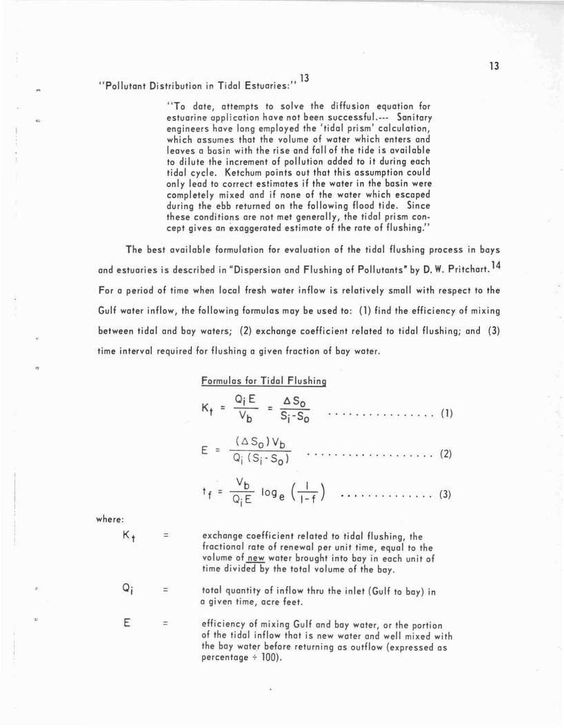
T he bes t ava i la ble for mulat ion for eva lua tion af the tida l fl ush ing process in bays
and e s tu ari es is de s c ribed in "Dis pe rs ion and Fl us hing of Po llutan ts ' by D. W. P ritcha rt. 14
For a pe riod of t ime when loca l fresh water in flaw is relat ively s mall with re s pect to the
Gulf water in flo w, the following formu las may be used to : (1) find the efficienc y of mix ing
between tidal and bay wa ters; (2 ) exchange coeff icient related to tidal flushing ; and (3)
time interval requ ir ed for fl ush ing a giv en fract ion af ba y wa ter .
Fo rmulas fo r T idal F lus hing
= . . . . . . . . . . . . . . . . (1)
whe re :
E =
t f =
( ~ So ) Vb
o, ( Sj ' So )
Vb
Qj E
• . . . . . . . • . . . . . . . . .. (2)
• • • . . . . . . . . . . . (3)
Q.I
E
=
=
=
exchan ge coefficient rel ated to tidal fl ushing , thefracti ona l ra te a f ren ew a l pe r unit time, eq ua l to thevolume of~ water brought into bay in each unit oftime d ivided by the total volum e of the bay.
total quantity of infl ow th ru the inlet (Gulf to bay) ino given time , acre feet .
efficiency of mixi ng Gul f and ba y water, or the porti onof the tidal infl ow that is new water and we ll mixe d wi ththe ba y water before return in g as outf low (e xpressed a sperc entage + 100).

14
Vb = volume of boy a t me an sea level, acre feet .
6So = change in mean salin ity within bo y a lter give ninc rem ent of tim e, ppt
Sj = mean s a lin ity of inflow from Gulf to bay, ppt,du ring same time interval.
So = mean sal in ity within the ba y a t ini ti al ti me t, in ppt .
If = time interval required for fl us hing to renew or exchangea given fract ion (f) of bay water .
loge = natu ral or Napieri an lo gari thm, log to the base e (2.71 8).
f = frac ti on of bay wa te r fl us he d out or exchanged.
The rate of flushing , re newal , o r exchange of the water in the ba y is an e xpo nent ia l
process . Theoretically, an infin ite t ime is requ ired to re ne w or flush out .2!! of the water
in the bay . A concept of the effects of this exponent ial process on the t idal flu shing may
be realized from the follow ing list ing :
The E xponential Flush ing Process
Fractio n of Bo yWater F lush ed
f
0.50 .750.900.950 .99
Val ue of1
loge (W)
0.6931.3862. 33.04.6
T he imp licat ion of th is e xpon enti al flu shi ng pro cess is, fo r instanc e , that it will
req uire 2 to 3 times as long 10 flush o ul 90 to 95 per ce nl of Ihe ba y wa le r than would
normally be expec te d with a linear flus hing proc e s s .
Whene ve r the e va pora t ion from boy s urface e xceeds ra infa ll a nd ru noff , the term
(Si - So) is changed to (So - Si) in th e se fo rmulas .
The appall ing ex ample of e s tuary pa ll ut ion is the Houston Sh ip Cha nne l. No doubt,
und e r lo w run o ff co nd it ions , it has stratifi ed fl ow and suffers fro m a s evere case af eutro-
phi cation (ex t reme loss of oxy ge n from th e lo we r st ratum ). With flushing runa ff, inc ludi ng
septic, low -dissol ved -o xygen s e wa ge from Houston's aid combined sto rm and s ani tary
sewers , the re s u lt is olten a maj or fis h kill.

•
15
It is known that th ese major fish kills usually occu r rig ht after ampl e flu shing ac
tion from rain fall run off. By mak ing several reasonable assumptions wi th respect to
dens ity diffe renc e s in the probable stratified flow, and by application of hyd ra ulic equa
tions includ ing th e necessary gravitational adjustment - it is computed tha t flush ing
fresh water flows of about 3, 000 cf s to 10,000 cfs a re require d to sta rt and the n nearly
co mplete fl ush ing out this lower stratum of low-ox yge n, stagnant, poll uted wate r t ha t is
probabl y the ba s ic cause of the major fish kills . This range of flushin g fre s h wate r flow
is at the rates of 2.2 to 7.2 million acre feet per year.
All th is mean s - flu shing that may well be applied to polluted fresh water s t re ams
will have litt le or no cha nc e of being beneficial in fightin g pollution in the coastal bay s
and estuaries .
In othe r wor ds, th e T exa s Co a stal Bays a nd Es tua ries can no longer be consi der e d
as substitutes for proper and adequa te tr ea tme nt p la nts. It is the co nce pt herein , with
respect to water fo r preservat ion of the bays and estuaries, that mun ici pa lit ies, indus tr y,
and agriculture do not hav e the inherent right to pollute these waters - no more than they
do for fresh wa te r streams. Ins te ad of holding pollution at present levels in these estu
arie s , it mus t be gre a t ly redu ced . If not, man must be prepared to " write off" the bays
fo r rec rea t ion and fi shery and turn them over ent irely to se rve industry and commerce,
and to oct as "hol ding ponds" for polluted waters .
OP ERAT IO N STUDI ES
Operation s tud ie s must be made on the bay a nd estuary s ys te ms , jus t as operati on
studies are made befo re any concep t ion is rea ched c onc e rn ing fres h water reser voi rs. But
formulat ion is differe nt, with more complexities , and peculiar to the e s tu ary. f inall y,
system ope ra t ion an a lyses will be need ed, includin g runoff from , e gula ted watersh ed, Gulf
inflow, and wa ter e xc hange between bays .
WATER BALANCE AND SALINITY
Con cep tual op e ra t ion s tudies have been made to indicate the probable ran ge of
overage annual salin ity of out flo w from the estuari es wi th increased Gulf inflo w thro ugh

16
new or improv ed in let s ope rating under p resen t runoff condit ions . The Gul f inle t s a re
balanced by tid al hydraulic s for eff ici en t mixi ng; an d ov er ag e salin ity is a we ighted
s a linit y ba s ed on s e gmented volu me s of the boy . These a re hypothetical stud ies, base d
on many assu mp t ions ; and they were mode hurrie dl y to he lp fo rm a log ic a l concept . Num.
ber s ar e used to pre s ent a pictu re of the re s ult a nt concep t and to illustrate ho w to fin d
th e correc t an s we rs . These nu mbe rs, the refo re , c ann ot be used li terally to arrive at any
final solu t ions.
The basic, s tacdy-s tc te , rn ixed-wnter an d salinity balance equations are:
F or Ra infall & Runoff E xceeding Evaporation :
. . . . . . . . . . . . . . .. (4)
. . . . . . . . . . . . . . . . (5)..
Wh e re :
And For Evaporation Exceed ing Ra infall & Runoff :
OeSoOJ = E(S - S.)o I
E
S·I
=
=
=
=
=
=
total quantity o f inflow through t he inl et (Gulf to boy)in a given time, acre fee t.
net quanti ty, in acre feet , of ra infall on boy surface plusrun off in to boy less gros s evaporat ion from boy water su rface .
we ighted ove rag e sal ini ty (pp t, or ports per thousand) ofoutf low from boy to Gul f.
effi ciency of mixing Gulf and boy water, or the portion of thetida l inf low that is new wate r a nd wel l mixed with the boywater befo re ret urn ing as outflow (exp ressed as pe rc e nta ge + 100) .
overage salinity of Gulf inflow through in le t into the estuary, ppt.
net quantity, in ac re feet , of evaporation from boy surface minusra infall on boy surface minus runoff into boy .
For Boff in Boy sal inity of Gulf inf lo w is as sumed as e qua l to overage s e a water a t
35 ppt. F rom Gal ve ston Boy to Corpus Chris t i, ba sed on e xtreme ly meage r data and unde r
present cond itions of river flow into Gulf, the foll owing ra nge in ove rage sa linit ies of
Gulf inflow hav e been a s s ume d:

17
Average Sal in ity of Gul f Inflow
Annua l Climati c Condit ion
Wellest (1941)High Average (1940-46)Average AnnualLo w Avera ge (1950-56)Dries t (19 56)
Si (ppt)
27293132.534
"
Resu lts of these con cep tu al opera t ion s tudi es are lis ted in Table 2, follo wing page;
which is ready for compa rison of sa lin it ies und er present and future runoff co ndit ions and
to compute fresh water needs. It shou ld be remembered tha t a steady. state for mula does
not reflect the wide seasonal va riat ions nor salin ity gradien ts toward lower sal inities in
upper reaches of runoff sources, nor hyper s olinit ie s in upper reaches when evaporation
e xceeds rainfall plus runoff. Based upon reasonably good spacing of inlets , the effi .
ciency (El of mix ing was assumed as 25 per cent.
The general increase in sa lin iti e s, going from east to west, will be noted . Gal·
veston Bay sal inities are always less than the nea rsho re Gulf. East Matagorda Bay may
be able ta aperate wholly from it s local coastal wate rshed - but th e actual runoff to this
portion of bay mus t be carefully determ ined . Matagorda Ba y is compa red with and without
the Colorado Rive r. This indic a te s tha t wi th all the Co lo rado River flow Matag orda Boy
sho uld ha ve been good for oysters exc ept for the dri e st ye a r.
San Antonio Ba y now has a good fre sh wat er s upply . Aransas Bo y ha s def in itely
limited fresh wate r sup ply , but it doe s get some fresh wa ter through limited co nnect ions
with San Anton io Bo y. Also , it is suspected that the present runoff used he re in for Aron.
sas Bay may be overest imate d.
This particu la r ope ra t ion s tudy of Corpus Christ i Boy is for from ind ica t ing its
presen t condit ion. It will be not ed th at it is a s s umed tha t Corpus Christi and Boggy
Slough Posses and Demit Island Ch an nel are in place . F urt he r, in this ca s e the natural
runoff of Nueces Ri ve r before construct ion of La ke Co rpus Ch ris t i wa s us ed to evaluate
present effects as well as futu re river development.

18
-w~Zon...JM-e(VlVlOc::WWWo.u>-x:I:W
N
(ldd) !S I ~
onVl ..... 0- ~ N ..,.W MOl:::lNI :::lln~ AlINIlVS N N M M M Vlc:: Z-e JauuoYJ puoisl I!Waa 'lI 0:::l I-1;:;0 sassod y6noiS ~6608 'lI !IS!JYJ N ..... 0- ~ on -cWW sndJoJ Y!!"') 3~aVW VNn~Vl
M M M -e- ..,. :::lVl 0
::E-e( ~3ddn 'lI AV8 NI:::l:::lV8 WOw >-c::c::~
(IauuoYJ I-u...uz Z~z- PUOISII!Waa 'lI sassod y6noiS-x ...Jo~_ 0 on 0- ..,. 0-
...Jo::E ~6608 'lI !IS!'YJ sndJoJ yl!"') N N N M M -eVlu......J1- AV8 11SI~HJ Snd~OJ 0I-u...z:::lzw Z0 __
(sassod puoisl pnw 'lI no~o8-e
• u...u...!:!JopaJ 'IU!Od JaYluod) SAV8 ..... N r-; ..,. co W
o...Ju... N N M M U~:::lu...
SVSNV~V 'lI OINOINV NVS zI-~W -c
N o.:I:C:: ...Jr W ~I-O (ssod puoisl pnw) I -e
...J >--u... N e-, ~ on 0- eo~
c:l I-~Cl AV8 SVSNV~VN N M M M ~ c::
-e -Ow~ W
I- ~zu(no~o8 JopaJ 'lIIU!Od JaYluod) I I-
...J-e(z -0 0 on ~ on -e-e(u...-e( AV8 OINOINV NVS
N N M M ~
Vlu......J ci...Jo-e( W-e(Zc:l (JaA!~ oPOJOloJ YI !"') I x:::l:::lVl on 0 -e 0 onZC::I- AV8 Va~O~VIVW
~ N N M M ::Ezl-w W-e(z...J :I:~W~ (JaA!~ °POJOloJ Inoy!!"') I ..,. co M co I-
>~>- AV8 vcsoov1 VWN N N M M
-e(c::c:l...Jo.
(JaA !~ 0POJOloJ InoYI!'"-e(:I:~I- 'lIlnJ JopaJ U"'OJ8) N ..... N 0 0-
N M M0.-
Ava voaoov1 vw '3w~uZ
(J a A o ll o~ a6Jolu3) I0 M -0 0 co NU Ava N01S3AlV~
~ ~ N N M
~ ~..,. on6 6-e on0- 0-~
~
~ ~ 0 ~Vl ~
" ~Z ..,. .. e ..0- '" '" on
U 0 ~ 0 " 0 0-- ~ -e ~ ~...J l- I- .. .. ~
-e( -e( C iii> .. >-c '" -e:::l ::E Z ~
0 iiiz .s: Q; ~ ..
...J 0 Q; '"ZU U > ° c-c ~ :I: -e( ...J

19
The range af salinities from 32 to 45 ppt in Baffin Bay and Upper Laguna Madre is
computed with the assumptian that Baggy Slough and Corpus Christi Passes and Demit
Island Channel are in operation; and has reduced maximum salin ity from 80 ppt ta 45 ppt.
There is insufficient data available to even attempt to make a conceptual study of
the Lower Laguna Madre. It is, however, suspected that Mansfield Channel needs to be
enlarged for proper salinity control in the Lower Laguna Madre .
SALINITY AND EURYHALINE FISH
Hofstetter 15 reports the opt imum range of salinity for oysters is between 15 and
30 ppt. That is, insofar as passible, the salinity gradients over prime oyster reefs should
be maintained between these limits.
Simmons and Breuer 16 reports the optimum range af salinity for redfish (channel
boss) is between 20 and 45 ppt; that is, in the drier climate this is where they are most
often found.
In the drier climate, satisfactory range of salinity for speckled trout (sea trout) and
redfish far spawning, nursery and catching is between 10 and 45 ppt . This same range
al so produces shrimp.
Simmons and Breuer 16 also report that the blackd rum{large source of commercial
meat fish} particularly like hypersalinities in excess af 45 ppt . The normal feeding habits
of black drum are considered detrimental to the grass beds and consequently detrimental
to sea trout, small redfish, and juvenile sh rimp which use these areas as spawning and
nursery grounds. The black drum can adapt quickly to wide ranges in salinity. Hence,
there appears to be no need to cater ta the excessive hypersaline (+45 ppt) ta ste of the
block drum .
It appears that between the adaptabilit ies of the three shrimps (brown, wh ite, and
pink) satisfactory shrimp production can be mainta ined within the appra ximate ranges of
5 or 10 to 40 or 45 ppt, considered along the entire Texas Coast. The lower salinity
range s a re particularly desired for shrimp and ather f ish food production in selected, shnl
low, protected areas used as spawning and nursery grounds .

"
•
•
•
20
In " Cra bs of Texas, " 17 it is repor ted that th e ma s t importa nt blue crab can adapt
it s e lf to many different envi ronments, and is found an a ll pa rts of th e T exas Coast. AI.
Ihough it i s more prom inenl in ba ys and arou nd the mo uth s of riv e rs , t he blue crab prospers
in the Gul f a s well as in brock ish flats and oreos of almosl fresh water . T he blu e c rabs
ore especially numerous in the many sa lt f10ts and shal low estuarine areas along the
coast.
SALINITY CONTROL
In ord er to moke the first step in deve lopment of a concep t in cl uding salinity COn·
trol over these highly var iab le estuories, it is convenient , but admittedly ever-slmpl tf led,
to take as a postulate - prov ide sal in ity control with reasonable limits for the oyster,
shrimps, speckled trout, and redfish, and then the blue crab, black dru m, menhaden, and
othe r eury haline fish can toke care of themselves.
To ke ep within reosonable limils, it is then co nvenienl from the s tan dpoint of
climat ic regi ons to take as the second postulate - keep the bays in humid cl imate good
for oysters with moximum sal inity of 30 ppt (Ga lvesto n Bay); limit hypersalinit ies to a
max imum of 40 or 45 ppt in serni-crid and dry s ubh umid cli mate (Baff in Bay , Uppe r and
Lower Laguna Madre , Corpus Christ i Bay and Aransas Bay ). Then in moist subhumid
cl imate (Mata gorda Boy and San Anton io Ba y) th e quest ion remai ns as to whether o r not
these estuar ies wi II be kep t good, or re stor ed, fo r oysters .
ESTUARY WATER NEEDS
In thi s conc epl , water needs of the bays are e xp ressed in le rms of the broad defi
niti on an d mea ning of mixed water for esluaries. Minimum fresh water needs a re e xpressed
as herein needed from the various rivers (o r some alternate sou rce) thot are planned fo r
development . Full advan tage i s ta ken of th e runoff from coa s ta l watersheds and in maxi
mum use of Gulf waler to minimi ze these fre s h water ne eds. This " fre s h water" may , of
course , incl ude re turn flows properl y tre at ed 10 meet the pe cu li a r requ irements of Ihe
estuary . Ce rta in gulf in lets, reslora li on of bay wa le r c irc ulation , and spec ial hyd raul ic
structu res for con lrol of wa ler d isl rib ution a re ne eded 10 fulfill this concept of estuary wa·
ter need s .

•
21
GAL VESTON BAY
Galveston Bay now ha s a considerab le ex cess of fresh wat e r, and su rely tao much
polluti on and spoiling . It app ea rs that i t s na tura l abili ty to a s s imila te s ame re a so na ble
amounts of pollutants has bee n impa ired by spoi l ba nks and dikes black ing major and
effect ive circulat io n pa tt ern s . Cer ta inly, e xc e ssive abus e by hyd raulic spoiling can
hardl y be exp ected to hel p th e estuary to re ce ive th e ever-increasing reductions in clarity
from retu rn fla ws. In this humid c limate, there is now ne ed for same increase s in salinity
- nat dec rease s in salin ity f rom add ed fres h wate r.
It appears tha t law aver a ge cli mati c co nditi ons (wit h respect to pre s e nt rai nfa l l
runoff-evapo ra t ion re la t ions) ar e opt imum fo r th is estua ry. This conc ept env is ions that
Galveston Ba y may reasonably be pre s erved goad for oyster s , ex cept possibly only toler
able for th e d rie s t yea r - but alway s an the an nu al " we t" s ide of water ba lance .
It should be re membere d tha t li ve oyster reefs a re an importa nt part of the eco logy
of the estuary, being prime s po rt fish ing ar ea s a s we ll a s pl a ce s to harve s t oy ste rs. Al so,
when the bay is goad for oysters i t is also goad for finfi s h, s hrim p, an d c rabs .
With ulti mate development of the Trini ty and Sa n J ac int a Riv er s, there i s du e to be
little o r no runo ff during law a verage and dr ie s t cli matic co ndi ti ons , bu t still ampl e flo ods
and spill s during average and wett er years to provi de fresh wate r to the bay . Redu ct ion
in s ilt load s hould be ben efic ial. The re is, a lso , su bs tantia l runoff f rom local wa te rs heds
ather than the Tri nity and San Jacinta Rivers .
Ten tat ive operation studies for ult imate de velopme nt indicate that Gal ve ston Bay
will have no specific fresh water ne eds du ring ave rage annual and wetter ye a rs. But to
meet these concep tual cond itions during la w average and d riest cl imatic condition s , the
fresh water needs amount to th e order of 1.0 to 1.5 milli on acre feet per ye a r, in add it ion
to the local runoff and develop ed ri ver spi lls. Return flaw s a re e stimated to be so me what
greater than thi s, and can be used if it is fo und economic ally feasibl e to trea t the m pro
perly for acceptable ass imilat ion by the bay an d e stuary .
Fo r future condi t io ns , th e av e rag e sal ini ty of Gulf inf low and amount s of local
runoff , plus ri ver s pi l ls, p lus 1.5 mill ion ac re fee t in low avera ge and dries t year s, a re
a s sumed a s fallows :

Ann ual Climat ic Co nd it ion
Wettes t (1941)High Ave rage (1940-46 )Ave rage Annu a lLo w Ave rage (1950.56)Driest (1956)
Assumed Ave rageSal in it y Gull In flow
Sj (ppt)
28303233 .535
22
AssumedF ut ure Fresh WaterMillio n Acre Fee t
13.39 .35.02.21.74
T he compa ra t ive sa lin it y conditi on s fo r pre s ent and future , under thes e con c ept s,
a re liste d below:
Go lves ton Boy Sal inities
"
AnnualClimaticCon d it ion s
Wettest (1941)High Average (194 0-4 6)Ave rag e Annu alLow Av erag e (1950-56)Drie s t (1956)
Avg . Annual Sal ini ty of Ou tflow, ppt
P re sent Future----13 1616 2020 2528 3032 33
F o r compari s on, the future salinities for weltest, high overage, and overa ge cl imatic
cond itions are computed without any return flo w - indic a ti ng that only du ring low overage
and dr ie s t climatic con dit ions i s there any speci fic fresh water needs, includ ing properly
treated re tu rn flows.
Ga lveston Boy nat ura lly ha s s ome where ne ar it s fu ll potential of Gulf woter int er-
chonge, bu t East Golveston Boy needs improved circu lat ion and inc re a s e in sal in ity in the
uppe r rea ches through Rollover Pass. It is believed that proper inve s t iga t ions an d water
inte rc ha nge analyses wi ll show so me thing lik e 2.0 to 4. 0 milli on ac re fee t of in flow pe r
ye ar. Fo r il lustra tion, 3.5 mil li on acre feet per year i s shown . The en la rge d pa s s is not
expected to make a very ma te ria l change in total infl ow to th e overall Galveston Boy
System - but i t will improve circ ulation and efficiency of mi xing , and increa s e sal in ity
in the east hal f of East Galv es ton Boy .
As a starte r for poss ible investigation of th is enlarged Rollo ver Pass, the lirst
appro ximat ion ind icates : length 7000 ft.; bo ttom wid th 350-500 ft.; dept h 7 or 8 ft.; and
with I on 5 s ide s lopes . Ba lanced leng th will need to be " c re a ted," proba b ly by des igned
"
23
spoil banks . Inte rior en d around the Intracoastal waterway may have to be des ign ed as a
sand catchment bas in for dredged " s a nd bypassing " up to 80,000 c u . yd . per ye a r of l it .
toral sand to the da wnd ri ft {we st side} beach . It may be found des irable to re loca t e the
Intracoasta l Waterwa y from the bay end of th is pass . If so , no s po il di sp osa l should be
permitted across Ea s t Ga lve s ton Ba y. Add it ional right.of.way will be needed.
The major obs truc t ions to natural water c irc ula ti on with in Ga lve s ton Bay will pro-
babl y be found to be Atk ins on Island {old ship channel s poi l bank jus t belo w Morgan
P o int} and the Texas Ci ty Dike . Re s to ra t ion of s ome of th is na tural cir c ula ti on to help
assim ilat ion of polluted boy waters shoul d be given c a reful study a nd seri ous cons ideru
tion. Any open ings for ci rc ula tion ac ross the Texas City Dike will ha ve to be by bridge,
in or de r to retain this now valuable recreat ion fac il ity . It is und e rstoo d that bo th the
T e xa s Cit y Dike and Atk in son Island we re con s t ructed to min imize th e re turn flow of
hydrau li c spoi ls conven iently placed along s ide th e nav igat ion chann els,
As a suggestion , to hel p prevent fish ki lls where the po lluted Ho uston Shi p Chann el
flows in to Gal ve s to n Bay, the ol d co mbin ed sewers in the centra l a rea s ho u ld be corn -
pletely separated; and con s id erati on may well be given to the possi bi l i t ies of mix ing
stratified flows and restora tion of dissol ved o xyge n by ai r in jec t ion a c ro s s the bottom of
channel. Such mix ing ha s been accomp lished by air bubble s , a s re po rted for instance in
" P ne uma t ic Barrie r Aga inst Sa lt Water Intrusion . " 18
MAT AGORDA BAY
With respect to th e oyster in Matagorda Boy , th e follo w ing I S quoted from " Re tu rn
F lows - Impact on Te xa s Ba y Sys te ms . ' · 19
"There are six extens ive oyster reefs in Matagorda Boy,and none of them is harvested e xt e ns ivel y . T he Mat agordaarea was, in yea rs past, one of th e c en te rs of oyste r pro duc ti on on th e T e xa s co as t. In the pa st two decades, theproduct ion from th is ar ea has decli ned to the po inl of in s iqnificance. On ly one major re ef, Mi dd le Ground Reef, is o fcommerci al vol ue. However, it has been closed to oys terings ince September , 196 1, when Hurr ica ne Ca rla des lroyed th esewag e tre a tme nt p lant nl P al a c io s a nd the Stal e HealthDe pa rtme nt cl o s ed the area in which the reef is loca ted ,The other re efs in th e Mat agor da area are no l worked e xtens ivel y becau s e o f poor qual ity o f oy ste rs or s ha llow we te rs. • I

24
This lonq-terrn declin e and fall of the commercial oyste r in Matagorda Bay migh t be
hi ndca st (f rom Table 1, Annua l Ra infa l l . Runoff. E va pora t io n Relat ions and Tabl e 2, Annua l
Sa l in ity of Outf low from E s tua rie s) as being du e to the divers ion of most of the Colo rado
River flow from t he ba y to th e Gulf. The annual water balance changed , for lo w average
cli mat ic cond it ion , fro m plus 0.69 milli on acre fe et with Co lo ra do River to a minus 0.09
millio n acre feet witho ut the river. For the dr ie st year, an annual defici enc y o f minus
0.29 milli on ac re feet was inc rea s ed to minus 0.86 million acre fee l. With the ri ver,
s a li nit y for the lo w a vera ge climat ic cond it ion was a t the upper optimum o f 30 ppt for
oy sters . Without the riv e r, s alinities appear to be runn in g a li ttle too high fo r the oy ster .
In order to conside r re stor a tio n of the o yst er, it is fi rs t fo recast th a t a verage annual
salinity of Gulf inflow in the fu ture will be 28 , 30, 32 , 33 .5 a nd 35 ppt , ran ging from the
wettest to driest cl imat ic cond it ions . For future averag e and wetter years there i s sub-
stantiol runoff from local wate rs he ds other th an the deve lo pe d river s . Data on future
spills from Colorado and Lavaca ar e not availabl e. Th e n op erat ion s tudies in di ca te th at
fre sh water releases from th e Col o ra do a nd L a vaca Rive rs as l is ted bel o w would need to
range from 0 .6 to 1.5 mill io n ac re fee t per year to restore s al in it y cond itio ns opti mum fo r
the oy st er - e xcept fo r th e driest ye ar .
Matagorda Bay - To Re s to re Oys te r
Ann ual Annua l Rive r Assumed Local Ave rage Annua lCl imat ic Re le a s e s - Runo ff - Sal inity OutflowCond it ion Mill ion Ac re F e e t Mill ion Ac re Feet ppt
Wettest 0.6 0 .85 23High Average 0 .6 0.64 27Average 0.6 0.47 29Low Ave rag e 1.5 0.1 7 30Drie st 1.5 0 .02 32
On th e o ther hand, to preserve the shrimp a nd c ra b and poss ib ly improve the fin.
fish , i t appears tha t Ma tag o rda Bay might opera te qui te well from its own coasta l wo ter-
shed during cli mat ic cond it ions wette r than average - but river re leases of the orde r of
0.3 million acre fe et pe r year may be needed with condi t ions at a nd bel ow a ve rag e to
maintain spawning and nur s e ry ground s an d c erta inl y to l imi t s a l ini ties bel ow 40 ppt, a s
25
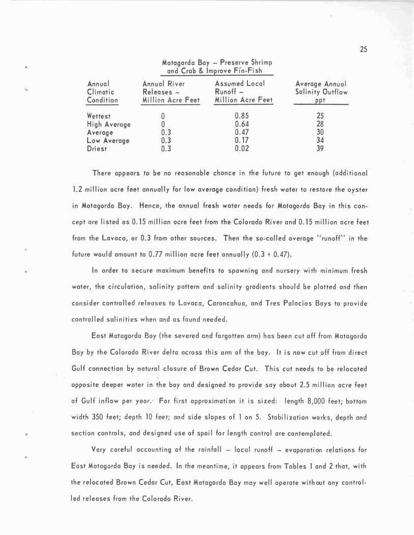
Matag orda Bay - Preserve Shrimpan d Crab & Improve Fin·Fish
AnnualCl imaticCondit ion
Annual Rive r Assumed LocalReleases - Runoff -Millien Acre Fee t Million Acre Feet
Average AnnualSalin ity Outf low
ppt
WettestHigh AverageAverageLaw AverageDriest
oo0.30.30.3
0.850.640.470.170.02
2528303439
There appea rs to be no reasonable chance in the future to get eno ugh (addit io na l
1.2 mill ion acre feet annua lly for law average co ndition ) fre sh water to res tore the oys te r
in Matagorda Boy . Hence , the an nual fresh wate r nee ds for Mat agorda Ba y in th is con-
cept are listed as 0.15 million acre feet from th e Co lorado River an d 0.15 million acre feet
from the Lavaca, or 0.3 from other sources . Then the so -ccl led overa ge " runoff" in the
future would amount to 0.77 million acre feet annua lly (0.3 + 0.47).
In order to sec ure maximum benefits to spawn ing and nursery with minimum fres h
water, the circula tion , sal in ity pattern and salinity gradien ts shou ld be plotted and then
con sider controlled rel eases to Lavaca, Carancahua, and Tres Palacio s Boys to prov ide
control led salinit ies when and as found needed .
East Matagorda Boy (the s eve red and forgotte n a rm) ha s been cut off from Matagorda
Boy by the Colorado Rive r delt a across thi s arm of the boy. It is now cut ,off from direct
Gulf connec tion by na tural c losure of Brown Cedar Cut . Th is cut needs to be relo ca te d
oppos ite deeper water in the bay and designed to prov ide say about 2.5 million ac re fee t
of Gulf inflow pe r yea r.' Fo r first app roximation it is s ized: length 8,000 feet ; bottom
width 350 feet ; depth 10 feet ; and s ide slopes of 1 on 5. Stabilizat ion works , dept h and
section controls, and designed use of spoi l for length contro l are contemplated .
Very carefu l accounting of the rainfall - local runoff - evapora t ion rela t ions for
East Matagorda Bay is needed . In the meant ime, it appears from Tables 1 and 2 tha t, wit h
the reloc ated Brown Cedar Cut, East Matagorda Bay may we ll operate wit hout any cont rol-
led releases from the Colorado River.

•
'.
26
SAN ANTONIO BA Y
San Anton io Boy, includ ing Espirutu Sa nto, Ayres, Hynes, and Mesqu ite Ba ys i s by
a l l class ificat io ns s t rict ly a median bay . It is inte rmediate in size and in unit pro du ction
o f th e basic co ntro l fish - finfish, crab, oyster, and sh rimp . It has neithe r goo d Gulf
water in te rcha ng e nor is i t co mpletely cho ked lik e the Upper L a guna Madre . It s d ist inc-
t ion s are: ( 1) fore casts in di c a t e a si x-fold inc re a s e in ma n-d ay s fishing activi ty (rec re a -
t ion ) in s tead o f two-fo ld increase for other bays ; (2) it is lo cated alon g th e Aransas
Nat ional Wild li fe Re fug e ; (3 ) e xtreme muni ci pa l and indus tri a l e xpa nsi on is, a t least, not
ye t foreca st a roun d this ba y; a nd (4 ) i t has no s ignifi c a nt local run off, dep ending almost
ent irely on San Anton io a nd Gua dal upe Ri ver s fo r fre sh water .
With the present and te ntati vely propos ed full development of th e San Antonia and
Guadalupe River, pract ically a l l fresh water flow will be c ut off from San Antonio Bay.
Then, with little return flo w and its present l imited Gulf water interchange , sal inities
wil l literally s kyrocket to e xcess ive hyper sal inity . It is then foreca s t that th e re will be
a ma ssive, ma n- made, oy ster ki l l in San An ton io Bay .
To ke ep and improve th is estu a ry fo r goo d o ys te r pro duc t ion , it is fir s t assum e d the
s a li n ities must be ke p t belo w 30 pp t. Th e minimum computed rel ea s e s from the fut ure
d; 'velope d San An to nio and Guadalupe Riv e rs th at will probably be needed a re compared
bel ow with th e pre s e nt runoff.
Sa n Anto n ia Ba y - Fo r Oy s te rs
•
Ann ua lCl imat icCon di t io n
Wett es t (194 1)Hig h Ave ra ge ( 1940-46)Aver ag eLow Ave rag e (1950- 56)Driest (1956 )
P resent Annua lRuno ff
Milli on Ac re Feet
3.32.11.40. 60. 3
F uture Annua lRe le a s e s
Milli on Ac re F eet
0. 10.20 . 50.81.1
Whether th is wou ld wo rk wi ll al s o probably dep end an the nat ure of spi ll s (present ly
nat kn own ) from th e fut ure deve loped rivers . F or go od oys te r product ion it is a s s umed
that the salin it y gradi ent should va ry da wn tow ar d the lo we r limit of 15 ppt a t ti mes , and
i t ma y be found that Panther Point Pas s wou ld not be desired wit h o yste r cu lture .

•
27
On the other hond , if it is des ired to prepare for the impac t of s lx-Icld increase in
rec rea t ion and sport fish ing , the producti on of trou t and redfis h and the fis he ry might well
be improved for recreation by con trol of sal in ities bet ween 20 to 40 ppt and by providing
improved Gulf water interchange.
It is then assumed that P onther Point and Cedar Bayo u Passe s are ins ta l led and
that with future cver-cl l river deve lopment the s a l inity of the nears ho re Gulf wil l te nd to
increase somewhat - say lik e 29, 31, 33, 35 and 37 ppt for the five cl imatic cond itions
from wettest to driest . Then with unifo rm releases (probably into Hynes Bay) for all
years but amounting to only about 0.3 mil lion acre feet per year, which is about the mini -
mum present flow for the driest year, the co mputed sa linity ranges are compared be low
with those listed in Table 2 for present runoff conditions .
San Antonia Bay - Fo r Recreation
AnnualClimaticCondit ion
P resent AnnualRunoffMill ion Ac Ft
Av1;, Annual Salinity of Outf low, etwit P resen t Future - witRunoff 0.3 Million Ac Ft
Wettest (1941)High Averoge (l94D-46)AverageLow Average (l95D.56)Driest (1956)
3.32.11.40.60.3
1620253135
2729323639
,.
Now to weigh the probl em of oyster vers us rec reat ion in San Anton io Bay , the fol
lowing co nsiderat ions are offered: (1) with the future despera te sea rch for fresh wat er ,
it is the bas ic concept herein to cons ider making maximum use of Gulf water to minim iz e
the fres h water needs of the estua ries; (2) the fre sh water need s for recreat ion in thi s
es tuary appear to be about half that needed for the oyste r; (3) it is forecast that man
da ys fis hing {recreation} will inc rease s ix-Iold in San Antonio Bay; and (4) evaluat ion
c ited herein does indicate that rec reation , now or late r, may be worth ten times commer-
cial fish ing.
From all th is , it is then fore seen tha t at leas t in this e stua ry recreati on will pro-
bably win out over the oys ter; so the fresh wat er needs for Son Antoni o Bay from the
co mbined San Antonio and Guadal upe Rivers is noted a t 0.3 million acre feet per year.

•
•
•
,-
28
If this concept i s fo llowed , i t mus t be rea li z ed that sooner or later there will likely
be considerable oyster mortal ity in San An ton io Bay . This will open the way for legal
explo itation of the " dea d" she ll re ef s - whi ch are s till ve ry va luable to the fishery.
Surely, there must be a way to give the coasta l f is he ries the needed legal , techn ical ,
scientific and enginee ring back ing to let th er e be reasonable production of excess shell
and still leave the fishery in so mewhat be tte r cond it ion - instead of the way it has been
done in the past.
A balanced inlet , Panther Point Pass, to provide about 6.3 milli on acre feet pe r
year of Gulf inflow to San Anton io Bay may be located across Matagorda Is land about 2
miles west of Panther P a in t and connecting with the deeper water in San Ant onio Ba y.
II is locat ed a bout 3 miles west of the west bound ary of the Matagorda Island gu nnery
ra nge. T his is a substantial sized pass, which by first approximation is ind ic at ed with
dimen s ions of : len gth 14,000 fee t; bottom widt h 50 0 feet ; de pth 1? 5 feet ; si de s lopes 1
on 5; and area of 10,000 square feet. Stabilization works and depth c on tro l s il ls at Gul f
en d are con tem pl ated . A bridge over the pass will be needed and ample rig ht-o f-wa y (say
a t least one mile wide) should be secured for both construction and public use.
Mesquite Bay is natu rally restricted fo r wate r interchange between San Anto n io and
Aransas Bays. Cedar Bayou may be balanced by sho rtening to about 11,000 feet length
with Gulf inflow increased f rom nil to about 2.1 mill ion ac re feet per year. F irst appro xi
mat ion s izing indi c a te s: bottom width 220 feet ; dep th 12 feet ; s ide slopes 1 on 5; an d
area of 3,360 s qua re feet . Stab il izat ion works , control s ills, and a br idge are contern
plated; as well as ample right.of.way about one mile wide across Matagorda Island.
ARANSAS BAY
Aransas Bay with Copano Bay is poo r fo r com merc ia l o ys te r producti on but e xcel.
lent for f infish and blue crab and good for shri mp. From p 154 of " Ti da l Waters of Texas ; '?
it is apparent that only in years of abo ve-normal prec ip itat ion does the sa linity of Aransas
Bay fall low enough to be cons idered an optim um oyster environ ment.
In 1963·64 with low average cli matic conditions there was a serious oys ter morta l.
ity . Durin g this per iod the salinit ies at te st platforms ranged from 28 to 42 ppt, while

29
opt imum upp er limit fo r oyste rs is 30 ppt , The low er solin it ies were recorded olter th e
higher s ol in it ies . It will be noted from Tobie 1 thot for low overoge c1imot ic cond ition
e vop oration e xce ed s ra infall plus runoff by 0.27 million cere feet per year. If Mud Island
Pa s s , whi ch woul d tend to mode ra te the highest sal in ities , hod been in s ta lled it is l ikel y
th at ther e would have been no material help fo r th e o ys ter. It will be not ed from Tabl e 2
that wit h Mud Is land P a s s and present runoff conditi ons t he overa ge -wei ght e d sa lini ty of
outflow for ov erage annual climatic condit ions is computed at 31 ppt . This a grees with
the statement that on ly in years of above-norma l rainfall does the sa lin ity of Aransas Boy
fall low enou gh to be considered on optimum oyster envi ronment.
It does not appear reasonable to attempt to improve conditions for the oyster in
Ara n s o s Boy . But the reefs, with o r without live o ys te rs at all times, should be strictly
preserved a nd pr otected for the ecology of the fishery.
It is t hen the concept to l imit design sa l ini ty of Ara ns a s Boy to 40 ppt. For the
five clima t ic con di tio ns , wettest to dri e s t , it is as sumed that overage salinity of Gul f
inflow wi ll be - 29 , 3 1, 33, 34.5 and 36 ppt. Ope ration studies indic a te that fresh water
needs from the Ara ns a s and Miss ion Rivers amount to appro ximately 0.15 mill io n acre feet
per year; and the Gu lf wa te r needs are Mud Island Pass with 4.0mi l l io n acre feet o f in fl ow
per year . The present and future solin ity cond i t ions olong with releoses pl us locol run-
off, compare as follows :
Ara nsas Boy Salinities
AnnualC limat icCondi tion
Fut ure 0. 15 plu sL oc a l RunoffMi lli on Ac re Feet
Avg. Annu a l Sal ini ty Out fl ow. pptP re s e nt wit h Future wit hM.1. P a s s M.1. P a s s
Wett e s tHigh Ave rageAve ra ge Annua lLow Ave rageDrie s t
0 .470.310.240 .190.154
2227313539
2630333640
Mud Is land P a s s i s te ntat ively loca te d 5 30 · E ac ross St. Joseph Island and Bl ind
P a s s , at the ju nction of Mud Island , an d con nec t ing wit h the deeper water of Aran sas Bo y.
Fo r a nnua l Gulf in flow of 4.0 million acre feet , first appro ximation formulas indica te s iz e

30
of pass a s : len gth 9 ,000 fe et; boltom 440 fe et; depth 12 feet; a nd a rea 6,0 00 sq . ft. Stob-
i l izo tion works , control s i lls , and ample right.of.way at least one mile wide ac ross 51.
Joseph Isla nd is contem plated, whic h in cl ude s a s hort la nd ing strip a nd a build in g .
In " Abnorma l Marine Ecos ystems of Te xas, "20 i t i s reported that Co pan o Bay
rece ives ex t en si ve bl eedwate rs (po llu ti on from oil f ield brine wa stes) . Proper acco un t in g
of th e se satu rat ed sa l t s olut ions sho uld be inc lu ded in the rnixe d- woter balance and so l in
i ty equatio n and stud ies of salinity gradients. Pa rt of the des ign int e nt is to produce
lower sa lin ities in Copano Bay wi th a min imum of fre sh water rele as es into tha t Bay. It
may be found that this oil field pallulion should be s topped be fore pre ci ou s fresh water i s
re lea s ed to " fr e s hen" the Copano Ba y waters .
CO RPU S CHRI STI BAY
Corpus Chri s t i Bay is alre ady s ufferi ng from the impac t of Nueces Ri ver de vel op.
me nt. Th e Te xas Coast for the la st 3 or 4 years has been under low average cl imatic
cond it ions . Wate r hoard ing (holding water fo r futu re use tha t is not prese nt l y ne ed ed and
thus na t available as return flo w) by L a ke Co rpus Chris t i appears to be the bas ic cause
of extr eme hy persali ni ty, mea su red at about 55 ppt , in Nueces Bay.
Co rpus Ch risti Bay has practically no a ther source of ru noff than the Nueces Rive r.
Annual average runoff ha s already been re du ced from abou t 610 ,000 to 505,000 acre fee t
per year. With contemplated future developments the re will be no river flow int o Corp us
Ch ri sti Bay in 13 out of 16 yea rs . P re s en t re turn flo ws a mount to only about 35 ,000 acre
fe et per year, but five times this much (177 ,0 00 acre feet per ye ar ) i s foreca st fo r t he ye a r
2020 . With the enormous burden of excess eva porat ion over ra in fal l a nd runo ff - minus
1.38 mil l io n a cre fee t in the dr ie st yea r from Corpu s Christ i a nd Baff in Boy a nd Uppe r
Laguna Madr e - Corpus C hris t i Ba y is c er ta inly in poor con di tion to assimi late thi s future
pollut ional load . In 1953, Dona ld W. Hood 8 concluded that th i s boy would be one of the
eas iest boys in the Texas Bay Sys tem to conlo minate with non-metaboli zable wasles o r
noxious mate ri e l s .
It ap pears that Nueces and Corp us Chr ist i Bays are s e rious ly threa tene d with undue
a nd into le rabl e hyper sa lin ity, a nd more pollu t ion tha n it can ass imi la te - ev e n fro m fa irly
we ll treate d re turn flow .

31
Unde r present condit io ns, Corp us Chri sti Boy needs more tha n all th e natural runoff
from th e Nuece s Rive r. T he firs t wa te r need is a mple Gulf water to re li eve t he e xtreme
hyper sali nit y of the ad ja c ent Upper Laguna Madre a nd Ba ffin Ba y. Th is may be do ne b y
th e Corpu s Ch ri st i an d Bo ggy Sla ugh Passes and Demi t Isl a nd Channel. See Refere nc es
21 and 22 fo r re por t s on th ese pa s s e s a nd c han ne l.
With thi s relief , i t is then bel ieved t ha t prope r inve s ti ga t ions and opera t ion studies
wi l l indicate tha t th e fre sh water ne eds of Co rpus Christ i Bay amounts to about 0.15 to
0.20 million ac re fe et per year. It is the inte nt of thi s concept to limit ma ximum sa lin ities
(we igh ted ave rage) to around 40 ppf in Corpu s Christ i Bay and 45 ppt in Nueces Ba y.
This e s tuary is nat no w a commercial oyster producer and th i s concept does not
attempt to make it one. Nevertheless , any re e fs that might deve lop oy s ters du ring we tter
years certain ly s hould be preserved as good fo r the ecology of the estua ry.
Th e probl em is complicat ed in Nueces Boy, whe re sal inities are now up to 55 pp t.
In " Abn orma l Ma ri ne Eco systems of Te xo s .. 20 i t is pointed ou t that cooling wa te r is
dra wn from the sh ip cha nne l and harbor and pumped int o Nue ces Ba y at a ra te of 155 mi l
lio n ga llo ns per day . Nueces Boy sal in i ty va ried from 1 to 45 ppt du rin g the period of
s tudy ( 1960. 6 1. 62). but s a linit ie s have re cently gon e up to 55 pp t. Th is circulation,
po s s ible increas e in e vapo ra ti on rate s in the s ha ll o w Nue ces Ba y, po int s of re t urn flow,
th e need fo r s ome "rncke-up" wa te r, an d co nt ro l of re leases fo r maxi mum be ne f it s with
min imum fre sh wa ter mus t be cons idered in th e deta i led investigat ion of thi s es tua ry.
T he s e st ud ies s ho uld incl ude determina tion of whet he r any ope ni ng s i n s poil banks are
needed for circ ula tio n of mixed wat e rs in Co rpu s Chris t i Bay.
Wi th Co rpus Ch rist i a n d Bogg y Slough Pa sses and Demit Island C ha nne l in place
and with natu ral runoff in Nueces Riv er (be for e Lake Co rpu s Chris ti ) the va ri a ti ons in
s a l in ity are l ist ed in T obl e 2. Th is is compared be low with futur e runo ff condit ions
plu s 0. 18 million acre fee t pe r yea r o f trea t ed re t urn fl ow an d re leases, and wit h scl in
it ies of Gulf inflow ran ging from 29 to 36 ppt from the wettes t to drie st years .

AnnualClimat icCond it ions
Corpus Chris ti Bay Sal init ies
Average Annual Sal in ity of Outflow, pptNatural Runoff Future Runoffwith Passes With Passes
32
Wette stHigh AverageAverage AnnualLow AverageDriest
2025293439
2429343640
The poin t is, thi s estuary needs the fresh water~ - nat in the year 2020.
BAFFIN BAY AND UPP ER LAGUNA MADRE
Baffin Bay , particularl y and partly the Upper Laguna Madre, may bes t be des cribed
as a tu rbid, da rk brown, polluted, dead sea - instead of a live estuary. It is naturally
pollu ted with exces s ive hypersa linity and aided and abetted by man to remain so . It is nat
a live estuary becaus e normal Gulf ti des do not reach a river current. The "tides" are
mos tly wind- induce d tides that simply rock the polluted waters bock and forth . This pol
lute d water is " bled" off by stratified (dens ity) flow into Corpus Christi Boy. Boffin
Boy is the home of the rooting, scl t- lovinq block drum - but even it is sometimes bl inded
by the extreme salin ities. Extensive land areas nre being blighted by wind transported
sa lt from th e flats of this dead sea .
The almost final closing of its limited natural life line of flow between Demit and
Pita Islands (ne xt to Corpus Christi Bay) is used herein as the horr ible example of man's
spoiling. This is the proposed location of Demit Island Channe l.
The Baff in Ba y Sys tem has no specific fresh water needs from the Texas Water
P lan - but it does need a la rge inle t co nnecti on with Gul f water, so it may enter the
family of l ive estua ries a long the Texas Gulf Coast.
The probl em ha s been studied, well investigated, and reported to the Texas Game
and Fish Commiss ion (now Texas Parks and Wildlife Deportment). See References 21
and 22. Solution to the proble m consists of: (1) Boggy Slough Pass - 11.5 million acre
feet annua l Gulf inflow; (2) Corpus Chris t i Pass - 3.5 million acre feet annual Gulf
inflow; and (3) Demit Is land Channel - 2.2 mill ion ac re feet inflow from Corpus Chris t i
Bay to Upper Laguna Madre.

33
It will be note d that Boggy Slough Pass is located oppos ite Boffin Boy and across
the Padre Is la nd Notional Seashore. II rood access and a large State Pork could be
located on the sho res of Boffin Boy near Boggy Slough Pass, i t would ce rtainly help the
Texas Coast to toke the impac t of rec re ati ona l de mands as now projec ted .
SUMMARY OF WATER NEEDS
Under this concept of making ma ximum use of Gull water to minimize the fresh water
needs of the boys and estuaries, it is forecast that intens ive invest igations and studies
will show the water needs to be on the order of:
Annual Water Needs - Million Acre Feet
Estuary Local Runoff Fresh Waler Gull Waler
Gal veston Boy 5.0 1.5 3.5East Matagorda Boy 0.3 0.0 2.5Matagorda Boy 0.47 0.3 0.0Son Antonio Boy 0.0 0.3 8.4Aransas Boy 0.09 0.15 4.0Corpu s Chri sti Boy 0.0 0.2 3.5Boffin Boy System 0.0 0.0 11.5
To tals 5.86 2.45 33.4
It should be remembered that fresh water ne ed s are e xpre s s e d as either re le as e s or
treated return flow from the pertinent developed rivers and that local runoff is simply
listed as overage annual. Gull water is listed as amoun t of inflow through the suggested
inlets.
SUMMARY OF POSSIBLE INLETSAND STRUCTURAL MODIFICATIONS
Suggested her ein for intens ive inve s t igati on, study, and considerat ion fo r possibl e
use in the preservat ion and enha ncement of the boys and estua rie s a re th e foll owing gulf
inlets, modifications in waler circulation, and other hydraul ic control st ruc ture s :
1. Galveston Boy. Enlarge Rollover Pass at east end of East Galveston Boy to
improve circulation and increase sal in ity . Re s to re som e of the natural boy water
circulation by open ings in Atkinson Island and by bridges in th e Texas City

34
Dike. Determine the loco t ion , tim e ond rote s of spec if ic fresh woter releoses
if treated return flows do not supp ly fresh water needs.
2. Matagorda Bay . Relocate Brown Cedar Cu t oppos ite deeper water near east end
of East Matagorda Bay; and verify, or mod ify the tenta tive assumpt ion that no
specific fresh water releoses will be needed for this orm of Matogorda Bay.
Determine the locot ion , time, rate, and distribution of specific fresh water
re leos e s - which will probably be to Lovoco , Corancohua and Tres Polocios
Boys.
3. San Antonio Boy. If sufficient fresh woter is not made available to ma intain
the commercial oyster in San Antonio Bay , then install Panther Point P ass .
Shorten Cedar Bayou to provide a balanced Gulf inlet tu Mesquite Bay. Det e r
mine the proper location {poss ibly Hynes Bay}, time, rates, and distribu tio n of
s pe cif ic fresh water releases.
4. Aran s a s Ba y. Install Mud Island Pass; and determine location, time, rates, and
di s trib uti on of the specific fresh water releases. These releases wi ll proba bly
be divided into Copano, Mi ss ion, and St. Charles Ba ys.
5. Corpus Christi Bay. Prov ide Carpus Christ i Pass and Demit Island Channel as
part of the program to control hypersalin it ies in th is bay and adjacent to Laguna
Madre. Determine distr ibution and rate of fre s h water releases into Nueces Bay .
De termine whether any openings in spo il banks are ne eded for proper and eff i
ci ent circulation of mixed bay wate rs within Corpus Ch rist i Bay.
6. Ba ff in Bay and Upper Laguna Madre . Construct Boggy Slough Pass, including
in tensive s tudie s to locate somewhat extens ive spoil removal to de fin itely pro
vide a nd restore much needed bay water circulat ion.
7. Lowe r Laguna Madre . Make water balance and salin ity control studies of the
Lowe r Laguna Madre to determ ine whether Mansf ield Channel needs enlargement.
F ina ll y, in order just to start cons ideration of this concept, i t is ment ioned that the
" order of magnitude" of cost of all these gulf inlets may be found to be somew here a round
$30 mill ion , more or less.

35
BASIC DATA NEEDS
In order to chonge the herein so-celled "i llus trot ive " numbers into literol numbers,
o consideroble omount of vi tol bo s ic doto must be secured ond put into usable form .
COMMUNICATIO N AND LIAISON
The first need is for improved com mun icat ion and close liaison between many d ivi
s ions of the scientific and engineer ing community. The problems are many and complex.
To solve them will require the cooperative work of - marine scientists, marine fisher y
biologists, coastal engineers, geologists, hydraulic engineers, sanitary engineers, hydro]
og ists, hydrographers, cartographe rs, waterway engineers, and others.
ANAL YSIS OF TIDAL DIFFERENTIALS
Many tidal readings have been token along the coast, but very lillie has been put
into usable form insofar as the problems at hand are concerned. For each boy, some
additional tidal readings are needed. The scientific sampling, analysis, and plalling of
tidal differentials to put th is vital basic data into usable form is covered in Reference 21
and in " De s ign of Inlets for Texas Coastal Fisheries."23
SALINITY DISTRIBUTION AND GRADIENTS
Typical synoptic mops of horizontal sal inity distribut ion, shown as isohalines , of
the boy systems are needed - along with simultaneous measurements of all quantities
used in the mi xed-water balance and salinity operation studies. Typical prof iles of snljn
i ty gradients, includ ing vert ical differentio ls, and study of s trat ified flow are needed .
TYPICAL CURRENTS AND CIRCULATION
Synoptic mops of the typical current directions, strength , and c irculation pallerns
are needed . For ins ta nce this would incl ude : with tropic and equator ial tidal inflow and
outflow; with fresh northerly winds; and with fresh southerly winds.
RAINFALL·RUNOFF-EVAPORATION RELATIONS
The use of inl and based evapora t ion stat ions to es t imate gross evaporat ion from the
surface of these large boys has been and should be seriously questioned . Complete

36
weat her st a ti ons prope rl y loca ted a re neede d to per mit bot h d irec t me a s urement and thea-
ret ical comp uta t ion of the e vapo ra tion from the s e bo ys loc a te d be twee n the gu lf and the
in land e vapora t io n s tat ions , as well as ra infall on the bo y surface .
Ca re ful account ing of both present and future runoff into the va rious pert inent por ts
o f th e s e bo ys and e stuarie s is needed an d must be properly segmented fo r the specif ic
need of ma kin g operat ion s t ud ie s of the boys - both sepa rate and as port of the complete
water system.
EFFICIENCY OF MIXING
Insofar as is presently known, the best way to determ ine the efficiency of mixi ng
fo r the various estuaries is to careful ly measure a ll qu an tities for a given tim e th a t go
into the "mi xed -water balance and sa lin ity formulas " and s imply solve for E (efficiency
of mec hanica l mixing). It shou ld be noted tha t diff e ren c e in salin it ies of inf low and
outflow shou ld amount to 5 ppt , or more, when us ing t his tec hn ique . At times, th e fo rmu
las for tida l flush ing may be used to determine the efficiency of t idal mixing.
HYDRAULIC MODELS - INLETS
Th e bas ic for mul ati ons for dyna mic bal ance in de s ig n of T exa s Coastal in le t s to
permit e ff ici ent gulf water interch a nge for sa lin ity co ntro l and fish pas sage t hrou gh th e
li ll a ra l ba rr iers hav e been deve loped and publis he d in " De s ign of In lets ,"23 T he f ina l
concl usion in this tec hn ic al pap er is qu ote d :
" T o ver if y and refine the de s ign, th e re is now a dist inctneed fo r the us e of hy draul ic model s with mov able bed tocomple te the design s tage and then th e cons t ruc tion o f oninlet balanced in accordan c e with cr i ter ia and fo rmula sde velo ped here in ."
CLASSIFICATION MAP S
One of the best wa ys to start comm un ic ation on the prob lem of preserva t ion and
enhancement of the es tuar ie s is to ha ve prepared goo d and co mpl et e class ificat ion mops
of the boys - fro m the sp ecific vie wpo int of the fish er y . Th ese mops s hou ld sho w irn-
portant spaw ning and nurs er y ground s, and parti cularly all s he ll ree fs - with or witho ut
comme rc ia l l ive oysters - that are of re a l value to the fisher y.

37
PLANNING FOR ESTUARYPRESERV ATIO N AND ENHA NCEMENT
After fulfi llin g th e ba s ic data needs , it is this co nc e pt th a t comple te plann ing fo r
the mixed wa te r needs fo r pre s e rva t ion and enhancement of the co a sta l boys and estuarie s
may we ll be along th e fo l lowing lines :
1. Maxim ize th e use of gulf wa ter to minimi ze the ne eds fo r fresh water.
2. Reduce pollu ti on by treatmen t to so me tol e ra bl e amount that may be ass imilated
by the boys; and a t the some t ime re s to re o r impr ove boy wa ter circ ul a ti on and
improve effic iency an d distrib utio n of gulf water interchange to he lp the boy s
ass imi la te the s e re turn fl o ws.
3. Ge t the ma ximum benefits out of min imum fre s h water by designed a nd can tral -
le d releases to selected and valuable spawn ing and nursery areas .
4. T her e remains, as a major and basic water pl ann ing decisi on, the fa te of th e
commercia l oyster in Son Antonio and Mata gord a Boys .
5. Wh en and where it is planned to preserve and enhance the boys an d estuaries
fo r rec rea t ion and fisheri es - and considerable funds are ex pe nde d to do th is
then surely th e plan n ing should incl ude curing the matter of hyd raul ic dredge
spoiling by p lacing it under so me respons ib le control, in order to pro tect t he
correct ive and improvement inv es tme nt s , as we ll as th is valuable he ritage .
6. When and whe re th e future in ev i tab le re duc t ion o f fresh wate r flow to these
boys and estua ries ma y be invo lve d in o ys te r morta lity , surely the plann ing can
find re asonabl e ways and mean s to e ither save or replace these valuable reefs -
and at the some ti me pe rmit rea s on able and valuab le min ing of shell that is of
no use to the fi s her y.
7 . T he re rema ins to be acco mpl ished, at least a long the Texas Coast , the co n
stru ction of a Gulf inlet wit h proper balanced de sign based on adequate basic
dat a. If gulf wa te r is us ed to minim ize fre sh wat e r needs , the planning ma y
we ll prof it by obser vat ion of the a wful e xa mpl e s of the pos t imba lanc ed inle ts.

,.
38
SELECTED REFERENCES
1. " Marine Re sources of the Carpus Chris ti Area :" by A. A. Anderson , sponsored byBureau of Bus ines s Re s earch and Ins titute of Marine Science, Univ. of Texas, andCarpus Chris t i Cha mber of Commerce, 1960.
2. " Hydro logy - Physics of the Ea rth - IX," edi te d by Oscar E. Meinzer, Dover Publicat ions , Inc. , N.Y. , 1942, p. 584.
3. " The Ocea ns - The ir Physics, Chemistry and General Biology", by Sverdrup ,Johns on, and F leming, 8th Printing 1959, Pr ent ic e-Hcll , lnc ., N. J ., p. 50, p. 55,p. 123, p, 147.
4. " Seasona l Populatio n Change s and Dis tribu tions as Related to Salinity, of CertainInvert eb rat e s of the Texas Coa st , Including the Commercial Shrimp, " by GordanGunte r, Ins t itu te of Ma rine Sci ence, Val. 1, No.2, Nov. 1950, p. 7.
5. " The Invertebra te Fauna of Te xas Coa s t Je tt ies " by Wh itten , Rosene, and Hedgpeth,Inst itute of Marine Science, Vol. 1, No. 2, Nov. 1950.
6. " Design of Deep Naviga tion Chann el from Gulf of Mexico into Matagorda Bay, Texas :'by E. A. We is er and Jack Armstrong, U. S. Army Enginee r Dist rict, Galveston , Te xas .
7. " An Introduct ion to the Hydrology of T idal Wa ters of Texas," by Albert Callier andJo el W. Hedgpeth , Ins titu te of Mari ne Sc ienc e, Va l. 1, No. 2, Nov. 1950, p. 125.
8. " A Hydrograph ic and Chemica l Survey of Corp us Chri s t i Bay and Connecting WaterBodi es, " by Donald W. Hood, J une 26, 1953, Depa rtment of Oceanography, A & MColl ege of Texas.
9. " Ecologica l Survey of the Upper Laguna Madre of Tex as," by Earnest G. Simmons,pp. 156· 200, Ins titute of Mari ne Science, Vol. IV, Number 2, July 1957.
10. " Ecologica l Survey of Baffin and Alaz an Bays, Tex as, " by Joseph P . Breuer,pp. 134-155, Insti tute of Mari ne Sci ence, Va l. IV, No. 2, July 1957.
11. "Result s of the Trinity Bay Study," by Ric hard A. Diener, published in Circular 16 1,U. S. Fi sh and Wi ldli fe Service, Fi s hery Res earch Biological Laboratory, Galves ton,1962.
12. " Biologic and Hydrographic Adjust men t in a Disturbed Gulf Coast Estuary," byGeorg e K. Reid , Limno logy and Oceanograph y, Vol. II, No.3, July 1957.
13. " On Determin ing Poll utant Di s tri bution in Tida l Estuari es," by E. E. Pyatt,Geolog ical Survey Wa te r - Suppl y Pap er 1586.F , 1964.
14. " Dispe rsi on and Flu sh ing of Poll utants ," by D. W. Pr itchard, Chapter VIII of ReportNo.3, " Evalu a tion of P res ent Stat e of Knowledge of Fa ctors Affecting TidalHydra uli c s and Rel at ed P henomena, " C. F. Wic ke r, Editor , Committee on TidalHydraul ics , C. of E. , U.S. Army, May 1965.

39
15. "The Texas Oyster Fishery," by Rober t P. Holste tte r, Texas Parks and Wildl ileDepartment, Bullet in No. 40, Re v. 1965 .
16. " A study 01 Red lish and Drum, " by Erne st G. Simmons and J oseph P. Bre uer ,Institu te a l Marine Sci en ce, Vol. 8, 1962.
17. " Crabs 01 Texas," by Sandra Pa und s Lea ry, Bulletin Na . 43, Serie s VII, Caas ta lFisheries, T exas Parks and Wildlile Depa rtment, Re vised 1964.
18. "Pneumatic Ba rrier Again st Sal t Water Intrusian " by Ian La rsen, Transac tionsASCE , Vol. 127, 1962, Part IV, p. 475.
19. " Return Fl aw - Impact on Texas Bay Sys tems, " repart to Texas Water Develo p.men t Boa rd, by Bryant.Curi ngto n, lnc ., Jan . 1966 .
20. "Abnorma l Marine Exasystems 01 Texas," by H. T . Odum, R. P . Cuzon duRest,R. J. Beyers , and C. Allbaugh , published by Inst itute 01 Marine Science, Val. 9,De c . 1963, p, 404.
21. " De ve la pment Re port on Fish Passes and Water Interchange lor the Upper LagunaMadre and Corpus Christi Bay, Coastal Texas," report by Lockwood, Andrews &Newnam, lnc. , to Texas Game and Fi sh Commission , 1959.
22. " Cons erva t ion 01 Hab itat and Fishery in th e Uppe r Laguna Madre, Te xas ," reportby Lackwood, Andrews & Newnam , Inc ., to Texas Gome ond Fish Commiss ion,1962.
23. "Design 01 Inlets lo r Texos Coostal Fisheries, " by H. P. Carothers an dHomer C. Innis , ASCE Transactions, Vol. 127, 1962, P ort IV, p. 231.