Planning for Cornwall’s future Local Plan...Cornwall Local Plan Planning for Cornwall’s future...
76
Cornwall Local Plan www.cornwall.gov.uk Planning for Cornwall’s future Strategic Policies 2010 - 2030 Community Network Area Sections
Transcript of Planning for Cornwall’s future Local Plan...Cornwall Local Plan Planning for Cornwall’s future...
Cornwall Local Plan
www.cornwall.gov.uk
Planning forCornwall’s future
Strategic Policies 2010 - 2030
Community Network Area Sections

Community Network Area Sections 2010-2030
Dalghow
Note: Penzance, Hayle, Helston, Camborne Pool Illogan Redruth, Falmouth Penryn, Newquay, St Austell, Bodmin, Bude, Launceston and Saltash will be subject to the Site Allocations Development Plan Document.
This document should be read in conjunction with the Cornwall Local Plan: Strategic Policies 2010 - 2030
3
Community Networks
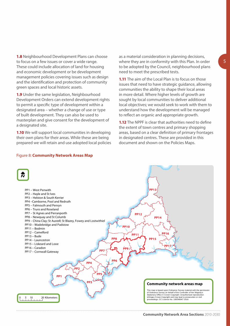
PP1 West Penwith PP2 Hayle and St IvesPP3 Helston and South Kerrier PP4 Camborne, Pool and Redruth PP5 Falmouth and PenrynPP6 Truro and Roseland PP7 St Agnes and PerranporthPP8 Newquay and St ColumbPP9 St Austell & Mevagissey; China Clay; St Blazey, Fowey & LostwithielPP10 Wadebridge and PadstowPP11 BodminPP12 CamelfordPP13 BudePP14 LauncestonPP15 Liskeard and Looe PP16 CaradonPP17 Cornwall Gateway
6
12
18
22
28
32
36
38
41
51
54
57
60
63
66
69
71
Contents

Cornwall Local Plan
4 Planning for places
Local objectives, implementation and monitoring1.1 The Local Plan (the Plan) sets out our main planning approach and policies for Cornwall. Further details including allocations are provided by additional Allocations Development Plan Documents and Supplementary Planning Documents. Neighbourhood Plans, prepared by city, town and parish councils will be part of the statutory Plan too. The Plan also sets out how we will manage development to 2030.
1.2 The Plan is intended to help deliver the vision and objectives of ‘Future Cornwall’, our sustainable community strategy. The underlying principles of the strategy seek to manage future development to ensure all communities in Cornwall have an appropriate balance of jobs, services, facilities and homes.
1.3 Community Network Areas (CNAs) have been established to act as a local focus for debate and engagement. These provide the basis for the place based element of our policy framework. Many local objectives are reflected in the overall approach to the plan, such as affordable housing and have less emphasis in this section. Other more locally specific issues form the area wide basis of these CNA policies and provide the context for managing development in a way that achieves local objectives without
unreasonably limiting future opportunity.
1.4 For the main towns, town frameworks were developed providing advice on objectives and opportunities for growth. The targets set out in this plan use these as a basis for policy where appropriate, but have been moderated to ensure the delivery of the wider strategy. These frameworks will form evidence supporting Cornwall Allocations Development Plan Document which will, where required, identify major sites and also Neighbourhood Development Plans where these are produced. Town frameworks have been prepared for; Bodmin; Bude; Camborne-Pool-Redruth; Falmouth & Penryn; Hayle; Launceston; Newquay; Penzance & Newlyn; St Austell, St Blazey and Clay Country (regeneration plan) and St Ives & Carbis Bay
1.5 The exception to the proposed policy framework is the China Clay, St Austell and Mevagissey and St Blazey, Fowey & Lostwithiel CNAs. These have been grouped to enable the better management of the growth needs of St Austell and the regeneration priority for the area with the transformational projects initiative. This requires a broader approach unconstrained by artificial boundaries and is the subject of a Regeneration Plan (and a town framework).
Framework for Localism1.6 The Local Plan gives communities a solid framework within which appropriate community-led planning policy documents, including neighbourhood plans can be brought forward and communities themselves can decide how best to plan locally.
1.7 Under the Government’s Localism Act, Parish and Town Councils are able to prepare Neighbourhood Plans that can be adopted as part of the statutory planning framework. These plans will have to be assessed by an independent examiner and must have regard to national policy and other national legislation and also be in general conformity with Local Plan Strategic Policies.
Community Network Area Sections 2010-2030
PP9
PP3
PP6
PP15
PP14
PP1
PP12
PP13
PP10
PP7
PP4
PP8PP11 PP16
PP5
PP17
PP2
Community network areas mapThis map is based upon Ordnance Survey material with the permissionof Ordnance Survey on behalf of the Controller of Her Majesty'sStationery Office © Crown Copyright. Unauthorised reproductioninfringes Crown Copyright and may lead to prosecution or civilproceedings. CC Licence No. 100049047 2016
51.8 Neighbourhood Development Plans can choose to focus on a few issues or cover a wide range. These could include allocation of land for housing and economic development or be development management policies covering issues such as design and the identification and protection of community green spaces and local historic assets.
1.9 Under the same legislation, Neighbourhood Development Orders can extend development rights to permit a specific type of development within a designated area – whether a change of use or type of built development. They can also be used to masterplan and give consent for the development of a designated site.
1.10 We will support local communities in developing their own plans for their areas. While these are being prepared we will retain and use adopted local policies
as a material consideration in planning decisions, where they are in conformity with this Plan. In order to be adopted by the Council, neighbourhood plans need to meet the prescribed tests.
1.11 The aim of the Local Plan is to focus on those issues that need to have strategic guidance, allowing communities the ability to shape their local areas in more detail. Where higher levels of growth are sought by local communities to deliver additional local objectives; we would seek to work with them to understand how the development will be managed to reflect an organic and appropriate growth.
1.12 The NPPF is clear that authorities need to define the extent of town centres and primary shopping areas, based on a clear definition of primary frontages in designated centres. These are provided in this document and shown on the Policies Maps.
Figure 8: Community Network Areas Map
Cornwall Local Plan
6 Community Network Areas
PP1 West Penwith Community
Network Area
Introduction
2.0 The West Penwith Community Network Area is at the far south west of Cornwall and includes the Lands End peninsula. The Community Network Area contains the 15 parishes of Ludgvan, Madron, Marazion, Morvah, Paul, Penzance, Perranuthnoe, Sancreed, Sennen, St Buryan, St Hilary, St Just, St Levan, St Michael’s Mount and Zennor.
Key facts
Population 2007: 39,300 2014: 38,875
Dwellings 2010: 20,663 (8.1% Cornwall)
Past house build rates 1991-2010: 2,867
Housing need (local connection) 2016: 684 (Bands A-D) plus 786 (Band E) equates to 6.2% and 6.1% of Cornwall total respectively
Housing completions and commitments (2016): 1361
Penzance employees estimate (2011): Full time: 4,916 Part-time: 4,706
opportunities and employment prospects within the marine and rural economies; developing and expanding the existing entrepreneurial culture, creative industries, and local skills base; promoting and developing high end tourism and the area’s natural assets. Developing Penzance as West Cornwall’s retail centre, tourism hub and a strategy for the harbours and waterfront of Penzance and Newlyn; and where appropriate providing a more diverse range of property to meet the local needs and conditions for micro-businesses and opportunities that arise.
Objective 3 – Travel
To manage traffic impacts, to support and develop more sustainable travel and freight solutions. Support in principle the long term future of the mainline rail network as a strategic operation for Cornwall and the UK, and the provision of air and sea routes to the Isles of Scilly and public transport provision in the far west.
Objective 4 – Infrastructure
To ensure that the appropriate levels of strategic and social infrastructure requirements are delivered and maintained. This includes maintaining the current level of hospital provision; minimising the vulnerability of key infrastructure to flooding and consideration of the needs of the rural communities in respect of health care and community services.
Objective 5 – Environment
To promote and enhance the area’s coastline and natural assets and ensure development is sensitive to the outstanding natural, built and historic environment of the area including the AONB and World Heritage Site, historic landscapes, primary agricultural land, giving careful consideration to the location, scale and design of new development and responding to climate change to create a more sustainable future. Maintain the separate identities between Penzance, Newlyn, Heamoor, Gulval and Longrock.
Objectives2.1 Specific objectives to be addressed in planning for the West Penwith Community Network Area include:
Objective 1 – Housing
To meet the local housing needs of the area.
Objective 2 – Economy
To broaden and diversify the local economy, fostering a culture of economic growth and innovation – particularly through developing and promoting
Community Network Area Sections 2010-2030
7
Newlyn
Madron
Sennen
HeamoorSt Just
Pendeen
Marazion
Penzance
Long Rock
MouseholeSt Buryan
Porthcurno/St Levan
Crowlas/Lower Ludgvan
© Crown copyright. All rights reserved. Cornwall Council, 100049047, 2011
West Penwith Community Network Area - Background Map
N0 2 41Km
Key
Port
Air Link
Sea Link
Rail Link
Road Link
World Heritage Site
AONB
SPA
SAC
SSSI
Flood Zone 2, 3a & 3b
employmentlinks to
St Ives/Hayle
road & raillinks to rest ofCornwall/UK
employmentlinks toHelston/Lizard
air link toIsles of Scilly
sea link to Isles of Scilly
A30
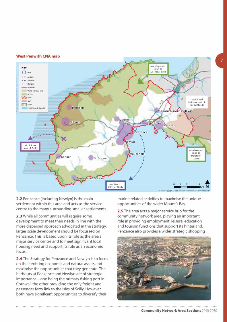
West Penwith CNA map
2.2 Penzance (including Newlyn) is the main settlement within this area and acts as the service centre to the many surrounding smaller settlements.
2.3 While all communities will require some development to meet their needs in line with the more dispersed approach advocated in the strategy, larger scale development should be focussed on Penzance. This is based upon its role as the area’s major service centre and to meet significant local housing need and support its role as an economic focus.
2.4 The Strategy for Penzance and Newlyn is to focus on their existing economic and natural assets and maximise the opportunities that they generate. The harbours at Penzance and Newlyn are of strategic importance – one being the primary fishing port in Cornwall the other providing the only freight and passenger ferry link to the Isles of Scilly. However both have significant opportunities to diversify their
marine related activities to maximise the unique opportunities of the wider Mount’s Bay.
2.5 The area acts a major service hub for the community network area, playing an important role in providing employment, leisure, education and tourism functions that support its hinterland. Penzance also provides a wider strategic shopping
Cornwall Local Plan
8
of existing space at Newlyn harbour could support existing industries and trigger significant employment growth in the marine leisure related industries. Investment in these harbours could also act as catalysts for other appropriate marine leisure developments to come forward within the wider Mount’s Bay area.
2.8 Longrock will continue to provide the major opportunity for industrial related growth. This growth will be supported by other employment opportunities, including regeneration and expansion of existing employment areas and appropriate properties and uses within new neighbourhood extensions and other larger housing developments.
2.9 The economic ambitions for Penzance and Newlyn also trigger the need to train and re-train the local workforce to ensure their skills match the employment needs maximising their opportunities for the towns younger people to remain in the area and live and work locally.
2.10 The Council will seek to develop the potential to maximise the opportunities for educational and skills delivery in a range of technologies and areas of expertise. Delivering opportunities for improving education and skill levels locally will help spin off employment opportunities and will help to drive economic wellbeing through improved skills and labour generation facilitating employment and business creation.
2.11 The delivery of appropriate start up and grow on space in the towns to support the areas growing
centre for west Cornwall although it needs investment and retail growth to ensure it maintains its role in relation to Truro and alongside developing destinations such as Falmouth, St Austell and Camborne, Pool & Redruth. Penzance also provides a strategic rail terminus and service facility that ensures Cornwall as a whole benefits from mainline rail connection direct to London and other destinations. Development opportunities to enhance this service are supported in principle.
Employment2.6 The towns of Penzance and Newlyn are committed to ensuring that they are well placed to meet the economic demands for the forthcoming years. In particular the communities are keen to promote and secure investment in key elements that will ensure economic success, such as: diversification in maritime assets to promote marine leisure related activities and capitalise on their unique location; a more diverse range of business properties and new technologies to support the number of micro businesses and other traditional small businesses that exist within the communities; artisan and creative based industries; expanding local further and higher education opportunities, young people graduating from apprenticeships; high end tourism; and the infrastructure required to support these activities.
2.7 Strategic employment growth opportunities revolve primarily around Penzance harbour and town centre which combined with the rationalisation
Community Network Area Sections 2010-2030
9
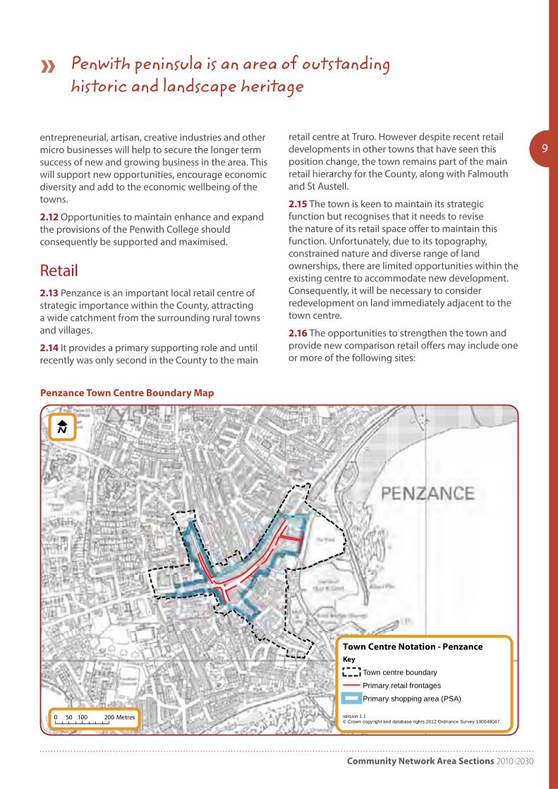
Town Centre Notation - Penzance
version 1.1© Crown copyright and database rights 2012 Ordnance Survey 100049047.
Key
Town centre boundary
Primary retail frontages
Primary shopping area (PSA)
0 100 20050 Metres
entrepreneurial, artisan, creative industries and other micro businesses will help to secure the longer term success of new and growing business in the area. This will support new opportunities, encourage economic diversity and add to the economic wellbeing of the towns.
2.12 Opportunities to maintain enhance and expand the provisions of the Penwith College should consequently be supported and maximised.
Retail2.13 Penzance is an important local retail centre of strategic importance within the County, attracting a wide catchment from the surrounding rural towns and villages.
2.14 It provides a primary supporting role and until recently was only second in the County to the main
retail centre at Truro. However despite recent retail developments in other towns that have seen this position change, the town remains part of the main retail hierarchy for the County, along with Falmouth and St Austell.
2.15 The town is keen to maintain its strategic function but recognises that it needs to revise the nature of its retail space offer to maintain this function. Unfortunately, due to its topography, constrained nature and diverse range of land ownerships, there are limited opportunities within the existing centre to accommodate new development. Consequently, it will be necessary to consider redevelopment on land immediately adjacent to the town centre.
2.16 The opportunities to strengthen the town and provide new comparison retail offers may include one or more of the following sites:
Penzance Town Centre Boundary Map
Penwith peninsula is an area of outstanding historic and landscape heritage
Cornwall Local Plan
10• Harbour Car Park;
• Clarence Street Car Park;
2.17 In seeking to deliver opportunity sites for retail growth the Council does not propose developing on all of the car park sites. Car parking provision and quality links to the town centre will be an essential element of any future retail development. Consequently, the Council will promote a car parking strategy to deliver and maintain appropriate car parking for the existing and future requirements for the town.
Housing2.18 In delivering the housing target for the Penzance and Newlyn Framework area priority should be given to the utilisation of brownfield and urban sites. However, it is acknowledged that the urban capacity within the towns and settlements covered by the framework is limited due to the constrained nature of the towns.
2.19 Consequently, growth will need to be provided on Greenfield sites; the identification of appropriate Greenfield options will be established within the Cornwall town’s allocation document developed from the framework plan for the area.
2.20 In delivering the housing growth for the towns, focus should be given to delivering an appropriate mix of housing type and tenure to address local housing need.
Infrastructure2.21 Fundamental to the delivery of the strategy will be the enhancement of Penzance and Newlyn’s infrastructure, including:
• Healthcare – Improved healthcare services to provide for the larger, and aging, population.
• Education – Improved school and academic facilities to provide for increasing demand, as well as maximise the opportunities arising from the Penwith College campus.
• Utilities and Drainage – Strategic and localised investment in the area’s utilities and drainage infrastructure to cater for the demand from the
additional housing and economic growth.
• Green Infrastructure – Maintain / enhance existing strategic green corridors to help preserve the identities of the communities that they separate; whilst also providing walking and cycling routes, ecological corridors, etc. Deliver new and improved public open space and green links as part of new developments to provide an enhance range of recreational facilities, linking the town with the Coast and the countryside and also help to deliver some of the sustainable transport objectives.
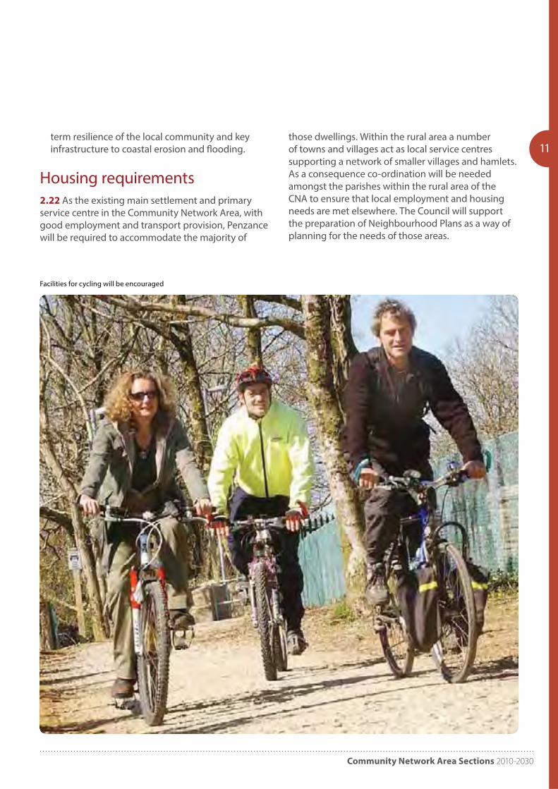
• Transportation – The enhancement and promotion of sustainable transport options forms the heart of Penzance’s transportation strategy. Consequently developments to proposals which improve the quality and frequency of bus and rail services and facilities for cycling will be encouraged. However, it is recognised that highway improvements will also be required at key junctions along the A30 and along key routes linking Penzance and Newlyn to address local congestion hotspots, and improve capacity and safety concerns. Support in principle the long term future of a main line rail link to Penzance, as a strategic operation for Cornwall and the UK; and support the provision of links to the Isles of Scilly and public transport provision in the far west.
• Flooding and coastal erosion – Sustainable measures should be sought to improve the long
Community Network Area Sections 2010-2030
11
Facilities for cycling will be encouraged
term resilience of the local community and key infrastructure to coastal erosion and flooding.
Housing requirements2.22 As the existing main settlement and primary service centre in the Community Network Area, with good employment and transport provision, Penzance will be required to accommodate the majority of
those dwellings. Within the rural area a number of towns and villages act as local service centres supporting a network of smaller villages and hamlets. As a consequence co-ordination will be needed amongst the parishes within the rural area of the CNA to ensure that local employment and housing needs are met elsewhere. The Council will support the preparation of Neighbourhood Plans as a way of planning for the needs of those areas.
Cornwall Local Plan
12 PP2 Hayle and St Ives
Community Network Area
Introduction
3.0 The Hayle and St Ives Community Network Area (CNA) covers the five parishes of Gwinear-Gwithian, Hayle, St. Erth, St Ives and Towednack.
Key facts:
Population 2007: 25,700 2014: 26,295
Dwellings 2010: 13,173 (5.2% Cornwall)
Past housing build rates 1991-2010: 2,273
Housing need (local connection) 2016: 454 (Bands A-D) plus 517 (Band E) equates to 4.1% and 4.0% of Cornwall total respectively
Housing completions and commitments (2016): 2,471
Hayle employees estimate (2011): Full time: 1,597 Part-time: 1,333
St Ives employees estimate (2011): Full time: 2,271 Part-time: 2,179
Objectives3.1 Specific objectives to be addressed in planning for the Hayle and St Ives Community Network Area include:
Objective 1 – Employment
Support new employment schemes both in the towns and in the rural areas. Emphasis should be given to quality, permanent work opportunities which break the cycle of seasonal labour. High speed broadband should be encouraged in all areas to meet modern working requirements. This should ensure prosperous town centres in Hayle and St Ives particularly supporting flexible workspace, arts and
tourism in St Ives and providing a continued delivery of the regeneration of Hayle through waterfront development associated with Marine Renewables and development of employment land to the south of Hayle.
Objective 2 – Housing
To deliver a mix of housing, of the size, type and tenure required to meet current and future housing needs, prioritising affordable and specialist accommodation.
Objective 3 – Community Infrastructure
Encourage investment in healthcare and GP coverage, education, neighbourhood centres, leisure facilities and open space provision and protect current levels of provision. Create better linkages between Hayle and its surrounding beaches, and improved and sustainable movement in St Ives.
Objective 4 – Environment
Ensure development is sensitive to the outstanding natural, built and historic environment of the area, particularly sensitive to the World Heritage Site status of Hayle and the historic harbour of St Ives, giving careful consideration to the location, scale and design of all new development.
Development Strategy
Hayle3.2 The strategy for Hayle is to build on the regeneration of the town that has already begun. The Hayle harbour proposals are fundamental to the future opportunities for the town; delivering high quality uses and coordinating these opportunities and projects together with the future southern expansion of the town is a key objective, ensuring that a strategy works for the whole town in terms of access and movement and necessary community infrastructure for the short and long term.
Community Network Area Sections 2010-2030
13
Hayle
St Erth
Connor Downs
St Ives/Carbis Bay
© Crown copyright. All rights reserved. Cornwall Council, 100049047, 2011
Hayle & St Ives Community Network Area - Environmental Designations
N0 2 41Km
KeyWorld Heritage Site
AONB
SPA
SSSI
Flood Zone 2, 3a & 3b
A30
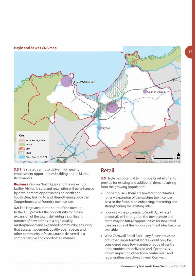
Hayle and St Ives CNA map
3.3 The strategy aims to deliver high quality employment opportunities building on the Marine Renewables
Business Park on North Quay and the wave hub facility. Visitor, leisure and retail offer will be enhanced by development opportunities on North and South Quay linking to and strengthening both the Copperhouse and Foundry town centre.
3.4 The large area to the south of the town up to the A30 provides the opportunity for future expansion of the town, delivering a significant number of new homes in a high quality masterplanned and expanded community; ensuring that access, movement, quality open spaces and other community infrastructure is delivered in a comprehensive and coordinated manner.
Retail3.5 Hayle has potential to improve its retail offer to provide for existing and additional demand arising from the growing population:
• Copperhouse – there are limited opportunities for any expansion of the existing town centre area so the focus is on enhancing, marketing and strengthening the existing offer.
• Foundry – the proximity to South Quay retail proposals will strengthen the town centre and there may be future opportunities for new retail uses on edge of the Foundry centre if sites become available.
• West Cornwall Retail Park – any future provision of further larger format stores would only be considered once town centre or edge of centre opportunities are delivered and if proposals do not impact on other town centre retail and regeneration objectives in west Cornwall.
Cornwall Local Plan
14
Employment3.6 New employment opportunities may arise for reuse of historic buildings in Hayle. On the edges of the town the Marsh Lane area may provide further employment or commercial opportunities over the longer term as Hayle grows. The St Erth industrial area may also offer opportunities for employment uses related to its A30 location or the west Cornwall public transport interchange.
Infrastructure3.7 In delivering the strategy Hayle’s infrastructure will need to be enhanced, including improvements to:
• Healthcare – Improved healthcare services to provide for a larger, and aging, population.
• Education – an expansion of Penpol Primary
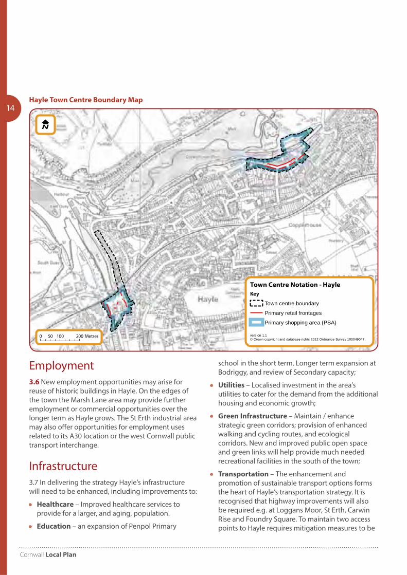
Town Centre Notation - Hayle
version 1.1© Crown copyright and database rights 2012 Ordnance Survey 100049047.
Key
Town centre boundary
Primary retail frontages
Primary shopping area (PSA)
0 100 20050 Metres
Hayle Town Centre Boundary Map
school in the short term. Longer term expansion at Bodriggy, and review of Secondary capacity;
• Utilities – Localised investment in the area’s utilities to cater for the demand from the additional housing and economic growth;
• Green Infrastructure – Maintain / enhance strategic green corridors; provision of enhanced walking and cycling routes, and ecological corridors. New and improved public open space and green links will help provide much needed recreational facilities in the south of the town;
• Transportation – The enhancement and promotion of sustainable transport options forms the heart of Hayle’s transportation strategy. It is recognised that highway improvements will also be required e.g. at Loggans Moor, St Erth, Carwin Rise and Foundry Square. To maintain two access points to Hayle requires mitigation measures to be
Community Network Area Sections 2010-2030
15
Town Centre Notation - St Ives
version 1.1© Crown copyright and database rights 2012 Ordnance Survey 100049047.
Key
Town centre boundary
Primary retail frontages
Primary shopping area (PSA)
0 100 20050 Metres
implemented along the Causeway and beyond or provision of new A30 junction.
• Flooding – A long term solution to coastal flooding should be sought to support the sustainable regeneration of Hayle town centre.
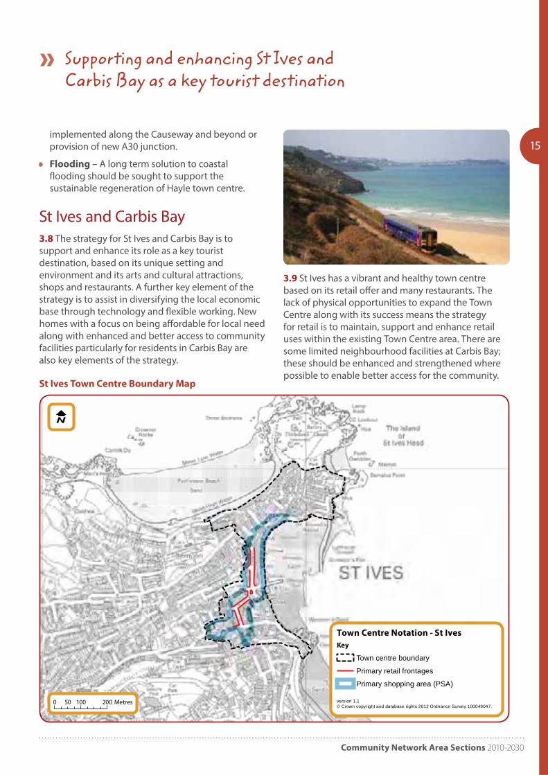
St Ives and Carbis Bay3.8 The strategy for St Ives and Carbis Bay is to support and enhance its role as a key tourist destination, based on its unique setting and environment and its arts and cultural attractions, shops and restaurants. A further key element of the strategy is to assist in diversifying the local economic base through technology and flexible working. New homes with a focus on being affordable for local need along with enhanced and better access to community facilities particularly for residents in Carbis Bay are also key elements of the strategy.
3.9 St Ives has a vibrant and healthy town centre based on its retail offer and many restaurants. The lack of physical opportunities to expand the Town Centre along with its success means the strategy for retail is to maintain, support and enhance retail uses within the existing Town Centre area. There are some limited neighbourhood facilities at Carbis Bay; these should be enhanced and strengthened where possible to enable better access for the community.
St Ives Town Centre Boundary Map
Supporting and enhancing St Ives and Carbis Bay as a key tourist destination
Cornwall Local Plan
16 Employment3.10 In St Ives and Carbis Bay there is a lack of opportunities and suitable sites for any significant larger scale employment uses, however many local jobs are over reliant on seasonal tourism related activity, therefore reuse of existing sites for smaller flexible workspace for businesses and home working should be encouraged.
Infrastructure3.11 Improving access, movement, and parking issues particularly through the busy summer months is a key aim of the sustainable transport strategy for the area.
3.12 In delivering the strategy for St Ives and Carbis Bay infrastructure will need to be enhanced, including improvements to:
• Healthcare – Improved healthcare services to provide for a larger, and aging, population, including better provision and access at Carbis Bay;
• Education – enhance primary school facilities. Secondary school facilities are under review;
• Utilities – Localised investment in the area’s utilities to cater for the demand from the additional housing.
• Green Infrastructure – Maintain / enhance strategic green corridors; provision of enhanced walking and cycling routes, and ecological corridors. New and improved public open spaces and green links; and
• Transportation – The enhancement and promotion of sustainable transport options including promotion of the West Cornwall Transport Interchange at St Erth, local branchline and bus services and town wide pedestrian and walking provision. Better signage and an improved parking strategy will assist in reducing peak summer congestion. It is also recognised that some minor highway improvements will also be required at certain key junctions linked to developments.
Housing requirements3.13 Co-ordination will be needed amongst the remaining parishes within the CNA to ensure that housing needs are met. The Council will support the preparation of Neighbourhood Plans as a way of planning for the needs of those areas.

Community Network Area Sections 2010-2030

Cornwall Local Plan
18 PP3 Helston and South Kerrier
Community Network Area
Introduction
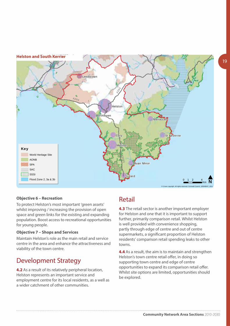
4.0 The Helston and south Kerrier Community Network Area is a wide geographical area covering the 18 parishes of Breage, Crowan, Cury, Germoe, Grade-Ruan, Gunwalloe, Gweek, Helston,Landewednack, Manaccan, Mawgan-in-Meneage, Mullion, Porthleven, Sithney, St Anthony in-Meneage, St Keverne, St Martin-in-Meneage and Wendron. Helston is the main town within this area, and therefore acts as the local service centre to the numerous smaller settlements surrounding it. The only other town in the area is Porthleven.
Key Facts:
Population 2007: 32,500 2014: 33,60
Dwellings 2010: 15,242 (6.0% Cornwall)
Past housing build rates 1991-2010: 2,156 (16% CNA increase, 5% Cornwall)
Housing need (local connection) 2016: 456 (Bands A-D) plus 638 (Band E) equates to 4.1% and 4.9% of Cornwall total respectively
Housing completions and commitments (2016): 1,949
Helston employees estimate (2011): Full time: 2,379 Part-time: 2,091
Porthleven employees estimate (2011): Full time: 291 Part-time: 323
Objectives4.1 Specific objectives to be addressed in planning for the Helston and south Kerrier Community Network Area include:
Objective 1 – Housing
To provide good quality housing, in doing so providing for the affordable housing requirements of the local community. Address high house prices, lack of affordable housing and lack of elderly and special needs accommodation.
Objective 2 – Rural Travel
Reduce rural isolation, particularly in the remote villages and hamlets, by encouraging regular public transport for residents to access services, work and education.
Objective 3 – Community Services
Encourage improvements to community services, health care and education provision and enhance current levels of provision where possible. Consideration should also be given to mobile services. To deliver community facilities that are thriving and well used, providing a range of activities for all ages.
Objective 4 – Businesses
To maintain and enhance Helston as a high quality service and retail centre for its local residents and its surrounding parishes. To provide more employment opportunities within Helston, in doing so reducing the reliance on Culdrose as the primary employer, whilst still continuing to support its continued operation. Enable the provision of rural workspace and encourage business mentoring and support.
Objective 5 – Environment
Ensure development is sensitive to the outstanding natural, built, historic and maritime environment of the area. To deliver growth sensitively, in doing so ensuring surrounding settlements / hamlets do not lose their separate identities.
Community Network Area Sections 2010-2030
19
Cury
Lizard
Helston
Mullion
Manaccan
Leedstown
Porthleven
St Keverne
Ruan Minor
© Crown copyright. All rights reserved. Cornwall Council, 100049047, 2011
Helston & the Lizard Community Network Area - Environmental Designations
N0 2 41Km
KeyWorld Heritage Site
AONB
SPA
SAC
SSSI
Flood Zone 2, 3a & 3b
A3083
A394
A394
Helston and South Kerrier
Objective 6 – Recreation
To protect Helston’s most important ‘green assets’ whilst improving / increasing the provision of open space and green links for the existing and expanding population. Boost access to recreational opportunities for young people.
Objective 7 – Shops and Services
Maintain Helston’s role as the main retail and service centre in the area and enhance the attractiveness and viability of the town centre.
Development Strategy4.2 As a result of its relatively peripheral location, Helston represents an important service and employment centre for its local residents, as a well as a wider catchment of other communities.
Retail4.3 The retail sector is another important employer for Helston and one that it is important to support further, primarily comparison retail. Whilst Helston is well provided with convenience shopping, partly through edge of centre and out of centre supermarkets, a significant proportion of Helston residents’ comparison retail spending leaks to other towns.
4.4 As a result, the aim is to maintain and strengthen Helston’s town centre retail offer, in doing so supporting town centre and edge of centre opportunities to expand its comparison retail offer. Whilst site options are limited, opportunities should be explored.
Cornwall Local Plan
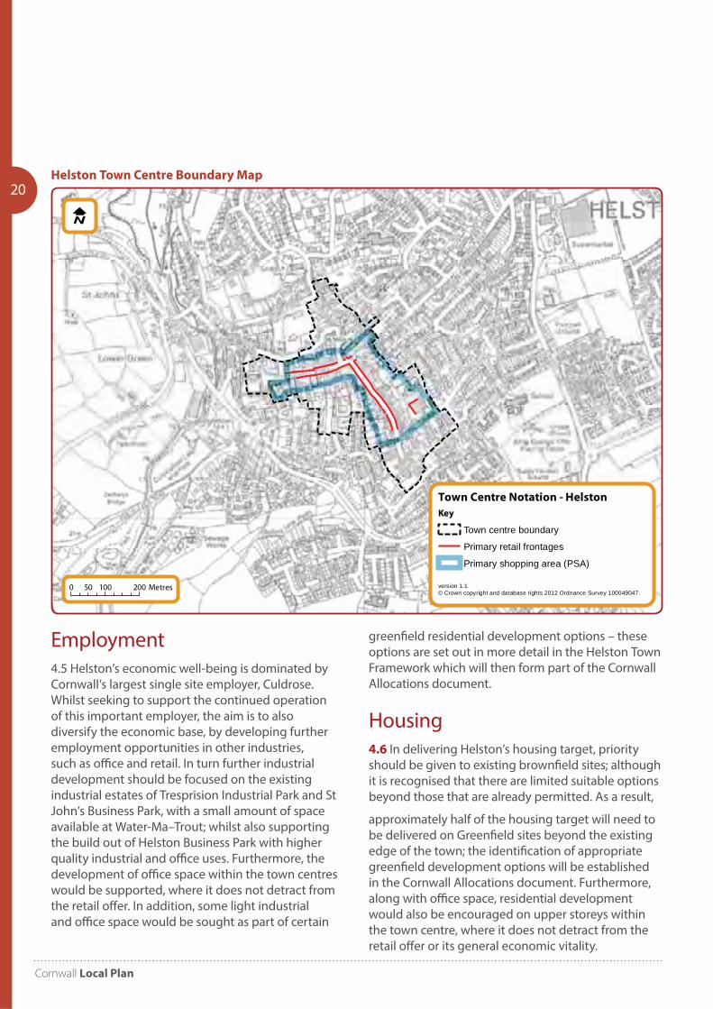
20Helston Town Centre Boundary Map
Town Centre Notation - Helston
version 1.1© Crown copyright and database rights 2012 Ordnance Survey 100049047.
Key
Town centre boundary
Primary retail frontages
Primary shopping area (PSA)
0 100 20050 Metres
Employment4.5 Helston’s economic well-being is dominated by Cornwall’s largest single site employer, Culdrose. Whilst seeking to support the continued operation of this important employer, the aim is to also diversify the economic base, by developing further employment opportunities in other industries, such as office and retail. In turn further industrial development should be focused on the existing industrial estates of Tresprision Industrial Park and St John’s Business Park, with a small amount of space available at Water-Ma–Trout; whilst also supporting the build out of Helston Business Park with higher quality industrial and office uses. Furthermore, the development of office space within the town centres would be supported, where it does not detract from the retail offer. In addition, some light industrial and office space would be sought as part of certain
greenfield residential development options – these options are set out in more detail in the Helston Town Framework which will then form part of the Cornwall Allocations document.
Housing4.6 In delivering Helston’s housing target, priority should be given to existing brownfield sites; although it is recognised that there are limited suitable options beyond those that are already permitted. As a result,
approximately half of the housing target will need to be delivered on Greenfield sites beyond the existing edge of the town; the identification of appropriate greenfield development options will be established in the Cornwall Allocations document. Furthermore, along with office space, residential development would also be encouraged on upper storeys within the town centre, where it does not detract from the retail offer or its general economic vitality.
Community Network Area Sections 2010-2030
21Infrastructure4.7 Of great importance in the delivery of the strategy, will be delivery of enhanced infrastructure. The growth in population will require improvements in;
• Healthcare – Improved healthcare services to provide for the larger aging population.
• Education – Work is ongoing to understand what additional education facilities would be required to cater for the increased population including the number of extra schools required. Some existing schools may have the physical capacity to provide additional facilities.
• Utilities – Strategic and localised investment in the area’s utilities to cater for the demand from the additional housing and economic growth.
• Green Infrastructure – Maintain / enhance strategic green corridors to help preserve the identities of the communities that they separate; whilst also providing walking and cycling routes, ecological corridors, etc. Furthermore, delivery of
new and improved public open space and green links will help provide much needed recreational facilities, whilst also helping to deliver some of the sustainable transport objectives.
• Transportation – The enhancement and promotion of sustainable transport options forms the heart of Helston’s transportation strategy, although it is recognised that highway improvements will also be required.
Housing requirements4.8 As the main settlement with good employment and transport provision, Helston will be required to accommodate the majority of those dwellings. Co-ordination will be needed amongst the remaining parishes within the CNA to ensure that housing needs are met. The Council will support the preparation of Neighbourhood Plans as a way of planning for the needs of these areas.
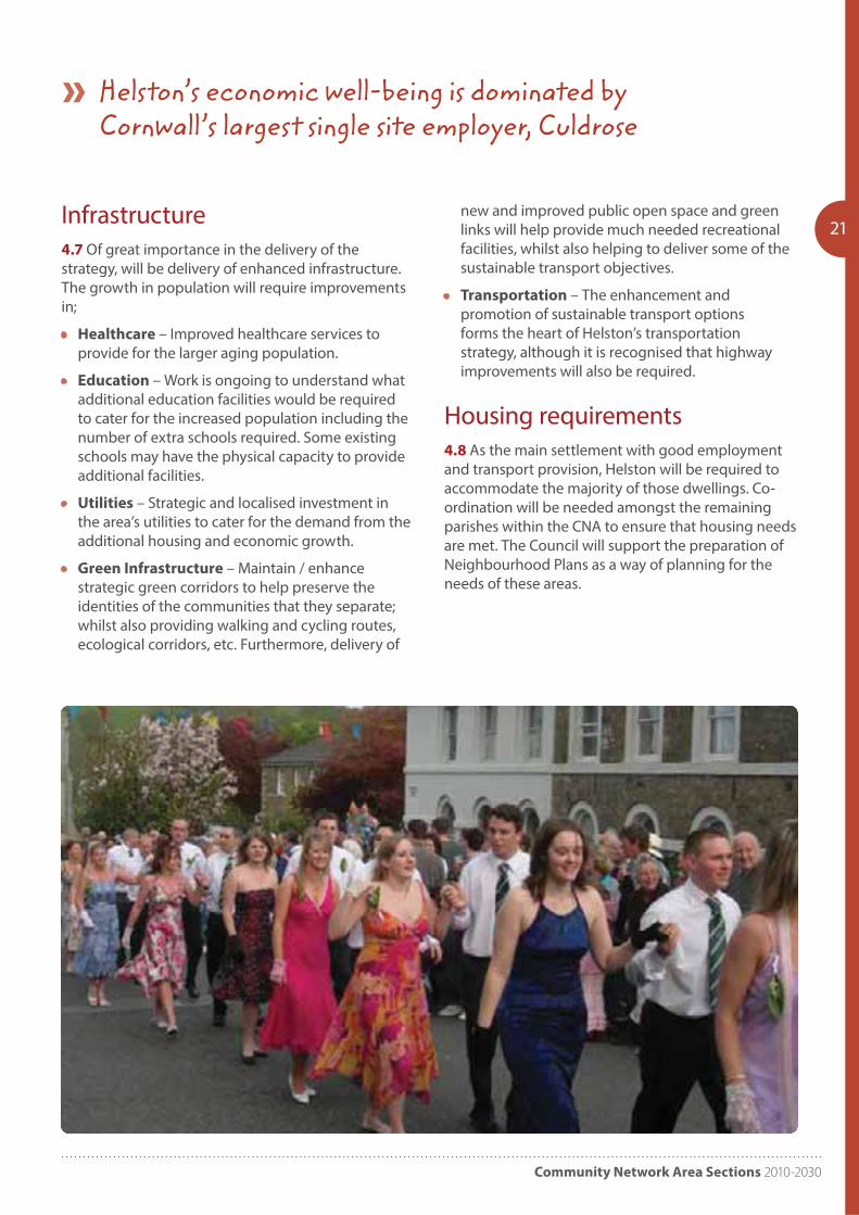
Helston’s economic well-being is dominated by Cornwall’s largest single site employer, Culdrose
Cornwall Local Plan
22 PP4 Camborne, Pool and Redruth
Community Network Area
Introduction
5.0 The Camborne, Pool and Redruth Community Network Area covers the parishes of Camborne, Carharrack, Carn Brea, Gwennap, Illogan, Lanner, Portreath, Redruth, St Day and Stithians.
Key Facts:
Population 2007: 59,100 2014: 60475
Dwellings 2010: 26,680 (10.5% Cornwall)
Past housing build rates 1991-2010: 4,084
CPR completions 2001-2010: 1624 (180pa)
Housing need (local connection) 2016: 1,220 (Bands A-D) plus 1,300 (Band E) equates to 11% and 10% of Cornwall total respectively’
Housing completions and commitments (2016): 4,487
Camborne / Pool / Redruth employees estimate (2011): Full time: 12,071 Part-time: 7,231
Objectives5.1 Specific objectives to be addressed in planning for the Camborne Pool Redruth Community Network Area include:
Objective 1 – Employment
Enable higher quality employment opportunities by sustaining and enhancing the area’s role as one of Cornwall’s primary employment hubs.
Objective 2 – Housing
Deliver housing growth that will help facilitate the area’s economic aspirations, whilst also delivering much needed affordable housing for local residents.
Objective 3 – Retail
Enhance the community network area’s retail offer, providing different but complementary roles for Camborne, Pool and Redruth, strengthening comparison shopping in particular.
Objective 4 – Education
Consolidate and enhance the community network area’s education opportunities, including Cornwall College.
Objective 5 – Regeneration
Reduce deprivation and support regeneration and growth through allocation of land for services, provision of infrastructure (including open space and enhanced sports and leisure facilities) and through high quality design.
Objective 6 – Transport Infrastructure
Deliver the highway and sustainable transport infrastructure needed to support the delivery of the area’s regeneration – including the east-west link road and improved access into Redruth town centre.
Objective 7 – Contaminated Land
Continue remediation of the area’s contaminated land, in doing so regenerating underused or derelict sites for housing, leisure and employment uses.

Community Network Area Sections 2010-2030
23
Pool
roon
St ay
Lanner
Redruth
Cam orne
Portreath
Stithians
Carharrac
our Lanes
© Crown copyright. All rights reserved. Cornwall Council, 100049047, 2011
Cam orne ool & edruth Community Network Area - Environmental Designations
N0 2 41Km
KeyWorld Heritage Site
AONB
SSSI
Flood Zone 2, 3a & 3b
A30
A393
Camborne, Pool and Redruth CNA Map
Objective 8 – Environment
For CPIR to be renowned as a destination for cultural and heritage related tourism; in doing so acting as the hub for experiencing the World Heritage Site. Maintain the separate identities of Camborne, Pool, Illogan and Redruth, whilst utilising their collective strength.
Development Strategy5.2 A fundamental principle of the strategy is to break down historic administrative boundaries and create an integrated spatial strategy that makes the most of CPIR’s collective assets, in doing so maximising the opportunity to continue the regeneration of CPIR. The strategy seeks to replace unsustainable past competition between the towns, with a strategy that promotes a coordinated response for the whole of CPIR; with each community supporting a collective effort, whilst still delivering a distinct set of objectives within their own area.
5.3 The successful regeneration of CPIR will require a holistic approach, but future built development will play a critical role; from delivering higher design standards to new / enhanced services and facilities; and from more / better quality employment opportunities to a reinvigorated retail offer.
5.4 With Pool sitting at the heart of the CPIR conurbation, together with the fact that it contains a significant amount of underused and derelict brownfield land; it represents both a regeneration priority and an opportunity to create a natural strategic hub for CPIR. As a result, Pool should deliver employment space and strategic services and facilities that the whole of the CPIR area would seek to benefit from. In addition, in delivering these strategic resources for the whole of CPIR, a further aim is to ensure Pool is recognised as a community and destination in its own right.
5.5 Gravitating out from this central location, the use of other underused or derelict brownfield
Cornwall Local Plan
24resources are being prioritised for development, such as Tuckingmill, Boilerworks and Dolcoath, which will deliver residential focused development, to respect their predominately residential setting; but also introducing some employment uses and other facilities that will add vibrancy to the development and help support the surrounding areas.
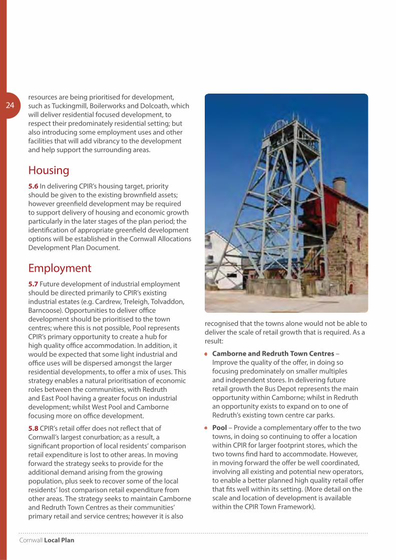
Housing5.6 In delivering CPIR’s housing target, priority should be given to the existing brownfield assets; however greenfield development may be required to support delivery of housing and economic growth particularly in the later stages of the plan period; the identification of appropriate greenfield development options will be established in the Cornwall Allocations Development Plan Document.
Employment5.7 Future development of industrial employment should be directed primarily to CPIR’s existing industrial estates (e.g. Cardrew, Treleigh, Tolvaddon, Barncoose). Opportunities to deliver office development should be prioritised to the town centres; where this is not possible, Pool represents CPIR’s primary opportunity to create a hub for high quality office accommodation. In addition, it would be expected that some light industrial and office uses will be dispersed amongst the larger residential developments, to offer a mix of uses. This strategy enables a natural prioritisation of economic roles between the communities, with Redruth and East Pool having a greater focus on industrial development; whilst West Pool and Camborne focusing more on office development.
5.8 CPIR’s retail offer does not reflect that of Cornwall’s largest conurbation; as a result, a significant proportion of local residents’ comparison retail expenditure is lost to other areas. In moving forward the strategy seeks to provide for the additional demand arising from the growing population, plus seek to recover some of the local residents’ lost comparison retail expenditure from other areas. The strategy seeks to maintain Camborne and Redruth Town Centres as their communities’ primary retail and service centres; however it is also
recognised that the towns alone would not be able to deliver the scale of retail growth that is required. As a result:
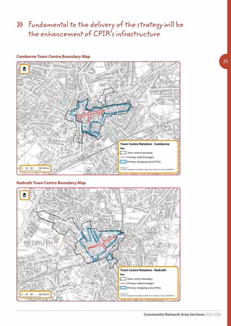
• Camborne and Redruth Town Centres – Improve the quality of the offer, in doing so focusing predominately on smaller multiples and independent stores. In delivering future retail growth the Bus Depot represents the main opportunity within Camborne; whilst in Redruth an opportunity exists to expand on to one of Redruth’s existing town centre car parks.
• Pool – Provide a complementary offer to the two towns, in doing so continuing to offer a location within CPIR for larger footprint stores, which the two towns find hard to accommodate. However, in moving forward the offer be well coordinated, involving all existing and potential new operators, to enable a better planned high quality retail offer that fits well within its setting. (More detail on the scale and location of development is available within the CPIR Town Framework).
Community Network Area Sections 2010-2030
25
Town Centre Notation - Camborne
version 1.1© Crown copyright and database rights 2012 Ordnance Survey 100049047.
Key
Town centre boundary
Primary retail frontages
Primary shopping area (PSA)
0 100 20050 Metres
Town Centre Notation - Redruth
version 1.2© Crown copyright and database rights 2012 Ordnance Survey 100049047.
Key
Town centre boundary
Primary retail frontages
Primary shopping area (PSA)
0 100 20050 Metres
Camborne Town Centre Boundary Map
Redruth Town Centre Boundary Map
Fundamental to the delivery of the strategy will be the enhancement of CPIR’s infrastructure
Cornwall Local Plan
265.9 Finally, due to the growth of internet shopping, it is recognised that if any of these centres are to flourish they need to develop complementary leisure / tourism roles – providing a destination where the shops form part, albeit the most important part, of a wider experience.
5.10 Fundamental to the delivery of the strategy will be the enhancement of CPIR’s infrastructure, including:
• Healthcare – Improved healthcare services to provide for the larger, and aging, population.
• Education – Improved academic facilities to provide for increasing demand, as well as maximise the opportunities arising from the Cornwall College campus.
• Utilities – Strategic and localised investment in the area’s utilities to cater for the demand from the additional housing and economic growth.
• Green Infrastructure – Maintaining / enhance strategic green corridors to help preserve the identities of the communities that they separate; whilst also providing walking and cycling routes, ecological corridors, etc. Furthermore, deliver new and improved public open space and green links will help provide much needed recreational facilities, whilst also helping to deliver some of the sustainable transport objectives.
• Transportation – The enhancement and promotion of sustainable transport options forms the heart of CPIR’s transportation strategy, although it is recognised that highway improvements will also be required – such as the development of the East-West Link Road.
• Flooding – Reduce risk of surface water flooding through the implementation of an area wide Surface Water Management Plan. New development should comply with its principles to help divert surface water out of the combined drainage system, prevent local sewers being overloaded and improve local water quality.
Housing requirements5.11 As the main settlements with good employment and transport provision, Camborne, Pool and Redruth will be required to accommodate the majority of those dwellings. Co-ordination will be needed amongst the remaining parishes within the CNA to ensure that housing needs are met. The Council will support the preparation of Neighbourhood Plans as a way of planning for the needs of those areas.
The strategy seeks to replace unsustainable past competition between the towns, with a strategy that promotes a coordinated response

Community Network Area Sections 2010-2030
27
Cornwall Local Plan
28
Introduction
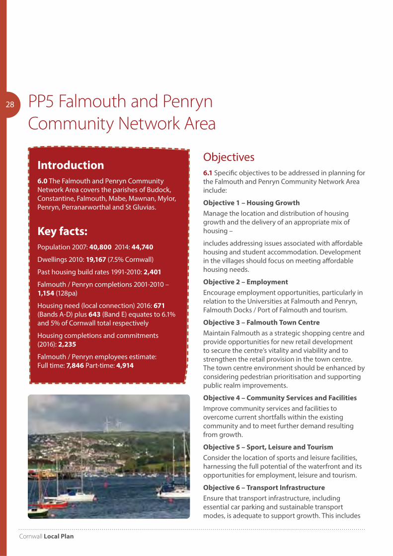
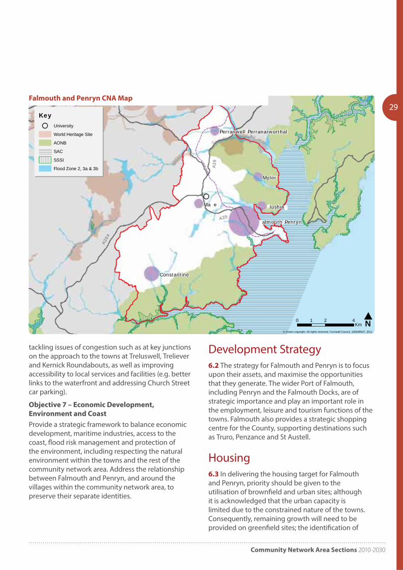
6.0 The Falmouth and Penryn Community Network Area covers the parishes of Budock, Constantine, Falmouth, Mabe, Mawnan, Mylor, Penryn, Perranarworthal and St Gluvias.
Key facts:
Population 2007: 40,800 2014: 44,740
Dwellings 2010: 19,167 (7.5% Cornwall)
Past housing build rates 1991-2010: 2,401
Falmouth / Penryn completions 2001-2010 – 1,154 (128pa)
Housing need (local connection) 2016: 671 (Bands A-D) plus 643 (Band E) equates to 6.1% and 5% of Cornwall total respectively
Housing completions and commitments (2016): 2,235
Falmouth / Penryn employees estimate: Full time: 7,846 Part-time: 4,914
PP5 Falmouth and Penryn
Community Network Area
Objectives6.1 Specific objectives to be addressed in planning for the Falmouth and Penryn Community Network Area include:
Objective 1 – Housing Growth
Manage the location and distribution of housing growth and the delivery of an appropriate mix of housing –
includes addressing issues associated with affordable housing and student accommodation. Development in the villages should focus on meeting affordable housing needs.
Objective 2 – Employment
Encourage employment opportunities, particularly in relation to the Universities at Falmouth and Penryn, Falmouth Docks / Port of Falmouth and tourism.
Objective 3 – Falmouth Town Centre
Maintain Falmouth as a strategic shopping centre and provide opportunities for new retail development to secure the centre’s vitality and viability and to strengthen the retail provision in the town centre. The town centre environment should be enhanced by considering pedestrian prioritisation and supporting public realm improvements.
Objective 4 – Community Services and Facilities
Improve community services and facilities to overcome current shortfalls within the existing community and to meet further demand resulting from growth.
Objective 5 – Sport, Leisure and Tourism
Consider the location of sports and leisure facilities, harnessing the full potential of the waterfront and its opportunities for employment, leisure and tourism.
Objective 6 – Transport Infrastructure
Ensure that transport infrastructure, including essential car parking and sustainable transport modes, is adequate to support growth. This includes
Community Network Area Sections 2010-2030
29
Ma e
Mylor
lushin
Constantine
almouth Penryn
Perranwell Perranarworthal
© Crown copyright. All rights reserved. Cornwall Council, 100049047, 2011
almouth & enryn Community Network Area - Environmental Designations
N0 2 41Km
KeyUniversity
World Heritage Site
AONB
SAC
SSSI
Flood Zone 2, 3a & 3b A39
A39
A394
Falmouth and Penryn CNA Map
tackling issues of congestion such as at key junctions on the approach to the towns at Treluswell, Treliever and Kernick Roundabouts, as well as improving accessibility to local services and facilities (e.g. better links to the waterfront and addressing Church Street car parking).
Objective 7 – Economic Development,
Environment and Coast
Provide a strategic framework to balance economic development, maritime industries, access to the coast, flood risk management and protection of the environment, including respecting the natural environment within the towns and the rest of the community network area. Address the relationship between Falmouth and Penryn, and around the villages within the community network area, to preserve their separate identities.
Development Strategy6.2 The strategy for Falmouth and Penryn is to focus upon their assets, and maximise the opportunities that they generate. The wider Port of Falmouth, including Penryn and the Falmouth Docks, are of strategic importance and play an important role in the employment, leisure and tourism functions of the towns. Falmouth also provides a strategic shopping centre for the County, supporting destinations such as Truro, Penzance and St Austell.
Housing6.3 In delivering the housing target for Falmouth and Penryn, priority should be given to the utilisation of brownfield and urban sites; although it is acknowledged that the urban capacity is limited due to the constrained nature of the towns. Consequently, remaining growth will need to be provided on greenfield sites; the identification of
Cornwall Local Plan
30appropriate greenfield options will be established in the Cornwall Strategic Allocations document. In delivering the housing growth for the towns, focus should be given to delivering an appropriate mix of housing to address local housing need, and the need for student accommodation. Whilst there are limited opportunities, every effort should be made to deliver good quality, managed accommodation within the towns that provides an element of the required accommodation, and an appropriate mix of housing types. Such provision will help to reduce the reliance on existing housing stock in the community for use by students.
6.4 Falmouth is an important local retail centre of strategic importance within the County, attracting a wide catchment from the surrounding rural towns and villages.
6.5 It provides a primary supporting role to the main retail centre at Truro, and is consequently part of the main retail hierarchy for the County, along with Penzance and St Austell.
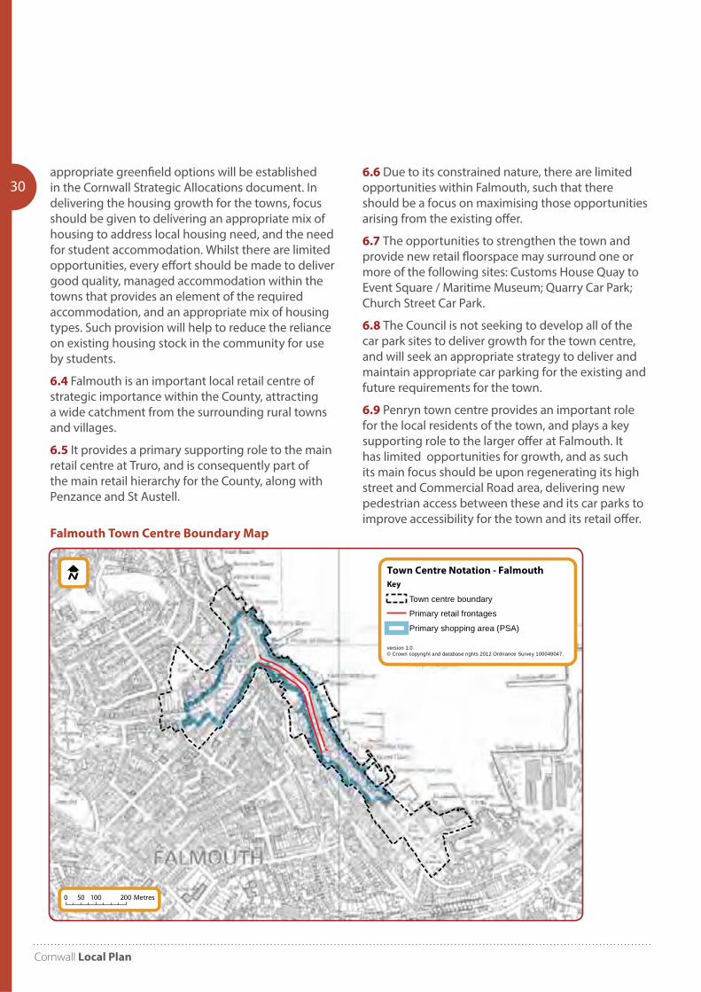
6.6 Due to its constrained nature, there are limited opportunities within Falmouth, such that there should be a focus on maximising those opportunities arising from the existing offer.
6.7 The opportunities to strengthen the town and provide new retail floorspace may surround one or more of the following sites: Customs House Quay to Event Square / Maritime Museum; Quarry Car Park; Church Street Car Park.
6.8 The Council is not seeking to develop all of the car park sites to deliver growth for the town centre, and will seek an appropriate strategy to deliver and maintain appropriate car parking for the existing and future requirements for the town.
6.9 Penryn town centre provides an important role for the local residents of the town, and plays a key supporting role to the larger offer at Falmouth. It has limited opportunities for growth, and as such its main focus should be upon regenerating its high street and Commercial Road area, delivering new pedestrian access between these and its car parks to improve accessibility for the town and its retail offer.
Town Centre Notation - Falmouth
version 1.0© Crown copyright and database rights 2012 Ordnance Survey 100049047.
Key
Town centre boundary
Primary retail frontages
Primary shopping area (PSA)
0 100 20050 Metres
Falmouth Town Centre Boundary Map

Community Network Area Sections 2010-2030
31Employment6.10 The towns of Falmouth and Penryn are committed to ensuring that they are well placed to meet the economic demands for the forthcoming years. In particular the communities are committed to investment in key elements that will ensure economic success in new technologies; young people graduating from apprenticeships; Further and Higher Education; in maritime assets; infrastructure; leisure and tourism; their unique location; and in micro businesses and other traditional small businesses within the communities.
6.11 Strategic growth opportunities revolve primarily around Falmouth, the wider port and the docks, which are anticipated to deliver significant employment growth surrounding employment and industry within the marine environment. This strategic growth would be supported by other employment opportunities around the urban extensions, including regeneration and expansion of existing employment areas. Economic ambitions for Falmouth and Cornwall as a whole relate to the universities at Penryn and Falmouth, as key economic drivers.
6.12 The Council will seek to develop the potential to maximise the opportunities for educational and skills delivery in a range of technologies and areas of expertise. Delivering opportunities for improving education and skill levels locally will help spin off employment opportunities and will help to drive economic well-being through improved skills and labour generation, thereby facilitating employment and business creation.
6.13 The delivery of grow on space in the towns to support the Tremough Innovation centre will help to secure the longer term success of new and expanding business in the area, which will add to the economic well-being of the towns. Opportunities to maintain enhance and expand the provisions of the universities at Falmouth and Penryn should consequently be supported and maximised.
Infrastructure6.14 In delivering the strategy Falmouth and Penryn’s infrastructure will need to be enhanced, including improvements to:
• Healthcare – improved services to provide for a larger and aging population;
• Education – consolidation of the Falmouth School campus onto one site, through the use of the adjacent and vacant former hospital site;
• Utilities – localised investment in the town’s utilities to cater for the demand from the additional housing and employment growth;
• Green Infrastructure – Maintain / enhance strategic green corridors; provision of enhanced walking and cycling routes, and ecological corridors. New and improved public open space and green links will help provide much needed recreational facilities in the south of the town
• Transportation – The enhancement and promotion of sustainable transport options forms the heart of Falmouth and Penryn’s transportation strategy. It is also recognised that highway improvements will also be required at several key junctions to address traffic congestion, capacity and safety concerns, and which are identified within the transport strategy.
• Flooding – Develop a flood risk management strategy for the area.
The wider Port of Falmouth is of strategic importance and play an important role in the towns of Falmouth and Penryn
Cornwall Local Plan
32 PP6 Truro and Roseland
Community Network Area
Objectives7.1 Specific objectives to be addressed in planning for the Truro and Roseland Community Network Area include:
Objective 1 – Housing Needs
Plan for the appropriate location and distribution of housing growth, taking into consideration the evidence gathering work undertaken for the Truro and Threemilestone Area Action Plan. Ensure that the housing needs of the community are met, with a particular emphasis on affordable housing.
Objective 2 – Housing and Jobs
Balance the provision of employment and housing to reduce commuting.
Objective 3 – Employment
Provide high quality, well paid employment in locations that reduce the need to travel.
Objective 4 – Sustainable Transport
Enable the use of more sustainable transport modes (for goods and people) and reduce congestion through the provision of additional transport infrastructure and ensuring sustainable transport is designed into new development.
Objective 5 – Shops and Services
Support the retail function of Truro in relation to other main towns in Cornwall and within the South West. Protect shops and access to services and facilities in rural areas.
Objective 6 – Community Facilities
Ensure that facilities, including health, leisure, education and sports facilities, are provided to support new development and address existing deficiencies.
Objective 7 – Design
Ensure that development is adaptable, sustainable and of a high quality design and layout.
Introduction
7.0 The Truro and Roseland Community Network Area covers the parishes of Chacewater, Cuby, Feock, Gerrans, Grampound with Creed, Kea, Kenwyn, Ladock, Philleigh, Probus, Ruanlanihorne, St Clement, St Erme, St Just-in- Roseland, St Michael Caerhays, St Michael Penkevil, Tregony, Truro and Veryan.
Key facts:
Population 2007: 43,900 2014: 45,480
Dwellings 2010: 20,636 (8.1% Cornwall)
Past housing build rates 1991-2010: 3,430
Truro completions 2001-2010 – 1353 (150pa)
Housing need (local connection) 2016: 638 (Bands A-D) plus 780 (Band E) equates to 5.8% and 6% of Cornwall total respectively
Jobs (2009): 31,400 (16.4% Cornwall)
Housing completions and commitments (2016): 4,358
Truro / Threemilestone employees estimate (2011):
Full time: 14,487 Part-time: 11,755
Community Network Area Sections 2010-2030
33
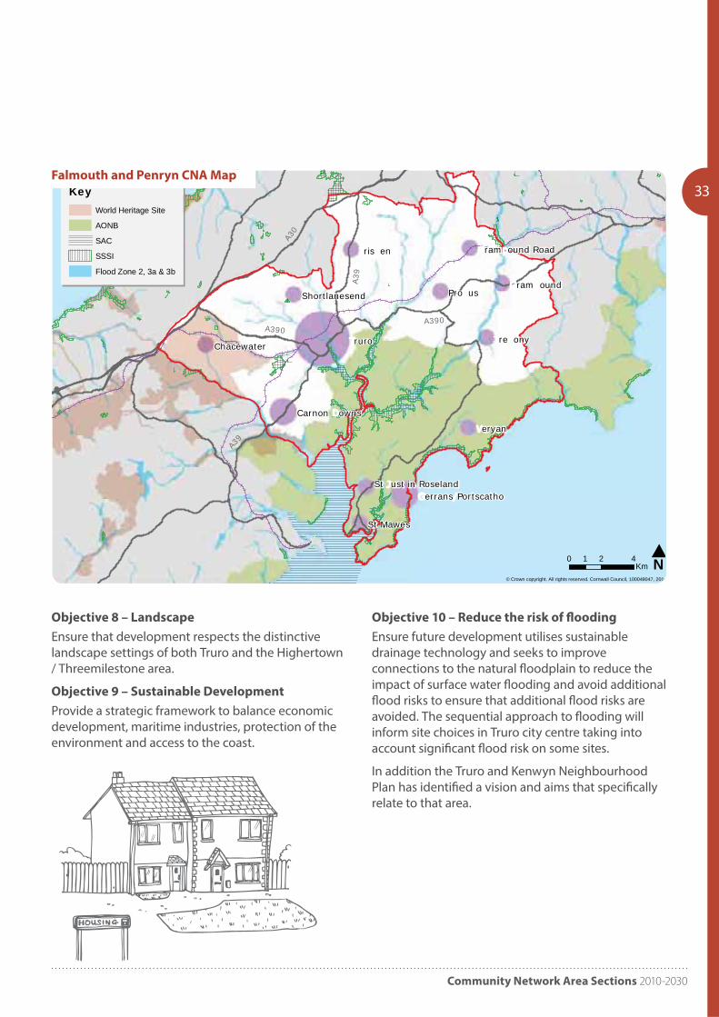
Objective 8 – Landscape
Ensure that development respects the distinctive landscape settings of both Truro and the Highertown / Threemilestone area.
Objective 9 – Sustainable Development
Provide a strategic framework to balance economic development, maritime industries, protection of the environment and access to the coast.
Objective 10 – Reduce the risk of flooding
Ensure future development utilises sustainable drainage technology and seeks to improve connections to the natural floodplain to reduce the impact of surface water flooding and avoid additional flood risks to ensure that additional flood risks are avoided. The sequential approach to flooding will inform site choices in Truro city centre taking into account significant flood risk on some sites.
In addition the Truro and Kenwyn Neighbourhood Plan has identified a vision and aims that specifically relate to that area.
ruro
Pro us
eryan
ris en
re ony
St Mawes
ram ound
Chacewater
Carnon owns
Shortlanesend
ram ound Road
errans PortscathoSt ust in Roseland
© Crown copyright. All rights reserved. Cornwall Council, 100049047, 2011
N0 2 41Km
KeyWorld Heritage Site
AONB
SAC
SSSI
Flood Zone 2, 3a & 3bA3
0
A390A390
A39
A39
Falmouth and Penryn CNA Map
Cornwall Local Plan
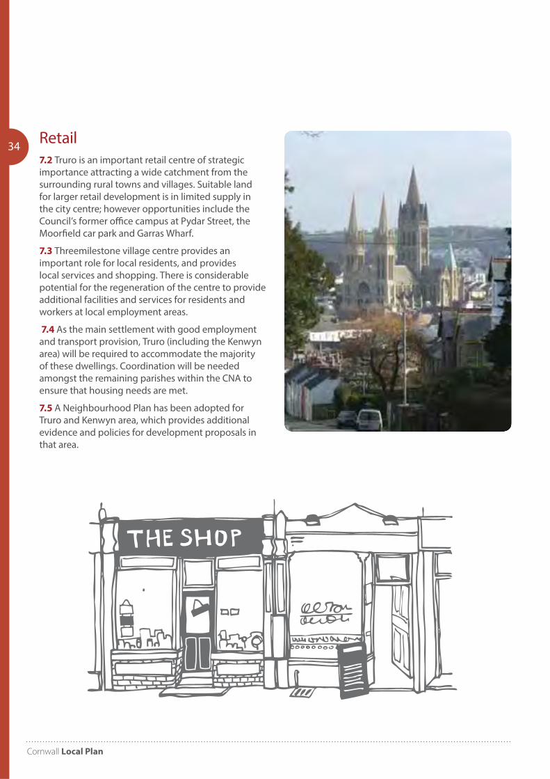
34 Retail7.2 Truro is an important retail centre of strategic importance attracting a wide catchment from the surrounding rural towns and villages. Suitable land for larger retail development is in limited supply in the city centre; however opportunities include the Council’s former office campus at Pydar Street, the Moorfield car park and Garras Wharf.
7.3 Threemilestone village centre provides an important role for local residents, and provides local services and shopping. There is considerable potential for the regeneration of the centre to provide additional facilities and services for residents and workers at local employment areas.
7.4 As the main settlement with good employment and transport provision, Truro (including the Kenwyn area) will be required to accommodate the majority of these dwellings. Coordination will be needed amongst the remaining parishes within the CNA to ensure that housing needs are met.
7.5 A Neighbourhood Plan has been adopted for Truro and Kenwyn area, which provides additional evidence and policies for development proposals in that area.
Community Network Area Sections 2010-2030
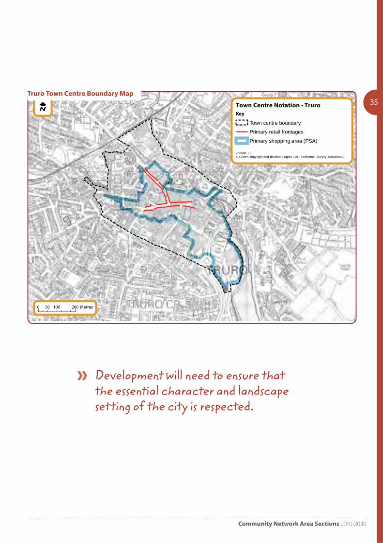
35Town Centre Notation - Truro
version 1.1© Crown copyright and database rights 2012 Ordnance Survey 100049047.
Key
Town centre boundary
Primary retail frontages
Primary shopping area (PSA)
0 100 20050 Metres
Truro Town Centre Boundary Map
Development will need to ensure that the essential character and landscape setting of the city is respected.

Cornwall Local Plan
36 PP7 St Agnes and Perranporth
Community Network Area
Objectives8.1 Specific objectives to be addressed in planning for the St Agnes and Perranporth Community Network Area include:
Objective 1 – Affordable Housing
Enable the provision and appropriate distribution of affordable housing.
Objective 2 – Tourism and Employment
Support the tourist industry and enable other employment opportunities.
Objective 3 – Rural Businesses
Protect and ensure the sustainability of rural shops and businesses.
Objective 4 – Services and Public Transport
Co-ordinate a strategic approach to provision of services and public transport to encourage self-containment and sustainable transport.
Objective 5 – Community Facilities
Consider the need for a north coast secondary school and the provision of leisure facilities.
Objective 6 – Needs of the Elderly
Provide for the needs of an elderly population.
Objective 7 – Coast
Encourage effective coastal management.
Objective 8 – Natural and Historic Environment
Maintain and enhance the area’s heritage and environmental assets for the benefit of the local community and to enhance the area’s tourism offer.
Development Strategy8.2 The CNA contains several thriving communities with opportunity for better self-containment. The main objective is to meet local need and build on strong relationships with nearby urban areas based on good public transport links.
Introduction
8.0 The St Agnes and Perranporth Community Network Area covers the 6 parishes of Crantock, Cubert, Perranzabuloe, St Agnes, St Allen and St Newlyn East. The main settlements in the area are St Agnes and Perranporth and other villages and smaller settlements include Goonhavern, St. Newlyn East, Porthtowan and Mount Hawke.
Key Facts:
Population 2007: 17,500 2014: 17,510
Dwellings 2010: 8,443 (3.3% Cornwall)
Past housing build rates 1991-2010: 1,410
Housing need (local connection) 2016: 257 (Bands A-D) plus 333 (Band E) equates to 2.3% and 2.5% of Cornwall total respectively
Housing completions and commitments (2016): 998
St Agnes employees estimate (2011): Full time: 416 Part-time: 348
Perranporth employees estimate (2011):
Full time: 651 Part-time: 583
Community Network Area Sections 2010-2030
37
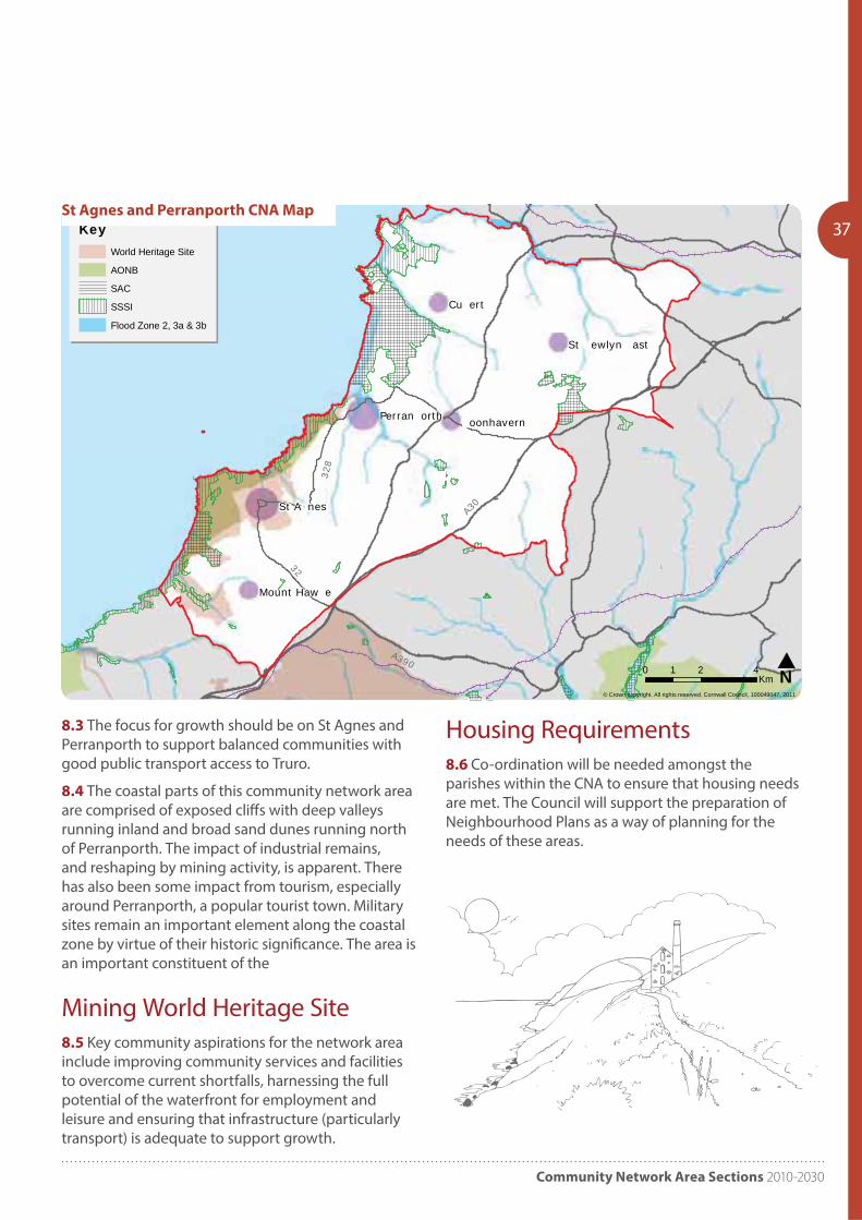
8.3 The focus for growth should be on St Agnes and Perranporth to support balanced communities with good public transport access to Truro.
8.4 The coastal parts of this community network area are comprised of exposed cliffs with deep valleys running inland and broad sand dunes running north of Perranporth. The impact of industrial remains, and reshaping by mining activity, is apparent. There has also been some impact from tourism, especially around Perranporth, a popular tourist town. Military sites remain an important element along the coastal zone by virtue of their historic significance. The area is an important constituent of the
Mining World Heritage Site8.5 Key community aspirations for the network area include improving community services and facilities to overcome current shortfalls, harnessing the full potential of the waterfront for employment and leisure and ensuring that infrastructure (particularly transport) is adequate to support growth.
Cu ert
St A nes
oonhavernPerran orth
Mount Haw e
St ewlyn ast
© Crown copyright. All rights reserved. Cornwall Council, 100049047, 2011
N0 2 41Km
KeyWorld Heritage Site
AONB
SAC
SSSI
Flood Zone 2, 3a & 3b
A30
A390
328
32
St Agnes and Perranporth CNA Map
Housing Requirements 8.6 Co-ordination will be needed amongst the parishes within the CNA to ensure that housing needs are met. The Council will support the preparation of Neighbourhood Plans as a way of planning for the needs of these areas.
Cornwall Local Plan
38 PP8 Newquay and St Columb
Community Network Area
Introduction
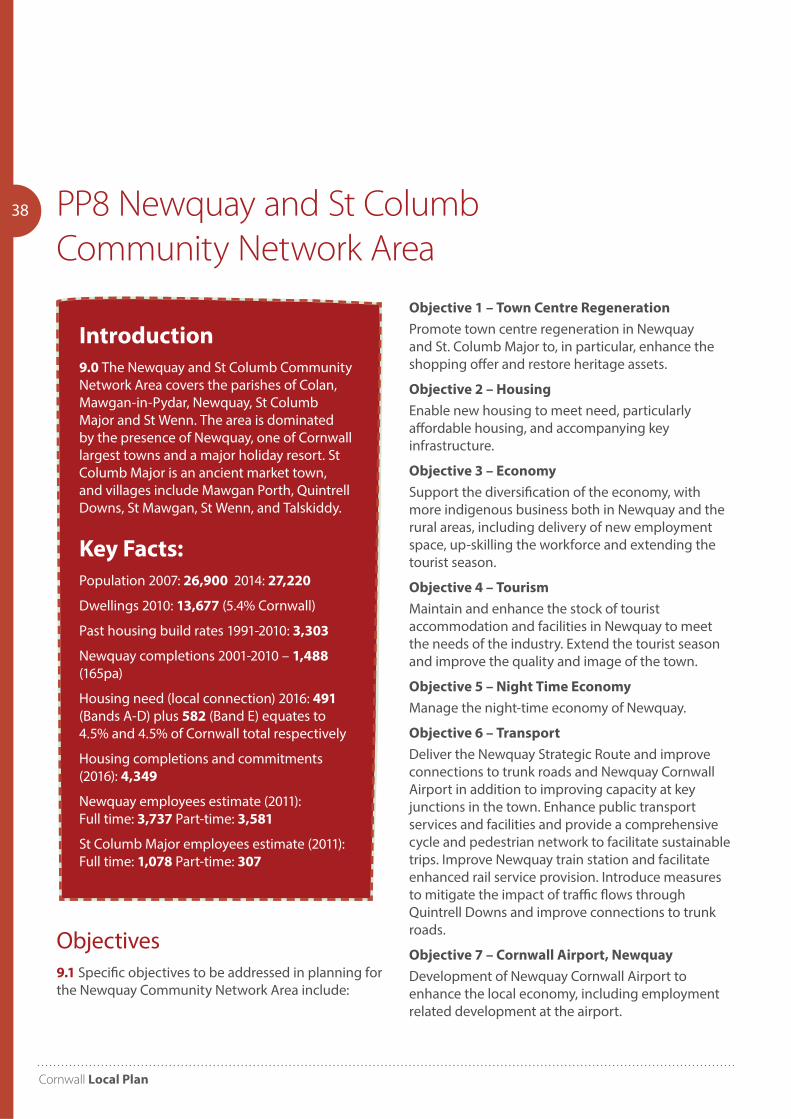
9.0 The Newquay and St Columb Community Network Area covers the parishes of Colan, Mawgan-in-Pydar, Newquay, St Columb Major and St Wenn. The area is dominated by the presence of Newquay, one of Cornwall largest towns and a major holiday resort. St Columb Major is an ancient market town, and villages include Mawgan Porth, Quintrell Downs, St Mawgan, St Wenn, and Talskiddy.
Key Facts:
Population 2007: 26,900 2014: 27,220
Dwellings 2010: 13,677 (5.4% Cornwall)
Past housing build rates 1991-2010: 3,303
Newquay completions 2001-2010 – 1,488
(165pa)
Housing need (local connection) 2016: 491 (Bands A-D) plus 582 (Band E) equates to 4.5% and 4.5% of Cornwall total respectively
Housing completions and commitments (2016): 4,349
Newquay employees estimate (2011): Full time: 3,737 Part-time: 3,581
St Columb Major employees estimate (2011): Full time: 1,078 Part-time: 307
Objective 1 – Town Centre Regeneration
Promote town centre regeneration in Newquay and St. Columb Major to, in particular, enhance the shopping offer and restore heritage assets.
Objective 2 – Housing
Enable new housing to meet need, particularly affordable housing, and accompanying key infrastructure.
Objective 3 – Economy
Support the diversification of the economy, with more indigenous business both in Newquay and the rural areas, including delivery of new employment space, up-skilling the workforce and extending the tourist season.
Objective 4 – Tourism
Maintain and enhance the stock of tourist accommodation and facilities in Newquay to meet the needs of the industry. Extend the tourist season and improve the quality and image of the town.
Objective 5 – Night Time Economy
Manage the night-time economy of Newquay.
Objective 6 – Transport
Deliver the Newquay Strategic Route and improve connections to trunk roads and Newquay Cornwall Airport in addition to improving capacity at key junctions in the town. Enhance public transport services and facilities and provide a comprehensive cycle and pedestrian network to facilitate sustainable trips. Improve Newquay train station and facilitate enhanced rail service provision. Introduce measures to mitigate the impact of traffic flows through Quintrell Downs and improve connections to trunk roads.
Objective 7 – Cornwall Airport, Newquay
Development of Newquay Cornwall Airport to enhance the local economy, including employment related development at the airport.
Objectives9.1 Specific objectives to be addressed in planning for the Newquay Community Network Area include:
Community Network Area Sections 2010-2030
39
Objective 8 – Rural Services
Support the improvement of rural services / facilities.
Objective 9 – Environment
Protect environmental assets, recognising their contribution to local people’s quality of life and their role in underpinning the tourism economy, in particular the undeveloped coast.
Objective 10 – Delivery
Ensure development reflects the needs and aspirations of the local community; in housing and employment terms – a higher proportion of family housing and better paid jobs.
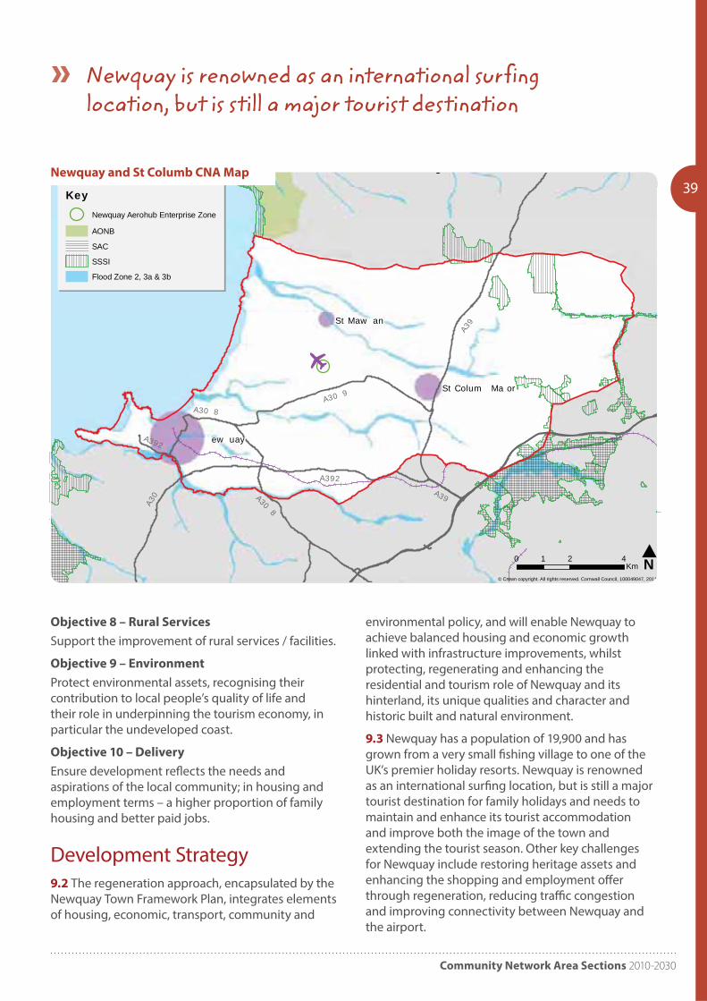
Development Strategy9.2 The regeneration approach, encapsulated by the Newquay Town Framework Plan, integrates elements of housing, economic, transport, community and
environmental policy, and will enable Newquay to achieve balanced housing and economic growth linked with infrastructure improvements, whilst protecting, regenerating and enhancing the residential and tourism role of Newquay and its hinterland, its unique qualities and character and historic built and natural environment.
9.3 Newquay has a population of 19,900 and has grown from a very small fishing village to one of the UK’s premier holiday resorts. Newquay is renowned as an international surfing location, but is still a major tourist destination for family holidays and needs to maintain and enhance its tourist accommodation and improve both the image of the town and extending the tourist season. Other key challenges for Newquay include restoring heritage assets and enhancing the shopping and employment offer through regeneration, reducing traffic congestion and improving connectivity between Newquay and the airport.
ew uay
St Maw an
St Colum Ma or
© Crown copyright. All rights reserved. Cornwall Council, 100049047, 2011
New uay & t Colum Community Network Area - Environmental Designations
N0 2 41Km
KeyNewquay Aerohub Enterprise Zone
AONB
SAC
SSSI
Flood Zone 2, 3a & 3b
A39
A392
A30
A30 8A30 9
A308
A392
A39
Newquay and St Columb CNA Map
Newquay is renowned as an international surfing location, but is still a major tourist destination
Cornwall Local Plan
409.4 Improvement of rural services and protection of the undeveloped coast and countryside are a challenge for the CNA.
Cornwall Airport, Newquay9.5 This community network area is the home of Newquay Cornwall Airport (NCA) which provides vital connectivity to national and international business centres allowing businesses to thrive when distances from key markets can be a real business constraint, affecting growth, productivity and competitiveness. As a strategic transport facility it plays a critical role in changing the perceptions of Cornwall as a place to invest, visit, locate to or live.
9.6 The airport’s infrastructure is nationally significant; it is the UK’s newest airport offering a unique aviation environment, which includes one of
the longest runways in the UK and capacity. It now also offers major development potential and job creation through the Aerohub Enterprise Zone.
Housing requirements9.7 As the main settlement with good employment and transport provision, Newquay will be required to accommodate the majority of those dwellings. Coordination will be needed amongst the remaining parishes within the CNA to ensure that housing needs are met. The Council will support the preparation of Neighbourhood Plans as a way of planning for the needs of those areas.
9.8 Newquay is the subject of a Town Framework Plan which provides additional evidence and policies for development proposals in that area.
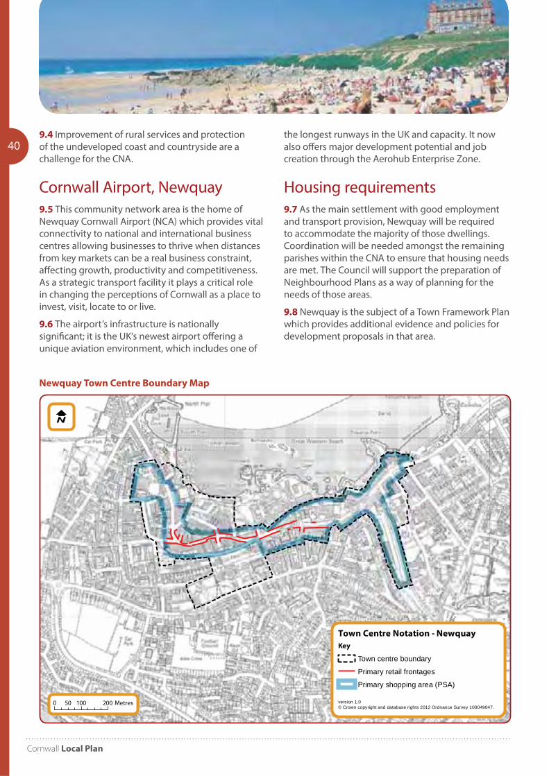
Town Centre Notation - Newquay
version 1.0© Crown copyright and database rights 2012 Ordnance Survey 100049047.
Key
Town centre boundary
Primary retail frontages
Primary shopping area (PSA)
0 100 20050 Metres
Newquay Town Centre Boundary Map
Community Network Area Sections 2010-2030
PP9 St Austell and Mevagissey; China
Clay; St Blazey, Fowey and Lostwithiel
Community Network Areas
41
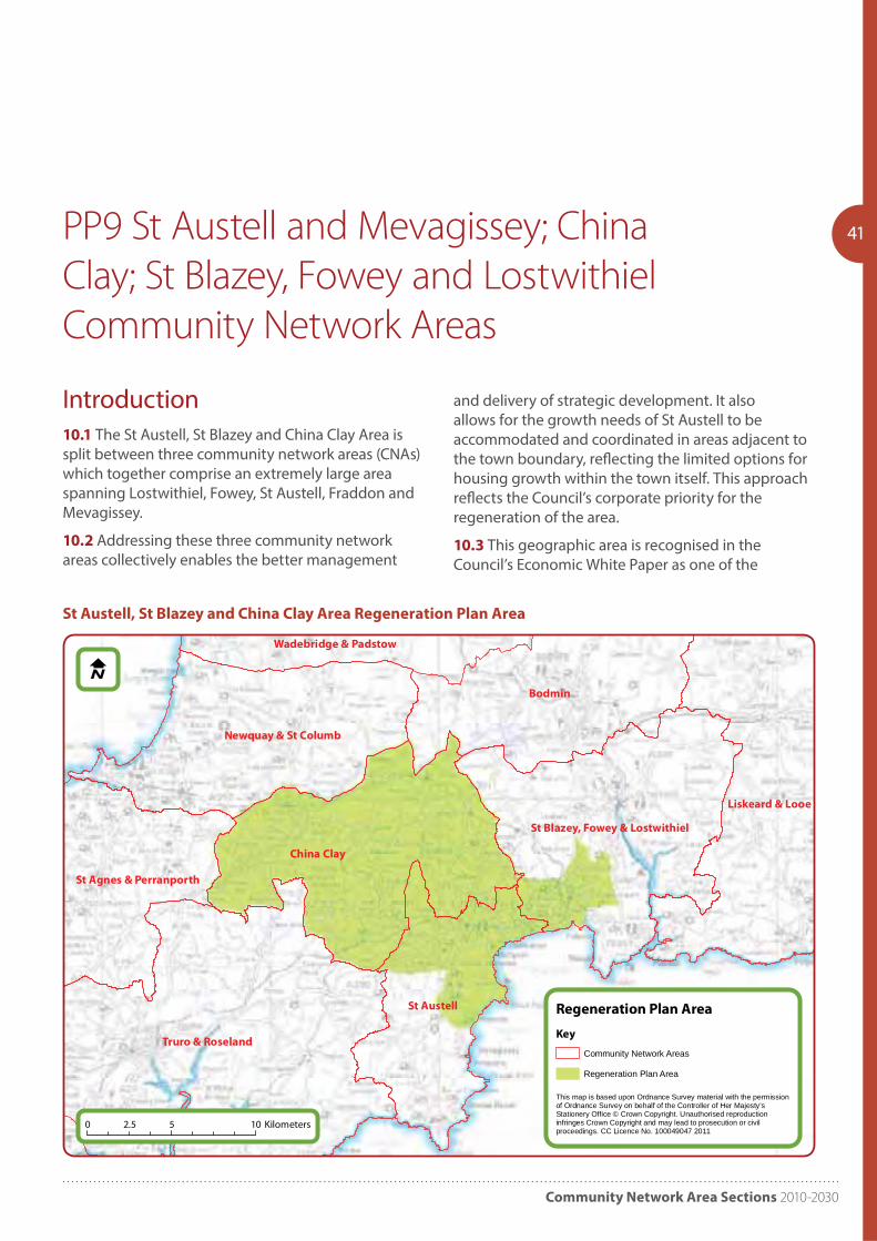
Introduction10.1 The St Austell, St Blazey and China Clay Area is split between three community network areas (CNAs) which together comprise an extremely large area spanning Lostwithiel, Fowey, St Austell, Fraddon and Mevagissey.
10.2 Addressing these three community network areas collectively enables the better management
and delivery of strategic development. It also allows for the growth needs of St Austell to be accommodated and coordinated in areas adjacent to the town boundary, reflecting the limited options for housing growth within the town itself. This approach reflects the Council’s corporate priority for the regeneration of the area.
10.3 This geographic area is recognised in the Council’s Economic White Paper as one of the
Truro & Roseland
China Clay
Bodmin
St Austell
Liskeard & Looe
Newquay & St Columb
St Blazey, Fowey & Lostwithiel
St Agnes & Perranporth
Wadebridge & Padstow
Regeneration Plan Area
This map is based upon Ordnance Survey material with the permissionof Ordnance Survey on behalf of the Controller of Her Majesty'sStationery Office © Crown Copyright. Unauthorised reproductioninfringes Crown Copyright and may lead to prosecution or civilproceedings. CC Licence No. 100049047 2011
Key
Community Network Areas
Regeneration Plan Area
0 5 102.5 Kilometers
St Austell, St Blazey and China Clay Area Regeneration Plan Area
Cornwall Local Plan
42Council’s two priority areas for strategic regeneration and investment, which makes it a priority for European Structural Grant Funding through the current Convergence Programme. A boundary for the delivery of this and other funding was drawn in 2008 as part of the St Austell, St Blazey and China Clay Area Strategic Investment Framework (SIF). This boundary continues to be used as a focus for further investment and is the geographic area covered by the 2012 St Austell, St Blazey and China Clay Area Regeneration Plan, as seen in figure 13. Further funding has been secured through the Clay Country Local Action Group European funding, Big Lottery funding and the
Department of Communities and Local Government as part of their Eco-Town programme, which will combine to achieve wider regeneration aims.
10.4 The St Austell, St Blazey and China Clay Area Regeneration Plan aims to promote investment and innovation in renewable energy, the built and natural environment, public spaces, community facilities and health and well-being, this could collectively bring about a sustained improvement in prosperity and quality of life. Relevant parts of this plan are included in this document.
Community Network Area Sections 2010-2030
43St Austell and Mevagissey Community
Network Area
Objectives10.6 Specific objectives to be addressed in planning for the St Austell Community Network Area, include:
Objective AU1 – New Development
Identify the locations for new growth to provide a range of housing, employment and other facilities.
Objective AU2 – Affordable Housing
Promote the delivery of affordable housing.
Objective AU3 – Economy
Support the regeneration of the local economy and the town centre.
Objective AU4 – Infrastructure
Enable the delivery of community infrastructure including new community facilities and in particular addressing transport congestion issues and links to the A30.
Objective AU5 – Environment
Conserve the south coast Area of Outstanding Natural Beauty, the World Heritage Site at Charlestown and other heritage assets, and maintain green corridors between settlements to preserve community identity and biodiversity.
Objective AU6 – Flooding
Consider flooding issues, particularly at Mevagissey, Pentewan and in the Sandy Hill and Holmbush areas of St Austell.
10.7 St Austell is the key settlement within this area, and acts as the local service centre to the smaller settlements surrounding it. Almost absorbed into St Austell are adjacent distinctive settlements such as Charlestown and Carlyon Bay.
10.8 This is also an important maritime zone as the coast has a number of significant ports and coastal settlements, including Mevagissey, dependent upon fishing, to the industrial ports like Pentewan and Charlestown.
Introduction10.5 The St Austell Community Network Area covers the 8 parishes of Carlyon, Mevagissey, Pentewan, St Austell Bay, St Austell Town, St Ewe, St Goran and St Mewan.
Key facts:Population 2007: 31,829 2014: 32,155
Dwellings 2010: 15,519 (6.1% Cornwall)
Past housing build rates 1991-2010: 3,557
St Austell completions 2001-2010 – 1915 (213pa)
Housing need (local connection) 2016: 552 (Bands A-D) plus 460 (Band E) equates to 5% and 3.5% of Cornwall total respectively’
Housing completions and commitments (2016): 2,669
St Austell employees estimate (2011): Full time: 7,950 Part-time: 5,634
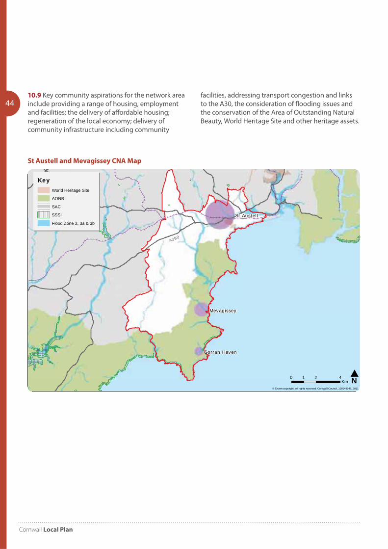
Cornwall Local Plan
44
St Austell
Mevagissey
Gorran Haven
© Crown copyright. All rights reserved. Cornwall Council, 100049047, 2011
N0 2 41Km
KeyWorld Heritage Site
AONB
SAC
SSSI
Flood Zone 2, 3a & 3b
A390
St Austell and Mevagissey CNA Map
10.9 Key community aspirations for the network area include providing a range of housing, employment and facilities; the delivery of affordable housing; regeneration of the local economy; delivery of community infrastructure including community
facilities, addressing transport congestion and links to the A30, the consideration of flooding issues and the conservation of the Area of Outstanding Natural Beauty, World Heritage Site and other heritage assets.
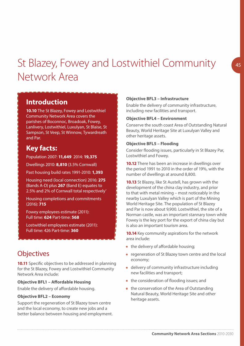
Community Network Area Sections 2010-2030
45St Blazey, Fowey and Lostwithiel Community
Network Area
Introduction10.10 The St Blazey, Fowey and Lostwithiel Community Network Area covers the parishes of Boconnoc, Broadoak, Fowey, Lanlivery, Lostwithiel, Luxulyan, St Blaise, St Sampson, St Veep, St Winnow, Tywardreath and Par.
Key facts:Population 2007: 11,649 2014: 19,375
Dwellings 2010: 8,810 (3.5% Cornwall)
Past housing build rates 1991-2010: 1,393
Housing need (local connection) 2016: 275 (Bands A-D) plus 267 (Band E) equates to 2.5% and 2% of Cornwall total respectively’
Housing completions and commitments (2016): 715
Fowey employees estimate (2011): Full time: 624 Part-time: 568
Lostwithiel employees estimate (2011): Full time: 426 Part-time: 360
Objective BFL3 – Infrastructure
Enable the delivery of community infrastructure, including new facilities and transport.
Objective BFL4 – Environment
Conserve the south coast Area of Outstanding Natural Beauty, World Heritage Site at Luxulyan Valley and other heritage assets.
Objective BFL5 – Flooding
Consider flooding issues, particularly in St Blazey Par, Lostwithiel and Fowey.
10.12 There has been an increase in dwellings over the period 1991 to 2010 in the order of 19%, with the number of dwellings at around 8,800.
10.13 St Blazey, like St Austell, has grown with the development of the china clay industry, and prior to that with metal mining – most noticeably in the nearby Luxulyan Valley which is part of the Mining World Heritage Site. The population of St Blazey and Par is now about 9,900. Lostwithiel, the site of a Norman castle, was an important stannary town while Fowey is the key port for the export of china clay but is also an important tourism area.
10.14 Key community aspirations for the network area include:
• the delivery of affordable housing;
• regeneration of St Blazey town centre and the local economy;
• delivery of community infrastructure including new facilities and transport;
• the consideration of flooding issues; and
• the conservation of the Area of Outstanding Natural Beauty, World Heritage Site and other heritage assets.
Objectives10.11 Specific objectives to be addressed in planning for the St Blazey, Fowey and Lostwithiel Community Network Area include:
Objective BFL1 – Affordable Housing
Enable the delivery of affordable housing.
Objective BFL2 – Economy
Support the regeneration of St Blazey town centre and the local economy, to create new jobs and a better balance between housing and employment.
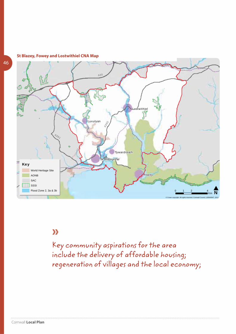
Cornwall Local Plan
46
Fowey
Luxulyan
Lostwithiel
Tywardreath
St Blazey/Par
© Crown copyright. All rights reserved. Cornwall Council, 100049047, 2011
N0 2 41Km
KeyWorld Heritage Site
AONB
SAC
SSSI
Flood Zone 2, 3a & 3b
A30
A390
A391
St Blazey, Fowey and Lostwithiel CNA Map
Key community aspirations for the area include the delivery of affordable housing; regeneration of villages and the local economy;
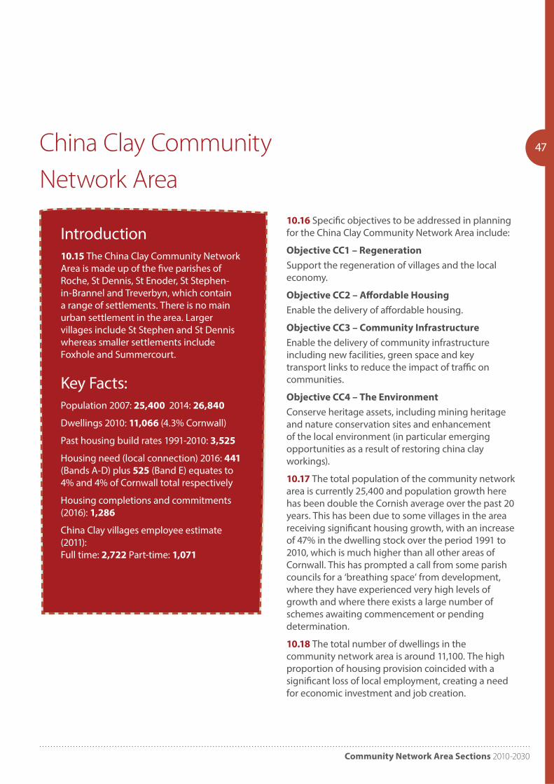
Community Network Area Sections 2010-2030
47China Clay Community
Network Area
10.16 Specific objectives to be addressed in planning for the China Clay Community Network Area include:
Objective CC1 – Regeneration
Support the regeneration of villages and the local economy.
Objective CC2 – Affordable Housing
Enable the delivery of affordable housing.
Objective CC3 – Community Infrastructure
Enable the delivery of community infrastructure including new facilities, green space and key transport links to reduce the impact of traffic on communities.
Objective CC4 – The Environment
Conserve heritage assets, including mining heritage and nature conservation sites and enhancement of the local environment (in particular emerging opportunities as a result of restoring china clay workings).
10.17 The total population of the community network area is currently 25,400 and population growth here has been double the Cornish average over the past 20 years. This has been due to some villages in the area receiving significant housing growth, with an increase of 47% in the dwelling stock over the period 1991 to 2010, which is much higher than all other areas of Cornwall. This has prompted a call from some parish councils for a ‘breathing space’ from development, where they have experienced very high levels of growth and where there exists a large number of schemes awaiting commencement or pending determination.
10.18 The total number of dwellings in the community network area is around 11,100. The high proportion of housing provision coincided with a significant loss of local employment, creating a need for economic investment and job creation.
Introduction10.15 The China Clay Community Network Area is made up of the five parishes of Roche, St Dennis, St Enoder, St Stephen-in-Brannel and Treverbyn, which contain a range of settlements. There is no main urban settlement in the area. Larger villages include St Stephen and St Dennis whereas smaller settlements include Foxhole and Summercourt.
Key Facts:Population 2007: 25,400 2014: 26,840
Dwellings 2010: 11,066 (4.3% Cornwall)
Past housing build rates 1991-2010: 3,525
Housing need (local connection) 2016: 441 (Bands A-D) plus 525 (Band E) equates to 4% and 4% of Cornwall total respectively
Housing completions and commitments (2016): 1,286
China Clay villages employee estimate (2011): Full time: 2,722 Part-time: 1,071
Objectives
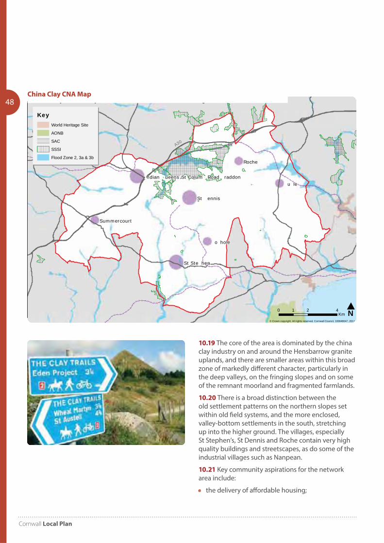
Cornwall Local Plan
48
u le
Roche
o hole
St ennis
St Ste hen
Summercourt
ndian ueens St Colum Road raddon
© Crown copyright. All rights reserved. Cornwall Council, 100049047, 2011
China Clay Community Network Area - Environmental Designations
N0 2 41Km
KeyWorld Heritage Site
AONB
SAC
SSSI
Flood Zone 2, 3a & 3b
A30
China Clay CNA Map
10.19 The core of the area is dominated by the china clay industry on and around the Hensbarrow granite uplands, and there are smaller areas within this broad zone of markedly different character, particularly in the deep valleys, on the fringing slopes and on some of the remnant moorland and fragmented farmlands.
10.20 There is a broad distinction between the old settlement patterns on the northern slopes set within old field systems, and the more enclosed, valley-bottom settlements in the south, stretching up into the higher ground. The villages, especially St Stephen’s, St Dennis and Roche contain very high quality buildings and streetscapes, as do some of the industrial villages such as Nanpean.
10.21 Key community aspirations for the network area include:
• the delivery of affordable housing;
Community Network Area Sections 2010-2030
49• regeneration of villages and the local economy;
• delivery of community infrastructure including new facilities;
• green space and key transport links; and
• the conservation of heritage assets and the enhancement of the local environment.
Development Strategy10.22 For the purposes of establishing a development strategy the area is broken down into four elements,
St Austell and Mevagissey CNA10.23 The approach helps to deliver high affordable housing need in the St Austell area, the level of growth sits well with the existing high level of commitments and allows for a reasonable level of growth over the plan period.
10.24 Due to the nature of existing administrative boundaries the growth of St Austell is likely to occur on the edge of the current built up area of the town but outside of the St Austell CNA. This approach helps to support and maintain the level of facilities and services available in St Austell and the wider area.
10.25 In the ‘rest of the CNA’, the settlements of Mevagissey, Gorran Haven and Trewoon are identified as being able to accommodate an appropriate level of growth which will help maintain their sustainability.
St Blazey, Fowey and Lostwithiel CNA10.26 The strategy continues to help deliver a balance of market and affordable housing in the area and is aimed to meet community aspirations in the small towns such as Lostwithiel.
10.27 The level of growth is proportionate with the existing level of commitments and allows for a reasonable level of growth over the plan period and supporting and maintaining the level of facilities and services available in the three small towns and the wider area.
China Clay CNA10.28 Past rates of housing growth have been high in this area compared to the rest of Cornwall and the area still has a high element of commitments that have yet to be built out.
10.29 The strategy seeks to acknowledge these past high rates of growth and sets an approach that helps deliver a sustainable balance of market and affordable housing in the area.
St Austell, St Blazey and China Clay Area Regeneration Area10.30 There is a shared vision to establish the St Austell, St Blazey and China Clay Area as the ‘Green Capital’ of Cornwall, bringing investment in sustainable employment and communities by encouraging quality and innovation.
10.31 The Regeneration area has a strong focus on sustainable development and this opportunity should be exploited so that the area becomes a focus for sustainable living and supports the development of environmental technologies and industries that offer regeneration and environmental benefits.
10.32 Emphasis is also placed on making the best productive and positive use of previously developed, despoiled, degraded, derelict, contaminated and unstable land including land in rural areas, particularly where the likelihood of early restoration of the land is remote and unlikely to be of high environmental value.
10.33 A key component of the Council’s growth and regeneration aspirations within the CNA’s is the policy approach that seeks to promote sustainable and environmentally responsible development in the area. The eco-communities sites are considered to be at the heart of the area wide ambition to become a ‘Green Capital’. Cornwall Council will be keen to see many of the standards and innovations associated with such projects to feature in other schemes that come forward throughout the area. The key aspects of achieving these aims will be to create economic growth and jobs; maximise green credentials; improve the natural and built environment and promote community resilience, similar in ethos and
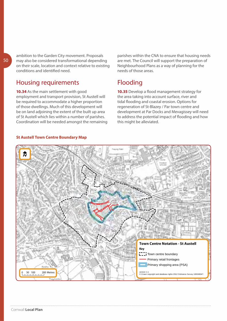
Cornwall Local Plan
50ambition to the Garden City movement. Proposals may also be considered transformational depending on their scale, location and context relative to existing conditions and identified need.
Housing requirements10.34 As the main settlement with good employment and transport provision, St Austell will be required to accommodate a higher proportion of those dwellings. Much of this development will be on land adjoining the extent of the built up area of St Austell which lies within a number of parishes. Coordination will be needed amongst the remaining
parishes within the CNA to ensure that housing needs are met. The Council will support the preparation of Neighbourhood Plans as a way of planning for the needs of those areas.
Flooding 10.35 Develop a flood management strategy for the area taking into account surface, river and tidal flooding and coastal erosion. Options for regeneration of St-Blazey / Par town centre and development at Par Docks and Mevagissey will need to address the potential impact of flooding and how this might be alleviated.
Town Centre Notation - St Austell
version 1.1© Crown copyright and database rights 2012 Ordnance Survey 100049047.
Key
Town centre boundary
Primary retail frontages
Primary shopping area (PSA)
0 100 20050 Metres
St Austell Town Centre Boundary Map

Community Network Area Sections 2010-2030
51PP10 Wadebridge and Padstow
Community Network Area
Objective 2 – Employment
Promote better quality jobs to create a more balanced economy.
Objective 3 – Shops and Services
Protect and support enhancements to local shops, facilities and services.
Objective 4 – Environment
Protect the various national and international designations; ensuring development does not have a negative impact on these areas. Consider coastal, tidal and fluvial flooding issues.
Objective 5 – Infrastructure
Improve access to healthcare provision particularly in the rural areas and promote public transport links to rural villages. Support and develop ICT infrastructure.
Development Strategy11.2 A comprehensive and co-ordinated approach will be pursued to the planning and development of the network area. Wadebridge is the main settlement in the CNA. A regeneration approach will enable Wadebridge to achieve balanced housing and economic growth linked with infrastructure improvements, whilst protecting, regenerating and enhancing its local service role, its unique qualities, character and the historic built and natural environment. Regeneration of the town centre should take into account its liability to flooding.
11.3 The network area contains the two key settlements of Wadebridge and Padstow, and these act as the local service centres to the many smaller settlements surrounding them. Larger villages in the area include St Merryn, Rock and Port Isaac whereas smaller villages include St Minver and St Tudy.
11.4 This is an area with an important maritime heritage. Padstow was historically north Cornwall’s main port and this remains both a working port and a
Introduction11.0 The Wadebridge and Padstow Community Network Area covers the parishes of Egloshayle, Padstow, St Breock, St Endellion, St Ervan, St Eval, St Issey, St Kew, St Mabyn, St Merryn, St Minver Highlands, St Minver Lowlands, St Tudy and Wadebridge.
Key facts:Population 2007: 20,500 2014: 20,665
Dwellings 2010: 11,659 (4.6% Cornwall)
Past housing build rates 1991-2010: 1,743
‘Housing need (local connection) 2016: 292 (Bands A-D) plus 408 (Band E) equates to 2.6% and 3.2% of Cornwall total respectively
Housing completions and commitments (2016): 1,084
Wadebridge employees estimate (2011): Full time: 1,983 Part-time: 1,563
Padstow employees estimate (2011): Full time: 985 Part-time: 722
Objectives11.1 Specific objectives to be addressed in planning for the Wadebridge and Padstow Community Network Area, include:
Objective 1 – Housing
Identify the level and location of new growth. Provide suitable types of housing to meet a variety of needs enable the delivery of affordable housing particularly when considering the impact of a high percentage of second homes.
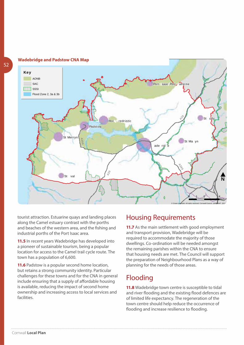
Cornwall Local Plan
52
St udy
Padstow
St val
St Ma ynSt Merryn
ade rid e
Roc redrizzic
Port saac Port averne
© Crown copyright. All rights reserved. Cornwall Council, 100049047, 2011
ade ridge & adstow Community Network Area - Environmental Designations
N
0 2 41Km
KeyAONB
SAC
SSSI
Flood Zone 2, 3a & 3b
A39
A39
A389
A389Wadebridge and Padstow CNA Map
tourist attraction. Estuarine quays and landing places along the Camel estuary contrast with the porths and beaches of the western area, and the fishing and industrial porths of the Port Isaac area.
11.5 In recent years Wadebridge has developed into a pioneer of sustainable tourism, being a popular location for access to the Camel trail cycle route. The town has a population of 6,600.
11.6 Padstow is a popular second home location, but retains a strong community identity. Particular challenges for these towns and for the CNA in general include ensuring that a supply of affordable housing is available, reducing the impact of second home ownership and increasing access to local services and facilities.
Housing Requirements11.7 As the main settlement with good employment and transport provision, Wadebridge will be required to accommodate the majority of those dwellings. Co-ordination will be needed amongst the remaining parishes within the CNA to ensure that housing needs are met. The Council will support the preparation of Neighbourhood Plans as a way of planning for the needs of those areas.
Flooding 11.8 Wadebridge town centre is susceptible to tidal and river flooding and the existing flood defences are of limited life expectancy. The regeneration of the town centre should help reduce the occurrence of flooding and increase resilience to flooding.
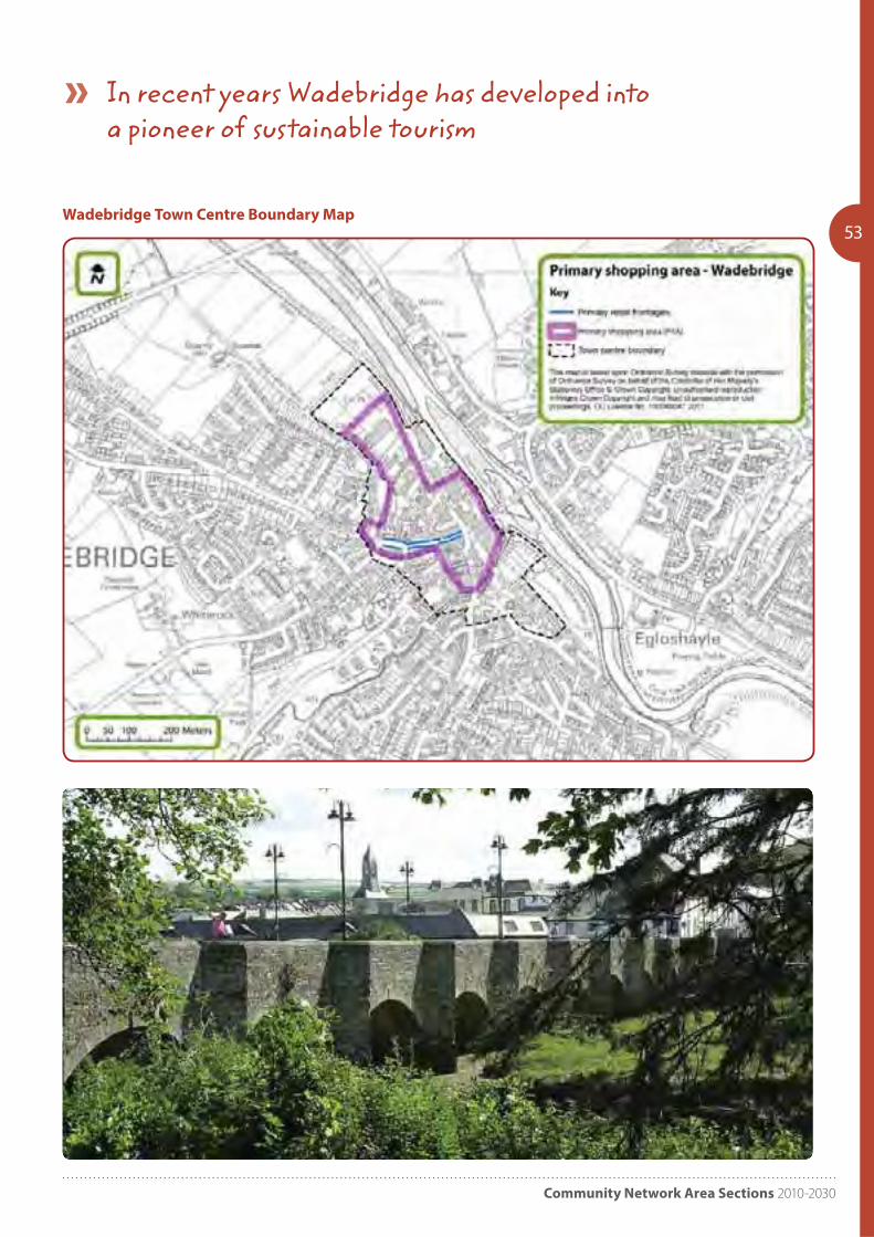
Community Network Area Sections 2010-2030
53Wadebridge Town Centre Boundary Map
In recent years Wadebridge has developed into a pioneer of sustainable tourism
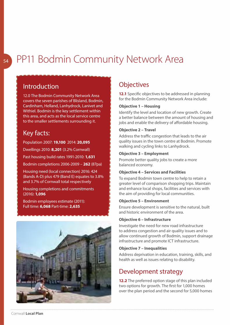
Cornwall Local Plan
54 PP11 Bodmin Community Network Area
Introduction12.0 The Bodmin Community Network Area covers the seven parishes of Blisland, Bodmin, Cardinham, Helland, Lanhydrock, Lanivet and Withiel. Bodmin is the key settlement within this area, and acts as the local service centre to the smaller settlements surrounding it.
Key facts:Population 2007: 19,100 2014: 20,095
Dwellings 2010: 8,201 (3.2% Cornwall)
Past housing build rates 1991-2010: 1,631
Bodmin completions 2006-2009 – 262 (87pa)
Housing need (local connection) 2016: 424 (Bands A-D) plus 479 (Band E) equates to 3.8% and 3.7% of Cornwall total respectively
Housing completions and commitments (2016): 1,096
Bodmin employees estimate (2011): Full time: 6,068 Part-time: 2,635
Objectives12.1 Specific objectives to be addressed in planning for the Bodmin Community Network Area include:
Objective 1 – Housing
Identify the level and location of new growth. Create a better balance between the amount of housing and jobs and enable the delivery of affordable housing.
Objective 2 – Travel
Address the traffic congestion that leads to the air quality issues in the town centre at Bodmin. Promote walking and cycling links to Lanhydrock.
Objective 3 – Employment
Promote better quality jobs to create a more balanced economy.
Objective 4 – Services and Facilities
To expand Bodmin town centre to help to retain a greater level of comparison shopping trips. Maintain and enhance local shops, facilities and services with the aim of providing for local communities.
Objective 5 – Environment
Ensure development is sensitive to the natural, built and historic environment of the area.
Objective 6 – Infrastructure
Investigate the need for new road infrastructure to address congestion and air quality issues and to allow continued growth of Bodmin, support drainage infrastructure and promote ICT infrastructure.
Objective 7 – Inequalities
Address deprivation in education, training, skills, and health as well as issues relating to disability.
Development strategy12.2 The preferred option stage of this plan included two options for growth. The first for 1,000 homes over the plan period and the second for 5,000 homes
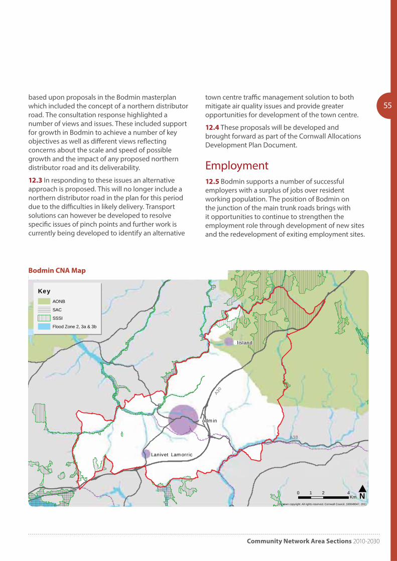
Community Network Area Sections 2010-2030
55based upon proposals in the Bodmin masterplan which included the concept of a northern distributor road. The consultation response highlighted a number of views and issues. These included support for growth in Bodmin to achieve a number of key objectives as well as different views reflecting concerns about the scale and speed of possible growth and the impact of any proposed northern distributor road and its deliverability.
12.3 In responding to these issues an alternative approach is proposed. This will no longer include a northern distributor road in the plan for this period due to the difficulties in likely delivery. Transport solutions can however be developed to resolve specific issues of pinch points and further work is currently being developed to identify an alternative
town centre traffic management solution to both mitigate air quality issues and provide greater opportunities for development of the town centre.
12.4 These proposals will be developed and brought forward as part of the Cornwall Allocations Development Plan Document.
Employment12.5 Bodmin supports a number of successful employers with a surplus of jobs over resident working population. The position of Bodmin on the junction of the main trunk roads brings with it opportunities to continue to strengthen the employment role through development of new sites and the redevelopment of exiting employment sites.
odmin
lisland
Lanivet Lamorric
© Crown copyright. All rights reserved. Cornwall Council, 100049047, 2011
odmin Community Network Area - Environmental Designations
N0 2 41Km
KeyAONB
SAC
SSSI
Flood Zone 2, 3a & 3b
A30
A38
Bodmin CNA Map
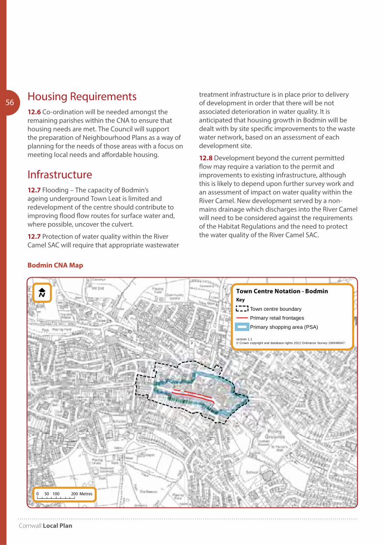
Cornwall Local Plan
56 Housing Requirements12.6 Co-ordination will be needed amongst the remaining parishes within the CNA to ensure that housing needs are met. The Council will support the preparation of Neighbourhood Plans as a way of planning for the needs of those areas with a focus on meeting local needs and affordable housing.
Infrastructure12.7 Flooding – The capacity of Bodmin’s ageing underground Town Leat is limited and redevelopment of the centre should contribute to improving flood flow routes for surface water and, where possible, uncover the culvert.
12.7 Protection of water quality within the River Camel SAC will require that appropriate wastewater
Town Centre Notation - Bodmin
version 1.1© Crown copyright and database rights 2012 Ordnance Survey 100049047.
Key
Town centre boundary
Primary retail frontages
Primary shopping area (PSA)
0 100 20050 Metres
treatment infrastructure is in place prior to delivery of development in order that there will be not associated deterioration in water quality. It is anticipated that housing growth in Bodmin will be dealt with by site specific improvements to the waste water network, based on an assessment of each development site.
12.8 Development beyond the current permitted flow may require a variation to the permit and improvements to existing infrastructure, although this is likely to depend upon further survey work and an assessment of impact on water quality within the River Camel. New development served by a non-mains drainage which discharges into the River Camel will need to be considered against the requirements of the Habitat Regulations and the need to protect the water quality of the River Camel SAC.
Bodmin CNA Map
Community Network Area Sections 2010-2030
57PP12 Camelford Community Network Area
Objective 5 – Jobs and Housing
Enable new employment opportunities and ICT improvements in the area to align housing and employment provision.Objective 6 – Renewable Energy
Promote renewable energy generation that is sensitive to the landscape character of the area.Objective 7 – Environment
Protect the unspoilt character of the undeveloped coast and the area’s special historic significance.
Development Strategy13.2 The approach, promoted through local consultation and parish plans identify a need for development to support Camelford, promote more sustainable transport choices, increase employment prospects, capture tourism benefits and provide a high proportion of affordable housing.
13.3 The settlement pattern in this community network area is characterised by a relatively large number of small settlements and a small market town. Camelford is the principal settlement within this area, and acts as the local service centre to the many smaller settlements in the area. Larger villages in the area include Boscastle, Delabole, St Breward, St Teath, Tintagel and Warbstow Cross.
13.4 There are a number of different landscape types that make up this large area. The area stretches from Rough Tor and Brown Willy – Cornwall’s highest points on Bodmin Moor – to a low coastal strip in the west. In between there are a number of settlements – some like Delabole on an exposed ridge, others such as Camelford in more sheltered locations.
13.5 The town of Camelford is a typical small attractive market town with a population of about 2,250. The A39 which runs through the town is extremely narrow in parts and causes traffic problems particularly during the summer months.
13.6 The coastal village of Tintagel is situated about 8 km (five miles) to the north west of Camelford and is a popular destination for tourists who are drawn by the Arthurian legend and ancient castle with its spectacular setting.
Introduction13.0 The Camelford Community Network Area covers the parishes of Advent, Camelford, Davidstow, Forrabury and Minster, Lesnewth, Michaelstow, Otterham, St Breward, St Clether, St Juliot, St Teath, Tintagel, Tremaine, Treneglos, Tresmeer, Trevalga and Warbstow.
Key Facts:Population 2007: 12,000 2014: 12,645
Dwellings 2010: 6,079 (2.4% Cornwall)
Past housing build rates 1991-2010: 1,312
Housing need (local connection) 2016: 193 (Bands A-D) plus 225 (Band E) equates to 1.7% and 1.7% of Cornwall total respectively
Housing completions and commitments (2016): 509
Camelford employees estimate (2011): Full time: 421 Part-time: 355
Objectives13.1 Specific objectives to be addressed in planning for the Camelford Community Network Area include:Objective 1 – Housing
Enable the provision of affordable housing, without major development being directed to the area.Objective 2 – Congestion
Address congestion within Camelford town centre.Objective 3 – Travel
Reduce private car use and improve and encourage the use of public and community transport within the area and with adjoining areas.Objective 4 – Community Facilities and Services
Strengthen Camelford’s role as a local centre by supporting and enhancing the town’s community facilities and services, and sustain the community infrastructure of surrounding villages, including through co-location of facilities.
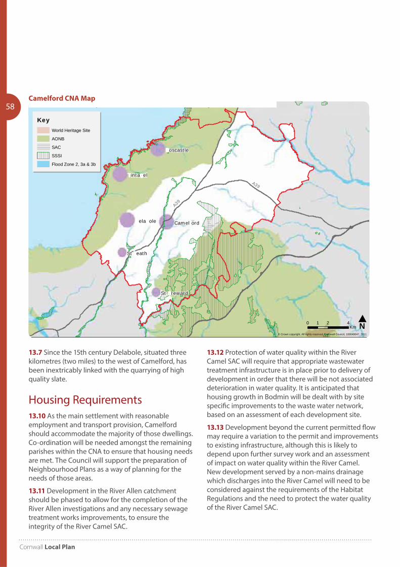
Cornwall Local Plan
58
13.7 Since the 15th century Delabole, situated three kilometres (two miles) to the west of Camelford, has been inextricably linked with the quarrying of high quality slate.
Housing Requirements13.10 As the main settlement with reasonable employment and transport provision, Camelford should accommodate the majority of those dwellings. Co-ordination will be needed amongst the remaining parishes within the CNA to ensure that housing needs are met. The Council will support the preparation of Neighbourhood Plans as a way of planning for the needs of those areas.
13.11 Development in the River Allen catchment should be phased to allow for the completion of the River Allen investigations and any necessary sewage treatment works improvements, to ensure the integrity of the River Camel SAC.
St eath
ela ole
inta el
Camel ord
oscastle
St reward
© Crown copyright. All rights reserved. Cornwall Council, 100049047, 2011
Camel ord Community Network Area - Environmental Designations
N0 2 41Km
KeyWorld Heritage Site
AONB
SAC
SSSI
Flood Zone 2, 3a & 3b
A39
A39
13.12 Protection of water quality within the River Camel SAC will require that appropriate wastewater treatment infrastructure is in place prior to delivery of development in order that there will be not associated deterioration in water quality. It is anticipated that housing growth in Bodmin will be dealt with by site specific improvements to the waste water network, based on an assessment of each development site.
13.13 Development beyond the current permitted flow may require a variation to the permit and improvements to existing infrastructure, although this is likely to depend upon further survey work and an assessment of impact on water quality within the River Camel. New development served by a non-mains drainage which discharges into the River Camel will need to be considered against the requirements of the Habitat Regulations and the need to protect the water quality of the River Camel SAC.
Camelford CNA Map

Community Network Area Sections 2010-2030
59
Cornwall Local Plan
60 P13 Bude Community Network Area
Objectives14.1 Specific objectives to be addressed in planning for the Bude Community Network Area include:
Objective 1 – Employment
Maintain Bude’s role as a local service centre meeting the needs of the town and the rural hinterland and sustain and enhance Bude’s role as one of the primary employment hubs in the northeast of the county – in doing so raising the quality and quantity of employment opportunities.
Objective 2 – Housing
To alleviate the demand for local affordable housing and improve the overall balance of housing in the area in terms of tenure, type and affordability.
Objective 3 – Community Services
Support the needs of communities in the rural hinterland through appropriate local needs development and the maintenance of community facilities.
Objective 4 – Heritage and Environment
To maintain and enhance the area’s heritage and environmental assets for the benefit of the local community and to use them to enhance the area’s tourism offer.
Objective 5 – Character
To maintain and enhance the distinct character of Bude, Stratton, Flexbury and Poughill and in doing so protect these from physical and / or perceived coalescence.
Objective 6 – Infrastructure
To deliver the highway and sustainable transport infrastructure needed to support the delivery of future housing and economic growth and deliver other infrastructure required for the growth of the area. Enhance the quantity and quality of Bude, Stratton, Flexbury and Poughill’s publicly accessible green infrastructure to improve health and wellbeing.
Introduction14.0 The Bude Community Network Area covers the 11 parishes of Bude- Stratton, Jacobstow, Kilkhampton, Launcells, Marhamchurch, Morwenstow, North Tamerton, Poundstock, St Gennys, Week St Mary and Whitstone.
Key Facts:Population 2007: 16,600 2014: 17,155
Dwellings 2010: 8,335 (3.3% Cornwall)
Past housing build rates 1991-2010: 1,563
Housing need (local connection) 2016: 236 (Bands A-D) plus 253 (Band E) equates to 2.1% and 1.9% of Cornwall total respectively
Housing completions and commitments (2016): 928
Bude employees estimate (2011): Full time: 1,880 Part-time: 1,751
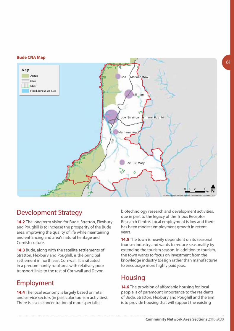
Community Network Area Sections 2010-2030
61
Kil ham ton
ee St Mary
Marhamchurch
Sho Morwenstow
ude Stratton le ury Pou hill
© Crown copyright. All rights reserved. Cornwall Council, 100049047, 2011
ude Community Network Area - Environmental Designations
N0 2 41Km
KeyAONB
SAC
SSSI
Flood Zone 2, 3a & 3b
A39
Bude CNA Map
Development Strategy14.2 The long term vision for Bude, Stratton, Flexbury and Poughill is to increase the prosperity of the Bude area, improving the quality of life while maintaining and enhancing and area’s natural heritage and Cornish culture.
14.3 Bude, along with the satellite settlements of Stratton, Flexbury and Poughill, is the principal settlement in north east Cornwall. It is situated in a predominantly rural area with relatively poor transport links to the rest of Cornwall and Devon.
Employment14.4 The local economy is largely based on retail and service sectors (in particular tourism activities). There is also a concentration of more specialist
biotechnology research and development activities, due in part to the legacy of the Tripos Receptor Research Centre. Local employment is low and there has been modest employment growth in recent years.
14.5 The town is heavily dependent on its seasonal tourism industry and wants to reduce seasonality by extending the tourism season. In addition to tourism, the town wants to focus on investment from the knowledge industry (design rather than manufacture) to encourage more highly paid jobs.
Housing14.6 The provision of affordable housing for local people is of paramount importance to the residents of Bude, Stratton, Flexbury and Poughill and the aim is to provide housing that will support the existing
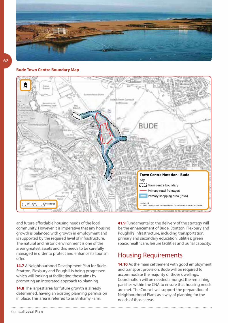
Cornwall Local Plan
62
Town Centre Notation - Bude
version 1.1© Crown copyright and database rights 2012 Ordnance Survey 100049047.
Key
Town centre boundary
Primary retail frontages
Primary shopping area (PSA)
0 100 20050 Metres
and future affordable housing needs of the local community. However it is imperative that any housing growth is balanced with growth in employment and is supported by the required level of infrastructure. The natural and historic environment is one of the areas greatest assets and this needs to be carefully managed in order to protect and enhance its tourism offer.
14.7 A Neighbourhood Development Plan for Bude, Stratton, Flexbury and Poughill is being progressed which will looking at facilitating these aims by promoting an integrated approach to planning.
14.8 The largest area for future growth is already determined, having an existing planning permission in place. This area is referred to as Binhamy Farm.
Bude Town Centre Boundary Map
41.9 Fundamental to the delivery of the strategy will be the enhancement of Bude, Stratton, Flexbury and Poughill’s infrastructure, including transportation; primary and secondary education; utilities; green space; healthcare; leisure facilities and burial capacity.
Housing Requirements14.10 As the main settlement with good employment and transport provision, Bude will be required to accommodate the majority of those dwellings. Coordination will be needed amongst the remaining parishes within the CNA to ensure that housing needs are met. The Council will support the preparation of Neighbourhood Plans as a way of planning for the needs of those areas.
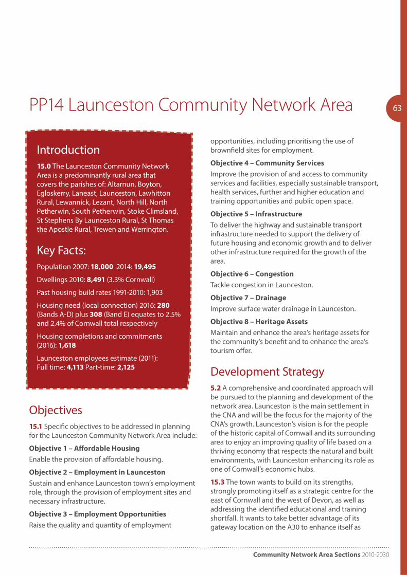
Community Network Area Sections 2010-2030
63PP14 Launceston Community Network Area
Introduction15.0 The Launceston Community Network Area is a predominantly rural area that covers the parishes of: Altarnun, Boyton, Egloskerry, Laneast, Launceston, Lawhitton Rural, Lewannick, Lezant, North Hill, North Petherwin, South Petherwin, Stoke Climsland, St Stephens By Launceston Rural, St Thomas the Apostle Rural, Trewen and Werrington.
Key Facts:Population 2007: 18,000 2014: 19,495
Dwellings 2010: 8,491 (3.3% Cornwall)
Past housing build rates 1991-2010: 1,903
Housing need (local connection) 2016: 280 (Bands A-D) plus 308 (Band E) equates to 2.5% and 2.4% of Cornwall total respectively
Housing completions and commitments (2016): 1,618
Launceston employees estimate (2011): Full time: 4,113 Part-time: 2,125
opportunities, including prioritising the use of brownfield sites for employment.
Objective 4 – Community Services
Improve the provision of and access to community services and facilities, especially sustainable transport, health services, further and higher education and training opportunities and public open space.
Objective 5 – Infrastructure
To deliver the highway and sustainable transport infrastructure needed to support the delivery of future housing and economic growth and to deliver other infrastructure required for the growth of the area.
Objective 6 – Congestion
Tackle congestion in Launceston.
Objective 7 – Drainage
Improve surface water drainage in Launceston.
Objective 8 – Heritage Assets
Maintain and enhance the area’s heritage assets for the community’s benefit and to enhance the area’s tourism offer.
Development Strategy5.2 A comprehensive and coordinated approach will be pursued to the planning and development of the network area. Launceston is the main settlement in the CNA and will be the focus for the majority of the CNA’s growth. Launceston’s vision is for the people of the historic capital of Cornwall and its surrounding area to enjoy an improving quality of life based on a thriving economy that respects the natural and built environments, with Launceston enhancing its role as one of Cornwall’s economic hubs.
15.3 The town wants to build on its strengths, strongly promoting itself as a strategic centre for the east of Cornwall and the west of Devon, as well as addressing the identified educational and training shortfall. It wants to take better advantage of its gateway location on the A30 to enhance itself as
Objectives15.1 Specific objectives to be addressed in planning for the Launceston Community Network Area include:
Objective 1 – Affordable Housing
Enable the provision of affordable housing.
Objective 2 – Employment in Launceston
Sustain and enhance Launceston town’s employment role, through the provision of employment sites and necessary infrastructure.
Objective 3 – Employment Opportunities
Raise the quality and quantity of employment
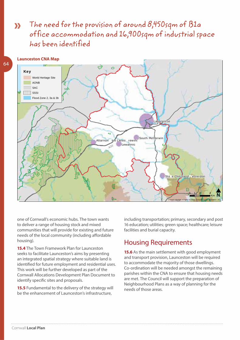
Cornwall Local Plan
64
one of Cornwall’s economic hubs. The town wants to deliver a range of housing stock and mixed communities that will provide for existing and future needs of the local community (including affordable housing).
15.4 The Town Framework Plan for Launceston seeks to facilitate Launceston’s aims by presenting an integrated spatial strategy where suitable land is identified for future employment and residential uses. This work will be further developed as part of the Cornwall Allocations Development Plan Document to identify specific sites and proposals.
15.5 Fundamental to the delivery of the strategy will be the enhancement of Launceston’s infrastructure,
including transportation; primary, secondary and post 16 education; utilities; green space; healthcare; leisure facilities and burial capacity.
Housing Requirements15.6 As the main settlement with good employment and transport provision, Launceston will be required to accommodate the majority of those dwellings. Co-ordination will be needed amongst the remaining parishes within the CNA to ensure that housing needs are met. The Council will support the preparation of Neighbourhood Plans as a way of planning for the needs of those areas.
Lewannic
Launceston
South Petherwin
Sto e Climsland enterdon
Altarnun ive Lanes rewint
© Crown copyright. All rights reserved. Cornwall Council, 100049047, 2011
Laun eston Community Network Area - Environmental Designations
N0 2 41Km
KeyWorld Heritage Site
AONB
SAC
SSSI
Flood Zone 2, 3a & 3b
A30
The need for the provision of around 8,450sqm of B1a office accommodation and 16,900sqm of industrial space has been identified
Launceston CNA Map
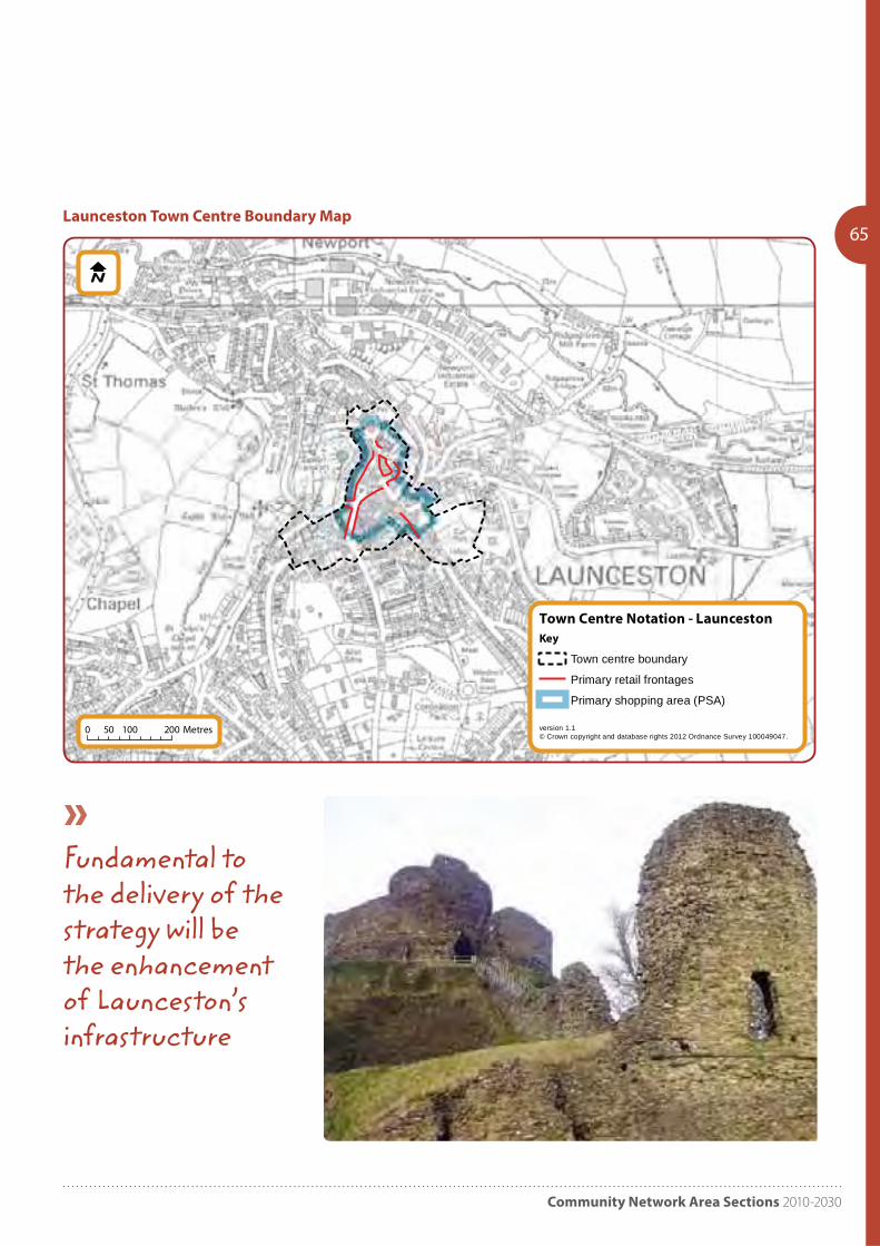
Community Network Area Sections 2010-2030
65
Town Centre Notation - Launceston
version 1.1© Crown copyright and database rights 2012 Ordnance Survey 100049047.
Key
Town centre boundary
Primary retail frontages
Primary shopping area (PSA)
0 100 20050 Metres
Launceston Town Centre Boundary Map
Fundamental to the delivery of the strategy will be the enhancement of Launceston’s infrastructure
Cornwall Local Plan
66 PP15 Liskeard and Looe Community
Network Area
Introduction16.0 The Liskeard and Looe Community Network Area covers the parishes of Deviock, Duloe, Dobwalls and Trewidland, Lanreath, Lansallos, Lanteglos, Liskeard, Looe, Menheniot, Morval, Pelynt, Quethiock, St Cleer, St Keyne,
St Neot, St Martin-by-Looe, St Pinnock and Warleggan.
Key Facts:Population 2007: 33,000 2014: 31,440
Dwellings 2010: 15,547 (6.1% Cornwall)
Past housing build rates 1991-2010: 1,869
Housing need (local connection) 2016: 500 (Bands A-D) plus 686 (Band E) equates to 4.5% and 5.3% of Cornwall total respectively
Housing completions and commitments (2016): 2,038
Liskeard employees estimate (2011): Full time: 2,349 Part-time: 1,949
Looe employees estimate (2011): Full time: 746 Part-time: 763
Objectives16.1 Specific objectives to be addressed in planning for the Liskeard and Looe Community Network Area include:
Objective 1 – Economy and Jobs
Deliver economic growth / employment, providing much needed jobs to counterbalance current and future housing development in and on the edge of Liskeard.
Objective 2 – Sustainable Development
Improve connectivity within and on the edge of Liskeard to ensure the town functions effectively as a major hub and service centre for the network area; including enhanced public transport provision.
Objective 3 – Liskeard as a Service Centre
Strengthen Liskeard’s role as a service centre and improve town centre viability through regeneration schemes.
Objective 4 – Housing
Balance the housing stock to provide a range of accommodation, particularly for open market family homes and intermediate affordable housing in Liskeard.
Objective 5 – Leisure Facilities
Improve and maintain the provision of recreational, cultural and leisure services and facilities in Liskeard with particular focus on delivering sports pitches.
Development Strategy16.2 A comprehensive and coordinated approach will be pursued to the planning and development of Liskeard.
16.3 Liskeard and Looe are the main settlements within this area, and act as the local service centres to the many smaller settlements surrounding
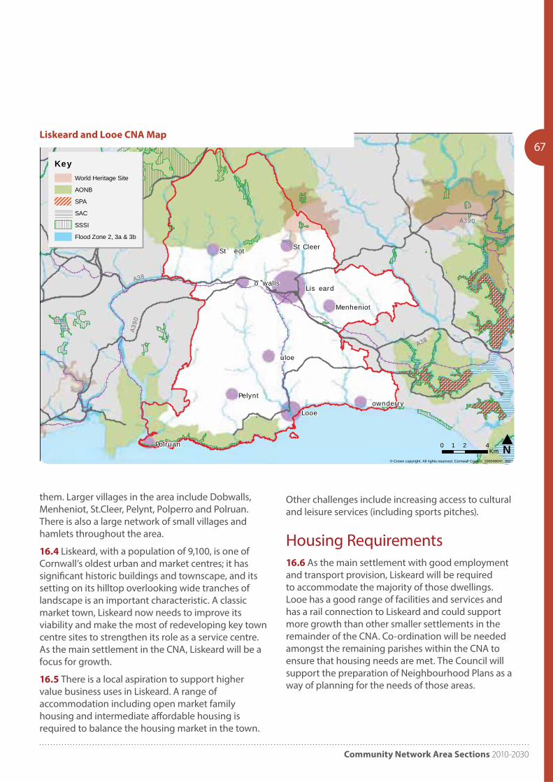
Community Network Area Sections 2010-2030
67
them. Larger villages in the area include Dobwalls, Menheniot, St.Cleer, Pelynt, Polperro and Polruan. There is also a large network of small villages and hamlets throughout the area.
16.4 Liskeard, with a population of 9,100, is one of Cornwall’s oldest urban and market centres; it has significant historic buildings and townscape, and its setting on its hilltop overlooking wide tranches of landscape is an important characteristic. A classic market town, Liskeard now needs to improve its viability and make the most of redeveloping key town centre sites to strengthen its role as a service centre. As the main settlement in the CNA, Liskeard will be a focus for growth.
16.5 There is a local aspiration to support higher value business uses in Liskeard. A range of accommodation including open market family housing and intermediate affordable housing is required to balance the housing market in the town.
Looe
uloe
Pelynt
St eot
Polruan
St Cleer
o wallsLis eard
Menheniot
ownderry
© Crown copyright. All rights reserved. Cornwall Council, 100049047, 2011
Liskeard & Looe Community Network Area - Environmental Designations
N0 2 41Km
KeyWorld Heritage Site
AONB
SPA
SAC
SSSI
Flood Zone 2, 3a & 3b
A38
A38
A390
A390
Other challenges include increasing access to cultural and leisure services (including sports pitches).
Housing Requirements16.6 As the main settlement with good employment and transport provision, Liskeard will be required to accommodate the majority of those dwellings. Looe has a good range of facilities and services and has a rail connection to Liskeard and could support more growth than other smaller settlements in the remainder of the CNA. Co-ordination will be needed amongst the remaining parishes within the CNA to ensure that housing needs are met. The Council will support the preparation of Neighbourhood Plans as a way of planning for the needs of those areas.
Liskeard and Looe CNA Map
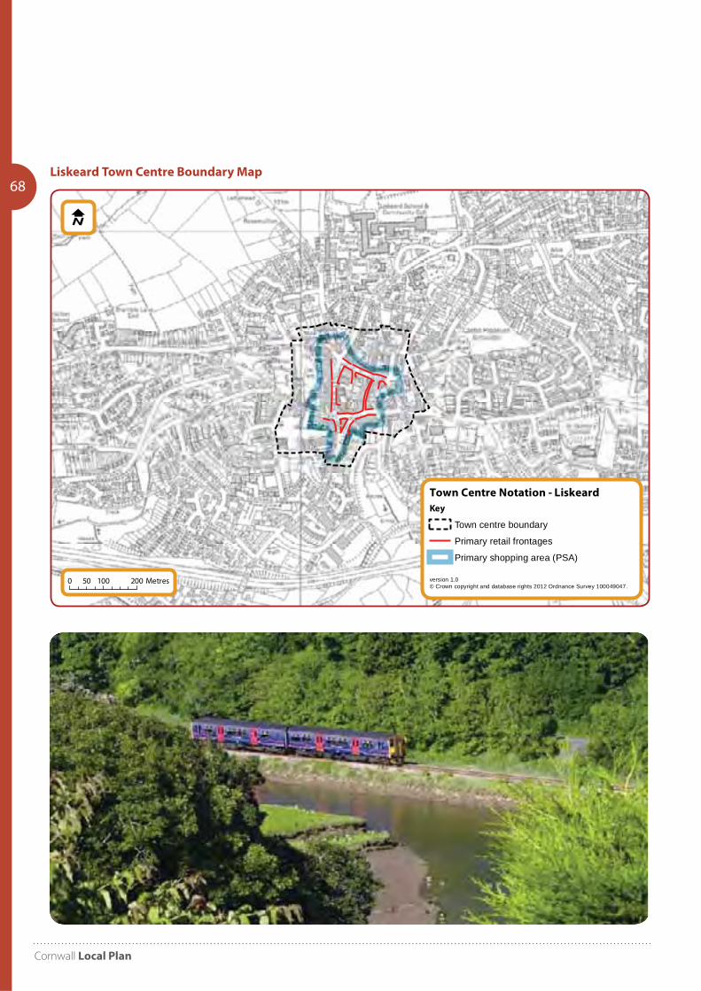
Cornwall Local Plan
68
Town Centre Notation - Liskeard
version 1.0© Crown copyright and database rights 2012 Ordnance Survey 100049047.
Key
Town centre boundary
Primary retail frontages
Primary shopping area (PSA)
0 100 20050 Metres
Liskeard Town Centre Boundary Map
Community Network Area Sections 2010-2030
69PP16 Caradon Community Network Area
Development Strategy17.2 A comprehensive and coordinated approach will be pursued to the planning and development of the network area. The approach, promoted through local consultation and parish plans identify a need for development to regenerate Callington, promote more sustainable transport choices, increase employment prospects, capture tourism benefits and provide a high proportion of affordable housing.
17.3 Callington, with a population of 5,600 is the key settlement within this area, and acts as the local service centre to the smaller settlements surrounding it. Larger villages in the area include Calstock, Gunnislake, Pensilva and St Ann’s Chapel and a network of smaller villages and hamlets. There is a need identified for regeneration of the town centre of Callington and enhancement of employment opportunities and service provision.
17.4 Settlements in the community network area such as Callington, Pensilva, Gunnislake and Calstock were strongly influenced by mining during the industrial revolution. This has produced a characteristic landscape; buildings and some areas form part of the Cornwall and West Devon Mining World Heritage Site. There are also issues of contamination and instability in some areas.
17.5 The Tamar Valley forms a distinct sub-area, marked both by its intense industrial exploitation, and also by extensive market gardening; it was historically a rich landscape and forms part of the Tamar Valley Area of Outstanding Natural Beauty. Tourism levels remain low and aspirations have been raised locally to capitalise on the draw of the natural beauty and mining heritage of the area.
17.6 The area sits adjacent to the Tamar Estuaries and is influenced by the impact of the port of Plymouth. This is a complex and dynamic area which encompasses Plymouth Sound, extending up the rivers of the Tamar, Tavy, Lynher and Plym. It is the largest estuarine system in south west England, supporting over a quarter of a million people, a diversity and richness of wildlife, as well as a
Introduction17.0 The Caradon Community Network Area covers the 8 parishes of Callington, Calstock, Linkinhorne, Pillaton, South Hill, St Dominick, St Ive and St Mellion.
Key Facts:Population 2007: 17,900 2014: 17,940
Dwellings 2010: 8,152 (3.2% Cornwall)
Past housing build rates 1991-2010: 1,119
‘Housing need (local connection) 2016: 217 (Bands A-D) plus 277 (Band E) equates to 1.9% and 2.2% of Cornwall total respectively
Housing completions and commitments (2016): 750
Callington employees estimate (2011): Full time: 2,022 Part-time: 894
Objectives17.1 Specific objectives to be addressed in planning for the Caradon Community Network Area include:
Objective 1 – Regeneration
Enable the regeneration of Callington town centre.
Objective 2 – Affordable Housing
Enable the provision of affordable housing.
Objective 3 – Jobs and Services
Enhance employment opportunities and services (including public services), considering the influence of Plymouth.
Objective 4 – Tourism
Promote the Cornwall and West Devon Mining World Heritage Site as a tourist destination.
Objective 5 – Infrastructure
Deliver the infrastructure needed for the growth of the area.
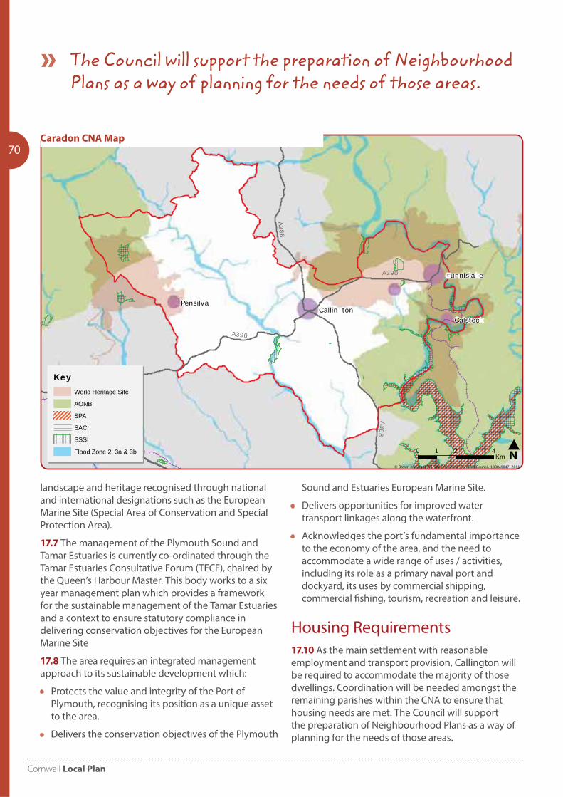
Cornwall Local Plan
70
Calstoc
Pensilva
unnisla e
Callin ton
© Crown copyright. All rights reserved. Cornwall Council, 100049047, 2011
Caradon Community Network Area - Environmental Designations
N0 2 41Km
KeyWorld Heritage Site
AONB
SPA
SAC
SSSI
Flood Zone 2, 3a & 3b
A390
A390A388
A388
Caradon CNA Map
landscape and heritage recognised through national and international designations such as the European Marine Site (Special Area of Conservation and Special Protection Area).
17.7 The management of the Plymouth Sound and Tamar Estuaries is currently co-ordinated through the Tamar Estuaries Consultative Forum (TECF), chaired by the Queen’s Harbour Master. This body works to a six year management plan which provides a framework for the sustainable management of the Tamar Estuaries and a context to ensure statutory compliance in delivering conservation objectives for the European Marine Site
17.8 The area requires an integrated management approach to its sustainable development which:
• Protects the value and integrity of the Port of Plymouth, recognising its position as a unique asset to the area.
• Delivers the conservation objectives of the Plymouth
Sound and Estuaries European Marine Site.
• Delivers opportunities for improved water transport linkages along the waterfront.
• Acknowledges the port’s fundamental importance to the economy of the area, and the need to accommodate a wide range of uses / activities, including its role as a primary naval port and dockyard, its uses by commercial shipping, commercial fishing, tourism, recreation and leisure.
Housing Requirements17.10 As the main settlement with reasonable employment and transport provision, Callington will be required to accommodate the majority of those dwellings. Coordination will be needed amongst the remaining parishes within the CNA to ensure that housing needs are met. The Council will support the preparation of Neighbourhood Plans as a way of planning for the needs of those areas.
The Council will support the preparation of Neighbourhood Plans as a way of planning for the needs of those areas.

Community Network Area Sections 2010-2030
71PP17 Cornwall Gateway
Community Network Area
Objectives18.1 Specific objectives to be addressed in planning for the Cornwall Gateway Community Network Area include:
Objective 1 – Regeneration
Support the regeneration of Saltash and Torpoint town centres.
Objective 2 – Jobs and Services
Improve the provision of and access to jobs and services (including public services), considering the influence of Plymouth.
Objective 3 – Affordable Housing
Enable the provision of affordable housing.
Objective 4 – Transport
Support the improvement of public transport between the rural and urban areas.
Objective 5 – Tourism
Improve Saltash as a tourism destination through the promotion of its heritage and regeneration of the waterfront.
Development Strategy18.1 A comprehensive and coordinated approach will be pursued to the planning and development of the network area. The network area contains the two key settlements of Saltash and Torpoint, and these act as the local service centres to the many smaller settlements surrounding them. As the main settlement with good employment and transport provision, Saltash will be required to accommodate the majority of growth.
18.2 Saltash wishes to unlock the potential of its geographical and communicational strengths, as well as addressing the current imbalance between the number of jobs and level of housing found within the town. In order to do this the town wants to take
Introduction18.0 The Cornwall Gateway Community Network Area covers the parishes of Antony, Botusfleming, Landrake with St Erney, Landulph, Maker-with-Rame, Millbrook, Saltash, Sheviock, St Germans, St John and Torpoint.
Key Facts:Population 2007: 31,300 2014: 33,280
Dwellings 2010: 14,958 (5.9% Cornwall)
Past housing build rates 1991-2010: 1,553
Saltash completions 2001-2010: 961 (107pa)
Housing need (local connection) 2016: 430 (Bands A-D) plus 492 (Band E) equates to 3.9% and 3.8% of Cornwall total respectively
Housing completions and commitments (2016): 434
Saltash employees estimate (2011): Full time: 2,583 Part-time: 2,431
Torpoint employees estimate (2011): Full time: 1,088 Part-time: 702
Millbrook employees estimate (2011): Full time: 394 Part-time: 324
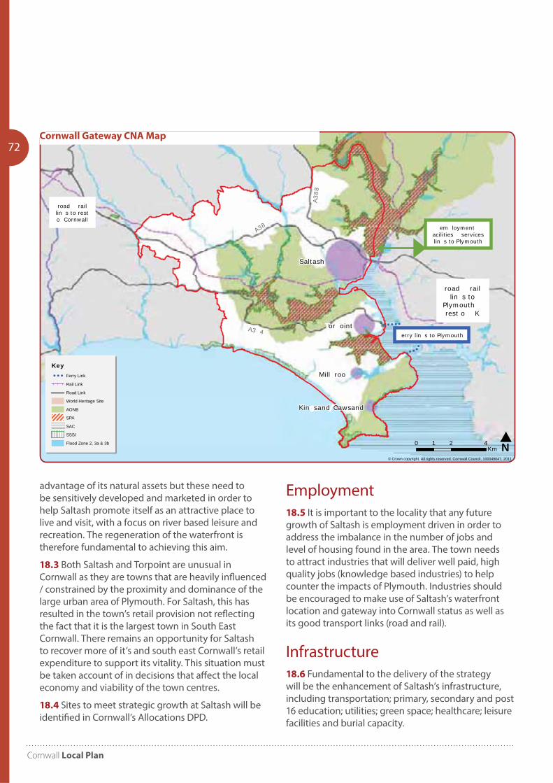
Cornwall Local Plan
72
advantage of its natural assets but these need to be sensitively developed and marketed in order to help Saltash promote itself as an attractive place to live and visit, with a focus on river based leisure and recreation. The regeneration of the waterfront is therefore fundamental to achieving this aim.
18.3 Both Saltash and Torpoint are unusual in Cornwall as they are towns that are heavily influenced / constrained by the proximity and dominance of the large urban area of Plymouth. For Saltash, this has resulted in the town’s retail provision not reflecting the fact that it is the largest town in South East Cornwall. There remains an opportunity for Saltash to recover more of it’s and south east Cornwall’s retail expenditure to support its vitality. This situation must be taken account of in decisions that affect the local economy and viability of the town centres.
18.4 Sites to meet strategic growth at Saltash will be identified in Cornwall’s Allocations DPD.
Saltash
or oint
Mill roo
Kin sand Cawsand
© Crown copyright. All rights reserved. Cornwall Council, 100049047, 2011
Cornwall ateway Community Network Area - a kground a
N0 2 41Km
KeyFerry Link
Rail Link
Road Link
World Heritage Site
AONB
SPA
SAC
SSSI
Flood Zone 2, 3a & 3b
em loymentacilities services lin s to Plymouth
road raillin s to resto Cornwall
road raillin s to
Plymouth rest o K
erry lin s to Plymouth
A38
A388
A3 4
Cornwall Gateway CNA Map
Employment18.5 It is important to the locality that any future growth of Saltash is employment driven in order to address the imbalance in the number of jobs and level of housing found in the area. The town needs to attract industries that will deliver well paid, high quality jobs (knowledge based industries) to help counter the impacts of Plymouth. Industries should be encouraged to make use of Saltash’s waterfront location and gateway into Cornwall status as well as its good transport links (road and rail).
Infrastructure18.6 Fundamental to the delivery of the strategy will be the enhancement of Saltash’s infrastructure, including transportation; primary, secondary and post 16 education; utilities; green space; healthcare; leisure facilities and burial capacity.
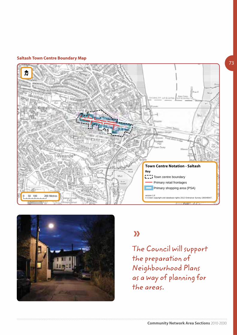
Community Network Area Sections 2010-2030
73
Town Centre Notation - Saltash
version 1.0© Crown copyright and database rights 2012 Ordnance Survey 100049047.
Key
Town centre boundary
Primary retail frontages
Primary shopping area (PSA)
0 100 20050 Metres
Saltash Town Centre Boundary Map
The Council will support the preparation of Neighbourhood Plans as a way of planning for the areas.
Cornwall Local Plan
74 Tamar Estuary18.7 The area sits adjacent to the Tamar Estuaries and the impact of the port of Plymouth this is a complex and dynamic area which encompasses Plymouth Sound, extending up the rivers of the Tamar, Tavy, Lynher and Plym. It is the largest estuarine system in south west England, supporting over a quarter of a million people, a diversity and richness of wildlife, as well as a landscape and heritage recognised through national and international designations such as the European Marine Site (Special Area of Conservation and Special Protection Area).
18.8 The management of the Plymouth Sound and Tamar Estuaries is currently co-ordinated through the Tamar Estuaries Consultative Forum (TECF), chaired by the Queen’s Harbour Master. This body works to a six year management plan which provides a framework for the sustainable management of the Tamar Estuaries and a context to ensure statutory compliance in delivering conservation objectives for the European Marine Site.
18.9 The area requires an integrated management approach to its sustainable development which:
• Protects the value and integrity of the Port of Plymouth, recognising its position as a unique asset to the area.
• Delivers the conservation objectives of the Plymouth Sound and Estuaries European Marine Site.
• Delivers opportunities for improved water transport linkages along the waterfront.
• Acknowledges the port’s fundamental importance to the economy of the area, and the need to accommodate a wide range of uses / activities, including its role as a primary naval port and dockyard, its uses by commercial shipping, commercial fishing, tourism, recreation and leisure.
Housing Requirements18.10 As the main settlement with good employment and transport provision, Saltash will be required to accommodate the majority of those dwellings. Co-ordination will be needed amongst the remaining parishes within the area to ensure that housing needs are met. The Council will support the preparation of Neighbourhood Plans as a way of planning for the needs of those areas.
18.11 Development in Torpoint should support the regeneration of the waterfront and town centre. This can be used to encourage economic growth which should be delivered alongside housing and infrastructure that supports local services.
18.12 Five parishes on the Rame Peninsula have joined together to create a Neighbourhood Plan to influence development in the area, with a focus on improving transport accessibility.

Community Network Area Sections 2010-2030
75

Cornwall Local Plan
If you would like this information in another format or language please contact:Cornwall Council, County Hall, Treyew Road, Truro TR1 3AYTelephone: 0300 1234 100 Email: [email protected] www.cornwall.gov.uk
More information
The Local Plan, policies map and evidence base can all be viewed on the Council’s website www.cornwall.gov.uk