Outline Business Case - Strategic Case
175
Cambridge South East Transport Phase 2 Outline Business Case - Strategic Case 15 May 2020
Transcript of Outline Business Case - Strategic Case

Cambridge South East Transport Phase 2
Outline Business Case - Strategic Case
15 May 2020


Mott MacDonald 22 Station Road Cambridge CB1 2JD United Kingdom T +44 (0)1223 463500 mottmac.com
Mott MacDonald Limited. Registered in England and Wales no. 1243967. Registered office: Mott MacDonald House, 8-10 Sydenham Road, Croydon CR0 2EE, United Kingdom
Cambridge South East Transport Phase 2
Outline Business Case - Strategic Case
15 May 2020


Mott MacDonald | Cambridge South East Transport Phase 2 Outline Business Case - Strategic Case
403394-MMD-BCA-00-RP-BC-0247 | C | 15 May 2020
Issue and Revision Record
Revision Date Originator Checker Approver Description
A 24/02/2020 H Palmer B Rimmer
H Kenyon M Payne
J Saldanha First draft for client review
B 16/03/2020 C Hunter B Rimmer H Kenyon
M Payne J Saldanha Revised draft
C 15/05/2020 H Kenyon C Harwood M Payne Issued for approval
Document reference: 403394-MMD-BCA-00-RP-BC-0247 Rev C
Information class: Standard
This document is issued for the party which commissioned it and for specific purposes connected with the above-
captioned project only. It should not be relied upon by any other party or used for any other purpose.
We accept no responsibility for the consequences of this document being relied upon by any other party, or being
used for any other purpose, or containing any error or omission which is due to an error or omission in data supplied
to us by other parties.
This document contains confidential information and proprietary intellectual property. It should not be shown to other
parties without consent from us and from the party which commissioned it.
This report has been pr epared sol ely for use by the party which commissi oned it (the ‘Client’) i n connecti on with the capti oned proj ect. It should not be used for any other purpose. N o person other than the Client or any party who has expressly agreed terms of r eliance with us (the ‘Reci pient(s)’) may rely on the content, i nformati on or any vi ews expressed i n the repor t. W e accept no duty of care, responsi bility or liability to any other r eci pient of thi s document. This r eport is confi denti al and contains pr opri etary intell ectual property.
No representati on, w arranty or under taki ng, expr ess or im plied, is made and no responsi bility or liability is accepted by us to any party other than the Cli ent or any Reci pient(s), as to the accuracy or com ple teness of the i nformati on contai ned i n this r eport. For the avoidance of doubt this r eport does not in any w ay purport to i nclude any legal , insur ance or fi nanci al advice or opi nion.
We disclaim all and any liability w hether arising i n tort or contrac t or otherwise which it might otherwise have to any party other than the Cli ent or the Reci pient(s), in r espect of this report , or any information attri buted to i t.
We accept no r esponsibility for any error or omission i n the r eport w hich is due to an error or omission i n data, information or statem ents supplied to us by other par ties incl udi ng the client (‘D ata’). We have not i ndependently verified such D ata and have assum ed it to be accurate, com plete, reli abl e and current as of the date of such inform ation.
Forecasts presented i n this docum ent w ere pr epared usi ng Data and the report is dependent or based on D ata. Inevitably, som e of the assumptions used to develop the for ecasts will not be realised and unantici pated events and circumstances m ay occur. C onseque ntly M ott MacDonal d does not guarantee or warr ant the concl usi ons contained i n the repor t as there are likely to be differ enc es betw een the for ecas ts and the ac tual results and those di ffer ences may be m aterial. Whil e w e consi der that the inform ation and o pini ons given i n this r eport are sound all parti es m ust rely on their ow n skill and j udgement when m aking use of it .
Under no circumstances m ay this report or any extr act or summary ther eof be used in connection wi th any public or private securities offering i ncluding any rel ated mem orandum or prospectus for any securities offering or stock exchange listing or announcement.

Mott MacDonald | Cambridge South East Transport Phase 2 Outline Business Case - Strategic Case
403394-MMD-BCA-00-RP-BC-0247 | C | 15 May 2020
Contents
1 Introduction 17
1.1 Strategic Case Approach 17
2 CSET Definition and Context 19
2.1 Overview of Strategic Need 19
2.2 Cambridge South East Transport Scheme Detail 22
2.2.1 Phase 1 (2018-2020) 22
2.2.2 Phase 2 (2020+) 22
2.3 Business Strategy 24
2.3.1 The City Deal Objectives 24
2.3.2 The City Deal Investment Programme 25
3 Policy Review 27
3.1 National Policy and Strategy 27
3.1.1 National Planning Policy Framework (NPPF)- March 2012 and National Planning Practice Guidance 2014 27
3.1.2 Transport Investment Strategy 28
3.2 Regional Policy and Strategy 28
3.2.1 Greater Cambridge, Greater Peterborough Strategic Economic Plan (SEP) 28
3.2.2 Cambridgeshire Third Local Transport Plan (2011-2031) 29
3.2.3 Mayoral Interim Transport Strategy Statement 2018 - Cambridgeshire and Peterborough Combined Authority (CPCA) 30
3.2.4 Cambridgeshire and Peterborough Local Transport Plan 31
3.2.5 Cambridgeshire Long Term Transport Strategy (LTTS) 2011-2031 33
3.2.6 Cambridgeshire County Council Climate Change and Environment Strategy 2020-2025 34
3.3 Local Policy and Strategy 35
3.3.1 Transport Strategy for Cambridge City and South Cambridgeshire (TSCSC) 35
3.3.2 Cambridge Air Quality Management Plan (2018 - 2023) 37
3.3.3 South Cambridgeshire Local Plan 37
3.3.4 Cambridge City Local Plan 38
3.3.5 Cambridge City Access Strategy 39
3.3.6 Cambridgeshire and Peterborough Local Industrial Strategy 40
3.4 Other Relevant Plans and Studies 41
3.4.1 Cambridge Biomedical Campus Transport Needs Review Parts 1, 2 and 3 42
3.4.2 Cambridgeshire and Peterborough Independent Economic Review (CPIER) 43
3.5 Policy Review Conclusion 44
Mott MacDonald | Cambridge South East Transport Phase 2 Outline Business Case - Strategic Case
403394-MMD-BCA-00-RP-BC-0247 | C | 15 May 2020
4 Understanding the Problems and Opportunities 45
5 Socio-Economic Overview 47
5.1 Population 47
5.2 Employment and Skills 51
5.2.1 Anticipated Employment Growth 54
5.2.2 Cambridgeshire’s Employment Sectors 58
6 Economy and Business 62
6.1 The Cambridge Phenomenon 62
6.2 Business Growth 63
6.3 Gross Value Added (GVA) 64
7 Land Use and Development 66
7.1.1 Development in South East Cambridge 68
7.1.2 Development Along the A1307 Corridor 69
8 How People Travel 71
8.1 Commuter Trips 71
8.1.1 Roadside Interviews 73
8.1.2 Forecast Increase in Private Car Trips 74
9 Environment 76
9.1 Air Quality 76
9.2 Noise 76
9.3 Historic Environment 76
9.4 Landscape 77
9.5 Green Belt 77
9.6 Biodiversity 77
9.7 Water and Flood Risk 78
9.8 Greenhouse Gases 78
10 Highways Network and Traffic 81
10.1 A1307 Corridor 81
10.2 Congestion, Delay and Journey Times 82
10.3 A1307 Traffic Flows 83
10.4 Vehicle Speeds Along the A1307 Corridor 86
10.5 Vehicle Routing and Journey Times 88
11 Road Safety 91
11.1 Collision Analysis 91

Mott MacDonald | Cambridge South East Transport Phase 2 Outline Business Case - Strategic Case
403394-MMD-BCA-00-RP-BC-0247 | C | 15 May 2020
12 Wider Transport Provision 95
12.1 Rail 95
12.1.1 Rail Proposals 98
12.2 Bus 101
12.3 Park & Ride 108
12.4 Cycling 112
12.5 Walking 113
13 Summary of Issues and Opportunities 116
14 Need for Intervention 122
14.1 Futureproofing the Transport Network to Support Growth 122
14.2 Introducing Modal Choice 123
14.3 Impact of Not Changing 123
15 Scheme Aims and Objectives 125
15.1 Study Aims 126
15.2 Scheme Objectives 127
15.3 Measures of Success 129
16 Potential Constraints and Interdependencies 131
16.1 Geographic Scope 131
16.2 Constraints 132
16.2.1 East West Rail 132
16.2.2 Potential Conflict with Non-Motorised Users 133
16.2.3 Legislative Issues Regarding Optically Guided Vehicles 134
16.2.4 Lack of Alternative Providers of Optical Guidance Technology 134
16.2.5 Location of Utilities infrastructure 134
16.3 Interdependencies 134
17 Stakeholders 140
18 Option Generation 141
18.1 Option Generation Process 141
18.1.1 Travel Hub Site Development 141
18.1.2 Route Alignment Development 145
18.2 Option Long List 154
18.3 Option Sifting 155
18.4 Option Shortlist 155
18.4.1 Overview of Shortlisted Route Alignments 157
18.4.2 Overview of Shortlisted Travel Hub Sites 158
19 The Preferred Option 161

Mott MacDonald | Cambridge South East Transport Phase 2 Outline Business Case - Strategic Case
403394-MMD-BCA-00-RP-BC-0247 | C | 15 May 2020
19.1 Preferred Option Selection Process 161
19.2 Appraisal Outcomes 161
19.2.1 INSET Appraisal 162
19.2.2 Benefit Cost Ratio 164
19.2.3 Consultation Feedback 164
19.3 Options Discounted 167
19.4 Consideration of Remaining Options 168
19.4.1 VISSIM Modelling 168
19.4.2 Green Belt Considerations 169
19.5 The Preferred Option 169
19.6 Future Option Refinements 172
19.7 Approach to Future Proofing 172
20 Summary 174
Tables
Table 1.1: DfT Requirements for the Strategic Case 18
Table 5.1: Total Employee Jobs 52
Table 5.2: Total Employee Jobs 54
Table 5.3: Total Employee Jobs 56
Table 5.4: Employment Sectors in Cambridgeshire 59
Table 5.5: Employment by Occupation 60
Table 10.1: Two-way AADF Counts from ATC’s Located Along the A1307 84
Table 10.2: Trafficmaster Data Weekday Analysis 87
Table 10.3: Trafficmaster Data Weekend Analysis 87
Table 10.4: Difference Between Weekday and Weekend Speeds on A1307 88
Table 11.1: Difference Between Weekday and Weekend Speeds on A1307 92
Table 11.2: Personal Injury Collisions by Year, 2014-2018 92
Table 12.1: Estimates Number of Passenger Entries and Exits 96
Table 12.2: Bus Services on A1307 and A1301 104
Table 15.1: Measures of Success 129
Table 16.1: Summary of Scheme Constraints and Interdependencies 139
Table 18.1: Feasible Route Alignments within each Segment 154
Table 19.1: Final Option Shortlist INSET Results 163
Table 19.2: Benefit Cost Ratio Comparison 164
Figures
Figure 2.1: Planned Development along the A1307 20
Figure 2.2: Rail Station Locations 21
Figure 2.3: The City Deal Vision for Greater Cambridgeshire 25
Mott MacDonald | Cambridge South East Transport Phase 2 Outline Business Case - Strategic Case
403394-MMD-BCA-00-RP-BC-0247 | C | 15 May 2020
Figure 2.4: City Deal Transport Investment Package 26
Figure 3.1: Cambridge City Access Strategy Measures 40
Figure 4.1: Assessment Themes 45
Figure 5.1: Cambridgeshire Population Projections 48
Figure 5.2: Population Density in Cambridge 49
Figure 5.3: Population in Employment 51
Figure 5.4: Cambridgeshire’s Unemployment Rate 52
Figure 5.5: Indexed Population Growth Estimates, 2016-2045 55
Figure 5.6: Indexed Employment Growth Estimates, 2016-2045 56
Figure 5.7: Indexed Employment Growth Estimates, 2016-2045 58
Figure 5.8: Employment by Standard Occupation Classification (Soc) (October 2015-
September 2016) 60
Figure 6.1: Cambridgeshire’s Business Start Ups 63
Figure 6.2: Real Gross Value Added (GVA)- Index 2001=100 64
Figure 7.1: Map of Key Development and City Deal Schemes 67
Figure 7.2: Cambridge’s Southern Fringe Major Development Sites 68
Figure 7.3: Cambridge’s Southern Fringe Major Development Sites 69
Figure 8.1: Incoming and Outgoing Commuter Flows 71
Figure 8.2: How do People Travel? 72
Figure 8.3: Direction of Staff Access to CBC by Vehicle 73
Figure 10.1: A1307 Geographical Scope 82
Figure 10.2: Anticipated Impact on Journey Times 83
Figure 10.3: ATC Locations 84
Figure 10.4: AADF Counts from ATC Sites Located Along the A1307 85
Figure 10.5: Trafficmaster Link Groups 86
Figure 10.6: ANPR Locations 89
Figure 11.1: Map of Personal Injury Collisions (PIC) for the Five-Year Period 2014-2018 91
Figure 11.2: Personal Injury Collisions by Year and Severity 93
Figure 12.1: Rail Station Locations 95
Figure 12.2: Passenger Entries and Exits- Cambridge Rail Station 97
Figure 12.3: Passenger Entries and Exits - Shelford and Whittlesford Parkway 98
Figure 12.4: Proposed East West Rail Corridor 99
Figure 12.5: Preferred Route Alignment: Bedford to Cambridge 100
Figure 12.6: Cambridge South Station 101
Figure 12.7: Bus Routes within the Study Area 102
Figure 12.8: Bus Routes within the Study Area 103
Figure 12.9: The Busway 106
Figure 12.10: Cambridge’s Current Park & Ride Facilities 108
Figure 12.11: Babraham Road Park & Ride Bus Timetable - Outbound and return services 109
Figure 12.12: Babraham Road Park & Ride Bus Route 110
Figure 12.13: A1307 Cycling Connectivity 112
Figure 12.14: PROW (Addenbrooke’s Hospital to Babraham) 113
Figure 12.15: PROW (Babraham to Hildersham) 114

Mott MacDonald | Cambridge South East Transport Phase 2 Outline Business Case - Strategic Case
403394-MMD-BCA-00-RP-BC-0247 | C | 15 May 2020
Figure 12.16: A11 Pedestrian Footbridge 114
Figure 14.1: Impact of Growth Without Transport Improvements 123
Figure 15.1: Objective Setting Process 125
Figure 15.2: CSET Logic Map 128
Figure 16.1: Phase 2 Geographic Scope 131
Figure 16.2: Preferred Route Alignment: Bedford to Cambridge 132
Figure 16.3: Guided Bus Accident as a Result of Avoiding Non-Motorised Users 133
Figure 16.4: Indicative Timeline of Interdependent Schemes 134
Figure 16.5: Location of Whittlesford Rural Travel Hub 135
Figure 16.6: Proposed Location of Cambridge South Station 137
Figure 16.7: Proposed Cambridge Greenways Network 138
Figure 18.1: Options Assessment Framework 141
Figure 18.2: Proposed Phase 2 Travel Hub Sites 142
Figure 18.3: Route Segments 147
Figure 18.4: Segment 1 Route Alignment Options 148
Figure 18.5: Segment 2 Route Alignment Options 149
Figure 18.6: Segment 3 Route Alignment Options 150
Figure 18.7: Segment 4 Route Alignment Options 151
Figure 18.8: Segment 5 Route Alignment Options 152
Figure 18.9: Segment 6 Route Alignment Options 153
Figure 18.10: Option Shortlist 156
Figure 19.1: Level of Support for the Scheme Proposals in General 165
Figure 19.2: Level of Support for the Travel Hub Sites 166
Figure 19.3: Level of Support for the Complete Option Packages 167
Figure 19.4: Brown Option 171
Mott MacDonald | Cambridge South East Transport Phase 2 12 Outline Business Case - Strategic Case
403394-MMD-BCA-00-RP-BC-0247 | C | 15 May 2020
Glossary of Terms
Analysis of Monetised Cost and Benefits (AMCB) table: Summarises the monetised impacts
of a scheme that are included in the scheme’s Net Present Value and Benefit-Cost Ratio.
Appraisal Summary Table (AST): Provides a complete summary of the scheme impacts,
including the scheme’s monetised impacts, and non-monetised impacts (both quantitative and
qualitative).
Assumption: A statement which is not yet known to be true. It can be a bridge in the planning
process to answer an uncertainty, and to allow scope and plans to be developed
Benefit Cost Ratio (BCR): Benefit Cost Ratio, is an indicator of the overall value for money of a
project or proposal.
CaCC: Cambridge City Council
CCC: Cambridgeshire County Council
Cambridge Autonomous Metro (CAM): CAM is the proposed metro style system for Greater
Cambridge.
Committed Schemes: Where a scheme has been deemed likely to proceed and is therefore
included within the option appraisals.
Conservation Area: An area designated under Section 69 of the Planning (Listed Buildings
and Conservation Areas) Act 1990 as being of special architectural or historic interest and with
a character or appearance which is desirable to preserve or enhance.
Context: The setting of a site or area, including factors such as traffic, activities and land uses
as well as landscape and built form.
Controls: Risk response activities that are undertaken as business as usual. These are
identified as aides memoire, to draw attention to the purpose and aim of standard procedures
and drive appropriate focus. Typically, controls will not incur any additional cost to delivery.
Countryside: The rural environment and its associated communities.
Cumulative Impact: The summation of effects that result from changes caused by a
development in conjunction with other past, present or reasonably foreseeable actions.
Department of Transport (DfT): is a ministerial department, supported by 24 agencies and
public bodies that plans and invests in transport infrastructure in the UK.
Dependency: An activity or activities which cannot be undertaken or completed until another
scope of work has completed or reached a defined stage or point.
Early Assessment Sifting Tool (EAST): Early Assessment Sifting Tool is used by DfT, to
quickly summarise and present evidence on options. INSET is an enhancement of EAST and
follows the same broad principles and approach.
Mott MacDonald | Cambridge South East Transport Phase 2 13 Outline Business Case - Strategic Case
403394-MMD-BCA-00-RP-BC-0247 | C | 15 May 2020
Effect: The consequence of the scale of any change to the baseline environment, i.e. impact,
on the environmental receptor, taking account of its particular value or sensitivity.
Element: A component part of the landscape (for example, roads, hedges, woods).
Emerging Scheme: The best performing route alignment option for CSET phase 2 based on
assessment to date.
Enhancement: Landscape improvement through restoration, reconstruction or creation.
Environment: Our physical surroundings including air, water and land.
Environmental Impact Assessment (EIA): A formal, structured process of evaluating the likely
environmental impacts of a proposed scheme, considering inter-related socio-economic, cultural
and human-health impacts, both beneficial and adverse.
Exclusion: An activity or product that has been specifically removed or omitted from the scope
of work for the defined project.
Fall-backs: Contingency actions taken in response to a risk impact. Generally, risks that are
tolerated should have fall-back actions identified, as should significant risks that are being
treated, where the treatment has a significant likelihood of not fully mitigating the risk.
Full Business Case (FBC): The culmination of the three-stage business case process is the
Full Business Case. This follows on from initial exploratory work to establish the strategic need
for intervention in the Strategic Outline Business Case and the optioneering and appraisal work
undertaken in the Outline Business Case. Generally, an investment committee will consider the
Full Business Case then make a recommendation to ministers. Ministers will decide whether a
proposal should proceed to implementation, however as funding and powers for transport
investment have been devolved to GCP as part of the Greater Cambridge City Deal, the
decision to implement the scheme resides with GCP.
Form: The layout (structure and urban grain), density, scale (height and massing), appearance
(materials and details) and landscape of development.
Gross Domestic Product (GDP): A measure of the total value of goods produced and services
provided in an area.
Gross Value Added (GVA): A measure of the economic productivity of an area.
High Quality Public Transport (HQPT): High Quality Public Transport, is a transport system
that includes a range of features such as high levels of segregation, junction priority, high
quality infrastructure (shelters, CCTV, real time, lighting, seating, help points etc), and high
quality vehicles to name but a few.
Heritage Asset: A building, monument, site, place, area or landscape of historic value.
Investment Sifting and Evaluation Tool (INSET): INSET is Mott MacDonald’s evaluation tool
used in the optioneering process. INSET is an enhancement and expansion of EAST.
Issue: A significant unanticipated event, or a risk which has impacted or has a >99% likelihood
of occurrence, that affects the achievement of the project objectives.
Landform: Combination of slope and elevation that produce the shape and form of the land.
Landscape: The character and appearance of land, including its shape, form, ecology, natural
features, colours and elements and the way these components combine. Landscape character

Mott MacDonald | Cambridge South East Transport Phase 2 14 Outline Business Case - Strategic Case
403394-MMD-BCA-00-RP-BC-0247 | C | 15 May 2020
can be expressed through landscape appraisal, and maps or plans. In towns ‘townscape’
describes the same concept.
Landscape Character: The distinct and recognisable pattern of elements that occurs
consistently in a particular type of landscape, and how this is perceived by people. It reflects
particular combinations of geology, landform, soils, vegetation, land use and human settlement.
It creates the particular sense of place of different areas of the landscape.
Landscape Feature: A prominent eye-catching element, for example, wooded hilltop or church
spire.
Landscape Quality: Based on judgements about the physical state of the landscape, and
about its intactness, from visual, functional, and ecological perspectives. It also reflects the state
of repair of individual features and elements which make up the character in any one place.
Landscape Sensitivity: The extent to which a landscape can accept change of a particular
type and scale without unacceptable adverse effects on its character.
Land Use: The primary use of the land, including both rural and urban activities.
Local Liaison Forum (LLF): The LFF provide a link between a project team and the local
community.
Multi Criteria Assessment Framework (MCAF): Multi-Criteria Assessment Frameworks are
used in the optioneering assessment process and allow options to be assessed against a range
of criteria linked to the scheme objectives as well as wider policy and strategy objectives.
Methodology: The specific approach and techniques used for a given study.
Mitigation: Measures, including any process, activity or design to avoid, reduce, remedy or
compensate for adverse landscape and visual effects of a development project.
Modal Shift: A shift from one transport type to another e.g. road travel to rail travel.
Movement: People and vehicles going to and passing through buildings, places and spaces.
The movement network can be shown on plans, by space syntax analysis, by highway
designations, by figure and ground diagrams, through data on origins and destinations or
pedestrian flows, by desire lines, by details of public transport services, by walk bands or by
details of cycle routes.
Nomis: A service provided by the Office for National Statistics, ONS, that provides free access
to the most detailed and up-to-date UK labour market statistics from official sources.
Option Appraisal Report (OAR): The Options Appraisal Report sets out the process
undertaken to identify and assesses options, leading to the selection of the preferred option.
Outline Business Case (OBC): Is the second phase of the process which reconfirms the
conclusions of set out in the Strategic Outline Business Case (SOBC). The OBC focuses on the
detailed assessment of the options to find the best solution.
Prince 2: PRojects IN Controlled Environments is a process-based method for effective project management, used extensively by the UK Government. It adopts a product-based planning approach to project management with emphasis on dividing projects into manageable and controllable stages.
Mott MacDonald | Cambridge South East Transport Phase 2 15 Outline Business Case - Strategic Case
403394-MMD-BCA-00-RP-BC-0247 | C | 15 May 2020
Public Accounts (PA) table: Records the investment and operating costs incurred by a public
sector in delivering the scheme.
Receptor: Something that makes up the environmental baseline e.g. humans or other biological
species, elements of the physical environment including water, air, soil, assets that make up the
cultural heritage of an area.
Risk (Threat): An uncertain event or set of circumstances that, should it occur, will have an
adverse effect on the achievement of the objectives of the project.
Risk (Opportunity): An uncertain event or set of circumstances that, should it be exploited, will
have a positive effect on the achievement of the objectives of the project.
SATURN: Simulation and Assignment of Traffic in Urban Road Networks, is a computer
program that calculates route choices between origin and destination.
Social and Distributional Impacts (SDI): considers the variance of transport intervention
impacts across different social groups.
Strategic Outline Business Case (SOBC): This sets out the need for intervention (the case for
change) and how this will meet strategic aims and objectives (the strategic fit). It provides
suggested or preferred ways forward and presents the evidence for a decision.
Strategic View: The line of sight from a particular point to an important landmark or skyline.
Sustainability: The principle that the environment should be protected in such a condition and
to such a degree that ensures new development meets the needs of the present without
compromising the ability of future generations to meet their own needs.
Topography: A description or representation of artificial or natural features on or off the
ground.
Townscape: Physical and social characteristics of the built and unbuilt urban environment and
the way in which those characteristics are perceived. The physical characteristics are expressed
by the development form of buildings, structures and space, whilst the social characteristics are
determined by how the physical characteristics are used and managed.
Transport Appraisal Guidance (TAG): The DfT’s Transport Appraisal Guidance (often referred
to as WebTAG)
Transparent Economic Assessment Model (TEAM): TEAM is a tool designed to calculate the
economic impacts and benefits of proposed infrastructure interventions and policy measures.
Tranquillity: A state of calm or quiet.
Transport Economic Efficiency (TEE) table: Summarises the monetised impacts against
different user groups.
Transport User Benefit Appraisal (TUBA): TUBA is an economic appraisal computer program
developed for the Department for Transport (DfT) for appraising multi modal transport studies.
Uncertainty: A condition where the outcome can only be estimated.
Visual Impact: Change in the appearance of the landscape as a result of development. This
can be positive (i.e. beneficial or an improvement) or negative (i.e. adverse or a detraction).

Mott MacDonald | Cambridge South East Transport Phase 2 16 Outline Business Case - Strategic Case
403394-MMD-BCA-00-RP-BC-0247 | C | 15 May 2020
Wider Economic Benefits (WEBs): improvements in economic benefits that are
acknowledged, but which are not typically captured in traditional transport cost-benefit
analysis.

Mott MacDonald | Cambridge South East Transport Phase 2 17 Outline Business Case - Strategic Case
403394-MMD-BCA-00-RP-BC-0247 | C | 15 May 2020
1 Introduction
The Strategic Case is one of the five cases that form the DfT’s Transport Business Case
process. The Strategic Case which determines whether an investment is needed, either now or
in the future. It demonstrates the case for change – that is, a clear rationale for making the
investment’ and strategic fit – that is how an investment will further the aims and objectives of
the organisation.
The four other cases which make up the Transport Business Case Process are:
● The Economic Case which assesses options to identify all their impacts, and the resulting
value for money, to fulfil the Treasury’s requirements for appraisal and demonstrating value
for the taxpayers’ money. The Economic Case is presented in document 403394-MMD-BCA-
00-RP-BC-0292.
● The Financial Case which outlines the affordability of the preferred option, its funding
arrangements and technical accounting issues. The case also presents the financial profile
of the preferred scheme option and an overview of how the scheme will be funded. The
Financial Case is presented in document 403394-MMD-BCA-00-RP-BC-0293.
● The Commercial Case which provides evidence on the commercial viability of a proposal
and the procurement strategy that is used to engage the market. It presents evidence on risk
allocation and transfer, contract timescales and implementation timescale as well as details
of the capability and skills of the team delivering the project. The Commercial Case is
presented in document 403394-MMD-BCA-00-RP-BC-0231.
● The Management Case which assesses whether a proposal is deliverable. It tests the
project planning, governance structure, risk management, communications and stakeholder
management, benefits realisation and assurance (e.g. a Gateway Review). The
Management Case is presented in document 403394-MMD-BCA-00-RP-BC-0277.
The remainder of this document identifies and presents the evidence base of the need for
intervention in the study area and sets out the CSET Phase 2 scheme aims and objectives. The
Strategic Case also details the scheme options considered for Phase 2 and identifies the
preferred scheme option. A full account of the options appraisal is however provided in
Appendix A, Options Appraisal Report (OAR), document reference number 403394-MMD-BCA-
00-RE-BC-0024-C.
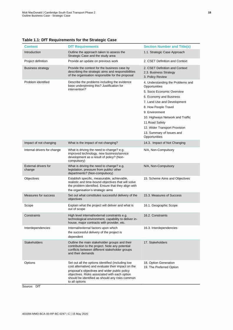
1.1 Strategic Case Approach
The structure of the Strategic Case broadly aligns to the DfT’s ‘The Transport Business Case:
Strategic Case’ which outlines key areas that should be covered as part of the business case
documentation and the level to which they should be undertaken at OBC stage. Table 1.1
shows where the relevant information, in accordance with DfT requirements, can be found in the
subsequent sections that make up the Strategic Case for CSET Phase 2.
Mott MacDonald | Cambridge South East Transport Phase 2 18 Outline Business Case - Strategic Case
403394-MMD-BCA-00-RP-BC-0247 | C | 15 May 2020
Table 1.1: DfT Requirements for the Strategic Case
Content DfT Requirements Section Number and Title(s)
Introduction Outline the approach taken to assess the Strategic Case and the study area
1.1. Strategic Case Approach
Project definition Provide an update on previous work 2. CSET Definition and Context
Business strategy Provide the context for the business case by describing the strategic aims and responsibilities of the organisation responsible for the proposal
2. CSET Definition and Context
2.3. Business Strategy
3. Policy Review
Problem identified Describe the problems including the evidence base underpinning this? Justification for intervention?
4. Understanding the Problems and
Opportunities
5. Socio Economic Overview
6. Economy and Business
7. Land Use and Development
8. How People Travel
9. Environment
10. Highways Network and Traffic
11.Road Safety
12. Wider Transport Provision
13. Summary of Issues and
Opportunities
Impact of not changing What is the impact of not changing? 14.3. Impact of Not Changing
Internal drivers for change What is driving the need to change? e.g. improved technology, new business/service development as a result of policy? (Non-compulsory)
N/A, Non-Compulsory
External drivers for change
What is driving the need to change? e.g. legislation, pressure from public/ other departments? (Non-compulsory)
N/A, Non-Compulsory
Objectives Establish specific, measurable, achievable, realistic and time-bound objectives that will solve the problem identified. Ensure that they align with
the organisation’s strategic aims
15. Scheme Aims and Objectives
Measures for success Set out what constitutes successful delivery of the objectives
15.3. Measures of Success
Scope Explain what the project will deliver and what is out of scope
16.1. Geographic Scope
Constraints High level internal/external constraints e.g. technological environment, capability to deliver in-house, major contracts with provider, etc.
16.2. Constraints
Interdependencies Internal/external factors upon which
the successful delivery of the project is
dependent
16.3. Interdependencies
Stakeholders Outline the main stakeholder groups and their contribution to the project. Note any potential conflicts between different stakeholder groups and their demands
17. Stakeholders
Options Set out all the options identified (including low cost alternative) and evaluate their impact on the
proposal’s objectives and wider public policy objectives. Risks associated with each option should be identified as should any risks common to all options
18. Option Generation
19. The Preferred Option
Source: DfT

Mott MacDonald | Cambridge South East Transport Phase 2 19 Outline Business Case - Strategic Case
403394-MMD-BCA-00-RP-BC-0247 | C | 15 May 2020
2 CSET Definition and Context
This section of the Strategic Case provides background information on the Cambridge South
East Transport (CSET) scheme and an overview of the strategic context that has influenced and
shaped the development of the scheme to deliver a better choice of public transport, walking
and cycling opportunities for those who travel along the A1307 corridor.
2.1 Overview of Strategic Need
Cambridge is one of the fastest growing cities in Europe. A booming economy and rapidly
growing population have forced growth out of central Cambridge into the periphery, placing
increasing pressure on the city’s radial routes. The A1307 provides a key radial route through
the south east of Cambridge between central Cambridge and Haverhill, serving a number of key
employment locations and communities in the hinterland of Cambridge.
The Local Plan for Cambridge and South Cambridgeshire estimates that more than 44,000
additional jobs will have been created in the area by 2031, whilst 8,000 new homes are
expected to be delivered across south east Cambridge over the next 15 years1. An illustration of
the growth anticipated within the study area can be seen in Figure 2.1. The rate at which
residential and commercial development is anticipated to be delivered across south east
Cambridge will place significant pressure on a transport system on which demand is already
exceeding capacity during busy periods. If action is not taken to futureproof the transport
network here, journey times are expected to increase by around 50%2, primarily as a result of
increased demand and a transport network which lacks the flexibility and capacity to respond
appropriately.
Cambridge and South Cambridgeshire import a larger proportion of labour than is exported. The
significant number of job opportunities and sector-specific requirements of the dominant science
and engineering industry necessitate that employers must attract labour from outside of the
immediate area. Reliance on external labour results in high commuter demand on the transport
network, particularly during peak hours.
A large proportion of commuters travelling into and within Cambridge opt for private car travel
due to a lack of viable and attractive alternative modal options. Cycling can be restrictive over
large stretches of the A1307, where cycle routes are often unsegregated from the carriageway.
This has led to cycle mode share in rural areas being low in contrast with the very high mode
share exhibited in central Cambridge. High volumes of traffic use the A1307 and high speeds
are experienced over long stretches of the route, making cycling unsafe and unattractive to
many prospective users, further details on this can be found under Section 11 of this OBC.
Crossing points along the A1307 also present a safety hazard to cyclists and pedestrians.
Individuals are frequently forced to cross high speed traffic with little to no protection, placing
themselves at high risk and creating severance.
1 South Cambridgeshire Local Plan; September 2018 & Cambridge Local Plan; October 2018
2 South Cambridgeshire Local Plan; September 2018 & Cambridge Local Plan; October 2018

Mott MacDonald | Cambridge South East Transport Phase 2 20 Outline Business Case - Strategic Case
403394-MMD-BCA-00-RP-BC-0247 | C | 15 May 2020
Figure 2.1: Planned Development along the A1307
Source: GCP
Much of the south east of Cambridge is detached from the rail network as illustrated in Figure
2.2. This means that rail users are required to undertake multi modal journeys which often
involve inefficient and lengthy interchanges and are therefore, unattractive options.

Mott MacDonald | Cambridge South East Transport Phase 2 21 Outline Business Case - Strategic Case
403394-MMD-BCA-00-RP-BC-0247 | C | 15 May 2020
Figure 2.2: Rail Station Locations
Source: OS Open Data Mapping
While up to five bus services per hour operate along the A1307, travel times by bus can be
uncompetitive compared to car travel. Ultimately, the limitations of active travel and public
transport mean that the preferred mode of travel to work for many is by car, leading to
congestion and long delays along the A1307.
Delivery of new, sustainable transport infrastructure is fundamental to securing the rate of
growth anticipated for south east Cambridge. A new public transport route, associated Travel
Hub and cycling and walking infrastructure will provide existing, new and growing communities
to the south east of Cambridge, in South Cambridgeshire and beyond, with improved access to
jobs, services and other opportunities in and around the city.
Investing in sustainable travel and providing a viable and attractive alternative to car travel could
encourage a modal shift, reducing reliance on private car travel and its damaging effects on the
environment, economy and quality of life for users now and in the future.
The Strategic Case of this Outline Business Case (OBC) provides a robust evidence base which
builds upon the overview presented here to provide a detailed account of the problems and
opportunities relative to the scheme and articulate the need for intervention.

Mott MacDonald | Cambridge South East Transport Phase 2 22 Outline Business Case - Strategic Case
403394-MMD-BCA-00-RP-BC-0247 | C | 15 May 2020
2.2 Cambridge South East Transport Scheme Detail
2.2.1 Phase 1 (2018-2020)
Phase 1 of the CSET scheme consists of 15 discrete small to medium works packages focusing
on bus priority measures, junction improvements, walking and cycling measures and road safety
enhancements along the A1307 between Cambridge and Haverhill. These initial works support
and compliment the CSET Phase 2 Scheme, which is the focus of this OBC.
Details on Phase 1 schemes can be found in the Phase 1 Business Case.
2.2.2 Phase 2 (2020+)
The wider CSET scheme extends from Cambridge Biomedical Campus at its north western
edge to the junctions of the A11 with the A1307 and A505, providing improved connectivity for
peripheral communities such as: Linton, the Abingtons, Babraham, Pampisford, Sawston,
Stapleford and Great and Little Shelford.
It is proposed that Phase 2 will deliver a new dedicated public transport route between a new
Travel Hub near the A11/A1307/A505 junction and the Cambridge Biomedical Campus via
Sawston, Stapleford and Great Shelford.
In addition, it is proposed that connections will be provided from the Travel Hub to Babraham,
Babraham Research Campus and Granta Park. At the Biomedical Campus, the new route is
proposed to run on dedicated public transport lanes on Francis Crick Avenue, connecting to the
existing Guided Busway, enabling services to continue to the station and Cambridge City Centre
via the Busway.
Stops on the new route are proposed for the Biomedical Campus, Great Shelford, Stapleford,
Sawston and the new Travel Hub site. The Biomedical Campus stop would be located near to
the proposed Cambridge South Station to enable easy interchange with rail services in the
future. All stops would have the following facilities:
● Platforms with shelter and real-time passenger information;
● Drop off facilities;
● Disabled parking; and
● Cycle parking and cycle lockers.
The route will connect to a new Travel Hub facility that will be delivered near the
A11/A1307/A505 junction to supplement capacity and facilities at the Babraham Road Park &
Ride site.
The name Travel Hub has been used as the site is intended to provide an interchange between
different modes of transport such as walking, cycling and existing bus services. This is in
addition to the site being a means to access the new public transport route by car.
The Travel Hub will be similar to a Park & Ride and offer the same facilities which can be found
at a Park & Ride site such as indoor waiting areas. However, the Travel Hub proposed for this
scheme is intended to be more sustainable than a typical Park & Ride design and flexible to
allow it to be expanded or increased in size as future demand requires.
Mott MacDonald | Cambridge South East Transport Phase 2 23 Outline Business Case - Strategic Case
403394-MMD-BCA-00-RP-BC-0247 | C | 15 May 2020
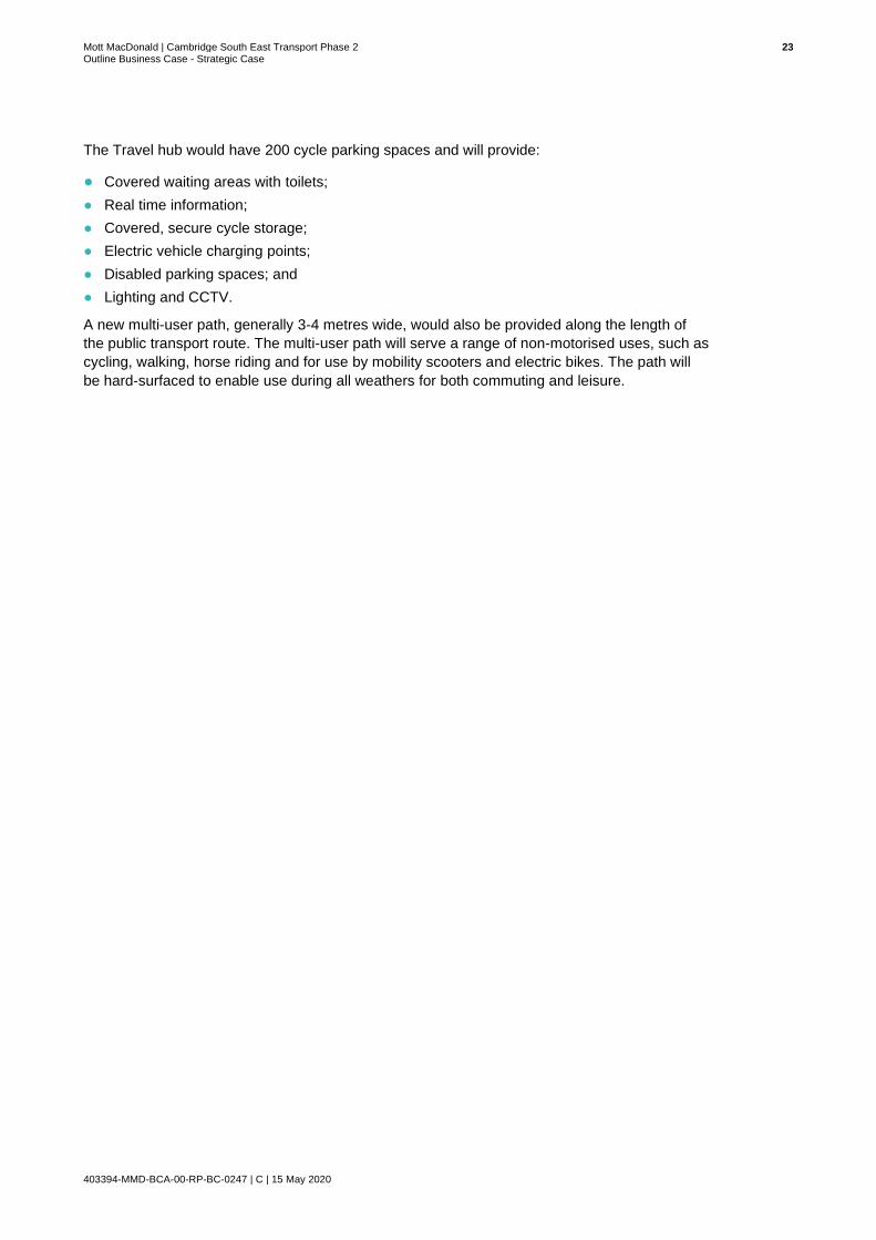
The Travel hub would have 200 cycle parking spaces and will provide:
● Covered waiting areas with toilets;
● Real time information;
● Covered, secure cycle storage;
● Electric vehicle charging points;
● Disabled parking spaces; and
● Lighting and CCTV.
A new multi-user path, generally 3-4 metres wide, would also be provided along the length of
the public transport route. The multi-user path will serve a range of non-motorised uses, such as
cycling, walking, horse riding and for use by mobility scooters and electric bikes. The path will
be hard-surfaced to enable use during all weathers for both commuting and leisure.

Mott MacDonald | Cambridge South East Transport Phase 2 24 Outline Business Case - Strategic Case
403394-MMD-BCA-00-RP-BC-0247 | C | 15 May 2020
2.3 Business Strategy
2.3.1 The City Deal Objectives
Since 2010, the government has pursued a policy of devolving increasing levels of powers and
funding away from central Government and down to local/regional areas, with City Deals playing
a key part of the devolution process. City Deals are a means for central government and local
partners to agree key investment programmes and outcomes, especially around promotion of
local economic growth and development.
The Greater Cambridge City Deal was signed between Government and local representatives in
2014. GCP was formed following the deal made with Government and is the local delivery body,
responsible for overseeing the delivery of the City Deal and the promotion of local economic
growth and development. GCP aims to:
● Deliver up to £1 billion of investment, providing vital improvements to infrastructure,
supporting and accelerating the creation of 44,000 new jobs and 33,500 new homes to
Greater Cambridge by 2031; and
● Enable a new wave of innovation-led growth in the Greater Cambridge area by investing in
infrastructure, housing and skills, thereby addressing housing shortages and transport
congestion bottlenecks that will facilitate its continued growth and a continuation of the
“Cambridge Phenomenon”3.
This investment fund offers funding towards proposed infrastructure in the region to help
achieve these aims.
To ensure infrastructure investment aligns with these aims, the Greater Cambridge City Deal
Assurance Framework has established key strategic objectives against which projects will be
prioritised, these are:
● To nurture the conditions necessary to enable the potential of Greater Cambridge to create
and retain the international high-tech businesses of the future which bring investment into
the UK;
● To better target investment to the needs of the Greater Cambridge economy by ensuring
those decisions are informed by the needs of businesses and other key stakeholders such
as the universities;
● To markedly improve connectivity and networks between clusters and labour markets so that
the right conditions are in place to drive further growth; and
● To attract and retain more skilled people by investing in transport and housing whilst
maintaining a good quality of life, in turn allowing a long-term increase in jobs emerging from
the internationally competitive clusters and more University of Cambridge spin-outs.
In this context, the OBC for Phase 2 will be assessed by the GCP Executive Board to ascertain
the extent to which any transport investment meets the strategic objectives of the City Deal,
including:
● How well the scheme supports business investment and confidence?
● How well the scheme represents targeted investment where business needs it?
● How well the scheme links effectively into the key growth sites?
● How well the scheme supports transport infrastructure and quality of life?
3 Section 5.1 provides further detail on the Cambridge Phenomenon.

Mott MacDonald | Cambridge South East Transport Phase 2 25 Outline Business Case - Strategic Case
403394-MMD-BCA-00-RP-BC-0247 | C | 15 May 2020
2.3.2 The City Deal Investment Programme
The City Deal includes a programme to enhance transport capacity in Greater Cambridge,
especially in areas where capacity is identified as an issue. This capacity is needed along key
strategic routes to and from the city (particularly along those routes where significant new
housing and/or employment growth is planned e.g. the A1307 corridor) as well as within the
built-up area of the city.
The City Deal vision for a comprehensive sub-regional infrastructure network is represented in
Figure 2.3, which draws on the key components of the development strategies within the Local
Plans and the Transport Strategy for Cambridge and South Cambridgeshire.
Figure 2.3: The City Deal Vision for Greater Cambridgeshire
Source: Greater Cambridge City Deal
Development of a sustainable transport network aims to improve access to employment hubs
and high-tech clusters in Greater Cambridge by making movement between them more
straightforward, efficient and convenient.
The interrelationship between infrastructure and growth as envisaged by the City Deal is
summarised in Figure 2.4 below:

Mott MacDonald | Cambridge South East Transport Phase 2 26 Outline Business Case - Strategic Case
403394-MMD-BCA-00-RP-BC-0247 | C | 15 May 2020
Figure 2.4: City Deal Transport Investment Package
Source: Greater Cambridge City Deal
The backbone of the proposed strategy is a transport network to link areas of population and
employment within the Greater Cambridge area, featuring:
● New orbital public transport routes around Cambridge that taken together provide a wider
variety of direct HQPT connections than would be traditionally possible under a traditional
radial City Centre “hub and spoke” model;
● New HQPT links into Cambridge on key routes, connecting existing and new housing
developments with major employment centres;
● A comprehensive network of pedestrian and cycle routes within Cambridge; and,
● High quality bus priority measures on main radial routes
This strategy will transform connectivity within and beyond the Greater Cambridge area, and
consequently allow significant increases in public transport and cycle use that will maximise the
capacity for movement, particularly within the historic core of Cambridge. This strategy also
supports carbon reduction objectives and promotes high quality of life for local communities by
minimising the environmental impact of transport whilst promoting the ability for the area to
grow.

Mott MacDonald | Cambridge South East Transport Phase 2 27 Outline Business Case - Strategic Case
403394-MMD-BCA-00-RP-BC-0247 | C | 15 May 2020
3 Policy Review
This section of the OBC provides a review of the national, regional and local policies and
strategies that frame and influence transport investment in Cambridgeshire.
3.1 National Policy and Strategy
3.1.1 National Planning Policy Framework (NPPF)- March 2012 and National Planning
Practice Guidance 2014
The National Planning Policy Framework (NPPF) sets out the UK Government planning policies
for England. This document sets out requirements of the planning system and how policy should
be adhered to and delivered in local plan development and planning decisions.
The NPPF promotes sustainable development and addresses the importance of developing
sustainable transport solutions to support sustainable development. It advocates:
● A transport system needs to be balanced in favour of sustainable transport modes, giving
people a real choice about how they travel;
● Transport solutions which support reductions in greenhouse gas emissions and reduce
congestion; and
● Developing strategies for the provision of viable infrastructure necessary to support
sustainable development, including transport investment necessary to support strategies for
the growth of ports, airports or other major generators of travel demand in their areas.
The NPPF states that all developments that generate significant amounts of movement should
take account of:
● Prioritising opportunities for encouraging the use of sustainable transport modes depending
on the nature and location of the site, to reduce the need for major transport infrastructure;
● Safe and sustainable access can be achieved for all users; and
● Improvements which can be undertaken within the transport network that cost effectively limit
the significant impacts of the development. Development should only be prevented or
refused on transport grounds where the residual cumulative impacts of development are
severe.
The NPPF also encourages local planning authorities to take account of:
● The availability of and opportunities for public transport;
● Local car ownership levels; and
● An overall need to reduce the use of high emission vehicles.
So, what does this mean for CSET Phase 2?
CSET Phase 2 will help to further sustainable development and align with the key principles of
the NPPF by:
● Promoting the use of sustainable modes of transport by the provision of improved public
transport infrastructure;
● Encouraging the use of non-car modes and low emission vehicles to minimise air quality
effects of car travel; and
● Creating a safer environment for pedestrians and cyclists on the highway network.

Mott MacDonald | Cambridge South East Transport Phase 2 28 Outline Business Case - Strategic Case
403394-MMD-BCA-00-RP-BC-0247 | C | 15 May 2020
3.1.2 Transport Investment Strategy
The Transport Investment Strategy (TIS) was developed in 2017 and supports the
Government’s Building Our Industrial Strategy. Maintaining and upgrading transport
infrastructure is seen as a core component of achieving the objectives of the Industrial Strategy.
The TIS sets out four objectives:
● Create a more reliable, less congested, and better-connected transport network that works
for the users who rely on it;
● Build a stronger, more balanced economy by enhancing productivity and responding to local
growth priorities;
● Enhance our global competitiveness by making Britain a more attractive place to trade and
invest; and
● Support the creation of new housing.
Several propositions have been agreed to enable the achievement of the TIS objectives:
● Ensure our investment consistently meets the needs of users and helps to create a balanced
economy;
● Focus on getting the best value out of the network and our investment;
● Retain a resolute focus on delivery; and
● Remain adaptable in the face of change.
3.2 Regional Policy and Strategy
3.2.1 Greater Cambridge, Greater Peterborough Strategic Economic Plan (SEP)
The Greater Cambridge Greater Peterborough Enterprise Partnership (LEP) is a business-led
organisation focused on sustainable economic growth. The Strategic Economic Plan (SEP) is
effectively a bid document to Government, seeking to agree support for the local economy. The
SEP prioritises six Intervention Packages:
● Digital connectivity and exploitation;
● Transport connectivity;
● Removing skills barriers to growth;
● Provision of incubation and innovation space;
So, what does this mean for CSET Phase 2?
CSET Phase 2 will help to achieve the objectives of the TIS by:
● Providing alternative modal options to private vehicle travel, minimising the potential for
increased congestion along the A1307 corridor which is associated with further development
in south east Cambridge;
● Improving linkages between key employment centres and medical campuses along the
corridor thus serving to enhance the area’s international competitiveness;
● Supporting the creation of new houses along the A1307 corridor by providing a safer
transport network, with increased travel options for future residents; and
● Enabling people to access new employment opportunities in south east Cambridge identified
by GCP and in turn increasing the size of the labour market for employers, further enhancing
the area’s international competitiveness.

Mott MacDonald | Cambridge South East Transport Phase 2 29 Outline Business Case - Strategic Case
403394-MMD-BCA-00-RP-BC-0247 | C | 15 May 2020
● Accelerating business growth by targeted support through a growth hub; and
● Alconbury Weald enterprise campus.
The Transport connectivity package has four aims:
● An integrated and reliable transport network that enables efficient movement of goods and
people;
● A highly connected and efficient rail network linking key destinations;
● Sustainable transport capacity to support and unlock growth along key corridors/hubs; and
● Good and reliable access to and between the key economic clusters.
A large number of transport proposals are included within the SEP that cover a full spectrum of
improvements such as Major Transport Schemes, Trunk Road, Motorway and major rail
schemes, Local Transport Projects, and a Local Sustainable Transport Programme.
3.2.2 Cambridgeshire Third Local Transport Plan (2011-2031)
The Cambridgeshire Third Local Transport Plan (LTP3) sets out CCC’s plans and policies for
the future of transport in Cambridgeshire. The current plan was adopted in 2011 and further
updated in 2014 and covers the 20-year period up to 2031. The overarching vision of the plan is
to create communities where people want to live and work, now and in the future. The LTP3
document addresses the County Council’s priorities. These are:
● Supporting and protecting people when they need it most;
● Helping people to live independent and healthy lives in their communities; and
● Developing the local economy for the benefit of all.
The LTP3 also outlines the following strategic objectives:
● Enable people to thrive, achieve their potential and improve quality of life;
● Supporting and protecting vulnerable people;
● Managing and delivering the growth and development of sustainable communities;
● Promoting improved skills levels and economic prosperity across the county, helping people
into jobs and encouraging enterprise; and
● Meeting the challenges of climate change and enhancing the natural environment.
So, what does this mean for CSET Phase 2?
CSET Phase 2 aligns strongly with the aims of the SEP Transport Connectivity package, and
whilst it is not specifically identified, the fact that it addresses commuting needs on a key radial
route and potentially serves major employment centres is significant and relevant to the SEP.
CSET Phase 2 also aligns strongly with many of the other key packages, through:
● Improving links between key employment centres and housing development along the
corridor, thus in turn increasing the size of the labour market for employers and reducing
skills barriers to growth; and
● Improving links between medical and enterprise campuses, thus supporting the growth of a
space for innovation as well as supporting the objective of accelerating business growth by
supporting an internationally competitive growth hub.

Mott MacDonald | Cambridge South East Transport Phase 2 30 Outline Business Case - Strategic Case
403394-MMD-BCA-00-RP-BC-0247 | C | 15 May 2020
The issues and problems related to each of the objectives listed above have been translated
into a series of challenges for transport. The transport challenges which are outlined in the plan
include:
● Improving the reliability of journey times by managing demand for road space, where
appropriate and maximising the capacity and efficiency of the existing network;
● Reducing the length of the commute and the need to travel by private car;
● Making sustainable modes of transport a viable and attractive alternative to the private car;
● Future proofing our maintenance strategy and new transport infrastructure to cope with the
effects of climate change;
● Ensuring people, especially those at risk of social exclusion, can access the services they
need within reasonable time, cost and effort wherever they live in the county;
● Addressing the main causes of road collisions in Cambridgeshire;
● Protecting and enhancing the natural environment by minimising the environmental impact of
transport; and
● Influencing national and local decisions on land use and transport planning that impact on
routes through Cambridgeshire.
3.2.3 Mayoral Interim Transport Strategy Statement 2018 - Cambridgeshire and
Peterborough Combined Authority (CPCA)
The Cambridgeshire and Peterborough Combined Authority (CPCA) was formed in 2017 and
now fulfils the role of the Local Transport Authority which holds strategic transport powers for
the area which were previously held by Cambridgeshire County Council and Peterborough City
Council. One of the duties placed upon the authority is the development of a new Local
Transport Plan. The Greater Cambridge and Greater Peterborough Local Transport Plan
(GCGPLTP), underwent a comprehensive consultation process during 2019 and has now been
published as a draft. Once adopted, the plan will set out the overall transport strategy for
Cambridgeshire and Peterborough as a whole.
The CPCA Board has produced an interim Local Transport Plan as a temporary measure until a
new Local Transport Plan for Cambridgeshire and Peterborough is produced. The interim Local
Transport Plan is a combination of a Mayoral Interim Transport Strategy Statement and the
previous Local Transport Plans of Cambridgeshire County Council and Peterborough City
Council.
So, what does this mean for CSET Phase 2?
CSET Phase 2 directly supports the Cambridgeshire LTP3. The interventions which will be
implemented as part of the scheme will seek to address a number of the challenges outlined in
the LTP3. Aligned with the challenges listed, the CSET scheme will aim to:
● Make sustainable modes of transport a viable and attractive alternative to the private car;
● Reduce the length of the commute and the need to travel by private car;
● Future proof the maintenance strategy and new transport infrastructure to cope with the
effects of climate change; and
● Protect and enhance the natural environment by minimising the environmental impact of
transport.
Mott MacDonald | Cambridge South East Transport Phase 2 31 Outline Business Case - Strategic Case
403394-MMD-BCA-00-RP-BC-0247 | C | 15 May 2020
The Mayoral Interim Transport Strategy Statement sets out principles which will guide the
development of the new LTP. These are:
● Economic growth and opportunity by connecting our dynamic workforce with a growing
number of jobs;
● Equity to ensure that all areas of the Combined Authority can prosper; and
● Environmental responsiveness by encouraging active and sustainable travel choices.
The transport policies set out in the current Cambridgeshire Local Transport Plan and the
emerging Cambridgeshire and Peterborough Local Transport Plan discuss the role of high-
quality public transport corridors in providing the required sustainable transport capacity and
connectivity to support growth. The policy has underpinned the development of existing
(Cambridgeshire Guided Busway) and planned (Cambridge to Cambourne, Granta Park and
Waterbeach New Town) segregated corridors. Despite the significant transport investment
planned across Greater Cambridge, constraints remain part of the transport network.
Fundamentally, the historic and highly constrained nature of the city centre streetscape limits
the public transport connectivity and capacity that can be achieved for trips to, across and within
the city. It is felt that city centre constraints cannot be overcome with an at-grade transit solution
therefore the Cambridgeshire Autonomous Metro (CAM), is proposed by the Combined
Authority as a solution to increase capacity across the transport network.
CAM has been designed to support the shared CPCA and GCP priorities and outcomes around
economic growth, accelerating housing delivery, promoting equity and encouraging sustainable
growth and development. The Cambridgeshire Guided Busway and planned Cambridge to
Cambourne, Granta Park and Waterbeach New Town segregated corridors will form integral
elements of the full CAM network. It is envisaged that the introduction of CSET Phase 2 will
support the operations of CAM, providing the early infrastructure to encourage its timely
delivery, whilst also addressing transport issues in advance of its delivery.
3.2.4 Cambridgeshire and Peterborough Local Transport Plan
The Cambridgeshire and Peterborough Local Transport Plan (CPLTP) has recently replaced the
former LTP3. The CPLTP is the first transport strategy for the combined Cambridgeshire and
Peterborough Combined Authority. The Combined Authority’s vision is to ‘Deliver a world-class
transport network for Cambridgeshire and Peterborough that supports sustainable growth and
So, what does this mean for CSET Phase 2?
CSET Phase 2 will strongly support the objectives which are likely to be included within the
forthcoming Cambridgeshire and Peterborough Local Transport Plan (LTP). It is clear that the
new LTP will have an explicit focus on improving public transport and encouraging active travel
uptake. CSET Phase 2 will deliver a number of improvements to sustainable transport
infrastructure along the A1307 corridor, encouraging cycling and walking in the study area and
further supporting the transport objectives of the Combined Authority.
The delivery of CSET Phase 2 will provide the early infrastructure for CAM, encouraging its
timely delivery, which will have a transformational impact on the transport network across
central Cambridge and peripheral areas.
Mott MacDonald | Cambridge South East Transport Phase 2 32 Outline Business Case - Strategic Case
403394-MMD-BCA-00-RP-BC-0247 | C | 15 May 2020
opportunity for all.’ The CPLTP has a goal for each of the three wellbeing categories of:
economy, society and environment. These are supported by a number of objectives:
● Economy:
– Support new housing and development to accommodate a growing population and
workforce, and address housing affordability issues;
– Connect all new and existing communities sustainably so residents can easily access a
good job within 30 minutes, spreading the region’s prosperity;
– Ensure all of our region’s businesses and tourist attractions are connected sustainably to
our main transport hubs, ports and airports; and
– Build a transport network that is resilient and adaptive to human and environmental
disruption, improving journey time reliability.
● Society:
– Embed a safe systems approach into all planning and transport operations to achieve
“Vision Zero” – zero fatalities or serious injuries;
– Promote social inclusion through the provision of a sustainable transport network that is
affordable and accessible for all;
– Ensure transport initiatives improve air quality across the region to exceed good practice
standards; and
– Provide ‘healthy streets’ and high-quality public realm that puts people first and promotes
active lifestyles.
● Environment:
– Deliver a transport network that protects and enhances our natural, historic and built
environments; and
– Reduce emissions to as close to zero as possible to minimise the impact of transport and
travel on climate change.
There are a series of policies and policy themes that sit below each of the objectives, which will
ensure that the transport schemes identified support the vision of the CPLTP.
The CSET Phase 2 improvements on the A1307 corridor are specifically identified as a
Strategic Project within the CPLTP.
So, what does this mean for CSET Phase 2?
CSET Phase 2 is strongly aligned with the objectives of the CPLTP and the proposed scheme is
specifically identified as a Strategic Project in the CPLTP.
The proposed improvements will support new housing areas in south east Cambridge and
provide high quality connections to major employment hubs within Cambridge. These
connections will be made by sustainable transport, including new public transport infrastructure
and walking and cycling provision. Overall, this will increase the uptake and mode share of
sustainable modes for travel within south east Cambridge. The increase in sustainable modes
could also result in a reduction in transport network emissions.
Mott MacDonald | Cambridge South East Transport Phase 2 33 Outline Business Case - Strategic Case
403394-MMD-BCA-00-RP-BC-0247 | C | 15 May 2020
3.2.5 Cambridgeshire Long Term Transport Strategy (LTTS) 2011-2031
Cambridgeshire’s Long-Term Transport Strategy (LTTS) forms part of the LTP3. Developed by
CCC, the strategy was officially adopted in July 2015. The purpose of the LTTS is to provide
additional detail on key strategic transport infrastructure and services needed to support the
growth and local economy. The LTTS details how the transport network will be developed to:
● Support sustainable growth across Cambridgeshire to 2031 in accordance with the Local
Plans of Cambridgeshire’s City and District Councils;
● Consider longer term aspirations in support of sustainable growth to 2050; and
● Support the Greater Cambridge and Greater Peterborough Growth prospectus.
The objectives of the strategy are listed below:
● Ensure that the transport network supports sustainable growth and continued economic
prosperity;
● Improve accessibility to employment and key services;
● Encourage sustainable alternatives to the private car, including rail, bus, walking and cycling,
car sharing and low emission vehicles;
● Encourage healthy and active travel, supporting improved wellbeing;
● To make the most efficient use of the transport network;
● Reduce the need to travel;
● Minimise the impact of transport on the environment; and
● Prioritise investment where it can have the greatest impact.
The aspects of the strategy most relevant to the South East of Cambridge are outlined below:
● Expanding rail capacity and creating new stations (e.g. Cambridge South station); and
● Wider pedestrian/cycle network improvements to provide a comprehensive network of high-
quality pedestrian/cycle routes linking the town with key destinations in Cambridge and the
surrounding villages.
So, what does this mean for CSET Phase 2?
CSET Phase 2 is strongly aligned with the objectives of the LTTS. Phase 2 will improve
transport infrastructure along a section of the A1307 corridor, encouraging healthy and
sustainable travel across the study area and providing viable and attractive alternatives to
private car travel.
The scheme will also improve access to some of Cambridge’s largest employment sites,
including Granta Park, Babraham Research Campus and Cambridge Biomedical Campus. All
components of Phase 2 will support sustainable growth and continued economic prosperity
across the study area and the wider region.
The CSET Phase 2 and Cambridge South railway station works are likely to be delivered
sequentially but are being planned and developed in parallel. Consequently, the design
concepts for the Cambridge South station and those of CSET will be influenced by each other
but both schemes will significantly improve the public transport offer across south east
Cambridge.

Mott MacDonald | Cambridge South East Transport Phase 2 34 Outline Business Case - Strategic Case
403394-MMD-BCA-00-RP-BC-0247 | C | 15 May 2020
3.2.6 Cambridgeshire County Council Climate Change and Environment Strategy
2020-2025
The Cambridgeshire County Council (CCC) Climate Change and Environment Strategy was
developed in response to the declaration of a climate emergency in May 2019.
As part of the strategy it is the Council’s intention that:
“by 2025 all buildings that are both owned and occupied by the Council will be heated
without fossil fuels, and all the Council’s car and van fleet will be electric”.
The Council’s vision is to deliver net zero carbon emissions in partnership with all stakeholders
and the purpose of the strategy is to provide a clear statement of the council’s climate change
and environmental objectives.
The Strategy has been developed around three key themes:
● Quantifying carbon footprints to inform and deliver Climate Change mitigation through efforts
to reduce or prevent carbon emissions;
● Adaptation to cope with the existing and future impacts of Climate Change;
● Enhancing and conserving natural capital such as wildlife, plants, air, water and soils.
Priority areas for the Climate Change mitigation theme (reducing the carbon footprint) are:
● Energy efficient, low carbon buildings – improving energy efficiency and installing low carbon
heating.
● Low carbon transport – prioritising walking, cycling and public transport, and supporting the
uptake of electric vehicles.
● Waste management strategies to reduce carbon;
● Afforestation – planting trees;
● Peatland - developing understanding and management best practice
Priority areas for the Climate Change adaptation theme are:
● Resilience of our services and buildings, effective Climate Change risk management
strategies across all services, and supporting vulnerable people in severe weather or
temperatures.
● Resilient infrastructure and highways;
● Flood risk;
● Water availability;
● Green and Blue Infrastructure.
Priority areas for the natural capital theme are:
● Reducing waste and tackling plastic pollution;
● Air pollution;
● Green spaces, restoring and/or creating natural habitats, and land management, including
more tree planting and continued environmental stewardship as part of rural estate
management.
● Peatland;
● Water management.

Mott MacDonald | Cambridge South East Transport Phase 2 35 Outline Business Case - Strategic Case
403394-MMD-BCA-00-RP-BC-0247 | C | 15 May 2020
An action plan developed as part of the strategy identifies seven targets. Targets 1 to 5 will be
delivered by the County Council, which are reflected in the pledge above, and targets 6 and 7
will be in collaboration with partners and communities.
3.3 Local Policy and Strategy
3.3.1 Transport Strategy for Cambridge City and South Cambridgeshire (TSCSC)
The Transport Strategy for Cambridge and South Cambridgeshire was adopted by
Cambridgeshire County Council in March 2014.
The overall vision outlined in the strategy is to create a sustainable, efficient and accessible
transport system to support Cambridge City, major employment hubs, villages and key centres.
The strategy covers all modes of transport and takes account of forecast employment and
housing growth up to 2031. This includes Local Plan growth at key campuses along the A1307
corridor.
The transport strategy contains specific policies which are relevant to Phase 2 of the CSET
scheme, including:
● Policy TSCSC 2: Catering for travel demand in Cambridge
– To enable more travel demand to be accommodated on the constrained Cambridge
transport network, all growth in travel demand will be catered for by sustainable transport.
There will be improved priority for people travelling by sustainable modes in and out of
the city to increase the uptake of these options.
● Policy TSCSC 3: Catering for travel demand in South Cambridgeshire
– This policy states that as existing transport networks from South Cambridgeshire into
Cambridge are constrained, passenger transport services on main radial corridors will be
used for part or all of trips to Cambridge and to other key destinations. The policy also
states that more people will walk and cycle to access services and that more people will
car share.
So, what does this mean for CSET Phase 2?
CSET Phase 2 will deliver improved connectivity to outlying communities and new public
transport routes from a new travel hub to employment areas at Babraham Research Campus
and Granta Park and Cambridge City Centre, helping to mitigate against climate change by
providing new and improved public transport routes, cycle parking facilities at the hub and at
bus stops, electric vehicle charging points and a new multi user route along the extent of the
new public transport route.
CSET Phase 2 will ensure that the county has resilient transport and highway infrastructure to
adapt by through the promotion and encouragement of the use of public transport, reducing
vehicle use and ensuring sufficient future capacity.
CSET Phase 2 will also contribute to reduction in air pollution through the provision of new and
improved public transport routes and infrastructure by facilitating a shift to public transport and
active travel modes providing improved networks for electric vehicles, which will reduce vehicle
emissions and help to protect or improve the natural capital within the county.

Mott MacDonald | Cambridge South East Transport Phase 2 36 Outline Business Case - Strategic Case
403394-MMD-BCA-00-RP-BC-0247 | C | 15 May 2020
● Policy TSCSC 4: National networks: trunk roads, motorways and rail
– National improvements to strategic transport infrastructure must take account of local
circumstances, opportunities and impacts e.g. changes to nationally important road and
rail routes.
● Policy TSCSC 7: Supporting sustainable growth
– Changes to the transport network should support sustainable travel modes.
● Policy TSCSC 8: Improving bus services
– Improvements to the bus network, to develop an integrated and high-quality passenger
transport system.
● Policy TSCSC 9: Access to jobs and services
– Maximising access to employment and key services, particularly by sustainable modes to
provide an effective and efficient transport network.
● Policy TSCSC 12: Encouraging cycling and walking
– This policy states that all new developments must provide safe and convenient pedestrian
and cycle improvements.
● Policy TSCSC 17: Air quality
– Placing an emphasis on reducing emissions from transport to achieve air quality targets.
Working with passenger transport operators to move towards ‘clean’ fleets and monitoring
air quality to ensure targets are met.
● Policy TSCSC 18: Protecting the environment
– Working alongside key partners such as transport operators and businesses to reduce
transport related emissions. This will protect and enhance the character and environment
of the area and support sustainable growth.
So, what does this mean for CSET Phase 2?
CSET Phase 2 is strongly aligned with a number of policies outlined in the transport strategy.
The scheme will seek to cater for the increased travel demand within Cambridge and South
Cambridgeshire by:
● Supporting modal shift to more sustainable forms of transport. CSET Phase 2 includes a
new dedicated public transport route to promote sustainable travel, encouraging a
movement away from private car use. The scheme also provides improved walking and
cycling routes; and
● Public transport improvements and a new Travel Hub facility will encourage modal shift to
more sustainable transport modes.
The CSET Phase 2 scheme will also contribute to improved road safety as indicated in the
Economic Case. Reducing the proportion of journeys undertaken by car could reduce the
number of congestion related incidents along the A1307 corridor. The provision of new public
transport routes will reduce the reliance on private vehicle trips to cater for new travel demand,
resulting in benefits to the environment and air quality. There are further opportunities for the
public transport routes to be serviced by a modern, ‘clean’ fleet.

Mott MacDonald | Cambridge South East Transport Phase 2 37 Outline Business Case - Strategic Case
403394-MMD-BCA-00-RP-BC-0247 | C | 15 May 2020
3.3.2 Cambridge Air Quality Management Plan (2018 - 2023)
Air quality is monitored in Cambridge through the Local Air Quality Management (LAQM)
process. An Air Quality Management Area (AQMA) was introduced in 2004 due to excessively
high levels of Nitrogen Dioxide (NO2), with the purpose of improving air quality and bringing
levels of pollutants below the National Air Quality Objectives.
In addition, Cambridge has an Air Quality Action Plan (2018 - 2023) which sets out priorities for
maintaining and improving air quality as Cambridge continues to grow. Cambridge City Council,
the Greater Cambridge Partnership and Cambridgeshire County Council officers have worked
together to identify a range of actions required. The Action Plan has been developed in
recognition of the legal requirement to work towards Air Quality Strategy (AQS) objectives under
Part IV of the Environment Act 1995 and relevant regulations made under that part and to meet
the requirements of the Local Air Quality Management (LAQM) statutory process. The key
objective of this plan is to encourage, enable and require, where appropriate, the shift from
internal combustion engine vehicles, to low emission petrol hybrid and ultra-low emission
electric vehicles. The plan priorities are to tackle emissions from transport through a range of
hard and soft measures. The seven main areas for action (the measures) are:
● Reduce emissions from taxis by requiring low emission taxis;
● Reduce emissions from buses and coaches;
● Reduce emissions from HGVs;
● Reduce emissions from all traffic/other traffic by providing better public transport;
● Maintaining low emissions through the planning process and long-term planning;
● Improving public health; and
● Leading by example.
3.3.3 South Cambridgeshire Local Plan
The South Cambridgeshire Local Plan (SCLP) was adopted in September 2018 and sets out
the planning policies and land allocations to guide future development of the district up to 2031.
The SCLP outlines the following vision for South Cambridgeshire:
‘South Cambridgeshire will continue to be the best place to live, work and study in the
country. Our district will demonstrate impressive and sustainable economic growth. Our
residents will have a superb quality of life in an exceptionally beautiful, rural and green
environment.’
So, what does this mean for CSET Phase 2?
CSET Phase 2 strongly aligns with the principles of the Air Quality Action Plan for Cambridge.
In particular the scheme will seek to:
● Provide public transport improvements and improved Travel Hub facilities that will encourage
modal shift to more sustainable transport modes thereby reducing the number of single
occupancy vehicle trips into central Cambridge.
● It is proposed that the HQPT services using the CSET Phase 2 infrastructure will be
operated by electric public transport vehicles, reducing the emissions generated by the fleet
when compared to standard buses.

Mott MacDonald | Cambridge South East Transport Phase 2 38 Outline Business Case - Strategic Case
403394-MMD-BCA-00-RP-BC-0247 | C | 15 May 2020
In order to achieve the overarching vision for the district, set out by the Local Council, the
following objectives have been established:
● To support economic growth by supporting South Cambridgeshire’s position as a world
leader in research and technology-based industries, research, and education; and
supporting the rural economy;
● To protect the character of South Cambridgeshire, including its built and natural heritage, as
well as protecting the Cambridge Green Belt. New development should enhance the area
and protect and enhance biodiversity;
● To provide land for housing in sustainable locations that meets local needs and aspirations,
and gives choice about type, size, tenure and cost;
● To deliver new developments that are high quality and well designed with distinctive
character that reflects their location, and which responds robustly to the challenges of
climate change; and
● To maximise potential for journeys to be undertaken by sustainable modes of transport
including walking, cycling, bus and train.
Transport policy TI/2: Planning for Sustainable Travel, further demonstrates the council’s
commitment to the delivery and promotion of sustainable modes of travel and a reduction in car
usage. The SCLP states that the ‘transport system needs to be balanced in favour of
sustainable modes; walking, cycling and public transport, in order to provide people with real
choice about how they travel’4.
3.3.4 Cambridge City Local Plan
The Cambridge Local Plan was formally adopted by the Council on 18 October 2018. The plan
replaces the Cambridge Local Plan 2006 and sets out policies and proposals for future
development and spatial planning requirements to 2031. 15 strategic objectives have been
outlined in the plan and those with relevance to transport schemes are set out below:
● Contribute to the vision of Cambridge as an environmentally sustainable city, where it is easy
for people to make a transition to a low carbon lifestyle;
● Meet the housing needs of the city within its sub region, delivering an approximate mix of
housing types, sizes and tenures to meet existing and future needs, including affordable
housing;
4 https://www.scambs.gov.uk/media/12740/south-cambridgeshire-adopted-local-plan-270918_sml.pdf
So, what does this mean for CSET Phase 2?
CSET Phase 2 will deliver greater modal choice for people travelling along the A1307 corridor.
Improvements to active travel infrastructure will encourage uptake of cycling and walking along the
corridor, directly aligning the scheme with the objectives of the SCLP. A new dedicated public
transport route will also maximise the potential for journeys to be undertaken by sustainable
modes within south east Cambridge and provide users of the corridor with real choice about how
they travel, with viable alternatives to car travel.
Whilst the construction of new transport infrastructure will have impacts on the natural
environment, there is a commitment from GCP to mitigate these and to achieve Biodiversity Net
Gain.

Mott MacDonald | Cambridge South East Transport Phase 2 39 Outline Business Case - Strategic Case
403394-MMD-BCA-00-RP-BC-0247 | C | 15 May 2020
● Assist in the creation and maintenance of inclusive, environmentally sustainable
communities;
● Promote and support economic growth in environmentally sustainable and accessible
locations, facilitating innovation and supporting Cambridge’s role as a world leader in higher
education, research and knowledge-based industries, while maintaining the quality of life and
place that contribute to economic success; and
● New development in Cambridge should be located to help minimise the distance people
need to travel and be designed to make it easy for everyone to move around the city and
access jobs and services by sustainable modes of transport.
It should also be noted that for the first time, Cambridge City Council and South Cambridgeshire
District Council are currently working together to create a joint Local Plan for the two areas
which will be referred to as the Greater Cambridge Local Plan. This will ensure that there is a
consistent approach to planning, and the same planning policies, where appropriate across both
areas. The Greater Cambridge Local Plan will guide how Greater Cambridge will change over
the next two decades and beyond. Upon adoption the Greater Cambridge Local Plan will
replace the South Cambridgeshire Local Plan 2018 and Cambridge City Local Plan 2018 as set
out above.
3.3.5 Cambridge City Access Strategy
The Cambridge City Access Strategy (CAS), which is not currently adopted and is still subject to
refinement, aims to address the issues that will arise from a 30% population increase by 2031.
The impacts of this growth on the transport system are even greater, with more than 30%
increase in morning peak traffic in Cambridge, a 40% increase in morning peak traffic in South
Cambridgeshire and a doubling of time spent in congestion. The initial CAS outlined a package
of eight measures to respond to the growth and associated issues, as illustrated below in Figure
3.1.
So, what does this mean for CSET Phase 2?
CSET Phase 2 is well aligned with the objectives of the Cambridge City Local Plan. The project
will seek to deliver sustainable travel improvements to one of Cambridge’s key radial routes,
encouraging users travelling from the south east of Cambridge to undertake journeys into the
city via sustainable modes of travel. The Phase 2 measures also seek to improve quality of life
across the study area by reducing carbon emissions generated as a result of private car
journeys to key employment sites and the city centre. Phase 2 will also improve access to key
employment sites including the Cambridge Biomedical Campus, to the south east of the city
centre, supporting sustainable economic growth at the site.
Whilst the construction of new transport infrastructure will have impacts on the natural
environment, there is a commitment from GCP to mitigate these and to achieve Biodiversity Net
Gain.

Mott MacDonald | Cambridge South East Transport Phase 2 40 Outline Business Case - Strategic Case
403394-MMD-BCA-00-RP-BC-0247 | C | 15 May 2020
Figure 3.1: Cambridge City Access Strategy Measures
Source: Greater Cambridge Partnership
In response to this initial outline package, the Greater Cambridge Citizens’ Assembly on
congestion, air quality and public transport brought together 53 randomly selected residents
from Greater Cambridge and the wider travel to work area for two weekends during September
and October 2019 to assess if these measures were in fact the right measures in response to
the issue of how to reduce congestion, improve air quality and provide better public transport in
Greater Cambridge. Responses are still being taken into consideration and as such the package
is not finalised.
3.3.6 Cambridgeshire and Peterborough Local Industrial Strategy
The Cambridgeshire and Peterborough Local Industrial Strategy5 sets out how Cambridgeshire
and Peterborough will maximise the economy’s strengths and remove barriers that remain to
ensure the economy is fit for the future. The Local Industrial Strategy sets out three priorities for
Cambridgeshire and Peterborough’s economy:
5 Cambridgeshire and Peterborough Local Industrial Strategy- July 2019
So, what does this mean for CSET Phase 2?
The CSET Phase 2 scheme supports the package of measures identified within the CAS to
manage the increase in travel demand in Cambridge. Phase 2 will include improvements to
both the public transport and active modes networks in south Cambridge which will help
minimise any increases in private vehicle trips. These measures are specifically
recommended through the CAS, and will result in a wide range of benefits, including easing
congestion, safer and easier journeys, and improved air quality and environmental
outcomes.

Mott MacDonald | Cambridge South East Transport Phase 2 41 Outline Business Case - Strategic Case
403394-MMD-BCA-00-RP-BC-0247 | C | 15 May 2020
1. Improve the long-term capacity for growth in Greater Cambridge by supporting the
foundations of productivity;
2. Increase sustainability and broaden the base of local economic growth; and
3. Expand and build upon the clusters and networks that have enabled Cambridge to become a
global leader in innovative growth.
The strategy recognises the importance of transforming transport infrastructure capacity in order
to maximise economic growth of the area. Research undertaken to inform the evidence base
presented in the Local Industrial Strategy suggested that insufficient infrastructure is hampering
productivity growth. The existing transport network in Cambridge was designed for a small town
and is now struggling to cope with the weight of commuters looking to work in the city and on
the periphery.
Transport was cited by businesses as a limitation for growth. Businesses stressed that ‘a better
road network and finding a solution to reduce traffic congestion in Cambridge’ was considered a
top priority. Whilst recognising the need for urgent investment in transport infrastructure to avoid
stalling economic growth, the strategy also supports the move towards more sustainable modes
of transport.
The strategy specifically cites the need for the delivery of CAM, which could support sustainable
growth in and beyond Cambridge City. The delivery of CAM would transform connectivity across
central Cambridge and the periphery and would serve several key economic hubs. CSET Phase
2 seeks to deliver the early infrastructure for CAM, enabling proposals to come forward quicker
whilst also significantly improving connectivity in advance of CAM delivery.
3.4 Other Relevant Plans and Studies
In addition to prevailing and anticipated forthcoming policy and strategy, there have also been
several additional important studies undertaken which help to form an evidence base to support
the need for intervention and the need for this particular scheme. These are summarised below.
So, what does this mean for CSET Phase 2?
Delivery of CSET Phase 2 is well aligned with the three priorities of the Cambridgeshire and
Peterborough Local Industrial Strategy. Phase 2 will deliver additional capacity to the transport
network and provide improved connectivity to key economic hubs, including Cambridge
Biomedical Campus.
CSET Phase 2 will support the ongoing growth of the Cambridge Biomedical Campus, Granta
Park and Babraham Research Campus and holds the potential to unlock further undeveloped
land across south east Cambridge, encouraging investment and sustained economic growth.
CSET Phase 2 will deliver the early infrastructure to enable the timely delivery of CAM. CAM is
specifically identified in the strategy as a key transport investment to support sustainable growth
across Cambridgeshire. Delivery of CSET Phase 2 should be seen as essential to supporting
the ongoing growth of Cambridge, addressing existing issues across south east Cambridge,
futureproofing the transport network and enabling the delivery of CAM.
Mott MacDonald | Cambridge South East Transport Phase 2 42 Outline Business Case - Strategic Case
403394-MMD-BCA-00-RP-BC-0247 | C | 15 May 2020
3.4.1 Cambridge Biomedical Campus Transport Needs Review Parts 1, 2 and 3
The Cambridge Biomedical Campus (CBC) is a significant economic hub in the south of
Cambridge and will continue to grow over the next 10-15 years. The site currently has 17,250
staff and 14,500 visitors every day.
Transport congestion has the potential to deteriorate access to the site, restricting the potential
for economic growth. The Transport Needs Review has three parts:
Part 1: Assessment of existing and future transport supply (including availability, quality and
reliability) and demand. Identification of challenges which include, highway congestion, gaps in
bus services, high demand for car parking, low walking mode share and poor cycle parking
provision. Part 1 also outlines short-term measures (through to 2022) to respond to these
challenges
Part 2: Assessment of changes in supply and demand from 2022-2031, and the potential
impacts of the Cambridge South rail station. Part 2 sets two targets for private vehicle use:
● To maintain 2017 traffic levels through to 2031
● To achieve a 10-15% decrease in peak highway trips from 2011 levels (stretch target)
A number of demand management measures are identified to help achieve these targets,
including parking restrictions, improved walking and cycling paths, uptake of car sharing and
wider sustainable transport infrastructure improvements such as park and ride facilities, walking
and cycling paths, and bus routes.
Part 3 develops a phasing and implementation plan for transport improvements through to 2031
and makes a case for investment in the Cambridge South Station and the Cambridgeshire
Autonomous Metro (CAM). The CAM is anticipated to have the biggest impact on achieving the
targets established in the Part 2 report. The recommendations include ensuring that the
transport investment programme remains on track, looking at the quick wins to manage demand
and congestion, and ongoing collaboration between the key stakeholder organisations.
So, what does this mean for CSET Phase 2?
Phase 2 is well aligned with the recommendations and findings of the CBC Transport Needs
Review. CSET was assessed in the context of the increasing CBC travel demand, and the
potential for it to reduce the number of trips on the highway network. By 2031, CSET works are
anticipated to remove approximately 1,300 highway trips to the CBC per day. The CAM is
expected to make the biggest contribution to achieving the vehicle trip targets set out within the
CBC reports.
Mott MacDonald | Cambridge South East Transport Phase 2 43 Outline Business Case - Strategic Case
403394-MMD-BCA-00-RP-BC-0247 | C | 15 May 2020
3.4.2 Cambridgeshire and Peterborough Independent Economic Review (CPIER)
The Cambridgeshire and Peterborough Independent Economic Review6 was commissioned and
funded by Cambridgeshire and Peterborough Combined Authority, the Combined Authority’s
Business Board and Cambridge Ahead in June 2017. Following an intense and thorough review
period, the CPIER was officially finalised and published in September 2018.
The report sets out an authoritative evidence base on the economic performance and potential
of Cambridgeshire and Peterborough. The report suggests that if properly stewarded in the
years ahead, Cambridgeshire and Peterborough can sustain its own economy, and support the
UK economy. The CPIER makes fourteen key recommendations about how this should be
done, and another thirteen subsidiary recommendations.
Of particular relevance to CSET Phase 2 is Key Recommendation 7:
The findings of the report suggest that the level of investment in the transport infrastructure of
Cambridgeshire and Peterborough has been inadequate for too long. Research undertaken for
the CPIER also found that the most acute constraints lie in the southern part of the Combined
Authority area. The report suggests that unless urgently addressed, inadequate transport could
become a hindrance to growth. Intelligently planned transport links are required to avoid
worsening of congestion. It is suggested that investment here could be economically beneficial
for the Combined Authority.
6 Cambridgeshire and Peterborough Independent Economic Review- September 2018
‘A package of transport and other infrastructure projects to alleviate the growing pains
of Greater Cambridge should be considered the single most important infrastructure
priority facing the Combined Authority in the short to medium term. These should
include the use of better digital technology to enable more efficient use of current
transport resources.’
So, what does this mean for CSET Phase 2?
Research undertaken in the development of the CPIER identified transport as a key constraint
to economic growth. It is suggested that investment could be economically beneficial for the
Combined Authority. Of particular urgency is connectivity improvements to economic hubs,
which could unlock land for development and encourage further growth.
CSET Phase 2 will significantly improve connectivity to some of Cambridgeshire’s key economic
hubs; Cambridge Biomedical Campus, Babraham Research Campus and Granta Park. The
scheme will deliver a direct public transport link between the A11/A1307/A505 junction and the
Cambridge Biomedical Campus. The transport infrastructure will also provide improved links to
Granta Park to the east and Babraham Research Campus. The delivery of a new Non-
Motorised User route will also improve connectivity for cyclists and pedestrians to economic
hubs, providing a number of viable transport options to support growth and potentially unlock
undeveloped land across south east Cambridge to further encourage investment in the area.

Mott MacDonald | Cambridge South East Transport Phase 2 44 Outline Business Case - Strategic Case
403394-MMD-BCA-00-RP-BC-0247 | C | 15 May 2020
3.5 Policy Review Conclusion
This review has examined a comprehensive range of policy and strategies developed by the UK
Government, Greater Cambridgeshire organisations, and local Cambridge bodies. There are
consistent policy themes across all organisations, with a strong focus on sustainable transport,
relieving congestion, improving active travel infrastructure, improving air quality, and delivering
improvements to the provision and reliability of public transport.
The CSET Phase 2 scheme will enable the local authorities and organisations to meet both
transport and economic goals, without exacerbating existing congestion and environmental
issues. The CSET Phase 2 scheme is specifically referred to within a number of local and
regional documents as an important component of transport plans in Greater Cambridge. The
CSET Phase 2 scheme will provide significant improvements to the public transport network in
the south east of Cambridge alongside high-quality walking and cycling infrastructure. In turn
this will increase accessibility to employment hubs and support residential growth in this part of
Greater Cambridge.

Mott MacDonald | Cambridge South East Transport Phase 2 45 Outline Business Case - Strategic Case
403394-MMD-BCA-00-RP-BC-0247 | C | 15 May 2020
4 Understanding the Problems and
Opportunities
This section of the Strategic Case provides an overview of the problems and issues identified in
the study area and the opportunities to resolve them. Problems and issues were first identified
during the earlier stages of the Business Case process; these have since been reviewed at
Outline Business Case (OBC) stage. Problem identification forms a crucial part of each stage of
the Business Case process; hence a refreshed review of baseline conditions is required to
reconfirm problems and opportunities identified.
Eight assessment themes have been identified as a basis for undertaking a review of evidence
to capture the key problems and opportunities in the study area that transport investment may
alleviate and/or support. The eight equally important themes are illustrated in Figure 4.1.
Figure 4.1: Assessment Themes
Source: Mott MacDonald
Sections 4 to 12 present baseline conditions for each of the above themes. From this, evidence-
based issues and opportunities have been summarised together with their relevance and impact
in terms of the CSET Phase 2 scheme.
Identifcation of Problems
and Opportunities
Economy and
Business
Land Use and
Development
Road Safety
HighwaysNetwork
and Traffic
Wider Transport Provision
Environment
Whypeople travel
SocioEconomicOverview

Mott MacDonald | Cambridge South East Transport Phase 2 46 Outline Business Case - Strategic Case
403394-MMD-BCA-00-RP-BC-0247 | C | 15 May 2020
The thematic approach has been adopted to identify where problems and opportunities:
● Exist in isolation in one thematic area;
● Where they intercept multiple themes; or
● Where one thematic problem or opportunity intensifies or compounds another thematic
problem.
Each sub section is set out according to the following structure:
● A detailed review of the main issues and opportunities according to the theme;
● A summary of the key issues and opportunities in tabular format at the end of each section;
and
● Relevance of the key issues to the CSET Phase 2 scheme.
Section 13 collates all of the emerging objectives from Sections 4 to 12. This has helped to re-
inform and update evidence-based objectives for the overall scheme that were established at
SOBC stage to support the scheme aims set out by GCP.

Mott MacDonald | Cambridge South East Transport Phase 2 47 Outline Business Case - Strategic Case
403394-MMD-BCA-00-RP-BC-0247 | C | 15 May 2020
5 Socio-Economic Overview
This section provides an overview of socio-economic trends in Cambridge, Greater Cambridge
and Cambridgeshire. Primarily it identifies challenges and opportunities regarding population
growth and employment levels. In assessing pertinent socio-economic trends, this section of the
report relies on data sources from the Office of National Statistics and Nomis as well as
independent reports commissioned by the Cambridgeshire and Peterborough Combined
Authority (CPCA).
5.1 Population
Cambridgeshire’s 7 population has grown steadily over previous decades. However, more
recently the population has experienced a significantly faster rate of growth with people coming
from elsewhere in the UK as well as overseas, attracted by the high skilled employment
opportunities, with a total population growth of 4.2% over just 5 years. The latest count in 2017
found Cambridgeshire’s population to stand at 648, 237, a figure expected to continue to grow
rapidly over coming years.
The population of Cambridge itself is estimated to stand at 145,624 and is forecast to reach
150,000 within the next decade8. A contributing factor to Cambridge’s population is that the city
hosts a large academic population from the University of Cambridge and the Anglia Ruskin
University. Cambridge's two universities serve around 30,000 students, by some estimates9.
Since students represent a significant proportion of the population in Cambridge, the population
can fluctuate according to term time. The impact of such fluctuations will become more severe
as the student population continues to grow alongside the growth of the University and
associated research and academia facilities. As a result, it is possible that Cambridgeshire will
annually exceed the previous years ’peak population as each academic year commences.
Figure 5.1 provides the population projections for Cambridgeshire up to 2040. Statistics indicate
significant growth over the next 20 years. By 2040 the population can be expected to reach
707,068, an increase of nearly 10% when compared to the present.
7 Data extracted from Nomis is at a county level and covers the local authority areas of Cambridge, South Cambridgeshire, East
Cambridgeshire, Huntingdonshire and Fenland. It does not include data for Peterborough.
8 https://ukpopulation2019.com/population-of-cambridge-2019.html [Accessed 12 December 2019]
9 The Complete University Guide. Archived from the original on 14 January 2013.
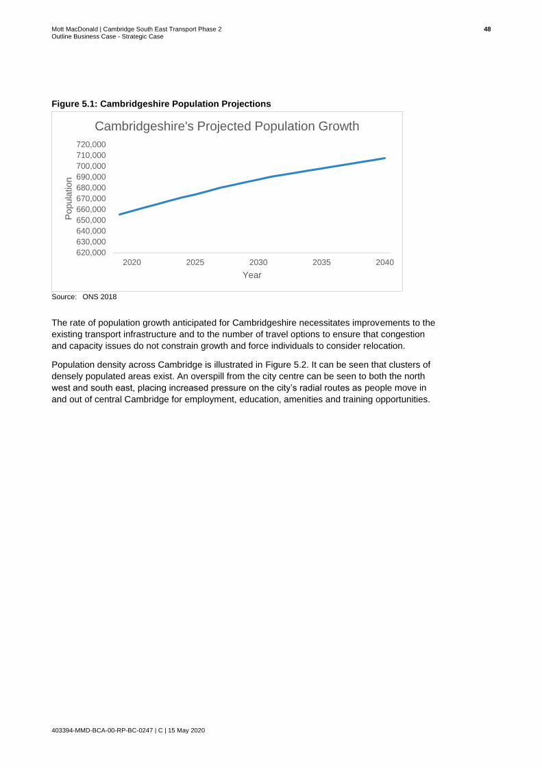
Mott MacDonald | Cambridge South East Transport Phase 2 48 Outline Business Case - Strategic Case
403394-MMD-BCA-00-RP-BC-0247 | C | 15 May 2020
Figure 5.1: Cambridgeshire Population Projections
Source: ONS 2018
The rate of population growth anticipated for Cambridgeshire necessitates improvements to the
existing transport infrastructure and to the number of travel options to ensure that congestion
and capacity issues do not constrain growth and force individuals to consider relocation.
Population density across Cambridge is illustrated in Figure 5.2. It can be seen that clusters of
densely populated areas exist. An overspill from the city centre can be seen to both the north
west and south east, placing increased pressure on the city’s radial routes as people move in
and out of central Cambridge for employment, education, amenities and training opportunities.
620,000
630,000
640,000
650,000
660,000
670,000
680,000
690,000
700,000
710,000
720,000
2020 2025 2030 2035 2040
Popula
tion
Year
Cambridgeshire's Projected Population Growth
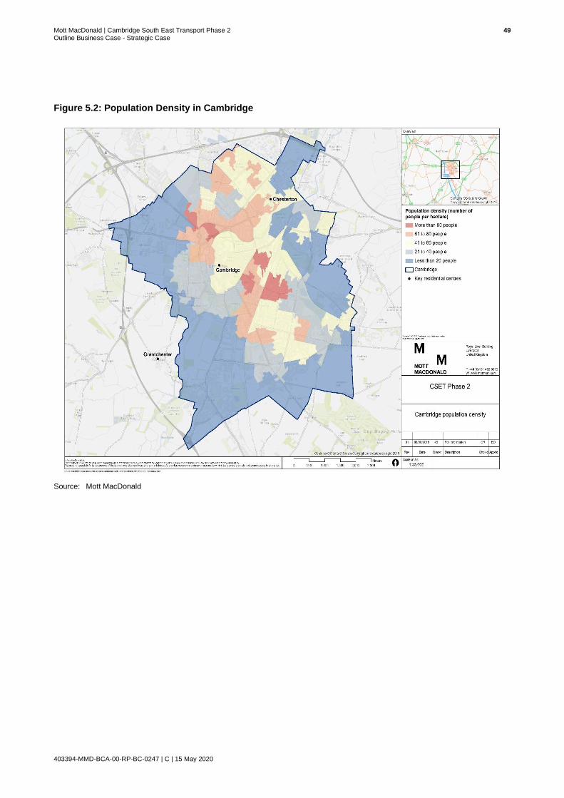
Mott MacDonald | Cambridge South East Transport Phase 2 49 Outline Business Case - Strategic Case
403394-MMD-BCA-00-RP-BC-0247 | C | 15 May 2020
Figure 5.2: Population Density in Cambridge
Source: Mott MacDonald
Mott MacDonald | Cambridge South East Transport Phase 2 50 Outline Business Case - Strategic Case
403394-MMD-BCA-00-RP-BC-0247 | C | 15 May 2020
Key Issues and Opportunities
The table below highlights the key issues and opportunities in relation to population in
Cambridgeshire.
Issues Opportunities
● The population of Cambridge and Cambridgeshire is growing rapidly and there is an increasing academic population. However, the current transport infrastructure is not evolving at a pace which matches population increase.
● Transport infrastructure which is inadequately equipped to accommodate a rapidly growing population may force people to relocate away from the area, slowing the rate of economic growth which has recently been experienced.
● Cambridge’s dense population is overspilling into the periphery. A large proportion of the overspill are choosing to live to the south east of Cambridge and commute into Cambridge, placing increased pressure on radial routes in and out of central Cambridge.
● A greater number of people living in the area will create indirect and induced economic impacts, spending their incomes locally and using local services, resulting in growth in the local economy.
● A sustainable transport network will allow Cambridgeshire to continue its success in academia, technology and research through close ties between campuses enabling knowledge sharing and innovation. A transport system that supports growth of the area and economic growth will benefit the wider UK economy.
● Futureproofing existing transport infrastructure will support the requirements of future generations and will ensure a successful and sustainable future for Cambridgeshire.
● Cambridge has a large student population who are more likely to use public transport and cycle modes of transportation. Enhancing the sustainable transport options will benefit the future growth of the Universities in Cambridge enabling Cambridge and in turn the UK to maintain its international competitiveness while also relieving pressure on the transport network.
● Providing a safe cycle and walking route will provide residents and students with travel options and will contribute to health and wellbeing.
So, what does this mean for CSET Phase 2?
The A1307 currently experiences periods of acute congestion, resulting in delays for users. With
Cambridgeshire’s population set to grow, overspill from central Cambridge will result in increasing
populations in towns on the hinterland of Cambridge, placing increased pressure on the city’s
radial routes.
The A1307 provides one of the city’s key radial routes between Cambridge and Haverhill, serving
a number of key communities and employment locations including Linton and Sawston. If transport
infrastructure along the A1307 corridor does not evolve to accommodate population growth,
conditions along the corridor will likely worsen, resulting in an adverse impact on air quality.
CSET Phase 2 will improve cycling, walking and public transport provision along a section of the
A1307 corridor, providing users with an attractive and viable alternative to private car travel.
Measures proposed as part of the scheme will ultimately ensure that people can travel through
south east Cambridge in a reliable, timely and safe manner, whilst also futureproofing the corridor
to accommodate the growth in trips associated with Cambridgeshire’s increasing population.

Mott MacDonald | Cambridge South East Transport Phase 2 51 Outline Business Case - Strategic Case
403394-MMD-BCA-00-RP-BC-0247 | C | 15 May 2020
5.2 Employment and Skills
In order to continue to support economic growth, the population within the employment
catchment area needs to possess the required skills and the transport network must be flexible
and efficient enough to expand the catchment area to ensure that jobs created as a result of
growth can be filled.
Cambridge and South Cambridgeshire import a larger proportion of labour than is exported,
both from other Cambridgeshire local authorities and further afield. The significant number of job
opportunities and sector specific requirements of the dominant science and engineering industry
necessitate that employers must attract labour from outside of the immediate area. Reliance on
external labour results in high commuter demand on the transport network, particularly during
peak hours.
Figure 5.3 provides an overview or employment rates in Cambridgeshire. It can be seen that,
employment rates in Cambridgeshire have remained consistently higher than the rest of the
East of England and Great Britain throughout the analysis period. The number of people in
employment increased rapidly in the 24-month period between 2016 and 2018. A percentage
increase of 2.0% was observed during this period. The rapid growth experienced over the 24-
month period could be an indication of the growth in employment which can be expected over
forthcoming years.
Figure 5.3: Population in Employment
Source: ONS 2018
64
66
68
70
72
74
76
78
80
82
2008 2009 2010 2011 2012 2013 2014 2015 2016 2017 2018
Perc
enta
ge o
f P
opula
tion (
%)
Year
Percentage of the population in employment
Cambridgeshire Great Britain East

Mott MacDonald | Cambridge South East Transport Phase 2 52 Outline Business Case - Strategic Case
403394-MMD-BCA-00-RP-BC-0247 | C | 15 May 2020
Figure 5.4 presents the unemployment rate in Cambridgeshire during the 10-year period
between 2008 and 2018.
Since the height of the recession in 2012 when unemployment rates were at their highest,
Cambridgeshire has recovered well. A 4% decrease in unemployment can be observed
between 2012 and 2018. The unemployment rate in Cambridgeshire was at an all-time low in
2017, with only 1.7% of the population not in employment. The impressive recovery
demonstrated in Cambridgeshire is testament to the growing economy of the area and
sustained investment despite national instability.
Figure 5.4: Cambridgeshire’s Unemployment Rate
Source: ONS 2018
Analysis of employment and unemployment levels for Cambridgeshire demonstrates that there
is a strong and active economy. The economy is well positioned to initiate further growth as
emerging opportunities are presented.
Table 5.1 below shows the number of people who are employed in Cambridgeshire, East
England and Great Britain, providing an indication of the extent of Cambridgeshire’s role as a
source of employment for the surrounding region.
Table 5.1: Total Employee Jobs
Year Cambridgeshire East Great Britain
2015 311,000 2,608,000 28,565,000
2016 319,000 2,680,000 29,045,000
2017 327,000 2,735,000 29,375,000
% Increase 5.1 4.9 3
Source: ONS Business Register and Employment Survey
0
1
2
3
4
5
6
7
8
2008 2009 2010 2011 2012 2013 2014 2015 2016 2017 2018
Perc
enta
ge o
f popula
tion u
nem
plo
yed
Unemployment in Cambridgeshire
Cambridgeshire

Mott MacDonald | Cambridge South East Transport Phase 2 53 Outline Business Case - Strategic Case
403394-MMD-BCA-00-RP-BC-0247 | C | 15 May 2020
In 2017, 327,000 people were employed in Cambridgeshire. The number of jobs available in
Cambridgeshire represent a significant proportion of those available in the East of England,
particularly when considering that the area represents less than 1% of the UK’s land mass and
population.
The economic performance of Cambridgeshire is very positive, particularly when compared with
Great Britain. A recent review of businesses undertaken as part of the Cambridgeshire and
Peterborough Independent Economic Review (CPIER) suggests that employment and turnover
growth have been picking up right across the area10.
Cambridgeshire provides a key source of employment in the East of England and continues to
grow its employment base, ensuring that the area continues to attract outside investment is
crucial to sustaining the recent rate of economic growth experienced.
The provision of adequate transport infrastructure to accommodate the expansion of existing
businesses whilst attracting further public and private sector investors is vital to the further
growth of the area. Employment growth drives increased demand for housing and higher levels
of commuting, therefore both factors must be addressed in order to support the growing
economy of the area11.
10 Cambridgeshire and Peterborough Independent Economic Review (CPIER). September 2018.
11 Cambridgeshire and Peterborough Independent Economic Review, 2018

Mott MacDonald | Cambridge South East Transport Phase 2 54 Outline Business Case - Strategic Case
403394-MMD-BCA-00-RP-BC-0247 | C | 15 May 2020
5.2.1 Anticipated Employment Growth
The East of England Forecasting Model (EEFM)12 suggests that the East of England economy
will employ a further 980,000 people over a twenty-year period by 2036, representing growth
per annum of 0.7% and above the national average of 0.6%. Growth nationally is anticipated to
continue to focus on the Greater South East (London, South East and East) given the high
levels of innovation (compared to the other government office regions).
Table 5.2: Total Employee Jobs
Cambridge South Cambs
Greater Cambridge13
CPCA14 East UK
Population, 000s
2016 131 157 288 847 6,114 65,572
2036 160 195 355 1,010 7,096 73,361
2045 172 210 382 1,071 7,456 76,055
Absolute change, 000s
2016-2036
29 38 67 163 982 7789
2016-2045
40 53 94 224 1,342 10,483
Annual growth rate (CAGR), %
2016-2036
1.0% 1.1% 1.0% 0.9% 0.7% 0.6%
2016-2045
0.9% 1.0% 1.0% 0.8% 0.7% 0.5%
Employment, 000s
2016 107 82 189 464 3,040 34,008
2036 123 90 213 519 3,359 36,582
2045 130 94 224 543 3,498 37,815
Absolute change, 000s
2016-2036
16 8 24 54 319 2,574
2016-2045
24 12 35 79 458 3,806
Annual growth rate (CAGR), %
2016-2036
0.7% 0.5% 0.6% 0.6% 0.5% 0.4%
2016-2045
0.7% 0.5% 0.6% 0.5% 0.5% 0.4%
Source: EEFM, Cambridge Econometrics, 2016
12 The East of England Forecasting Model (EEFM) has been designed to facilitate the setting of consistent housing and jobs targets by provides a set of baseline forecasts prepared by Cambridge Econometrics for the East of England region and sub-regions (counties, unitaries and district authorities). The overall model structure captures the interdependence of the economy, demographic change and housing at a local level, as well as reflecting the impact of broader economic trends on the East of England. EEFM forecasts are based on historical past trends and are unconstrained, i.e. they do not take into account any policy or other constraints that might prevent their actual realisation on the ground. For more information refer to: https://cambridgeshireinsight.org.uk/EEFM/
13 Greater Cambridge is Cambridge and South Cambs combined.
14 CPCA data covers the local authority areas of Cambridge, South Cambridgeshire, East Cambridgeshire, Huntingdonshire, Fenland and Peterborough

Mott MacDonald | Cambridge South East Transport Phase 2 55 Outline Business Case - Strategic Case
403394-MMD-BCA-00-RP-BC-0247 | C | 15 May 2020
Between 2016 and 2045, as shown in Figure 5.5 and Figure 5.6 below, the rate of population
and employment growth in Greater Cambridge is set to significantly outstrip the East and UK
rates of growth. This is due to the strong historical performance of the city and its unique
competitive strengths.
Figure 5.5: Indexed Population Growth Estimates, 2016-2045
Source: EEFM, Cambridge Econometrics, 2016
100
110
120
130
140
2001
2003
2005
2007
2009
2011
2013
2015
2017
2019
2021
2023
2025
2027
2029
2031
2033
2035
2037
2039
2041
2043
2045
Index 1
00 =
2016
Greater Cambridge East UK
Greater Cambridge - 93,500 extra persons

Mott MacDonald | Cambridge South East Transport Phase 2 56 Outline Business Case - Strategic Case
403394-MMD-BCA-00-RP-BC-0247 | C | 15 May 2020
Figure 5.6: Indexed Employment Growth Estimates, 2016-2045
Source: EEFM, Cambridge Econometrics, 2016
Table 5.3 below compares the growth forecasts from the EEFM model to the growth targets within
the Local Plans and actual employee growth over the 2011-16 period. Overall the total job growth
in Greater Cambridgeshire over the planning period, 2011-31, was established as 44,100 jobs
which informed the growth identified within the City Deal.
Although this growth is ambitious when compared to the latest EEFM 2016 figures (36,000 jobs
over 2011-2031) it is in line with recent actual employee growth recorded in the national data. As
shown in Figure 5.6 above, job growth exceeds the national rate significantly and is driven by the
high-tech sectors, namely professional, scientific and technical, human health, and information and
communication activities.
Table 5.3: Total Employee Jobs
Local plans - jobs target 2011-
31
EEFM jobs growth 2011-31
Actual No. Employees growth BRES
2011-16
Cambridge 22,100 25,300 13,000
South Cambridgeshire
22,000 10,700 11,600
Greater Cambridge15 44,100 36,000 24,600
Source: EEFM, Cambridge Econometrics, 2016
15 Greater Cambridge refers to the city of Cambridge and South Cambridgeshire but excludes Peterborough
100
110
120
130
140
2001
2003
2005
2007
2009
2011
2013
2015
2017
2019
2021
2023
2025
2027
2029
2031
2033
2035
2037
2039
2041
2043
2045
Index 1
00 =
2016
Greater Cambridge East UK
Greater Cambridge - 93,500 extra persons

Mott MacDonald | Cambridge South East Transport Phase 2 57 Outline Business Case - Strategic Case
403394-MMD-BCA-00-RP-BC-0247 | C | 15 May 2020
The CPIER articulates that not only has historical employment growth been underplayed but
future employment growth could be much higher than these levels. The report has set out four
scenarios for the future, which inform recommendations about how development will be carried
out and what infrastructure is likely to be needed to position the area well, to maximise the
benefits presented by opportunities associated with growth in the future. This includes
examining the options for densification, fringe growth, dispersal, transport corridors and deeper
digital transformations.
The modelling carried out was driven by employment growth and as this grows so does the
demand for housing and the pressure on the transport system. The model has been run by the
CPIER for four scenarios:
1. Local land use plans – capturing the assumptions around the employment targets
underpinning the Local Plans.
2. Employment Growth – Longer term rate. Based on a continuation of the 1981-2016 trend of
employment growth (no weight given to recent high levels of employment growth).
3. Employment Growth – Shorter term rate. Based on a continuation of the 2010-2015
employment growth trends according to the recent Centre for Business Research (CBR)
data.
4. Employment Growth – shorter term (ST) rate returning to longer term (LT) rate. This is the
central projection of the four. It assumes first a continuation of growth rates closer to higher
recent Office of National Statistics (ONS) employment growth rates, before gradually
returning to longer term ONS growth rates.
The findings in relation to these scenarios are shown in Figure 5.7 and include Peterborough as
well as the Cambridgeshire local authority areas. Clearly, forecast growth according to the
employment projections from historical performance demonstrate that the growth le assumed
within the Local Plans are very low and at the lower bound of the projections. Figures for
Greater Cambridge on its own are not yet available, but this analysis, when looking at the
central projection indicates that the 44,100 jobs target within the Local Plans is perhaps
inherently pessimistic and planning and transport policy needs to be actively planning for further
growth.

Mott MacDonald | Cambridge South East Transport Phase 2 58 Outline Business Case - Strategic Case
403394-MMD-BCA-00-RP-BC-0247 | C | 15 May 2020
Figure 5.7: Indexed Employment Growth Estimates, 2016-2045
Source: Dr Ying Jin, Department of Architecture, University of Cambridge (CPIER)
If employment grows as anticipated at local land use plan levels, there will be an increased
number of commuter trips and resultant issues across the transport network. If employment
grows at higher rates (under the Shorter-Term rate scenario) there could be 82% more
commuters travelling into Cambridge by 2031 when compared with 2011 levels16, with a number
of significant transport issues arising as a result if the transport network does not evolve to
accommodate such growth.
5.2.2 Cambridgeshire’s Employment Sectors
A summary of employment by sector is provided in Table 5.4. Employment is mostly
concentrated in the professional, scientific and technical services and the education sectors.
The dominance of these two sectors can largely be attributed to the growing biomedical
campuses and the expansion of the University of Cambridge and associated facilities which has
attracted both UK and international businesses.
The proportion of jobs in Human Health and Social Work activities is shown to be significant,
representing 12.8% of all jobs in Cambridgeshire. This proportion can also largely be attributed
to the significance of the Biomedical sector within Cambridgeshire and the ongoing investment
from large pharmaceutical companies such as AstraZeneca which moved its global research
headquarters to Cambridge in 2016. It should be noted that both Cambridge Biomedical
Campus and the headquarters of AstraZeneca are located in close proximity to the A1307
corridor, indicating the significance of the study area as strategically important employment hub
for the UK.
16 Cambridge & Peterborough Independent Economic Review (CPIER), Final Report, September 2018
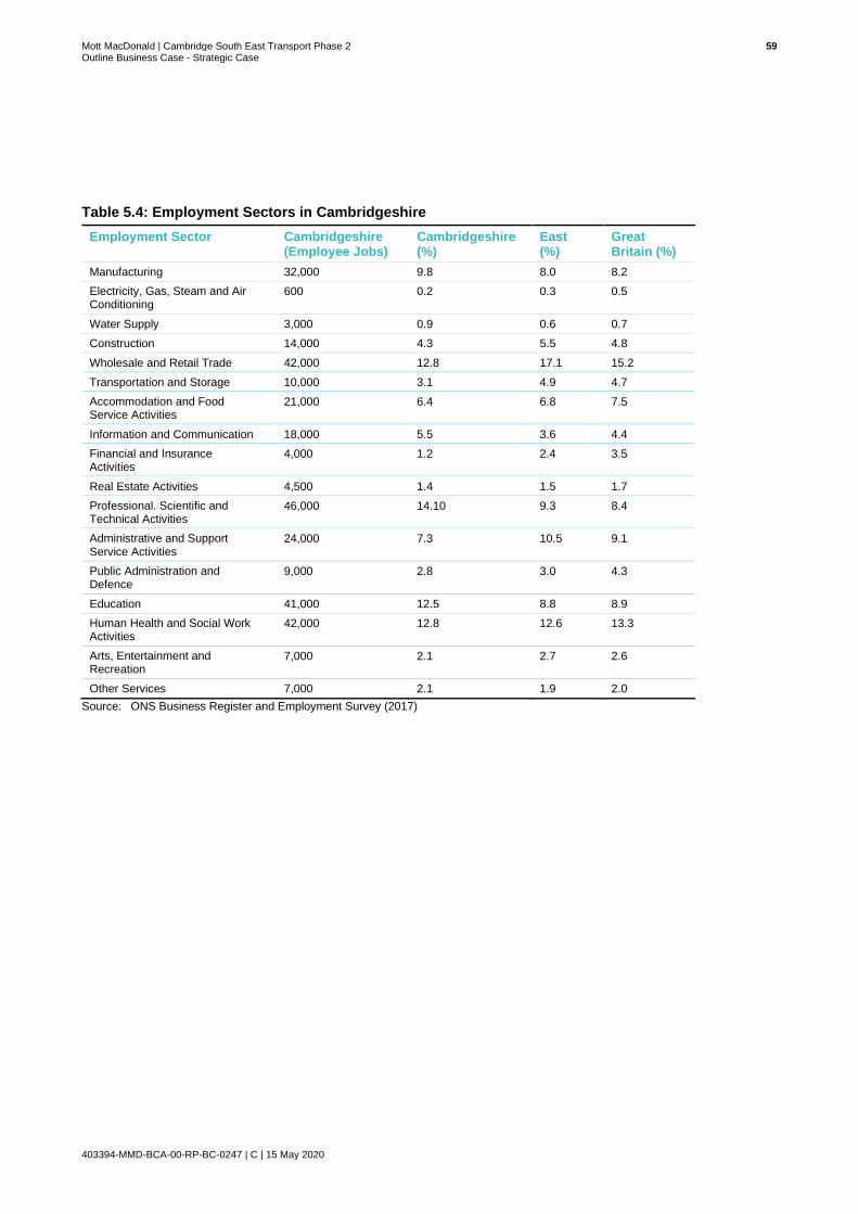
Mott MacDonald | Cambridge South East Transport Phase 2 59 Outline Business Case - Strategic Case
403394-MMD-BCA-00-RP-BC-0247 | C | 15 May 2020
Table 5.4: Employment Sectors in Cambridgeshire
Employment Sector Cambridgeshire (Employee Jobs)
Cambridgeshire (%)
East (%)
Great Britain (%)
Manufacturing 32,000 9.8 8.0 8.2
Electricity, Gas, Steam and Air Conditioning
600 0.2 0.3 0.5
Water Supply 3,000 0.9 0.6 0.7
Construction 14,000 4.3 5.5 4.8
Wholesale and Retail Trade 42,000 12.8 17.1 15.2
Transportation and Storage 10,000 3.1 4.9 4.7
Accommodation and Food Service Activities
21,000 6.4 6.8 7.5
Information and Communication 18,000 5.5 3.6 4.4
Financial and Insurance Activities
4,000 1.2 2.4 3.5
Real Estate Activities 4,500 1.4 1.5 1.7
Professional. Scientific and Technical Activities
46,000 14.10 9.3 8.4
Administrative and Support Service Activities
24,000 7.3 10.5 9.1
Public Administration and Defence
9,000 2.8 3.0 4.3
Education 41,000 12.5 8.8 8.9
Human Health and Social Work Activities
42,000 12.8 12.6 13.3
Arts, Entertainment and Recreation
7,000 2.1 2.7 2.6
Other Services 7,000 2.1 1.9 2.0
Source: ONS Business Register and Employment Survey (2017)

Mott MacDonald | Cambridge South East Transport Phase 2 60 Outline Business Case - Strategic Case
403394-MMD-BCA-00-RP-BC-0247 | C | 15 May 2020
Figure 5.8: Employment by Standard Occupation Classification (Soc) (October 2015-September 2016)
Source: ONS Annual Population Survey
The standard occupation classification groups referred to in Figure 5.8 are based on the
classifications set out in Table 5.5.
Table 5.5: Employment by Occupation
Standard Occupation Classification (Soc) 2010 Major Group
Occupation
Soc 2010 Major Group 1-3 1. Managers, Directors and Senior Officials
2. Professional Occupations
3. Associate Professional and Technical
Soc 2010 Major Group 4-5 4. Administrative & Secretarial
5. Skilled Trades Occupations
Soc 2010 Major Group 6-7 6. Caring, Leisure and Other Service Occupations
7. Sales and Customer Service Occupations
Soc 2010 major group 8-9 8. Process Plant and Machines Operatives
9. Elementary Occupations
Source: ONS Annual Population Survey
The distribution of employees across the Soc Major Groups provides an indication of the type of
jobs that are available in Cambridgeshire and the level of skills required to obtain employment in
the study area. In Cambridgeshire, almost half of the people in employment work in Soc 2010
major group 1-3 positions.
0
10
20
30
40
50
60
70
80
90
100
Cambridgeshire East GB
Perc
enta
ge (
%)
Soc 2010 Major Group 1-3 Soc 2010 Major Group 4-5
Soc 2010 Major Group 6-7 Soc 2010 Major Group 8-9
Mott MacDonald | Cambridge South East Transport Phase 2 61 Outline Business Case - Strategic Case
403394-MMD-BCA-00-RP-BC-0247 | C | 15 May 2020
Cambridgeshire displays a higher proportion of people in managerial positions, professional
occupations and associated professional technical positions in comparison to the East of
England and Great Britain. Conversely, Cambridgeshire has a significantly lower proportion of
people employed in Soc Major Group 6-7 and SOC Major Group 8-9.
The proportion of jobs in Cambridgeshire which are classified within Soc major group 1-3 means
that employers need to attract labour from outside of the immediate area to recruit individuals
with the necessary skills to fill these positions. Cambridgeshire needs to ensure therefore that
links into and out of the area are improved to provide ease of access and present an attractive
offer to individuals with the specified skills set.
Key Issues and Opportunities
The table below highlights the key issues and opportunities for the CSET Phase 2 scheme in
relation to employment and skills in Cambridgeshire.
Issues Opportunities
● Highly skilled professionals are required to fill a relatively large proportion of the jobs on offer in Cambridgeshire. Employers in Cambridgeshire therefore recruit from outside of the immediate area in order to find individuals who meet the specific requirements of job roles on offer.
● As a result, a large number of individuals work in Cambridgeshire but live outside of the area, leading to a high number of peak time commuters.
● High numbers of commuters are causing congestion problems during peak times, particularly in south east Cambridgeshire as individuals travel to employment opportunities in central Cambridge and further sites along the A1307 corridor.
● Cambridgeshire has a large proportion of people working in professional, scientific and technical activities compared to the national average. Increased employment within these sectors presents the opportunity to further excel Cambridgeshire, and in particular South Cambridgeshire as a destination of excellence in science and industry. Thereby attracting more jobs, employment opportunities and investment and boosting the local economy.
● CSET Phase 2 will provide attractive sustainable travel options that will help to accommodate existing and future commuter demand, providing a more efficient and sustainable transport network overall. Enhanced public transport and provision of an additional Travel Hub will alleviate pressure on the A1307.
So, what does this mean for CSET Phase 2?
The A1307 is a key route into the centre of Cambridge and provides direct links to Cambridge
Biomedical Campus and a number of other employment centres to the south east of Cambridge
including Granta Park and Babraham Research Campus. In recent years business growth
across the south east of Cambridgeshire has placed increased pressure on the corridor, leading
to long delays during peak times and unreliable journey times for commuters.
Delivery of CSET Phase 2 will support existing demand along the corridor whilst futureproofing
the corridor to accommodate further growth. The provision of attractive sustainable transport
modes along the corridor will provide commuters with a viable alternative to car travel. Improved
travel choice and reduced pressure on the road network will ensure employers can continue to
attract the necessary workforce to fill employment opportunities and that skilled individuals are
not discouraged from seeking opportunities in Cambridgeshire as a result of unreliable journey
times and a lack of other alternative modal options.

Mott MacDonald | Cambridge South East Transport Phase 2 62 Outline Business Case - Strategic Case
403394-MMD-BCA-00-RP-BC-0247 | C | 15 May 2020
6 Economy and Business
This section of the report provides a breakdown of the business performance and economy of
Cambridge and Cambridgeshire focusing primarily on the performance of businesses within the
study area, along and around the A1307 corridor. Economic growth here has outpaced both the
East of England and UK over the last decade and significantly increased the contribution that
the county makes to the country. This has been driven primarily by rapid business creation and
growth in South Cambridgeshire, particularly around the A1307 corridor.
6.1 The Cambridge Phenomenon
Greater Cambridge is renowned for being a world-leading centre for research, innovation and
technology. Over the past 50 years there has been an explosion of globally significant
companies and innovations across bioscience, medicine and technology. The ‘Cambridge
Phenomenon’, is a term that describes the thriving hi-tech and biotech industry, which has
developed since the 1960’s. The GCP’s current vision is to:
Rapid business creation and growth in South Cambridgeshire, particularly around the A1307
corridor, as part of the ‘Cambridge Phenomenon’ has created jobs and prosperity in Greater
Cambridge. The success of Greater Cambridge brings jobs and opportunities, not only for the
City Region, but for the whole region and helps the UK economy to compete and attract high
calibre knowledge-based individuals to fill gaps and increase economic growth. The city
embodies the key foundations of the National Industrial Strategy17 for the UK to become the
world’s most innovative economy.
The success experienced over recent years is largely due to:18
• A world class university that draws talent from across the globe, fostering innovation and
encouraging new businesses;
• The area’s scale and connectedness allow overlapping networks to develop and facilitate a
culture of co-operation and cross-fertilisation between entrepreneurs and academics, and;
• Retaining a strong heritage and sense of place, thereby competing with other world cities as
a good place for business leaders and their families to live, not just a good place to do
business.
The sub-region is home to world-leading research centres such as the MRC Laboratory for
Molecular Biology, the Babraham Institute for immunology research, and the Wellcome Trust
Sanger Institute for genomic research. This year the new Papworth Hospital will open at the
Biomedical Campus, uniting this internationally recognised heart and lung treatment institution
with other world-leading healthcare organisations.
17 Industrial Strategy: Building a Britain fit for the future, HM Government, November 2017
18 City Deal, Greater Cambridge City Deal Document, 2014
“Unleash a second wave of the ‘Cambridge Phenomenon’, with the aim of
‘securing sustainable economic growth and quality of life for the people of
Cambridge and South Cambridgeshire’”.

Mott MacDonald | Cambridge South East Transport Phase 2 63 Outline Business Case - Strategic Case
403394-MMD-BCA-00-RP-BC-0247 | C | 15 May 2020
The University of Cambridge (UoC), which is amongst the world’s top universities, attracts
global talent, fosters innovation and encourages business spin-outs.
Cambridge has been at the forefront of the development of disruptive technologies, ranging
from drug modelling, DNA sequencing and alternative fuels to network computing, inkjet
printing, low power semiconductors, speech recognition software and telecommunications.
This entrepreneurial environment and concentration of people focused on science and
engineering is attracting international businesses to invest in the area. More than 25 of the
world’s largest corporations have established operations in Cambridge, including Amazon,
Apple, HP, Illumina, Microsoft, Sanofi, Siemens and Qualcomm. AstraZeneca has chosen
Cambridge for its global research headquarters for 2,000 staff. Cambridge has transformed from
a city characterised by a high rate of start-ups to a city which major companies class worthy of
housing headquarters.
6.2 Business Growth
Building on the success of the ‘Cambridge Phenomenon’, Cambridgeshire has successfully built
a reputation as an attractive location to invest and expand businesses, bringing businesses to
Cambridge which might otherwise not have invested in the UK. Economic growth experienced
has been driven primarily, but not entirely, by rapid business creation. The rate of business
start-ups over the past five years is indicated below in Figure 6.1.
Figure 6.1: Cambridgeshire’s Business Start Ups
Source: ONS 2018
Rapid growth in business start-ups can be seen between 2013 and 2017, with an impressive
increase of nearly 10% during this four-year period. The slowest rate of growth can be seen
between 2017 and 2018, and although the data presented was published before the end of
2018, it suggests growth is possibly slowing down.
27,000
28,000
29,000
30,000
31,000
32,000
33,000
34,000
2013 2014 2015 2016 2017 2018
Cambridgeshire Business Start-Ups

Mott MacDonald | Cambridge South East Transport Phase 2 64 Outline Business Case - Strategic Case
403394-MMD-BCA-00-RP-BC-0247 | C | 15 May 2020
If this is indeed the first indication of growth slowing, Cambridgeshire must identify and address
the factors which may have recently deterred businesses from investing in the area at the same
rate as previously experienced.
Cambridge and South Cambridgeshire’s recent economic success is also attributable to the
connectivity across the City, and its surrounding area. Likewise, this slowdown in business start-
up rates could be linked to supply side constraints, such as labour market accessibility.
Transport infrastructure in the area needs to be able to support not only the current pace of
growth, but also be future proofed to prepare for further emerging opportunities. A lack of
investment in infrastructure could limit future growth in Cambridgeshire and may lead to slower
economic growth and a loss of international competitiveness for the UK. The growth seen in
Cambridgeshire and South Cambridgeshire in particular, is unlikely to be sustained in the future
without further and significant investment in the infrastructure. Businesses are already beginning
to note this as a major concern, suggesting action must be taken imminently19.
6.3 Gross Value Added (GVA)
Recent work undertaken as part of the CPIER has provided the most up to data analysis of GVA
for the Cambridgeshire and Peterborough Combined Authority (CPCA) area. Figure 6.2 displays
GVA growth between 2001 and 2016.
Figure 6.2: Real Gross Value Added (GVA)- Index 2001=100
Source: CPIER, 2018
GVA growth across the CPCA area has increasingly outpaced both the East of England and the
rest of the UK, with record high GVA levels recorded in 2016. Research suggests that GVA
growth across the CPCA area has been primarily driven by Cambridgeshire and more
specifically, South Cambridgeshire. GVA generated in South Cambridgeshire is primarily a
19 Cambridgeshire and Peterborough Independent Economic Review, 2018.

Mott MacDonald | Cambridge South East Transport Phase 2 65 Outline Business Case - Strategic Case
403394-MMD-BCA-00-RP-BC-0247 | C | 15 May 2020
result of the ongoing growth of the technology and science clusters centred around the A1307
corridor.
Ongoing growth in South Cambridgeshire, centred around the A1307 corridor brings huge
opportunities for the area. However, in tandem this also brings burgeoning issues associated
with the transport infrastructure and limited sustainable transport options along the corridor. The
current demand alone has led to capacity issues along the corridor, poor accessibility and
issues associated with delays and air quality. Failure to respond to these issues may
compromise the rate of growth along the A1307 corridor.
Key Issues and Opportunities
The table below highlights the key issues and opportunities for the CSET Phase 2 scheme in
relation to economy and business in Cambridgeshire.
Issues Opportunities
● Cambridge is strategically important for attracting international investors into the UK and maintaining the UK’s international competitiveness. However, this relies on Cambridgeshire continuing to offer strong links between businesses, training campuses and housing developments.
● Rapid business creation and the number of businesses choosing to locate in Cambridgeshire has increased pressure on the existing transport network.
● The existing transport network is inadequately equipped to accommodate current demand. If the network does not evolve at the same rate as economic growth, this problem will inevitably worsen.
● Businesses may be deterred from investing if accessing the employment site is difficult for their workforce.
● Existing businesses may struggle to attract labour from outside of the local area as journey times are long and unreliable. This may also deter investors and businesses locating to the area.
● The rate of business start-ups has slightly declined recently. Cambridgeshire must establish the reason for this and seek to address concerns.
● Cambridgeshire has a worldwide reputation and strong existing economic base, and one which continues to grow. Infrastructure to support and facilitate continued access to employment and homes will equip the area to deal with expansion and thus support sustainable economic growth.
● The proposed Travel Hub will improve accessibility to key employment sites, including Babraham Research Campus, Granta Park and Cambridge Biomedical Campus, encouraging investment and supporting existing businesses. This will also alleviate pressure on the A1307.
● Cambridgeshire must ensure that sustainable modes of travel are attractive to an ever-increasing number of commuters. The proposed scheme will provide a viable alternative to private car travel, reducing congestion along key routes and providing benefits for the environment and quality of life.
So, what does this mean for CSET Phase 2?
The A1307 is a key commuter route, serving central Cambridge, Cambridge Biomedical
Campus and a number of other employment centres and medical campuses to the south east of
Cambridge including Granta Park and Babraham Research Campus. Growth of employment
opportunities at a number of locations, has placed increased pressure on the transport corridor,
leading to delays during peak times and unreliable journey times for commuters.
Delivery of a dedicated public transport route and a new Travel Hub facility as part of Phase 2 of
the CSET scheme will alleviate existing demand for private car travel on the corridor and
futureproof it to accommodate anticipated growth in demand. The scheme will improve the
provision of sustainable transport modes along the corridor, providing commuters with an
attractive and viable alternative to car travel.
Improvements to the transport corridor could support access to a wider workforce and
strengthen the links between key training and employment centres, bringing benefits of
agglomeration and knowledge sharing. In this way, attractive and sustainable travel options
could support sustainable economic growth across Cambridgeshire and help to maintain
Cambridge’s world-leading offer, and in turn the UK’s international competitiveness.
.

Mott MacDonald | Cambridge South East Transport Phase 2 66 Outline Business Case - Strategic Case
403394-MMD-BCA-00-RP-BC-0247 | C | 15 May 2020
7 Land Use and Development
A significant level of development is planned across Cambridgeshire over the Local Plan period
(2011-2031), which will provide employment space to underpin the growth targets. The local
authorities’ aim is to ensure sufficient land is available to accommodate the 22,100 forecast new
jobs in Cambridge by 2031, including some 8,800 in B-use class (offices and industry).
Therefore, provision has been made for the development of at least 12 hectares of employment
land (net) from April 2011 to March 2031.
Furthermore, there is a strong pipeline of employment space beyond 2031. Investments in
transport infrastructure will be critical to unlock the growth potential of Cambridge and South
Cambridgeshire, and to achieve this transport network capacity, high congestion levels, and
poor reliability issues will need to be addressed.
It is worth noting, as set out in the CPIER, that the economic success of Greater Cambridge,
has in large part been a result of the historical approach to planning at the turn of the 21st
century20 which led to areas of the Cambridge Green Belt being freed for important
developments and various market towns being expanded. A key element of this was the release
of Green Belt land to enable the development of the Cambridge Biomedical Campus. This pro-
active approach to development continues in the current Local Plans but, as highlighted above,
recognising the growth potential will require not only investment in transport but addressing
housing shortages and ensuring sufficient employment floorspace is available post 2031 (the
end point of the 2018 adopted Local Plans).
Figure 7.1 illustrates the major planned development sites, categorised into six key areas
including:
● New Settlements;
● North West Cambridge and West Cambridge;
● Cambridge Southern Fringe and Biomedical Campus;
● Cambridge East;
● City Centre developments; and
● Existing employment locations.
Overlaid on the map are the City Deal transport schemes for reference. The A1307 corridor can
be seen to the South East of the map.
20 Discussed further below but set out fully in the Cambridge & Peterborough Independent Economic Review (CPIER), Final Report, September 2018.

Mott MacDonald | Cambridge South East Transport Phase 2 67 Outline Business Case - Strategic Case
403394-MMD-BCA-00-RP-BC-0247 | C | 15 May 2020
Figure 7.1: Map of Key Development and City Deal Schemes
Source: Mott MacDonald, August 2016
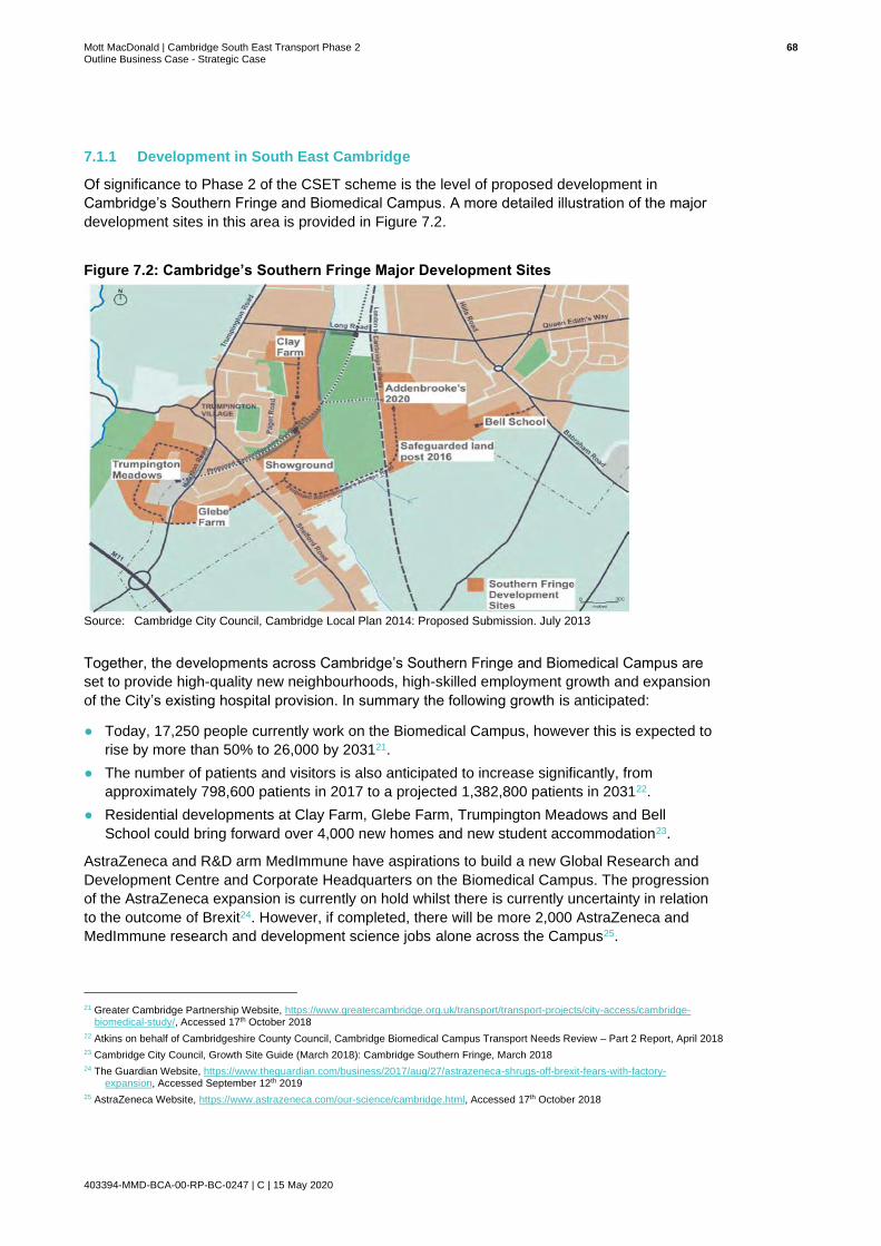
Mott MacDonald | Cambridge South East Transport Phase 2 68 Outline Business Case - Strategic Case
403394-MMD-BCA-00-RP-BC-0247 | C | 15 May 2020
7.1.1 Development in South East Cambridge
Of significance to Phase 2 of the CSET scheme is the level of proposed development in
Cambridge’s Southern Fringe and Biomedical Campus. A more detailed illustration of the major
development sites in this area is provided in Figure 7.2.
Figure 7.2: Cambridge’s Southern Fringe Major Development Sites
Source: Cambridge City Council, Cambridge Local Plan 2014: Proposed Submission. July 2013
Together, the developments across Cambridge’s Southern Fringe and Biomedical Campus are
set to provide high-quality new neighbourhoods, high-skilled employment growth and expansion
of the City’s existing hospital provision. In summary the following growth is anticipated:
● Today, 17,250 people currently work on the Biomedical Campus, however this is expected to
rise by more than 50% to 26,000 by 203121.
● The number of patients and visitors is also anticipated to increase significantly, from
approximately 798,600 patients in 2017 to a projected 1,382,800 patients in 203122.
● Residential developments at Clay Farm, Glebe Farm, Trumpington Meadows and Bell
School could bring forward over 4,000 new homes and new student accommodation23.
AstraZeneca and R&D arm MedImmune have aspirations to build a new Global Research and
Development Centre and Corporate Headquarters on the Biomedical Campus. The progression
of the AstraZeneca expansion is currently on hold whilst there is currently uncertainty in relation
to the outcome of Brexit24. However, if completed, there will be more 2,000 AstraZeneca and
MedImmune research and development science jobs alone across the Campus25.
21 Greater Cambridge Partnership Website, https://www.greatercambridge.org.uk/transport/transport-projects/city-access/cambridge-
biomedical-study/, Accessed 17th October 2018
22 Atkins on behalf of Cambridgeshire County Council, Cambridge Biomedical Campus Transport Needs Review – Part 2 Report, April 2018
23 Cambridge City Council, Growth Site Guide (March 2018): Cambridge Southern Fringe, March 2018
24 The Guardian Website, https://www.theguardian.com/business/2017/aug/27/astrazeneca-shrugs-off-brexit-fears-with-factory-expansion, Accessed September 12th 2019
25 AstraZeneca Website, https://www.astrazeneca.com/our-science/cambridge.html, Accessed 17th October 2018

Mott MacDonald | Cambridge South East Transport Phase 2 69 Outline Business Case - Strategic Case
403394-MMD-BCA-00-RP-BC-0247 | C | 15 May 2020
7.1.2 Development Along the A1307 Corridor
Figure 7.3 shows the key growth areas in proximity to the A1307 corridor. A significant level of
both commercial and housing led development is planned over coming years. Independently
these growth areas would place a significant amount of pressure on the transport network in the
area. However, collectively, the delivery of these planned developments will force the transport
network beyond breaking point if action to accommodate increasing demand is not taken.
Figure 7.3: Cambridge’s Southern Fringe Major Development Sites
Source: Cambridge City Council, Cambridge Local Plan 2014: Proposed Submission. July 2013
Works as part of the CSET Phase 2 scheme will reduce public transport journey times to key
employment sites in proximity to the A1307 corridor and encourage journeys to be undertaken
by active travel reducing the pressure which private car travel will place on the corridor.

Mott MacDonald | Cambridge South East Transport Phase 2 70 Outline Business Case - Strategic Case
403394-MMD-BCA-00-RP-BC-0247 | C | 15 May 2020
Key Issues and Opportunities
The table below highlights the key issues and opportunities in relation to land use and
development in Cambridgeshire.
Issues Opportunities
● The level of planned development in Greater Cambridge will increase pressure on the existing transport network, resulting in deteriorating journey times and journey time reliability.
● Increased demand on the road network across south east and central Cambridge will result in congestion and associated air quality issues.
● Planned employment space may be left vacant if accessing the sites is deemed unattractive and inaccessible by the potential workforce.
● Planned development may not come to fruition at the rate anticipated in the Local Plan if transport infrastructure is not in place to support development and expansion.
● Addressing issues associated with Cambridgeshire’s transport network will encourage planned development to come to fruition. Development will bring forward an unprecedented number of opportunities for economic growth.
● CSET Phase 2 will improve active travel infrastructure along a section of the A1307 corridor, improving connectivity for pedestrians and cyclists. Improved active travel links will encourage commuters to adopt more sustainable modes of travel.
● Preparing the transport network for future growth will secure a prosperous future for Cambridgeshire and encourage growth, post the Local Plan period, and provide economic benefits to the rest of the UK.
So, what does this mean for CSET Phase 2?
Existing transport infrastructure is not equipped to cope with the travel demand associated with
the scale of development which is planned across south east Cambridge and central
Cambridge. Failure to improve infrastructure adequately may stall the rate at which
developments are delivered, slowing economic growth. Failure to invest in transport may
ultimately result in a transport network which exceeds breaking point, resulting in increased
delay, unreliable journey times, greater road safety concerns and increased greenhouse gas
emissions.
CSET Phase 2 will deliver measures which will futureproof the network in preparation for
planned growth. Attractive and reliable sustainable transport options will encourage uptake,
alleviating pressure on the A1307 corridor and will help to accommodate greater demand.

Mott MacDonald | Cambridge South East Transport Phase 2 71 Outline Business Case - Strategic Case
403394-MMD-BCA-00-RP-BC-0247 | C | 15 May 2020
8 How People Travel
This section explores the travel behaviour of those living/and or working within Cambridge and
South Cambridgeshire. Data in this section has been primarily sourced from CENSUS data
produced by the Office of National Statistics.
8.1 Commuter Trips
Figure 8.1 provides an overview of journey to work trips between Cambridge and South
Cambridgeshire and key employment locations. The blue arrows show inbound travel to work
trips, while the green arrows show outbound travel to work trips. Total numbers of people
travelling are shown as well as the percentage share of the total incoming and outgoing trips.
Commuter flows indicate that inbound flows (372,456) are larger than outbound flows (248,659),
highlighting the significance of the area as an employment hub for the surrounding region. The
largest proportion of Cambridge and South Cambridgeshire’s workforce travel from East
Cambridgeshire and Huntingdonshire.
The largest proportions of outbound flows are to Westminster and the City of London, both to
the south of the study area, and Huntingdonshire to the north west.
Figure 8.1: Incoming and Outgoing Commuter Flows
Source: Nomis WU03- Location of usual residence and place of work by method of travel to work (2011)

Mott MacDonald | Cambridge South East Transport Phase 2 72 Outline Business Case - Strategic Case
403394-MMD-BCA-00-RP-BC-0247 | C | 15 May 2020
A large proportion of Cambridge and South Cambridgeshire’s workforce live outside of the area
and commute inbound making the accessibility of employment sites crucial to sustaining the
necessary workforce to support continued economic growth across Cambridge and South
Cambridgeshire and in turn maintain its international competitiveness. The transport network
must flexibly adapt to the needs of those commuting into the area from different origin points.
Figure 8.2 below displays the modal split of Cambridge and South Cambridgeshire’s workforce.
Figure 8.2: How do People Travel?
Source: Nomis WU03- Location of usual residence and place of work by method of travel to work 2011
63% of Cambridge and South Cambridgeshire’s workforce as a whole commute by car or van,
contributing significantly to the congestion experienced across the road network. As shown in
Figure 8.1, a large proportion of those who work in Cambridge and South Cambridgeshire
commute from east Cambridgeshire. The most popular routes to key employment sites in the
south of Cambridge are via the A10 and the A1307.
Data indicates that the second most popular mode of transport for commuters in Cambridge and
South Cambridgeshire is bicycle. It is likely that the popularity of cycling to work is due to the
number of people who live and also work in the immediate area. The short distance between
origin and work destination makes cycling a viable, sustainable and attractive mode of travel.
Public transport appears to be a less favourable mode of travel for commuters. Census data
analysed by Mott MacDonald during the development of this OBC indicates that only a small
number of commuters opt for bus or train travel. However, it should be noted that this data was
collected and published before the complete delivery of the Cambridgeshire Guided Busway
which has experienced high levels of patronage, indicating a potential modal shift towards
public transport which is not represented in data set provided here.
0 10000 20000 30000 40000 50000 60000 70000 80000 90000
Underground, metro, light rail or tram
Train
Bus, minibus or coach
Taxi
Motorcycle
Driving a car or van
Bicycle
On foot
Mode of travel
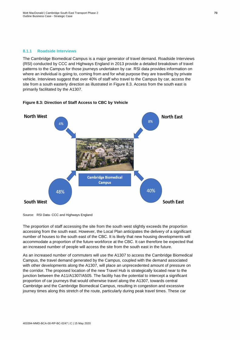
Mott MacDonald | Cambridge South East Transport Phase 2 73 Outline Business Case - Strategic Case
403394-MMD-BCA-00-RP-BC-0247 | C | 15 May 2020
8.1.1 Roadside Interviews
The Cambridge Biomedical Campus is a major generator of travel demand. Roadside Interviews
(RSI) conducted by CCC and Highways England in 2013 provide a detailed breakdown of travel
patterns to the Campus for those journeys undertaken by car. RSI data provides information on
where an individual is going to, coming from and for what purpose they are travelling by private
vehicle. Interviews suggest that over 40% of staff who travel to the Campus by car, access the
site from a south easterly direction as illustrated in Figure 8.3. Access from the south east is
primarily facilitated by the A1307.
Figure 8.3: Direction of Staff Access to CBC by Vehicle
Source: RSI Data- CCC and Highways England
The proportion of staff accessing the site from the south west slightly exceeds the proportion
accessing from the south east. However, the Local Plan anticipates the delivery of a significant
number of houses to the south east of the CBC. It is likely that new housing developments will
accommodate a proportion of the future workforce at the CBC. It can therefore be expected that
an increased number of people will access the site from the south east in the future.
As an increased number of commuters will use the A1307 to access the Cambridge Biomedical
Campus, the travel demand generated by the Campus, coupled with the demand associated
with other developments along the A1307, will place an unprecedented amount of pressure on
the corridor. The proposed location of the new Travel Hub is strategically located near to the
junction between the A11/A1307/A505. The facility has the potential to intercept a significant
proportion of car journeys that would otherwise travel along the A1307, towards central
Cambridge and the Cambridge Biomedical Campus, resulting in congestion and excessive
journey times along this stretch of the route, particularly during peak travel times. These car

Mott MacDonald | Cambridge South East Transport Phase 2 74 Outline Business Case - Strategic Case
403394-MMD-BCA-00-RP-BC-0247 | C | 15 May 2020
journeys could be replaced by more sustainable modes of travel via the new public transport
route and associated NMU route as part of the Phase 2 scheme.
8.1.2 Forecast Increase in Private Car Trips
The Southern Fringe, including the CBC, is experiencing a high level of employment growth.
Based on previous background work undertaken by Atkins in 2016, the Biomedical Campus
alone (excluding Addenbrooke’s Hospital) is expected to generate an additional 8,000 daily
employee trips by the time it is fully operational. The current assumption is that at least 30%
(2,400) of these additional trips are expected to be made by private car.
Congestion is already a major problem across Cambridge and South Cambridgeshire and
threatens the liveability and attractiveness of Cambridge to residents, employees and visitors
alike. Much of the congestion in Cambridge can be attributed to the heavy reliance on private
vehicles26. If trip forecasts outlined above prove to be accurate, an already congested road
network will become worse with longer delays and increased unreliability.
It is expected that around 20,000 new jobs will be delivered across the CBC, Babraham
Research Campus and Granta Park27. The A1307 will be expected to accommodate a large
proportion of all additional journeys generated by new job opportunities. Increased demand on
this corridor will place an immense amount of pressure on infrastructure here. Infrastructure
improvements must look to respond to forecast demand and accommodate it accordingly.
Key Issues and Opportunities
The table below highlights the key issues and opportunities in relation to how people travel in
Cambridgeshire.
Issues Opportunities
● Cambridge is one of the fastest growing cities in the UK and as such, it is not surprising that Cambridge and South Cambridgeshire are net importers of people for work purposes. However, the transport network is not equipped to accommodate the scale of inbound commuter flows.
● 63% of Cambridge and South Cambridgeshire’s workforce commute by car or van resulting in congestion and associated air quality issues across many of central Cambridge’s key radial routes.
● Ongoing growth at key employment sites across south east Cambridge and central Cambridge will result in increased commuter demand on the A1307 corridor where there is a lack of alternate travel modes to car.
● The CBC employs a large number of people and is a significant generator of travel demand. 40% of staff at the campus access the site from the south east, using the A1307, resulting in congestion and delays at peak times.
● An increased number of sustainable travel options across south east Cambridge may encourage a modal shift away from car travel resulting in a more sustainable travel environment.
● Improved public transport and walking and cycling provision across south east Cambridge could attract potential employees to opportunities in the area which will be essential to securing future growth of businesses in the area.
● The proposed Travel Hub facility Is strategically located to intercept a large number of journeys heading into central Cambridge and towards the CBC and Babraham Research Campus. The onward public transport route and NMU route would provide a more sustainable link to key destinations whilst also providing journey time savings and journey time reliability for users.
26 City Access and Bus Service Improvements Update- Greater Cambridge Partnership, 2018
27 City Access and Bus Service Improvements Update- Greater Cambridge Partnership, 2018

Mott MacDonald | Cambridge South East Transport Phase 2 75 Outline Business Case - Strategic Case
403394-MMD-BCA-00-RP-BC-0247 | C | 15 May 2020
So, what does this mean for CSET Phase 2?
63% of Cambridge and South Cambridgeshire’s workforce commute by car or van, contributing
to a growing congestion problem across central Cambridge’s radial routes. A large proportion of
commuters rely on the A1307 to access job opportunities in central Cambridge and south east
Cambridge due to a lack of alternate routes and modal options.
There is significant potential for a growth in job opportunities across three of south east
Cambridge’s key employment sites; Cambridge Biomedical Campus, Babraham Research
Campus and Granta Park, as well as potential for ongoing growth across central Cambridge.
This is likely to put increased pressure on the A1307 corridor; thus, corridor improvements could
support this continued growth in employment opportunities.
A new Travel Hub facility close to the A11 junction could intercept a proportion of car trips from
areas to the south and east of central Cambridge, reducing the number of car trips into central
Cambridge and towards the CBC and Babraham Research Campus. The Travel Hub facility will
present existing and potential users of the A1307 with a sustainable alternative to car travel,
offering the opportunity to travel by HQPT or via cycling and walking. Sustainable travel options
in south east Cambridge may encourage a modal shift away from car travel.
Mott MacDonald | Cambridge South East Transport Phase 2 76 Outline Business Case - Strategic Case
403394-MMD-BCA-00-RP-BC-0247 | C | 15 May 2020
9 Environment
The environmental constraints identified during the development of the SOBC have been
reviewed and considered in this section of the report and built upon.
9.1 Air Quality
The centre of Cambridge has had an Air Quality Management Area (AQMA) since 2004 due to
poor air quality (mainly due to high Nitrogen Dioxide from traffic) that does not meet National Air
Quality Objectives. The AQMA extends along Hills Road (A1307) to the main London-Kings
Lynn railway line. To implement improvement in air quality a series of Air Quality Management
Plans have been implemented and integrate into the local transport plans. The latest air quality
management plan is the Cambridge Air Quality Management Plan (2018 – 2023).
Air quality outside of the city is deemed to be good as indicated by DEFRA’s modelling of air
quality across the UK.
Public transport schemes are considered to have lower environmental impact because they are
able to move a greater number of people per unit of pollutant emitted. The proposed scheme
would encourage fewer private vehicles to enter Cambridge by providing high-quality public
transport alternatives, including new non-motorised user routes into the city centre.
There is also the opportunity to move to electric or other non-fossil fuel powered public transport
vehicles on the proposed route in the medium-term. This will help to reduce Nitrogen Dioxide
(NO2) emissions in particular and offers a sustainable journey into Cambridge.
9.2 Noise
Noise is increasingly understood to have an impact on human physical and mental health (e.g.
by disrupting sleep patterns (physical health) and leading to stress, inability to concentrate, and
frustration (mental health)). Traffic noise can be a significant contribution to ambient noise
levels, with adverse consequences for human health. Hence, any scheme that seeks to reduce
noise levels can bring benefit to human health. It is worth noting that changes in traffic levels
need to be significant before noticeable improvements in ambient noise levels are noticed.
9.3 Historic Environment
Cambridge city centre has a world-famous historic built and natural environment that generates
a very significant tourist industry in addition to providing the setting for its outstanding academic
institutions. It is vital to preserve the setting of the historic buildings and open spaces, which the
City Council has a duty to do, in the exercise of its development management functions,
particularly within designated Conversation Areas. There are 17 such Conservation Areas in
and around the centre of Cambridge, including in the villages of Great Shelford, Little Shelford,
Babraham, Sawston and Great Abington. Whilst the emphasis in the conservation areas is to
preserve and enhance the built environment (townscape) there is also a need to manage traffic
levels to avoid noise, congestion and pollution which can have a significant impact on the
character and appearance of the city.
There are known archaeological remains of regional and potentially national significance within
the footprint of the proposed public transport route corridor.
Mott MacDonald | Cambridge South East Transport Phase 2 77 Outline Business Case - Strategic Case
403394-MMD-BCA-00-RP-BC-0247 | C | 15 May 2020
The scheme will be assessed using aerial photographic interpretation, geophysical surveys and
trial trenching to better understand the buried archaeology along the route. This will increase
knowledge and understanding of the setting around Wandlebury and the Magog Scheduled
Monuments.
9.4 Landscape
The landscape of the route corridor is mainly open, with an undulating landform which slopes
gently down the River Granta valley in the south and Cambridge in the west. Little Tree Hill,
Wandlebury and Fox Hill are highpoints. Large arable fields are separated by ditches and
occasional low hedgerows. Views tend to be long, except where woodland belts frame or screen
views. The landscape is more intimate around the villages of Babraham, Stapleford, Sawston
and Great Shelford, where streets and garden boundaries tend to be tree lined. The designed
landscapes of Babraham Hall, Wandlebury Country Park, Granta Park and The Gog Magog
Golf Club gives part of the proposed route a more intimate wooded quality.
There are opportunities to enhance the landscape character of the area by changing the vertical
profile of the proposed route and landscape mitigation in the form of sensitive planting along the
route. The District Design Guide Supplementary Planning Document (SPD) and the Landscape
in New Developments SPD have a number of landscape enhancement measures identified for
the East Anglian Chalk landscape which would be taken into account when delivering the CSET
Phase 2 scheme.
9.5 Green Belt
Large sections of the proposed route are located within the Green Belt. The Green Belt has a
strong protection at both National and Local Level. Policy 4 of the adopted Cambridge City
Local Plan (2018) sets out a presumption against inappropriate development in the Green Belt.
Policy NH/8 of the South Cambridgeshire Local Plan 2018 also sets out the presumption against
inappropriate development in the Green Belt.
When considering the acceptability of the principle of scheme development within the Green
Belt, the key policy criteria is set out within paragraph 146 of the NPPF. Paragraph 146 of the
NPPF states the following:
”Certain other forms of development are also not inappropriate in Green Belt provided they
preserve the openness and do not conflict with the purposes of including land within it. These
are: …
● Local transport infrastructure which can demonstrate a requirement for a Green Belt
location.”
9.6 Biodiversity
There are several Sites of Special Scientific Interest (SSSI) in the area including:
● The Gog Magog Golf Course SSSI, the largest SSSI in the area, which is north of the
proposed scheme adjacent to the A1307
● Sawston Hall Meadows SSSI and Demford Fen SSSI, both west of the London/Cambridge
railway.

Mott MacDonald | Cambridge South East Transport Phase 2 78 Outline Business Case - Strategic Case
403394-MMD-BCA-00-RP-BC-0247 | C | 15 May 2020
There are also the following Local Nature Reserves (LNR) within close proximity to the
proposed route:
● Nine Wells LNR; and
● The Beechwoods LNR.
It is important to avoid any direct land take that could affect a SSSI area, but it is equally
important to reduce traffic and thus nutrient loading from exhaust emissions – which could
impact the important flora in SSSIs.
There are two County Wildlife Sites in the immediate vicinity of the project as follows:
● Shelford - Haverhill Disused Railway (Pampisford)
● River Granta
The CSET Phase 2 project has the potential to deliver positive gain for biodiversity. There are
significant opportunities to achieve this strategic objective as part of the design, providing both
wildlife corridors by prioritising linking current areas of habitat together and creating new habitat
in other areas. GCP are committed to ensuring a minimum of 10% biodiversity net gain for the
scheme, with the aim to reach a 20% net gain.
9.7 Water and Flood Risk
There are numerous policies at national and local level relating to the protection of water
resources. The general theme of all the policies is that the development and day to day
activities must avoid any negative impacts on the quality of water bodies (surface or
groundwater) from any anthropological activities, including from transport schemes where the
greatest risks are from road drainage and accidents.
National and local policies on flooding all have a common basis to prevent development in flood
zones that are not flood resilient. In particular the Environmental Permitting Regulations (EPR)
2010 aim to protect groundwater and surface waters from pollution by controlling the inputs of
potentially harmful and polluting substances.
The project crosses the flood plain of the River Granta and some of the minor tributaries of the
River Cam around the Cambridge Biomedical Campus. The scheme design will have to take
into account the potential effects on flood risk on these flood plains and on all land adjacent to
the scheme. To achieve this the CSET Phase 2 scheme will have SuDs drainage installed along
the route and in the Travel Hub which will ensure runoff does not contribute to flood risk and
should also ensure the quality of runoff discharged to infiltrate into the ground does not affect
groundwater quality that is used for public water supplies.
There is potential for the CSET Phase 2 scheme to enhance biodiversity by creating water
related habitats to compensate for lost flood storage in the River Granta flood plain. This is in
line with policy 31 of the Cambridge Local Plan 2018 which states: “development adjacent to a
water body actively seeks to enhance the water body in terms of its hydromorphology,
biodiversity potential and setting”.
9.8 Greenhouse Gases
The Climate Change Act commits the UK government to reduce greenhouse gas emissions to
net zero by 2050. Transport schemes present both a risk to reducing greenhouse gas emissions
and an opportunity if modal shift to lower emitting transport can be achieved.
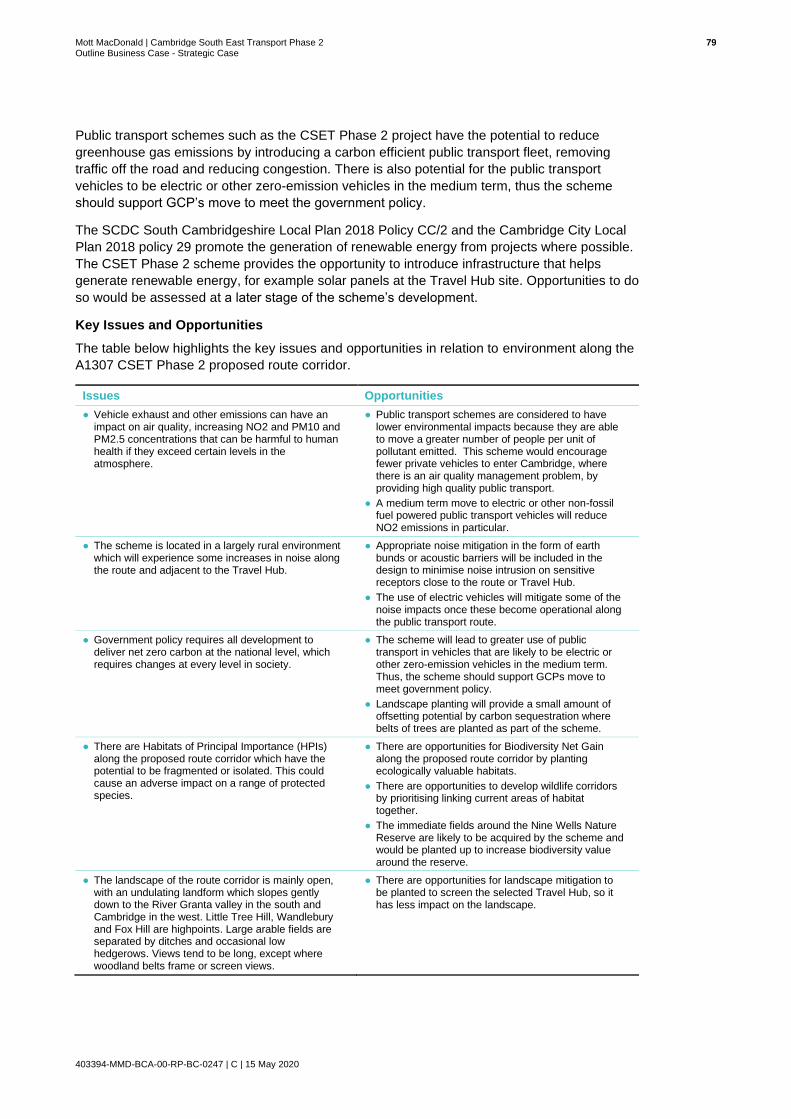
Mott MacDonald | Cambridge South East Transport Phase 2 79 Outline Business Case - Strategic Case
403394-MMD-BCA-00-RP-BC-0247 | C | 15 May 2020
Public transport schemes such as the CSET Phase 2 project have the potential to reduce
greenhouse gas emissions by introducing a carbon efficient public transport fleet, removing
traffic off the road and reducing congestion. There is also potential for the public transport
vehicles to be electric or other zero-emission vehicles in the medium term, thus the scheme
should support GCP’s move to meet the government policy.
The SCDC South Cambridgeshire Local Plan 2018 Policy CC/2 and the Cambridge City Local
Plan 2018 policy 29 promote the generation of renewable energy from projects where possible.
The CSET Phase 2 scheme provides the opportunity to introduce infrastructure that helps
generate renewable energy, for example solar panels at the Travel Hub site. Opportunities to do
so would be assessed at a later stage of the scheme’s development.
Key Issues and Opportunities
The table below highlights the key issues and opportunities in relation to environment along the
A1307 CSET Phase 2 proposed route corridor.
Issues Opportunities
● Vehicle exhaust and other emissions can have an impact on air quality, increasing NO2 and PM10 and PM2.5 concentrations that can be harmful to human health if they exceed certain levels in the atmosphere.
● Public transport schemes are considered to have lower environmental impacts because they are able to move a greater number of people per unit of pollutant emitted. This scheme would encourage fewer private vehicles to enter Cambridge, where there is an air quality management problem, by providing high quality public transport.
● A medium term move to electric or other non-fossil fuel powered public transport vehicles will reduce NO2 emissions in particular.
● The scheme is located in a largely rural environment which will experience some increases in noise along the route and adjacent to the Travel Hub.
● Appropriate noise mitigation in the form of earth bunds or acoustic barriers will be included in the design to minimise noise intrusion on sensitive receptors close to the route or Travel Hub.
● The use of electric vehicles will mitigate some of the noise impacts once these become operational along the public transport route.
● Government policy requires all development to deliver net zero carbon at the national level, which requires changes at every level in society.
● The scheme will lead to greater use of public transport in vehicles that are likely to be electric or other zero-emission vehicles in the medium term. Thus, the scheme should support GCPs move to meet government policy.
● Landscape planting will provide a small amount of offsetting potential by carbon sequestration where belts of trees are planted as part of the scheme.
● There are Habitats of Principal Importance (HPIs) along the proposed route corridor which have the potential to be fragmented or isolated. This could cause an adverse impact on a range of protected species.
● There are opportunities for Biodiversity Net Gain along the proposed route corridor by planting ecologically valuable habitats.
● There are opportunities to develop wildlife corridors by prioritising linking current areas of habitat together.
● The immediate fields around the Nine Wells Nature Reserve are likely to be acquired by the scheme and would be planted up to increase biodiversity value around the reserve.
● The landscape of the route corridor is mainly open, with an undulating landform which slopes gently down to the River Granta valley in the south and Cambridge in the west. Little Tree Hill, Wandlebury and Fox Hill are highpoints. Large arable fields are separated by ditches and occasional low hedgerows. Views tend to be long, except where woodland belts frame or screen views.
● There are opportunities for landscape mitigation to be planted to screen the selected Travel Hub, so it has less impact on the landscape.

Mott MacDonald | Cambridge South East Transport Phase 2 80 Outline Business Case - Strategic Case
403394-MMD-BCA-00-RP-BC-0247 | C | 15 May 2020
The landscape is more intimate around the villages of Babraham, Stapleford, Sawston and Great Shelford, where streets and garden boundaries tend to be tree-lined. The designed landscapes of Babraham Hall, Wandlebury Country Park, Granta Park and The Gog Magog Golf Club give parts of the route a more intimate wooded quality. The introduction of access roads and hard engineering into the landscape is likely to have an adverse impact.
● The design of the route would be carried out in a manner that minimised visual intrusion and impacts on landscape character, this would be achieved by changing the vertical profile of the route and sensitive planting along the route.
● There are known archaeological remains of regional and potentially national significance within the footprint of the proposed route corridor.
● The scheme will be assessed using aerial photographic interpretation, geophysical surveys and trial trenching to better understand the buried archaeology along the route. This will increase knowledge and understanding of the setting around Wandlebury and the Magog Scheduled Monuments.
● There is potential to incorporate some of the scheme drainage discharge into Hobson Brook – which is a heritage feature running towards the city and which is frequently dry. Increasing flows in the drainage feature could have heritage benefits which need to be assessed.
● The scheme crosses the flood plain of the River Granta and is within the footprint of the Source Protection Zone 2 of groundwater fed public water supplies
● The scheme design that crosses the River Granta will ensure that there is no increase in flood risk arising from the construction of the bridge(s) over the river.
● There is opportunity to create water related habitat to compensate for lost flood storage in the River Granta flood plain.
● The scheme will have SuDS drainage installed along the route and in the Travel Hub. This will ensure runoff does not contribute to flood risk and should also ensure the quality of runoff discharged to infiltrate into the ground does not affect groundwater quality that is used for public water supplies.
● Opportunities to help with any wider flood management plans being developed by the Environment Agency will be explored during the EIA phase of the project.
● The proposed route corridor sits largely within the Cambridge Green Belt which has strong protection at both local and national level.
● Appropriate landscaping and sensitive routing of the scheme. Or siting of the Travel Hub will minimise impacts on Green Belt function.
So, what does this mean for CSET Phase 2?
The proposed route for the scheme is in an environmentally sensitive area, as the majority of
the route is within the Cambridgeshire Green Belt which is protected at both local and national
level. There are also known archaeological remains of regional and potentially national
significance within the footprint of the proposed route corridor.
Despite environmental challenges, the scheme offers the opportunity to enhance biodiversity
within the area, by prioritising linking areas of existing habitats to create wildlife corridors and
creating new habitats in other areas, both contributing to a positive biodiversity net gain.
Landscape mitigation to effectively screen the Travel Hub and proposed route will also add to
biodiversity net gain and could enhance the landscape character of the area with sensitive,
community friendly planting schemes.
The major environmental benefit the scheme offers is to sustainable transport options into
Cambridge city centre, reducing the number of private vehicles on the road and reducing
congestion. This will help to reduce emissions, be beneficial to local air quality within the
Cambridge city AQMA and contribute to reducing carbon emissions from vehicular transport.

Mott MacDonald | Cambridge South East Transport Phase 2 81 Outline Business Case - Strategic Case
403394-MMD-BCA-00-RP-BC-0247 | C | 15 May 2020
10 Highways Network and Traffic
A large majority of commuters into and within Cambridge opt for private car travel due to a lack
of viable and attractive travel alternatives. As a result, high volumes of traffic use the A1307.
High volumes of traffic, particularly during peak periods, have an impact on road safety for all
road users. There is evidence to suggest that congestion associated with the number of
vehicles using the A1307 may be a contributing factor to the number of recorded collisions
along the route. High volumes of vehicles using the route may contribute to the perception that
the route is not safe for pedestrians and cyclists, discouraging the use of sustainable modes of
travel into Cambridge. This section of the Strategic Case evidences the key highway network,
traffic and road safety issues and opportunities associated with the A1307 and the surrounding
road network.
10.1 A1307 Corridor
The A1307 is a secondary class A road between the A14 at Junction 31 in Cambridge and
Haverhill, Suffolk. The corridor is a key radial route to the centre of Cambridge and serves
several rural villages. Outside of the centre of Cambridge, the route is predominately rural and
consists of a mixture of single lane and dual lane carriageways with varying speed limits
throughout. The geographical scope of the A1307 corridor in its entirety is illustrated below in
Figure 10.1. The extent of the Phase 2 works stretches from the A11/A1307/A505 junction,
north west to the CBC at Francis Crick Avenue.
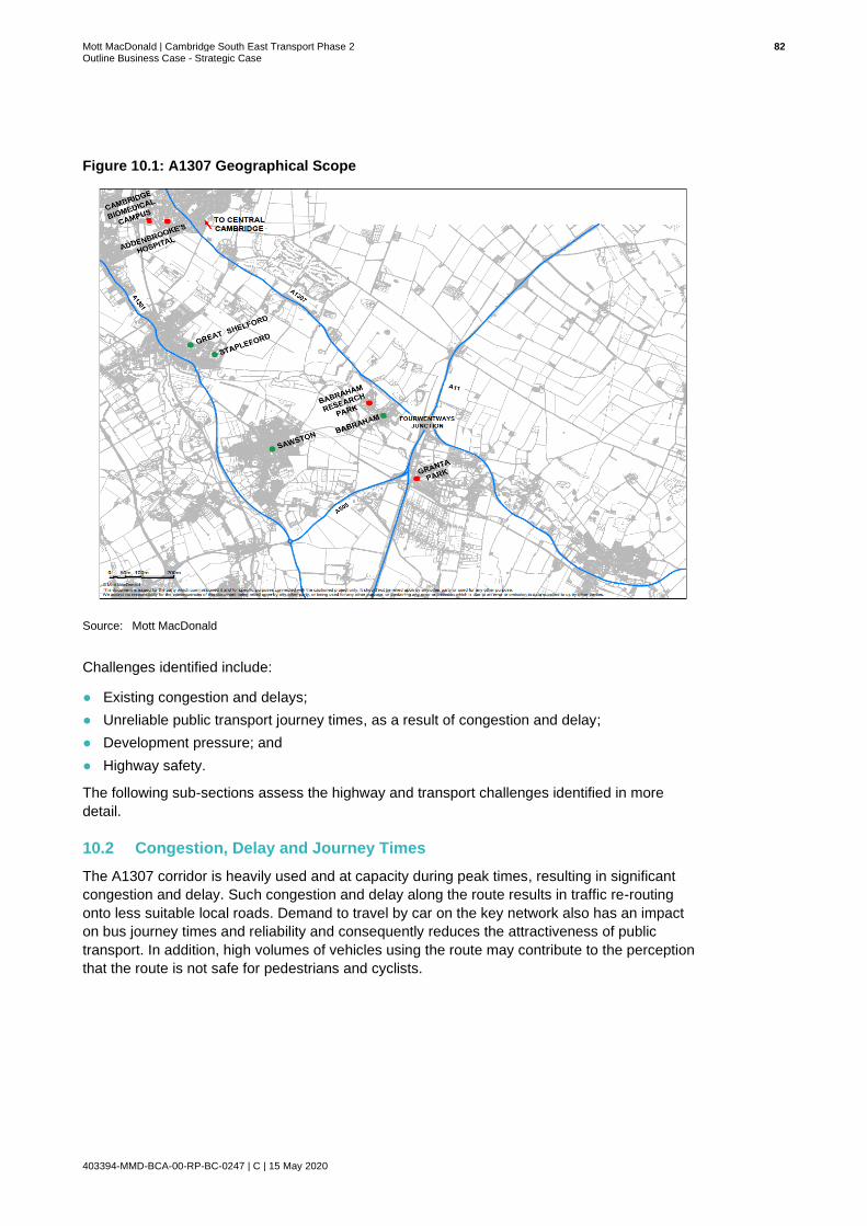
Mott MacDonald | Cambridge South East Transport Phase 2 82 Outline Business Case - Strategic Case
403394-MMD-BCA-00-RP-BC-0247 | C | 15 May 2020
Figure 10.1: A1307 Geographical Scope
Source: Mott MacDonald
Challenges identified include:
● Existing congestion and delays;
● Unreliable public transport journey times, as a result of congestion and delay;
● Development pressure; and
● Highway safety.
The following sub-sections assess the highway and transport challenges identified in more
detail.
10.2 Congestion, Delay and Journey Times
The A1307 corridor is heavily used and at capacity during peak times, resulting in significant
congestion and delay. Such congestion and delay along the route results in traffic re-routing
onto less suitable local roads. Demand to travel by car on the key network also has an impact
on bus journey times and reliability and consequently reduces the attractiveness of public
transport. In addition, high volumes of vehicles using the route may contribute to the perception
that the route is not safe for pedestrians and cyclists.

Mott MacDonald | Cambridge South East Transport Phase 2 83 Outline Business Case - Strategic Case
403394-MMD-BCA-00-RP-BC-0247 | C | 15 May 2020
Population growth means trips on the transport network will increase by 25,000 by 2031 (from
101,000 in 2011 to 126,000)28 , further exacerbating the existing problems. GCP predicts that
without action, by 2031:
● Traffic in Cambridge will increase by over 30% in the morning peak;
● Traffic in South Cambridgeshire will increase by almost 40% in the morning peak; and
● The time spent in congestion will more than double.
Figure 10.2 illustrates the impact on journey times for those travelling along A1307 between
central Cambridge and the junction between the A11/A1307 as a result of planned development
under current conditions.
Figure 10.2: Anticipated Impact on Journey Times
Source: Cambridge and South Cambridgeshire Local Plan
10.3 A1307 Traffic Flows
Automatic Traffic Count (ATC) data sourced from the Department for Transport (DfT) has been
analysed for the A1307 corridor. Six traffic counters are positioned along the A1307 from
Cambridge to Haverhill, the locations of the six ATC’s are illustrated in Figure 10.3 and are
numbered 1 to 6.
28 https://www.greatercambridge.org.uk

Mott MacDonald | Cambridge South East Transport Phase 2 84 Outline Business Case - Strategic Case
403394-MMD-BCA-00-RP-BC-0247 | C | 15 May 2020
Figure 10.3: ATC Locations
Source: Mott MacDonald/DfT
Annual Average Daily Flow’s (AADF) recorded at these locations for the period 2013-2016 are
summarised in Table 10.1 and displayed in Figure 10.4. Data recorded at all of the ATC sites,
except for ATC 1, indicate that traffic counts have steadily grown over the 4-year period. The
decline in traffic counts at ATC 1 may be attributable to the introduction of traffic management
measures within the city centre.
Table 10.1: Two-way AADF Counts from ATC’s Located Along the A1307
Year ATC 1 ATC 2 ATC 3 ATC 4 ATC 5 ATC 6
2013 12717 10562 18746 16418 15466 14008
2014 11916 10865 19300 16884 15898 14378
2015 12212 11135 19427 17548 16580 14968
2016 12446 11370 19800 17908 16938 15280
Source: DfT

Mott MacDonald | Cambridge South East Transport Phase 2 85 Outline Business Case - Strategic Case
403394-MMD-BCA-00-RP-BC-0247 | C | 15 May 2020
Figure 10.4: AADF Counts from ATC Sites Located Along the A1307
Source: Mott MacDonald/DfT
The highest traffic counts along the A1307 are recorded at ATC 3, just south of the Cambridge
Biomedical Campus. The significantly lower traffic counts obtained at ATCs 1 and 2, just north
of the Biomedical Campus, suggest that the Biomedical Campus is the main draw of trips on
this part of the network. High traffic volumes along this section of the route demonstrate that the
network is already under pressure and the traffic count total at ATC 3 is likely to increase as the
Biomedical Campus continues to expand. It is clear from the ATC data that measures are
required to ensure connectivity to the city centre is maintained whilst growth at the Biomedical
centre continues. Increasing traffic counts for ATC’s 2 to 6 over the 4-year period illustrate that,
outside of the city centre, demand is increasing along the entire length of the A1307. Transport
infrastructure is required to enable future growth and also ensure connectivity to the city centre
is not impeded.
ATC’s 3 and 4 demonstrate the highest volumes of traffic along the route. This is particularly
pertinent to CSET Phase 2 since the introduction of a dedicated public transport route will
provide much needed relief to this section of the route.
The ATC data presented provides evidence that the route is operating at capacity, particularly
for the section of the A1307 within the Phase 2 scheme extents. The data therefore supports
the introduction of viable sustainable travel options provided through CSET Phase 2 as a
practical means to manage existing and anticipated traffic volumes.
0
5,000
10,000
15,000
20,000
25,000
ATC 1 ATC 2 ATC 3 ATC 4 ATC 5 ATC 6
AADF Counts
2013 2014 2015 2016

Mott MacDonald | Cambridge South East Transport Phase 2 86 Outline Business Case - Strategic Case
403394-MMD-BCA-00-RP-BC-0247 | C | 15 May 2020
10.4 Vehicle Speeds Along the A1307 Corridor
Trafficmaster Data has been obtained from CCC for the A1307 corridor throughout March 2018. The data presents vehicle speeds across 12 link
groups along the A1307, from Cambridge to Haverhill. Figure 10.5 illustrates the location of the link groups referenced in Table 10.2 to Table 10.4.
Figure 10.5: Trafficmaster Link Groups
Source: Mott MacDonald

Mott MacDonald | Cambridge South East Transport Phase 2 87 Outline Business Case - Strategic Case
403394-MMD-BCA-00-RP-BC-0247 | C | 15 May 2020
Table 10.2 displays average vehicle speeds Westbound (WB) towards central Cambridge and
Eastbound (EB) towards the A1307/A11 in 2018 during the AM and PM peak on weekdays for
link groups 1 to 5, which is the geographic scope of the scheme. Data indicates long delays on
the immediate approach into Central Cambridge (link group 1). Congestion appears to be worse
on the westbound approach into Central Cambridge, particularly during the morning peak.
Significant delays are also noted on the eastbound approach to the A11 Roundabout (link group
4) during the PM peak.
Table 10.2: Trafficmaster Data Weekday Analysis
Speed in Miles per Hour
08:00-09:00 17:00-18:00
Link Group Link Length (m)
WB EB WB EB
1 Cherry Hinton Rd. – Haverhill Road 1,300 14 37 40 38
2 Haverhill Road – Cambridge Lodge Roundabout
2,888 49 47 49 42
3 Cambridge Lodge Roundabout – High St. Babraham
1,044 43 46 47 41
4 High St. Babraham – A11 Roundabout
706 38 41 45 15
5 A11 Roundabout – Hildersham Road 1,477 30 35 36 30
Source: DfT
Table 10.3 displays average vehicle speeds Westbound (WB) towards central Cambridge and
Eastbound (EB) towards Haverhill in 2018 during the AM and PM peak at weekends. Higher
vehicle speeds in both directions can be seen, compared to vehicle speeds for weekdays during
the same time periods. Increased vehicle speeds suggest shorter delays and less congestion
during weekends, demonstrating the adverse impact of commuter journeys on travel times
along the A1307 corridor.
Table 10.3: Trafficmaster Data Weekend Analysis
Speed in Miles per Hour
08:00-09:00 17:00-18:00
Link Group Link Length
(m)
WB EB WB EB
1 Cherry Hinton Road 1,300 47 44 47 39
2 Haverhill Road 2,888 55 53 56 51
3 Cambridge Lodge Roundabout
1,044 48 46 53 47
4 High Street, Babraham 706 44 38 52 47
5 A11 Roundabout 1,477 40 40 38 41
Source: DfT

Mott MacDonald | Cambridge South East Transport Phase 2 88 Outline Business Case - Strategic Case
403394-MMD-BCA-00-RP-BC-0247 | C | 15 May 2020
Table 10.4 provides a comparison of weekday speeds versus weekend speeds to illustrate the
impact of commuter demand on travel times indicated in Table 10.2 and Table 10.3.
Table 10.4: Difference Between Weekday and Weekend Speeds on A1307
Speed in Miles per Hour
08:00-09:00 17:00-18:00
Link Group Link Length
(m)
WB EB WB EB
1 Cherry Hinton Road 1,300 33 7 6 2
2 Haverhill Road 2,888 6 6 7 9
3 Cambridge Lodge Roundabout
1,044 6 0 6 7
4 High Street, Babraham 706 6 3 7 32
5 A11 Roundabout 1,477 10 5 2 10
Source: DfT
The biggest differences in weekday and weekend vehicle speeds can be seen during the AM
peak on the westbound approaches into Cambridge and during the PM peak in the eastbound
direction towards Haverhill. Most notably, a difference of 32mph between weekdays and the
weekend can be seen on the eastbound approach to the junction between High Street and the
A11 (link group 4). There is also a large variation in vehicle speed of circa 33mph westbound
approach to the junction between Cherry Hinton Road and the A1307 (link group 1).
Differences in Trafficmaster data between weekdays and weekends suggest a high level of
commuter flows in both an eastbound and westbound direction, however, the overall pattern of
the data appears to be movement westbound towards central Cambridge. It is however
expected that this trend may change slightly as a result of the growing number of employment
opportunities to the south of Cambridge, resulting in an increased number of commuters
travelling eastbound and a general increase in the number of users of the A1307.
10.5 Vehicle Routing and Journey Times
At SOBC stage Automatic Number Plate Recognition (ANPR) surveys were commissioned at
various locations along the A1307 on Tuesday 18 and Wednesday 19 October 2016 to
understand vehicle routing and journey times along the corridor. A total of 31 ANPR cameras
were installed along the A1307 and A11 corridors from Addenbrooke’s Hospital in the west to
Haverhill in the east. Figure 10.6 details the locations of the ANPR survey cameras installed to
gather origin and destination data and journey times.
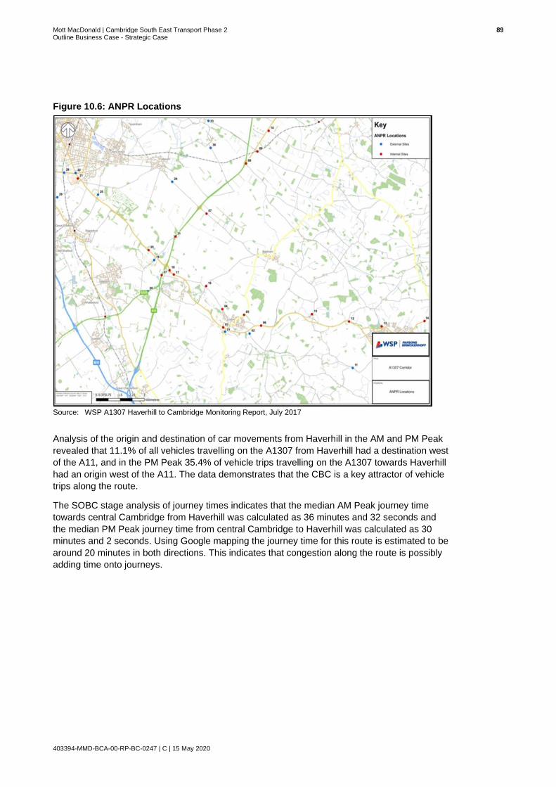
Mott MacDonald | Cambridge South East Transport Phase 2 89 Outline Business Case - Strategic Case
403394-MMD-BCA-00-RP-BC-0247 | C | 15 May 2020
Figure 10.6: ANPR Locations
Source: WSP A1307 Haverhill to Cambridge Monitoring Report, July 2017
Analysis of the origin and destination of car movements from Haverhill in the AM and PM Peak
revealed that 11.1% of all vehicles travelling on the A1307 from Haverhill had a destination west
of the A11, and in the PM Peak 35.4% of vehicle trips travelling on the A1307 towards Haverhill
had an origin west of the A11. The data demonstrates that the CBC is a key attractor of vehicle
trips along the route.
The SOBC stage analysis of journey times indicates that the median AM Peak journey time
towards central Cambridge from Haverhill was calculated as 36 minutes and 32 seconds and
the median PM Peak journey time from central Cambridge to Haverhill was calculated as 30
minutes and 2 seconds. Using Google mapping the journey time for this route is estimated to be
around 20 minutes in both directions. This indicates that congestion along the route is possibly
adding time onto journeys.

Mott MacDonald | Cambridge South East Transport Phase 2 90 Outline Business Case - Strategic Case
403394-MMD-BCA-00-RP-BC-0247 | C | 15 May 2020
Key Issues and Opportunities
The table below highlights the key issues and opportunities in relation to Highways, Network
and Traffic across the study area.
Issues Opportunities
• Heavy traffic flows are regularly experienced along the section of the A1307 approaching the CBC from the South. This is evidenced in ATC data analysed. Increasingly unattractive conditions are likely to deter further investment, restricting growth potential of the wider area.
• Increasing demand across the A1307 corridor has had an impact on capacity, journey time reliability and possibly road safety.
• Demand on the corridor is likely to increase, worsening congestion and journey times for users of the A1307.
The CBC is key attractor of vehicle trips along the A1307. With growth at the campus projected, traffic flows are likely to increase which will have an adverse impact on journey times along the route.
• Proposed improvements to the transport infrastructure along the A1307 will facilitate more reliable and accessible multi-modal journeys. This will incentivise shifts away from private car usage and reduce congestion around the CBC, ensuring growth continues.
• Proposed infrastructure for public transport, walking and cycling along the A1307 will encourage the uptake of sustainable travel options along the corridor and reduce the demand on the road network.
• Alternative modal options will reduce the dominance of car travel along the A1307, reducing congestion along the corridor and providing more sustainable travel options for users.
Congestion could be considered a key constraint for business investment and growth. Reducing congestion and improving transport provision could help improve network resilience. In tandem this could help encourage investment.
So, what does this mean for CSET Phase 2?
The A1307 currently experiences periods of congestion and delay which has an adverse
impact on journey times. South east Cambridge has restricted modal choice, leaving users
with little choice but to travel by car, increasing congestion and contributing to greenhouse
gas emissions. Significant growth is anticipated across south east Cambridge which will
generate a greater number of trips, leading to a deterioration in journey times and journey
time reliability.
CSET Phase 2 presents the opportunity to provide additional capacity to the transport
network by the introduction of viable alternatives to private car travel, thereby reducing the
pressure on the existing A1307 corridor and improving journey times for users. The scheme
will improve connectivity to key trip attractors via sustainable travel modes.
Increasing the proportion of people who travel to and through south east Cambridge using
sustainable transport will reduce the proportion of users who opt to travel by car, reducing
the pressure on the corridor. The proposed Travel Hub will provide an efficient transport
interchange for users, presenting them with the opportunity to complete their onward
journey via bus, cycling or walking, reducing congestion levels on the approach to central
Cambridge and the CBC.

Mott MacDonald | Cambridge South East Transport Phase 2 91 Outline Business Case - Strategic Case
403394-MMD-BCA-00-RP-BC-0247 | C | 15 May 2020
11 Road Safety
This section of the report provides a summary of the collision analysis undertaken for the CSET
Phase 2 scheme extents. For the purposes of analysis, scheme extents have been prescribed
as the stretch of carriageway between Cambridge Biomedical Campus and the A1307/A11
roundabout.
11.1 Collision Analysis
Analysis has considered STATS19 data recorded by the Police and cleansed and tabulated by
the Department for Transport (DfT) and data featured on the CrashMap website. Data has been
reviewed for the five-year period covering 2014-2018 inclusive.
STATS19 and CrashMap provides data on injury collisions only, therefore damage collisions
have not been reviewed as part of the analysis. General assumptions regarding collision
contributory factors have been made based on the traffic flows, traffic speeds and the highway
layout associated with the A1307 route.
A total of 52 collisions were recorded for the A1307 between Addenbrooke’s Hospital and the
A1307/A11 junction for the five-year analysis period. Figure 11.1 illustrates the locations of the
recorded collisions for the full extent of the study area.
Figure 11.1: Map of Personal Injury Collisions (PIC) for the Five-Year Period 2014-2018
Source: Mott MacDonald

Mott MacDonald | Cambridge South East Transport Phase 2 92 Outline Business Case - Strategic Case
403394-MMD-BCA-00-RP-BC-0247 | C | 15 May 2020
Table 11.1 provides a breakdown of the collision locations along the route and details the
severity of the collisions recorded.
Table 11.1: Difference Between Weekday and Weekend Speeds on A1307
Location Collision Severity
Slight Serious
Fatal Total
A1307/Fendon Road roundabout 7 1 0 8
A1307/Nightingale Avenue 2 0 0 2
A1307 near junction with Wort’s Causeway 1 0 0 1
Babraham Road / Granham’s Road 2 0 0 2
A1307 Newbury Farm 0 1 0 1
A1307 Babraham Road Park & Ride 1 0 0 1
A1307/Hinton Way roundabout 3 0 0 3
A1307 NW of Haverhill Road 1 1 0 2
A1307/Haverhill Road 4 1 0 5
A1307 Babraham Road dual carriageway 3 0 0 3
A1307 Babraham Road Magog Farm Barns 1 0 0 1
A1307 Babraham Road Mile Road 0 1 0 1
A1307 Cambridge Road Babraham Research Campus
1 0 0 1
A1307 Cambridge Road between Babraham Research Campus and High Street
5 0 0 5
A1307/High Street 4 1 0 5
A1307/A11 9 2 0 11
Total collisions in 5-year period 44 8 0 52
*Sites with 4 or more collisions within proximity, known as a Collision Cluster Site.
Source: Cambridge County Council
The collision data demonstrates that of the 52 collisions recorded for the five-year period 2014-
2018, a total of 8 collisions are recorded as serious in severity and 44 collisions are recorded as
slight in severity.
The collision profile in Table 11.2 below illustrates collisions recorded by year.
Table 11.2: Personal Injury Collisions by Year, 2014-2018
Year Number of Collisions
Proportion of Total (%)
2014 8 16%
2015 17 33%
2016 14 25%
2017 8 16%
2018 5 10%
Total: 52 100%
Source: Mott MacDonald
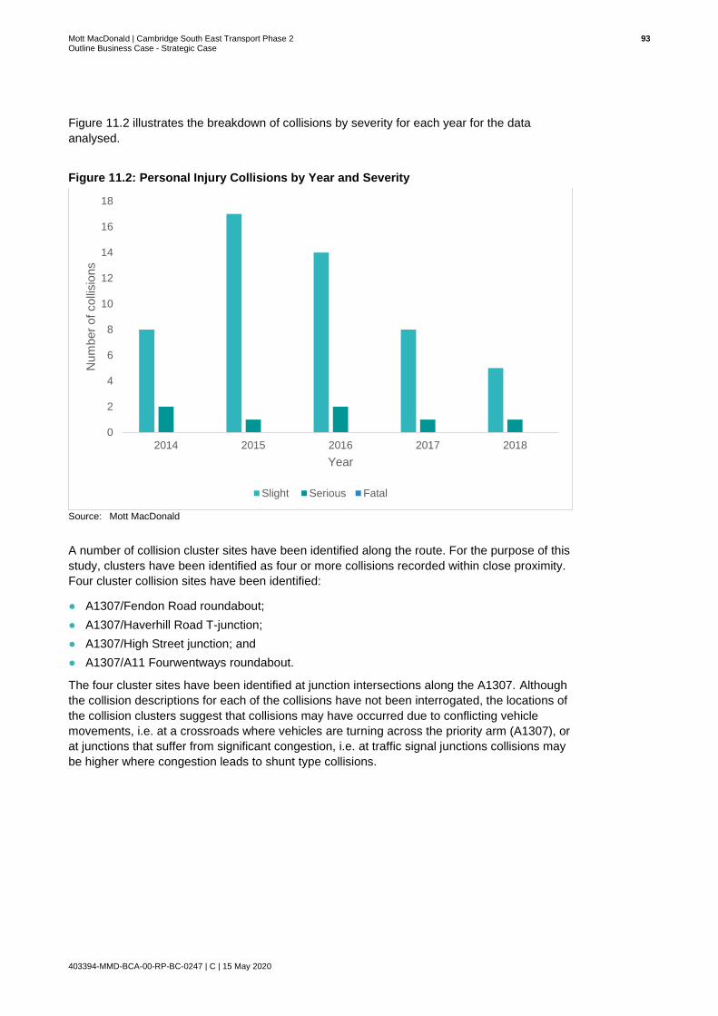
Mott MacDonald | Cambridge South East Transport Phase 2 93 Outline Business Case - Strategic Case
403394-MMD-BCA-00-RP-BC-0247 | C | 15 May 2020
Figure 11.2 illustrates the breakdown of collisions by severity for each year for the data
analysed.
Figure 11.2: Personal Injury Collisions by Year and Severity
Source: Mott MacDonald
A number of collision cluster sites have been identified along the route. For the purpose of this
study, clusters have been identified as four or more collisions recorded within close proximity.
Four cluster collision sites have been identified:
● A1307/Fendon Road roundabout;
● A1307/Haverhill Road T-junction;
● A1307/High Street junction; and
● A1307/A11 Fourwentways roundabout.
The four cluster sites have been identified at junction intersections along the A1307. Although
the collision descriptions for each of the collisions have not been interrogated, the locations of
the collision clusters suggest that collisions may have occurred due to conflicting vehicle
movements, i.e. at a crossroads where vehicles are turning across the priority arm (A1307), or
at junctions that suffer from significant congestion, i.e. at traffic signal junctions collisions may
be higher where congestion leads to shunt type collisions.
0
2
4
6
8
10
12
14
16
18
2014 2015 2016 2017 2018
Num
ber
of
colli
sio
ns
Year
Slight Serious Fatal

Mott MacDonald | Cambridge South East Transport Phase 2 94 Outline Business Case - Strategic Case
403394-MMD-BCA-00-RP-BC-0247 | C | 15 May 2020
Key Issues and Opportunities
The table below highlights the key issues and opportunities in relation to road safety across the
study area.
Issues Opportunities
● Collisions recorded along the A1307 between Addenbrooke’s Hospital and the A1307/A11 Fourwentways roundabout may be associated with high volumes of traffic for some sections of the route and the consequential congestion and delay.
● A number of recorded collisions may be associated with high vehicle speeds for some parts of the route. This may contribute to the perception that the route is not safe for pedestrians and cyclists and discourage uptake.
● Provision for cyclists and pedestrians in a safe environment will encourage sustainable travel.
● Further improvements to cycling and walking provision will build upon interventions delivered in CSET Phase 1 to improve road safety for a number of users.
So, what does this mean for CSET Phase 2?
Analysis of Personal Injury Collision (PIC) data for the A1307 suggests that a number of
collisions which have occurred between 2014-2018 are attributable to the traffic volumes and
speed conditions along the corridor.
CSET Phase 2 presents the opportunity to improve the safety of cyclists and pedestrians
through provision of off-highway cycling and walking infrastructure, providing an alternative to
the existing network. The scheme also builds upon the improvements delivered in CSET Phase
1 across the study area.
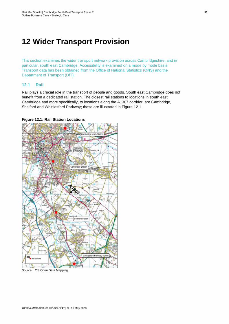
Mott MacDonald | Cambridge South East Transport Phase 2 95 Outline Business Case - Strategic Case
403394-MMD-BCA-00-RP-BC-0247 | C | 15 May 2020
12 Wider Transport Provision
This section examines the wider transport network provision across Cambridgeshire, and in
particular, south east Cambridge. Accessibility is examined on a mode by mode basis.
Transport data has been obtained from the Office of National Statistics (ONS) and the
Department of Transport (DfT).
12.1 Rail
Rail plays a crucial role in the transport of people and goods. South east Cambridge does not
benefit from a dedicated rail station. The closest rail stations to locations in south east
Cambridge and more specifically, to locations along the A1307 corridor, are Cambridge,
Shelford and Whittlesford Parkway; these are illustrated in Figure 12.1.
Figure 12.1: Rail Station Locations
Source: OS Open Data Mapping

Mott MacDonald | Cambridge South East Transport Phase 2 96 Outline Business Case - Strategic Case
403394-MMD-BCA-00-RP-BC-0247 | C | 15 May 2020
Cambridge rail station is served by the Greater Anglia and Great Northern Train Operating
Companies (TOC), connecting Cambridge with the rest of East Anglia and London. London
routes are typically into either King’s Cross or Liverpool Street stations, whilst regional
destinations include Ipswich, Ely and Norwich. The CrossCountry TOC also provides a service
which travels south east to Stansted Airport and north west to Birmingham via Peterborough.
Thameslink also provides a service to Brighton.
Shelford rail station, located approximately 1.4 miles west of the A1307 along Hinton Way,
provides users with direct services northbound to Cambridge, with journey times of around 8
minutes and southbound to Bishops Stortford and London Liverpool Street in around 90
minutes. Services from Shelford to Cambridge are hourly in the off peak and half hourly during
peak periods.
Whittlesford Parkway is the next station south of Shelford rail station, approximately 3 miles
south-west of the A1307. Whittlesford Parkway serves the village of Whittlesford in
Cambridgeshire with regular Abellio Greater Anglia services on the West Anglia Main Line.
Trains from Whittlesford Parkway run thrice hourly in each direction, with additional trains calling
at peak times to serve commuter demand. Two trains run southbound to London Liverpool
Street; one semi-fast and one stopping. One southbound train runs semi-fast to Stansted
Airport. Two non-stop trains run through to Cambridge, the third northbound train calls at
Shelford. In peak periods, a select number of trains continue to Ely and King’s Lynn.
It should be noted that a new station in the south of Cambridge has been identified as part of
the Cambridgeshire Long Term Transport Strategy. Work is in the early stages and whilst it is
progressing through Network Rail’s Governance for Railway Investment Projects (GRIP)
process, neither the station footprint nor location have currently been determined. If delivered,
the new station, along with a four-track line, has the potential to improve rail accessibility in
south east Cambridge, providing appropriate supporting transport infrastructure is also
delivered.
Current Station Usage
Cambridge rail station is the busiest in the east of England29 and provides local and regional
transport connections for a significant number of people. Since 2011 there has been a 31%
increase in the number of passenger entries and exits at Cambridge rail station.
Shelford and Whittlesford Parkway have also experienced major increases in passenger
numbers over the same time period. Estimated passenger entries and exits can be seen in
Table 12.1, along with the estimated percentage increase over the six-year period.
Table 12.1: Estimates Number of Passenger Entries and Exits
Station 2011-2012
2012-2013
2013-2014
2014-
2015
2015-
2016
2016-
2017
2017-
2018
% change
Cambridge 8,823,236
9,168,938
9,824,859
10,420,178
10,954,212,
11,424,902 11,530,238
+31
Shelford 145,900
154,060
152,976
159,920 174,920 182,138 204,618 +40
Whittlesford Parkway
343,772
396,622
431, 544
454,734, 493,004 509,744 538,972 +56
Source: Office of Rail and Road
29https://www.thetrainline.com/stations/cambridge?ds_kids=p34781589471&cm=0p4a&msclkid=85ab9a16dcca1301306fc1cdc28f6d2b&g
clid=CIGnm9XDs94CFQ6MhQod9-EELg&gclsrc=ds

Mott MacDonald | Cambridge South East Transport Phase 2 97 Outline Business Case - Strategic Case
403394-MMD-BCA-00-RP-BC-0247 | C | 15 May 2020
Passenger numbers at Cambridge rail station are at an all-time high. The station experienced
over 11.5 million entries and exits in the year 2017-2018. In order to accommodate increasing
demand, £16 million has recently been spent at the station to deliver a new platform30. The new
platform has meant that trains which are 50% longer and contain extra seats are able to stop at
Cambridge. The delivery of the new platform has boosted capacity and reduced overcrowding
on a number of lines. Figure 12.2 provides a graph of passenger entries and exits between
2011 and 2018.
Figure 12.2: Passenger Entries and Exits - Cambridge Rail Station
Source: Office of Rail and Road
Shelford and Whittlesford Parkway, situated on the West Anglia Main Line, are much smaller
stations than Cambridge. However, both stations have also experienced a significant increase in
passenger numbers since 2011. Passenger numbers at Whittlesford Parkway have nearly
doubled since 2011, placing increased pressure on the station and associated services.
It is likely that the growth in passenger numbers at both stations is associated with the growth of
central Cambridge and also the more recent increase in employment opportunities across
peripheral areas, such as Babraham Research Campus and Granta Park.
The A505 provides a direct connection between Whittlesford Parkway and Granta Park making
multi-modal journeys quick and attractive. Journey times by bike between Whittlesford Parkway
and Granta Park of under 20 minutes can be achieved.
30 https://www.cambridge-news.co.uk/news/cambridge-news/cambridge-station-national-rail-awards-13496757 [Accessed 14/0519]
0
2,000,000
4,000,000
6,000,000
8,000,000
10,000,000
12,000,000
14,000,000
2011-2012 2012-2013 2013-2014 2014-2015 2015-2016 2016-2017 2017-2018
Cambridge
Cambridge
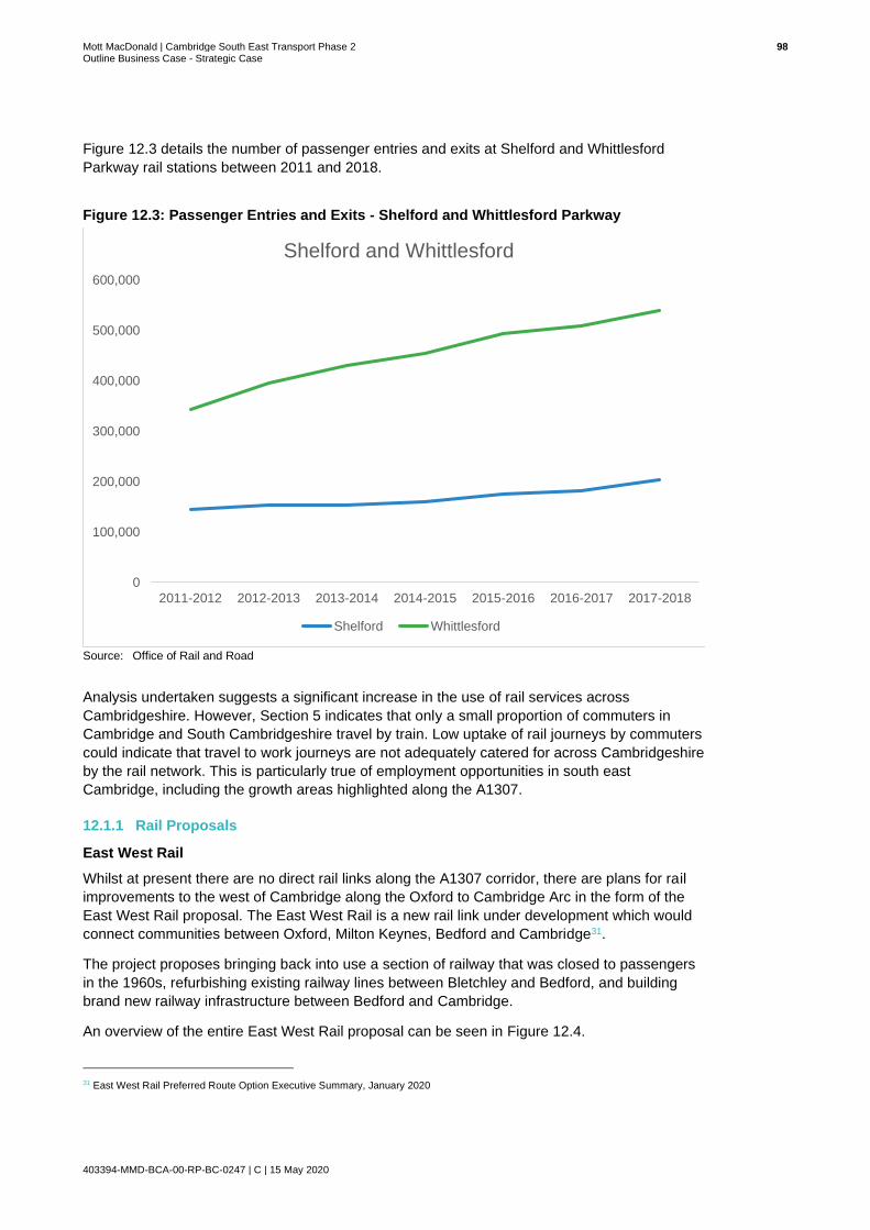
Mott MacDonald | Cambridge South East Transport Phase 2 98 Outline Business Case - Strategic Case
403394-MMD-BCA-00-RP-BC-0247 | C | 15 May 2020
Figure 12.3 details the number of passenger entries and exits at Shelford and Whittlesford
Parkway rail stations between 2011 and 2018.
Figure 12.3: Passenger Entries and Exits - Shelford and Whittlesford Parkway
Source: Office of Rail and Road
Analysis undertaken suggests a significant increase in the use of rail services across
Cambridgeshire. However, Section 5 indicates that only a small proportion of commuters in
Cambridge and South Cambridgeshire travel by train. Low uptake of rail journeys by commuters
could indicate that travel to work journeys are not adequately catered for across Cambridgeshire
by the rail network. This is particularly true of employment opportunities in south east
Cambridge, including the growth areas highlighted along the A1307.
12.1.1 Rail Proposals
East West Rail
Whilst at present there are no direct rail links along the A1307 corridor, there are plans for rail
improvements to the west of Cambridge along the Oxford to Cambridge Arc in the form of the
East West Rail proposal. The East West Rail is a new rail link under development which would
connect communities between Oxford, Milton Keynes, Bedford and Cambridge31.
The project proposes bringing back into use a section of railway that was closed to passengers
in the 1960s, refurbishing existing railway lines between Bletchley and Bedford, and building
brand new railway infrastructure between Bedford and Cambridge.
An overview of the entire East West Rail proposal can be seen in Figure 12.4.
31 East West Rail Preferred Route Option Executive Summary, January 2020
0
100,000
200,000
300,000
400,000
500,000
600,000
2011-2012 2012-2013 2013-2014 2014-2015 2015-2016 2016-2017 2017-2018
Shelford and Whittlesford
Shelford Whittlesford

Mott MacDonald | Cambridge South East Transport Phase 2 99 Outline Business Case - Strategic Case
403394-MMD-BCA-00-RP-BC-0247 | C | 15 May 2020
Figure 12.4: Proposed East West Rail Corridor
Source: East West Rail Preferred Route Option Document- January 2020
Completed in 2016, the section between Oxford and Bicester Village combined upgrading the
track with major improvements to local stations and Chiltern Railways began running services
from Oxford through to London via Bicester in 2017.
The section from Bicester to Milton Keynes and Bedford involves reinstating parts of the old
track, upgrading stations and building a new station at Winslow. A Transport and Works Act
Order (TWAO) was submitted in July 2018 and the Secretary of State for Transport is expected
to make a decision on this submission early in 2020. If granted, construction is expected to start
this year, following the final investment decision by government.
Options were developed for the Bedford to Cambridge section and consultation was held
between January and March 2019 where the public were presented with a shortlist of five broad
route alignments. The results of that consultation were published in January 2020, and based
on responses, found that the preferred route alignment option between Bedford and Cambridge
would link existing stations in Bedford and Cambridge with communities in Cambourne and the
area north of Sandy, south of St. Neots. Figure 12.5 illustrates this preferred alignment.
Of relevance to CSET Phase 2, this section of the East West Rail alignment will connect the
growing population of Cambourne with environmentally sustainable transport and could
integrate with proposed improvements to the local transport network in south Cambridgeshire
such as the busway extension and the Cambridgeshire Autonomous Metro (CAM). CSET, along
with the developing Cambourne to Cambridge scheme is essentially Phase 1 of CAM delivery
and as such will need to consider the impacts and synergies between the emerging preferred
CSET option and this preferred alignment for East West Rail.

Mott MacDonald | Cambridge South East Transport Phase 2 100 Outline Business Case - Strategic Case
403394-MMD-BCA-00-RP-BC-0247 | C | 15 May 2020
Figure 12.5: Preferred Route Alignment: Bedford to Cambridge
Source: East West Rail Preferred Consultation Option Executive Summary, January 2020
On the basis of consultation, the East West Railway Company are now beginning to develop
options within the preferred route alignment. Consideration will be given to station sites, land
and connections with local transport networks and the CSET development team will need to
liaise with the East West Railway Company to ensure synergies between the schemes. In this
manner the benefits of both schemes can be maximised in a holistic manner that addresses the
wider strategic objectives of economic growth and improved transport connectivity in the area.
Cambridge South Station
The proposed new rail station at Cambridge South aims to improve connectivity between the
growing Biomedical Campus and international gateways, to reduce reliance on Cambridge
station for travel to the southern fringe, and to improve sustainable transport access into the
Southern Fringe.
The proposed Cambridge South Station would be located to the west of the A1307. With
appropriate provision for interchange, CSET Phase 2 would complement the delivery of the
proposed Cambridge South Station in providing south Cambridge with a holistic sustainable
transport network. Figure 12.6 displays the most recent proposal for the general location of
Cambridge South Station.

Mott MacDonald | Cambridge South East Transport Phase 2 101 Outline Business Case - Strategic Case
403394-MMD-BCA-00-RP-BC-0247 | C | 15 May 2020
Figure 12.6: Cambridge South Station
Source: Cambridge South Station Briefing Note, CCC, 2018
12.2 Bus
This sub-section explores the bus network and provision of services in south east
Cambridgeshire. Bus travel presents an efficient way to transport people around urban areas
and the periphery. Buses are categorised as a more sustainable and effective mode of transport
which utilises highway space more efficiently. Bus travel also presents a relatively affordable
means of transport and as such is a valued travel option.
Regular Bus Network
Cambridgeshire’s bus network is primarily composed of a wide-reaching traditional bus network
complimented by ‘The Busway’-Cambridgeshire’s Guided Busway. Collectively these two
networks provide good coverage across Cambridge and South Cambridgeshire. Cambridge’s
bus station located on Drummer Street acts as a hub for bus activity with most buses to and
from destinations outside the city starting and terminating at this interchange or adjacent on-
street bus stops.

Mott MacDonald | Cambridge South East Transport Phase 2 102 Outline Business Case - Strategic Case
403394-MMD-BCA-00-RP-BC-0247 | C | 15 May 2020
Figure 12.7 displays bus routes within the study area which either run along the A1307, run
parallel to the A1307 or intercept with the A1307.
Figure 12.7: Bus Routes within the Study Area
Source: Cambridgeshire County Council/Sustrans
In total there are 16 bus stops (eight on each carriageway) on the A1307 between
Addenbrooke’s Hospital and Linton as detailed in Figure 12.8.

Mott MacDonald | Cambridge South East Transport Phase 2 103 Outline Business Case - Strategic Case
403394-MMD-BCA-00-RP-BC-0247 | C | 15 May 2020
Figure 12.8: Bus Routes within the Study Area
Source: Cambridgeshire County Council/Sustrans
Details of those services which operate along the A1307 and A1301 are summarised in Table
12.2. The information provided has been taken from the CCC website.

Mott MacDonald | Cambridge South East Transport Phase 2 104 Outline Business Case - Strategic Case
403394-MMD-BCA-00-RP-BC-0247 | C | 15 May 2020
Table 12.2: Bus Services on A1307 and A1301
Bus Service Stops Weekday Services Saturday Services Sunday Services
13 Gold- Cambridge, Linton, Haverhill
18 18 Services
06:55 to 00:59
16 Services
08:00 to 00:59
14 Services
09:20 to 00:26
13 Gold- Haverhill, Linton, Cambridge
16 17 Services
05:44 to 23:03
17 Services
06:52 to 23:03
14 Services
07:33 to 22:35
13A Gold- Cambridge, Haverhill
15 12 Services
07:25 to 20:07
12 Services
08:47 to 20:07
No Services
13A Gold- Haverhill, Cambridge
15 16 Services
05:14 to 18:03
11 Services
06:07 to 18:53
No Services
13B Gold- Haverhill, Linton, Cambridge
9 1 Service
07:28 to 09:06
No Services No Services
13C Gold- Haverhill, Linton, Cambridge
11 1 Service
07:28 to 09:06
No Services No Services
31- Cambridge, Stapleford. Cambridge
15 6 Services
06:58 to 14:55
6 Services
10:25 to 19:42
No Services
31- Fowlmere, Stapleford, Cambridge
15 6 Services
06:58 to 14:55
5 Services
06:58 to 14:55
No Services
Babraham Park and Ride- Cambridge City Centre, Babraham Road Park & Ride
4 80 Services
06:46 to 20:49
60 Services
07:41 to 20:49
30 Services
09:19 to 18:24
Babraham Park and Ride - Babraham Park and Ride, Cambridge City Centre
4 77 Services
06:46 to 20:49
70 Services
08:06 to 20:49
36 Services
08:56 to 18:32
X13 Gold- Cambridge, Linton, Haverhill
11 8 Services
16:10 to 19:48
1 Service
16:15 to 17:03
No Services
X13 Gold- Haverhill, Linton, Cambridge
13 5 Services
06:45 to 08:46
No Services No Services
Citi 7- Cambridge, Great Shelford, Stapleford, Sawston, Pampisford, Saffron Waldon
7 Cambridge- Sawston
18 Cambridge – Saffron
Waldon
40-42 services between Cambridge
and Sawston
06.55 to 23.25
12-14 services between Cambridge and Saffron Waldon
06.55-18.15
40-42 services between Cambridge
and Sawston
06.55 to 23.25
12-14 services between Cambridge and Saffron Waldon
6.55-18.15
18- 19 services between Cambridge
and Sawston
No services between Cambridge and Saffron Waldon
Source: https://www.cambridgeshire.gov.uk/residents/travel-roads-and-parking/buses/bus-timetables/

Mott MacDonald | Cambridge South East Transport Phase 2 105 Outline Business Case - Strategic Case
403394-MMD-BCA-00-RP-BC-0247 | C | 15 May 2020
It can be seen that a good number of services travel along the A1307 as part of their route, providing an efficient and frequent service for users.
The Stagecoach Gold 13 group of services provide particularly good connectivity between Cambridge and Haverhill, offering up to four services per hour arriving in Cambridge in the AM Peak period and departing from Cambridge during the PM Peak period; they also offer one service per hour on Sundays. These services also serve key villages along the route including Linton and Babraham.
Average bus journey times from Cambridge Drummer Street to Haverhill Bus Station are around
1 hour 10 minutes during interpeak hours, this is approximately 30 minutes longer than
undertaking the same journey by car. However, journeys undertaken by both bus and car can
become significantly longer during peak travel hours due to congestion along the corridor. As an
example, the same service between Cambridge Drummer Street and Haverhill Bus Station
takes anywhere between approximately 1 hour 20 and 1 hour 30 minutes. Additional delays to
an already excessive journey time can discourage users from adopting bus as a mode of travel,
reducing patronage on key services.
Cambridgeshire’s Guided Busway provides coverage from Royston to the south of Cambridge,
up to Peterborough to the north of Cambridge. The six routes provided by the Busway can be
seen in Figure 12.9.
Cambridgeshire’s Guided Busway
Many of the employment opportunities located in the Southern Fringe including those located at
the Cambridge Biomedical Campus are served by the Busway, however it does not extend any
further south east beyond the campus, thus there is no busway connectivity between
settlements and other employment hubs along the A1307 corridor such as Great Shelford,
Stapleford, Sawston, Babraham and its research campus, Granta Park, Linton and Haverhill.
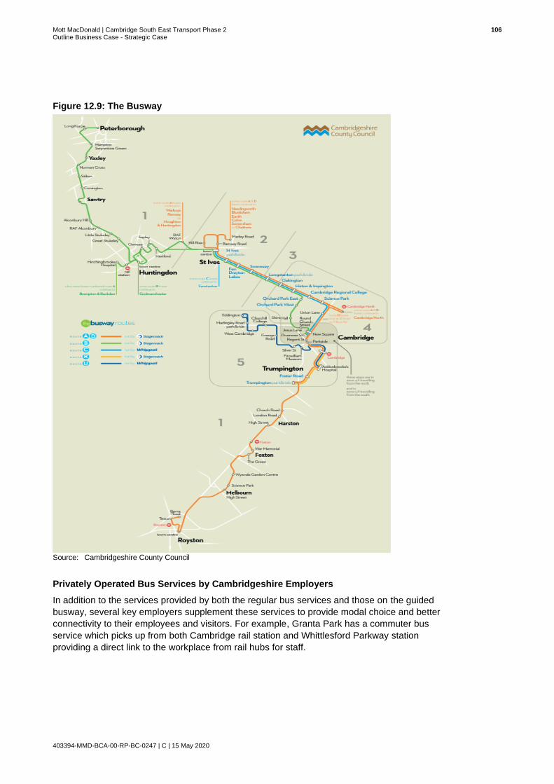
Mott MacDonald | Cambridge South East Transport Phase 2 106 Outline Business Case - Strategic Case
403394-MMD-BCA-00-RP-BC-0247 | C | 15 May 2020
Figure 12.9: The Busway
Source: Cambridgeshire County Council
Privately Operated Bus Services by Cambridgeshire Employers
In addition to the services provided by both the regular bus services and those on the guided
busway, several key employers supplement these services to provide modal choice and better
connectivity to their employees and visitors. For example, Granta Park has a commuter bus
service which picks up from both Cambridge rail station and Whittlesford Parkway station
providing a direct link to the workplace from rail hubs for staff.

Mott MacDonald | Cambridge South East Transport Phase 2 107 Outline Business Case - Strategic Case
403394-MMD-BCA-00-RP-BC-0247 | C | 15 May 2020
Key Issues and Opportunities
The table below highlights the key issues and opportunities in relation to rail and bus provision
across the study area.
Issues Opportunities
● South east Cambridge is detached from the rail network forcing rail users to undertake lengthy multi-modal journeys, enduring inefficient interchanges and inadequate coverage.
● Congestion along the A1307, coupled with multiple stops make bus journey times excessively lengthy and uncompetitive when compared with car travel, discouraging uptake of bus travel.
● The A1307 is not directly served by the Cambridgeshire Guided Busway. As such for commutes that start in locations where the busway is a convenient travel option, passengers will need to change to regular bus services to continue to employment locations along the A1307 corridor, beyond the CBC. Although tickets are transferable, the perception of a break in journey and the possibility of missing connections due to delay may lead to potential users still opting to travel by car.
● Improvements to public transport provision across south east Cambridge could encourage uptake, reducing the proportion of journeys undertaken by private car.
● A reduction in the proportion of private car journeys across south east Cambridge could benefit the environment, creating a sustainable travel environment across the area.
● Better public transport connectivity, with services for key employment hubs could encourage commuters to adopt public transport as their primary mode of transport.
● Possibility to integrate staff bus services to key employment hubs into the public transport network.
● Improved active transport routes delivered in tandem with new public transport infrastructure could encourage a greater number of multi-modal journeys.
So, what does this mean for CSET Phase 2?
South east Cambridge is currently detached from the rail network, making journeys to south
east Cambridge by public transport largely inconvenient and lengthy. Whilst there are a number
of bus routes which operate frequently along the corridor and connections to the guided busway
exist, journey times via bus are excessively long and unreliable as buses are delayed by
worsening congestion in and out of central Cambridge and further slowed by the number of
stops.
A fast, efficient, reliable and frequent public transport route which serves demand and provides
good coverage across south east Cambridge could transform the perception of public transport
across south east Cambridge, encouraging uptake. Increased uptake of public transport for
journeys along the A1307 corridor could reduce the proportion of people who travel by car,
reducing existing pressure on the route. Furthermore, the possibility to integrate staff bus
services to key employment hubs into the public transport network will further enhance
connectivity and provide greater modal choice for those living and working in south east
Cambridge.
Onward connections from the proposed public transport route to Cambridge train station could
further encourage use of rail services, as multimodal journeys to employment sites across south
east Cambridge are made easier. The proposed Cambridge South station will also be well
connected to the public transport route, further improving the public transport offer of south east
Cambridge.

Mott MacDonald | Cambridge South East Transport Phase 2 108 Outline Business Case - Strategic Case
403394-MMD-BCA-00-RP-BC-0247 | C | 15 May 2020
12.3 Park & Ride
Cambridge has a total of five well used Park & Ride sites, located on the outskirts of the City.
The existing Park & Ride sites are strategically located to intercept trips on the key radial routes
into the City Centre, they are;
● Madingley Road (M11/A1303 to Central Cambridge);
● Milton (A10 to Central Cambridge);
● Newmarket Road (A1303 to Central Cambridge);
● Babraham Road (A1307 to Central Cambridge); and
● Trumpington (M11/A10 to Central Cambridge).
Figure 12.10 illustrates the location of Cambridge’s current Park & Ride facilities.
Figure 12.10: Cambridge’s Current Park & Ride Facilities
Source: www.cambridgeparkandrideinfo.com

Mott MacDonald | Cambridge South East Transport Phase 2 109 Outline Business Case - Strategic Case
403394-MMD-BCA-00-RP-BC-0247 | C | 15 May 2020
Babraham Road Park & Ride is located along the A1307, on the outskirts of Cambridge. The
facility provides 1,458 car parking spaces and 250 cycle parking spaces. Additional cycle
parking and cycle lockers have recently been delivered at the site as part of CSET Phase 1.
Babraham Road Park & Ride provides onward services to central Cambridge every ten minutes
Mondays to Saturday and every 15 minutes on Sundays as illustrated below in Figure 12.11.
Figure 12.11: Babraham Road Park & Ride Bus Timetable - Outbound and return services
Source: www.cambridgeparkandrideinfo.com
Babraham Road Park & Ride is well used and intercepts a proportion of journeys travelling
along the A1307, on the immediate south easterly approach to central Cambridge and provides
a frequent and convenient service to Addenbrooke’s Hospital in addition to the city centre. The
route covered by Babraham Road Park & Ride bus services can be seen in Figure 12.12.
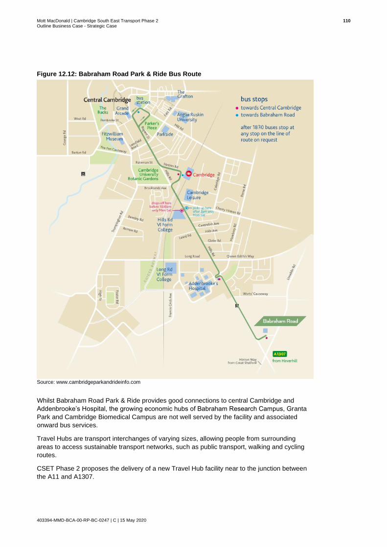
Mott MacDonald | Cambridge South East Transport Phase 2 110 Outline Business Case - Strategic Case
403394-MMD-BCA-00-RP-BC-0247 | C | 15 May 2020
Figure 12.12: Babraham Road Park & Ride Bus Route
Source: www.cambridgeparkandrideinfo.com
Whilst Babraham Road Park & Ride provides good connections to central Cambridge and
Addenbrooke’s Hospital, the growing economic hubs of Babraham Research Campus, Granta
Park and Cambridge Biomedical Campus are not well served by the facility and associated
onward bus services.
Travel Hubs are transport interchanges of varying sizes, allowing people from surrounding
areas to access sustainable transport networks, such as public transport, walking and cycling
routes.
CSET Phase 2 proposes the delivery of a new Travel Hub facility near to the junction between
the A11 and A1307.

Mott MacDonald | Cambridge South East Transport Phase 2 111 Outline Business Case - Strategic Case
403394-MMD-BCA-00-RP-BC-0247 | C | 15 May 2020
The proposed location of the facility presents the opportunity to intercept a higher number of
journeys due to its strategic location near to the A11 Fourwentways junction. The facility will
also provide improved connectivity to Granta Park, Babraham Research Campus and
Cambridge Biomedical Campus by the provision of a new public transport link and active travel
routes, linking the Travel Hub site to key trip attractors.
Key Issues and Opportunities
The table below highlights the key issues and opportunities in relation to Park & Ride provision
across Cambridgeshire.
Issues Opportunities
● Despite Cambridgeshire’s existing Park & Ride network, facilities are not well positioned to serve demand associated with growing economic hubs across south east Cambridge.
● Ongoing development across south east Cambridge will place increased pressure on the Babraham Road Park & Ride site. Capacity here will not be able to accommodate demand.
● A strategically located Travel Hub facility could encourage a larger proportion of users to opt for more sustainable modes of travel, parking at the Travel Hub and using public transport, cycling or walking for their onward journey.
● A new Travel Hub facility in south east Cambridge will accommodate increasing demand for parking capacity across the area.
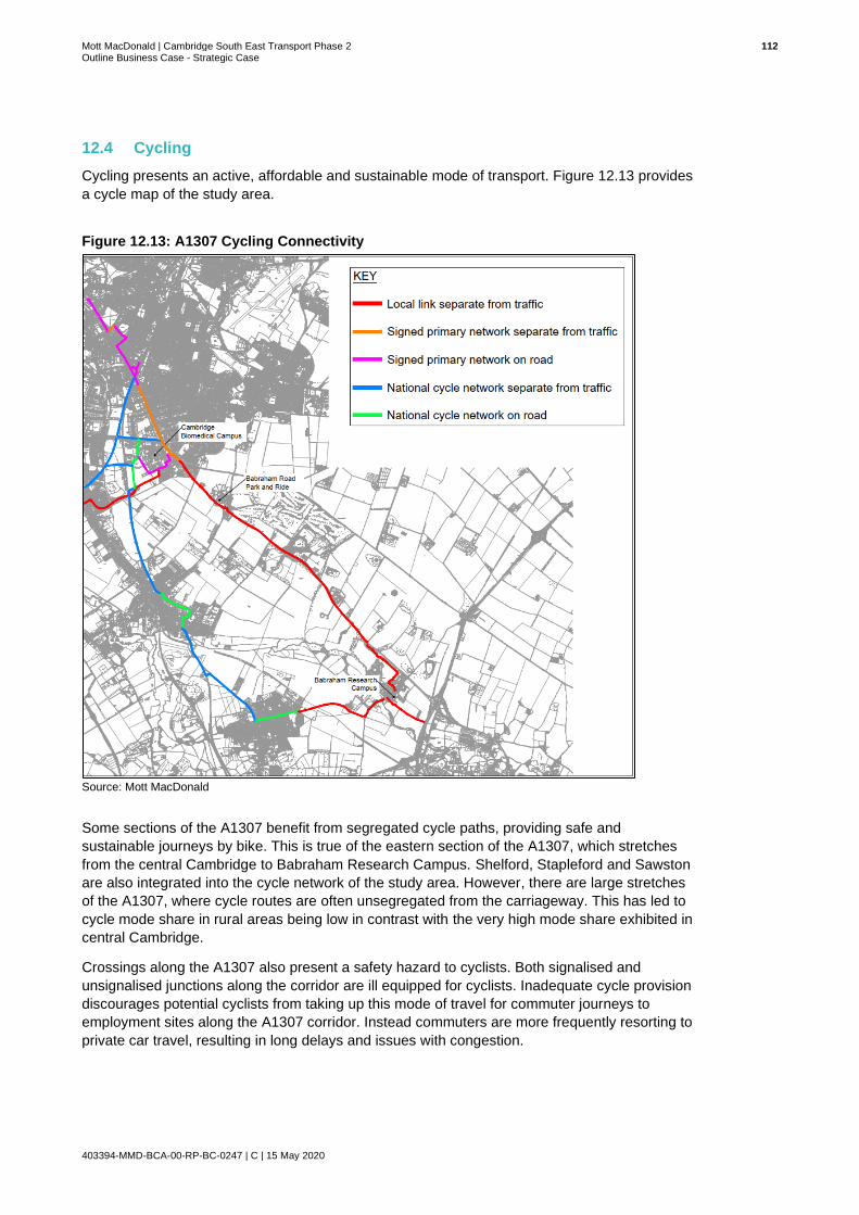
Mott MacDonald | Cambridge South East Transport Phase 2 112 Outline Business Case - Strategic Case
403394-MMD-BCA-00-RP-BC-0247 | C | 15 May 2020
12.4 Cycling
Cycling presents an active, affordable and sustainable mode of transport. Figure 12.13 provides
a cycle map of the study area.
Figure 12.13: A1307 Cycling Connectivity
Source: Mott MacDonald
Some sections of the A1307 benefit from segregated cycle paths, providing safe and
sustainable journeys by bike. This is true of the eastern section of the A1307, which stretches
from the central Cambridge to Babraham Research Campus. Shelford, Stapleford and Sawston
are also integrated into the cycle network of the study area. However, there are large stretches
of the A1307, where cycle routes are often unsegregated from the carriageway. This has led to
cycle mode share in rural areas being low in contrast with the very high mode share exhibited in
central Cambridge.
Crossings along the A1307 also present a safety hazard to cyclists. Both signalised and
unsignalised junctions along the corridor are ill equipped for cyclists. Inadequate cycle provision
discourages potential cyclists from taking up this mode of travel for commuter journeys to
employment sites along the A1307 corridor. Instead commuters are more frequently resorting to
private car travel, resulting in long delays and issues with congestion.

Mott MacDonald | Cambridge South East Transport Phase 2 113 Outline Business Case - Strategic Case
403394-MMD-BCA-00-RP-BC-0247 | C | 15 May 2020
The CSET Phase 2 scheme will facilitate cycling along the A1307 corridor making cycling a
safer and more attractive mode of travel. The route will also link to a multi-user path for
pedestrians, cyclists and horse riders from Cambridge to Linton as part of the Linton Greenway.
12.5 Walking
For distances under 2km, walking is a quick and effective way to travel. For this reason, walking
trips often form at least one leg of a multi-modal journey. Walking is also a form of active
transport and presents limited impacts to the environment, thereby a preferred transport mode
as it offers benefits to the user and the transport network.
Similar to public perceptions of cycling in south east Cambridgeshire, the popularity of walking
here is limited by the lack of continuous, safe and segregated footpaths and infrequent and
inadequate crossing provision.
Public Rights of Way
There are a number of fragmented Public Rights of Way (PROW) within the study area, routes
either run alongside the A1307, intersect the A1307 or run parallel to the A1307. The greatest
number of PROW exist towards the south east of the A1307 corridor, serving villages such as
Linton. Figure 12.14 and Figure 12.15 illustrate the locations of the PROW in the study area.
Figure 12.14: PROW (Addenbrooke’s Hospital to Babraham)
Source: Cambridgeshire County Council
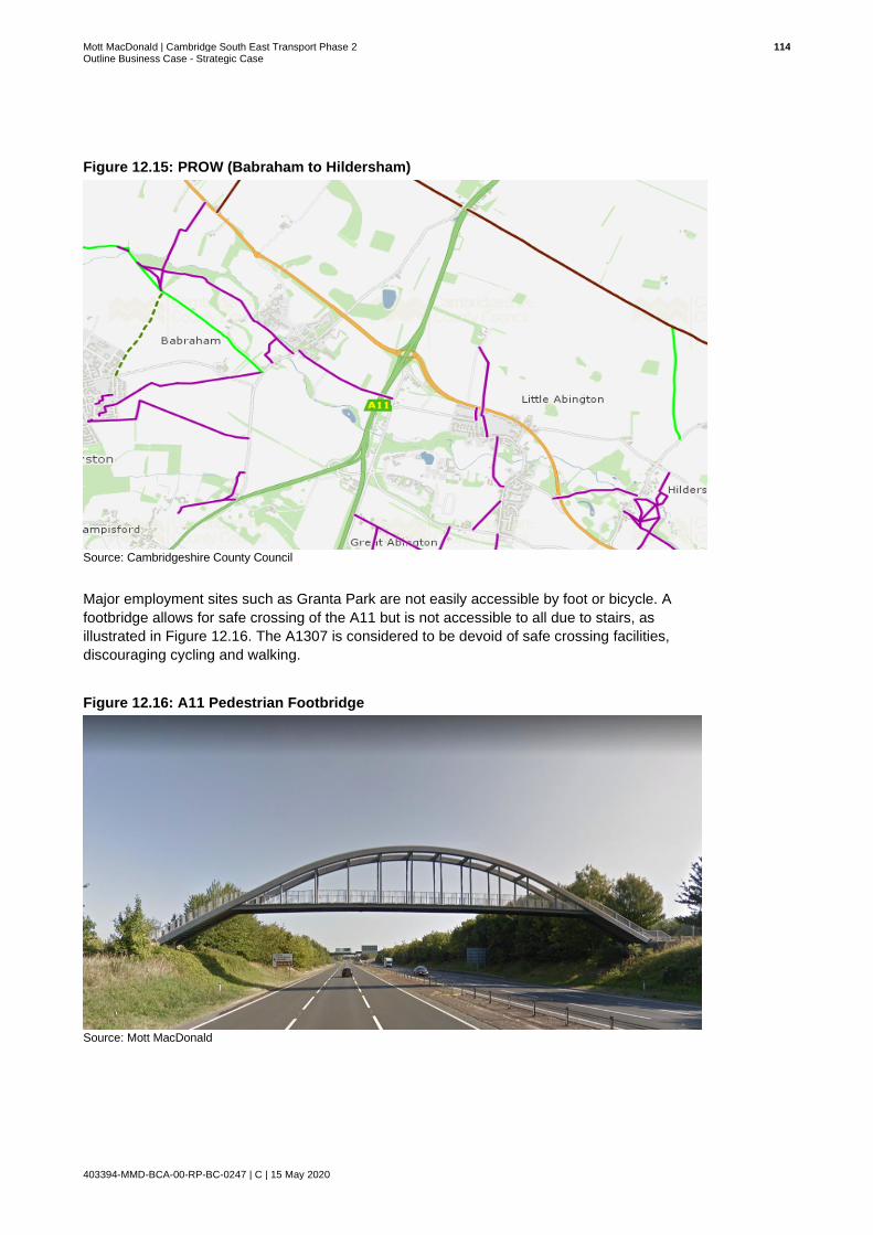
Mott MacDonald | Cambridge South East Transport Phase 2 114 Outline Business Case - Strategic Case
403394-MMD-BCA-00-RP-BC-0247 | C | 15 May 2020
Figure 12.15: PROW (Babraham to Hildersham)
Source: Cambridgeshire County Council
Major employment sites such as Granta Park are not easily accessible by foot or bicycle. A
footbridge allows for safe crossing of the A11 but is not accessible to all due to stairs, as
illustrated in Figure 12.16. The A1307 is considered to be devoid of safe crossing facilities,
discouraging cycling and walking.
Figure 12.16: A11 Pedestrian Footbridge
Source: Mott MacDonald
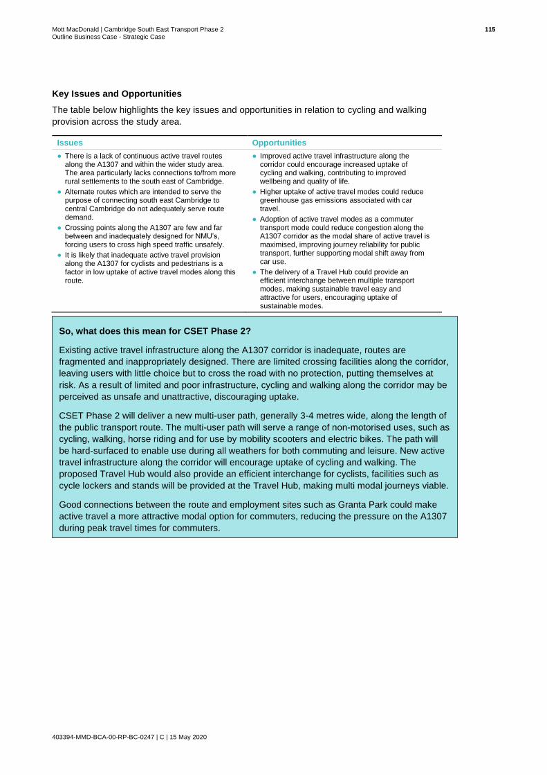
Mott MacDonald | Cambridge South East Transport Phase 2 115 Outline Business Case - Strategic Case
403394-MMD-BCA-00-RP-BC-0247 | C | 15 May 2020
Key Issues and Opportunities
The table below highlights the key issues and opportunities in relation to cycling and walking
provision across the study area.
Issues Opportunities
● There is a lack of continuous active travel routes along the A1307 and within the wider study area. The area particularly lacks connections to/from more rural settlements to the south east of Cambridge.
● Alternate routes which are intended to serve the purpose of connecting south east Cambridge to central Cambridge do not adequately serve route demand.
● Crossing points along the A1307 are few and far between and inadequately designed for NMU’s, forcing users to cross high speed traffic unsafely.
● It is likely that inadequate active travel provision along the A1307 for cyclists and pedestrians is a factor in low uptake of active travel modes along this route.
● Improved active travel infrastructure along the corridor could encourage increased uptake of cycling and walking, contributing to improved wellbeing and quality of life.
● Higher uptake of active travel modes could reduce greenhouse gas emissions associated with car travel.
● Adoption of active travel modes as a commuter transport mode could reduce congestion along the A1307 corridor as the modal share of active travel is maximised, improving journey reliability for public transport, further supporting modal shift away from car use.
● The delivery of a Travel Hub could provide an efficient interchange between multiple transport modes, making sustainable travel easy and attractive for users, encouraging uptake of sustainable modes.
Summary of Issues and O
So, what does this mean for CSET Phase 2?
Existing active travel infrastructure along the A1307 corridor is inadequate, routes are
fragmented and inappropriately designed. There are limited crossing facilities along the corridor,
leaving users with little choice but to cross the road with no protection, putting themselves at
risk. As a result of limited and poor infrastructure, cycling and walking along the corridor may be
perceived as unsafe and unattractive, discouraging uptake.
CSET Phase 2 will deliver a new multi-user path, generally 3-4 metres wide, along the length of
the public transport route. The multi-user path will serve a range of non-motorised uses, such as
cycling, walking, horse riding and for use by mobility scooters and electric bikes. The path will
be hard-surfaced to enable use during all weathers for both commuting and leisure. New active
travel infrastructure along the corridor will encourage uptake of cycling and walking. The
proposed Travel Hub would also provide an efficient interchange for cyclists, facilities such as
cycle lockers and stands will be provided at the Travel Hub, making multi modal journeys viable.
Good connections between the route and employment sites such as Granta Park could make
active travel a more attractive modal option for commuters, reducing the pressure on the A1307
during peak travel times for commuters.

Mott MacDonald | Cambridge South East Transport Phase 2 116 Outline Business Case - Strategic Case
403394-MMD-BCA-00-RP-BC-0247 | C | 15 May 2020
13 Summary of Issues and Opportunities
Population Issues Opportunities
• The population of Cambridge and Cambridgeshire is growing rapidly and there is an increasing academic population. However, the current transport infrastructure is not evolving at a pace which matches population increase.
• Transport infrastructure which is inadequately equipped to accommodate a rapidly growing population may force people to relocate away from the area, slowing the rate of economic growth which has recently been experienced.
• Cambridge’s dense population is
overspilling into the periphery. A large proportion of the overspill are choosing to live to the south east of Cambridge and commute into Cambridge, placing increased pressure on radial routes in and out of central Cambridge.
• A greater number of people living in the area will create indirect and induced economic impacts, spending their incomes locally and using local services, resulting in growth in the local economy.
• A sustainable transport network will allow Cambridgeshire to continue its success in academia, technology and research through close ties between campuses enabling knowledge sharing and innovation. A transport system that supports growth of the area and economic growth will benefit the wider UK economy.
• Futureproofing existing transport infrastructure will support the requirements of future generations and will ensure a successful and sustainable future for Cambridgeshire.
• Cambridge has a large student population who are more likely to use public transport and cycle modes of transportation. Enhancing the sustainable transport options will benefit the future growth of the Universities in Cambridge enabling Cambridge and in turn the UK to maintain its international competitiveness while also relieving pressure on the transport network.
• Providing a safe cycle and walking route will provide residents and students with travel options and will contribute to health and wellbeing.
Employment and Skills
Issues Opportunities
• Highly skilled professionals are required to fill a large proportion of the jobs on offer in Cambridgeshire. Employers in Cambridgeshire therefore recruit from outside of the immediate area in order to find individuals who meet the specific requirements of job roles on offer.
• As a result, a large number of individuals work in Cambridgeshire but live outside of the area, leading to a high number of peak time commuters.
• High numbers of commuters are causing congestion problems during peak times, particularly in south east Cambridgeshire as individuals travel to employment opportunities in central Cambridge and further sites along the A1307.
• Cambridgeshire has a large proportion of people working in professional, scientific and technical activities compared to the national average. Increased employment within these sectors presents the opportunity to further excel Cambridgeshire, and in particular south Cambridgeshire as a destination of excellence in science and industry. Thereby attracting more jobs, employment opportunities and investment and boosting the local economy.
• CSET Phase 2 will provide attractive sustainable travel options that will help to accommodate existing and future commuter demand, providing a more efficient and sustainable transport network overall. Enhanced public transport and provision of an additional Travel Hub will alleviate pressure on the A1307.

Mott MacDonald | Cambridge South East Transport Phase 2 117 Outline Business Case - Strategic Case
403394-MMD-BCA-00-RP-BC-0247 | C | 15 May 2020
Economy and Business
Issues Opportunities
• Cambridge is strategically important for attracting international investors into the UK and maintaining the UK’s international competitiveness. However, this relies on Cambridgeshire continuing to offer strong links between businesses, training campuses and housing developments.
• Rapid business creation and the number of businesses choosing to locate in Cambridgeshire has increased pressure on the existing transport network.
• The existing transport network is inadequately equipped to accommodate current demand. If the network does not evolve at the same rate as economic growth, this problem will inevitably worsen.
• Businesses may be deterred from investing if accessing the employment site is difficult for their workforce.
• Existing businesses may struggle to attract labour from outside of the local area as journey times are long and unreliable. This may also deter investors and businesses locating to the area.
• The rate of business start-ups has slightly declined recently. Cambridgeshire must establish the reason for this and seek to address concerns.
• Cambridgeshire has a worldwide reputation and strong existing economic base, and one which continues to grow. Infrastructure to support and facilitate continued access to employment and homes will equip the area to deal with expansion and thus support sustainable economic growth.
• The proposed Travel Hub will improve accessibility to key employment sites, including Babraham Research Campus, Granta Park and Cambridge Biomedical Campus, encouraging investment and supporting existing businesses. This will also alleviate pressure on the A1307.
• Cambridgeshire must ensure that sustainable modes of travel are attractive to an ever-increasing number of commuters. The proposed scheme will provide a viable alternative to private car travel, reducing congestion along key routes and providing benefits for the environment and quality of life.
Land Use and Development
Issues Opportunities
• The level of planned development in Greater Cambridge will increase pressure on the existing transport network, resulting in deteriorating journey times and journey time reliability.
• Increased demand on the road network across south east and central Cambridge will result in congestion and associated air quality issues.
• Planned employment space may be left vacant if accessing the sites is deemed unattractive and inaccessible by the potential workforce.
• Planned development may not come to fruition at the rate anticipated in the Local Plan if transport infrastructure is not in place to support development and expansion.
• Addressing issues associated with Cambridgeshire’s transport network will encourage planned development to come to fruition. Development will bring forward an unprecedented number of opportunities for economic growth.
• CSET Phase 2 will improve active travel infrastructure along a section of the A1307, improving connectivity for pedestrians and cyclists. Improved active travel links will encourage commuters to adopt more sustainable modes of travel.
• Preparing the transport network for future growth will secure a prosperous future for Cambridgeshire and encourage growth, post Local Plan period, and provide economic benefits to the rest of the UK.

Mott MacDonald | Cambridge South East Transport Phase 2 118 Outline Business Case - Strategic Case
403394-MMD-BCA-00-RP-BC-0247 | C | 15 May 2020
How People Travel
Issues Opportunities
• Cambridge is one of the fastest growing cities in the UK and as such, it is not surprising that Cambridge and South Cambridgeshire are net importers of people for work purposes. However, the transport network is not equipped to accommodate the number of inbound commuter’s flow.
• 63% of Cambridge and South Cambridgeshire’s workforce commute by car or van resulting in congestion and associated air quality issues across many of central Cambridge’s key radial routes.
• Ongoing growth at key employment sites across south east Cambridge and central Cambridge will result in increased commuter demand on the A1307 corridor where there is a lack of alternate travel modes to car.
• The CBC employs a large number of people and is a significant generator of travel demand. 40% of staff at the campus access the site from the south east, using the A1307, resulting in congestion and delays at peak times.
• An increased number of sustainable travel options across south east Cambridge may encourage a modal shift away from car travel resulting in a more sustainable travel environment.
• Improved public transport and walking and cycling provision across south east Cambridge could attract potential employees to opportunities in the area which will be essential to securing future growth of businesses in the area.
• The proposed Travel Hub facility Is strategically located to intercept a large number of journeys heading into central Cambridge and towards the CBC and Babraham Research Campus. The onward public transport route and NMU route would provide a more sustainable link to key destinations whilst also providing journey time savings and journey time reliability for users.
Environment Issues Opportunities
Air Quality
• Vehicle exhaust and other emissions can have an impact on air quality, increasing NO2 and PM10 and PM2.5 concentrations that can be harmful to human health if they exceed certain levels in the atmosphere.
• Public Transport (PT) schemes are considered to have lower environmental impacts because they are able to move a greater number of people per unit of pollutant emitted. This scheme would encourage fewer private vehicles entering Cambridge where there is an air quality management problem, by providing high quality public transport.
• A medium term move to electric or other non-fossil fuel powered public transport vehicles will reduce NO2 emissions in particular.
Noise • The scheme is located in a largely rural environment which will experience some increases in noise along the route and adjacent to the Travel Hub.
• Noise mitigation in the form of earth bunds or acoustic barriers will be included in the design to minimise noise intrusion on sensitive receptors close to the route or Travel Hub.
Greenhouse Gases
• The government policy requires all development to deliver net zero carbon at the national level, which requires changes at every level in society.
• The scheme will lead to greater use of public transport in vehicles that are likely to be electric or other zero carbon powered vehicles in the medium term. Thus, the scheme should support GCPs move to meet government policy.
• Landscape planting will provide a small amount of offsetting potential by carbon sequestration where belts of trees are planted as part of the scheme
Biodiversity • There are Habitats of Principle Importance (HPIs) along the proposed route corridor which have the potential to be fragmented or isolated. This could cause an adverse impact on a range of protected species.
• There are opportunities for Biodiversity Net Gain along the proposed route corridor by planting ecologically valuable habitats.
• There are opportunities to develop wildlife corridors by prioritising linking current areas of habitat together.
Mott MacDonald | Cambridge South East Transport Phase 2 119 Outline Business Case - Strategic Case
403394-MMD-BCA-00-RP-BC-0247 | C | 15 May 2020
• The immediate fields around the Nine Wells Nature Reserve are likely to be acquired by the scheme and would be planted up to increase biodiversity value around the reserve.
Landscape • The current landscape in the area is open fields in a slightly elevated position. The introduction of access roads and hard engineering into the landscape is likely to have an adverse impact.
• There are opportunities for landscape mitigation to be planted to screen the Travel Hubs, so they have less impact on the landscape.
• The design of the route would be carried out in a manner that minimised visual intrusion and impacts on landscape character, this would be achieved by changing the vertical profile of the route and sensitive planting along the route.
Heritage and Archaeology
• There are known archaeological remains of regional and potentially national significance within the footprint of the proposed route corridor.
• The scheme will be assessed using aerial photographic interpretation, geophysical surveys and trial trenching to better understand the buried archaeology along the route. This will increase knowledge and understanding of the setting around Wandlebury and the Magog Scheduled Monuments.
• There is potential to incorporate some of the scheme drainage discharge into Hobson Brook – which is a heritage feature running towards the city and which is frequently dry. Increasing flows in the drainage feature could have heritage benefits which need to be assessed.
Water Resources
• The scheme crosses the flood plain of the River Granta and is within the footprint of the Source Protection Zone 2 of groundwater fed public water supplies
• The scheme design that crosses the River Granta will ensure that there is no increase in flood risk arising from the construction of the bridge(s) over the river.
• There is opportunity to create water related habitat to compensate for lost flood storage in the River Granta flood plain.
• The scheme will have SuDS drainage installed along the route and in the Travel Hub – this will ensure runoff does not contribute to flood risk whilst also ensuring runoff discharged to infiltrate into the ground does not affect the quality of groundwater that is used for public water supplies.
• Opportunities to help with any wider flood management plans being developed by the Environment Agency will be explored during the EIA phase of the project.
Green Belt • The proposed route corridor sits largely within the Cambridge Green Belt which has strong protection at both local and national level.
• Appropriate landscaping and sensitive routing of the scheme. Or siting of the Travel Hub will minimise impacts on Green Belt function.

Mott MacDonald | Cambridge South East Transport Phase 2 120 Outline Business Case - Strategic Case
403394-MMD-BCA-00-RP-BC-0247 | C | 15 May 2020
Rail and Bus Provision
Issues Opportunities
• South east Cambridge is detached from the rail network forcing rail users to undertake lengthy multi-modal journeys, enduring inefficient interchanges and inadequate coverage.
• Congestion along the A1307, coupled with multiple stops make bus journey times excessively lengthy and uncompetitive when compared with car travel. Discouraging uptake of bus travel.
• The A1307 is not directly served by the Cambridgeshire Guided Busway. As such for commutes that start in locations where the busway is a convenient travel option, passengers will need to change to regular bus services to continue to employment locations along the A1307 corridor, beyond the CBC. Although tickets are transferable, the perception of a break in journey and the possibility of missing connections due to delay may lead to potential users still opting to travel by car.
• Improvements to public transport provision across south east Cambridge could encourage uptake, reducing the proportion of journeys undertaken by private car.
• A reduction in the proportion of private car journeys across south east Cambridge could benefit the environment, creating a sustainable travel environment across south east Cambridge.
• Better public transport connectivity, with services for key employment hubs could encourage commuters to adopt public transport as their primary mode of transport.
• Possibility to integrate staff bus services to key employment hubs into the public transport network
• Improved active transport routes delivered in tandem with new public transport infrastructure could encourage a greater number of multi-modal journeys.
Highways Network and Traffic
Issues Opportunities
• Heavy traffic flows are regularly experienced along the section of the A1307 approaching the CBC from the South. This is evidenced in ATC data analysed. Increasingly unattractive conditions are likely to deter further investment, restricting growth potential of the wider area.
• Increasing demand across the A1307 corridor has had an impact on capacity, journey time reliability and possibly road safety.
• Demand on the corridor is likely to increase, worsening congestion and journey times for users of the A1307.
• The CBC is key attractor of vehicle trips along the A1307. With growth at the campus projected, traffic flows are likely to increase which will have an adverse impact on journey times along the route.
• Proposed improvements to the transport infrastructure along the A1307 will facilitate more reliable and accessible multi-modal journeys. This will incentivise shifts away from private car usage and reduce congestion around the CBC, ensuring growth continues.
• Proposed infrastructure for public transport, walking and cycling along the A1307 will encourage the uptake of sustainable travel options along the corridor and reduce the demand on the road network.
• Alternative modal options will reduce the dominance of car travel along the A1307, reducing congestion along the corridor and providing more sustainable travel options for users.
• Congestion could be considered a key constraint for business investment and growth. Reducing congestion and improving transport provision could help improve network resilience. In tandem this could help encourage investment.
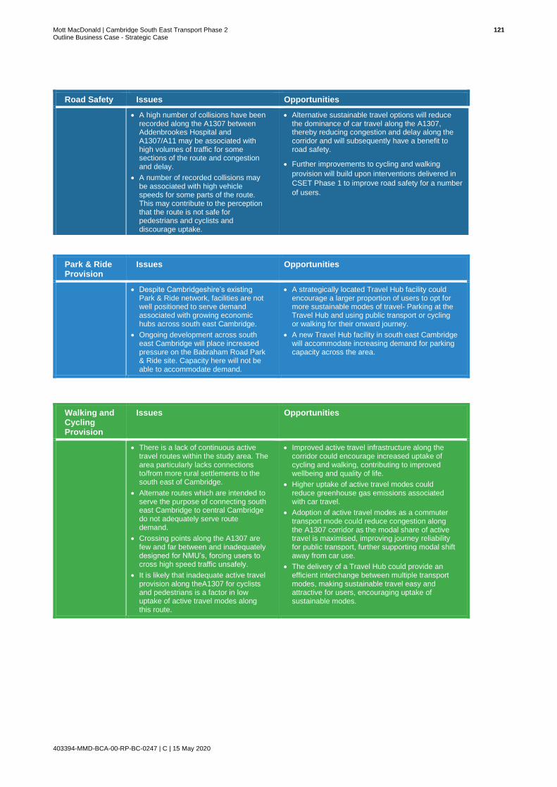
Mott MacDonald | Cambridge South East Transport Phase 2 121 Outline Business Case - Strategic Case
403394-MMD-BCA-00-RP-BC-0247 | C | 15 May 2020
Park & Ride Provision
Issues Opportunities
• Despite Cambridgeshire’s existing Park & Ride network, facilities are not well positioned to serve demand associated with growing economic hubs across south east Cambridge.
• Ongoing development across south east Cambridge will place increased pressure on the Babraham Road Park & Ride site. Capacity here will not be able to accommodate demand.
• A strategically located Travel Hub facility could encourage a larger proportion of users to opt for more sustainable modes of travel- Parking at the Travel Hub and using public transport or cycling or walking for their onward journey.
• A new Travel Hub facility in south east Cambridge will accommodate increasing demand for parking capacity across the area.
Walking and Cycling Provision
Issues Opportunities
• There is a lack of continuous active travel routes within the study area. The area particularly lacks connections to/from more rural settlements to the south east of Cambridge.
• Alternate routes which are intended to serve the purpose of connecting south east Cambridge to central Cambridge do not adequately serve route demand.
• Crossing points along the A1307 are few and far between and inadequately designed for NMU’s, forcing users to cross high speed traffic unsafely.
• It is likely that inadequate active travel provision along theA1307 for cyclists and pedestrians is a factor in low uptake of active travel modes along this route.
• Improved active travel infrastructure along the corridor could encourage increased uptake of cycling and walking, contributing to improved wellbeing and quality of life.
• Higher uptake of active travel modes could reduce greenhouse gas emissions associated with car travel.
• Adoption of active travel modes as a commuter transport mode could reduce congestion along the A1307 corridor as the modal share of active travel is maximised, improving journey reliability for public transport, further supporting modal shift away from car use.
• The delivery of a Travel Hub could provide an efficient interchange between multiple transport modes, making sustainable travel easy and attractive for users, encouraging uptake of sustainable modes.
Road Safety Issues Opportunities
• A high number of collisions have been recorded along the A1307 between Addenbrookes Hospital and A1307/A11 may be associated with high volumes of traffic for some sections of the route and congestion and delay.
• A number of recorded collisions may be associated with high vehicle speeds for some parts of the route. This may contribute to the perception that the route is not safe for pedestrians and cyclists and discourage uptake.
• Alternative sustainable travel options will reduce the dominance of car travel along the A1307, thereby reducing congestion and delay along the corridor and will subsequently have a benefit to road safety.
• Further improvements to cycling and walking
provision will build upon interventions delivered in
CSET Phase 1 to improve road safety for a number
of users.

Mott MacDonald | Cambridge South East Transport Phase 2 122 Outline Business Case - Strategic Case
403394-MMD-BCA-00-RP-BC-0247 | C | 15 May 2020
14 Need for Intervention
Having established a firm evidence base on which to establish objectives to guide scheme
development and appraisal in Sections 6 to 13, this section draws the problems and issues
identified in the thematic evidence-based review together in a holistic manner to establish a
rationale for investment.
14.1 Futureproofing the Transport Network to Support Growth
Cambridge is one of the fastest growing and most productive cities in the UK with notable
population and economic growth forecasted to occur in the short to medium term. Cambridge’s
growth is driven by a thriving internationally recognised hi-tech and biotech industry, known as
the “Cambridge Phenomenon” and is strategically important in boosting the UK’s international
competitiveness. It is expected to continue to be a key location for regional and national job
creation should the supply side constraints, such as labour market accessibility and housing
availability, be addressed. This scheme presents the opportunity to address this challenge and
improve labour market access and maintain Cambridge’s international reputation as an
attractive place to live, work and invest.
Fuelled by the ‘Cambridge Phenomenon’ and the rise of a successful entrepreneurial
environment, significant capital investment is needed to provide a greener, more reliable, less
congested and better-connected transport network for the region. Whilst investment in transport
infrastructure supports the Government’s post-Brexit Industrial Strategy and aligns with the
2017 Transport Investment Strategy, it also creates a stronger economy, fuelling further
investment into the UK. This growth however, especially in South Cambridgeshire, cannot be
sustained in the long term unless significant investment and changes are made to future-proof
existing transport infrastructure.
Greater Cambridge’s economic success is putting pressure on its housing market. Very high
average house prices are in turn pushing its workforce further out of the city to more affordable
housing and increasing levels of commuting into the city.
As detailed throughout this Strategic Case the A1307 is a key radial route between central
Cambridge and Haverhill which serves the Cambridge Biomedical Campus and other
employment centres, such as Babraham Research Campus and Granta Park.
Many of the staff working at the Cambridge Biomedical Campus, and at other employment hubs
along the A1307, do not live in the immediate area, resulting in a high number of commuter
trips. The geographical distribution of the workforce, coupled with limited modal choice has
resulted in a car dependent culture, resulting in congestion and capacity constraints.
With the already dense population of Cambridgeshire continuing to increase in response to
economic growth, business creation and increased employment opportunities, there are
increased numbers of people commuting into Cambridge from its peripheral areas. This is
evident in the scale of proposed commercial and residential led development across south east
Cambridge as well as in Haverhill. Development on the periphery of central Cambridge has
placed increased pressure on radial routes, such as the A1307. At present, transport
infrastructure in south east Cambridge is not adequate to accommodate demand associated
with the level of proposed development. Failure to act appropriately may compromise the rate of
economic growth which has been experienced over recent years and thus threaten Cambridge’s
international standing.

Mott MacDonald | Cambridge South East Transport Phase 2 123 Outline Business Case - Strategic Case
403394-MMD-BCA-00-RP-BC-0247 | C | 15 May 2020
14.2 Introducing Modal Choice
Despite extensive congestion and road safety issues, less than 36,000 of the workforce in
Cambridge and South Cambridgeshire opt to travel by bus or train. Although several bus
services operate along the A1307 and A1301, congestion along the corridors increases an
already excessive journey time, particularly during peak travel periods. Rail provision is also
limited in south east Cambridge. The area is largely detached from the rail network as it does
not have a dedicated train station. Poor public transport further exacerbates car dependency, as
commuters opt for the convenience and flexibility of travelling by car.
Dedicated provision is made for cyclists, pedestrians and equestrians in parts of the study area.
However, active travel infrastructure is inadequate or non-existent in some areas, and does not
cater for existing demand, nor does it encourage uptake for these journeys.
Ultimately those travelling through or to south east Cambridge are left with few attractive options
to car use, further reinforcing the car dependent culture which exists here and exacerbating
congestion and capacity issues.
14.3 Impact of Not Changing
In establishing the need for the proposed scheme, it is important to consider the counterfactual,
that is, what would happen if the status quo was allowed to continue and GCP opted not to
intervene. In not changing, south east Cambridge runs the risk of experiencing a situation in
which journey times are worsened, a spread of peak hour is experienced, and network
resilience is significantly eroded. The potential impact of growth without transport improvements
is illustrated below in Figure 14.1. If no action is taken to deal with the anticipated growth
sustainably, average journey times on key radial routes such as the A1307 are expected to
increase by around 50%.
Figure 14.1: Impact of Growth Without Transport Improvements
Source: Cambridge and South Cambridgeshire Local Plan
Failure to deliver new public transport infrastructure and walking and cycling provision will
further exacerbate congestion and delay along the corridor, as users are left with no alternative
option other than to travel by car. Inadequate sustainable travel options will have a negative
impact on the quality of life of users and worsen air quality in the study area as vehicle
emissions increasingly pollute the environment.
Increases in journey times and worsening journey time reliability could mean the current
agglomeration benefits that Cambridge benefits from through the close connections and
knowledge sharing between employment sites and training campuses would be much reduced.
This, alongside the impacts of poorer air quality, could result in businesses, that are currently
attracted to the UK because of Cambridge’s global offer, seeking locations elsewhere outside

Mott MacDonald | Cambridge South East Transport Phase 2 124 Outline Business Case - Strategic Case
403394-MMD-BCA-00-RP-BC-0247 | C | 15 May 2020
the UK. The expected economic growth from the planned employment sites and housing
developments could therefore potentially be constrained through the lack of supporting
infrastructure. Insufficient transport opportunities along the A1307 could therefore impede the
economic growth of the area, reversing the positive economic growth which has been
experienced over more recent years.

Mott MacDonald | Cambridge South East Transport Phase 2 125 Outline Business Case - Strategic Case
403394-MMD-BCA-00-RP-BC-0247 | C | 15 May 2020
15 Scheme Aims and Objectives
In addition to scheme aims identified by GCP during the development of the SOBC, scheme
objectives have been established at OBC stage to reflect updates to the evidence base and to
guide the development and appraisal of the scheme. This section provides a summary of how
the scheme objectives were established and sets out the relationship between the existing aims
and newly developed scheme objectives.
The thematic evidence review undertaken during the development of the Strategic Case
identified a range of challenges and opportunities in the study area; this alongside the policy
review mapped out the need for intervention.
Establishing an evidence-based need to take action to address clearly defined issues and
opportunities enabled the development of scheme objectives.
This process of setting scheme objectives is illustrated below in Figure 15.1.
Figure 15.1: Objective Setting Process
Source: Mott MacDonald

Mott MacDonald | Cambridge South East Transport Phase 2 126 Outline Business Case - Strategic Case
403394-MMD-BCA-00-RP-BC-0247 | C | 15 May 2020
15.1 Study Aims
Regarding transport, the GCP has identified the following challenge:
In developing an appropriate action plan to tackle the challenge set out above the GCP has
developed six transport aims. The GCP will aim to:
In addition to the GCP Transport Aims set out above, five study specific aims have been
developed, which are illustrated in the infographic below32.
32 https://www.greatercambridge.org.uk/transport/transport-projects/cambridge_south_east_study/ [Accessed 14 May 2019]
Ease congestion and prioritise greener and active travel,
making it easier for people to travel by bus, rail, cycle or on
foot to improve average journey times.
Keep the Greater Cambridge area well connected to the
regional and national transport network, opening up
opportunities by working closely with strategic partners.
Reallocate limited road space in the city centre and invest in public transport to make bus
travel quicker and more reliable.
Build an extensive network of new cycle ways, directly
connecting people to homes, jobs, study and opportunity,
across the city and neighbouring villages.
Help make people’s journeys and lives easier by making use
of research and investing in cutting edge technology.
Connect Cambridge with strategically important towns
and cities by improving our rail stations, supporting the
creation of new ones and financing new rail links.
‘The Greater Cambridge area of Cambridge and South Cambridgeshire is set to grow by up to 30% over the next
15 years- with the population rising by 65,000 to 338,000 by 2031. Population growth means trips on the transport
network will increase by 25,000 by 2031. If we carry on as we are by 2031:
• Traffic in Cambridge will increase by over 30% in the morning peak
• Traffic in South Cambridgeshire will increase by almost 40% in the morning peak
• The time spent in congestion will more than double.’

Mott MacDonald | Cambridge South East Transport Phase 2 127 Outline Business Case - Strategic Case
403394-MMD-BCA-00-RP-BC-0247 | C | 15 May 2020
The study aims for the overarching CSET scheme, together with the GCP Transport Aims have
aided the development of the scheme specific objectives developed for this OBC. The scheme
objectives set out in the following sub-section will detail how the aims outlined above will be
achieved.
15.2 Scheme Objectives
Scheme objectives were developed by Mott MacDonald in consultation with GCP and apply to
CSET as a whole, both Phase 2 and Phase 1. The scheme objectives set out below have been
designed to be Specific, Measurable, Achievable. Realistic, and Time Bound (SMART).
The logic map in Figure 15.2 shows the causal pathway between the objectives of the scheme,
the outputs and the expected outcomes and impacts. This sets the basis for the framework of
the Monitoring and Evaluation Plan, which can be found in the Management Case.
1
•Support the continued growth of Cambridge and south Cambridge’s economy.•Deliver journey time savings for commuters travelling by public transport to job opportunities in south east Cambridge and central Cambridge.•Improve journey time reliability for users of the A1307 corridor.•Provide the transport infrastructure necessary to sustain economic growth.
2
• Relieve congestion and improve air quality in south east Cambridge.• Encourage use of sustainable transport modes for journeys through south east Cambridge and into central
Cambridge.
• Enhance quality of life by relieving congestion and improving air quality in south east Cambridge.
• Relieve pressure at network pinch points.
3
• Improve active travel infrastructure and public transport provision in south east Cambridge.
• Deliver a High Quality Public Transport (HQPT) offer between Cambridge and Haverhill.
• Increase frequency of public transport services during peak periods.
• Reduce severance for cyclists, pedestrians and equestrians.
• Increase uptake of sustainable transport modes for commuter journeys.
4
• Improve road safety for all users of the A1307 corridor.• Reduce the number of accidents at identified accident clusters along the corridor.
• Reduce the number of speed related incidents along the corridor.
• Improve the safety of crossing movements for cyclists, pedestrians and equestrians.
5
• Improve connectivity to employment sites in south east Cambridge and central Cambridge.• Provide improved access to the Granta Park, Addenbrooke's Hospital, Cambridge Biomedical Campus (CBC)
and a number of other employment sites in south east Cambridge.
• Increase modal options for commuters travelling to and from employment sites in south east Cambridge and central Cambridge by delivering a HQPT network and improved active travel routes for users.
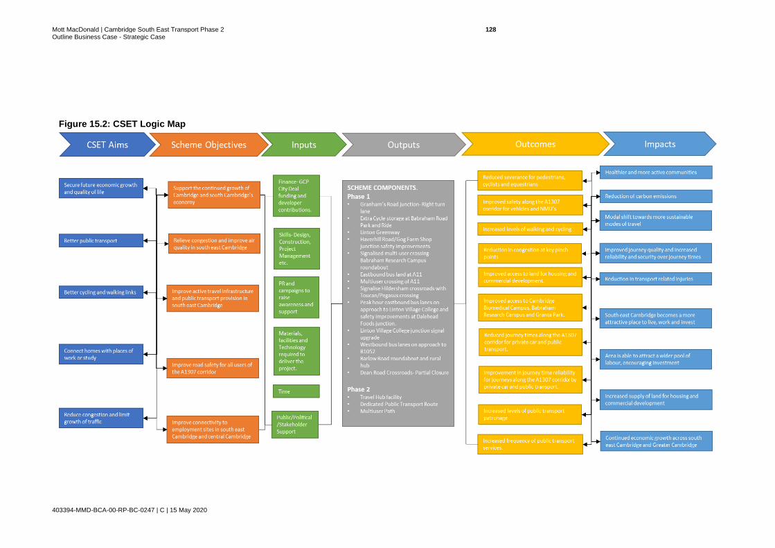
Mott MacDonald | Cambridge South East Transport Phase 2 128 Outline Business Case - Strategic Case
403394-MMD-BCA-00-RP-BC-0247 | C | 15 May 2020
Figure 15.2: CSET Logic Map
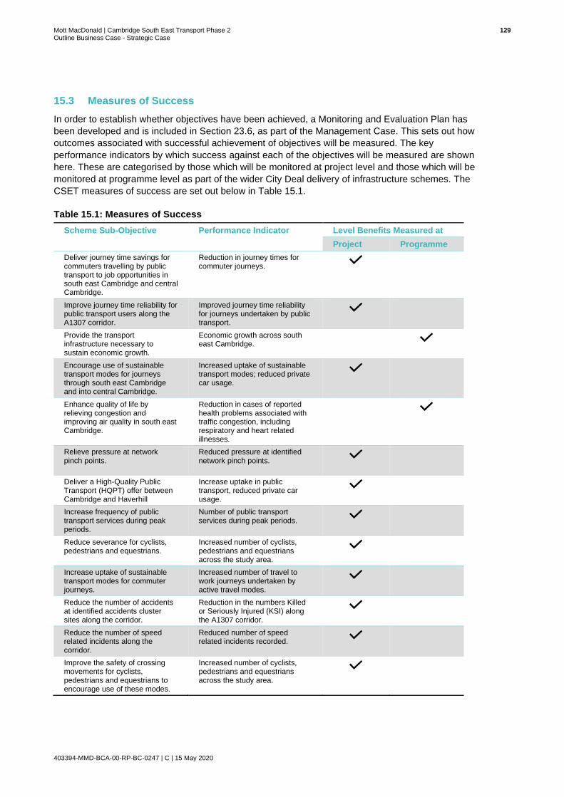
Mott MacDonald | Cambridge South East Transport Phase 2 129 Outline Business Case - Strategic Case
403394-MMD-BCA-00-RP-BC-0247 | C | 15 May 2020
15.3 Measures of Success
In order to establish whether objectives have been achieved, a Monitoring and Evaluation Plan has
been developed and is included in Section 23.6, as part of the Management Case. This sets out how
outcomes associated with successful achievement of objectives will be measured. The key
performance indicators by which success against each of the objectives will be measured are shown
here. These are categorised by those which will be monitored at project level and those which will be
monitored at programme level as part of the wider City Deal delivery of infrastructure schemes. The
CSET measures of success are set out below in Table 15.1.
Table 15.1: Measures of Success
Scheme Sub-Objective Performance Indicator Level Benefits Measured at
Project Programme
Deliver journey time savings for commuters travelling by public transport to job opportunities in south east Cambridge and central Cambridge.
Reduction in journey times for commuter journeys.
Improve journey time reliability for public transport users along the A1307 corridor.
Improved journey time reliability for journeys undertaken by public transport.
Provide the transport infrastructure necessary to sustain economic growth.
Economic growth across south east Cambridge.
Encourage use of sustainable transport modes for journeys through south east Cambridge and into central Cambridge.
Increased uptake of sustainable transport modes; reduced private car usage.
Enhance quality of life by relieving congestion and improving air quality in south east Cambridge.
Reduction in cases of reported health problems associated with traffic congestion, including respiratory and heart related illnesses.
Relieve pressure at network pinch points.
Reduced pressure at identified network pinch points.
Deliver a High-Quality Public Transport (HQPT) offer between Cambridge and Haverhill
Increase uptake in public transport, reduced private car usage.
Increase frequency of public transport services during peak periods.
Number of public transport services during peak periods.
Reduce severance for cyclists, pedestrians and equestrians.
Increased number of cyclists, pedestrians and equestrians across the study area.
Increase uptake of sustainable transport modes for commuter journeys.
Increased number of travel to work journeys undertaken by active travel modes.
Reduce the number of accidents at identified accidents cluster sites along the corridor.
Reduction in the numbers Killed or Seriously Injured (KSI) along the A1307 corridor.
Reduce the number of speed related incidents along the corridor.
Reduced number of speed related incidents recorded.
Improve the safety of crossing movements for cyclists, pedestrians and equestrians to encourage use of these modes.
Increased number of cyclists, pedestrians and equestrians across the study area.
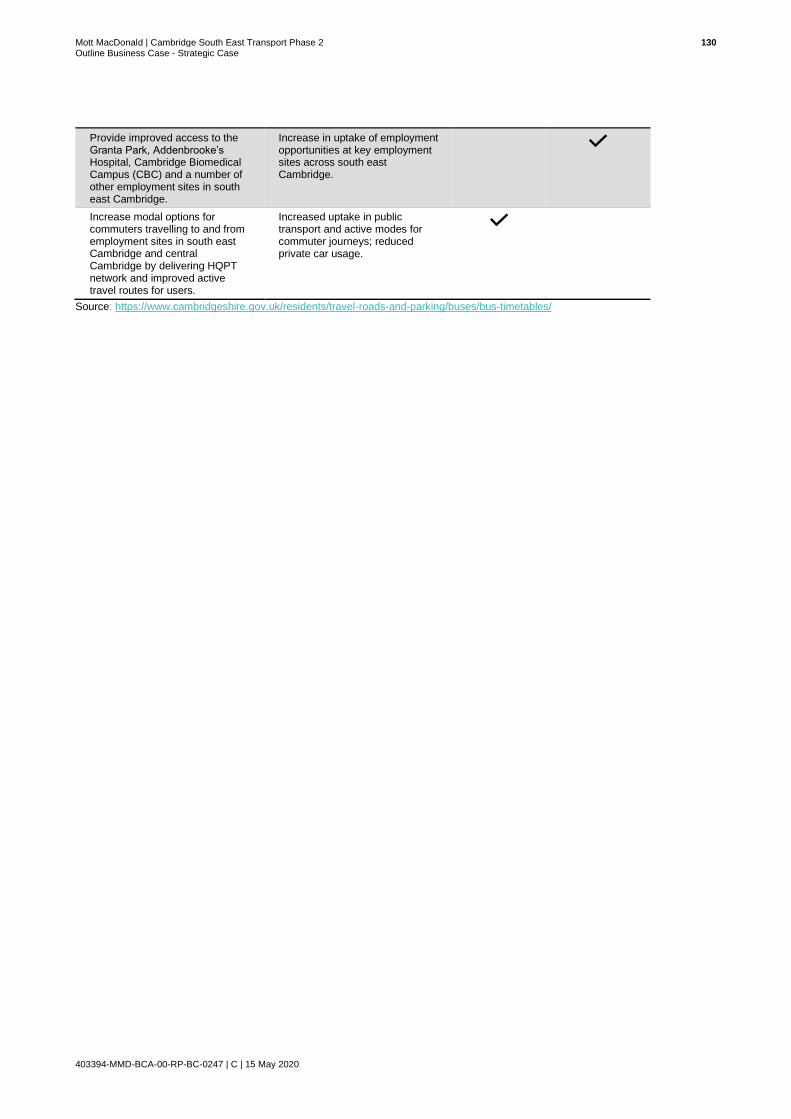
Mott MacDonald | Cambridge South East Transport Phase 2 130 Outline Business Case - Strategic Case
403394-MMD-BCA-00-RP-BC-0247 | C | 15 May 2020
Provide improved access to the Granta Park, Addenbrooke’s Hospital, Cambridge Biomedical Campus (CBC) and a number of other employment sites in south east Cambridge.
Increase in uptake of employment opportunities at key employment sites across south east Cambridge.
Increase modal options for commuters travelling to and from employment sites in south east Cambridge and central Cambridge by delivering HQPT network and improved active travel routes for users.
Increased uptake in public transport and active modes for commuter journeys; reduced private car usage.
Source: https://www.cambridgeshire.gov.uk/residents/travel-roads-and-parking/buses/bus-timetables/

Mott MacDonald | Cambridge South East Transport Phase 2 131 Outline Business Case - Strategic Case
403394-MMD-BCA-00-RP-BC-0247 | C | 15 May 2020
16 Potential Constraints and Interdependencies
16.1 Geographic Scope
The geographic scope of the CSET Phase 2 scheme focuses on a section of the A1307 corridor
stretching from the A11/A1307 Fourwentways junction, north west to the Cambridge Biomedical
Campus. This section of the A1307 travels past villages such as Babraham, Stapleford and Great
Shelford and provides one of the key access routes into central Cambridge from the south east. An
overview of the geographic extent of the CSET Phase 2 works can be seen below in Figure 16.1.
Figure 16.1: Phase 2 Geographic Scope
Source: Mott MacDonald

Mott MacDonald | Cambridge South East Transport Phase 2 132 Outline Business Case - Strategic Case
403394-MMD-BCA-00-RP-BC-0247 | C | 15 May 2020
16.2 Constraints
In the design and delivery of the CSET Phase 2 works, the project team will need to consider how best
to overcome, incorporate or mitigate impacts relating to the constraints set out below.
Route Alignment
16.2.1 East West Rail
The East West Rail scheme proposes bringing back into use a section of railway that was closed to
passengers in the 1960s, refurbishing existing railway lines between Bletchley and Bedford, and
building brand new railway infrastructure between Bedford and Cambridge.
In January 2020, based on the results of public consultation held the previous year, the preferred route
corridor between Bedford and Cambridge was identified and will link existing stations in Bedford and
Cambridge with communities in Cambourne and the area north of Sandy, south of St. Neots. Figure
16.2 illustrates this corridor. The preferred corridor envisages joining the London to Cambridge Main
Line railway in the vicinity of Great Shelford; the actual point of joining being either south or north of
Great Shelford, but yet to be determined.
Figure 16.2: Preferred Route Corridor: Bedford to Cambridge
Source: East West Rail Preferred Consultation Option Executive Summary, January 2020
The preferred East West Rail route alignment currently has the potential to connect to the existing
Shelford station which sits firmly within the CSET Phase 2 corridor. This means until a new station at
Cambridge South is approved and delivered that there could be potential for users of the new East
West Rail route to alight at Shelford and make use of the CSET route onward to key employment hubs
such as CBC, Granta Park and Babraham Research Park, thereby boosting patronage. This is in fact
an opportunity and as such consideration will need to be given to the frequency of services and the
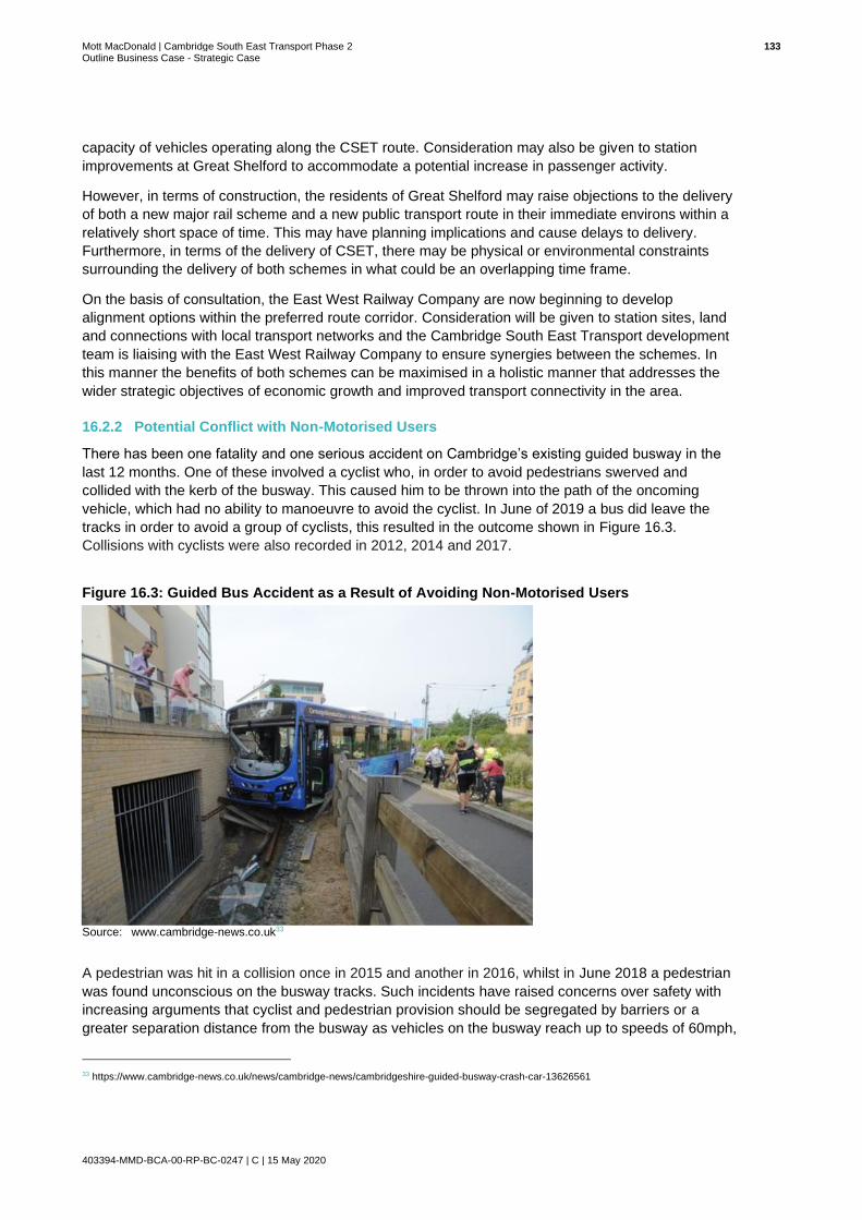
Mott MacDonald | Cambridge South East Transport Phase 2 133 Outline Business Case - Strategic Case
403394-MMD-BCA-00-RP-BC-0247 | C | 15 May 2020
capacity of vehicles operating along the CSET route. Consideration may also be given to station
improvements at Great Shelford to accommodate a potential increase in passenger activity.
However, in terms of construction, the residents of Great Shelford may raise objections to the delivery
of both a new major rail scheme and a new public transport route in their immediate environs within a
relatively short space of time. This may have planning implications and cause delays to delivery.
Furthermore, in terms of the delivery of CSET, there may be physical or environmental constraints
surrounding the delivery of both schemes in what could be an overlapping time frame.
On the basis of consultation, the East West Railway Company are now beginning to develop
alignment options within the preferred route corridor. Consideration will be given to station sites, land
and connections with local transport networks and the Cambridge South East Transport development
team is liaising with the East West Railway Company to ensure synergies between the schemes. In
this manner the benefits of both schemes can be maximised in a holistic manner that addresses the
wider strategic objectives of economic growth and improved transport connectivity in the area.
16.2.2 Potential Conflict with Non-Motorised Users
There has been one fatality and one serious accident on Cambridge’s existing guided busway in the
last 12 months. One of these involved a cyclist who, in order to avoid pedestrians swerved and
collided with the kerb of the busway. This caused him to be thrown into the path of the oncoming
vehicle, which had no ability to manoeuvre to avoid the cyclist. In June of 2019 a bus did leave the
tracks in order to avoid a group of cyclists, this resulted in the outcome shown in Figure 16.3.
Collisions with cyclists were also recorded in 2012, 2014 and 2017.
Figure 16.3: Guided Bus Accident as a Result of Avoiding Non-Motorised Users
Source: www.cambridge-news.co.uk33
A pedestrian was hit in a collision once in 2015 and another in 2016, whilst in June 2018 a pedestrian
was found unconscious on the busway tracks. Such incidents have raised concerns over safety with
increasing arguments that cyclist and pedestrian provision should be segregated by barriers or a
greater separation distance from the busway as vehicles on the busway reach up to speeds of 60mph,
33 https://www.cambridge-news.co.uk/news/cambridge-news/cambridgeshire-guided-busway-crash-car-13626561

Mott MacDonald | Cambridge South East Transport Phase 2 134 Outline Business Case - Strategic Case
403394-MMD-BCA-00-RP-BC-0247 | C | 15 May 2020
comparable with the speed of a train. These incidents have the potential to constrain the scheme
unless solutions for ensuring the safety of non-motorised users can be included in any designs, which
may impact land take and potentially cost.
HQPT Operations
16.2.3 Legislative Issues Regarding Optically Guided Vehicles
Both kerb-guided and optically-guided vehicles are being considered for HQPT operations on the
CSET Phase 2 public transport route. When operating within a guideway, kerb-guided vehicles do not
have the capability to move from the tracks on which they run, similar to light rail, whereas optically-
guided vehicles do have the ability to manoeuvre within the route alignment. There is a current
preference for optically-guided vehicles. Vehicles employing this technology are currently in use in
Europe but would require type approval for use in the UK.
16.2.4 Lack of Alternative Providers of Optical Guidance Technology
At present there is only one established provider of optical guidance technology, Siemens - who
supply the guidance systems for the current optically-guided bus operations in other countries. GCP
could therefore be constrained by the lack of competition as this is currently a captive market. This
may exert upward pressure on procurement prices and also may reduce any incentive for the single
supplier to provide any service enhancements or speciality modifications. However, this constraint is
likely to be mitigated by current developments in autonomous vehicle technology which include
equipping vehicles with a range of sensors, including cameras, for positioning and guidance and are
expected to lead to the availability of alternatives to the Siemens system.
Travel Hub Facility
16.2.5 Location of Utilities infrastructure
There is a high-pressure gas main which runs to the west of the A11, in the general area within which
the Travel Hub facility is proposed. The pipeline is classified by the Health and Safety Executive as a
hazardous installation and is therefore subject to Planning Advice for Developments near Hazardous
Installations. This may rule out consideration of some options and narrow the possibilities for the
scheme.
16.3 Interdependencies
Whilst the CSET Phase 2 proposals do not have any specific dependencies in order to be delivered,
the project is interdependent with a number of other proposals located within close proximity. Figure
16.4 provides an indicative timeline of the anticipated delivery timescales of the four schemes
considered within this sub-section, followed by further details of the relevant schemes and their
interdependent relationship with CSET Phase 2.
Figure 16.4: Indicative Timeline of Interdependent Schemes
Source: Mott MacDonald

Mott MacDonald | Cambridge South East Transport Phase 2 135 Outline Business Case - Strategic Case
403394-MMD-BCA-00-RP-BC-0247 | C | 15 May 2020
In order to provide improved end to end connectivity between settlements and employment sites along
the A1307 corridor and the city centre, CSET Phase 2 will depend on the City Access Strategy and
associated Plan to tackle the issues of congestion within the city centre and enhance the ability for
people to get into, out of and around the city.
Schemes within this strategy aim to reduce congestion on routes into the city centre which will be key
to reducing public transport journey times on sections of route where HQPT services are sharing road
space with general traffic, therefore making the CSET Travel Hub more attractive and successful. In
addition, the removal of traffic from the city centre will help create additional demand for the facility.
A505 Royston to Granta Park Strategic Transport Study
A strategic transport study for the A505 corridor between Royston and the A11 at Granta Park has
recently been commissioned by Cambridgeshire County Council on behalf of CPCA. This study will
look at current traffic problems and potential future demand on the A505 between Royston and the
A11; a corridor which skirts the southern edge of the scope of the CSET Phase 2 scheme, and will
investigate options for better provision for cyclists, pedestrians and public transport users. Any
proposals put forward will need to consider the CSET Phase 2 proposals, just as the development of
CSET will need to take into account any emerging findings from this study to ensure a joined-up
approach to infrastructure delivery.
Whittlesford Rural Travel Hub
Rural Travel Hubs are small, flexible transport interchanges at key locations in Cambridgeshire,
allowing more people to access sustainable transport networks. The Whittlesford Rural Travel Hub
would include a larger car park at Whittlesford Parkway station which is highlighted in red in Figure
16.5.
Figure 16.5: Location of Whittlesford Rural Travel Hub
Source: Skanska

Mott MacDonald | Cambridge South East Transport Phase 2 136 Outline Business Case - Strategic Case
403394-MMD-BCA-00-RP-BC-0247 | C | 15 May 2020
Improvements to connectivity along the A1307 corridor as a result of CSET Phase 2 could encourage
demand at Whittlesford Rural Hub as well as at the new CSET Travel Hub as individuals travelling to
Cambridge from the south east could utilise parking facilities at either location. It is possible that the
Whittlesford site may attract some of the potential users of the CSET Travel Hub and route and
negatively impact utilisation.
Cambridge South Station
The proposed new rail station at Cambridge South aims to improve connectivity between the growing
Biomedical Campus and international gateways, to reduce reliance on Cambridge station for travel to
the Southern Fringe, and to improve sustainable transport access into the Southern Fringe.
The proposed Cambridge South Station will further improve the public transport offer for south
Cambridge but will likely be located to the west of the A1307 as shown in Figure 16.6.

Mott MacDonald | Cambridge South East Transport Phase 2 137 Outline Business Case - Strategic Case
403394-MMD-BCA-00-RP-BC-0247 | C | 15 May 2020
Figure 16.6: Proposed Location of Cambridge South Station
Source: Cambridge South Station Briefing Note, CCC; 2018
Although passengers using Cambridge South station would not use the CSET Travel Hub facility itself,
the segregated cycle and footway alongside the new route may be regarded as an attractive,
sustainable alternative modal option for onward commutes.
Cambridge Autonomous Metro (CAM)
CSET Phase 2 is a priority for the GCP and will create a vital link to ease congestion, offer sustainable
travel choices, connect communities and support growth. The project is regarded as one of a number
of GCP projects that form Phase 1 of the longer-term Cambridgeshire Autonomous Metro (CAM)
programme.

Mott MacDonald | Cambridge South East Transport Phase 2 138 Outline Business Case - Strategic Case
403394-MMD-BCA-00-RP-BC-0247 | C | 15 May 2020
The CPCA’s plans for a wider, regional CAM are at an early stage and action is needed now to tackle
worsening congestion and accommodate housing and employment growth. A future CAM network
proposes electric, rubber-tyred tram-like vehicles using dedicated, off-road routes to bypass
congestion and routes would extend underground through Cambridge to provide traffic-free, fast
transport.
The options for CSET Phase 2 are the first phase of the emerging CAM, and as such option
development must take into consideration how they will link, connect and align with the wider CAM
network.
Cambridge Greenways
The Cambridge Greenways project comprises of a network of 12 radial routes into Cambridge from
surrounding towns and villages as shown in Figure 16.7. The Linton Greenway and Sawston
Greenway are both located within the same geographic area where the CSET Phase 2 project is
proposed. The Linton Greenway is being delivered as part of CSET Phase 1 and this includes
providing access to the upgraded footbridge crossing over the A11. Although it has been determined
that delivery of CSET Phase 2 should not be constrained by the Linton Greenway, rather the
development of the Greenway and its route/features will be adapted to accommodate CSET Phase 2,
it is clear that the two schemes will interface with each other and so provision needs to be made to
ensure that the schemes are developed so that they complement each other and enhance overall
connectivity within the area.
Figure 16.7: Proposed Cambridge Greenways Network
Source: GCP

Mott MacDonald | Cambridge South East Transport Phase 2 139 Outline Business Case - Strategic Case
403394-MMD-BCA-00-RP-BC-0247 | C | 15 May 2020
The proposed Sawston Greenway would be built around the successful path that runs between
Cambridge Biomedical Campus and Great Shelford, which is now so popular that it needs to be
widened. The initial development of the Sawston Greenway proposals acknowledge that should CSET
Phase 2 include an off-road cycle/pedestrian route, work undertaken to date could help the
development of this element of the CSET scheme. Any off-road provision delivered through CSET will
need to consider how it can address the need for intervention established by the Sawston Greenway
whilst ensuring that there is no redundant duplication of infrastructure, gaps in provision or misaligned
links between the two schemes.
Table 16.1: Summary of Scheme Constraints and Interdependencies
Constraint/Interdependency Nature of Constraint/Interdependency with CSET Phase 2
Constraints
East-West Rail Rail options may constrain the alignment options north of Shelford and within CBC
Potential conflict with NMU’s Concerns from the public and associated costs in ensuring segregated NMU provision
Legislative issues Optically guided public transport vehicles, being considered for CSET are currently not type approved for use in the UK
Lack of alternative guidance technology providers
Lack of competition may mean premium operational costs / supplier dependency as market is captive
Location of utilities Planning advice regarding hazardous installations may limit the number of alignment and Travel Hub site layout options
Interdependencies
City Access Plan (CAP) CAP measures to improve congestion and reduce public transport journey times can bolster demand for the scheme
Whittlesford Rural Travel Hub Potential users of the CSET facility may use Whittlesford instead, adversely affecting demand
Cambridge South Station Potential users of the CSET facility may use Cambridge South station instead, adversely affecting demand
CAM CSET scheme design must be able to accommodate future interface and linkage with CAM
A505 Strategic Transport Study CSET development needs to consider emerging proposals and ensure a linked-up approach to infrastructure delivery
Cambridge Greenways CSET proposals may deliver/should consider scheme elements that also meet the need for intervention established for the Sawston and Linton Greenways, to avoid provision of redundant infrastructure or creation of a disjointed network
Source: Mott MacDonald

Mott MacDonald | Cambridge South East Transport Phase 2 140 Outline Business Case - Strategic Case
403394-MMD-BCA-00-RP-BC-0247 | C | 15 May 2020
17 Stakeholders
The stakeholders for the CSET Phase 2 project are a key interdependency for the project to ensure it
meets stakeholder needs. Key stakeholders have identified issues and fed back to GCP throughout
the development of the C2C project.
GCP has grouped stakeholders into four distinct groups in order to develop an appropriate
communications approach to successfully engage necessary parties. The four groups and the
overarching approaches to engagement with them are set out below.
Manage Closely
Stakeholders which are considered to have high influence and high interest need to be actively and
closely managed through frequent communications to keep this group fully engaged with the project.
This should include regular face to face meetings and activities to allow for active discussion and
consultation, supported by tailored communications that maintain an open dialogue between those
solely involved with the project.
Keep Satisfied
Stakeholders which are considered to have high influence and low interest are regarded as ‘Opinion
Formers’ and should be managed through regular, tailored communications that satisfy their needs.
Pro-active consultation on specific areas can be used to increase their interest and support for the
project. Communications to this group need to be timely and relevant, with opportunities for face-to-
face and two-way communication to help build relationships.
Keep Informed
Stakeholders which are considered to have high interest and low influence need to be kept informed of
developments through regular communications providing general updates and relevant information.
Offering opportunities to share their views on specific areas that may affect them can help to increase
support and goodwill for the project. Communication channels could include newsletters, emails, direct
main, forums and questionnaires and social media opportunities.
Monitor
Stakeholders who are considered to have low interest and low influence are unlikely to be actively
seeking information about the project. This group can be kept informed through easily accessible,
general communications, e.g. news articles, social media, website, brochures. Reactive
communications may also be required, for example, to respond to specific queries.
A list of the stakeholders and the groups to which they belong is included in the Stakeholder
Engagement and Communications Plan, and is included as Appendix F, document reference MMD-
BCA-00-RP-BC-0371.

Mott MacDonald | Cambridge South East Transport Phase 2 141 Outline Business Case - Strategic Case
403394-MMD-BCA-00-RP-BC-0247 | C | 15 May 2020
18 Option Generation
This section provides a summary of the options that were generated and taken through a
multistage appraisal process to arrive at a shortlist of five options which were assessed in
greater detail to arrive at the preferred option. A complete account of the process and appraisal
results can be found in Appendix A: OAR, document reference MMD-BCA-00-RE-BC-0024.
18.1 Option Generation Process
Options were generated and appraised in accordance with the process map shown in Figure
18.1. The four stages of the bespoke CSET Phase 2 option generation and appraisal process
are aligned with the first two stages of the Department for Transport’s (DfT) guidance ‘The
Transport Appraisal Process’34.
Figure 18.1: Options Assessment Framework
Source: Mott MacDonald
To establish a long list of option packages consisting of both a proposed route alignment and a Travel Hub facility, option generation was essentially performed in Stages 1A to 1C as shown in the above process map.
18.1.1 Travel Hub Site Development
Eleven Travel Hub sites were identified, and these are shown in Figure 18.2. A brief description
of each site follows on from this.
34 Transport Analysis Guidance, The Transport Appraisal Process, May 2018, Department for Transport
(https://assets.publishing.service.gov.uk/government/uploads/system/uploads/attachment_data/file/712965/webtag-transport-appraisal-process-may-2018.pdf)
Stage 1A – Identify Alignment Options in each Segment
Identification of route
segments
6 Route segments
Identification of route
alignment options within each segment
High level INSET sift based on feasibility
and political & environmental
constraints
Stage 1C – Package Route Alignment Options and Travel Hub Options and Assess Feasible
Combinations
Stage 1B – Route Alignment Sift
Stage 2 – Define Option Shortlist through INSET Sift and then Quantitively Appraise Shortlist to
Identify Preferred Option
Refined longlist of alignments
Packaging of feasible route alignments
with Travel Hub site options
Longlist of options
Gateway assessment based on connectivity between feasible route alignments and Travel
Hub options
Revised longlist of options
INSET Sift
Option shortlist
Quantitative INSET Appraisal
Preferred option

Mott MacDonald | Cambridge South East Transport Phase 2 142 Outline Business Case - Strategic Case
403394-MMD-BCA-00-RP-BC-0247 | C | 15 May 2020
Sites were developed based upon the following key criteria:
● Location – the new strategic Travel Hub facility should be located within close proximity to
the intersection of the A11, A1307 and A505;
● Capacity – availability of sites of sufficient size to accommodate 2,000 to 3,000 spaces;35
● Accessibility, proximity and synergy to corridor route alignments;
● Compatibility with other emerging strategic transport infrastructure schemes; and
● Constraints to development.
Figure 18.2: Proposed Phase 2 Travel Hub Sites
Source: Mott MacDonald. Contains OS data © Crown copyright and database rights 2018 OS 100023205
35 WSP’s Technical Note ref 70012014-TN-006 P&R cites the Cambridge Parking Strategy Review (SDG, May 2017) in seeking a minimum parking space provision for new Travel Hub facilities of 2,000 spaces, with further consideration for future expansion to a total of 3,000 spaces

Mott MacDonald | Cambridge South East Transport Phase 2 143 Outline Business Case - Strategic Case
403394-MMD-BCA-00-RP-BC-0247 | C | 15 May 2020
Travel Hub Site 1
Site 1 is located to the west of the A11/A505 junction, with direct access from the A505. Public
access to the site would require a new junction from the A505 or significant improvements to the
existing A11/A505 junction which is not currently an all-movements junction.
The site would facilitate direct access to an offline route, with capacity of up to 3,000 spaces.
The site is located on Green Belt land (current use arable farming) but could be seen as
essential transport infrastructure and an exception could be permitted.
The location of the site would mean a diversion for many users away from their desire line into
Cambridge. This could increase traffic using Pampisford Road and result in a change in traffic
flow at the A11/A1307 Fourwentways) junction and junctions between the A1307 and
Newmarket Road and Pampisford Road.
Travel Hub Site 2
Site 2 is located to the west of the A11, with direct access from the A505 or A11 an option. A
bridge across the A505 or signalised junction would be required to provide access for the public
transport route. This location would require significant improvements to the existing A11/A505
junction to provide public vehicle access. For those willing to access the site from the A1307,
there would be a significant diversion (approximately 2.4km).
The site is located beyond the dedicated Green Belt but has the potential to impact the setting
of the Grade 2 listed Pampisford Hall. The site is also adjacent to a high-pressure gas pipeline
over which development is restricted. However, there is enough space to accommodate 3,000
parking spaces within this boundary.
Travel Hub Site 3
Site 3 is located to the west of the A11, with direct access to the A1307 and would be well
located for public access and to intercept potential users travelling into Cambridge via the
A1307.
However, the site would require a dedicated public transport link from the western alignment
options and consideration would need to be given to future proofing to allow for potential
extensions and use by CAM vehicles.
The site is dedicated as Green Belt land and would be located in close proximity to Babraham
village. It is noted that GCP made an undertaking in November 2017 not to progress this site,
owing to the potential impact on the setting of the village. However, it was retained within the
longlist of options to allow a full and fair assessment against the other Travel Hub options that
have subsequently been identified.
The site is also situated adjacent to the high-pressure gas pipeline and, although the required
capacity could be provided, avoiding the gas pipeline would mean that the Travel Hub site
would extend around the village, which was the reason for the previous GCP decision.
Travel Hub Site 4
Site 4 is located east of the A11. It is currently an organic farm, with a school neighbouring it to
the west and residential dwellings in Little Abington to the east. The site has potential to
accommodate up to 2,000 vehicles but there is less opportunity for expansion without impacting
on the neighbouring school playing fields.
The site is not within the dedicated Green Belt, however, the current land use cannot be easily
relocated or mitigated and developing this land would impact the operation of the farm and local

Mott MacDonald | Cambridge South East Transport Phase 2 144 Outline Business Case - Strategic Case
403394-MMD-BCA-00-RP-BC-0247 | C | 15 May 2020
employment. Developing a Travel Hub facility on this site could also have detrimental impacts
on the school and Little Abington. To access the site, a bridge would be required over the A11,
the position of which would be dependent on the alignment option.
Travel Hub Site 5
Site 5 is located on the A1307 east of the A11. It has a parking capacity of 2,100 and could
accommodate an expansion of up to 3,000 vehicles. The site is currently used as arable
farmland but is outside of the designated Green Belt.
As with the other sites located east of the A11, a bridge would be required to connect with the
route alignment options west of the A11. A new junction would be required on the A1307 to
provide access to the site. The design of this would be dependent on whether public transport
vehicles join Newmarket Road or run via a dedicated alignment to Site 5. The latter would
require a signalised junction on the A1307 to provide a crossing point for public transport
vehicles to enter the site. General traffic could enter the site by replacing the existing priority
junction between Newmarket Road and the A1307 with a four-arm roundabout.
The site is relatively well located for vehicles travelling towards Cambridge from Haverhill,
Linton and other points east of the A11; however, those travelling on the A11 would need to
deviate from their desire line into Cambridge and the site location would not be as visible to
them.
Travel Hub Site 6
Site 6 is located on the A1307, opposite the Babraham Research Campus roundabout with
amendments to the existing junction providing access into the site. This site would be well
located for potential users travelling into Cambridge and, as the site is located west of the
A11/A1307 Fourwentways junction, the current trip distribution would be maintained.
The site is on Green Belt land and has parking capacity of 2,000 with the opportunity to expand
to 2,500.
Travel Hub Site 7
Site 7 is located west of the A11 and in a location which would be passed by all traffic travelling
west into Cambridge on the A1307, avoiding the need for many users to deviate from their
existing route and being visible to drivers which would encourage future use. Access to this site
would be from the A1307 via a new junction.
The site has a potential parking capacity of between 2,000 and 2,800 spaces but is subject to a
number of constraints. It is located within the Green Belt; part of the site is situated in flood
zones 2 and 336 and it is located adjacent to the high-pressure gas pipeline with the access from
the A1307 crossing the pipeline. In addition, the site straddles an existing public footpath. All
these would need careful consideration in planning the layout of the site and necessary
mitigation measures.
Travel Hub Site 8
Site 8 is located on Newmarket Road (east of the A11) and has a provisional parking capacity of
2,000 spaces, with potential to expand to 2,200. Access to the site would be indirect for vehicles
which would need to travel from the A1307 via Newmarket Road and the site would have limited
visibility.
36 Zone 2 is defined by the Environment Agency as land assessed as having between a 1 in 100 and 1 in 1,000 annual probability of river flooding (1% – 0.1%) and Zone 3 as land assessed as having a 1 in 100 or greater annual probability of river flooding (>1%)

Mott MacDonald | Cambridge South East Transport Phase 2 145 Outline Business Case - Strategic Case
403394-MMD-BCA-00-RP-BC-0247 | C | 15 May 2020
For public transport access to the site, a bridge over the A11 would be required, the position of
which would be dependent on the associated alignment option.
The site is adjacent to a listed building whilst the current land use is school playing fields. This
has low ecological value but would need to be replaced and there are potentially greater air
quality and noise impacts from a site in this location.
Travel Hub Site 9
Site 9 is located opposite Site 1, to the west of the A11/A505 junction. The site is set back from
the A505 so additional infrastructure would need to be implemented for access. The site has
potential to provide between 2,000 and 3,000 spaces.
Public access to this site will require a new junction from the A505 or A11, the improvement of
the existing A505/A11 junction or involve the construction of a new access road from the A1307.
The site is located on Green Belt land, which is currently being used for arable farming. The
Travel Hub infrastructure could be an essential development, and an exception could be
permitted. The site is located close to the high-pressure gas pipeline and the impact on this
would be dependent on the access location.
The location creates a significant diversion for those using the A1307 from the A11
(Fourwentways) junction and the site would be less visible to the majority of potential users.
Travel Hub Site 10
Site 10 is located between the A11 and Newmarket Road. It is assumed access will be provided
from Newmarket Road, rather than the A11, meaning access from the A1307, A505 and A11
would be indirect. As this site is located east of the A11, a bridge would be required for public
transport access from the offline route alignment options.
The site would be insufficient in size to meet capacity requirements, with indicative layouts
suggesting approximately 800-900 vehicles could be accommodated.
Travel Hub Site 11
Site 11 is a smaller site, located on Newmarket Road and was formerly used as a café and car
park. It has a provisional parking capacity of approximately 500-600 vehicles.
The site could either be accessed from Newmarket Road or via a new or modified junction on
the A1307.
Sites 10 and 11 though not meeting capacity requirements were considered as it was
recognised there may be potential to merge the sites due to their close proximity.
18.1.2 Route Alignment Development
The length of the route along the study area between the Cambridge Biomedical Campus and the A11/A1307 Fourwentways junction was split into six segments and multiple route alignments were then developed in each of these segments.
The segments are shown in Figure 18.3 and are as follows:
● Segment 1: CBC
● Segment 2: CBC to Granham’s Road
● Segment 3: Granham’s Road to Hinton Way
● Segment 4: Hinton way to Sawston Road

Mott MacDonald | Cambridge South East Transport Phase 2 146 Outline Business Case - Strategic Case
403394-MMD-BCA-00-RP-BC-0247 | C | 15 May 2020
● Segment 5: Sawston Road to High Street
● Segment 6: Connection to the Travel Hub site
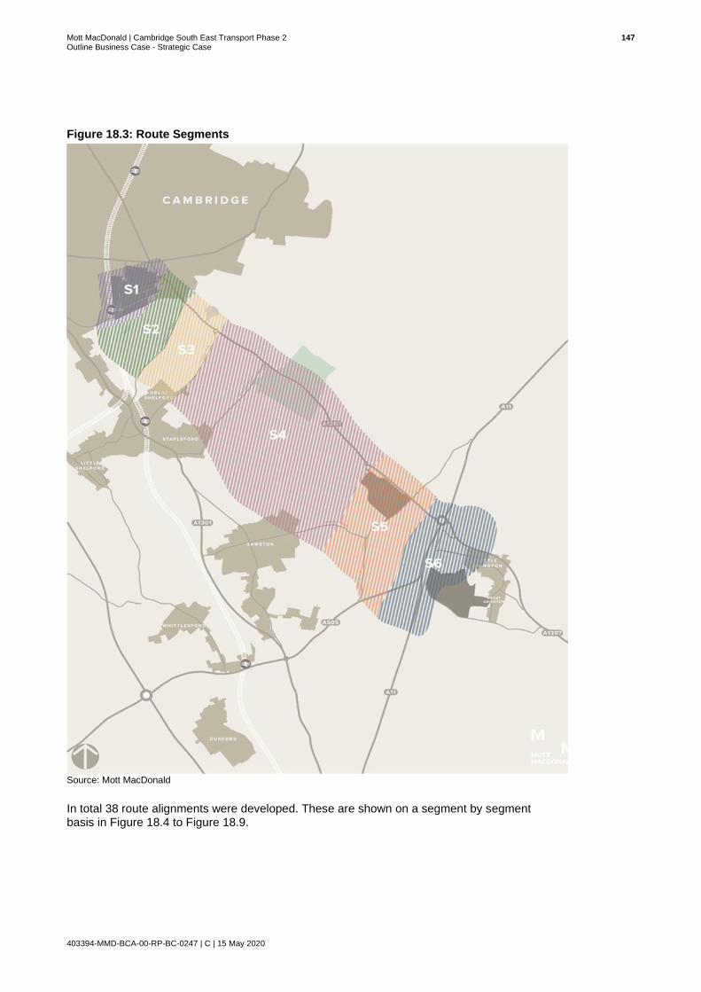
Mott MacDonald | Cambridge South East Transport Phase 2 147 Outline Business Case - Strategic Case
403394-MMD-BCA-00-RP-BC-0247 | C | 15 May 2020
Figure 18.3: Route Segments
Source: Mott MacDonald
In total 38 route alignments were developed. These are shown on a segment by segment basis in Figure 18.4 to Figure 18.9.

Mott MacDonald | Cambridge South East Transport Phase 2 148 Outline Business Case - Strategic Case
403394-MMD-BCA-00-RP-BC-0247 | C | 15 May 2020
Segment 1: CBC
Eight options (1A-1H) were identified for the connection into the CBC and shown in Figure 18.4.
Option 1A would run from a western alignment parallel with the railway and connect to the
campus at the roundabout junction of Addenbrooke’s Road, Dame Mary Archer Way and
Francis Crick Avenue. It would then follow Francis Crick Avenue before joining the route of the
existing guided busway. Option 1F is similar to Option 1A except it would connect to an
alignment following the A1307 rather than a western alignment.
Options 1B, 1C, 1G and 1H would join the campus at Robinson Way and follow this to reach the
route of the existing guided busway. The options differ in the route they take through land and
the proposed development area to the south of the campus. Options 1B and 1C would connect
to a western alignment, with Option 1C providing a more direct connection to Robinson Way.
Options 1G and 1H would connect to an alignment alongside the A1307 with both being a
similar distance.
Options 1D and 1E differ from the other options by entering the campus to the east, rather than
the south, and connecting with a route running via Hills Road. Option 1D would provide a
segregated route into the campus whereas Option 1E would require public transport vehicles to
share with general traffic.
Figure 18.4: Segment 1 Route Alignment Options
Source: Mott MacDonald. Contains OS data © Crown copyright and database rights 2018 OS 100023205

Mott MacDonald | Cambridge South East Transport Phase 2 149 Outline Business Case - Strategic Case
403394-MMD-BCA-00-RP-BC-0247 | C | 15 May 2020
Segment 2: CBC to Granham’s Road
Five route alignment options (2A-2E) were identified in Segment 2 and shown in Figure 18.5.
Option 2A would provide a dedicated route for public transport vehicles and run to the west of
Nine Wells Nature Reserve, parallel with the railway. This has been designed to avoid
dissecting the nature reserve.
Options 2B and 2C would continue along the A1307 (Hills Road) to reach the CBC at the
Addenbrooke’s Hospital roundabout. Option 2B would provide separate lanes alongside the
existing carriageway whereas Option 2C would provide a new alignment parallel to the existing
carriageway. Options 2D and 2E would provide a new connecting road between the A1307 at
Babraham Road Park & Ride to the south of the CBC. The difference between these options is
that Option 2E provides a direct alignment and Option 2D follows the field boundary.
Figure 18.5: Segment 2 Route Alignment Options
Source: Mott MacDonald. Contains OS data © Crown copyright and database rights 2018 OS 100023205

Mott MacDonald | Cambridge South East Transport Phase 2 150 Outline Business Case - Strategic Case
403394-MMD-BCA-00-RP-BC-0247 | C | 15 May 2020
Segment 3: Granham’s Road to Hinton Way
Four route alignment options (3A-3D), were identified in Segment 3 and shown in Figure 18.6.
Both Options 3A and 3B would provide a new alignment. Option 3A would run between
Granham’s Road and Hinton Way to the east of Great Shelford whereas Option 3B would take a
more direct route but consequently require the compulsory purchase of residential properties.
Options 3C and 3D would run alongside the A1307. Option 3C would comprise a widening of
the existing carriageway whereas Option 3D would be the construction of a new road parallel
with the A1307.
Figure 18.6: Segment 3 Route Alignment Options
Source: Mott MacDonald. Contains OS data © Crown copyright and database rights 2018 OS 100023205

Mott MacDonald | Cambridge South East Transport Phase 2 151 Outline Business Case - Strategic Case
403394-MMD-BCA-00-RP-BC-0247 | C | 15 May 2020
Segment 4: Hinton Way to Sawston Road
Eight route alignment options (4A-4H) were identified in Segment 4 and shown in Figure 18.7.
Options 4A, 4B, 4C, 4D, 4E and 4F are variations of a new alignment running between Hinton
Way and Sawston Road. In contrast, Options 4G and 4H would follow the A1307 with Option 4G
being a widening of the existing carriageway and Option 4H being a new road parallel with the
A1307.
Option 4A is a westerly alignment which runs alongside the former railway alignment and close
to the villages of Stapleford and Sawston. Option 4B follows a marginally more direct route to
the east of Option 4A but is slightly further from the residential areas.
Options 4C and 4D provide connections from the easterly alignment (Option 4B) to a new Travel
Hub site on the A1307, north of Babraham Research Campus. Option 4C would connect into
the north of the site and Option 4D would connect into the south.
Similarly, Options 4E and 4F provide connections from the westerly alignment (Option 4A) to the
same Travel Hub site on the A1307. Option 4E would connect into the north of the site and
Option 4D would connect into the south.
Figure 18.7: Segment 4 Route Alignment Options
Source: Mott MacDonald. Contains OS data © Crown copyright and database rights 2018 OS 100023205

Mott MacDonald | Cambridge South East Transport Phase 2 152 Outline Business Case - Strategic Case
403394-MMD-BCA-00-RP-BC-0247 | C | 15 May 2020
Segment 5: Sawston Road to High Street
Seven route alignment options (5A-5G) were identified in Segment 5 and shown in Figure 18.8.
Options 5A, 5B, 5C, 5D and 5G would provide a new alignment running south east of Sawston.
Options 5E and 5F would instead follow the A1307 from Babraham Research Campus, with
Option 5E being a widening of the existing carriageway and Option 5F a new road parallel with
the A1307.
Option 5A would run adjacent to the former railway alignment from Sawston and therefore close
to the County Wildlife Site. It would also require a bridge over High Street or significant
regrading of land. This would be avoided by Options 5B and 5C which would bypass the former
railway to the south and north respectively.
Option 5D would follow a different route from Sawston to connect directly with a Travel Hub site
adjoining the A1307 to the south east of Babraham Research Campus. Option 5G would
provide a direct link from Sawston to the A11/A1307 junction and a Travel Hub site located in
this area.
Figure 18.8: Segment 5 Route Alignment Options
Source: Mott MacDonald. Contains OS data © Crown copyright and database rights 2018 OS 100023205

Mott MacDonald | Cambridge South East Transport Phase 2 153 Outline Business Case - Strategic Case
403394-MMD-BCA-00-RP-BC-0247 | C | 15 May 2020
Segment 6: Connection to Travel Hub Site
Segment 6 considered how potential locations for the 11 potential Travel Hub sites would be
accessed from the main alignment options extending as far as the A11. Six route alignment
options (6A-6F) were identified and detailed in Figure 18.9.
Figure 18.9: Segment 6 Route Alignment Options
Source: Mott MacDonald. Contains OS data © Crown copyright and database rights 2018 OS 100023205
Option 6A would run alongside the A1307 as far as the A11, therefore serving a Travel Hub site
west of the A11. Option 6B would also follow the A1307 but cross the A11 and serve a Travel
Hub site to the east of this.
Option 6C would provide a connection from a new western alignment, serving Travel Hub sites
located north of the A505. It would not require a significant extension to the public transport
route in order to serve a Travel Hub site in this location.
Option 6D would extend from a new western alignment and cross the A505 to serve a Travel
Hub site on the south of this.
Option 6E would also require an extension to the public transport route, in this case running
parallel with the A11.

Mott MacDonald | Cambridge South East Transport Phase 2 154 Outline Business Case - Strategic Case
403394-MMD-BCA-00-RP-BC-0247 | C | 15 May 2020
Option 6F would extend Options 6E or 5G by creating a bridge across the A11. It would then
join the existing highway network with public transport vehicles running on Newmarket
Road/Bourn Bridge to connect with a Travel Hub site. Option 6F(b) would cross the A11 but
extend to the A1307 via a dedicated new route instead of sharing with existing traffic on
Newmarket Road.
18.2 Option Long List
Following a high level sift at Stage 1B, which sought to discount any route alignments that
were not feasibly deliverable based on political and environmental constraints, 25 alignments
remained. These are listed in Table 18.1. Due to the nature of the landscape and topography
some of the segments had more alignment possibilities than others.
Table 18.1: Feasible Route Alignments within each Segment
Segment Overview of Segment
1: CBC Option 1A: Western alignment with entry via Francis Crick Ave
Option 1B: Western alignment with entry via Robinson Way (East)
Option 1C: Western alignment with entry via Robinson Way (West)
Option 1F: A1307 alignment with entry via Francis Crick Ave
2. CBC to Granham’s Road
Option 2A: West of Nine Wells
Option 2D: A1307 alignment with link road to CBC via field boundary
Option 2E: A1307 alignment with link road to CBC direct alignment
3: Granham’s Road to Hinton Way
Option 3A: East (avoiding urban area)
Option 3B: Western Route
Option 3C: A1307 (separate lanes)
4: Hinton Way to Sawston Road
Option 4A: West with no Travel Hub connection
Option 4B: East with no Travel Hub connection
Option 4C: East with northern connection to Travel Hub
Option 4D: East with southern connection to Travel Hub
Option 4E: West with northern connection to Travel Hub
Option F4: West with southern Babraham Research Campus connection to Travel Hub
Option 4G: A1307 (separate lanes)
5: Sawston Road to High Street
Option 5C: North of former railway
Option 5D: Connection to Babraham Research Campus Travel Hub
Option 5E: A1307 (separate lanes)
Option 5G: Direct route to A11 and A1307 Travel Hub sites
6: Connection to Travel Hub Site
Option 6A: Via A1307 (north)
Option 6C: Direct from western alignment
Option 6E: Parallel with A11 (without crossing)
Option 6F: Parallel with A11 (with crossing)
Source: Mott MacDonald
These 25 route alignments were then combined with the 11 potential Travel Hub sites. In theory
this should have led to 275 option packages (25 x 11), had all feasible alignments been able to
connect to each of the 11 Travel Hub sites, however this was not the case and the maximum
number of option packages generated was 231.

Mott MacDonald | Cambridge South East Transport Phase 2 155 Outline Business Case - Strategic Case
403394-MMD-BCA-00-RP-BC-0247 | C | 15 May 2020
As 231 was a far too large a number of options to develop in detail, and differences between
some of the options were marginal, a Gateway Assessment was undertaken to discount any of
the option packages that either did not meet key policy objectives or would cause hardship and
distress such that it would render the scheme unacceptable by the local communities.
The three Gateway Assessment Criteria are:
Through this Gateway Assessment, 141 of the 231 options were sifted out leaving 90 options
remaining as a refined long list to go forward to Stage 2 for formal appraisal. Full detail on the
refined long list can be found in Appendix A: OAR, document reference MMD-BCA-00-RE-BC-
0024-C.
18.3 Option Sifting
The longlist of 90 option packages were subjected to a detailed qualitative sift and scored using
a Multi-Criteria Assessment Framework according to how well they addressed criteria under the
themes of:
A seven-point scoring system was adopted to assess how well options met the established
criteria, using a scale of -3 to +3, where -3 represented a very poor ability to address criteria
and +3 a very good ability. On this basis and with some refinement to the designs following
consultation with stakeholders five options were shortlisted and taken forward for a robust
quantitative appraisal.
18.4 Option Shortlist
The five shortlisted options are shown in Figure 18.10. There are five route alignments, which
are denoted by colour; Black, Blue, Brown, Pink and Purple and three Travel Hub sites denoted
by letter; A, B and C.
Does the Travel Hub Site meet minimum capacity requirements of 1,000
spaces?
Does the land take required involve taking specialist /unique land that is not compensatable without
causing severe hardship or commercial loss to exisiting
owners?
Does land take required involve unnecessary loss of residential property as an alternate equally suitable
and beneficial alignment is available?
Transport User Benefits
Environment DeliverabilitySocial Impacts (Quality of Life)
Wider Economic Benefits
Alignment with Objectives
Policy Alignment

Mott MacDonald | Cambridge South East Transport Phase 2 156 Outline Business Case - Strategic Case
403394-MMD-BCA-00-RP-BC-0247 | C | 15 May 2020
Figure 18.10: Option Shortlist
Source: Mott MacDonald

Mott MacDonald | Cambridge South East Transport Phase 2 157 Outline Business Case - Strategic Case
403394-MMD-BCA-00-RP-BC-0247 | C | 15 May 2020
18.4.1 Overview of Shortlisted Route Alignments
All five options follow the same route between CBC and Sawston, from which point they diverge
into five alternative alignments, leading to one of three Travel Hub sites.
All options would have the same HQPT service frequencies and have similar levels of provision
for pedestrians and cyclists. The main differences between each option and the Travel Hub
sites are summarised below; this includes acknowledgement of constraints and risks to delivery.
CBC to Sawston
The section of the route common to all options runs along Francis Crick Avenue before exiting
on the southern side of the CBC and running parallel with the railway. It then diverts to the east
of Great Shelford and Stapleford before crossing the River Granta and running to the east of
Sawston. All four stops proposed at this stage are within this section and in the same locations
for each option. These would be at the CBC, Hinton Way (Great Shelford), Haverhill Road
(Stapleford) and Sawston Road (Sawston). The route would cross each of these roads and
Granham’s Road, via new at-grade junctions to be signalised with priority given to public
transport vehicles. Before reaching High Street, the route options then diverge as outlined within
the following sections.
Brown Option
The Brown (and Blue) route takes a direct alignment across fields towards the A11, which
includes a second crossing of the River Granta. The Brown route ends at Travel Hub Site B,
located to the south west of the junction between the A1307 and A11. General traffic would
access it from the A1307 via a new junction whilst the site itself would have a linear
arrangement in order to accommodate it between a high-pressure gas main, over which
development is restricted, and the A11. The site could provide parking for up to 2,800 cars.
Blue Option
The Blue route extends beyond the Brown route to cross the A11 via a new bridge. The route
would then cross Newmarket Road at a new junction, before running through the south of the
former Comfort Café site and crossing the A1307 via a new junction to connect with Travel Hub
Site C, located on the north side of the A1307. As with the junctions on the common section of
route, all new junctions would be at-grade and signalised with priority for public transport
vehicles. Site C would have a separate roundabout junction to provide general traffic with
access into the site at the current junction between the A1307 and Newmarket Road. It could
provide parking for up to 2,100 cars.
Black Option
The Black, Purple and Pink routes follow the route of a former railway; however, as this is now
designated as a County Wildlife Site, the proposed alignment would be slightly to the north of
this, also avoiding the need for a bridge or significant regrading works at the former High Street
crossing. All three options follow the same route initially with the Black and Pink options
continuing to the A505 junction before running parallel with the A11 and crossing the River
Granta. The Black route would then cross the A11 before following the same alignment as the
Blue option from Newmarket Road to Travel Hub Site C.
Pink Option
The Pink option is the same as the Black option but, instead of crossing the A11, it terminates at
Travel Hub Site B to the north of the River Granta. This would be the same as the Travel Hub
site for the Brown route but have a slightly different layout in order to accommodate public

Mott MacDonald | Cambridge South East Transport Phase 2 158 Outline Business Case - Strategic Case
403394-MMD-BCA-00-RP-BC-0247 | C | 15 May 2020
transport vehicles entering the site from the south rather than west. This would result in a
slightly lower capacity of up to 2,500 cars.
Purple Option
The Purple route is the shortest of all options and, unlike other options, crosses the River
Granta once only. It follows the same route as the Pink and Black route but stops to the west of
the A11/A505 junction and would serve Travel Hub Site A. This would be accessed via a new
roundabout junction to the north of the A505 slip road and require an extended access road to
the site itself. This would be necessary in order to avoid the high-pressure gas pipeline. The site
would provide capacity for approximately 2,000 cars but has potential for expansion.
It was from these five shortlisted options; outcomes of the INSET process, that the preferred
option was selected; this is detailed in Section 19.
18.4.2 Overview of Shortlisted Travel Hub Sites
Travel Hub Site A
Site A is located to the west of the A11/A505 junction. The site is set back from the A505 so
additional infrastructure would need to be implemented for access. The site has potential to
provide between 2,000 and 3,000 spaces.
Figure 18.11 shows the site location and proposed access from the A505/Granta Park junction,
with a roundabout at the access/exit and a second roundabout, where the northbound access
road meets the access road from the A505 southbound to Granta Park.
Figure 18.11: Travel Hub Site A and Proposed Access
Source: Mott MacDonald
The site is located on Green Belt land, which is currently being used for arable farming. In
planning terms this type of transport infrastructure may be considered essential development,
and therefore a case could be made for ‘not inappropriate development’. The site is located to

Mott MacDonald | Cambridge South East Transport Phase 2 159 Outline Business Case - Strategic Case
403394-MMD-BCA-00-RP-BC-0247 | C | 15 May 2020
avoid a high-pressure gas pipeline and the associated exclusion zone, albeit the access to the
site would need to cross the pipeline. An access road crossing the pipeline is permissible, but
the site itself must be outside the exclusion zone.
The location requires a significant diversion for traffic currently using the A1307 from the A11
(Fourwentways) junction to the A505/Granta Park junction and the site would not be visible to
potential users travelling on the A1307 or A11.
Travel Hub Site B
Site B is located west of the A11 and in a location which would be passed by all traffic travelling
west into Cambridge on the A1307, avoiding the need for many users to deviate from their
existing route and being visible to drivers which would encourage future use. Access to this site
would be from the A1307 via a new junction in the form of a roundabout (Figure 18.12) or
alternatively a signal-controlled junction.
Figure 18.12: Travel Hub Site B and Proposed Access
Source: Mott MacDonald
The site has a potential parking capacity of between 2,000 and 2,800 spaces but is subject to
several constraints. It is located within the Green Belt; parts of the site are situated in flood
zones 2 and 337 and it is located adjacent to a high-pressure gas pipeline with the access from
the A1307 crossing the pipeline. An access road crossing the pipeline is permissible, but the
site itself must be outside the exclusion zone. In addition, the site straddles an existing public
footpath. All these constraints have been considered in planning the layout of the site.
37 Zone 2 is defined by the Environment Agency as land assessed as having between a 1 in 100 and 1 in 1,000 annual probability of river flooding (1% – 0.1%) and Zone 3 as land assessed as having a 1 in 100 or greater annual probability of river flooding (>1%)
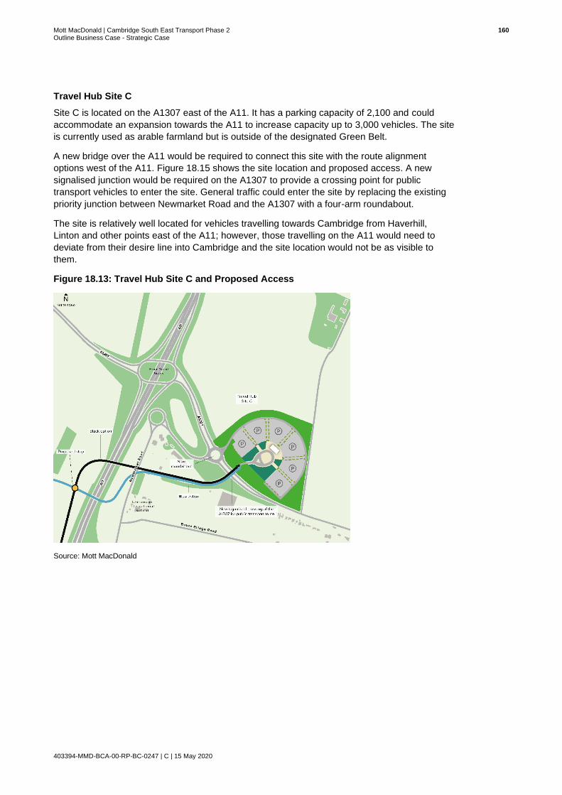
Mott MacDonald | Cambridge South East Transport Phase 2 160 Outline Business Case - Strategic Case
403394-MMD-BCA-00-RP-BC-0247 | C | 15 May 2020
Travel Hub Site C
Site C is located on the A1307 east of the A11. It has a parking capacity of 2,100 and could
accommodate an expansion towards the A11 to increase capacity up to 3,000 vehicles. The site
is currently used as arable farmland but is outside of the designated Green Belt.
A new bridge over the A11 would be required to connect this site with the route alignment
options west of the A11. Figure 18.15 shows the site location and proposed access. A new
signalised junction would be required on the A1307 to provide a crossing point for public
transport vehicles to enter the site. General traffic could enter the site by replacing the existing
priority junction between Newmarket Road and the A1307 with a four-arm roundabout.
The site is relatively well located for vehicles travelling towards Cambridge from Haverhill,
Linton and other points east of the A11; however, those travelling on the A11 would need to
deviate from their desire line into Cambridge and the site location would not be as visible to
them.
Figure 18.13: Travel Hub Site C and Proposed Access
Source: Mott MacDonald

Mott MacDonald | Cambridge South East Transport Phase 2 161 Outline Business Case - Strategic Case
403394-MMD-BCA-00-RP-BC-0247 | C | 15 May 2020
19 The Preferred Option
19.1 Preferred Option Selection Process
In order to identify a preferred option, the five shortlisted options were appraised from multiple
perspectives utilising three mechanisms:
1. Mott MacDonald’s in-house Multi-Criteria Assessment Framework INSET, (INvestment,
Sifting and Evaluation Tool): a quantitative and more detailed qualitative assessment of the
shortlisted options was undertaken to aid in the identification of the preferred option. A
detailed account of this process can be found in Appendix A: OAR, document reference
MMD-BCA-00-RE-BC-0024.
2. Benefit Cost Ratio (BCR) calculation and Value for Money (VfM). A detailed account of this
process can be found in the Economic Case of this OBC.
3. Consultation Feedback: based on public consultation held during the autumn of 2019. A
summary of the consultation process and the subsequent feedback can be found in the
Management Case of this OBC and the results are reported fully in the consultation
summary report produced by the Cambridgeshire Research Group for GCP. 38
Under all three mechanisms the preferred option was either Brown (INSET and consultation
feedback) or Purple (BCR). This narrowed the potential options down to either Travel Hub Site
A (Purple) or B (Brown). The Black and Blue options which connected to Travel Hub Site C, and
the Pink option connecting to Travel Hub Site B were at this point discounted from further
consideration.
In order to assess the relative advantages and disadvantages between Site A and Site B,
microsimulation modelling work was undertaken using VISSIM software to assess the traffic
impact at both of these sites to investigate if there were any material differences between the
two options that might influence the recommendation of a preferred option. However, it was
found that there was no material difference in overall network performance between the two
options. Based on the evidence from the microsimulation modelling a roundabout access
junction to Site B was identified as the preferred form of access junction for the Brown option.
It was concluded that the Brown option was the best performing in terms of both route alignment
and Travel Hub site, performing best both under the INSET appraisal process, which assessed
options against a total 92 criteria under 7 themes, and at public consultation. This option will be
taken forward for consideration by the GCP Executive Board as the recommended preferred
option to be progressed for planning and further development to Full Business Case stage.
Section 19.2 summarises the appraisal process and outcome under each of the three
mechanisms.
19.2 Appraisal Outcomes
The main appraisal tool at the option shortlist stage was INSET, which had previously been
used to sift the longlist of options to arrive at the shortlist.
38 Cambridge South East Transport – Better Public Transport Project: Summary Report of Consultation Findings, Cambridgeshire
Research Group, January 2020
Mott MacDonald | Cambridge South East Transport Phase 2 162 Outline Business Case - Strategic Case
403394-MMD-BCA-00-RP-BC-0247 | C | 15 May 2020
For consistency the same process was applied to assessment of the options shortlist, where
options were again appraised against 92 criteria under seven themes, though at the shortlist
stage a more quantitative approach was adopted, but still involving some qualitative elements.
Feedback from consultation and public opinion was not included as one of the assessment
criteria under INSET because no public consultation was undertaken until after the options
shortlist had been identified. The results of and feedback from consultation have therefore been
considered as a separate mechanism in the selection of a preferred option.
Benefit Cost Ratios were also calculated for the shortlisted options. Again, this process was not
undertaken in the assessment of the longlist as the options would have required more detailed
development in order to apply this quantitative analysis. To apply such an analysis to options
which could be discounted through qualitative measures alone was not deemed efficient or
proportionate and this approach is consistent with DfT appraisal guidance.
19.2.1 INSET Appraisal
The five shortlisted options were quantitatively assessed against the same criteria under the
same themes (noted below) as they were under qualitative assessment at the longlist stage of
the appraisal process:
Where applicable, metrics (e.g. journey times, junction delay) were calculated. Where
quantitative analysis was not possible or applicable, a more detailed and robust qualitative
analysis was undertaken that built on the assessment undertaken at the longlist stage, using the
same seven-point scoring system. Metrics were then calibrated into scores ranging from -3 to
+3, where -3 represented a very poor ability to address criteria and +3 a very good ability. A full
list of the criteria under each theme and the basis for assigning scores are detailed in Appendix
A: OAR, document reference MMD-BCA-00-RE-BC-0024.
The final results of the INSET appraisal are set out in Table 19.1 and can be interpreted on a
theme by theme basis as well as by overall score. The final ranking of the five shortlisted
options is also indicated.
Transport User Benefits
Environment DeliverabilitySocial Impacts (Quality of Life)
Wider Economic Benefits
Alignment with Objectives
Policy Alignment

Mott MacDonald | Cambridge South East Transport Phase 2 163 Outline Business Case - Strategic Case
403394-MMD-BCA-00-RP-BC-0247 | C | 15 May 2020
Table 19.1: Final Option Shortlist INSET Results
Rank Scheme Transport Benefits
Environment Deliverability
Social Impacts
(Quality of Life)
Wider Economic Benefits
Alignment with
Objectives
Policy Alignment
Total Score
1 Brown Route from Travel Hub Site B
1.52 -1.25 -0.57 0.88 3.00 1.75 2.20 1.08
2 Pink Route from Travel Hub Site B
1.50 -1.25 -0.64 0.88 3.00 1.75 2.20 1.06
3 Blue Route from Travel Hub Site C
1.33 -1.25 -1.10 0.58 3.00 1.65 2.20 0.92
4 Purple Route from Travel Hub Site A
1.31 -1.25 -0.29 0.71 2.00 1.68 2.20 0.91
5 Black Route from Travel Hub Site C
1.33 -1.25 -1.38 0.58 3.00 1.65 2.20 0.88
Source: Mott MacDonald
As shown in Table 19.1 the INSET appraisal has identified the Brown Route from Travel Hub Site B as the indicative preferred option for CSET
Phase 2 under this appraisal mechanism with a score of 1.08
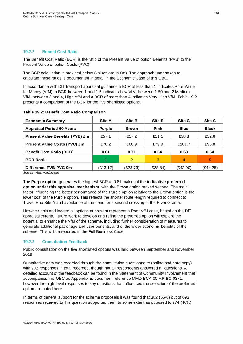
Mott MacDonald | Cambridge South East Transport Phase 2 164 Outline Business Case - Strategic Case
403394-MMD-BCA-00-RP-BC-0247 | C | 15 May 2020
19.2.2 Benefit Cost Ratio
The Benefit Cost Ratio (BCR) is the ratio of the Present Value of option Benefits (PVB) to the
Present Value of option Costs (PVC).
The BCR calculation is provided below (values are in £m). The approach undertaken to
calculate these ratios is documented in detail in the Economic Case of this OBC.
In accordance with DfT transport appraisal guidance a BCR of less than 1 indicates Poor Value
for Money (VfM); a BCR between 1 and 1.5 indicates Low VfM, between 1.50 and 2 Medium
VfM, between 2 and 4, High VfM and a BCR of more than 4 indicates Very High VfM. Table 19.2
presents a comparison of the BCR for the five shortlisted options.
Table 19.2: Benefit Cost Ratio Comparison
Economic Summary Site A Site B Site B Site C Site C
Appraisal Period 60 Years Purple Brown Pink Blue Black
Present Value Benefits (PVB) £m £57.1 £57.2 £51.1 £58.8 £52.6
Present Value Costs (PVC) £m £70.2 £80.9 £79.9 £101.7 £96.8
Benefit Cost Ratio (BCR) 0.81 0.71 0.64 0.58 0.54
BCR Rank 1 2 3 4 5
Difference PVB-PVC £m (£13.17) (£23.73) (£28.84) (£42.90) (£44.25) Source: Mott MacDonald
The Purple option generates the highest BCR at 0.81 making it the indicative preferred
option under this appraisal mechanism, with the Brown option ranked second. The main
factor influencing the better performance of the Purple option relative to the Brown option is the
lower cost of the Purple option. This reflects the shorter route length required to connect to
Travel Hub Site A and avoidance of the need for a second crossing of the River Granta.
However, this and indeed all options at present represent a Poor VfM case, based on the DfT
appraisal criteria. Future work to develop and refine the preferred option will explore the
potential to enhance the VfM of the scheme, including further consideration of measures to
generate additional patronage and user benefits, and of the wider economic benefits of the
scheme. This will be reported in the Full Business Case.
19.2.3 Consultation Feedback
Public consultation on the five shortlisted options was held between September and November
2019.
Quantitative data was recorded through the consultation questionnaire (online and hard copy)
with 702 responses in total recorded, though not all respondents answered all questions. A
detailed account of the feedback can be found in the Statement of Community Involvement that
accompanies this OBC as Appendix E, document reference MMD-BCA-00-RP-BC-0371,
however the high-level responses to key questions that influenced the selection of the preferred
option are noted here.
In terms of general support for the scheme proposals it was found that 382 (55%) out of 693
responses received to this question supported them to some extent as opposed to 274 (40%)

Mott MacDonald | Cambridge South East Transport Phase 2 165 Outline Business Case - Strategic Case
403394-MMD-BCA-00-RP-BC-0247 | C | 15 May 2020
who opposed the proposals to some degree; 37 (5%) of the respondents expressed no opinion.
The results of the survey are detailed in Figure 19.1.
Figure 19.1: Level of Support for the Scheme Proposals in General
Source: Consult Cambridgeshire
Regarding the preferred location for the Travel Hub most support was expressed for Site B, with
300 (45%) of the 668 responses either supporting or strongly supporting the option and 200
(30%) opposing the site to some degree. Site C proved to be the least attractive site with only
194 (30%) supporting it to some extent and 286 (43%) opposing it. This is illustrated in Figure
19.2.

Mott MacDonald | Cambridge South East Transport Phase 2 166 Outline Business Case - Strategic Case
403394-MMD-BCA-00-RP-BC-0247 | C | 15 May 2020
Figure 19.2: Level of Support for the Travel Hub Sites
Source: Consult Cambridgeshire
36 stakeholder responses were also received on behalf of groups and organisations. Although
individual stakeholders had preferences for the location of the Travel Hub, no individual site had
clear support or opposition. Stakeholders were concerned about:
● The ability to access the site from surrounding roads and the potential impact this could have
on those roads;
● The impact on the environment and nearby villages;
● Access to Granta Park and Babraham Research Campus; and
● The possibility of future proofing through expanding the site and extending the public
transport route towards Haverhill.
When asked about the route alignments the Brown option, which connects to the most strongly
supported Travel Hub site (Site B) received the greatest level of approval with 228 out if the 651
responses received supporting the option to some extent, compared with 198 opposing the site
to some degree. The Black and Blue options which connect to Site C, the least popular Travel
Hub site, received the least support with only 158 and 173 respondents respectively showing
some level of support. This is shown in Figure 19.3.

Mott MacDonald | Cambridge South East Transport Phase 2 167 Outline Business Case - Strategic Case
403394-MMD-BCA-00-RP-BC-0247 | C | 15 May 2020
Figure 19.3: Level of Support for the Complete Option Packages
Source: Consult Cambridge
On this basis consultation concluded the Brown Route from Travel Hub Site B was, from a
public acceptability standpoint, the indicative preferred option - aligning with the findings of
the formal INSET appraisal process.
19.3 Options Discounted
Under all three mechanisms the preferred option was either Brown (INSET and consultation
feedback) or Purple (BCR). This narrowed the potential options down to either Travel Hub Site

Mott MacDonald | Cambridge South East Transport Phase 2 168 Outline Business Case - Strategic Case
403394-MMD-BCA-00-RP-BC-0247 | C | 15 May 2020
A (Purple) or B (Brown). The Black and Blue options connecting to Travel Hub Site C, and the
Pink option connecting to Travel Hub Site B were at this point discounted from further
consideration.
There are clear grounds for discounting the two options connecting to Travel Hub Site C at this
point:
● These are the two highest cost options out of the five shortlisted, with significant additional
Present Value Costs of £15.9m (Black) and £20.8m (Blue) relative to the next highest cost
option (Brown).
● These are also the two options with the lowest BCRs, indicating that the additional costs of
these options are not justified by additional benefits.
● Travel Hub Site C was the least supported of the three Travel Hub site options in the
consultation responses.
● The Black and Blue options connecting to Site C were the least supported of the five
complete option packages.
● The Black and Blue options connecting to Site C involve the construction of a new bridge
over the A11. Constructing a bridge over a live high-speed trunk road presents some
challenges and the inherent construction risks are greater than the other options.
The main grounds for preferring the Brown option connecting to Travel Hub Site B over the Pink
option are:
● The Brown route is more direct, offering shorter journey times, generating higher patronage
and delivering additional benefits relative to the Pink option. This is reflected in a higher
INSET score for the Transport User Benefits theme.
● The additional benefits of the Brown option are sufficient to justify the additional costs of this
option relative to the Pink option as demonstrated by the higher BCR of the Brown option.
● The Brown option received a slightly greater level of support and a slightly lower level of
opposition relative to the Pink option in the consultation responses.
19.4 Consideration of Remaining Options
The remaining options from which to select a recommended preferred option were narrowed
down to two, namely:
● The Brown option (Travel Hub Site B), identified as the indicative preferred option from both
the INSET appraisal and consultation feedback; and
● The Purple option (Travel Hub Site A), identified as the best performing option in terms of
VfM.
These options were analysed further, including undertaking microsimulation modelling using
VISSIM software to assess the traffic impact at both of these sites to investigate if there were
any material differences in performance between the two options.
19.4.1 VISSIM Modelling
Future year (2036) models for the AM and PM Peak were created and comparisons between
the two options made regarding:
● Junction Performance (processed traffic volumes, average queue length; and average
delay);
● Travel Time Performance, based on the time required to traverse existing routes using:

Mott MacDonald | Cambridge South East Transport Phase 2 169 Outline Business Case - Strategic Case
403394-MMD-BCA-00-RP-BC-0247 | C | 15 May 2020
– the A505 between the M11, Junction 10 and the A11/A1307 junction and
– the A1307 between High Street Abington and a point east of the Babraham Campus
roundabout;
● Overall Network Performance.
A detailed account of the modelling process can be found in the VISSIM Assessment Report,
document reference 403394-MMD-TRA-00-RP-TA-0241 and is this summarised in the
Economic Case of this OBC.
In conclusion, the Purple option resulted in the best modelled operational performance,
however, the differences relative to the Brown option are marginal and the benefit with the
Purple option is likely to be due to the lower traffic flow using the access junction to Site A as
forecast by the SATURN model of the highway network. This reflects the access to Site A not
being provided directly from the principal road network.
19.4.2 Green Belt Considerations
The conclusions of a report39 assessing Green Belt considerations in relation to the shortlisted
route and Travel Hub site options included that:
● The Brown option would require a bridge over the River Granta and associated ramped
approaches, which is not required for the Purple option, introducing a volume of additional
built development into open countryside. This would impact openness and result in a
Moderate-minor degree of harm to Green Belt. However, it may be possible to design a
bridge structure that reduces the potential harm as part of the detailed design of the
structure.
● Both of the proposed Travel Hub Sites located within the Green Belt (Sites A and B) would
introduce a volume of new development with a permanent visual and spatial effect on the
openness of the Green Belt.
● Whilst both Travel Hub Sites A and B would have similar conflict with Green Belt purposes,
Travel Hub Site B fits slightly better with its landscape context, being closer to the A11 and at
a lower elevation.
● Overall, for both Travel Hub Sites A and B, there would be partial changes to relevant
aspects of the landscape, resulting in a Moderate degree of harm to Green Belt arising from
the impact on openness and a conflict with National Green Belt purpose 3, Cambridge Green
Belt purpose 2 and National Green Belt purpose 4. Planting around the perimeter of Site A or
along the northern boundary of Site B could reduce this conflict over time to a Moderate-
minor degree of harm to Green Belt purposes.
Green Belt considerations do not provide compelling reasons to prefer either the Purple option
(Travel Hub Site A) or the Brown option (Travel Hub Site B). While the Brown option requires a
bridge over the River Granta which is not required for the Purple option, impacting on openness,
Travel Hub Site B fits slightly better with its landscape context than Site A.
19.5 The Preferred Option
Following consideration of all of the appraisal perspectives and mechanisms outlined above it
was concluded that the Brown option was the best performing option in terms of both route
39 Cambridge South East Transport, Consideration of Green Belt Issues, LDA Design, March 2020

Mott MacDonald | Cambridge South East Transport Phase 2 170 Outline Business Case - Strategic Case
403394-MMD-BCA-00-RP-BC-0247 | C | 15 May 2020
alignment and Travel Hub site, performing best under the INSET appraisal process, which
assessed options against a total 92 criteria covering a wide range of transport specific, strategic,
economic, environmental and political factors, and being the preferred option in the public
consultation, while ranking second for value for money.
Although the BCR calculation showed that the Purple option provided the best value for money,
this is only one element or rationale for implementing the scheme and it considers only a narrow
set of economic criteria in the appraisal process.
Travel Hub Site B ultimately has greater potential to fulfil the role of a multi-modal Travel Hub
and to facilitate enhancements to sustainable transport connectivity to both employment
campuses than Site A. Site B is better located to intercept traffic on both the A1307 and A11,
and to act as a public transport hub than Site A, to which access is compromised by the lack of
a northbound exit from the A11 at the A505 junction. Site A is also more remote from Babraham
Research Campus.
The Brown Route from Travel Hub Site B will therefore be taken forward for consideration by the
GCP Executive Board as the recommended preferred option to be progressed for planning and
further development to Full Business Case stage.
Figure 19.4 illustrates the alignment of the Brown option.

Mott MacDonald | Cambridge South East Transport Phase 2 171 Outline Business Case - Strategic Case
403394-MMD-BCA-00-RP-BC-0247 | C | 15 May 2020
Figure 19.4: Brown Option
Source: Mott MacDonald
The Brown option follows the same alignment as all other shortlisted options up to a point just
north of High Street, in that it runs along Francis Crick Avenue before exiting on the southern
side of the CBC and running parallel with the railway. It then diverts to the east of Great
Shelford and Stapleford before crossing the River Granta and running to the east of Sawston.
Four passenger stops are proposed at the CBC, Hinton Way (Great Shelford), Haverhill Road
(Stapleford) and Sawston Road (Sawston). The route then crosses each of these roads and
Granham’s Road, via a new at-grade junctions to be signalised with priority given to public
transport vehicles.

Mott MacDonald | Cambridge South East Transport Phase 2 172 Outline Business Case - Strategic Case
403394-MMD-BCA-00-RP-BC-0247 | C | 15 May 2020
Before reaching High Street the route then cuts across fields towards the A11 which includes a
second crossing of the River Granta. The route ends at Travel Hub Site B, located to the south
west of the junction between the A1307 and A11. General traffic would access the Travel Hub
from the A1307 via a new roundabout junction whilst the site itself would have a linear
arrangement in order to accommodate it between a high-pressure gas main, over which
development is restricted, and the A11. The site could provide parking for up to 2,800 cars with
the current known constraints.
19.6 Future Option Refinements
Having established the Brown option as the recommended preferred scheme, stakeholder
feedback and consultation responses from landowners have resulted in the need to explore the
following minor design amendments to the route alignment:
● Review alignment around Nine Wells to provide better protection for grey partridge which
use the hedgerow along the currently proposed route.
● Change requested by landowner at Granham’s Road/Hinton Way to reduce dissection of a
field.
● Alternative alignment north of Haverhill Road to avoid dissection of a field.
● Review whether alignment can be brought any closer to the villages, particularly at
Stapleford.
● Amend route between Sawston and Babraham to run close to the south side of Sawston
Road in response to comments on the impact of the proposals on the Green Belt and
landscape impacts. This would also bring the shared-use path to be built alongside the
public transport route closer to Babraham and link into the existing cycle path between
Sawston and Babraham.
These are not alternative options, and in the event of any of these amendments being adopted
they are considered to represent only minor modifications to the current recommended
preferred route.
All but one of these potential minor amendments to the route alignment are within the section of
the alignment that is identical for all five shortlisted options. Any minor design changes here
would impact all options equally and would not affect the overall ranking or the selection of the
Brown option as the preferred option.
This design development work will be undertaken at Full Business Case stage and the
performance and impacts of the proposed alignment change compared with the initial Brown
option so that a decision on the optimum alignment can be made and taken forward for detailed
design and implementation.
19.7 Approach to Future Proofing
The CSET project aspires to utilise guidance technology that delivers the greatest level of
benefits in relation to meeting its strategic objectives, and to ensure alignment with the future
CAM network, for which CSET Phase 2 would partially comprise Phase 1, if CAM were
consented. The benefits of such a system include:

Mott MacDonald | Cambridge South East Transport Phase 2 173 Outline Business Case - Strategic Case
403394-MMD-BCA-00-RP-BC-0247 | C | 15 May 2020
● Requiring limited fixed infrastructure;
● Facilitating the alignment of vehicles with a raised platform at stops for level boarding;
● Ease of retrofitting to existing/new buses; and
● Providing a smooth transition between sections with continuous guidance and sections
beyond the core CSET Phase 2 public transport route where vehicles would operate without
guidance.
As these technologies are still developing, the assessment of the CSET project, including its
economic appraisal and costings, have been based on utilising existing Euro VI standard buses,
which use proven technology which typically meets the standards of Clean Air Zones. However,
as the aspiration is to eventually use the most up to date guidance technology for the CSET
Phase 2 project, Appendix C, document reference 403394-MMD-BCA-00-RP-BC-0369 sets out
the GCP’s consideration of guidance technology options, and in particular considers the
available options in the context of their compliance with existing Transport Works Act 1992
(TWA) legislation and the project objectives.

Mott MacDonald | Cambridge South East Transport Phase 2 174 Outline Business Case - Strategic Case
403394-MMD-BCA-00-RP-BC-0247 | C | 15 May 2020
20 Summary
● The CSET Phase 2 proposal will deliver a new dedicated public transport route between a
new Travel Hub near the A11/A1307/A505 junction and the Cambridge Biomedical Campus
via intermediate communities. The term Travel Hub has been used as the site is intended to
provide an interchange between different modes of transport such as walking, cycling
and existing bus services and be more sustainable than a typical Park & Ride facility.
● Eight assessment themes have been identified as a basis for undertaking a review of
evidence to capture the key problems and opportunities in the study area that transport
investment may alleviate and/or support.
● Many of the issues presented relate to the population and employment growth of Cambridge,
with this growth resulting in increased congestion and associated impacts on air quality,
journey time and the environment, with many of the areas experiencing growth currently
poorly connected by public transport.
● The opportunities stated relate to the potential for Cambridge and the wider area to grow in a
more sustainable manner, improving public transport travel and spurring more development
through greater connections between the peripheral communities and central Cambridge.
● There is a need for intervention as the number of new jobs and homes expected to be
created in the coming years would mean journey times between the A11 and Cambridge
would increase by 50% by 2031 whilst an increase in car use will have a negative impact on
quality of life and worsen air pollution.
● CSET Phase 2 options have been subjected to a multistage appraisal process, including a
gateway assessment and detailed option sifting to shortlist five options, all travelling from
CBC to Sawston before diverging into different route alignments.
● These five options were appraised from multiple perspectives utilising three mechanisms:
Mott MacDonald’s in-house Multi-Criteria Assessment Framework INSET; Benefit Cost Ratio
(BCR) calculation and Value for Money (VfM); and consultation feedback. Under all three
mechanisms the preferred option was either Brown (INSET and consultation feedback) or
Purple (BCR).
● It was concluded that the Brown option was the best performing in terms of both route
alignment and Travel Hub site and therefore it will be taken forward for GCP Executive
Board approval as the preferred option to be progressed for planning and further
development at Full Business Case stage.
● The Brown route takes a direct route across fields towards the A11 which includes a second
crossing of the River Granta. The route ends at Travel Hub Site B, located to the south west
of the junction between the A1307 and A11. General traffic would access the Travel Hub
from the A1307 via a new roundabout junction whilst the site itself would have a linear
arrangement in order to accommodate it between a high-pressure gas main, over which
development is restricted, and the A11. The site could provide parking for up to 2,800 cars.

Mott MacDonald | Cambridge South East Transport Phase 2 175 Outline Business Case - Strategic Case
403394-MMD-BCA-00-RP-BC-0247 | C | 15 May 2020
mottmac.com