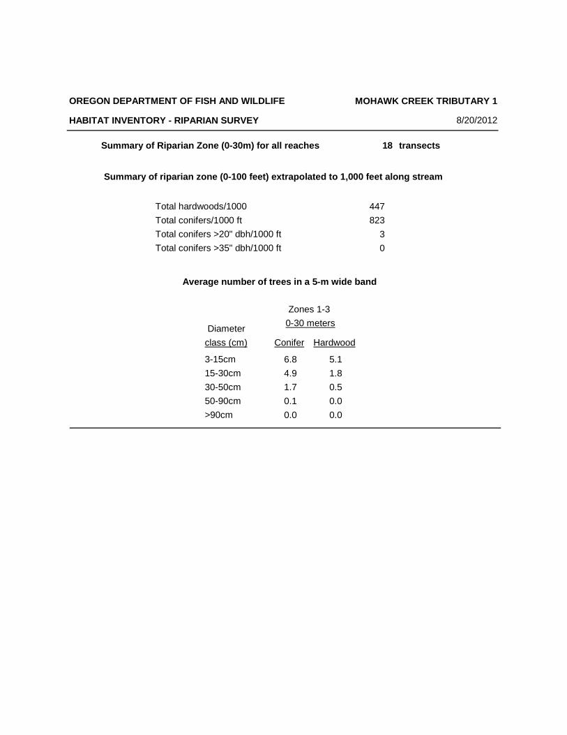
ODFW AQUATIC INVENTORY PROJECT STREAM...
54
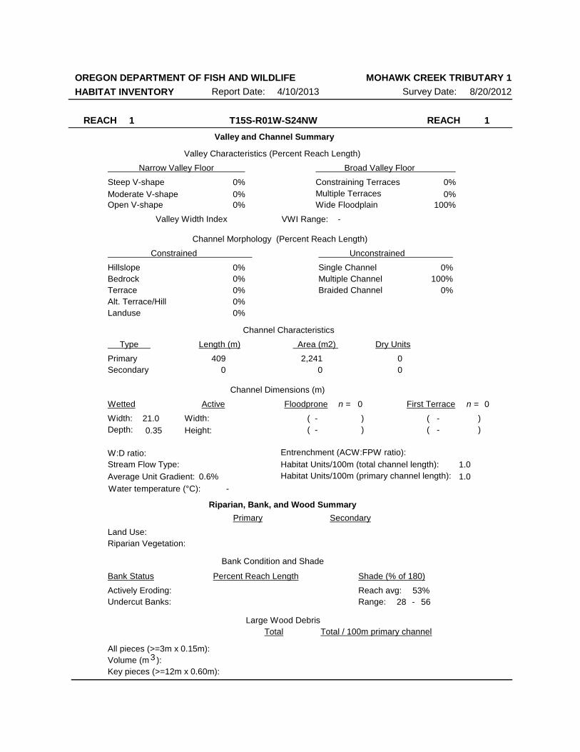
ODFW AQUATIC INVENTORY PROJECT STREAM REPORT STREAM: Mohawk Tributary 1 LLID: none BASIN: McKenzie River HUC NUMBER: 17090004 DATES: August 20 – September 5, 2012 SURVEY CREW: Chee Xiong, Maya Rommwatt, and Peggy Kavanagh REPORT PREPARED BY: Peggy Kavanagh USGS MAPS: Crawfordsville ECOREGION: Cascades West BASIN AREA: 1.99km 2 FIRST ORDER TRIBUTARIES: 1 STREAM ORDER: 1 GENERAL DESCRIPTION: The Mohawk Creek Tributary 1 habitat survey began at the confluence of the Mohawk River and ended approximately 3000 meters upstream at a tributary split. Eight reaches were designated based on changes in land use, vegetation class, surveyor composition, or geomorphology. The land uses were second-growth timber (15-30cm dbh), large timber (30-50cm dbh), and mature trees (50-90cm dbh). The stream habitat was composed mostly of scour pool with riffle, rapid, and cascades. The substrate was a mix of fine sediment, gravel, and cobble. The trees observed most frequently in the riparian transect were hardwoods 3-15cm and conifers 3-30cm dbh. Large wood volume ranged from 1.6-23.2m 3 /100m. REACH DESCRIPTIONS: Reach 1: (T15S-R01W-S24NW) Length 409 meters. Reach 1 began at the junction with the Mohawk River and ended where the channel narrowed. The stream was unconstrained with multiple channels in a broad valley. Two pools (84%) composed most of the wetted area of the reach, with 18.5 percent unsurveyed (mix of habitat). The stream channel did not match the USGS topographic map and was difficult to find (see Map in report). Due to the challenges of the pooled habitat and the length of unsurveyed habitat, channel metrics and riparian transect were not conducted and reach assessment was incomplete. The average gradient was 0.6 percent. The substrate was mostly sand (18%) and silt and organics (48%). No trees were recorded. Reach 2: (T15S-R01W-S24NW) Length 212 meters. Reach 2 extended to narrowing of the valley. The stream was unconstrained with multiple channels in a broad valley. The average valley width index was 27.5 (range: 5.0-50.0). There were 93 meters of secondary channel habitat. The land use was second-growth timber. The average gradient was 2.0 percent. Scour pool (44.4%) and riffle (34%) composed most of the stream habitat. The substrate was predominantly silt/organic (85%). The residual pool depth was 0.24 meters. The trees found most frequently in the riparian zone were hardwoods 3-15cm dbh with conifers 3- 30cm dbh (based on two riparian transects). Large wood volume was 1.6m 3 /100m. Reach 3: (T15S-R01W-S13SW) Length 257 meters. Reach 3 ended due to changes in land use and vegetation class. The stream was an unconstrained single channel in a wide floodplain. The average valley width index was 7.4 (range: 1.0-20.). There were 27 meters of secondary channel habitat. The land use was second-growth timber. The average gradient was 3.4 percent. The stream habitat was a mix of scour pool (26%), riffle (37%), and rapid
Transcript of ODFW AQUATIC INVENTORY PROJECT STREAM...

ODFW AQUATIC INVENTORY PROJECT STREAM REPORT
STREAM: Mohawk Tributary 1 LLID: none BASIN: McKenzie River HUC NUMBER: 17090004 DATES: August 20 – September 5, 2012 SURVEY CREW: Chee Xiong, Maya Rommwatt, and Peggy Kavanagh REPORT PREPARED BY: Peggy Kavanagh USGS MAPS: Crawfordsville ECOREGION: Cascades West BASIN AREA: 1.99km2 FIRST ORDER TRIBUTARIES: 1 STREAM ORDER: 1 GENERAL DESCRIPTION: The Mohawk Creek Tributary 1 habitat survey began at the confluence of the Mohawk River and ended approximately 3000 meters upstream at a tributary split. Eight reaches were designated based on changes in land use, vegetation class, surveyor composition, or geomorphology. The land uses were second-growth timber (15-30cm dbh), large timber (30-50cm dbh), and mature trees (50-90cm dbh). The stream habitat was composed mostly of scour pool with riffle, rapid, and cascades. The substrate was a mix of fine sediment, gravel, and cobble. The trees observed most frequently in the riparian transect were hardwoods 3-15cm and conifers 3-30cm dbh. Large wood volume ranged from 1.6-23.2m3/100m. REACH DESCRIPTIONS: Reach 1: (T15S-R01W-S24NW) Length 409 meters. Reach 1 began at the junction with the Mohawk
River and ended where the channel narrowed. The stream was unconstrained with multiple channels in a broad valley. Two pools (84%) composed most of the wetted area of the reach, with 18.5 percent unsurveyed (mix of habitat). The stream channel did not match the USGS topographic map and was difficult to find (see Map in report). Due to the challenges of the pooled habitat and the length of unsurveyed habitat, channel metrics and riparian transect were not conducted and reach assessment was incomplete. The average gradient was 0.6 percent. The substrate was mostly sand (18%) and silt and organics (48%). No trees were recorded.
Reach 2: (T15S-R01W-S24NW) Length 212 meters. Reach 2 extended to narrowing of the valley.
The stream was unconstrained with multiple channels in a broad valley. The average valley width index was 27.5 (range: 5.0-50.0). There were 93 meters of secondary channel habitat. The land use was second-growth timber. The average gradient was 2.0 percent. Scour pool (44.4%) and riffle (34%) composed most of the stream habitat. The substrate was predominantly silt/organic (85%). The residual pool depth was 0.24 meters. The trees found most frequently in the riparian zone were hardwoods 3-15cm dbh with conifers 3-30cm dbh (based on two riparian transects). Large wood volume was 1.6m3/100m.
Reach 3: (T15S-R01W-S13SW) Length 257 meters. Reach 3 ended due to changes in land use and
vegetation class. The stream was an unconstrained single channel in a wide floodplain. The average valley width index was 7.4 (range: 1.0-20.). There were 27 meters of secondary channel habitat. The land use was second-growth timber. The average gradient was 3.4 percent. The stream habitat was a mix of scour pool (26%), riffle (37%), and rapid

(27%). The substrate was primarily fine sediment (46%), gravel (25%), and cobble (17%). The residual pool depth was 0.12 meters. The trees found most frequently in the riparian zone were conifers 3-15cm dbh. Conifers 15-30cm and hardwoods 3-15cm dbh were recorded (based on two riparian transects). Large wood volume was 2.9m3/100m.
Reach 4: (T15S-R01W-S13SW) Length 496 meters. Reach 4 extended to a geomorphological
change. The stream was unconstrained with a single channel in a wide floodplain. The average valley width index was 5.0 (range: 1.2-10.0). There were 37 meters of secondary channel habitat. The land uses were large timber and mature trees. The average gradient was 4.8 percent. Rapid (28%), riffle (37%), and scour pool (25%) composed most of the stream habitat. The substrate was a mix of gravel (29%), fine sediment (40%), and cobble (27%). The residual pool depth was 0.12 meters. The trees found most frequently in the riparian zone were conifers 3-50cm dbh (based on four riparian transects). Large wood volume was 23.2m3/100m.
Reach 5: (T15S-R01W-S13NW) Length 375 meters. Reach 5 extended to geomorphology change.
The stream was constrained by multiple terraces in a broad valley. The average valley width index was 7.0 (range: 2.5-10.0). There were 23 meters of secondary channel habitat. The land use was large timber. The average gradient was 6.3 percent. Rapid (36%), riffle (24%), and scour pool (30%) composed most of the stream habitat. The substrate was a mix of fine sediment (46%), gravel (22%), and cobble (29%). The residual pool depth was 0.13 meters. The trees found most frequently in the riparian zone were hardwoods 3-30cm dbh (based on three riparian transects). Large wood volume was 12.4m3/100m.
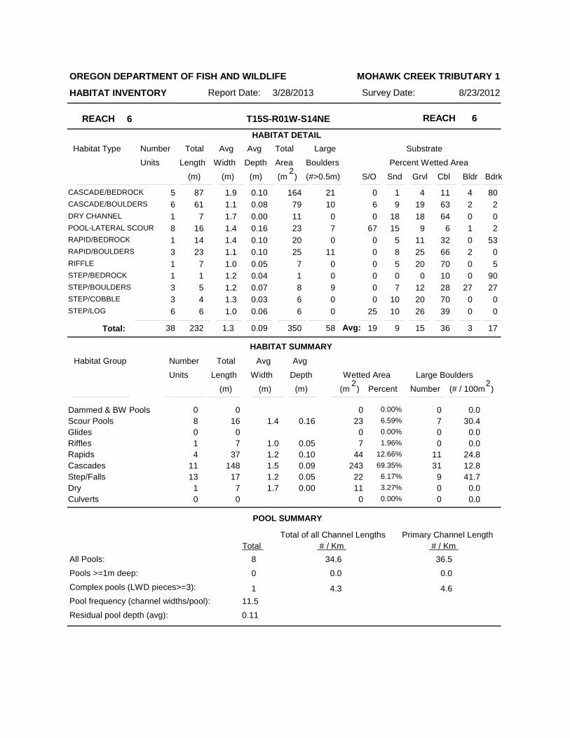
Reach 6: (T15S-R01W-S14NE) Length 219 meters. Reach 6 ended when the land use changed.
The stream was a constrained by hillslopes in a moderate v-shaped narrow valley. The average valley width index was 1.7 (range: 1.0-3.0). There were 12 meters of secondary channel habitat. The land uses were large timber and second-growth timber. The average gradient was 11.2 percent. The stream habitat was predominantly cascade (70%). Cobble (36%), fine sediment (28%), gravel (15%) and bedrock (17%) constituted the stream substrate. The residual pool depth was 0.11 meters. The trees found most frequently in the riparian zone were hardwoods 3-30cm dbh (based on one riparian transect). Large wood volume was 6.3m3/100m.
Reach 7: (T15S-R01W-S14NE) Length 544 meters. Reach 7 continued until the surveyor
composition changed. The average valley width index was 2.0 (range: 1.0-3.3). There were 98 meters of secondary channel habitat. The land use was second-growth timber. The average gradient was 9.7 percent. Rapid (41%), cascade (22%), and riffle (19.7%) composed most of the stream habitat. The substrate was mostly fine sediment (45%), gravel (16%), and cobble (28%). Fourteen percent of the reach length was actively eroding. The residual pool depth was 0.10 meters. The trees found most frequently in the riparian zone were conifers 3-15cm dbh (based on four riparian transects). Large wood volume was 5.3m3/100m.
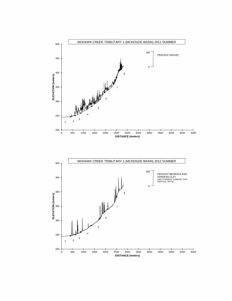
Reach 8: (T15S-R01W-S12SW) Length 303 meters. Reach 8 ended at a tributary split. The stream
was constrained by alternating hillslopes and terraces in broad valley. The average valley width index was 6.0 (range: 1.0-10.0). There were 51 meters of secondary channel habitat. The land use was second-growth timber. The average gradient was 12.8 percent. Cascade (61%) dominated the stream habitat. The stream substrate was mostly fine sediment (64%) with a mix of gravel (12%), cobble (11%), boulder (8%), and bedrock (5%). Thirty-seven percent of the reach length was actively eroding. The residual pool depth was 0.14 meters. The trees found most frequently in the riparian zone were conifers 15-30cm dbh (based on two riparian transects). Large wood volume was 15.4m3/100m.

COMMENT SUMMARY
Fish, including trout, were observed through unit 362 (2108 meters). A fish presence/absence survey was not conducted. A potential natural barrier to fish movement was recorded at unit 412 (2458 meters). It was a bedrock step 1.5 meters high. Wildlife observations included hornets, deer tracks, red-legged frog, canine tracks, rough skin newt, crayfish, wren, and beaver activity (chewed sticks and dam). Hardpan clay was present and analyzed as bedrock. Refer to the Comment Summary for units with hardpan clay. There may be fewer channel-forming debris jams than the Comment Summary presented. Yellow, white and green striped, and orange dotted flags were noted.
The photo summary represents Reach 8. Photographs from the other reaches were lost. Reach 1 stream channel did not enter the Mohawk River as the USGS topographic map indicated. See the map in the report to reflect the channel at the time of the survey.

Transcription of crew notes – Mohawk Creek Tributary 1- 2012 August 20, 2012
Had difficulty finding the survey start. From the Mohawk River, there was a 1.5 meter step to a culvert crossing. The culvert was 0.5m in diameter. The culvert was not immediately visible from either side of the road. Nor was any sort of channel. On the opposite (non-Mohawk River) side of the road, Carex and skunk cabbage indicated the presence of water. No channels to speak of. Roaming yielded 2+ ‘channels’ of skunk cabbage and lots of young Alder. We left this section alone (U1 MX). Upstream was a large pond ~80W X 10L meters with a path leading to it from the road and a constructed (decommissioned?) road along it, parallel to the main road. Pond = U2. U3 = MX between the pond and where our survey begins (U5). U4 = marsh visible from survey start at U5.
Survey has multiple channels, blackberry (native and Himalayan), Carex, skunk cabbage, young trees/shrubs, tall grasses. Some channels were well-defined; others not. There were many short channels connecting the primary channels. Substrate=boot-sucking silt = prohibited exploration. Some surveying from creek bank or islands necessary. Had to estimate a metric due to deep muck.
Reach 3 = forested single channel HS = ST conifer replant Saw water striders, rough skin newt, fish Beaver activity present, but low
Description: mouth at end of tributary to Mohawk River is a swamp/bog area creating long pond that ended at Road 1900A. There seems to be no obvious outlet of the pond to the mainstem Mohawk River. The left bank Mohawk River has 2 dried small culvert and underground water seeps. Swamp has 3 channels. 1 channel is dried up. Marsh goes until it goes into 1 channel. Channel is small and brushy with young 2nd growth timber. Substrate of swamp is silty and channel substrate is sand with gravel. Beaver activity was sighted above the swamp. August 21, 2012 Roadbed on either side after crossing of Road 1900A2 Reach change to unharvested lovely MT, LT with cedar, Doug firs, conifers, and Alder. Noticeably more wood in creek. Towards end of day, fewer conifers on HS, road on left gone, road on right ending. Channel changed from US to CA/CT - didn’t feel US but numbers (metrics) say so ACW ~2meters, but feels bigger. Survey pace is slow though units are short Small pools, some with fish. Look like trout; no positive id Description: Channel is narrow with heavy downfall wood. It is very brushy. Substrate has lots of cobble, gravel, and silt/sand. There are also some areas with underground flow. Riparian has younger trees near mouth but upper we start to see alder trees and D30-50 and C 30-50. Lots of grasses on the ground. August 22, 2012 Change from LT, MT with mix of conifer to mostly D50. Conifers mostly on hillslope. Mix of shrubs to ferns. Shrubs are blackberry or vine maple. Lots of small short units. Pools, ~2.5m long and fast water ~7m.
More so CT/MT or CA/CT Old roads at Zone 3 of Rips. Not so noticeably road bed, but not hillslope either. Long hike in due to following roads too much! Hike out was much more direct. Slow-going with short units! Ug! I’m not sure how many more days until we get to the end…2? 3?
Description: Channel is narrow with lots of small units often followed by a pool then a step. Units are complex and short. Units have a lot of erosion activity. There were a few side channels and half of them were dried channels. Valley opens up for a good 100 meters or so and then narrows back down. There
were a few fish spotted in the pools…could be salmonids but unidentified. Riparian has a lot of fern/forb cover with D30-50 being the dominant tree. August 23, 2012
After a good start to the day, we were both stung multiple times by yellow jackets. Soon thereafter RB lengthened to CB. Longer units = more distance covered! Land use changed from LT to ST Valley changed from CA/US to CH/MV Towards end, conifers ST were closer to creek Ended after a series of CB Fish seen, little else. Some deer prints and tracks Section / property boundary marker seen CH changed from SV to OV to MV
Description: Stream valley narrows down with steep hill slope. Hardly any terrace. Riparian is second-growth timber. Forest floor has lots of duff and grass/forb cover. Not much shrubs growing. Stream is very cascade and rapid-like. The substrate is changing to a lot of bedrock and big boulders. Almost every pool has fish. There is also a significant amount of land erosion. There are a few secondary channels. The land is increasing in slope. September 5, 2012 Maya and I returned to complete the survey. Many small, not fully-formed channels were present. Some had flow, others not.
The metrics and channels indicate US/WF, because the ACW is only 1m or so. The hillslopes were close. ACW 1+ forced US calls regardless of feeling less unconstrained.
Maya stung twice from single incident. Few signs of deer trails and prints (deer, dog, mouse) Changed from CB to RI/LP/SC sequence to long CB Ended at marshy spot. Survey ended here. This agrees with BLM map at end at TJ/TJ split (versus a road crossing as on the USGS topo). ST conifers, gental HS, ferns, some downed wood. More sticks than countable wood. Survey began in cascade-over-boulder with numerous secondary channels. Surrounding land was all secondary timber with some deciduous trees along the creek. The creek shifted back and forth between a lower gradient with an unconstrained channel and a large amount of silt in the substrate to the previous description (boulder cascade). The survey ended at the headwater of the creek in a marshy junction of tributaries.

200
250
300
350
400
450
500
0 500 1000 1500 2000 2500 3000 3500 4000 4500 5000 5500 6000
EL
EV
AT
ION
(m
eter
s)
DISTANCE (meters)
REACH
BRIDGE \ CULVERT
TRIBUTARY
DEBRIS JAM
MASS FAILURE
MOHAWK CREEK TRIBUTARY 1 (MCKENZIE BASIN) 2012 SUMMER
1 23
7
6
5
4
8
POTENTIAL BARRIER
200
250
300
350
400
450
500
0 500 1000 1500 2000 2500 3000 3500 4000 4500 5000 5500 6000
EL
EV
AT
ION
(m
eter
s)
DISTANCE (meters)
MOHAWK CREEK TRIBUTARY 1 (MCKENZIE BASIN) 2012 SUMMER
1 23
7
6
5
4
8
0
100PERCENT SHADE

200
250
300
350
400
450
500
0 500 1000 1500 2000 2500 3000 3500 4000 4500 5000 5500 6000
EL
EV
AT
ION
(m
eter
s)
DISTANCE (meters)
MOHAWK CREEK TRIBUTARY 1 (MCKENZIE BASIN) 2012 SUMMER
1 23
7
6
5
4
8
0
100PERCENT SILT AND ORGANICS
200
250
300
350
400
450
500
0 500 1000 1500 2000 2500 3000 3500 4000 4500 5000 5500 6000
EL
EV
AT
ION
(m
eter
s)
DISTANCE (meters)
MOHAWK CREEK TRIBUTARY 1 (MCKENZIE BASIN) 2012 SUMMER
1 23
7
6
5
4
8
0
100PERCENT SILT, ORGANICS, AND SAND
200
250
300
350
400
450
500
0 500 1000 1500 2000 2500 3000 3500 4000 4500 5000 5500 6000
EL
EV
AT
ION
(m
eter
s)
DISTANCE (meters)
MOHAWK CREEK TRIBUTARY 1 (MCKENZIE BASIN) 2012 SUMMER
1 23
7
6
5
4
8
0
100PERCENT GRAVEL
200
250
300
350
400
450
500
0 500 1000 1500 2000 2500 3000 3500 4000 4500 5000 5500 6000
EL
EV
AT
ION
(m
eter
s)
DISTANCE (meters)
MOHAWK CREEK TRIBUTARY 1 (MCKENZIE BASIN) 2012 SUMMER
1 23
7
6
5
4
8
0
100PERCENT BEDROCK AND HARDPAN CLAY(SEE COMMENT SUMMARY FOR INDIVIUAL UNITS)

200
250
300
350
400
450
500
0 500 1000 1500 2000 2500 3000 3500 4000 4500 5000 5500 6000
EL
EV
AT
ION
(m
eter
s)
DISTANCE (meters)
MOHAWK CREEK TRIBUTARY 1 (MCKENZIE BASIN) 2012 SUMMER
1 23
7
6
5
4
8
0
100NUMBER OF BOULDERS (running average per 100 m.)
200
250
300
350
400
450
500
0 500 1000 1500 2000 2500 3000 3500 4000 4500 5000 5500 6000
EL
EV
AT
ION
(m
eter
s)
DISTANCE (meters)
MOHAWK CREEK TRIBUTARY 1 (MCKENZIE BASIN) 2012 SUMMER
1 23
7
6
5
4
81
0
POOLS GREATER THAN OR EQUAL TO 0.5 METERS DEEP
DEPTH (meters)

200
250
300
350
400
450
500
0 500 1000 1500 2000 2500 3000 3500 4000 4500 5000 5500 6000
EL
EV
AT
ION
(m
eter
s)
DISTANCE (meters)
MOHAWK CREEK TRIBUTARY 1 (MCKENZIE BASIN) 2012 SUMMER
1 23
7
6
5
4
8
0
100PIECES OF LARGE WOOD
200
250
300
350
400
450
500
0 500 1000 1500 2000 2500 3000 3500 4000 4500 5000 5500 6000
EL
EV
AT
ION
(m
eter
s)
DISTANCE (meters)
MOHAWK CREEK TRIBUTARY 1 (MCKENZIE BASIN) 2012 SUMMER
1 23
7
6
5
4
8
0
100VOLUME OF LARGE WOOD (cubic meters)

200
250
300
350
400
450
500
0 500 1000 1500 2000 2500 3000 3500 4000 4500 5000 5500 6000
EL
EV
AT
ION
(m
eter
s)
DISTANCE (meters)
MOHAWK CREEK TRIBUTARY 1 (MCKENZIE BASIN) 2012 SUMMER
1 23
7
6
5
4
8
0
1KEYPIECES OF LARGE WOOD
OREGON DEPARTMENT OF FISH AND WILDLIFE
HABITAT INVENTORY Survey Date: 8/20/2012Report Date: 4/10/2013
MOHAWK CREEK TRIBUTARY 1
REACH 1 REACH 1T15S-R01W-S24NW
Valley and Channel Summary
Narrow Valley Floor Broad Valley Floor
Valley Characteristics (Percent Reach Length)
Steep V-shape
Moderate V-shapeOpen V-shape
Constraining TerracesMultiple TerracesWide Floodplain
Valley Width Index
Channel Morphology (Percent Reach Length)
Hillslope
Constrained Unconstrained
BedrockTerraceAlt. Terrace/HillLanduse
Single ChannelMultiple ChannelBraided Channel
Channel Characteristics
Type Length (m) Area (m2) Dry Units
PrimarySecondary
Channel Dimensions (m)
Wetted Active Floodprone First Terrace
Width:Depth:
Width:
Height:
W:D ratio: Entrenchment (ACW:FPW ratio):
Stream Flow Type:
Average Unit Gradient:
Habitat Units/100m (total channel length):
0%0%
0%0%0%
0%100%
0%
0%
0%0%
0%
0%100%
VWI Range: -
0 000
409 2,241
21.0
0.35
0.6%
1.0
Riparian, Bank, and Wood Summary
Primary Secondary
Land Use:Riparian Vegetation:
Bank Condition and Shade
Bank Status Percent Reach Length Shade (% of 180)
Reach avg:Undercut Banks:
Large Wood DebrisTotal Total / 100m primary channel
All pieces (>=3m x 0.15m):Volume (m ):Key pieces (>=12m x 0.60m):
53%Actively Eroding:
Water temperature (°C): -
28Range: 56 -
3
0n = 0n =
( - ( -
( - ( -
))
))
1.0Habitat Units/100m (primary channel length):

OREGON DEPARTMENT OF FISH AND WILDLIFE
HABITAT INVENTORY Survey Date: 8/20/2012Report Date: 4/10/2013
MOHAWK CREEK TRIBUTARY 1
REACH 2 REACH 2T15S-R01W-S24NW
Valley and Channel Summary
Narrow Valley Floor Broad Valley Floor
Valley Characteristics (Percent Reach Length)
Steep V-shape
Moderate V-shapeOpen V-shape
Constraining TerracesMultiple TerracesWide Floodplain
Valley Width Index
Channel Morphology (Percent Reach Length)
Hillslope
Constrained Unconstrained
BedrockTerraceAlt. Terrace/HillLanduse
Single ChannelMultiple ChannelBraided Channel
Channel Characteristics
Type Length (m) Area (m2) Dry Units
PrimarySecondary
Channel Dimensions (m)
Wetted Active Floodprone First Terrace
Width:Depth:
Width:
Height:
W:D ratio: Entrenchment (ACW:FPW ratio):
Stream Flow Type:
Average Unit Gradient:
Habitat Units/100m (total channel length):
0%0%
0%0%0%
0%100%
0%
0%
0%0%
0%
0%100%
27.5 VWI Range: 5 - 50
93 8700
212 479
2.0
0.25
8.0
0.5
52.0
1.0
24.51.0
18.8 14.6
MF
2.0%
10.5
Riparian, Bank, and Wood Summary
Primary Secondary
Land Use:Riparian Vegetation:
ST
G D3
Bank Condition and Shade
Bank Status Percent Reach Length Shade (% of 180)
Reach avg:Undercut Banks:
Large Wood DebrisTotal Total / 100m primary channel
All pieces (>=3m x 0.15m):Volume (m ):Key pieces (>=12m x 0.60m):
5
3
0
2.4
1.6
0.0
3%2%
56%Actively Eroding:
14.0 14.0Water temperature (°C): -
31Range: 83 -
3
2n = 1n =
( 14 - 90( 0.8 - 1.1
( 24.5 - 24.5( 1 - 1
))
))
15.1Habitat Units/100m (primary channel length):

OREGON DEPARTMENT OF FISH AND WILDLIFE
HABITAT INVENTORY Survey Date: 8/20/2012Report Date: 4/10/2013
MOHAWK CREEK TRIBUTARY 1
REACH 3 REACH 3T15S-R01W-S13SW
Valley and Channel Summary
Narrow Valley Floor Broad Valley Floor
Valley Characteristics (Percent Reach Length)
Steep V-shape
Moderate V-shapeOpen V-shape
Constraining TerracesMultiple TerracesWide Floodplain
Valley Width Index
Channel Morphology (Percent Reach Length)
Hillslope
Constrained Unconstrained
BedrockTerraceAlt. Terrace/HillLanduse
Single ChannelMultiple ChannelBraided Channel
Channel Characteristics
Type Length (m) Area (m2) Dry Units
PrimarySecondary
Channel Dimensions (m)
Wetted Active Floodprone First Terrace
Width:Depth:
Width:
Height:
W:D ratio: Entrenchment (ACW:FPW ratio):
Stream Flow Type:
Average Unit Gradient:
Habitat Units/100m (total channel length):
0%0%
0%0%0%
100%0%0%
0%
0%0%
0%
0%100%
7.4 VWI Range: 1 - 20
27 3404
257 363
1.4
0.14
2.1
0.4
9.1
0.7
15.61.0
5.7 4.9
MF
3.4%
18.7
Riparian, Bank, and Wood Summary
Primary Secondary
Land Use:Riparian Vegetation:
ST
G D3
Bank Condition and Shade
Bank Status Percent Reach Length Shade (% of 180)
Reach avg:Undercut Banks:
Large Wood DebrisTotal Total / 100m primary channel
All pieces (>=3m x 0.15m):Volume (m ):Key pieces (>=12m x 0.60m):
13
8
0
5.1
2.9
0.0
5%3%
94%Actively Eroding:
13.5 13.5Water temperature (°C): -
51Range: 100 -
3
5n = 1n =
( 3.6 - 15( 0.6 - 0.82
( 15.6 - 15.6( 1 - 1
))
))
20.6Habitat Units/100m (primary channel length):

OREGON DEPARTMENT OF FISH AND WILDLIFE
HABITAT INVENTORY Survey Date: 8/21/2012Report Date: 4/10/2013
MOHAWK CREEK TRIBUTARY 1
REACH 4 REACH 4T15S-R01W-S13SW
Valley and Channel Summary
Narrow Valley Floor Broad Valley Floor
Valley Characteristics (Percent Reach Length)
Steep V-shape
Moderate V-shapeOpen V-shape
Constraining TerracesMultiple TerracesWide Floodplain
Valley Width Index
Channel Morphology (Percent Reach Length)
Hillslope
Constrained Unconstrained
BedrockTerraceAlt. Terrace/HillLanduse
Single ChannelMultiple ChannelBraided Channel
Channel Characteristics
Type Length (m) Area (m2) Dry Units
PrimarySecondary
Channel Dimensions (m)
Wetted Active Floodprone First Terrace
Width:Depth:
Width:
Height:
W:D ratio: Entrenchment (ACW:FPW ratio):
Stream Flow Type:
Average Unit Gradient:
Habitat Units/100m (total channel length):
0%0%
0%0%0%
100%0%0%
0%
0%0%
0%
0%100%
5.0 VWI Range: 1.2 - 10
37 3804
496 765
1.5
0.12
3.0
0.4
10.1
0.8
8.51.0
8.3 3.6
MF
4.8%
19.1
Riparian, Bank, and Wood Summary
Primary Secondary
Land Use:Riparian Vegetation:
LT
M50
MT
G
Bank Condition and Shade
Bank Status Percent Reach Length Shade (% of 180)
Reach avg:Undercut Banks:
Large Wood DebrisTotal Total / 100m primary channel
All pieces (>=3m x 0.15m):Volume (m ):Key pieces (>=12m x 0.60m):
104
115
1
21.0
23.2
0.2
8%3%
92%Actively Eroding:
13.5 13.5Water temperature (°C): -
72Range: 100 -
3
10n = 3n =
( 4.4 - 21( 0.56 - 1.04
( 5.5 - 12.6( 0.8 - 1.1
))
))
20.6Habitat Units/100m (primary channel length):

OREGON DEPARTMENT OF FISH AND WILDLIFE
HABITAT INVENTORY Survey Date: 8/22/2012Report Date: 4/10/2013
MOHAWK CREEK TRIBUTARY 1
REACH 5 REACH 5T15S-R01W-S13NW
Valley and Channel Summary
Narrow Valley Floor Broad Valley Floor
Valley Characteristics (Percent Reach Length)
Steep V-shape
Moderate V-shapeOpen V-shape
Constraining TerracesMultiple TerracesWide Floodplain
Valley Width Index
Channel Morphology (Percent Reach Length)
Hillslope
Constrained Unconstrained
BedrockTerraceAlt. Terrace/HillLanduse
Single ChannelMultiple ChannelBraided Channel
Channel Characteristics
Type Length (m) Area (m2) Dry Units
PrimarySecondary
Channel Dimensions (m)
Wetted Active Floodprone First Terrace
Width:Depth:
Width:
Height:
W:D ratio: Entrenchment (ACW:FPW ratio):
Stream Flow Type:
Average Unit Gradient:
Habitat Units/100m (total channel length):
0%0%
0%0%
100%
0%0%0%
0%
0%0%
0%
100%0%
7.0 VWI Range: 2.5 - 10
23 1901
375 498
1.3
0.12
2.8
0.3
5.3
0.5
6.50.8
11.0 1.9
MF
6.3%
25.1
Riparian, Bank, and Wood Summary
Primary Secondary
Land Use:Riparian Vegetation:
LT
D30 S
Bank Condition and Shade
Bank Status Percent Reach Length Shade (% of 180)
Reach avg:Undercut Banks:
Large Wood DebrisTotal Total / 100m primary channel
All pieces (>=3m x 0.15m):Volume (m ):Key pieces (>=12m x 0.60m):
43
46
1
11.5
12.4
0.3
8%1%
92%Actively Eroding:
13.5 13.5Water temperature (°C): -
78Range: 100 -
3
10n = 9n =
( 3.4 - 10.5( 0.36 - 0.7
( 3.6 - 11.8( 0.4 - 0.92
))
))
26.6Habitat Units/100m (primary channel length):

OREGON DEPARTMENT OF FISH AND WILDLIFE
HABITAT INVENTORY Survey Date: 8/23/2012Report Date: 4/10/2013
MOHAWK CREEK TRIBUTARY 1
REACH 6 REACH 6T15S-R01W-S14NE
Valley and Channel Summary
Narrow Valley Floor Broad Valley Floor
Valley Characteristics (Percent Reach Length)
Steep V-shape
Moderate V-shapeOpen V-shape
Constraining TerracesMultiple TerracesWide Floodplain
Valley Width Index
Channel Morphology (Percent Reach Length)
Hillslope
Constrained Unconstrained
BedrockTerraceAlt. Terrace/HillLanduse
Single ChannelMultiple ChannelBraided Channel
Channel Characteristics
Type Length (m) Area (m2) Dry Units
PrimarySecondary
Channel Dimensions (m)
Wetted Active Floodprone First Terrace
Width:Depth:
Width:
Height:
W:D ratio: Entrenchment (ACW:FPW ratio):
Stream Flow Type:
Average Unit Gradient:
Habitat Units/100m (total channel length):
0%0%
100%0%0%
0%0%0%
0%
100%0%
0%
0%0%
1.7 VWI Range: 1 - 3
12 1601
219 334
1.3
0.09
2.5
0.3
4.0
0.6
6.21.0
8.8 1.6
MF
11.2%
16.4
Riparian, Bank, and Wood Summary
Primary Secondary
Land Use:Riparian Vegetation:
LT
D30
ST
S
Bank Condition and Shade
Bank Status Percent Reach Length Shade (% of 180)
Reach avg:Undercut Banks:
Large Wood DebrisTotal Total / 100m primary channel
All pieces (>=3m x 0.15m):Volume (m ):Key pieces (>=12m x 0.60m):
26
14
0
11.9
6.3
0.0
2%0%
93%Actively Eroding:
13.0 13.0Water temperature (°C): -
86Range: 100 -
3
4n = 1n =
( 2.8 - 4.7( 0.44 - 0.64
( 6.2 - 6.2( 1 - 1
))
))
17.3Habitat Units/100m (primary channel length):

OREGON DEPARTMENT OF FISH AND WILDLIFE
HABITAT INVENTORY Survey Date: 8/23/2012Report Date: 4/10/2013
MOHAWK CREEK TRIBUTARY 1
REACH 7 REACH 7T15S-R01W-S14NE
Valley and Channel Summary
Narrow Valley Floor Broad Valley Floor
Valley Characteristics (Percent Reach Length)
Steep V-shape
Moderate V-shapeOpen V-shape
Constraining TerracesMultiple TerracesWide Floodplain
Valley Width Index
Channel Morphology (Percent Reach Length)
Hillslope
Constrained Unconstrained
BedrockTerraceAlt. Terrace/HillLanduse
Single ChannelMultiple ChannelBraided Channel
Channel Characteristics
Type Length (m) Area (m2) Dry Units
PrimarySecondary
Channel Dimensions (m)
Wetted Active Floodprone First Terrace
Width:Depth:
Width:
Height:
W:D ratio: Entrenchment (ACW:FPW ratio):
Stream Flow Type:
Average Unit Gradient:
Habitat Units/100m (total channel length):
0%0%
100%0%0%
0%0%0%
0%
100%0%
0%
0%0%
2.0 VWI Range: 1 - 3.3
98 7105
544 632
1.0
0.10
3.1
0.3
4.8
0.5
3.90.7
12.5 1.6
MF
9.7%
14.2
Riparian, Bank, and Wood Summary
Primary Secondary
Land Use:Riparian Vegetation:
ST
D15 G
Bank Condition and Shade
Bank Status Percent Reach Length Shade (% of 180)
Reach avg:Undercut Banks:
Large Wood DebrisTotal Total / 100m primary channel
All pieces (>=3m x 0.15m):Volume (m ):Key pieces (>=12m x 0.60m):
101
29
0
18.6
5.3
0.0
14%0%
93%Actively Eroding:
13.0 13.0Water temperature (°C): -
78Range: 100 -
3
10n = 2n =
( 2.25 - 7.5( 0.42 - 0.6
( 3.3 - 4.5( 0.65 - 0.8
))
))
16.7Habitat Units/100m (primary channel length):

OREGON DEPARTMENT OF FISH AND WILDLIFE
HABITAT INVENTORY Survey Date: 9/5/2012Report Date: 4/10/2013
MOHAWK CREEK TRIBUTARY 1
REACH 8 REACH 8T15S-R01W-S12SW
Valley and Channel Summary
Narrow Valley Floor Broad Valley Floor
Valley Characteristics (Percent Reach Length)
Steep V-shape
Moderate V-shapeOpen V-shape
Constraining TerracesMultiple TerracesWide Floodplain
Valley Width Index
Channel Morphology (Percent Reach Length)
Hillslope
Constrained Unconstrained
BedrockTerraceAlt. Terrace/HillLanduse
Single ChannelMultiple ChannelBraided Channel
Channel Characteristics
Type Length (m) Area (m2) Dry Units
PrimarySecondary
Channel Dimensions (m)
Wetted Active Floodprone First Terrace
Width:Depth:
Width:
Height:
W:D ratio: Entrenchment (ACW:FPW ratio):
Stream Flow Type:
Average Unit Gradient:
Habitat Units/100m (total channel length):
100%0%
0%0%0%
0%0%0%
0%
0%0%
100%
0%0%
6.0 VWI Range: 1 - 10
51 3301
303 221
0.7
0.07
1.3
0.3
5.5
0.7
9.61.4
3.9 4.1
MF
12.8%
19.4
Riparian, Bank, and Wood Summary
Primary Secondary
Land Use:Riparian Vegetation:
ST
C15 G
Bank Condition and Shade
Bank Status Percent Reach Length Shade (% of 180)
Reach avg:Undercut Banks:
Large Wood DebrisTotal Total / 100m primary channel
All pieces (>=3m x 0.15m):Volume (m ):Key pieces (>=12m x 0.60m):
67
47
1
22.1
15.4
0.3
37%3%
93%Actively Eroding:
13.0 13.0Water temperature (°C): -
75Range: 100 -
3
6n = 2n =
( 1 - 13.3( 0.6 - 0.8
( 1.1 - 18( 0.85 - 2
))
))
22.7Habitat Units/100m (primary channel length):

REACH 1 REACH 1T15S-R01W-S24NW
HABITAT DETAIL
Habitat Type Number Total Avg Total Large Substrate
Percent Wetted Area Units Length Width
Avg
Depth Area Boulders
(m) (m) (m) (m )2
(#>0.5m) S/O Snd Grvl Cbl Bldr Bdrk
OREGON DEPARTMENT OF FISH AND WILDLIFE
HABITAT INVENTORY Survey Date: 8/20/2012Report Date: 3/28/2013
MOHAWK CREEK TRIBUTARY 1
2MIX OF HABITATS 358 1.3 0.10 362 0 17 17 17 17 17 17
2POOL-LATERAL SCOUR 51 40.7 0.60 1,879 0 80 20 0 0 0 0
HABITAT SUMMARY
POOL SUMMARY
4 409 21.0 0.35 2,241 0 48 18 8 8 8 8Total:
Habitat Group Number Total Avg
Wetted Area Large Boulders Units Length Width
Avg
Depth
Number (m) (m) (m) )2
(# / 100mPercent
Scour PoolsGlidesRifflesRapidsCascadesStep/FallsDry
Dammed & BW Pools 000 0.00%
1,87951 40.7 0.602 83.85%
000 0.00%
000 0.00%
000 0.00%
000 0.00%
000 0.00%
Culverts000 0.00%
000 0.00%
000000000
0.0
0.00.0
0.00.00.00.0
Total Total of all Channel Lengths
All Pools:
Pools >=1m deep:
Complex pools (LWD pieces>=3):
Pool frequency (channel widths/pool):
2
Residual pool depth (avg):
4.9
0.28
0
0
0.0
0.0
(m )2
0.0
0.0
Avg:
4.9
0.0
0.0
# / Km Primary Channel Length
# / Km

REACH 2 REACH 2T15S-R01W-S24NW
HABITAT DETAIL
Habitat Type Number Total Avg Total Large Substrate
Percent Wetted Area Units Length Width
Avg
Depth Area Boulders
(m) (m) (m) (m )2
(#>0.5m) S/O Snd Grvl Cbl Bldr Bdrk
OREGON DEPARTMENT OF FISH AND WILDLIFE
HABITAT INVENTORY Survey Date: 8/20/2012Report Date: 3/28/2013
MOHAWK CREEK TRIBUTARY 1
2GLIDE 19 2.9 0.38 56 0 90 10 0 0 0 0
3POOL-BACKWATER 13 1.7 0.23 21 0 93 7 0 0 0 0
1POOL-BEAVER DAM 12 3.5 0.60 42 0 100 0 0 0 0 0
10POOL-LATERAL SCOUR 77 3.4 0.36 251 0 95 3 2 0 0 0
10RIFFLE 179 1.1 0.14 192 0 82 8 9 0 0 1
1STEP/BEAVER DAM 1 1.2 0.15 1 0 100 0 0 0 0 0
3STEP/BEDROCK 2 0.5 0.15 1 0 33 0 0 0 0 67
1STEP/COBBLE 1 0.6 0.10 1 0 90 0 10 0 0 0
1STEP/LOG 1 1.2 0.15 1 0 90 10 0 0 0 0
HABITAT SUMMARY
POOL SUMMARY
32 305 2.0 0.25 565 0 85 5 4 0 0 7Total:
Habitat Group Number Total Avg
Wetted Area Large Boulders Units Length Width
Avg
Depth
Number (m) (m) (m) )2
(# / 100mPercent
Scour PoolsGlidesRifflesRapidsCascadesStep/FallsDry
Dammed & BW Pools 6325 2.2 0.334 11.22%
25177 3.4 0.3610 44.44%
5619 2.9 0.382 9.95%
192179 1.1 0.1410 33.89%
000 0.00%
000 0.00%
34 0.7 0.146 0.51%
Culverts000 0.00%
000 0.00%
000000000
0.0
0.00.0
0.00.00.00.0
Total Total of all Channel Lengths
All Pools:
Pools >=1m deep:
Complex pools (LWD pieces>=3):
Pool frequency (channel widths/pool):
14
Residual pool depth (avg):
45.9
0.24
2.7
0
0
0.0
0.0
(m )2
0.0
0.0
Avg:
66.0
0.0
0.0
# / Km Primary Channel Length
# / Km

REACH 3 REACH 3T15S-R01W-S13SW
HABITAT DETAIL
Habitat Type Number Total Avg Total Large Substrate
Percent Wetted Area Units Length Width
Avg
Depth Area Boulders
(m) (m) (m) (m )2
(#>0.5m) S/O Snd Grvl Cbl Bldr Bdrk
OREGON DEPARTMENT OF FISH AND WILDLIFE
HABITAT INVENTORY Survey Date: 8/20/2012Report Date: 3/28/2013
MOHAWK CREEK TRIBUTARY 1
4DRY CHANNEL 23 1.2 0.00 28 0 58 38 5 0 0 0
1POOL-ALCOVE 1 1.9 0.00 2 0 100 0 0 0 0 0
1POOL-BACKWATER 2 1.6 0.25 3 0 70 17 9 4 0 0
15POOL-LATERAL SCOUR 61 1.6 0.18 97 4 13 44 25 13 1 4
1POOL-PLUNGE 3 1.4 0.33 4 0 40 20 40 0 0 0
1RAPID/BEDROCK 7 1.6 0.20 12 0 0 5 9 14 73 0
7RAPID/BOULDERS 69 1.4 0.16 95 18 1 12 25 47 5 10
13RIFFLE 110 1.4 0.15 147 10 2 36 33 25 0 3
3STEP/BEDROCK 2 0.9 0.07 2 0 0 0 23 3 0 73
2STEP/COBBLE 2 1.3 0.05 2 4 0 3 38 15 45 0
5STEP/LOG 3 1.0 0.17 4 1 30 45 24 1 0 0
HABITAT SUMMARY
POOL SUMMARY
53 284 1.4 0.14 396 37 15 31 25 17 4 7Total:
Habitat Group Number Total Avg
Wetted Area Large Boulders Units Length Width
Avg
Depth
Number (m) (m) (m) )2
(# / 100mPercent
Scour PoolsGlidesRifflesRapidsCascadesStep/FallsDry
Dammed & BW Pools 63 1.7 0.132 1.45%
10164 1.6 0.1916 25.54%
000 0.00%
147110 1.4 0.1513 37.06%
10676 1.4 0.168 26.86%
000 0.00%
88 1.0 0.1210 2.07%
Culverts2823 1.2 0.004 7.03%
000 0.00%
040
1018
0500
0.0
0.06.8
0.061.1
0.00.0
Total Total of all Channel Lengths
All Pools:
Pools >=1m deep:
Complex pools (LWD pieces>=3):
Pool frequency (channel widths/pool):
18
Residual pool depth (avg):
63.5
0.12
7.7
0
0
0.0
0.0
(m )2
16.9
4.0
Avg:
70.0
0.0
0.0
# / Km Primary Channel Length
# / Km

REACH 4 REACH 4T15S-R01W-S13SW
HABITAT DETAIL
Habitat Type Number Total Avg Total Large Substrate
Percent Wetted Area Units Length Width
Avg
Depth Area Boulders
(m) (m) (m) (m )2
(#>0.5m) S/O Snd Grvl Cbl Bldr Bdrk
OREGON DEPARTMENT OF FISH AND WILDLIFE
HABITAT INVENTORY Survey Date: 8/21/2012Report Date: 3/28/2013
MOHAWK CREEK TRIBUTARY 1
3CASCADE/BOULDERS 24 1.2 0.10 26 4 2 9 25 60 5 0
2DRY CHANNEL 9 1.4 0.00 10 0 50 5 36 9 0 0
37POOL-LATERAL SCOUR 119 1.6 0.19 198 10 15 47 22 13 0 3
1POOL-PLUNGE 1 2.3 0.25 3 0 90 0 0 10 0 0
2PUDDLED UNIT 23 0.6 0.03 14 0 85 0 10 5 0 0
15RAPID/BOULDERS 140 1.6 0.10 221 42 1 16 36 43 3 2
20RIFFLE 185 1.6 0.09 294 10 6 15 34 45 0 0
1STEP/BEDROCK 1 0.6 0.10 1 0 10 0 0 0 0 90
1STEP/BOULDERS 0 0.9 0.15 0 5 0 5 10 0 86 0
14STEP/COBBLE 26 1.2 0.05 32 1 7 7 49 37 0 0
6STEP/LOG 3 1.1 0.07 3 1 17 68 14 1 0 0
HABITAT SUMMARY
POOL SUMMARY
102 533 1.5 0.12 803 73 12 28 29 27 2 2Total:
Habitat Group Number Total Avg
Wetted Area Large Boulders Units Length Width
Avg
Depth
Number (m) (m) (m) )2
(# / 100mPercent
Scour PoolsGlidesRifflesRapidsCascadesStep/FallsDry
Dammed & BW Pools 000 0.00%
201121 1.7 0.1938 25.05%
000 0.00%
294185 1.6 0.0920 36.65%
221140 1.6 0.1015 27.50%
2624 1.2 0.103 3.29%
3630 1.1 0.0622 4.52%
Culverts2432 1.0 0.024 3.00%
000 0.00%
010
01042
4700
0.0
0.03.4
15.119.3
0.00.0
Total Total of all Channel Lengths
All Pools:
Pools >=1m deep:
Complex pools (LWD pieces>=3):
Pool frequency (channel widths/pool):
38
Residual pool depth (avg):
71.3
0.12
4.6
0
3
0.0
5.6
(m )2
19.0
5.0
Avg:
76.6
0.0
6.0
# / Km Primary Channel Length
# / Km

REACH 5 REACH 5T15S-R01W-S13NW
HABITAT DETAIL
Habitat Type Number Total Avg Total Large Substrate
Percent Wetted Area Units Length Width
Avg
Depth Area Boulders
(m) (m) (m) (m )2
(#>0.5m) S/O Snd Grvl Cbl Bldr Bdrk
OREGON DEPARTMENT OF FISH AND WILDLIFE
HABITAT INVENTORY Survey Date: 8/22/2012Report Date: 3/28/2013
MOHAWK CREEK TRIBUTARY 1
1CASCADE/BOULDERS 5 0.5 0.01 2 0 30 60 10 0 0 0
1DRY CHANNEL 7 1.2 0.00 8 0 0 20 40 40 0 0
1POOL-BACKWATER 5 1.4 0.20 6 0 20 40 40 0 0 0
36POOL-LATERAL SCOUR 91 1.6 0.18 140 13 31 42 19 8 1 0
3POOL-PLUNGE 5 2.2 0.30 12 0 26 53 15 2 0 4
15RAPID/BOULDERS 143 1.3 0.12 184 2 0 12 27 60 2 0
13RIFFLE 108 1.2 0.08 126 8 8 15 24 52 0 0
4STEP/BOULDERS 4 1.0 0.06 5 12 11 11 8 31 36 3
11STEP/COBBLE 16 1.2 0.05 21 0 0 14 22 63 0 0
15STEP/LOG 14 0.8 0.06 12 0 28 29 29 14 0 0
HABITAT SUMMARY
POOL SUMMARY
100 398 1.3 0.12 517 35 18 28 22 29 2 0Total:
Habitat Group Number Total Avg
Wetted Area Large Boulders Units Length Width
Avg
Depth
Number (m) (m) (m) )2
(# / 100mPercent
Scour PoolsGlidesRifflesRapidsCascadesStep/FallsDry
Dammed & BW Pools 65 1.4 0.201 1.23%
15396 1.6 0.1939 29.52%
000 0.00%
126108 1.2 0.0813 24.38%
184143 1.3 0.1215 35.52%
25 0.5 0.011 0.47%
3834 1.0 0.0630 7.29%
Culverts87 1.2 0.001 1.59%
000 0.00%
013
0820
1200
0.0
0.06.3
0.031.8
0.00.0
Total Total of all Channel Lengths
All Pools:
Pools >=1m deep:
Complex pools (LWD pieces>=3):
Pool frequency (channel widths/pool):
40
Residual pool depth (avg):
100.5
0.13
3.6
0
2
0.0
5.0
(m )2
1.1
8.5
Avg:
106.6
0.0
5.3
# / Km Primary Channel Length
# / Km
REACH 6 REACH 6T15S-R01W-S14NE
HABITAT DETAIL
Habitat Type Number Total Avg Total Large Substrate
Percent Wetted Area Units Length Width
Avg
Depth Area Boulders
(m) (m) (m) (m )2
(#>0.5m) S/O Snd Grvl Cbl Bldr Bdrk
OREGON DEPARTMENT OF FISH AND WILDLIFE
HABITAT INVENTORY Survey Date: 8/23/2012Report Date: 3/28/2013
MOHAWK CREEK TRIBUTARY 1
5CASCADE/BEDROCK 87 1.9 0.10 164 21 0 1 4 11 4 80
6CASCADE/BOULDERS 61 1.1 0.08 79 10 6 9 19 63 2 2
1DRY CHANNEL 7 1.7 0.00 11 0 0 18 18 64 0 0
8POOL-LATERAL SCOUR 16 1.4 0.16 23 7 67 15 9 6 1 2
1RAPID/BEDROCK 14 1.4 0.10 20 0 0 5 11 32 0 53
3RAPID/BOULDERS 23 1.1 0.10 25 11 0 8 25 66 2 0
1RIFFLE 7 1.0 0.05 7 0 0 5 20 70 0 5
1STEP/BEDROCK 1 1.2 0.04 1 0 0 0 0 10 0 90
3STEP/BOULDERS 5 1.2 0.07 8 9 0 7 12 28 27 27
3STEP/COBBLE 4 1.3 0.03 6 0 0 10 20 70 0 0
6STEP/LOG 6 1.0 0.06 6 0 25 10 26 39 0 0
HABITAT SUMMARY
POOL SUMMARY
38 232 1.3 0.09 350 58 19 9 15 36 3 17Total:
Habitat Group Number Total Avg
Wetted Area Large Boulders Units Length Width
Avg
Depth
Number (m) (m) (m) )2
(# / 100mPercent
Scour PoolsGlidesRifflesRapidsCascadesStep/FallsDry
Dammed & BW Pools 000 0.00%
2316 1.4 0.168 6.59%
000 0.00%
77 1.0 0.051 1.96%
4437 1.2 0.104 12.66%
243148 1.5 0.0911 69.35%
2217 1.2 0.0513 6.17%
Culverts117 1.7 0.001 3.27%
000 0.00%
0700
1131
900
0.0
0.00.0
12.841.7
0.00.0
Total Total of all Channel Lengths
All Pools:
Pools >=1m deep:
Complex pools (LWD pieces>=3):
Pool frequency (channel widths/pool):
8
Residual pool depth (avg):
34.6
0.11
11.5
0
1
0.0
4.3
(m )2
24.8
30.4
Avg:
36.5
0.0
4.6
# / Km Primary Channel Length
# / Km

REACH 7 REACH 7T15S-R01W-S14NE
HABITAT DETAIL
Habitat Type Number Total Avg Total Large Substrate
Percent Wetted Area Units Length Width
Avg
Depth Area Boulders
(m) (m) (m) (m )2
(#>0.5m) S/O Snd Grvl Cbl Bldr Bdrk
OREGON DEPARTMENT OF FISH AND WILDLIFE
HABITAT INVENTORY Survey Date: 8/23/2012Report Date: 3/28/2013
MOHAWK CREEK TRIBUTARY 1
3CASCADE/BEDROCK 36 0.9 0.13 33 32 0 5 5 29 14 48
11CASCADE/BOULDERS 147 0.9 0.08 124 35 16 21 15 41 3 4
4DRY CHANNEL 34 1.1 0.00 37 0 68 4 28 0 0 0
21POOL-LATERAL SCOUR 49 1.3 0.15 62 9 45 29 14 8 1 3
1POOL-PLUNGE 2 1.3 0.20 2 0 10 70 20 0 0 0
1PUDDLED UNIT 6 0.3 0.02 2 0 90 0 10 0 0 0
15RAPID/BOULDERS 227 1.3 0.09 288 20 2 12 23 61 1 1
10RIFFLE 118 1.2 0.16 139 8 11 12 19 52 7 0
4STEP/BEDROCK 5 0.7 0.11 3 11 0 0 2 12 37 49
2STEP/BOULDERS 1 0.8 0.10 1 11 3 10 5 10 72 0
3STEP/COBBLE 7 0.7 0.07 5 0 0 10 20 70 0 0
16STEP/LOG 12 0.7 0.06 9 1 43 27 15 9 1 5
HABITAT SUMMARY
POOL SUMMARY
91 642 1.0 0.10 704 127 26 19 16 28 5 6Total:
Habitat Group Number Total Avg
Wetted Area Large Boulders Units Length Width
Avg
Depth
Number (m) (m) (m) )2
(# / 100mPercent
Scour PoolsGlidesRifflesRapidsCascadesStep/FallsDry
Dammed & BW Pools 000 0.00%
6451 1.3 0.1622 9.12%
000 0.00%
139118 1.2 0.1610 19.74%
288227 1.3 0.0915 41.00%
156183 0.9 0.0914 22.22%
1824 0.7 0.0725 2.50%
Culverts3839 0.9 0.005 5.43%
000 0.00%
0908
206723
00
0.0
0.05.8
42.9130.9
0.00.0
Total Total of all Channel Lengths
All Pools:
Pools >=1m deep:
Complex pools (LWD pieces>=3):
Pool frequency (channel widths/pool):
22
Residual pool depth (avg):
34.2
0.10
9.3
0
0
0.0
0.0
(m )2
6.9
14.0
Avg:
40.4
0.0
0.0
# / Km Primary Channel Length
# / Km

REACH 8 REACH 8T15S-R01W-S12SW
HABITAT DETAIL
Habitat Type Number Total Avg Total Large Substrate
Percent Wetted Area Units Length Width
Avg
Depth Area Boulders
(m) (m) (m) (m )2
(#>0.5m) S/O Snd Grvl Cbl Bldr Bdrk
OREGON DEPARTMENT OF FISH AND WILDLIFE
HABITAT INVENTORY Survey Date: 9/5/2012Report Date: 3/28/2013
MOHAWK CREEK TRIBUTARY 1
1CASCADE/BEDROCK 8 0.5 0.07 4 0 20 0 0 0 0 80
18CASCADE/BOULDERS 211 0.7 0.04 150 84 24 18 11 27 19 1
1DRY CHANNEL 11 1.4 0.00 15 2 50 10 5 30 5 0
1POOL-ISOLATED 1 0.7 0.10 0 0 100 0 0 0 0 0
14POOL-LATERAL SCOUR 32 0.9 0.17 28 1 89 5 3 3 0 0
1POOL-PLUNGE 2 1.2 0.28 2 0 100 0 0 0 0 0
3RAPID/BOULDERS 31 0.5 0.02 15 2 42 25 20 12 0 0
10RIFFLE 47 0.7 0.05 33 0 41 24 30 3 0 2
3STEP/BEDROCK 3 0.4 0.02 1 0 17 0 0 0 0 83
5STEP/BOULDERS 4 0.7 0.02 3 11 27 16 5 17 35 0
2STEP/COBBLE 1 0.5 0.01 1 0 0 15 60 25 0 0
10STEP/LOG 5 0.3 0.02 2 0 78 17 4 1 0 0
HABITAT SUMMARY
POOL SUMMARY
69 355 0.7 0.07 254 100 50 14 12 11 8 5Total:
Habitat Group Number Total Avg
Wetted Area Large Boulders Units Length Width
Avg
Depth
Number (m) (m) (m) )2
(# / 100mPercent
Scour PoolsGlidesRifflesRapidsCascadesStep/FallsDry
Dammed & BW Pools 01 0.7 0.101 0.17%
3134 0.9 0.1715 12.01%
000 0.00%
3347 0.7 0.0510 13.01%
1531 0.5 0.023 6.05%
154219 0.7 0.0419 60.45%
612 0.4 0.0220 2.32%
Culverts1511 1.4 0.001 5.99%
000 0.00%
01002
8411
20
0.0
0.00.0
54.7186.6
13.10.0
Total Total of all Channel Lengths
All Pools:
Pools >=1m deep:
Complex pools (LWD pieces>=3):
Pool frequency (channel widths/pool):
16
Residual pool depth (avg):
45.1
0.14
17.3
0
0
0.0
0.0
(m )2
13.0
3.3
Avg:
52.7
0.0
0.0
# / Km Primary Channel Length
# / Km

Number Total Avg Total Large Substrate
Percent Wetted Area Units Length Width
Avg
Depth Area Boulders
(m) (m) (m) (m )2
(#>0.5m)S/O Snd Grvl Cbl Bldr Bdrk
STREAM SUMMARY MOHAWK CREEK TRIBUTARY 1
Scour Pools
Glides
Riffles
Rapids
Cascades
Step/Falls
Dry
Dammed & BW Pools
Culverts
Wetted Area
Percent
76 1.30%
2,703 46.36%
56 0.96%
938 16.08%
859 14.73%
581 9.97%
130 2.23%
125 2.14%
0 0.00%
Habitat Group
(m )2
489 3,157 1.4 0.12 5,831 43027 22 20 23 4 5
Unsurveyed 362 6.21%

MOHAWK CREEK TRIBUTARY 1 - 2012 HABITAT DISTRIBUTION
0
200
400
600
800
1000
1200
1400
1600
1800
2000
DAMMEDPOOL
SCOUR POOL GLIDE RIFFLE RAPID CASCADE STEP/FALL DRY MIXEDHABITAT
WE
TT
ED
AR
EA
(m
2̂)
REACH 1
0
50
100
150
200
250
300
DAMMEDPOOL
SCOUR POOL GLIDE RIFFLE RAPID CASCADE STEP/FALL DRY MIXEDHABITAT
WE
TT
ED
AR
EA
(m
2̂)
REACH 2
0
20
40
60
80
100
120
140
160
180
200
DAMMEDPOOL
SCOUR POOL GLIDE RIFFLE RAPID CASCADE STEP/FALL DRY MIXEDHABITAT
WE
TT
ED
AR
EA
(m
2̂)
REACH 5
0
50
100
150
200
250
300
DAMMEDPOOL
SCOUR POOL GLIDE RIFFLE RAPID CASCADE STEP/FALL DRY MIXEDHABITAT
WE
TT
ED
AR
EA
(m
2̂)
REACH 6
0
50
100
150
200
250
300
350
DAMMEDPOOL
SCOUR POOL GLIDE RIFFLE RAPID CASCADE STEP/FALL DRY MIXEDHABITAT
WE
TT
ED
AR
EA
(m
2̂)
REACH 7
0
20
40
60
80
100
120
140
160
DAMMEDPOOL
SCOUR POOL GLIDE RIFFLE RAPID CASCADE STEP/FALL DRY MIXEDHABITAT
WE
TT
ED
AR
EA
(m
2̂)
REACH 3
0
50
100
150
200
250
300
350
DAMMEDPOOL
SCOUR POOL GLIDE RIFFLE RAPID CASCADE STEP/FALL DRY MIXEDHABITAT
WE
TT
ED
AR
EA
(m
2̂)
REACH 4
0
20
40
60
80
100
120
140
160
180
DAMMEDPOOL
SCOUR POOL GLIDE RIFFLE RAPID CASCADE STEP/FALL DRY MIXEDHABITAT
WE
TT
ED
AR
EA
(m
2̂)
REACH 8

Summary of Riparian Zone (0-30m) transects
Total hardwoods/1000Total conifers/1000 ftTotal conifers >20" dbh/1000 ftTotal conifers >35" dbh/1000 ft
Average number of trees in a 5-meter wide band
Canopy closure and ground cover
Predominant landform in each zone
Zone 1 Zone 2 Zone 3 Zones 1-30-10 meters 10 - 20 meters 20 - 30 meters 0-30 meters
Conifer Hardwood Conifer Hardwood Conifer Hardwood Conifer HardwoodDiameterclass (cm)
3-15cm15-30cm30-50cm50-90cm>90cm
Total/100m2
Zone 1 Zone 2 Zone 3
0-10 meters 10 - 20 meters 20 - 30 meters
Zone 1 Zone 2 Zone 3
0-10 meters 10 - 20 meters 20 - 30 meters
Canopy closureShrub coverGrass/forb cover
HillslopeHigh terraceLow terraceFloodplainWetland/meadowStream channelRoadbed/RailroadRiprap
Surface slope (%)
2
914914
00
3.02.00.00.0
5.0
0.0
3.00.00.00.0
3.0
0.0
3.51.00.00.00.0
4.00.50.00.00.0
2.03.50.00.00.0
7.50.00.00.00.0
8.56.50.00.0
5.0
0.0
14.50.50.00.0
5.0
0.0
401858
381353
611063
0250
750000
2500
750000
2500
750000
0 10 9
4.5 4.5 5.5 7.5
(%) (%)(%)
(%) (%)(%)
RIPARIAN ZONE VEGETATION SUMMARYREACH 2 REACH 2
OREGON DEPARTMENT OF FISH AND WILDLIFE
HABITAT INVENTORY Report Date:
MOHAWK CREEK TRIBUTARY 1
3/26/2013 Survey Date: 8/20/2012

Summary of Riparian Zone (0-30m) transects
Total hardwoods/1000Total conifers/1000 ftTotal conifers >20" dbh/1000 ftTotal conifers >35" dbh/1000 ft
Average number of trees in a 5-meter wide band
Canopy closure and ground cover
Predominant landform in each zone
Zone 1 Zone 2 Zone 3 Zones 1-30-10 meters 10 - 20 meters 20 - 30 meters 0-30 meters
Conifer Hardwood Conifer Hardwood Conifer Hardwood Conifer HardwoodDiameterclass (cm)
3-15cm15-30cm30-50cm50-90cm>90cm
Total/100m2
Zone 1 Zone 2 Zone 3
0-10 meters 10 - 20 meters 20 - 30 meters
Zone 1 Zone 2 Zone 3
0-10 meters 10 - 20 meters 20 - 30 meters
Canopy closureShrub coverGrass/forb cover
HillslopeHigh terraceLow terraceFloodplainWetland/meadowStream channelRoadbed/RailroadRiprap
Surface slope (%)
2
4271798
00
7.52.00.00.0
9.5
0.0
3.00.00.00.0
3.0
0.0
8.53.00.00.00.0
1.00.00.00.00.0
7.01.50.00.00.0
3.00.00.00.00.0
23.06.50.00.0
9.8
0.0
7.00.00.00.0
2.3
0.0
795
80
800
59
813
55
0250
750000
1000000000
1000000000
3 21 32
11.5 1.0 8.5 3.0
(%) (%)(%)
(%) (%)(%)
RIPARIAN ZONE VEGETATION SUMMARYREACH 3 REACH 3
OREGON DEPARTMENT OF FISH AND WILDLIFE
HABITAT INVENTORY Report Date:
MOHAWK CREEK TRIBUTARY 1
3/26/2013 Survey Date: 8/20/2012

Summary of Riparian Zone (0-30m) transects
Total hardwoods/1000Total conifers/1000 ftTotal conifers >20" dbh/1000 ftTotal conifers >35" dbh/1000 ft
Average number of trees in a 5-meter wide band
Canopy closure and ground cover
Predominant landform in each zone
Zone 1 Zone 2 Zone 3 Zones 1-30-10 meters 10 - 20 meters 20 - 30 meters 0-30 meters
Conifer Hardwood Conifer Hardwood Conifer Hardwood Conifer HardwoodDiameterclass (cm)
3-15cm15-30cm30-50cm50-90cm>90cm
Total/100m2
Zone 1 Zone 2 Zone 3
0-10 meters 10 - 20 meters 20 - 30 meters
Zone 1 Zone 2 Zone 3
0-10 meters 10 - 20 meters 20 - 30 meters
Canopy closureShrub coverGrass/forb cover
HillslopeHigh terraceLow terraceFloodplainWetland/meadowStream channelRoadbed/RailroadRiprap
Surface slope (%)
4
244716
00
1.31.81.80.0
4.8
0.0
0.30.80.00.0
1.0
0.0
1.30.31.30.00.0
1.30.00.00.00.0
1.51.31.50.00.0
0.80.80.30.00.0
4.03.34.50.0
3.9
0.0
2.31.50.30.0
1.3
0.0
702371
744663
731073
38130
500000
8800
130000
8800000
130
20 31 27
2.8 1.3 4.3 1.8
(%) (%)(%)
(%) (%)(%)
RIPARIAN ZONE VEGETATION SUMMARYREACH 4 REACH 4
OREGON DEPARTMENT OF FISH AND WILDLIFE
HABITAT INVENTORY Report Date:
MOHAWK CREEK TRIBUTARY 1
3/26/2013 Survey Date: 8/21/2012

Summary of Riparian Zone (0-30m) transects
Total hardwoods/1000Total conifers/1000 ftTotal conifers >20" dbh/1000 ftTotal conifers >35" dbh/1000 ft
Average number of trees in a 5-meter wide band
Canopy closure and ground cover
Predominant landform in each zone
Zone 1 Zone 2 Zone 3 Zones 1-30-10 meters 10 - 20 meters 20 - 30 meters 0-30 meters
Conifer Hardwood Conifer Hardwood Conifer Hardwood Conifer HardwoodDiameterclass (cm)
3-15cm15-30cm30-50cm50-90cm>90cm
Total/100m2
Zone 1 Zone 2 Zone 3
0-10 meters 10 - 20 meters 20 - 30 meters
Zone 1 Zone 2 Zone 3
0-10 meters 10 - 20 meters 20 - 30 meters
Canopy closureShrub coverGrass/forb cover
HillslopeHigh terraceLow terraceFloodplainWetland/meadowStream channelRoadbed/RailroadRiprap
Surface slope (%)
3
691163
00
0.00.00.30.0
0.3
0.0
1.72.30.70.0
4.7
0.0
0.00.00.30.00.0
2.70.31.30.00.0
0.01.30.70.00.0
1.01.00.30.00.0
0.01.31.30.0
0.9
0.0
5.33.72.30.0
3.8
0.0
682378
662075
681873
33330
330000
6733000000
1000000000
29 30 41
0.3 4.3 2.0 2.3
(%) (%)(%)
(%) (%)(%)
RIPARIAN ZONE VEGETATION SUMMARYREACH 5 REACH 5
OREGON DEPARTMENT OF FISH AND WILDLIFE
HABITAT INVENTORY Report Date:
MOHAWK CREEK TRIBUTARY 1
3/26/2013 Survey Date: 8/22/2012

Summary of Riparian Zone (0-30m) transects
Total hardwoods/1000Total conifers/1000 ftTotal conifers >20" dbh/1000 ftTotal conifers >35" dbh/1000 ft
Average number of trees in a 5-meter wide band
Canopy closure and ground cover
Predominant landform in each zone
Zone 1 Zone 2 Zone 3 Zones 1-30-10 meters 10 - 20 meters 20 - 30 meters 0-30 meters
Conifer Hardwood Conifer Hardwood Conifer Hardwood Conifer HardwoodDiameterclass (cm)
3-15cm15-30cm30-50cm50-90cm>90cm
Total/100m2
Zone 1 Zone 2 Zone 3
0-10 meters 10 - 20 meters 20 - 30 meters
Zone 1 Zone 2 Zone 3
0-10 meters 10 - 20 meters 20 - 30 meters
Canopy closureShrub coverGrass/forb cover
HillslopeHigh terraceLow terraceFloodplainWetland/meadowStream channelRoadbed/RailroadRiprap
Surface slope (%)
1
671122
00
0.00.00.00.0
0.0
0.0
1.03.00.00.0
4.0
0.0
0.00.00.00.00.0
3.02.00.00.00.0
0.01.01.00.00.0
0.01.01.00.00.0
0.01.01.00.0
0.7
0.0
4.06.01.00.0
3.7
0.0
682070
701570
751570
5050000000
1000000000
1000000000
53 58 52
0.0 5.0 2.0 2.0
(%) (%)(%)
(%) (%)(%)
RIPARIAN ZONE VEGETATION SUMMARYREACH 6 REACH 6
OREGON DEPARTMENT OF FISH AND WILDLIFE
HABITAT INVENTORY Report Date:
MOHAWK CREEK TRIBUTARY 1
3/26/2013 Survey Date: 8/23/2012

Summary of Riparian Zone (0-30m) transects
Total hardwoods/1000Total conifers/1000 ftTotal conifers >20" dbh/1000 ftTotal conifers >35" dbh/1000 ft
Average number of trees in a 5-meter wide band
Canopy closure and ground cover
Predominant landform in each zone
Zone 1 Zone 2 Zone 3 Zones 1-30-10 meters 10 - 20 meters 20 - 30 meters 0-30 meters
Conifer Hardwood Conifer Hardwood Conifer Hardwood Conifer HardwoodDiameterclass (cm)
3-15cm15-30cm30-50cm50-90cm>90cm
Total/100m2
Zone 1 Zone 2 Zone 3
0-10 meters 10 - 20 meters 20 - 30 meters
Zone 1 Zone 2 Zone 3
0-10 meters 10 - 20 meters 20 - 30 meters
Canopy closureShrub coverGrass/forb cover
HillslopeHigh terraceLow terraceFloodplainWetland/meadowStream channelRoadbed/RailroadRiprap
Surface slope (%)
4
244945
00
2.80.00.00.0
2.8
0.0
1.51.80.00.0
3.3
0.0
3.82.30.00.00.0
0.00.00.00.00.0
3.53.00.30.00.0
0.80.00.00.00.0
10.05.30.30.0
5.2
0.0
2.31.80.00.0
1.3
0.0
651371
719
65
711161
1000000000
1000000000
1000000000
43 40 41
6.0 0.0 6.8 0.8
(%) (%)(%)
(%) (%)(%)
RIPARIAN ZONE VEGETATION SUMMARYREACH 7 REACH 7
OREGON DEPARTMENT OF FISH AND WILDLIFE
HABITAT INVENTORY Report Date:
MOHAWK CREEK TRIBUTARY 1
3/26/2013 Survey Date: 8/23/2012

Summary of Riparian Zone (0-30m) transects
Total hardwoods/1000Total conifers/1000 ftTotal conifers >20" dbh/1000 ftTotal conifers >35" dbh/1000 ft
Average number of trees in a 5-meter wide band
Canopy closure and ground cover
Predominant landform in each zone
Zone 1 Zone 2 Zone 3 Zones 1-30-10 meters 10 - 20 meters 20 - 30 meters 0-30 meters
Conifer Hardwood Conifer Hardwood Conifer Hardwood Conifer HardwoodDiameterclass (cm)
3-15cm15-30cm30-50cm50-90cm>90cm
Total/100m2
Zone 1 Zone 2 Zone 3
0-10 meters 10 - 20 meters 20 - 30 meters
Zone 1 Zone 2 Zone 3
0-10 meters 10 - 20 meters 20 - 30 meters
Canopy closureShrub coverGrass/forb cover
HillslopeHigh terraceLow terraceFloodplainWetland/meadowStream channelRoadbed/RailroadRiprap
Surface slope (%)
2
3351067
300
0.54.01.50.5
6.5
0.0
0.50.50.00.0
1.0
0.0
0.54.51.00.00.0
2.00.00.00.00.0
0.53.51.00.00.0
2.50.00.00.00.0
1.512.03.50.5
5.8
0.0
5.00.50.00.0
1.8
0.0
732164
804051
803050
750
2500000
1000000000
1000000000
15 13 15
6.0 2.0 5.0 2.5
(%) (%)(%)
(%) (%)(%)
RIPARIAN ZONE VEGETATION SUMMARYREACH 8 REACH 8
OREGON DEPARTMENT OF FISH AND WILDLIFE
HABITAT INVENTORY Report Date:
MOHAWK CREEK TRIBUTARY 1
3/26/2013 Survey Date: 9/5/2012
Summary of Riparian Zone (0-30m) for all reaches transects
Total hardwoods/1000
Total conifers/1000 ft
Total conifers >20" dbh/1000 ft
Total conifers >35" dbh/1000 ft
18
447
823
3
0
Zones 1-3
0-30 meters
Conifer Hardwood
6.8
4.9
1.7
0.1
0.0
5.1
1.8
0.5
0.0
0.0
Diameter
class (cm)
3-15cm
15-30cm
30-50cm
50-90cm
>90cm
Average number of trees in a 5-m wide band
OREGON DEPARTMENT OF FISH AND WILDLIFE
HABITAT INVENTORY - RIPARIAN SURVEY
MOHAWK CREEK TRIBUTARY 1
8/20/2012
Summary of riparian zone (0-100 feet) extrapolated to 1,000 feet along stream

8/20/2012Survey Date:3/26/2013
Reach 2 2
HABITAT INVENTORY
MOHAWK CREEK TRIBUTARY 1
Report Date:
RIPARIAN ZONE VEGETATIONReach
OREGON DEPARTMENT OF FISH AND WILDLIFE
Slope Canopy ShrubSurfaceZoneSideUnit
Cover (percent)
Grass 3-15 15-30 30-50 50-90 >90
Diameter class (cm)
Notes
6 LF 1 FP 0 20 30 70
2
Conifer
Hardwood
6 LF 2 FP 0 0 50 50 Conifer
Hardwood
6 LF 3 FP 0 0 40 60 Conifer
Hardwood
6 RT 1 FP 0 20 10 90 3Conifer
Hardwood
6 RT 2 FP 0 0 0 90 1 2 10% DUFFConifer
Hardwood
6 RT 3 FP 0 80 0 90 1 1 10% DUFFConifer
Hardwood
33 LF 1 FP 0 40 30 60
2
10% DOWNED WOOD
Conifer
Hardwood
33 LF 2 FP 0 65 0 60
6 1
30% GRV, 10% DWNED WD
Conifer
Hardwood
33 LF 3 FP 0 80 0 90 1 1
13
10% DOWNED WOOD
Conifer
Hardwood
33 RT 1 HT 0 80 0 10 3 4
2
90% DUFFConifer
Hardwood
33 RT 2 HS 40 85 0 10 6
2
90% DUFFConifer
Hardwood
33 RT 3 HS 35 85 0 10 2 5
2
90% DUFFConifer
Hardwood

8/20/2012Survey Date:3/26/2013
Reach 3 3
HABITAT INVENTORY
MOHAWK CREEK TRIBUTARY 1
Report Date:
RIPARIAN ZONE VEGETATIONReach
OREGON DEPARTMENT OF FISH AND WILDLIFE
Slope Canopy ShrubSurfaceZoneSideUnit
Cover (percent)
Grass 3-15 15-30 30-50 50-90 >90
Diameter class (cm)
Notes
41 LF 1 HT 0 80 10 80 8
2
10% DUFFConifer
Hardwood
41 LF 2 HS 18 80 0 80 7 20% DUFFConifer
Hardwood
41 LF 3 HS 12 85 0 80 6 20% DUFFConifer
Hardwood
41 RT 1 FP 0 75 10 80 3 10% DUFFConifer
Hardwood
41 RT 2 HS 14 85 0 10 9 1 90% DUFFConifer
Hardwood
41 RT 3 HS 58 85 0 30 3 1
1
70% DUFFConifer
Hardwood
60 LF 1 FP 13 80 0 80 3 1
2
20% DUFFConifer
Hardwood
60 LF 2 HS 30 75 0 65 3
2
35% DUFFConifer
Hardwood
60 LF 3 HS 32 80 0 70 3 2 30% DUFFConifer
Hardwood
60 RT 1 FP 0 80 0 80 1 3
2
20% DUFFConifer
Hardwood
60 RT 2 HS 21 80 0 80 1 2 20% DUFFConifer
Hardwood
60 RT 3 HS 26 75 10 40 2
5
50% DUFFConifer
Hardwood

8/21/2012Survey Date:3/26/2013
Reach 4 4
HABITAT INVENTORY
MOHAWK CREEK TRIBUTARY 1
Report Date:
RIPARIAN ZONE VEGETATIONReach
OREGON DEPARTMENT OF FISH AND WILDLIFE
Slope Canopy ShrubSurfaceZoneSideUnit
Cover (percent)
Grass 3-15 15-30 30-50 50-90 >90
Diameter class (cm)
Notes
90 LF 1 HT 1 80 10 50 40% DUFFConifer
Hardwood
90 LF 2 HS 77 80 0 20 80% DUFFConifer
Hardwood
90 LF 3 HS 40 80 0 30 2 2 70% DUFFConifer
Hardwood
90 RT 1 HS 70 70 40 60 2
1
Conifer
Hardwood
90 RT 2 HS 35 80 250 30 3 50% DUFFConifer
Hardwood
90 RT 3 HS 33 80 10 30 3 1 2 60% DUFFConifer
Hardwood
120 LF 1 FP 0 70 0 90 1 10% DUFFConifer
Hardwood
120 LF 2 FP 0 70 10 80 10% DUFFConifer
Hardwood
120 LF 3 HS 40 70 0 90 1 10% DUFFConifer
Hardwood
120 RT 1 HS 55 75 10 90 1 4 MOSTLY HSConifer
Hardwood
120 RT 2 HS 30 70 10 90 Conifer
Hardwood
120 RT 3 RB 8 65 0 100 1
2
Conifer
Hardwood
150 LF 1 FP 0 70 20 80 Conifer
Hardwood
150 LF 2 HS 30 75 10 90
1
Conifer
Hardwood
150 LF 3 HS 35 80 10 90 1
1
Conifer
Hardwood
150 RT 1 FP 0 65 40 60 1 2
3
Conifer
Hardwood
150 RT 2 HS 27 80 20 60 5 20% DUFFConifer
Hardwood
150 RT 3 HS 33 70 20 80 Conifer
Hardwood
180 LF 1 HS 25 60 40 60 3 1Conifer
Hardwood

180 LF 2 HS 30 65 40 60 2
2
Conifer
Hardwood
180 LF 3 HS 22 65 20 80 1
3 1
Conifer
Hardwood
180 RT 1 FP 8 70 20 80 4Conifer
Hardwood
180 RT 2 HS 18 70 30 70 1
2
Conifer
Hardwood
180 RT 3 HS 3 70 20 80 3Conifer
Hardwood

8/22/2012Survey Date:3/26/2013
Reach 5 5
HABITAT INVENTORY
MOHAWK CREEK TRIBUTARY 1
Report Date:
RIPARIAN ZONE VEGETATIONReach
OREGON DEPARTMENT OF FISH AND WILDLIFE
Slope Canopy ShrubSurfaceZoneSideUnit
Cover (percent)
Grass 3-15 15-30 30-50 50-90 >90
Diameter class (cm)
Notes
210 LF 1 FP 0 65 10 90
1
Conifer
Hardwood
210 LF 2 HT 8 65 20 80
1
Conifer
Hardwood
210 LF 3 HS 25 70 30 70
3 1
Conifer
Hardwood
210 RT 1 HS 58 65 10 90 1
3
Conifer
Hardwood
210 RT 2 HS 45 60 10 90 1
2
Conifer
Hardwood
210 RT 3 HS 42 55 10 90 1Conifer
Hardwood
240 LF 1 HS 50 65 5 95
2
Conifer
Hardwood
240 LF 2 HS 13 60 0 100 Conifer
Hardwood
240 LF 3 HS 50 70 10 90 1
2 1
Conifer
Hardwood
240 RT 1 FP 0 65 70 30
3
Conifer
Hardwood
240 RT 2 HT 0 65 60 30
3 1
10% DUFFConifer
Hardwood
240 RT 3 HS 30 60 60 30 2 10% DUFFConifer
Hardwood
270 LF 1 HT 40 80 20 80
1
Conifer
Hardwood
270 LF 2 HS 75 80 10 80
1
10% DUFFConifer
Hardwood
270 LF 3 HS 75 80 0 80 20% DUFFConifer
Hardwood
270 RT 1 HT 25 70 20 80
2 1 1
Conifer
Hardwood
270 RT 2 HS 38 65 20 70
2 3
10% DUFFConifer
Hardwood
270 RT 3 HS 22 70 0 80 1 1 20% DUFFConifer
Hardwood

8/23/2012Survey Date:3/26/2013
Reach 6 6
HABITAT INVENTORY
MOHAWK CREEK TRIBUTARY 1
Report Date:
RIPARIAN ZONE VEGETATIONReach
OREGON DEPARTMENT OF FISH AND WILDLIFE
Slope Canopy ShrubSurfaceZoneSideUnit
Cover (percent)
Grass 3-15 15-30 30-50 50-90 >90
Diameter class (cm)
Notes
300 LF 1 HT 60 65 30 70 Conifer
Hardwood
300 LF 2 HS 60 65 20 70
3
10% DUFFConifer
Hardwood
300 LF 3 HS 48 70 20 70 1
1
10% DUFFConifer
Hardwood
300 RT 1 HS 45 70 10 70
1 3
20% DUFFConifer
Hardwood
300 RT 2 HS 55 75 10 70
2
20% DUFFConifer
Hardwood
300 RT 3 HS 55 80 10 70 1
1
20% DUFFConifer
Hardwood

8/23/2012Survey Date:3/26/2013
Reach 7 7
HABITAT INVENTORY
MOHAWK CREEK TRIBUTARY 1
Report Date:
RIPARIAN ZONE VEGETATIONReach
OREGON DEPARTMENT OF FISH AND WILDLIFE
Slope Canopy ShrubSurfaceZoneSideUnit
Cover (percent)
Grass 3-15 15-30 30-50 50-90 >90
Diameter class (cm)
Notes
330 LF 1 HS 55 60 30 70 1
2
Conifer
Hardwood
330 LF 2 HS 36 65 20 70 1 3 10% DUFFConifer
Hardwood
330 LF 3 HS 36 65 10 70 2 20% DUFFConifer
Hardwood
330 RT 1 HS 85 60 0 80 20% DUFFConifer
Hardwood
330 RT 2 HS 90 70 5 70 2 1 15% DUFFConifer
Hardwood
330 RT 3 HS 90 70 10 70 1 3 20% DUFFConifer
Hardwood
360 LF 1 HS 15 55 0 70 1
2
30% DUFFConifer
Hardwood
360 LF 2 HS 13 65 10 50 1 2 40% DUFFConifer
Hardwood
360 LF 3 HS 10 65 30 50 1 1 20% DUFFConifer
Hardwood
360 RT 1 HS 40 60 20 70
1 3
10% DUFFConifer
Hardwood
360 RT 2 HS 20 65 10 70 20% DUFFConifer
Hardwood
360 RT 3 HS 14 70 10 60 3 30% DUFFConifer
Hardwood
389 LF 1 HS 25 70 0 70 30% DUFFConifer
Hardwood
389 LF 2 HS 28 70 0 70 2 1 30% DUFFConifer
Hardwood
389 LF 3 HS 35 70 20 70 1 3 10% DUFFConifer
Hardwood
389 RT 1 HS 66 75 10 50 3
2
30% DUFFConifer
Hardwood
389 RT 2 HS 55 80 0 30 4 70% DUFFConifer
Hardwood
389 RT 3 HS 70 80 0 20 1
3
80% DUFFConifer
Hardwood
420 LF 1 HS 25 70 20 80
2
Conifer
Hardwood

420 LF 2 HS 55 80 10 80 4 10% DUFFConifer
Hardwood
420 LF 3 HS 60 80 0 60 5 40% DUFFConifer
Hardwood
420 RT 1 HS 30 70 20 80 6
1
Conifer
Hardwood
420 RT 2 HS 20 70 20 80 1 2Conifer
Hardwood
420 RT 3 HS 12 70 10 90 6Conifer
Hardwood

9/5/2012Survey Date:3/26/2013
Reach 8 8
HABITAT INVENTORY
MOHAWK CREEK TRIBUTARY 1
Report Date:
RIPARIAN ZONE VEGETATIONReach
OREGON DEPARTMENT OF FISH AND WILDLIFE
Slope Canopy ShrubSurfaceZoneSideUnit
Cover (percent)
Grass 3-15 15-30 30-50 50-90 >90
Diameter class (cm)
Notes
450 LF 1 HS 13 90 0 55 3 1 45% DUFFConifer
Hardwood
450 LF 2 HS 15 85 0 80 3 1 20% DUFFConifer
Hardwood
450 LF 3 HS 1 85 0 80 4 20% DUFFConifer
Hardwood
450 RT 1 HS 22 85 5 90 1 4
1
5% DUFFConifer
Hardwood
450 RT 2 HS -14 85 50 45 1 1
2
5% DUFFConifer
Hardwood
450 RT 3 HS 25 90 25 20 1 1
1
40% DUFF; 15% 02 CHNL
Conifer
Hardwood
480 LF 1 HS 25 75 70 20 1 1
1
10% DUFFConifer
Hardwood
480 LF 2 HS 20 80 80 10 1 1 10% DUFFConifer
Hardwood
480 LF 3 HS 5 75 75 20 1 1 5% DUFFConifer
Hardwood
480 RT 1 LT 0 40 10 90 1 1Conifer
Hardwood
480 RT 2 HS 30 70 30 70 4
2
Conifer
Hardwood
480 RT 3 HS 30 70 20 80 1 1
4
YELLOW/WHITE STRIPE FLAG
Conifer
Hardwood

MOHAWK CREEK TRIBUTARY 1 COMMENT SUMMARY 2012
REACH UNIT# TYPE CHAN DIST.(m) COMMENTS NOTE_ESTIMATOR NOTE_NUMERATOR
1 1 MX 00 236 MOHAWK RIVER RD, UNSURVEYED UTM-0519086/4900157
1 2 LP 00 256 MARSH, POND UTM-0519183/4900329; POND
1 3 MX 00 378 MARSH-TRANSITION, UNSURVEYED TRANSITION POND
1 4 LP 00 409 T=16C/1200, END OF REACH MARSH TO CHANNEL
2 5 GL 00 418 T=14C/1200 UTM-0519146/4900497
2 7 LP 00 440 UTM-0519174/4900504
2 8 SL 00 440 BV BEAVER (BV) STICKS; H=0.6M
2 9 LP 00 450 ESTIMATED = TOO MUCKY
2 10 LP 00 459 WL, BV ELKS TRACKS, BV STICKS
2 11 SR 00 460 HARDPAN CLAY BEDROCK=HARDPAN
2 14 LP 00 475 AM RED-LEGGED FROG
2 16 LP 00 488 WL DEER TRACKS
2 17 SD 00 488 BD ROUGH SKIN NEWT (RSN), H=0.85M; BEAVER STICKS
2 18 BP 00 500 BV MARSHY; DEEP POND-EST
2 20 SR 00 509 BD H=0.3M; HARDPAN-CLAY HARDPAN; BV DAM
2 24 LP 01 542 BV RSN, BV STICKS, FIRE DAMAGE-OG
2 25 BW 10 AM ROUGH SKIN NEWT (RSN) MARSH
2 26 BW 10 BV BV SLIDE MARSH
2 27 RI 01 551 MARSH; HARDPAN
2 28 BW 10 BV BV STICKS
2 29 SR 00 552 H=0.4M; HARDPAN CLAY
2 30 RI 01 578 UTM-0519213/4900668; END MARSH
2 31 RI 02 MARSH SIDE CHNL
2 32 RI 03 MARSH SIDE CHNL
2 33 RI 01 605 T=14.5C/1420 ABOVE MARSH
2 34 RI 02 T=14C/1500 ESTIMATED
2 36 RI 00 621 ABOVE MARSH, 3 CHANNELS END OF REACH
3 37 LP 00 625 UTM-0519211/4900750
3 38 SL 00 625 H=0.25M
3 39 RI 00 633 MANY SMALL STICKS
3 41 SL 00 642 H=.2M; UTM-519205/49007641
3 42 RI 00 650 T=13C/0900 T=13C/0917
3 43 SR 00 650 H=.15M; HARDPAN CLAY
3 45 RI 01 662 MANY STICKS IN CREEK
3 50 RI 00 678 UTM-519200/4900770
3 53 SL 01 694 H=0.3M
3 59 LP 00 721 T=13C/1015
3 60 SR 00 722 UTM-519203/4900847
3 61 LP 01 730 TJ/
3 63 SR 00 731 H=0.2M
3 65 LP 00 746 DJ BEDROCK (BRK)=HARDPAN
3 69 PP 00 766 UTM-519186/4900924
3 70 SL 01 766 H=.3M
3 71 AL 10 WL DRY, WREN DRIED UP
3 73 RI 01 780 TJ/
3 74 DC 11 SIDE CHANNEL
3 79 SC 00 819 H=0.25M
3 80 RI 00 828 DECOMMISSIONED ROAD
3 81 RB 00 837 CROSSING 1900 A-1
3 82 RI 00 845 UTM-519174/4900925
3 83 RI 00 853 T=14C/1120
3 84 LP 00 856 WL CRAYFISH
3 85 RB 00 863 PILE OF OLD LOGS
3 86 SL 00 864 H=0.45M
3 89 LP 00 878 UTM-519181/4900954=U90 END OF REACH

MOHAWK CREEK TRIBUTARY 1 COMMENT SUMMARY 2012
REACH UNIT# TYPE CHAN DIST.(m) COMMENTS NOTE_ESTIMATOR NOTE_NUMERATOR
4 90 SC 00 879 T=14C/1200; CEDAR/
4 92 RB 00 891 DJ
4 93 LP 00 895 DJ, WL BUTTERFLY
4 96 LP 00 911 FISH
4 97 SL 00 912 DJ H=0.25M
4 98 RB 00 929 DJ OLD FLAGS-WHITE AND GREEN STRIPE
4 99 LP 00 932 ORANGE DOTS
4 100 RB 00 941 UTM-519200/49010065
4 103 SR 00 947 H=0.6M
4 105 RB 00 957 PARTIALLY SUBSURFACE UNDERGROUND FLOW
4 106 SC 00 958 DJ
4 109 LP 00 966 DJ FISH FISH
4 110 SC 00 968 UTM-519190/4901040
4 111 LP 00 973 FISH FISH
4 113 LP 00 981 FISH
4 114 RI 00 985 HUGE DOWNED TREES=1M DBH
4 115 SL 00 985 H=0.35M
4 117 LP 00 998 FISH
4 119 LP 00 1015 FISH
4 120 RI 00 1027 SS/ SS/; UTM-519182/4901084; T=14C
4 121 LP 00 1031 FISH, YELLOW FLAG
4 125 SL 00 1043 H=0.7M
4 128 RI 00 1056 SHRUBBY
4 130 RI 00 1065 OLD YELLOW FLAG
4 132 SL 00 1069 H=0.2M; UTM-519167/4901129
4 135 LP 00 1098 3 CEDARS AT CREEK EDGE
4 136 SL 00 1099 H=0.27M; LOTS OF SHADE
4 137 RI 00 1112 PARTIALLY SUBSURFACE FLOW
4 141 RI 00 1148 UTM-519160/4901187
4 145 LP 00 1161 DJ
4 147 RI 00 1177 1.0M+ DBH SNAG
4 150 LP 00 1200 UTM-519128/4901238; T=15C/1545
4 151 RB 01 1214 TJ/
4 152 PD 11 TJ NOT ON TOPO
4 153 DC 02 TJ ACW=1.3M; T=15C END OF DAY
4 154 LP 00 1215 T=13C/0930 T=13°C
4 157 SB 00 1231 H=0.3M
4 158 RB 00 1241 /SS
4 161 CB 01 1262 UTM-519132/4912811
4 162 PD 02 LOTS OF VINE MAPLE
4 163 DC 02 ALDERS, SOME CONIFERS
4 166 SC 00 1276 H=0.15M
4 167 LP 00 1278 BIRD
4 168 SL 00 1278 DJ H=0.15M
4 170 SC 00 1289 H=0.35M CHANNEL FLOWS UNDER TREE
4 171 RI 00 1296 UTM-519105/4901332
4 177 SC 00 1317 FLOWS SUBSURFACE FOR 2M
4 178 LP 00 1321 LOGGING CABLE
4 179 SC 00 1322 H=0.2M; /FORMER ROAD 1900A1
4 180 RI 00 1336 UTM-519073/4901354; T=13.5C/11
4 186 SC 01 1365 /TJ
4 188 SC 11 H=0.7M; ACW=0.8M
4 189 RI 11 TRIB NOT ON TOPO; T=13C
5 192 RB 00 1381 T=13.5C
5 197 SL 00 1399 H=0.4M

MOHAWK CREEK TRIBUTARY 1 COMMENT SUMMARY 2012
REACH UNIT# TYPE CHAN DIST.(m) COMMENTS NOTE_ESTIMATOR NOTE_NUMERATOR
5 208 LP 00 1447 /HUGE CEDAR 1.0+M DBH
5 209 SC 00 1448 H=0.35M
5 210 RB 00 1458 T=14C/1230; UTM-519025/4901451
5 212 SL 00 1460 H=0.15M
5 214 SL 00 1465 H=0.5M
5 219 RB 00 1497 SS/ SS/, BLACKBERRIES EVERYWHERE
5 220 LP 00 1500 UTM-518998/4901485
5 223 SL 00 1506 H=0.5M
5 226 RI 00 1517 BLACKBERRIES COVER CREEK
5 228 SL 00 1522 H=0.6M
5 229 LP 00 1526 WINDY
5 230 SC 00 1528 UTM-518977/4901537
5 232 RI 00 1542 /RIDGE LOOKS LIKE TIMBER HARVT
5 234 SL 00 1545 H=0.3M
5 235 RB 01 1558 /TJ /TJ NOT ON TOPO
5 238 RI 11 ACW=0.7M
5 240 LP 00 1589 UTM-518946/4901541; T=14.5C
5 241 RB 00 1594 DJ
5 244 LP 00 1598 PETRIFIED ROCK
5 245 SL 00 1598 H=0.43M
5 248 LP 00 1626 VALLEY=9.2M
5 249 RB 00 1637 WL DEER TRACKS
5 250 LP 01 1639 UTM-518929/4901557; 1425
5 253 SL 01 1645 ROOTS, H=.35M
5 255 SL 02 H=0.6M DRY CHANNEL START
5 258 SL 00 1654 H=0.8M
5 260 RI 00 1668 VALLEY=10M
5 261 SB 00 1670 UTM-518926/4901603
5 263 SB 00 1672 H=0.25M
5 265 SB 00 1684 H=0.65M
5 269 SL 00 1691 H=0.6M, ROOTS
5 270 LP 00 1693 UTM-518911/4901618; T=14.5C/15
5 271 SL 00 1694 DJ H=0.25M; T=13C/0855
5 273 LP 00 1703 DJ
5 274 SC 00 1706 DJ
5 276 SC 00 1711 H=0.1M
5 277 PP 00 1712 BRK=HARDPAN
5 278 SL 00 1713 H=0.68M
5 279 RI 00 1717 BLACKBERRIES
5 280 LP 00 1721 UTM-518913/4901651
5 281 SC 00 1721 H=0.1M; 0910
5 282 LP 00 1723 DJ
5 283 SL 00 1723 DJ H=0.32M
5 286 RB 00 1734 WL WL TRAIL
5 288 SC 01 1739 H=0.45M
6 292 SR 00 1750 UTM-518913/4901663; H=0.5M
6 296 SL 02 H=0.8M DRIED UP
6 299 LP 00 1781 T=13C/1010
6 300 CB 00 1789 UTM-518900/4901715
6 301 CB 00 1811 WL HORNETS HORNETS
6 302 SL 00 1812 DJ H=0.5M
6 303 CB 00 1824 SS/
6 305 SB 00 1851 H=0.6M
6 308 CB 02 DJ
6 311 CR 00 1880 UTM-518866/4901800

MOHAWK CREEK TRIBUTARY 1 COMMENT SUMMARY 2012
REACH UNIT# TYPE CHAN DIST.(m) COMMENTS NOTE_ESTIMATOR NOTE_NUMERATOR
6 312 SB 00 1882 H=0.6M
6 314 SL 00 1886 DJ H=0.45M
6 315 RI 00 1892 SECOND-GROWTH TIMBER ON LEFT CLOSER TO CREEK
6 316 SL 00 1893 DJ H=0.5M
6 317 RB 00 1905 HUCKLEBERRIES
6 319 SL 00 1938 H=0.65M
6 320 LP 00 1940 UTM-518897/4901835 FISH
6 321 SC 00 1942 SKUNK CABBAGE
6 324 LP 00 1961 FISH
6 325 SL 00 1962 H=0.6M
6 329 SC 00 1968 H=0.15M; T=13C/1130
7 330 LP 01 1970 UTM-518943/4901869 FISH
7 332 DC 02 SKUNK CABBAGE
7 334 SL 00 1984 H=0.25M
7 335 RB 00 1996 DJ
7 336 SL 00 1997 DJ H=0.6M
7 337 LP 00 2001 WL DEER TRACKS
7 340 RB 01 2024 UTM-518983/4910887
7 342 SL 01 2027 H=0.35M
7 343 DC 02 SKUNK CABBAGE
7 350 RB 00 2057 UTM-519025/4901892
7 354 RI 01 2081 /TJ
7 355 DC 11 TJ NOT ON TOPO
7 357 SC 00 2082 H=0.13M
7 358 RB 00 2093 HARPPAN CLAY BANK ON RIGHT BRK-HARDPAN
7 359 LP 00 2095 WL YELLOW JACKETS; T=14C/1300
7 360 SL 00 2095 H=0.15M;UTM=519021/4901934
7 362 LP 00 2108 FISH-TROUT BRK-HARDPAN; FISH
7 363 RI 00 2127 ERODING BANK/
7 365 RB 00 2169 /SS
7 366 SL 00 2170 DJ H=0.4M
7 369 RI 01 2209 TJ/
7 370 RI 11 ACW=1.5M; TJ NOT ON TOPO
7 371 LP 00 2211 VALLEY=6.3M
7 372 SL 00 2213 DJ H=0.55M; UTM-519027/4902026
7 375 LP 00 2266 SS/
7 377 SL 00 2286 DJ H=0.3M
7 378 RB 01 2303 /TJ /TJ-NOT ON MAP
7 379 PD 11 NOT ON TOPO; ACW=1.0M
7 380 SL 00 2304 DJ H=0.5M; ROOTS, VALLEY=12M
7 381 RB 00 2314 DJ UTM-519037/4902117; BEES
7 384 SL 00 2337 H=0.3M, ROOTS
7 385 RB 00 2356 SALMONBERRY
7 388 SL 01 2362 H=0.25M
7 389 SC 01 2365 SECTION BOUNDARY MARKER
7 390 LP 01 2366 UTM-519074/4902160;T=13.5C
7 391 SL 01 2367 H=0.3M, ROOTS
7 396 SL 01 2389 H=0.3M; ROOTS
7 398 SL 01 2410 DJ
7 400 CB 02 DJ MANY SMALL ROOTS, BRANCHES
7 401 SL 02 H=0.55M
7 403 CB 03 WL DEER TRACKS
7 404 SB 01 2425 DJ UTM-519073/4902211
7 408 SR 00 2435 H=0.45M
7 410 SL 00 2445 /SS H=0.45M; /SS

MOHAWK CREEK TRIBUTARY 1 COMMENT SUMMARY 2012
REACH UNIT# TYPE CHAN DIST.(m) COMMENTS NOTE_ESTIMATOR NOTE_NUMERATOR
7 411 CR 00 2457 CAR-SIZED BOULDERS
7 412 SR 00 2458 PN H=1.5M; PN
7 415 SR 00 2478 H=0.65M
7 417 SL 00 2493 H=0.5M
7 419 CB 00 2512 T=13.5C/1545
7 420 SB 00 2512 H=0.75M;UTM-519114/4902304 END OF DAY
8 421 SB 00 2513 T=12C/0930; H=0.7M
8 423 CB 00 2530 VINE MAPLE
8 424 SB 01 2531 H=0.85M
8 429 CB 01 2578 SKUNK CABBAGE/
8 430 SL 01 2578 H=0.4M; SUBSURFACE FLOW
8 431 CB 01 2589 UTM-519130/49026361
8 433 SL 02 H=0.5M
8 436 SB 02 H=0.45M
8 438 SR 02 H=0.3M
8 440 CB 02 FLOWS UNDER AND AROUND
8 441 RI 01 2603 WL, TJ/ TJ/; TREES AND STUMPS DEER TRACKS
8 442 RB 11 ACW=0.7M
8 443 SL 00 2604 H=0.3M; VESPIDS
8 444 CB 00 2617 /SS, WL DEER TRACKS
8 445 SL 00 2617 WL H=0.6M CANINE TRACKS
8 446 RI 00 2622 /SS SEEPY; /SS, DOG PRINTS
8 447 SL 00 2623 H=0.6M
8 449 SL 00 2625 H=0.45M; T=12.5C/1210
8 450 CB 00 2636 UTM-519160/4902423
8 451 SL 00 2637 H=0.55M
8 452 LP 00 2639 WL DEER TRACKS
8 453 RB 00 2654 WL HORNETS = ESTIMATED DATA ESTIMATED = BEES' NEST
8 454 SL 00 2654 H=0.45M
8 458 RB 00 2673 /SS
8 460 SL 00 2676 H=0.35M; UTM=519151/4902496
8 463 LP 00 2683 HUGE STUMP/
8 465 LP 00 2690 SKUNK CABBAGE ON LT
8 466 SL 00 2691 H=0.2M
8 468 SC 00 2693 H=0.1M
8 470 SC 00 2696 UTM-519176/4902544; H=0.1M
8 471 LP 00 2698 FLOWS UNDER TREE
8 478 SR 00 2724 H=0.5M; HARDPAN BRK-HARDPAN
8 479 CR 00 2732 T=13.5C/1400 BRK-HARDPAN
8 480 LP 00 2734 UTM-519206/4902524
8 485 SB 01 2763 H=0.65M
8 487 SB 01 2775 H=0.8M
8 488 CB 02 CHANNEL SPLITS
8 489 CB 00 2816 /LA /LA; UTM-519273/4902592 BRK-HARDPAN; END SURVEY

Reach 8 - Unit 431 - An upstream view of the creek and riparian zone. Reach 8 - Unit 431 - A downstream view of the creek and riparian zone.
and riparian vegetation. channel margin: many shrubs and downed trees
Reach 8 - Unit 450 - Upstream view - active channel was Reach 8 - Unit 459 - Looking upstream at Unit 460 log step0.5-1.0 meters wide
Reach 1 - Unit 71 - Egg mass close-up
Reach 8 - Unit 480 - Upstream view of channel less than 1 meter wide.
Mohawk Creek Tributary (McKenzie Basin) 2012 Summer Habitat Survey Photographs

Reach 8 - Unit 489 - An upstream view of the creek, horsetails, and riparian zone.
and riparian vegetation. channel margin: many shrubs and downed trees
Reach 8 - Unit 489 - A closer look at the stream, just downstream Reach 8 - Unit 489 - Upstream of the survey endof the horsetails (though in the same unit)
Mohawk Creek Tributary (McKenzie Basin) 2012 Summer Habitat Survey Photographs

MOHAWK TRIBUTARY START
Unit 1 - MX
REACH 3
REACH 2
REACH 4
REACH 5
REACH 6
REACH 7
REACH 8
END SURVEY
REACH 1 START MOHAWK TRIB 2
REACH 1
REACH 2
SURVEY END
Copyright (C) 2009 MyTopo, 2006-2013 TomTom
0 5 17 000m 10 5 18 000m 10 5 19 000m 10 5 20 000m 10 5 21 000m
0 5 17 000m 10 5 18 000m 10 5 19 000m 10 5 20 000m 10 5 21 000m
48 9
9 00
0m49
00
000m
49 0
1 00
0m49
02
000m
49 0
3 00
0m49
04
48 9
9 00
0m49
00
000m
49 0
1 00
0m49
02
000m
49 0
3 00
0m49
04
Map Name: CRAWFORDSVILLEHorizontal Datum: NAD83
MOHAWK CREEK TRIBUTARY 1 HABITAT SURVEYMCKENZIE BASIN2012 SUMMER(blue highlighted portion indicates creek channel deviation from USGS topographic map)