
ODFW AQUATIC INVENTORY PROJECT RESTORATION MONITORING...
12
ODFW AQUATIC INVENTORY PROJECT RESTORATION MONITORING BEAR CREEK LOWER SITE ID: 364 GCG: 1-NC SURVEY DATE: 3/26/2013 STREAM: STREAM HABITAT REPORT BASIN: TREATMENT DATE: SURVEY CREW: REPORT PREPARED BY: USGS MAPS: ECOREGION: SURVEY DESCRIPTION: SURVEY COMMENTS: NESTUCCA Eric Bailey, Keenan Smith BEAVER Coastal Uplands Diana Forsberg, Lora Tennant Primary channel length (meters) and area (m²): VWI average: Average Gradient: Wood Volume (m³) per 100m: Pieces LWD per 100m: Dominant landuse(s): Dominant riparian vegetation: Secondary channel length (meters) and area (m²) 618 3,004 1 1 7.0 VWI Range: 2 - 15 2.3% 23.3 10.8 : : Percent pools: Complex pools (LWD pieces>=3): Pools >=1m deep: 0 Constrained by high terraces Channel morphology: Rural residential Deciduous trees: size class 30-50cm dbh Percent substrate (avg): Silt / organics Sand Gravel Cobble Boulder Bedrock 1 4 33 15 5 42 All units 3 6 32 9 4 46 Pool units 0 2 32 20 7 39 Fast water units 33% 7 This was a post-treatment survey. Numerous log habitat structures were seen throughout the survey. Several debris and log jams were noted as well. 2007 REACH: 1 __________ LOCATION: T03S-R09W-S18NW
Transcript of ODFW AQUATIC INVENTORY PROJECT RESTORATION MONITORING...
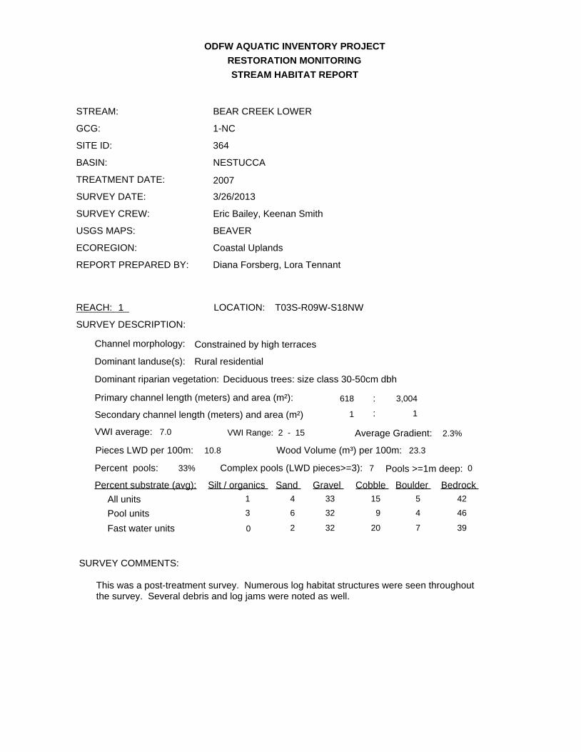
ODFW AQUATIC INVENTORY PROJECT
RESTORATION MONITORING
BEAR CREEK LOWER
SITE ID: 364
GCG: 1-NC
SURVEY DATE: 3/26/2013
STREAM:
STREAM HABITAT REPORT
BASIN:
TREATMENT DATE:
SURVEY CREW:
REPORT PREPARED BY:
USGS MAPS:
ECOREGION:
SURVEY DESCRIPTION:
SURVEY COMMENTS:
NESTUCCA
Eric Bailey, Keenan Smith
BEAVER
Coastal Uplands
Diana Forsberg, Lora Tennant
Primary channel length (meters) and area (m²):
VWI average: Average Gradient:
Wood Volume (m³) per 100m:Pieces LWD per 100m:
Dominant landuse(s):
Dominant riparian vegetation:
Secondary channel length (meters) and area (m²)
618 3,004
1 1
7.0 VWI Range: 2 - 15 2.3%
23.310.8
:
:
Percent pools: Complex pools (LWD pieces>=3): Pools >=1m deep: 0
Constrained by high terracesChannel morphology:
Rural residential
Deciduous trees: size class 30-50cm dbh
Percent substrate (avg): Silt / organics Sand Gravel Cobble Boulder Bedrock
1 4 33 15 5 42All units
3 6 32 9 4 46Pool units
0 2 32 20 7 39Fast water units
33% 7
This was a post-treatment survey. Numerous log habitat structures were seen throughout the survey. Several debris and log jams were noted as well.
2007
REACH: 1__________ LOCATION: T03S-R09W-S18NW
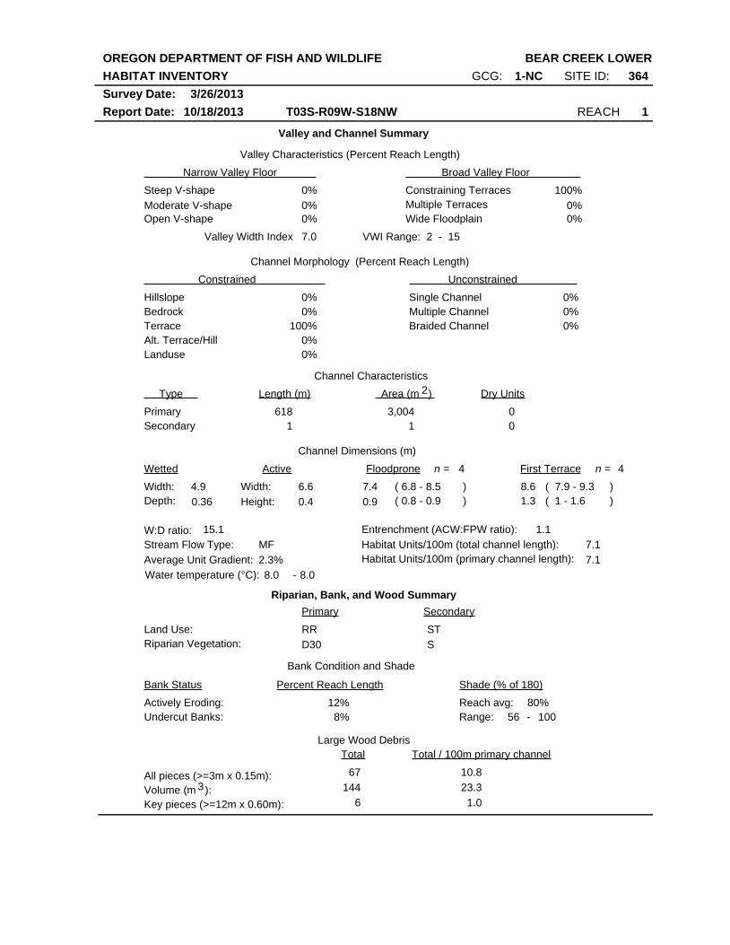
OREGON DEPARTMENT OF FISH AND WILDLIFE
HABITAT INVENTORY
Report Date: 10/18/2013
BEAR CREEK LOWER
REACH 1T03S-R09W-S18NW
SITE ID: 364GCG: 1-NC
Survey Date: 3/26/2013
Valley and Channel Summary
Narrow Valley Floor Broad Valley Floor
Valley Characteristics (Percent Reach Length)
Steep V-shape
Moderate V-shape
Open V-shape
Constraining Terraces
Multiple Terraces
Wide Floodplain
Valley Width Index
Channel Morphology (Percent Reach Length)
Hillslope
Constrained Unconstrained
Bedrock
Terrace
Alt. Terrace/Hill
Landuse
Single Channel
Multiple Channel
Braided Channel
Channel Characteristics
Type Length (m) Area (m ) Dry Units
Primary
Secondary
Channel Dimensions (m)
Wetted Active Floodprone First Terrace
Width:
Depth:
Width:
Height:
W:D ratio: Entrenchment (ACW:FPW ratio):
Stream Flow Type:
Average Unit Gradient:
Habitat Units/100m (total channel length):
0%
0%
0%
0%
100%
0%
0%
0%
0%
0%
0%
100%
0%
0%
7.0 VWI Range: 2 - 15
1 1
0
0
618 3,004
4.9
0.36
6.6
0.4
7.4
0.9
8.6
1.3
15.1 1.1
MF
2.3%
7.1
Riparian, Bank, and Wood Summary
Primary Secondary
Land Use:
Riparian Vegetation:
RR
D30
ST
S
Bank Condition and Shade
Bank Status Percent Reach Length Shade (% of 180)
Reach avg:
Undercut Banks:
Large Wood Debris
Total Total / 100m primary channel
All pieces (>=3m x 0.15m):
Volume (m ):
Key pieces (>=12m x 0.60m):
67
144
6
10.8
23.3
1.0
12%
8%
80%Actively Eroding:
8.0 8.0Water temperature (°C): -
56Range: 100 -
3
4n = 4n =
( 6.8 - 8.5
( 0.8 - 0.9
( 7.9 - 9.3
( 1 - 1.6
)
)
)
)
7.1Habitat Units/100m (primary channel length):
2
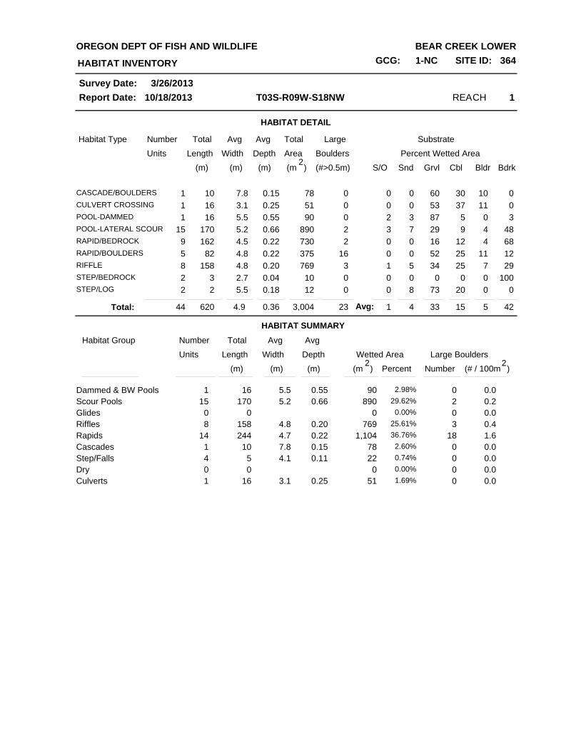
HABITAT DETAIL
Habitat Type Number Total Avg Total Large Substrate
Percent Wetted Area Units Length Width
Avg
Depth Area Boulders
(m) (m) (m) (m )2
(#>0.5m) S/O Snd Grvl Cbl Bldr Bdrk
REACH 1T03S-R09W-S18NW
HABITAT INVENTORY
Report Date: 10/18/2013
OREGON DEPT OF FISH AND WILDLIFE BEAR CREEK LOWER
GCG: 1-NC SITE ID: 364
Survey Date: 3/26/2013
1CASCADE/BOULDERS 10 7.8 0.15 78 0 0 0 60 30 10 0
1CULVERT CROSSING 16 3.1 0.25 51 0 0 0 53 37 11 0
1POOL-DAMMED 16 5.5 0.55 90 0 2 3 87 5 0 3
15POOL-LATERAL SCOUR 170 5.2 0.66 890 2 3 7 29 9 4 48
9RAPID/BEDROCK 162 4.5 0.22 730 2 0 0 16 12 4 68
5RAPID/BOULDERS 82 4.8 0.22 375 16 0 0 52 25 11 12
8RIFFLE 158 4.8 0.20 769 3 1 5 34 25 7 29
2STEP/BEDROCK 3 2.7 0.04 10 0 0 0 0 0 0 100
2STEP/LOG 2 5.5 0.18 12 0 0 8 73 20 0 0
HABITAT SUMMARY
44 620 4.9 0.36 3,004 23 1 4 33 15 5 42Total:
Habitat Group Number Total Avg
Wetted Area Large Boulders Units Length Width
Avg
Depth
Number (m) (m) (m) )2
(# / 100mPercent
Scour Pools
Glides
Riffles
Rapids
Cascades
Step/Falls
Dry
Dammed & BW Pools 9016 5.5 0.551 2.98%
890170 5.2 0.6615 29.62%
000 0.00%
769158 4.8 0.208 25.61%
1,104244 4.7 0.2214 36.76%
7810 7.8 0.151 2.60%
225 4.1 0.114 0.74%
Culverts
000 0.00%
5116 3.1 0.251 1.69%
0
2
0
3
18
0
0
0
0
0.0
0.0
0.4
0.0
0.0
0.0
0.0
(m )2
1.6
0.2
Avg:
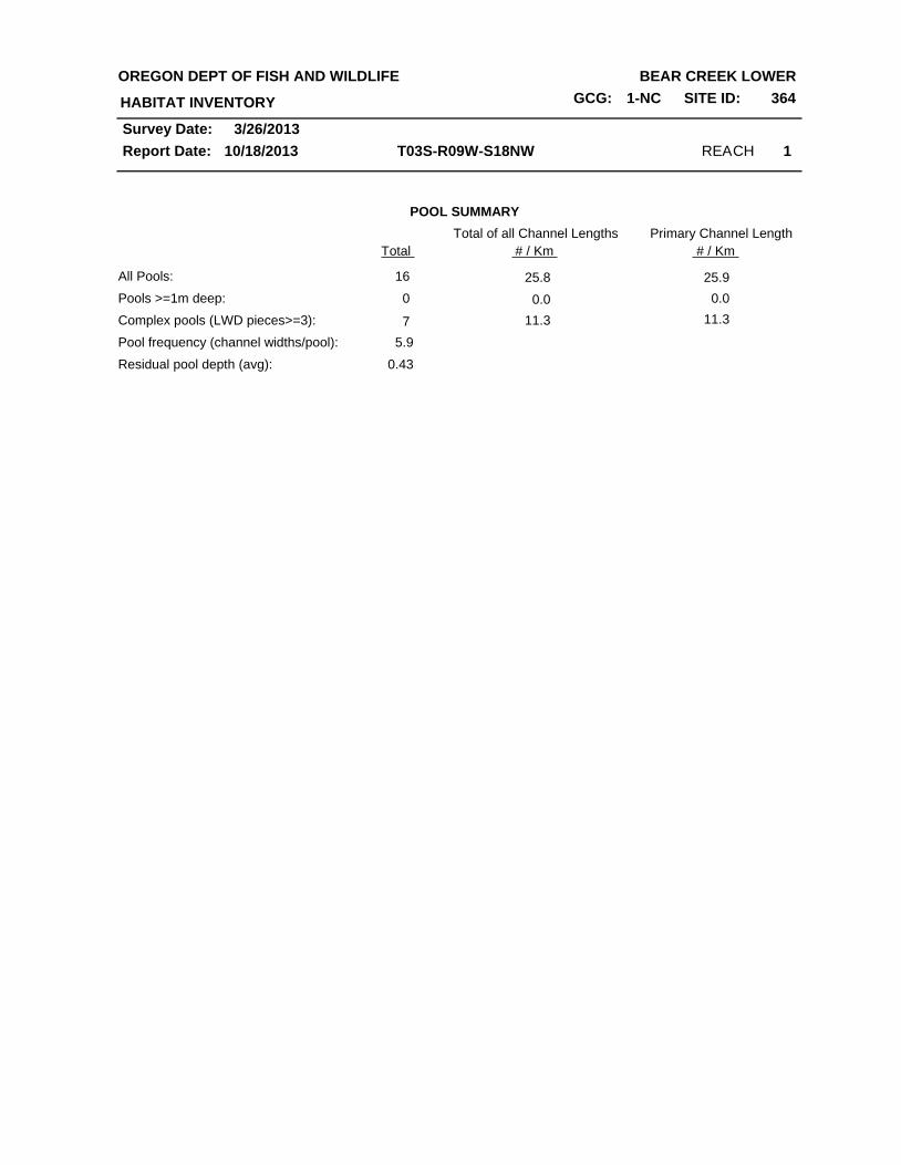
REACH 1T03S-R09W-S18NW
HABITAT INVENTORY
Report Date: 10/18/2013
OREGON DEPT OF FISH AND WILDLIFE BEAR CREEK LOWER
GCG: 1-NC SITE ID: 364
Survey Date: 3/26/2013
POOL SUMMARY
Total
All Pools:
Pools >=1m deep:
Complex pools (LWD pieces>=3):
Pool frequency (channel widths/pool):
16
Residual pool depth (avg): 0.43
5.9
0
7
Total of all Channel Lengths
25.8
0.0
11.3
25.9
0.0
11.3
# / Km
Primary Channel Length
# / Km
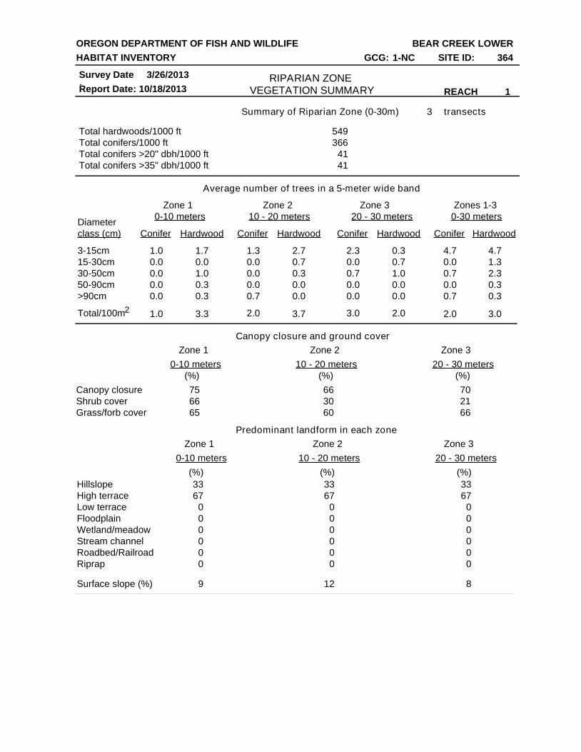
Summary of Riparian Zone (0-30m) transects
Total hardwoods/1000 ft
Total conifers/1000 ft
Total conifers >20" dbh/1000 ft
Total conifers >35" dbh/1000 ft
Average number of trees in a 5-meter wide band
Canopy closure and ground cover
Predominant landform in each zone
Zone 1 Zone 2 Zone 3 Zones 1-3
0-10 meters 10 - 20 meters 20 - 30 meters 0-30 meters
Conifer Hardwood Conifer Hardwood Conifer Hardwood Conifer Hardwood
Diameter
class (cm)
3-15cm
15-30cm
30-50cm
50-90cm
>90cm
Total/100m
Zone 1 Zone 2 Zone 3
0-10 meters 10 - 20 meters 20 - 30 meters
Zone 1 Zone 2 Zone 3
0-10 meters 10 - 20 meters 20 - 30 meters
Canopy closure
Shrub cover
Grass/forb cover
Hillslope
High terrace
Low terrace
Floodplain
Wetland/meadow
Stream channel
Roadbed/Railroad
Riprap
Surface slope (%)
3
549
366
41
41
1.0
0.0
0.0
0.0
1.0
0.0
1.7
0.0
1.0
0.3
3.3
0.3
1.3
0.0
0.0
0.0
0.7
2.7
0.7
0.3
0.0
0.0
2.3
0.0
0.7
0.0
0.0
0.3
0.7
1.0
0.0
0.0
4.7
0.0
0.7
0.0
2.0
0.7
4.7
1.3
2.3
0.3
3.0
0.3
75
66
65
66
30
60
70
21
66
33
67
0
0
0
0
0
0
33
67
0
0
0
0
0
0
33
67
0
0
0
0
0
0
9 12 8
2.0 3.7 3.0 2.0
(%) (%)(%)
(%) (%)(%)
RIPARIAN ZONE VEGETATION SUMMARY REACH 1
OREGON DEPARTMENT OF FISH AND WILDLIFE
HABITAT INVENTORY
Report Date:
BEAR CREEK LOWER
10/18/2013
Survey Date:
3/26/2013
GCG: 1-NC SITE ID: 364
2
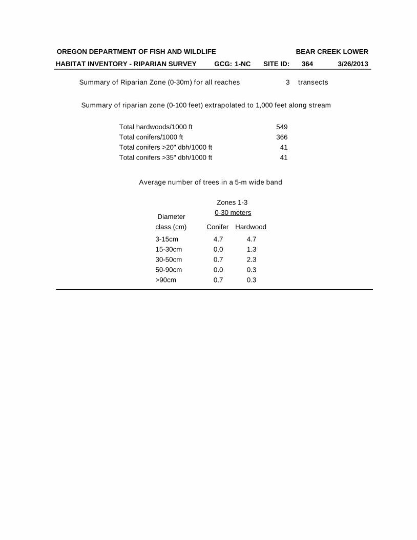
Summary of Riparian Zone (0-30m) for all reaches transects
Total hardwoods/1000 ft
Total conifers/1000 ft
Total conifers >20" dbh/1000 ft
Total conifers >35" dbh/1000 ft
3
549
366
41
41
Zones 1-3
0-30 meters
Conifer Hardwood
4.7
0.0
0.7
0.0
0.7
4.7
1.3
2.3
0.3
0.3
Diameter
class (cm)
3-15cm
15-30cm
30-50cm
50-90cm
>90cm
Average number of trees in a 5-m wide band
OREGON DEPARTMENT OF FISH AND WILDLIFE
HABITAT INVENTORY - RIPARIAN SURVEY
BEAR CREEK LOWER
3/26/2013
Summary of riparian zone (0-100 feet) extrapolated to 1,000 feet along stream
GCG: 1-NC SITE ID: 364
3/26/2013Survey Date:10/18/2013
Reach 1 1
HABITAT INVENTORY Report Date:
RIPARIAN ZONE VEGETATION
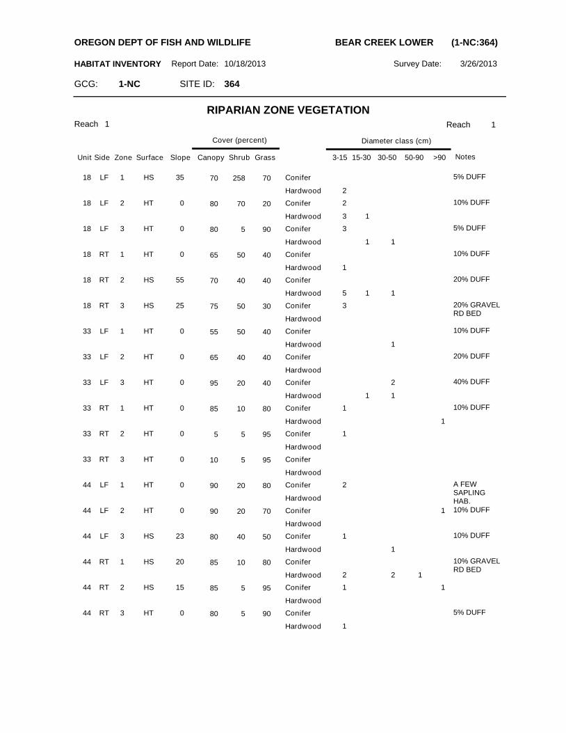
Reach
Slope Canopy ShrubSurfaceZoneSideUnit
Cover (percent)
Grass 3-15 15-30 30-50 50-90 >90
Diameter class (cm)
Notes
SITE ID: 364GCG: 1-NC
OREGON DEPT OF FISH AND WILDLIFE BEAR CREEK LOWER (1-NC:364)
18 LF 1 HS 35 70 258 70
2
5% DUFFConifer
Hardwood
18 LF 2 HT 0 80 70 20 2
3 1
10% DUFFConifer
Hardwood
18 LF 3 HT 0 80 5 90 3
1 1
5% DUFFConifer
Hardwood
18 RT 1 HT 0 65 50 40
1
10% DUFFConifer
Hardwood
18 RT 2 HS 55 70 40 40
5 1 1
20% DUFFConifer
Hardwood
18 RT 3 HS 25 75 50 30 3 20% GRAVEL RD BED
Conifer
Hardwood
33 LF 1 HT 0 55 50 40
1
10% DUFFConifer
Hardwood
33 LF 2 HT 0 65 40 40 20% DUFFConifer
Hardwood
33 LF 3 HT 0 95 20 40 2
1 1
40% DUFFConifer
Hardwood
33 RT 1 HT 0 85 10 80 1
1
10% DUFFConifer
Hardwood
33 RT 2 HT 0 5 5 95 1Conifer
Hardwood
33 RT 3 HT 0 10 5 95 Conifer
Hardwood
44 LF 1 HT 0 90 20 80 2 A FEW SAPLING HAB.
Conifer
Hardwood
44 LF 2 HT 0 90 20 70 1 10% DUFFConifer
Hardwood
44 LF 3 HS 23 80 40 50 1
1
10% DUFFConifer
Hardwood
44 RT 1 HS 20 85 10 80
2 2 1
10% GRAVEL RD BED
Conifer
Hardwood
44 RT 2 HS 15 85 5 95 1 1Conifer
Hardwood
44 RT 3 HT 0 80 5 90
1
5% DUFFConifer
Hardwood
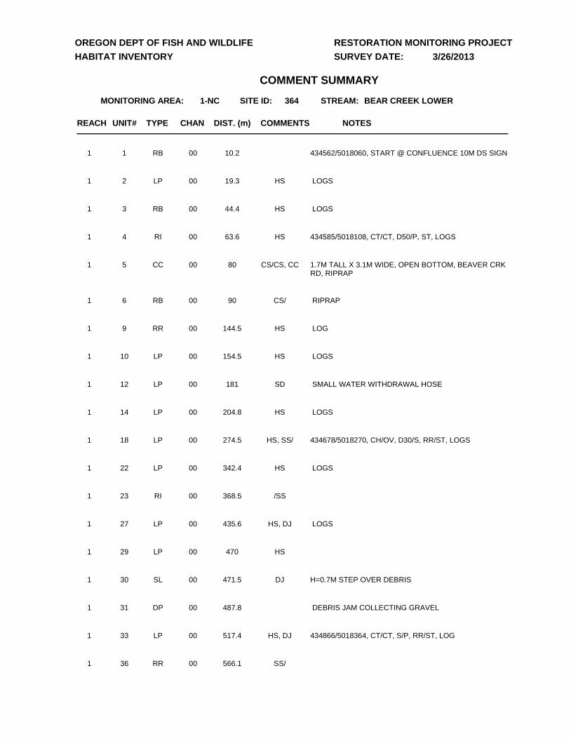
UNIT# TYPE CHAN DIST. (m) NOTES
1-NC 364 BEAR CREEK LOWER
COMMENTS
MONITORING AREA: SITE ID:
OREGON DEPT OF FISH AND WILDLIFE
HABITAT INVENTORY
RESTORATION MONITORING PROJECT
SURVEY DATE:
STREAM:
COMMENT SUMMARY
3/26/2013
REACH
1 RB 00 10.2 434562/5018060, START @ CONFLUENCE 10M DS SIGN1
2 LP 00 19.3 LOGSHS1
3 RB 00 44.4 LOGSHS1
4 RI 00 63.6 434585/5018108, CT/CT, D50/P, ST, LOGSHS1
5 CC 00 80 1.7M TALL X 3.1M WIDE, OPEN BOTTOM, BEAVER CRK RD, RIPRAP
CS/CS, CC1
6 RB 00 90 RIPRAPCS/1
9 RR 00 144.5 LOGHS1
10 LP 00 154.5 LOGSHS1
12 LP 00 181 SMALL WATER WITHDRAWAL HOSESD1
14 LP 00 204.8 LOGSHS1
18 LP 00 274.5 434678/5018270, CH/OV, D30/S, RR/ST, LOGSHS, SS/1
22 LP 00 342.4 LOGSHS1
23 RI 00 368.5 /SS1
27 LP 00 435.6 LOGSHS, DJ1
29 LP 00 470 HS1
30 SL 00 471.5 H=0.7M STEP OVER DEBRISDJ1
31 DP 00 487.8 DEBRIS JAM COLLECTING GRAVEL1
33 LP 00 517.4 434866/5018364, CT/CT, S/P, RR/ST, LOGHS, DJ1
36 RR 00 566.1 SS/1
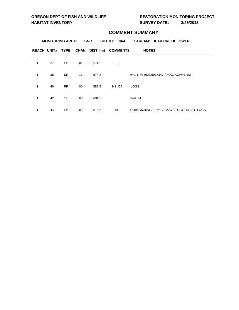
UNIT# TYPE CHAN DIST. (m) NOTES
1-NC 364 BEAR CREEK LOWER
COMMENTS
MONITORING AREA: SITE ID:
OREGON DEPT OF FISH AND WILDLIFE
HABITAT INVENTORY
RESTORATION MONITORING PROJECT
SURVEY DATE:
STREAM:
COMMENT SUMMARY
3/26/2013
REACH
37 LP 01 574.2 TJ/1
38 SR 11 574.2 H=1.1, 434927/5018347, T=9C, ACW=1.1M1
40 RR 00 589.5 LOGSHS, DJ1
42 SL 00 601.5 H=0.3M 1
44 LP 00 618.2 434958/5018338, T=8C, CA/CT, D30/S, RR/ST, LOGSHS1
DD
D
D
D
D
D
#*
#*
#*
#*
365
364
365
364
434000.000000
434000.000000
435000.000000
435000.000000
436000.000000
436000.000000
5017
000.00
0000
5017
000.00
0000
5018
000.00
0000
5018
000.00
0000
5019
000.00
0000
5019
000.00
0000
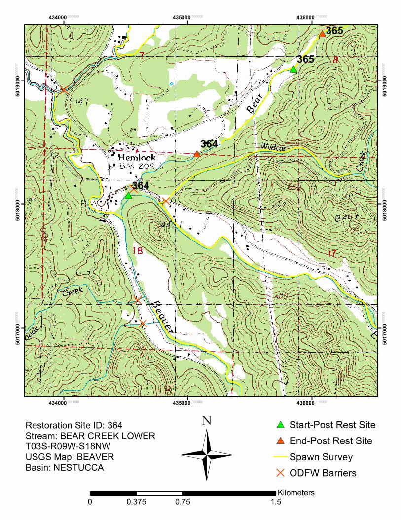
Restoration Site ID: 364Stream: BEAR CREEK LOWERT03S-R09W-S18NWUSGS Map: BEAVERBasin: NESTUCCA
#* Start-Post Rest Site#* End-Post Rest Site
Spawn SurveyD ODFW Barriers
0 0.75 1.50.375Kilometers
Ü
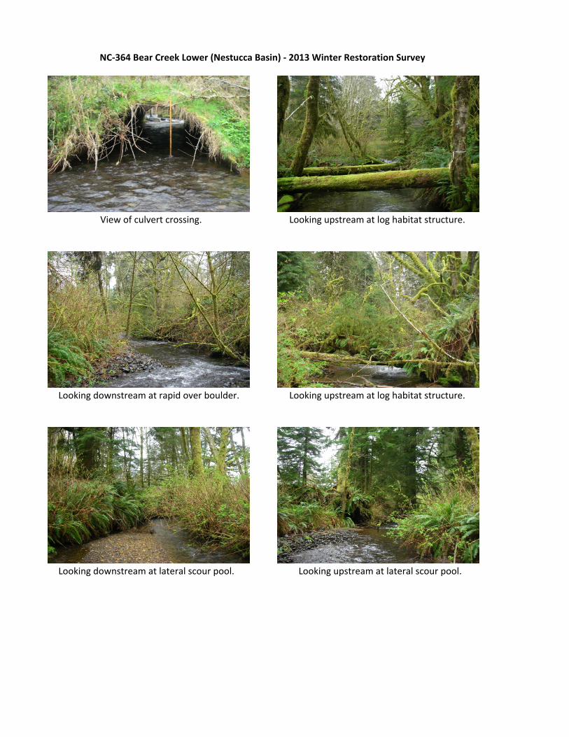
View of culvert crossing. Looking upstream at log habitat structure.
Looking downstream at rapid over boulder. Looking upstream at log habitat structure.
Looking downstream at lateral scour pool. Looking upstream at lateral scour pool.
NC‐364 Bear Creek Lower (Nestucca Basin) ‐ 2013 Winter Restoration Survey
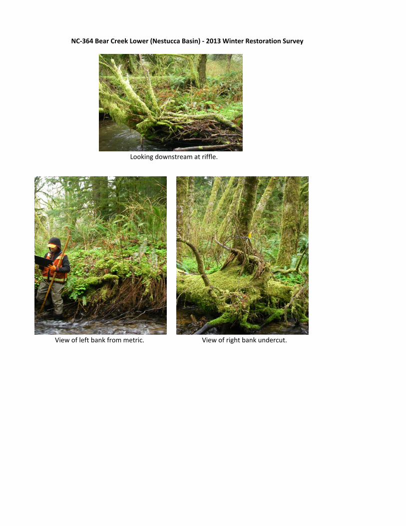
Looking downstream at riffle.
View of left bank from metric. View of right bank undercut.
NC‐364 Bear Creek Lower (Nestucca Basin) ‐ 2013 Winter Restoration Survey


![Inventory of Shellfish Restoration Permitting & …masglp.olemiss.edu › projects › files › tnc-report.pdf! 8!! • LeasingforRestoration:!Alabamadoesnothavespecificprovisionsforleasingstate]](https://static.fdocuments.us/doc/165x107/5f0b9f067e708231d431682b/inventory-of-shellfish-restoration-permitting-a-projects-a-files-a-tnc-reportpdf.jpg)