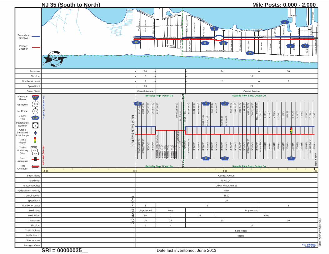
NJ 35 (South to North) Mile Posts: 0.000 - 2 · n ue e e e l s r v e n u e 35 2 Number WIM AVC NJ...
20
Central Avenue K Court Barnegat Avenue I S tre et North Street North Ocean Avenue O Street L S tre et H S tre et 14th Street G Street F Street 13th Avenue 12th Avenue 23rd Avenue D S tre et South Bayview Avenue 11th Avenue 22nd Avenue S o u th Ocea n A v en u e 9th Avenue 20th Avenue North Bayview Avenue 3r d A ve n ue Lafayette Avenue 1st Avenue 6th Street Island Avenue Bayview Avenue Bay VIew Avenue K Street O Street Central Avenue 6 53 49 51 8 14 2 4 Primary Direction Secondary Direction 22 33 689 2 Interstate Route US Route NJ Route County Road Interchange Number Grade Separated Interchange Traffic Signal Traffic Monitoring Sites Road Underpass Road Overpass WIM AVC VOL Units in miles Primary Direction Secondary Direction 287 NJ 35 (South to North) SRI = 00000035__ Mile Posts: 0.000 - 2.000 2515 Date last inventoried: June 2013 Page Created: June, 2015 -1.0 0.0 1.0 2.0 Begin NJ 35 MP=0.00 Island Beach State Park (0.54) Berkeley Twp, Ocean Co (0.54) Berkeley Twp, Ocean Co (0.54) Seaside Park Boro, Ocean Co (0.54) Seaside Park Boro, Ocean Co (0.03) 24TH (0.03) AVENUE (0.07) 23RD (0.07) AVENUE (0.13) 22ND AVENUE (0.18) 21ST AVENUE (0.23) 20TH AVENUE 49 (0.26) 11TH LN (0.29) 10TH LN (0.32) 9TH LN (0.35) 8TH LN (0.38) 7TH LN (0.39) 6TH LN (0.41) 5TH LN (0.44) 4TH LN (0.46) 3RD LN (0.48) 15TH AVE 2ND LN LANE (0.52) 1ST (0.54) 14TH AVENUE (0.58) 13TH (0.58) AVENUE (0.64) 12TH AVENUE (0.69) 11TH AVENUE (0.74) 10TH AVENUE (0.79) 9TH AVENUE (0.84) 8TH AVENUE (0.89) 7TH AVENUE AVENUE (0.95) 6TH (1.00) 5TH AVENUE (1.05) 4TH AVENUE (1.10) 3RD AVENUE (1.15) 2ND AVENUE (1.20) 1ST AVENUE (1.24) NORTH (1.24) AVENUE (1.29) ISLAND AVENUE (1.34) BRIGHTON AVENUE (1.38) C (1.38) STREET (1.43) D STREET (1.48) E STREET (1.53) F STREET (1.58) G STREET (1.63) H STREET (1.68) I STREET (1.74) J STREET (1.79) K STREET STREET (1.84) L (1.89) M STREET (1.93) STREET (1.93) N (1.98) O STREET 8 8 14 14 2 Street Name Central Avenue Jurisdiction N.J.D.O.T. Functional Class Urban Minor Arterial Federal Aid - NHS Sy STP Control Section 1520 Speed Limit 25 Number of Lanes 1 2 3 Med. Type Unprotected None Unprotected Med. Width 60 0 48 VAR Pavement 14 24 20 36 Shoulder 6 4 10 Traffic Volume 5,166 (2012) Traffic Sta. ID 091503 Structure No. Enlarged Views See Enlarged View #19 See Enlarged View #19 Pavement 24 24 36 Shoulder 6 10 Number of Lanes 2 2 3 Speed Limit 25 25 Street Name Central Avenue Central Avenue
Transcript of NJ 35 (South to North) Mile Posts: 0.000 - 2 · n ue e e e l s r v e n u e 35 2 Number WIM AVC NJ...
Centra l A venue
K C
ou
rt
Barnegat Av enue
I S
tre
et
No
rth
Str
ee
t
North Oc ean Av enue
O S
tre
et
L S
tre
et
H S
tre
et
14
th S
tre
et
G S
tre
et
F S
tre
et
13
th A
ve
nu
e
12
th A
ve
nu
e
23
rd A
ve
nu
e
D S
tre
et
South B ay view A venue
11
th A
ve
nu
e
22
nd
Ave
nu
e
South Oc ean Av enue
9th
Av
en
ue
20
th A
ve
nu
e
North Bay view Av enue
3rd A
ve
nue
La
faye
tte A
ve
nue
1s
t A
ve
nu
e
6th Street
Isla
nd
Ave
nu
e
Bayview Avenue
Bay V Iew Av enueK Str eet
O S
tre
et
Centra l A venue
6
53
49
518 14
2
4
Prim
ary
Dire
ctio
nS
eco
nd
ary
Dire
ctio
n
22
33
689
2
Interstate
Route
US Route
NJ Route
County
Road
Interchange
Number
Grade
Separated
Interchange
Traffic
Signal
Traffic
Monitoring
Sites
Road
Underpass
Road
Overpass
WIM
AVC
VOL
Un
its in
mile
s
Primary
Direction
Secondary
Direction
287
NJ 35 (South to North)
SRI = 00000035__
Mile Posts: 0.000 - 2.000
2515
Date last inventoried: June 2013
Page C
reate
d: J
une, 2
015
-1.0 0.0 1.0 2.0
Begin
NJ 3
5 M
P=
0.0
0Is
land B
each S
tate
Park
(0.5
4)
Berkeley Twp, Ocean Co
(0.5
4)Berkeley Twp, Ocean Co
(0.5
4)
Seaside Park Boro, Ocean Co
(0.5
4) Seaside Park Boro, Ocean Co
(0.0
3) 2
4T
H(0
.03) A
VE
NU
E
(0.0
7) 2
3R
D(0
.07) A
VE
NU
E
(0.1
3) 2
2N
DA
VE
NU
E
(0.1
8) 2
1S
TA
VE
NU
E
(0.2
3) 2
0T
HA
VE
NU
E
49
(0.2
6) 1
1T
H L
N
(0.2
9) 1
0T
H L
N
(0.3
2) 9
TH
LN
(0.3
5) 8
TH
LN
(0.3
8) 7
TH
LN
(0.3
9) 6
TH
LN
(0.4
1) 5
TH
LN
(0.4
4) 4
TH
LN
(0.4
6) 3
RD
LN
(0.4
8) 1
5T
H A
VE
2N
D L
N
LA
NE
(0.5
2) 1
ST
(0.5
4) 1
4T
HA
VE
NU
E
(0.5
8) 1
3T
H(0
.58) A
VE
NU
E
(0.6
4) 1
2T
HA
VE
NU
E
(0.6
9) 1
1T
HA
VE
NU
E
(0.7
4) 1
0T
HA
VE
NU
E
(0.7
9) 9
TH
AV
EN
UE
(0.8
4) 8
TH
AV
EN
UE
(0.8
9) 7
TH
AV
EN
UE
AV
EN
UE
(0.9
5) 6
TH
(1.0
0) 5
TH
AV
EN
UE
(1.0
5) 4
TH
AV
EN
UE
(1.1
0) 3
RD
AV
EN
UE
(1.1
5) 2
ND
AV
EN
UE
(1.2
0) 1
ST
AV
EN
UE
(1.2
4) N
OR
TH
(1.2
4) A
VE
NU
E
(1.2
9) IS
LA
ND
AV
EN
UE
(1.3
4) B
RIG
HT
ON
AV
EN
UE
(1.3
8) C
(1.3
8) S
TR
EE
T
(1.4
3) D
ST
RE
ET
(1.4
8) E
ST
RE
ET
(1.5
3) F
ST
RE
ET
(1.5
8) G
ST
RE
ET
(1.6
3) H
ST
RE
ET
(1.6
8) I
ST
RE
ET
(1.7
4) J
ST
RE
ET
(1.7
9) K
ST
RE
ET
ST
RE
ET
(1.8
4) L
(1.8
9) M
ST
RE
ET
(1.9
3) S
TR
EE
T(1
.93) N
(1.9
8) O
ST
RE
ET
8
8
14
14 2
Street Name Central Avenue
Jurisdiction N.J.D.O.T.
Functional Class Urban Minor Arterial
Federal Aid - NHS Sy STP
Control Section 1520
Speed Limit 25
Number of Lanes 1 2 3
Med. Type Unprotected None Unprotected
Med. Width 60 0 48 VAR
Pavement 14 24 20 36
Shoulder 6 4 10
Traffic Volume 5,166 (2012)
Traffic Sta. ID 091503
Structure No.
Enlarged Views See Enlarged View #19
See Enlarged View #19
Pavement 24 24 36
Shoulder 6 10
Number of Lanes 2 2 3
Speed Limit 25 25
Street Name Central Avenue Central Avenue

NJ 35
Bay A venue
Boulevard
K C
ou
rt
NJ 37
Baltimore Av enue
6th
Av
en
ue
No
rth
Str
ee
t
Ce
ntra
l Ave
nue
1s
t A
ve
nu
e
NJ 35 S outhbound
3rd A
ve
nue
2n
d A
ven
ue
O S
tre
et
Washington A venue
Ha
rdin
g A
ve
nu
e
L S
tre
et
Ne
wa
rk A
ve
nue
Fie
lde
r A
ve
nu
e
8th A
ven
ue
Grand Centr al Av enue
Ocean A venue
Gra
nt A
ve
nue
Vir
gin
ia A
ve
nu
e
Je
rse
y C
ity A
ven
ue
Anna O Hawkins Boulevard
Lin
co
ln A
ven
ue
Du
po
nt
Ave
nue
Ca
rte
ret
Av
en
ue
Su
mn
er
Ave
nu
e
Fre
mo
nt
Ave
nu
e
Tre
nto
n A
ven
ue
Fra
nk
lin
Ave
nu
e
Sh
erid
an
Ave
nu
e
Barnegat Av enue
Ne
w Y
ork
Av
en
ue
Sa
mp
so
n A
ve
nu
e
Hie
ring
Av
en
ue
M S
tree
t
Co
l lidg
e A
ven
ue
Ocean Terr ac e
4th
Av
en
ue
La
faye
tte A
ve
nue
Lake A venue
5th
Av
en
ue
Tun
ne
y A
ve
nu
e
Pe
rsh
ing
Bou
lev
ard
Dia
ne
La
ne
Centra l A venue
Barnegat Av enue
NJ 35
Bay A venue
O S
tre
et
Bay A venue
NJ
37
8th
Av
en
ue
35
37
629
51
47
42
24
6
14
10
20
8
79
202
629
Prim
ary
Dire
ctio
nS
eco
nd
ary
Dire
ctio
n
22
33
689
2
Interstate
Route
US Route
NJ Route
County
Road
Interchange
Number
Grade
Separated
Interchange
Traffic
Signal
Traffic
Monitoring
Sites
Road
Underpass
Road
Overpass
WIM
AVC
VOL
Un
its in
mile
s
Primary
Direction
Secondary
Direction
287
NJ 35 (South to North)
SRI = 00000035__
Mile Posts: 2.000 - 5.000
2516
Date last inventoried: June 2013
Page C
reate
d: J
une, 2
015
2.0 3.0 4.0 5.0
(2.4
2)
Seaside Park Boro, Ocean Co
(2.4
2)Seaside Park Boro, Ocean Co
(2.4
2)
(2.5
8)
Seaside Hts, Oce. Co.
(2.4
2)
(2.5
8)Seaside Hts,
Oce. Co.
(2.5
8)
(2.7
3)
Berkeley, Oce. Co.
(2.5
8)
(2.7
3)Berkeley, Oce.
Co.
(2.7
3)
(3.3
6)
Seaside Heights Boro, Ocean Co
(2.7
3)
(3.3
6)Seaside Heights Boro, Ocean Co
(3.3
6)
(4.3
5)
Toms River Twp, Ocean Co
(3.3
6)
(4.3
5)Toms River Twp, Ocean Co
(4.3
5)
Lavallette Boro, Ocean Co
(4.3
5) Lavallette Boro, Ocean Co
AV
EN
UE
LA
FA
YE
TT
E
(2.0
3)
(2.0
8) D
EC
AT
UR
AV
E
(2.1
3) S
TO
CK
TO
N A
VE
(2.1
3) U
NN
AM
ED
RD
(2.1
8) F
AR
RA
GU
T A
VE
(2.1
8) U
NN
AM
ED
RD
(2.2
1) C
EN
TR
AL A
VE
(2.3
1) B
AR
NE
GA
T A
VE
(2.7
0)
HA
MIL
TO
N A
VE
.
BA
Y B
LV
D(3
.26)
BA
Y B
LV
D
(3.2
8)
BA
RN
EG
AT
E A
VE
(3.3
6)
(3.4
8) C
EN
TR
AL
AV
EN
UE
37
629
629
GR
AN
D C
EN
TR
AL A
VE
(3.5
3)
(3.5
5) C
OLO
NY
RD
HO
LID
AY
RD
(3.6
2)
FR
OM
CO
LO
NY
RD
(3.6
6) S
UR
F R
D
EIS
EN
HO
WE
R R
D
(3.6
9)
(3.6
9) B
EA
CH
RD
(3.7
4) H
AR
DIN
GA
VE
NU
E
(3.7
7) C
OO
LID
GE
AV
EN
UE
(3.8
1) F
OR
TA
VE
NU
E
(3.8
4) F
IELD
ER
AV
EN
UE
(3.8
6) 9
TH
AV
E
(3.9
1) 8
TH
AV
EN
UE
(3.9
6) 7
TH
AV
EN
UE
(4.0
0) 6
TH
AV
EN
UE
(4.0
5) 5
TH
AV
EN
UE
(4.1
0) 4
TH
AV
EN
UE
(4.1
7) 3
RD
AV
EN
UE
(4.2
4) 2
ND
AV
EN
UE
(4.2
8) S
EA
GU
LL L
A
(4.3
2) 1
ST
AV
ED
OV
ER
AV
E
(4.3
7) T
RE
NT
ON
AV
EN
UE
(4.4
2) N
EW
AR
KA
VE
NU
E
(4.4
7) E
LIZ
AB
ET
HA
VE
NU
E
(4.5
3) P
RIN
CE
TO
NA
VE
NU
E
(4.5
8) J
ER
SE
Y C
ITY
AV
EN
UE
(4.6
3) N
EW
JE
RS
EY
AV
EN
UE
(4.6
8) N
EW
YO
RK
AV
EN
UE
(4.7
4) P
EN
NS
YLV
AN
IAA
VE
NU
E
(4.7
9) V
IRG
INIA
AV
EN
UE
(4.8
4) N
EW
BR
UN
SW
ICK
AV
EN
UE
(4.8
9) B
RO
OK
LY
NA
VE
NU
E
(4.9
4) W
AS
HIN
GT
ON
AV
EN
UE
(5.0
0) P
HIL
AD
ELP
HIA
AV
EN
UE
51
8
Street Name Central Avenue NJ 35 Grand Central Avenue
Jurisdiction N.J.D.O.T.
Functional Class Urban Minor Arterial Urban Principal Arterial
Federal Aid - NHS Sy STP NHS
Control Section 1520 1506
Speed Limit 25 45 35
Number of Lanes 3 4 3 6 2
Med. TypeUnprote cted
Curbed None
Med. Width VAR 0
Pavement 36 50 24 36 24 20
Shoulder 10 0 10 13 15 25
Traffic Volume 10,084 (2012)
Traffic Sta. ID 6-4-328
Structure No. 1508152
Enlarged Views See Enlarged View #19See Enlarged View #19
Pavement 36
Shoulder 10
Number of Lanes 3 2 3
Speed Limit 25 45
Street Name Central Avenue NJ 35

NJ 35
NJ 35 S outhbound
Ocean A venue
Bay A venue
Ocean Terr
Grand Centr al Av enue
Norm andy Dr iv e
6th
Av
en
ue
Co
lem
an L
an
e
We
stm
on
t Av
en
ueKe
rr Ave
nue
Bry
n M
aw
r A
ven
ue
Bro
wn
Ave
nu
e
Be
ach
Wa
y
Ca
mde
n A
ven
ue
Ha
ye
s C
ou
rt
Me
lod
y L
ane
So
uth
Co
urt
Sp
ray W
ay
Sunset B oulevard
He
ron
Roa
d
So
uth
La
go
on
Ro
ad
Arr ow
Co
ur t
Normandy Dr iv e35629
Prim
ary
Dire
ctio
nS
eco
nd
ary
Dire
ctio
n
22
33
689
2
Interstate
Route
US Route
NJ Route
County
Road
Interchange
Number
Grade
Separated
Interchange
Traffic
Signal
Traffic
Monitoring
Sites
Road
Underpass
Road
Overpass
WIM
AVC
VOL
Un
its in
mile
s
Primary
Direction
Secondary
Direction
287
NJ 35 (South to North)
SRI = 00000035__
Mile Posts: 5.000 - 8.000
2517
Date last inventoried: June 2013
Page C
reate
d: J
une, 2
015
5.0 6.0 7.0 8.0
(5.7
3)
Lavallette Boro, Ocean Co
(5.7
3)Lavallette Boro, Ocean Co
(5.7
3)
(7.2
4)
Toms River Twp, Ocean Co
(5.7
3)
(7.2
4)Toms River Twp, Ocean Co
(7.2
4)
Brick Twp, Ocean Co
(7.2
4) Brick Twp, Ocean Co
(5.0
0) P
HIL
AD
ELP
HIA
AV
EN
UE
(5.0
5) C
AM
DE
NA
VE
NU
E
(5.1
0) B
RO
WN
AV
EN
UE
(5.1
5) M
AG
EE
AV
EN
UE
(5.2
0) V
AN
CE
AV
EN
UE
(5.2
5) R
EE
SE
AV
EN
UE
(5.3
1) P
RE
SID
EN
TA
VE
NU
E
(5.3
6) G
UY
ER
AV
EN
UE
(5.4
1) B
ON
DA
VE
NU
E
(5.4
6) K
ER
RA
VE
NU
E
(5.5
1) W
HIT
EA
VE
NU
E
(5.5
6) O
RT
LE
YA
VE
NU
E
(5.6
2) W
ES
TM
ON
TA
VE
NU
E
(5.6
7) H
AD
DO
NF
IELD
AV
EN
UE
(5.7
2) B
RY
NM
AW
RA
VE
NU
E
(5.7
6) E
SH
OR
E W
AY
(5.7
7) W
SU
RF
WA
Y
(5.7
8) E
SP
RA
Y W
AY
(5.8
0) W
CH
AN
NE
L W
AY
(5.8
1) E
BE
AC
H W
AY
(5.8
3) W
BA
Y W
AY
(5.8
4) B
AR
NE
GA
T W
AY
(5.8
6) B
RIG
HT
ON
AV
ER
UT
HE
RF
OR
DLA
NE
(5.9
0) J
OS
EP
H S
T(5
.92) P
LA
INF
IELD
AV
E(5
.93) K
AT
HR
YN
ST
(5.9
7) O
CE
AN
BA
YB
LV
D
(6.0
3) C
AR
ME
L D
R(6
.05) C
ATA
LIN
A D
R(6
.09) S
EA
WA
Y(6
.11) C
HA
DW
ICK
AV
E(6
.13) B
AY
BE
RR
Y A
VE
(6.1
4) S
HE
LL A
VE
(6.1
6) D
UN
E A
VE
(6.1
7) T
IDE
AV
E(6
.18) H
AR
BO
R D
R
(6.2
8) K
ITT
IWA
KE
AV
E
(6.3
3) T
UN
AA
VE
NU
E
(6.3
6) O
SP
RE
YA
VE
NU
E(6
.38) A
LB
AC
OR
E A
VE
(6.4
0) P
LO
WE
R A
VE
(6.4
1) A
MB
ER
JA
CK
AV
E(6
.43) P
EN
GU
IN A
VE
(6.4
5) B
ON
ITA
AV
E(6
.46) C
RA
NE
RD
(6.4
8) S
WO
RD
FIS
H A
VE
(6.4
9) C
OR
MO
RA
NT
AV
E(6
.51) P
OM
PO
NO
RD
(6.5
3) S
AN
D P
IPE
R W
AY
(6.5
4) M
AR
LIN
WA
Y(6
.54) M
AR
LIN
WA
Y(6
.56) P
ELIC
AN
WA
Y(6
.58) D
OLP
HIN
WA
Y(6
.60) B
AY
VIE
W D
RF
LA
MIN
GO
WA
Y(6
.61) T
AR
PO
N W
AY
(6.6
3) K
ING
FIS
H W
AY
(6.6
5) B
EA
CH
WA
Y R
D(6
.66) B
AY
WA
Y R
D(6
.68) A
TLA
NT
IC W
AY
(6.6
9) P
AC
IFIC
WA
Y(6
.70) S
TR
ICK
LA
ND
BLV
DS
UR
FW
AY
CH
AN
NE
L W
AY
SP
RA
Y W
AY
(6.7
5) B
AR
NE
GA
T W
AY
(6.7
9) B
AY
SID
E R
DS
UR
F R
D
(6.8
3) C
OLO
NY
RO
AD
(6.8
9) S
ILV
ER
BE
AC
HR
OA
D
(6.9
5) J
AC
OB
SE
NLN
(6.9
8) P
ET
ER
SO
NLA
NE
(7.0
2) N
OR
MA
ND
Y W
AY
(7.0
4) 1
ST
AV
E(7
.05) W
1S
T A
VE
(7.0
8) 2
ND
AV
EN
UE
(7.1
3) 3
RD
AV
EN
UE
(7.1
8) 4
TH
AV
EN
UE
(7.2
3) 5
TH
AV
EN
UE
(7.2
7) 6
TH
AV
EN
UE
(7.3
2) 7
TH
AV
EN
UE
(7.3
7) 8
TH
AV
E
(7.4
2) 9
TH
AV
E(7
.44) J
EA
NE
TT
ED
RIV
E
DE
AU
VIL
LE
(7.4
9)
DR
IVE (7
.53) D
RIV
E(7
.53) G
EO
RG
IAN
(7.5
7) N
EP
TU
NE
CT
(7.6
0) K
UP
PE
R D
R
(7.6
3) L
YN
HU
RS
T D
R(7
.65) M
AR
ION
WA
Y(7
.67) C
UM
MIN
S S
T
(7.7
0) S
HE
LL R
D
(7.7
1) E
LD
ER
ST
(7.7
3) S
AN
DE
RLIN
G W
AY
FA
BE
R L
A
(7.9
1)
(7.9
5) O
SP
RE
Y L
A
629
Street Name Grand Central Avenue NJ 35 Ocean Avenue
Jurisdiction N.J.D.O.T.
Functional Class Urban Principal Arterial
Federal Aid - NHS Sy NHS
Control Section 1506
Speed Limit 35 40
Number of Lanes 2
Med. Type None
Med. Width 0
Pavement 20
Shoulder 25 10
Traffic Volume
Traffic Sta. ID
Structure No.
Enlarged Views
Pavement
Shoulder
Number of Lanes
Speed Limit
Street Name
Ocean A venue
Barnegat LaneNJ 35 S outhbound
East Av enue
Bay A venue
Squan Beach Drive
Runyon Lane
Curtis P oin t Road
Cu
tter L
an
e
Sunset Lane
He
rbe
rt S
tree
t
Lagoon Lane
South B ay Dr iv e
Arnold Str eet
Sunset Lane
35
528
Prim
ary
Dire
ctio
nS
eco
nd
ary
Dire
ctio
n
22
33
689
2
Interstate
Route
US Route
NJ Route
County
Road
Interchange
Number
Grade
Separated
Interchange
Traffic
Signal
Traffic
Monitoring
Sites
Road
Underpass
Road
Overpass
WIM
AVC
VOL
Un
its in
mile
s
Primary
Direction
Secondary
Direction
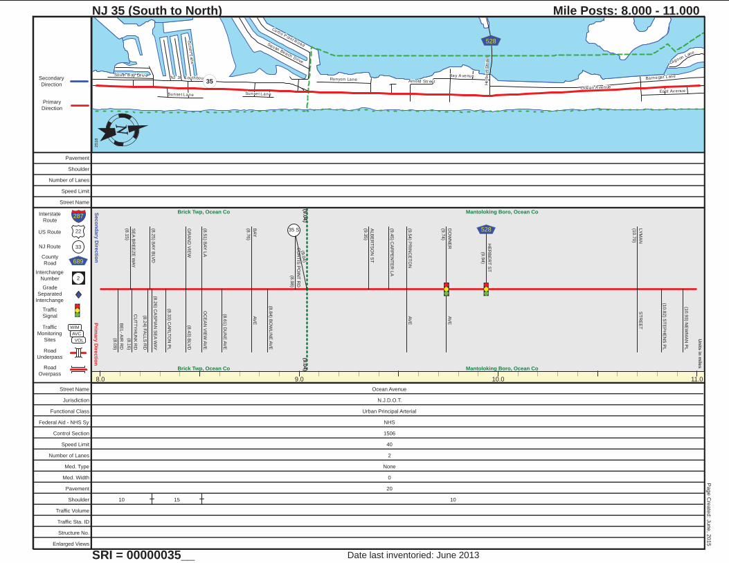
287
NJ 35 (South to North)
SRI = 00000035__
Mile Posts: 8.000 - 11.000
2518
Date last inventoried: June 2013
Page C
reate
d: J
une, 2
015
8.0 9.0 10.0 11.0
(9.0
4)
Brick Twp, Ocean Co
(9.0
4)Brick Twp, Ocean Co
(9.0
4)
Mantoloking Boro, Ocean Co
(9.0
4) Mantoloking Boro, Ocean Co
BE
L- A
IR R
D
(8.0
9)
SE
A B
RE
EZ
E W
AY
(8.1
5)
CU
TT
YH
UN
K R
D
(8.1
6)
(8.2
4) F
ALLS
RD
(8.2
5) B
AY
BLV
D(8
.26) C
AS
PIA
N S
EA
WA
Y
(8.3
3) C
AR
LT
ON
PL
GR
AN
D V
IEW
(8.4
3) B
LV
D
(8.5
1) B
AY
LA
OC
EA
N V
IEW
AV
E
(8.6
1) D
UN
E A
VE
BA
Y
(8.7
6)
AV
E
(8.8
4) B
OW
LIN
E A
VE
CU
RT
IS P
OIN
T R
D
(8.9
8)
(9.0
4)
ALB
ER
TS
ON
ST
(9.3
5)
(9.4
5) C
AR
PE
NT
ER
LA
(9.5
4) P
RIN
CE
TO
NA
VE
DO
WN
ER
(9.7
4)
AV
E
HE
RB
ER
T S
T
(9.9
4)
LY
MA
N
(10.7
0)
ST
RE
ET
(10.8
2) S
TE
PH
EN
S P
L
(10.9
3) N
EW
MA
N P
L
35 S 528
Street Name Ocean Avenue
Jurisdiction N.J.D.O.T.
Functional Class Urban Principal Arterial
Federal Aid - NHS Sy NHS
Control Section 1506
Speed Limit 40
Number of Lanes 2
Med. Type None
Med. Width 0
Pavement 20
Shoulder 10 15 10
Traffic Volume
Traffic Sta. ID
Structure No.
Enlarged Views
Pavement
Shoulder
Number of Lanes
Speed Limit
Street Name
East Av enue
Main A venueLake A venue
Richm ond Av enue
St Louis Av enue
NJ
35
Ch icago A venue
Arn
old
Av
enu
e
Cincinnati A venue
Barnegat Lane
Atla
ntic
Ave
nu
e
Osb
orn
e A
ven
ue
Bri
dge
Av
enu
e
Bay A venue
Ne
w J
ers
ey
Av
en
ue
Ocean A venue
Baltimore Av enue
Nib
lick S
tre
et
West Lak e A venue
River A venue
Ce
ntra
l Ave
nue
Ca
rte
r A
ven
ue
Wa
sh
ing
ton
Ave
nu
e
Clu
b D
rive
Se
a A
ven
ue
El iz
ab
eth
Ave
nue
Lagoon Lane
Metca lfe Str eetHawthor ne A venue
De
law
are
Av
enu
e
Ph
ilade
lph
ia A
ve
nue
La
ure
l Co
urt
Tw
i lig
ht R
oa
d
Cooks Lane
Ma
ryla
nd
Ave
nue
Marcia Av enue
Cran
be
rry
Ave
nu
e
1s
t A
ve
nu
e
Sea A venue
Ch
ica
go A
ve
nue
Ocean A venue
35
88
16
69
633
2
71
10
632
635
604
14
71
Prim
ary
Dire
ctio
nS
eco
nd
ary
Dire
ctio
n
22
33
689
2
Interstate
Route
US Route
NJ Route
County
Road
Interchange
Number
Grade
Separated
Interchange
Traffic
Signal
Traffic
Monitoring
Sites
Road
Underpass
Road
Overpass
WIM
AVC
VOL
Un
its in
mile
s
Primary
Direction
Secondary
Direction
287
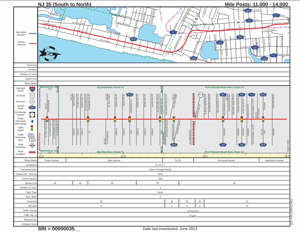
NJ 35 (South to North)
SRI = 00000035__
Mile Posts: 11.000 - 14.000
2519
Date last inventoried: June 2013
Page C
reate
d: J
une, 2
015
11.0 12.0 13.0 14.0
(11.2
1)
Mantoloking, Oce. Co.
(11.2
1)Mantoloking, Oce.
Co.
(11.2
1)
(12.4
8)
Bay Head Boro, Ocean Co
(11.2
1)
(12.4
8)Bay Head Boro, Ocean Co
(12.4
8)
Point Pleasant Beach Boro, Ocean Co
(12.4
8) Point Pleasant Beach Boro, Ocean Co
(12.8
6)
N.J
.T.
(11.0
4) W
ILLIA
MS
PL
BE
RG
EN
AV
E
(11.0
7)
(11.0
9) C
HA
FE
Y P
L
(11.1
4) C
AR
RIG
AN
PL
(11.1
8) M
AT
HIS
PL
ST
RIC
KLA
ND
(11.3
8)
ST
RE
ET
(11.4
3) G
OE
TZ
ES
TR
EE
T
(11.4
8) E
GB
ER
TS
TR
EE
T
(11.5
3) B
RIS
TO
L P
L
(11.5
7) J
OH
NS
ON
ST
CH
AD
WIC
K S
T
(11.7
9)
FO
RS
YT
RE
ST
(11.8
1)
(11.9
0) M
OU
NT
ST
RE
ET
(11.9
9) H
OW
ES
TR
EE
T
(12.0
8) B
RID
GE
AV
E
(12.1
6) H
AR
RIS
ST
RE
ET
(12.2
5) K
AR
GE
ST
RE
ET
(12.3
4) N
OR
TH
ST
RE
ET
(12.4
1) T
WIL
IGH
T R
D
(12.4
5) O
SB
OR
NE
AV
E
(12.5
1) D
ELA
WA
RE
AV
E
UN
NA
ME
D R
D
(12.5
2) O
CE
AN
AV
E
MA
RY
LA
ND
AV
E(1
2.5
7)
(12.6
2) O
CE
AN
AV
E
(12.6
8) S
EA
AV
E
(12.8
3) E
AS
T S
T
(12.8
8) S
EA
AV
E
(12.9
9) R
AM
P F
RO
M 3
5
(13.0
4) C
AR
TE
R A
VE
(13.1
4) N
EW
AR
K A
VE
(13.2
2) W
AS
HIN
GT
ON
AV
EN
UE
PH
ILA
DE
LP
HIA
AV
E
(13.2
8)
(13.3
3) N
EW
YO
RK
AV
E
(13.3
9) N
EW
JE
RS
EY
AV
EN
UE
(13.4
5) A
TLA
NT
ICA
VE
NU
E
(13.5
1) F
OR
MA
NA
VE
NU
E
(13.5
7) T
RE
NT
ON
AV
E(1
3.5
7) T
RE
NT
ON
AV
E
LA
UR
AL L
N
(13.6
4)
AR
NO
LD
AV
E
(13.7
1)
AV
EN
UE
(13.8
2) M
CLE
AN
632
635
35 S 10
10
69
69
71 633
633
Street Name Ocean Avenue Main Avenue NJ 35 Cincinnati Avenue Hawthorne Avenue
Jurisdiction N.J.D.O.T.
Functional Class Urban Principal Arterial
Federal Aid - NHS Sy NHS
Control Section 1506
Speed Limit 40 35 30 35 40
Number of Lanes 2
Med. Type None
Med. Width 0
Pavement 20 40 24 26 24
Shoulder 10 0 8 0 10
Traffic Volume 18,012 (2010)
Traffic Sta. ID 6-4-334
Structure No.
Enlarged Views
Pavement
Shoulder
Number of Lanes
Speed Limit
Street Name
NJ 35
Union Str eet
Atla
ntic
Ave
nue
Arn
old
Av
enu
e
Richm ond Av enue
Old
Brid
ge R
oa
d
Apache Road
Bay A venue Rive
rvie
w D
rive
St Louis Av enue
Ranken Road
Oak
Roa
d
Churc
h S
treetU
nion
Ave
nue
Higgin
s Av enue
Tre
nto
n A
ven
ue
Ma
rce
l lu
s A
ve
nue
Til t
ons
Co
rne
r R
oad
Gow
dy Avenue
Borrie A
venue
Ivanh
oe P
t
Borden A venue
Orchardcr es t B oulevard
Curtis Avenue
La
ke
wo
od R
oa
d
NJ 34
Park Avenue
Nnp
Gro
ve
Str
ee
t
Tec
um
se
m P
lac
e
Cr es tview Road
Wil lia
m D
rive
Apple Ridge B oulev ard
Stear ns Driv e
Yale Av enue
Is ham Cir
Wessie Street
Macintos h D
rive
Be
nne
t Lan
e
Jo
di C
ou
rt
NJ 35
NJ
35
35
71
524S
633
20
69
48
604 71
14
635
Prim
ary
Dire
ctio
nS
eco
nd
ary
Dire
ctio
n
22
33
689
2
Interstate
Route
US Route
NJ Route
County
Road
Interchange
Number
Grade
Separated
Interchange
Traffic
Signal
Traffic
Monitoring
Sites
Road
Underpass
Road
Overpass
WIM
AVC
VOL
Un
its in
mile
s
Primary
Direction
Secondary
Direction
287
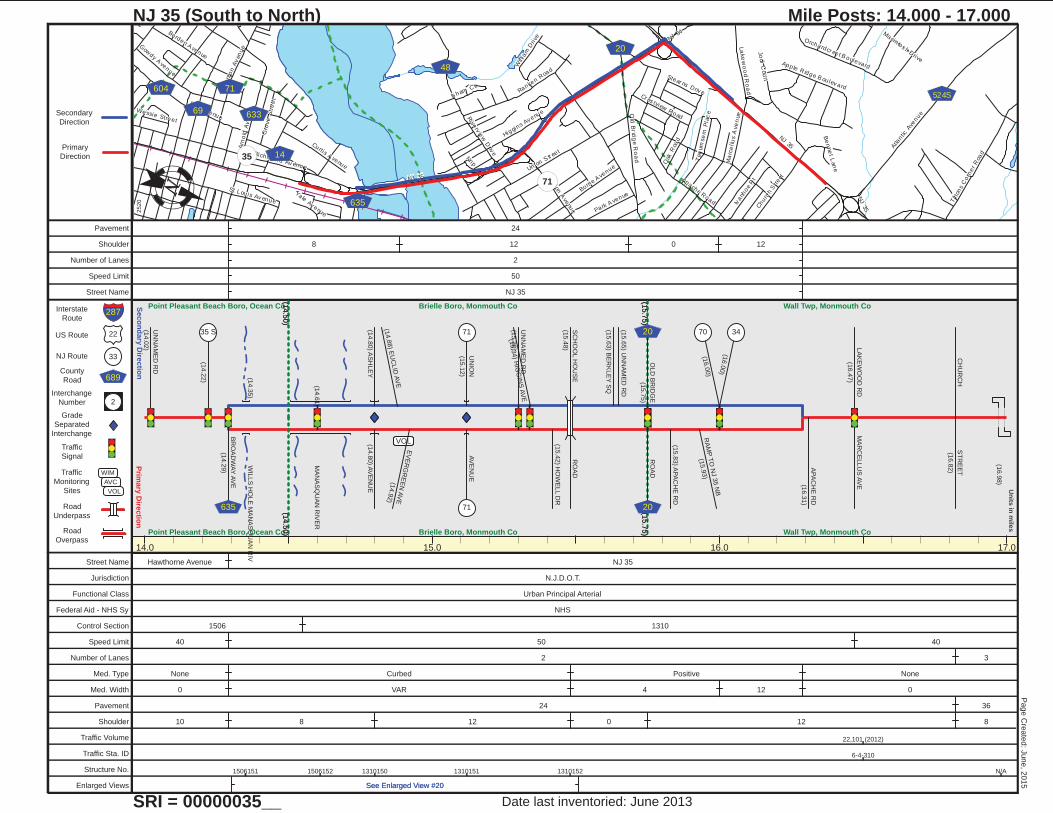
NJ 35 (South to North)
SRI = 00000035__
Mile Posts: 14.000 - 17.000
2520
Date last inventoried: June 2013
Page C
reate
d: J
une, 2
015
14.0 15.0 16.0 17.0
(14.5
0)
Point Pleasant Beach Boro, Ocean Co
(14.5
0)Point Pleasant Beach Boro, Ocean Co
(14.5
0)
(15.7
5)
Brielle Boro, Monmouth Co
(14.5
0)
(15.7
5)Brielle Boro, Monmouth Co
(15.7
5)
Wall Twp, Monmouth Co
(15.7
5) Wall Twp, Monmouth Co
(14.3
5)
WIL
LS
HO
LE
MA
NA
SQ
UA
N R
IV
(14.6
1)
MA
NA
SQ
UA
N R
IVE
R
(16.9
8)
VOLVOL
UN
NA
ME
D R
D
(14.0
2)
(14.2
2)
BR
OA
DW
AY
AV
E
(14.2
9)
35 S
635
(14.8
0) A
VE
NU
E(1
4.8
0) A
SH
LE
Y
(14.8
8) E
UC
LID
AV
E
EV
ER
GR
EE
N A
VE
(14.9
2)
UN
ION
(15.1
2)
AV
EN
UE
UN
NA
ME
D R
D
(15.3
0)
(15.3
4) H
IGG
INS
AV
E
(15.4
2) H
OW
ELL D
R
SC
HO
OL H
OU
SE
(15.4
8)
RO
AD
(15.6
3) B
ER
KLE
Y S
Q
(15.6
5) U
NN
AM
ED
RD
OLD
BR
IDG
E
(15.7
5)
RO
AD
(15.8
3) A
PA
CH
E R
D
RA
MP
TO
NJ 3
5 N
B
(15.9
3)
(16.0
0)
(16.0
0)
71
71
20
20
70 34
AP
AC
HE
RD
(16.3
1)
LA
KE
WO
OD
RD
(16.4
7)
MA
RC
ELLU
S A
VE
CH
UR
CH
ST
RE
ET
(16.8
2)
Street Name Hawthorne Avenue NJ 35
Jurisdiction N.J.D.O.T.
Functional Class Urban Principal Arterial
Federal Aid - NHS Sy NHS
Control Section 1506 1310
Speed Limit 40 50 40
Number of Lanes 2 3
Med. Type None Curbed Positive None
Med. Width 0 VAR 4 12 0
Pavement 24 36
Shoulder 10 8 12 0 12 8
Traffic Volume 22,101 (2012)
Traffic Sta. ID 6-4-310
Structure No. 1506151 1506152 1310150 1310151 1310152 N/A
Enlarged Views See Enlarged View #20See Enlarged View #20
Pavement 24
Shoulder 8 12 0 12
Number of Lanes 2
Speed Limit 50
Street Name NJ 35

NJ 35
Old M il l Road
Al la
ir e Road
Oce
an D
rive
New B
edford
Road
Wall R
oad
Mo
nm
ou
th Co
unty
30 II
Wa
rren
Ave
nu
e
Se
a G
irt Ave
nue
La
ure
l Ave
nue
Troy Drive
Kipl in
g Av en
ue
Wa
ll Ch
urc
h Ro
ad
Garre
tt Driv
eBa ileys Corner Road
Bradfor d RunSpruce Driv e
Ma
gno
lia
Av
en
ue
Ch
ica
go B
ou
lev
ard
Gar d
en P
lace
Meadow Road
Su
nse
t Ter r
South M Stre
etSouth North S tre
et
Tux
edo P
lace
Jane
t Pla
ce
Stonebrooke Driv e
Old Mil l R
oad
NJ 35
524
30
47
Prim
ary
Dire
ctio
nS
eco
nd
ary
Dire
ctio
n
22
33
689
2
Interstate
Route
US Route
NJ Route
County
Road
Interchange
Number
Grade
Separated
Interchange
Traffic
Signal
Traffic
Monitoring
Sites
Road
Underpass
Road
Overpass
WIM
AVC
VOL
Un
its in
mile
s
Primary
Direction
Secondary
Direction
287
NJ 35 (South to North)
SRI = 00000035__
Mile Posts: 17.000 - 20.000
2521
Date last inventoried: June 2013
Page C
reate
d: J
une, 2
015
17.0 18.0 19.0 20.0
Wall Twp, Monmouth Co
Wall Twp, Monmouth Co
(17.2
6)
ST
OC
KT
ON
BK
.(1
7.2
6)
ST
OC
KT
ON
BK
.
(17.7
8)
HA
NN
AB
RA
ND
BK
.
(18.2
0)
N B
R. W
RE
CK
PO
ND
AT
LA
NT
IC
(17.1
7)
AV
E
524S
524S
(17.3
2) M
EE
TIN
G H
OU
SE
RO
AD
(17.4
1) S
EA
GIR
TA
VE
(17.4
9) L
AU
RE
L A
VE
TA
RP
ON
DR
(17.6
8)
OC
EA
N
(18.1
4)
RD
NE
W B
ED
FO
RD
(18.4
9)
RO
AD
WA
RR
EN
(18.7
1)
AV
E
ALLA
IIRE
(18.7
8)
RO
AD
WA
LL C
HU
RC
H
(19.2
0)
RO
AD
(19.3
1) O
LD
MIL
L R
D
OLD
MIL
L R
D(1
9.3
5)
EIG
HT
EE
NT
H
(19.8
4)
AV
E
MA
RIE
TTA
AV
E
(20.0
0)
47
47
524
524
30
30
Street Name NJ 35
Jurisdiction N.J.D.O.T.
Functional Class Urban Principal Arterial
Federal Aid - NHS Sy NHS
Control Section 1310
Speed Limit 40
Number of Lanes 3 1 2 3
Med. Type None Curbed None
Med. Width 0 VAR 0
Pavement 36 18 36
Shoulder 8
Traffic Volume
Traffic Sta. ID
Structure No. N/A 1310154 1310155
Enlarged Views
Pavement 18
Shoulder 8
Number of Lanes 1
Speed Limit 40
Street Name NJ 35

NJ 35
Main S tr eetMemoria l Drive
Ridge A venue
17th
Ave
nu
e
M Str eet
Ste iner Av enue
16
th A
ve
nu
e
Fou
rth A
ve
nu
e
Six
th A
ve
nu
e
NJ
138
7th
Av
en
ue
9th
Av
en
ue
Thi rd
Av
en
ue
Mo
nm
ou
th Co
unty
30 II
Fifth
Aven
ue
I S treet
L S treet
K Str eet
We
st Cur tis A
ven
ue
Ham mond A venue
Eig
hth
Ave
nu
e
5th
Av
en
ue
Ten
th A
ven
ue
Seventh A venue
Eve
rgre
en
Ave
nu
e
13
th S
tree
t
Morris A venue
H S treet Nnp
Se
avie
w C
ir
Hi ll to
p Drive
Ri ley Road
West Rai lr oad Av enue
J Street
Laure l A venue
Grove Street
Fifth Avenue
Delaware Av enue
World S
tr eet
So
uth
Co
nc
ourse
Riv
erv
iew
Av
en
ue
2n
d A
ven
ue
Bra
dle
y S
treet
Windsor A venue
Gar fie ld A venue
For es t Avenue
5th Av enue
NJ 35
L Stre
et
NJ
35
Nn
p
NJ 35
NJ 138
71
71
40A
5
30
18 2
17
17
Prim
ary
Dire
ctio
nS
eco
nd
ary
Dire
ctio
n
22
33
689
2
Interstate
Route
US Route
NJ Route
County
Road
Interchange
Number
Grade
Separated
Interchange
Traffic
Signal
Traffic
Monitoring
Sites
Road
Underpass
Road
Overpass
WIM
AVC
VOL
Un
its in
mile
s
Primary
Direction
Secondary
Direction
287
NJ 35 (South to North)
SRI = 00000035__
Mile Posts: 20.000 - 23.000
2522
Date last inventoried: June 2013
Page C
reate
d: J
une, 2
015
20.0 21.0 22.0 23.0
MP
20.3
1 =
End N
J 1
38 M
P 3
.52
MP
21.0
6 =
Begin
Duplic
. With
NJ 7
1 M
P 5
.09
MP
21.4
1 =
End D
uplic
. With
NJ 7
1 M
P 5
.41
(20.4
4)
Wall Twp, Monmouth Co
(20.4
4)Wall Twp, Monmouth Co
(20.4
4)
(21.6
3)
Belmar Boro, Monmouth Co
(20.4
4)
(21.6
3)Belmar Boro, Monmouth Co
(21.6
3)
(22.0
5)
Neptune Twp, Monmouth Co
(21.6
3)
(22.0
5)Neptune Twp, Monmouth Co
(22.0
5)
Neptune City Boro, Monmouth Co
(22.0
5) Neptune City Boro, Monmouth Co
(21.6
0)
SH
AR
K R
IV.
(21.7
7)
N. C
HA
NN
EL S
HA
RK
RIV
.
(22.9
1)
ST
RE
AM
MA
RIE
TTA
AV
E
(20.0
0)
17T
H A
VE
(20.0
6)
CU
RT
IS A
VE
(20.1
3)
(20.2
4)
RA
MP
TO
RT
138
(20.3
1)
(20.4
8) B
ELM
AR
AV
E16T
H A
VE
138 18
18
OA
KW
OO
D R
D
(20.6
6)
(20.7
2) M
AP
LE
WO
OD
RD
(20.7
8) P
INE
TR
EE
WA
Y
(20.8
5) B
RIE
RW
OO
D R
D
(20.9
1) T
O P
IER
L S
T
(20.9
8) K
ST
(21.0
6) H
ST
(21.1
0) 1
2T
H A
VE
(21.1
8) 1
1T
H A
VE
EN
T T
O M
AR
INA
(21.2
5)
(21.2
5) 1
0T
H A
VE
TO
MA
RIN
A
(21.4
1)
8T
H A
VE
(21.4
7) 7
TH
AV
E
(21.6
8) G
RA
Y D
R
(21.7
3) S
EA
VIE
W C
R
(21.8
6) S
CO
NC
OU
RS
E
(21.8
9) S
EA
VIE
W C
IR
ME
MO
RIA
L D
R(2
1.9
6) N
EW
YO
RK
RD
(21.9
9) W
AS
HIN
GT
ON
RD
(22.0
5) U
NN
AM
ED
RD
(22.0
5) A
LB
AN
Y R
D
(22.0
9) B
OS
TO
N R
D
(22.2
1) R
AM
PS
(22.2
3) O
AK
TE
RR
AC
E
71 71 40 A
(22.3
0) S
TE
INE
RA
VE
(22.3
7) B
ELLE
PL
BR
AD
LE
Y S
T(2
2.4
2) G
RE
EN
AV
E
(22.4
6) S
WA
LL S
T
5
(22.4
8) M
YR
ON
AV
E
(22.5
3) M
ER
RIT
T A
VE
SY
LV
AN
IA A
VE
(22.5
8) R
IDG
E A
VE
17
(22.6
5) M
OR
RIS
AV
E
(22.6
7) W
OO
DLA
ND
AV
E
(22.7
3) S
UM
MIT
AV
E
(22.7
8) H
ILLS
IDE
AV
EN
UE
(22.8
3) E
VE
RG
RE
EN
AV
EN
UE
(22.8
8) 3
RD
AV
EN
UE
(22.9
5) 4
TH
AV
E
Street Name NJ 35 Morris Avenue
Jurisdiction N.J.D.O.T.
Functional Class Urban Principal Arterial
Federal Aid - NHS Sy NHS
Control Section 1310 1338 1311
Speed Limit 40 35
Number of Lanes 3 2 4 3 2 4 1 2
Med. Type None Unprotected None Curbed Positive Curbed None Curbed None
Med. Width 0 VAR 0 VAR 8 VAR 0 VAR 0
Pavement 36 24 54 36 24 30 50 20 30
Shoulder 8 10 0 10 0 6
Traffic Volume 26,228 (2014) 36,086 (2012)
Traffic Sta. ID 6-5-302 091302
Structure No. 13171581317159
1311150 1311151 1311158 1311159
Enlarged Views
Pavement 24 24 30 20
Shoulder 10 8 0 0
Number of Lanes 2 2 1
Speed Limit 35 35 35
Street Name NJ 35 NJ 35 NJ 35
Stokes A venue
NJ 35
Logan Road
Tay lor A venue
Six
th A
ven
ue
Su
nse
t Ave
nu
e
He
ck
Av
en
ue
Fis her A venue
7th
Av
enu
e
Co
rlie
s A
ve
nu
e
Myr tle Av enue
Neptune Boulev ar d
Fift
h Av
enu
e
Mu
nro
e S
tre
et
Un ion A venueEig
hth
Ave
nu
e
Ba
ngs
Ave
nu
e
Sta
rtfo
rd A
ve
nue
Dr um m ond Av enue
Asb
ury
Ave
nu
e
Ro
se
Ave
nue
Pa
rkv
iew
Av
enu
e
Lin
co
ln A
ven
ue
Hawthor ne A venue
Ten
th A
ven
ue Li
nco
ln D
rive
Ring Road
Ed
gew
oo
d A
ven
ue
NJ
66
Bra
dfo
rd A
ve
nue
Bi rch Av enue
Al la
ire
Ave
nue
Wa
sh
ing
ton
Ave
nu
e
Nnp
En
glis
h L
an
e
Sa
yre
Str
ee
t
Pa
rk B
vld
Oxonia Av enue
Al lan S treet
Kn
eely R
oad
Tur ner A venue
Old
en
Ave
nu
e
He
rbe
rt A
ve
nue
Brad ley A venue
Ma
rion
Ave
nue
Tho
mas
Av
enu
e
Lafayette Drive Oak Street
Ha
rdin
g A
ve
nu
e
Stokes A venue
NJ 35
33
2 17
4016
17
Prim
ary
Dire
ctio
nS
eco
nd
ary
Dire
ctio
n
22
33
689
2
Interstate
Route
US Route
NJ Route
County
Road
Interchange
Number
Grade
Separated
Interchange
Traffic
Signal
Traffic
Monitoring
Sites
Road
Underpass
Road
Overpass
WIM
AVC
VOL
Un
its in
mile
s
Primary
Direction
Secondary
Direction
287
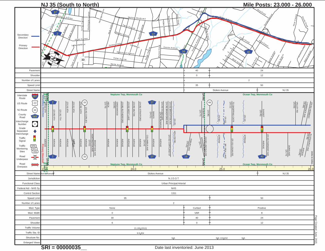
NJ 35 (South to North)
SRI = 00000035__
Mile Posts: 23.000 - 26.000
2523
Date last inventoried: June 2013
Page C
reate
d: J
une, 2
015
23.0 24.0 25.0 26.0
(23.0
4)
Nept une City , Mo n. C
o.
(23.0
4)Nept
une City , Mo n. C
o.
(23.0
4)
(24.8
0)
Neptune Twp, Monmouth Co
(23.0
4)
(24.8
0)Neptune Twp, Monmouth Co
(24.8
0)
Ocean Twp, Monmouth Co
(24.8
0) Ocean Twp, Monmouth Co
(24.4
5)
HO
LLO
W B
K.
(24.9
5)
ST
RE
AM
(25.0
2)
BR
. DE
AL L
AK
E
(25.2
4)
ST
RE
AM
(23.0
2) 5
TH
AV
EN
UE
(23.0
9) 6
TH
AV
EN
UE
(23.1
6) 7
TH
AV
EN
UE
(23.2
4) 8
TH
AV
EN
UE
NN
PA
VE
NU
E(2
3.3
1) 9
TH
(23.3
9) 1
0T
HA
VE
NU
E
(23.4
5) C
OR
LIE
SA
VE
NU
E
HU
NT
ING
TO
N A
VE
(23.5
2)
BR
AD
FIS
KE
AV
E
HE
CK
(23.7
0)
AV
EN
UE
GR
EE
NW
OO
D
(23.8
0)
AV
EN
UE
(23.8
6) R
UT
HE
RF
OR
DA
VE
NU
E
(23.9
3) W
ES
T L
AK
EA
VE
NU
E
(23.9
9) M
ILT
ON
AV
EN
UE
(24.0
6) S
TR
AT
FO
RD
AV
EN
UE
CO
LU
MB
US
AV
E
(24.1
4)
BA
NG
S
(24.2
1)
AV
EN
UE
(24.2
9) M
ON
RO
EA
VE
NU
E(2
4.3
4) O
LD
EN
AV
E
(24.3
9) B
RA
DF
OR
D A
VE
(24.4
2) C
OR
TLA
ND
ST
(24.4
3) B
RO
CK
TO
N A
VE
2
2
33
33
17
17
AS
BU
RY
AV
E(2
4.6
5)
BIN
GH
AM
AV
E
(24.7
4)
RO
BIN
RD
(24.7
7)
(24.8
0) L
INC
OLN
DR
(24.8
6)
(25.1
0) L
OG
AN
RD
TO
SH
OP
PIN
G C
NT
R
(25.1
1)
SU
NS
ET
(25.4
5)
AV
EN
UE
(25.5
0) F
AIR
MO
NT
AV
E
DO
RIS
AV
E
(25.7
4)
VA
LLE
Y R
D
(25.8
3)
LA
WR
EN
CE
AV
E(2
5.8
9)
(25.9
4) H
ER
BE
RT
AV
EN
UE
(25.9
4)
ALLE
NH
UR
ST
AV
E(2
5.9
9)
16
66
40
Street NameMorris Avenue Stokes Avenue NJ 35
Jurisdiction N.J.D.O.T.
Functional Class Urban Principal Arterial
Federal Aid - NHS Sy NHS
Control Section 1311
Speed Limit 35 50
Number of Lanes 2
Med. Type None Curbed Positive
Med. Width 0 VAR 8
Pavement 30 40 24
Shoulder 6 0 12
Traffic Volume 21,193 (2012)
Traffic Sta. ID 6-5-304
Structure No. N/A N/A 1311152 N/A
Enlarged Views
Pavement 40 24
Shoulder 0 12
Number of Lanes 2
Speed Limit 35 50
Street Name Stokes Avenue NJ 35
NJ 35
Neptune Boulev ar d
De
al R
oa
d
Logan Road
Rustic A venue
Westfie ld S treet
We
st P
ark
Ave
nu
e
Me lv il le Str eet
Holbr ook S treet
Westin
g P
lace
Cin
dy
La
ne
Kings Hy w
Ind
ustr
ial
Wa
y W
es
t
Apo llo S treet
Meridian Road
Co
rbe
tt Wa
y
Wall
Street
Gar den Road
Ja
me
s W
ay
Marisa Court
Arm
str
on
g B
vld
Finder ne S tr eet
Ald
rin
Av
en
ue
Dwight A venue
Burns P lace
Ke
nne
th D
r ive
Be llmore S tr eet
Mi lv il le Street
Prim
ary
Dire
ctio
nS
eco
nd
ary
Dire
ctio
n
22
33
689
2
Interstate
Route
US Route
NJ Route
County
Road
Interchange
Number
Grade
Separated
Interchange
Traffic
Signal
Traffic
Monitoring
Sites
Road
Underpass
Road
Overpass
WIM
AVC
VOL
Un
its in
mile
s
Primary
Direction
Secondary
Direction
287
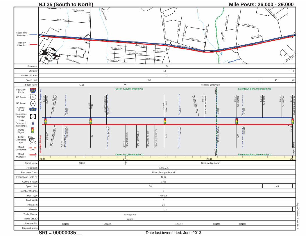
NJ 35 (South to North)
SRI = 00000035__
Mile Posts: 26.000 - 29.000
2524
Date last inventoried: June 2013
Page C
reate
d: J
une, 2
015
26.0 27.0 28.0 29.0
(28.0
9)
Ocean Twp, Monmouth Co(2
8.0
9)Ocean Twp, Monmouth Co
(28.0
9)
Eatontown Boro, Monmouth Co(2
8.0
9) Eatontown Boro, Monmouth Co
(26.2
8)
HA
RV
EY
BK
.
(26.7
8)
PO
PLA
R B
K.
(27.6
4)
ST
RE
AM
(28.0
9)
WH
ALE
PO
ND
BK
.
(28.4
0)
ST
RE
AM
ALLA
IRE
(26.0
4)
AV
EN
UE
BLO
OM
FIE
LD
AV
E(2
6.1
0)
(26.1
5) F
RA
NK
LIN
AV
E
UN
NA
ME
D R
D
(26.2
5)
DE
AL
(26.5
8)
RD
(26.7
7) W
ILLO
W D
R
TA
LM
AD
GE
AV
E
(27.0
0)
(27.1
3) A
UT
H A
VE
(27.2
5) D
OW
AV
E
(27.3
5) C
AR
OL A
VE
WE
ST
PA
RK
(27.4
7)
AV
E
(27.8
8) K
ING
S H
WY
AR
MS
TR
ON
G B
LV
D
(27.9
4)
IND
US
TR
IAL
(28.3
3)
WA
Y
BU
RN
S P
L
(28.6
4)
WE
ST
ON
PL
(28.8
7)
TO
SH
OP
PIN
G C
TR
R
(29.0
0)
(29.0
0)
Street Name NJ 35 Neptune Boulevard
Jurisdiction N.J.D.O.T.
Functional Class Urban Principal Arterial
Federal Aid - NHS Sy NHS
Control Section 1311
Speed Limit 50 45
Number of Lanes 2
Med. Type Positive
Med. Width 8
Pavement 24
Shoulder 12
Traffic Volume 35,884 (2012)
Traffic Sta. ID 091303
Structure No. 1311153 1311154 1311156 1311155 1311160
Enlarged Views
Pavement 24
Shoulder 12 0
Number of Lanes 2
Speed Limit 50 45 40
Street Name NJ 35 Neptune Boulevard
Broad S treet
NJ
36
South S
tr eet
Wyc
koff R
oad
Cl into
n Ave
nueWhite Street
Syc
am
ore
Av
en
ue
Ke
llys L
an
e
Si lverbrook Road
Marc CourtByr nes Lane
Pearce A
v enue
Win
din
gb
rook
Wa
y
Marin W
ay
Hig
h S
tre
et
Rose Court
Blades Run D
rive
Ma
libu D
rive
Co lon ial Driv e
Ave At The C
omm
ons
We
st S
tree
t
Buttonwood Drive
Churc h Street
Rodman C
ourt
Willo
w S
tree
t
NJ
36
Wyc
koff R
oad
Bro
ad
Stre
et
36
71
547
13A
Prim
ary
Dire
ctio
nS
eco
nd
ary
Dire
ctio
n
22
33
689
2
Interstate
Route
US Route
NJ Route
County
Road
Interchange
Number
Grade
Separated
Interchange
Traffic
Signal
Traffic
Monitoring
Sites
Road
Underpass
Road
Overpass
WIM
AVC
VOL
Un
its in
mile
s
Primary
Direction
Secondary
Direction
287
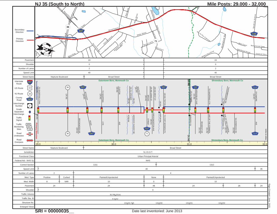
NJ 35 (South to North)
SRI = 00000035__
Mile Posts: 29.000 - 32.000
2525
Date last inventoried: June 2013
Page C
reate
d: J
une, 2
015
29.0 30.0 31.0 32.0
(31.0
0)
Eatontown Boro, Monmouth Co
(31.0
0)Eatontown Boro, Monmouth Co
(31.0
0)
(31.0
1)
T i n t o n F a l l s , M o n . C o .
(31.0
0) Shrewsbury Boro, Monmouth Co
(31.0
1)
Shrewsbury Boro, Monmouth Co
(30.1
8)
ST
RE
AM
(30.2
5)
HA
SS
OC
K H
UG
KE
Y B
K.
(30.6
0)
WA
MP
UM
BK
.
(31.0
0)
PA
RK
ER
S C
K.
(31.4
3)
BR
. PA
RK
ER
S C
K.
TO
SH
OP
PIN
G C
TR
R
(29.0
0)
(29.0
0)
(29.3
9)
36
36
BR
OO
KW
OO
D D
R
(29.5
3)
WY
CK
OF
F
(29.6
5)
RO
AD
TO
SH
OP
PIN
G
(29.8
4)
CT
R
CLIN
TO
N
(30.0
6)
AV
E
(30.2
1) K
RE
ME
R
SO
UT
H S
T
(30.3
6)
547
547
BR
OA
D
(30.4
4)
ST
RE
ET
(30.4
8) L
EW
IS S
T
TH
RO
CK
MO
RT
ON
AV
E
(30.5
1)
(30.5
3) W
ES
T S
T
TO
FO
RT
MO
NM
OU
TH
(30.6
6) T
INT
ON
AV
E
71
537
537(3
1.0
1) R
AM
P
SH
RE
WS
BU
RY
AV
E
(31.0
8)
RE
VM
ON
T D
R
(31.1
5)
TO
SH
OP
PIN
G C
TR
AV
E O
F T
HE
CO
MM
ON
(31.2
5)
TH
OR
NB
RO
OK
E D
RA
VE
OF
TH
E C
OM
MO
N
(31.4
5)
SIL
VE
RB
RO
OK
RD
(31.6
0)
SY
CA
MO
RE
(31.8
7)
AV
E
13 13 A
13 A
Street Name Neptune Boulevard Broad Street
Jurisdiction N.J.D.O.T.
Functional Class Urban Principal Arterial
Federal Aid - NHS Sy NHS
Control Section 1311 1312
Speed Limit 40 35
Number of Lanes 2 4
Med. Type Positive Curbed Painted/Unprotected None Painted/Unprotected
Med. Width 8 VAR 10 0 10
Pavement 24 24 48 24 26 24
Shoulder 0
Traffic Volume 30,799 (2014)
Traffic Sta. ID 6-4-312
Structure No. 1311161 N/A 1312150 1312151 1312152
Enlarged Views
Pavement 24 24
Shoulder 0 0
Number of Lanes 2 2
Speed Limit 40 40
Street Name Neptune Boulevard Broad Street Broad Street
NJ 35
Broad S treet
West Street
Maple Av enue
Shrewsbury A venue
Obre
Str
ee
t
We
st F
ron
t Str
ee
t
Obre
Pla
ce
Wall Street
Na
ve
sin
k R
ive
r Roa
d
Pa
tterso
n A
ve
nue
Mo
nm
ou
th S
tre
et
Spruce Driv e
Ch
estn
ut S
tre
et
Ne
wm
an
Sp
rin
gs R
oa
d
Samara Drive
Fie
ld A
ve
nu
e
Victoria Place
Drs J
am
es
Pa
rker B
oule
va
rd
He
rbe
rt S
tree
t
Co
no
ve
r L
an
e
Mohawk Lane
Conover Place
Wil low Str eet
Louis Ci r
Recto
r Pla
ce
East Roos ev elt C ir
Irvin
g P
lace
Fra
nc
es S
tre
et
East Wi ls on CirLake
s hore
Driv
e
Wh
ite R
oad
Co lem ane A venue
Tul ip Lane
Le
roy P
lace
Ha
dd
on
Ave
nu
e
Lo
cu
st A
ve
nue
Al len S treet
Ce
da
r S
tre
et
Maple Road
Dr um m ond Street
Ce
ntr
al S
tre
et
NJ 35
NJ 35
Broad S treet
13 10
12A520
11
Prim
ary
Dire
ctio
nS
eco
nd
ary
Dire
ctio
n
22
33
689
2
Interstate
Route
US Route
NJ Route
County
Road
Interchange
Number
Grade
Separated
Interchange
Traffic
Signal
Traffic
Monitoring
Sites
Road
Underpass
Road
Overpass
WIM
AVC
VOL
Un
its in
mile
s
Primary
Direction
Secondary
Direction
287
NJ 35 (South to North)
SRI = 00000035__
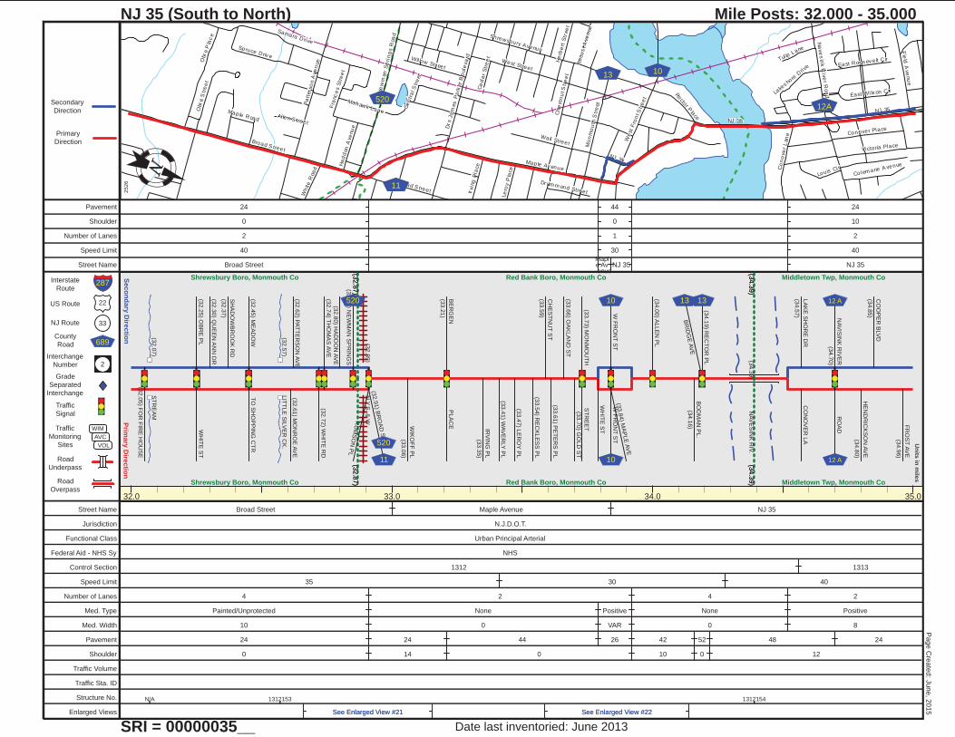
Mile Posts: 32.000 - 35.000
2526
Date last inventoried: June 2013
Page C
reate
d: J
une, 2
015
32.0 33.0 34.0 35.0
(32.8
7)Shrewsbury Boro, Monmouth Co
(32.8
7)
Shrewsbury Boro, Monmouth Co
(32.8
7)
(34.3
9)
Red Bank Boro, Monmouth Co
(32.8
7)
(34.3
9)Red Bank Boro, Monmouth Co
(34.3
9)
Middletown Twp, Monmouth Co
(34.3
9) Middletown Twp, Monmouth Co
(32.0
7)
ST
RE
AM
(32.5
7)
LIT
TLE
SIL
VE
R C
K.
(32.8
9)
N.Y
.S. &
W
(34.3
9)
NA
VE
SIN
K R
IV.
(32.0
5) F
OR
FIR
E H
OU
SE
(32.2
5) O
BR
E P
LW
HIT
E S
T
(32.3
0) Q
UE
EN
AN
N D
R
SH
AD
OW
BR
OO
K R
D
(32.3
7)
(32.4
5) M
EA
DO
WT
O S
HO
PP
ING
CT
R
(32.6
1) M
ON
RO
E A
VE
(32.6
2) P
AT
TE
RS
ON
AV
E
(32.7
2) W
HIT
E R
D(3
2.7
4) T
HO
MA
S A
VE
(32.8
0) H
AD
DO
N A
VE
(32.8
5) N
EW
MA
N S
PR
ING
S
(32.9
1) B
RO
AD
ST
RU
MS
ON
PL
520
11
520
WIK
OF
F P
L
(33.0
6)
BE
RG
EN
(33.2
1)
PLA
CE
IRV
ING
PL
(33.3
5)
(33.4
1) W
AV
ER
LY
PL
(33.4
7) L
ER
OY
PL
(33.5
4) R
EC
KLE
SS
PL
CH
ES
TN
UT
ST
(33.5
9)
(33.6
1) P
ET
ER
S P
L
(33.6
6) O
AK
LA
ND
ST
(33.7
0) G
OLD
ST
(33.7
3) M
ON
MO
UT
HS
TR
EE
T
WH
ITE
ST
W F
RO
NT
ST
(33.8
4) M
AP
LE
AV
E
W F
RO
NT
ST
10
10
(34.0
0) A
LLE
N P
L
BO
DM
AN
PL.
(34.1
6)
BR
IDG
E A
VE
(34.1
9) R
EC
TO
R P
L
13 13
LA
KE
SH
OR
E D
R
(34.5
7)
CO
NO
VE
R L
A
NA
VIS
INK
RIV
ER
(34.7
0)
RO
AD
HE
ND
RIC
KS
ON
AV
E
(34.8
0)
CO
OP
ER
BLV
D
(34.8
5)
FR
OS
T A
VE
(34.9
6)
12 A
12 A
Street Name Broad Street Maple Avenue NJ 35
Jurisdiction N.J.D.O.T.
Functional Class Urban Principal Arterial
Federal Aid - NHS Sy NHS
Control Section 1312 1313
Speed Limit 35 30 40
Number of Lanes 4 2 4 2
Med. Type Painted/Unprotected None Positive None Positive
Med. Width 10 0 VAR 0 8
Pavement 24 24 44 26 42 52 48 24
Shoulder 0 14 0 10 0 12
Traffic Volume
Traffic Sta. ID
Structure No. N/A 1312153 1312154
Enlarged Views See Enlarged View #21See Enlarged View #21 See Enlarged View #22See Enlarged View #22
Pavement 24 44 24
Shoulder 0 0 10
Number of Lanes 2 1 2
Speed Limit 40 30 40
Street Name Broad StreetMapl e Av enue
NJ 35 NJ 35
NJ 35
Oak
Hill R
oad
Ma ida Terr
Victoria Place
Oak StreetSpruce D
riv e
Kin
gs
Hig
hw
ay
Co
op
er R
oa
d
Ru
tled
ge
Dr i
ve
Tindal l Road
Ka
nes
La
ne
Richard Terr
Cr e
stv
iew
Dri
ve
Tw
in B
roo
ks
Ave
nu
e
Wood
land D
rive
Mcg
ui r
es D
riv
e
Brighton Avenue
Danemar Drive
Ap
ple
Fa
rm R
oa
d
Park Drive
Devon Road
Rosewood Terr
For es t Dr iv e
Danie l Dr iv e
Melr os e P
lac e
Longwood A
venue
Bra
nd
ywin
e W
ay
Vo lt P lace
Martin P lace
Uni ty C
ourt
Lawre
nce Cir
Linden Av enue
Cr es ce
nt Pky
Kin
gs
Court
Atta B
oy
Cour
t
Walnut A venue
Kin
gs
Hig
hw
ay
50
Prim
ary
Dire
ctio
nS
eco
nd
ary
Dire
ctio
n
22
33
689
2
Interstate
Route
US Route
NJ Route
County
Road
Interchange
Number
Grade
Separated
Interchange
Traffic
Signal
Traffic
Monitoring
Sites
Road
Underpass
Road
Overpass
WIM
AVC
VOL
Un
its in
mile
s
Primary
Direction
Secondary
Direction
287
NJ 35 (South to North)
SRI = 00000035__
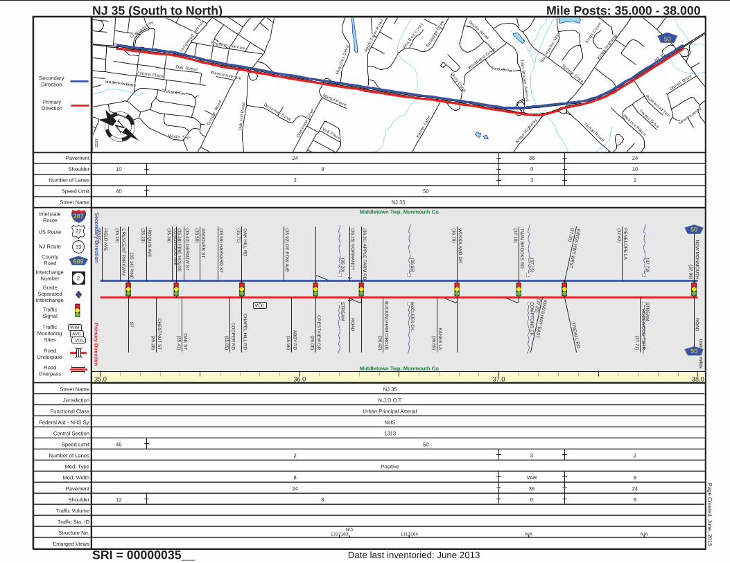
Mile Posts: 35.000 - 38.000
2527
Date last inventoried: June 2013
Page C
reate
d: J
une, 2
015
35.0 36.0 37.0 38.0
Middletown Twp, Monmouth Co
Middletown Twp, Monmouth Co
(36.2
0)
ST
RE
AM
(36.5
5)
McC
LE
ES
CK
.
(37.1
5)
CO
MP
TO
NS
CK
.
(37.7
3)
ST
RE
AM
VOL
FIE
LD
AV
E
(35.0
1)
CR
ES
CE
NT
PA
RK
WA
Y
(35.1
0)
ST
(35.1
4) P
INE
IRO
QU
IS A
VE
(35.2
3)
CH
ES
TN
UT
ST
(35.2
8)
LO
NG
WO
OD
AV
E
(35.3
6)
(35.3
8) F
IRE
HO
US
E
OA
K S
T
(35.4
1)
(35.4
2) D
EP
AU
W S
T
AN
DO
VE
R S
T
(35.5
0)
(35.5
9) H
AR
VA
RD
ST
CO
OP
ER
RD
(35.6
5)
OA
K H
ILL R
D
(35.7
1)
CH
AP
EL H
ILL R
D
(35.9
2) D
E P
OW
AV
E
AB
BY
RD
(35.9
6)
CR
ES
TV
IEW
DR
(36.0
8)
(36.2
5) N
OR
MA
ND
YR
OA
D
(36.3
1) A
PP
LE
FA
RM
RD
BU
CK
ING
HA
M C
IRC
LE
(36.4
2)
KA
NE
S L
A
(36.6
9)
WO
OD
LA
ND
DR
(36.7
9)
TW
IN B
RO
OK
S R
D
(37.1
0)
KIN
GS
HW
Y E
AS
T(3
7.2
2)
KIN
GS
HW
Y W
ES
T(3
7.3
3)
TIN
DA
LL R
D
PE
NE
LO
PE
LA
(37.6
2)
RO
SE
WO
OD
TE
RR
(37.7
1)
NE
W M
ON
MO
UT
H
(37.9
8)
RO
AD
50
50
Street Name NJ 35
Jurisdiction N.J.D.O.T.
Functional Class Urban Principal Arterial
Federal Aid - NHS Sy NHS
Control Section 1313
Speed Limit 40 50
Number of Lanes 2 3 2
Med. Type Positive
Med. Width 8 VAR 8
Pavement 24 36 24
Shoulder 12 8 0 8
Traffic Volume
Traffic Sta. ID
Structure No. 1313163N/A
1313164 N/A N/A
Enlarged Views
Pavement 24 36 24
Shoulder 10 8 0 10
Number of Lanes 2 3 2
Speed Limit 40 50
Street Name NJ 35
NJ 35
Tay
lor L
ane
Ne
w M
on
mou
th R
oa
d
Ha
rmo
ny
Roa
d
Un
ion A
venu
e
Ch
erry
Tre
e L
an
e
Tak
olusa
Driv
eBayberry Dr ive
So
uth
La
urel A
ven
ue
King
s High
wa
y
Old Country
Road
La
ure
l Ave
nue
Ma
gno
l ia L
ane
Downing Court
Bi rtha Road
The
VIs
ta
Pa
lme
r Av
en
ue
Burdge Driv
e
Winsto
n Driv
e
Mcbride P lac e
Oak dale Dr iv e
Lone Oak R
oad
Nass au PlaceL
aw
ren
ce
Cir
Sta
nle
y L
ane
5052
5167
Prim
ary
Dire
ctio
nS
eco
nd
ary
Dire
ctio
n
22
33
689
2
Interstate
Route
US Route
NJ Route
County
Road
Interchange
Number
Grade
Separated
Interchange
Traffic
Signal
Traffic
Monitoring
Sites
Road
Underpass
Road
Overpass
WIM
AVC
VOL
Un
its in
mile
s
Primary
Direction
Secondary
Direction
287
NJ 35 (South to North)
SRI = 00000035__
Mile Posts: 38.000 - 41.000
2528
Date last inventoried: June 2013
Page C
reate
d: J
une, 2
015
38.0 39.0 40.0 41.0
(39.5
8)
Middletown Twp, Monmouth Co
(39.5
8)Middletown Twp, Monmouth Co
(39.5
8)
Holmdel Twp, Monmouth Co
(39.5
8) Holmdel Twp, Monmouth Co
(38.1
4)
ST
RE
AM
(39.0
4)
ST
RE
AM
(39.0
6)
ST
RE
AM
(39.7
0)
MA
HO
RA
S B
K.
(40.3
3)
WA
CK
AA
CK
CK
.
(40.9
2)
ST
RE
AM
(38.1
6) T
HE
TR
AIL
GR
EE
N O
AK
BLV
D
(38.2
4)
FIR
E H
OU
SE
(38.4
9)
KIN
GS
HW
Y
(38.6
9)
HA
RM
ON
Y R
D
MA
GN
OLIA
LA
(38.9
3)
CH
ER
RY
TR
EE
LA
(39.1
6)
OLD
CO
UN
TR
Y R
D
CH
RY
TR
EE
FR
M R
D
PA
LM
ER
AV
E
(39.5
8)
S L
AU
RE
L
(39.8
4)
AV
EN
UE
GA
RD
EN
IA D
R
(40.5
0)
CE
NT
ER
VIL
LE
RO
AD
(40.6
8)
(40.7
5) T
AK
OLU
SA
DR
UN
ION
AV
E
516 7
52
516
Street Name NJ 35
Jurisdiction N.J.D.O.T.
Functional Class Urban Principal Arterial
Federal Aid - NHS Sy NHS
Control Section 1313
Speed Limit 50
Number of Lanes 2 3 2
Med. Type Positive
Med. Width 8
Pavement 24 36 24
Shoulder 8 0 10
Traffic Volume 34,795 (2012)
Traffic Sta. ID 6-8-933
Structure No. N/A N/A1313166
1313151 1313152 N/A
Enlarged Views
Pavement 24 36 24
Shoulder 10
Number of Lanes 2 3 2
Speed Limit 50
Street Name NJ 35
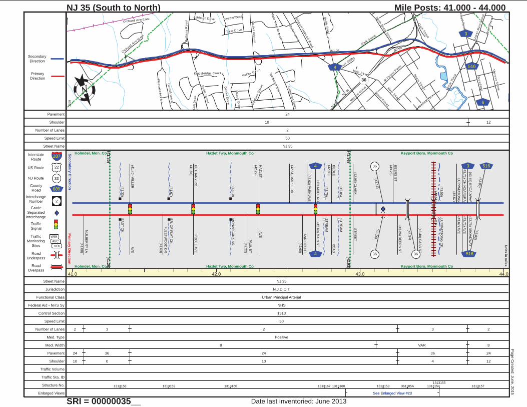
NJ 35
NJ 36
Be
ers S
tr eet
Clark S
treet
Bro
ad
wa
y
Po
ole
Stre
et
Ha
zle
t Ave
nu
e
Main
Str ee
t
Ma
ple
Pla
ce
Ke
ypo
rt-Ho
lmd
el Roa
d
Pa
rk Ave
nue L
ow
er
Ma
in S
tre
et
Co
rne
ll Driv
e Monro
e S
treet
Bro
ad S
treet
Da
nie
l Driv
e
Gale
woo
d D
rive
Tal ln Drive
Fle
etw
oo
d D
riv
e
Wall in
g Ter
r
Be
tha
ny R
oa
d
The
res
e S
treet
Orc
hard A
v e W
est
Syc
amo
re D
rive
Be
dle
Roa
d
Ma
so
n D
riv
e
No
rth B
ee
rs S
tree
t
St Pete
rs P
lace
Ca
lt D
riv
e
Ash leigh Drive
Ste
phe
n S
tre
et
Llo
yd
Ro
ad
Ne
w Y
ork
Av
en
ue
Orchard Av e E ast Copper Lane
Ry
an
Str
eet
Kingsbridge Cour t
Center S
treet
Kail ley Court
NJ 35
Main S tr eet
NJ 36
Cla
rk Stre
et
36
4 516
6
3
Prim
ary
Dire
ctio
nS
eco
nd
ary
Dire
ctio
n
22
33
689
2
Interstate
Route
US Route
NJ Route
County
Road
Interchange
Number
Grade
Separated
Interchange
Traffic
Signal
Traffic
Monitoring
Sites
Road
Underpass
Road
Overpass
WIM
AVC
VOL
Un
its in
mile
s
Primary
Direction
Secondary
Direction
287
NJ 35 (South to North)
SRI = 00000035__
Mile Posts: 41.000 - 44.000
2529
Date last inventoried: June 2013
Page C
reate
d: J
une, 2
015
41.0 42.0 43.0 44.0
(41.2
6)
Holmdel, Mon. Co.
(41.2
6)Holmdel, Mon. Co.
(41.2
6)
(42.9
3)
Hazlet Twp, Monmouth Co
(41.2
6)
(42.9
3)Hazlet Twp, Monmouth Co
(42.9
3)
Keyport Boro, Monmouth Co
(42.9
3) Keyport Boro, Monmouth Co
(41.3
3)
EA
ST
CK
.
(41.6
7)
BR
. OF
FLA
T C
K.
(42.1
0)
MO
NA
SC
UN
K B
K.
(42.7
5)
ST
RE
AM
(42.8
5)
ST
RE
AM
(43.5
5)
LU
PP
ATA
TO
NG
CK
.
(43.5
1)
C.R
.
MU
LB
ER
RY
LA
(41.0
8)
AV
E(4
1.4
0) M
ILLE
R
FLE
ET
WO
OD
DR
(41.6
3)
PO
OLE
AV
EB
ET
HA
NY
RD
(41.8
4)
PA
UL S
T
(42.2
2)
HA
ZLE
T
(42.2
9)
AV
E
(42.5
1) M
AP
LE
DR
AN
N C
OU
RT
(42.6
0)
(42.6
3) P
AR
K A
VE
HO
LM
DE
L R
D(4
2.6
9) M
AIN
ST
BE
DLE
(42.8
0)
RO
AD
(42.9
5) C
LA
RK
ST
RE
ET
(43.1
6)
(43.1
6)
BE
ER
S S
T
(43.2
3)
(43.2
6) B
EE
RS
ST
(43.3
3)
(43.4
0) C
AS
S S
T
LU
PP
ATA
TO
NG
(43.6
7)
(43.6
7) A
VE
(43.7
1) C
HIN
GA
RU
RA
(43.7
1) A
VE
(43.7
5) B
RO
AD
WA
Y(4
3.7
5) B
RO
AD
WA
Y
(43.8
2)
(43.8
2)
4
4 36
36
36
3
3
516
516
Street Name NJ 35
Jurisdiction N.J.D.O.T.
Functional Class Urban Principal Arterial
Federal Aid - NHS Sy NHS
Control Section 1313
Speed Limit 50
Number of Lanes 2 3 2 3 2
Med. Type Positive
Med. Width 8 VAR 8
Pavement 24 36 24 36 24
Shoulder 10 0 10 4 12
Traffic Volume
Traffic Sta. ID
Structure No. 1313158 1313159 1313160 1313167 1313168 1313153 361185A 13131541313155
1313157
Enlarged Views See Enlarged View #23See Enlarged View #23
Pavement 24
Shoulder 10 12
Number of Lanes 2
Speed Limit 50
Street Name NJ 35
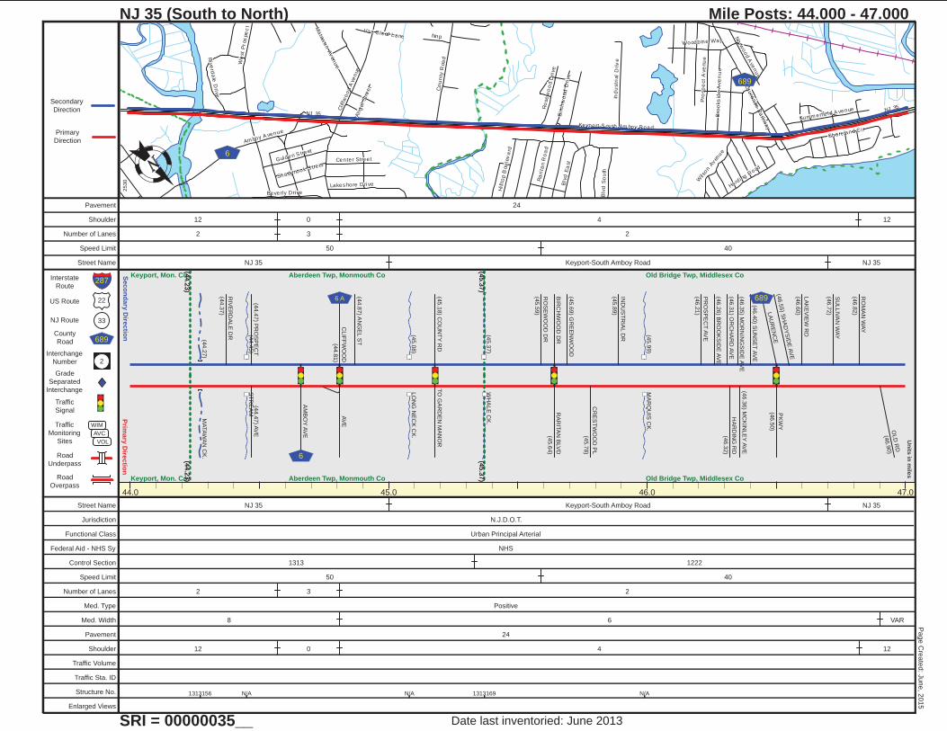
NJ 35
Keyport-S outh Am boy Road
Am boy A venue
Clif
fwo
od
Ave
nue
Co
un
ty R
oa
d
Blv
d E
ast
Shore land Ci r
Pro
sp
ect
Ave
nu
e
We
st
Pros
pe
ct
Nnp
Ind
ustr
ial
Driv
e
Woodbine Way
Ra
rita
n R
oa
d
Beverly Drive
Gulden S treet
Harding R
oad
Lakes hore Drive
Blv
d S
ou
th
Bro
oks
ide
Ave
nu
e
Ma
tawa
n A
ven
ue
Wils
on A
ven
ue
Summ erfie ld A venue
Center Street
Ro
se
wo
od D
rive
Riv
erd
ale
Driv
e
No
rwo
od A
ven
ue
Bir
ch
wo
od
Dri
ve
Hi ll t
op B
ou
lev
ard
Lau
ren
ce P
arkw
ay
An
gel
Str
ee
t
Shady nook S treet
Van Cleaf Lane
NJ 35
6
689
Prim
ary
Dire
ctio
nS
eco
nd
ary
Dire
ctio
n
22
33
689
2
Interstate
Route
US Route
NJ Route
County
Road
Interchange
Number
Grade
Separated
Interchange
Traffic
Signal
Traffic
Monitoring
Sites
Road
Underpass
Road
Overpass
WIM
AVC
VOL
Un
its in
mile
s
Primary
Direction
Secondary
Direction
287
NJ 35 (South to North)
SRI = 00000035__
Mile Posts: 44.000 - 47.000
2530
Date last inventoried: June 2013
Page C
reate
d: J
une, 2
015
44.0 45.0 46.0 47.0
(44.2
3)
Keyport, Mon. Co.
(44.2
3)Keyport, Mon. Co.
(44.2
3)
(45.3
7)
Aberdeen Twp, Monmouth Co
(44.2
3)
(45.3
7)Aberdeen Twp, Monmouth Co
(45.3
7)
Old Bridge Twp, Middlesex Co
(45.3
7) Old Bridge Twp, Middlesex Co
(44.2
7)
MA
TA
WA
N C
K.
(44.4
5)
ST
RE
AM
(45.0
8)
LO
NG
NE
CK
CK
.
(45.3
7)
WH
ALE
CK
.
(45.9
9)
MA
RQ
UIS
CK
.
RIV
ER
DA
LE
DR
(44.3
7)
(44.4
7) P
RO
SP
EC
T(4
4.4
7) A
VE
AM
BO
Y A
VE
CLIF
FW
OO
D
(44.8
1)
AV
E
(44.8
7) A
NG
EL S
T
(45.1
8) C
OU
NT
Y R
DT
O G
AR
DE
N M
AN
OR
RO
SE
WO
OD
DR
(45.5
9)
BIR
CH
WO
OD
DR
RA
RIT
AN
BLV
D
(45.6
4)
(45.6
9) G
RE
EN
WO
OD
CR
ES
TW
OO
D P
L
(45.7
8)
IND
US
TR
IAL D
R
(45.8
9)
PR
OS
PE
CT
AV
E
(46.2
1)
(46.2
6) B
RO
OK
SID
E A
VE
(46.3
1) O
RC
HA
RD
AV
EH
AR
DIN
G R
D
(46.3
2)
(46.3
5) M
OR
NIN
GS
IDE
AV
E(4
6.3
6) M
CK
INLE
Y A
VE
(46.4
0) S
UN
SE
T A
VE
PK
WY
(46.5
0)
LA
UR
EN
CE
(46.5
5) S
HA
DY
SID
E A
VE
LA
KE
VIE
W R
D
(46.6
0)
SU
LLIV
AN
WA
Y
(46.7
2)
RO
MA
N W
AY
(46.8
2)
OLD
RD
(46.9
0)
6
6 A 689
Street Name NJ 35 Keyport-South Amboy Road NJ 35
Jurisdiction N.J.D.O.T.
Functional Class Urban Principal Arterial
Federal Aid - NHS Sy NHS
Control Section 1313 1222
Speed Limit 50 40
Number of Lanes 2 3 2
Med. Type Positive
Med. Width 8 6 VAR
Pavement 24
Shoulder 12 0 4 12
Traffic Volume
Traffic Sta. ID
Structure No. 1313156 N/A N/A 1313169 N/A
Enlarged Views
Pavement 24
Shoulder 12 0 4 12
Number of Lanes 2 3 2
Speed Limit 50 40
Street Name NJ 35 Keyport-South Amboy Road NJ 35
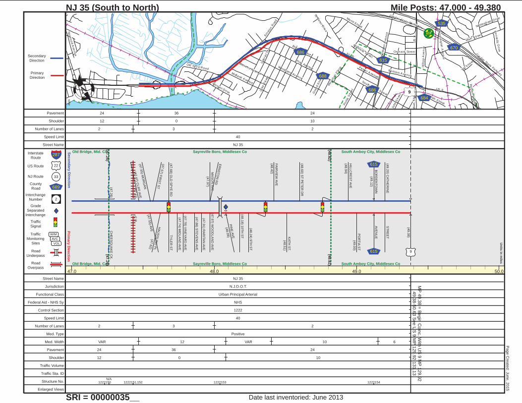
GSPG SP
NJ 35
US
9
Ma in S tr eet
Gar den State Parkway
Pine Av enue
Bo
rde
nto
wn
Ave
nu
e
Ra
ri tan S
treet
Woodland Av enue
South Feltus S treet
Luke
Str
eet
Ern
ston R
oad
Po
rtia
Str
eet
Meri tt S treet
Brook A venue
Stevens Av enueMidland A venue
Old Spy e Road
Highland S tr eet
Bertram A venue
St P
ete
r Driv
e
Orchard Street
Morgan Drive
Wa
sh
ing
ton
Ave
nu
e
Ke
nne
dy D
rive
Welsh S treet
Parker A venue
Gra
nd
Str
eet
No
rwo
od A
ve
nu
e
John
Str
eet
Hillt
op A
ve
nue
No ttingham Drive
Val Stre
etGab
r ie
l Te
rr
Me
ach
an P
lace
US 9
Ma
in S
tree
t
Gar den State Parkw
ay
9
688
670
615
686
535
684
686
Prim
ary
Dire
ctio
nS
eco
nd
ary
Dire
ctio
n
22
33
689
2
Interstate
Route
US Route
NJ Route
County
Road
Interchange
Number
Grade
Separated
Interchange
Traffic
Signal
Traffic
Monitoring
Sites
Road
Underpass
Road
Overpass
WIM
AVC
VOL
Un
its in
mile
s
Primary
Direction
Secondary
Direction
287
NJ 35 (South to North)
SRI = 00000035__
Mile Posts: 47.000 - 49.380
2531
Date last inventoried: June 2013
Page C
reate
d: J
une, 2
015
47.0 48.0 49.0 50.0
MP
49.3
8 =
Begin
Coin
c. W
ith U
S 9
MP
129.9
249.3
8-5
0.6
3 S
ee U
S 9
MP
129.9
2-1
31.1
3
(47.2
6)
Old Bridge, Mid. Co.
(47.2
6)Old Bridge, Mid. Co.
(47.2
6)
(48.8
2)
Sayreville Boro, Middlesex Co
(47.2
6)
(48.8
2)Sayreville Boro, Middlesex Co
(48.8
2)
South Amboy City, Middlesex Co
(48.8
2) South Amboy City, Middlesex Co
(47.2
6)
CH
EE
SQ
UA
KE
CK
.
(47.4
3)
C.R
.(4
7.4
7) C
LIF
F A
VE
(47.5
5) M
OR
GA
N(4
7.5
5) A
VE
(47.5
7) F
IRS
T S
TH
AU
SS
LIN
G P
L(4
7.6
2)
(47.6
8) O
LD
SP
YE
RD
TY
LE
R S
T
(47.7
4) M
IDLA
ND
AV
E
(47.7
8) V
INE
YA
RD
AV
E
(47.8
6) S
TE
VE
NS
AV
E
(47.9
1) R
AR
ITA
N A
VE
MA
SO
N A
VE
(47.9
7)
ER
NS
TO
N R
D
(47.9
7) W
OO
DLA
ND
AV
E
PIN
E A
VE
(48.0
8)
(48.1
8) 1
0T
H S
T
(48.2
4) 9
TH
ST
FA
IRV
IEW
AV
E
(48.4
2)
KA
TH
ST.
(48.5
1)
(48.6
0) S
T P
ET
ER
DR
HIL
LC
RE
ST
AV
E
(48.9
4)
PO
RT
IA S
T
(49.0
0)
BO
RD
EN
TO
WN
(49.1
2)
AV
EN
UE
(49.2
0) C
AT
HE
RIN
ES
TR
EE
T
(49.3
8)
615
615 9
Street Name NJ 35
Jurisdiction N.J.D.O.T.
Functional Class Urban Principal Arterial
Federal Aid - NHS Sy NHS
Control Section 1222
Speed Limit 40
Number of Lanes 2 3 2
Med. Type Positive
Med. Width VAR 12 VAR 10 6
Pavement 24 36 24
Shoulder 12 0 10
Traffic Volume
Traffic Sta. ID
Structure No. 1222150N/A
1222151,152 1222153 1222154
Enlarged Views
Pavement 24 36 24
Shoulder 12 0 10
Number of Lanes 2 3 2
Speed Limit 40
Street Name NJ 35
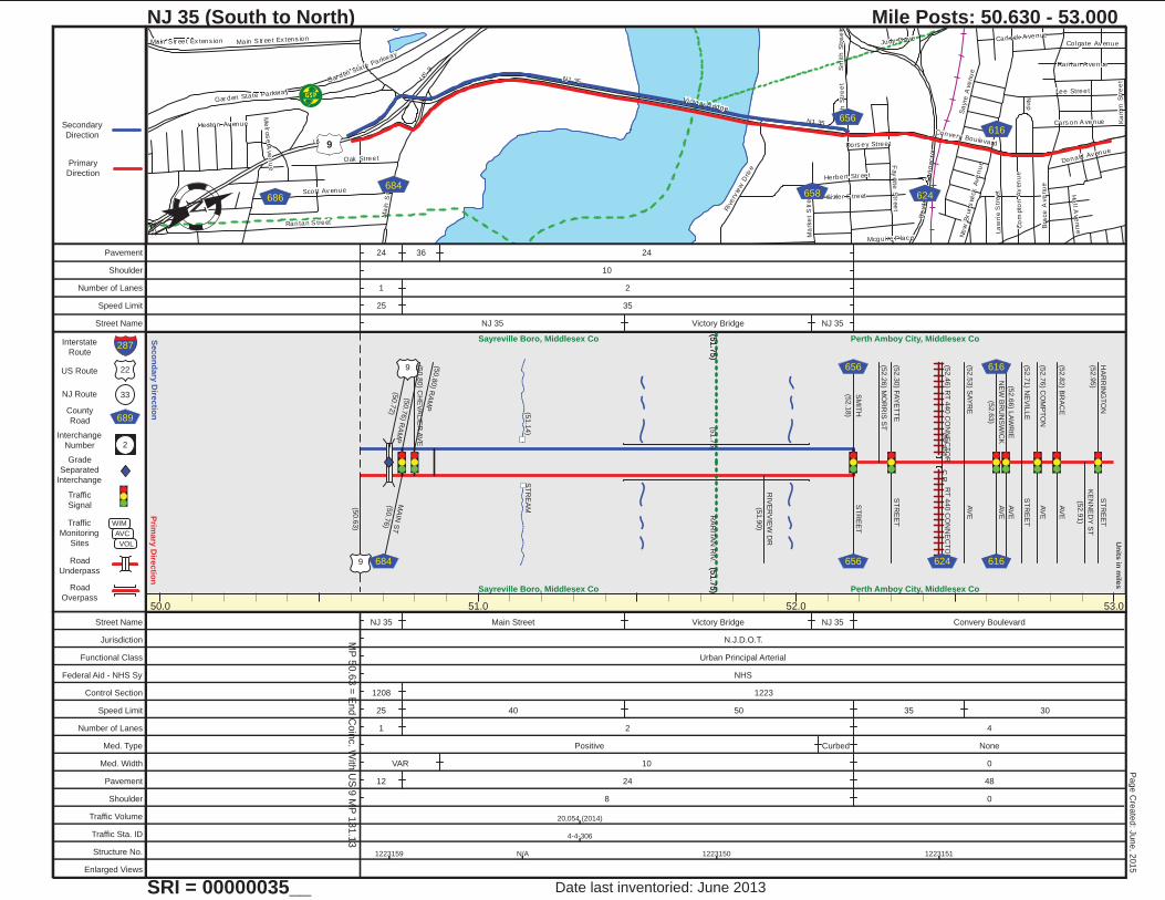
GSPG SP
US 9
NJ 35
Ma
in S
tree
t
Sm
ith
Str
ee
t
Rari tan S treet
Bra
ce
Ave
nu
e
Gar den State Parkway
Convery Boulevard
Victory B ridge
Sa
yre
Ave
nu
e
Riv
erv
iew
Driv
e
Lee Street
Fay
ette
Str
ee
t
Oak Street
Main S tr eet Ex tens ion
Ne
w B
run
sw
ick
Ave
nu
e
Carlock A venue
La
wri
e S
tre
etScott Av enue
Herbert Str eet
Co
mpto
n A
ven
ue
Sizler S treet
Colgate Av enue
Cars on A venue
Rari tan A venue
Ro
ute
44
0 C
on
nec
tor
Donald Av enue
Ha
ll Ave
nu
e
Ma
rke
t S
tree
t
Nn
p
Ka
mm
Str
ee
t
Heston Av enue
Dors ey Street
Mcgui re P lac e
Me
lros
e A
ve
nu
e
Judy Driv eMain S tr eet Ex tens ion
US
9
Gar den State Parkway
NJ 35
Sm
ith
Str
ee
t
9
616
656
686
684624658
Prim
ary
Dire
ctio
nS
eco
nd
ary
Dire
ctio
n
22
33
689
2
Interstate
Route
US Route
NJ Route
County
Road
Interchange
Number
Grade
Separated
Interchange
Traffic
Signal
Traffic
Monitoring
Sites
Road
Underpass
Road
Overpass
WIM
AVC
VOL
Un
its in
mile
s
Primary
Direction
Secondary
Direction
287
NJ 35 (South to North)
SRI = 00000035__
Mile Posts: 50.630 - 53.000
2532
Date last inventoried: June 2013
Page C
reate
d: J
une, 2
015
50.0 51.0 52.0 53.0
MP
50.6
3 =
End C
oin
c. W
ith U
S 9
MP
131.1
3
(51.7
5)
Sayreville Boro, Middlesex Co
(51.7
5)Sayreville Boro, Middlesex Co
(51.7
5)
Perth Amboy City, Middlesex Co
(51.7
5) Perth Amboy City, Middlesex Co
(51.1
4)
ST
RE
AM
(51.7
5)
RA
RIT
AN
RIV
.
(52.4
5)
C.R
.
(50.6
3)
(50.7
2)
(50.7
6) R
AM
PM
AIN
ST
(50.7
6)
(50.8
0) R
AM
P
(50.8
0) C
HE
VA
LIE
R A
VE
RIV
ER
VIE
W D
R
(51.9
0)
SM
ITH
(52.1
8)
ST
RE
ET
9
9
684
656
656
(52.2
6) M
OR
RIS
ST
(52.3
0) F
AY
ET
TE
ST
RE
ET
(52.4
6) R
T 4
40 C
ON
NE
CT
OR
RT
440 C
ON
NE
CT
OR
(52.5
3) S
AY
RE
AV
E
NE
W B
RU
NS
WIC
K
(52.6
3)
AV
E
AV
E(5
2.6
6) L
AW
RIE
(52.7
1) N
EV
ILLE
ST
RE
ET
(52.7
6) C
OM
PT
ON
AV
E
(52.8
2) B
RA
CE
AV
E
KE
NN
ED
Y S
T
(52.9
1)
HA
RR
ING
TO
N
(52.9
5)
ST
RE
ET
624
616
616
Street Name NJ 35 Main Street Victory Bridge NJ 35 Convery Boulevard
Jurisdiction N.J.D.O.T.
Functional Class Urban Principal Arterial
Federal Aid - NHS Sy NHS
Control Section 1208 1223
Speed Limit 25 40 50 35 30
Number of Lanes 1 2 4
Med. Type Positive Curbed None
Med. Width VAR 10 0
Pavement 12 24 48
Shoulder 8 0
Traffic Volume 20,054 (2014)
Traffic Sta. ID 4-4-306
Structure No. 1223159 N/A 1223150 1223151
Enlarged Views
Pavement 24 36 24
Shoulder 10
Number of Lanes 1 2
Speed Limit 25 35
Street Name NJ 35 Victory Bridge NJ 35

I- 95
Am boy A venue
Ma
in S
tr eet
Convery Boulevard
Gre
en S
tre
et
Bu
nns
La
ne
Barron Av enue
Gro
ve S
tree
t
Fre
eman
Street
Lee Street
Be
rge
n Stre
et
Linden Av enue
No
rth P
ark
Av
en
ue
Hig
h S
tre
et
Va
len
tine
Pla
ce
Mary S treet
Gro
ve
Av
en
ue
Frank lin
Dr ive
Oak Av enue
Sh
erry S
treet
Harr el l A venue
Willr
y S
tree
t
Ma
wbe
y S
tre
et
Alw
at
Str
ee
t
Ne
w S
tree
t
Ch
urc
h S
tre
et
Ru
dya
rd D
rive
St Jam es Avenue
School S tr eet
Pearl S treet
Hom mann A venue
Elmwood A venue
Pfeiff
er Boule
vard
Gre
nvil le
Str
ee
t
Rari tan A venue
Earl Street
Alb
ert S
tree
t
Clayton Court
Sp
ring
Str
ee
t
Ham il ton A
venue
Sofie
ld A
venu
e
I- 95
Gro
ve
Av
en
ue
Earl S
treet
I-95
I-95
N JTPTURNPIKE95
§̈¦95440
184
514604
655
Prim
ary
Dire
ctio
nS
eco
nd
ary
Dire
ctio
n
22
33
689
2
Interstate
Route
US Route
NJ Route
County
Road
Interchange
Number
Grade
Separated
Interchange
Traffic
Signal
Traffic
Monitoring
Sites
Road
Underpass
Road
Overpass
WIM
AVC
VOL
Un
its in
mile
s
Primary
Direction
Secondary
Direction
287
NJ 35 (South to North)
SRI = 00000035__
Mile Posts: 53.000 - 56.000
2533
Date last inventoried: June 2013
Page C
reate
d: J
une, 2
015
53.0 54.0 55.0 56.0
(54.0
8)
Perth Amboy City, Middlesex Co
(54.0
8)Perth Amboy City, Middlesex Co
(54.0
8)
Woodbridge Twp, Middlesex Co
(54.0
8) Woodbridge Twp, Middlesex Co
(54.0
4)
BR
. WO
OD
BR
IDG
E C
K.
(54.2
4)
ST
RE
AM
(54.2
7)
ST
RE
AM
(55.2
4)
HE
AR
DS
BK
.
(55.9
2)
WO
OD
BR
IDG
E R
IVE
R
KA
MM
(53.0
5)
ST
RE
ET
AV
E(5
3.1
3) K
RO
CK
MA
LLY
(53.2
3) H
AR
DIN
GA
VE
PF
EIF
FE
R B
LV
D(5
3.3
2)
TO
RT
440
(53.3
9)
(53.4
9) S
OU
TH
PA
RK
DR
DO
RO
TH
Y S
T
(53.5
1)
NO
RT
H P
AR
K D
R(5
3.5
4) B
EN
TLE
Y A
VE
TO
FIR
E H
OU
SE
CH
AM
BE
RLA
IN A
VE
(53.6
1)
(53.6
5) B
EN
TLE
Y A
VE
(53.7
0) L
IND
BE
RG
H A
VE
(53.7
5) F
RA
NK
LIN
DR
(53.8
0) K
ELLY
AV
E
(53.8
4) C
LA
RK
AV
E
(53.9
9) K
OZ
US
KO
AV
E(5
4.0
1) R
UD
YA
RD
DR
FLO
RID
A G
RO
VE
RD
KE
LS
EY
AV
E
(54.3
2) A
MB
OY
AV
E
ST. J
OS
EP
H A
VE
(54.4
8)
CR
ICK
ET
LA
(54.5
3) N
EW
JE
RS
EY
(54.6
8)
TU
RN
PIK
E
(54.7
5) B
UN
NS
LA
(54.7
6) A
LB
ER
T S
T
(54.8
0) C
LIN
TO
N S
T
(54.8
7) S
HE
RR
Y S
T
(54.9
2) B
ER
GE
N S
T
(54.9
8) G
RE
EN
VIL
LE
ST
2N
D S
T
(55.0
2) N
EW
ST
(55.0
3) G
RO
VE
ST
(55.0
8) M
AIN
ST
RE
ET
(55.1
3) J
AM
ES
ST
(55.1
5) J
AM
ES
ST
(55.1
8) R
OS
S S
TD
RIV
E(5
5.2
3) S
OU
TH
PA
RK
(55.2
5) N
OR
TH
PA
RK
DR
IVE
(55.3
1) E
DG
AR
ST
(55.3
8) G
RE
EN
ST
RE
ET
(55.4
3) R
OW
LA
ND
DR
(55.4
7) D
EC
KE
R P
LV
ALE
NT
INE
PL
(55.5
1) G
RO
VE
ST
RE
ET
DU
NH
AM
ST
(55.5
5) C
AM
BE
LL S
T
(55.6
0) M
AY
BE
Y S
TH
IGH
ST
(55.6
4) C
HU
RC
H S
T
CH
UR
CH
ST
(55.6
9) S
T. G
EO
RG
E A
VE
(55.7
0) S
EY
MO
RE
ST
(55.7
5) W
ILLR
Y S
T
(55.8
1) A
LW
AY
ST
(55.8
6) V
AN
BU
RE
N S
T
(55.9
8) S
T G
EO
RG
ES
ST
184 440
440
184 655
653
95
95
514
514
604
604
Street Name Convery Boulevard Amboy Avenue
Jurisdiction N.J.D.O.T.
Functional Class Urban Principal Arterial
Federal Aid - NHS Sy NHS
Control Section 1223 1224
Speed Limit 30 35 45 35
Number of Lanes 4
Med. Type None
Med. Width 0
Pavement 48
Shoulder 0
Traffic Volume
Traffic Sta. ID
Structure No. 1232154 1224154 12241561224155
M091890 1224150 1224151
Enlarged Views
Pavement
Shoulder
Number of Lanes
Speed Limit
Street Name

St George` s Av enue
NJ 27
Herbert Highw
ay
Jeffers on A venue
Remsen A
venue
St Georges Avenue
Madis on Av enue
Lord
Str
eet
Hyat
t S
treet
Prospect Avenue
Gro
ve
Str
ee
t
Ave
nel S
tree
t
Minna Av enue
Demor es t Av enue
We
st
Lak
e A
ve
nue
Thorpe Street
Le
ntz
Co
urt
Jans en Avenue
Bu
tler
Str
eet
Woodruff Av enue
Jens en A venue
El la Av enue
Bram
hal l
Road
Mcfarlane R
oad
Alb
em
arle
Str
ee
t
Midfie ld R
oad
Jaqu
es A
venue
Tap
pe
n S
tre
et
Pla
infie
ld A
ven
ue
Co lon ia B oulevard
Ma
ple
Av
en
ue
Roanok e Avenue
Bry
ant S
tr eet
Wo
od
bin
e A
ven
ue
Ne
w D
ov
er R
oa
d
Ridge Road
Elm
Te
r
New
Br un
swick
Ave
nue
Sm
ith S
treet
Ald
en
Roa
d
En
field
Ro
ad
Ra
ce S
tre
et
Ronald Driv e
Manor Plac e
St George` s Av enue
Herbert Highw
ay
27
650
602
651
609
Prim
ary
Dire
ctio
nS
eco
nd
ary
Dire
ctio
n
22
33
689
2
Interstate
Route
US Route
NJ Route
County
Road
Interchange
Number
Grade
Separated
Interchange
Traffic
Signal
Traffic
Monitoring
Sites
Road
Underpass
Road
Overpass
WIM
AVC
VOL
Un
its in
mile
s
Primary
Direction
Secondary
Direction
287
NJ 35 (South to North)
SRI = 00000035__
Mile Posts: 56.000 - 58.070
2534
Date last inventoried: June 2013
Page C
reate
d: J
une, 2
015
56.0 57.0 58.0 59.0
End N
J 3
5 M
P=
58.0
7
(57.9
1)
Woodbridge Twp, Middlesex Co
(57.9
1)Woodbridge Twp, Middlesex Co
(57.9
1)
Rahway, Uni. Co.
(57.9
1)Rahway, Uni. Co.
(56.1
2)
P.R
.R.
(57.9
3)
S B
R R
AH
WA
Y R
IV.
(58.0
5)
C.R
.
GE
OR
GE
FR
ED
RIC
K P
L
(56.0
5)
(56.1
3) A
SP
EN
LN
(56.1
5) W
ALT
ER
DR
TO
SH
OP
PIN
G C
TR
(56.3
0)
RO
AN
OK
E S
T
(56.3
4) K
IMB
ALL S
T
(56.4
1) J
AN
SE
N S
T
(56.4
8)
RA
MP
FR
OM
RT
1/9
(56.5
1)
RA
MP
TO
RT
1/9
(56.5
1)
(56.6
2) G
RE
EN
WO
OD
ST
1/9
1/9
(56.6
6) B
ELG
RA
DE
ST
(56.7
0) W
AS
HIN
GT
ON
AV
E
RE
MS
EN
AV
E
(56.7
0)
(56.7
5) S
OU
TH
HIL
L R
D
(56.8
2) H
IGH
FIE
LD
RD
(56.8
8) M
IDD
LE
HIL
L R
D
(56.9
4) E
NF
IELD
RD
(56.9
9) S
MIT
H S
TW
SM
ITH
ST
(57.0
6) C
OLO
NIA
PL
(57.1
1) V
ALLE
Y R
D(5
7.1
3) W
YLIE
ST
(57.1
7) N
OR
TH
HIL
L R
D
LO
RD
ST
(57.2
7)
CH
AIN
-O-H
ILLS
RD
(57.3
5)
AV
EN
EL A
VE
(57.4
2) H
YA
TT
ST
(57.4
4) L
ON
G H
ILL D
R
MID
FIE
LD
RD
(57.5
7)
BU
TLE
R S
T
(57.6
1)
(57.6
3) R
ON
ALD
DR
(57.6
7) W
OO
DB
INE
AV
E
(57.7
9) P
EA
CH
ST
(57.8
9) T
O S
HO
PP
ING
CE
NT
ER
NE
W B
RU
NS
. AV
E
(58.0
1)
LIN
CO
LN
HW
Y
(58.0
7) C
OLO
NIA
BLV
D
650
650 609
27
Street Name Amboy Avenue
St George`s Avenue
Jurisdiction N.J.D.O.T.
Functional Class Urban Principal Arterial
Federal Aid - NHS Sy NHS
Control Section 1224 2000
Speed Limit 35 40
Number of Lanes 4
Med. Type None Curbed None
Med. Width 0 6 0
Pavement 48 30 60
Shoulder 0
Traffic Volume 29,638 (2012)
Traffic Sta. ID 061201
Structure No. N/A 2022150 2022151
Enlarged Views
Pavement 30
Shoulder 0
Number of Lanes 2
Speed Limit 35
Street Name St George`s Avenue