NITRB Standard Presentation Format - · What’s Changed? • The Joint Planning and Development...
18
NextGen Update Cecilia Miner May, 2017
Transcript of NITRB Standard Presentation Format - · What’s Changed? • The Joint Planning and Development...

NextGen Update
Cecilia Miner May, 2017

Agenda • What’s changed? • NextGen Background • FAA NextGen Weather Architecture
– NextGen Weather Processor – Aviation Weather Display – Common Support Services - Weather
• NWS “NextGen” Weather • Digital Aviation Services • Conclusion
2

What’s Changed?
• The Joint Planning and Development Office (JPDO) has closed – Completed its purpose of setting the vision for
NextGen – New Interagency Program Office handles R&D
coordination and interagency NextGen planning
• NOAA has dropped “NextGen” from its weather program in favor of Science Applications and Integration
3

Background Program Description
• Next Generation Air Transportation System (NextGen) formed from a U.S. Congress mandate to modernize the U.S. Air Transportation System in order to: – Increase capacity and reliability – Improve safety and security – Minimize the environmental impact of aviation
• Partners – NextGen is a multi-department initiative: Transportation, NASA,
Defense, Homeland Security, Commerce (NOAA/NWS), White House Office of Science and Technology Policy
– NextGen Weather is primarily driven by Federal Aviation Administration (Department of Transportation)
– NOAA’s contribution is employing more modern technologies for access and distribution of required aviation weather information and increased accuracy of weather information
4
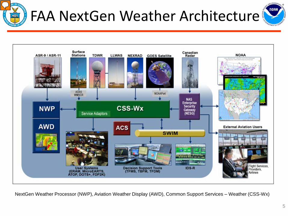
FAA NextGen Weather Architecture
5
NextGen Weather Processor (NWP), Aviation Weather Display (AWD), Common Support Services – Weather (CSS-Wx)
Presenter
Presentation Notes
Major pieces: NextGen Weather Processor (NWP), Aviation Weather Display (AWD), Common Support Services – Weather (CSS-Wx)

NextGen Weather Processor
• NextGen Weather Processor (NWP) identifies terminal and enroute safety hazards, and provides translated weather information needed to predict route blockage and airspace capacity constraints up to eight hours in advance.
• Combines information from weather radars, environmental satellites, lightning, meteorological observations (from surface stations and aircraft), and NOAA numerical forecast model output to generate improved products
6
Example: Improved echo top mosaics
Presenter
Presentation Notes
Example of NWP improvement in Echo Tops mosaics, an important product for determining enroute airspace availability. The mosaics represent a map of the storm tops (the top of the radar echoes) and are colored in 5000 foot increments. The 'Current' (top) mosaic is range limited, leading to poor high-altitude coverage directly over the center radar and curved artifacts from the other radars. The NWP Echo Tops mosaic (bottom) provides a realistic, artifact-free image that does not exaggerate echo tops values at long range.

Aviation Weather Display
• Combines current multiple weather displays from the Weather and Radar Processor (WARP), the Integrated Terminal Weather System (ITWS) and the Corridor Integrated Weather System (CIWS) for use by controllers
• More consistent weather depiction
• Downside: Controllers must still mentally integrate weather information with traffic on their scopes
7
Weather Display Consolidation

Common Support Services - Wx
• Provides weather data, products, and imagery within the National Airspace System (NAS), using standards-based weather dissemination via System-Wide Information Management (SWIM)
• Makes available both NOAA and FAA NWP weather products for integration into air traffic decision support tools
8

NOAA “NextGen” Weather • NOAA’s “NextGen” Weather Program formulated
to enable improvements to support the Federal NextGen initiative
• Program divided into two main components: “IT/Web Services” and “Science and Applications” – IT/Web Services:
• Near-term deliverable to improve access and discoverability of NOAA data for aviation
• Transferred to Integrated Dissemination Program (IDP) in FY14
– Science and Applications: • Longer-term research and development of applications to
improve the accuracy and timeliness of aviation weather information
9
NOAA “NextGen” Weather
• Major thrusts – NextGen IT/Web Services – Digital Aviation Services/Enhanced Digital Services – INtegrated Support for Impacted air Traffic
Environments (INSITE) tool – CL31/PBL ceilometer extension – TRACON Approach and Departure Gate Forecast – Aviation Forecast Verification Tool
10

Digital Aviation Services
• Adding aviation elements to the National Digital Forecast Database (NDFD) – Provide hourly graphical
forecasts of ceiling and visibility out to 36 hours
• TAFs are generated from the database with forecaster oversight
11

Why Digital Aviation Services/ Enhanced Digital Services?
• One event, one forecast • Moves toward NextGen
requirement of a National Digital Ceiling and Visibility Grid
• Build a National Ceiling and Visibility Grid with 2-way collaboration from National Centers and Weather Forecast Offices
• Important guidance tool for medical services, search and rescue, and General Aviation
• Improves NWS forecast consistency with aviation forecasts and beyond
12
Conclusion
• NextGen continuing to make solid progress on several key activities
• Implementing state of the art dissemination technologies
• Enabling more accurate and timely forecasts of weather affecting the National Airspace System
• Developing additional NextGen capabilities which will help all NWS service areas
13

14
BACKUP

Forecast Applications INSITE
• Goal: Provide decision assistance tool for NWS forecasters to aid in the prediction of convective weather events that affect aviation – Test and evaluation continues at NWS
Aviation Weather Center, FAA Air Traffic Control Command Center, two NWS Region Center Weather Service Units and two Weather Forecast Offices
– Tool assists in CAWS preparation by defining constrained areas
– Expect transition to operations in 2017 • Close coordination with NWS Aviation
Services and FAA’s Weather Evaluation Team (WET)
15
INtegrated Support for Impacted air-Traffic Environments (INSITE)

Aviation Forecast Verification Tool (AFVT)
• Top Drivers – Meet the Federal Aviation Administration’s (FAA’s) quality
management system requirements for verification of NWS Aviation products
– Establish NWS performance for Aviation elements at national scale, regions, offices, individuals
– Near-real time verification
• Benefits – Near-real time verification of Weather Elements important to Aviation
(Ceiling Height, Visibility, Temperature, Dewpoint Temperature, Wind Speed, Wind Direction, Wind Gusts, Sky Cover)
– Users submit queries for location, time period and parameters – Results provided for gridded verification as graphics or charts – Results computed for various levels (national, regional) for FAA and
NWS 16

Aviation Forecast Verification Tool (AFVT)
17
National Digital Forecast Database Verification •Verification of Aviation Weather Elements •Near-real time results
Verification of a Forecast for a Region •NWS regions •Air Route Traffic Control Center
Verification of a Forecast for a WFO •User defined areas •For one specified County Warning Area
Verification of a Forecast for an Airport or Point •Core CONUS Airports •User selected point locations

Aviation Weather Elements CL31
18
CL31 PBL Project • Benefits: Expands utilization of the current operational ASOS ceilometer
from 12,000 ft to 25,000 ft, without infrastructure expenditures • Goal: Investigate and validate the effectiveness of the selected CL31
ceilometer algorithm across the U.S., as provided by the Proof of Concept CL31 Test Sites Evaluation
• Objectives: (1) expand experience and knowledge of the CL31 Test Sites Evaluation (local) to the national scope, (2) ensure that the ceilometer algorithm selected performs as anticipated and the PBL profiles generated meet scientific rigor, (3) implement algorithm into ASOS operations
• Deliverable: PBL algorithm which extends CL31 profile detection beyond current range and implement into operations
Presenter
Presentation Notes
PBL: Planetary Boundary Layer