Neart na Gaoithe Offshore Wind Farm - Welcome to Marine ...
58
Neart na Gaoithe Offshore Wind Farm Navigational Safety and Vessel Management Plan Revision 3.0 April 2020 DOCUMENT REFERENCE: NNG-NNG-ECF-PLN-0010
Transcript of Neart na Gaoithe Offshore Wind Farm - Welcome to Marine ...

Neart na Gaoithe Offshore Wind Farm
Navigational Safety and Vessel Management Plan
Revision 3.0
April 2020 DOCUMENT REFERENCE: NNG-NNG-ECF-PLN-0010

Navigational Safety and Vessel Management Plan
Neart na Gaoithe NNG-NNG-ECF-PLN-0010
NNG-NNG-ECF-PLN-0010 PROTECT – NOT PROTECTIVELY MARKED PAGE 2 OF 58
Neart na Gaoithe Offshore Wind Farm
Navigational Safety and Vessel Management Plan
Pursuant to Section 36 Consent Conditions 17 and Marine Licence (Offshore Transmission Works) Conditions 3.2.2.12 in respect of the Navigational Safety Plan
and Section 36 Consent Conditions 15, Marine Licence (Generating Station) Condition 3.2.2.12 and Marine Licence (Offshore Transmission Works) Conditions
3.2.2.11 in respect of the Vessel Management Plan
For the approval of the Scottish Ministers
Document Control
SIGN OFF
Name (Role) Signature Date
David Sweenie
Development Manager
Claire Gilchrist
Offshore Consents
08/04/20
Sarah MacNab
Environmental Clerk of Works
02/04/20
14/04/20 [Redacted]
[Redacted]
[Redacted]

Navigational Safety and Vessel Management Plan
Neart na Gaoithe NNG-NNG-ECF-PLN-0010
NNG-NNG-ECF-PLN-0010 PROTECT – NOT PROTECTIVELY MARKED PAGE 3 OF 58
Overview Purpose and Objectives of the Plan
This Navigational Safety and Vessel Management Plan (NSVMP) has been prepared to address the specific requirements of the relevant conditions attached to the Section 36 (S36) consent and Marine Licences (collectively referred to as the Offshore Consents) issued to Neart na Gaoithe Offshore Windfarm Limited (NnGOWL). These conditions require the documentation of a Navigational Safety Plan (NSP) and Vessel Management Plan (VMP). These plans have been combined into a single document (the NSVMP) given the overlap between the two, noting that this approach has been agreed with the Scottish Ministers.
The overall objective of the NSVMP is to detail the navigational safety measures that will be put in place by NnGOWL (including vessel management procedures) to minimise any risks from the Project to mariners.
All NnGOWL personnel and Contractors involved in the Project must comply with this NSVMP.
Scope of the Plan
The NSVMP covers, in line with the requirements of the consents conditions, and in line with industry standards and good practice, the following:
• Navigational safety measures during construction: Temporary lighting and marking; buoyage; safety zones; management of the construction area; recommended routes and entry/exit gates; and, vessel safety requirements.
• Navigational safety measures during operation: Marine coordination; safety zones; management of operations and maintenance activities; recommended routes and entry/exit gates; and, vessel safety requirements.
• Details of anchoring areas.
• Notifications to stakeholders and marine users.
• Emergency response.
• Project vessel specifications.
• Vessel management procedures.
• Details of working ports.
Structure of the Plan
The NSVMP is structured as follows:
Sections 1 to 3 sets out the scope and objectives of the NSVMP, details the process for making updates and amendments to this document, sets out broad statements of compliance and provides an overview of the Project.
Sections 4 and 5 present the navigational safety measures to be adopted during the construction and Operation and Maintenance (O&M) phases including lighting and marking, buoyage, safety zones, cable laying operations and recommended entry/exit route gates.

Navigational Safety and Vessel Management Plan
Neart na Gaoithe NNG-NNG-ECF-PLN-0010
NNG-NNG-ECF-PLN-0010 PROTECT – NOT PROTECTIVELY MARKED PAGE 4 OF 58
Sections 6 and 7 detail the promulgation of information through Notice to Mariners (NtM)s and other notifications as well as details of what is to be included within the Emergency Response Cooperation Plan (ERCoP).
Sections 8 to 12 present the locations of working ports, the management and coordination of vessels, types, specifications, numbers and movements of vessels and indicative transit routes for vessel associated with the Project.
Section 13 describes the areas recommended for anchoring and areas where anchoring should be avoided.
Sections 14 and Appendix A confirms compliance of the NSVMP with the Application.
Plan Audience
The NSVMP is intended to be referred to by personnel involved in the construction of the Project, including NnGOWL personnel and Contractors. The NSVMP will be issued to the Fisheries Liaison Officer (FLO) for information.
Compliance with this NSVMP will be monitored by the Marine Coordination Centre (MCC). , the NnGOWL Consents team, NnGOWL’s Environmental Clerk of Works (ECoW), and reported to the Marine Scotland Licensing Operations Team (MS-LOT).
Plan Locations
Copies of this NSVMP are to be held in the following locations:
• NnGOWL Project Office;
• At the premises of the main Contractors acting on behalf of NnGOWL;
• All site offices dealing with marine operations, including the NnGOWL Marine Coordination Centre; and
• With NnGOWL’s ECoW.

Navigational Safety and Vessel Management Plan
Neart na Gaoithe NNG-NNG-ECF-PLN-0010
NNG-NNG-ECF-PLN-0010 PROTECT – NOT PROTECTIVELY MARKED PAGE 5 OF 58
Contents 1 Introduction ...................................................................................................................................................................... 12
1.1 Background.......................................................................................................................................................... 12
1.2 Objectives of this Document ............................................................................................................................... 12
1.3 Linkages with other Consent Plans ...................................................................................................................... 18
1.4 NSVMP Document Structure ............................................................................................................................... 19
2 NnGOWL Statements of Compliance ................................................................................................................................ 21
3 Project Overview ............................................................................................................................................................... 22
4 Navigational Safety Measures during Construction .......................................................................................................... 24
4.1 Introduction......................................................................................................................................................... 24
4.2 Temporary Lighting and Marking ........................................................................................................................ 24
4.3 Construction Safety Zones ................................................................................................................................... 24
4.4 Management of the Construction Area (including Safety Zones)........................................................................ 25
4.5 Construction Vessels ........................................................................................................................................... 26
4.6 Injury, Destruction or Decay of the Project ......................................................................................................... 26
5 Navigational Safety Measures during Operation and Maintenance ................................................................................. 27
5.1 Introduction......................................................................................................................................................... 27
5.2 Operational Lighting and Marking ....................................................................................................................... 27
5.3 Operational Safety Zones .................................................................................................................................... 27
5.4 Management of Operation and Maintenance Activities ..................................................................................... 27
5.5 Operation and Maintenance Vessels ................................................................................................................... 28
5.6 Subsea Cable Inspections .................................................................................................................................... 28
5.7 Hydrographic Surveys .......................................................................................................................................... 29
5.8 Injury, Destruction of Decay of the Project ......................................................................................................... 29
6 Promulgation of Information ............................................................................................................................................ 30
6.1 Introduction......................................................................................................................................................... 30
6.2 Local Notice to Mariners ..................................................................................................................................... 30
6.3 Admiralty Notices to Mariners (UKHO) ............................................................................................................... 31
6.4 Aviation ............................................................................................................................................................... 31
6.5 Kingfisher Bulletins and KIS-ORCA ....................................................................................................................... 32
6.6 UKHO ................................................................................................................................................................... 33
6.7 Radio Navigational Warnings .............................................................................................................................. 33
6.8 Vessel Reports ..................................................................................................................................................... 34
7 Emergency Response ........................................................................................................................................................ 35
7.1 Emergency Response Cooperation Plan .............................................................................................................. 35

Navigational Safety and Vessel Management Plan
Neart na Gaoithe NNG-NNG-ECF-PLN-0010
NNG-NNG-ECF-PLN-0010 PROTECT – NOT PROTECTIVELY MARKED PAGE 6 OF 58
7.2 Marine Incident Reporting .................................................................................................................................. 35
8 Location of Working Ports ................................................................................................................................................ 36
8.1 Port of Dundee .................................................................................................................................................... 36
8.2 Eyemouth Harbour .............................................................................................................................................. 36
8.3 Montrose Port ..................................................................................................................................................... 36
8.4 Port of Leith ......................................................................................................................................................... 36
8.5 Port of Methil ...................................................................................................................................................... 36
9 Management and Coordination of Vessels ....................................................................................................................... 37
10 Types and Specifications of Vessels .................................................................................................................................. 38
11 Numbers and Movements of Vessels................................................................................................................................ 41
11.1 Construction Vessels ........................................................................................................................................... 41
11.2 Operation and Maintenance Vessels ................................................................................................................... 48
12 Indicative Transit Routes ................................................................................................................................................... 50
13 Anchoring Areas ................................................................................................................................................................ 52
13.1 Charted Anchorages ............................................................................................................................................ 52
13.2 Areas where Anchoring should be Avoided......................................................................................................... 52
14 Compliance with the Application ...................................................................................................................................... 54
References ................................................................................................................................................................................... 55
Appendix A – Compliance with the Application .......................................................................................................................... 56
Figures Figure 3-1: Wind Farm Area and Offshore Export Cable Corridor Location ...........................................................................................23
Figure 12-1: Indicative Vessel Transit Routes ........................................................................................................................................51
Figure 13-1: Charted Anchorage and Areas to be Avoided....................................................................................................................53
Tables Table 1-1 : NSP and VMP consent conditions to be discharged by this Consent Plan ...........................................................................12
Table 1-2 : Other consent conditions relevant to this Consent Plan .....................................................................................................15
Table 1-3: NSVMP linkages with other Consent Plans (and consents conditions) .................................................................................18
Table 1-4 : NSVMP document structure ................................................................................................................................................19
Table 6-1: Local Notice to Mariners Content .........................................................................................................................................30
Table 11-1 Indicative Construction Vessel Numbers, Key Construction Activities and Return Journeys ...............................................42
Table 11-2: Example vessel types required during O&M.......................................................................................................................48

Navigational Safety and Vessel Management Plan
Neart na Gaoithe NNG-NNG-ECF-PLN-0010
NNG-NNG-ECF-PLN-0010 PROTECT – NOT PROTECTIVELY MARKED PAGE 7 OF 58
Acronyms and Abbreviations
TERM DESCRIPTION
AC Alternating Current
AIS Automatic Identification System
AtoN Aids to Navigation
CAA Civil Aviation Authority
CGOC Coast Guard Operation Centre
CLV Cable Lay Vessel
COLREGS International Regulations for Preventing Collisions at Sea
CTV Crew Transfer Vessel
DGC Defence Geographic Centre
DIO Defence Infrastructure Organisation
ECoW Environmental Clerk of Works
FP Forth Ports
HLV Heavy Lift Vessel
HMCG HM Coastguard
HTV Heavy Transport Vessel
IALA International Association of Marine Aids to Navigation and Lighthouse Authorities
IHO International Hydrographic Organization
IMCA International Marine Contractor Audit
IMO International Maritime Organisation
JUV Jack-up Vessel
KIS-ORCA Kingfisher Information Service – Offshore Renewable & Cable Awareness
LNtMs Local Notice to Mariners
MCA Maritime and Coastguard Agency
MCC Marine Coordination Centre

Navigational Safety and Vessel Management Plan
Neart na Gaoithe NNG-NNG-ECF-PLN-0010
NNG-NNG-ECF-PLN-0010 PROTECT – NOT PROTECTIVELY MARKED PAGE 8 OF 58
TERM DESCRIPTION
MF Medium Frequency
MGN Marine Guidance Note
MS-LOT Marine Scotland Licensing and Operations Team
MW Megawatt
NAVAREA Navigational Area
NLB Northern Lighthouse Board
NOTAM Notice to Airmen
NSP Navigational Safety Plan
NtM Notice to Mariners
OCV Offshore Construction Vessel
OfCom Office of Communications
OREI Offshore Renewable Energy Installation
OSP Offshore Substation Platform
O&M Operation and Maintenance
PSV Platform Supply Vessel
RAM Restricted in Ability to Manoeuvre
SAR Search and Rescue
SFF Scottish Fishermen’s Federation
SNH Scottish Natural Heritage
SOLAS Safety of Life at Sea
SOV Service Operation Vessel
SSCV Semi-submersible Crane Vessel
STCW Standards for Training, Certification and Watch Keeping
T&P Temporary and Preliminary
UKHO United Kingdom Hydrographic Office

Navigational Safety and Vessel Management Plan
Neart na Gaoithe NNG-NNG-ECF-PLN-0010
NNG-NNG-ECF-PLN-0010 PROTECT – NOT PROTECTIVELY MARKED PAGE 9 OF 58
TERM DESCRIPTION
VHF Very High Frequency
VMP Vessel Management Plan
WDC Whale and Dolphin Conservation
WWNWS Worldwide Navigational Warning Service
WZ UK Coastal Navigational Warning
Defined Terms TERM DESCRIPTION
Addendum The Addendum of Additional Information submitted to the Scottish Ministers by NnGOWL on 26 July
2018.
Application The Environmental Impact Assessment Report, Habitats Regulations Appraisal Report submitted to
the Scottish Ministers by NnGOWL on 16 March 2018; the Addendum of Additional Information
submitted to the Scottish Ministers by NnGOWL on 26 July 2018 and the Section 36 Consent Variation
Report dated 08 January 2019.
Company Neart na Gaoithe Offshore Wind Limited (NnGOWL) (Company Number SC356223). NnGOWL has
been established to develop, finance, construct, operate, maintain and decommission the Project.
Consent Conditions The terms that are imposed on the Company under the Offshore Consents that must be complied
with
Consent Plans The plans, programmes or strategies required to be approved by the Scottish Ministers (in
consultation with appropriate stakeholders) in order to discharge the Consent Conditions.
Contractors Any Contractor/Supplier (individual or firm) working on the Project.
EIA Report The Environmental Impact Assessment Report, dated March 2018, submitted to the Scottish
Ministers by NnGOWL as part of the Application.
Inter-array Cables The offshore cables connecting the wind turbines to one another and to the OSPs.
Interconnector Cables
The offshore cables connecting the OSPs to one another.
Marine Licences The written consents granted by the Scottish Ministers under the Marine (Scotland) Act 2010, for
construction works and deposits of substances or objects in the Scottish Marine Area in relation to
the Wind Farm (Licence Number 06677/19/0) and the OfTW (Licence Number 06678/19/1), dated 4
June 2019 and 5 June 2019 respectively.
Offshore Consents The Section 36 Consent and the Marine Licences.

Navigational Safety and Vessel Management Plan
Neart na Gaoithe NNG-NNG-ECF-PLN-0010
NNG-NNG-ECF-PLN-0010 PROTECT – NOT PROTECTIVELY MARKED PAGE 10 OF 58
TERM DESCRIPTION
Offshore Export Cable Corridor
The area within which the offshore export cables are to be located.
Offshore Export Cables
The offshore export cables connecting the OSPs to the landfall site.
OfTW The Offshore Transmission Works comprising the OSPs, offshore interconnector cables and offshore
export cables required to connect the Wind Farm to the Onshore Transmission Works at the landfall.
OfTW Area The area outlined in red and blue in Figure 1 attached to Part 4 of the OfTW Marine Licence.
OnTW The onshore transmission works from landfall and above Mean High Water Springs, consisting of
onshore export cables and the onshore substation.
Project The Wind Farm and the OfTW.
Section 36 Consent The written consent granted on 3 December 2018 by the Scottish Ministers under Section 36 of The
Electricity Act 1989 to construct and operate the Wind Farm, as varied by the Scottish Ministers
under section 36C of the Electricity Act 1989 on 4 June 2019.
Section 36 Consent Variation Report
The Section 36 Consent Variation Report submitted to the Scottish Ministers by NnGOWL as part of
the Application as defined above on 08 January 2019.
Subcontractors Any Contractor/Supplier (individual or firm) providing services to the Project, hired by the Contractors
(not NnGOWL).
Wind Farm The offshore array as assessed in the Application including wind turbines, their foundations and inter-
array cabling.
Wind Farm Area The area outlined in black in Figure 1 attached to the Section 36 Consent Annex 1, and the area
outlined in red in Figure 1 attached to Part 4 of the Wind Farm Marine Licence.
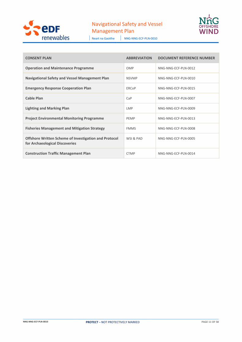
Consent Plans
CONSENT PLAN ABBREVIATION DOCUMENT REFERENCE NUMBER
Decommissioning Programme DP NNG-NNG-ECF-PLN-0016
Construction Programme and Construction Method Statement
CoP & CMS NNG-NNG-ECF-PLN-0002
Piling Strategy PS NNG-NNG-ECF-PLN-0011
Development Specification and Layout Plan DSLP NNG-NNG-ECF-PLN-0003
Design Statement DS NNG-NNG-ECF-PLN-0004
Environmental Management Plan EMP NNG-NNG-ECF-PLN-0006
Navigational Safety and Vessel Management Plan
Neart na Gaoithe NNG-NNG-ECF-PLN-0010
NNG-NNG-ECF-PLN-0010 PROTECT – NOT PROTECTIVELY MARKED PAGE 11 OF 58
CONSENT PLAN ABBREVIATION DOCUMENT REFERENCE NUMBER
Operation and Maintenance Programme OMP NNG-NNG-ECF-PLN-0012
Navigational Safety and Vessel Management Plan NSVMP NNG-NNG-ECF-PLN-0010
Emergency Response Cooperation Plan ERCoP NNG-NNG-ECF-PLN-0015
Cable Plan CaP NNG-NNG-ECF-PLN-0007
Lighting and Marking Plan LMP NNG-NNG-ECF-PLN-0009
Project Environmental Monitoring Programme PEMP NNG-NNG-ECF-PLN-0013
Fisheries Management and Mitigation Strategy FMMS NNG-NNG-ECF-PLN-0008
Offshore Written Scheme of Investigation and Protocol for Archaeological Discoveries
WSI & PAD NNG-NNG-ECF-PLN-0005
Construction Traffic Management Plan CTMP NNG-NNG-ECF-PLN-0014
Navigational Safety and Vessel Management Plan
Neart na Gaoithe NNG-NNG-ECF-PLN-0010
NNG-NNG-ECF-PLN-0010 PROTECT – NOT PROTECTIVELY MARKED PAGE 12 OF 58
1 Introduction
1.1 Background
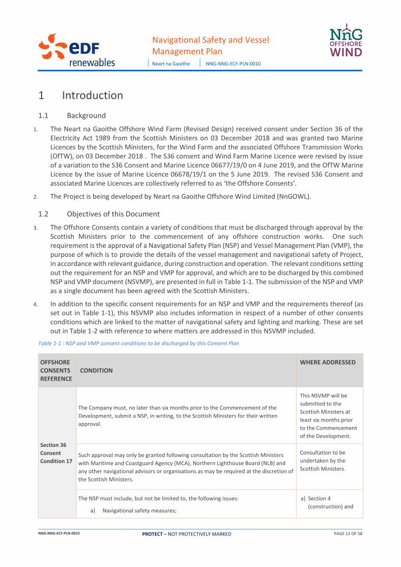
1. The Neart na Gaoithe Offshore Wind Farm (Revised Design) received consent under Section 36 of the Electricity Act 1989 from the Scottish Ministers on 03 December 2018 and was granted two Marine Licences by the Scottish Ministers, for the Wind Farm and the associated Offshore Transmission Works (OfTW), on 03 December 2018 . The S36 consent and Wind Farm Marine Licence were revised by issue of a variation to the S36 Consent and Marine Licence 06677/19/0 on 4 June 2019, and the OfTW Marine Licence by the issue of Marine Licence 06678/19/1 on the 5 June 2019. The revised S36 Consent and associated Marine Licences are collectively referred to as ‘the Offshore Consents’.
2. The Project is being developed by Neart na Gaoithe Offshore Wind Limited (NnGOWL).
1.2 Objectives of this Document
3. The Offshore Consents contain a variety of conditions that must be discharged through approval by the Scottish Ministers prior to the commencement of any offshore construction works. One such requirement is the approval of a Navigational Safety Plan (NSP) and Vessel Management Plan (VMP), the purpose of which is to provide the details of the vessel management and navigational safety of Project, in accordance with relevant guidance, during construction and operation. The relevant conditions setting out the requirement for an NSP and VMP for approval, and which are to be discharged by this combined NSP and VMP document (NSVMP), are presented in full in Table 1-1. The submission of the NSP and VMP as a single document has been agreed with the Scottish Ministers.
4. In addition to the specific consent requirements for an NSP and VMP and the requirements thereof (as set out in Table 1-1), this NSVMP also includes information in respect of a number of other consents conditions which are linked to the matter of navigational safety and lighting and marking. These are set out in Table 1-2 with reference to where matters are addressed in this NSVMP included.
Table 1-1 : NSP and VMP consent conditions to be discharged by this Consent Plan
OFFSHORE CONSENTS REFERENCE
CONDITION WHERE ADDRESSED
Section 36
Consent
Condition 17
The Company must, no later than six months prior to the Commencement of the
Development, submit a NSP, in writing, to the Scottish Ministers for their written
approval.
This NSVMP will be
submitted to the
Scottish Ministers at
least six months prior
to the Commencement
of the Development.
Such approval may only be granted following consultation by the Scottish Ministers
with Maritime and Coastguard Agency (MCA), Northern Lighthouse Board (NLB) and
any other navigational advisors or organisations as may be required at the discretion of
the Scottish Ministers.
Consultation to be
undertaken by the
Scottish Ministers.
The NSP must include, but not be limited to, the following issues:
a) Navigational safety measures;
a) Section 4
(construction) and

Navigational Safety and Vessel Management Plan
Neart na Gaoithe NNG-NNG-ECF-PLN-0010
NNG-NNG-ECF-PLN-0010 PROTECT – NOT PROTECTIVELY MARKED PAGE 13 OF 58
OFFSHORE CONSENTS REFERENCE
CONDITION WHERE ADDRESSED
b) Construction exclusion zones;
c) Notice(s) to mariners and radio navigation warnings;
d) Anchoring areas;
e) Temporary construction lighting and marking;
f) Buoyage.
Section 5
(operation)
b) Section 4.3
c) Section 6
d) Section 13
e) Section 4.2
f) Section 4.2
(construction) and
Section 5.2
(operation)
The Company must confirm within the NSP that they have taken into account and
adequately addressed all of the recommendations of the MCA in the current Marine
Guidance Note 543 (“MGN 543”), and its annexes that may be appropriate to the
Development, or any other relevant document which may supersede this guidance
prior to approval of the NSP.
This NSVMP has been
written in compliance
with MGN 543 as per
Section 2
Section 36
Consent
Condition 15
The Company must, no later than six months prior to the Commencement of the
Development, submit a VMP, in writing, to the Scottish Ministers for their written
approval.
This NSVMP will be
submitted to the
Scottish Ministers at
least six months prior
to the Commencement
of the Development.
Such approval may only be granted following consultation by the Scottish Ministers
with Scottish Natural Heritage (SNH), Whale and Dolphin Conservation (WDC), Forth
Ports (FP), MCA [Maritime and Coastguard Agency], NLB [Northern Lighthouse Board],
Scottish Fishermen’s Federation (SFF) and any such other advisors or organisations as
may be required at the discretion of the Scottish Ministers.
Consultation to be
undertaken by the
Scottish Ministers.
The VMP must include, but not be limited to, the following details:
a) The number, types and specification of vessels required;
b) How vessel management will be coordinated, particularly during construction
but also during operation; and
c) Location of working port(s), the routes of passage, how often vessels will be
required to transit between port(s) and the site and indicative vessel transit
corridors proposed to be used during construction and operation of the
Development.
a) Sections 10 and 11
b) Section 4
c) Section 8 (ports),
Section 4
(movements), and
Section 12 (transit
routes)
The confirmed individual vessel details must be notified to the Scottish Ministers in
writing no later than 14 days prior to the Commencement of the Development, and
thereafter, any changes to the details supplied must be notified to the Scottish
Ministers, as soon as practicable, prior to any such change being implemented in the
construction or operation of the Development.
As per Section 10, final
vessel details will be
submitted to the
Scottish Ministers at
least 14 days prior to
Commencement of
Development, with

Navigational Safety and Vessel Management Plan
Neart na Gaoithe NNG-NNG-ECF-PLN-0010
NNG-NNG-ECF-PLN-0010 PROTECT – NOT PROTECTIVELY MARKED PAGE 14 OF 58
OFFSHORE CONSENTS REFERENCE
CONDITION WHERE ADDRESSED
notification of any
changes provided as
soon as is practicable.
The VMP must, so far as is reasonably practicable, be consistent with the Construction
Method Statement (CMS), the Environmental Management Plan (EMP), the Project
Environmental Monitoring Programme (PEMP), the NSP, and the Lighting and Marking
Plan (LMP).
Section 1.3.
OfTW Marine
Licence
Condition
3.2.2.12
The Licensee must, no later than six months prior to the Commencement of the Works,
submit an NSP, in writing, to the Licensing Authority for its written approval.
This NSVMP will be
submitted to the
Scottish Ministers at
least six months prior
to the Commencement
of the Development.
Such approval may only be granted following consultation by the Licensing Authority
with MCA, NLB and any other navigational advisors or organisations as may be required
at the discretion of the Licensing Authority. Commencement of the Works may not
take place until such approval is granted.
Consultation to be
undertaken by the
Scottish Ministers.
The NSP must include, but not be limited to, the following issues:
a. Navigational safety measures;
b. Construction exclusion zones;
c. Notice(s) to mariners and radio navigation warnings;
d. Anchoring areas;
e. Temporary construction lighting and marking; and
f. Buoyage.
a. Section 4
(construction) and
Section 5
(operation)
b. Section 4.3
c. Section 6
d. Section 13
e. Section 4.2
f. Section 4.2
(construction) and
Section 5.2
(operation)
The Licensee must confirm within the NSP that they have taken into account and
adequately addressed all of the recommendations of the MCA in the current MGN 543,
and its annexes that may be appropriate to the Works, or any other relevant document
which may supersede this guidance prior to approval of the NSP.
Section 2
OfTW Marine
Licence
Condition
3.2.2.11 and
The Licensee must, no later than six months prior to the Commencement of the Works,
submit a VMP, in writing, to the Licensing Authority for its written approval.
This document sets out
the VMP for approval
by the Scottish
Ministers.

Navigational Safety and Vessel Management Plan
Neart na Gaoithe NNG-NNG-ECF-PLN-0010
NNG-NNG-ECF-PLN-0010 PROTECT – NOT PROTECTIVELY MARKED PAGE 15 OF 58
OFFSHORE CONSENTS REFERENCE
CONDITION WHERE ADDRESSED
Wind Farm
Marine
Licence
Condition
3.2.2.12
Such approval may only be granted following consultation by the Licensing Authority
with SNH, WDC, FP, MCA, NLB, SFF and any such other advisors or organisations as may
be required at the discretion of the Licensing Authority. Commencement of the Works
may not take place until such approval is granted.
Consultation to be
undertaken by Scottish
Ministers.
The VMP must include, but not be limited to, the following details:
a. The number, types and specification of vessels required;
b. The manner in which vessel management will be coordinated, particularly
during construction but also during operation; and,
c. Location of working port(s), the routes of passage, the frequency with which
vessels will be required to transit between port(s) and the site and indicative
vessel transit corridors proposed to be used during construction and
operation of the Works.
a. Section 10 and 0
b. Section 4.4
c. Section 8 (ports),
Section 4
(movements), and
Section 12 (transit
routes)
The confirmed individual vessel details must be notified to the Licensing Authority in
writing no later than 14 days prior to the Commencement of the Works, and
thereafter, any changes to the details supplied must be notified to the Licensing
Authority, as soon as practicable, prior to any such change being implemented in the
construction or operation of the Works.
Section 10
The VMP must, so far as is reasonably practicable, be consistent with the CMS, the
EMP, the PEMP, the NSP, and an LMP.
Section 1.3
Table 1-2 : Other consent conditions relevant to this Consent Plan
OFFSHORE CONSENTS REFERENCE
CONDITION WHERE ADDRESSED
Wind Farm
Marine
Licence
Condition
3.2.2.2
The Licensee must, prior to the Commencement of the Works, provide the positions
and maximum heights of any WTG and construction equipment to the United Kingdom
Hydrographic Office (“UKHO”), for nautical charting purposes, and to the Defence
Geographic Centre (“DGC”), for aviation purposes.
Section 6 (Promulgation
of Information)
OfTW Marine
Licence
Condition
3.2.2.4
Navigation and Charting
The Licensee must, no later than one calendar month prior to Commencement of the
Works, notify the UK Hydrographic Office (“UKHO”) of the proposed Works to facilitate
the promulgation of maritime safety information and updating of admiralty charts and
publications through the national Notice to Mariners system.
The Licensee must, no later than one calendar month prior to Commencement of the
Works, and following confirmation of the approved DSLP by the Licensing Authority
(refer to condition 3.2.2.17), provide the positions and maximum heights of the OSPs
Section 6 (Promulgation
of Information)
Section 4 (Statutory
Sanction)

Navigational Safety and Vessel Management Plan
Neart na Gaoithe NNG-NNG-ECF-PLN-0010
NNG-NNG-ECF-PLN-0010 PROTECT – NOT PROTECTIVELY MARKED PAGE 16 OF 58
OFFSHORE CONSENTS REFERENCE
CONDITION WHERE ADDRESSED
and construction equipment to the UKHO and Defence Geographic Centre (“DGC”) for
aviation and nautical charting purposes.
The Licensee must, no later than one calendar month prior to the Commencement of
the Works, ensure that local mariner’s organisations and local fishermen's
organisations and HM Coastguard (HMCG), are made fully aware of the Works through
local Notice to Mariners (LNtMs) or any other appropriate means.
The Licensee must ensure that details of the Licensed Activities are promulgated in the
Kingfisher Fortnightly Bulletin, no later than one calendar month prior to
Commencement of the Works to inform the commercial fishing industry of the vessel
routes and the timing and location of the construction activities.
The Licensee must no later than eight weeks prior to Commencement of the Works,
complete an “Application for Statutory Sanction to Alter/Exhibit” form and submit this
to the NLB for the necessary sanction to be granted.
Wind Farm
Marine
Licence
Condition
3.2.2.5
Navigation and Charting
The Licensee must, no later than one calendar month prior to Commencement of the
Works, notify the UKHO of the proposed works to facilitate the promulgation of
maritime safety information and updating of admiralty charts and publications through
the national Notice to Mariners system.
The Licensee must, no later than one calendar month prior to Commencement of the
Works, ensure that local mariner’s organisations and local fishermen's organisations
and HM Coastguard are made fully aware of the Works through local Notice to
Mariners or by any other appropriate means.
The Licensee must ensure that details of the Licensed Activities are promulgated in the
Kingfisher Fortnightly Bulletin, no later than one calendar month prior to the
Commencement of the Works to inform the commercial fishing industry of the vessel
routes and the timing and location of the construction activities.
The Licensee must, no later than eight weeks prior to the Commencement of the
Works, complete an “Application for Statutory Sanction to Alter/Exhibit” form and
submit this to the Northern Lighthouse Board (“NLB”) for the necessary sanction to be
granted.
Section 6 (Promulgation
of Information)
Section 4 (Statutory
Sanction)
OfTW Marine
Licence
Condition
3.2.3.2 and
Wind Farm
Marine
Licence
Condition
3.2.3.2
Navigational Safety
The Licensee must notify the UKHO of the progress of the construction of the Works to
facilitate the promulgation of maritime safety information and updating of admiralty
charts and publications through the national Notice to Mariners (NtMs) system.
The Licensee must ensure that the progress of the Works is promulgated regularly in
the Kingfisher Fortnightly Bulletin to inform the commercial fishing industry of the
vessel routes and the timing and location of the construction activities.
The Licensee must in the case of damage to, or destruction or decay of the Works,
notify the Licensing Authority, in writing, as soon as reasonably practicable, following
such damage, destruction or decay. The Licensee must carry out any remedial action as
required by the Licensing Authority, following consultation with the MCA the NLB or
any such advisers as required by the Licensing Authority.
Section 6 (Promulgation
of Information)
Section 4.6 and section
5.8 (Injury, Destruction
or Decay)
Section 4.5.1 (Cable
Laying and other
Restricted in Ability to
Manoeuvre (RAM)
Operations)
Section 6.7 (Radio
Navigational Warnings)
Navigational Safety and Vessel Management Plan
Neart na Gaoithe NNG-NNG-ECF-PLN-0010
NNG-NNG-ECF-PLN-0010 PROTECT – NOT PROTECTIVELY MARKED PAGE 17 OF 58
OFFSHORE CONSENTS REFERENCE
CONDITION WHERE ADDRESSED
The Licensee must ensure that any vessels permitted to engage in the construction of
the Works are marked in accordance with the International Rules for the Prevention of
Collisions at Sea whilst under way, and in accordance with the UK Standard Marking
Schedule for Offshore Installations if the vessel is secured to the seabed.
The Licensee must ensure that no radio beacon or radar beacon operating in the
marine frequency bands is installed or used on the Works without the prior written
approval of the Office of Communications (“OfCom”).
The Licensee must ensure that navigable depth is not altered by more than 5%
referenced to chart datum unless otherwise agreed, in writing, with the Licensing
Authority in consultation with the MCA and NLB.
Section 5.6 (Subsea
Cable Inspections)
OfTW Marine
Licence
Condition
3.2.4.4 and
Wind Farm
Marine
Licence
Condition
3.2.4.4
Navigational Safety
The Licensee must notify the UKHO of the completion of the Works to facilitate the
promulgation of maritime safety information and updating of Admiralty Charts and
publications through the national Notice to Mariners system.
The Licensee must, within one month of the Completion of the Works, provide the “as-
built” positions and maximum heights of all Offshore Substation Platform (OSP) along
with any sub-sea infrastructure, to the Defence Geographic Centre and the UKHO for
aviation and nautical charting purposes.
The Licensee must, as per the requirements of the MCA’s MGN 543 and any
appropriate updates, complete post-installation hydrographic surveys of the Site or
subsections thereof, to the International Hydrographic Organization (IHO) Order 1a
survey standard. On completion of all these surveys the data and corresponding report
of survey must be supplied to the UKHO, with notification to the MCA hydrography
manager and the Licensing Authority.
The Licensee must ensure that local mariners, fishermen’s organisations and HM
Coastguard, in this case the National Maritime Coastguard Centre are made fully aware
of the Completion of the Works.
The Licensee must ensure that the Completion of the Works is promulgated in the
Kingfisher Fortnightly Bulletin to inform the commercial fishing industry.
The Licensee must, where any damage, destruction or decay is caused to the Works,
notify the Licensing Authority, in writing, of such damage, destruction or decay as soon
as reasonably practicable following such damage, destruction or decay. The Licensee
must carry out any remedial action which the Licensing Authority advises the Licensee,
in writing, as requiring to be taken, which may include a requirement to display aids to
navigation, following consultation by the Licensing Authority with the MCA, the NLB or
any such advisers as required.
The Licensee must ensure that the Works are actively monitored during the operation
and maintenance phases. The Licensee must ensure that a contingency plan is in place
to respond to any reported catastrophic failures which may result in the Works, or
part(s) of the Works, breaking loose and becoming a buoyant hazard. This contingency
plan should include the transmission of local radio navigation warnings.
Section 6 (Promulgation
of Information)
Section 4 (Statutory
Sanction)
Section 5.7
(Hydrographic Surveys)
Section 4.6 and section
5.8 (Injury, Destruction
or Decay)
Section 5.4
(Management of
Operation and
Maintenance Activities)

Navigational Safety and Vessel Management Plan
Neart na Gaoithe NNG-NNG-ECF-PLN-0010
NNG-NNG-ECF-PLN-0010 PROTECT – NOT PROTECTIVELY MARKED PAGE 18 OF 58
OFFSHORE CONSENTS REFERENCE
CONDITION WHERE ADDRESSED
The Licensee must ensure that no radio beacon or radar beacon operating in the
marine frequency bands is installed or used on the Works without the prior written
approval of OfCom.
The Licensee must not exhibit, alter or discontinue navigational lighting of the Works
without the statutory sanction of the Commissioners of Northern Lighthouses. An
‘Application for Statutory Sanction to Exhibit/Discontinue’ form must be completed by
the Licensee as fully as possible and returned to the NLB for the necessary sanction to
be granted prior to exhibiting, altering or discontinuing navigational lighting.
OfTW Marine
Licence
Condition
3.2.4.8 and
Wind Farm
Marine
Licence
Condition
3.2.4.8
Charting requirements
The Licensee must, within one month of the final Completion of the Works, provide the
coordinates accurate to three decimal places of minutes of arc for each OSP / WTG,
position and maximum heights of the OSP / WTG to UKHO and the DGC for nautical
charting and aviation purposes.
Section 6 (Promulgation
of Information)
1.3 Linkages with other Consent Plans
5. This NSVMP document sets out the vessel management measures and proposed navigational safety measures for the Project. It forms part of a suite of approved documents that provide the framework for environmental management of the Project – namely the other Consent Plans required under the consents.
6. The linkages between this NSVMP and other Consent Plans is summarised in Table 1-3.
Table 1-3: NSVMP linkages with other Consent Plans (and consents conditions)
OFFSHORE CONSENT REFERENCE CONSENT PLAN
LINKAGE WITH NSVMP
Section 36 Consent Condition 10
OfTW Consent Condition 3.2.2.8
Wind Farm Marine Licence Condition 3.2.2.8
Construction Method Statement (CMS)
The purpose of the CMS is to detail the methods that will be
implemented during the construction phase. The CMS is, so far as
is reasonably practicable, consistent with the NSVMP as required
under the relevant conditions.
Section 36 Consent Condition 14
OfTW Consent Condition 3.2.2.11
Wind Farm Marine Licence Condition 3.2.2.11
Environmental Management Plan (EMP)
The EMP sets out the environmental management framework for
the construction and operation of the Project. The vessel activity
and vessel management described in the NSVMP will be
undertaken in line with the environmental management measures
described in the EMP.
Section 36 Consent Condition 23
OfTW Consent Condition 3.2.2.16
Project Environmental Monitoring
The PEMP provides an overview of the programme developed to
monitor the environmental effects of the Project.

Navigational Safety and Vessel Management Plan
Neart na Gaoithe NNG-NNG-ECF-PLN-0010
NNG-NNG-ECF-PLN-0010 PROTECT – NOT PROTECTIVELY MARKED PAGE 19 OF 58
OFFSHORE CONSENT REFERENCE CONSENT PLAN
LINKAGE WITH NSVMP
Programme (PEMP)
Section 36 Consent Condition 20
OfTW Consent Condition 3.2.3.3 and 3.2.4.5
Wind Farm Marine Licence Consent Condition 3.2.3.3 and 3.2.4.5
Lighting and Marking Plan (LMP)
Provides details of lighting and marking of the Project during
construction and operation. The NSVMP will be implemented in
accordance with the approved LMP.
Section 36 Consent Condition 16; OfTW Consent Condition 3.2.2.17
Wind Farm Marine Licence Consent Condition 3.2.4.6
Operation and Maintenance Programme (OMP)
The OMP sets out the procedures and good working practices for
the operation and maintenance phase of the Project. The OMP
must, so far as is reasonably practicable, be consistent with the
NSVMP.
1.4 NSVMP Document Structure
7. An overview of the structure of this NSVMP is provided below.
Table 1-4 : NSVMP document structure
SECTION TITLE SUMMARY OF CONTENT
1 Introduction
Background to consent requirements and overview of the NSVMP scope and
structure; and
Identifies those other Consent Plans with linkages to the NSVMP.
2 NnGOWL Statements of
Compliance
Sets out the NnGOWL statements of compliance in relation to the NSVMP.
3 Project Overview Provides an overview of the Project.
4 Navigational Safety Measures
during Construction
Sets out the navigational safety measures to be adopted during the
construction phase including: lighting and marking, buoyage, safety zones,
management of the construction area and safety zones, cable laying and other
RAM operations and recommended entry/exit route gates.
5 Navigational Safety Measures
during Operation and
Maintenance
Sets out the navigational safety measures to be adopted during the Operation
and Maintenance (O&M) phase including: lighting and marking, marine
coordination, safety zones, RAM operations, subsea cable inspections and
recommended entry/exit route gates.
6 Promulgation of Information Sets out the NtMs and other notifications to be promulgated at various stages
of the Project (prior to, during and following construction and operation).
7 Emergency Response
Sets out details of what will be included in the Emergency Response
Cooperation Plan (ERCoP) and references the marine incident reporting process
which will be detailed in the emergency response plan.

Navigational Safety and Vessel Management Plan
Neart na Gaoithe NNG-NNG-ECF-PLN-0010
NNG-NNG-ECF-PLN-0010 PROTECT – NOT PROTECTIVELY MARKED PAGE 20 OF 58
SECTION TITLE SUMMARY OF CONTENT
8 Location of Working Ports Describes the potential location and specifications of the construction ports.
9 Management and Coordination
of Vessels
Summarises the process for the management and coordination of vessels
during the construction and O&M phases of the Project.
10 Types and Specifications of
Vessels
Describes the types of vessels that will be used during the construction and
O&M phases of the Project.
11 Numbers and Movements of
Vessels
Describes the numbers of vessels during the construction and O&M phases of
the Project and the anticipated movements between the Wind Farm Area and
ports.
12 Indicative Transit Routes Sets out the indicative vessel transit routes that may be used during the
construction and O&M phases of the Project.
13 Anchoring Areas Describes the areas recommended by Admiralty Sailing Directions and
Admiralty Charts for anchoring, and areas which should be avoided.
14 Compliance with the
Application
Confirms that the details set out in this NSVMP are in accordance with those
assessed in the EIA Report.
Appendix A Compliance with the
Application
Provides full details as to how the NSVMP is compliant with the Application.

Navigational Safety and Vessel Management Plan
Neart na Gaoithe NNG-NNG-ECF-PLN-0010
NNG-NNG-ECF-PLN-0010 PROTECT – NOT PROTECTIVELY MARKED PAGE 21 OF 58
2 NnGOWL Statements of Compliance 8. NnGOWL (including NnGOWL’s relevant Contractors/Subcontractors) in undertaking the construction
and operation of the Project will comply with this NSVMP as approved by Scottish Ministers.
9. Where updates or amendments to this NSVMP are required, NnGOWL will ensure the Scottish Ministers are informed as soon as reasonably practicable and where necessary the NSVMP will resubmitted for approval.
10. NnGOWL will comply with the limits defined by the Application and supporting documentation (referred to in Annex 1 of the S36 Consent and Part 2 of the OfTW Marine Licence in so far as they apply to this NSVMP (unless otherwise approved in advance by the Scottish Ministers)).
11. NnGOWL (including NnGOWL’s relevant Contractors/Subcontractors) will comply with the requirements of relevant environmental, health and safety, and maritime legislation as standard. NnGOWL have prepared this NSVMP in line with the requirements of Marine Guidance Note (MGN) 543 (Maritime and Coastguard Agency (MCA), 2016) and its annexes, as required under S36 Consent Condition 17 and OfTW Marine Licence Condition 3.2.2.13.

Navigational Safety and Vessel Management Plan
Neart na Gaoithe NNG-NNG-ECF-PLN-0010
NNG-NNG-ECF-PLN-0010 PROTECT – NOT PROTECTIVELY MARKED PAGE 22 OF 58
3 Project Overview 12. The Wind Farm Area is located to the northeast of the Firth of Forth, 15.5 km directly east of Fife Ness
on the east coast of Scotland (see Figure 3-1). The Wind Farm Area covers approximately 105 km2. Offshore Export Cables will be located within the 300 m wide Offshore Export Cable Corridor, running in an approximately southwest direction from the Wind Farm Area, making landfall at Thorntonloch beach to the south of Torness Power Station in East Lothian. Figure 3-1 shows the Wind Farm Area and Offshore Export Cable Corridor.
13. The Offshore Consents allow for the construction and operation of the following main components, which together comprise the Project:
• 54 wind turbines generating a confirmed total output of around 450 Megawatts (MW);
• 54 jacket substructures installed on pre-piled foundations, to support the wind turbines;
• Two alternating current (AC) substation platforms, referred to as Offshore Substation Platforms (OSPs), to collect the generated electricity and transform the electricity from 66kV to 220 kV for transmission to shore;
• Two jacket substructures installed on piled foundations, to support the OSPs;
• A network of inter-array subsea cables, buried and/or mechanically protected, to connect strings of turbines together and to connect the turbines to the OSPs;
• One interconnector cable connecting the OSPs to each other;
• Two buried and/or mechanically protected subsea export cables to transmit the electricity from the OSPs to the landfall at Thorntonloch and connecting to the onshore buried export cables for transmission to the onshore substation and connection to the National Grid network; and
• Minor ancillary works such as the deployment of metocean buoys and permanent navigational marks.
14. It is currently anticipated that offshore construction will commence in Summer 2020. Details of the construction programme are provided in the Construction Programme and Construction Method Statement (CoP & CMS).

Navigational Safety and Vessel Management Plan
Neart na Gaoithe NNG-NNG-ECF-PLN-0010:
NNG-NNG-ECF-PLN-0010 PROTECT – NOT PROTECTIVELY MARKED PAGE 23 OF 58
Figure 3-1: Wind Farm Area and Offshore Export Cable Corridor Location
Navigational Safety and Vessel Management Plan
Neart na Gaoithe NNG-NNG-ECF-PLN-0010
NNG-NNG-ECF-PLN-0010 PROTECT – NOT PROTECTIVELY MARKED PAGE 24 OF 58
4 Navigational Safety Measures during Construction
4.1 Introduction
15. This section sets out the navigational safety measures that NnGOWL will implement during the construction of the wind farm and OFTW, specifically detailing the conditions required by the consent.
4.2 Temporary Lighting and Marking
16. Marine and aviation marking, including lights, visual marks and construction buoyage will be provided in accordance with Northern Lighthouse Board (NLB), Civil Aviation Authority (CAA), MCA and the Defence Infrastructure Organisation (DIO) requirements. This information is detailed within the LMP. During construction, the Project shall be marked and lit as required by NLB (and as set out in the LMP) and continued as such unless and until the Licensing Authority rescind this direction.
17. Prior to commencing construction of the Project, NnGOWL will complete an “Application for Statutory Sanction to Alter/Exhibit” form and submit this to NLB for the necessary sanction to be granted.
4.3 Construction Safety Zones
18. A safety zone is a scheme set out in the Energy Act 2004 and the Electricity Regulations 2007. It applies to territorial waters in or adjacent to Scotland and within the Renewable Energy Zone. It allows a Safety Zone of up to 500 m (defined by the United Nations Convention for Law of the Sea) to be established around a fixed object in order to control vessel movements within proximity to a navigational hazard. Safety zones prohibit third party marine users from entering within 500m of the activity being carried out due to navigational safety risk, apart from during emergency incidents.
19. Prior to construction, NnGOWL will apply to Marine Scotland1 for the use of 500m safety zones around structures where construction activities are ongoing (as denoted by the presence of a construction vessel at that structure), and 50m safety zones around any structure where construction is not ongoing up until the point of commissioning of the wind farm. This application will be in accordance with The Electricity (Offshore Generating Stations) (Safety Zones) (Application Procedures and Control of Access) Regulations 2007. The application will be accompanied by a layout plan, construction programme and include proposals for notifying relevant stakeholders.
20. The Safety Zones are “rolling”, i.e. they follow the construction vessels from one location to the next and are based around the construction activity. Construction activities for which a Safety Zone would be applied for include but are not limited to:
• Installation of foundation;
• Erection of turbine on the foundation;
• Installation of substation topsides;
• Inter-array cable connection at turbine foundation;
• Inter-array cable connection at substation foundation; and
• Export cable connection at substation foundation.
1 Responsibilities associated with safety zone applications were transferred from BEIS to Marine Scotland, as of the 1st April, 2017.

Navigational Safety and Vessel Management Plan
Neart na Gaoithe NNG-NNG-ECF-PLN-0010
NNG-NNG-ECF-PLN-0010 PROTECT – NOT PROTECTIVELY MARKED PAGE 25 OF 58
21. Construction safety zones shall be monitored for infringements. Marine Scotland will be notified of any incidents of a vessel repeatedly infringing the safety zones, or any isolated incidents considered as representing dangerous behaviour. Any such notification would be accompanied by supporting evidence of the infringement. This evidence will be gathered using on site radar and Automatic Identification System (AIS) monitoring, or other supporting evidence provided by on-site vessels.
4.4 Management of the Construction Area (including Safety Zones)
22. The following sub-sections describe how the construction activities within both the Wind Farm Area and the Offshore Export Cable Corridor will be managed from a navigational safety perspective.
4.4.1 Marine Coordination Centre
23. Permission for construction vessels to enter the construction area and safety zones shall be managed by the Marine Coordination Centre (MCC), using a Permit to Work system.
24. The MCC will establish protocols for approaching and leaving the worksite as well as management systems to record the work being undertaken and the vessels and personnel undertaking that work.
25. The MCC shall ensure the safety of the site using appropriate methods such as guard vessels where appropriate. Systems will be in place to address unauthorised vessels entering the site and emergency situations as well as reporting mechanisms to ensure the relevant projects and stakeholders are informed. Third party vessels are not prohibited from entering the overall construction area (assuming active Safety Zones are avoided, see Section 4.3); but communication should be established in the event that the construction vessels or MCC feel the vessel may be at risk from (or to) the activities.
4.4.2 Recommended Routes and Entry /Exit Gates
26. NnGOWL has identified suitable vessel transport routes and entry / exit points to the construction areas as detailed in Section 12. These will be recommended for use by construction vessels to ensure they do not increase the risk of encounters with other commercial, recreational or fishing traffic in proximity to the construction area, and to ensure local users are aware of areas they are likely to encounter construction vessels associated with the Project. The following have been considered as part of the route designation process:
• Existing commercial vessel routeing;
• Known anchorage areas;
• Other developments and their associated traffic;
• Recreational routes (likely seasonal);
• Fishing areas; and
• Consultation with local port operators relevant to the construction base.
27. These defined routes and entry/exit points will be used by construction vessels2 to ensure they do not increase the risk of encounters with other commercial, recreational or fishing traffic within the surrounding sea area, and to ensure local users are aware of areas where they are likely to encounter vessels associated with construction of the Project.
2 It is noted that the recommended routes are intended to be indicative only. The Master of any vessel may alter their vessel’s course should
navigational safety dictate in line with COLREGs.

Navigational Safety and Vessel Management Plan
Neart na Gaoithe NNG-NNG-ECF-PLN-0010
NNG-NNG-ECF-PLN-0010 PROTECT – NOT PROTECTIVELY MARKED PAGE 26 OF 58
28. The routes are intended to provide an indication as to likely general passage of project vessels for the benefit of local marine stakeholders. As such they are not compulsory, and the Master of any vessel may alter their vessels course should navigational safety dictate in line with the International Regulations for Preventing Collisions at Sea (COLREGs) (International Maritime Organization (IMO), 1972).
29. During the construction phase NnGOWL shall liaise with local port operators to appropriately manage vessel movements in the area.
4.5 Construction Vessels
30. Vessels used on site as part of the construction of the Project will be audited by NnGOWL to ensure they comply with legislation appropriate for their class and area of operation. It shall also be ensured that the vessels’ on-board Health and Safety requirements meet those laid out by the NnGOWL Health, Safety and Environment Plan and Management Standards. The audits will follow the International Marine Contractor Audit (IMCA) standard.
31. The audits will also ensure that vessel crew meet the requirements for the size, type and area of operation in line with the Standards for Training, Certification and Watch keeping (STCW) set out by the IMO, and any site-specific requirements implemented by NnGOWL above minimum standards.
32. Any required survey, certification and inspection arrangements will be discussed and agreed with the relevant MCA Marine Office in advance of works commencing where necessary.
33. All construction vessels will be equipped with AIS receivers and transmitters.
34. Details of the types of construction vessels to be employed can be found within Section 10.
4.5.1 Cable Laying and other Operations involving Vessels Restricted in their Ability to Manoeuvre
35. Vessels that are Restricted in their Ability to Manoeuvre (RAM) will be utilised during cable installation works. These shall comply with COLREGS which is the international convention for regulating vessel movements. All vessels regardless of nationality are required to comply with this Convention to ensure that they do not interact with vessels that are restricted in their navigational ability. RAM vessels are able to transmit safety warnings on Very High Frequency (VHF) to inform other vessels of their actions using the ‘Sécurité’ message, if the messages contain important safety information relevant to navigation. Communications between the RAM vessels and the Marine Coordination Centre will be ongoing throughout their operation.
36. RAM vessels shall comply with vessel type regulation information transmitted through AIS and show current navigational statuses at all times to ensure other vessels operational on AIS will identify that they are a vessel engaged in a restricted manoeuvrability operation.
37. Cable laying activities will be publicised through the notification procedures (see Section 6), and if found necessary, guard vessels may be employed during the cable laying period.
4.6 Injury, Destruction or Decay of the Project
38. NnGOWL will notify the Licensing Authority, in writing, in the case of injury to, destruction or decay associated with any Project infrastructure during construction. The Licensing Authority will advise of any remedial action to be taken and any Aids to Navigation (AtoN) to be displayed following consultation from the MCA, NLB or any such required advisers.

Navigational Safety and Vessel Management Plan
Neart na Gaoithe NNG-NNG-ECF-PLN-0010
NNG-NNG-ECF-PLN-0010 PROTECT – NOT PROTECTIVELY MARKED PAGE 27 OF 58
5 Navigational Safety Measures during Operation and Maintenance
5.1 Introduction
39. This section sets out the navigational safety measures that NnGOWL will implement during the Operation and Maintenance (O&M) of the wind farm and OFTW, specifically detailing the conditions required by the consent.
5.2 Operational Lighting and Marking
40. Marine and aviation marking, including lights, visual marks and construction buoyage will be provided in accordance with the NLB, the CAA, MCA and Ministry of Defence (MoD) requirements. Detailed information relating to lighting and marking of the Project during the operational phase is set out in the LMP.
41. Prior to commencing construction of the Project, NnGOWL will complete an “Application for Statutory Sanction to Alter/Exhibit” form and submit this to NLB for the necessary sanction to be granted.
42. Based on consultation with the NLB, no buoyage is required during the operational phase.
5.3 Operational Safety Zones
43. NnGOWL are not intending to utilise operational safety zones during normal operations. However, this decision will be kept under review, and where it is considered necessary for the purposes of safe navigation, NnGOWL may consider applying for 50 m operational safety zones around structures.
44. 500 m safety zones will be applied for around any structure where major maintenance is ongoing, as denoted by the presence of a maintenance vessel. Full details will be provided within the Safety Zone Application.
5.4 Management of Operation and Maintenance Activities
45. This section describes how the operations and maintenance activities of the Project will be managed from a navigational safety perspective.
5.4.1 Marine Coordination Centre
46. Operations and Maintenance activities will be managed from the MCC. The MCC will be the focus of marine activities and coordinate all communications internally and to third parties. A copy of the ERCoP will also be held at the MCC and it will be the main point of contact in the event of emergency incidents.
47. The MCC, as part of the necessary O&M facilities, will have AIS and radar coverage installed. By using these facilities other marine users within and in proximity to the Project can be monitored from the MCC. This will be in addition to visual observations by personnel on wind farm vessels working within and in proximity to the Project.
5.4.2 Recommended Routes and Entry /Exit Gates
48. As for construction, NnGOWL will identify suitable vessel transport routes and entry/exit points to the operational wind farm area. These are set out in Section 12.

Navigational Safety and Vessel Management Plan
Neart na Gaoithe NNG-NNG-ECF-PLN-0010
NNG-NNG-ECF-PLN-0010 PROTECT – NOT PROTECTIVELY MARKED PAGE 28 OF 58
49. These defined routes and entry/exit points will be used by operations and maintenance vessels3 to ensure they do not increase the risk of encounters with other commercial, recreational or fishing traffic within the sea area, and to ensure local users are aware of areas where they are likely to encounter vessels associated with the O&M of the Project.
50. These defined routes and entry/exit points will be used by Project vessels to ensure they do not increase the risk of encounters with other commercial, recreational or fishing traffic within the surrounding sea area, and to ensure local users are aware of areas where they are likely to encounter vessels associated with construction of the Project.
51. The routes are intended to provide an indication as to likely general passage of project vessels for the benefit of local marine stakeholders. As such they are not compulsory, and the Master of any vessel may alter their vessels course should navigational safety dictate in line with COLREGs (IMO, 1972).
52. During the operational phase liaison will also be ongoing with local port operators to appropriately manage vessel movements in the wider sea area.
5.5 Operation and Maintenance Vessels
53. All vessels used on site as part of the NnGOWL operational phase will be audited to ensure they comply with legislation appropriate for its class and area of operation. It shall also be ensured that the vessels’ on-board Health and Safety requirements meet those laid out by the NnGOWL Safety Management System. The audits will follow the IMCA standard and will be undertaken regularly during the operational phase.
54. The audits will also ensure that vessel crew meet the requirements for the size, type and area of operation in line with the STCW set out by the International Maritime Organisation, and any site specific requirements implemented by NnGOWL above minimum standards.
55. All O&M vessels will be equipped with AIS receivers and transmitters.
5.5.1 Cable Maintenance and other RAM Operations
56. Vessels RAM may be used during cable maintenance operations and shall comply with COLREGS. The RAM vessels will be able to transmit safety warnings on VHF to inform other vessels of their actions using the ‘Sécurité’ message (if the messages contain important safety information relevant to navigation).
57. Cable maintenance will be publicised through the notification procedures (see Section 8), and if found necessary via risk assessment, guard vessels may be employed during cable maintenance periods.
5.6 Subsea Cable Inspections
58. The subsea export, interconnector and inter-array cables will be subject to periodic inspection to ensure they remain buried and protected. Further information on the inter-array, interconnector cables and export cables will be provided within the Cable Plan. Concerns in relation to the cables or protection identified by other users of the sea, or via the inspection process will be promulgated via the methods set out in Section 6. In the event that any hazards to navigation are identified (e.g. exposed cables), NnGOWL will contact the MCA and the NLB to determine suitable mitigation (e.g. temporary buoys, guard vessel) until such a time as permanent measures were in place.
3 It is noted that the recommended routes are indicative therefore are not compulsory. The Master of any vessel may alter their vessel’s course
should navigational safety dictate in line with COLREGs.

Navigational Safety and Vessel Management Plan
Neart na Gaoithe NNG-NNG-ECF-PLN-0010
NNG-NNG-ECF-PLN-0010 PROTECT – NOT PROTECTIVELY MARKED PAGE 29 OF 58
5.7 Hydrographic Surveys
59. As per the requirements of MGN 543 (MCA, 2016), NnGOWL will complete post-installation hydrographic surveys of the site to the International Hydrographic Organization (IHO) Order 1a survey standard. On completion of all these surveys the data and corresponding report of survey will be supplied to the MCA hydrography manager for review. Once approved, it will subsequently be supplied to the UKHO, with notification to the Licensing Authority provided.
5.8 Injury, Destruction of Decay of the Project
60. NnGOWL will notify the Licensing Authority, in writing, in the case of injury to, destruction or decay of any aspect of the Project during O&M. The Licensing Authority will advise of any remedial action to be taken and any AtoN to be displayed following consultation with the MCA, NLB or any such required advisers.

Navigational Safety and Vessel Management Plan
Neart na Gaoithe NNG-NNG-ECF-PLN-0010
NNG-NNG-ECF-PLN-0010 PROTECT – NOT PROTECTIVELY MARKED PAGE 30 OF 58
6 Promulgation of Information
6.1 Introduction
61. This section provides information on the proposed approach to distributing and issuing Notices to Mariners (NtMs) and other appropriate notifications to the relevant stakeholders and marine users to advise them of activities which may impact on their navigation.
6.2 Local Notice to Mariners
62. Local Notice to Mariners (LNtMs) will be issued when required during each phase of the Project. The LNtMs will be concise, detailing navigational safety information and may include, but not be limited to, the information set out in Table 6-1.
Table 6-1: Local Notice to Mariners Content
INFORMATION SUMMARY DESCRIPTION
Title
Shall clearly state the document is a LNtM and provide a short relevant title about the
scope of the topic.
This should include the date of issue and the notice number.
Supplementary Information Details of the organisation and project issuing the LNtM and any relevant LNtMs issued
prior to the current one.
Details
• Date / time of start / finish and location of work (coordinates in Latitude and
Longitude - degrees, minutes and decimals of minutes)
• Vessels on site including call signs
• Activity being undertaken
• Specific risks to navigation and presence of safety zones if applicable.
Contact Details Sufficient details to allow mariners to contact the organisation issuing the LNtM.
Guard Vessel and Safety Zone Detail
Details of any guard vessels, or active safety zones.
Links to Additional Information Provided only if absolutely necessary.
63. Specific actions required during certain phases of the Project are set out in the sections below.
6.2.1 Prior to Commencement of Construction
64. NnGOWL will, as soon as reasonably practicable prior to commencement of construction of the Project, ensure that local mariners, fishermen’s organisations and HM Coastguard, in this case Aberdeen Coast Guard Operation Centre (CGOC), are made fully aware of the Licensed Marine Activity through LNtMs or any other appropriate means.

Navigational Safety and Vessel Management Plan
Neart na Gaoithe NNG-NNG-ECF-PLN-0010
NNG-NNG-ECF-PLN-0010 PROTECT – NOT PROTECTIVELY MARKED PAGE 31 OF 58
6.2.2 During Construction
65. NnGOWL will notify local mariners, fishermen’s organisations and HM coastguard (Aberdeen CGOC), of the progress of the construction of the Project through LNtMs or any other appropriate means. This includes faults to AtoNs which may impact navigational safety.
6.2.3 Upon Final Commissioning
66. NnGOWL will ensure that local mariners, fishermen’s organisations and HM coastguard (Aberdeen CGOC) are made fully aware of the completion of construction of the Project.
67. NnGOWL will ensure that relevant stakeholders are informed via LNtMs, or other appropriate means, of any planned or unplanned maintenance activities that are outside day to day maintenance activities carried out at the Project.
6.3 Admiralty Notices to Mariners (UKHO)
68. Admiralty NtMs are issued by the UKHO and can include chart corrections. The UKHO issues these on a weekly basis to provide physical corrections to charts and associated publications. It is the responsibility of mariners to look up the weekly editions of Admiralty NtMs (which can be found on the UKHO website) and to make corrections to the charts on-board their vessel.
6.3.1 Prior to the Commencement of Construction
69. NnGOWL will, as soon as reasonably practicable prior to commencement of construction, notify the UKHO of the proposed Project to facilitate the promulgation of maritime safety information and updating of nautical charts and publications through the national NtMs system. This will ensure relevant details associated with the Wind Farm are distributed.
6.3.2 During Construction
70. NnGOWL will notify the UKHO of the progress of the construction of the Project to facilitate the promulgation of maritime safety information and updating of nautical charts and publication through the national NtMs system.
71. Temporary and Preliminary (T&P) NtMs are a type of NtM which indicate works about to commence and temporary changes to charts. NnGOWL will issue these T&P NtMs as and when required during the construction period. A T&P NtM will be issued by NnGOWL to the UKHO at the start of the construction works and the UKHO is likely to issue the NtM as a chart correction covering the Wind Farm Area as “Construction in Progress” until construction is complete.
6.3.3 Upon Commissioning
72. NnGOWL will notify the UKHO of the completion of construction of the Project to facilitate the promulgation of maritime safety information and updating of nautical charts and publications through the national NtM system. NnGOWL will, within one month of the completion of construction of the Project provide “as-built” positions and maximum heights of all turbines, OSPs and any sub-sea infrastructure, to the UKHO for aviation and nautical charting purposes.
6.4 Aviation
73. A Notice to Airmen (NOTAM) is a notice filed with the CAA to alert aircraft pilots of potential hazards along a flight route or at a location that could affect the safety of the flight.

Navigational Safety and Vessel Management Plan
Neart na Gaoithe NNG-NNG-ECF-PLN-0010
NNG-NNG-ECF-PLN-0010 PROTECT – NOT PROTECTIVELY MARKED PAGE 32 OF 58
6.4.1 Prior to the Commencement of Construction
74. There is an international civil aviation requirement for all structures of 300 feet (91.4m) or more to be charted on aeronautical charts. Accordingly, such structures will be reported to the Defence Geographic Centre (DGC) which maintains the UK’s data base of tall structures (the Digital Vertical Obstruction File) at least 10 weeks prior to the start of construction. The point of contact is: 0208 818 2702, mail to [email protected]. The DGC require the following information:
• Accurate location of the turbines;
• Accurate maximum turbine heights;
• Accurate maximum height of any construction equipment required to build the turbines;
• The lighting status of the turbines;
• The estimated start / end dates for construction;
• Estimate of when the turbines are scheduled to be removed; and
• Confirmation of the completion of construction.
75. In order to ensure that aviation stakeholders are aware of the turbines while aviation charts are in the process of being updated, organisations may also need to be notified through the means of a NOTAM. To discuss / arrange an associated NOTAM, NnGOWL will contact the CAA’s Airspace Regulation (0207 453 6599, mail to [email protected]) providing the same information as required by the DGC at least 14 days prior to the start of construction.
6.4.2 Upon Commissioning
76. The “as-built” positions and maximum heights of all offshore structures associated with the Project will be reported to the DGC within one month of the completion of the works for aviation charting purposes.
6.5 Kingfisher Bulletins and KIS-ORCA
77. The Kingfisher Information Service – Offshore Renewable & Cable Awareness project (KIS-ORCA) is a joint initiative between Subsea Cables UK and Renewable UK and is being managed by the Kingfisher Information Service of Seafish. Information is available in fortnightly bulletins (Kingfisher – offshore wind and marine renewables) or downloadable from the KIS-ORCA website.
6.5.1 Prior to Commencement of Construction
78. NnGOWL will ensure that details of the Project are promulgated in the Kingfisher Fortnightly Bulletin, as soon as reasonably practicable prior to the commencement of construction, to inform fishery stakeholders of the vessel routes, timings, location of the Project and of the relevant operations.
6.5.2 During Construction
79. NnGOWL will ensure that the progress of the construction of the Project is promulgated in the Kingfisher Fortnightly Bulletin to inform fishery stakeholders of the vessel routes, the timings and the location of construction activities.
80. Such notification to the Kingfisher Fortnightly Bulletin may include, for example:
• An overview of the Project;
• Roles and Responsibilities;

Navigational Safety and Vessel Management Plan
Neart na Gaoithe NNG-NNG-ECF-PLN-0010
NNG-NNG-ECF-PLN-0010 PROTECT – NOT PROTECTIVELY MARKED PAGE 33 OF 58
• Method statements relevant to the scope of work for which the notification is issued;
• Offshore activity schedule;
• Navigational safety procedures;
• Safety zones or advisory passing distances; and
• Any relevant drawings or other information.
6.5.3 Upon Commissioning
81. NnGOWL will ensure that the completion of construction of the Project is promulgated in the Kingfisher Fortnightly Bulletin to inform fishery stakeholders.
82. NnGOWL will ensure that notices are issued to the Kingfisher Fortnightly Bulletin detailing any planned and unplanned maintenance activities that are outside the day to day maintenance activities associated with the Project.
6.6 UKHO
83. Wind turbines will be charted by the UKHO using the magenta turbine tower or wind farm area chart symbol (see ‘NP 5011 – Symbols and Abbreviations used in Admiralty Charts’ publication (UKHO, 2016a)) on appropriate scale charts. The OSPs shall be charted using the standard offshore platform symbol. Subsea cables (export and inter-array cables) associated with the Project will also be charted on appropriately scaled charts.
6.7 Radio Navigational Warnings
84. Radio Navigational Warnings may be issued if an activity or incident poses a danger to other marine users. Examples of when Radio Navigational Warnings could be issued at the Project are:
• Failures to light signals, fog signals, buoys or other aids to navigation;
• Establishing major new aids to navigation;
• Cable laying activities; or
• Other underwater operations that may constitute potential dangers in or near shipping lanes.
85. Once the details of an activity on site are promulgated via the standard LNtM process, the UKHO will then decide if the warning should be transmitted as a Radio Navigational Warning. If deemed as the appropriate action, the UKHO will issue the navigational warning. In the context of Radio Navigational Warnings the UKHO act as the Navigational Area (NAVAREA) I (NE Atlantic) Co-ordinator for the IMO and IHO Worldwide Navigational Warning Service (WWNWS) and also as the UK National Co-ordinator for issuing coastal navigational warnings.
86. The MCA however is the overarching body responsible for broadcasting the warnings and are the organisation responsible for charging to broadcast them.
87. For information, the broadcasts tend to be made in the following way, controlled by the UKHO:
• For vessels in NAVAREA1 broadcasts are made through Enchanted Group Call Safety NET within 30 minutes of receiving the navigational warning or at the next scheduled broadcast (every 12 hours). They are also broadcast by Navtex twice a day.
• As UK Coastal Navigational Warnings (WZs) by appropriate Navtex station at each transmission time (every 4 hours) or upon receipt of the information if it is of a vital nature. They are also

Navigational Safety and Vessel Management Plan
Neart na Gaoithe NNG-NNG-ECF-PLN-0010
NNG-NNG-ECF-PLN-0010 PROTECT – NOT PROTECTIVELY MARKED PAGE 34 OF 58
broadcast by VHF or Medium Frequency (MF) radio from selected MCA stations at the next scheduled broadcast and every 12 hours thereafter.
88. NnGOWL will ensure that no radio beacon or radar beacon operating in the Marine frequency bands are installed or used during the construction and O&M of the Project without the prior written approval of the Office of Communications (OfCom).
6.8 Vessel Reports
89. NnGOWL will publish the name and function of any vessel, agent, contractor or subcontractor required for the construction or operation of the Project via a Vessel Report published on the NnGOWL webpage (https://nngoffshorewind.com). Updated details will be provided no later than five days prior to the vessel, agent, contractor or subcontractor beginning its engagement with the construction or operational activities.
90. Where applicable, the Vessel Report will include the following details for any vessel listed:
• Master’s name;
• Vessel type;
• IMO number;
• Vessel owner; and
• Operating company.

Navigational Safety and Vessel Management Plan
Neart na Gaoithe NNG-NNG-ECF-PLN-0010
NNG-NNG-ECF-PLN-0010 PROTECT – NOT PROTECTIVELY MARKED PAGE 35 OF 58
7 Emergency Response
7.1 Emergency Response Cooperation Plan
91. NnGOWL will provide a full ERCoP for the Wind Farm and OfTW (following the MCA template) for approval, no later than 6 months prior to construction commencing. The ERCoP will include, but not be limited to, the following:
• Roles and responsibilities of NnGOWL in an emergency;
• Details of the installation to be built;
• CGOC;
• Search and Rescue (SAR) Facilities and their response capability;
• Medical advice and assistance;
• Firefighting, chemical hazards, trapped persons etc;
• Survivor shore reception arrangements;
• Suspension/ termination of SAR action;
• Criminal action and accidents to persons;
• Media relations;
• Exercises;
• Unexploded ordnance and wreck materials located on or near to Offshore Renewable Energy Installations (OREIs);
• Wreck or wreck materials; and
• Counter pollution.
7.2 Marine Incident Reporting
92. In relation to Safety, Health and Environment or pollution incidents, an incident reporting process is set out in the Emergency Response Plan, which will be followed by all vessels and personnel. This sets out the reporting process to be followed and the roles and responsibilities in relation to incident reporting and management, and is defined with reference to Condition 6 of the S36 Consent:
“In the event of any breach of health and safety or environmental obligations relating to the Development during the period of this consent, the Company must provide written notification of the nature and timing of the incident to the Scottish Ministers within 24 hours of the incident occurring. Confirmation of remedial measures taken and/or to be taken to rectify the breach must be provided, in writing, to the Scottish Ministers within a period of time to be agreed by the Scottish Ministers.”
93. Matters relating to emergency response, including the reporting of any such incidents will be set out for approval in the ERCoP.

Navigational Safety and Vessel Management Plan
Neart na Gaoithe NNG-NNG-ECF-PLN-0010
NNG-NNG-ECF-PLN-0010 PROTECT – NOT PROTECTIVELY MARKED PAGE 36 OF 58
8 Location of Working Ports 94. A number of ports are currently being considered to support various elements of the construction phase.
A summary of the key working ports are listed within this section, noting that further details are provided in the Construction Traffic Management Plan (Ref NNG-NNG-ECF-PLN-0014).
8.1 Port of Dundee
95. Dundee port is located on the east coast of Scotland, on the north side of the River Tay. The port is ideally placed to serve the oil and gas, and renewable industries. With its deep water berths and extensive landside project areas the port regularly accommodates significant fabrication projects.
96. The Port of Dundee will be used for turbine pre-assembly and as a marshalling port for installation vessels and Crew Transfer Vessels (CTVs).
8.2 Eyemouth Harbour
97. Eyemouth harbour is located on the east coast pf Scotland, and can accommodate fishing, leisure and commercial vessels. The harbour entrance is 17m wide and while it offers 24 hour, lock-free access to deep berths, water depths are variable therefore the Harbour Master should be contacted for up to date information.
98. Eyemouth Harbour may be used to facilitate crew transfer, minor transfer of supplies, fuel and waste, and to support the Project Marine Coordination Centre (see Sections 4.4.1 and 5.4.1).
8.3 Montrose Port
99. Montrose Port is located along the north and south banks of the South Esk River in Montrose, approximately mid-way between Dundee and Aberdeen along the east coast of Scotland. The port has approximately 1,000m of quayside facilities along with 130,000s m2 of storage space and is able to offer berths to a depth of up to 8m.
100. Montrose Port may be utilised in a similar way to Eyemouth during construction.
8.4 Port of Leith
101. The port of Leith is situated within the Albert Dock area of Leith to the north of Edinburgh.
102. The port may be used to facilitate crew transfers to a variety of offshore construction and support vessels, minor transfer of supplies, fuel and waste (see Section 8.2).
8.5 Port of Methil
103. The port of Methil is situated on the northern shore of the Firth of Forth and is one of the satellite ports of the Fife Ports.
104. The port has a Fabrication Yard which will be used for jacket fabrication activities.

Navigational Safety and Vessel Management Plan
Neart na Gaoithe NNG-NNG-ECF-PLN-0010
NNG-NNG-ECF-PLN-0010 PROTECT – NOT PROTECTIVELY MARKED PAGE 37 OF 58
9 Management and Coordination of Vessels 105. In summary, during construction, the following measures will be in place:
• A Marine Coordination Centre will be established from where construction activities will be managed;
• Permission for construction vessels to enter the Wind Farm Area and safety zones will be managed by the Marine Coordination Centre, for example using a Permit to Work system;
• The Marine Coordination Centre will route vessels to an agreed location or berth/anchorage;
• The Marine Coordination Centre will constantly monitor vessels and personnel via communication with vessels and AIS for any potential vessel access conflicts. The Marine Coordination Centre will also detect and monitor unauthorised vessels;
• The Marine Coordination Centre will define safety zones, no-go locations etc.
• The Marine Coordination Centre will obtain and provide localised weather information for vessels associated with the Project to assist in planning the work to be undertaken;
• The Marine Coordination Centre will be the central contact point for contractors in case of an emergency. They will maintain a copy of the ERCoP; and
• Issue NtMs after being reviewed and approved by NnGOWL.
106. All marine operations and vessel movements will be planned to give due regard to the requirements of the NSVMP.
107. During operation, similar provisions for vessel coordination will be established with marine coordination continuing from the Marine Coordination Centre throughout the operational phase. Further information on marine coordination during the operational phase will be provided, for approval, in the OMP.

Navigational Safety and Vessel Management Plan
Neart na Gaoithe NNG-NNG-ECF-PLN-0010
NNG-NNG-ECF-PLN-0010 PROTECT – NOT PROTECTIVELY MARKED PAGE 38 OF 58
10 Types and Specifications of Vessels 108. As specific vessels to be used during the construction of the Project are yet to be confirmed,
representative vessel types that are anticipated to be required are set out below. As set out in Table 1-1, NnGOWL are required to notify the Scottish Ministers of the final vessel list prior to the commencement of construction or operation works. This will be provided as required once the information is known.
109. Vessel crews will be required to meet recognised standards and comply with the international maritime rules (as adopted by the relevant flag state) and regulations for their class and area of operation. NnGOWL will conduct independent vessel audits on construction vessels as necessary to check that they meet these standards and are appropriate for the purpose of their described roles.
110. Vessel crews will be required to meet the requirements for the size, type and area of operation in line with the STCW set out by the IMO, and any site specific requirements implemented by NnGOWL above minimum standards.
111. All vessels involved in the construction of the Project will be marked and lit as per the COLREGS (IMO, 1972) and in accordance with the UK Standard Marking Schedule for Offshore Installations (BEIS, 2011). All of the construction vessels will be equipped with AIS receivers and transmitters.
112. NnGOWL will require that all construction vessels comply with the procedures and requirements set out in this NSVMP as well as other relevant consent plans such as the EMP and the LMP.
10.1.1 Overview of Main Construction Vessels
113. The following sections set out examples of those types of vessels that will be used during the construction works, specifically relating to:
• Piled foundation, jacket and OSP topside installation.
• Turbine installation.
• Export cable installation.
• Inter-array cable installation.
• Construction support.
114. Further details are also set out in the CoP and CMS document. It is noted that at the time of writing (Nov 2019), the details and specifications of the construction vessels involved are still to be confirmed. The final list of vessels to be used will be provided to the Scottish Ministers in advance of their engagement in Construction activities, as required under the consent conditions (see Table 1-1).
10.1.1.1 Jacket, Pile, Casing and OSP Topside Installation
115. It is anticipated that the foundation pin piles and casings will be installed using a Semi-Submersible Crane Vessel (SSCV). Once pile installation is complete the SSCV will install the jacket substructures that will support the turbines and the OSP topsides. The SSCV is expected to travel to the wind farm site and remain on site for the duration of pile and jacket installation. The SSCV may use a local port for shelter or leave the field to undertake bunkering operations if required.
116. The SSCV may be used for installation of jackets following completion of the pile installation. However, a Heavy Lift Vessel (HLV) may be used as an alternative solution for jacket installation.

Navigational Safety and Vessel Management Plan
Neart na Gaoithe NNG-NNG-ECF-PLN-0010
NNG-NNG-ECF-PLN-0010 PROTECT – NOT PROTECTIVELY MARKED PAGE 39 OF 58
117. The type of vessel to be used for the OSP topside installation is still to be confirmed. It is likely that the OSP topsides will be delivered direct to site from the port of fabrications and be installed by the SSCV or HLV during, or at the end, of the jacket installation campaign.
118. Cable hook up and commissioning of the OSPs will be supported by either a Jack Up Vessel (JUV) or Service Operations Vessel (SOV).
10.1.1.2 Transport Vessels
119. The first batch of foundation pin piles and casings will be transported by the SSCV installing the pin piles. The following foundation pin piles and casings will be transported by a HLV / Offshore Construction Vessel (OCV) / Platform Supply Vessel (PSV) from port to the SSCV. Delivery will be phased to align with the Construction schedule. If required, the HLV will seek shelter until the SSCV is ready to install the pin piles.
120. The jackets are likely to be transported using Heavy Transport Vessels (HTVs) and potentially barges, directly to the wind farm. The HTVs, barge and tug will shelter until the jackets are ready to be installed then will travel directly to the wind farm site.
121. The OSP topsides will be transported by a barge and tug from the port of fabrication. The barge and tug will shelter until the OSP topsides are ready to be installed and then will travel directly to the wind farm site.
10.1.1.3 Support Vessels
122. It is anticipated that a bunkering vessel will be used to support the pin pile, casing, and jacket installation vessel.
123. There may also be up to two dedicated OCVs used to clean the piles prior to jacket installation, grouting and surveys.
124. Up to two tugs will also likely assist with mooring lines from the HTV / barge. This vessel will be available as required.
10.1.2 Turbine Installation Vessels
125. The turbines will be collected from the marshalling port and transported directly to the site by either a JUV or similar.
10.1.2.1 Transport Vessels
126. The turbines will be delivered to the marshalling port from various locations. The vessels to be used for the delivery have not yet been selected.
10.1.2.2 Support Vessels
127. Two CTV will be used to support the turbine installation vessel. Currently there is also the option to use a SOV and two CTVs.
10.1.3 Inter-Array Cable Installation Vessels
128. A Cable Lay Vessel (CLV) will be used to collect the inter-array cable from port and deliver and install the inter-array cable at the Wind Farm Area. The inter array cable installation campaign will also be supported by an Anchor Handling Tug (AHT) that will carry out the pre-lay grapnel run (PLGR), a survey vessel that will undertake pre- and post-lay survey and a fall pipe vessel if required to deploy cable protection.

Navigational Safety and Vessel Management Plan
Neart na Gaoithe NNG-NNG-ECF-PLN-0010
NNG-NNG-ECF-PLN-0010 PROTECT – NOT PROTECTIVELY MARKED PAGE 40 OF 58
10.1.4 Export Cable Installation Vessels
129. A CLV will deliver and install the export cables along the Offshore Export Cable Corridor. An AHT may be used to complete the PLGR and an OCV may be required to assist in cable burial.
10.1.4.1 Support Vessels
130. A dive support vessel may assist in the cable pull operations of the export cables at the landfall location. This vessel will be available as required and will come from a local port.
131. An anchor-handling tug will also prepare the seabed for cable installation by undertaking a pre-lay grapnel run.
10.1.5 Additional Construction Support Vessels
132. Guard vessels will be utilised as required and will likely mobilise from a local port.
133. CTVs will also be used as required for transporting personnel to, from and around the Wind Farm Area.
134. A Walk to Work vessel will be utilised as required to assist with pull in operations, termination, testing and preparation.
Navigational Safety and Vessel Management Plan
Neart na Gaoithe NNG-NNG-ECF-PLN-0010
NNG-NNG-ECF-PLN-0010 PROTECT – NOT PROTECTIVELY MARKED PAGE 41 OF 58
11 Numbers and Movements of Vessels
11.1 Construction Vessels
135. The number of vessels within the Wind Farm Area at any one time will vary over the course of the construction period, with peaks in vessel activity reflecting the timing of major installation works.
136. For each vessel type predicted to be entering the Wind Farm Area, Table 11-1 below presents the indicative number of vessels involved in construction, the main construction activities they will be involved in, and the anticipated number of return journeys they will make (where this information is available). One return journey equates to the vessel transiting to the Wind Farm Area once, and then returning to port. It should be noted that the number of transits given is a best estimate based on the available information at the time of writing, and that the actual numbers may differ during the construction phase.
137. It should be noted that the daily movements of construction vessels have not yet been determined as construction ports are still to be confirmed.
138. It is noted that in addition to the vessels listed, dedicated guard vessels may be employed during certain stages of construction.

Navigational Safety and Vessel Management Plan
Neart na Gaoithe NNG-NNG-ECF-PLN-0010
NNG-NNG-ECF-PLN-0010 PROTECT – NOT PROTECTIVELY MARKED PAGE 42 OF 58
Table 11-1 Indicative Construction Vessel Numbers, Key Construction Activities and Return Journeys
VESSEL TYPE ANTICIPATED TOTAL NUMBER
VESSEL SPECIFICATIONS
KEY CONSTRUCTION ACTIVITIES APPROXIMATE NUMBER OF RETURN JOURNEYS
Pile and Jacket Installation and Delivery
SSCV 1 Length: 198m
Breadth: 87m
Depth 43.5m
Transit draft: 10.5m
Capable to cruise at
(knots): 9.5
Mobilise with first batch of piles, casings and grout. Stay on site for
the duration of pile and jacket installation. May utilise local port for
shelter as required.
4
HLV 1 Length: 199m
Breadth: 48
Depth 15 m
Transit draft: 7.5 m
Capable to cruise at
(knots): 13.5
May be mobilised as an alternative to the SSCV for jacket
installation.
1
HLV / OCV / PSV 1 Length: 216m
Breadth: 43m
Depth: 13m
Transit draft: 8.5m
(expected)
Capable to cruise at
(knots): 12.5
Pile, casing and grout load delivery from marshalling harbour to
main installation vessel. Will assist main installation vessel by
undertaking pre-installation and post-installation at each
foundation location.
9

Navigational Safety and Vessel Management Plan
Neart na Gaoithe NNG-NNG-ECF-PLN-0010
NNG-NNG-ECF-PLN-0010 PROTECT – NOT PROTECTIVELY MARKED PAGE 43 OF 58
VESSEL TYPE ANTICIPATED TOTAL NUMBER
VESSEL SPECIFICATIONS
KEY CONSTRUCTION ACTIVITIES APPROXIMATE NUMBER OF RETURN JOURNEYS
OCV 2 Length: 98.6m
Breadth: 19m
Draft max: 6.6m
Design draught: 6.0m
Capable to cruise at
(knots): 15.5
Clean piles prior to jacket installation, grouting and surveys 6
HTV 6 Length: 225m
Breadth: 48m
Draft with design load:
10.64m
Capable to cruise at
(knots): 14.5
Direct delivery of jacket foundations to wind farm site.
Will seek shelter until the jackets are ready to be installed and then
travel to the array.
The delivery will be staggered to meet the installation window.
6
Barge Up to 2 To be determined. Direct delivery of jacket foundations to wind farm site.
Will seek shelter until the jackets are ready to be installed and then
travel to the array.
1 – 8 depending on final tug and
barge specification
Tug Up to 2 To be determined. The delivery will be staggered to meet the installation window.
Barge 1 Length: 80m
Breadth: 22m
Transit draft: 1.5m
Will seek shelter until the OSP topsides are ready to be installed
and then travel to the Wind Farm Area.
2

Navigational Safety and Vessel Management Plan
Neart na Gaoithe NNG-NNG-ECF-PLN-0010
NNG-NNG-ECF-PLN-0010 PROTECT – NOT PROTECTIVELY MARKED PAGE 44 OF 58
VESSEL TYPE ANTICIPATED TOTAL NUMBER
VESSEL SPECIFICATIONS
KEY CONSTRUCTION ACTIVITIES APPROXIMATE NUMBER OF RETURN JOURNEYS
Tug 1 Length: 89m
Breadth: 22m
Depth: 9.10mCapable to
cruise at (knots): 16.4
Bollard pull max (tonnes):
200
Tug 1 Length: 89 m
Breadth: 22
Depth: 9.1
Capable to cruise at
(knots): 16.4
Assist with mooring lines from HTV / barge 2
Bunkering 1 To be determined Bunkering to pile and jacket installation vessels N/A – as required
Inter-Array and Interconnector Cabling Delivery and Installation
CLV 1 Length: 161m
Breadth: 32.2m
Depth: 11.5m
Transit draft: 7.1m
Collect inter-array cables and install at wind farm site 4

Navigational Safety and Vessel Management Plan
Neart na Gaoithe NNG-NNG-ECF-PLN-0010
NNG-NNG-ECF-PLN-0010 PROTECT – NOT PROTECTIVELY MARKED PAGE 45 OF 58
VESSEL TYPE ANTICIPATED TOTAL NUMBER
VESSEL SPECIFICATIONS
KEY CONSTRUCTION ACTIVITIES APPROXIMATE NUMBER OF RETURN JOURNEYS
Walk to Work Vessel
1 Length: 107.95
Breadth: 16.00
Depth: 9.3
Transit draft: 5.5
Capable to cruise at
(knots): 12
Assist in pull in operations, termination, testing and preparation 4
CTV 2 Length: 25.75
Breadth: 10.06
Depth: 1.5
Capable to cruise at
(knots): 25
Transfer personnel to and from and around the wind farm site 1
Survey Vessel 1 Length: 62m
Breadth: 13m
Summer draft: 4.65m
Pre- and post-lay cable route surveys. 5
Fall pipe / Cable protection installation vessel
1 Length: 62m
Breadth: 13m
Summer draft: 4.65m
Installation of cable protection as required. 5

Navigational Safety and Vessel Management Plan
Neart na Gaoithe NNG-NNG-ECF-PLN-0010
NNG-NNG-ECF-PLN-0010 PROTECT – NOT PROTECTIVELY MARKED PAGE 46 OF 58
VESSEL TYPE ANTICIPATED TOTAL NUMBER
VESSEL SPECIFICATIONS
KEY CONSTRUCTION ACTIVITIES APPROXIMATE NUMBER OF RETURN JOURNEYS
Anchor Handling Tug
1 Length: 35.1
Breadth: 15.00
Depth: 4.07
Transit draft: 3.0
Capable to cruise at
(knots): N/A
Seabed preparation – pre lay grapnel run 5
Export Cable Delivery and Installation
CLV 1 Length: 124.32
Breadth: 31.6
Depth: 6.8
Transit draft: 4.938
laying speed: up to
100m/hr
Deliver and install export cables 2
Anchor Handling Tug
1 Length: 35.1
Breadth: 15.00
Depth: 4.07
Transit draft: 3.0
Capable to cruise at
(knots): N/A
Seabed preparation – pre lay grapnel run 1
OCV 1 To be determined Deployment of burial and trenching tools N/A – as required

Navigational Safety and Vessel Management Plan
Neart na Gaoithe NNG-NNG-ECF-PLN-0010
NNG-NNG-ECF-PLN-0010 PROTECT – NOT PROTECTIVELY MARKED PAGE 47 OF 58
VESSEL TYPE ANTICIPATED TOTAL NUMBER
VESSEL SPECIFICATIONS
KEY CONSTRUCTION ACTIVITIES APPROXIMATE NUMBER OF RETURN JOURNEYS
Dive support vessel 1 To be determined The Project do not intend to undertake any diver operations as part
of planned construction activities. However, dive support may be
required to assist with intertidal cable pull in.
N/A – as required
Wind Turbine Delivery and Installation
JUV 1 Length: 115m
Breadth: 50m
Depth: 9.75m
Loadline draft: 5.20m
Capable to cruise at
(knots):
8-10
Installation of turbines. Will transfer wind turbine components
from the marshalling harbour.
Will transfer to marshalling port
every 6 – 8 days. Up to 25 journeys
anticipated in total.
OSP Hook Up and Commissioning
JUV 1 To be determined Support of OSP hook up and commissioning. 1
SOV 1 To be determined May be used as an alternative to the JUV for OSP hook up and
commissioning activities.
1

Navigational Safety and Vessel Management Plan
Neart na Gaoithe NNG-NNG-ECF-PLN-0010
NNG-NNG-ECF-PLN-0010 PROTECT –NOT PROTECTIVELY MARKED PAGE 48 OF 58
139. Table 11-1 details the anticipated main construction vessels required to undertake the construction activities detailed within the CoP and CMS. In addition, to the vessels detailed within this table it is anticipated that number of ancillary vessels may be required throughout construction to support these main vessels. For example, additional CTVs may be required during Construction and the number of guard vessels may vary depending on the level of activity being undertaken at any one time. The number and specification of these vessels cannot be confirmed at present but will be reported to Marine Scotland Licensing Operations Team (MS-LOT) in advance of their involvement on the Project through the Vessel Reports.
11.2 Operation and Maintenance Vessels
140. Throughout the O&M phase it is anticipated that major maintenance shall be required in addition to the planned regular maintenance. Major maintenance requirements shall vary from year to year and therefore it is not currently possible to provide a comprehensive schedule for such activity.
141. Example vessel types that will be required during the O&M phase of the Project are detailed in Table 11-2.
Table 11-2: Example vessel types required during O&M
VESSEL TYPE KEY O&M ACTIVITIES EXAMPLE VESSEL SPECIFICATIONS
CTV Routine turbine, foundation and OSP O&M activities Length: 25.75
Breadth: 10.06
Depth: 1.5
Capable to cruise at (knots): 25
JUV Large component replacements, i.e. blades,
nacelles, gear box.
Length: 115m
Breadth: 50m
Depth: 9.75m
Loadline draft: 5.20m
Capable to cruise at (knots): 8-10
OCV Maintenance or repairs that don’t require heavy
lifting operations. Cleaning of marine growth.
Length: 98.6m
Breadth: 19m
Draft max: 6.6m
Design draught: 6.0m
Capable to cruise at (knots): 15.5
CLV Cable repairs or replacement. Length: 124.32
Breadth: 31.6
Depth: 6.8
Transit draft: 4.938
laying speed: up to 100m/hr
SOV / Walk to Work Vessel
Being considered for routine servicing, and / or
smaller maintenance works that do not require
heavy lift operations.
Length: 107.95
Breadth: 16.00
Depth: 9.3
Transit draft: 5.5
Capable to cruise at (knots): 12
Navigational Safety and Vessel Management Plan
Neart na Gaoithe NNG-NNG-ECF-PLN-0010
NNG-NNG-ECF-PLN-0010 PROTECT –NOT PROTECTIVELY MARKED PAGE 49 OF 58
142. Any large component replacements that are required during O&M may utilise additional vessels for delivery and return of components to shore for recycling, reuse or disposal; or may be delivered and recovered to shore by the installation vessel. In the event that additional vessels are required for delivery it is likely that a HTV or tug and barge similar to those specified in Table 11-1 will be used. In addition, there may also be a requirement for smaller support vessels such as CTVs or guard vessels depending on the size and nature of the work.
Navigational Safety and Vessel Management Plan
Neart na Gaoithe NNG-NNG-ECF-PLN-0010
NNG-NNG-ECF-PLN-0010 PROTECT –NOT PROTECTIVELY MARKED PAGE 50 OF 58
12 Indicative Transit Routes 143. Indicative transit routes to site from key construction and operation ports have been defined. These
defined routes will be used by Project vessels to ensure the risk to safe navigation is minimised. Impacts on third party commercial, recreational or fishing traffic within the surrounding sea area will be mitigated via compliance with COLREGs (IMO, 1972) and effective promulgation of information via the Marine Coordination Centre. These routes will also notify local users of areas where they are likely to encounter vessels associated with the Project.
144. The indicative transit corridors for the major construction vessels between the Wind Farm Area and other relevant ports are presented in Figure 12-1. This includes routes for vessels delivering components direct to the Project and also for delivery of components to the relevant marshalling port. Given that the Project vessels are only likely to be of concern to local users, specific routeing is only shown for the area in the vicinity of the Project. Figure 12-1 shows indicative routes where vessels may approach the Wind Farm Area from a number of potential locations, noting that as per Section 8, working ports are yet to be confirmed. As required under condition 15 of the s36 consent, precise port locations will be added to a future revision of the NSVMP once confirmed.
145. It should be noted that these indicative routes are not intended to be prescriptive for the purposes of navigation and will not be followed precisely by every vessel. All vessels shall passage plan as per the International Regulations for the Safety of Life at Sea (SOLAS) (IMO, 1974).
146. Some construction vessels routeing from the south may seek nearby shelter until they are required rather than transiting directly to the Wind Farm Area, however the routes have been defined on the assumption that vessels will transit straight to site.
147. Vessels may deviate from these indicative routes for a variety of reasons at the discretion of the vessel’s Master, for example due to:
• Compliance with COLREGS (IMO, 1972) or SOLAS (IMO, 1974);
• Prevailing weather, tidal or sea state conditions;
• Navigational hazards as indicated on charts or notified through Notices to Mariners or other such sources;
• Due to the vessel originating from or being bound for a destination not indicated by the transit routes;
• Instructions from the Marine Coordination Centre or other responsible persons in charge of coordinating and managing construction vessel traffic; and
• Such other reasons as the Master of a vessel may deem relevant for the purposes of ensuring the safety of his vessel or another vessel.

Navigational Safety and Vessel Management Plan
Neart na Gaoithe NNG-NNG-ECF-PLN-0010:
NNG-NNG-ECF-PLN-0010 PROTECT – NOT PROTECTIVELY MARKED PAGE 51 OF 58
•
Figure 12-1: Indicative Vessel Transit Routes

Navigational Safety and Vessel Management Plan
Neart na Gaoithe NNG-NNG-ECF-PLN-0010:
NNG-NNG-ECF-PLN-0010 PROTECT –NOT PROTECTIVELY MARKED PAGE 52 OF 58
13 Anchoring Areas
13.1 Charted Anchorages
148. Charted and uncharted anchorages in the vicinity of the Project are presented in Figure 13-1. These have been identified via study of local Admiralty Nautical Charts and Admiralty Sailing Directions NP 54 (UKHO, 2016b).
149. It should be noted that a vessel can anchor in any water which it deems safe and where anchoring is not prohibited.
150. Anchoring is at the discretion of the vessel Master but can be in conjunction with information provided by the MCC. Standard marine practice however requires that when a vessel proceeds to anchor, consideration is given to:
• Water depth;
• Seabed type and charted hazards including cables/pipelines;
• Weather and tidal information including current and predicted weather;
• Avoidance of prohibited anchorage areas;
• Consideration for other anchored vessels;
• Avoidance of known areas of other marine activity such as fishing or recreational boating; and
• Avoidance of main commercial routes, pilot boarding areas or other navigational features such as spoil grounds or subsea cables.
151. All vessels associated with the Project will take the above into consideration prior to anchoring as per standard marine practise. Construction/maintenance vessels requiring anchorage within the site will request permission to do so from the Marine Coordination Centre.
13.2 Areas where Anchoring should be Avoided
152. Based on a review of the navigational features in the area, the following areas have been identified as being necessary to avoid when anchoring:
• Ammunition dumping ground off Isle of May; • Foul Area off Crail; and • Spoil grounds in St Andrew’s Bay.
153. The locations of these areas are shown in Figure 13-1. It is unlikely that Project vessels would attempt to anchor within these areas due to the proximity to the Wind Farm Area and Offshore Export Cable Corridor.

Navigational Safety and Vessel Management Plan
Neart na Gaoithe NNG-NNG-ECF-PLN-0010:
NNG-NNG-ECF-PLN-0010 PROTECT –NOT PROTECTIVELY MARKED PAGE 53 OF 58
Figure 13-1: Charted Anchorage and Areas to be Avoided
Navigational Safety and Vessel Management Plan
Neart na Gaoithe NNG-NNG-ECF-PLN-0010:
NNG-NNG-ECF-PLN-0010 PROTECT –NOT PROTECTIVELY MARKED PAGE 54 OF 58
14 Compliance with the Application 154. In addition to the conditions presented in Table 1-1, Condition 7 of the S36 Consent states that:
“Except as otherwise required by the terms of this consent, the Development must be constructed and operated in accordance with the Application (as supplemented by the additional environmental information (EIA Addendum), submitted by the Company on 26 July 2018) and any other documentation lodged in support of the Application.”
155. And conditions 3.1.1 of the Wind Farm and OfTW Marine License states that:
The Licensee must at all times construct, operate and maintain the Works in accordance with this licence, the Application and the plans and programmes approved by the Licensing Authority.
156. The Application described a range of specification and layout options that could be applied during the construction of the Project. This took the form of a broad design envelope incorporating a variety of options. The Application and supporting documentation detailed the likely marine navigation and aviation requirements for the Project, which adhered to relevant standard guidance. As per the conditions stated above NnGOWL have ensured this NSVMP has been drafted in line with the contents of the Application as it was submitted to the Scottish Ministers.
157. Appendix A provides details as to how the NSVMP has been drafted in compliance with the Application.

Navigational Safety and Vessel Management Plan
Neart na Gaoithe NNG-NNG-ECF-PLN-0010:
NNG-NNG-ECF-PLN-0010 PROTECT –NOT PROTECTIVELY MARKED PAGE 55 OF 58
References BEIS (2011). Standard Marking Schedule for Offshore Installations. London: BEIS.
Energy Act 2004, Chapter 2, Section 95-97. Available online: https://www.legislation.gov.uk/ukpga/2004/20/contents [accessed 05/06/19].
IALA (2013). Recommendations O-139 on the Marking of Man-Made Structures. Edition 2. December 2013. Saint Germain en Laye, France: IALA.
IMO, 1972, Convention on the International Regulations for Preventing Collisions at Sea (COLREGS). IMO: London.
IMO, 1974, International Convention for the Safety of Life at Sea (SOLAS). IMO: London.
MCA (2016). MGN 543 –OREIs – Guidance on UK Navigational Practice, Safety and Emergency Response. Southampton: MCA.
The Electricity (Offshore Generating Stations) (Safety Zones) (Application Procedures and Control of Access) Regulations 2007, Available online: http://www.legislation.gov.uk/uksi/2007/1948/contents/made [accessed 05/06/19].
UKHO (2016a). NP5011 - Symbols and Abbreviations used in Admiralty Charts. Somerset: UKHO.
UKHO (2016b). NP54 – Admiarlty Sailing Directions North Sea (West) Pilot. 10th Edition. Somerset: UKHO.

Navigational Safety and Vessel Management Plan
Neart na Gaoithe NNG-NNG-ECF-PLN-0010:
NNG-NNG-ECF-PLN-0010 PROTECT –NOT PROTECTIVELY MARKED PAGE 56 OF 58
Appendix A – Compliance with the Application
SOURCE AND REFERENCE DETAILS OF COMMITMENT IMPLEMENTATION
EIA Report, Chapter 4: Project Description
Safety Zones
NnGOWL will apply to the Scottish
Ministers for a notice declaring safety
zones around construction activities and
in the vicinity of offshore structures
thereafter under specific scenarios. The
safety zone notice will be applied for
under Section 95 of the Energy Act 2004 in
accordance with Schedule 16 of the
Energy Act 2004 and the Electricity
(Offshore Generating Stations) (Safety
Zones) (Application Procedures and
Control of Access) Regulations 2007.
See Sections 4.3 and 42.
EIA Report, Chapter 4: Project Description
Cable Monitoring
The inter-array and Offshore Export
Cables will be inspected regularly by use
of a (CTV mounted sonar or other suitable
technology.
See Section 5.6.
EIA Report, Chapter 11 Shipping and Navigation
Information Circulation
Appropriate liaison to ensure information
on the construction and operation of the
Offshore Wind Farm is circulated in Notice
to Mariners, Kingfisher Bulletin,
Navigation Information Broadcasts and
other appropriate media. As part of the
Notice to Mariners process the
information will be supplied to Imray
publications.
See Section 6.
EIA Report, Chapter 11 Shipping and Navigation
Navigational Chart Marking
While construction work is in progress,
Admiralty Charts will provide a note over
the Wind Farm Area stating as such
including position of construction
buoyage.
The Project will be charted by the UKHO
using the magenta turbine tower chart
symbol found in the publication NP5011 -
Symbols and Abbreviations used in
Admiralty Charts (UKHO, 2016a). The
buried, subsea cables associated with the
Project will also be charted on the
appropriate scale charts. Offshore Export
Cables will be charted by the UK
Hydrographic Office on the appropriate
See Section 6.

Navigational Safety and Vessel Management Plan
Neart na Gaoithe NNG-NNG-ECF-PLN-0010:
NNG-NNG-ECF-PLN-0010 PROTECT –NOT PROTECTIVELY MARKED PAGE 57 OF 58
SOURCE AND REFERENCE DETAILS OF COMMITMENT IMPLEMENTATION
scale charts who may provide a note on
the charts to state no anchorage areas
over charted cables.
EIA Report, Chapter 11 Shipping and Navigation
Lighting and Marking
The Project will be marked in line with the
International Association of Lighthouse
Authorities (IALA) Recommendations on
Marking of Man-Made Offshore
Structures O-139 (IALA, 2013), and as
agreed with NLB, MCA and the CAA.
See Sections 4.2 and 5.2.
EIA Report, Chapter 11 Shipping and Navigation
Compliance with relevant MCA Guidance
(MGN 543 and Annexes)
The Project will be designed and operated
in compliance with MGN543. Annex 5
(Requirements, Guidance and Operational
Considerations for Search and Rescue)
specifies ”Standards and procedures for
generator shutdown and other
operational requirements in the event of a
SAR, counter pollution or salvage incident
in or around an OREI.”
See Section 2.
EIA Report, Chapter 11 Shipping and Navigation
Formulation of an ERCoP as per MCA
template
Creation of an ERCoP based on the MCA
template and Project Safety Management
Systems (SMS), in consultation with the
MCA. Procedures will be followed in the
event of an emergency situation.
See Section 7.1.
EIA Report, Chapter 11 Shipping and Navigation
Onshore Operations Base
The onshore operations base will also
serve as a Marine Control Centre that will
monitor vessel activity (AIS and non-AIS)
and record the movements of vessels
around the Wind Farm Area as well as
infield (company) vessels working at the
Offshore Wind Farm. Possible errant
vessels identified in construction areas or
safety zones will be identified and
contacted.
See Sections 4.4.1 and 5.4.1.
EIA Report, Chapter 11 Shipping and Navigation
Safety zones and guard vessels
Safety zones of 500 m around structures
where construction or major maintenance
is ongoing. Guard vessels, or another
nominated vessel, will be used to monitor
passing traffic and contact vessels, which
Safety Zones: Sections 4.3 and 42
Guard Vessels: Section 10.1.5.
Navigational Safety and Vessel Management Plan
Neart na Gaoithe NNG-NNG-ECF-PLN-0010:
NNG-NNG-ECF-PLN-0010 PROTECT –NOT PROTECTIVELY MARKED PAGE 58 OF 58
SOURCE AND REFERENCE DETAILS OF COMMITMENT IMPLEMENTATION
could infringe the safety zones. 50 m pre-
commissioning safety zones may also be
included. Minimum safe passing distance
may be requested by vessels where safety
zones are not applicable.
EIA Report, Chapter 11 Shipping and Navigation
Cable protection (inter-array and
Offshore Export Cable)
Cables will be protected appropriately
taking into account fishing and anchoring
practices. Positions of the cable routes
notified to Kingfisher Information Services
–Offshore Renewables Cable Awareness
(KIS -ORCA) for inclusion in cable
awareness charts and plotters for the
fishing industry.
See Section 6.
EIA Report, Chapter 11 Shipping and Navigation
Subsea surveys of cables and burial
depths
Periodic and planned surveys of cable to
monitor burial depths/protection and
seabed mobility (cable movement).
See Section 5.6.