Multimodal Transportation Design 2014
14
-
Upload
smithgroupjjr -
Category
Documents
-
view
222 -
download
1
description
Multimodal Transportation Design and SmithGroupJJR
Transcript of Multimodal Transportation Design 2014

s m i t h g r o u p j j r / 2 0 1 d e p o t s t r e e t / s e c o n d f l o o r / a n n a r b o r , m i 4 8 1 0 4 / t 7 3 4 . 6 6 2 . 4 4 5 7 f 7 3 4 . 6 6 2 . 7 5 2 0

SmithGroupJJR
OfficesAnn Arbor; Dallas; Detroit; Chicago; Madison; Phoenix; San Francisco; Los Angeles; Shanghai, China; Washington, DC
Staffing – Firm Wide - 800
ServicesArchitectureBuilding TechnologyConstruction AdministrationEngineeringEnvironmental ScienceFacility EconomicsInterior ArchitectureLandscape ArchitectureLightingMaster PlanningProgramming/PlanningTelecommunicationsUrban Design + Planning
National PracticesCities and CommunitiesColleges and Universities HealthcareLaboratory and ResearchMuseums and ArchivesOffice Buildings and Mixed UseProperty DevelopmentScience and TechnologyParks and RecreationWaterfronts and Marinas
Design is our Passion.Today’s transportation planning and design is no longer about simply moving vehicular traffic. Pedestrians, bicyclists, motorists and transit riders of all ages and abilities must be able to safely and efficiently move throughout the transportation network.
SmithGroupJJR’s integrated approach to transportation design, involving multidisciplinary teams of landscape architects, urban planners, environmental specialists and civil engineers, allows us to advance multimodal designs that enhance transportation networks.
SmithGroupJJR understands the diversity and complexity of transportation environments and the need to balance social, economic, and aesthetic solutions and recommendations.
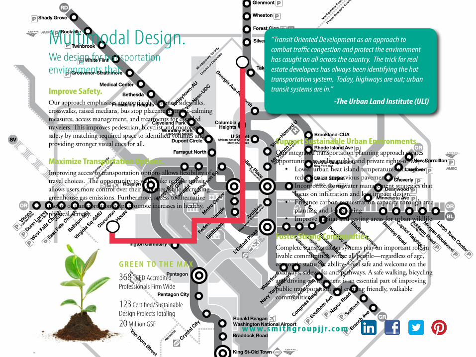
368 LEED Accredited Professionals Firm Wide
123 Certified/Sustainable Design Projects Totaling
20 Million GSF
G R E E N TO T H E M A X
Support Sustainable Urban Environments. Our integrated transportation planning approach creates opportunities to utilize public and private rights-of-way to:
• Lower urban heat island temperatures through a reduction in impervious pavement area.
• Incorporate stormwater management strategies that focus on infiltration and low impact design.
• Enhance carbon sequestration capacity through tree planting and landscaping.
• Improve habitat and resting areas for urban wildlife.
Foster Strong Communities. Complete transportation systems play an important role in livable communities, where all people—regardless of age, economic status, or ability—feel safe and welcome on the roadways, sidewalks and pathways. A safe walking, bicycling and driving environment is an essential part of improving public transportation and creating friendly, walkable communities.
“Transit Oriented Development as an approach to combat traffic congestion and protect the environment has caught on all across the country. The trick for real estate developers has always been identifying the hot transportation system. Today, highways are out; urban transit systems are in.”
-The Urban Land Institute (ULI)
Multimodal Design.We design for transportation environments that:
Improve Safety. Our approach emphasizes appropriately designed sidewalks, crosswalks, raised medians, bus stop placement, traffic-calming measures, access management, and treatments for disabled travelers. This improves pedestrian, bicyclist and motorist safety by matching required space to identified volumes and providing stronger visual cues for all.
Maximize Transportation Options. Improving access to transportation options allows flexibility of travel choices. The opportunity to walk, bike or take transit allows users more control over their expenses while decreasing greenhouse gas emissions. Furthermore, access to alternative modes of transportation helps promote increases in healthy, physical activity.
w w w. s m i t h g r o u p j j r. c o m

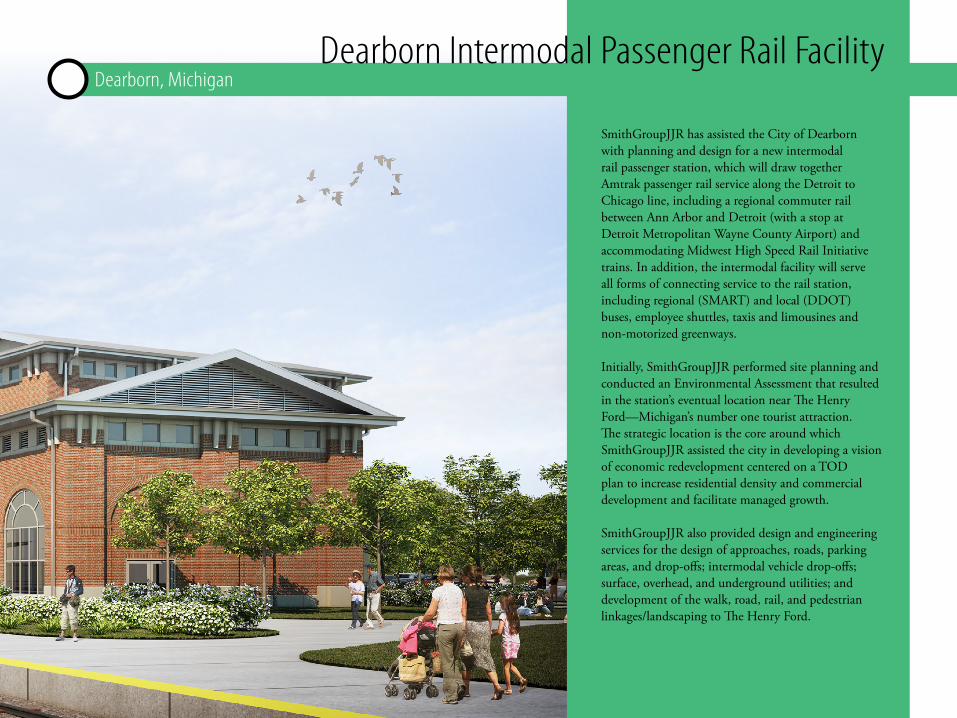
Dearborn Intermodal Passenger Rail FacilityDearborn, Michigan
SmithGroupJJR has assisted the City of Dearborn with planning and design for a new intermodal rail passenger station, which will draw together Amtrak passenger rail service along the Detroit to Chicago line, including a regional commuter rail between Ann Arbor and Detroit (with a stop at Detroit Metropolitan Wayne County Airport) and accommodating Midwest High Speed Rail Initiative trains. In addition, the intermodal facility will serve all forms of connecting service to the rail station, including regional (SMART) and local (DDOT) buses, employee shuttles, taxis and limousines and non-motorized greenways.
Initially, SmithGroupJJR performed site planning and conducted an Environmental Assessment that resulted in the station’s eventual location near The Henry Ford—Michigan’s number one tourist attraction. The strategic location is the core around which SmithGroupJJR assisted the city in developing a vision of economic redevelopment centered on a TOD plan to increase residential density and commercial development and facilitate managed growth.
SmithGroupJJR also provided design and engineering services for the design of approaches, roads, parking areas, and drop-offs; intermodal vehicle drop-offs; surface, overhead, and underground utilities; and development of the walk, road, rail, and pedestrian linkages/landscaping to The Henry Ford.
M a y w e s h o w y o u m o r e ?

Reimagine WashtenawWashtenaw County, Michigan
YPSILANTIANN ARBOR YPSILANTI TOWNSHIP
FOUNTAIN PLAZA
K MART
GLENCOECROSSING
GLENCOEHILLS
COUNTY FARM PARK
G1
ARBORLAND
PITTSFIELD TOWNSHIP
NO
RMA
L
MAU
LBET
SH
MA
PLE
FOST
ER
TORR
EY
DA
LTO
N
PITT
SFIE
LD
MA
NCH
ESTE
RSH
ERID
AN
PROPOSED BIKE FACILITIESIN ROAD BIKE LANES (BOTH SIDES OF STREET)
VEHICULAR TRAFFICE AADTRIGHT OF WAY
3450093’ - 100’
4640080’
43200100’
288002880080’
2690080’
2490080’
2600080’
2790080’73’
41000 52700100’ 100’
OA
KWO
OD
MA
NSF
IELD
HEW
ITT
GO
LFSI
DE
CARP
ENTE
R
YOST
PLAT
T
STADIU
M/WA
SHTE
NAW
SPLIT
HO
GBA
CK
US
23
HU
RON
PKW
Y
ROO
SEV
ELT
CORN
ELL
COU
RTLA
ND
BELL
EVIL
LE
BORD
ER T
O B
ORD
ER T
RAIL
FOU
NTA
IN P
LAZA
GLE
NCO
E H
ILLS
ARL
ING
TON
G3
G4 G5
G6
G7
G8G2
Transforming Washtenaw Avenue into a Vibrant Mixed-Use Corridor
Complete Streets Urban Design Sustainable Solutions Transit Economic Development
N
Scale: 1” = 250’
LEGENDCROSSING IMPROVEMENTS AT SIGNALIZED INTERSECTION (PER REIMAGINE)
CROSSING IMPROVEMENTS AT UNSIGNALIZED INTERSECTION (PER REIMAGINE)
SUPER STOP LOCATION (PER AATA 5 YEAR TRANSIT)
ALTERNATE SUPER STOP
POTENTIAL ROUNDABOUT LOCATIONGREEN INFRASTRUCTURE OPPORTUNITIES
NODE (PER REIMAGINE)Washtenaw Avenue is the primary transportation corridor linking the region’s job and education centers and the cities of Ann Arbor and Ypsilanti. Existing land use practices along this five-mile stretch have resulted in a sprawling and congested auto-centric development pattern limiting the ability to provide the high quality of place residents and visitors expect. The City of Ann Arbor, Pittsfield Township, Ypsilanti Township, and the City of Ypsilanti recognized Washtenaw Avenue’s potential to be transformed using smart growth and TOD principles and documented these in Vision for Washtenaw Avenue (2009).
In 2013, SmithGroupJJR was engaged by Washtenaw County to develop and expand upon the vision principles as the next step towards realizing a re-imagined Washtenaw Avenue. The work focused on embracing a complete streets approach to enhance the pedestrian, non-motorized and transit experience. A collaborative committee, representing each of the four communities, was engaged in a process to identify future road cross-sections, nodes of proposed revitalization and transit super-stop locations as part of the proposed corridor improvements. Applications of a road diet, narrow and wide boulevards, continuous buffered bicycle lanes and dedicated transit service were evaluated. Individually, each community evaluated adjacent land use policies that would provide the foundation for economic redevelopment.
SmithGroupJJR’s approach was based on a vision where land use and the pedestrian environment would dictate the quality of the road corridor. This project was funded through a Housing and Urban Development (HUD) Sustainable Communities Planning Grant.
I n t e r e s t e d i n m o r e ?

YPSILANTIANN ARBOR YPSILANTI TOWNSHIP
FOUNTAIN PLAZA
K MART
GLENCOECROSSING
GLENCOEHILLS
COUNTY FARM PARK
G1
ARBORLAND
PITTSFIELD TOWNSHIP
NO
RMA
L
MAU
LBET
SH
MA
PLE
FOST
ER
TORR
EY
DA
LTO
N
PITT
SFIE
LD
MA
NCH
ESTE
RSH
ERID
AN
PROPOSED BIKE FACILITIESIN ROAD BIKE LANES (BOTH SIDES OF STREET)
VEHICULAR TRAFFICE AADTRIGHT OF WAY
3450093’ - 100’
4640080’
43200100’
288002880080’
2690080’
2490080’
2600080’
2790080’73’
41000 52700100’ 100’
OA
KWO
OD
MA
NSF
IELD
HEW
ITT
GO
LFSI
DE
CARP
ENTE
R
YOST
PLAT
T
STADIU
M/WA
SHTE
NAW
SPLIT
HO
GBA
CK
US
23
HU
RON
PKW
Y
ROO
SEV
ELT
CORN
ELL
COU
RTLA
ND
BELL
EVIL
LE
BORD
ER T
O B
ORD
ER T
RAIL
FOU
NTA
IN P
LAZA
GLE
NCO
E H
ILLS
ARL
ING
TON
G3
G4 G5
G6
G7
G8G2
Transforming Washtenaw Avenue into a Vibrant Mixed-Use Corridor
Complete Streets Urban Design Sustainable Solutions Transit Economic Development
N
Scale: 1” = 250’
LEGENDCROSSING IMPROVEMENTS AT SIGNALIZED INTERSECTION (PER REIMAGINE)
CROSSING IMPROVEMENTS AT UNSIGNALIZED INTERSECTION (PER REIMAGINE)
SUPER STOP LOCATION (PER AATA 5 YEAR TRANSIT)
ALTERNATE SUPER STOP
POTENTIAL ROUNDABOUT LOCATIONGREEN INFRASTRUCTURE OPPORTUNITIES
NODE (PER REIMAGINE)
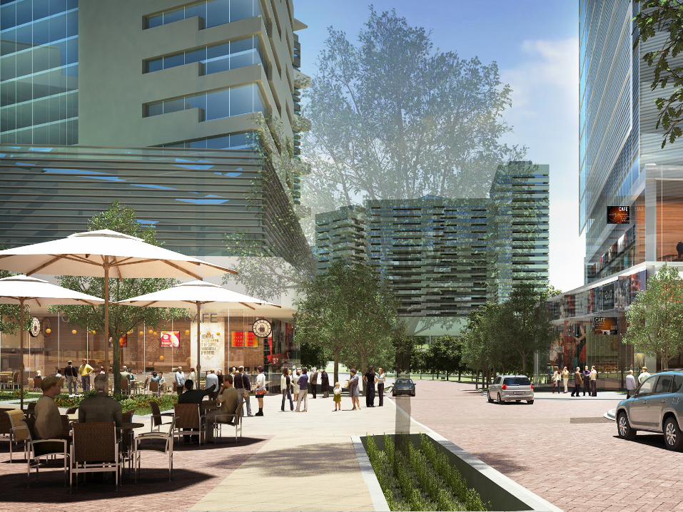

Scotts Run StationTysons Corner, Virginia
The suburban Washington DC community of Tysons Corner has an exceptional redevelopment opportunity within the DC Metropolitan area with the arrival of four new Metrorail Stations. SmithGroupJJR’s master plan for Cityline Partners’ properties at the new Tysons/McLean station will transform that area into a transit-oriented, mixed-use community with the Scotts Run Stream Valley Park at its heart.
The development plan introduces a new pedestrian-scaled grid of streets with an engaging mix of uses along Station Street, the development’s main avenue. A total of 17 new buildings are planned, including residential, office and retail uses along with a full-service hotel.
Scotts Run Station South will feature highly sustainable architecture, site, landscape, and stormwater design throughout. New buildings will be designed for energy efficiency, with minimum LEED-Silver certification for office and LEED certification for residential. The park will add another dimension of livability and sustainability to the area, featuring a restored stream, new trails and public open spaces. The result is a holistic vision for transforming this part of the suburban edge city into a true urban center.
M a y w e s h o w y o u m o r e ?
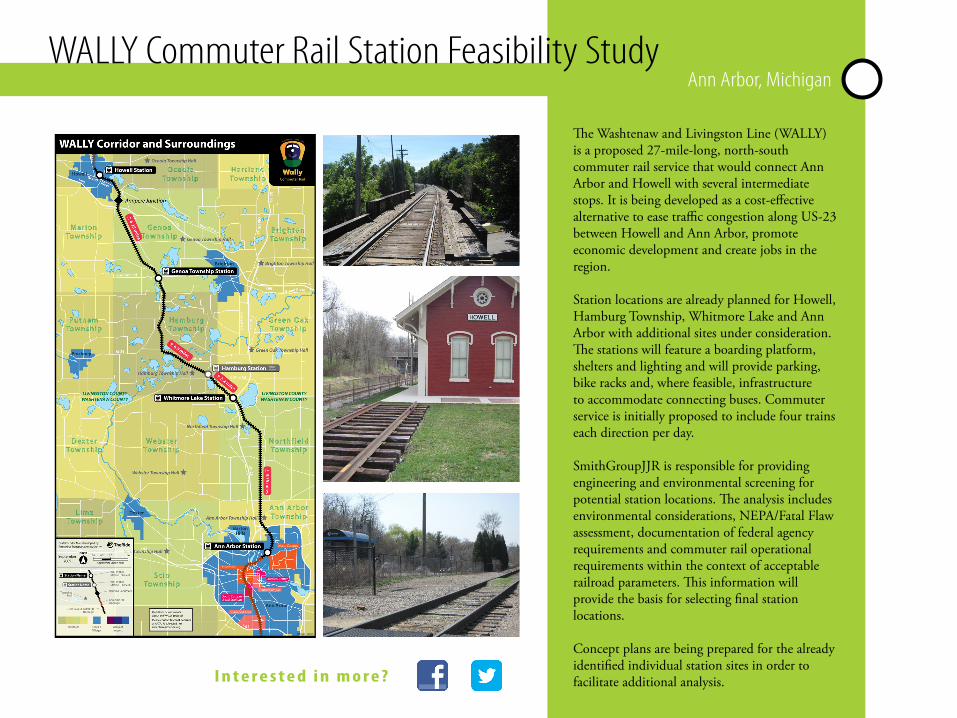
WALLY Commuter Rail Station Feasibility Study Ann Arbor, Michigan
The Washtenaw and Livingston Line (WALLY) is a proposed 27-mile-long, north-south commuter rail service that would connect Ann Arbor and Howell with several intermediate stops. It is being developed as a cost-effective alternative to ease traffic congestion along US-23 between Howell and Ann Arbor, promote economic development and create jobs in the region.
Station locations are already planned for Howell, Hamburg Township, Whitmore Lake and Ann Arbor with additional sites under consideration. The stations will feature a boarding platform, shelters and lighting and will provide parking, bike racks and, where feasible, infrastructure to accommodate connecting buses. Commuter service is initially proposed to include four trains each direction per day.
SmithGroupJJR is responsible for providing engineering and environmental screening for potential station locations. The analysis includes environmental considerations, NEPA/Fatal Flaw assessment, documentation of federal agency requirements and commuter rail operational requirements within the context of acceptable railroad parameters. This information will provide the basis for selecting final station locations.
Concept plans are being prepared for the already identified individual station sites in order to facilitate additional analysis.I n t e r e s t e d i n m o r e ?

Over the past few years, several projects have been planned and implemented in Detroit, including the Detroit East RiverWalk, Dequindre Cut, and Midtown Loop (all designed by SmithGroupJJR). While substantial in their individual contributions, collectively these projects lacked a capacity for connectivity that could make them successful from a city-wide network perspective. Master plans were put in place to identify these connections but funding for implementation was far beyond any individual expectation. The Federal “TIGER” 2012 grant program offered a way for the City, in collaboration with multiple non-profit organizations, to realize a true paradigm shift in establishing and implementing a collective vision.
SmithGroupJJR worked closely in partnership with the City and a group of non-profits to develop the concept of Link Detroit!—a series of multi-modal infrastructure improvements to create a non-motorized, environmentally proactive network. SmithGroupJJR is coordinating and leading the project initiatives to extend, and complete, the substantial investments already made in the development of greenways, streetscapes, and bicycle paths in Detroit.
In addition to providing these critically needed transportation connections, the project will generate opportunities for economic reinvestment and will improve the quality of life through sustainable green infrastructure improvements.
Link Detroit!Detroit, Michigan


L’Enfant PlazaWashington, DC
Originally conceived in the late 1960s, L’Enfant Plaza in Southwest Washington, DC, is a landmark site of mid-century modern urban planning. In addition to serving as a node and connector between the National Mall and Smithsonian Museums to the north and the Southwest Waterfront neighborhood to the south, L’Enfant Plaza’s Metrorail Station is the only station at which four of the five DC rail lines come together.
The existing 1.3 million-square-foot development is undergoing a major mixed-use transformation, tripling in size to add density and create a dynamic and sought-after neighborhood with enhanced public spaces and improved connectivity to the surrounding areas. The first step in the plan provides a refreshed retail hub to serve the existing community as well as draw consumers from one of the busiest metro stations in the region.
Additional redevelopment calls for renovation of the existing hotel and development of a new extended-stay hotel, a new residential building, new office buildings in the existing central plaza space and public spaces along a vibrant redeveloped 10th Street promenade.
Upon completion, the redeveloped and revitalized L’Enfant Plaza will more efficiently leverage this important transit node.
L o o k i n g f o r m o r e i n f o r m a t i o n ?

w w w . s m i t h g r o u p j j r . c o m
ANN ARBOR
CHICAGO
DALLAS
DETROIT
LOS ANGELES
MADISON
PHOENIX
SAN FRANCISCO
SHANGHAI, CHINA
WASHINGTON, DC
www.smithgroupjjr.com