mm Preparedm - Defense Technical Information Center ABSTRACT (Maximum 200 words) ... APC Argos APIB...
74
Naval Oceanographic Office Stennis Space Reference Publication Center RP 49 MS 39522-5001 May 1997 RP49 NAVOCEANO ACRONYM DICTIONARY TECHNICAL PUBLICATIONS Approved for public release; distribution is unlimited. ******! $ mm m Prepared under the authority of Commander Naval Meteorology and Oceanography Command
Transcript of mm Preparedm - Defense Technical Information Center ABSTRACT (Maximum 200 words) ... APC Argos APIB...

Naval Oceanographic Office Stennis Space Reference Publication Center RP 49 MS 39522-5001 May 1997
RP49
NAVOCEANO ACRONYM DICTIONARY
TECHNICAL PUBLICATIONS
Approved for public release; distribution is unlimited.
******!
$
mm m Prepared under the authority of Commander Naval Meteorology and Oceanography Command

FOREWORD
This document is a list of acronyms and abbreviations frequently used by the Naval Oceanographic Office (NAVOCEANO) and is designed to be an up-to-date, convenient reference.
In order to keep this document current, users are encouraged to forward comments, additions, deletions, and suggestions to NAVOCEANO Technical Publications/Graphics Division.
DIETER K. RUDOLPH Captain, U.S. Navy Commanding Officer
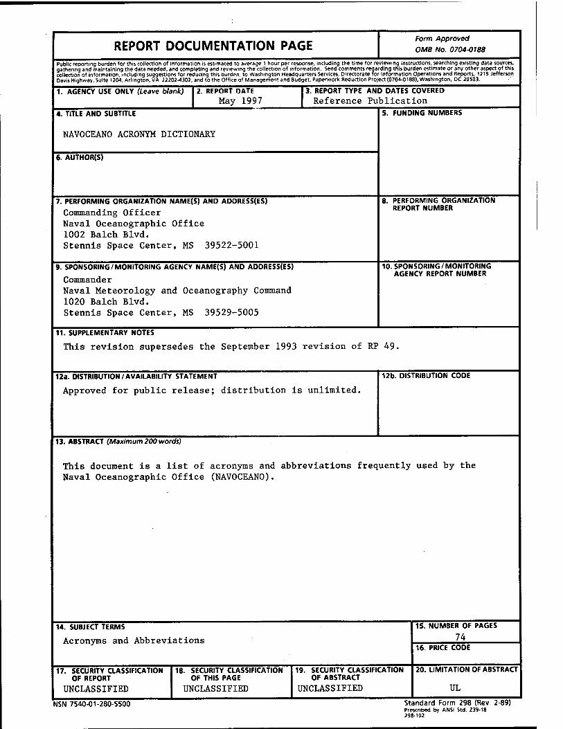
REPORT DOCUMENTATION PAGE Form Approved
OMB No. 0704-0188
Public reporting burden for this collection of information is estimated to average 1 hour per response, including the time for reviewing instructions, searching existing data sources, gathering and maintaining the data needed, and completing and reviewing the collection of information. Send comments regarding this burden estimate or any other aspect of this collection of information, including suggestions for reducing this burden, to Washington Headquarters Services, Directorate for Information Operations and Reports, 1215 Jefferson Davis Highway, Suite 1204, Arlington, VA 22202-4302, and to the Office of Management and Budget, Paperwork Reduction Project (0704-0188), Washington, DC 20503.
1. AGENCY USE ONLY (Leave blank) 2. REPORT DATE May 1997
3. REPORT TYPE AND DATES COVERED Reference Publication
4. TITLE AND SUBTITLE
NAVOCEANO ACRONYM DICTIONARY
6. AUTHOR(S)
5. FUNDING NUMBERS
7. PERFORMING ORGANIZATION NAME(S) AND ADDRESS(ES)
Commanding Officer Naval Oceanographic Office 1002 Balch Blvd. Stennis Space Center, MS 39522-5001
8. PERFORMING ORGANIZATION REPORT NUMBER
9. SPONSORING/MONITORING AGENCY NAME(S) AND ADDRESS(ES)
Commander Naval Meteorology and Oceanography Command 1020 Balch Blvd. Stennis Space Center, MS 39529-5005
10. SPONSORING/MONITORING AGENCY REPORT NUMBER
11. SUPPLEMENTARY NOTES
This revision supersedes the September 1993 revision of RP 49.
12a. DISTRIBUTION/AVAILABILITY STATEMENT
Approved for public release; distribution is unlimited. 12b. DISTRIBUTION CODE
13. ABSTRACT (Maximum 200 words)
This document is a list of acronyms and abbreviations frequently used by the Naval Oceanographic Office (NAVOCEANO).
14. SUBJECT TERMS
Acronyms and Abbreviations
15. NUMBER OF PAGES
74 16. PRICE CODE
17. SECURITY CLASSIFICATION OF REPORT
UNCLASSIFIED
18. SECURITY CLASSIFICATION OF THIS PAGE
UNCLASSIFIED
19. SECURITY CLASSIFICATION OF ABSTRACT
UNCLASSIFIED
20. LIMITATION OF ABSTRACT
UL
NSN 7540-01-280-5500 Standard Form 298 (Rev. 2-89) Prescribed by ANSI Std. Z39-18 298-102

ACRONYM LIST
A-Frame A-3 A-76 A/D AA AACS AAGP AAIS AAODL AAPHI/DV AAS
AASIR AASP AAW AAWC ABC ABFC ABS ABSS ACARS ACAT ACCAT ACCGRID ACCIS ACCTRACK ACD ACDS ACINT ACM ACMPM ACO ACS ACSAS ACSM ACSP ACTLOSS ACTS ACTVAST ACU ACW
- A-Shaped Hydraulic Device for Overboarding Equipment - POLARIS Missile - OMB Circular A-76 Re: Contracting Out - Analog-to-Digital - Active Adjunct - Automated Access Control System - Acoustic Analysis Guidance Product - Acoustic Automated Information System - Atmospheric Aerosols and Optics Data Library - Affirmative Action Plan for Handicapped Individuals/Disabled Veterans - (1) Acoustic Assessment System - (2) Advanced Automation System - Advanced Atmospheric Sounder and Image Radiometer - Aircraft ASW Search Patterns - Anti-Air Warfare - Anti-Air Warfare Coordinator - Advanced Base Capability - Advanced Based Functional Component - Airborne Bathymetric Survey - Airborne Bathymetric Survey System - Aeronautical Radio Communications Addressing Reporting System - Acquisition Category - Advanced Command Control Architectural Test-bed - Acoustic Command and Control Grid - Alpha Command and Control Information System (NATO) - Acoustic Command and Control Track - Automatic Call Distributor - Advanced Combat Data System - Acoustic Intelligence - Acoustic Current Meter - Analytic Countered Minefield Planning Model - Administrative Contracting Officer - Afloat Correlation System - Advanced Conformal Submarine Acoustic Sensor ■ American Congress on Surveying and Mapping - Activity Computer Security Plan ■ Active Loss - Automatic Cloud Tracking System ■ Active Astral ■ Aircraft Control Unit ■ Anti-Carrier Warfare

ADAC ADAS ADCAP ADCCP ADCIRC ADCP ADD ADEOS ADEPS ADFC ADI ADM ADP ADPE ADPSIS ADPSO ADPSSO ADRG ADS
ADT ADWS AE
AEAS
AEDC AEF AEL
AEM AEP AEPS AEAS AESD
AESOP AESS AEW AFCEA AFDIS AFGE AFGL AFGWC AFOS
- Attitude Determination and Control - AWOS/ASOS Data Acquisition System - Advanced Capability - Advanced Data Communications Control Protocol - Advanced Circulation - Acoustic Doppier Current Profiler - Acoustic Deception Device - Advanced Earth Observing Satellite - Automated Detection Prediction System - Altimetry Data Fusion Center - Air Defense Initiative - Advanced Development Model - Automated Data Processing J
- Automated Data Processing Equipment - Automated Data Processing Software Inventory System - Automated Data Processing Security Officer - Automated Data Processing System Security Officer - Arc Digitized Raster Graphics - (1) Advanced Deployable System - (2) Aegis Display System - Automatic Detection and Tracking - Automated Digital Weather Switch - (1) Applications Environment - (2) Automation Equipment - (1) Acoustic Environment Assessment System - (2) ASW Environmental Acoustic Support - Arnold Engineering Development Center - Atmosphere Environmental File - (1) Algorithm Enunciation Language - (2) Allowance Equipage List - Airborne Electromagnetic - Affirmative Employment Program - Automated Environmental Prediction System - ASW Environmental Acoustic Support - (1) Acoustic Environmental Support Detachment ■ (2) Advanced Electronics School Division ■ An Expert System for Shipboard Obscuration Prediction ■ Allied Environmental Support System ■ Airborne Early Warning ■ Armed Forces Communications and Electronics Association • Air Force Dial-In Subsystem ■ American Federation of Government Employees ■ Air Force Geophysics Laboratory ■ Air Force Global Weather Central ■ Automation of Field Operations and Services

AFP AG AG/SAG AGCM AGL AGS
AHIP AHOS AHP AHRS AI AIAA AICS AIG AIMS
AINS AIRDALE AIREM AIRS AIS
AISC AJ AJTWC ALBE ALCM ALDOT ALE ALFS ALMDS ALMEDS ALU ALWT AM AMAP AMC AMCC AMCM AMCR AMEC AMI AMMS
Annual Financial Plan Aerographer's Mate Activity Group/Sub-Activity Group Atmospheric Global Circulation Model Above Ground Level (1) Airborne Gravity System (2) Auxiliary General Survey ARPANET Host-IMP Protocol Automated Hydrologie Observing System Allied Hydrographie Publication Attitude/Heading Reference System Artificial Intelligence American Institute of Aeronautics and Astronautics AUTODIN Integrated Communications System Address Indicating Group (1) Acoustic Interference Monitor System (2) Active Interference Monitor System Airborne Integrated Navigation System Airborne Data Logging Environment
• Air Effective Measurement • Atmospheric Infrared Sounder • (1) Acoustic Intercept System • (2) Automated Information System • Assessment and Information Services Center ■ Anti-Jam ■ Alternate Joint Typhoon Warning Center Air Land Battlefield Environment
• Air Launched Cruise Missile Aircraft Launchable Deep Ocean Transponder
■ Annual Loss Expectancy ■ Airborne Low Frequency Sonar ■ Airborne Laser Mine Detection System • Aleutian Meteorological Data System ■ Antenna Loading Unit ■ Advanced Lightweight Torpedo ■ Amplitude Modulation ■ Acoustic Model Applications Project ■ Atlantic Marine Center ■ Ashore Mobile Communications Center ■ Airborne Mine Countermeasures ■ Alternate Management Control Reviews • Acoustic Model Evaluation Committee ■ Active Microwave Instrument ■ Automated Manpower Management System
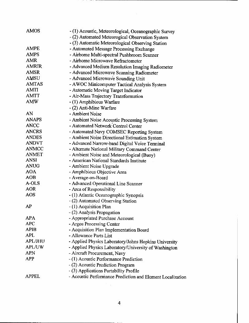
AMOS
AMPE AMPS AMR AMRIR AMSR AMSU AMTAS AMTI AMTT AMW
AN ANAPS ANCC ANCRS ANDES ANDVT ANMCC ANMET ANSI ANUG AOA AOB A-OLS AOR AOS
AP
APA APC APIB APL APL/JHU APL/UW APN APP
APPEL
- (1) Acoustic, Meteorological, Oceanographic Survey - (2) Automated Meteorogical Observation System - (3) Automatic Meteorological Observing Station - Automated Message Processing Exchange - Airborne Multi-spectral Pushbroom Scanner - Airborne Microwave Refractometer - Advanced Medium Resolution Imaging Radiometer - Advanced Microwave Scanning Radiometer - Advanced Microwave Sounding Unit - AWOC Minicomputer Tactical Analysis System - Automatic Moving Target Indicator ■ Air-Mass Trajectory Transformation - (1) Amphibious Warfare • (2) Anti-Mine Warfare ■ Ambient Noise ■ Ambient Noise Acoustic Processing System ■ Automated Network Control Center ■ Automated Navy COMSEC Reporting System ■ Ambient Noise Directional Estimation System ■ Advanced Narrow-band Digital Voice Terminal ■ Alternate National Military Command Center ■ Ambient Noise and Meteorological (Buoy) ■ American National Standards Institute ■ Ambient Noise Upgrade ■ Amphibious Objective Area ■ Average-on-Board ■ Advanced Operational Line Scanner ■ Area of Responsibility ■ (1) Atlantic Oceanographic Synopsis (2) Automated Observing Station
■ (1) Acquisition Plan (2) Analysis Propagation Appropriated Purchase Account Argos Processing Center Acquisition Plan Implementation Board Allowance Parts List Applied Physics Laboratory/Johns Hopkins University Applied Physics Laboratory/University of Washington Aircraft Procurement, Navy (1) Acoustic Performance Prediction (2) Acoustic Prediction Program (3) Applications Portability Profile Acoustic Performance Prediction and Element Localization
4

APR
APRB APS
APT AQL ARD AREC ARG ARIADNE ARIS ARL ARL/UT ARM
ARMS ARNNS ARP ARPANET ARPGEN ARQ ARRCS ARSR ARTCC ASAC ASAPS
ASC ASCII ASCM ASCOMM ASCS ASDAPS ASDAR ASDP ASEPS ASERT ASFS ASI ASID
(1) Acoustic Product Request (2) Agency Procurement Request (3) Automated Product Request Acquisition Plan Review Board (1) Acoustic Processing System (2) Acoustic Projection System (3) Afloat Planning System (4) Atmospheric Properties System (5) Auxiliary Propulsion System Automatic Picture Transmission Acceptable Quality Level Automated Release Date Air Element Coordinator Amphibious Ready Group Deployable Fiber Optic Surveillance System Atmospheric Research and Instrumentation System Applied Research Laboratory Applied Research Laboratory/University of Texas (1) Anti-Radiation Missile (2) Atmospheric Radiation Measurement Automation Resource Management System Airborne Receiver, Navy Navigation Satellite Algorithm Research Panel Advanced Research Project Agency Network Atmospheric Refractivity Profile Generator Automatic Response to Query Air Raid Reporting Control Ship Air Route Surveillance Radar Air Route Traffic Control Center Air ASW Controller (1) Active Sonar Acquisition Processing System (2) Advanced Surveillance Acoustic Prediction System Automated (AUTODIN) Switching Center American Standard Code for Information Interchange Anti-Ship Cruise Missile Antisubmarine Warfare Communications Acoustic Sediment Classification System Acoustic Surveillance Data Acquisition and Processing System Aircraft Satellite Data Relay Abbreviated System Decision Paper
• Automated Signal Excess Prediction System ■ ASTRAL System for the Estimation of Radial Transmission ■ Automated Shipboard Forecasting System ■ Air-Sea Interaction ■ Air-Sea Interaction Drifting (Buoy)

ASIS ASM
ASMMR ASN ASNR ASO ASOPT ASOS ASPA ASPS ASPSHD ASPSVP ASR
ASRAP ASRAPC ASRAPV ASROC ASRS ASST ASTDA ASTRAL ASTRO ASU ASUW ASUWC ASW ASWC ASWCS ASWCCS ASWEPS ASWEX ASWIXS ASWM ASWOC ASWOM ATAC ATARS ATC
ATCF ATCM ATCS
- Acoustic Station Inventory System - (1) Advanced Sea Mine - (2) Air-to-Surface Missile - Advanced Scanning Multi-Channel Microwave Radiometer - Assistant Secretary of the Navy - Assistant Senior NAVOCEANO Representative - Aviation Supply Office - Acoustic Sensor Optimization - Automated Surface Observing System - Aircraft Series Program Adjustment - Airborne Signal Processing System - ASEPS Historical Shipping Densities - ASEPS Sound Velocity Profiles - (1) Airport Surveillance Radar - (2) Auxiliary Submarine Rescue - Acoustic Sensor Range Prediction - Acoustic Sensor Range Prediction Compacted - Acoustic Sensor Range Prediction Vertical Line Array DIFAR - Antisubmarine Rocket - Automated Stopper Referral System - Atmospheric Simulation for Sensitivity Testing - Analytic Strike Timing Decision Aid - ASEPS Transmission Loss Model - Stellar Azimuth Observed at Geodetic Control Points - Approval for Service Use - Antisurface Warfare - Antisurface Warfare Commander or Coordinator - Antisubmarine Warfare - Antisubmarine Warfare Commander or Coordinator • Antisubmarine Warfare Control System - Antisubmarine Warfare Center Command and Control System ■ Antisubmarine Warfare Environmental Prediction System ■ Antisubmarine Warfare Exercise ■ Antisubmarine Warfare Information Exchange System ■ Antisubmarine Warfare Module ■ Antisubmarine Warfare Operations Center ■ Antisubmarine Warfare Operations Module ■ Air Transportable Acoustic Communication ■ Advanced Tactical Airborne Reconnaissance System (1) Air Target Chart
• (2) Air Traffic Control (3) Automated Technical Control Automated Tropical Cyclone Forecasting Advanced Tropical Cyclone Model Automated Test and Calibration System

ATDS - Air Tactical Data System ATE - Applied Tomography Experiment ATF - (1) Amphibious Task Force
- (2) Auxiliary, Tug, Fleet ATIR - Annual Training Input Requirement ATLAS - Acoustic Transmission Loss Acquisition System ATLID - Atmospheric LIDAR ATLIS - Arctic Thin Line Instrumented System ATM - Asynchronous Transfer Mode ATO - (1) Afloat Training Organization
- (2) Air Tasking Order ATOX - Air Tasking Order Express ATP - Allied Tactical Publication ATSR-M - Along-Track Scanning Radiometer-Microwave ATV - Advanced Tethered Vehicle AUAMP - Advanced Underwater Acoustic Modeling Project AUSS - Advanced Unmanned Search System AUTEC - Atlantic Underwater Test and Evaluation Center AUTOCAT - Automatic Collection and Transmission AUTODIN - Automatic Digital Network AUTOSEVOCOM - Automatic Secure Voice Communication Network AV - Audiovisual AVHPvR - Advanced Very-High-Resolution Radiometer AWACS - Airborne Warning and Control System AWDL - Aviation Weather Development Laboratory AWDS - Automated Weather Distribution System AWIPS - Advanced Weather Interactive Processing System AWIS - Automated Weather Information System AWN - Automated Weather Network AWOC - All-Weather Operations Committee AWOS - Automated Weather Observing System AWS - Air Weather Service AXBT AXCTD AXSV
Airborne Expendable Bathythermograph Airborne Expendable CTD Airborne Expendable Sound Velocimeter
-B
BAFO BALWINDS BARCAP BAS
BB BB/ODT
Best and Final Offer Ballistic Winds Barrier Combat Air Patrol (1) Bathy Accuracy Summary (2) BLUB/ANUG (Editing and Quality Control) System Bottom Bounce Bottom Bounce/Omni-Directional Transmission

BBADCP BBS BB/TF BCR BCST BDI BDLS BDR BDSD BDSL BDST BEAMS BEP BEPC BER BERT BESEP BF BFC2 BFI BFIT BFR BFRL BG BGM BGPHES-ST BGS
BGV BIOLITE BISTRV BIT BITE BITS
BIU BLERT BLKDT BLOS BLUG BMO BNC BNPC BOAC BOAT
■ Broadband Acoustic Doppler Curent Profiler - Bulletin Board System ■ Bottom Bounce/Triple Frequency ■ Benefit/Cost Ratio ■ Broadcast ■ Bearing Deviation Indicator ■ Boat Data Logging System ■ Basic Data Report ■ Bathymetric Depth Storage Disk ■ Bathymetric Depth Supplementary Listing ■ Bathymetric Depth Storage Tape ■ Bathymetric Editing, Analysis, and Matrixing System ■ Back-End Processor ■ Black Employment Program Coordinator ■ Bit Error Rate • Bit Error Rate Test • Base Electronic Systems Engineering Plan ■ Battle Force ■ Battle Force Command and Control ■ Bearing Frequency Indicator ■ Battle Force Inport Training ■ Basic Facility Requirement ■ Basic Facilities Requirements List • Battle Group ■ Bell Gravity Measurement • Battle Group Passive Horizon Extension System - Surface Terminal (1) Bell Gravity System
■ (2) British Geological Survey ■ Battle Group Vulnerability • Underway Photometer System • Bistatic Reverberation Built-in Test Built-in Test Equipment (1) Base Information Transfer System (2) Binary Digits Bus Interface Unit Block Error Rate Test Block Data Beyond Line of Sight Bottom Loss Upgrade British Meteorological Office Bathymetric Navigation Chart Bathymetric Navigation Planning Chart Billing Office Accounting Code Basic Oceanography Accession Training
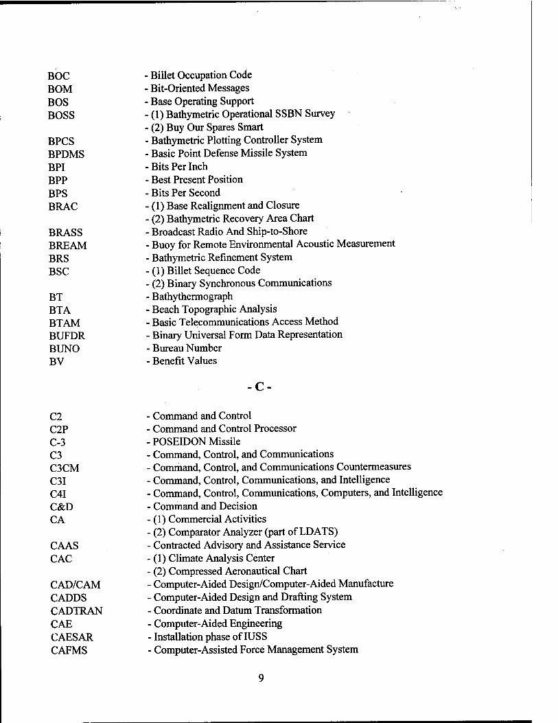
BOC BOM BOS BOSS
BPCS BPDMS BPI BPP BPS BRAC
BRASS BREAM BRS BSC
BT BTA BTAM BUFDR BUNO BV
Billet Occupation Code Bit-Oriented Messages Base Operating Support (1) Bathymetric Operational SSBN Survey (2) Buy Our Spares Smart Bathymetric Plotting Controller System
■ Basic Point Defense Missile System ■ Bits Per Inch • Best Present Position • Bits Per Second • (1) Base Realignment and Closure ■ (2) Bathymetric Recovery Area Chart ■ Broadcast Radio And Ship-to-Shore ■ Buoy for Remote Environmental Acoustic Measurement • Bathymetric Refinement System ■ (1) Billet Sequence Code ■ (2) Binary Synchronous Communications ■ Bathythermograph - Beach Topographic Analysis ■ Basic Telecommunications Access Method - Binary Universal Form Data Representation - Bureau Number - Benefit Values
-C
C2 C2P C-3 C3 C3CM C3I C4I C&D CA
CAAS CAC
CAD/CAM CADDS CADTRAN CAE CAESAR CAFMS
Command and Control Command and Control Processor POSEIDON Missile Command, Control, and Communications Command, Control, and Communications Countermeasures Command, Control, Communications, and Intelligence Command, Control, Communications, Computers, and Intelligence Command and Decision (1) Commercial Activities (2) Comparator Analyzer (part of LDATS)
• Contracted Advisory and Assistance Service (1) Climate Analysis Center
■ (2) Compressed Aeronautical Chart ■ Computer-Aided Design/Computer-Aided Manufacture ■ Computer-Aided Design and Drafting System ■ Coordinate and Datum Transformation ■ Computer-Aided Engineering ■ Installation phase of IUSS ■ Computer-Assisted Force Management System
CAIMS CALOW CAMS CANOES CANTRAC CAP
CAPTOR CARDS CARIS CARMEDS CARS CART CAS CASCAN CASCOR CASE
CASR CASREP CASS CASTAR CAT CAU CAWIS CAWSS CBD CBL CBR CBS CCB CCC
CCCO CCD CCITT CCS CCTV CCWS CD-ROM CD
CDA CDAS
- Conventional Ammunition Integrated Management System - Contingency Area and Limited Objective Warfare - Communications Area Master Station - Computer-Assisted Naval Oceanography Education System - Catalog of Naval Training Courses - (1) Combat Air Patrol - (2) Computer Acquisition Program - Encapsulated Torpedo (a Mine System) - Create a Refractivity Data Set - Computer-Assisted Resource Information System - Caribbean Meteorological Data System - COMSEC Automated Reporting System - Control Alert and Reporting Terminal - Committee for Aviation Services - Casualty Canceled - Casualty Correction Report - (1) Composite ASW Search Evaluation - (2) Computer-Aided Software Engineering - Caribbean States Region (HYCOOP Program) - Casualty Summary Report - Command Activated Sonobuoy System - Computer-Aided Sonar Tactical Recommendations - Clear Air Turbulence - Control and Analysis Unit - Committee on Automated Weather Information Systems - Crisis Action Weather Support System - Communication Buffer Device - Computer-Based Learning - Chemical, Biological, Radiological - Committee for Basic Services - Configuration Control Board - (1) CINC Command Center ■ (2) Configuration Control Center - Committee on Climatic Changes and the Ocean - Chaff Corridor Density ■ Consultative Committee on International Telephony and Telegraphy ■ Consolidated Communication System ■ Closed Circuit Television - Common Cryptologic Workstation • Compact Disk Read-Only Memory ■ (1) Compact Disks ■ (2) Computer Disks • (3) Counter Detection ■ Command and Data Acquisition ■ Command Data Acquisition Station
10
CDC CDDF CDR CDRL CDS
CEAP CEAS
CEB CEEMS CEL CEP CERC CERS CFE CFLOS CFOT CGA CGM CGMS CHADIS CHAFFROC CHATRA CHBDL-ST CHMS CHOP CI CIB CIC CICA CICS CIDE CIDREP CIESIN CIM CIMP CIMREP CIN CINC CIO CIP CIWS CIVPERS CIVSUB
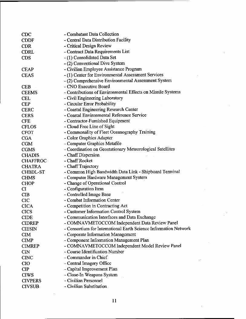
Combatant Data Collection Central Data Distribution Facility Critical Design Review Contract Data Requirements List (1) Consolidated Data Set (2) Conventional Dive System Civilian Employee Assistance Program (1) Center for Environmental Assessment Services (2) Comprehensive Environmental Assessment System CNO Executive Board Contributions of Environmental Effects on Missile Systems Civil Engineering Laboratory Circular Error Probability Coastal Engineering Research Center Coastal Environmental Reference Service Contractor-Furnished Equipment Cloud Free Line of Sight Commonality of Fleet Oceanography Training Color Graphics Adapter Computer Graphics Metafile Coordination on Geostationary Meteorological Satellites Chaff Dispersion Chaff Rocket Chaff Trajectory Common High Bandwidth Data Link - Shipboard Terminal Computer Hardware Management System Change of Operational Control Configuration Item Controlled Image Base Combat Information Center Competition in Contracting Act Customer Information Control System Communication Interfaces and Data Exchange COMNAVMETOCCOM Independent Data Review Panel Consortium for International Earth Science Information Network Corporate Information Management Component Information Management Plan COMNAVMETOCCOM Independent Model Review Panel Course Identification Number Commander in Chief Central Imagery Office Capital Improvement Plan Close-In Weapons System Civilian Personnel Civilian Substitution
11

CJCS CJTF CLF CLI CM
CMAS CMB CMC
CMCC CME CMI CMIP CMIS CMM CMO CMOD CMP CMS CMW CNRI COAP COAST COBRA COD CODAG CODAS COE
COEP COES COM COMEDS COMET
COMINT COMM MOD COMPASS COMPTUEX COMSAT COMSEC CONDIGS CONEX
- Chairman, Joint Chiefs of Staff - Commander, Joint Task Force - Commander Landing Force - Communications Line Interface - (1) Configuration Management - (2) Corrective Maintenance - (3) Current Meter - Circular Map Accuracy Standard - Configuration Management Board - (1) Consolidated Maintenance Contract - (2) Correspondence/Material Control - Classified Material Control Center - Community Modeling Experiment - Contamination Monitor Instrument - Command Model Installation Program - Configuration Management Information System - Commission for Marine Meteorology - Configuration Management Office - Compact Meteorological and Oceanographic Drifting (Buoy) - Configuration Management Plan - Communications Management System - Contel Meteorological Workstation - Corporation for National Research Initiatives - Center for Ocean Analysis and Prediction - Coastal Optics and Spill Tracking - Coastal Battlefield Reconnaissance and Analysis - Carrier Onboard Delivery - Combined Diesel and Gas - Common Oceanographic Data Archival System - (1) Center of Expertise - (2) Common Operating Environment - Cooperative Education Program - Committee for Operational Environmental Satellites - Computer Output Microfilm - CONUS Meteorological Data System - Cooperative Program for Operational Meteorology Education and
Training - Communications Intelligence - Communication Module - Computer-Assisted Search Series - Composite Training Unit Exercise - Communication Satellite - Communications Security - CONUS Digital Graphics System - Container Export
12

CONGRATS - Continuous Gradient Ray Tracing System CONOPS - Concept of Operations CONUS - Continental United States COOP - (1) Cooperative Oceanographic Observation Program
- (2) Craft of Opportunity COP - Continuation of Pay COPR - Combined Operational Performance Requirement COR - (1) Circular of Requirements
- (2) Condition of Readiness - (3) Contracting Officer's Representative
COSAL - Coordinated Shipboard Allowance List COSMOS - Committee on SONAR Model Standards COTR - Contracting Officer's Technical Representative COTS - Commercial Off-the-Shelf COVER - EM Coverage Diagram CP - Critical Point CPA - Closest Point of Approach CPCI - Computer Program Configuration Item CPE - (1) Computer Performance Evaluation
- (2) Customer Premises Equipment CPHC - Central Pacific Hurricane Center CPI - (1) Characters-Per Inch
- (2) Civilian Personnel Instruction CPRRS - Civilian Personnel Resource Reporting System CPS - Characters Per Second CPT - Common Production Tools CPU - Central Processing Unit CR - Change Request CRA - Continuing Resolution Authority CRADA - Cooperative Research and Development Agreement CRATT - Covered Radio Teletype CRB - Configuration Review Board CRC - Cyclic Redundancy Checksum CRADA - Cooperative Research and Development Agreement CRLCMP - Computer Resources Life Cycle Management Plan CRS - Command Read-out Site (Station) CRT - Cathode Ray Tube CS - (1) Color Scanner
- (2) Computer Software CSCI - Computer Software Configuration Item CSEF - Committee for Space Environment Forecasting CSG - Cryptologic Support Group CSM - Continental Shelf Mine CSMS - Computer Software Management System CSN - COMSAT Service Network
13
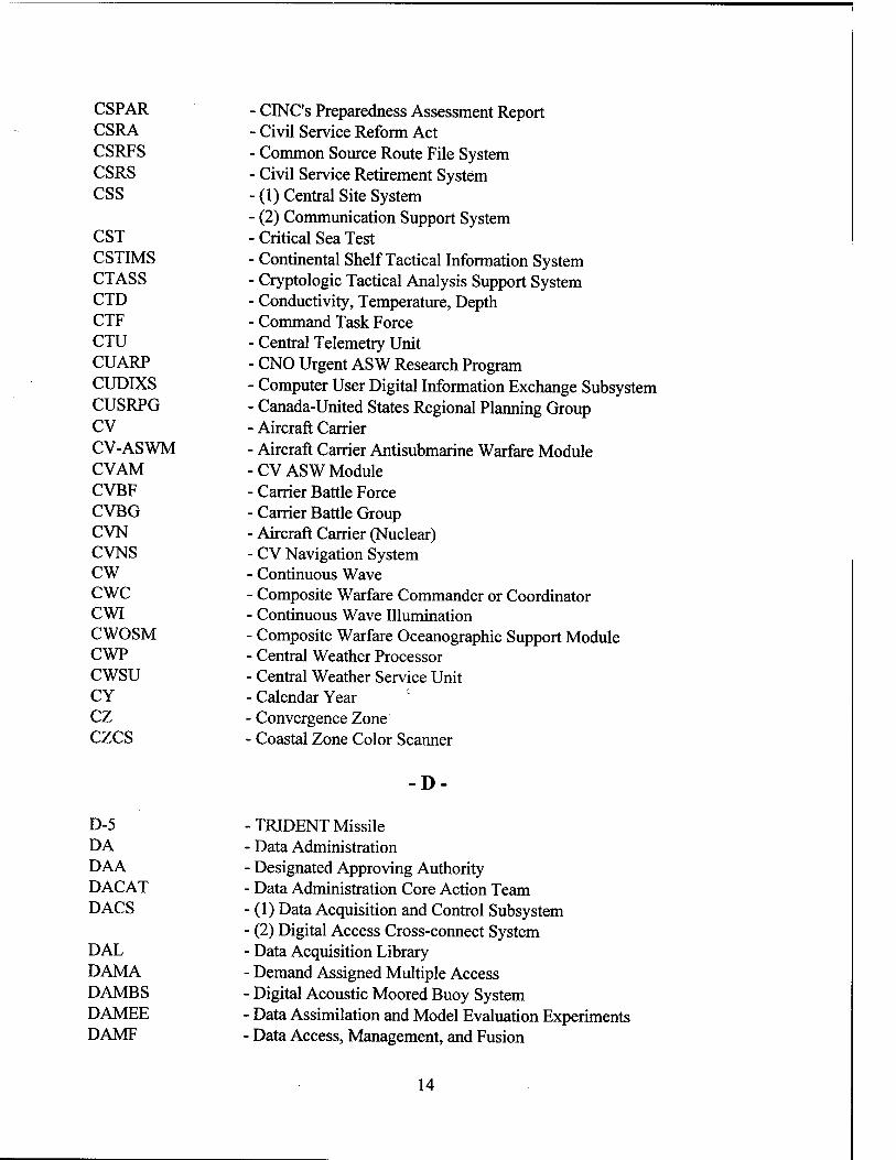
CSPAR CSRA CSRFS CSRS CSS
CST CSTIMS CTASS CTD CTF CTU CUARP CUDIXS CUSRPG CV CV-ASWM CVAM CVBF CVBG CVN CVNS cw cwc CWI CWOSM CWP cwsu CY cz czcs
- CINC's Preparedness Assessment Report - Civil Service Reform Act - Common Source Route File System - Civil Service Retirement System - (1) Central Site System - (2) Communication Support System - Critical Sea Test - Continental Shelf Tactical Information System - Cryptologic Tactical Analysis Support System - Conductivity, Temperature, Depth - Command Task Force - Central Telemetry Unit - CNO Urgent ASW Research Program - Computer User Digital Information Exchange Subsystem - Canada-United States Regional Planning Group - Aircraft Carrier - Aircraft Carrier Antisubmarine Warfare Module -CV ASW Module - Carrier Battle Force - Carrier Battle Group - Aircraft Carrier (Nuclear) - CV Navigation System - Continuous Wave - Composite Warfare Commander or Coordinator - Continuous Wave Illumination - Composite Warfare Oceanographic Support Module - Central Weather Processor - Central Weather Service Unit - Calendar Year - Convergence Zone - Coastal Zone Color Scanner
D-
D-5 DA DAA DACAT DACS
DAL DAMA DAMBS DAMEE DAMF
■ TRIDENT Missile ■ Data Administration - Designated Approving Authority ■ Data Administration Core Action Team ■ (1) Data Acquisition and Control Subsystem ■ (2) Digital Access Cross-connect System ■ Data Acquisition Library ■ Demand Assigned Multiple Access ■ Digital Acoustic Moored Buoy System ■ Data Assimilation and Model Evaluation Experiments • Data Access, Management, and Fusion
14

DAMOD - Data Management Module DANES - Directional Ambient Noise Estimation System DAO - Defense Accounting Office DARDC - Device for Automatic Remote Data Collection DARIC - Defense Automation Resource Information Center DARPA - Defense Advanced Research Projects Agency DART - Data Assimilation Research and Transition DAT - Digital Audio Tape DAXBT - Deep Airborne Expendable Bathythermograph dB - Decibel DBA - (1) Data Base Administration
- (2) Despin Bearing Assembly DBCP - Drifting Buoy Cooperation Panel DBD - Data Base Description DBDB - Digital Bathymetric Data Base DBDB-5 - Digital Bathymetric Data Base - 5-Minute Resolution DBDB-C - Digital Bathymetric Data Base - Confidential DBDB-C-RET - DBDB-C Data Retrieval DBDB-S - Digital Bathymetric Data Base - Secret DBDB-V - Digital Bathymetric Data Base - Variable DBE - Data Base Engine DBM - Data Base Management or Manager DBMS - Data Base Management System DBNPC - Digital BNPC DBOF - Defense Business Operating Fund DC - Data Communications DCA - Defense Communications Agency DCAA - Defense Contract Audit Agency DC APS - Data Collection and Processing System DCE - (1) Data Circuit-terminating Equipment
DCEC DCIC DCP
DCPI DCPLS DCPR DCPS DCS
DCTN DCW DDM
(2) Despin Control Electronics Defense Communications Engineering Center Discrimination Complaints Investigation Component (1) Data Collection Platform (2) Dedicated Communications Processor (3) Development Concept Paper Data Collection Platform Interrogation Data Collection and Platform Location System Data Collection Platform Reply Defense Civilian Payroll System (1) Data Collection System (2) Defense Communications System
■ Defense Commercial Telecommunications Network ■ Digital Chart of the World • Doppler-Density Matrix
15

DDN
DDRS DDS DEA. DEC DECCO DECM DEEOO DEF DF DFAD DFAR DFARS DFAS DFD DFS DFWP DGDEM DGPS DHI DHS DI DIAMC DICASS DIFAR DIFAS DIFAX DIMUS DIN DIPC DIPS DIRSSP DIS DISA DISCO DISHIDROS
DISN DISNET DISSPLA DLC DLRP DLSC DMA
- (1) Defense Data Network - (2) Digital Data Network - Defense Data Repository System - Digital Data System - Data Exchange Agreement - Digital Equipment Corporation - Defense Commercial Communications Office - Defensive Electronic Countermeasures - Deputy Equal Employment Opportunity Officer - Data Exchange Format - Direction Finding - Digital Feature Analysis Data - Defense Federal Acquisition Regulation - Defense Federal Acquisition Regulation Supplement - Defense Finance and Accounting Service - Data Flow Diagram - Direct Fleet Support - Drug-Free Workplace - Dynamic Generalized Digital Environmental Model - Differential Global Positioning System - Defense Hydrographie Initiative - Data Handling System - Directivity Index - Defense Intelligence Agency, Mapping and Charting - Directional Command Active Sonobuoy System - Directional Frequency Analysis and Recording - Digital Ice Forecasting and Analysis System - Digital Facsimile - Digital Multi-Unit Steering - Data Identification Number - Disabled Individuals Program Coordinator - Digital Image Processing System - Director, Strategic Systems Program Office - Defense Investigative Service - Defense Information System Agency ■ Defense Industrial Security Clearance Office ■ Dinas Hidro-Oseanografi (Indonesian Navy Hydrographie/
Oceanographic Service) ■ Defense Information Systems Network ■ Defense Integrated Secure Network ■ Display Integrated Software System and Plotting Language ■ Data Link Processor ■ Data Link Reference Point • Defense Logistics Services Center ■ Defense Mapping Agency
16

DMAAC DMACSC DMAHTC DMAP DMARAS DMARS DMASC DMCM DMI DMINSS DMP DMPvD DMS
DMSO DMSP DMSS DNC DNI DOBS DOC DOD DODIIS DODINST DOD-STD DOP DORI DOS DOSL DPF DPG DPI DPIIS DPN DPS
DPSDBO DPSR DPSS DR
DRB DRIBU DRIS
Defense Mapping Agency Aerospace Center Defense Mapping Agency Combat Support Center Defense Mapping Agency Hydrographie/Topographie Center Digital MC&G Analysis Program Defense Mapping Agency Requirements Analysis System Digital METOC and Acoustic Reference System
■ DMA Systems Center • Digital Mine Countermeasures • Depot Maintenance Interservice ■ Depot Maintenance Interservice New Start Study ■ Direct Measurement Program ■ Defense Management Review Decision ■ (1) Defense Mapping School • (2) Defense Message System ■ (3) Distance Measuring System ■ Defense Modeling and Simulation Office ■ Defense Meteorological Satellite Program ■ Data Management Support System - Digital Nautical Chart ■ Director of Naval Intelligence - Digital Ocean Bottom Seismometer - Department of Commerce - Department of Defense - Department of Defense Intelligence Information System - Department of Defense Instruction - DOD Standard - Designated Overhaul Point - Deep Ocean Relocatable Island - Disk Operating System - Diurnal Ocean Surface Layer - Data Processing Facility - Data Point Generator - Data Processing Installation - Data Processing Installation Information System - Distributed Processing Network - (1) Display Processing System - (2) Distributed Processing System - Defense Printing Service Detachment Branch Office - Distributed Processing System Replacement - Data Processing and Services Subsystem - (1) Dead Reckoning - (2) Depth Required - Defense Resources Board - Drifting Buoy - Defense Regional Interservice Support
17

DRMO DROLS DROLSTR DROLSWU DRS DRTS DRU DS
DSAA DSBN DSBNPC DSC DSCA DSCS DSD DSDP DSG DSL DSN DSNETI DSO DSOAR DSPL DSR DSRV DSS DSSCS DSTB DSV DSVSS DTAGS DTAMS DTC DTE DTED DTIC DTR DTSS DUAT DVAL DWG DX
- Defense Reutilization and Marketing Office - Defense RDT&E On-Line Systems - DROLS Technical Report - DROLS Work Unit - Data Refinement System - Defense Regional Telecommunications System - Data Recovery Unit - (1) Direct Support - (2) Dwell Sounding - Defense Security Assistance Agency - Discrete Shipping Beam-Noise Model - Digital Source Bathymetric Navigation Planning Chart - Deep Sound Channel - Deep Sound Channel Axis - Defense Satellite Communication System - Digital Sharing Device - Deep Sea Drilling Program - Data Systems Group - Deep Scattering Layer - Defense Switched Network - Defense Secure Network I ■ Designated Senior Official - Dynamic Sonar Ocean Acoustic Response ■ Digital Signal Processing Library ■ Defense Software Repository • Deep Submergence Rescue Vehicle ■ Decision Support System ■ Defense Special Security Communications System ■ Direct Support Tactical Broadcast ■ Deep Submergence Vehicle • Deep Submergence Vehicle Support Ship ■ Deep Towed Array Geophysical System ■ Document Tracking and Management System ■ Desk Top Computer ■ Data Terminal Equipment Digital Terrain Elevation Data Defense Technical Information Center Digital Tape Recorder Data Transmission from Survey Ships Direct User Access Terminal D-Values Data Working Group Depth Excess
18

-E-
E-IMET - Expanded International Military Education and Training E-MAIL - Electronic Mail EA - Economic Analysis EAIDS - Environmental Acoustic Interactive Data System EARS - Environmental Acoustic Recording System EASTPAC - Eastern Pacific EC - Engineering Change ECL - Executive Control Language ECLIPS - Expanded Calculator Link Processing System ECCM - Electronic Counter-Countermeasures ECM - Electronic Countermeasures ECMOP - Experimental Center for Mesoscale Ocean Prediction ECMWF - European Center for Medium-range Weather Forecasts ECOR - Engineering Committee on Oceanic Resources ECORD - Experimental Computer-based Oceanographic Requirements Database ECP - Engineering Change Proposal ECWG - Environmental Communications Working Group EDA - Environmental Decision Aid EDBD - Environmental Data Base Directory EDC - Employee Development Course EDH - Evaporation Duct Height EDI - Electronic Data Interchange EDIS - Environmental Data and Information Service EDM - Engineering Development Model EDME - Electronic Distance Measuring Equipment EDORB - Edit Orbital Element Set EDP - Electronic Data Processor EDR - Environmental Data Record EEI - Essential Element Information EEO - Equal Employment Opportunity EEOC EEOO EESWG EGA
EGS EHF EHIC EIS
EKF ELAS ELDORA
Equal Employment Opportunity Commission Equal Employment Opportunity Officer Electronic Equipment Specifications Working Group (1) Enhanced Graphics Adapter (2) Enhanced Graphics Array Enhanced GFMPL Support Extremely High Frequency Energetic Heavy Ion Composition (1) Engineering Information System (2) Executive Information System Extended Kaiman Filter Earth Resources Laboratory Applications Software Electra Doppler Radar
19
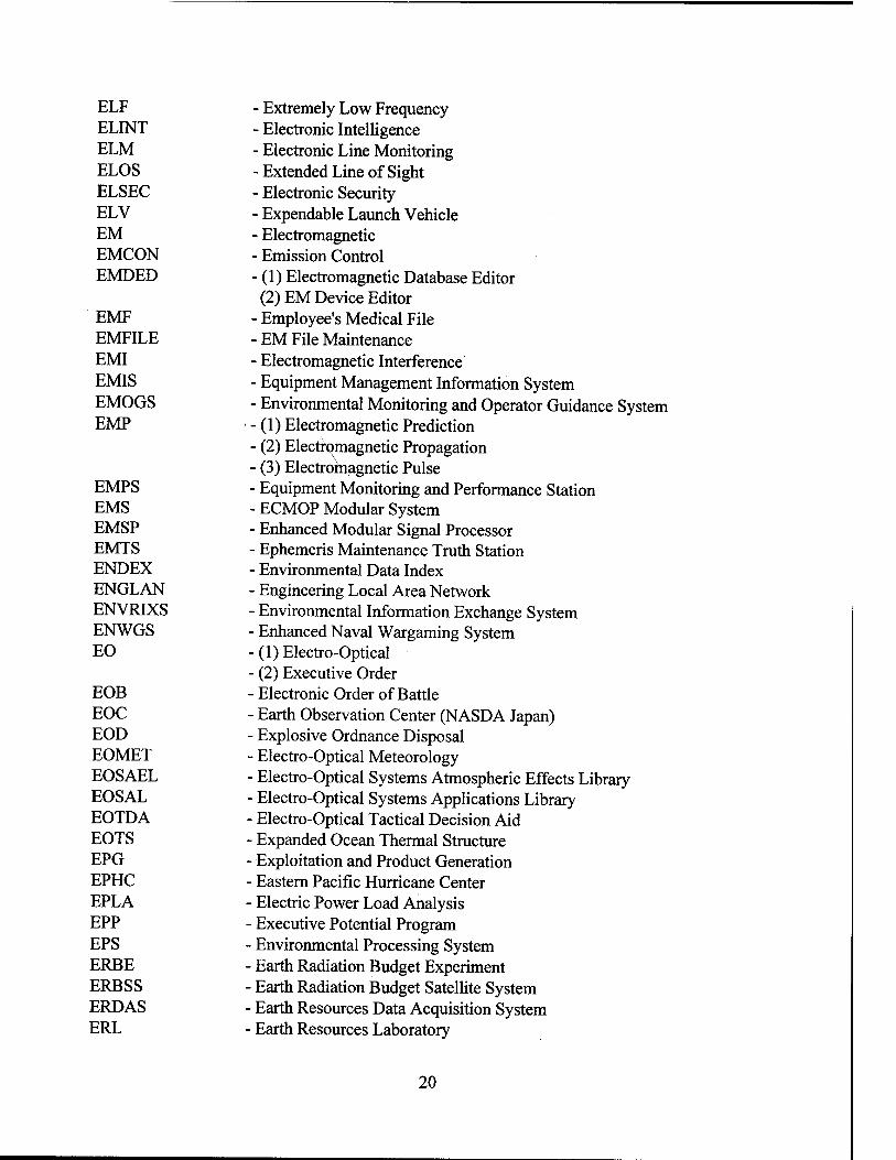
ELF ELINT ELM ELOS ELSEC ELV EM EMCON EMDED
EMF EMFILE EMI EMIS EMOGS EMP
EMPS EMS EMSP EMTS ENDEX ENGLAN ENVRIXS ENWGS EO
EOB EOC EOD EOMET EOSAEL EOSAL EOTDA EOTS EPG EPHC EPLA EPP EPS ERBE ERBSS ERDAS ERL
- Extremely Low Frequency - Electronic Intelligence - Electronic Line Monitoring - Extended Line of Sight - Electronic Security - Expendable Launch Vehicle - Electromagnetic - Emission Control - (1) Electromagnetic Database Editor (2) EM Device Editor
- Employee's Medical File - EM File Maintenance - Electromagnetic Interference - Equipment Management Information System - Environmental Monitoring and Operator Guidance System - (1) Electromagnetic Prediction - (2) Electromagnetic Propagation - (3) Electromagnetic Pulse - Equipment Monitoring and Performance Station - ECMOP Modular System - Enhanced Modular Signal Processor - Ephemeris Maintenance Truth Station - Environmental Data Index - Engineering Local Area Network - Environmental Information Exchange System - Enhanced Naval Wargaming System - (1) Electro-Optical - (2) Executive Order - Electronic Order of Battle - Earth Observation Center (NASDA Japan) - Explosive Ordnance Disposal - Electro-Optical Meteorology - Electro-Optical Systems Atmospheric Effects Library - Electro-Optical Systems Applications Library - Electro-Optical Tactical Decision Aid - Expanded Ocean Thermal Structure - Exploitation and Product Generation - Eastern Pacific Hurricane Center - Electric Power Load Analysis - Executive Potential Program - Environmental Processing System - Earth Radiation Budget Experiment - Earth Radiation Budget Satellite System - Earth Resources Data Acquisition System - Earth Resources Laboratory
20

ERM ERS
ERS-1 ES ESA ESC ESF ESG ESGN ESM
ESMR ESP ESS ESSM ESST ESTAR ESWG ETA ETAC EUC EURDIGS EURMEDS EVA EVS EW EWC EWCM EWCS EWEPS EWRL EXPERCAT EXPROB
Exact Repeat Mission (1) Earth Remote Sensing (2) Earth Resources Satellite (3) Echo Repeater System (4) Environmental Reference Service (5) ESA Remote Sensing (6) Excess Reporting System Earth Remote Serving Satellite-1 Executive Summary European Space Agency
• Electronic Still Camera Extended Superframe Format
■ Electrostatically Suspended Gyroscope • Electrostatic Suspended Gyro Navigation ■ (1) Electronic Support Measures • (2) Electronic Surveillance Measures • Electrically Scanning Microwave Radiometer ■ Environmental Support Package • Environmental Support System • Environmental Standards and Structures Manual ■ Environmental Simulation for Sensitivity Training ■ Electronically Scanned Thinned Array Radiometer ■ Environmental Support Working Group ■ Expected Time of Arrival ■ Environmental Tactical Applications Center ■ Equatorial Undercurrent ■ European Digital Graphics System • European Meteorological Data System - Environmental/Acoustic ■ Enhanced Verdin System - Electronic Warfare ■ Electronic Warfare Coordinator ■ Electronic Warfare Counter-measures ■ Electronic Warfare Control System ■ Environmental Weapons Effect Prediction System - Electronic Warfare Reprogrammable Library - Expert System for CAT Forecasting - Expected Probability of Detection
-F
F/AD FACT FAD FAM
Force Activity Designator Fast Asymptotic Coherent Transmission Fleet Air Defense Field Assignment Memorandum
21

FANM FAR FASOR FASS FAT FAX FBM FCA FCC
FCCBMP FCMSSR FCSC FCT FCVS FD FDDI FDDS FDM FDP FDS
FDS-D FEB FECA FED-STD FEDEX FEDI FEDLOG FEDSIM FEGLI FEHB FEMA FEORP FEP FEPE FER FERS FES FEW FF FFAX FFG FFISTS FFP
- Fast Ambient Noise Model - Federal Acquisition Regulation - Forward Area SONAR Research Program - Fly-Away Survey System - Factory Acceptance Test - Facsimile - Fleet Ballistic Missile - Functional Configuration Audit - (1) Federal Communication System - (2) Fleet Command Center - Fleet Command Center Battle Management Program - Federal Committee for Meteorological Services and Supporting Research - Federal Conversion Support Center - Final Contract Trials - FORTRAN Compiler Validation System - Functional Description - Fiber Distributed Data Interface - Flag Data Display System - Figure of Demerit - Fast Delivery Product - (1) Fixed Distribution System - (2) Fixed Deployable System - Fixed Distribution System - Deployable - Fast Easy Binary - Federal Employee Compensation Act - Federal Communications Standard - Fleet Environmental Data Exchange - Failure Experience Data Interchange ■ Federal Logistics ■ Federal Systems Integration and Management - Federal Employees' Group Life Insurance ■ Federal Employees' Health Benefit • Federal Emergency Management Agency ■ Federal Equal Opportunity Recruiting Program ■ Front-End Processor ■ Finite Element Primitive Equation ■ Far East Region • Federal Employees' Retirement System ■ Factor Evaluation System ■ Federally Employed Women ■ Fast Frigate EASTPAC Fleet Facsimile Broadcast Guided Missile Frigate Frigate (FF) Integrated Shipboard Tactical System Fast Field Program
22
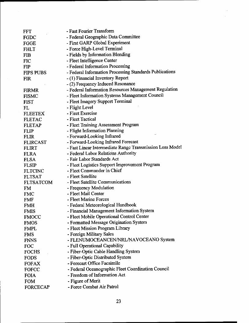
FFT FGDC FGGE FHLT FIB FIC FIP FIPS PUBS FIR
FIRMR FISMC FIST FL FLEETEX FLETAC FLETAP FLIP FLIR FLIRCAST FLIRT FLRA FLSA FLSIP FLTCINC FLTSAT FLTSATCOM FM FMC FMF FMH FMIS FMOCC FMOS FMPL FMS FNNS FOC FOCHS FODS FOFAX FOFCC FOIA FOM FORCECAP
Fast Fourier Transform Federal Geographic Data Committee First GARP Global Experiment Force High-Level Terminal Fields by Information Blending Fleet Intelligence Center
■ Federal Information Processing • Federal Information Processing Standards Publications ■ (1) Financial Inventory Report ■ (2) Frequency Induced Resonance • Federal Information Resources Management Regulation ■ Fleet Information Systems Management Council ■ Fleet Imagery Support Terminal ■ Flight Level • Fleet Exercise ■ Fleet Tactical ■ Fleet Training Assessment Program ■ Flight Information Planning ■ Forward-Looking Infrared - Forward-Looking Infrared Forecast ■ Fast Linear Intermediate Range Transmission Loss Model ■ Federal Labor Relations Authority - Fair Labor Standards Act - Fleet Logistics Support Improvement Program ■ Fleet Commander in Chief - Fleet Satellite - Fleet Satellite Communications - Frequency Modulation - Fleet Mail Center - Fleet Marine Forces - Federal Meteorological Handbook - Financial Management Information System - Fleet Mobile Operational Control Center - Formatted Message Origination System - Fleet Mission Program Library - Foreign Military Sales - FLENUMOCEANCEN/NRL/NAVOCEANO System - Full Operational Capability - Fiber-Optic Cable Handling System - Fiber-Optic Distributed System - Forecast Office Facsimile - Federal Oceanographic Fleet Coordination Council - Freedom of Information Act -Figure of Merit - Force Combat Air Patrol
23

FORMICA FORTRAN FOSIC FOSIF FOSS
FOTC FOTE FOTV FOV
FPM FPMR FQT FREDDIES FSAS FSC FSDR FSED FSI FSIR FSR
FSS FTC FTE FTN FTO FTP
FTS FURPUR FWC
FWP FWPC FY FYDP
- Foreign Military Intelligence Collection Activity - Formula Translation - Fleet Ocean Surveillance Information Center - Fleet Ocean Surveillance Information Facility - (1) Fiber-Optic Sensor System - (2) Fibert-Optic Sensor Survey - Fleet OTH Targeting Coordinator - Fleet Operational Test and Evaluation - Fiber-Optic Training Vehicle - (1) Fiber-Optic Vehicle - (2) Field of View - Federal Personnel Manual - Federal Property Management Regulations - Final Qualification Test - Fronts and Eddies - Flight Service Automation System - Federal Supply Classification - Free Space Detection Range - Full Scale Engineering Development - Falmouth Systems, Inc. - Free-Space Intercept Range - (1) Facilities Service Request - (2) Free Space Range - Flight Service Station - Force Track Coordinator ■ Full Time Equivalent ■ ASCII FORTRAN (FORTRAN 77) ■ Foreign Training Officer ■ (1) File Transfer Protocol ■ (2) Full-Time Permanent - (3) Functional Transfer Plan ■ Federal Telecommunications Service ■ File Utility Routines Program Utility Routines ■ (1) Federal Women's Center • (2) Fleet Weather Channel ■ Federal Women's Program ■ Federal Women's Program Coordinator ■ Fiscal Year • Five-Year Defense Plan
G&A GAC
General and Administrative (1) General Acoustic Conditions (2) Global Area Coverage
24

GADHS GAO GARP GASP GB GCA GCI GCM
GCS GDB GDBC GDEM GDF GDPS GDR GDS GDSD GDSL GDST GEBCO GEC GEM
GEMO GEMS GENRAD GENRAYT GENSER GEOS GEOSAT GFAX GFCS GFE GFI GFM GFMPL GFO GFR GFS GIDEP GIN GIS
GIUK
GOES Acquisition and Data Handling System General Accounting Office Global Atmospheric Research Program Geomagnetic Autonomous Shuttle-Launched Probe Gigabyte Ground-Controlled Approach Ground-Controlled Intercept (1) General Circulation Model (2) Global Circulation Model Gateway Computer System Geophysical Data Base Gravity Data Boundary Chart Generalized Digital Environmental Model Government Designated Facility Global Data Processing System Geophysical Data Record General Declassification Schedule Gravity Data Storage Disk Gravity Data Supplementary Listing Gravity Data Storage Tape General Bathymetric Charts of the Ocean Gross Error Check (1) General Environmental Message (2) Goddard Earth Model Ground Electronics Maintenance Officer General Environmental Message Support Generalized Range Dependent Acoustic Driver General Ray Trace General Service Geodynamic Experimental Ocean Satellite Geodesy Satellite WESTPAC Facsimile Broadcast Gun Fire Control System Government Furnished Equipment Government Furnished Information Government Furnished Material Geophysics Fleet Mission Program Library GEOSAT Follow-On General Functional Requirements Government Furnished Software Government/Industry Exchange Program Greenland-Iceland-Norway (1) Geographic Information System
■ (2) Geophysical Information System ■ Greenland/Iceland/United Kingdom
25
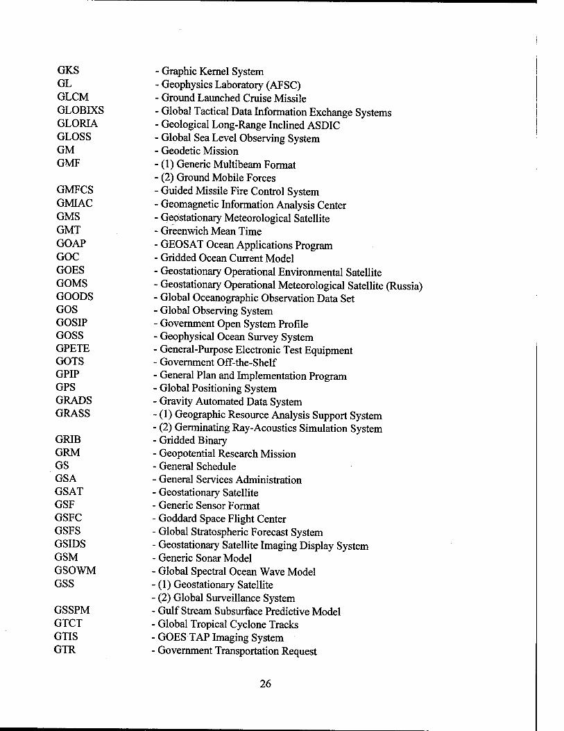
GKS GL GLCM GLOBIXS GLORIA GLOSS GM GMF
GMFCS GMIAC GMS GMT GOAP GOC GOES GOMS GOODS GOS GOSIP GOSS GPETE GOTS GPIP GPS GRADS GRASS
GRIB GRM GS GSA GSAT GSF GSFC GSFS GSIDS GSM GSOWM GSS
GSSPM GTCT GTIS GTR
- Graphic Kernel System - Geophysics Laboratory (AFSC) - Ground Launched Cruise Missile - Global Tactical Data Information Exchange Systems - Geological Long-Range Inclined ASDIC - Global Sea Level Observing System - Geodetic Mission - (1) Generic Multibeam Format - (2) Ground Mobile Forces - Guided Missile Fire Control System - Geomagnetic Information Analysis Center - Geostationary Meteorological Satellite - Greenwich Mean Time - GEOSAT Ocean Applications Program - Gridded Ocean Current Model - Geostationary Operational Environmental Satellite - Geostationary Operational Meteorological Satellite (Russia) - Global Oceanographic Observation Data Set - Global Observing System - Government Open System Profile - Geophysical Ocean Survey System - General-Purpose Electronic Test Equipment - Government Off-the-Shelf - General Plan and Implementation Program - Global Positioning System ■ Gravity Automated Data System - (1) Geographic Resource Analysis Support System ■ (2) Germinating Ray-Acoustics Simulation System ■ Gridded Binary ■ Geopotential Research Mission ■ General Schedule ■ General Services Administration ■ Geostationary Satellite ■ Generic Sensor Format ■ Goddard Space Flight Center ■ Global Stratospheric Forecast System ■ Geostationary Satellite Imaging Display System • Generic Sonar Model Global Spectral Ocean Wave Model
• (1) Geostationary Satellite (2) Global Surveillance System Gulf Stream Subsurface Predictive Model Global Tropical Cyclone Tracks GOES TAP Imaging System Government Transportation Request
26

GTRL GTS
GUCL GUI GUIDES GWE GWIP
• Geophysics Technical Readiness Laboratory ■ (1) Global Telecommunications System • (2) Graphics Terminal Subsystem ■ General Use Consumables List ■ Graphical User Interface • Gravity Universal Interactive Data Editing System ■ Global Weather Experiment ■ Global Weather Intercept Program
H
HACLCS HAD HALE HALT HARM HARPOON HARPSS HASP HATRACK HCG HCI HCS HDAS HDC HDLC HEL HEMP HEP AD HEPC
HERO HESM HF HFAX HFBL HFDF HFDM HHPC HIANAL HICANS HIDEX HIE HIG HIHAN
HARPOON Aircraft Command and Launch Control System Horizontal Acoustic Depiction
• High Altitude Long Endurance ■ Higher Away Lower Toward • Highspeed Anti-Radiation Missile • Tactical Anti-Ship Missile ■ High Altitude Remote Platform Surveillance System ■ High Accuracy Satellite Position ■ Hurricane and Typhoon Tracking ■ Hard Copy Generator ■ Hardware Configuration Item • Hydroplane Collection Subsystem - Hydrographie Data Acquisition System - Helicopter Direction Center • High-Level Data Link Control - High-Energy Laser ■ High-Altitude Electromagnetic Pulse ■ High-Energy Proton and Alpha-Particle Detector - (1) Hispanic Employment Program Coordinator - (2) Historical Electromagnetic Propagation Conditions - Hazards of Electromagnetic Radiation to Ordnance - HEL Environmental System Model - High Frequency - MIDFAC Facsimile Broadcast - High-Frequency Bottom Loss - High-Frequency Direction Finding - High-Frequency Digital Modem - Hand-held Programmable Calculator - High-Level Analysis Model - High-speed Collision Avoidance and Navigation System - High Intake Defined Excitation - Historical Ice Edge - Hawaii Institute of Geophysics - Hydrographie Information Handling System
27

HIMS HIPS HIRIS HIRS HITS
HITTS HLA HMPS HN HODAS HODS HOFMP HOJ HOODS HOP HP
HPC HPI HPTS HR-GDEM HRIPS HRIS HRIS/2 HRMOODS HRO
HRPT HRV HS HSCS HSFB HSL HSLAN HSLP HSO HSPS HTML HUD HUGO
HULTEC HVU HWD
- Hydrographie Information Management System - Hydrographie In-House Processing System - High-Resolution Imaging Spectrometer - High-Resolution Infrared Radiation Sounder - (1) Historical Temporal Shipping - (2) Hull Integrity Test-Dive Site - HARPOON Interactive Tactical Training System - Horizontal Line Array - Hydrographie Multibeam Processing System - Hydrodynamical Numerical Model - Hydrographie Oceanographic Data Acquisition System - Hydrographie Oceanographic Data Sheet - Hydrographic/Oceanographic Fleet Mobilization Plan - Home on Jam - High-Resolution Oceanographic Observation Data Set - Historical Ocean Profile - (1) Hewlett-Packard - (2) Hydrographie Procedure - High-Performance Computing - Hydrographie Project Instructions - Hydrographie Post-Time System - High-Resolution - Generalized Digital Environmental Model - High-Resolution Image Processing System - High-Resolution Imaging Spectrometer - Modified High-Resolution Infrared Sounder - Classified High-Resolution Oceanographic Observation Data Set - (1) Historical Radiosonde Observation - (2) Human Resources Office - High-Resolution Picture Transmission - High-Resolution Visible - ASW Helicopter (Carrier Based) - High-Speed Communications Subsystem - High-Speed Fleet Broadcast - Hydrographie Survey Launch - High-Speed Local Area Network - High-Speed Line Printer - Historical Surface Observation - Hydrographie Single-Beam Processing System - Hypertext Markup Language - Heads Up Display - Hydrographie Upgrade to OCEANIS (Oceanographic Information
System) - Hull-to-Emitter Correlation - High Value Unit - Horizontal Weather Depiction
28

HWS HYBAHCOS
HYCOOP HYDAT HYDROWINCH HYSAP HYSAS HYSTAR Hz
Historical Wind Speed Cooperative Hydrographie Program between Commonwealth of
Bahamas and United States Hydrographie Cooperation (Program) Hydroclimatological Data Retrieval Program Light/Fast Winch for Electronic Sensors
• Hydrographie Survey Assistance Program • Hydrographie Source Assessment System ■ Hydrographie Sounding, Tracking, and Recording System Hertz
I
I/O I2R IABP IACS IAGS IAT IATO IAW IB IBLUG IC (IC)2 ICAFS ICAO ICAPS ICD ICECAPS
ICEX ICOM ICS/SCAN
ICWG ID
IDA IDAFMS IDBMS IDBP IDDS IDEAL IDEAS
Input/Output Imaging Infrared International Arctic Buoy Program Integrated Acoustic Communications System Inter-America Geodetic Survey Initial Acceptance Test Interim Authority to Operate Image Analysis Workstations Interface Board Interim Bottom Loss Upgrade
• Intelligence Community • Integrated Interior Communications and Control ■ Improved Cloud Analysis and Forecasting System • International Civil Aviation Organization • Integrated Carrier ASW Prediction System ■ Interface Control Document ■ Interactive Computer Environment for Comprehensive Active Prediction
System ■ Ice Exercise ■ Interim Communications Operations Method - Integrated Communications System/Shipboard Communications
Network ■ Interface Control Working Group - (1) Identification - (2) Internal Document - Inertial Data Assembly ■ Integrated Disbursing and Accounting Financial Management System - Integrated Data Base Management System - Integrated Drifting Buoy Program - INSAT Data Distribution System - Initiating, Diagnosing, Establishing, Acting, and Leveraging - Inshore Data Evaluation and Analysis System
29

IDI IDIQ IDP IDPSS IDS IDSF IEEE IEP IERS IES IESS IFD IFE IFF IFOV IFR IG IGDR IGES IGOSS IGS IHB IHMEP
IHO IHS IIP ILCS ILS ILSM ILSP IM IM/DM IMCS IMEA IMEEDS IMET IMETS I-MOSS IMP IMS IMSL IMTS IMU INCO
- Imaging Doppler Interferometry - Indefinite Delivery/Indefinite Quantity - Individual Development Plan - IGOSS Data Processing and Services System - Instrumentation Development System - Initial Data Storage File - Institute of Electrical and Electronics Engineers - Information Exchange Project - International Earth Rotation Service - Inverted Echo Sounders - Image Exploitation Support System - Implicit Finite Difference - Interactive Front-End - Identification, Friend or Foe - Instantaneous Field of View - Instrument Flight Rules - Inspector General - Interim Geophysical Data Record - Initial Graphics Exchange Specification - Integrated Global Ocean Services System - Interactive Graphics Subsystem - International Hydrographie Bureau - International Hydrographie Management and Engineering Program
(HYCOOP Training Program) - International Hydrographie Organization - Interactive Histogram Stretching - International Ice Patrol - Improved Low-Cost Sonobuoy - Integrated Logistics Support - Integrated Logistics Support Manager - Integrated Logistics Support Plan - Interface Multiplexer ■ Information Management/Data Management - Interim Mobile Environmental Team Computer System - Interactive Multi-Variate Environmental Analysis ■ Integrated Marine Environment Element Detection System ■ International Military Education and Training - Integrated Meteorological System ■ Interim-Mobile Oceanography Support System • Interface Message Processor • Inventory Management System ■ International Mathematical and Statistical Library • Integraph Maintenance Tracking System ■ Inertial Measuring Unit Installation and Check Out
30

INFOSEC INMARSAT INO INOS INS INSAT INSURV 10 IOC
IOCARIBE IODE 10 FAX IOL IORD IOS
IOTA IP IPA IPAM IP ASS IPC IPLI IPMS IPS IPV IR
IRDS IREPS IRIG-B IRIS IRM IRN IRST IS ISA ISAR ISCCP ISCS - ISDN ISE ISEA
- Information Systems Security - International Maritime Satellite - Institute for Naval Oceanography - Improved NEDS Operating System - Inertial Navigation System - Indian National Satellite - U.S. Navy Board of Inspection and Survey - Indian Ocean - (1) Initial Operational Capability - (2) Intergovernmental Oceanographic Commission - IOC Sub-Commission for the Caribbean and Adjacent Regions - International Oceanographic Data and Information Exchange - Indian Ocean Facsimile Broadcast - Initial Outfitting List - Integrated Operations Requirement Document - (1) IGOSS Observing System - (2) Improved Oceanographic Sensor - Integrated Oceanographic Tactical Aid - Internet Protocol - Intergovernmental Personnel Act (1970) - Improved Point Analysis Model - Improved Point Analysis Support System - Interprocess Control - Internet Private Line Interface - International Polar Motion Service - Integrated Projector System - Instrumented Pressure Vessel - (1) Infrared - (2) Infrared Radiometer - Information Resource Dictionary System - Integrated Refractive Effects Prediction System - InterRange Instrumentation Group - International Radio Interferometric Surveying - Information Resources Management - Interface Revision Notice - Infrared Search and Track - Information System - Intra or Interservice Support Agreements - Inverse Synthetic Aperture Radar - International Satellite Cloud Climatology Project - Integrated Submarine Communications System - Integrated Services Digital Network - Independent Ships Exercise - (1) In-Service Engineering Activity - (2) Inter-Service Engineering Agency
31

ISIC ISIS ISLPP ISO ISP ISPADS ISPS ISR ISS ISSA 1ST ISTV IT ITA ITAPS ITASS ITCZ ITDA ITF ITIR ITO ITOS ITPB ITRRS ITS
ITSS IUSS IVD IVDS IWAPS IWD IWG IWRS
- Immediate Superior in Command - Integrated Stored Information System - IGOSS Sea Level Pilot Project - International Standards Organization - Internet Service Protocol - Integrated Survey Processing and Display System - Integrated Strike Planning System - Identification Safety Range - Integrated Survey System - Interservice Support Agreement - Interswitch Trunks - Interactive Structured Time-Varying Visualizer - Information Technology - IGOSS Telecommunications Arrangement - Intermediate Towed Acoustic Projector System - Interim Towed Array Surveillance System - Intertropical Convergence Zone - Integrated Tactical Decision Aid - Information Technology Facility - Intermediate Thermal Infrared Radiometer - Invitational Travel Order - Improved TIROS Operational Satellite - Integrated Technology Policy Board - Information Technology Resources Reporting System - (1) Installation Telecommunications System - (2) Instrumented TEMPEST Survey ■ (3) International Temperature Scale - Improved Tactical Surveillance Sonobuoy ■ Integrated Underwater Surveillance System - Interactive Video Disk - Independent Variable Depth Sonar ■ Improved Weather Analysis and Prediction System ■ Intermediate Water Depth ■ Interface Working Group ■ Improved Weather Reconnaissance System
J-
JADREP JAWOP JAWS JCL JCMPO JCS JDISS
■ Joint Resource Assessment Data Base Report ■ Joint Automated Weather Observation Program ■ Joint Airport Weather Studies ■ Job Control Language ■ Joint Cruise Missile Project Office ■Joint Chiefs of Staff • Joint Deployable Intelligence Support System
32
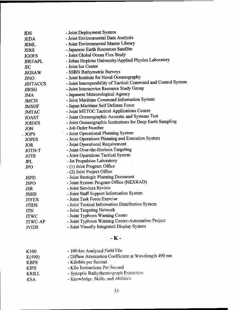
JDS JEDA JEML JERS JGOFS JHU/APL JIC JIGSAW JINO JINTACCS JIRSG JMA JMCIS JMSDF JMTAC JOAST JOIDES JON JOPS JOPES JOR JOTH-T JOTS JPL JPO
JSPD JSPO JSR JSSIS JTFEX JTIDS JTN JTWC JTWC-AP JVIDS
■ Joint Deployment System • Joint Environmental Data Analysis ■ Joint Environmental Master Library ■ Japanese Earth Resources Satellite ■ Joint Global Ocean Flux Study ■ Johns Hopkins University/Applied Physics Laboratory - Joint Ice Center - SSBN Bathymetric Surveys - Joint Institute for Naval Oceanography - Joint Interoperability of Tactical Command and Control System - Joint Interservice Resource Study Group - Japanese Meteorological Agency - Joint Maritime Command Information System - Japan Maritime Self Defense Force - Joint METOC Tactical Applications Course - Joint Oceanographic Acoustic and Systems Test - Joint Oceanographic Institutions for Deep Earth Sampling - Job Order Number - Joint Operational Planning System - Joint Operations Planning and Execution System - Joint Operational Requirement - Joint Over-the-Horizon Targeting - Joint Operations Tactical System - Jet Propulsion Laboratory - (1) Joint Program Office - (2) Joint Project Office - Joint Strategic Planning Document - Joint System Program Office (NEXRAD) - Joint Services Review - Joint Staff Support Information System - Joint Task Force Exercise - Joint Tactical Information Distribution System - Joint Targeting Network - Joint Typhoon Warning Center - Joint Typhoon Warning Center-Automation Project - Joint Visually Integrated Display System
K
K100 K(490) KBPS KIPS KRILL KSA
100-km Analyzed Field File Diffuse Attenuation Coefficient at Wavelength 490 nm Kilobits per Second
■ Kilo Instructions Per Second ■ Synoptic Bathythermograph Extraction ■ Knowledge, Skills, and Abilities

KVA kw
Kilovolt-ampere Kilowatt
LABL LABS LAC LADS LAMBDA LAMPS LAN LANDSAT LANTIRN LANTMET LAP LAPS LAR LASA LASER LATA LATRAN LAVA LAWS LBTS LCAC LCC LCI LCID LCM LCN LCS LCSA LCT1 LCVP LDAR LDATS LDEO LDMX LDS LE LEC LEO LEWEX
- Littoral Atmospheric Boundary Layer - Laser Airborne Bathymetry Survey - Local Area Coverage - Laser Airborne Depth Sounder - Large Aperture Marine Basic Data Array - Light Airborne Multi-Purpose System - Local Area Network - Land Satellite - Low Altitude Navigation Targeting IR Night - Atlantic Mobile Environmental Team - LID AR Atmospheric Profiler - Laptop ASW Prediction System - Latin American Region - LID AR Atmospheric Sounder and Altimeter - Light Amplification by Stimulated Emission of Radiation - Local Access and Transport Area - Lateral Range Model - Linear Acoustic Vernier Analysis - Laser Atmospheric Wind Sounder - Long Baseline Tracking System - Landing Craft Air Cushioned - Life Cycle Cost ■ Line Control Unit ■ Littoral Currents Information Database ■ Life Cycle Management - Loosely Coupled Network ■ Life Cycle Support ■ Life Cycle Support Activity - Low Cost Terminal, Category 1 ■ Landing Craft Vehicle Personnel ■ Lightning Detection Antenna Receiver ■ Lightning Detection and Tracking System ■ Lamont-Doherty Earth Observatory ■ Local Digital Message Exchange • Logic Development System ■ Total Background Noise • LAMPS Element Coordinator Low Earth Orbit Labrador Extreme Waves Experiment
34
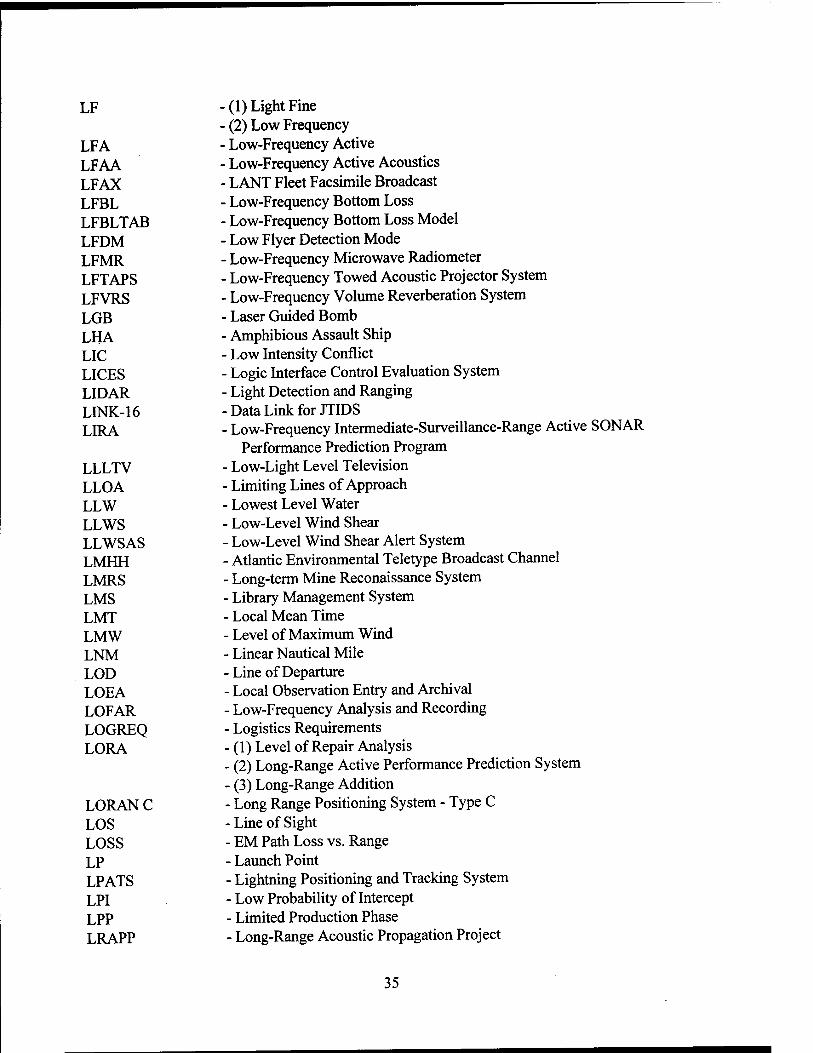
LF
LFA LFAA LFAX LFBL LFBLTAB LFDM LFMR LFTAPS LFVRS LGB LHA LIC LICES LID AR LINK-16 LIRA
LLLTV LLOA LLW LLWS LLWSAS LMHH LMRS LMS LMT LMW LNM LOD LOEA LOFAR LOGREQ LORA
LORANC LOS LOSS LP LPATS LPI LPP LRAPP
• (1) Light Fine ■ (2) Low Frequency ■ Low-Frequency Active • Low-Frequency Active Acoustics ■ LANT Fleet Facsimile Broadcast ■ Low-Frequency Bottom Loss ■ Low-Frequency Bottom Loss Model - Low Flyer Detection Mode - Low-Frequency Microwave Radiometer ■ Low-Frequency Towed Acoustic Projector System - Low-Frequency Volume Reverberation System - Laser Guided Bomb - Amphibious Assault Ship - Low Intensity Conflict - Logic Interface Control Evaluation System - Light Detection and Ranging -Data Link for JTIDS - Low-Frequency Intermediate-Surveillance-Range Active SONAR
Performance Prediction Program - Low-Light Level Television - Limiting Lines of Approach - Lowest Level Water - Low-Level Wind Shear - Low-Level Wind Shear Alert System - Atlantic Environmental Teletype Broadcast Channel - Long-term Mine Reconaissance System - Library Management System - Local Mean Time - Level of Maximum Wind - Linear Nautical Mile -Line of Departure - Local Observation Entry and Archival - Low-Frequency Analysis and Recording - Logistics Requirements - (1) Level of Repair Analysis - (2) Long-Range Active Performance Prediction System - (3) Long-Range Addition - Long Range Positioning System - Type C -Line of Sight - EM Path Loss vs. Range - Launch Point - Lightning Positioning and Tracking System - Low Probability of Intercept - Limited Production Phase - Long-Range Acoustic Propagation Project
35

LRI LRIP LRM LRMP LRP
LRU
LS LSA LSC LST LTIM LTOC LUF LUT LWC LWDS
- Limited Range Intercept - Low Rate Initial Production - Long-Range Mode - Long-Range Maritime Patrol - (1) Laser Range Prediction - (2) Long-Range Plan - (1) Line Replaceable Unit - (2) Lowest Replaceable Unit - Light Smoothed - Logistics Support Analysis ■ Large-Scale Computer ■ Laser Spot Tracker ■ Lightning Tracking Indicator Memory ■ Lowest Total Overall Cost ■ Lowest Usable Frequency ■ Local User Terminal ■ Liquid Water Content • Lightweight Dive System
-M
M&S MA MAC
MACAS
MAD MADAMS MAES MAG MAGAIS MAGNAV MAGNET MAGR MAGTF MAGSAT MAISRC MAN MAOA MAP MARAD MARCO POLO
MARISAT
- Modeling and Simulation - Management Advocate - (1) Magnetic Anomaly Concealment - (2) Military Airlift Command - Magnetic Capability and Safety (system for measuring electrical field for
minesweeping) - Magnetic Anomaly Detection - Multi-Channel Acoustic Data Acquisition and Measurement System - MCSST Algorithm Evaluation System - Maritime Action Group - Magnetic Automated Information System - Magnetic Navigation - The Project MAGNET Geomagnetic Survey Program - Miniature Airborne GPS Receiver ■ Marine Air-Ground Task Force ■ Magnetometer Satellite ■ Major Automated Information Systems Review Council ■ Metropolitan Area Network ■ Meteorological Aspects of Ocean Affairs ■ Maritime Airborne Patrol ■ Maritime Administration • Cooperative Oceanographic Teaching Program between U.S. Navy and
National Geographic Society Maritime Satellite System
36

MARUP MARV MAS MASINT MAVA MAXIE MBMB MBR MBT MC MC&G MCA MCAPS MCC MCDR MCIDAS MCJR MCM MCN MCR MCS MCSST MCTL MDA MDF MDFF MDR MDS
MDT MDUS MDUS-R MDZ MEAR MED MEDEA MEDEVAC MEDAL MEDS MEDSUBFCST MEECN MEF MEL
- Material Readiness and Upgrade ■ Maneuverable Reentry Vehicle • Map Accuracy Standard ■ Measurements and Signatures Intelligence • Moored Acoustic Vertical Array ■ Magnetic and Atmospheric X-ray Imaging Experiment ■ Master Bathymetric Data Base ■ Minimum Boundary Rectangle • Mechanical Bathythermograph ■ Management Control ■ Mapping, Charting, and Geodesy ■ Manpower Control Authority ■ Mission Control and Processing Subsystem ■ Military Cooperation Committee ■ Mean Counterdetection Range • Man-computer Interactive Data Access System ■ Multi-Channel Jezebel Relay ■ Mine Counter-measures ■ Military Construction, Navy Management Control Review Moisture Channel Support Multichannel Sea Surface Temperature Military Critical Technologies List Milestone Decision Authority Master Data File Map Data Formatting Facility Mean Detection Range (1) Message Distribution System (2) Mission Display System Message Distribution Terminal Medium Data Utilization System Medium Data Utilization System Replacement Missile Danger Zone Middle East/Europe/Africa Region Mediterranean Measurements of Earth Data for Environmental Analysis Medical Evacuation Mine Warfare Environmental Decision Aid Library Meteorological Data System Mediterranean Submarine Forecast Minimum Essential Emergency Communications Network Magnetic Environmental Filter Master Environmental Library
37
MENTOR
MEPAD MERCAST MERIS MES MESSR MET METBAL METEM METEOR METEOSAT METOC METREP MEU MFAX MFCS MFM MGDEM MGS
MHC MHz MICFAC MIDDS MIGCAP MUS MIL-SPEC MIL-STD MILCON MILNET MILOC MILPERS MILS MILSTAR MILSTRAP MILSTRIP MINET MINIRAD MIO MIP
MIPR MIPS MIRV
A Tactical Environmental Data Collection and Analysis System for Mine Warfare
Medium Energy Proton and Alpha-Particle Detector Merchant Ship Broadcast
• Medium Resolution Imaging Spectrometer • Mission Electronic System • Multispectral Electronic Self-Scanning Radiometer ■ Mobile Environmental Team • Ballistic Winds and Densities ■ Meteorological Maintenance ■ Soviet Polar-Orbiting Meteorological-Satellite Program ■ Eurpoean Geostationary Meteorological Satellite ■ Meteorology and Oceanography - Meteorological (Equipment Casualty) Report • Mission Essential Unit ■ MED Facsimile Broadcast - Missile Fire-Control System - Movable Fine-Mesh Model - Master Generalized Digital Environmental Model - (1) Marine Geophysical Survey - (2) Marine Graphics System - Mine Hunter, Coastal Slip - Megahertz - Mobile Integrated Command Facility - METOC Integrated Data Display System - MIG Combat Air Patrol - Meditech Interpretive Information System (Library Operating System) - Military Specification - Military Standard - Military Construction - Military Network (Unclassified DDN) - Military Oceanography - Military Personnel - Missile Impact Location System - Military Strategic Tactical Relay - Military Standard Transaction Reporting and Accounting Procedures - Military Standard Requisitioning and Issue Procedures - Movement Information Network - Minimum Radiation - Multiple Input/Output - (1) Model Installations Program - (2) Modest Improvement Program - Military Interagency Purchase Request - Million Instructions Per Second - Multiple Independent Reentry Vehicle
38
MIS MISE MITI MIUW MIW MIZ MIZEX MKS MLCDB MLD MLS MLV MMHH MMO MMoDS MMS
MNS
MOA MOATL MODAS MODE MODEM MODIS-N MODIS-T MODLOC MOE MOEP MOETLO
MOHATT MOI MOLS MOMS MOODS MOP MOPP MORS MOS
Management Information System Man-Instrument Support Equipment Ministry of International Trade and Industry Mobile Inshore Undersea Warfare Mine Warfare Marginal Ice Zone Marginal Ice Zone Experiment Meters Kilograms Seconds Mine-Like Contacts Data Base Mixed Layer Depth Multi-Level Security Memory Loader Verifier Mediterranean Environmental Teletype Broadcast Channel Minor Maintenance Order METOC Models, Databases, and Simulations (1) Marine Mammal System (2) Marine Meteorological Services (3) Meteorological Measurement System (4) Multilevel Mail Server (5) Multimission Modular Spacecraft (1) Mine Neutralization System (2) Mission Need Statement Memorandum of Agreement Modal Acoustic Transmission Loss Modular Ocean Data Assimilation System Mid-Ocean Dynamics Experiment Modulator/Demodulator Moderate Resolution Imaging Spectrometer - Nadir Moderate Resolution Imaging Spectrometer - Tilt Miscellaneous Operational Detail Location MAD Operational Effectiveness Meteorological and Oceanographic Equipment Program Meteorological and Oceanographic Equipment Technical Liaison
Officer Modified Hurricane and Typhoon Tracking Message of Intent Maury Oceanographic Library System Modular Optoelectronic Multispectral Scanner Master Oceanographic Observation Data Set Magnetic Orange Pipe Mission Oriented Protective Posture Military Operations Research Society (1) Marine Observation Satellite
■ (2) Military Occupational Specialty • (3) Model Output Statistics
39
MOSS - Mobile Oceanography Support System MOST - Mobile SONAR Technology MOTT - Mediterranean Oceanographic Tactical Team MOTU - Mobile Technical Unit MOU - Memorandum of Understanding MOVREP - Movement Report MP - Multiple Path MPA - Maritime Patrol Aircraft MPACU - Maritime Patrol Aircraft Control Unit MPAS - Mesoscale Prediction and Analysis System MPBL - Marine Planetary Boundary Level MPC - MAD Planning Chart MPCS - Mission Planning and Control Station MPDS - Multi-Purpose Display Station MPN - Military Personnel, Navy MPO - Minefield Performance Objective MPP - Multiple Profile Program MPS - Microwave Pressure Sounder MPT - Manpower, Personnel, and Training MPTCD - Manpower, Personnel, and Training Concept Document MR - Microwave R MRA - Mean Acoustic Response Axis MRP - Mid-Range Plan MRS - Mini-Rawinsonde System MRV - Multiple Reentry Vehicle MSDDB - Master Seafloor Digital Data Base MSE - Mission Sponsor Equipment MSGFORM - Message Formatter MSI - (1) Multi-Spectral Imagery
- (2) Multi-Spectral Scan Imaging MSL - Mean Sea Level MSLP - Medium Speed Line Printer MSO - Minor Service Order MSPB - Merit System Protection Board MSR - (1) Material Status Report
- (2) Microwave Scanning Radiometer MSRC - Major Shared Resource Center MSS - Multispectral Scanner MSS/IPS - Multispectral Scanner/Image Processing System MSU - Microwave Sounding Unit MTA - Message Transfer Agent MTBCF - Mean Time Between Critical Failure MTBF - Mean Time Between Failures MTBO - Mean Time Before Obsolescence MTEDS - MCM Tactical Environmental Data System
40
MTF - Message Text Format MTI - Moving Target Indicator MTMC - Military Traffic Management Command MTN - Main Telecommunication Network MTP - Microwave Temperature Profiler MTRR - Maintenance Training Requirements Review MTT - Mobile Training Team MTTR - Mean Time to Repair MTU - Magnetic Tape Unit MUF - Maximum Usable Frequency MUMS - MOODS Upgrade Management System MUT - Main Unit Task MUX - Multiplex MVOI - Multi-Variable Optimal Interpolation MW - Microwave MWES - Mine Warfare Environmental Survey MWP - (1) Mine Warfare Pilot
- (2) Meteorological Weather Processor MWPC - Mine Warfare Planning Chart MWR - Microwave Radiometer
-N
N NABS NABTAM NAC NACISA NAD
NADCON NADCS NADIN NAESU NAFAX NAG NALAN NALC NAMFAX NAR NAS
NASA NASCOM NASDA
■ Refractivity • Navy ADP Budgeting System • Narrow Beam Towed Array Model • Network Access Controller NATO Communications and Information Systems Agency
■ (1) Network Access Device (2) North American Datum North American Datum Conversion NAVOCEANO Automated Document Control System National Airspace Data Integration Network Naval Aviation Engineering Service Unit National Weather Service Analog Facsimile Naval Astronautics Group NAVOCEANO Administrative LAN Navy Ammunition Logistic Code National and Aviation Meteorological Facsimile NAVOCEANO At-Sea Representative
• (1) National Airspace System • (2) Naval Air Station • National Aeronautics and Space Administration ■ NASA Communications Center ■ National Space Development Agency of Japan
41

NATE NATO NATOPS NAVCMR NAVCOMPARS NAVDAB NAVHYDROPLAN NAVIXS NAVMACS NAVOCEANPLAN NAVNET NAVOCEANO NAVOPB NAVPAL NAVSAR NAVSAT NAVSOC R/S NAVSSI NAVSTAR NAWAS NB NBC NBES NC2P NCAR NCC NCCS NCDC NCEA NCGIA NCMRP
NCP NCPDS NCPO NCS ... NCTAMS NDC NDCP NDI NDS NEA NEC NECC NECP
- Narrow-Beam Automated Test Equipment - North Atlantic Treaty Organization - Naval Air Training and Operating Procedures Standardization - NAVOCEANO Central Mainframe Replacement (IDBMS) - Naval Communication Processing and Routing System - Navy Ocean Environmental Acoustic Data Bank - Naval Hydrographie Plan - Navy Information Exchange System - Naval Modular Automated Communications System - Navy Oceanographic Requirements and Survey Plan - Navy Network - Naval Oceanographic Office - Submersible Photometer System - Navigation Processing and Logging - Navy Search and Rescue - Navigation Satellite - Naval Space Command Remote Site - Navigational Sensor System Interface - Naval System Using Timing and Ranging - National Warning System - Narrow Band - Nuclear, Biological, and Chemical - Narrow Beam Echo Sounder - Navy C2 Plan - National Center for Atmospheric Research - National Climatic Center - Navy Command and Control System - National Climatic Data Center - Non-Combat Expenditure Allocation - National Center for Geographic Information and Analysis - (1) Naval Communications Mid-Range Plan - (2) NAVOCEANCOM Communications Mid-Range Plan - National Climate Program - Navy Civilian Personnel Data System - National Climate Program Office - Naval Communication Station - Naval Computer and Telecommunications, Area Master Station - National Distribution Circuit - Navy Decision Coordinating Paper - Non-Development Item - Nodal Distribution System - Naval Exercise Area - Navy Enlisted Classification - North Equatorial Countercurrent - Non-Engineering Change Proposal
42

NEDN NEDRES NEDS NEO NEONS NEPTUNE
NES NESDIS NESP NESS NEXLAN NEXRAD NEXUS NF NFAX NFC NFS NGBNS NGDC NGFS NGS NGSDC NHC NHECT NIAS NIC NICN NIDAS NIDS NIEWS NIFS NIIN NIMA NIMBUS NIMS NIPRNET NIPS NIS
NISSM NIST NITES NIU NLNM
- Naval Environmental Data Network - National Environmental Data Referral Service - Naval Environmental Display Station - Non-Combat Evacuation - Naval Environmental Operational Nowcasting System - Naval Environmental Programs for Tactical Utilization of the Natural
Environment - Network Encryption System - National Environmental Satellite, Data, and Information Service ■ Navy EHF SATCOM Program - National Earth Satellite Service - Next Generation Local Area Network ■ Next Generation Weather RADAR ■ NAVOCEANO Executive Users System ■ Noise Figure ■ LANT Facsimile Broadcast - Numbered Fleet Commander ■ Network File System ■ Navy General Bathymetric Navigation System ■ National Geophysical Data Center ■ Naval Gunfire Support ■ National Geodetic Survey ■ National Geophysical and Sojar-Terrestrial Data Center ■ National Hurricane Center • Northern Hemisphere Extratropical Cyclone Tracks ■ Non-Proprietary Image Analysis System • Network Interface Connector • Navy Item Control Number ■ NAVOCEANO Interactive Data Analysis System ■ NEXRAD Information Distribution System ■ NCTS-A Imagery Exploitation Workstation • NODDES Interface Subsystem • National Item Identification Number ■ National Imagery and Mapping Agency ■ NASA Meteorological Research Satellite NAVOCEANO Inventory Management System Unclassified Internet Protocol Router Network Naval Intelligence Processing System (1) National Intelligence Survey (2) Naval Investigative Service Navy Interim Surface Ship Model National Institute of Standards and Technology Navy Integrated Tactical Environmental Subsystem Network Interface Unit N-Layer Normal Mode
43
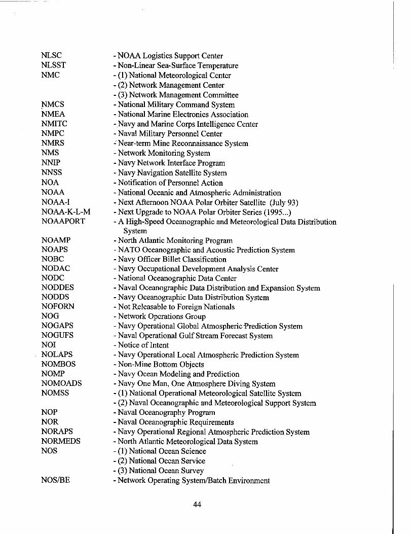
NLSC NLSST NMC
NMCS NMEA NMITC NMPC NMRS NMS NNIP NNSS NOA NOAA NOAA-I NOAA-K-L-M NOAAPORT
NOAMP NOAPS NOBC NODAC NODC NODDES NODDS NOFORN NOG NOGAPS NOGUFS NOI NOLAPS NOMBOS NOMP NOMOADS NOMSS
NOP NOR NORAPS NORMEDS NOS
NOS/BE
NOAA Logistics Support Center Non-Linear Sea-Surface Temperature (1) National Meteorological Center
• (2) Network Management Center • (3) Network Management Committee ■ National Military Command System • National Marine Electronics Association ■Navy and Marine Corps Intelligence Center ■ Naval Military Personnel Center : Near-term Mine Reconnaissance System ■ Network Monitoring System ■ Navy Network Interface Program • Navy Navigation Satellite System • Notification of Personnel Action ■ National Oceanic and Atmospheric Administration • Next Afternoon NOAA Polar Orbiter Satellite (July 93) ■ Next Upgrade to NOAA Polar Orbiter Series (1995...) ■ A High-Speed Oceanographic and Meteorological Data Distribution
System • North Atlantic Monitoring Program ■ NATO Oceanographic and Acoustic Prediction System ■ Navy Officer Billet Classification • Navy Occupational Development Analysis Center ■ National Oceanographic Data Center ■ Naval Oceanographic Data Distribution and Expansion System • Navy Oceanographic Data Distribution System ■ Not Releasable to Foreign Nationals • Network Operations Group ■ Navy Operational Global Atmospheric Prediction System ■ Naval Operational Gulf Stream Forecast System ■Notice of Intent ■ Navy Operational Local Atmospheric Prediction System ■ Non-Mine Bottom Objects ■ Navy Ocean Modeling and Prediction ■ Navy One Man, One Atmosphere Diving System ■ (1) National Operational Meteorological Satellite System (2) Naval Oceanographic and Meteorological Support System Naval Oceanography Program Naval Oceanographic Requirements Navy Operational Regional Atmospheric Prediction System North Atlantic Meteorological Data System (1) National Ocean Science (2) National Ocean Service (3) National Ocean Survey Network Operating System/Batch Environment
44

NOSHIP NOSS
NOS/VE NOTAM NOTS NOWLAPS NOWOP NPC NPCP NPOESS NPS NRC
NRZI NSA NSADB NSAP
NSCAT NSD
NSDS NSDS-G NSDTC NSF
NSG NSIA NSIDC NSIPS NSITS NSO NSODB NSRDC NSS NSSA NSSFC NSSL NSW NTAG NTCC NTCM NTCS-A NTDS
- Naval Occupational Safety and Health Inspection Program - (1) National Oceanic Satellite System - (2) NAVOCEANO Operations Support System - Network Operating System/Virtual Environment - Notice to Airmen - Near-Surface Ocean Thermal Structure - Navy Over-Water Local Atmospheric Prediction System - Northern Waters Oceanographic Program - NEXRAD Program Council - Navy Potential Contractor Program - National Polar-Orbiting Operational Environmental Satellite System - Navigation Processing System - (1) National Reconditioning Center - (2) National Regulatory Commission - Non-Return to Zero Interface - National Security Agency - Navy Standard Acoustic Data Base ■ (1) National Science Assistance Program • (2) National Scientific Advisory Program - NASA Scatterometer - (1) Naval Supply Depot ■ (2) Navy Support Date - Naval Satellite Display Station • NSDS-Geostationary ■ Navy Standard Desktop Tactical Computer ■ (1) National Science Foundation ■ (2) Navy Stock Fund • Naval Security Group ■ National Security Industrial Association • National Snow and Ice Data Center ■ NRL Satellite Image Processing System ■ Naval Satellite Information Transfer System ■ Network Security Officer • NATO Standard Oceanographic Data Base • Naval Ship Research and Development Center • New Start Study • Navy Space Systems Activity National Severe Storms Forecast Center National Severe Storms Laboratory Naval Special Warfare Navy Tactical Applications Guide Naval Telecommunications Center
■ Nested Tropical Cyclone Model Navy Tactical Command Systems - Afloat Naval Tactical Data System
45
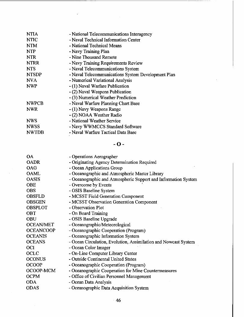
NTIA NTIC NTM NTP NTR NTRR NTS NTSDP NVA NWP
NWPCB NWR
NWS NWSS NWTDB
• National Telecommunications Interagency Naval Technical Information Center National Technical Means Navy Training Plan Nine Thousand Remote Navy Training Requirements Review Naval Telecommunications System Naval Telecommunications System Development Plan Numerical Variational Analysis (1) Naval Warfare Publication (2) Naval Weapons Publication (3) Numerical Weather Prediction Naval Warfare Planning Chart Base (1) Navy Weapons Range (2) NOAA Weather Radio National Weather Service
■ Navy WWMCCS Standard Software Naval Warfare Tactical Data Base
o
OA OADR OAG OAML OASIS OBE OBS OBSFLD OBSGEN OBSPLOT OBT OBU OCEAN/MET OCEANCOOP OCEANIS OCEANS OCI OCLC OCONUS OCOOP OCOOP-MCM OCPM ODA ODAS
• Operations Aerographer ■ Originating Agency Determination Required ■ Ocean Applications Group ■ Oceanographic and Atmospheric Master Library ■ Oceanographic and Atmospheric Support and Information System • Overcome by Events ■ OSIS Baseline System • MCSST Field Generation Component MCSST Observation Generation Component
• Observation Plot On Board Training OSIS Baseline Upgrade Oceanographic/Meteorological Oceanographic Cooperation (Program) Oceanographic Information System Ocean Circulation, Evolution, Assimilation and Nowcast System Ocean Color Imager On-Line Computer Library Center Outside Continental United States Oceanographic Cooperation (Program) Oceanographic Cooperation for Mine Countermeasures Office of Civilian Personnel Management Ocean Data Analysis Oceanographic Data Acquisition System
46

ODATS ODC ODISTA ODS ODT OEA OEF OEM OERS OES OFCM
OGCM 01 OIS OLDAS OLS
O&MN OMB OMP OMR OMS OMT ONA ONR ONS ONT OOB OPAREA OPARS OPC
OPCHECK ÖPCON OPDEC OPEVAL OPF OPIP OPM OPN OPSEC OPTAMAS
OPTAR
- Oceanographic Data Acquisition Through the Sensors - Officer Designator Code - Oceanographic Data in Submarine Transit Areas - Office of Distribution Services - Omni-Directional Transmission - Ocean Executive Office - Ocean Environmental File - Original Equipment Manufacturer - Oceanographic Environmental Reference Service - Oceanographic/Environmental Summary ■ Office of the Federal Coordinator for Meteorological Services and
Supporting Research - Oceanic Global Circulation Model - Optimum Interpolation - Oceanographic Information System ■ Off Line Data Analysis Station ■ (1) Operational Linescan System - (2) Optical Line Scanner ■ Operations and Maintenance, Navy ■ Office of Management and Budget • Ocean Measurements Program • Outgoing Mail Record ■ Optimum Mode Selection ■ Ocean Measurement Techniques ■ Open Network Architecture ■ Office of Naval Research ■ Operational Navigation Chart ■ Office of Naval Technology ■Order of Battle ■ Operational Area ■ Optimum Path Aircraft Routing System (1) Ocean Processing Center (2) Operational Processing Centers Operational Check Operational Control Operational Deception Operational Evaluation Official Personnel Folder Ocean Performance Improvement Office of Personnel Management Other Procurement, Navy Operational Security Optimization of the Performance of Theater ASW Mobile Acoustic
Sensors Operating Target
47

OPTASK OPTEST OPTEVFOR OPTOMA OR ORA ORCA ORD ORESTES OS OSD OSEPS OSF
OSGP OSHA OSI
OSIS OSO OSP OSPSS OSS OSSM OSTA OSU OTAR OTC OTC/CWC OTCIXS OTH OTH-B OTH-T OTIS
OTIS-G OTJ OTS OTSR OVT OWG OWS
- Operational Tasking - Operational Test - Operational Test and Evaluation Force - Ocean Prediction Through Observation, Modeling and Analysis - Operational Requirement - Operational Readiness Assessment - Oceanographic Remotely Controlled Automaton - Operational Requirements Document - Covered Radio Teletype - Operational Specifications - Office of the Secretary of Defense - On Scene Environmental Prediction System - (1) Open Software Foundation - (2) Operational Support Facility - Operations Support Group Processor - Occupational Safety and Health Administration - (1) Open System Interconnection - (2) Operating Space Item - Ocean Surveillance Information System - Office of System Operations - Ocean Survey Program - Ocean Survey Program Survey System - Operations Support System - On-Scene Spill Model - Ocean Station ■ Optical Scan Unit - Over the Air Rekeying ■ Officer in Tactical Command ■ Officer in Tactical Command/Composite Warfare Comander - Officer in Tactical Command Information and Exchange System • Over the Horizon ■ Over the Horizon-Backscatter ■ Over the Horizon-Targeting ■ (1) Ocean Technology Information System ■ (2) Optimal Thermal Interpolation System ■ Ocean Technology Information System - Geophysical ■ Outstanding Transaction Journal ■ Ocean Thermal Structure ■ Optimum Track Ship Routing ■ Operational Verification Testing Operations Working Group Ocean Weather Station
48

P3I PA PABX PACDIGS PACMEDS PAD PADA PAIGH PAIR PALDS PALT PAO PARM PARS PASS
PAT PATWAS PBB PBBPF PBD PBL PBNZ PBNZC PBNZD PBX PC PCA PCCB PCEAS PCGRAFAX PCH PCHFFAX PCM PCS
PCZD PD
- Preplanned Products Improvement - Point Analysis - Private Automatic Branch Exchange - Pacific Digital Graphics System - Pacific Meteorological Data System - Packet Assembler/Disassembler ■ PressureAltitude/Density Altitude ■ Pan American Institute of Geography and History - Performance and Integration Retrofit - Precision Alignment Determination System ■ Purchase Administrative Lead Time ■ Public Affairs Officer ■ Participating Manager • Performance Appraisal Recognition System ■ (1) Performance Analysis for Surveillance Systems ■ (2) Portable Acoustic Survey System ■ Process Action Team • Pilot Automatic Telephone Weather Answering Service ■ Passive Broad Band • Passive Broad Band Prediction Frequency ■ Program Budget Decision • Planetary Boundary Layer ■ Precise Bathymetric Navigation Zone • Precise Bathymetric Navigation Zone Chart ■ Precise Bathymetric Navigation Zone Digitized ■ Private Branch Exchange ■ Personal Computer • Power Challenge Array PMI Configuration Control Board Programmable Calculator Environmental Applications Software
• Personal Computer Graphics Facsimile • Packing, Crating, and Handling Personal Computer High-Frequency Facsimile Pulse Code Modulation (1) Permanent Change of Station (2) Primary Control Ship (3) Propagation Conditions Summary Probability of Convergence Zone Detection (1) Periscope Depth (2) Position Description
■ (3) Probability of Detection ■ (4) Program Director
49

PDA
PDAPS PDB PDC PDD
PDM PDN PDP PDR
PDS
PDT PE
PEACS PEAK PECI PECP PEDAM PEP
PEPG PEPS PEPSR PEPSU PERCOM PERMA PESOGEN PFCS PFM PGM PHITAR PI/DE PICS PID PIES PIF PIM
(1) Post Delivery Availability (2) Principal Development Activity (3) Property Disposal Agent
■ Portable Data Acquisition and Processing System ■ Program Decision Board • Program Designator Code • (1) Precision Depth Digitizer ■ (2) Program Definition Document • Program Decision Meeting • Public Data Network • Programmed Data Processor ■ (1) Precision Depth Recorder ■ (2) Preliminary Design Review ■ (1) Passive Detection System ■ (2) Program Design Specification ■ (3) Protected Distribution System ■ Processed Directional Transmission ■ (1) Parabolic Equation ■ (2) Primitive Equation ■ (3) Probable Error ■ (4) Program Element • Portable Environmental/Acoustic Collection System ■ Promoting Environmental Acoustic Knowledge ■ Productivity Enhancement Capital Investment ■ Preliminary Engineering Change Proposal • Primitive Equation Data Assimilating Model ■ (1) Personal Excellence Partnership ■ (2) Personnel Exchange Program • Primitive Equation Persian Gulf • Primary Environmental Prediction System • PEPS Replacement • PEPS Upgrade Persian Gulf Operational Circulation Module
■ Planning, Embarkation, Rehearsal, Movement and Assault • Parabolic Equation Solution Generator Permanent File Computer System
■ Pre-Faulted Module Precision Guided Munitions Pre-Designated High Interest Tactical Area Passive Identification and Detection PC Image Communications System Program Implementation Directive Photographic Image Editing System Productivity Investment Fund Position and Intended Movement
50
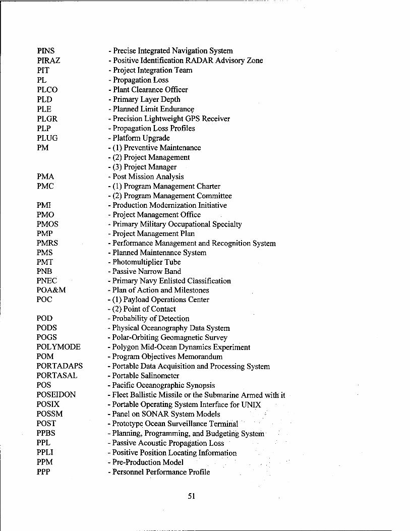
PINS PIRAZ PIT PL PLCO PLD PLE PLGR PLP PLUG PM
PMA PMC
PMI PMO PMOS PMP PMRS PMS PMT PNB PNEC POA&M POC
POD PODS POGS POLYMODE POM PORTADAPS PORTASAL POS POSEIDON POSIX POSSM POST PPBS PPL PPLI PPM PPP
• Precise Integrated Navigation System ■ Positive Identification RADAR Advisory Zone ■ Project Integration Team • Propagation Loss ■ Plant Clearance Officer ■ Primary Layer Depth • Planned Limit Endurance • Precision Lightweight GPS Receiver • Propagation Loss Profiles ■ Platform Upgrade ■ (1) Preventive Maintenance ■ (2) Project Management • (3) Project Manager ■ Post Mission Analysis ■ (1) Program Management Charter ■ (2) Program Management Committee ■ Production Modernization Initiative Project Management Office Primary Military Occupational Specialty Project Management Plan Performance Management and Recognition System Planned Maintenance System Photomultiplier Tube Passive Narrow Band Primary Navy Enlisted Classification Plan of Action and Milestones (1) Payload Operations Center (2) Point of Contact Probability of Detection Physical Oceanography Data System Polar-Orbiting Geomagnetic Survey Polygon Mid-Ocean Dynamics Experiment Program Objectives Memorandum Portable Data Acquisition and Processing System Portable Salinometer Pacific Oceanographic Synopsis Fleet Ballistic Missile or the Submarine Armed with it Portable Operating System Interface for UNIX Panel on SONAR System Models Prototype Ocean Surveillance Terminal Planning, Programming, and Budgeting System Passive Acoustic Propagation Loss Positive Position Locating Information Pre-Production Model Personnel Performance Profile
51

PPS
PPS&C PPSL PPT PQS PQT PRAM PREOS PRESSURS PRF PRISM
PRITAC PROFGEN PROFS PROM PROPLOSS PSA
PSMSL PSN
PSS PST PSU PTE PTF PTP PTS PTTI PTWC PUFFS PUP PV PVA PVDOT
(1) Precise Positioning System (2) Priority Placement Program
■ (3) Program Performance Specification Programming Practices, Standards, and Conventions Program Parts Selection List Pass Prediction Table
■ Personnel Qualification Standard • Preliminary Qualification Testing ■ Propelled Rocket Assisted Mine ■ Prediction of Range for Electro-Optic Systems • Pre-Strike Surveillance/Reconnaissance System • Pulse Repetition Frequency ■ (1) PR Information Storage Method ■ (2) Program for Integrated SONAR Modeling • Primary Tactical Circuit ■ Profile Generator Program for Regional Observing and Forecasting Service Programmable Read Only Memory
• Propagation Loss • (1) Post Shakedown Availability (2) Project Support Agreement Permanent Service for Mean Sea Level (1) Packet Switching Network (2) Packet Switching Node Peripheral Server Station Primary Search Tonal Practical Salinity Unit Paper Tape Equipment Patch and Test Facility Practical Training Publications Post Time System Precise Time and Time Interval Pacific Tsunami Warning Center Passive Underwater Fire-Control Feasibility System Principal User Processor Platform Vulnerability Positive Vorticity Advection Position and Velocity Deep Ocean Transponder
Q-MIPS QA QC QLP
Q-route Mine Image Processing System Quality Assurance Quality Control Query Language Processor
52

QLSC QMB QRS QSI
Quadri-lateralized Spherical Cube Quality Management Board Quartz Rate Sensor Quality Salary Increase
R-
R/V R&D RA RAD RADAPS RADAR RADARSAT RADFO RADIDS RADHAZ RADSS RAIDS RAINFORM
RAM
RAMOS RAMS RANDI RAP
RAPLOC RAPMO RAS RASS RAST RATT RBOC RBR RCC/MG RCM RCP RCR RCS
RD RDA
Research Vessel Research and Development RADAR Altimeter Resource Allocation Display Replacement Airborne Data Acquisition and Processing System Radio Detecting and Ranging Radar Satellite, Canadian Space Agency, SAR Equipped Radiological Fallout RADAR Information Display System Radiation Hazard Requirements Analysis Decision Support System Remote Atmospheric and Ionospheric Detection System Formatted Message that is Computer Readable for Automatic
Information Display (1) Random Access Memory (2) Reserve Aerographer's Mate (3) Rolling Airframe Missile Remote Automatic Meteorological Observing System Reserve Aerographer's Mate School Research Ambient Noise Directionality Model (1) Reliable Acoustic Path (2) Rocket Assisted Projectile Rapid Acoustic Passive Localization Program Rapid Mobilization Remote Antenna Site Radio Acoustic Sounding System Recovery, Assist, Securing and Traversing Radio Teletype Rapid Bloom Offboard Chaff Refracted, Bottom Reflected Range Commanders Council Meteorology Group Recording Current Meter Request for Contractual Procurement Runway Condition Report (1) Reaction Control Subsystem (2) Report Control Symbol
■ Recognition Differential ■ Radar Data Acquisition
53

RDBMS RDD RDI RDIXS RDJTF RDOS RDOT RDSS RDT RDT&E RDT&EN RE REX RF RFC RFI
RFOU RFP
RFQ RFSDR RFT RGASS RGDR RH RHAW RIA RIMPAC RISOP RIXT RJE RMS
RMTN RNODC ROE ROM ROMS ROPE RO/RO ROS ROSS ROTHR
- Relational Data Base Management System - Required Delivery Date - RD Instruments - R&D Information Exchange System - Rapid Deployment Joint Task Force - Real-Time Disk Operating System - Recoverable Deep Ocean Transponder - Rapidly Deployable Surveillance System - Rotational Directional Transmission - Research, Development, Test, and Evaluation - Research, Development, Test, and Evaluation, Navy - Regional Expert - Regional Energetics Experiment - Radio Frequency - River Forecast Center - (1) Radio Frequency Interference - (2) Ready for Issue - Ready for Operational Use - (1) Request for Products - (2) Request for Proposal - Request for Quote ■ Radar Free Space Detection Range ■ Ready for Training - Replacement Geophysical Airborne Survey System ■ Real-time Geophysical Data Record - Relative Humidity ■ RADAR Homing and Warning - Radiosonde Initial Analysis ■ Rim of the Pacific ■ Rapid Interval Scan Operations Plan ■ Remote Information Exchange Terminal • Remote Job Entry ■ (1) Redistribution Management System ■ (2) Remote Minehunting System ■ (3) Root Mean Square ■ Regional Meteorological Telecommunication Network Responsible National Oceanographic Data Center Rules of Engagement Read Only Memory Remote Ocean Surface Measuring System Read Only Print Emulators Roll On/Roll Off Reduced Operating Status Remote Ocean Sensing System Relocatable Over the Horizon RADAR
54

ROV - Remotely Operated Vehicle ROW -Rest of World RP - (1) Real Points
- (2) Reference Publication RPA - (1) RADAR Propagation Analysis
- (2) Request for Personnel Action RPG - Radar Product Generator RPIPS-B - Regional Polar Ice Prediction System - Barents Sea RPIPS-G - Regional Polar Ice Prediction System - Greenland Sea RPN - Reserve Personnel, Navy RPO - Radio Physical Optics RPV - Remotely Piloted Vehicle RR - Refracted-Refracted RRSD - Research Rapid Scan Day RS - Recommended Standard RSP - Rapid Scan Picture RSR - Refracted Surface-Reflected Ray Path RSS - Root Sum Square RSVP - Retrieve Sound Velocity Profile RTD - Real-Time Data RTDHS - Real-Time Data Handling System RTE - Real-Time Executive RTH - Regional Telecommunication Hub RTM - Rate Training Manual RTOPS - Regional Thermal Ocean Prediction System RTRVB - Real-Time Reverberation Collection and Processing System RTSP - Real-Time Signal Processor RTU - Remote Telemetry Unit RVR - Runway Visual Range RWI - Radio Wireline Interface RWP - Real-Time Weather Processor
-S-
S&H SABLE SAC
SACAM SACDIN SADBU SADOT SADS SAG
Sample and Hold Sonar Active Bottom-Loss Estimator (1) Scene of Action Commander (2) Strategic Air Command Ships Acquisition Contract and Administrative Manual Strategic Air Command Digital Network Small and Disadvantaged Business Utilization Sound-Activated Deep Ocean Transponder Submarine Active Detection SONAR (1) Sub Activity Group
■ (2) Surface Action Group
55
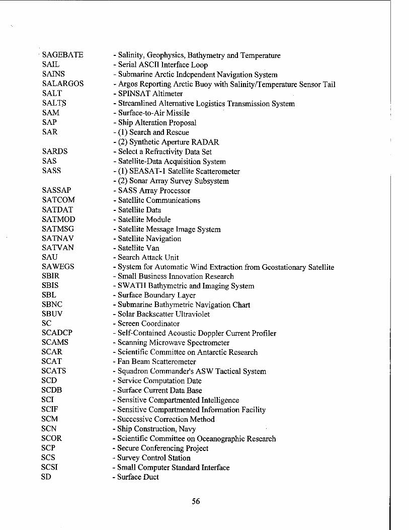
SAGEBATE SAIL SAINS SALARGOS SALT SALTS SAM SAP SAR
SARDS SAS SASS
SASSAP SATCOM SATDAT SATMOD SATMSG SATNAV SATVAN SAU SAWEGS SBIR SBIS SBL SBNC SBUV SC SCADCP SCAMS SCAR SCAT SCATS SCD SCDB SCI SCIF SCM SCN SCOR SCP scs SCSI SD
■ Salinity, Geophysics, Bathymetry and Temperature • Serial ASCII Interface Loop ■ Submarine Arctic Independent Navigation System • Argos Reporting Arctic Buoy with Salinity/Temperature Sensor Tail ■ SPINSAT Altimeter • Streamlined Alternative Logistics Transmission System ■ Surface-to-Air Missile ■ Ship Alteration Proposal ■ (1) Search and Rescue • (2) Synthetic Aperture RADAR • Select a Refractivity Data Set ■ Satellite-Data Acquisition System • (1) SEASAT-1 Satellite Scatterometer • (2) Sonar Array Survey Subsystem • SASS Array Processor • Satellite Communications ■ Satellite Data ■ Satellite Module ■ Satellite Message Image System ■ Satellite Navigation • Satellite Van ■ Search Attack Unit ■ System for Automatic Wind Extraction from Geostationary Satellite ■ Small Business Innovation Research SWATH Bathymetric and Imaging System Surface Boundary Layer Submarine Bathymetric Navigation Chart Solar Backscatter Ultraviolet Screen Coordinator Self-Contained Acoustic Doppler Current Profiler Scanning Microwave Spectrometer Scientific Committee on Antarctic Research Fan Beam Scatterometer Squadron Commander's ASW Tactical System Service Computation Date Surface Current Data Base Sensitive Compartmented Intelligence Sensitive Compartmented Information Facility Successive Correction Method Ship Construction, Navy Scientific Committee on Oceanographic Research Secure Conferencing Project Survey Control Station Small Computer Standard Interface Surface Duct
56

SDC SDD
SDDD SDHS SDLC SDLM SDP SDR
SDRPS SDRS SDS
SDS III SDT SDTS SDV SE SEA LANCE SEABEAM SEALAR SEAMAP SEAMOS SEAOATS
SEAPL SEAS SEATAC SEAWIFS SEC
SECNAVINST SEDAAR SEF SEGS SEI SEL SELRES SEM SENCAL SERCES
SERDP
Sonobuoy Data Computer (1) Software Design Document (2) System Design Document Software Detailed Design Document Satellite Data Handling System Synchronous Data Link Control Scheduled Depot Level Maintenance System Decision Paper (1) Sensor Data Record (2) Signal Data Recorder Satellite Data Receiving and Processing System Submarine Data Recording System (1) Stored Data, Smooth (2) Surveillance Direction System Shipboard Data System III Steered Directional Transmission Spatial Data Transfer Standards Swimmer Delivery Vehicle Signal Excess ASW Standoff Weapon (MK-50) Swath Survey System Sea Launch and Recovery Southeast Assessment, Monitoring, and Prediction Satellite Environmental Analysis Mobile Oceanographic System Shallow-Water Environmental Assessment: Operational-
Analytical-Tactical System Shipboard Equipment Allowance Parts List Shipboard Environmental Data Acquisition System Screen Evaluation Aid for Tactical Commanders Sea-Viewing Wide Field-of-View Sensor (1) South Equatorial Current (2) Submarine Element Coordinator Secretary of Navy Instruction Strategic Environmental Distributed Active Archive Resource Software Enhancement Form Secure Environmental Graphics System
• Software Engineering Institute ■ Systems Engineering Laboratory • Selected Reservist ■ Solar (Space) Environmental Monitor ■ Sensor Calibration Laboratory ■ Synthetic Environment for Requirements and Concepts Evaluation
Simulation - Strategic Environmental Research and Development Program
57
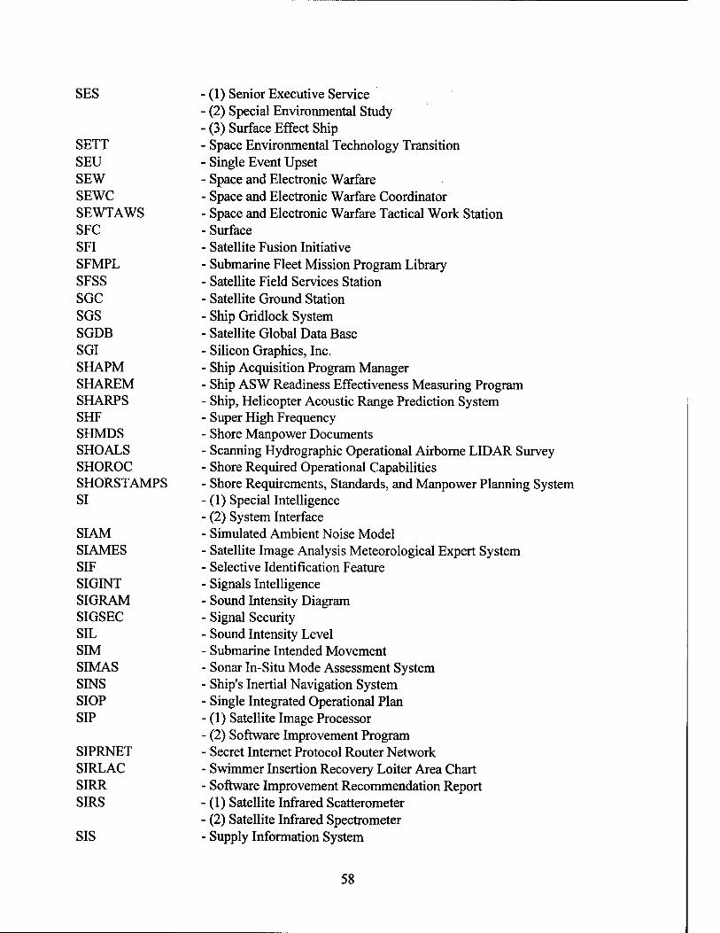
SES
SETT SEU SEW SEWC SEWTAWS SFC SFI SFMPL SFSS SGC SGS SGDB SGI SHAPM SHAREM SHARPS SHF SHMDS SHOALS SHOROC SHORSTAMPS SI
SIAM SIAMES SIF SIGINT SIGRAM SIGSEC SIL SIM SIMAS SINS SIOP SIP
SIPRNET SIRLAC SIRR SIRS
SIS
(1) Senior Executive Service (2) Special Environmental Study (3) Surface Effect Ship Space Environmental Technology Transition Single Event Upset Space and Electronic Warfare Space and Electronic Warfare Coordinator Space and Electronic Warfare Tactical Work Station Surface Satellite Fusion Initiative Submarine Fleet Mission Program Library Satellite Field Services Station Satellite Ground Station Ship Gridlock System Satellite Global Data Base Silicon Graphics, Inc. Ship Acquisition Program Manager Ship ASW Readiness Effectiveness Measuring Program Ship, Helicopter Acoustic Range Prediction System
• Super High Frequency Shore Manpower Documents Scanning Hydrographie Operational Airborne LID AR Survey Shore Required Operational Capabilities Shore Requirements, Standards, and Manpower Planning System (1) Special Intelligence
• (2) System Interface ■ Simulated Ambient Noise Model Satellite Image Analysis Meteorological Expert System Selective Identification Feature Signals Intelligence
• Sound Intensity Diagram Signal Security Sound Intensity Level Submarine Intended Movement Sonar In-Situ Mode Assessment System Ship's Inertial Navigation System Single Integrated Operational Plan (1) Satellite Image Processor (2) Software Improvement Program Secret Internet Protocol Router Network Swimmer Insertion Recovery Loiter Area Chart Software Improvement Recommendation Report (1) Satellite Infrared Scatterometer (2) Satellite Infrared Spectrometer Supply Information System
58

SIT SITREP SL SLAP SLAR
SLATE SLBM SLC SLCM
SLCSAT SLD SLEP SLF SLMM SLO SLOC SLOT SLP SLPF SLR SLW SM&R SMCM SMDD SMDR SME SMMR SMOOS SMOS
SMS SN SNA SNAP SNAPS SNAR SNCR SNEC SNPC SNR
SNS
- System Integration Test - Situation Report - Source Level - Solar/Lunar Almanac Program - (1) Side-Looking Airborne Radar - (2) Side-Looking Aperture Radar - Submarine-Launched ASW Two-Way Expendable Buoy - Submarine-Launched Ballistic Missile - Sonobuoy Launch Container - (1) Ship-Launched Cruise Missile - (2) Submarine-Launched Cruise Missile - Submarine Laser Communications Satellite - Sonic Layer Depth - Service Live Extension Program - Standard Linear Format - Submarine-Launched Mobile Mine - Submarine Liaison Officer - Sea Line of Communications - Submarine-Launched One-Way Transmission - Sea Level Pressure - Sealift Protection Force - Side-Looking RADAR - Super-cooled Liquid Water ■ Source Maintenance and Recoverability ■ Surface Mine Countermeasures ■ Storage Module Disk Drive ■ Station Message Detailing Recording ■ Subject Matter Expert ■ Scanning Multichannel Microwave Radiometer ■ Shipboard Meteorological and Oceanographic Observing System • (1) Secondary Military Occupational Specialty ■ (2) Summary of Meteorological Observations • Synchronous Meteorological Satellite ■ Shipping Noise • System Network Architecture Shipboard Numerical Aids Program Standard Navy Ahimetry Processing System Standard Navy Altimetry Record Statement of Nonavailability of Computer Resources Secondary Navy Enlisted Classification Submarine Navigation Planning Chart (1) Senior NAVOCEANO Representative (2) Signal to Noise Ratio Senior NAVOCEANO Scientist
59
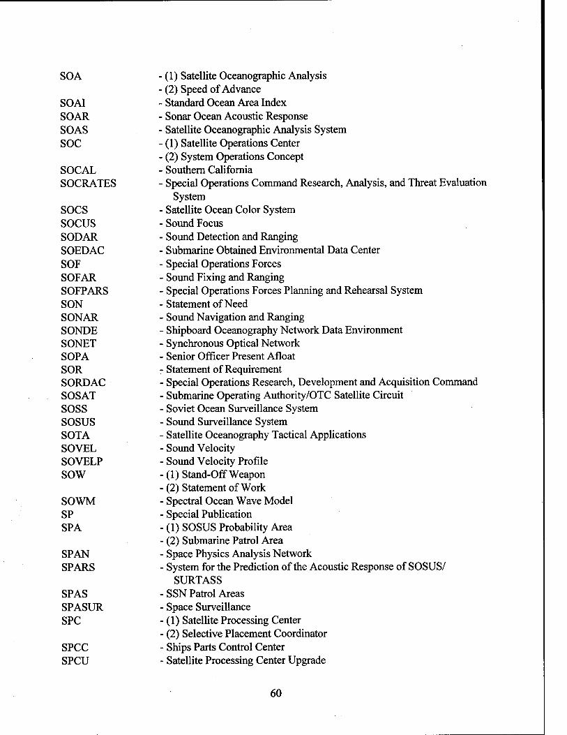
SOA
SOAI SOAR SOAS SOC
SOCAL SOCRATES
SOCS SOCUS SODAR SOEDAC SOF SOFAR SOFPARS SON SONAR SONDE SONET SOPA SOR SORDAC SOSAT SOSS SOSUS SOTA SOVEL SOVELP SOW
SOWM SP SPA
SPAN SPARS
SPAS SPASUR SPC
SPCC SPCU
(1) Satellite Oceanographic Analysis (2) Speed of Advance Standard Ocean Area Index Sonar Ocean Acoustic Response Satellite Oceanographic Analysis System (1) Satellite Operations Center (2) System Operations Concept Southern California Special Operations Command Research, Analysis, and Threat Evaluation
System Satellite Ocean Color System Sound Focus
• Sound Detection and Ranging ■ Submarine Obtained Environmental Data Center Special Operations Forces
• Sound Fixing and Ranging • Special Operations Forces Planning and Rehearsal System • Statement of Need ■ Sound Navigation and Ranging ■ Shipboard Oceanography Network Data Environment ■ Synchronous Optical Network • Senior Officer Present Afloat ■ Statement of Requirement ■ Special Operations Research, Development and Acquisition Command ■ Submarine Operating Authority/OTC Satellite Circuit ■ Soviet Ocean Surveillance System ■ Sound Surveillance System ■ Satellite Oceanography Tactical Applications ■ Sound Velocity ■ Sound Velocity Profile (1) Stand-Off Weapon
• (2) Statement of Work ■ Spectral Ocean Wave Model ■ Special Publication ■ (1) SOSUS Probability Area ■ (2) Submarine Patrol Area ■ Space Physics Analysis Network ■ System for the Prediction of the Acoustic Response of SOSUS/
SURTASS ■ SSN Patrol Areas ■ Space Surveillance ■ (1) Satellite Processing Center ■ (2) Selective Placement Coordinator ■ Ships Parts Control Center ■ Satellite Processing Center Upgrade
60

SPECOPS SPEM SPETE SPETERL SPINS SPINSAT SPINTCOMM SPL SPN SPP
SPR SPRBOC SPS
SPSU SPW SQIDS SQL
SR SRA SRB SRBR SRF SRFLOS SRS SRT
SRU ss
SSA SSAAC SSBN SSC
SSE SSEE SSES SSFC
- Special Operations - Semi-spectral Primitive Equation Model - Special-Purpose Electronic Test Equipment - Shore Portable Electronic Test Equipment Requirements List - Ship's Passive Integrated Navigation System - Special Purpose Inexpensive Satellite - Special Intelligence Communications - Sound Pressure Level - Shared Processing Network - (1) Sensor Performance Prediction - (2) Shared Processing Program - (3) Sponsor Program Proposal - Sponsor's Program Review - Super Rapid Bloom Offboard Chaff - (1) Satellite Processing System - (2) Sharing Profile System - (3) Signal Processing System - (4) Software Product Specification - Satellite Processing System Upgrade - Special Warfare ■ Satellite Quick-Look Interactive Display System - (1) Standard Query Language - (2) Structured Query Language ■ Scanning Radiometer ■ Selected Restricted Availability - Software Review Board ■ Surface Reflected-Bottom Reflected ■ Sub-Regional Forecast • Surface Loss ■ Software Requirements Specification • (1) Shipboard Readiness Test ■ (2) Systems Readiness Test ■ System Replaceable Unit (1) Diesel Attack Submarine (2) Submersible Ship (Submarine) Software Support Activity Surface Ship ASW Analysis Center Nuclear-Powered Fleet Ballistic Missile Submarine (1) Shallow Sound Channel (2) Stennis Space Center Site-Specific Expert Ship's Signal Exploitation Equipment Ship's Signal Exploitation Space Severe Storms Forecast Center
61

SSGN - Nuclear Cruise Missile Submarine SSH - Sea-Surface Height SSIXS - Submarine Satellite Information Exchange System SSM - Surface-to-Surface Missile SSMI - Special Sensor Microwave Imager SSMO - Summary of Synoptic Meteorological Observations SSM/T - Special Sensor Microwave Temperature SSN - Nuclear-Powered Attack Submarine SSP -(1) Sound Speed Profile
- (2) SSBN Security Program - (3) Strategic Systems Program
SSPO - Strategic Systems Program Office SSR SSS sssc SST
SSTAC SSTD SSTG ssu SSVA SSXBT ST&E STA STACS STANAG STARS-FL STASS STD
STDN STDP STEAP STICS STIR STIWG STOIC STORM STP STR
STRED STSS STT
Surface Search Radar ■ Side-Scan Sonar ■ Surface/Subsurface Surveillance Control ■ (1) Sea Surface Temperature ■ (2) Ship Surveillance and Targeting ■ Sea-Surface Temperature Analysis and Composite ■ Surface Ship Torpedo Defense - Ship's Service Turbo-Generator ■ Stratospheric Sounding Unit • Signals Susceptibility and Vulnerability Assessment ■ Submarine-Launched Expendable Bathythermograph ■ Security Test and Evaluation ■ Submarine Trial Area • Subtropical Atlantic Climate Studies ■ Standard NATO Agreement ■ Standard Accounting and Reporting System - Field Level • Submarine Towed Array Surveillance System ■ (1) Salinity, Temperature, Depth • (2) Software Test Description Spacecraft Tracking and Data Network Submarine Tactical Development Program Shore Test Equipment Allowance Program Scalable Transportable Intelligence Communications Systems Separate Tracking and Illumination Radar Satellite Telemetry Interagency Working Group Special Tactical Oceanographic Information Chart Submarine Tactical Oceanographic Reference Manual Space Test Program (1) Software Trouble Report (2) STEAP Technical Representative Standard Tactical Receive Equipment Display Surface Towed Search System Shore Targeting Terminals
62
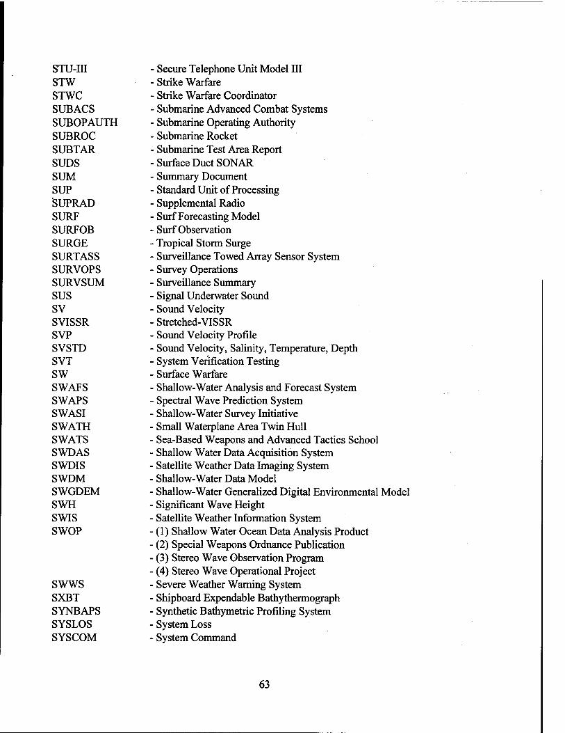
STU-III STW STWC SUBACS SUBOPAUTH SUBROC SUBTAR SUDS SUM SUP SUPRAD SURF SURFOB SURGE SURTASS SURVOPS SURVSUM SUS SV SVISSR SVP SVSTD SVT SW SWAFS SWAPS SWASI SWATH SWATS SWDAS SWDIS SWDM SWGDEM SWH SWIS SWOP
SWWS SXBT SYNBAPS SYSLOS SYSCOM
• Secure Telephone Unit Model III • Strike Warfare Strike Warfare Coordinator
■ Submarine Advanced Combat Systems Submarine Operating Authority Submarine Rocket
• Submarine Test Area Report Surface Duct SONAR Summary Document Standard Unit of Processing Supplemental Radio Surf Forecasting Model Surf Observation Tropical Storm Surge Surveillance Towed Array Sensor System Survey Operations Surveillance Summary Signal Underwater Sound Sound Velocity Stretched-VISSR Sound Velocity Profile Sound Velocity, Salinity, Temperature, Depth System Verification Testing Surface Warfare Shallow-Water Analysis and Forecast System Spectral Wave Prediction System Shallow-Water Survey Initiative Small Waterplane Area Twin Hull Sea-Based Weapons and Advanced Tactics School Shallow Water Data Acquisition System Satellite Weather Data Imaging System Shallow-Water Data Model Shallow-Water Generalized Digital Environmental Model Significant Wave Height Satellite Weather Information System (1) Shallow Water Ocean Data Analysis Product (2) Special Weapons Ordnance Publication (3) Stereo Wave Observation Program (4) Stereo Wave Operational Project Severe Weather Warning System Shipboard Expendable Bathythermograph Synthetic Bathymetric Profiling System System Loss System Command
63

T&A T-AGS T&E T/S/D TAC TACAIR TACAMO TACCO TACINTEL TACNOTE TACRAPS TACSIT TACTAS TACTASS TADILA TADIXS TAEAS TAGOS TAINS TAMPS TAO TAPS
TAR TARP TARPS TARSUS TAS
TASDA
TASM TASO TASP TASS TASSRAP TBD TCASS TCB TCC TCO TCP/IP TCU
Time and Attendance See AGS Test and Evaluation Temperature/Salinity/Depth Tactical Advanced Computer Tactical Air Take Charge and Move Out Tactical Coordinator Tactical Intelligence
■ Tactical Notice Tactical Range Prediction System Tactical Situation
■ Tactical Towed Array Sonar ■ Tactical Towed Array Surveillance System ■ Tactical Data Information Link (Link A) ■ Tactical Digital Exchange Information Subsystem ■ Tactical ASW Environmental Acoustic Support ■ Ocean Surveillance Ship ■ TERCOM-Aided Inertial Navigation System ■ Tactical Aircraft Mission Planning System • Tactical Coordinator ■ (1) Task Force Area Coverage Prediction System ■ (2) Towed Acoustic Projector System ■ Training and Administrative Reserves ■ Towed Array Ranging Program ■ Tactical Air Recon POD System ■ Towed Automatic Reverberation Survey System ■ (1) Tactical Atmospheric Summary ■ (2) Training Advisory Service (1) Tactical ASW SONAR Decision Aid
■ (2) Tactical Sonobuoy Decision Aid TOMAHAWK Anti-Ship Missile
■ Terminal Area Security Officer • Tactical Acoustic Specialist Program ■ Towed Array Surveillance System TASS Range Prediction To Be Determined Tropical Cyclone Applications Software System Trusted Computing Base Tactical Command Center TEMPEST Control Officer Transmission Control Protocol/Interface Protocol Time Critical Units
64

TDA
TDF-11 TDP
TDRSS TDS TDWR TDZ TECA TECHEVAL TEDS TELCOR TEMA TEMP TEMPEST TEMPSAL TEMP-UTIL TENCAP TEPS TERCOM TEROC TESAC TESR TESS TEXAS TF TFR TG/SAG THAIS THIR TIARA TICCS TIMS TINS TIP
TIPS
TIROS TIWG TJS TKE TLAM-C TLAM-N
(1) Tactical Decision Aid (2) Tactical Development Agent Climatology Tape File (1) Tactical Data Processor (2) Testing Designated Position Tracking and Data Relay Satellite System Transfer and Display Software Terminal Doppler Weather Radar Torpedo Danger Zone Tomahawk Environmental Calculation Aid Technical Evaluation Tactical Environmental Data System
• Telecommunications Operating Requirement ■ Training, Education, and Mutual Assistance ■ Test and Evaluation Master Plan ■ Transient Electromagnetic Pulse Emanations Standard • Temperature and Salinity Profile ■ Temperature Utility ■ Tactical Exploitation of National Capabilities ■ Technical/Electronic Publishing System ■ Terrain Contour Matching ■ Terrier-ASROC • Temperature, Salinity, Current Report ■ Tactical Environmental Ship Routing ■ Tactical Environmental Support System ■ Tactical Exchange Automation System - Thermal Fine - Trouble Failure Report ■ Task Group/Surface Action Group ■ Type Commanders Headquarters Automated Information System - Temperature-Humidity Infrared Radiometer - Tactical Intelligence and Related Activities - Tactical Information Command and Control System - Training Information Management System - Trident Integrated Navigation System - (1) Target Intelligence Package - (2) Terminal Interface Processor - (1) Tactical Intelligence Processing System ■ (2) Typhoon Information Processing System - Television Infrared Observational Satellite - Transition Integration Working Group - Tactical Jamming System - Turbulent Kinetic Energy - TOMAHAWK Land Attack Missile - Conventional - TOMAHAWK Land Attack Missile - Nuclear
65

TLDB TLM
TLR TLWR TM
TMASS TMM TMR TN TNCP TNS TOA TOAS TOGA TOI TOMS TOPAS TOPEX TOPS TOPPS TOR
TOS TOSI/B TOSS TOTS TOVS TOW TOWDEX TP TPC TPS TPT TQL TQM TR TRAM
TRBM TRE TRIDENT
- Transmission Loss Data Bank - (1) Telemetry - (2) Topographic Line Map - Top Level Requirement - Top Level Warfare Requirement - (1) Tactical Manager - (2) Technical Manual - (3) Thematic Mapper - (4) Training Manual - Transit Multipass Acoustic Survey Solution - Teletype Message Management - TOPEX Microwave Radiometer - Technical Note - TRIDENT Navigation Commonality Program - Topographic Noise Stripping - Total Obligational Authority - Tactical Oceanographic/Acoustic Spreadsheet - Tropical Ocean and Global Atmosphere - Target of Interest - Tactical Oceanographic Monitoring System - Tactical Operational Performance Assessment System - Topographical Experiment Satellite (U.S.) - Thermodynamic Ocean Prediction System - Tactical Operator's Performance Prediction System - (1) Tactical Oceanographic Refresher - (2) Tentative Operational Requirement - Tactical Oceanographic Summary - Tactical Oceanography Support Interpreter/Briefer - Towed Oceanographic Survey System - Three-Dimensional Ocean Thermal Structure - TIROS Operational Vertical Sounder - Tactical Oceanography Workshop - Towed Bioluminescence Photometer System - Test Plan - Tactical Pilotage Chart - Training Path System - Towed Array Proficiency Training ■ Total Quality Leadership - Total Quality Management ■ Technical Report ■ (1) Target Recognition Attack Multi-Sensor ■ (2) Test, Reliability, and Maintainability ■ Trawl-Resistant Bottom Mount • Tactical Receive Equipment ■ Fleet Ballistic Missile or the Submarine Armed with it
66

TRIFAR - Three-Frequency Wave Spectrometer TRI/PK - TRIDENT/Peacekeeper TRI-TAC - Joint Tactical Communications Development Project TROPE - Trial Ocean Prediction Experiment TRR - Test Readiness Review TS - (1) Target Strength
- (2) Test Specification - (3) Thermal Smooth
TSAR - Theater Simulation of Airfield Resources TSARP - TASS SONAR Acoustic Range Prediction TSC - Tactical Support Center TSCM - Tomahawk Support Command Module TSEP - Temperature Statistical Envelope Package TSES - Tactical Signals Exploitation System TSG - Technical Steering Group TSP - Thrift Savings Plan TSPS - Tide and Surge Prediction System TSR - Telecommunications Service Request TSS - Tactical Surveillance Sonobuoy TTE - Technical Training Equipment TTY - Teletype/Teletypewriter TUPS - Towed Underwater Pumping System TVAR - TEMPEST Vulnerability Assessment Request TVM - Transparent VAS Mode TVRS - Towed Volume Reverberation System TWEB - Transcribed Weather Broadcast TWCS - TOMAHAWK Weapon Control System TWI - Tactical Weather Intelligence TWR - Technical Work Request TWS - Track While Scan TWT - Traveling Wave Tube TXBT - Typical Expendable Bathythermograph TYAN - Typhoon Analog TYCOM - Type Commander TYMNET TYRACK
Commercially Leased Network Typhoon Tracking
U
U-Frame UA UAC U.A.E. UAGC UAV
U-Shaped Hydraulic Device for Overboarding Equipment Upper Air Uniform Annual Cost United Arab Emirates
• Upper Air Gridded Climatology • Unmanned Aerial Vehicle
67

UBFCS UCAR UCD UDF
UEB UHF UIC ULF UMMIPS UMP UN UNDP UNESCO UNISIPS UNITAS UNIVAC UNODIR UNREP UPS URDB URG USAN USAPC USB USE USIABP USR USS USW UTC UTIPS UTM uuv
■ Underwater Battery Fire-Control System ■ University Corporation for Atmospheric Research ■ Useable Completion Date ■ (1) Unit Development Folder ■ (2) User Data Files ■ Underwater Electric Potential ■ Ultra High Frequency ■ Unit Identification Code - Ultra Low Frequency - Uniform Material Movement and Issue Priority System ■ Upward Mobility Program - United Nations ■ United Nations Development Program ■ United Nations Educational, Scientific and Cultural Organization ■ Unified NAVOCEANO Integrated Sonar Image Processing System ■ United International Antisubmarine Warfare - Universal Automatic Computer ■ Unless Otherwise Directed ■ Underway Replenishment ■ Uninterruptible Power Supply - User Requirements Data Base ■ Underway Replenishment Group ■ University Satellite Network • United States Argos Processing Center - User Sensitive Billing - UNIVAC Scientific Exchange ■ U.S. Interagency Arctic Buoy Program ■ Universal Space Rectangular ■ Underway Survey System ■ Undersea Warfare • Universal Time Coordinated • Upgraded Tactical Information Processing System ■ Universal Transverse Mercator ■ Unmanned Undersea Vehicle
VA VACM VAMP VAN VAS VCP VD VDAS
■ Vulnerability Assessment ■ Vector Averaging Current Meter ■ Visual, Acoustic, Magnetic, and Pressure Value Added Network VISSR Atmospheric Sounder Voluntary Cooperation Program Vertical Deflection Velocity Data Acquisition System
68

VDBC VDD VDH VDM VDS VDSL VDST VDT VDU VEDABS VERTREP VFCT
VFR VHF VHRR VIDS VINSON
VIRR VIS/IR VISION VISSR VITR VLA
VLAD VLAPS VLBI VLF VLS VLSTRACK VMADCP VME VOS VP VPRS VPX VRS VSAT VSC VSS VSTOL VSOS VSS
Vertical Deflection Boundary Chart ■ Version Description Document Very Distant Host
■ VISSR/VAS Digital Multiplexer Variable Depth SONAR Vertical Deflection Supplementary Listing Vertical Deflection Storage Tape Video Display Terminal Visual Display Unit Versatile Experimental Data Acquisition Buoy System Vertical Replenishment (1) Voice Frequency Carrier Telegraph (2) Voice Frequency Control Teletype Visual Flight Rules Very High Frequency Very High Resolution Radiometer Visual Integrated Display System VHF/UHF Wide-band Tactical Secure Voice System Cryptographic
Equipment Visibile-Infrared Radiometer Visible/Infrared Video Imagery Support Intelligence Operations Network Visible and Infrared Spin Scan Radiometer Visible and Thermal Infrared Radiometer (1) Vertical Launch ASROC (2) Vertical Line Array Vertical Line Array DIFAR Vertical Line Array Prediction System Very Long Baseline Interferometry Very Low Frequency Vertical Launch System Vapor Liquid Solid Track Vessel-Mounted Acoustic Doppler Current Profiler Versa Module Eurocard Voluntary Observing Ship Fixed Wing Shore Based Patrol Aircraft Velocity Position Reference System Vector Product Exchange Voice Response System Very Small Aperature Terminal Volume Scattering Coefficient Volume Scattering Strength Vertical Short Takeoff and Landing
■ Virtual Storage Operating System ■ Volume Scattering Strength
69
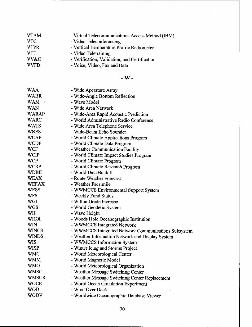
VTAM VTC VTPR VTT VV&C VVFD
Virtual Telecommunications Access Method (IBM) Video Teleconferencing
■ Vertical Temperature Profile Radiometer ■ Video Teletraining • Verification, Validation, and Certification • Voice, Video, Fax and Data
-W
WAA WABR WAM • WAN WARAP WARC WATS WBES WCAP WCDP WCF WCIP WCP WCRP WDBII WEAX WEFAX WESS WFS WGI WGS WH WHOI WIN WINCS WINDS WIS WISP WMC WMM WMO WMSC WMSCR WOCE WOD WODV
Wide Aperature Array Wide-Angle Bottom Reflection Wave Model Wide Area Network Wide-Area Rapid Acoustic Prediction World Administrative Radio Conference Wide Area Telephone Service Wide-Beam Echo Sounder World Climate Applications Program World Climate Data Program Weather Communication Facility World Climate Impact Studies Program World Climate Program World Climate Research Program World Data Bank II Route Weather Forecast Weather Facsimile WWMCCS Environmental Support System
• Weekly Fund Status Within Grade Increase World Geodetic System
• Wave Height Woods Hole Oceanographic Institution
• WWMCCS Integrated Network ■ WWMCCS Integrated Network Communications Subsystem Weather Information Network and Display System WWMCCS Information System Winter Icing and Storms Project World Meteorological Center World Magnetic Model World Meteorological Organization
• Weather Message Switching Center Weather Message Switching Center Replacement World Ocean Circulation Experiment Wind Over Deck Worldwide Oceanographic Database Viewer
70
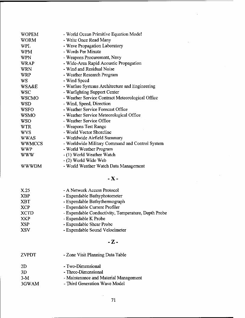
WOPEM - World Ocean Primitive Equation Model WORM - Write Once Read Many WPL - Wave Propagation Laboratory WPM - Words Per Minute WPN - Weapons Procurement, Navy WRAP - Wide-Area Rapid Acoustic Propagation WRN - Wind and Residual Noise WRP - Weather Research Program WS - Wind Speed WSA&E - Warfare Systems Architecture and Engineering WSC - Warfighting Support Center WSCMO - Weather Service Contract Meteorological Office WSD - Wind, Speed, Direction WSFO - Weather Service Forecast Office WSMO - Weather Service Meteorological Office WSO - Weather Service Office WTR - Weapons Test Range WVS - World Vector Shoreline WWAS - Worldwide Airfield Summary WWMCCS - Worldwide Military Command and Control System WWP - World Weather Program WWW - (1) World Weather Watch
- (2) World Wide Web WWWDM - World Weather Watch Data Management
-X-
- A Network Access Protocol X.25 XBP - Expendable Bathyphotometer XBT - Expendable Bathythermograph XCP - Expendable Current Profiler XCTD - Expendable Conductivity, Temperature, Depth Probe XKP XSP xsv
Expendable K Probe Expendable Shear Probe Expendable Sound Velocimeter
ZVPDT Zone Visit Planning Data Table
2D 3D 3-M 3GWAM
Two-Dimensional Three-Dimensional Maintenance and Material Management Third Generation Wave Model
71